
Corvallis City Zoning Code
ARTICLE IV
DEVELOPMENT STANDARDS
CHAPTER 4.0 - IMPROVEMENTS REQUIRED WITH DEVELOPMENT
Sections:
CHAPTER 4.1 - PARKING, LOADING, AND ACCESS REQUIREMENTS[1]
Sections:
Editor's note—Ord. No. 2023-19, §§ 3, 35(Exh. A), effective June 30, 2023, repealed ch. 4.1, §§ 4.1.10—4.1.70 and enacted a new ch. 4.1 as set out herein. Former ch. 4.1 pertained to similar subject matter and derived from Ord. No. 2012-18, effective December 13, 2012; Ord. No. 2018-36, effective January 1, 2019; Ord. No. 2022-06, effective March 17, 2022; Ord. No. 2022-12, effective June 1, 2022; and Ord. No. 2023-01, effective February 8, 2023.
CHAPTER 4.2 - LANDSCAPING, BUFFERING, SCREENING, AND LIGHTING
Sections:
CHAPTER 4.3 - ACCESSORY DEVELOPMENT REGULATIONS
Sections:
CHAPTER 4.5 - FLOODPLAIN PROVISIONS
Sections:
CHAPTER 4.6 - SOLAR ACCESS[3]
Sections:
Editor's note—Ord. No. 2024-26, § 2, adopted November 18, 2024, repealed ch. 4.6, §§ 4.6.10—4.6.60 and enacted a new ch. 4.6 as set out herein. Former ch. 4.6 pertained to similar subject matter and derived from the 2006 Land Development Code.
CHAPTER 4.7 - SIGN REGULATIONS[4]
Editor's note—Ord. No. 2025-28, § 2, adopted June 16, 2025, repealed ch. 4.7, §§ 4.7.10—4.7.120 and enacted a new ch. 4.7 as set out herein. Former ch. 4.7 pertained to similar subject matter and derived from Ord. No. 2012-17, effective December 13, 2012; Ord. No. 2018-01, effective January 26, 2018; Ord. No. 2018-18, effective June 26, 2018; Ord. No. 2019-03, effective February 26, 2019; Ord. No. 2021-06, effective May 25, 2021; Ord. No. 2022-06, effective March 17, 2022; Ord. No. 2022-12, effective June 1, 2022; Ord. No. 2022-24, effective September 28, 2022; and Ord. No. 2023-01, effective February 8, 2023.
CHAPTER 4.8 - MANUFACTURED DWELLING FACILITY STANDARDS
Sections:
CHAPTER 4.9 - ADDITIONAL PROVISIONS
Sections:
CHAPTER 4.10 - PEDESTRIAN ORIENTED DESIGN STANDARDS
Sections:
CHAPTER 4.11 - MINIMUM ASSURED DEVELOPMENT AREA (MADA)
Sections:
CHAPTER 4.12 - SIGNIFICANT VEGETATION PROTECTION PROVISIONS
Sections:
CHAPTER 4.13 - RIPARIAN CORRIDOR AND WETLAND PROVISIONS
Sections:
CHAPTER 4.14 - LANDSLIDE HAZARD AND HILLSIDE DEVELOPMENT PROVISIONS
Sections:
Section 4.0.10 - Purposes.
This Chapter provides general information regarding improvements required with development. It is intended to clarify timing, extent, and standards for improvements. In addition to the standards in this Chapter, standards for specific situations are contained in Chapter 2.11 - Floodplain Development Permit and Chapters 4.1 - Parking, Loading, and Access Requirements through Chapter 4.14 - Landslide Hazard and Hillside Development Provisions. Improvements required with development must meet construction standards established by the City Engineer and amended over time.
(Ord. No. 2022-12, eff. 6-1-2022)
Section 4.0.20 - Timing of Improvements.
a.
The applicant must install, concurrent with development, all improvements the standards in this Chapter require.
1.
Where a Land Division is proposed, the applicant must install or secure the required public and franchise utility improvements for each proposed lot prior to approval of the Final Plat, in accordance with the provisions of Chapter 2.4 - Land Divisions, Replats and Property Line Adjustments.
2.
Where a Land Division is not proposed, the applicant must install the required public and franchise utility improvements, dedicate right-of-way consistent with standards in the Transportation System Plan, and record the right-of-way dedication prior to issuance of building permits. Applicants with development proposals that require only sidewalk and/or driveway improvements that do not require a Public Improvement by Private Contract permit may obtain building permits prior to securing or installing the improvements.
3.
Following an Applicant's request, the Director may issue building permits prior to installation of required public and franchise utility improvements through a discretionary agreement. The Director will approve the agreement if the applicant satisfies the following requirements:
a)
Where a land division is proposed, the applicant must provide a performance guarantee for the public improvements per Section 2.4.70.07 and record the Final Plat;
b)
The applicant must provide complete Public Improvement by Private Contract plans which must be authorized for construction;
c)
The applicant must demonstrate that each lot or parcel, where building permits are requested, will be served by functional public storm, sewer and water utilities, and franchise utilities per Section 4.0.90.a;
d)
The applicant must submit and receive approval for a fire access plan. The applicant must demonstrate that water mains and fire hydrants will be operational for fire protection, and all street identification signs must be installed to facilitate emergency response and building inspection;
e)
The applicant may not connect to public water or sewer systems until the City conditionally accepts these systems;
f)
The applicant must apply for and receive an approved erosion prevention and sediment control permit;
g)
The applicant must demonstrate that all potential and actual lot purchasers have been informed in writing that required public improvements have not been accepted and the City is not liable regarding the timing of such acceptance and ability to connect or occupy; and
h)
The applicant must install or secure other needed improvements required to serve the development, as determined by the Director and City Engineer.
4.
The applicant must install all required public improvements consistent with City standards prior to issuance of a certificate of occupancy. The Director may allow issuance of a temporary certificate of occupancy prior to completion of the public improvements in cases where unusual situations prevent their completion.
5.
Exceptions - Street and alley improvements required by the standards of this chapter, including right-of-way dedication, sidewalk and planter strip improvements, are not required for the following (NOTE: Staff will evaluate the percentage-based thresholds identified below, cumulatively over a five year period):
a)
Residential accessory development, including Accessory Dwelling Units, except where new access is proposed from an alley, where the applicant must provide City-standard alley improvements.
b)
The alteration of an existing residential structure that does not result in additional dwelling units. If the alteration affects an existing Group Residential structure, the alteration may not increase the occupant load of the structure by more than 20 percent.
c)
With the exception of Multi-dwelling (5 units or greater) Building Types, the replacement of a Residential Building Type, as defined in Chapter 1.6, with a new residential building of the same type or a type containing fewer dwelling units, where permit applications for the replacement of the building are submitted within 18 months of the demolition final inspection approval.
d)
Nonresidential accessory structures that are either:
i.
500 sq. feet or less in size; or
ii.
3,000 sq. feet or less in size and equivalent to 20 percent or less of the primary structure's gross floor area.
e)
The alteration of an existing nonresidential building or structure, including nonresidential changes in use and/or occupancy, if all of the following are met:
i.
The alteration adds floor area of 500 sq. feet or less, or adds floor area of 3,000 sq. feet or less that is equivalent to 20 percent or less of the existing structure's gross floor area;
ii.
The alteration generates less than 20 new vehicle trips per day according to the ITE Trip Generation Manual; and
iii.
The alteration is not a Substantial Improvement, as defined in Chapter 1.6 of this Code.
f)
For mixed-use buildings, the above thresholds apply to each individual use component.
6.
Where constrained conditions exist, either natural or built, the City will follow the Street Improvements Implementation Process in the Transportation System Plan to determine the required improvements. Where the applicant demonstrates that development qualifies for an exception to street improvement requirements under this Section, the applicant must configure new buildings and other site improvements to prevent the creation of nonconformities in the future, when the minimum right-of-way pursuant to the standards in the Transportation System Plan is dedicated or acquired.
b.
Where specific approval for a phasing plan has been granted for a Planned Development and/or Subdivision, the applicant must complete improvements in accordance with that plan.
(Ord. No. 2014-19, eff. 12-11-2014; Ord. No. 2018-20, eff. 7-24-2018; Ord. No. 2018-36, eff. 1-1-2019; Ord. No. 2021-22, eff. 11-24-2021; Ord. No. 2022-12, eff. 6-1-2022)
Section 4.0.30 - Public and Private Pedestrian Requirements.
a.
The applicant must provide sidewalks along both sides of all streets, as follows:
1.
The applicant must provide sidewalks and planting strips consistent with standards in the Transportation System Plan.
Planting strips must be eliminated, or widths reduced, to minimize impacts to Natural Resource areas governed by Chapter 4.12 - Significant Vegetation Protection Provisions and Chapter 4.13 - Riparian Corridor and Wetland Provisions, and Special Flood Hazard Areas governed by regulations in Chapter 2.11 - Floodplain Development Permit and Chapter 4.5 - Floodplain Provisions.
2.
Sidewalk Installation Timing - The timing of sidewalk installation is as follows:
a)
The applicant must install sidewalks and planting strips along Arterial Highway, Arterial, Collector, and Neighborhood Collector Streets with street improvements.
b)
Except as noted in "c" below, construction of sidewalks along Local and Local Connector Streets may be deferred until development of the site and reviewed as a component of the Building Permit. However, in no case may construction of the sidewalks be completed later than three years from the recording of the Final Plat. The obligation to complete sidewalk construction within three years will be outlined in a deed restriction on affected parcels and recorded concurrently with the Final Plat.
c)
On Local and Local Connector Streets, where there is an existing sidewalk with insufficient planting strip width, the existing sidewalk may be retained provided the Street Improvements Implementation Process in the Transportation System Plan is followed and all of the following are met:
i.
The proposed development is residential and does not exceed four dwelling units on a single Lot or Parcel;
ii.
The applicant signs an irrevocable petition, consistent with the provisions in Section 4.1.30.b.2;
iii.
Street trees are provided consistent with Section 4.2.30.a.1; and
iv.
The frontage of the Development Site is less than 100-ft.
d)
Where sidewalks on streets abut common areas, drainageways, or other publicly owned areas, or where off-site street extensions are required and sufficient right-of-way exists, the sidewalks and planting strips must be installed with street improvements.
b.
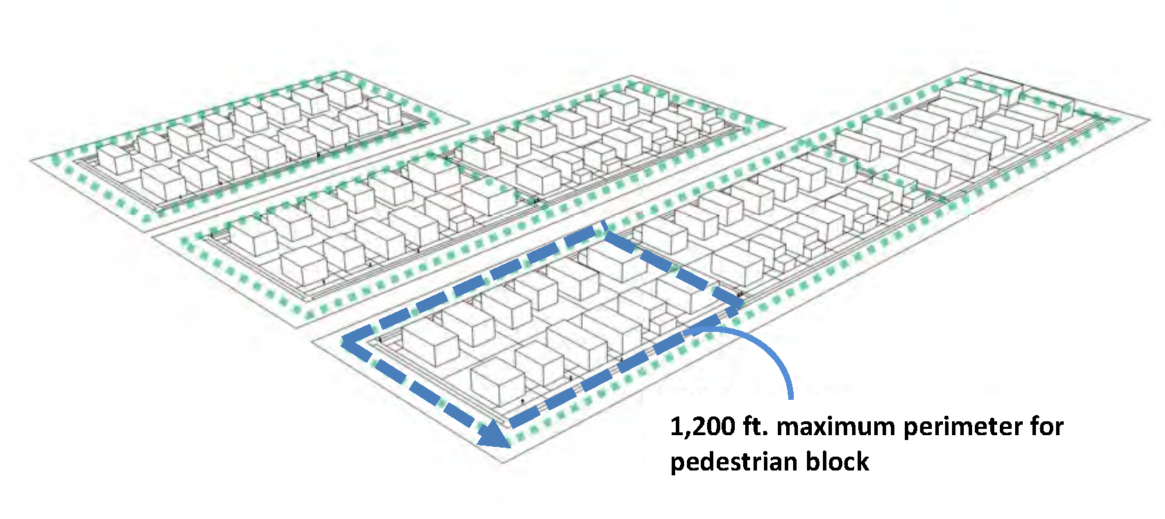
Pedestrian Block Perimeter - The following requirements apply to a Development Site greater than two acres in size.An applicant must provide a development plan that creates a series of complete pedestrian blocks bound by a connecting network of public sidewalks and/or Multi-use paths, unless listed in the exceptions below. Pedestrian blocks may be bound by sidewalks along streets or a combination of sidewalks along streets and sidewalks that provide a mid-block pedestrian-only corridor or Multi-use paths identified in City master plans.
1.
Maximum pedestrian block perimeter: 1,200 feet as measured along the centerlines of the sidewalks or multiuse paths that form the block.
2.
Mid-Block Pedestrian Corridor: The following standards apply to segments of the pedestrian block perimeter that are not located along streets:
a)
15-feet wide public access easement over the length of the sidewalk and connecting to public street rights of way at each end. The required public access easement may be located in a Tract under common ownership or on private development lots.
b)
8-feet wide asphalt or concrete sidewalk with a maximum longitudinal slope of 15 percent, centered within the pedestrian corridor.
c)
Landscape planters between the sidewalk and edge of the public access easement, located on both sides of the sidewalk, and extending the length of the corridor. The applicant must provide vegetative or non-vegetative groundcover within the landscape planter consistent with Section 4.2.20.a.3, and irrigation to ensure plant survival.
d)
Minimum distance of 50 feet between the centerline of the mid-block pedestrian sidewalk and end of block face.
e)
Minimum centerline distance of 200 feet between mid-block pedestrian sidewalks.
f)
Sidewalk and landscaping within the public access easement must be maintained by the property owner(s).
3.
Exceptions: Exceptions to pedestrian block perimeter standards are outlined below. Variations beyond these exceptions may be considered through Development Standards Adjustment or Planned Development process. Where a proposed Development Site abuts or includes any of the following features, block perimeter standards will not apply to that portion of the Development Site that abuts or includes the following features:
a)
Railroads.
b)
Significant Natural Hazards and/or Natural Resources required to be Preserved by this Code, or by State or Federal law.
c)
Sloped areas 15 percent or greater.
d)
Public parks, public schools, Taylor Water Treatment Plant, Wastewater Treatment Plant and the Public Works compound.
c.
Other Types of Pedestrian Facilities Required With Development - An applicant must provide safe and convenient pedestrian facilities consistent with the types listed below within the Development Site, and between pedestrian facilities within the Development Site and public pedestrian facilities abutting the Development Site. For purposes of this Section, safe and convenient means pedestrian facilities that are free from hazards and that provide a direct route of travel between destinations. The applicant must provide the following types of pedestrian facilities with development:
1.
Pedestrian walkways connecting a cul-de-sac/dead-end street to an adjacent public right-of-way or multi-use path/trail within a public access easement. The following construction standards apply to the walkways:
a)
15-feet wide public access easement over the length of the sidewalk and connecting to public rights of way or public access easements at each end. The required public access easement may be located in a Tract under common ownership or on private development lots.
8-feet wide asphalt or concrete sidewalk with a maximum longitudinal slope of 15 percent, centered within the public access easement.
b)
Landscape planters between the sidewalk and edge of the public access easement, located on both sides of the sidewalk, and extending the length of the public access easement. The applicant must provide vegetative or non-vegetative groundcover within the landscape planter consistent with Section 4.2.20.a.3, and irrigation to ensure plant survival. Sidewalk and landscaping within the public access easement must be maintained by the property owner(s).
2.
Pedestrian facilities identified in the Transportation System Plan or Parks and Recreation Master Plan. Facilities must be constructed to the standards and specifications identified in those documents.
3.
Pedestrian facilities as required in Chapter 4.10 - Pedestrian Oriented Design Standards.
d.
To provide for orderly development of an effective pedestrian network, pedestrian facilities installed concurrently with development of a site must be extended to and through the site to the edge of adjacent property(ies).
e.
Prior to development, applicants must perform a site inspection and identify any Contractor Sidewalk/street Stamps, sidewalk prisms, horse rings, and iron curbs that will be impacted by the development. If such a feature exists, it must either be left in its current state as part of the existing sidewalk or street, or incorporated into the new sidewalk or street for the Development Site, as close as possible to its original location and orientation. Iron curbs must be retained unless required to be removed or modified to comply with mandatory ADA standards. In such instances, the iron curb may only be removed or modified to the minimum extent necessary to comply with ADA standards.
(Ord. No. 2014-19, eff. 12-11-2014; Ord. No. 2018-36, eff. 1-1-2019; Ord. No. 2021-22, eff. 11-24-2021; Ord. No. 2022-12, eff. 6-1-2022; Ord. No. 2023-19, § 33(Exh. A), eff. 6-30-2023; Ord. No. 2024-26, § 32(Exh. A), eff. 1-1-2025; Ord. No. 2025-25, § 10(Exh. A), eff. 6-12-2025)
Section 4.0.40 - Bicycle Requirements.
a.
On-street Bike Lanes - On-street bike lanes are required on all Arterial Highway, Arterial, Collector, and Neighborhood Collector Streets consistent with the standards in the Transportation System Plan and must be constructed with street improvements.
b.
Safe and Convenient Bicycle Facilities - Safe and convenient bicycle facilities that minimize travel distance to the greatest extent practicable must be provided within the Development Site, and between bicycle facilities within the Development Site and public bicycle facilities abutting the Development Site.
1.
For the purposes of this Section, safe and convenient means bicycle facilities that are free from hazards and provide a direct route of travel between destinations.
2.
Bicycle/pedestrian easements connecting cul-de-sacs to other cul-de-sacs and streets or passing through unusually long or oddly shaped blocks must be a minimum of 15 ft. wide. Maintenance of the paved improvement is the responsibility of adjacent property owners. Additionally, a minimum of five ft. of landscaping must be provided on both sides of these bicycle/pedestrian facilities, in accordance with Chapter 4.2 - Landscaping, Buffering, Screening, and Lighting. Maintenance of the landscaping is the responsibility of adjacent property owners.
c.
Widths for Pedestrian/Bicycle Facilities - Adequate widths for pedestrian/bicycle facilities must be provided in accordance with the requirements in the Engineering Standards.
d.
To provide for orderly development of an effective bicycle network, bicycle facilities installed concurrently with development of a site must be extended to and through the site to the edge of adjacent property(ies).
(Ord. No. 2018-36, eff. 1-1-2019; Ord. No. 2022-12, eff. 6-1-2022; Ord. No. 2023-27, § 6(Exh. A), eff. 2-28-2024)
Section 4.0.50 - Transit Requirements.
a.
Development Sites located along existing or planned transit routes must provide transit stop easements and transit stop improvements, consistent with the Transit Development Plan and in coordination with the Corvallis Transit System. These improvements must be installed in accordance with standards established by the City Engineer, as amended over time.
b.
Development Sites within 50 feet of existing or planned transit stops must provide safe and convenient pedestrian walkways between all buildings with customer/resident entrances and the transit stop, in accordance with the provisions of Section 4.0.30.b. For purposes of this Section, "safe and convenient" means pedestrian facilities that are free from hazards and that provide a direct route of travel between destinations.
c.
Transit stops must be located a minimum of 50 feet from accesses. Exceptions to this requirement may be granted by the City Engineer. Evaluations of exceptions will consider the posted speed for the street on which access is proposed, whether the distance between transit stops and an access restricts permissible uses on the Development Site, constraints due to lot patterns, and effects on the safety and capacity of the adjacent public street, bicycle, and pedestrian facilities.
(Ord. No. 2018-36, eff. 1-1-2019; Ord. No. 2022-12, eff. 6-1-2022; Ord. No. 2023-01, eff. 2-8-2023)
Section 4.0.60 - Public and Private Street Requirements.
a.
Traffic evaluations are required for all development proposals in accordance with the Engineering Standards and the following:
1.
All development proposals must provide an estimate of site generated trips based on ITE standards. A traffic impact analysis (TIA) is required for any proposal generating 30 or more peak hour trips to an intersection/access. A proposed TIA scope with preliminary trip estimates and trips distribution must be prepared by a registered professional engineer, and submitted to the City Engineer for review and approval based on established procedures. The applicant must complete the evaluation consistent with the approved scope in accordance with accepted traffic engineering practices and present the results with the development proposal.
2.
If the TIA identifies safety issues or mobility performance conditions less than the minimum standard established in the Transportation System Plan, recommended improvements and funding strategies mitigating the issue or conditions must be included in the TIA.
3.
Conditions of Approval.
a)
The City may deny, approve, or approve a proposal with conditions necessary to meet operational and safety standards; provide the necessary right-of-way for improvements; and to require construction of improvements to ensure consistency with the future planned transportation system.
b)
Construction of off-site improvements may be required to mitigate impacts resulting from development that relate to capacity deficiencies and public safety; and/or to upgrade or construct public facilities to city standards.
b.
The locations of new Arterial, Collector, and Neighborhood Collector Streets must conform to the Transportation System Plan.
c.
Although through-traffic movement on new Local Connector and Local Streets usually is discouraged, this may not be practical for particular neighborhoods. Local Connector or Local Street designations will be applied in newly developing areas based on review of a street network plan and, in some cases, a traffic study provided with the development application. The decision regarding which of these designations will be applied is based on a number of factors, including density of development, anticipated traffic volumes, and the potential for through traffic.
Street network plans must provide for connectivity within the transportation system to the extent that, generally, both Local Connector and Local Streets will be created for a development. In order to promote efficient vehicular and pedestrian circulation throughout the city, Development Sites must be served by an interconnected street network consistent with the vehicle block perimeter standards in Section 4.0.60.o.
Traffic calming techniques, such as bulbed intersections, can reduce traffic speeds and, where included, are to be constructed at the time of development. To further address traffic speeds and volumes on Local Connector and Local Streets, the following street designs, along with other designs intended to reduce traffic speeds and volumes, will be considered:
1.
Straight segments of Local Connector and Local Streets should be less than .25 mile in length, and include design features such as curves and T intersections.
2.
A cul-de-sac will only be permitted where the Planning Commission or Director determines that natural features or topographical constraints, existing development patterns, or compliance with other applicable City requirements preclude a street extension. Cul-de-sacs may not exceed 600 feet
3.
Street designs that include traffic calming, where appropriate, are encouraged.
d.
Private streets may be provided on a Development Site if all the following conditions are met:
1.
Extension of a public street through the Development Site is not needed for continuation of the existing street network or for future service to adjacent properties;
2.
The Development Site remains in one ownership, or adequate mechanisms are established, such as a homeowners' association with the authority to enforce payment, to ensure that a private street will be adequately maintained;
3.
Where a private street is installed in conjunction with a Land Division, it must be located within a separate Tract, and development standards, including paving standards, consistent with City standards for public streets must be used to protect the interests of future homeowners; and
4.
The applicant grants a public access easement over the entirety of the private street.
e.
Development Sites must be provided with access from a public street, or a private street that meets the criteria in "d" above, improved to City standards in accordance with the following:
1.
Where a Development Site abuts an existing public street not improved to City standards, the abutting street must be improved to City standards along the full frontage of the property concurrently with development. Where a Development Site abuts an existing private street not improved to City standards, and the private street is allowed per the criteria in "d" above, the abutting street must meet all the criteria in "d" above and be improved to City standards along the full frontage of the property concurrently with development.
2.
Full width street improvements, from curb to curb are typically required. Half-width street improvements from curb to centerline may be approved by the Planning Commission or Director where essential to the reasonable development of the property. Approval for half-width street improvements may be allowed when other standards required for street improvements are met and when the Planning Commission or the Director finds that it will be possible to obtain the dedication and/or improvement of the remainder of the street when property on the other side of the half-width street is developed.
3.
To ensure improved access to a Development Site consistent with policies on orderly urbanization and extension of public facilities, the Planning Commission or Director may require off-site street improvements concurrently with development.
f.
To provide for orderly development of adjacent properties, public streets, and private streets that meet all the criteria in "d" above, must be installed concurrently with development and must be extended through the site to the edge of adjacent property(ies) in accordance with the following:
1.
Temporary dead-ends created by this requirement may be installed without turn-arounds, subject to the approval of the Fire Marshal.
2.
Drainage facilities must be provided to properly manage storm water run-off from temporary dead-ends.
g.
Where provision of a public or private street divides a Development Site into discrete units of land, the applicant must file a partition concurrently with the development, in accordance with Chapter 2.4 - Land Divisions, Replats, and Property Line Adjustments.
h.
Names for new streets may not duplicate or create confusion with names of existing streets. Street names and numbers must conform to the established pattern in the surrounding area and are subject to approval of the Director.
i.
To provide off-street loading and/or access to parking areas, alleys must be provided in Commercial and Industrial zones to serve abutting properties unless other permanent provisions are approved by the Planning Commission or Director.
j.
Alley standards are as follows -
1.
Standards for Alleys Serving both Residential and Nonresidential Use Types
a)
Alleys serving Residential Use Types must be privately owned, with the exception of existing publicly owned alleys. Alleys serving nonresidential Use Types may be private, but are strongly encouraged to be public;
b)
Alleys must be designed consistent with the Engineering Standards;
c)
Alleys must be clearly marked to prohibit parking, unless designed to accommodate it;
d)
An alley serving six or more dwelling units must be contained within a separate, privately owned Tract;
e)
Alleys must be unobstructed at least to their minimum required width. Service areas provided adjacent to alleys may not encroach into the alleys;
f)
Site layouts of alleys may include, but are not limited to, straight alleys, T-shaped alleys, L-shaped alleys, etc.;
g)
Where an alley provides required emergency access to a structure(s), the alley must be a minimum of 20 feet wide and have adequate turning radii on curves, T's, and L's, to accommodate emergency vehicles;
h)
Developments that will have garbage pick-up services and/or loading facilities from alleys must have adequate turning radii on curves, T's, and L's, to accommodate those vehicles;
i)
The applicant must grant a public access easements over the entirety of a private alley;
j)
Private alleys must be maintained by the owner(s) of property abutting the alley, a property owners' association, or through a privately administered arrangement instituted by the developer. Maintenance responsibilities for private alleys must be identified in deed restrictions filed with the Final Plat or prior to the issuance of final occupancy permits in cases where there is no plat to be filed; and
k)
Utilities within alleys must be placed underground.
2.
Additional Standards for Alleys Serving Residential Use Types -
a)
One-way alleys must have a minimum width of 12 feet; two-way alleys must have a minimum width of 16 feet One-way alleys must be clearly designed as one-way alleys and signed accordingly;
b)
Alley segments may not exceed 350 feet;
c)
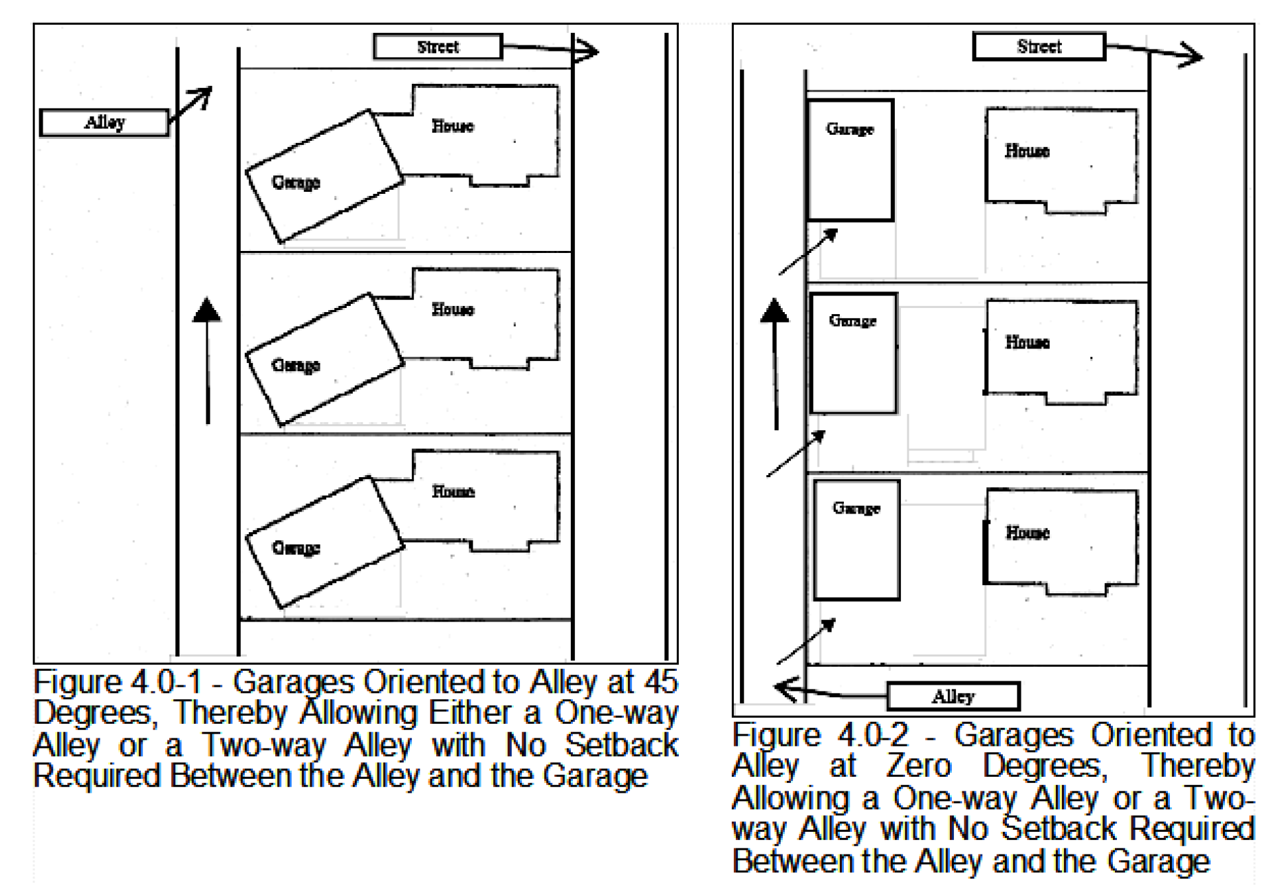
Garages accessed by one-way alleys must be angled from the alley zero degrees to 45 degrees to assist with vehicle access and assist drivers in determining that the alley is one-way. Garages installed consistent with this requirement may be located along the outside boundaries of one-way alleys with no setback required. See Figure 4.0-1 - Garages Oriented to Alley at 45 Degrees, Thereby Allowing Either a One-way Alley or a Two-way Alley with No Setback Required Between the Alley and the Garage and Figure 4.0-2 - Garages Oriented to Alley at Zero Degrees, Thereby Allowing a One-way Alley or a Two-way Alley with No Setback Required Between the Alley and the Garage; and
d)
Garages adjacent to two-way alleys must be located no closer than 14 feet from the centerline of the alley unless they are angled from the alley zero degrees to 45 degrees, in which case they may be located along the outside boundaries of the alleys with no setback required. See Figure 4.0-1 - Garages Oriented to Alley at 45 Degrees, Thereby Allowing Either a One-way Alley or a Two-way Alley with No Setback Required Between the Alley and the Garage and Figure 4.0-2 - Garages Oriented to Alley at Zero Degrees, Thereby Allowing a One-way Alley or a Two-way Alley with No Setback Required Between the Alley and the Garage
3.
Additional Standards for Alleys Serving Nonresidential Use Types -Unless Specified Differently By the Underlying Zone -
a)
One-way alleys must have a minimum width of 12 feet; two-way alleys must have a minimum width of 20 feet One-way alleys must be clearly designed as one-way alleys and signed accordingly;
b)
Parking may be provided on one side of an alley, but not on both sides. Where parking is provided on one side of a one-way alley, the alley must be a minimum width of 14 feet, exclusive of parking;
c)
Where parking is provided, it must not interfere with service areas, utilities, or pedestrian facilities. Such parking may be 45-degree angled parking, parallel parking, or 90-degree parking, provided the parking stalls and related back-up areas are designed consistent with the Site Development and Design Standards, as amended over time. Rather than widen alleys to allow for adequate back-up areas for 90-degree parking stalls, applicants are encouraged to provide longer parking stalls; and
d)
Where alleys provide access to one or more properties, and 15 or more vehicle parking spaces, alleys must be a minimum of 20 feet wide.
k.
Location, grades, alignments, and widths for all public and private streets must be considered in relation to existing and planned streets, topographical conditions, public convenience and safety, and proposed land use. Where topographical conditions present special circumstances, exceptions to these standards may be granted by the City Engineer provided that the safety and capacity of the street network is not adversely effected. The following standards apply:
1.
Grading plans are required and must demonstrate that the proposal does not contain any grade changes (cuts or fills) that are inconsistent with the provisions of Chapter 4.14 - Landslide Hazard and Hillside Development Provisions. Cut and fill is measured vertically from natural grade. The grading plan must identify all proposed cuts and fills and the associated grade changes in feet to demonstrate adherence to this provision. Streets must be designed along natural contours.
2.
Location of streets in a Development Site must not preclude development of adjacent properties. Streets must conform to planned street extensions identified in the Transportation System Plan and/or provide for continuation of the existing street network in the surrounding area.
3.
Grades must not exceed six percent on Arterial Streets, 10 percent on Collector and Neighborhood Collector Streets, and 15 percent on Local and Local Connector Streets.
4.
As far as practicable, Arterial, Collector, and Neighborhood Collector Streets must be extended in alignment with existing streets by continuation of the street centerline. When staggered street alignments resulting in T intersections are unavoidable, they must leave a minimum of 200 feet between the nearest edges of the two rights-of-way.
5.
Local street intersections must be located a minimum of 125 feet from any other street intersection.
6.
Centerline radii of curves must not be less than 500 feet on Arterial Streets; 300 feet on Collector and Neighborhood Collector Streets; and 100 feet on Local and Local Connector Streets.
7.
Streets must be designed to intersect at right angles and must comply with the following:
a)
The intersection of an Arterial, Collector, or Neighborhood Collector Street with another Arterial, Collector, or Neighborhood Collector Street must have a minimum of 100 feet of straight (tangent) alignment perpendicular to the intersection;
b)
The intersection of a Local or Local Connector Street with another street must have a minimum of 50 feet of straight (tangent) alignment perpendicular to the intersection;
c)
Where right-angle intersections are not possible, exceptions may be granted by the City Engineer provided that intersections have a minimum corner radius of 20 feet along the right-of-way lines of the acute angle; and
d)
All intersections must have a minimum curb corner radius of 20 feet.
8.
Right-of-way and improvement widths must be as specified in the Transportation System Plan.
Exceptions to this standard:
• Urban Commercial Street and Sidewalk Standards (Section 4.0.60.n), where on-street parking is provided
• OSU Streets (Section 3.36.60.18)
9.
Where streets must cross protected Natural Resources or Natural Hazards, street improvement widths must be minimized by reducing or eliminating on-street parking and planting strips
10.
The vision clearance standards set forth in Section 4.1.30.c must be adhered to.
l.
Where standards do not exist to address unusual situations, the Planning Commission or Director may require special design standards recommended by the City Engineer as Conditions of development Approval.
m.
Deleted.
n.
Urban Commercial Street and Sidewalk Standards
1.
Applicability - The following minimum design standards apply to right-of-way abutting:
a.
Property zoned Commercial Mixed Use 3 (CMU-3); or
b.
NW Monroe Avenue between NW 14 th and NW 26 th Street.
2.
These streets must be consistent with the provisions in LDC Sections 4.0.60.k.1-7, and 9. Right-of-way and minimum improvement widths must be as specified in Table 4.0-3 - Urban Commercial Street and Sidewalk Standards.
o.
Vehicle Block Perimeter Standards - The following requirements apply to a Development Site greater than two acres in size. An applicant must provide a development plan that creates a series of complete blocks bound by a connecting network of streets, unless listed in the exceptions below. Partial blocks are allowed only when appropriate block perimeter connections are stubbed to abutting property that would be required to complete the blocks with future development.
1.
Applicability: While the standards of this section apply to Development Sites greater than two acres in size, other transportation connectivity standards set forth under Section 4.0.60 apply to all Development Sites regardless of size and/or zoning designation, unless otherwise specified. In addition, streets and other transportation facilities are required as identified in City master plans.
2.
Residential, Commercial, and Office Zones: 2,400 feet
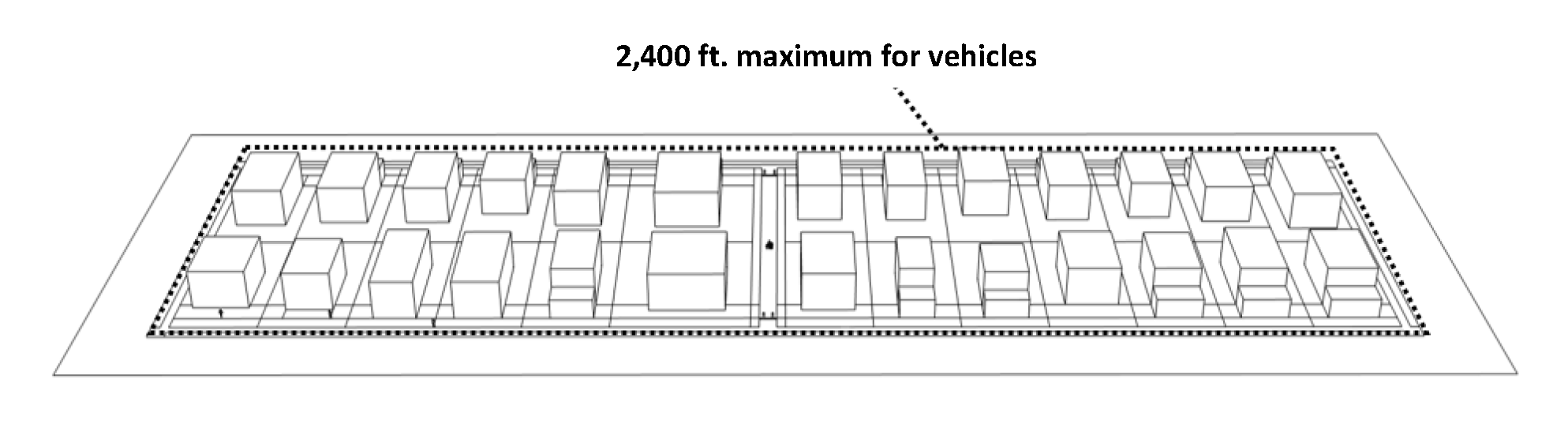
3.
Industrial Zones (LI-O, MUE, and MUT only): 3,000 feet
4.
Pedestrian Walkway Requirement: In addition to the vehicle block perimeter standards in this section, an applicant must provide a development plan that creates a series of complete pedestrian blocks, consistent with Section 4.0.30.b.
5.
Exceptions: The City allows exceptions to vehicle block perimeter standards as outlined below. Variations beyond these exceptions may be considered through the Development Standards Adjustment or Planned Development process.
a)
Arterial Highways - Where Arterial Highway access control limitations restrict the ability to make street connections, walkway or multiuse path connections will be used to satisfy block perimeter standards.
b)
Existing Development - Block perimeter connections to an abutting site are not required in the following instances:
i.
The abutting site is zoned residential, and meets or exceeds the minimum density requirements of the zone.
ii.
The abutting site is not subject to block perimeter standards, as set forth in the "Applicability" provisions of this Section.
c)
Additional Exceptions - Where a proposed Development Site abuts or includes any of the following features, block perimeter standards will not apply to that portion of the Development Site that abuts or includes the following features:
i.
Railroads.
ii.
Significant Natural Hazards and/or Natural Resources required to be Preserved by this Code, or by State or Federal law.
iii.
Sloped areas 15 percent or greater.
iv.
Public parks, public schools, Taylor Water Treatment Plant, Wastewater Treatment Plant and the Public Works compound.
p.
New access to Arterial Highways is restricted to maintain the Highway's carrying capacity, enhance its safety levels, and is limited to the roadways identified in the Transportation System Plan. Exceptions to this standard may be approved by the Oregon Department of Transportation (ODOT). Access restriction is achieved through the following requirements:
1.
Access to Arterial Highways for new or expanded development must comply with the Transportation System Plan, unless superseded by an ODOT corridor plan;
2.
New or expanded development on sites abutting an Arterial Highway must have direct access to a Local, Collector, and/or Neighborhood Collector Street, wherever practicable;
3.
Local Streets or direct access from individual properties, should not be used to access an Arterial Highway;
4.
New or existing Local Street access to Highway 20/34 will be restricted or eliminated where possible;
5.
Full-street access points should be consolidated and spaced at no closer than 0.25-mile intervals along Highway 20/34; and
6.
New or expanded development must comply with state highway access regulations and other accepted traffic engineering standards.
q.
Multiple accesses to properties along an Arterial Highway must be consolidated when:
1.
Land uses develop, expand, intensify, and/or change;
2.
Properties are consolidated and/or divided; and
3.
Property lines are adjusted.
r.
Streetlights must be provided, along all public streets in conjunction with development, in compliance with the standards of the City Engineer, as amended over time. This requirement includes installation of underground electrical service and conduit.
The developer must install such facilities and make the necessary arrangements with the serving electric utility. Upon City's acceptance of such improvements, the street lighting system, exclusive of utility-owned service lines, will become the property of the City.
s.
Dead-end streets planned for future extension must be posted to inform the public that the street will be extended in the future.
(Ord. No. 2012-18, eff. 12-13-2012; Ord. No. 2014-19, eff. 12-11-2014; Ord. No. 2018-20, eff. 7-24-2018; Ord. No. 2018-36, eff. 1-1-2019; Ord. No. 2021-22, eff. 11-24-2021; Ord. No. 2022-06, eff. 3-17-2022; Ord. No. 2022-12, eff. 6-1-2022; Ord. No. 2023-01, eff. 2-8-2023; Ord. No. 2023-19, § 34(Exh. A), eff. 6-30-2023; Ord. No. 2023-27, 6(Exh. A), eff. 2-28-2024; Ord. No. 2024-26, § 32(Exh. A), eff. 1-1-2025; Ord. No. 2025-25, § 10(Exh. A), eff. 6-12-2025)
Section 4.0.70 - Public Utility Requirements (Or Installations).
a.
All Development Sites must be provided with public water, sanitary sewer, storm drainage, and street lights.
b.
Where necessary to serve property as specified in "a" above, required public utility installations must be constructed concurrently with development.
c.
Off-site public utility extensions necessary to fully serve a Development Site and adjacent properties must be constructed concurrently with development.
d.
To provide for orderly development of adjacent properties, public utilities installed concurrently with development of a site must be extended to and through the site to the edge of adjacent property(ies).
e.
All required public utility installations must conform to the City's facilities master plans.
f.
Private on-site sanitary sewer and storm drainage facilities may be allowed, provided all the following conditions exist:
1.
Extension of a public facility through the site is not necessary for future development of adjacent properties;
2.
Sanitary sewer systems only serve one Lot or Parcel;
3.
The Development Site remains in one ownership and Land Division does not occur, with the exception of Land Divisions that may occur under the provisions of Section 4.0.60.d, above; and
4.
The facilities are designed and constructed in accordance with the Uniform Plumbing Code and other applicable codes, and permits are obtained from the Development Services Division prior to commencement of work.
(Ord. No. 2014-19, eff. 12-11-2014; Ord. No. 2022-12, eff. 6-1-2022)
Section 4.0.80 - Public Improvement Procedures.
It is in the best interests of the community to ensure that public improvements installed in conjunction with development are constructed in accordance with all applicable City policies, standards, procedures, and ordinances. Therefore, before installing public water, sanitary sewer, storm drainage, streetlights, street, transit, bicycle, or pedestrian improvements, developers must contact the City Engineer for information regarding procedures governing plan submittal, plan review and approval, permit requirements, inspection and testing requirements, progress of the work, and provision of easements, dedications, and as-built drawings for installation of public improvements.
Whenever any work is done contrary to the provisions of this Code, the Director may order the work stopped via a written notice served on the persons performing the work or otherwise in charge of the work. The work must stop until the Director authorizes that it proceed or authorizes corrective action to remedy existing substandard work.
(Ord. No. 2022-12, eff. 6-1-2022)
Section 4.0.90 - Franchise Utility Installations.
These standards are intended to supplement, not replace or supersede, requirements contained within individual franchise agreements that the City has with providers of electrical power, telecommunication, cable television, and natural gas services, hereafter referred to as Franchise Utilities.
a.
Where a Land Division is proposed, the developer must provide Franchise Utilities to the Development Site. Each lot or parcel must have an individual service available or secured prior to approval of the Final Plat, in accordance with Chapter 2.4 - Land Divisions, Replats, and Property Line Adjustments.
b.
Where necessary and in the judgment of the Director, Franchise Utilities must be extended through the site to the edge of adjacent property(ies) to provide for orderly development of adjacent properties.
c.
The developer must provide natural gas and cable television service to the Development Site, unless all of the following conditions exist:
1.
Extension of Franchise Utilities through the site is not necessary for the future orderly development of adjacent property(ies);
2.
The development site remains in one ownership and Land Division does not occur, with the exception of Land Divisions that may occur under the provisions of Section 4.0.60.d, above; and
3.
The development is nonresidential.
d.
All Franchise Utility distribution facilities installed to serve new development must be placed underground except as provided below.
1.
Poles for traffic signals, pedestals for police and fire system communications and alarms, pad-mounted transformers, pedestals, pedestal-mounted terminal boxes and meter cabinets, concealed ducts, substations, or facilities used to carry voltage higher than 35,000 volts; and
2.
Overhead utility distribution lines may be permitted upon approval of the City Engineer when unusual terrain, soil, or other conditions make underground installation impracticable. Location of such overhead utilities must follow rear or side lot lines wherever feasible.
e.
The developer is responsible for making necessary arrangements with Franchise Utility providers for plans, timing of installation, and payment for services installed. Plans for Franchise Utility installations must be submitted together with plans for public improvements to facilitate review by the City Engineer.
(Ord. No. 2022-12, eff. 6-1-2022)
Section 4.0.100 - Land For Public Purposes.
a.
Easements for public facilities must be provided whenever they are located outside the right-of-way. Requirements are provided in facility master plans, the Engineering Standards and this Chapter.
b.
Utility easements with a minimum width of seven ft. must be granted to the public adjacent to all street rights-of-way for franchise utility installations. The Director may allow alternatives to this requirement with the concurrence of the City Engineer and affected utility companies.
c.
Where a development site is traversed by a drainageway or water course, improvements must be in accordance with the Storm Water Master Plan and the Natural Hazards, Minimum Assured Development Area (MADA), and Natural Resources provisions of Chapter 2.11 - Floodplain Development Permit, Chapter 4.2 - Landscaping, Buffering, Screening, and Lighting, Chapter 4.5 - Floodplain Provisions, Chapter 4.11 - Minimum Assured Development Area (MADA), Chapter 4.12 - Significant Vegetation Protection Provisions, Chapter 4.13 - Riparian Corridor and Wetland Provisions, and Chapter 4.14 - Landslide Hazard and Hillside Development Provisions.
d.
Where a Development Site is traversed by, or adjacent to, a future trail linkage identified in the Transportation System Plan or the Trails Master Plan, dedications of suitable width to accommodate the trail linkage must be provided. This width will be determined by the City Engineer, based on the appropriate standard for the type of trail facility involved.
e.
Where street, trail, utility, or other rights-of-way and/or easements in or adjacent to a Development Site are nonexistent or of insufficient width, dedications and/or easements meeting current standards will be required.
f.
Easements or dedications required in conjunction with Land Divisions must be recorded on the Final Plat. For developments not involving a Land Division, easements and/or dedications must be recorded on standard forms provided by the City Engineer.
g.
Environmental assessments must be provided by the developer (grantor) for all lands to be dedicated to the public or City. An environmental assessment must include information necessary for the City to evaluate potential liability for environmental hazards, contamination, or required waste cleanups related to the dedicated land. An environmental assessment must be completed prior to the acceptance of dedicated lands, in accordance with the following:
1.
The initial environmental assessment must detail the history of ownership and past use of the land. Upon review of this information, as well as any site investigation by the City, the Director will determine if the risks of potential contamination warrant further investigation. If further site investigation is warranted, a Level I Environmental Assessment must be provided by the grantor, as described in "2," below.
2.
Level I Environmental Assessments must include data collection, site reconnaissance, and report preparation. Data collection must include review of Oregon records, City and County fire department records, interviews with agency personnel regarding citations or enforcement actions issued for the site or surrounding sites that may impact the site, review of available historic aerial photographs and maps, interviews with current and available past owners of the site, and other data as appropriate.
Reconnaissance must include walking reconnaissance the site to check for physical evidence of potentially hazardous materials that may impact it. Report preparation must summarize data collection and site reconnaissance, assess existing and future potential for contamination with hazardous materials, and recommend additional testing if there are indications of potential site contamination. Level I Environmental Assessment reports must be signed by a registered professional engineer.
3.
If a Level I Environmental Assessment concludes that additional environmental studies or site remediation are needed, no construction permits will be issued until those studies are submitted and any required remediation is completed by the developer and/or owner. Additional environmental studies and/or required remediation is at the sole expense of the developer and/or owner. The City reserves the right to refuse acceptance of land identified for dedication if risk of liability from previous contamination is found.
(Ord. No. 2012-16, eff. 12-13-2012; Ord. No. 2021-22, eff. 11-24-2021; Ord. No. 2022-06, eff. 3-17-2022; Ord. No. 2022-12, eff. 6-1-2022; Ord. No. 2023-27, 6(Exh. A), eff. 2-28-2024)
Section 4.0.110 - Mail Delivery Facilities.
a.
Placement of mail delivery facilities must consider locations of sidewalks, bikeways, intersections, existing or future driveways, existing or future utilities, right-of-way and street width, and vehicle, bicycle and pedestrian movements. Where mail delivery facilities are installed in conjunction with a Land Division, their placement must be indicated on the plans for public improvements and meet the approval of the City Engineer and the U.S. Post Office.
b.
Where mail delivery facilities are proposed on an existing or future curbside sidewalk, a sidewalk transition must be provided that maintains the required design width around the mail delivery facility. If the right-of-way width will not accommodate the sidewalk transition, a public access easement must be provided adjacent to the right-of-way.
c.
Mail delivery facilities and associated sidewalk transitions, when they are necessary, must comply with the Construction Specifications. Mailboxes must comply with the U.S. Post Office standards for mail delivery facilities.
d.
Mail delivery facilities are the obligation of the developer and must be installed concurrently with public improvements. Where a Development Site does not require public improvements, mail delivery facilities must be installed concurrently with private site improvements.
(Ord. No. 2022-12, eff. 6-1-2022; Ord. No. 2023-27, 6(Exh. A), eff. 2-28-2024)
Section 4.0.120 - [Repealed].
(Ord. No. 2022-12, eff. 6-1-2022)
Section 4.0.130 - Storm Water Management and Discharge Control.
To reduce pollution, lower the risk of flooding on downstream properties and to help maintain or restore the Properly Functioning Conditions of receiving waters, development that creates or replaces impervious surfaces must provide stormwater retention, or treatment and detention, consistent with the requirements of Municipal Code 4.05, the Engineering Standards and this Section.
a.
Retention Requirements. Municipal Code 4.05 provides the thresholds and requirements for stormwater retention. In some instances, retention will not be allowed or may not be feasible. The Engineering Standards provide guidance and requirements to make this determination. When retention is required, but not allowed or not feasible, treatment is required.
b.
Detention Requirements. Stormwater detention is required when stormwater retention is not allowed or not feasible, and the following thresholds are met.
1.
Development that creates impervious surfaces in excess of 25,000 sq. ft. is required to implement stormwater detention measures consistent with the Engineering Standards. Impervious surfaces include such elements as roads, driveways, parking lots, walks, patios, roofs, etc.
2.
Expansion and Redevelopment
a)
Development that creates new or redeveloped impervious area totaling at least 10,000 sq. ft. and resulting in at least 25,000 sq. ft. of post-development impervious area must implement stormwater detention measures for the new and redeveloped impervious area consistent with the Engineering Standards. Redeveloped impervious area consists of roof area and new or replaced impervious area, minus any reduction in total impervious area, associated with substantial improvement or replacement of structures.
b)
Pre-developed runoff conditions for redeveloped impervious area must assume a runoff pattern based on good condition grass and the corresponding native hydrologic soil group for the site. Detention is required to the point at which gravity flow to the existing abutting storm drainage system can be feasibly maintained, as determined during development plan review.
3.
Exemptions and Subtractions to Stormwater Detention Requirements
a)
Properties east of the Marys River and south of Highway 20/34 (specifically identified in the Stormwater Master Plan as the Mill Race Basin, the Goodnight Basin, properties draining or piped directly into the Marys River or Willamette River, and areas subject to the South Corvallis Drainage Master Plan) are exempt from detention requirements because of their proximity to the Marys River or Willamette River and the need for quick dispersion of stormwater.
b)
Properties subject to Section 4.0.130.b.1, above, may subtract the square footage of underground parking, for each level of structured parking, from the square footage subject to detention requirements.
4.
Stormwater facilities south of Goodnight Avenue must be constructed in accordance with the requirements of the South Corvallis Drainage Master Plan.
c.
Stormwater management facilities (retention, treatment or detention) within a regulated Riparian Corridor must be located outside of the applicable riparian easement area or the Floodway, whichever is greater. Riparian easement areas are identified in Section 4.13.70, and this standard applies regardless of whether or not an easement has been granted.
(Ord. No. 2012-16, eff. 12-13-2012; Ord. No. 2018-20, eff. 7-24-2018; Ord. No. 2021-22, eff. 11-24-2021; Ord. No. 2022-12, eff. 6-1-2022; Ord. No. 2023-27, 6(Exh. A), eff. 2-28-2024)
Section 4.0.140 - Rough Proportionality.
If an applicant intends to assert that it cannot legally be required, as a condition of Building Permit or development approval, to provide easements, dedications, or improvements at the level otherwise required by this Code, the Building Permit or site plan review application must include a rough proportionality report in accordance with the provisions of Section 1.2.120 of Chapter 1.2 - Legal Framework.
(Ord. No. 2022-12, eff. 6-1-2022)
Section 4.0.150 - Transportation Uses and Activities Exempt From Land Use Approval.
In addition to ORS 197.015(10)(b)(D), transportation uses and activities, including operation and maintenance of transportation services and facilities as well as construction of transportation facilities identified in the Transportation System Plan, do not require land use approval.
(Ord. No. 2018-36, eff. 1-1-2019; Ord. No. 2022-12, eff. 6-1-2022)
Section 4.1.10 - Purposes.
The regulations in this Chapter are established to provide appropriate location and design of parking areas provided to serve Development. This Chapter also includes minimum requirements for off-street loading areas and minimum requirements for bicycle parking. The regulations in this Chapter also concern appropriate location, design, and capacity of accesses between properties and public rights-of-way, to implement the access management standards of the Transportation System Plan.
(Ord. No. 2023-19, § 35(Exh. A), eff. 6-30-2023)
Section 4.1.20 - General Provisions.
a.
Provision and Maintenance of Vehicle Parking - The provision of a minimum number of off-street parking spaces for vehicles is not a requirement of this Code. However, when provided, facilities for off-street vehicle parking are subject to applicable City codes and standards, including the standards in this Chapter. Building or other Permits will only be issued after receipt of plans that show the location of parking facilities that are designed consistent with the applicable standards.
b.
Provision and Maintenance of Off-Street Loading Facilities - The provision of off-street loading facilities for vehicles is required pursuant to Section 4.1.40. Building or other Permits will only be issued after receipt of plans that show the location of loading facilities that are designed consistent with the applicable standards.
c.
Provision and Maintenance of Bicycle Parking Facilities - The provision of parking for bicycles is required pursuant to Section 4.1.50. Building or other Permits will only be issued after receipt of plans that show the location of bicycle parking that are designed consistent with the applicable standards.
(Ord. No. 2023-19, § 35(Exh. A), eff. 6-30-2023)
Section 4.1.30 - Standards For Vehicle Access, Manuevering, and Parking.
All off-street parking facilities, vehicle maneuvering areas, driveways, loading facilities, and Accessways must be designed, paved, curbed, drained, striped, and constructed to the standards set forth in this Section and the Site Development Design Standards, as amended over time. A permit from the Development Services Division is required to construct parking, loading, private streets, and access facilities.
a.
Access to Arterial, Collector, and Neighborhood Collector Streets
1.
Off-street facilities must be designed and constructed with turnaround areas to prevent vehicle back-up movement onto Arterial Streets.
2.
Location of all accesses must be consistent with the access spacing standards of the Transportation System Plan, and are subject to review and approval by the City Engineer. Design and number of accesses must be consistent with the Engineering Standards.
3.
When developed property will be expanded or altered in a manner that affects on-site parking or circulation, both existing and proposed accesses will be reviewed under the standards in "2," above. As a part of an expansion or alteration approval, the City will require relocation and/or reconstruction of existing accesses not meeting those standards.
b.
Access to Substandard Streets - See Section 4.0.20 for associated street improvement requirements and exceptions.
1.
Development may occur on an existing substandard public street, when that development constitutes Infill. A condition of development will be to prepay the City for future street improvements according to current policies and procedures. This is required with approval of any of the following applications:
a)
Land Divisions;
b)
Conditional Developments;
c)
Building Permits for new nonresidential construction or structural additions to nonresidential structures, except Accessory Development; and/or
d)
Building Permits for new residential units.
2.
The City Engineer may allow the developer to sign an irrevocable petition for public street improvements in lieu of prepayment if it is determined that:
a)
Existing development along a particular street corridor is so extensive that the ability to fund a future street improvement project through the collection of prepayment fees is limited; or
b)
Future improvement scenarios are uncertain to the extent that an estimate for street improvements cannot be generated with any degree of confidence; or
c)
The street is listed as a Legacy Street per City Council Resolution 2017-13, or as amended.
c.
Vision Clearance - Except within the Commercial Mixed Use 3 (CMU-3) Zone, Vision Clearance Areas must be provided at the intersections of all streets and at the intersections of driveways and alleys with streets to promote pedestrian, bicycle, and vehicular safety.
d.
Backing or Maneuvering of Vehicles -
1.
Prohibitions - For developments with five or more surface parking spaces, vehicular backing or maneuvering movements are not permitted across public sidewalks or within any public street other than an alley, except as approved by the City Engineer.
The City Engineer may grant an exception based on an evaluation of constraints due to lot patterns and effects on the safety and capacity of the adjacent public street and on bicycle and pedestrian facilities.
2.
Minimum Driveway Length - Where vehicles will be backing out from a driveway to the public right-of-way, the length of the driveway must be a minimum of 19 feet as measured from the sidewalk or future sidewalk. Where no sidewalk location has been established, the length of the driveway must be a minimum of 19 feet.as measured from the right-of-way.
e.
Parking Lot Landscaping and Lighting - Parking areas must include landscaping and lighting in accordance with Chapter 4.2 - Landscaping, Buffering, Screening, and Lighting and where specified by the Zone.
f.
Street Access Standards - Except where required for emergency vehicle and refuse/recycling collection vehicle access, driveway access points are not required by this Code. The standards of this section regulate driveway access points to streets. For the purpose of this section, a driveway access point is defined as any point where a private driveway accesses a public street. Any new or modified driveway access point requires a City development permit, and must comply with the standards of this Code, the Site Development Design Standards, Engineering Standards, and Transportation System Plan.
Due to potential conflicts with other requirements of this Code, including, but not limited to, street tree requirements in Chapter 4.2 and utility spacing requirements, narrow lots and parcels with a limited Frontage dimension that are unable to establish a driveway access point at the Frontage, must provide desired access through rear or shared access points that can fully comply with all of the other requirements of this Code. This requirement to comply with all other requirements of this Code applies to all lot Access scenarios, including the scenarios outlined in Section 4.1.30 "1" and "2" below.
1.
Except where limited or prohibited by other regulations, driveway access point restrictions are as follows:
a)
Driveway access point width must not exceed 40 percent of the lot's street frontage width, up to a maximum of 20 feet (for residential building types with fewer than 5 dwelling units) or 24 feet (for all other development types).
b)
Any interior lot with a front lot line dimension of less than 50 feet is limited to one driveway access point.
c)
Single Detached, Duplex, Triplex, Fourplex and Townhome developments are limited to one driveway access point per lot.
d)
Residentially-zoned Properties Abutting Alleys: For any residentially-zoned lot abutting an alley improved to city standards, any new vehicle access must be taken exclusively from the alley (see Figure 4.1-1).
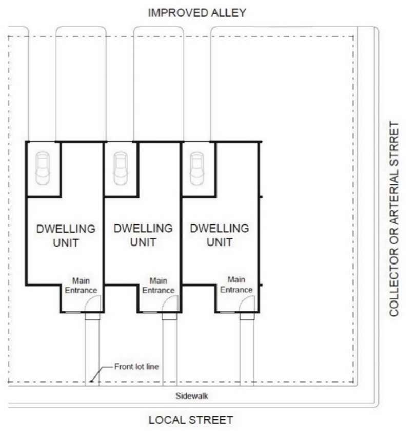
Figure 4.1-1
2.
Restriction Exceptions: Exceptions to the above-listed driveway access point restrictions are as follows:
a)
In lieu of one 20-foot wide driveway access point, a Single Detached, Duplex, Triplex or Fourplex development on a corner lot may have two maximum 10-foot wide driveway access points, one on each street frontage, provided both abutting streets are classified as Local and all other applicable development standards can be met.
b)
A Triplex or Fourplex development may have multiple driveway access points if the following conditions are met:
i.
The development site does not abut an improved or paved alley;
ii.
All driveway access points are taken from a Local street(s);
iii.
A minimum separation of 20 feet is provided between driveway access points;
iv.
Utility services are configured to allow for street tree planting in accordance with Chapter 4.2 standards;
v.
The width for each individual driveway access point does not exceed 10 feet; and
vi.
The combined width of all driveway access points (including on-site driveways and vehicle maneuvering areas) does not exceed a total of 50 percent of the street frontage (see Figure 4.1-2).
Figure 4.1-2
c)
The 24-foot maximum width for driveway access points serving nonresidential uses will be exceeded where the City Engineer determines additional drive aisles that provide turning lanes for site egress are necessary.
d)
The 40 percent street frontage width limitation does not apply to driveways within a designated flag parcel Accessway.
3.
Driveway access points are prohibited from First Street.
g.
Commercial Development - Shared Access between Sites via Parking Lots and/or Drives - An applicant of commercial and/or mixed use Development must extend new drive aisles to abutting commercially-zoned properties to reduce off-site traffic impacts and provide convenience for customers and delivery vehicles. The applicant must grant a shared access easement between the abutting property and the public street that provides vehicular access to the Development Site. If Development occurs in a location where abutting properties have already provided shared access easements, the drive aisle connections and easements must be extended as part of the Development. Shared access easements between commercial and/or mixed use developments may be relocated upon consent of all parties, final approval by the City Engineer, and recording of new shared access easements.
h.
Climate Friendly Parking Design - An applicant proposing new Surface Parking Area for the Development Site that exceeds 21,780 square feet (one-half acre) must provide at least one of the following:
1.
Installation of solar panels with a generation capacity of at least 0.5 kilowatt for each new provided parking space on the Development Site. Solar panels may be located anywhere on the Development Site.
2.
Prior to issuance of site development permits, the applicant provides payment in an amount consistent with the City's adopted fee schedule for each new provided parking space on the Development Site. Payments received will then be transmitted by the City into a fund managed by the Oregon Department of Energy dedicated to equitable solar and wind energy development.
3.
Supplemental Tree Canopy - Provide parking lot trees such that the total parking lot tree canopy covers at least 40% of new Surface Parking Area (excluding non-paved surfaces such as landscape or tree islands). Canopy of trees required per Chapter 4.2 - Landscaping, Buffering, Screening, and Lighting and canopy of existing trees that extends over the Surface Parking Area may count towards compliance with the 40% of Surface Parking Area standard. Tree canopy is measured at the projected growth rate 15 years after Development.
Exception for Public Buildings - Construction, reconstruction, or major renovation of a public building that involves actions to comply with Oregon Administrative Rule 330-135-0010 is not subject to this requirement for Climate Friendly Parking Design.
i.
Location -
1.
Location Relative to Buildings and Streets: Vehicle parking must be located such that it does not separate Primary Use buildings from streets.
Exceptions for Development Sites with Frontage on three or more streets:
• The location requirement applies to only two of these streets. The Frontage(s) selected not to apply cannot include a Frontage subject to the standards of Chapter 4.10 Pedestrian Oriented Design Standards, a Maximum Setback, or a Frontage Occupation requirement.
Exceptions for Specific Zones:
• Agriculture-Open Space (AG-OS)
• Conservation-Open Space (C-OS)
Exceptions for Specific Use Types:
• Household Residential: Single Detached, Duplex, Triplex, Fourplex, and Townhouse residential Development
• Parking Services: Parking Services is considered a Civic or Commercial Primary Use, located on its own lot or parcel.
j.
Maximum Surface Parking Allowed - CMU Zones - The number of surface vehicle parking stalls provided on a Development Site in CMU Zones must not exceed the quantities for the specified Use Types in Table 4.1-1 - Maximum Surface Vehicle Parking in CMU Zones. Use Types not included in Table 4.1-1 are not subject to the maximum surface vehicle parking standard. See exceptions provided below in "j.1" and "j.2."
When the calculated sum of the maximum surface vehicle parking spaces for all Use Types on a Development Site includes a fraction, the number of allowed spaces will be rounded down to the nearest whole number.
Table 4.1-1 - Maximum Surface Vehicle Parking in CMU Zones
Exceptions to Maximum Parking Area:
1.
Accessible Parking Exception - Required accessible spaces do not count toward the maximum parking spaces allowed pursuant to this Section.
2.
Additional parking may be provided in excess of the surface vehicle parking maximum if the additional stalls are contained in a structure, including, but not limited to, a parking deck, garage, or underground structure. If the first floor of a parking deck is at grade, the at grade parking underneath or on top of the parking structure is considered to be structured parking and not part of the Surface Parking Area.
k.
Structured Parking Required - For Commercial, Civic, and Industrial Development in all Zones, up to 200 vehicle parking stalls within the Surface Parking Area will be allowed for each Story of structures within the development site. Parking in excess of the 200 stall per Story limit must be provided in a parking deck, garage, or underground structure. The maximum surface vehicle parking standards for the CMU Zones continue to apply.
l.
Carpool and vanpool parking - New Commercial, Industrial, and Civic Developments that have more than 20 vehicle parking spaces intended for employee use must designate the following special purpose parking spaces:
1.
Parking designated for employee use must include preferential carpool and vanpool parking spaces.
2.
Five spaces or 5 percent of the designated employee-use parking spaces, whichever is less, must be designated as preferential carpool and vanpool parking spaces.
3.
Preferential carpool and vanpool parking spaces must be closer to the employee entrance(s) of the building than any other parking spaces, excepting ADA accessible parking spaces.
4.
Required carpool and vanpool spaces must be clearly marked "Reserved - Carpool/Vanpool Only."
(Ord. No. 2023-19, § 35(Exh. A), eff. 6-30-2023; Ord. No. 2023-27, § 7(Exh. A), eff. 2-28-2024; Ord. No. 2025-11, § 3(Exh. A), eff. 4-17-2025)
Section 4.1.40 - Standards for Off-Street Loading Facilities.
a.
Quantity: Development of Commercial or Industrial Use Types with a gross floor area of 10,000 square feet or more must provide at least one off-street loading facility consistent with the design requirements below. Provided off-street loading facilities must be utilized to prevent loading and unloading from public rights-of-way.
b.
Design Requirements: Off-street loading facilities must conform to the following standards:
1.
Each loading space must be at least 35 feet by 10 feet and have a minimum height clearance of 14 feet;
2.
Sufficient space for turning and maneuvering of vehicles must be provided on the site in accordance with the standard specifications established by the City Engineer;
3.
Entrances and exits must be provided at locations approved in accordance with applicable City ordinances and state statutes;
4.
No on-site loading facilities are required where buildings abut a public alley, provided that loading operations can be conducted from the alley in accordance with applicable traffic and parking ordinances; and
5.
The applicant must provide screening and/or landscape buffering consistent with Chapter 4.2, to screen and/or buffer the facility from adjacent properties and street rights-of-way.
(Ord. No. 2023-19, § 35(Exh. A), eff. 6-30-2023)
Section 4.1.50 - Standards For Bicycle Access And Parking.
All bicycle parking facilities required in conjunction with development must conform to the standards in this Section.
a.
Quantity
1.
Bicycle Parking Spaces - A minimum of two bicycle parking spaces must be provided with development of each Use Type listed below, unless a greater amount is required per Table 4.1-2 - Bicycle Parking Requirements. Use Types not listed in Table 4.1-2 do not require associated bicycle parking.
2.
Large Bicycle Parking Spaces - For Development that requires twenty or more bicycle parking spaces, a minimum of 5% of the required number of bicycle parking spaces, or one space, whichever is greater, must meet the large bicycle parking space dimensions provided in this Section.
3.
Alterations, Additions, or Change of Use - For existing structures, additional bicycle parking spaces are only required if the alteration, addition, or change of use results in a requirement for two or more bicycle parking spaces.
Table 4.1-2—Bicycle Parking Requirements
Footnotes:
capacity to be based on criteria set forth in the Oregon Structural Specialty Code
3.
Alteration of Existing Structures and/or Change of Use - When an existing structure is altered and/or existing uses within the structure change, bicycle parking must be provided in the amount required for the resultant uses.
4.
Mixed Uses - When several Uses occupy a Development Site, the total required bicycle parking is the sum of the requirements of individual Uses.
5.
Fractions - When the calculated sum of the required bicycle parking spaces includes a fraction equal to or greater than one half of a space (0.5 or more), a full space is required. If the fraction is less than 0.5, an additional space is not required.
b.
Design Requirements:
1.
Location and Availability -
a)
Bicycle parking required for all Use Types in all zones must be provided on the Development Site, with safe, convenient access to the public right-of-way.
Exception: Upon City Council creation of a Fee-in-Lieu program for bicycle parking, applicants may use the Fee-In-Lieu bicycle parking program, to allow for construction of bicycle parking in locations other than the Development Site.
b)
The applicant must provide pedestrian access between the bicycle parking area and the main entrance of the site's Primary Use.
c)
If the bicycle parking area is located within the vehicle parking area, it must be separated from vehicular maneuvering areas by curbing or other barriers to prevent damage to parked bicycles.
d)
A Curb Cut must be provided where a parking lot curb separates a bicycle driving surface from bicycle parking facilities.
e)
Where bicycle parking facilities are not directly visible or apparent from the public right-of-way, the applicant must provide entry and directional signs used to direct bicyclists to the facility. Signs must be designed, constructed and installed to the standards set forth in the Site Development Design Standards.
f)
Bicycle parking facilities must be placed in a location convenient to the main entrance of the site's Primary Use.
g)
For security and convenience, exterior bicycle parking facilities must be located in areas visible from adjacent sidewalks and vehicle parking areas within the site.
h)
Required bicycle parking spaces must be unobstructed, and available for parking of bicycles of residents, customers, patrons, and employees.
i)
Applicants must provide unassigned bicycle parking area(s) for Development Sites containing Multi-dwelling units with more than 10 required bicycle parking spaces. The unassigned bicycle parking must consist of at least 15 percent of the total required parking spaces, to be located such that they are available for shared use by all residents, visitors, and staff within the development.
2.
Bicycle Parking Space Dimensions -
a)
Each bicycle parking space must have minimum dimensions of six feet long by two feet wide. The minimum width may be reduced for multiple abutting bicycle spaces as described in the City Engineer's standard bicycle construction specification.
b)
Each large bicycle parking space (example: cargo-style bikes) must have a minimum dimension of four feet by ten feet.
c)
Overhead clearance in covered areas must be at least seven feet. This provision does not apply to bicycle lockers.
d)
A minimum five feet-wide aisle must be provided beside or between each row of bicycle parking.
3.
Enclosures and Racks -
a)
Bicycle parking facilities must include lockable enclosures (lockers or spaces within secure buildings) in which the bicycle is stored, or stationary objects (racks) to which bicycles may be locked.
b)
Lockers and racks must be securely anchored to the pavement or a structure.
c)
Bicycle racks and covered bicycle parking must be consistent with the standards of the City Engineer.
4.
Covering -
a)
At least 50 percent of the required bicycle parking must be covered unless the facility is in a public park, or the Commercial Mixed Use 3 (CMU-3) Zone.
b)
On Development Sites where a percentage of provided vehicle parking is covered, the same percentage of required bicycle parking must be covered. However, the minimum amount of covered bicycle parking specified in Section 4.1.50.b.4.a above must be provided.
c)
Covering for bicycle parking facilities must be permanent and provide protection from precipitation.
d)
Covering may be provided by an independent outdoor structure, a parking garage, a wide roof overhang, or a wide awning. Bicycle parking facilities may also be located within buildings, provided the other requirements of this Section are met.
5.
Lighting -
For security and convenience, the applicant must provide lighting in bicycle parking areas such that the facilities are thoroughly illuminated and visible from adjacent sidewalks and vehicle parking areas during all hours of use. Lighting must be consistent with Chapter 4.2 - Landscaping, Buffering, Screening, and Lighting.
(Ord. No. 2023-19, § 35(Exh. A), eff. 6-30-2023; Ord. No. 2025-25, § 11(Exh. A), eff. 6-12-2025)
Section 4.2.10 - Purposes.
The City recognizes the aesthetic and economic value of landscaping and encourages its use to establish a pleasant community character, unify developments, and buffer or screen unsightly features; to soften and buffer large-scale structures and parking lots; and to aid in energy conservation by providing shade from the sun and shelter from the wind. The community desires and intends all properties to be landscaped and maintained.
This Chapter prescribes standards for Landscaping, Buffering, Screening, and Lighting. While this Chapter provides standards for frequently encountered development situations, detailed planting plans and irrigation system designs, when required, are reviewed by the City with this purposes clause as the guiding principle.
Section 4.2.20 - General Provisions.
a.
Required Landscaping -
1.
Landscaping and Irrigation Plans - Where a landscape plan is required by this Code, by a particular proposal, and/or by Conditions of Approval, the applicant must submit detailed planting plans, irrigation plans and other related plans for review and approval with Building Permit applications and/or prior to the recordation of a Final Plat, as applicable. Building Permits, including Foundation Permits, will not be issued until the Director has determined that the plans comply with the standards in this Chapter, any specific proposal(s), and/or Conditions of Approval that apply to the particular project.
2.
Installation - All required landscaping and related improvements, such as irrigation, etc., must be completed prior to the issuance of a Certificate of Occupancy, with the exception of the following:
a)
In accordance with Administrative Policy 10.05, required street trees for a development may be provided by utilizing the City's "Tree for a Fee" program. If the "Tree for a Fee" program is utilized, a Certificate of Occupancy will be issued once all required fees have been paid, and all required irrigation and site preparation as defined in Administrative Policy 10.05 has been completed and approved.
b)
All required landscaping and related improvements along Arterial Highways, Arterial, Collector, and Neighborhood Collector Streets, or which are located within Tracts and public rights-of-way that abut those Tracts must beinstalled, financially guaranteed, or paid for by utilizing the City's "Tree for a Fee" program, prior to recording of the associated Final Plat.
If an applicant chooses to financially secure landscaping and related improvements in order to record a Final Plat, such financial security must be consistent with the provisions of this Code, must be reviewed and approved by the Director, and equal 120 percent of the material and labor cost of installation of required landscaping and related improvements.
If an applicant utilizes the "Tree for a Fee" program in order to record a Final Plat, site preparation as defined in Administrative Policy 10.05 must be completed and approved with individual lot development, prior to issuance of a Certificate of Occupancy.
3.
Coverage within Three Years - The applicant must install a sufficient amount of landscaping and maintain the required landscaping to ensure a minimum 90 percent ground coverage within three years.
The applicant must provide a financial guarantee for new residential development, with the exception of lots containing Single-Detached, Duplex, Triplex, Fourplex, Townhome, or Cottage Cluster development.
The applicant must provide a financial guarantee for new nonresidential development, and nonresidential redevelopment that involves a 3,000 sq. feet or 20 percent expansion, whichever is less, except that 20 percent expansions less than 500 sq. feet are exempt.
The financial guarantee must cover maintenance for a three-year period from the date that the landscaping was installed by the applicant and accepted by the City. This guarantee must be established prior to the issuance of a Final Certificate of Occupancy and prior to recording of a Final Plat. Additionally, this guarantee must be consistent with the provisions of this Code, be reviewed and approved by the Director, and equal 60 percent of the material and labor cost of installation of required landscaping and related improvements.
To release this guarantee at the end of the three-year period, the developer must provide a report to the Director. This report must be prepared by a licensed arborist or licensed landscape contractor and must verify that 90 percent ground coverage has been achieved, either by successful plantings or by the installation of replacement plantings. The Director must approve the report prior to release of the guarantee.
Street trees provided through the "Tree for a Fee" program are not subject to the requirement for a three-year maintenance financial guarantee.
b.
Appropriate care and maintenance of landscaping on-site and landscaping in the adjacent right-of-way is the right and responsibility of the property owner, unless City ordinances specify otherwise for general public and safety reasons. A City permit is required to plant, remove, prune, or root-prune any trees in a public right-of-way. Pruning must comply with the American National Standards Institute (ANSI) A300 standards for Tree Care Operations. Landscaping, buffering, and screening required by this Code must be maintained. If street trees or other plant materials do not survive or are removed, materials must be replaced in kind.
Trees located within the right of way of any state highway may not be removed or otherwise affected as described in ORS 377.030 without written consent of the Oregon Department of Transportation. Applicants must provide evidence of required written consent from the Oregon Department of Transportation prior to City issuance of any site development permits that would result in impacts to the subject tree(s).
c.
Protection of Shrub, Ground Cover and Tree Specimens in Natural Resource and Natural Hazard Overlays -
1.
The applicant must preserve shrub, groundcover, and tree specimens within Natural Resource and Natural Hazard Overlays, in accordance with the provisions of Chapter 2.11 - Floodplain Development Permit, Chapter 4.5 - Floodplain Provisions, Chapter 4.11 - Minimum Assured Development Area (MADA), Chapter 4.12 - Significant Vegetation Protection Provisions, Chapter 4.13 - Riparian Corridor and Wetland Provisions, and Chapter 4.14 - Landslide Hazard and Hillside Development Provisions.
2.
The applicant must identify plants to be preserved and methods of protection on the detailed planting plan submitted for approval. Existing trees and shrubs are considered preserved if the standards in Section 4.12.60.f are met.
d.
Protection of Significant Tree and Significant Shrub Specimens Outside of Natural Resource and Natural Hazard Overlays -
Where the preservation of Significant Trees or Significant Shrubs is required by this Code and/or by Conditions of Approval, no development permits will be issued until a preservation plan has been reviewed and approved by the Director. The preservation plan must comply with the specific standards in this Chapter and/or Conditions of Approval that apply to the particular project. Additionally, Significant Trees and Significant Shrubs to be saved and methods of protection must be indicated on the preservation plan submitted for approval. Methods of preservation must be consistent with Section 4.12.60.f, unless the preservation plan is prepared by a certified arborist and outlines alternative methods of preservation.
See definitions for Significant Shrub and Significant Tree in Chapter 1.6 - Definitions.
e.
Areas used for required plantings must have a minimum diameter of five feet excluding any curbs. Where the curb or the edge of these areas is used as a tire stop for parking, the planter or boundary plantings must be a minimum width of 7.5 feet
f.
Irrigation Systems - The applicant must provide an irrigation system or other method of water to ensure survival of plant materials in required landscape areas. The Director may waive the requirement for watering or irrigation systems in areas containing established trees and shrubs that are more than five years old, and are retained as significant vegetation in common, open space tracts and areas. Irrigation systems needed to establish trees and shrubs in Natural Resource and Natural Hazard areas are required. A detailed irrigation system or watering plan must be submitted with Building Permit applications. The plan must indicate source of water, pipe location and size (if used), and specifications for backflow prevention. Irrigation systems must be designed to achieve 100 percent sprinkler head-to-head coverage or sufficient coverage to ensure 90 percent coverage of plant materials in three years.
g.
Shrubs, conifer trees, or other screening may not be located within Vision Clearance Areas of street, alley, or driveway intersections, or where the City Engineer otherwise deems such plantings would endanger pedestrians and vehicles.
h.
Historically Significant Trees - Definitions, procedures, and review criteria to remove Historically Significant Trees are located in Chapter 1.6 - Definitions and Chapter 2.9 - Historic Preservation Provisions.
i.
Hazardous Tree Removal - Hazardous Trees are defined in Chapter 1.6 - Definitions. Except in emergency situations, removal of Hazardous Trees may only occur following the City Urban Forester's approval of a Hazard Tree Evaluation, which recommends tree removal. The Hazard Tree Evaluation must be performed by an ISA Certified Arborist or ASCA Consulting Arborist using the 12-point hazard evaluation method, and the associated report must be submitted to the City's Urban Forester for review. The City Urban Forester will make the final determination as to whether or not the tree qualifies as a Hazardous Tree. Historically Significant Trees are also subject to the provisions in Section 2.9.40.x. Protected trees that qualify as Hazardous Trees are also subject to the relevant Natural Resource protection provisions in this Code, and/or any relevant Conditions of Approval.
j.
Tree for a Fee Program - City staff is authorized to establish a "Tree for a Fee" Administrative Policy. The "Tree for a Fee" policy allows applicants to enter into an agreement with the City wherein the applicant pays the City to plant street trees required by this Code on their behalf. Fees associated with the "Tree for a Fee" program will be established as set forth in the Administrative Policy. All fees collected through the program must be utilized for the sole purpose of the planting and establishment of new trees.
(Ord. No. 2017-09, eff. 6-6-2017; Ord. No. 2022-12, eff. 6-1-2022; Ord. No. 2023-01, eff. 2-8-2023; Ord. No. 2023-24, § 14(Exh. A), 8-21-2023)
Section 4.2.30 - Required Tree Plantings and Maintenance.
a.
Tree Plantings -
Tree plantings in accordance with this Section are required for:
• Street Trees within planting strips along public and private street frontages
• Parking lots
1.
Street Trees -
a)
Along streets, applicants must plant trees in designated landscape planting strips. If street trees are required and City-standard planting strips are not provided, the applicant must utilize the "Tree for a Fee" program in order to satisfy the street tree requirements of this Code. If City-standard planting strips are not available for tree planting due to tree/utility spacing conflicts as identified in Section 4.2.30.b, the applicant may utilize the "Tree for a Fee" program in order to satisfy the street tree requirements of this Code. Alternatively, the applicant can relocate the utility line and/or other features, in order to install the required street trees consistent with the spacing standards in Section 4.2.30.b.
An exception to street tree requirements applies in cases where planting strips have been eliminated from a street due to a protected Natural Features area(s), as required in Chapter 4.0 of this Code, in which case no street trees are required for the segment of street crossing the protected Natural Features area(s).
b)
Along all streets with planting strips in excess of eight feet wide and where power lines are located underground, a minimum of 80 percent of the street trees must be large canopy trees.
c)
Planting strips on Local Connector and Local Streets must be planted with medium canopy trees.
Exception: Trees to be planted under or near power lines must be selected so as to not conflict with power lines at maturity. In this case, small canopy trees must be used.
d)
The distance between required street trees is determined by the type of tree used and its anticipated canopy size at maturity. See Table 4.2-1 - Street Trees.
Table 4.2-1 - Street Trees
2.
Parking Lot Trees - The applicant must provide trees within parking lots that contain eight or more vehicle spaces. Trees must be provided in the following locations.
a)
Tree Planting Islands - Tree planting islands are required for parking lots containing eight or more vehicle spaces as follows:
Table 4.2-2 - Parking Lot Trees within Tree Planting Islands
Each tree planting island within parking lots must -
i.
Include one or more parking lot trees;
ii.
Be a minimum length of ten feet at its smallest dimension, with sufficient additional dimension to accommodate the soil area and volume necessary to comply with Section 4.2.30.e;
iii.
Include at least 180 square feet of ground area per tree to allow for root aeration;
iv.
Include raised concrete curbs around the perimeter; and
v.
Be located so that tree islands break up the parking area into rows of not more than 8 contiguous vehicle spaces (medium-canopy trees) or 12 contiguous vehicle spaces (large-canopy trees).
b)
Walkway Trees - Where other provisions of this Code require walkways within or through parking lots, the applicant must provide trees along the walkways at a rate of one tree per 40 linear feet of walkway.
c)
Driveway Trees - The applicant must provide trees along both sides of driveways that connect to or through parking lots at a rate of one tree per 40 linear feet of driveway.
d)
Buffer Planting Areas - The applicant must provide a sufficient quantity of trees within the parking lot perimeter landscaping buffers required per Section 4.2.40.a, to satisfy the Tree Canopy Coverage standard in Section 4.2.30.a.2.e, below.
e)
Tree Canopy Coverage - The combination of all required parking lot trees in Section 4.2.30.a.2 must result in a minimum Tree Canopy Coverage of 20% of new Surface Parking Area (excluding non-paved surfaces such as landscape or tree islands). Canopy of existing preserved trees that extends over the new Surface Parking Area may count towards meeting this requirement. Tree Canopy is measured at the projected growth rate 15 years after Development.
Exception: The 20% Tree Canopy Coverage Standard does not apply where the applicant chooses to install solar panels per Section 4.1.30.h.1.
b.
Areas Where Trees May Not be Planted:
1.
Within 10 feet of fire hydrants and utility poles;
2.
Within 20 feet of street light poles;
3.
Within 5 feet of a driveway Curb Cut;
4.
Within 10 feet of a public sanitary sewer, storm drainage, or water line;
5.
Within 10 feet of a stormwater facility unless the tree is a required component of the treatment process;
6.
Trees may not block traffic signs or traffic signals. The minimum distance of trees from STOP signs in planter strips is 30 feet on Local and Local Connector streets, and 50 feet on Arterial, Collector, and Neighborhood Collector streets; and
7.
Where the Director determines the trees may be a hazard to the public interest or general welfare.
Exceptions to the above spacing standards may be considered by the City Engineer on a case-by case basis.
c.
Tree Maintenance Near Sidewalks and Paved Surfaces - Trees must be pruned to provide a minimum clearance of eight feet above sidewalks and 12 feet above street and roadway surfaces. Trees must be pruned in accordance with the American National Standards Institute (ANSI) A300 standards for Tree Care Operations.
d.
Trees Planted near Weather Protection - Where street trees are required in combination with weather protection features such as awnings, the trees must be allowed to grow and their canopies trimmed above the weather protection features. Such trimming must be in accordance with the American National Standards Institute (ANSI) A300 standards for Tree Care Operations.
e.
Tree Planting Standards and Soil Preparation - Trees must be planted and maintained to maximize their root health and chances for survival, including having ample high-quality soil and space for root growth, according to the needs of the species. To meet this standard, each required tree must be provided with a minimum of 700 cubic feet (medium canopy species) or 1,050 cubic feet (large canopy species) of planting area. Planting must comply with the City's standard construction detail for tree planting.
(Ord. No. 2017-09, eff. 6-6-2017; Ord. No. 2022-06, eff. 3-17-2022; Ord. No. 2023-01, 2-8-2023; Ord. No. 2023-19, § 36(Exh. A), eff. 6-30-2023; Ord. No. 2023-27, § 8(Exh. A), eff. 2-28-2024)
Section 4.2.40 - Buffer Plantings.
Requirements for buffer plantings are established through Conditions of Approval associated with Special and General Development, in areas required by other provisions within this Code, and as required below.
Buffer plantings are used to reduce apparent building scale, provide a transition between contrasting architectural styles, and generally mitigate incompatible or undesirable views. They are used to soften rather than block viewing. Buffer plantings must include trees, shrubs, and ground cover, and may also consist of existing vegetation, such as natural areas that will be preserved.
Parking, Loading, and Vehicle Maneuvering Areas -
a.
Buffer plantings are required for parking areas containing five or more spaces, loading areas, and vehicle maneuvering areas, and are used to buffer these uses from adjacent properties and the public right-of-way. A minimum five-feet-wide perimeter landscaping buffer is required around parking areas. Additionally, where parking abuts this perimeter landscape buffer, either wheel stops must be provided or the buffer must be increased in width by 2.5 feet On-site plantings are required between parking bays, as well as between parking bays and vehicle maneuvering areas. Low-lying ground cover and shrubs, balanced with vertical shrubs and trees, are required to buffer the view of these facilities.
Walls and fences may be used in conjunction with plantings, but may not be used alone to comply with buffering requirements.
(Ord. No. 2012-18, eff. 12-13-12; Ord. No. 2022-12, eff. 6-1-2022; Ord. No. 2023-01, eff. 2-8-2023)
Section 4.2.50 - Screening.
Requirements for screening are established through Conditions of Approval associated with Special and General Development, in areas required by other provisions within this Code, and as required below.
Screening is required where unsightly views or visual conflicts must be obscured or blocked and/or where privacy and security are desired.
4.2.50.01 Trash Dumpsters, Mechanical Equipment, and Outdoor Storage Areas.
a.
Ground Level Screening - Trash dumpsters, ground-level air conditioning units and other mechanical equipment, and outdoor storage areas must be screened with a fence, wall, or plantings, consistent with the provisions of this Section. The following additional standards apply:
1.
Items required to be screened per this Section must not be placed within any required yard adjacent to a street, nor within any required vision clearance area.
2.
Screening must be at least 4-feet in height or at least as tall as the item(s) being screened, whichever is greater.
3.
Screening may include one or more openings for access and maintenance, provided each opening contains a solid access gate that is at least equal in height to the facilities being screened.
4.
Trash and recycling facilities provided as part of a multi-dwelling development must be located a minimum of 15 feet from habitable floor area of both on-site and off-site residential buildings. An exception to locate service areas inside buildings may be granted consistent with the Oregon Fire Code.
5.
Residential development containing five or more dwelling units must provide a common, shared space for collection of containers for solid waste and recyclable materials. Access to the space must be accommodated on-site and not within street facing yards and rights-of-way. Access to the space must be provided consistent with the City franchise utility agreement for refuse and recycling service.
6.
Trash facilities provided on or abutting a residential zone must not be located within 3 feet or less of any side or rear property line, unless the property line abuts alley right-of-way, in which case no minimum setback is required.
7.
Fences and walls used for screening must be constructed of wood, concrete, stone, brick, metal, or other commonly used solid fencing/wall materials. A chainlink fence with slats qualifies for screening only if a landscape buffer is provided in compliance with Section 4.2.40, above.
8.
Where landscaping is used for required screening, it must be at least six feet in height and be at least 80 percent opaque, as seen from a perpendicular line of sight, within 18 months of final inspection.
9.
Earthen berms may be used to comply with screening requirements. The slope of a berm may not exceed 3:1. The faces of a berm's slope must be planted with ground cover, shrubs, and trees
b.
Roof Mounted Equipment - For all new buildings and substantial improvements, roof mounted equipment, such as heating, ventilation, air conditioning equipment, etc. must be screened by providing sight-block features such as parapets or walls at least equal in height to the equipment.
(Ord. No. 2012-18, eff. 12-13-2012; Ord. No. 2022-12, eff. 6-1-2022; Ord. No. 2023-01, eff. 2-8-2023)
Section 4.2.60 - Prohibited Street Trees.
a.
Section 2.19.100 of the Municipal Code - Section 2.19.100 of the Municipal Code prohibits certain species of trees within public rights-of-way and parking strips.
b.
Section 2.19.110 of the Municipal Code - Because of concerns regarding tree root interactions with sanitary sewer lines, Section 2.19.110 of the Municipal Code prohibits certain species of trees from being planted anywhere in the City, unless the City Manager approves an exception for a situation where the tree roots are unlikely to interfere with a public sewer.
(Ord. No. 2021-22, eff. 11-24-2021)
Section 4.2.70 - Gateway Provisions.
Development in designated Gateway areas, as defined in the Comprehensive Plan, must comply with the provisions of this Section in addition to the standards of the underlying zone.
4.2.70.01 Gateway Provisions for Development Along South Third Street.
The following standards apply within the Limited Industrial-Office (LI-O), General Commercial (GC), and Commercial Mixed Use 2 (CMU-2) zones:
a.
Street Trees and Streets - A double row of street trees along street frontages are required, as shown below in Figure 4.2-2 - Gateway Features. Properties zoned CMU-2 are exempt from this double row of trees requirement. Other street improvements, such as for sidewalks, bicycle lanes, transit facilities, and roadways, must conform to the provisions of this Code including all chapters in Article IV, unless more restrictive provisions are established in this Chapter.
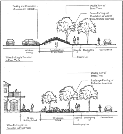
Figure 4.2-2 - Gateway Features
b.
Landscaping - Areas within required setbacks adjacent to a Gateway Street, considered to be the gateway landscape area, must be landscaped with a combination of ground cover, shrubbery, and trees to serve as buffering between the development and the Gateway Street, in accordance with this Chapter. While properties zoned CMU-2 must provide required landscaping, they are exempt from the portion of this requirement that pertains to buffering of buildings.
Screening must block views of the paved surfaces of parking and circulation areas for pedestrians on the abutting public sidewalk, such as on South Third Street, in accordance with this Chapter and the following special screening standards:
1.
Screening must be provided with planted berms with a maximum slope of 3:1, or other effective terrain features, but may not block the view(s) of building facades from the Gateway Street. See Figure 4.2-2 - Gateway Features; and
2.
Mulch, rocks, and other non-plant ground cover materials are not permitted as screening, but are allowed to aid in the establishment of plants and to control erosion.
c.
Fences and Walls - Fences and walls within required setbacks adjacent to a Gateway Street must not exceed three feet above finished grade, and must have a minimum average setback of 12 feet from the Gateway Street right-of-way. The setback must be landscaped in accordance with "b," above. Straight fence or wall segments may not exceed 50 feet in length without an off-set or pillar measuring at least two feet in depth. Pillars must have a clearly defined base and cap and be constructed of brick, masonry, wood, or similar quality material. Cyclone fences are not permitted. Fences and walls associated with required screening of service facilities must be located no closer than 25 feet from a Gateway Street. Service facilities include elements such as trash dumpsters, gas meters, ground-level air conditioning units, other mechanical equipment within required setback areas, etc.
d.
Signs, Facilities, and Features - Monument signs, pedestrian and transit facilities, and water quality/quantity features approved by the City are allowed within the Gateway landscape area. Examples of water quality/quantity features include drainageways, detention ponds, etc.
e.
Parking and Vehicle Circulation - Parking and vehicle circulation areas may not be placed closer than 25 feet from a Gateway Street right-of-way. Such areas must not be visible from a Gateway Street, as provided in "b," above. Where the Gateway Street is used to comply with Section 3.22.40.09, parking and circulation areas may not be placed between the subject building and the Gateway Street.
f.
Pole-mounted Signs - Pole-mounted signs are prohibited within 100 feet of any Gateway Street's right-of-way.
g.
Monument Signs - Monument signs on properties along Gateway Streets are limited to eight feet in height.
Section 4.2.80 - Site Lighting.
Where exterior lighting is proposed, applicants must submit a proposed lighting plan for approval meeting the standards below. Compliance with the provisions listed below is substantiated by the applicant's submittal of the necessary information, such as information including but not limited to manufacturers' light fixture/luminaire specifications, height of free-standing pole-mounted lighting, etc.:
a.
For safety purposes, lighting must be provided in all areas designed to include pedestrian activities, such as streets, sidewalks, multi-use paths, parking lots, buildings, and plazas.
b.
With the exception of lighting for public streets, which is maintained by the City through a contract with an electric company, all other lighting used to illuminate buildings, sidewalks, multi-use paths, parking lots, plazas, or the landscape, will be evaluated during the plan review process associated with requests for permits.
c.
Site lighting that may be confused with warning, emergency, or traffic signals is prohibited.
d.
Light sources (lamps, light bulbs, LEDs, etc.) must be enclosed within a full cut-off fixture. The fixture must incorporate a translucent lens and/or be fully shielded.
(Ord. No. 2022-12, eff. 6-1-2022)
Section 4.3.10 - Purpose.
These provisions are intended to establish the relationship between Primary and Accessory development and to specify criteria for regulating Accessory developments.
Section 4.3.20 - Accessory Uses Encompassed By Principal Uses.
In addition to the designated Primary, Accessory, Special, or Ministerial Development Uses, each zone shall provide for Accessory developments identified in this Chapter. When a proposed Accessory Use is not specified, the Director shall determine the appropriateness of the Use and whether it is customarily associated with, and subordinate to, the Primary development. The Director shall base the decision on the similarity of the proposed Accessory development to those developments specifically identified as Accessory to the Primary developments, and on the relationship between the proposed Accessory development and Primary development. The Director's determination shall be made in accordance with procedures in Chapter 2.16 - Request for Interpretation.
Section 4.3.30 - Accessory Developments Subject To Controls.
Accessory developments are subject to the same requirements as the Primary Uses within each zone, except as otherwise provided below:
a.
Accessory development involving Nonconforming Uses and Nonconforming Structures is subject to the requirements of Chapter 1.4 - Nonconforming Development;
b.
In a residential zone, a side and/or rear yard setback may be reduced to three feet for an Accessory Structure located behind the nearest facade of the primary structure in relation to the front yard of the residence. Vision clearance standards must be maintained;
c.
An Accessory Structure must not exceed a height of 14 feet nor occupy more than 35 percent of a required yard;
d.
Patios and decks not exceeding 30 inches in height from grade and open to the sky may encroach to within 3 feet of interior side and/or rear property lines;
e.
Fences and Landscape Walls - Fences and walls are Accessory Structures, subject to the following provisions:
1)
Maximum Structure Height: 14-feet with additional height limits described below. The height of fences and walls is measured from the lowest adjoining finished grade.
a.
Fences and walls located within any required yard adjacent to a street must not exceed a height of four feet, except as provided in "d" and "e" below.
The Planning Commission may grant an outright exception to this provision as part of its approval of a Special Development application, where the fence or wall provides screening that mitigates a compatibility concern.
b.
Notwithstanding the height restrictions outlined in "a," above, the height of fences and walls is limited to a maximum of four feet when constructed within five feet or less of sidewalks and multi-use paths that are not adjacent or parallel to streets. Examples of such situations include sidewalks and multi-use paths adjacent to pedestrian and bicycle connections between Cul-de-sacs or between residential areas and neighborhood centers, etc. This limitation is intended to increase visibility and public safety. Portions of fences and walls above four feet in height are allowed, when they are designed and constructed of materials that are open a minimum of 50 percent. Fence and wall heights is measured from the grade of the sidewalk or multi-use path. Fences and walls along sidewalks and multi-use paths must be located outside of any associated rights-of-way and/or easement areas.
c.
Fences and walls located within any required exterior side yard are allowed up to six feet in height provided the screen is no closer than five feet from the exterior side-yard property line and a five-foot-wide landscaped buffer is maintained on the street side of the fence. Exterior side yard fencing above four feet in height is not allowed to extend closer to the front property line than the rear of the building at its closest point to the exterior side yard.
d.
In exterior side yards of residential lots of a size less than 5,500 square feet, fences and walls up to six feet in height are allowed to be located up to the exterior side-yard property line, unless the property line is located at the edge of a curbside sidewalk, in which case the fence must be set back one foot from the property line. The six-foot height allowance extends 50 feet forward from the rear property line or to the rear of the building at its closest point to the exterior side yard, whichever distance is greater (Refer to Figure 4.3-1).
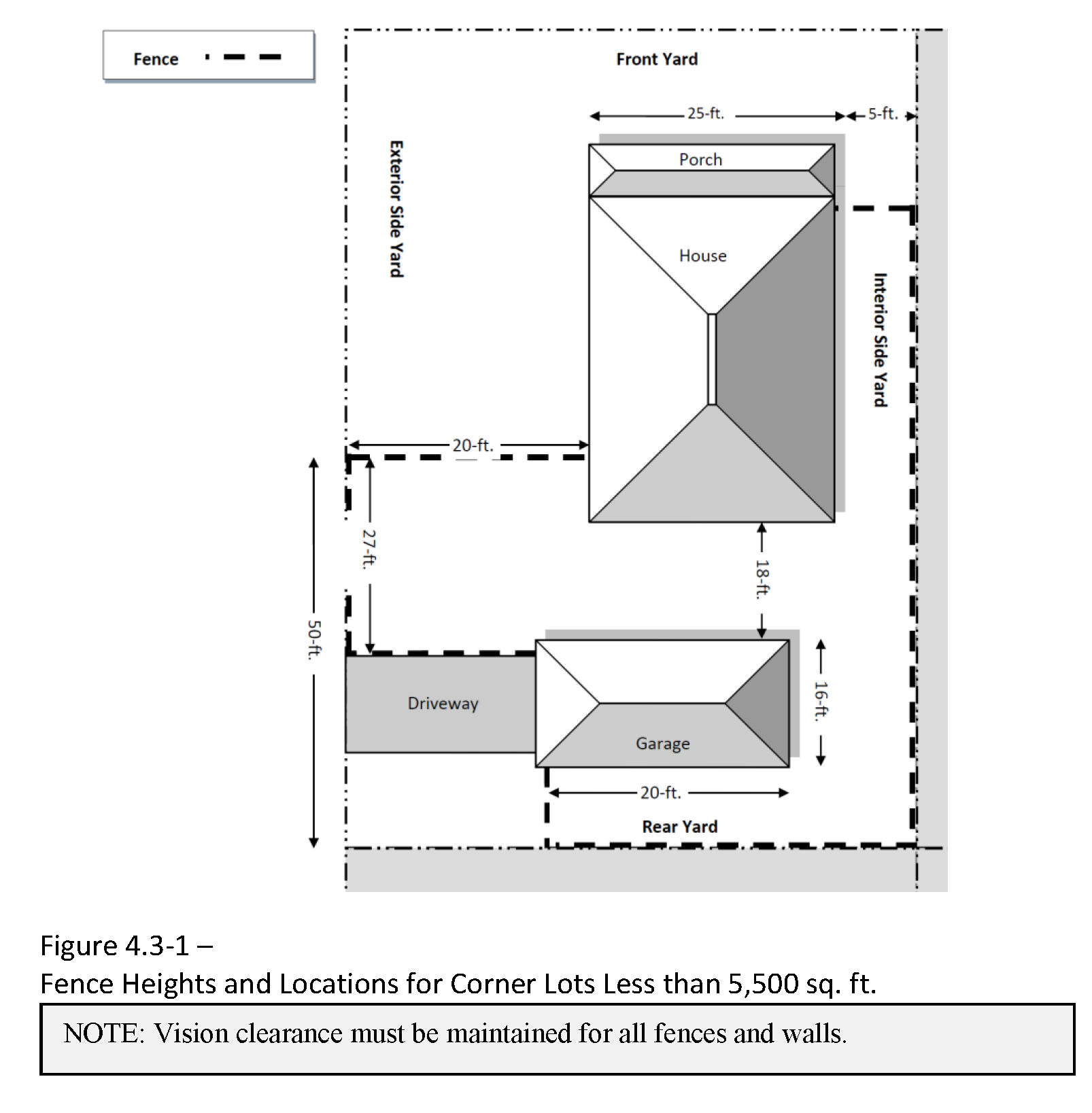
2)
Vision clearance must be maintained for all fences and walls.
3)
Accessory structures commonly integrated into fencing and garden designs, such as Arbors, Pergolas, and Trellises, are permitted within required front, side, and rear yard setbacks, and may be up to 10 feet in height, provided the structure is at least 50% open above the height at which an opaque fence in the same location would be allowed as described in this Section. However, within front yard setback areas, the cumulative width of such structures, as measured parallel to the lot's front property line, may be no more than 15 feet. Building code may require special construction techniques and materials for structures near property lines.
4)
Chainlink fences are prohibited within 100 feet of the identified Gateway Street within the Limited Industrial-Office Zone, unless they are screened in accordance with landscape screening requirements in this Chapter. See Section 3.22.40.03 of this Code.
(Ord. No. 2012-16, eff. 12-13-2012; Ord. No. 2022-12, eff. 6-1-2022)
Section 4.3.40 - Residential Use Types.
a.
Accessory Structures must not have bedrooms or sleeping rooms except for detached ADUs built in accordance with the ADU standards of LDC Section 4.9.40. Accessory Structures must be detached from the primary residence, except for decks.
b.
Subject to the restrictions and limitations specified in this Code, the following types of Accessory Structures shall be permitted in zones where Residential Use Types are permitted:
1.
Private garages;
2.
Children's playhouses;
3.
Radio and television antennas - personal use;
4.
Sheds;
5.
Shops;
6.
Barns;
7.
Kennels for dog and cat keeping;
8.
Gazebos;
9.
Solar and wind energy systems, including solar collectors, storage facilities, distribution components, and wind generation devices; and
10.
Other necessary and customary developments as determined by the Director in accordance with Section 4.3.20 above and Chapter 2.16 - Request for Interpretation.
c.
When the primary use on a lot is a Garden, the combined square footage of all accessory structures shall not exceed 600 sq. ft, and the cumulative maximum allowed square footage for all non-greenhouse structures is 200 sq. feet
(Ord. No. 2012-18, eff. 12-13-2012; Ord. No. 2012-19, eff. 12-13-2012; Ord. No. 2020-04, eff. 3-3-2020)
Section 4.3.50 - Civic, Commercial, Industrial, Agricultural, or Extractive Use Types.
Accessory development customarily associated with, and subordinate to, the Primary Civic, Commercial, Industrial, Agricultural, or Extractive Use Types shall be permitted where these Use Types are authorized.
Industrial and Agriculture/Open Space Zones
a.
A single dwelling unit shall be permitted in Industrial zones and the Agricultural/Open Space Zone, provided that the Uses are for the following:
1.
Caretaker or Superintendent - On a lot or building site with a Permitted Industrial Use and occupied exclusively by a caretaker or superintendent of such Industrial Use and his/her family;
2.
Farm Owner or Operator - On a lot or building site having a net area of at least five acres being farmed and occupied exclusively by the owner or operator and his/her family;
3.
Kennel Owner or Operator - On a lot or building site with a kennel, and occupied by the owner or operator; or
4.
Residential Development in a Limited Industrial Zone - On a lot or building site in the Limited Industrial (LI) Zone with residential development in accordance with Section 3.21.20.01.b.2 of Chapter 3.21 - Limited Industrial (LI) Zone.
b.
Retail outlets, cafeterias, and offices accessory to the Primary Use, developed during or following development of the Primary Use.
(Ord. No. 2012-18, eff. 12-13-2012; Ord. No. 2012-19, eff. 12-13-2012; Ord. No. 2020-04, eff. 3-3-2020; Ord. No. 2023-01, 2-8-2023)
Section 4.5.10 - Purposes—Floodplain Provisions.
The State of Oregon has in ORS 197.175 delegated the responsibility to local governmental units to adopt floodplain management regulations designed to promote the public health, safety, and general welfare of its community members. Therefore, Corvallis does ordain as follows:
Without establishing any priority, the purposes of this Chapter are intended to:
a.
Protect human life, health, and property in areas subject to periodic flooding;
b.
Implement the Floodplain requirements of Statewide Planning Goal 7 - which relates to Areas Subject to Natural Disasters and Hazards;
c.
Implement some of the land use aspects of the City's Stormwater Master Plan, as well as some aspects of the City's Endangered Species Act Salmon Response Plan;
d.
Through Floodplain regulation, contribute to the Properly Functioning Condition of Streams and rivers and address, in part, the water quality aspects of Statewide Planning Goal 6;
e.
Manage stormwater drainage in a manner that:
1.
Maintains the Properly Functioning Conditions of Streams;
2.
Provides for the conveyance and temporary storage of floodwater;
3.
Reduces floodwater velocity;
4.
Facilitates sediment deposition in the Floodplain;
5.
Provides an opportunity for groundwater recharge; and
6.
Promotes other Stormwater and Floodplain functions.
These provisions are also intended to minimize maintenance costs, eliminate potential hazards before they occur, and protect properties and persons adjacent to drainageways and to other Natural Hazard areas;
f.
Implement requirements for the City's participation in the National Flood Insurance Program, including the Community Rating System;
g.
Minimize damage to public facilities and utilities such as water purification and sewage treatment plants, water and gas mains, electric, telephone and sewer lines, streets, and bridges located in Floodplains;
h.
Help maintain a stable tax base by providing for the sound use and Development of flood-prone areas;
i.
Minimize expenditure of public money for costly flood control projects;
j.
Minimize the need for rescue and emergency services associated with flooding and generally undertaken at the expense of the general public;
k.
Minimize unnecessary disruption of commerce, access, and public service during times of flood;
l.
Facilitate the notification of potential buyers that property is in the Special Flood Hazard Area;
m.
Compel those who occupy the Special Flood Hazard Areas to assume responsibility for their actions;
n.
Manage the alteration of Special Flood Hazard Areas, stream channels, and shorelines to minimize the impact of Development on the natural and beneficial functions of the Floodplain; and
o.
Methods of Reducing Flood Losses - In order to accomplish its purpose, this chapter and Chapter 2.11 - Floodplain Development Permit include methods and provisions to:
1.
Require that Development that is vulnerable to floods, including buildings, structures, and facilities necessary for the general health, safety and welfare of citizens, be protected against flood damage at the time of initial construction;
2.
Restrict or prohibit uses which are dangerous to health, safety and property due to water or erosion hazards, or which increase flood heights, velocities, or erosion;
3.
Control filling, grading, dredging and other Development which may increase flood damage or erosion;
4.
Prevent or regulate the construction of flood barriers that will unnaturally divert flood waters or that may increase flood hazards to other lands;
5.
Preserve and restore natural Floodplains, stream channels, and natural protective barriers which carry and store flood waters, and;
6.
Coordinate with and supplement provisions of Oregon Building Codes; and
p.
To advance these purposes, where not required, creation of open space Tracts is encouraged within areas designated as Natural Resources or Natural Hazards on the Comprehensive Plan and Official Zoning Maps.
(Ord. No. 2025-31, §§ 2, 8(Exh. A), 7-21-2025)
Section 4.5.20 - Applicability.
4.5.20.01 Natural Hazards that are Subject to this Chapter.
a.
These provisions apply to public and private properties in the Special Flood Hazard Area (100-Year Floodplain) of rivers and local streams;
b.
Mapped Special Flood Hazard Areas - The Special Flood Hazard Area (100-Year Floodplain) in "a," above, is identified on the Corvallis Natural Hazards Map.
The Special Flood Hazard Areas identified by the Federal Emergency Management Agency in its Flood Insurance Study for Benton County and Incorporated Areas, dated June 2, 2011, with accompanying Flood Insurance Rate Maps or Digital Flood Insurance Rate Maps, and other supporting data, are adopted by reference and declared a part of the 100-yr. Floodplain regulations presented below. The Flood Insurance Study and the Flood Insurance Rate Map are on file at the office of the City of Corvallis Engineer at 1245 NE Third Street, Corvallis, Oregon 97330, and at the Development Services Division at 501 SW Madison Avenue, Corvallis, Oregon, 97333.
c.
Unmapped Special Flood Hazard Areas - Not every Special Flood Hazard Area within the Urban Growth Boundary and upper reaches of local streams has been mapped by the Federal Emergency Management Agency through the Flood Insurance Study, Flood Insurance Rate Maps, and Digital Flood Insurance Rate Maps cited above.
The Floodplain Administrator or designee is authorized through Sections 2.11.50.01.h and 4.5.60.02.b to obtain from applicants the information necessary, in a standard digital format adopted by the Director, to determine the presence and extent of unmapped Special Flood Hazard Areas as part of reviewing Development proposals that affect the 100-yr. Floodplain. Once approved by the Floodplain Administrator or designee, the Director will incorporate the new information and designate it as High Protection Floodway Fringe and Regulatory Floodway on the Natural Hazards Map. This new information will then be used by the City of Corvallis to supplement the Flood Insurance Study, Flood Insurance Rate Maps, and Digital Flood Insurance Rate Maps cited above to ensure consistency with the 100-yr. Floodplain regulations contained in this Chapter and Chapter 2.11 - Floodplain Development Permit.
4.5.20.02 Coordination with Building Codes and Greater Restrictions.
a.
Coordination with Building Codes - Pursuant to the requirement established in ORS 455 that the City of Corvallis administers and enforces the State Building Codes, the City Council of the City of Corvallis does hereby acknowledge that the State Building Codes contain certain provisions that apply to the design and construction of buildings and structures located in Special Flood Hazard Areas. Therefore, this chapter and Chapter 2.11 - Floodplain Development Permit are intended to be administered and enforced in conjunction with the State Building Codes.
b.
Greater Restrictions - This Chapter is not intended to repeal, abrogate, or impair any existing easements, covenants, or deed restrictions. However, where this Chapter and any other ordinance, easement, covenant, or deed restriction conflict or overlap, whichever imposes the more stringent restrictions prevails.
4.5.20.03 Exceptions to Achieve Minimum Assured Development Area (MADA).
a.
General - Chapter 4.11 - Minimum Assured Development Area (MADA) explains how Minimum Assured Development Area (MADA) is determined. If the application of Natural Hazard regulations outside prohibited areas, or if the cumulative impact of such Natural Hazard regulations and the application of the regulations in Chapter 4.12 - Significant Vegetation Protection Provisions and Chapter 4.13 - Riparian Corridor and Wetland Provisions would limit the developable portion of a property below the property's MADA, then development will be allowed on the property, to the degree necessary to achieve the MADA, as explained in Chapter 4.11 - Minimum Assured Development Area;
b.
MADA Provisions Cannot be Used to Encroach into the Regulatory Floodway - While Section 4.5.80 allows for some very limited types of activities in the Regulatory Floodway, encroachments for the specific purpose of achieving a Minimum Assured Development Area per Chapter 4.11 - Minimum Assured Development Area (MADA) are prohibited in the Regulatory Floodway.
c.
Floodway Fringe Development Pursuant to MADA Provisions Requires Adherence to Partial Protection Floodplain Provisions - In cases where encroachment into the Floodway Fringe is allowed per the Minimum Assured Development Area provisions in Chapter 4.11 - Minimum Assured Development Area (MADA), all such Development must comply with Section 4.5.100 - Standards in Partial Protection Floodway Fringe Areas.
(Ord. No. 2025-31, §§ 2, 8(Exh. A), 7-21-2025)
Section 4.5.30 - Disclaimer of Liability.
The degree of flood protection required by this Chapter and Chapter 2.11 - Floodplain Development Permit is considered reasonable for regulatory purposes and is based on scientific and engineering considerations. Larger floods and hazard events can and will occur on rare occasions. Flood heights may be increased by man-made or natural causes. Areas impacted by other Natural Hazards may differ from those shown on the Corvallis Natural Hazards Map. Neither this Chapter nor Chapter 2.11 - Floodplain Development Permit implies that land outside the Special Flood Hazard Areas or Uses permitted within such areas will be free from flooding or flood damages, nor does it imply that land outside of mapped hazard areas will be free from damage or earth movement in a hazard event.
Neither this Chapter nor Chapter 2.11 - Floodplain Development Permit will create liability on the part of the City of Corvallis, any officer or employee thereof, or the Federal Insurance Administration, for any flood damages or other hazard damages that result from reliance on this chapter and Chapter 2.11 - Floodplain Development Permit, or any administrative decision lawfully made hereunder. Compliance with the minimum standards established by this Chapter is not intended to relieve any private party from liability for the design or construction of Development which causes damage or injury by increasing flooding or aggravating an existing and known hazard.
Certain fish, wildlife, and plant species in Corvallis may be protected by the federal Endangered Species Act (ESA). Through the issuance of permits required in this Chapter, Corvallis makes no representation or assurance that the subject land use or development activity is permissible under the Endangered Species Act. The Developer applying for a permit required in this Chapter assumes all responsibility to ensure that activities undertaken in accordance with the permit do not violate applicable ESA rules and requirements, or any other state or federal rules or regulations.
(Ord. No. 2025-31, §§ 2, 8(Exh. A), 7-21-2025)
Section 4.5.40 - Findings of Fact, Definitions, and Related Standards.
4.5.40.01 Findings of Fact.
a.
The Special Flood Hazard Areas of the City of Corvallis are subject to periodic inundation that results in loss of life and property, health and safety hazards, disruption of commerce and governmental services, extraordinary public expenditures for flood relief and protection, and impairment of the tax base, all of which adversely affect the public health, safety and general welfare.
b.
These flood losses are caused by buildings and structures in Special Flood Hazard Areas, which are inadequately elevated, flood-proofed, or otherwise unprotected from flood damages, and by the cumulative effect of obstructions in Floodplains causing increases in flood heights and velocities.
c.
The City of Corvallis has the primary responsibility for planning, adoption and enforcement of land use regulations to accomplish proper Floodplain management.
See Section 1.6.40 for the full set of definitions that are unique to the provisions of this Chapter.
4.5.40.03 Relationship of Regulatory Floodway and Floodway Fringe to Regulated Riparian Corridors.
Areas of the Regulatory Floodway and Floodway Fringe that fall within a Regulated Riparian Corridor are also subject to the provisions of Chapter 4.13 - Riparian Corridor and Wetland Provisions. Where regulations are in conflict, the most restrictive applies. See Riparian Corridor, Regulated in Chapter 1.6 - Definitions.
(Ord. No. 2025-31, §§ 2, 8(Exh. A), 7-21-2025)
Section 4.5.50 - Procedures.
Compliance with the provisions of this Chapter is determined through the development review processes identified in Section 1.2.110 of Chapter 1.2 - Legal Framework and in Chapter 2.11 - Floodplain Development Permit. Applications for Excavation and Grading Permits, Floodplain Development Permits, Building Permits or other permits for buildings and structures on sites containing the 100-yr. Floodplain must be submitted by the applicant and reviewed by the city to ensure compliance with specifications referenced herein; and to ensure that development is reasonably safe from anticipated hazards. Such applications also include those needed for Manufactured Dwellings. Other development activities as described in this provision include all the activities listed in the Section 1.6.40 definition for Development. However, unless development qualifies as one of the exceptions per Section 2.11.40 or 4.5.80.05, no rise in Base Flood Elevation (BFE) is allowed.
4.5.50.01 Floodplain Development Permit.
The Developer must obtain a Floodplain Development Permit consistent with Chapter 2.11 - Floodplain Development Permit, prior to initiating Development activities in any Special Flood Hazard Area established through Section 4.5.20.01.
4.5.50.02 Development Application.
Development applications for all properties containing or abutting a mapped or unmapped Special Flood Hazard Area must accurately indicate the locations of these features and the location of any proposed Development. These Development applications include Floodplain Development Permits, Excavation and Grading Permits, Building Permits, Mechanical Permits, Plumbing Permits, Electrical Permits, Public Improvements by Private Contract Permits (PIPC), and any land use application identified in Chapter 2.1 - Comprehensive Plan Amendment through Chapter 2.13 - Plan Compatibility Review.
(Ord. No. 2021-22, eff. 11-24-2021; Ord. No. 2025-31, §§ 2, 8(Exh. A), 7-21-2025)
Section 4.5.60 - Administration and Interpretation.
4.5.60.01 Administration.
a.
Designation of a Local Floodplain Administrator - The City Engineer is hereby appointed as the Floodplain Administrator. The City Engineer or designee is responsible for administering, implementing, and enforcing the provisions of this chapter and Chapter 2.11 - Floodplain Development Permit;
b.
Duties and Responsibilities of the Floodplain Administrator or Designee - Duties of the Floodplain Administrator or designee include, but are not limited to:
1.
Review all Floodplain Development Permit applications to determine whether proposed new Development will be located in Special Flood Hazard Area;
2.
Review applications for modifications of any existing Development in Special Flood Hazard Areas for compliance with the requirements of this Chapter and Chapter 2.11 - Floodplain Development Permit;
3.
Interpret Special Flood Hazard Area boundaries, provide available Special Flood Hazard Area information, and provide Base Flood Elevations, where they exist;
4.
Review proposed Development to assure that applicants have obtained and provided the necessary permits from governmental agencies from which approval is required by federal or state law, including, but not limited to, Section 404 of the Federal Water Pollution Control Act Amendments of 1972, 33 U.S.C. 1334; the Endangered Species Act of 1973, 16 U.S.C. 1531-1544; and State of Oregon Removal-Fill permits. Copies of such permits will be maintained on file by the City;
5.
Review all Floodplain Development Permit applications to determine if:
- the proposed Development is located within the Regulatory Floodway and, if so, ensure that the encroachment standards of Section 4.5.80 are met;
- the proposed development is a watercourse alteration and, if so, ensure compliance with the provisions in Section 4.5.80.02.
- the proposed development activity includes the placement of fill or excavation.
6.
When Base Flood Elevation or Floodway data have not been identified by FEMA in a Flood Insurance Study and/or Flood Insurance Rate Maps, the Floodplain Administrator or designee will require the Developer provide a Floodplain study prepared by a licensed engineer. The study must meet the requirements of Section 2.11.50.01.h. Newly mapped 100-yr. Floodplain areas will be designated as High Protection Floodway Fringe and 0.2-ft. Floodway on the Natural Hazards Map. Upon receipt and approval of this Floodplain study, the Floodplain Administrator or designee will review, and reasonably utilize scientific or historic Base Flood Elevation and Floodway data available from a federal, state, or other source, in order to administer this chapter and Chapter 2.11 - Floodplain Development Permit;
7.
When Base Flood Elevations or other engineering data are not available from an authoritative source, the Floodplain Administrator or designee will take into account the Special Flood Hazard Areas, to the extent they are known, to determine whether a proposed building site or Subdivision will be reasonably safe from flooding. Oregon Residential Specialty Code R324.1.3 authorizes the Building Official to require an applicant to determine a Base Flood Elevation where none exists. Additionally, Section 2.11.50.01.h authorizes the Floodplain Administrator or designee to require an applicant to provide a Floodplain study in accordance with the provisions of that Code section. Newly mapped 100-yr. Floodplain areas will be designated as High Protection Floodway Fringe and 0.2-ft. Floodway on the Natural Hazards Map ;
8.
Where interpretation is needed in order to determine the boundaries of the Special Flood Hazard Areas, including the Regulatory Floodway (for example, where there appears to be a conflict between a mapped boundary and actual field conditions), the Floodplain Administrator or designee will make the interpretation. Any person contesting the location of the boundary must be given a reasonable opportunity to appeal the interpretation as provided in Section 1.1.30;
9.
Issue Floodplain Development Permits when the provisions of Chapter 2.11 - Floodplain Development Permit have been met, or deny the same in the event of noncompliance;
10.
Coordinate with the Building Official to assure that applications for Building Permits comply with the requirements of this chapter and Chapter 2.11 - Floodplain Development Permit;
11.
Obtain from applicants, verify, and record the actual elevation in relation to the vertical datum used on the effective Flood Insurance Rate Map, or Highest Adjacent Grade where no Base Flood Elevation is available, of the Lowest Floor level, including Basement, of all New Construction or Substantially Improved buildings and structures;
12.
Obtain from applicants, verify, and record the actual elevation, in relation to the vertical datum used on the effective Flood Insurance Rate Map, or Highest Adjacent Grade where no Base Flood Elevation is available, to which any new or Substantially Improved buildings or structures have been flood-proofed. When flood-proofing is utilized for a structure, the Floodplain Administrator or designee will obtain from the Developer certification of design criteria from a registered professional engineer or architect;
13.
Ensure that all records pertaining to the 100-yr. Floodplain regulations presented in this Chapter are permanently maintained in the office of the Floodplain Administrator or designee and are available for public inspection;
14.
Make inspections in Special Flood Hazard Areas to determine whether Development has been undertaken without issuance of a Floodplain Development Permit, ensure that Development is undertaken in accordance with a Floodplain Development Permit and the provisions of this Chapter and Chapter 2.11 - Floodplain Development Permit, and verify that existing buildings and structures maintain compliance with the provisions of this Chapter and Chapter 2.11 - Floodplain Development Permit;
15.
The Floodplain Administrator or designee will make periodic inspections of Floodplain areas to establish that Development activities within the Floodplain are being performed in compliance with an approved Floodplain Development Permit. The Floodplain Administrator or designee will prepare a field report listing non-complying conditions and will proceed with enforcement actions including, but not limited to: the issuance of a Stop Work Order; the issuance of a citation; and the commencement of civil legal proceedings;
16.
Coordinate with the Building Official to inspect areas where existing buildings and structures in Special Flood Hazard Areas have been damaged, regardless of the cause of damage, and notify owners that permits may be required prior to repair, rehabilitation, demolition, relocation, or reconstruction of the Building or Structure; and
17.
Make Substantial Improvement or Substantial Damage determinations.
18.
Enforce the provisions of this Chapter and Chapter 2.11 - Floodplain Development Permit, as provided in Chapter 1.3 (Enforcement).
a.
Interpretation and Application of this Chapter and Chapter 2.11 - Floodplain Development Permit - In the interpretation and application of the 100-yr. Floodplain regulations presented below, all provisions will be:
1.
Considered as minimum requirements;
2.
Liberally construed in favor of the governing body, and;
3.
Deemed neither to limit nor repeal any other powers granted under state statutes, including state Building Codes.
b.
Interpretation of Flood Insurance Rate Map and Other Floodplain Boundaries:
1.
When there is a conflict between a mapped boundary and actual field conditions, the Floodplain Administrator or designee will determine the boundaries of the Floodplain.
2.
Where FEMA Base Flood Elevation information is unavailable for Special Flood Hazard Areas, the Floodplain Administrator or designee will obtain, review, and reasonably utilize any Base Flood Elevation and Floodway data as a basis for applying standards in the Floodway Fringe and Regulatory Floodway.
3.
Where there are multiple Flood Maps for an area, the more restrictive Flood Map applies unless it is determined that one map is inaccurate. Where interpretation is needed to determine which map is more restrictive or accurate, the Floodplain Administrator or designee will make the interpretation.
c.
The Floodplain Administrator or designee is authorized to require the Developer to provide the information required to make these interpretations in accordance with Sections 2.11.50.01.h and 4.5.20.01.c.
(Ord. No. 2025-31, §§ 2, 8(Exh. A), 7-21-2025)
Section 4.5.70 - Incentives for Relocating Buildings, Structures, Parking Lots, and Other Impervious Surfaces Outside the 100-Yr. Floodplain.
Existing buildings and structures, parking lots, and other impervious surface areas that are removed from the 100-yr. Floodplain will qualify for the benefits in "a," and "b," below. Additionally, new Development is also eligible for the benefits in "a," and "b," below, in areas of the 100-yr. Floodplain where such Development is allowed, including identified portions of the Willamette River, Mary's River, Millrace Floodplain, and Partially Protected local Stream areas.
4.5.70.01 Allowed Intensification.
a.
Residentially Zoned Properties - Development or redevelopment of a residentially zoned property, or of a group of contiguous residentially zoned properties, may transfer density from portions of the site within the Floodway Fringe to portions of the site outside of the Floodway Fringe to the extent allowed by use of the Development standards in the next most intensive Development zone. However, this intensification is only allowed provided that, in resultant Development, no buildings, structures or parking areas are located within the Floodway Fringe portion of the site.
b.
Nonresidentially Zoned Properties for which at Least 25 Percent of the Total Site Area is within the 100-yr. Floodplain -
1.
Allowed building height of the underlying zone may be increased by 10 ft. if all improvements, including buildings and parking areas, are removed from at least 75 percent of the site area within the Floodplain. This is not a cumulative standard and cannot be combined with height exceptions allowed elsewhere in this Code.
2.
Allowed building height of the underlying zone may be increased by 20 ft. if all improvements, including buildings and parking areas, are removed from 100 percent of the site area within the Floodplain. This is not a cumulative standard and cannot be combined with height exceptions allowed elsewhere in this Code.
4.5.70.02 Reduction of Impervious Surface Area for Development Sites with at Least 50 percent of Their Area within the 100-yr. Floodplain.
When a Development site has at least 50 percent of its site area within the 100-yr. Floodplain, the height of buildings and structures may be increased by 10 ft. above the height normally allowed in the applicable underlying Development zone if Development or redevelopment of the site results in pervious surface area for at least 50 percent of the entire Development site. Gravel, paving, concrete, buildings, and structures are all impervious. This is not a cumulative standard and cannot be combined with height exceptions allowed elsewhere in this Code.
(Ord. No. 2025-31, §§ 2, 8(Exh. A), 7-21-2025)
Section 4.5.80 - Standards in the Regulatory Floodway.
4.5.80.01 Encroachments.
Development encroachments are not allowed within the Regulatory Floodway. Encroachments include fill, New Construction, fences, Substantial Improvements (except as provided in Section 4.5.80.03.c, below), and other Development.
Exceptions:
a.
Exceptions listed in Sections 4.5.80.02, 4.5.80.03, and 4.5.80.04.
b.
Bridges, infrastructure, utilities, or Water-dependent Uses, for which it may be demonstrated, through hydrologic and hydraulic analyses certified by a registered professional civil engineer and performed in accordance with standard engineering practices, that the proposed encroachment would not result in any increase in flood levels within the community during the Base Flood discharge.
c.
Where exceptions apply, Development within the Regulatory Floodway must comply with all applicable state and federal requirements. Construction of these facilities must be shown to cause minimal harm to the Properly Functioning Condition of the stream. These improvements are subject to the City's Engineering Standards.
4.5.80.02 Watercourse Relocations.
Watercourse relocation by artificial means is prohibited, except for emergency management purposes, the realignment of Dunawi Creek back to its natural alignment as allowed by the note on the Comprehensive Plan Map, or as mandated by state or federal actions that supersede local authority. For riverine situations, the applicant who is authorized for such a relocation must notify the Oregon Department of State Lands (DSL) and the Oregon Department of Land Conservation and Development, and submit copies of such notification to the Floodplain Administrator or designee, prior to the relocation of the Watercourse. The applicant is required to submit copies of said notification to those adjacent communities that the Floodplain Administrator or designee determines should receive such notification. The Developer must submit to the Floodplain Administrator or designee certification provided by a registered professional engineer, assuring that the flood carrying capacity of a relocated Watercourse can and will be maintained.
4.5.80.03 Limitations and Exceptions to Activities in the Regulatory Floodway.
In addition to the requirements of the underlying zone, the limitations and exceptions in "a," through "c," below, and in Sections 4.5.80.04 and 4.5.80.05 apply to activities within the Regulatory Floodway. Where applicable state or federal regulations provide greater restrictions, such regulations apply. The Developer must obtain all necessary local, state, and federal approvals prior to the commencement of earth movement or construction in these areas.
a.
Removal of Vegetation - Removal of vegetation from the Regulatory Floodway is prohibited, except for the following purposes, as approved by the Floodplain Administrator or designee:
1.
Stream restoration and enhancement programs;
2.
Removal of Invasive and/or Noxious Vegetation as defined in Chapter 1.6 - Definitions. If necessary in conjunction with vegetation removal, non-rip-rap erosion control measures must be utilized;
3.
For the Development of Water-related or Water-dependent Uses, provided they are designed and constructed to minimize impact on the existing Riparian Vegetation;
4.
Removal of emergent in-channel vegetation and debris likely to cause flooding events that result in structural damage;
5.
Mowing/cutting of vegetation and in a 20-ft. perimeter around buildings and structures for fire hazard prevention;
6.
Continuation of agricultural activities occurring on a property prior to December 31, 2004, such as grazing livestock, growing crops, etc. However, the use of herbicides, or other pesticides, the application of synthetic fertilizers, and the storage of toxic materials in these areas is subject to applicable state and federal regulations and is also subject to the restrictions set forth in the Corvallis Municipal Code;
7.
Removal of Hazardous Trees - Requests for removal of Hazardous Trees, except in emergency circumstances, will be reviewed by the City Urban Forester (or another qualified arborist) and approved, conditionally approved, or denied by the Community Development Director. Any trees removed must be replaced by the Developer, with like native species or alternative approved native species listed on the City of Corvallis Native Plant List; and
8.
For maintenance consistent with the City of Corvallis Public Works Department Urban Stream Maintenance Guidelines. However, any maintenance conducted according to these guidelines may only be done if it is consistent with the other applicable provisions of this Chapter 4.5 - Floodplain Provisions, as well as the applicable provisions of Chapter 4.11 - Minimum Assured Development Area (MADA), Chapter 4.12 - Significant Vegetation Protection Provisions, Chapter 4.13 - Riparian Corridor and Wetland Provisions, and Chapter 4.14 - Landslide Hazard and Hillside Development Provisions.
b.
Maintenance within the Regulatory Floodway -
1.
The limitations imposed by this Section do not preclude the routine maintenance of existing buildings and structures, nor the routine maintenance, repair, and replacement of infrastructure in the Regulatory Floodway.
2.
Maintenance of lawns, non-native riparian planted vegetation, and landscaping must be kept to a minimum. Additionally, the application of herbicides or other pesticides, and the application of synthetic fertilizers is subject to applicable state and federal regulations and developed properties are subject to the restrictions set forth in the Corvallis Municipal Code;
3.
Where replanting is done, native species listed on the City of Corvallis Native Plant List must be used, with the exception of continuing agricultural uses, as specified in Section 4.5.80.03.a.6;
4.
Maintenance pruning of existing trees must be kept to a minimum and performed in accordance with the American National Standards Institute (ANSI) A300 standards for Tree Care Operations. Maintenance pruning must not compromise the tree's health, longevity, and resource functions;
5.
Vegetation within utility easements must be kept in a natural state and replanted when necessary with native plant species listed on the City of Corvallis Native Plant List. However, trees are not allowed within utility easements;
6.
Disposal of yard waste or other organic materials is prohibited within the Top-of-bank boundary of any Stream, and is regulated by restrictions in the Corvallis Municipal Code; and
7.
Maintenance consistent with the City of Corvallis Public Works Department Urban Stream Maintenance Guidelines. However, any maintenance conducted according to these guidelines may only be done if it is consistent with the other applicable provisions of this Chapter 4.5 - Floodplain Provisions, as well as the applicable provisions of Chapter 4.11 - Minimum Assured Development Area (MADA), Chapter 4.12 - Significant Vegetation Protection Provisions, Chapter 4.13 - Riparian Corridor and Wetland Provisions, and Chapter 4.14 - Landslide Hazard and Hillside Development Provisions.
c.
Existing Buildings and Structures Constructed Prior to December 4, 1984 - Existing buildings and structures that were constructed prior to December 4, 1984, and are located in the area between the 1.0-ft. Floodway and the 0.2-ft. Floodway will not be considered Nonconforming Structures for the purposes of this Chapter. Additionally, Substantial Improvement or replacement within the same footprint is permitted. Such replacements must comply with the mandatory construction standards in Sections 4.5.100 and 4.5.110.
4.5.80.04 Placement of Fill within the Regulatory Floodway.
Placement of fill is not allowed within the Regulatory Floodway.
Exception:
a.
Exceptions listed in Sections 2.11.40, 4.5.80.01, or 4.5.80.05.
b.
The applicant must design any fill such that the fill is stable under conditions of flooding, including rapid rise and rapid drawdown of floodwaters, prolonged inundation, and flood-related erosion and scour. This development standard may not be varied.
4.5.80.05 Exception to the Regulatory Floodway "No Rise" Standard.
No rise in Base Flood Elevation (BFE) is allowed.
Exception:
Notwithstanding Section 4.5.80.01, an increase in the Base Flood Elevation within the Regulatory Floodway may be permitted in exceptional circumstances, if the Floodplain Administrator or designee approves the exceptional circumstances and if the applicant obtains approval of a Conditional Letter of Map Revision (CLOMR) by the Federal Emergency Management Agency. An applicant must strictly adhere to the procedures for obtaining a CLOMR, as described in Section 2.11.50.01, and provide copies of a valid CLOMR to the Floodplain Administrator or designee prior to receiving approval of a local land use request that will result in any increase in Base Flood Elevation within the Regulatory Floodway.
(Ord. No. 2025-31, §§ 2, 8(Exh. A), 7-21-2025)
Section 4.5.90 - Standards in High Protection Floodway Fringe Areas.
In addition to the requirements of the underlying zone, the following standards apply to activities and Development in High Protection Floodway Fringe areas. Generally, these areas contain the 100-yr. Floodplain of local Streams, but not the portions of the Millrace and Willamette and Mary's River 100-yr. Floodplains within the City Limits boundary, as of December 31, 2004. Additionally, Special Flood Hazard Areas mapped after December 31, 2004, will be designated High Protection Floodway Fringe and subject to the standards of this chapter and Chapter 2.11 - Floodplain Development Permit.
Where applicable state or federal regulations provide greater restrictions, such regulations apply. The Developer must obtain all necessary local, state, and federal approvals prior to the commencement of earth movement or construction in these areas.
4.5.90.01 Removal of Vegetation.
Removal of vegetation from High Protection Floodway Fringe areas is prohibited.
Exceptions - The Floodplain Administrator or designee will allow the Exemptions listed in Section 2.11.40, and the following activities within High Protection Floodway Fringe areas:
a.
Stream restoration and enhancement programs;
b.
Removal of Invasive and/or Noxious Vegetation as defined in Chapter 1.6 - Definitions. If necessary in conjunction with vegetation removal, non-rip-rap erosion control measures must be utilized;
c.
For the Development of Water-related or Water-dependent Uses, provided they are designed and constructed to minimize impact on the existing Riparian Vegetation;
d.
Removal of emergent in-channel vegetation likely to cause flooding events that result in structural damage;
e.
Mowing/cutting of vegetation in a 20-ft. perimeter around buildings and structures for fire hazard prevention;
f.
Continuation of agricultural activities occurring on a property prior to December 31, 2004, such as grazing livestock, growing crops, etc. However, the use of herbicides, or other pesticides, the application of synthetic fertilizers, and the storage of toxic materials in these areas is subject to applicable state and federal regulations, and is also subject to the restrictions set forth in the Corvallis Municipal Code;
g.
Maintenance and protection of the function of City utilities and transportation facilities located within Floodway Fringe areas;
h.
Removal of Hazardous Trees - Requests for removal of Hazardous Trees, except in emergency circumstances, will be reviewed by the City Urban Forester (or another qualified arborist) and approved, conditionally approved, or denied by the Community Development Director. Any trees removed must be replaced by the Developer with like native species or alternative approved native species listed on the City of Corvallis Native Plant List;
i.
Maintenance consistent with the City of Corvallis Public Works Department Urban Stream Maintenance Guidelines. However, any maintenance conducted according to these guidelines may only be done if it is consistent with the other applicable provisions of this Chapter 4.5 - Floodplain Provisions, as well as the applicable provisions of Chapter 4.11 - Minimum Assured Development Area (MADA), Chapter 4.12 - Significant Vegetation Protection Provisions, Chapter 4.13 - Riparian Corridor and Wetland Provisions, and Chapter 4.14 - Landslide Hazard and Hillside Development Provisions; and
j.
Removal of vegetation as permitted in Chapter 4.11 - Minimum Assured Development Area (MADA). All encroachments permitted using the MADA provisions must comply with Section 4.5.100 - Standards in Partial Protection Floodway Fringe Areas.
4.5.90.02 Building, Paving, and Grading Activities.
The placement of buildings and structures or impervious surfaces, as well as grading, excavation, and the placement of fill, are prohibited in High Protection Floodway Fringe areas.
Exceptions - The Floodplain Administrator or designee will allow the Exemptions listed in Section 2.11.40, and the following activities within High Protection Floodway Fringe areas, provided they are designed and constructed to minimize adverse impacts to Stormwater and Floodplain Functions within the Floodway Fringe, comply with the mandatory construction standards in Sections 4.5.100 and 4.5.110 and, unless permitted in accordance with Section 4.5.80, result in no increase in Base Flood Elevation.
a.
Replacement or Relocation of Existing Buildings and Other Structures - Replacement or relocation of existing buildings and/or other structures, either within the original footprint, or with the same or reduced square footage area elsewhere in the Floodplain portion of the site. A relocation of an existing building and/or other structure within the same square footage area, but located elsewhere within the Floodplain portion of the site, is only allowed if the relocated building and/or other structure enhances Stormwater and Floodplain Function. The relocation will be considered to enhance Stormwater and Floodplain Function if it furthers any of the following goals without worsening any other goal:
1.
Replaces standard construction with flow-through construction;
2.
Moves the structure or paved area to a higher elevation;
3.
Moves the structure or paved area further from the Top-of-bank of the adjacent Watercourse;
4.
Reduces the amount of impervious surface area in the Floodway Fringe;
5.
Does not negatively impact non-noxious Riparian Vegetation. Invasive and/or Noxious Vegetation is defined in Chapter 1.6 - Definitions; and/or
6.
Maintains or reduces the volume of floodwater displacement.
b.
Additions to existing buildings and structures that either:
1.
Fall below the threshold of Substantial Improvement as defined in Chapter 1.6 - Definitions; or
2.
Will not result in the filling of additional Floodway Fringe area, such as a second story addition or Flow-through Design construction;
c.
Location, maintenance, repair, and replacement of infrastructure, and construction of streets, utilities, bridges, bicycle, and pedestrian facilities. Location and construction of such facilities within High Protection Floodway Fringe areas must be deemed necessary to maintain a functional system by the City Engineer. This Code, City Transportation and Utility Master Plans, and other adopted City plans will guide this determination;
d.
Redevelopment of utility operations existing as of December 31, 2004. Required riparian easement areas must be re-vegetated by the applicant, consistent with Section 4.13.50.d.1 and Section 4.13.50.d.2 of Chapter 4.13 - Riparian Corridor and Wetland Provisions;
e.
Development of Water-related and Water-dependent Uses, including associated drainage facilities, water and sewer utilities, stormwater detention and retention facilities, flood control projects, and drainage pumps. These improvements are subject to the City's Engineering Standards;
f.
Erosion control or flood control measures that have been approved by the Oregon Department of State Lands (DSL), the U.S. Army Corps of Engineers, or other state or federal regulatory agency with jurisdiction in this area. Erosion control or flood control measures must either utilize bio-engineering methods other than rip-rap, or utilize rip-rap only to address an imminent hazard to a structure built prior to December 31, 2004. If utilized, the rip-rap installation must be designed by a Professional Engineer Licensed by the State of Oregon and approved by the Oregon Department of Fish and Wildlife; and
g.
Development encroachments as permitted in Chapter 4.11 - Minimum Assured Development Area (MADA). All encroachments permitted using the MADA provisions must comply with Section 4.5.100 - Standards in Partial Protection Floodway Fringe Areas.
4.5.90.03 Subdivisions, Partitions, and Property Line Adjustments.
Subdivision, Partition, and Property Line Adjustment applications must comply with Section 4.11.30.
4.5.90.04 Maintenance within Floodway Fringe Areas.
The limitations imposed by this Section do not preclude the routine maintenance of allowed or pre-existing buildings, structures, infrastructure, and landscaped areas.
a.
Maintenance of lawns, non-native riparian planted vegetation and landscaping may not involve an expansion of lawn areas or remove or damage any non-hazardous tree. A lawn area is defined as vegetated area mowed to an 18-in. or less height;
b.
The application of herbicides or other pesticides, and the application of synthetic fertilizers are subject to applicable state and federal regulations; and developed properties are subject to the restrictions set forth in the Corvallis Municipal Code;
c.
Where replanting is done, native species from the City of Corvallis Native Plant List must be used, with the exception of continuing agricultural uses, as specified in Section 4.5.90.01.f;
d.
Maintenance pruning of existing trees must be kept to a minimum and performed in accordance with the American National Standards Institute (ANSI) A300 standards for Tree Care Operations. Under no circumstances may the maintenance pruning be so severe that it compromises the tree's health, longevity, and resource functions;
e.
Vegetation within utility easements must be kept in a natural state and replanted when necessary with native plant species. However, no trees may be planted within utility easements;
f.
Disposal of yard waste or other organic materials is prohibited within 25 ft. of the Top-of-bank boundary of any Stream, and is regulated by restrictions in the Corvallis Municipal Code; and
g.
Maintenance consistent with the City of Corvallis Public Works Department Urban Stream Maintenance Guidelines. However, any maintenance conducted according to these guidelines may only be done if it is consistent with the other applicable provisions of this Chapter 4.5 - Floodplain Provisions, as well as the applicable provisions of Chapter 4.11 - Minimum Assured Development Area (MADA), Chapter 4.12 - Significant Vegetation Protection Provisions, Chapter 4.13 - Riparian Corridor and Wetland Provisions, and Chapter 4.14 - Landslide Hazard and Hillside Development Provisions.
(Ord. No. 2025-31, §§ 2, 8(Exh. A), 7-21-2025)
Section 4.5.100 - Standards in Partial Protection Floodway Fringe Areas.
In addition to the requirements of the underlying zone, the following standards apply to activities and Development in Partial Protection Floodway Fringe areas. These areas contain the portions of the Millrace, Willamette River, and Marys River 100-yr. Floodplain within the City Limits boundary, as of December 31, 2004; and specific portions of local Streams as noted on the Riparian Corridors and Wetlands Map.
Where applicable state or federal regulations provide greater restrictions, such regulations apply. The applicant must obtain all necessary local, state, and federal approvals prior to the commencement of earth movement or construction in these areas.
Except as provided in Sections 4.5.100.01 and 2.11.40, the placement of fill is prohibited within Partial Protection Floodway Fringe areas.
4.5.100.01 Excavation and Grading.
a.
Volumetric exchange: To compensate for the deposition of fill materials or construction of flood-proofed buildings within any portion of the 100-yr. Floodplain, an equal amount of material must be removed from the same property or Development Site to ensure that the available flood volume of the 100-yr. Floodplain is not reduced. Unless permitted in accordance with Section 4.5.80, no increase in Base Flood Elevation will be permitted.
1.
Volumetric exchange is limited to the following areas:
a.
Floodway Fringe portions of the Mill Race and Willamette and Marys Rivers; and
b.
Floodway Fringe portions of other local streams, provided the area is designated as Partial Protection Floodplain on the Natural Hazards Map and at least one of the following is true:
i.
The development is nonresidential construction; or
ii.
The development is residential construction and the development is less than a Substantial Improvement; or
iii.
The development is residential on a site where the natural grade is such that, if flow-through design were used and the finished floor elevation were constructed at the Design Flood Elevation (DFE), the resulting foundation wall would not be deep enough to accommodate the required venting below base flood elevation; or
iv.
The development is a garage; or
v.
The development is a driveway or building access.
2.
Volumetric exchange is required for flood-proofed buildings and structures within the Floodway Fringe but is not required for buildings constructed with Flow-through Design.
3.
The volume of a stormwater detention facility necessary to accommodate the designed-for storm event will not count as an element of volumetric exchange.
b.
Material removed from the site may not be taken from Significant Natural Resource areas as mapped on the Corvallis Significant Vegetation Map and Riparian Corridors and Wetlands Map, and may only be removed consistent with all requirements of this Code and other applicable City policies;
c.
Areas of fill and excavation must be designed to accommodate floodwater flows and not create barriers to the flow of floodwater. Proposals to alter topography in the Floodplain must demonstrate that they will not result in alteration of hydrology or flow regimes that would cause erosion, ponding, new or increased drainage onto neighboring properties, or other problems;
d.
Dikes are prohibited in these areas; and
e.
The applicant must design any fill allowed to be placed within the Floodway Fringe such that it is stable under conditions of flooding, including rapid rise and rapid drawdown of floodwaters, prolonged inundation, and flood-related erosion and scour.
4.5.100.02 Parking Limitation - to Reduce Impervious Surface Area in the Floodplain.
a.
Where permitted, expansion, redevelopment, or Development of a parking lot containing four or more parking spaces within any portion of the Floodway Fringe is limited to 50 percent of the maximum amount of parking allowed per Chapter 4.1 - Parking, Loading, and Access Requirements, unless "1," or "2," below, is true. In Zones where the maximum amount of parking standard does not apply, all new parking must comply with "1" or "2" below.
1.
Be constructed of appropriate pervious materials approved by the City Engineer; or
2.
Be contained in a multi-story structured parking facility with at least 50 percent of the provided parking located above ground level and utilizing Flow-through Design.
b.
Compact Spaces - Where parking lots are permitted in the Floodway Fringe:
1.
50 percent of the parking spaces within new and redeveloped parking lots must be compact spaces; and
2.
If existing parking lots within the Floodway Fringe are permitted to expand, per the provisions of this Chapter, all additional parking spaces created in the expanded parking lot must be compact spaces, until the 50 percent threshold in "1," above, is reached for the overall parking lot.
c.
Parking Lots - Parking lot design must allow for the entry and exit of floodwaters by incorporating voids within the curb and installing paving materials and landscaping at existing grade.
4.5.100.03 Adherence to Sections 4.5.110, 4.5.120, and 4.5.20.03.
Development is required to adhere to the Construction standards in Section 4.5.110, Subdivision, Partition, and Property Line Adjustment standards in Section 4.5.120, and Minimum Assured Development Area (MADA) in Section 4.5.20.03.
(Ord. No. 2023-19, § 37(Exh. A), eff. 6-30-2023; Ord. No. 2025-31, §§ 2, 8(Exh. A), 7-21-2025)
Section 4.5.110 - Construction Standards Within the 100-yr. Floodplain.
General Standards for All Construction - Development within the Floodway Fringe (Federal Flood Zones A, AH, A1-A30, AE, AO, and A99 on the Flood Insurance Rate Map), including residential and nonresidential buildings and structures and the public and private facilities serving these buildings and structures, must adhere to the following standards so as to minimize damage from flooding. Unless permitted in accordance with Section 4.5.80, no increase in Base Flood Elevation will be permitted. Although other types of construction are allowed by this Code, Flow-through Designs are preferable. The standards in Section 4.5.110.01 through Section 4.5.110.03, below, apply to all construction within the Floodway Fringe. Additional standards in Section 4.5.110.04 through Section 4.5.110.15, below, apply, for the specific types of development stated in those Sections.
4.5.110.01 [Permits.].
The applicant must obtain all necessary permits from those governmental agencies from which approval is required by federal or state law, including Section 404 of the Federal Water Pollution Control Act Amendments of 1972, 33 U.S.C. 1334, as amended. If obtaining such permits is a Condition of Approval for a land use application, such Condition of Approval must be satisfied prior to issuance of any construction permit.
4.5.110.02 [Permit Applications.].
All Land Division and Building Permit applications, including the placement of mobile and Manufactured Dwellings within Federal Flood Zones A, A1-A30, AE, AH, AO, and A99, will be reviewed for conformance with these standards.
a.
Be consistent with the need to minimize flood damage;
b.
Locate and construct utilities such as sewer, gas, electrical, and water systems to minimize or eliminate flood damage;
c.
Provide adequate drainage to reduce exposure to flood hazards;
d.
Design new and replacement water systems within flood-prone areas to minimize or eliminate infiltration of flood waters into the systems; and
e.
Design new and replacement sanitary sewer systems within flood-prone areas to minimize or eliminate infiltration of flood waters into the systems and discharges from the systems into flood waters. On-site waste disposal systems are not allowed.
4.5.110.03 Floodplain Protection Construction Standards.
All New Construction and Substantial Improvements including nonhabitable enclosures must be designed to comply with the following:
a.
Structures must be adequately anchored to prevent flotation, collapse, or lateral movement of the structure resulting from Hydrodynamic and Hydrostatic Loads, including the effects of buoyancy during the 100-yr flood event;
b.
The Lowest Floor as defined in Section 1.6.40, including all electrical, mechanical, and ductwork must be elevated or watertight to the Design Flood Elevation (DFE);
c.
All building materials not elevated to the Design Flood Elevation (DFE) must be constructed with materials that resist, and methods that minimize, flood damages; and
d.
If a crawlspace is constructed, the crawlspace floor elevation must be at or above the elevation of the grade outside of the foundation or comply with Section 4.5.110.07.
4.5.110.04 Residential Construction.
a.
Lowest Floor - New Construction, conversion to, and Substantial Improvement (as defined in Chapter 1.6 - Definitions) of any residential structure, including mobile and Manufactured Dwellings, must have the Lowest Floor elevated at or above the Design Flood Elevation (DFE). In AO Federal Flood Zones, the Lowest Floor must be elevated a minimum of one ft. above the flood Depth Number or, in areas where the Depth Number is unknown, the Lowest Floor must be elevated a minimum of three ft. above the Highest Adjacent Grade. Lowest Floor includes basements, Habitable attached garages, electrical, heating, ventilation, air conditioning equipment, ductwork, plumbing, and other service facilities. See definition for Lowest Floor in Section 1.6.40.
b.
Flood Openings - Crawl spaces and non-habitable enclosed areas must have flood openings. All new construction and substantial improvements with fully enclosed areas below the lowest floor (excluding basements) are subject to the following requirements. Enclosed areas below the Base Flood Elevation, including crawl spaces must:
a.
Be designed to automatically equalize hydrostatic flood forces on walls by allowing for the entry and exit of floodwaters;
b.
Be used solely for parking, storage, or building access;
c.
Be certified by a registered professional engineer or architect or meet all of the following minimum criteria:
i.
A minimum of two openings on at least two sides of each enclosed area;
ii.
The total net area of non-engineered openings must not be less than one square inch for each square foot of enclosed area, where the enclosed area is measured on the exterior of the enclosure walls;
iii.
The bottom of all openings must be no higher than one foot above adjacent grade;
iv.
Openings may be equipped with screens, louvers, or other coverings or devices provided that they permit the automatic entry and exit of floodwaters.
v.
The design must comply with all additional and applicable higher standards for flood openings in the State of Oregon Residential Specialty Codes Section R322.2.2.
4.5.110.05 Manufactured Dwellings.
In addition to the requirements in Section 4.5.110.04 for residential construction, all mobile and Manufactured Dwellings must comply with the following:
a.
Manufactured dwellings to be placed (new or replacement) or substantially improved that are supported on solid foundation walls must be constructed with flood openings that comply with section 4.5.110.04.b. Break-away skirting as defined by FEMA may be provided when not installed on solid foundation walls;
b.
The bottom of the longitudinal chassis frame beam must be at or above Base Flood Elevation;
c.
Manufactured dwellings to be placed (new or replacement) or substantially improved must be anchored to prevent flotation, collapse, and lateral movement during the base flood and be installed using methods and practices that minimize flood damage. Anchoring methods may include, but are not limited to, use of over-the-top or frame ties to ground anchors as approved by the Building Official (Reference FEMA's "Manufactured Home Installation in Flood Hazard Areas" guidebook for additional techniques). This requirement is in addition to applicable state and local anchoring requirements for resisting wind forces, and;
d.
Electrical crossover connections must at or above Design Flood Elevation (DFE).
4.5.110.06 Nonhabitable Enclosures.
Accessory buildings and fully enclosed nonhabitable areas below the Lowest Floor that are subject to flooding are prohibited, unless designed to automatically equalize Hydrostatic flood forces on exterior walls by allowing for the entry and exit of flood waters (fences and walls are not governed by this section, but are subject to the standards in Section 4.5.110.14). These accessory buildings and fully enclosed nonhabitable areas include nonhabitable attached or detached garages, provided they meet the description of an "unfinished or flood-resistant enclosure" in the Section 1.6.40 definition for Lowest Floor. Designs for meeting these requirements must comply with standards outlined in the adopted Oregon Structural Specialty Code and must meet or exceed the following minimum criteria:
a.
Appurtenant structures must only be used for parking, access, and/or storage and must not be used for human habitation;
b.
Must provide flood openings in accordance with section 4.5.110.04.b;
c.
Must not be used to store toxic material, oil, or gasoline, or any priority persistent pollutant identified by the Oregon Department of Environmental Quality unless confined in a tank installed in compliance with section 4.5.110.12; and,
d.
Must be constructed such that all electrical, mechanical, and ductwork is elevated or flood-proof to a minimum of 1-foot above the base flood elevation.
4.5.110.07 Below-grade Crawlspaces.
Below-grade Crawlspaces are allowed, provided they conform to the following standards as found in FEMA Technical Bulletin 11-01, Crawlspace Construction for Buildings Located in Special Flood Hazard Areas:
a.
The building must be designed and adequately anchored to resist flotation, collapse, and lateral movement of the structure resulting from hydrodynamic and hydrostatic loads, including the effects of buoyancy. Hydrostatic loads and the effects of buoyancy can usually be addressed through the required openings stated in "b," below. Because of hydrodynamic loads, Crawlspace construction is not allowed in areas with flood velocities greater than five ft. per second unless the design is reviewed by a qualified design professional, such as a registered architect or licensed professional engineer. Other types of foundations are recommended for these areas;
b.
The Crawlspace is an enclosed area below the Design Flood Elevation (DFE) and, as such, must have openings that equalize hydrostatic pressures by allowing the automatic entry and exit of floodwaters. The bottom of each flood vent opening must be no more than one ft. above the lowest adjacent exterior grade;
c.
Portions of the building below the DFE must be constructed with materials resistant to flood damage. This includes not only the foundation walls of the Crawlspace used to elevate the building, but also any joists, insulation, or other materials that extend below the BFE. The recommended construction practice is to elevate the bottom of joists and all insulation above DFE;
d.
Any building utility systems within the Crawlspace must be elevated above DFE or designed so that flood waters cannot enter or accumulate within the system components during flood conditions. Ductwork, in particular, must either be placed above the DFE or sealed from flood waters;
e.
The interior grade of a Crawlspace below the DFE must not be more than two ft. below the lowest adjacent exterior grade;
f.
The height of the below-grade Crawlspace, measured from the interior grade of the Crawlspace to the top of the Crawlspace foundation wall must not exceed four ft. at any point. The height limitation is the maximum allowable unsupported wall height according to the engineering analyses and Building Code requirements for Special Flood Hazard Areas;
g.
The design must include an adequate drainage system that removes flood waters from the interior area of the crawlspace. The enclosed area should be drained within a reasonable time after a flood event. The type of drainage system will vary because of the site gradient and other drainage characteristics, such as soil types. Possible options include natural drainage through porous, well-drained soils and drainage systems such as perforated pipes, drainage tiles, or gravel or crushed stone drainage by gravity or mechanical means; and
h.
The velocity of flood waters at the site should not exceed five ft. per second for any Crawlspace. For velocities in excess of five ft. per second, other foundation types should be used (see "a," above).
4.5.110.08 Nonresidential Construction.
a.
New Construction, conversion to, and Substantial Improvement of any commercial, industrial, or other nonresidential structure must either have the Lowest Floor elevated at or above the Design Flood Elevation (DFE) and comply with residential construction in Section 4.5.110.04, or accomplish the alternative flood-proofing approach in "1" through "4" below. Lowest Floor includes basements, habitable attached garages, electrical, heating, ventilation, air conditioning equipment, ductwork, plumbing, and other service facilities. See definition for Lowest Floor in Section 1.6.40. The alternative approach includes:
1.
Flood-proofing the Lowest Floor together with attendant utilities and sanitary facilities, so that the structure is watertight at or above the Design Flood Elevation (DFE);
2.
Having the structural components of the Lowest Floor capable of resisting Hydrostatic and Hydrodynamic Loads and effects of buoyancy during the 100-yr flood event; and
3.
Having the alternative design certified by a registered professional engineer or architect, stating that the design and methods of construction are in accordance with accepted standards of practice for meeting provisions of this subsection, based on their Development and/or review of the structural design, specifications, and plans; and
4.
Providing volumetric exchange to account for the displaced flood storage volume per section 4.5.100.01.
b.
Designs for meeting the requirements in "a," above, must comply with standards outlined in the adopted Oregon Structural Specialty Code.
c.
The Floodplain Administrator or designee will notify applicants proposing to flood-proof nonresidential buildings that the flood insurance premiums will be based on rates for buildings and structures with a Lowest Floor that is one ft. below the flood-proofed level.
4.5.110.09 Non-conversion of Enclosed Areas Below the Lowest Floor.
To ensure that the areas below the Base Flood Elevation (BFE) continue to be used solely for parking vehicles, limited storage, or access to the building and not be finished for use as human habitation without first becoming fully compliant with the provisions of this chapter and Chapter 2.11 - Floodplain Development Permit in effect at the time of conversion, the Floodplain Administrator or designee will:
a.
Determine which applicants for New Construction and/or Substantial Improvements have fully enclosed areas below the Lowest Floor that are five ft. or higher;
b.
Require the property owner to enter into a "NON-CONVERSION AGREEMENT FOR CONSTRUCTION WITHIN SPECIAL FLOOD HAZARD AREAS" or equivalent with the City of Corvallis. The Developer must record the agreement with Benton County as a deed restriction and provide a copy of the recorded document to the City. The non-conversion agreement will be reviewed and approved by the Floodplain Administrator or designee; and
c.
Have the authority to inspect any area of a structure below the Base Flood Elevation to ensure compliance upon prior notice of at least 72 hours.
4.5.110.10 Standards for Recreational Vehicles.
a.
For the purposes of this Section, Recreational Vehicle is defined as a vehicle which includes all the following characteristics:
1.
Built on a single chassis;
2.
400 sq. ft. or less in size when measured at the largest horizontal projection;
3.
Designed to be self-propelled or towable by a light duty truck; and
4.
Not designed as a permanent dwelling; and
5.
Designed for temporary uses; to include job trailers, construction trailers, mobile food units, or living quarters for recreational, camping, travel, or seasonal use.
b.
All Recreational Vehicles placed on sites within Federal Flood Zones A, AH, A1-A30, AE, AO, and A99 must either:
1.
Be on the site for fewer than 180 consecutive days;
2.
Be fully licensed and ready for highway use, on its wheels or jacking system, attached to the site only by quick disconnect-type utilities and security devices, and have no permanently attached structures or addition; or
3.
Meet all standards of Section 4.5.110.03.
4.5.110.11 Critical Facilities.
Construction of new Critical Facilities, as defined in Section 1.6.40, must be, to the maximum extent possible, located outside the limits of Special Flood Hazard Areas. Construction of new Critical Facilities is allowed within the Special Flood Hazard Area if no feasible alternative site is available. Critical Facilities constructed within Special Flood Hazard Areas must have the Lowest Floor elevated three feet above Base Flood Elevation (or Depth Number in AO Federal Flood Zones). Access to and from the Critical Facility must also, to the maximum extent possible, be protected to the height utilized above within the corresponding Special Flood Hazard Area(s). Any grade transition necessary to achieve the access protection requirement must be achieved outside of the corresponding Special Flood Hazard Area(s). Dry floodproofing and sealing measures must be used to ensure that toxic substances or priority organic pollutants, as defined by the Oregon Department of Environmental Quality, will not be displaced by or released into floodwaters. The Floodplain Administrator or designee will make the determination as to whether or not the Critical Facility's siting and access have achieved this provision's standards of "to the maximum extent possible."
Some types of facilities may be critical to a community, but require location within or partially within Special Flood Hazard Areas because of the nature of the facilities. The Taylor Water Treatment plant along the Willamette River is an example of such a facility. It is pulling water from the Willamette River. Because of this fact, these types of facilities have purposefully been excluded from the definition of Critical Facility in Section 1.6.40.
a.
Underground tanks in Special Flood Hazard Areas must be anchored to prevent flotation, collapse or lateral movement resulting from hydrostatic loads, including the effects of buoyancy assuming the tank is empty, during conditions of the design flood.
b.
Above-ground tanks in Special Flood Hazard Areas must be:
1.
Attached to and elevated to or above the Base Flood Elevation (or Depth Number in AO Federal Flood Zones) and attached to a supporting structure that is designed to prevent flotation, collapse or lateral movement during conditions of the design flood; or be
2.
Anchored or otherwise designed and constructed to prevent flotation, collapse or lateral movement resulting from hydrodynamic and hydrostatic loads, including the effects of buoyancy assuming the tank is empty, during conditions of the design flood.
c.
Tank inlets, fill openings, outlets and vents must be:
1.
A minimum of 2 ft. above Base Flood Elevation (BFE) or fitted with covers designed to prevent the inflow of floodwater or outflow of the contents of the tank during conditions of the design flood; and
2.
Anchored to prevent lateral movement resulting from hydrodynamic and hydrostatic loads, including the effects of buoyancy, during conditions of the design flood.
4.5.110.13 On-site Sewage Systems.
a.
Soil absorption systems must be located outside of Special Flood Hazard Areas. Where suitable soil absorption sites outside of Special Flood Hazard Areas are not available, the soil absorption site is permitted to be located within a Special Flood Hazard Area, provided the Floodplain Administrator or designee finds that it is located to minimize the effects of inundation under conditions of the Base Flood; and
b.
Mound systems are prohibited in Special Flood Hazard Areas.
Unless exempt per Section 2.11.40.b, the Developer must obtain a Floodplain Development Permit for fences and walls, and the fences and walls must comply with all of the standards in "a," and "b," below:
a.
Applicability - These provisions apply when fences and walls are not exempt per Section 2.11.40.b, and at least one of the following is true:
1.
The velocity of the flood waters where the fence or wall is proposed is equal to or greater than 5 ft. per second. This velocity information must be obtained from one of the two following sources:
a)
The Flood Insurance Study for Benton County and Incorporated Areas, dated June 2, 2011; or
b)
For sites where no FEMA Flood Insurance Study is available, an independent Floodplain study approved by the Floodplain Administrator or designee and meeting all the requirements as outlined in Section 4.5.50.03.p; or
2.
The velocity of flood waters information specified in "1," above, is not available from one of the two sources in Section 4.5.110.12.a.1. In these instances the velocity of flood waters will be assumed to be greater than 5 ft. per second.
The purpose of the Floodplain Development Permit for fences and walls in Floodplain areas with unknown flood water velocities or velocities at least 5 ft. per second, even where the fences and walls meet the design parameters in Section 4.5.110.12.b, is to ensure proper documentation and consideration of Floodplain activities for the benefit of the Federal Emergency Management Agency (FEMA) and the Floodplain Administrator or designee.
b.
Fencing must comply with Table 4.5-1 Fencing and Wall Parameters for Fences and Walls that Require a Floodplain Development Permit.
4.5.110.15 Temporary Structures, Storage, and Bridges.
A Floodplain Development Permit is required for construction or placement of temporary structures, temporary storage associated with nonresidential uses, and temporary bridges located in Special Flood Hazard Areas:
a.
Temporary structures, not including bridges, will be limited by the Floodplain Administrator or designee as to time of service, with the intent that the time of service is limited to the minimum time necessary to accomplish the temporary activity, per the provisions in "c," below. This time of service must not exceed 90 days. The Floodplain Administrator or designee is authorized to grant extensions for demonstrated cause; such cause will reaffirm the temporary nature of the structure. Temporary structures must be anchored to prevent flotation, collapse, or lateral movement.
b.
Temporary storage of fill will be limited by the Floodplain Administrator or designee as to time of service, with the intent that the time of service is limited to the minimum time necessary to accomplish the temporary activity, per the provisions in "c," below. This time of service must not exceed 90 days and the amount of temporary fill will be limited to no more than 50 cubic yards. The Floodplain Administrator or designee is authorized to grant extensions for demonstrated cause; such cause will reaffirm the temporary nature of the storage. Stored material must be anchored or contained to prevent flotation or release outside the assigned storage area. Hazardous materials priority persistent pollutants identified by the Oregon Department of Environmental Quality must not be stored in the Regulatory Floodway.
c.
Temporary encroachments, including bridges, in the Regulatory Floodway require approval of a Floodplain Development Permit subject to conditions "1" through "5", below. No CLOMR/LOMR is required. [2]
1.
The Floodplain Development Permit will stipulate the days and dates the Development will be on site. The Floodplain Administrator or designee will determine the permissible period of encroachment based on the existing and expected hydrologic conditions of the 0.2-Floodway, as well as the type of and need for the encroachment. The Floodplain Administrator or designee is authorized to grant extensions for demonstrated cause; such cause will reaffirm the temporary nature of the Development and be based on the hydrologic conditions expected during the period of extension. The Floodplain Administrator or designee is authorized to place limits on the volume of materials placed within the Regulatory Floodway as a temporary encroachment and, when making such a determination, will consider the existing and expected hydrologic conditions during the period of encroachment, as well as the type of and need for the encroachment;
2.
A flood warning plan for the project must be in place to allow equipment to be evacuated from the site and placed outside the Floodplain prior to inundation by flood waters;
3.
Placement of equipment in the Floodway will be restricted to only that equipment which is absolutely necessary for the purposes of the project. All other accessory equipment and temporary structures (i.e., construction trailers) will be restricted from the Regulatory Floodway. Structures should be placed on site so that flood damages are minimized. In instances where the Floodplain Administrator or designee believes that evacuation isn't practical, the Floodplain Administrator or designee is authorized to require anchoring of construction trailers;
4.
Temporary changes to the Floodplain under a one percent chance flood event (100-yr. flood) must be identified; and
5.
The Floodplain Administrator or designee will notify the applicant in writing that the applicant may be liable for any flood damages resulting from the temporary structure.
(Ord. No. 2025-31, §§ 2, 8(Exh. A), 7-21-2025)
No CLOMR/LOMR will be required because there is no need to modify the FIRM due to the temporary condition of the encroachment.
Section 4.5.120 - Subdivisions, Partitions, and Property Line Adjustments.
Subdivisions and Partitions that would create parcels or lots that cannot be developed in conformance with the regulations contained in this Chapter are prohibited, with the exception of lots created for public park purposes. See Section 4.5.90.03.
Property Line Adjustments that would result in properties that cannot be developed in conformance with the regulations contained in this Chapter are prohibited, with the exception of Property Line Adjustments affecting public parks. See Section 4.5.90.03.
(Ord. No. 2023-19, § 37(Exh. A), eff. 6-20-2023; Ord. No. 2025-31, §§ 2, 8(Exh. A), 7-21-2025)
Section 4.5.130 - Map Refinements.
4.5.130.01 Map Refinements Defined.
Map Refinements are adjustments made through professional analyses to refine the actual boundaries of some Natural Resources and Natural Hazards. Map Refinements must be made in accordance with the provisions in Chapter 4.5 - Floodplain Provisions, Chapter 4.13 - Riparian Corridor and Wetland Provisions, and Chapter 4.14 - Landslide Hazard and Hillside Development Provisions. The Map Refinements governed by this chapter are specifically allowed to determine the location and extent of the:
a.
0.2-ft. Floodway;
b.
1.0-ft. Floodway, in accordance with FEMA regulations; and
c.
100-yr. Floodplain, in accordance with FEMA regulations.
4.5.130.02 Map Refinements Provisions.
a.
Map Refinement provisions for the 0.2-ft. Floodway, the 1.0-ft. Floodway, and the 100-yr. Floodplain are outlined below. Map Refinement provisions for Top-of-bank, Riparian Corridor, and Wetland boundaries are outlined in Chapter 4.13 - Riparian Corridor and Wetland Provisions. Map Refinement provisions for Landslide Hazard areas and slopes are outlined in Chapter 4.14 - Landslide Hazard and Hillside Development Provisions. Map Refinements are also adjustments to resolve registration issues that may occur between different GIS layers or maps, or adjustments that may be necessary to comply with updates to applicable Flood Insurance Rate Maps, Digital Flood Insurance Rate Maps, and Flood Insurance Studies issued by the Federal Emergency Management Agency.
b.
Floodplain and Floodway Boundaries - The precise locations of Floodplain and Floodway boundaries are determined as follows:
1.
0.2-ft. Floodway - Surveyed and mapped by a licensed surveyor or civil engineer, using two-ft. contour intervals established by the survey, and outlining a river channel or other Watercourse and the adjacent land areas that must be reserved in order to discharge the Base Flood (100-yr. Flood) without cumulatively increasing the water surface elevation more than 0.2 ft.
2.
1.0-ft. Floodway - Surveyed and mapped by a licensed surveyor or civil engineer, using two-ft. contour intervals established by the survey, and outlining a river channel or other Watercourse and the adjacent land areas that must be reserved in order to discharge the Base Flood (100-yr. Flood) without cumulatively increasing the water surface elevation more than one ft.
3.
100-Yr. Floodplain -
a)
100-yr. Floodplain in Areas Studied by FEMA and Addressed by Current Federal Insurance Rate Map (FIRM) -
1)
Surveyed and mapped by a licensed surveyor or civil engineer, using the Base Flood Elevations established by the Federal Emergency Management Agency (FEMA) and two-ft. contour intervals established by the survey; or
2)
FEMA-approved adjustments as specified in "i," and "ii," below. However, no adjustments to the FIRM other than those specified in "i," and "ii," below may occur through the Map Refinement process.
i)
Adjustments needed to comply with updates to applicable Flood Insurance Rate Maps, Digital Flood Insurance Rate Maps, and Flood Insurance Studies issued by the Federal Emergency Management Agency.
ii)
Adjustments needed to reflect Letters of Map Amendment (LOMAs) and Letters of Map Revision (LOMRs) approved by the Federal Emergency Management Agency (FEMA). The Director will only correct the 100-yr. Floodplain portion of the City's maps to exactly reflect FEMA decisions.
b)
100-Yr. Floodplain in Areas Not Studied by FEMA and Not Addressed by Current Federal Insurance Rate Map (FIRM) - Sections 4.5.20.01.b and 4.5.50.03.p require Floodplain Studies to identify the 100-yr. Floodplain and related information in areas that are unmapped by the current FEMA Flood Insurance Study for Benton County and Incorporated Areas, dated, June 2, 1011, and are, therefore, not shown on the current Federal Insurance Rate Map (FIRM). Provided the information is entirely consistent with Sections 4.5.20.01.b and 4.5.50.03.p, the Map Refinement process can be used to map the 100-yr. Floodplain for these unstudied and unmapped areas. Once identified and approved by the Floodplain Administrator or designee, these newly mapped areas will be reflected in the Natural Hazards Overlay on the Comprehensive Plan and Zoning Maps, and graphically depicted as High Protection Floodplain on the Natural Hazards Map.
4.5.130.03 Map Refinement Procedures.
a.
Adjustments to maps consistent with the provisions of Sections 4.5.130.01 and 4.5.130.02, above, are considered to be Map Refinements and may be Ministerially adjusted on the relevant maps, with no land use process required other than a demonstrated adherence to the provisions of Sections 4.5.130.01 and 4.5.130.02.
b.
Adjustments to maps to address FEMA-approved Letters of Map Amendment (LOMAs) and Letters of Map Revisions (LOMRs) for 100-yr. Floodplain information may be requested following written verification of a LOMA or LOMR approved by the Federal Emergency Management Agency (FEMA). When the FEMA determines that a LOMA or LOMR should be approved, and written documentation of the approval is provided to the Community Development Director, the Director will ensure that changes reflected in the LOMA or LOMR are reflected in the City's affected maps and databases.
(Ord. No. 2025-31, §§ 2, 8(Exh. A), 7-21-2025)
Section 4.5.140 - Map Corrections.
A Zone Change or Comprehensive Plan Map Amendment is not required to accomplish Map Corrections approved in accordance with the provisions outlined in this Section.
a.
Decisions regarding Map Correction requests will be made by the Community Development Director, as specified in Sections 4.5.140.01 and 4.5.140.02, below. Upon approval of a Map Correction request, the Director will ensure that changes are reflected in the City's affected maps and databases. Notice of such Map Correction will be provided to decision-makers as outlined in Section 4.5.140.b, below.
b.
When requests for five Map Corrections on any Natural Hazard or Natural Resource for which a Map Correction is allowed have been submitted to and decided upon by the Community Development Department Director, or approximately twice a year, whichever is sooner, the Map Correction requests will be summarized in an informational memo for decision-makers so that they may review them for tracking purposes in accordance with Comprehensive Plan Policy 4.2.6. This memo will be shared with the Corvallis Planning Commission and City Council for Map Correction requests on lands within the City limits; and with the Corvallis and Benton County Planning Commissions, the Corvallis City Council, and the Benton County Board of Commissioners for Map Correction requests on lands within the Urban Fringe.
4.5.140.01 Map Corrections Defined.
a.
A Map Correction is not the type of adjustment described in the Map Refinement provisions of Section 4.5.130, above. A Map Correction is, however, an actual correction to maps referencing Natural Hazards or Natural Resources other than Significant Vegetation areas, where it is found that the map depiction does not reflect the Natural Features Inventory. As the Natural Features Inventory (NFI) was the basis for developing the City's maps that reference Natural Hazards and Natural Resources, a correction to the NFI for Natural Hazards or Natural Resources other than Significant Vegetation areas could result in a correction to the related maps. These maps include the Comprehensive Plan Map, Local Wetlands Inventory Map, Official Zoning Map, Natural Hazards Map, or Riparian Corridors and Wetlands Map.
b.
Map Correction provisions for the 100-year Floodplain are outlined below. Adjustments to other hazards governed by this chapter are not Map Corrections, but are Map Refinements and are addressed through the provisions of Section 4.5.130, above. Map Correction provisions for Riparian Corridor widths and Wetland boundaries are outlined in Chapter 4.13 - Riparian Corridor and Wetland Provisions. Map Correction provisions for Landslide Hazard Areas are outlined in Chapter 4.14 - Landslide Hazard and Hillside Development Provisions.
4.5.140.02 Map Corrections Procedures for 100-year Floodplain.
[Publication note: Section 4.5.140.02 ends at this point without additional explanation of Map Corrections Procedures. Refer to Ordinance 2011-01, Map Refinement provisions in Section 4.5.130 above, and record of case LDT10-00001 for more information.]
(Ord. No. 2025-31, § 8(Exh. A), 7-21-2025)
Section 4.6.10 - Purposes.
Solar energy can make a significant long-term contribution to the City's energy supply. This Chapter is intended to encourage the use of solar energy by protecting Solar Access in new residential Planned Developments.
(Ord. No. 2024-26, § 33(Exh. A), eff. 1-1-2025)
Section 4.6.20 - Exemptions.
Residential buildings constructed or lots developed in locations noted below are exempt from the requirements of this Chapter:
a.
On north-facing slopes of 10 percent or more;
b.
On portions of sites where Solar Access Protection, as defined in Chapter 1.6 - Definitions, is unavailable due to shading from Natural Resources or Natural Hazards subject to the provisions of Chapter 2.11 - Floodplain Development Permit, Chapter 4.2 - Landscaping, Buffering, Screening, and Lighting, Chapter 4.5 - Floodplain Provisions, Chapter 4.12 - Significant Vegetation Protection Provisions, Chapter 4.13 - Riparian Corridor and Wetland Provisions, and Chapter 4.14 - Landslide Hazard and Hillside Development Provisions.
c.
On sites where density is concentrated because density is being transferred from an area on the same Development Site that is simultaneously being rezoned to Conservation - Open Space; or
d.
On sites which contain Natural Resources or Natural Hazards subject to the provisions of Chapter 2.11 - Floodplain Development Permit, Chapter 4.2 - Landscaping, Buffering, Screening, and Lighting, Chapter 4.5 - Floodplain Provisions, Chapter 4.12 - Significant Vegetation Protection Provisions, Chapter 4.13 - Riparian Corridor and Wetland Provisions, and Chapter 4.14 - Landslide Hazard and Hillside Development Provisions, and where:
1.
The developed portion of the site will exceed minimum required density by at least 50 percent for properties designated as Low or Medium Density Residential; and
2.
The developed portion of the site will exceed minimum required density by at least 25 percent for properties designated as Medium-high or High Density Residential.
(Ord. No. 2024-26, § 33(Exh. A), eff. 1-1-2025)
Section 4.6.30 - Performance Standards.
The applicant must design Residential Planned Developments on Development Sites of more than one acre so that Solar Access Protection, as defined in Chapter 1.6 - Definitions, is available consistent with the following:
a.
No reduction in Solar Access Protection at ground level of the south face of existing residential buildings adjacent to the development;
b.
In Planned Developments, a minimum of 80 percent of the buildings contain:
1.
Sufficient east/west dimension to allow the following minimum ground floor lengths of the building to use solar energy:
a)
30 lineal ft. per unit for Single Detached Residential Building Types; and
b)
15 lineal ft. per ground floor Dwelling Unit in Household Residential Building Types other than Single Detached.
2.
Additionally, for Single Detached Residential Building Types, a minimum of 100 sq. ft. of roof area, for the dwelling unit and/or the garage, which could allow the utilization of solar energy.
(Ord. No. 2024-26, § 33(Exh. A), eff. 1-1-2025)
Section 4.6.40 - Adjustments of Standard in Subdivisions.
An adjustment from the requirements of Section 4.6.30 above may be granted by the Director or Planning Commission, based on the provisions in Chapter 2.12 - Development Standards Adjustment.
(Ord. No. 2024-26, § 33(Exh. A), eff. 1-1-2025)
Section 4.6.50 - Reduction or Waiver of Standard in Planned Developments.
For residential Planned Developments, a reduction or waiver from the requirements of Section 4.6.30 above may be granted by the Planning Commission based on the provisions of Section 4.6.40 above or to the minimum extent necessary to:
a.
Meet a broad range of residential needs by encouraging use of innovative site development techniques and a mix of Residential Building Types;
b.
Address future housing needs in the community by encouraging Affordable Housing, as defined in Chapter 1.6 - Definitions, to increase housing choices;
c.
Reflect development constraints associated with complying with the hillside development provisions of Chapter 4.14 - Landslide Hazard and Hillside Development Provisions or reflect physical land development constraints related to the shape of the site;
d.
Meet City design requirements for provision of landscaping and location of buildings consistent with minimum setbacks; or
e.
Address sites where site planning to achieve Solar Access Protection is negatively affected by the construction of streets, roads, utilities, bridges, bicycle, and pedestrian facilities that are required by the Transportation System Plan, or other adopted City Plan, or that are necessary in order to maintain an acceptable functional classification of roadways adjacent to the property. It must be shown that no other reasonable location is available for the required infrastructure.
A reduction or waiver may not be granted under this Section unless the applicant demonstrates that the loss of Solar Access Protection for current and future generations has been mitigated by a substantial increase in energy efficiency of the proposed dwellings over Building Code requirements.
(Ord. No. 2024-26, § 33(Exh. A), eff. 1-1-2025)
Section 4.7.10 - Purposes.
The City's sign regulations serve the community by doing the following:
a.
Requiring sound construction and maintenance of signs, and by limiting the number of visual images communicated;
b.
Providing an equitable opportunity to use signs as a communication medium outside of public rights-of-way;
c.
Providing standards for location, size, type, and number of signs; and
d.
Providing reasonable limits on the magnitude and extent of graphic communication presented to the public.
(Ord. No. 2025-28, § 2, eff. 6-26-2025)
Section 4.7.20 - Definitions.
Sign - See Chapter 1.6 for "Sign" definition.
Sign Area - As shown in Figure 4.7-1 - Sign Area, square footage of a sign face within a single continuous rectilinear perimeter that encloses the extreme limits of a sign. Excludes the pole or base of free-standing signs. The area of a sign on an awning is determined using the smallest rectangle around the graphic on the awning.
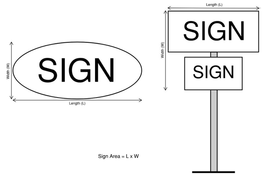
Figure 4.7-1 - Sign Area
Where a sign is more than one ft. thick, has more than two faces, or is three dimensional, the Sign Area calculation is based on 50 percent of the surface area of the four vertical faces of the smallest rectangular solid that can be formed around the sign (see Figure 4.7-2 - Sign Area When Sign is More Than 1-ft. Thick).
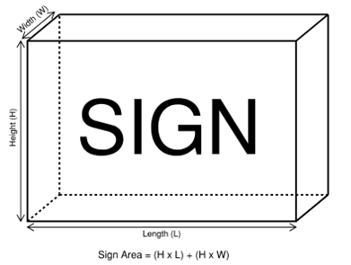
Figure 4.7-2 - Sign Area When Sign is More Than 1-ft. Thick
Sign Area Allocation - The total square footage of Sign Area allowed on a given property, calculated by multiplying the length of the property's Primary Sign Frontage by the primary frontage multiple, which is identified for each zone as follows:
a.
Primary Frontage Multiple for RS-6, RS-9, RS-12, RS-20, AG-OS and C-OS Zones: 0.10
b.
Primary Frontage Multiple for all other Zones (excluding OSU): 1.5
Sign Area Allocation may be apportioned to Attached Signs and, if permitted by this Chapter, to Detached Signs. The combined total Sign Area of all signs on a property must not exceed the Sign Area Allocation.
Figure 4.7-3 below includes an example Sign Area Allocation calculation, with an assumed zone having a Primary Frontage Multiple of 1.5.
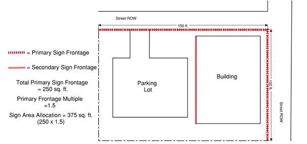
Figure 4.7-3 - Sign Frontage and Sign Area Allocation
Sign, Attached - Sign attached to the primary building on the subject property.
Sign, Banner - A sign made of fabric or similar non-rigid material with no enclosing framework or electrical components that is supported or anchored on two or more edges or at all four corners.
Sign, Blade - Narrow sign attached to the underside of an awning, canopy or marquee, extending perpendicular to a building over a sidewalk.
Sign Clearance - As shown in Figure 4.7-4 - Sign Height, Clearance and Projection, height measured from the highest grade directly beneath the sign to the bottom of the sign structure enclosing the sign face.
Sign, Detached - Structurally self-supporting sign not attached to a building, including Pole and Monument Signs.
a.
Sign, Monument - Detached Sign that is roughly rectilinear in shape, generally with a consistent width down to or no more than two (2) feet above the ground surface directly beneath the sign.
b.
Sign, Pole - Detached Sign with support elements that attach the sign to the ground surface, where the support elements extend more than two (2) feet above the ground surface directly beneath the sign.
Sign Frontage, Primary - Length of the property line(s) parallel to and along all Streets (public and/or private) abutting a property. See also Figure 4.7-3 - Sign Frontage and Sign Area Allocation.
Sign Frontage, Secondary - Face of a building oriented toward an Alley or on-site parking lot. See also Figure 4.7-3 - Sign Frontage and Sign Area Allocation.
Sign Height - As shown in Figure 4.7-4 - Sign Height, Clearance and Projection, height as measured from the lowest grade directly beneath the sign to the top of the sign structure enclosing the sign face.
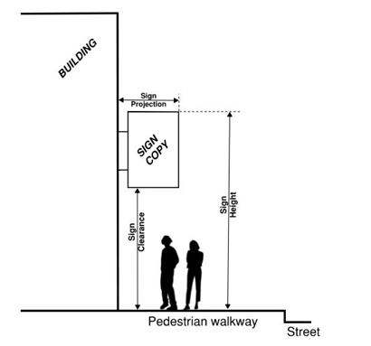
Figure 4.7-4 - Sign Height, Clearance and Projection
Sign, Nonconforming - A sign that was lawful when erected but that does not comply with one or more provisions of this chapter.
Sign, Permanent - Sign permanently affixed or attached to a building, structure, or to the ground.
Sign, Portable - Applicable only in the Commercial Mixed Use (CMU) Zones. A sign not permanently attached to the ground or other permanent structure, including A-frame Signs (also called sandwich board signs), Pedestal Signs, Easel Signs, and Vertically-Oriented Pole-Mounted Banner Signs.
a.
Sign, A-frame - Often called sandwich board sign. A folding sign constructed of wood, metal, plastic or other similar material and consisting of two surfaces, which when open form a self-supporting triangular shape. No larger than 6 sq. ft. per sign face and no taller than 4 ft. in total height, including the frame.
b.
Sign, Pedestal - A sign constructed of wood, metal, plastic or other similar material and supported by one or two pedestals. No larger than 6 sq. ft. per sign face and no taller than 4 ft. in total height, including the frame/pedestal. A pedestal is an architectural support or base for a column or statue or, in this case, a sign. The pedestal can be square, octagonal, or circular.
c.
Sign, Easel - A sign displayed on and supported by an upright standing frame, typically with a tripod configuration. No larger than 6 sq. ft. per sign face and no taller than 6 ft. in total height.

Figure 4.7-5 - Vertically-Oriented
d.
Sign, Vertically-Oriented Pole-Mounted Banner - A sign mounted on a pole or pedestal and secured into the sidewalk in a flush-mounted fashion that does not create a trip hazard. Constructed of canvas, nylon, vinyl, or other flexible, weather-resistant fabric. No larger than 6 sq. ft. and secured to the pole or pedestal at the top and bottom of the banner. See Figure 4.7-5 - Vertically-Oriented, Pole-Mounted Banner Sign.
Sign Projection - For Attached Signs, the horizontal distance between the outer-most edge of the sign face and the building wall to which the sign/sign structure is attached. See Figure 4.7-4 - Sign Height, Clearance and Projection.
Sign, Temporary - Sign that is not permanently affixed or attached to a building, structure, or to the ground, and is displayed for a period not to exceed six (6) months per calendar year per property.
Sign, Variable Message - Sign which utilizes manual, mechanical, electro-mechanical, electronic, radiofrequency, fiberoptic, or other automated means of changing the sign message or copy at timed intervals. Includes LED, incandescent luminaries, electronic message centers, and video display boards.
Sign Variance - Land use process to request a deviation from the provisions of Chapter 4.7 - Sign Regulations. Procedures for this type of land use application are outlined in Section 1.2.110.03 - Special Development and Section 4.7.110.
(Ord. No. 2025-28, § 2, eff. 6-26-2025)
Section 4.7.30 - Prohibited signs
No person shall erect, install, maintain, alter, repair, remove, or use (or cause or allow such action) any sign unless specifically authorized by these regulations. No permit will be issued for the erection, display, or maintenance of any sign in violation of these regulations. The following types of signs are specifically prohibited:
a.
Signs that obstruct any required Vision Clearance Area, as defined by the City Engineer;
b.
Signs that obstruct ingress or egress through any door, window, fire escape, standpipe, or like facility required or designated for safety or emergency use;
c.
Signs that may be confused with public traffic signs or highway identification signs, or appear graphically similar to these types of signs;
d.
Signs that use words such as STOP, SLOW, CAUTION, LOOK, DANGER, or any other word, phrase, symbol, or character that may mislead or confuse motorists;
e.
Signs or sign structures determined by the Building Official to constitute a hazard to the public safety or health by reason of poor structural design or construction, inadequate maintenance, lack of repair, or dilapidation;
f.
Signs located on or above public rights-of-way without written consent of the applicable jurisdiction, unless specifically permitted elsewhere in this chapter. This includes, but is not limited to, sandwich boards, posters on utility poles, political signs in parking strips, and signs on sidewalks;
g.
Signs that flash, blink, fluctuate, or have chaser, scintillating, or speller effects, including search lights. The interval of change specified in Section 4.7.60.01.d shall be used to inform the meaning of these terms for all sign types;
h.
Signs that move or have any moving part. This includes movement by mechanical, electrical, or kinetic means, wind currents, or any other means;
i.
Signs that inflate, including balloons and blimps;
j.
Flags, banners, and other signs made of fabric or other similar non-rigid material, unless specifically permitted under Section 4.7.40.b (regarding flags), Section 4.7.80.01 (regarding Banner Signs), or Sections 4.7.40.k and 4.7.80.02 (regarding Portable Signs in the CMU Zones);
k.
Roof signs including those projecting more than four ft. above an eave on sloped roofs, or four ft. above the parapets on flat roofs;
l.
Signs with visible A-frames, trusses, or guy wires as part of the sign or sign structure (unless specifically permitted under Section 4.7.80.02/Portable Signs);
m.
Signs placed on, affixed to, or painted on any motor vehicle, trailer, or other mobile structure not registered, licensed, and insured for use on public highways; and
n.
Handbills, including any notice, placard, poster, showbill, dodger, circular, pamphlet, booklet, letter, folder, sheet, sticker, or banner, except as permitted by the Corvallis Criminal Code.
(Ord. No. 2025-28, § 2, eff. 6-26-2025)
Section 4.7.40 - Exemptions
The following types of graphic communication are exempt from the requirement for a Sign Permit and are not subject to Sign Area Allocation and Sign Area limits but must comply with other applicable provisions of this Code. Limitations on number and size of these classes of signs, if any, are noted below.
a.
Signs erected in a public right-of-way or easement by an agent of the City, Benton County, the State of Oregon, the U.S. Government, public utility, franchise utility or railroad. Examples include street identification signs traffic control, safety, warning, hazard, construction, and related signs.
b.
Flags mounted on a pole, where the pole is mounted either directly to the ground or directly to a building. See Section 4.9.110 for flagpole development standards.
c.
Campaign signs related to local, state, or national elections. Campaign signs are limited to the time period between 60 days preceding the election date to 15 days following the election date.
d.
Signs required by City ordinance, County ordinance, or state or federal law. Examples include address numbers, street names, public notices, restaurant health inspection ratings, handicapped access signs, and Civil Defense Shelter signs.
e.
For Designated Historic Resources listed in the Local and/or National Register of Historic Places, one permanent memorial sign or tablet per property. The dimensions and design of such memorial signs or tablets must be consistent with guidelines established by the Corvallis Historic Resources Commission.
f.
Permanent signs directing and guiding traffic and parking on private property, not to exceed six sq. ft. and limited to one sign per driveway entrance or street frontage. Other signs that designate reserved parking spaces or are related to traffic or parking regulations, if limited to two sq. ft., are also exempt.
g.
Signs that communicate only to persons inside buildings or building complexes or on private property.
h.
Signs, decorations, and displays inside of windows or attached to the inside of a window, except those signs prohibited by Section 4.7.30.
i.
One (1) Temporary Sign per property, other than Banner Signs and Portable Signs. Temporary Signs must be constructed of material with sufficient structural integrity to withstand wind and moisture, and must be maintained in sound condition, appearance, and repair. Maximum Sign Area and Sign Height must not exceed the following limitations by zone:
1.
RS-6, RS-9, RS-12, RS-20, AG-OS and C-OS Zones: 5 sq. ft. Sign Area/4 ft. Sign Height
2.
All other Zones: 5 sq. ft. Sign Area/6 ft. Sign Height
j.
One (1) non-illuminated Blade Sign per building entrance, securely fastened to the underside of an awning, canopy or marquee, and not exceeding 3 sq. ft. in Sign Area. Blade Signs must maintain a minimum Sign Clearance of 7.5 ft. over pedestrian sidewalks/walkways.
k.
Portable Signs conforming with this Chapter. See definitions for Portable Signs in Section 4.7.20 and applicable standards in Section 4.7.80.02.
(Ord. No. 2025-28, § 2, eff. 6-26-2025)
Section 4.7.50 - Sign permit procedure
Unless exempt under Section 4.7.40, a Sign Permit must be obtained prior to the installation of each sign. A Sign Permit is also required for structural and/or electrical modifications to existing signs, including changes of sign size, shape, and/or location. A Sign Permit is not required for normal maintenance and repair of a sign or sign structure, such as painting, repainting and/or cleaning.
a.
A completed Sign Permit ("Permit") application accompanied by the appropriate fee must be submitted for review to the Development Services Division.
b.
The Director will review the Permit application to ensure it is complete and accompanied by the appropriate fee, and that the proposed sign complies with the requirements of this Code and other City ordinances. A Permit shall be issued only when all of these criteria have been met. Additionally, unless exempt per Section 2.11.40.e, Detached Signs in Special Flood Hazard Areas require a Flood Development Permit per Chapter 2.11 - Floodplain Development Permit.
c.
An approved Permit does not replace, supersede, or waive structural or electrical standards and permits required by the Corvallis Building Code. These other permits must also be obtained prior to work on the installation of a sign.
d.
The applicable Permit review fee will be doubled if sign installation is begun before the Permit is obtained. Payment of the double fee shall not relieve any person from full compliance with these regulations.
e.
The Permit will expire if a sign is not installed within 180 days from the date of Permit issuance. Re-application must include a new, fully completed application form and a new Permit review fee. The application must comply with the criteria in "b," above, including any amendments to these regulations adopted since the previous Permit approval.
f.
An approved Permit may be revoked by the Director if the Sign is not constructed and installed as approved, if incorrect information was provided on the application, or if the City approved the Permit in error. A decision of the Director may be appealed in accordance with Chapter 2.19 - Appeals.
g.
All signs are subject to inspection and reinspection by the Director. Footing inspections may be required for all signs having footings.
(Ord. No. 2025-28, § 2, eff. 6-26-2025)
Section 4.7.60 - General sign standards
The following provisions and standards apply to all signs, except where a more specific or restrictive standard is set forth in Section 4.7.70 - Sign Standards by Zone, below.
4.7.60.01 Standards for All Signs (Detached and Attached)
a.
Sign Area Allocation may be apportioned to Attached Signs and, if permitted by this Chapter, to Detached Signs. The combined total Sign Area of all signs on a property must not exceed the Sign Area Allocation.
b.
All signs and sign structures must comply with the standards of this Chapter and with the provisions of the Building Code.
c.
Illuminated signs are permitted unless specified otherwise within the provisions below. Illumination may be provided by internal lighting or external spot lighting unless otherwise specified. In no case shall this illumination cause direct glare on adjacent properties or streets.
d.
The interval of change in the message or copy of a Variable Message Sign, whether manual or automated, may not be less than twenty (20) minutes. In no case shall the sign exhibit characteristics of those signs prohibited in Section 4.7.30.g.
e.
Any portion of a Variable Message Sign that displays time and temperature information is exempt from the 20-minute interval of change limitation.
f.
Sign maintenance is the responsibility of the property owner. Signs must be maintained to protect the public safety, present a neat appearance, and prevent deterioration.
4.7.60.02 Standards for Detached Signs
a.
Detached Signs (including supporting structures) must not encroach into the public right-of-way or any required Vision Clearance Area. EXCEPTION: Up to two poles, each with a maximum diameter of six (6) inches, may be placed within a Vision Clearance Area and used to support a Sign above the Vision Clearance Area.
b.
Minimum separation between Detached Signs on the same side of a public right-of-way shall be 100 ft., unless specified differently by the applicable zone.
c.
Minimum Sign Clearance for Pole Signs above a pedestrian walkway shall be eight (8) ft.
d.
See Section 4.2.70 - Gateway Provisions for additional restrictions on Pole Signs and Monument Signs within gateway areas.
4.7.60.03 Standards for Attached Signs
a.
That portion of the Sign Area Allocation used by a business or tenant for Attached Signs shall be used in not more than two signs per individual street frontage. Additional allocation may be used for additional Attached Signs, provided that a minimum eight (8)-ft. separation is maintained between signs.
b.
Attached Signs must face the site's Primary Sign Frontage, except as allowed under (d) below.
c.
Sign Projection must not exceed eight (8) feet, unless further restricted in the zone-specific standards below. In addition:
1.
Where Sign Projection exceeds six (6) inches, the minimum Sign Clearance above pedestrian walkways/sidewalks must be eight (8) feet.
2.
Were Sign Projection exceeds one (1) foot, the edge of the sign structure closest to the building must not be separated from the building face by more than six (6) inches.
3.
Attached Signs may project into public street right-of-way only within the Commercial Mixed Use (CMU), Residential Mixed Use (RMU) and Mixed Use Residential (MUR) zones. A minimum setback of two (2) feet must be maintained from the curb face. The street right-of-way projection allowance does not apply to alley right-of-way.
d.
Sign Area Allocation may be used for one Attached Sign per business/tenant that faces a Secondary Sign Frontage. No Attached Sign facing a Secondary Sign Frontage shall project more than six (6) inches from the building face, nor into a public alley.
(Ord. No. 2025-28, § 2, eff. 6-26-2025)
Section 4.7.70 - Sign standards by zone
The following subsections, organized by Zone, set forth standards for maximum Sign Area, maximum Sign Height and minimum setbacks for individual Attached and Detached (including Pole and Monument) Signs. If an individual sign type is not listed in a table, it means that particular sign type is not allowed in the Zone. Additional standards are listed below each table as applicable to the listed zones.
4.7.70.01 RS-6, RS-9, RS-12, RS-20, AG-OS and C-OS Zones:
Table 4.7-1 - RS-6, RS-9, RS-12, RS-20, AG-OS and C-OS Zones
a.
Attached Signs must not:
1.
Extend above building eaves or parapets;
2.
Project more than six (6) inches from the building face; nor
3.
Project into the public right-of-way.
b.
Where Primary Sign Frontage is 100 ft. or less, Monument Signs and illuminated signs are prohibited, and Attached Signs are limited to one street frontage.
c.
Where Primary Sign Frontage exceeds 100 ft.:
1.
Monument Signs are allowed in accordance with Section 4.7.60.02 above. Monument Signs must maintain a minimum setback of five (5) feet and maximum Sign Height of six (6) feet;
2.
Maximum Sign Area for Attached and Monument Signs is 16 sq. ft.; and
3.
Illuminated signs are permitted.
4.7.70.02 MUR, RMU-12 and RMU-20 Zones:
Table 4.7-2 - MUR, RMU-12 and RMU-20 Zones
a.
Attached Signs must not extend more than four (4) feet above building eaves or parapets.
b.
Attached Signs may project into the public right-of-way, subject to Section 4.7.60.03.c.
4.7.70.03 CMU-1, PA-O and RTC Zones:
Table 4.7-3 - CMU-1, PA-O and RTC Zones
a.
Attached Signs must not extend more than four (4) feet above building eaves or parapets.
b.
Within the PA-O and RTC Zones, Attached Signs must not project into the public right-of-way.
c.
Within the CMU-1 Zone:
1.
Attached Signs may project into the public right-of-way, subject to Section 4.7.60.03.c; and
2.
Pole Signs are prohibited.
4.7.70.04 GC, CBF, CMU-2, CMU-3, LI-O, LI, GI, II, MUT and MUE Zones:
Table 4.7-2 - GC, CBF, CMU-2, CMU-3, LI-O, LI, GI, II, MUT and MUE Zones
a.
Within the CMU-3 Zone there is no maximum Sign Height for Attached Signs. However, Attached Signs with a Sign Height higher than 25 ft. must not extend above building eaves or parapets nor be internally illuminated.
b.
Attached Signs must not extend more than four (4) feet above building eaves or parapets.
c.
Within the CMU-2 and CMU-3 Zones Attached Signs may project into the public right-of-way, subject to Section 4.7.60.03.c.
d.
Within all listed zones other than CMU-2 and CMU-3, Attached Signs must not project into the public right-of-way.
4.7.70.05 Oregon State University (OSU) Zone:
Sign regulations for the OSU Zone vary, depending on the location and visual impact of the sign in relation to properties surrounding the zone. The following part of the OSU Zone is called the exemption area: the area east of 30th Street, south of Johnson Avenue and Monroe Avenue, west of the east boundary of the OSU Zone, and north of Western Boulevard and Oak Creek.
a.
Any sign inside the exemption area shall be exempt from these regulations, provided that:
1.
The sign is more than 100 ft. inside the exemption area;
2.
The sign has a Sign Area of less than 32 sq. ft.; or
3.
The sign doesn't function as a graphic communication to people outside the exemption area.
b.
Any sign located in the OSU Zone but outside the exemption area shall be exempt from these regulations, provided the sign does not function as a graphic communication to people on adjacent streets or private property. See Figure 4.7-6 - OSU Sign Exemption Area.
c.
All other signs in the OSU Zone outside the exemption area shall have a Sign Area not greater than 32 sq. ft. Monument signs shall not exceed six ft. in height, and attached signs shall not vertically or horizontally project more than six in. from a building. Pole signs are prohibited. Unless otherwise exempt, signs along the boundary shall have a minimum separation of 100 ft. An approved Sign Permit is required prior to installation of any sign not specifically exempt by the provisions of Section 4.7.40, Section 4.7.70.05.a, or Section 4.7.70.05.b, above.
Figure 4.7-6 - OSU Sign Exemption Area
(Ord. No. 2025-28, § 2, eff. 6-26-2025)
Section 4.7.80 - Standards for special sign types
Unless exempt under Section 4.7.40, a Sign Permit must be obtained prior to the installation of each sign.
4.7.80.01 Banner Signs
Banner Signs are allowed in all office, OSU, commercial and industrial zones, and in residential zones for properties with a primary frontage measuring greater than 200 ft.
a.
Banner Signs require an approved Sign Permit. Banner Signs shall be used consistent with either option provided below in a calendar year. The first Sign Permit issued for a Banner Sign on a property shall determine the option chosen. The options are:
1.
Each property is limited to three Sign Permits for Banner Signs per year. The maximum Sign Area for a Banner Sign shall be 16 sq. ft. Each Sign Permit for a Banner Sign shall be valid for 30 consecutive days, after which time the banner shall be removed; or
2.
Each property is limited to two Sign Permits for Banner Signs per year. The maximum Sign Area for a Banner Sign shall be 100 sq. ft. Each Sign Permit for a Banner Sign shall be valid for seven consecutive days, after which time the banner shall be removed.
b.
All Banner Signs must be securely attached flush with a building face and comply with the maximum Sign Height provisions for Attached Signs in the applicable zone. The Sign Area of a Banner Sign shall not reduce a property's Sign Area allocation.
c.
An approved Permit does not replace, supersede, or waive structural or electrical standards and permits required by the Corvallis Building Code. These other permits must also be obtained prior to work on the installation of a sign.
Portable Signs are permitted in the Commercial Mixed Use (CMU) Zones, subject to all of the following provisions, as applicable (see also Sign, Portable definitions in Section 4.7.20 above):
a.
The number of Portable Signs displayed per property (including within abutting public right-of-way where allowed under (b) below) must not exceed the following limitations:
1.
For properties containing less than 25 ft. of street frontage, up to two Portable Signs are permitted.
2.
For properties with 25 ft. or more of street frontage, up to two Portable Signs are permitted for every 25 ft. of street frontage.
3.
A minimum of 4-ft. spacing must be provided between signs, as well as between signs and abutting bicycle racks.
4.
For corner properties, Portable Signs are permitted on each street frontage, per "1" and "3" above.
5.
In no case may an individual business on a property have more than two Portable Signs per street frontage
b.
Portable Signs are allowed on public sidewalks, either directly adjacent to the building or in the area of sidewalk immediately adjacent to the street curb where bicycle racks, newspaper dispensers and trash bins are commonly located. However, at least 4 ft. of clear, continuous and unobstructed sidewalk width must be maintained for passage along the sidewalk. For properties with buildings set back 5 ft. or more from the public sidewalk, Portable Signs must be placed on private property.
c.
Portable Signs are prohibited in the following locations:
1.
Vision Clearance Areas, as defined by Chapter 1.6 - Definitions and the Site Development Design Standards.
2.
Standard and bulbed sidewalk intersections (see Figure 4.7-7 below).
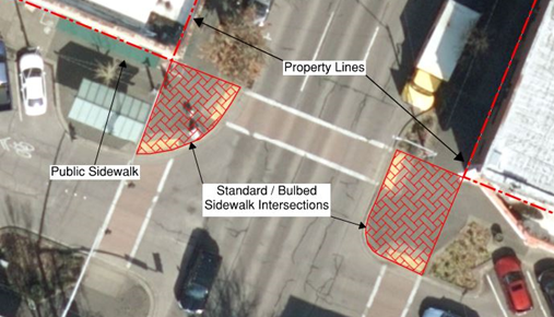
Figure 4.7-7 - Standard/Bulbed Sidewalk Intersections
d.
Portable Signs may only be displayed during business hours and must be placed indoors overnight.
e.
No sign permit, or permit fee, is required for Portable Signs and the Sign Area of a Portable Sign does not reduce a property's sign allocation.
f.
Sign owners are responsible for all liability issues related to their Portable Signs.
(Ord. No. 2025-28, § 2, eff. 6-26-2025)
Section 4.7.90 - Zoning overlay sign provisions
4.7.90.01 Sign Provisions for Designated Historic Resources
A proposed sign for a Designated Historic Resource must comply with the provisions in this Chapter and in Chapter 2.9 - Historic Preservation Provisions.
4.7.90.02 Sign Provisions for the Willamette River Greenway (WRG) Overlay Zone
In addition to the provisions of this Chapter, properties within the Willamette River Greenway (WRG) Overlay Zone are subject to the following:
a.
For property that is separated from the Willamette River by public street right-of-way, signs are exempt from the requirements of Chapter 3.41 - Willamette River Greenway (WRG) Overlay.
b.
For property that is not separated from the Willamette River by public street right-of-way, any sign visible from the Willamette River is subject to the WRG Conditional Development review process and must be consistent with the purposes of the Greenway, as stated in Chapter 3.41 - Willamette River Greenway (WRG) Overlay.
(Ord. No. 2025-28, § 2, eff. 6-26-2025)
Section 4.7.100 - Nonconforming signs
a.
Nonconforming Signs may continue to be used until altered, replaced, or moved, at which time the sign shall be brought into conformance with all provisions of this Code.
b.
Abandoned Nonconforming Signs shall be removed within 180 days. A new Sign Permit at the same address shall not be issued until the abandoned Nonconforming Sign is removed. Where a new business fails to remove Nonconforming Signs from the premises, the property owner shall be responsible for their removal.
(Ord. No. 2025-28, § 2, eff. 6-26-2025)
Section 4.7.110 - Variance to standards
There may be rare instances where a combination of strict application of the standards in this Chapter and/or public safety concerns may preclude signs as a communication medium for a primary frontage. In these cases, it may be appropriate to vary a particular standard to enable a property owner to use signage in a manner similar to other properties in the zone.
a.
To request a variance, an applicant shall submit a completed Sign Variance application and appropriate review fee.
b.
The Planning Commission shall hold a public hearing and provide notice on the application in accordance with Chapter 2.0 - Public Involvement.
c.
A Sign Variance request shall not be granted for any of the following:
1.
Size of a proposed sign;
2.
Limitations on visibility resulting from required landscaping;
3.
Location of buildings or other structures;
4.
Lack of exposure on a Primary Sign Frontage;
5.
Convenience or economic hardship to the applicant; or
6.
Inclusion of signs otherwise prohibited by these regulations.
d.
To approve a Sign Variance request, the Planning Commission must find that the application meets all of the following criteria:
1.
The proposed sign is not of a type prohibited by these regulations;
2.
The Sign Variance is the minimum remedy necessary to eliminate the hardship;
3.
The Sign Variance does not substantially subvert the basic regulating formula relating the amount of Sign Area to the amount of sign frontage; and
4.
No alternative solution that complies with these regulations is available to the applicant.
e.
The Planning Commission shall impose such conditions on the approval as necessary to achieve the purposes of these regulations.
f.
The decision of the Planning Commission shall be final unless appealed to the City Council in accordance with Chapter 2.19 - Appeals.
g.
Where a sign approved through Sign Variance procedures is not installed within one year, the Sign Variance approval shall expire, and all work must fully comply with this Code.
(Ord. No. 2025-28, § 2, eff. 6-26-2025)
Section 4.7.120 - Administrative
4.7.120.01 Enforcement
The Director shall administer and enforce sign regulations and is authorized to issue citations for violations in accordance with Chapter 1.3 - Enforcement.
Violations of these regulations shall be considered a Class B infraction and are subject to the procedures provided in ORS 153.110 through 153.310, as now constituted, and as amended over time.
a.
A person cited for a violation shall be fined up to $100.00.
b.
Each day a sign is in violation shall be considered a new violation.
The Director may order removal of any sign erected or maintained in violation of these regulations.
a.
The Director shall deliver a warning notice that the sign is in violation of these regulations. The notice shall be provided to individuals using the sign, to the owner of the sign or enterprise, and/or to the property owner.
b.
The notice shall allow three working days for removal of temporary signs and 14 working days for removal of permanent signs.
c.
If the owner or permittee fails to remove the sign as directed in the warning notice, the Director may issue a citation and may remove the sign. Any expense related to removal shall be paid by the owner or permittee of the sign. If such persons cannot be found, the expense shall be paid by the owner of the building, structure, or property to which the sign is affixed.
d.
If the condition of the sign presents an immediate threat to public safety, the Director may order immediate removal of the sign, without prior notice. Any expenses related to removal shall be paid by the owner or permittee of the sign. If such persons cannot be found, the expense shall be paid by the owner of the building, structure, or property.
4.7.120.04 Limitation of Liability
The City shall not be held responsible for any damage to persons or property by reason of approval, disapproval, or the issuance of a Sign Permit authorized herein, or inspection or reinspection of a sign as authorized by this Chapter.
(Ord. No. 2025-28, § 2, eff. 6-26-2025)
Section 4.8.10 - Purposes.
The provisions in this Chapter are established to ensure a safe and healthful living environment for residents of Manufactured Dwelling Facilities and to ensure that Manufactured Dwelling Facilities can provide affordable quality housing compatible with adjacent land uses. In addition, these provisions are intended to ensure compliance with State regulations governing review of Manufactured Dwelling Facility development.
Section 4.8.20 - Area Requirements.
a.
The minimum size for a Manufactured Dwelling Facility, as defined in Chapter 1.6 - Definitions, is one acre.
b.
The minimum size for a Manufactured Dwelling space is 3,000 sq. feet ORS 446.100(c), as amended, requires that the space be at least 30 feet wide and 40 feet long.
Section 4.8.30 - Permitted Structures.
a.
Manufactured Dwellings and Mobile Homes, as defined in Chapter 1.6 - Definitions.
b.
Accessory Structures - Structures customarily incidental to the Primary Use in accordance with Chapter 4.3 - Accessory Development Regulations.
Section 4.8.40 - Setback and Separation For The Facility Perimeter.
a.
Setback between Facility Structures and Abutting Properties - Between the abutting property and any Dwelling or Accessory facility structure or facility road a minimum setback shall be required equal to the rear yard setback specified by the zone of the abutting property, but not less than five feet
b.
Setback between Facility Structures and a Public Street Right-of-Way - Between the public right-of-way and any Dwelling or Accessory facility structure, an average setback of 25 feet shall be required along the public street, with a minimum setback equal to the front yard setback of the zone.
Section 4.8.50 - Facility Perimeter Treatment.
a.
Perimeter Treatment Adjacent to Abutting Properties - A sight-obscuring fence or wall six feet in height shall surround each Manufactured Dwelling Facility, except as specified below for lands adjacent to public streets. Plantings in the required setback area shall be used to reinforce this Buffer.
b.
Perimeter Treatment Adjacent to Public Streets - An applicant can choose one of two options for perimeter treatment adjacent to public streets:
1.
Option I - A six feet-high sight-obscuring screen shall be provided through the use of fencing and vegetation and/or earth sculpting and vegetation.
a)
Fencing - Fences shall have an average 15 feet setback from the public right-of-way and shall meet Vision Clearance Area requirements as specified by the City Engineer. Fencing closer than 15 feet to the public right-of-way shall be subject to the zone's restrictions on front yard fencing. Long expanses of fence or wall along public streets shall be designed to prevent visual monotony through the use of off-sets, landscaping, and change in materials.
b)
Earth Sculpting - See Figure 4.8-1 - Earth Sculpting for Buffering. Earth sculpting shall be used in conjunction with plant materials and, when combined, the screen shall be six feet high in two years. This combination of earth sculpting and plant materials is subject to the following standards:
1)
At a minimum, the earth sculpting shall include a berm with a slope grade not exceeding 40 percent, 1:2.5, on the side facing the street. The slope for the side facing the facility may vary.
2)
At least one row of deciduous and/or evergreen shrubs spaced not more than five feet apart shall be planted on this berm.
3)
Lawn, low-growing evergreen shrubs, and evergreen ground cover shall cover the balance of the setback area.
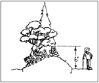
Figure 4.8-1 Earth Sculpting for Buffering
2.
Option II -
a)
A Manufactured Dwelling space that abuts the perimeter setback shall be a minimum of 5,000 sq. feet
b)
Manufactured Dwellings abutting a public street shall have staggered setbacks and a variety of living unit orientations such as indicated below in Figure 4.8-2 Staggered Setbacks and Variable Orientations. The required off-sets between adjacent Dwellings shall be at least eight feet as measured perpendicular from the street; or
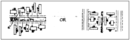
Figure 4.8-2 Staggered Setbacks and Variable Orientations
c)
An alternative to the above is to use a uniform setback but provide a substantial acute or obtuse angle from the street, such as indicated below. See Figure 4.8-3 Angled Orientation with Uniform Setbacks. As used in this provision, a substantial acute or obtuse angle is greater than 30 degrees; or
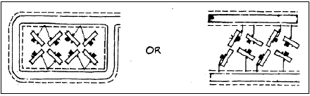
Figure 4.8-3 Angled Orientation with Uniform Setbacks
d)
A third alternative is to establish an eight feet minimum building off-set by using attached garages or triple-wide expansions such as indicated below in Figure 4.8-4 Attached Garages and Triple-wide Expansions.
Figure 4.8-4 Attached Garages and Triple-wide Expansions
e)
Driveway access on local public streets shall occur at the maximum frequency of one access for every two Dwellings. Access from individual Dwellings shall not be permitted on Arterial Streets. Access to Collector Streets shall be subject to review by the City Engineer.
Section 4.8.60 - Setback and Separation For Structures Within The Facility.
Figure 4.8-5 Structure Separation
a.
Dwellings shall be separated by at least 10 feet on all sides. See Figure 4.8-5 Structure Separation.
b.
Dwellings shall be placed at least 14 feet apart if a flammable or combustible fuel storage vessel is located on or between units.
c.
Dwellings shall be separated from facility buildings by at least 10 feet
d.
Any Structure and a facility street or any Structure and a sidewalk intended for public use shall be separated by at least five feet
e.
Accessory Structures and Dwellings Shall Be Separated as Follows -
1.
An Accessory building shall be separated at least six feet from any Dwelling or other Accessory building on adjacent space, except in the case of Section 4.8.70.b below.
2.
When a double carport or garage is built to serve two adjacent Dwellings, a minimum three-feet separation shall be provided between the double carport and any adjacent structure, Dwelling, or Accessory facility structure. As an alternative, a one-hour fire wall separation may be provided through the center of a double carport serving an adjacent Dwelling.
Section 4.8.70 - Site Development Standards.
a.
Parking and Accessways -
1.
Parking - When provided, off-street parking facilities must be constructed in accordance with Chapters 4.1 - Parking, Loading, and Access Requirements.
2.
Street Widths - Facility streets shall be a minimum width of 20 feet If on-street parking is permitted, ORS 446.095(1), as amended, requires a minimum width of 30 feet Streets serving more than 12 Dwelling spaces shall be a minimum width of 24 feet Streets serving more than 30 Dwelling spaces shall be a minimum width of 28 feet
3.
Street Standards - Streets shall be paved to standards adopted by the City Engineer.
4.
Dead End Streets - Dead end streets over 400 feet in length shall have a standard Cul-de-sac bulb with a 38-feet curb-side radius. Shorter dead end streets shall have a turnaround approved by the City Engineer.
5.
Walkways - Paved walkways, at least five feet wide and accessible to wheelchairs, shall be provided to connect facility buildings to a facility street or public street. In addition, for an area with more than 25 Dwelling spaces, a street sidewalk or equivalent pedestrian walkway shall be provided to connect the area to a public sidewalk.
6.
Lighting - Private facility roadways shall be lighted at intersections and pedestrian crossings and all site lighting shall be consistent with the lighting provisions in Chapter 4.2 - Landscaping, Buffering, Screening, and Lighting.
7.
Street Signs - Street identification signs shall be provided according to applicable City requirements if 50 or more Manufactured Dwelling spaces are on the site.
8.
Fire Access - Access for fire protection services shall permit fire apparatus to approach within 100 feet of each Dwelling. In addition, each Manufactured Dwelling space shall have direct access to a street to permit emergency escape. This access shall be an unobstructed area not less than 14 feet wide.
b.
Siting of Dwellings within the Facility -
1.
Dwellings shall have staggered setbacks and a variety of Dwelling Unit orientations such as indicated below in Figure 4.8-6 Dwelling Unit Orientation and Setbacks. The required off-sets between adjacent Dwellings shall be at least eight feet as measured perpendicular from the street; or
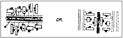
Figure 4.8-6 Dwelling Unit Orientation and Setbacks
2.
An alternative to the above is to use a uniform setback but provide a substantial acute or obtuse angle from the facility street, such as indicated below in Figure 4.8-7 Obtuse Angle Orientation. As used in this provision, a substantial acute or obtuse angle is greater than 30 degrees.
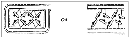
Figure 4.8-7 Obtuse Angle Orientation
c.
Public and Private Facilities
1.
Each Manufactured Dwelling Facility space shall be provided with water, sanitary sewer, storm drainage, and street facilities; and electrical power, telecommunication, cable television, and natural gas services in accordance with Chapter 4.0 Improvements Required with Development.
2.
Applications for Manufactured Dwelling Facilities that would adjoin an open, natural drainageway or would be located in a Floodway Fringe shall be reviewed in accordance with Chapter 2.11 - Floodplain Development Permit, Chapter 4.5 - Floodplain Provisions, Chapter 4.13 - Riparian Corridor and Wetland Provisions, and Chapter 4.14 - Landslide Hazard and Hillside Development Provisions.
d.
Play Areas - A separate play area shall be provided in all Manufactured Dwelling Facilities that accommodate children unless each Manufactured Dwelling Space has a minimum size of 4,000 sq. feet A required play area shall be at least 2,500 sq. feet in area with no dimension less than 30 feet At least 100 sq. feet of play area shall be provided for each Manufactured Dwelling space less than 4,000 sq. feet
e.
Space Coverage - Not more than 60 percent of a Manufactured Dwelling space shall be occupied by a Dwelling and any other attached or detached structure used in conjunction with such Dwelling.
f.
Decks - Each Manufactured Dwelling space shall have at least one private or semi-private outdoor space adjacent to the Dwelling, constructed of concrete, asphalt, flagstone, wood, or other equivalent surface material totaling at least 120 sq. feet of area and not less than eight feet wide in any dimension.
g.
Skirting - Each Mobile Home or Manufactured Dwelling located in a Manufactured Dwelling Facility shall have continuous skirting that, in design, color, and texture, appears to be an integral part of the exterior walls or the foundation of the Dwelling.
(Ord. No. 2023-19, § 38(Exh. A), eff. 6-30-2023)
Section 4.8.80 - Landscape Plan.
A landscape plan is required prior to issuance of Building Permits. This plan shall be drawn to scale and shall show the location of existing trees and vegetation proposed to be removed or to be retained on the site, the location and design of landscaped areas, the varieties and sizes of trees and plant materials to be planted on the site, contour lines indicating any proposed earth sculpting, and other pertinent landscape information. The plan shall also be consistent with the provisions outlined in Section 4.8.90.
a.
Plant Coverage and Maintenance
Required landscape areas shall be covered by living plant materials capable of attaining 90 percent ground coverage within three years. The plant materials shall be continuously maintained and irrigated with permanent facilities.
b.
Plantings in Perimeter Area
In addition to the requirements specified in Section 4.8.50, above, and in Chapter 4.2 - Landscaping, Buffering, Screening, and Lighting, landscaping shall be used to screen decks and storage areas from the public roadway. Plant masses shall also be established between perimeter Dwellings to reduce negative visual effects of roads and vehicle storage areas located within the facility.
c.
Plantings along Facility Streets -
1.
Street Trees - Street trees shall be provided in accordance with Chapter 4.2 - Landscaping, Buffering, Screening, and Lighting.
2.
Planting Continuity - To provide continuity, trees of the same or similar species shall be planted along facility streets. The consistent use of lighting fixtures, fencing styles, and carports can complement this street tree pattern. See Figure 4.8-8 Planting Continuity below.
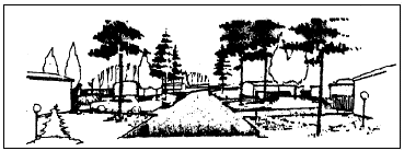
Figure 4.8-8 Planting Continuity
3.
Street Focal Points - The real or visually apparent end of a street shall be planted heavily either with foreground plants or with background plants. See Figure 4.8-9 Street Focal Point.
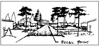
Figure 4.8-9 Street Focal Point
d.
Planting for Energy Efficiency - Appropriate plant materials shall be used to cool Dwellings in the summer and help insulate them in the winter. Possible applications are illustrated below in Figure 4.8-10 Planting for Energy Efficiency
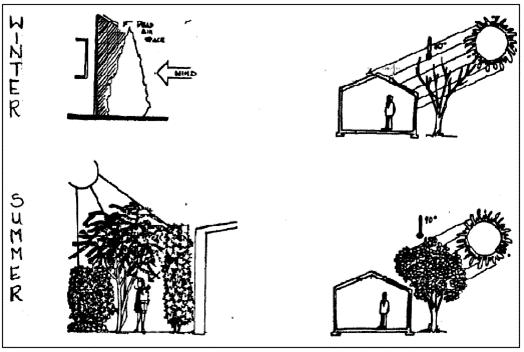
Figure 4.8-10 Planting for Energy Efficiency
Section 4.8.90 - Landscaping, Natural Hazards, Minimum Assured Development Area (MADA), and Natural Resources.
Unless specified more strictly in this Chapter, landscaping shall be consistent with the provisions of Chapter 2.11 - Floodplain Development Permit, Chapter 4.2 - Landscaping, Buffering, Screening, and Lighting, and Chapter 4.5 - Floodplain Provisions. Natural Hazards, Minimum Assured Development Area (MADA), and Natural Resources shall be addressed in accordance with Chapter 2.11 - Floodplain Development Permit, Chapter 4.2 - Landscaping, Buffering, Screening, and Lighting, Chapter 4.5 - Floodplain Provisions, Chapter 4.11 - Minimum Assured Development Area (MADA), Chapter 4.12 - Significant Vegetation Protection Provisions, Chapter 4.13 - Riparian Corridor and Wetland Provisions, and Chapter 4.14 - Landslide Hazard and Hillside Development Provisions.
Section 4.9.10 - Purposes.
Some types of Uses have special development standards to improve their compatibility with surrounding land uses. In certain other situations, there are exceptions to the regulations not addressed elsewhere in the Code.
(Ord. No. 2018-16, eff. 6-25-2018; Ord. No. 2022-024, eff. 9-28-2022)
Section 4.9.20 - Manufactured Dwelling Design Standards.
The following standards apply to Manufactured Dwellings not placed within a Manufactured Dwelling Facility:
a.
Continuous permanent vertical skirting or foundation, enclosing the area between the finished floor elevation and exterior finished grade, must be provided around the entire structure. The skirting or foundation must consist of concrete or masonry, or of materials that match the structure's exterior siding;
b.
Upon installation, the wheels, tongue and traveling lights must be removed from the structure, or fully enclosed and concealed;
c.
If placed as a Residential Building Type other than a Cottage Cluster or Accessory Dwelling Unit, development must comply with the standards of the underlying Zone that are applicable to a site-built dwelling;
d.
If placed as an Accessory Dwelling Unit, the building must comply with the Accessory Dwelling Unit standards of Section 4.9.40;
e.
If placed as a Cottage in a Cottage Cluster, the building must comply with the Cottage Cluster standards of Section 4.10.55; and
f.
Provisions made for drainage, water and sewage must meet City Code standards.
(Ord. No. 2019-08, eff. 3-14-2019; Ord. No. 2022-12, eff. 6-1-2022)
Section 4.9.30 - Minor Utilities.
Depending on the zoning, Minor Utilities typically require Conditional Development approval in accordance with Chapter 2.3 - Conditional Development, or Plan Compatibility Review in accordance with Chapter 2.13 - Plan Compatibility Review. In addition to complying with these review criteria, Minor Utilities must meet the following siting standards:
a.
The setback from the base of a Minor Utility structure to any lot in an adjoining residential zone must be at least 20 percent of the structure height.
b.
If scientifically validated evidence demonstrates the level of electric magnetic fields (EMFs) produced by the Minor Utility poses a health hazard based on nationally accepted standards, the City Council may require removal of the Minor Utility after conducting a public hearing in accordance with Chapter 2.0 - Public Involvement.
(Ord. No. 2018-01, eff. 1-26-2018; Ord. No. 2022-06, eff. 3-17-2022)
Section 4.9.40 - Accessory Dwelling Units.
Accessory Dwelling Units, hereafter called ADUs, are subject to the standards listed below:
a.
The subject property is required to be a legally created lot, parcel, or lot of record that contains, or is proposed to contain via an active building permit, a dwelling unit or dwelling units. There is no minimum lot area or width required in order to develop an ADU.
b.
The ADU must not exceed 900 square feet of floor area, or 85 percent of the primary dwelling's floor area, whichever is less. The primary dwelling unit on a lot with multiple dwelling units is the dwelling unit with the greatest floor area.
c.
The proposed ADU must meet City and Building Code water, sewer, and storm drainage regulations and standards.
d.
The ADU must meet the height, lot coverage, and Green Area standards of the underlying zone as applicable to the primary dwelling unit, except that there is no Private Outdoor Space requirement for an ADU.
e.
The ADU must meet the setback standards of the underlying zone as applicable to the primary dwelling unit, with exception of the following:
1.
ADUs are not subject to maximum front yard setbacks; and
2.
A detached ADU located on a Townhouse lot must maintain a minimum interior side yard setback of 5 feet from all interior side lot lines, regardless of setback standards applicable to the primary dwelling. Note that the minimum exterior side yard setback must be maintained in accordance with the underlying zone.
f.
Only one ADU is allowed on a lot, parcel, or lot of record.
g.
An ADU may not encroach on a utility easement regardless of setback standards or the exceptions in "e" above.
Ord. No. 2012-16, eff. 12-13-2012; Ord. No. 2014-18, eff. 12-11-2014; Ord. No. 2018-16, eff. 6-25-2018; Ord. No. 2020-04, eff. 3-3-2020; Ord. No. 2022-12, eff. 6-1-2022; Ord. No. 2023-19, § 39(Exh. A), eff. 6-30-2023)
Section 4.9.50 - Exceptions To Building Heights and Projections.
4.9.50.01 General Exceptions to the Building Height Limitations.
Building projections such as chimneys, spires, domes, elevator shaft housings, towers, aerials, building-mounted flagpoles and other similar objects not used for human occupancy are subject to the height limitations specified in each zone. Such structures exceeding a zone's height limitations may be permitted subject to Chapter 2.12 - Development Standards Adjustment, and upon a finding by the State of Oregon Aeronautics Division that the proposed projection does not pose a hazard to air traffic.
Wireless Telecommunication Facilities are subject to Section 4.9.60 below.
Ground-mounted flagpoles are subject to the height limitations set forth Section 4.9.110 below.
4.9.50.02 General Exceptions to Minimum Setback Standards.
Architectural features such as cornices, eaves, canopies, sunshades, gutters, building-mounted flagpoles, chimneys, fireplaces, and flues may project up to three ft. into a required yard, provided that a minimum 30 in. setback is maintained from any property line. However, architectural features must not be located within a Vision Clearance Area as defined by Section 4.1.30.c, nor within franchise utility or other public easements. For the purposes of this Section, Architectural Features must not include any portion of a structure built for the support, conveyance, occupancy, shelter, or enclosure of persons, chattels, or property of any kind.
Within residential zones, unenclosed porches may encroach to within 7 feet of front and/or exterior side yard property lines, but must not be located within a Vision Clearance Area as defined by Section 4.1.30.c.
4.9.50.03 Front Yard Determination for Flag Parcels.
For development on Flag Parcels, the property owner may determine the location of the front yard and front lot line, for purposes of establishing building setbacks, provided that no side yard setback is less than 10 feet
If the property owner does not designate the location of the front yard, then City Staff will determine the location of the front yard and front lot line, based on the location of the driveway, and the structure's orientation and legal street access.
4.9.50.04 Front Yard Determination for Lots or Parcels with Alley-only Access.
For lots or parcels without public or private street frontage, and where access occurs from an alley, the property owner may determine the location of the front yard and front lot line, for purposes of establishing building setbacks.
If the property owner does not designate the location of the front yard and front lot line, then City Staff will determine the front lot line as being the line proximate to the nearest public or private street.
(Ord. No. 2021-22, eff. 11-24-2021; Ord. No. 2022-12, eff. 6-1-2022; Ord. No. 2023-19, § 39(Exh. A), eff. 6-30-2023; Ord. No. 2024-26, § 34(Exh. A), eff. 1-1-2025; Ord. No. 2025-28, § 6(Exh. A), eff. 6-26-2025)
Section 4.9.60 - Wireless Telecommunication Facilities.
4.9.60.01 Siting Criteria and Review Procedures.
Wireless Telecommunication Facilities, as defined in Chapter 3.0 Use Classifications, may be permitted outright, may require Plan Compatibility Review in accordance with Chapter 2.13 Plan Compatibility Review, or may require Conditional Development approval in accordance with Chapter 2.3 -Conditional Development, depending on the type of facility, such as Colocated/attached or Freestanding, and its proposed location. Uses that are permitted outright require Building Permits only.
All facilities that have a Willamette River Greenway Overlay are subject to the provisions of Chapter 3.41 - Willamette River Greenway (WRG) Overlay. All facilities located on Designated Historic Resources are subject to the provisions of Chapter 2.9 - Historic Preservation Provisions. All Wireless Telecommunication Facilities and their related appurtenances located in areas with a Planned Development Overlay, except those within residential zones, are exempt from the requirements to have an approved Conceptual Development Plan and/or Detailed Development Plan in accordance with sections 2.5.40 and 2.5.50 of Chapter 2.5 - Planned Development. Facilities proposed for location in residential zones with a Planned Development Overlay are treated as a Minor Modification to the approved Conceptual and/or Detailed Development Plan, and processed accordingly.
4.9.60.02 Standard Requirements.
All Wireless Telecommunication Facilities must demonstrate compliance with the following standard requirements prior to a City-required final inspection. Only alternative setbacks and spacing requirements are allowed, provided they are approved under the Conditional Development process in accordance with Chapter 2.3 - Conditional Development.
a.
Height - No Wireless Telecommunication Facility may exceed 150 feet in height except where attached to an existing structure that exceeds 150 feet in height and the attached antennas do not increase the total height of that structure. All Wireless Telecommunication Facilities are exempt from the provisions in Section 4.9.50. Additional height limitations are defined in individual zone chapters in Article III .
b.
Setbacks -
1.
Setbacks for Freestanding Wireless Telecommunication Facilities, including associated ground-level equipment, are as follows:
a)
A facility must be set back by a distance greater than or equal to two times the height of the facility structure, including attached antennas, from the nearest property line of any property that either contains an existing Residential Use or is located in a residential development zone.
b)
A facility located on a site adjacent to the Corvallis Gateway Corridor, defined as the rights-of-way of highways 99W and 20/34 that are within the Corvallis City limits, must be set back from the right-of-way by a distance greater than or equal to three times the height of the facility structure, including attached antennas.
c)
All said facilities must comply with the setback requirements of the underlying development zone.
2.
Ground-level equipment associated with colocated/attached Wireless Telecommunication Facilities must meet the setback requirements of the underlying development zone. When the ground-level equipment is on a site abutting a residential zone or an existing Residential Use, this equipment must be set back from the nearby residential property line(s) by at least 25 feet.
c.
Spacing -
1.
A facility greater than or equal to 100 feet in height, including attached antennas, must be separated from other Freestanding Wireless Telecommunication Facilities by at least 3,000 feet.
2.
A facility between 51 and 99 feet in height, including attached antennas, must be separated from other Freestanding Wireless Telecommunication Facilities by at least 1,500 feet.
3.
A facility under 51 feet in height, including attached antennas, must be separated from other Freestanding Wireless Telecommunication Facilities by at least the height of the facility's structure.
d.
Colocation -
1.
A Freestanding Wireless Telecommunication Facility may be approved only if the applicant demonstrates that it is not feasible to site the facility on an existing structure. The application must document that alternative sites within a radius of least 2,000 feet have been considered and are technologically unfeasible or unavailable. The application also must document why colocation is impractical on existing structures for one or more of the following reasons: structural support limitations, safety considerations, lack of available space, failure to meet service coverage area needs, or unreasonable economic constraints.
2.
Freestanding Wireless Telecommunication Facilities must be designed to accommodate future colocation, as follows:
a)
Facilities up to 120 feet in height must accommodate at least two facilities/providers.
b)
Facilities between 120 feet and 150 feet in height must be designed to accommodate at least three facilities/providers.
e.
Compliance with Emission Standards - All facility applications must contain documentation showing that the emissions of the proposed facility, and the cumulative emissions of the facility and any colocated or nearby facilities, will meet the occupational/controlled and general population/uncontrolled electromagnetic radiation emission standards established by the Federal Communications Commission, 47 CFR §1.1310. as amended.
f.
Painting - All facilities must be painted in a non-reflective color to match the existing or attached structure and/or to blend into the surrounding environment. Alternative neutral colors may be approved by the Director.
g.
Landscaping/Screening - All ground-level facilities must be screened in accordance with the provisions in Section 4.2.50 of Chapter 4.2 - Landscaping, Buffering, Screening, and Lighting.
h.
Noise Reduction - All applications must contain documentation showing that the noise levels from the proposed facility will meet the following standards:
1.
A facility located on a site adjacent to a residential development zone or existing Residential Uses must limit noise levels to 35 DBA or less, as measured at the residential property line(s).
2.
A facility located on any other site must comply with the industrial and commercial quiet-area noise standards established by the Oregon State Department of Environmental Quality, OAR 340-35-035, Table 9, as amended.
i.
Lighting - No lighting of Wireless Telecommunication Facilities is allowed, except as required by the Federal Aviation Administration (FAA). Required lighting must be shielded from the ground, to the extent practicable. The application for a facility subject to FAA requirements must document compliance with FAA requirements.
j.
Signage - Warning and safety signs, up to three sq. feet in area, are allowed. All other signs are prohibited.
k.
Site Access - Site access is subject to the provisions in Section 4.1.30 of Chapter 4.1 - Parking, Loading, and Access Requirements. The facility operator must implement measures to prohibit unauthorized site access.
l.
Decommissioning - A facility must be removed by the facility owner or operator within six months from the date the facility ceases to be operational. The Director may grant a six-month extension to this requirement. Requests for extensions must be in writing and must be received by the Director within the initial six-month period. The property owner bears the ultimate responsibility for removal of decommissioned facilities.
m.
Landscaping, Natural Hazards, Minimum Assured Development Area (MADA), and Natural Resources - Landscaping, Natural Hazards, Minimum Assured Development Area (MADA), and Natural Resources must be addressed in accordance with Chapter 2.11 - Floodplain Development Permit, Chapter 4.2 - Landscaping, Buffering, Screening, and Lighting, Chapter 4.5 - Floodplain Provisions, Chapter 4.11 - Minimum Assured Development Area (MADA), Chapter 4.12 - Significant Vegetation Protection Provisions, Chapter 4.13 - Riparian Corridor and Wetland Provisions, and Chapter 4.14 - Landslide Hazard and Hillside Development Provisions.
(Ord. No. 2023-01, eff. 2-8-2023; Ord. No. 2023-19, § 39(Exh. A), eff. 6-30-2023)
Section 4.9.70 - Reserved.
Editor's note— Ord. No. 2022-06, eff. 3-17-2022, repealed § 4.9.70.
Section 4.9.80 - Residential Building Type Variety Requirements.
A variety of Residential Building Types must be provided with residential development, in accordance with the provisions this Section, including the provisions in Table 4.9-1 - Options A and B for Developments Five - 10 Acres, Table 4.9-2 - Options A and B for Developments Greater than 10 acres, and Table 4.9-3 - Allowed Residential Building Types by Zone. For purposes of determining applicability of these standards, development acreage is determined by using the Development Site's gross area. Where percentage calculation of buildings or units results in a partial building or unit, the resultant number must be rounded up to the next whole number.
a.
RS-6 and RS-9 Zones - The darker shading in the columns for these zones in Table 4.9-3 - Allowed Residential Building Types by Zone indicates permitted Building Types.
1.
Developments Less Than Five Acres - No Building Type variety is required.
2.
Developments Five - 10 Acres - At least two Building Types are required. Each required Building Type must be at least 20 percent of the total units.
3.
Developments Greater Than 10 Acres - At least three Building Types are required. Each required Building Type must be at least 20 percent of the total units.
b.
RS-12, RS-20, RMU-12, RMU-20, and MUR Zones - The lighter shading in the columns for these zones in Table 4.9-3 - Allowed Building Types by Zone indicates permitted Building Types. The darker shading in the columns for these zones indicates "Option B" discussed in "2," and "3," below.
1.
Developments Less Than Five Acres - No Building Type variety is required.
2.
Developments Five - 10 Acres - Compliance is required with either Option A or Option B in Table 4.9-1 - Options A and B for Developments Five - 10 Acres.
3.
Developments Greater Than 10 Acres - Compliance is required with either Option A or Option B in Table 4.9-2 - Options A and B for Developments Greater Than 10 Acres.
(Ord. No. 2014-18, eff. 12-11-2014; Ord. No. 2022-06, eff. 3-17-2022; Ord. No. 2022-12, eff. 6-1-2022; Ord. No. 2023-01, eff. 2-8-2023)
Section 4.9.90 - Urban Agriculture Standards.
a.
Market Gardens
1.
Market Garden activities may only be conducted by members of the family occupying the associated dwelling, with up to one additional employee, or full-time-equivalent, whose work on the site does not exceed 40 hours per work week.
2.
No display can indicate from the exterior that the building is being used in whole or in part for any purpose other than a dwelling, except that signage consistent with Section 4.7.90.01 of Chapter 4.7 - Sign Regulations is allowed.
3.
The amount of commercial activity is less intensive than activities permitted in a commercial zone.
4.
The use will not cause excessive or unusual traffic in the vicinity because of deliveries, pick-ups, parking, sales, or other activities.
5.
Noise, smoke, or odors do not exceed those created by normal residential use, for more than 24 hours per year.
6.
Retail activities may occur only within the home, garage, permanent outbuildings, or stands or kiosks as described in "7", below.
7.
Temporary stands or kiosks used to sell products may be placed within required yard areas abutting streets, but must be removed from the required yard, and cease operations, by 8:00 PM each day. Stands and kiosks may not be permitted in the public right-of-way.
b.
Community Gardens
1.
Gardens must be at least 5-ft from all property lines.
2.
Items such as tools, equipment, and fuel, must be stored within enclosed buildings or screened per Section 4.2.50.01.a - Ground Level Screening.
3.
Sales and donation of products grown in the community garden may occur on-site. Temporary stands or kiosks used to sell products may be placed within required yard areas abutting streets, but must be removed from the required yard by 8:00 PM each day.
(Ord. No. 2012-19, eff. 12-13-2012; Ord. No. 2023-01, eff. 2-8-2023)
Section 4.9.100 - Mixed Use Building Incentives.
a.
As specified in subsection "b," Mixed Use Buildings may be granted an 18-foot bonus to the maximum structure height established in the Zone.
b.
In order to gain the benefits in subsection "a," a Mixed Use Building must feature the following:
1.
At least 50% of the first floor Gross Floor Area must be occupied by nonresidential uses, which may include uses that are accessory to nonresidential uses, and;
2.
The cumulative upper-floor Gross Floor Area that is occupied by residential uses, including uses that are accessory to residential uses, is equal to at least 100% of the first floor Gross Floor Area.
(Ord. No. 2022-06, eff. 3-17-2022; Ord. No. 2023-19, § 39(Exh. A), 6-30-2023)
Section 4.9.110 - Flagpole development standards.
4.9.110.01 Standards Applicable to All Flagpoles.
a.
Flagpoles must be mounted directly to the ground (ground-mounted) or to a building (building-mounted).
b.
Each site is limited to a maximum of three (3) flagpoles, except that sites with 200 feet or more of street frontage are allowed additional flagpoles as follows:
c.
Flag/flagpole lighting must comply with the site lighting standards of Section 4.2.80.
4.9.110.02 Standards Applicable to Ground-Mounted Flagpoles.
a.
Ground-mounted flagpoles must be permanently affixed to the ground and must not be movable.
b.
Ground-mounted flagpoles must not exceed a height of 20 ft. or 110 percent of the tallest point of an existing primary structure on the subject site, whichever is greater, and in no case may exceed a height of 50 feet.
c.
Ground-mounted flagpoles must comply with the minimum setback standards of the underlying zone and are subject to vision clearance standards.
4.9.110.03 Standards Applicable to Building-Mounted Flagpoles.
a.
Building-mounted flagpoles may not project into the public right-of-way.
b.
Building-mounted flagpoles, including attached flags, must maintain a minimum overhead clearance above pedestrian walkways of 8 feet.
(Ord. No. 2025-28, § 7(Exh. A), eff. 6-26-2025)
Section 4.10.10 - Purpose.
The Pedestrian Oriented Design Standards in this Chapter are established to do the following:
a.
Implement applicable policies of the Comprehensive Plan;
b.
Foster human-scale development that emphasizes pedestrian rather than vehicular features;
c.
Promote pedestrian oriented buildings, pedestrian amenities, and landscaping that contribute positively to an appealing streetscape;
d.
Promote an environment where developed areas, recreational areas, and multi-use paths are accessible to all;
e.
Promote pedestrian safety by increasing the visibility and vitality of pedestrian areas;
f.
Ensure direct and convenient access and connections for pedestrians and bicyclists;
g.
Augment the sidewalk and multi-use path system for pedestrians;
h.
Provide a connected network of sidewalks and multi-use paths;
i.
Encourage street activity to support livable neighborhoods and vital commercial areas;
j.
Ensure that developments contribute to the logical continuation of the City's street and block form and/or establish block patterns in parts of the City where they do not exist;
k.
Provide a sense of diversity and architectural variety, especially in residential areas, through the use of varied site design layouts and building types and varied densities, sizes, styles, and materials;
l.
Encourage development and building designs that promote crime prevention and personal and community safety; and
m.
Encourage development and building designs that maintain some level of privacy for individual dwelling units.
Section 4.10.20 - Applicability.
The Pedestrian Oriented Design Standards apply to those chapters in this Code that reference compliance with this Chapter.
(Ord. No. 2022-12, eff. 6-1-2022)
Section 4.10.30 - Options For Review.
Three options are available for review of a development's compliance with the Pedestrian Oriented Design Standards. These options include:
a.
Clear and Objective Review - Applications must demonstrate compliance with the standards in this Chapter. Compliance allows applications to proceed with ministerial review when they consist of outright permitted uses or when they have already obtained the necessary discretionary review approvals.
b.
Development Standards Adjustment - Adjustments to the standards may be requested through the Development Standards Adjustment procedures outlined in Chapter 2.12 - Development Standards Adjustment.
c.
Discretionary Reviews Involving Public Hearings - Flexibility beyond the allowances described in "b," above may be requested in accordance with the procedures in Chapter 2.5 - Planned Development.
(Ord. No. 2022-12, eff. 6-1-2022; Ord. No. 2024-26, § 35(Exh. A), eff. 1-1-2025)
Section 4.10.40 - Application of Standards.
a.
Residential Uses - For all Residential Uses, the applicable standards of Section 4.10.50 apply. Multi-dwelling developments (5 units or more) are subject to the additional provisions of Section 4.10.50.05. Cottage Cluster development must comply with the applicable standards of Section 4.10.55.
b.
Commercial, Industrial, and Civic Uses - For all Commercial, Industrial, and Civic Uses, the applicable commercial, industrial, and civic standards of Section 4.10.70 apply.
c.
Mixed Use Buildings - For Mixed Use Building Types, as defined in Chapter 1.6, the Use Type that occupies the greatest amount of ground floor Gross Floor Area within the building will apply to the entire building. For example, if the ground floor of a Mixed Use building is more than fifty percent Commercial Uses, the standards for Commercial, Industrial, and Civic Uses will apply to the building
d.
Orientation to Streets - Where a lot or parcel fronts on three or more streets, the requirements of this Chapter, such as building orientation, location of parking, etc., apply to only two of these streets. The requirements of this Chapter do not apply to street frontages with an established through lot easement area.
e.
Flag Parcels - For a Flag Parcel, as defined in Chapter 1.6 - Definitions, the accessway is considered a street, for purposes of compliance with the requirements of this Chapter.
(Ord. No. 2012-18, eff. 12-23-2012; Ord. No. 2022-06, eff. 3-17-2022; Ord. No. 2022-12, eff. 6-1-2022)
Section 4.10.50 - Standards For Residential Development.
4.10.50.01 Applicability.
All new Residential Building Types for which a valid permit application has been submitted must comply with Sections 4.10.50.02 through 4.10.50.04.
Residential development consisting of multi-dwellings (5 units or greater) for which a valid permit application has been submitted must comply with Sections 4.10.50.02 through 4.10.50.04 and the additional requirements of Section 4.10.50.05.
Exceptions:
a.
Accessory Dwelling Units
b.
Cottage Cluster (see Section 4.10.55 for applicable Pedestrian Oriented Design Standards)
c.
Manufactured Dwelling Facility (see Chapter 4.8 - Manufactured Dwelling Facility Standards)
4.10.50.02 Building Orientation, Entrances, and Facades Adjacent to Pedestrian Areas.
a.
Orientation of Dwellings - All buildings must be oriented to existing or proposed public or private streets, as follows:
At least one dwelling within the building has its primary entrance facing the street or the primary entrance is directly accessed from a public street right-of-way or private street tract by a sidewalk or multi-use path less than 100 feet long (distance measured along the centerline of the path from a public street right-of-way or private street tract to the primary entrance). The primary dwelling unit entrance must open directly to the outside and not require passage through a garage or carport to gain access to the dwelling.
Where multiple buildings are located on the same Development Site, this standard is applies only to building(s) located within the required maximum front yard setback.
b.
Windows and Doors - Any facade facing a street, sidewalk, or multi-use path must include windows or doors, or a combination of windows and doors, with a total area that is equal to or greater than 15 percent of the area of the façade. This provision includes garage facades. Garage doors must not be included as a door for purposes of this requirement. However, windows provided within a garage door can be included when calculating the window percentage requirement. Gabled areas need not be included in the base wall calculation when determining this minimum 15 percent requirement.
4.10.50.03 Maximum Widths of Street-facing Garages, Placement, and Materials.
a.
Maximum Widths of Street-facing Garages
1.
Lots ≥ 50 Ft. in Width - For buildings with front-loaded garages, the width of the garage wall facing the street must be no more than 50 percent of the width of the building's street-facing facade. Front-loaded garages are attached garages with entrances facing the same street as the primary building entrance. Additionally, the term garage wall pertains to the whole wall and not just the doors. See Figure 4.10-1A - Unacceptable Width of Street-facing Garage on a Lot ≥50 feet and Figure 4.10-1B - Acceptable Width of Street-facing Garage on a Lot ≥ 50 feet
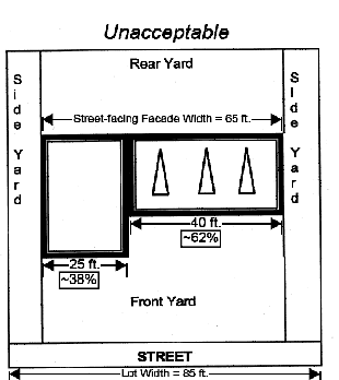
Figure 4.10-1A - Unacceptable Width of Street-facing Garage on a Lot >50 feet Wide
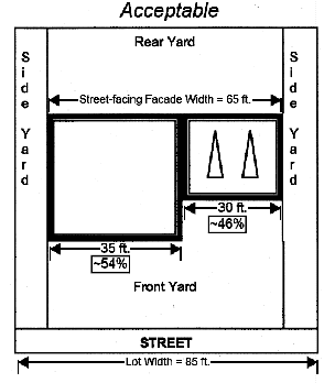
Figure 4.10-1B - Acceptable Width of Street-facing Garage on a Lot >50 feet Wide
2.
Lots < 50 Ft. in Width - For buildings with front-loaded garages, the area of the garage wall facing the street must be no more than 50 percent of the area of the building's street-facing facade. Front-loaded garages are attached garages with entrances facing the same street as the building's primary entrance. The area is measured in sq. feet and, with the exception of gabled areas and second stories, the entire facade of the garage is measured. The interior of the garage determines the width of the garage facade, not just the garage doors. See Figure 4.10-2A - Unacceptable Street-facing Garage Area and Figure 4.10-2B - Acceptable Street-facing Garage Area.
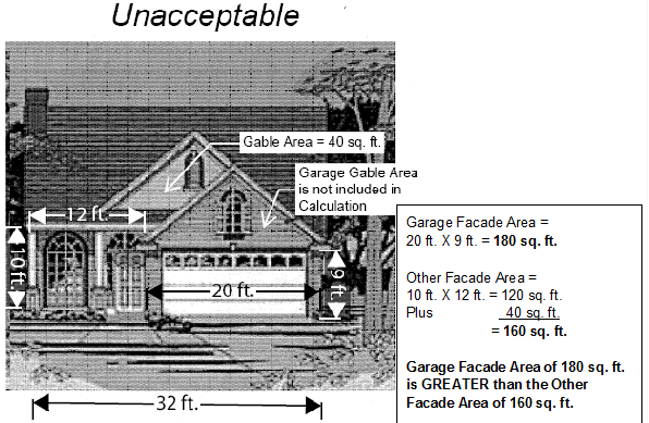
Figure 4.10-2A - Unacceptable Street-facing Garage Façade Area
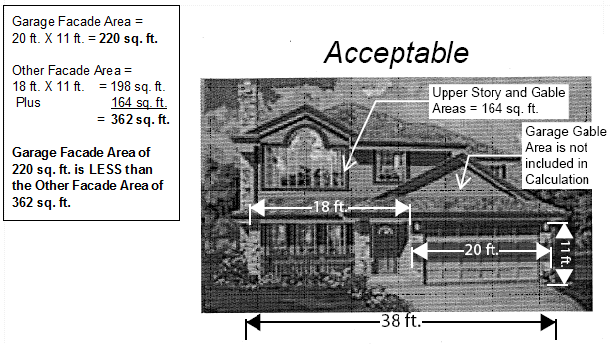
Figure 4.10-2B - Acceptable Street-facing Garage Façade Area
3.
Exception - Where the street-facing facade of a building is less than 24 feet wide, the garage wall facing the street may be up to 12 feet wide if the garage meets one of the following:
a)
Interior Living Area above the Garage - The living area is not set back more than four feet from the street-facing garage wall; or
b)
Covered Balcony - A covered balcony above the garage is:
1)
At least the same width as the street-facing garage wall;
2)
At least six feet deep; and
3)
Accessible from the interior living area of the building.
b.
Garage Placement - Garages must be placed only as indicated in the options below. The applicant must indicate the proposed option(s) on plans submitted for building permits. Additionally, measurements may be taken from the second floor of homes, provided the second floor spans across the entire garage.
As used below, the term "front wall of the building" means the living space wall that is closest and roughly parallel to the street frontage that the garage is oriented towards. A front porch, bay window, or other projection or architectural feature does not constitute a living space wall.
Garage Placement Options -
1.
Street Accessed Garage with Four-feet Recess - Vehicular entrances face the street and are recessed at least four feet from the front wall of the building as shown in Figure 4.10-3 - Garage Facing Street and Recessed at Least Four Ft
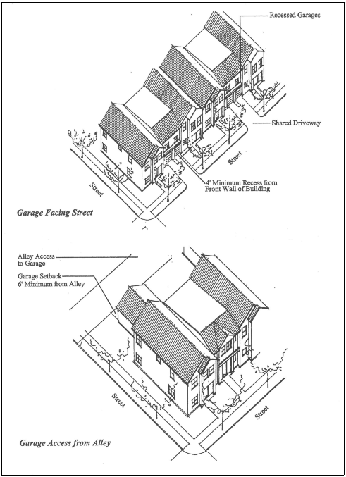
Figure 4.10-3 - Garage Facing Street and Recessed at Least Four Ft.; and
Figure 4.10-4 - Garage with Alley Access
2.
Side or Rear Accessed Garage- Vehicular entrances are accessed from and oriented towards a rear or side alley or driveway, and not a street, as shown in Figure 4.10-4 - Garage with Alley Access. Garage setbacks from alleys are outlined in Section 4.0.60.j of Chapter 4.0 Improvements Required with Development. Any garage wall facing a street must provide a minimum area of 15 percent windows and/or doors.
3.
Garage Access Diagonal to the Street - Vehicular entrances are oriented diagonally to the street, as shown in Figure 4.10-5 - Garage Access Diagonal to the Street, below. The garage wall facing the street must include a minimum area of 15 percent windows and/or doors. To determine whether the portion of the garage that faces the street complies with Section 4.10.50.03.a, the width of the front garage wall is measured as the length of the leg of a right triangle parallel to the street, where the hypotenuse of the triangle is the front of the garage.
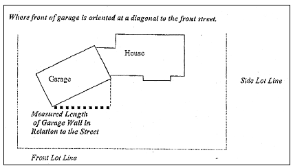
Figure 4.10-5 - Garage Access Diagonal to the Street
4.
Basement Garage - Vehicular entrances face the street and garages are located beneath the main floor and front door entrance to the building, provided the garage entrances are flush with or set behind the front wall of the building, as shown in Figure 4.10-6 Basement Garage, below. This option addresses the basement garage scenario in hillside areas.
Figure 4.10-6 - Basement Garage
5.
Flush Garage with Porch - Vehicular entrances face the street and are flush with or recessed from the front wall of the building, and a front porch is provided with minimum dimensions of 6 feet by 10 feet (60 sq. feet). A minimum of 60 percent of the porch must be covered to provide weather protection.
6.
Flush or Recessed Single Car Garage - Vehicular entrances face the street and are flush with or recessed from the front wall of the building, and the garage is a single-car garage that is a maximum of 12 feet wide. These options are shown below in Figure 4.10-7 - Single Car Garage Access Recessed from Front Wall of Dwelling and in Figure 4.10-8 - Single Car Garage Flush from Front Wall of Dwelling.
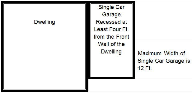
Figure 4.10-7 - Single Car Garage Recessed from Front Wall of Dwelling
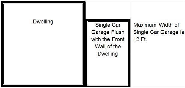
Figure 4.10-8 - Single Car Garage Flush with Front Wall of Dwelling
7.
Narrow Lot (less than 40 feet width) Facing Street - Vehicular entrances face the street and the garage portion of the building is recessed a minimum of 2 feet from the portion of the building nearest the street that is designed for human occupancy (includes enclosed rooms, porches, balconies, etc.) and the width of the garage portion of the building is equal to or less than 50% of the lot width.
c.
Garage Materials - When provided, garages must be constructed of the same building materials as the primary building.
4.10.50.04 Menus for Building Articulation and Design Variety.
a.
Building and Roof Articulation - Street-facing building elevations with a length exceeding 40 feet must incorporate design features to preclude large expanses of uninterrupted building surfaces. Along the face(s) of a structure oriented toward a public or private street, such features must occur at least every 40 feet in the horizontal dimension. In addition, each story (as the term "story" is defined in the Oregon Residential Specialty Code) is required to include at least one such feature.
For townhomes, this requirement applies where attached units exceed a length of 40 feet and the standard is satisfied by applying the articulation and design features to their combined length. At least two of the following three choices must be provided on the street-facing building elevations:
1.
Off-sets or breaks in roof elevation of three feet or more in height, or cornices two feet or more in height.
2.
Recesses, such as enclosed floor area, decks, patios, courtyards, entrances, etc., with a minimum depth of two feet and minimum length of four feet if combined with a change in exterior siding using one or more of the materials listed below in Section 4.10.50.04.b.3., or with a minimum depth of four feet and minimum length of eight feet if not combined with a change in exterior siding materials.
3.
Extensions/projections, such as enclosed floor area, porches, bay windows, decks, entrances, etc., that have a minimum depth of two feet and minimum length of four feet if combined with a change in exterior siding using one or more of the materials listed below in Section 4.10.50.04.b.3, or with a minimum depth of four feet and minimum length of eight feet if not combined with a change in exterior siding materials.
b.
Design Variety Menu - Each building must incorporate a minimum of three of the following eight building design features. Building design features are required on the street facing façade for development on an interior lot, and both street facing facades for development on a corner lot.
1.
Roof Pitch - A minimum 6:12 roof pitch with at least a six-inch overhang.
2.
Eaves - Eaves with a minimum 18-in. overhang.
3.
Building Materials - At least two different types of building materials including but not limited to stucco and wood, brick and stone, etc. Alternatively, a minimum of two different patterns of the same building material, such as scalloped wood and lap siding, etc., on facades facing streets. These requirements are exclusive of foundations and roofs and pertain only to the walls of a structure.
4.
Trim - A minimum of 2.25-in. trim or recess around windows and doors that face the street.
5.
Increased Windows - A minimum area of 20 percent windows and/or doors on facades facing streets, sidewalks, and multi-use paths. This provision includes garage facades. Gabled areas need not be included in the base wall calculation when determining this minimum 20 percent calculation.
6.
Architectural Features - At least one architectural feature included on dwelling facades that face the street. Architectural features are defined as bay windows, covered porches greater than 60 sq. feet in size, balconies above the 1st floor, dormers related to living space, or habitable cupolas.
7.
Architectural Details - Architectural details used consistently on dwelling facades. Architectural details are defined as exposed rafter or beam ends, eave brackets, windows with grids or divided lights, or pergolas/trellis work integrated into building facades.
8.
Elevated Finished Floor - An elevated finished floor a minimum of two feet above the grade of the nearest street sidewalk or streetside multi-use path.
4.10.50.05 Pedestrian Circulation and Site Design Standards for Multi-Dwellings.
a.
Applicability - The following additional pedestrian circulation and site design standards apply to all residential developments with five or more dwelling units.
b.
Standards -
1.
Connectivity - The internal sidewalk system must connect all abutting streets to primary building entrances. The internal sidewalk system must connect all buildings on site, and connect the dwelling units to vehicle and bicycle parking areas, refuse areas, and all recreational facility and common areas on or abutting the property. The internal sidewalk system must connect to abutting public sidewalks, multi-use paths and other pedestrian connections, and be stubbed towards any future phases on the subject property.
2.
Sidewalk and Building Separation - Internal sidewalks must be separated a minimum of five feet from dwellings, measured from the sidewalk edge closest to the dwelling unit. This requirement does not apply to the following:
a)
Sidewalks along public or private streets used to meet building orientation standards; or
b)
Mixed use buildings and multi-family densities exceeding 30 units per acre.
3.
Sidewalk Surface Treatment - Public internal sidewalks must be concrete and must be at least five feet wide. Private internal sidewalks are required to be concrete, or masonry; and must be at least five feet wide. All materials used for sidewalks must meet City Engineering standards.
4.
Crossings - Where internal sidewalks cross a vehicular circulation area or parking aisle, they must be clearly marked with contrasting paving materials.
5.
Sidewalk and Vehicle Circulation Separation - The following buffering standards apply to dwelling units built within eight feet of ground level:
a)
Driveways and parking lots must be separated from windowed walls by at least eight feet; sidewalks and multi-use paths must be separated by at least five feet
b)
Driveways and uncovered parking spaces must be separated from doorways by at least five feet
6.
Safety Adjacent to Vehicular Areas - Where internal sidewalks parallel and abut a vehicular circulation area, sidewalks must be raised a minimum of six in., or must be separated from the vehicular circulation area by a minimum six-in. raised curb. In addition, a landscaping strip at least five feet wide, or wheel stops with landscaping strips at least four feet wide, must be provided.
7.
Building Separation - The minimum distance between multi-dwellings must be 10 feet.
8.
Percentage of Frontage -
Residential Mixed Use (RMU) and Commercial Mixed Use (CMU) Zones: See the minimum Frontage Occupation established for each Zone.
All other zones: On sites with 100 feet or more of public or private street frontage, at least 50 percent of the street frontage width must be occupied by one or more buildings placed within the maximum front yard setback established for the Zone. For sites with less than 100 feet of public or private street frontage, at least 40 percent of the street frontage width must be occupied by buildings placed within the maximum front yard setback established for the Zone.
Exception: This requirement does not apply to buildings on lots with a rear lot line length that is 50 percent or less of the length of the front lot line.
(Ord. No. 2012-16, eff. 12-13-2012; Ord. No. 2012-18, eff. 12-13-2012; Ord. No. 2014-18, eff. 12-11-2014; Ord. No. 2014-19, eff. 12-11-2014; Ord. No. 2020-04, eff. 3-3-2020; Ord. No. 2021-22, eff. 11-24-2021; Ord. No. 2022-12, eff. 6-1-2022; Ord. No. 2023-01, eff. 2-8-2023)
Section 4.10.55 - Standards For Cottage Clusters.
4.10.55.01 Applicability.
Cottage Cluster development must comply with Sections 4.10.55.02 through 4.10.55.07. When an existing single detached dwelling is located on the same lot as a proposed Cottage Cluster development and is retained with the development, the existing dwelling must meet the requirements of Section 4.10.55.02.
4.10.55.02 Cottage Development Standards.
a.
Cottages as defined in Chapter 1.6 are subject to the following:
1.
The maximum building height for all Cottages and community buildings is 25 feet.
2.
Each Cottage must be limited to 1,200 square feet of enclosed/habitable floor area or less.
a)
Storage areas are exempt from the size limit in "2." above.
1)
Attached enclosed storage areas may not exceed 100 sq. feet
2)
Detached storage areas are subject to 4.10.55.06 - Accessory Structures.
3.
Each Cottage is limited to a building (ground floor) footprint of less than 900 square feet.
4.
Setbacks. Cottage Clusters must meet the minimum and maximum setback standards that apply to Single Detached dwellings in the same zone. Where the setback standards of the underlying zone exceeds 10 feet, the minimum setback standard for Cottage Cluster development will be 10 feet.
Cottages must be separated by a minimum distance of 6 feet. The minimum distance between all other structures within the Cottage Cluster development, including accessory structures, must be in accordance with building code requirements.
b.
Existing Structures
1.
On a lot or parcel to be used for a Cottage Cluster project, an existing detached dwelling on the same lot at the time of proposed development of the Cottage Cluster may remain within the Cottage Cluster project area under the following conditions:
a)
The existing dwelling may be nonconforming with respect to the requirements of this code.
b)
The existing dwelling may be expanded up to the maximum height, building floor area, and building footprint of a Cottage in a Cottage Cluster pursuant to Section 4.10.55.02. Existing dwellings that exceed the allowed maximum height, floor area and footprint may not be expanded.
4.10.55.03 Building Orientation, Courtyards, Privacy, and Facades Adjacent to Pedestrian Areas.
a.
Cottage Orientation - Cottages must be clustered around a common courtyard, meaning they abut the associated common courtyard or are directly connected to it by a pedestrian path, and must meet the following standards. See Figure 4.10-9 - Cottage Cluster Orientation and Common Courtyard Standards.
1.
Each Cottage within a cluster must either abut the common courtyard or must be directly connected to it by a pedestrian path that meets the requirements of Section 4.10.55.04.
When an existing Single Detached dwelling is located on the same lot as a proposed Cottage Cluster development and is retained with the development, the existing dwelling is exempt from this provision.
2.
A minimum of 50 percent of Cottages within a cluster must be oriented to the common courtyard and must:
a)
Have a main entrance facing the common courtyard;
b)
Be within 10 feet from the common courtyard, measured from the façade of the Cottage to the nearest edge of the common courtyard; and
c)
Be connected to the common courtyard by a pedestrian path.
3.
Cottages within 20 feet of a street right-of-way may have their entrances facing the street.
4.
Cottages not facing the common courtyard or the street must have their main entrances facing a pedestrian path that is directly connected to the common courtyard.
b.
Common Courtyard Design Standards - Common courtyards provide communal open space available to each Cottage in a Cottage Cluster. See Figure 4.10-9 -Cottage Cluster Orientation and Common Courtyard Standards. Common courtyards must meet the following standards:
1.
The common courtyard must be a single, contiguous area.
2.
Cottages must abut the common courtyard on at least two sides of the courtyard.
3.
The common courtyard must contain a minimum of 150 square feet per Cottage within the associated cluster.
4.
The common courtyard must be a minimum of 15 feet wide at its narrowest dimension.
5.
The common courtyard must be developed with a mix of landscaping, lawn area, pedestrian paths, and/or paved courtyard area, and may also include recreational amenities. Impervious elements of the common courtyard must not exceed 75 percent of the total common courtyard area.
6.
Pedestrian paths must be included in a common courtyard. Paths that are contiguous to a courtyard will count toward the courtyard's minimum dimension and area. Parking areas, required setbacks, and driveways do not qualify as part of a common courtyard.
Figure 4.10-9. Cottage Cluster Orientation and Common Courtyard Standards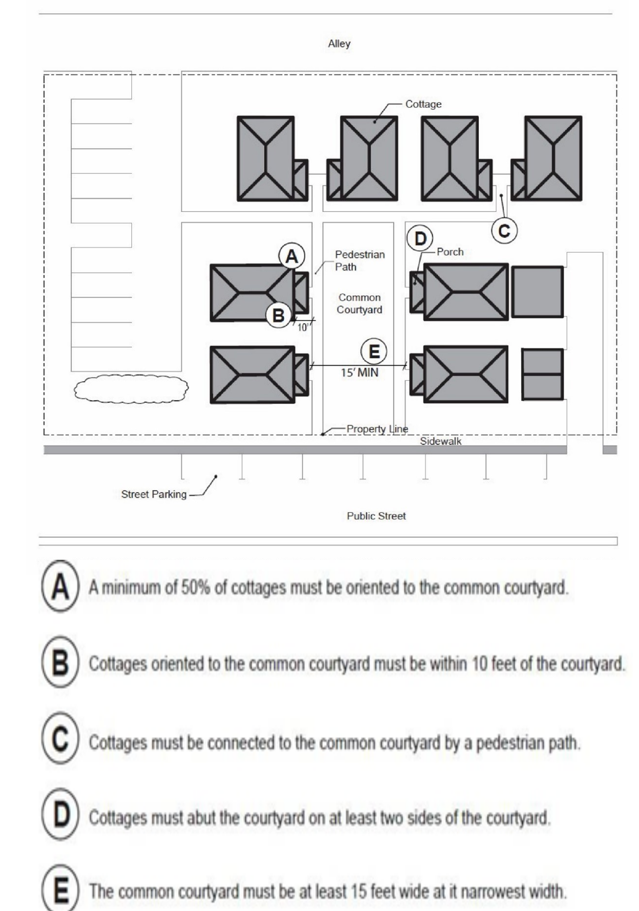
c.
Community Buildings - Cottage Cluster projects may include community buildings available to residents for communal uses such as community meeting rooms, rooms for guests, exercise rooms, day care, or community eating areas. Community buildings must meet the following standards:
1.
Each Cottage Cluster development is permitted one community building.
2.
Community buildings are limited to the same height restriction as Cottages, the maximum height is 25 feet.
3.
A community building that meets the development code's definition of a dwelling unit must meet the maximum 900 square foot footprint limitation that applies to Cottages, unless a covenant is recorded against the property stating that the structure is not a legal dwelling unit and will not be used as a primary dwelling.
d.
Privacy - If the side wall of a dwelling is on or within three feet of the property line, ground floor windows or other openings that allow for visibility into the side yard of the adjacent lot will not allowed. Windows that do not allow visibility into the side yard of the adjacent lot, such as a clerestory window or a translucent window, are allowed.
e.
Windows - Cottages within 20 feet of a street right-of-way must contain a minimum area of 15 percent windows and/or doors on the street facing facade.
4.10.55.04 Pedestrian Circulation Standards.
a.
Pedestrian Path - A pedestrian path must be provided that connects the main entrance of each Cottage to the following:
1.
The common courtyard;
2.
Shared parking areas;
3.
Community buildings; and
4.
Sidewalks in public rights-of-way abutting the site or rights-of-way if there are no sidewalks.
b.
Pedestrian paths that are required to meet subsection a. above must be constructed to the Site Design and Development Standards and a minimum of four (4) feet wide.
4.10.55.05 Vehicle Parking and Design Standards.
a.
When provided, off-street parking must be constructed consistent with Chapter 4.1 - Parking, Loading, and Access Requirements.
b.
Parking Design - Off-street parking may be arranged in clusters, as shown in Figure 4.10-10 Cottage Cluster Parking Design Standards, subject to the following standards:
1.
Cottage Cluster projects with fewer than 16 Cottages are permitted parking clusters of not more than five (5) contiguous spaces.
2.
Cottage Cluster projects with 16 Cottages or more are permitted parking clusters of not more than eight (8) contiguous spaces.
3.
Parking clusters must be separated from other spaces by at least four (4) feet of landscaping.
c.
Parking Location and Access
1.
Off-street parking spaces and vehicle maneuvering areas must not be located:
a)
Within of 20 feet from any street right-of-way;
b)
Between a street right-of-way and the front façade of Cottages located closest to the street. This standard does not apply to alleys.
2.
Off-street parking spaces are not allowed within 5 feet of any other property line, except alley property lines. Driveways and drive aisles are permitted within 10 feet of other property lines.
3.
Clustered parking areas and parking structures must include landscape buffers when abutting common courtyards and streets, consistent with Section 4.2.40.
4.
Garages and carports.
a)
Garages and carports attached to Cottages are not permitted.
b)
Garages and carports (whether shared or individual) must not abut common courtyards.
c)
Individual detached garages must not exceed 400 square feet in floor area.
d)
Garage doors for detached individual garages must not exceed 20 feet in width.
e)
Clustering of covered parking must be consistent with the numerical standards for clustering in Section 4.10.55.05.b.
Figure 4.10-10 Cottage Cluster Parking Design Standards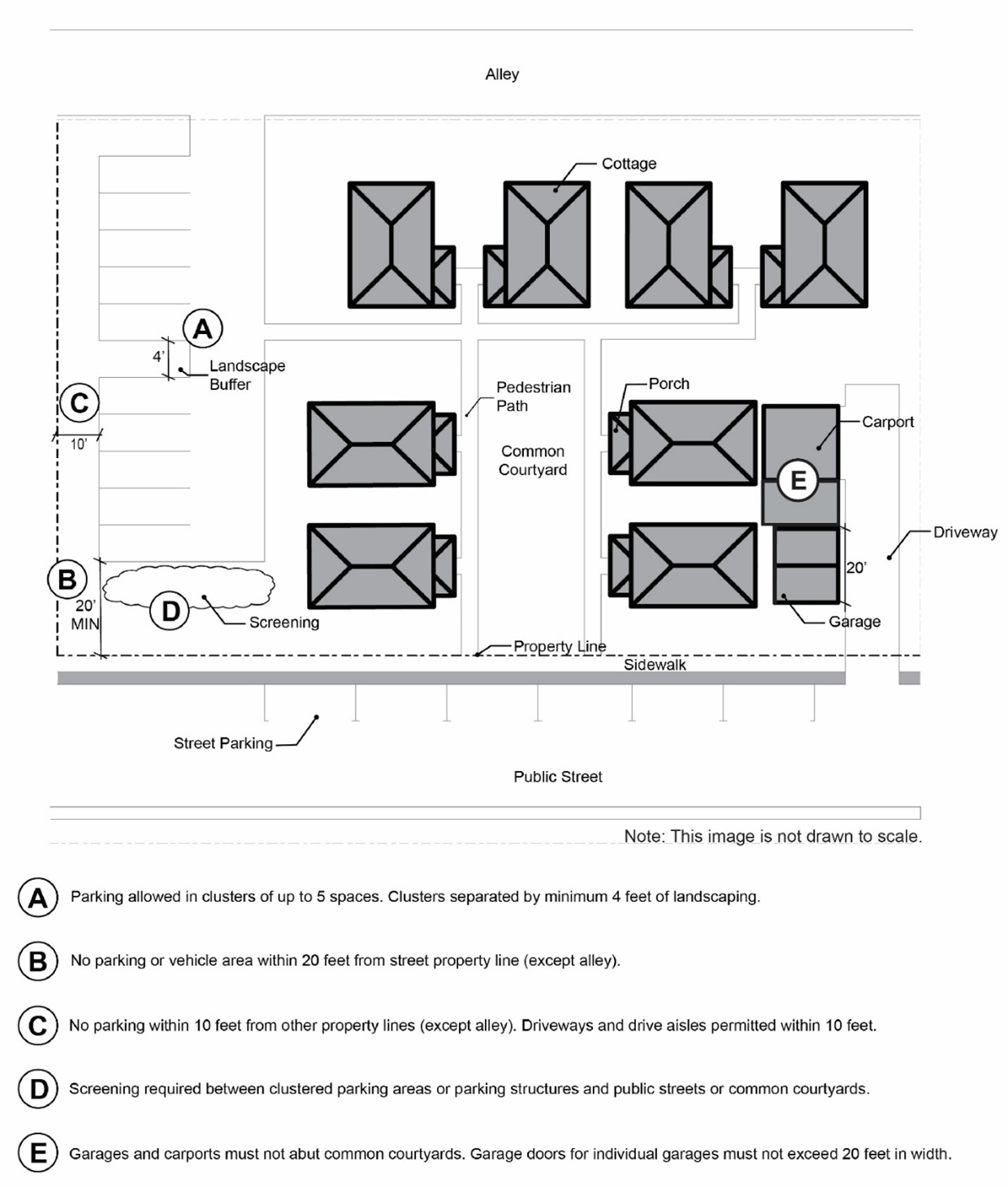
4.10.55.06 Accessory Structures.
Accessory structures within a Cottage Cluster development must not exceed 400 square feet in floor area and comply with the standards in Chapter 4.3 - Accessory Development Regulations.
Garbage and recycling collection areas, ground-mounted and roof-mounted mechanical equipment - See requirements in Chapter 4.2 - Landscaping, Buffering, Screening, and Lighting
(Ord. No. 2022-12, eff. 6-1-2022; Ord. No. 2023-01, eff. 2-8-2023; Ord. No. 2023-19, § 40(Exh. A), eff. 6-30-2023)
Section 4.10.60 - [Repealed].
Editor's note— Ord. No. 2022-12, effective June 1, 2022, repealed § 4.10.60.
Section 4.10.70 - Standards For Commercial, Industrial, and Civic Development.
4.10.70.01 Applicability.
a.
All new commercial, industrial, and civic building types and associated features, such as parking lots, within all zones that refer to Section 4.10.70 must comply with Sections 4.10.70.02 through 4.10.70.05. Buildings associated with stand alone Automotive and Equipment - Car Wash, Fuel Sales, and Wholesale, Storage, and Distribution - Mini Warehouses use types are not required to comply with these Sections.
b.
Independent or cumulative expansions of a commercial, industrial, or civic structure in existence and in compliance with this Code on December 31, 2006, or constructed after December 31, 2006, pursuant to a valid Conceptual or Detailed Development Plan approved on or before December 31, 2006, are not required to comply with this section provided that:
1.
The expansion adds floor area of 500 square feet or less; or
2.
The expansion adds floor area of 3,000 square feet or less and is equivalent to 20 percent or less of the existing structure's gross floor area.
c.
Independent or cumulative expansions of a commercial, industrial, or civic structure in existence and in compliance with the Code on December 31, 2006, or constructed after December 31, 2006, pursuant to a valid Conceptual or Detailed Development Plan approved on or before December 31, 2006, must comply with the requirements of Sections 4.10.70.02 through 4.10.70.05, subject to the provisions in "d," below, that allow choices among some standards, provided that:
1.
The expansion adds floor area of more than 3,000 square feet; or
2.
The expansion adds floor area of more than 500 square feet and is equivalent to more than 20 percent of the existing structure's gross floor area.
d.
Pedestrian oriented design requirements for commercial, industrial, or civic structure expansions identified in Section 4.10.70.01.c, above, are as follows:
1.
Applicants must choose at least four standards from Sections 4.10.70.02 - Building Orientation and 4.10.70.03 - Pedestrian Circulation Standards, with a minimum of one standard from each. This criterion does not apply if the expansion/enlargement is an upper story addition only. If the expansion/enlargement is for space not open to customers or to the public, applicants must choose only one standard from Section 4.10.70.02 and two standards from Section 4.10.70.03.
2.
New parking must comply with the Vehicle Circulation and Design Standards in Sections 4.10.70.04.a.2 and 4.10.70.04.b. For new drive-throughs, Section 4.10.70.04.c applies.
3.
Applicants must choose the option in Section 4.10.70.05.b.2.a or the option in Section 4.10.70.05.b.2.b.
4.
Applicants must choose at least two of the five standards from Section 4.10.70.05.b.3.a through 4.10.70.05.b.3.e. If the expansion/enlargement is for space not open to customers or to the public, applicants must choose only one standard from Section 4.10.70.05.b.3.a through 4.10.70.05.b.3.e.
e.
The required standards applicable to expansions must be applied either to the portion of the building being expanded, or in equal proportion to portions of the original building not in compliance with respect to the standard. For example, where windows may be required, but the security of a proposed storage room is needed, the applicant may install windows on other portions of the building not in compliance with the window provisions to satisfy the requirements.
f.
Accessory Structures not open to customers or the public, and modular classroom buildings on school grounds, are not required to comply with this section provided that:
1.
The Accessory Structure is not located between the primary building and the street to which that building is oriented; and either
a)
The building is 500 square feet or less in size; or
b)
The building is 3,000 square feet or less in size and is equivalent to 20 percent or less of the primary structure's gross floor area.
4.10.70.02 Building Orientation.
All buildings must be oriented, as outlined in this Section, to existing or proposed public or private streets. See Chapter 4.0 Improvements Required with Development for public and private street standards.
The building orientation standard is met when all of the following criteria are met:
a.
Street Frontage Setback -
Residential Mixed Use (RMU) Zones and Commercial Mixed Use (CMU) Zones: See the minimum Frontage Occupation established in each zone chapter.
All other zones that include a Maximum Front Yard Setback standard: At least 50 percent of the building's linear frontage is located within the maximum setback established for the zone for structures that have street frontage. Expansion of a structure existing prior to December 31, 2006, and in conformance with the Code on that date is deemed to meet this criterion, provided the area of expansion is between the street and the existing building frontage.
b.
Entrances - All building sides that face an adjacent public or private street must include at least one primary pedestrian entrance oriented to a public pedestrian facility such as the adjacent public sidewalk and be accessible to people with mobility disabilities. When the Development Site contains frontage on more than one street, building corner entrances at an angle of up to 45 degrees, from the largest of the two adjacent streets, may be substituted for separate entrances on adjacent streets. If the building does not have frontage along an adjacent street, direct pedestrian access to the street may be achieved by a sidewalk or courtyard connecting to a street no farther than 100 feet from the building's pedestrian entrance (distance measured along the centerline of the sidewalk or over the "hard-surfaced" portion of the courtyard from a public street right-of-way or private street tract). Examples of these requirements are shown below in Figure 4.10-11 - Site Development Element Locations. Buildings of less than 3,000 sq. feet fronting on only one street may provide the primary pedestrian entrance on the side of the building in lieu of the front, if a sidewalk or courtyard provides a direct, "hard-surfaced" pedestrian connection of less than 50 feet between the entrance and the street (distance measured along the centerline of the sidewalk or over the "hard-surfaced" portion of the courtyard from a public street right-of-way or private street tract).
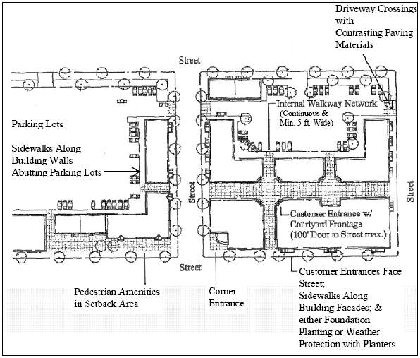
Figure 4.10-11 - Site Development Element Locations
4.10.70.03 Pedestrian Circulation Standards.
a.
Requirements for New Development and Options for Expansions of a Commercial, Industrial, or Civic Structure, Consistent with Section 4.10.70.01.c -
1.
Continuous Internal Sidewalks - A continuous internal sidewalk, including associated necessary sidewalk crossings, no less than five feet wide, must be provided from public sidewalks or rights-of-way to all primary pedestrian entrances, and between primary pedestrian entrances of all buildings, as shown in Figure 4.10-11 - Site Development Element Locations. Sidewalks must be direct and convenient and form a network of walking routes.
2.
Sidewalks along Building Walls - Sidewalks no less than five feet wide must be provided along the full length of building walls featuring a primary pedestrian entrance and along any wall parallel to and abutting parking areas larger than eight parking spaces, except in situations where the sidewalk would not provide connectivity between an entrance and parking area. These elements are noted in Figure 4.10-11 - Site Development Element Locations.
3.
Separation and Distinction from Driving Surfaces - Where any internal sidewalk is parallel to and abuts a vehicular circulation or parking area, the sidewalk must be raised and separated from the vehicular circulation or parking area by a raised curb at least six in. in height. In addition to this requirement, a landscaping strip at least five feet wide, or wheel stops with landscaping strips at least four feet wide, are strongly encouraged to enhance the separation of vehicular from pedestrian facilities.
4.
Sidewalk Treatment - Internal sidewalks must be concrete and at least five feet wide.
5.
Crossings - Where any internal sidewalk crosses an internal street, driveway, or parking aisle, the sidewalk must be clearly marked and constructed with paving materials that contrast with the intersecting vehicle driving surface. Additional use of other measures to clearly mark a crossing, such as an elevation change, speed humps, or striping, is encouraged.
6.
Connection to Adjacent Properties or Streets - In addition to the sidewalk connections required by the block development standards in Chapter 4.0 Improvements Required with Development, sidewalk connections shall be provided between internal sidewalk networks and all adjacent planned streets, sidewalks, and multi-use paths. Multi-use paths shall be connected with adjacent multi-use paths, sidewalks, and/or bike lanes. Where appropriate, such connections shall also be provided to adjacent residential properties.
b.
Additional Requirement for New Development and Additional List of Options for Expansions of a Commercial, Industrial, or Civic Structure, Consistent with Section 4.10.70.01.d.1 - Except in the Commercial Mixed Use (CMU) and Residential Mixed Use (RMU) Zones, an applicant proposing new Commercial, Industrial, or Civic development must include one of the following six design options. Applicants may add this list of choices to those presented in Section 4.10.70.03.a to obtain a larger list of options, to comply with the requirements of Section 4.10.70.01.d.1.
Design Options::
1.
Curb Cut Consolidation - Removal of at least one existing Curb Cut through outright removal or access consolidation, such that the net number of Curb Cuts for the Development Site is at least one fewer than prior existing conditions.
2.
Increased Landscape Buffer for Existing and New Vehicle Parking Areas - Construction or expansion of a landscape buffer for a parking, loading, and vehicle maneuvering area that exceeds the minimum width required in Section 4.2.40.a. The constructed or expanded landscape buffer must be a minimum of 20 feet wide for its full length.
3.
Photovoltaic Solar Installation for Surface Parking Areas Less Than ½ Acre - The Development Site contains less than ½ acre of Surface Parking Area, and the applicant installs photovoltaic solar panels with a generation capacity of at least 0.5 kilowatt per provided parking space on the Development Site.
4.
Covered Walkways - Installation of weather protection resulting in covered pedestrian walkways between and around all buildings and between the primary building and adjacent public pedestrian facilities. This option does not require covered pedestrian walkways along any facade without a pedestrian entrance.
5.
Street Median Improvements and Waiver of Remonstrance - Where development is proposed on property adjacent to existing five-lane arterial streets or highways, the applicant and owner record a signed and notarized letter with the Benton County Clerk stating the owner and future owners of the Development Site agree not to oppose construction of a future median or pedestrian refuge.
6.
Covered Bicycle Parking - The applicant provides covering (weather protection) for 100 percent of the bicycle parking spaces provided with development.
4.10.70.04 Vehicle Circulation and Design Standards.
a.
Parking Lots -
1.
Off-street parking and vehicular circulation must be placed to the rear of buildings. The Applicant may seek and the Director may approve an exception to this standard when the Director finds that parking cannot be located to the rear of the building due to other requirements of this Code or unusual site constraints, both of which are defined in the following paragraph, the amount of parking and vehicle circulation that cannot be accommodated to the rear of the building may be provided only to the side of the building. Where allowed by the underlying zone, outdoor vehicle display lots for sale of autos, noncommercial trucks, motorcycles, trailers with less than 10,000 lbs. gross cargo weight, motor homes, and boats may be located adjacent to streets.
2.
Other requirements of this Code may include, but are not necessarily limited to, significant Natural Resource and Natural Hazard provisions in Chapter 2.11 - Floodplain Development Permit, Chapter 4.2 - Landscaping, Buffering, Screening, and Lighting, Chapter 4.5 - Floodplain Provisions, Chapter 4.12 - Significant Vegetation Protection Provisions, Chapter 4.13 - Riparian Corridor and Wetland Provisions, and Chapter 4.14 - Landslide Hazard and Hillside Development Provisions; and Chapter 4.1 - Parking, Loading, and Access Requirements. Unusual site constraints may include parcels fronting more than two streets, irregular lot configuration, weak foundation soils, or other physical site factors that constrain development when considered with Building Code requirements.
b.
Corner Parcels - Parking areas shall not be located within 30 feet of a roadway intersection, as measured from the center of the curb radius to the edge of the parking area's curb or wheel stop.
c.
Drive-through Facilities - Internal driveways are prohibited between buildings and streets to which the building entrances are oriented. Examples of correct and incorrect locations of these facilities are shown on the next page in Figure 4.10-12 - Drive-through Facilities.
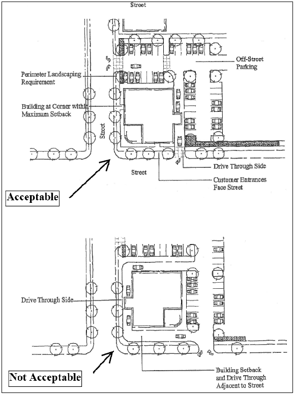
Figure 4.10-12 Drive-through Facilities
4.10.70.05 Standards and Menus for Pedestrian Features and Design Variety.
a.
Pedestrian Amenities Standards
1.
Weather Protection -
a)
General - Except as provided in "b," and "c," below, where new commercial and civic development is constructed immediately adjacent to (abutting) street sidewalks or pedestrian plazas, a minimum six-feet-wide, weather-protected area, protected by such elements as awnings or canopies, shall be provided and maintained along at least 80 percent of any building wall immediately adjacent to the sidewalks and/or pedestrian plazas. An additional requirement shall include a minimum eight-feet and maximum twelve-feet vertical clearance between the sidewalk and the lowest portion of the weather protection. The minimum vertical clearance shall be nine feet for balconies. These requirements are shown below in Figure 4.10-13 - Weather Protection.
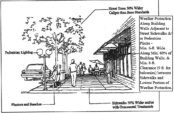
Figure 4.10-13 - Weather Protection
b)
Commercial Mixed Use 3 Zone - When subject to the standards in this chapter per Section 4.10.70.01, development on buildings abutting street sidewalks and pedestrian plazas in the Commercial Mixed Use 3 (CMU-3) Zone must provide weather protection consistent with the locational and dimensional standards in "a," above, when:
1)
Expansion or improvement costs exceed 50% of the real market value of the property according to the Benton County Assessor's office; and
2)
The building does not meet the exemption provisions in "c," below.
c)
General Commercial Zone - Weather protection in accordance with "a," above, is required only at street-oriented entrances.
d)
Designated Historic Resources - Development on Designated Historic Resources are subject to the provisions in Chapter 2.9 - Historic Preservation Provisions and exempt from the requirements in "a" through "c," above. This default to Chapter 2.9 and exemption from "a" through "c," above, applies whether or not weather protection such as awnings or canopies is proposed.
2.
Pedestrian Amenity Requirements - Except in the Commercial Mixed Use (CMU), Residential Mixed Use (RMU), and General Commercial (GC) Zones, all new development and substantial improvements must provide pedestrian amenities as defined by this Section. The number of pedestrian amenities provided must comply with the following sliding scale:
3.
Acceptable Pedestrian Amenities - Acceptable pedestrian amenities include the items listed below, some of which are shown in Figure 4.10-14 - Pedestrian Amenities:
a)
Sidewalks with ornamental treatments, such as brick pavers, or sidewalks 50 percent wider than required by this Code;
b)
Sidewalk planters with benches and public outdoor seating;
c)
Significant public art, such as sculpture, fountain, clock, mural, etc.;
d)
Mini parks or plazas that provide a minimum usable area of 300 sq. feet; and
e)
Street trees of a caliper 50 percent wider than required by this Code. This approach may include preservation of healthy mature trees adjacent to the street sidewalk.
4.
Accessibility of Pedestrian Amenities - Pedestrian amenities must be visible and accessible to the general public from an improved street. Access to pedestrian amenities must be provided via a public right-of-way or a public access easement.
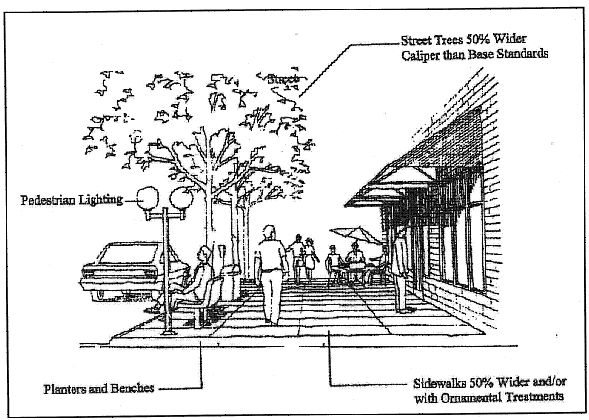
Figure 4.10-14 - Pedestrian Amenities
b.
Design Standards and Design Variety Menus
1.
Loading/Service Facilities - Loading and service areas such as trash enclosures must be located and screened consistent with Section 4.2.40.01 - Trash Dumpsters, Mechanical Equipment, and Outdoor Storage Areas. To minimize conflicts with public pedestrian areas, facilities must also be located to the back or sides of buildings, or in alleys where available. In addition, all loading and service areas such as trash enclosures must be located and sized appropriately for servicing.
2.
Windows - The provisions in this Section apply to placement and type of windows on street facing facades.
a)
Ground Floor Windows and Doors - Except for the General Commercial Zone, which is addressed in "c," below, a minimum of 60 percent of the length and 25 percent of the first 12 feet in height from the adjacent grade of any street-facing facade must contain windows and/or glass doors. For expansions or enlargements of existing buildings, the Director will grant an exception if the expansion/enlargement is for space neither adjacent to a street nor open to customers or the public. Additional requirements include the following:
1)
Ground floor windows must be framed by bulkheads, piers, and sills such as are used in a recessed window. Ground floor windows must also have a Top Treatment such as a hood, awning, or a storefront cornice separating the ground floor from the second story. Alternatively, all ground floor windows shall provide a minimum three-in.-wide trim or recess. The Base Treatment standards under Section 4.10.70.05.b.3.d, below, and the Top Treatment standards under Section 4.10.70.05.b.3.e, below, shall be used as a guide for providing bulkheads and cornices that meet this standard.
2)
Ground floor windows must have an opacity of less than 60 percent.
3)
Ground floor windows must allow views from adjacent sidewalks into working areas, lobbies, or pedestrian entrances. The bottom of the window glazing must not exceed four feet above the adjacent exterior grade.
b)
Windows on Stories above Ground Floor - For stories above the ground floor, each street-facing facade must include at least 20 percent window coverage.
c)
General Commercial Zone - A minimum of 20 percent of the length and 10 percent of the ground-floor wall area of any street-facing façade shall contain windows and/or glass doors.
d)
Designated Historic Resource Exemption - Where development occurs on a Designated Historic Resource, that Resource is subject to the provisions of Chapter 2.9 - Historic Preservation Provisions, and is exempt from the window requirements in "a," through "c," above. This default to Chapter 2.9 and exemption from "a," through "c," above, applies whether or not windows are proposed.
3.
Design Variety Menu - Each building must incorporate a minimum of three of the following five building design features. The applicant must indicate proposed options on plans submitted for building permits. While not all of the design features are required, the inclusion of as many as possible is strongly encouraged.
a)
Building Walls - Building walls in excess of 30 feet in length do not exceed a height/width ratio of 1:3 without a change in height of at least four feet, as addressed below in Figures 4.10-15A through C - Building Walls.
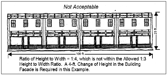
Figure 4.10-15A - Building Walls
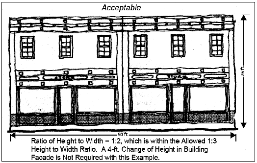
Figure 4.10-15B - Building Walls
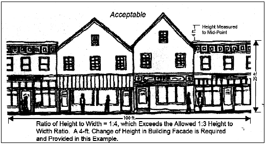
Figure 4.10-15C - Building Walls
b)
Maximum Wall Segments - All building wall segments on all sides of buildings are a maximum of 30 feet in length. Building wall segments are distinguished by architectural features including at least one of the following: columns, reveals, ribs or pilasters, piers, recesses, or extensions. The segment length may be increased to a maximum of 60 feet if the segment contains integral planters, public art, or permanent seating such as a seating wall, that conform to the accessibility standards in Section 4.10.70.05.a.4.
c)
Entrances - Primary building entrances are clearly defined by recess or projection, and framed by a sheltering element such as an awning, overhang, arcade, or portico.
d)
Base Treatments - A recognizable Base Treatment consisting of at least one of the following:
1)
Thicker walls, such as a bulkhead, ledges, or sills as viewed from the exterior of the building;
2)
Integrally textured materials such as stone, stucco, or other masonry;
3)
Integrally colored and patterned materials such as smooth-finished stone or tile;
4)
Lighter or darker colored materials, Mullions, or panels;
5)
Detailing such as scoring, ribbing, moldings, or ornamentation; or
6)
Planters integral to the building.
e)
Top Treatments - A recognizable Top Treatment consisting of at least one of the following:
1)
Cornice treatments, other than colored stripes or bands that are integral to the building design. Materials such as stone, masonry, brick, wood, galvanized and painted metal, or other colored materials are used;
2)
Sloping roof (4:12 or greater) with overhangs. Overhangs may be boxed with moldings such as Modillions, Dentils, or other moldings, as applicable; or contain brackets; or
3)
Stepped parapets.
(Ord. No. 2012-16, eff. 12-13-2012; Ord. No. 2012-17, eff. 12-13-2012; Ord. No. 2012-18, eff. 12-13-2012; Ord. No. 2014-19, eff. 12-11-2014; Ord. No. 2022-06, eff. 3-17-2022; Ord. No. 2023-01, eff. 2-8-2023; Ord. No. 2023-19, § 40(Exh. A), eff. 6-30-2023)
Section 4.11.10 - Purposes.
Procedures and standards for determination of Minimum Assured Development Area (MADA) are established in this Chapter to accomplish the following purposes:
a.
Provide protection for identified significant Natural Resources and reduce risks associated with Natural Hazards as identified in Chapter 2.11 - Floodplain Development Permit, Chapter 4.5 - Floodplain Provisions, Chapter 4.12 - Significant Vegetation Protection Provisions, Chapter 4.13 - Riparian Corridor and Wetland Provisions, and Chapter 4.14 - Landslide Hazard and Hillside Development Provisions;
b.
Permit efficient use of land;
c.
Provide flexibility and innovation in site planning to allow for an appropriate level of development on sites where Natural Resources are located;
d.
Establish a balanced, clear, and objective mechanism to avoid an undue burden for property owners protecting Natural Resources on individual properties;
e.
Minimize procedural delays and ensure due process in the review of development proposals.
Section 4.11.20 - Greater Restrictions.
This Chapter of this Code is not intended to repeal, abrogate, or impair any existing easements, covenants, or deed restrictions. However, these provisions do provide relief from other ordinances to assure a minimum development area.
Section 4.11.30 - Procedures.
Properties with Natural Resources or Natural Hazards subject to the provisions of Chapter 2.11 - Floodplain Development Permit, Chapter 4.5 - Floodplain Provisions, Chapter 4.12 - Significant Vegetation Protection Provisions, Chapter 4.13 - Riparian Corridor and Wetland Provisions, and Chapter 4.14 - Landslide Hazard and Hillside Development Provisions, have access to the provisions of this Chapter, provided the regulations within it are followed. Compliance with the provisions of this Chapter must be determined through the development review processes identified in Section 1.2.110 of Chapter 1.2 - Legal Framework or through the Building Permit or construction permit review processes.
a.
Property within the City Limits as of December 31, 2004 -
1.
Existing Lots and Development Sites - Minimum Assured Development Area (MADA) applies only to -
a)
Individual lots and individual parcels legally established prior to December 31, 2004; and
b)
Development sites composed of one or more legally established lots or parcels aggregated for a specific development permit application.
2.
Property Proposed for Subdivision, Partition, or Property Line Adjustment -
a)
Any Subdivision, Partition, and/or Property Line Adjustment processed after December 31, 2004, may not create lots or parcels unless:
1)
Each new and remaining lot or parcel contains:
i.
an area unconstrained by Natural Resources or Natural Hazards; or
ii.
an area that includes Formerly Constrained Areas; or
iii.
contains an area that includes the areas in 2.a)1)i. and ii. above; and
2)
The area in "2. a) 1)," above, is equal to or greater than the Minimum Assured Development Area (MADA) for the zone or zones in which the development proposal falls.
b)
Exceptions to the requirements in "a," above, include:
1)
Lots created for public park purposes;
2)
Privately- or publicly-owned lots completely contained within land zoned Conservation-Open Space; and
3)
Common open space tracts created for the purpose of protecting Natural Resources or Natural Hazards.
3.
Zone Changes - Zone Changes, other than those initiated by the City Council, may not be used to increase the area of encroachment into the protected Natural Resources and Natural Hazards on a lot, parcel, or development site, unless such Zone Change is accompanied by an Economic, Social, Environmental, and Energy (ESEE) analysis indicating the overall balance provided by the City's Natural Resources and Natural Hazards protection program is maintained or improved.
b.
Property Annexed to the City after December 31, 2004 -
1.
Existing Lots and Development Sites - Minimum Assured Development Area (MADA) applies only to -
a)
Individual lots and individual parcels legally established prior to Annexation; and
b)
Development sites composed of one or more legally established lots or parcels aggregated for a specific development permit application.
2.
Property Proposed for Subdivision, Partition, or Property Line Adjustment -
Any Subdivision, Partition, and/or Property Line Adjustment processed after Annexation may not create lots or parcels unless the proposal meets the provisions in Section 4.11.30.a.2, above.
3.
Zone Changes - After Annexation, Zone Changes, other than those initiated by the City Council, must meet the provisions in Section 4.11.30.a.3, above.
c.
Re-use of Minimum Assured Development Area (MADA) Prohibited -
1.
Once a site has been developed based on the provisions of this Chapter, no increase in the MADA is permitted. Development may occur in phases and portions of sites may be developed. However, the total MADA must not exceed that allowed for the site as a whole. Sites which have used the MADA provisions will be graphically outlined on the Official Zoning Map and monitored in the City's Permit Plan tracking system.
2.
Once annexed, any County development on a site that occurred prior to Annexation will be included as part of and not in addition to the MADA calculations allowed by this Chapter.
d.
Effects of Underground Utility Projects on Minimum Assured Development Area (MADA) - The following improvements are not counted as development against the MADA for a site:
1.
Underground utility projects that have been or are proposed to be constructed in accordance with the Corvallis Capital Improvement Program (CIP) process; and
2.
Areas planted with native species as mitigation for the construction impacts in "1," above.
(Ord. No. 2023-01, eff. 2-8-2023)
Section 4.11.40 - Submittal Requirements For Determining Minimum Assured Development Area.
Proposals for development of properties containing Natural Resources and Natural Hazards identified in Chapter 2.11 - Floodplain Development Permit, Chapter 4.5 - Floodplain Provisions, Chapter 4.12- Significant Vegetation Provisions, Chapter 4.13 - Riparian Corridor and Wetland Provisions, and/or Chapter 4.14 - Landslide Hazard and Hillside Development Provisions, must contain the following information:
a.
Description of the land on which the proposed development is to take place, including address, lot, block, tract, Assessor's Map and Tax Lot number, or similar description;
b.
Narrative - A narrative that includes:
1.
Gross area (acreage) and net area (acreage) of the Development Site;
2.
A description or table identifying the allowed Minimum Assured Development Area (MADA) for the site, calculated in accordance with the provisions of this Chapter; and
3.
The extent of any proposed encroachments into the protected Natural Resource and Natural Hazard areas.
c.
Map information and supporting data to support any Map Refinement requests being submitted in conjunction with a request to determine the MADA on a site.
d.
Site Plans - Site plans drawn to scale and showing existing conditions. Plans must be no larger than 24 by 36 in. and must include the following information:
1.
Date the site plan was prepared, scale, scale bar, and north arrow;
2.
Relationship of the Development Site to adjoining properties, streets, alleys, structures, public utilities, and drainageways;
3.
Property lines and dimensions;
4.
Location and extent of each of the Natural Hazards identified as Highly Protected on the Natural Hazards Map, both on and within 150 feet of the Development Site;
5.
Location and extent of each of the Natural Hazards identified as Partially Protected on the Natural Hazards Map, both on and within 150 feet of the Development Site;
6.
Location and extent of each of the Natural Resources identified as Highly Protected on the Significant Vegetation Map and the Riparian Corridors and Wetlands Map, both on and within 150 feet of the Development Site;
7.
Location and extent of each of the Natural Resources identified as Partially Protected on the Significant Vegetation Map and the Riparian Corridors and Wetlands Map, both on and within 150 feet of the Development Site;
8.
Public and private roadways and driveways;
9.
Location and extent of required Department of State Lands and/or U.S. Army Corps of Engineers Wetland mitigation areas located on the site and/or a permit indicating any off-site mitigation acreage requirements.
10.
Vehicle and pedestrian access points and accessways;
11.
Public and private easements and labels as to the purpose of the easements;
12.
Existing structures, including fences and walls;
13.
Existing off-street parking facilities; and
14.
Any dedications that exist on the site.
e.
Site Plans with Preservation Information - Site plans indicating the proposed development and areas of preservation. Plans must be no larger than 24 by 36 in. and drawn to scale. The site plan must include the information required in Section 4.11.40.d and the following:
1.
Proposed development and disturbance areas;
2.
If grading is to occur, a grading plan showing existing and finished contours on the site, at two-feet contour intervals;
3.
Location and extent of the proposed encroachment into the protected Natural Resources and Natural Hazards and area calculations of the encroachment into each specific protected Natural Resource and Natural Hazard, as listed in Section 4.11.50.04.
f.
Minimum Assured Development Area (MADA) Calculations - Minimum Assured Development Area (MADA) calculations to include:
1.
Gross acreage and Net acreage of the Development Site;
2.
Current Zoning Map designations of the site;
3.
Acreage and Percentage Coverage of the Site for -
a)
The aggregate of the Highly Protected Natural Resources and Natural Hazards; and
b)
The Net Aggregate Natural Feature Area of the Partially Protected Natural Resources and Natural Hazards. This net aggregate excludes Partially Protected Natural Resources and Natural Hazards that are located in the same physical location as Highly Protected Natural Resources and Natural Hazards. See Chapter 1.6 - Definitions for the definition of Net Aggregate Natural Feature Area;
4.
Acreage and percent coverage of the site for areas that are inaccessible due to the location of the protected Natural Resources and Natural Hazards;
5.
Acreage of the portion(s) of public right-of-way dedication that is:
a)
For roadways that are identified in the Transportation System Plan and are located outside of the protected Natural Resources and Natural Hazards areas; and
b)
Limited to the acreage associated with the extra-capacity aspect of the roadways identified in "a," above. This extra-capacity aspect includes acreage in excess of that required for a Local Street;
6.
Acreage of Wetland mitigation areas required to allow construction of the publicly dedicated road improvements in "5" above, to and through the site. The Wetland mitigation area acreage is limited to that specifically needed for the extra-capacity portion of the road improvements, as described in "5" above;
7.
Acreage of on-site and off-site Wetland mitigation areas not already covered in "6" above, and identification of where any off-site mitigation acres will be located;
8.
Acreage and percentage of the site that is not constrained by "3" through "7" above;
9.
Minimum and maximum residential density calculations for the site;
10.
Allowed Minimum Assured Development Area (MADA) in accordance with Section 4.11.50, and proposed number of dwelling units for Residential Uses;
11.
Minimum Assured Development Area (MADA) in accordance with Section 4.11.50, and proposed gross square footage of the development for nonresidential Uses;
12.
Acreage of the encroachment into each Natural Resource and Natural Hazard protected in Chapter 2.11 - Floodplain Development Permit, Chapter 4.5 - Floodplain Provisions, Chapter 4.12 - Significant Vegetation Protection Provisions, Chapter 4.13 - Riparian Corridor and Wetland Provisions, and Chapter 4.14 - Landslide Hazard and Hillside Development Provisions; and the net cumulative area of the encroachments; and
13.
Acreage remaining of each of the protected Natural Resources and Natural Hazards on the site.
(Ord. No. 2022-12, eff. 6-1-2022)
Section 4.11.50 - Standards For Minimum Assured Development Area.
4.11.50.01 Natural Resources and Natural Hazards Coverage and Unconstrained Area.
a.
Determining Natural Resource and Natural Hazard Coverage - The Natural Resources and Natural Hazards Coverage for a site is composed of:
1.
The areas identified as Highly Protected Natural Resources and Natural Hazards in Chapter 2.11 - Floodplain Development Permit, Chapter 4.5 - Floodplain Provisions, Chapter 4.12 - Significant Vegetation Protection Provisions, Chapter 4.13 - Riparian Corridor and Wetland Provisions, and Chapter 4.14 - Landslide Hazard and Hillside Development Provisions;
2.
The 25-feet setback/buffer area of Partially Protected Riparian Corridors;
3.
Areas of Partially Protected Significant Vegetation, consistent with Chapter 4.12 - Significant Vegetation Protection Provisions; and
4.
Areas that are not covered by Natural Resources and Natural Hazards, but that cannot be accessed or served with public utilities without encroaching into, or crossing over, protected Natural Resources and Natural Hazards.
b.
Determining Unconstrained Area - The Unconstrained Area of a site is that portion which is not included in the Natural Resources and Natural Hazards coverage, as determined by the provisions of "a," above.
4.11.50.02 Calculation of the Base Minimum Assured Development Area (MADA).
a.
Residential Sites - The base Minimum Assured Development Area (MADA) for a residential site is calculated by multiplying the Gross Area (acres) of the Development Site by the Minimum Assured Development Area (MADA) per acre as shown in Table 4.11-1 - Determining Minimum Assured Development Area (MADA) for Residential Zones, below. Acreage calculations must be rounded to two decimal points. If a site contains multiple zones, the base Minimum Assured Development Area for each zone is determined and the total base Minimum Assured Development Area is the sum of the base Minimum Assured Development Areas for all the zones.
b.
Nonresidential Sites - The base Minimum Assured Development Area of a nonresidential site is calculated by multiplying the Gross Area (acres) of the Development Site by the Minimum Assured Development Area per acre, as shown in Table 4.11-2 - Determining Minimum Assured Development Area (MADA) for Nonresidential Zones, below. Acreage calculations must be rounded to two decimal points. If a site contains multiple zones, the base Minimum Assured Development Area for each zone is determined and the total base Minimum Assured Development Area is the sum of the base Minimum Assured Development Areas of all the zones.
c.
Additional Allowances/Area Credits for Determining the Minimum Assured Development Area of Residential and Nonresidential Sites - The Minimum Assured Development Area calculated in Section 4.11.50.02.a and Section 4.11.50.02.b may be increased above the base MADA by adding the areas determined by the provisions below:
1.
The area of public right-of-way dedications resulting from a required width in excess of the width needed for a local street, provided the required street is identified in the Corvallis Transportation Plan;
2.
The area of Wetland mitigation that is required by the Department of State Lands and/or the U.S. Army Corps of Engineers when infrastructure must be extended through a Wetland. The area credited is based upon the written requirements of the associated permit approval of the Department of State Lands and/or the U.S. Army Corps of Engineers, whichever is greater;
3.
Above-ground stormwater detention facilities designed and constructed consistent with the Engineering Standards; and
4.
Trails required by the Transportation System Plan or the Parks and Recreation Master Plan, or necessary to provide public access to or through designated open space areas.
4.11.50.03 Variations Allowed Outright to Minimize Development Encroachments.
The following provisions apply to Development Sites where the amount of Unconstrained Area as determined by Section 4.11.50.01.b is less than the total of the base MADA and additional allowances, as determined by Section 4.11.50.02 (a) through (c).
a.
Residential Properties and Residential Uses - The Building Types and development standards of the next most intensive residential zone may be used. For purposes of this provision, development standards does not include the Maximum Density of the next most intensive residential zone.
Additionally, for development on lots zoned RS-6 that are 24,000 square feet in size or less, Development is allowed within required front, side, and rear yard areas up to three feet from property lines. However, all such development must comply with vision clearance requirements and garage setback standards.
b.
Nonresidential Properties and Nonresidential Uses - Minimum setbacks required by the applicable zone may be reduced up to 15 percent.
4.11.50.04 Priority of Encroachments into Protected Natural Resource and Natural Hazard Areas
a.
Encroachments are allowed only to the minimum extent necessary to achieve the MADA.
b.
Development must occur within unconstrained areas and to accommodate the access encroachments allowed under Section 4.11.50.04.c.1 below, before encroachments can occur within areas of Natural Hazards and Natural Resources coverage.
c.
Order of Encroachments - Encroachments must occur sequentially into the areas of protected Natural Resources and Protected Natural Hazards based upon the priorities presented below, with encroachments into areas identified in Section 4.11.50.04.c.1 first, and Section 4.11.50.04.c.2.l last. Encroachments into areas described in each subsection must also occur in the order presented, starting from the top of each list.
1.
Access Encroachments - Encroachments are allowed to provide access to areas that do not contain Natural Resources and Natural Hazards as defined in Chapter 2.11 - Floodplain Development Permit, Chapter 4.5 - Floodplain Provisions, Chapter 4.12 - Significant Vegetation Protection Provisions, Chapter 4.13 - Riparian Corridor and Wetland Provisions, and Chapter 4.14 - Landslide Hazard and Hillside Development Provisions, where such areas cannot be accessed and/or served with public utilities without encroaching into or crossing over the protected Natural Resources and Natural Hazards. Such access encroachments must meet the following standards:
a)
The access encroachment area must be less than 25 percent of the non-constrained area being accessed via the access encroachment, unless "b," below applies;
b)
The access encroachment area for an access driveway/roadway may be increased to 35 percent of the non-constrained area being accessed, if necessary to meet the maximum slope standards listed in Chapter 4.14 - Landslide Hazard and Hillside Development Provisions;
c)
Access roadways/driveways must provide shared access to the lots/parcels being developed; and
d)
The access roadway serving four or more residential lots/parcels, six or more dwelling units, and/or any nonresidential sites must use the minimum allowed street width with sidewalks on both sides, no landscape strips, and no on-street parking.
2.
Development Encroachments -
a)
Partially Protected Significant Vegetation, in addition to that already allowed in Chapter 4.12 - Significant Vegetation Protection Provisions;
b)
Highly Protected Significant Vegetation;
c)
Highly Protected 100-yr. Floodway Fringe areas. However, all such development must comply with Section 4.5.100 Standards in Partial Protection Floodway Fringe Areas. See Sections 4.5.20.03, 4.5.90.05, and 4.5.100.03;
d)
Proximate Wetlands - Jurisdictional Wetlands associated with Riparian Corridors, including Wetlands not determined to be Locally Significant;
e)
Protected Locally Significant Wetlands;
f)
Protected Locally Significant Wetlands of Special Concern;
g)
Riparian Corridors of the Marys River and the Willamette River;
h)
Riparian Corridors of local Streams with a corridor width of 100 feet from Top-of-bank on each side of the stream, as shown on the Riparian Corridors and Wetlands Map;
i)
Riparian Corridors of local Streams with a corridor width of 75 feet from Top-of-bank on each side of the stream, as shown on the Riparian Corridors and Wetlands Map;
j)
Riparian Corridors of local Streams with a corridor width of 50 feet from Top-of-bank on each side of the stream, as shown on the Riparian Corridors and Wetlands Map;
k)
The 25-feet setback/buffer within Partially Protected Riparian Corridors shown on the Riparian Corridors and Wetlands Map, but not in a manner that conflicts with Section 4.11.50.05.c; and then
l)
Areas with existing landslides, consistent with the development standards contained in Chapter 4.14 - Landslide Hazard and Hillside Development Provisions.
3.
Allowance under these provisions for development to encroach into otherwise protected Natural Resources and Natural Hazards does not remove the necessity that development must comply with all other standards of this Code.
4.11.50.05 Encroachments into High Risk/Impact Natural Resources and Natural Hazards.
a.
Some Natural Resources and Natural Hazards present such high risks to life and property, or are of such high importance to the protection of water quality, that encroachments are not appropriate for areas containing these Natural Resources and Natural Hazards, even to provide a Minimum Assured Development Area. Regardless of the area or percentage of a particular lot or parcel covered by the High Risk/Impact Natural Resources and Natural Hazards, no encroachments may be permitted within them, except as provided in Chapter 2.11 - Floodplain Development Permit, Chapter 4.5 - Floodplain Provisions, and Chapter 4.14 - Landslide Hazard and Hillside Development Provisions.
b.
All development in the Natural Resources and Natural Hazards listed in "c," below, is limited to the specific land uses, development requirements, and exceptions listed in Chapter 2.11 - Floodplain Development Permit, Chapter 4.5 - Floodplain Provisions, Chapter 4.12 - Significant Vegetation Protection Provisions, Chapter 4.13 - Riparian Corridor and Wetland Provisions, and Chapter 4.14 - Landslide Hazard and Hillside Development Provisions.
c.
High Risk/Impact Natural Resources -
1.
Slopes of 35 percent or greater, unless allowed by Chapter 4.14 Landslide Hazard and Hillside Development Provisions;
2.
Landslide Debris Runout Areas, unless allowed by Section 4.14.60;
3.
0.2-feet Floodway; and
4.
Less than five feet from the Top-of-bank in Riparian Corridors.
(Ord. No. 2012-16, eff. 12-13-2012; Ord. No. 2012-18, eff. 12-13-2012; Ord. No. 2022-06, eff. 3-17-2022; Ord. No. 2022-12, eff. 6-1—2022; Ord. No. 2023-01, eff. 2-8-2023; Ord. No. 2023-19, § 41(Exh. A), eff. 6-30-2023; Ord. No. 2023-27, § 9(Exh. A), eff. 2-28-2024)
Section 4.11.60 - Variations.
Except as limited by provisions in Chapter 2.11 - Floodplain Development Permit, Chapter 4.5 - Floodplain Provisions, Chapter 4.12 - Significant Vegetation Protection Provisions, Chapter 4.13 - Riparian Corridor and Wetland Provisions, and Chapter 4.14 - Landslide Hazard and Hillside Development Provisions, variations from development and design standards in this Chapter may be allowed through the process outlined in Chapter 2.5 - Planned Development. However, in no case may an increase in the Minimum Assured Development Area be permitted.
(Ord. No. 2023-01, eff. 2-8-2023; Ord. No. 2024-26, § 36(Exh. A), eff. 1-1-2025)
Section 4.12.10 - Purposes.
The Natural Resources Overlay includes properties within the Corvallis Urban Growth Boundary that contain Significant Vegetation in either an area inventoried as a wildlife habitat area, or in an area inventoried as an Isolated Tree Grove. These Significant Vegetation areas were determined by the community to be significant and are shown on the City's Significant Vegetation Map. This Chapter implements standards for development and vegetation management on such properties. The Natural Resources Overlay and these standards are intended to:
a.
Protect, conserve, maintain, and/or enhance the natural, environmental, scenic, recreational, open space, and economic qualities of the identified Significant Vegetation;
b.
Minimize impacts to soils and maintain or improve air and water quality within the Corvallis Urban Growth Boundary;
c.
Provide diverse, multi-layered vegetation to support continued diversity of fish and wildlife species within the Corvallis Urban Growth Boundary;
d.
Conserve energy by providing solar benefits and temperature moderation;
e.
Store and maintain carbon levels within the ecosystem;
f.
Provide groundwater recharge opportunities;
g.
Protect the economic values of the community associated with open spaces, recreational and visual amenities, and managed, sustainable forests;
h.
Enhance stormwater and Natural Hazards management;
i.
Protect and enhance the tree canopy throughout the Urban Growth Boundary;
j.
Provide sound-absorbing and visual buffering amenities throughout urban neighborhoods; and
k.
Implement the wildlife habitat and Significant Vegetation policies of the City of Corvallis Comprehensive Plan.
Section 4.12.20 - Applicability.
These provisions apply to areas of Significant Vegetation identified on the Significant Vegetation Map. Significant Vegetation includes:
a.
Highly Protected Significant Vegetation (HPSV); and
b.
Partially Protected Significant Vegetation (PPSV).
Standards for development and vegetation management on sites containing Significant Vegetation are included below.
Section 4.12.30 - Exemptions.
The following activities are exempted from the requirements of this Chapter:
a.
Routine Maintenance and/or Replacement of Structures - Routine maintenance and/or replacement of structures constructed or placed on the site prior to December 31, 2004. Building replacements shall be limited to the footprint of existing buildings, and replacement of other impervious surface shall be limited to the area of existing impervious surface.
b.
Routine Site Maintenance -
1.
Routine maintenance of the site, including maintenance of lawns and planted landscaping areas existing on December 31, 2004. Additionally, the application of herbicides or other pesticides, and the application of synthetic fertilizers is subject to applicable state and federal regulations and developed properties shall be subject to the restrictions set forth in the Corvallis Municipal Code;
2.
Where replanting is done, native species listed on the City of Corvallis Native Plant List shall be used;
3.
Maintenance pruning of existing trees shall be kept to a minimum and shall be in accordance with the American National Standards Institute (ANSI) A300 standards for Tree Care Operations. Under no circumstances shall the maintenance pruning be so severe that it compromises the tree's health, longevity, and/or resource functions; and
4.
Vegetation within utility easements shall be kept in a natural state and when replanted only native plant species shall be used.
c.
Removal of Hazardous Trees - Requests for removal of hazardous trees, except in emergency circumstances, shall be reviewed by the City Urban Forester (or another qualified arborist) and approved, conditionally approved, or denied by the Community Development Director. Any trees removed shall be replaced by like native species or alternative approved native species listed on the City of Corvallis Native Plant List.
d.
Creation and Maintenance of Fire Fuel Breaks Surrounding All Structures Designed for Human Occupancy, and Meeting the Following Standards -
1.
Fire fuel breaks are areas that are free of dead or dying vegetation and have native, fast-burning species sufficiently thinned so that there is no interlocking canopy of this type of vegetation;
2.
A fire fuel break includes:
a)
An area a minimum of 30 feet out from a structure or to the property line, whichever is less; and
b)
A maximum of 40 feet out in all directions;
3.
The fire fuel break may be increased by:
a)
50 feet downslope on 10-20 percent slopes;
b)
75 feet downslope on 20-25 percent slopes; and
c)
100 feet downslope on 25-40 percent slopes;
4.
Fire fuel break areas shall be kept clear and/or maintained with:
a)
Vegetation trimmed to below two feet in height and above eight feet in height; and
b)
Trees spaced at least 15 feet apart;
5.
Where necessary for erosion control or aesthetic purposes, the fire fuel break area may be planted in slow-burning species;
6.
Establishment of a fire fuel break shall not involve stripping the ground of all native vegetation; and
7.
Fire fuel breaks may include the use of noncombustible structures such as walkways and driveways.
e.
Reduction of fire fuel load outside of fire fuel break areas in "d," above, by pruning trees so the lowest limbs are six to 10 feet above Natural Grade and tree crowns do not touch or interlace.
f.
Creation and maintenance of one fire escape route, up to 14 feet in width for each development site, and outside of fire fuel break areas in "d," above.
g.
Creation and maintenance of one fire truck turn-around area if the distance of structures designed for human occupancy exceeds 150 feet from a developed public right-of-way.
h.
City utility or road work in utility or road easements or rights-of-way. Any trees removed in the course of utility work shall be replaced in accordance with the standards of this Chapter.
i.
Removal of Invasive and/or Noxious Vegetation as defined in Chapter 1.6 - Definitions. If necessary in conjunction with vegetation removal, non-rip-rap erosion control measures shall be utilized.
j.
Removal of vegetation in accordance with an approved Significant Vegetation Management Plan as outlined in Section 4.12.90.
Section 4.12.40 - Greater Restrictions.
This Chapter is not intended to repeal, abrogate, or impair any existing easements, covenants, or deed restrictions. However, where this Chapter conflicts or overlaps with other provisions of this Code or any other ordinance, easement, covenant, or deed restriction, whichever imposes the more stringent restrictions shall prevail.
Section 4.12.50 - Procedures.
a.
Compliance with the provisions of this Chapter shall be determined through the development review processes identified in Section 1.2.110 of Chapter 1.2 - Legal Framework and/or through the Building Permit or construction permit review processes. Applications for Building Permits, other land development permits, and/or permits for vegetation removal on sites containing Significant Vegetation shall be reviewed to ensure that existing vegetation is preserved, enhanced, and/or its removal mitigated for based on and consistent with the standards contained in this Chapter. No Building Permits, other land development permits, and/or permits for vegetation removal shall be approved for sites containing Significant Vegetation without an approved Significant Vegetation Management Plan, which may be applied for as a concurrent application. See Section 4.12.90 Standards for Significant Vegetation Management Plans.
b.
Within Significant Vegetation Areas, the activities in "1," through "5," below, are prohibited unless they are specifically exempted in Section 4.12.30, or are allowed as a result of the approval of a Significant Vegetation Management Plan, a land use development permit, or a construction permit. See Section 4.12.90 Standards for Significant Vegetation Management Plans.
1.
Removing, damaging, destroying, or cutting any tree greater than four in. caliper as measured four feet above Natural Grade;
2.
Removing, damaging, destroying, or cutting any shrub over four feet in height;
3.
Removing any ground covers or soil;
4.
Preparing a site for development, such as excavating, grading, clearing, etc.; and
5.
Constructing fences over four feet in height or of a material that will prevent small animal passage.
c.
Submittal Requirements for Development on Sites Containing Significant Vegetation - Areas of Significant Vegetation within the community have been identified in two ways as follows:
1.
All Natural Hazards and Natural Resources are depicted with overlays on the Comprehensive Plan and Official Zoning Maps. Significant Vegetation is one of the Natural Resources identified;
2.
The Significant Vegetation Map depicts the actual locations of Significant Vegetation and the specific levels to which different Significant Vegetation areas are to be protected. Standards are established in this Chapter for the protection of Significant Vegetation by designating the areas as follows:
a)
Highly Protected Significant Vegetation (HPSV); or
b)
Partially Protected Significant Vegetation (PPSV). Areas designated as PPSV are further differentiated into four sub-categories:
1)
PPSV-1;
2)
PPSV-2;
3)
PPSV-3; and
4)
PPSV-4).
d.
As a part of any development proposal or vegetation management effort on sites containing any of the Significant Vegetation areas in "c," above, four copies of the information in "1" through "9", below, shall be submitted on forms provided by the Director. The Director may waive any of the requirements below when such information is found to be unnecessary for the evaluation of a proposed plan.
1.
Description of the land on which the proposed development is to take place, such as address, lot, block, tract, or similar description;
2.
Signed consent of the owner(s) or the owner's legal representatives of the subject property(ies);
3.
Narrative addressing how the application meets the standards in this Chapter;
4.
Data sheets from the Corvallis Natural Features Inventory for each of the Natural Resources and Natural Hazards located on the site;
5.
Existing Site Plan Information - Site plans indicating existing conditions. Plans shall be no larger than 24 by 36 in. and shall include a legible copy reduced to either 8.5 by 11 in. or 11 by 17 in. The site plan shall be drawn to scale and show:
a)
Date, scale, scale bar, and north arrow;
b)
Relationship of the site to adjoining properties, streets, alleys, structures, public utilities, drainageways, and drainage patterns, especially those that would affect adjacent Natural Resources and Natural Hazards identified as significant on the Natural Hazards Map, Riparian Corridors and Wetlands Map, or the Significant Vegetation Map;
c)
Property lines and dimensions;
d)
Location and extent of each of the Natural Hazards identified as Highly Protected on the Natural Hazards Map, both on and within 150 feet of the site;
e)
Location and extent of each of the Natural Hazards identified as Partially Protected on the Natural Hazards Map, both on and within 150 feet of the site;
f)
Location and extent of each of the Natural Resources identified as Highly Protected on the Significant Vegetation and Riparian Corridor and Wetlands Maps, both on and within 150 feet of the site;
g)
Location and extent of each of the Natural Resources identified as Partially Protected on the Significant Vegetation and Riparian and Wetlands Maps, both on and within 150 feet of the site;
h)
Public and private roadways and driveways;
i)
Location and extent of required Department of State Lands and/or U.S. Army Corps of Engineers Wetland mitigation areas located on the site and/or a permit indicating any off-site mitigation acreage requirements.
j)
Vehicle and pedestrian access points and accessways;
k)
Public and private easements and labels as to the purpose of the easements;
l)
Existing structures, including fences and walls;
m)
Existing off-street parking facilities; and
n)
Any dedications that exist on the site.
6.
Proposed Site Plan Information - Site plans indicating areas of proposed vegetation removal, vegetation preservation, vegetation planting, and development and/or areas of ground disturbance. Plans are to be no larger than 24 by 36 in. and shall include a copy of the site plan reduced to either 8.5 by 11 in. or to 11 by 17 in. Plans shall be drawn to scale and shall include the information required in "5," above, and the following:
a)
Location, extent, acreage, and types of vegetation to be protected and/or enhanced;
b)
Location, extent, acreage, and types of vegetation to be removed;
c)
Location, extent, and net area calculations indicating any proposed encroachments into each specific protected Natural Feature or Natural Hazard area indicated on the Natural Hazards Map, Riparian Corridors and Wetlands Map, or the Significant Vegetation Map;
d)
Location, development pattern plans, and drainage pattern impacts as required for associated grading and development permit reviews;
e)
If grading is to occur, a grading plan showing existing and finished contours on the site, at two-feet contour intervals;
f)
Existing percentage of cover for the areas where vegetation is to be removed;
g)
A reforestation/replanting plan in protection/enhancement areas that includes:
1)
Location, extent, and acreage of the vegetation to be planted;
2)
Types of vegetation to be planted;
3)
Number of deciduous trees, conifers, and shrubs to be planted;
4)
Size and spacing of the plantings;
5)
Planting schedule;
6)
Erosion control measures;
7)
Estimated cost of replanting the trees and shrubs; and
8)
Mitigation for any negative impacts resulting from changed drainage patterns.
7.
All necessary permits shall be obtained from those federal, state or local governmental agencies from which approval is required, including Section 404 of the Federal Water Pollution Control Act Amendments of 1972, 33 U.S.C. 1334, as amended. If obtaining such permits is a Condition of Approval for a land use application, such Condition of Approval shall be satisfied prior to issuance of any construction permit.
8.
Additional Requirements for Sites Containing PPSV-4 Areas - In addition to the application requirements identified in Section 4.12.50.a through 4.12.50.d, above, development proposals on sites containing areas designated as PPSV-4 shall include the following information:
A detailed planting plan of proposed trees, shrubs, and ground covers at the same scale as the project site plan. This plan shall include:
a)
Location, extent, and acreage of vegetation to be preserved and/or enhanced;
b)
Location, extent, and acreage of vegetation to be planted;
c)
Number and types of deciduous trees, conifers, shrubs, and ground covers to be planted;
d)
Size and spacing of the plantings;
e)
Mature Tree Canopy Coverage on the site, based on either the anticipated canopy at 15 years of age or the canopy of the preserved existing trees, whichever is greater. See Tree Canopy Coverage in Chapter 1.6 - Definitions;
f)
Planting techniques/standards and schedule;
g)
Protection fencing location and method of installation;
h)
Irrigation plan;
i)
Maintenance plan indicating the responsibility to maintain and replace the required vegetation, including the Conditions, Covenants, and Restrictions (CC&R's) of the Homeowners' Association when a Homeowners' Association is proposed; and
j)
Estimated cost of planting the trees, shrubs, and ground covers.
9.
If an applicant has produced part or all of a submittal in an electronic format, an electronic version of these documents shall be provided (both text and graphics, as applicable). The applicant shall coordinate with the City regarding compatible electronic formats.
Section 4.12.60 - Standards For Development On Sites Containing Significant Vegetation.
The location and extent of development on sites containing Significant Vegetation shall be based on the standards established below. Encroachments into areas of Significant Vegetation may be permitted based on the provisions of Chapter 4.11- Minimum Assured Development Area and the following:
a.
Highly Protected Significant Vegetation (HPSV) Areas - For Properties Containing Areas Designated as Highly Protected Significant Vegetation (HPSV), the following standards shall apply -
1.
Development shall be limited to portions of properties outside of the areas designated as HPSV, except to the extent allowed by the Minimum Assured Development Area, as determined through the use of the procedures and criteria established in Chapter 4.11 - Minimum Assured Development Area;
2.
Vegetation that is required to be protected shall be preserved and/or enhanced in specific tracts or conservation easements (as defined in ORS 271.715), which shall ensure that a minimum of a 70 percent Mature Tree Canopy Coverage is achieved in the tracts or conservation easements. The preserved and/or enhanced vegetation shall not be placed in tracts, if the creation of separate tracts will cause the remainder lot or parcel to fall below the required minimum lot area. The City of Corvallis shall be the holder of proposed conservation easements. Exceptions to this requirement shall be granted based on the following:
a)
Preserved existing upland prairie areas shall be credited as 100 percent Tree Canopy Coverage; and
b)
Preserved Oak savannas, which are identified as ARA type 13 in the Natural Features Inventory, shall be credited at 70 percent Mature Tree Canopy coverage;
3.
Vegetation that is required to be protected, that has been damaged, destroyed, or cut shall be restored or replaced in specific tracts or conservation easements (as defined in ORS 271.715), such that a minimum of 70 percent Mature Tree Canopy overage is achieved in the tracts. This mitigation shall be completed consistent with Section 4.12.100- Enforcement and Mitigation Provisions; and
4.
Portions of the site developed according to the MADA provisions contained in Chapter 4.11- Minimum Assured Development Area, areas outside of preserved Significant Vegetation tracts or easements shall be planted to achieve 40 percent Mature Tree Canopy Coverage. Street trees and other trees required by Chapter 4.2 - Landscaping, Buffering, Screening, and Lighting may be included in the determination of Tree Canopy Coverage.
b.
Partially Protected Significant Vegetation-1 (PPSV-1) Areas - For properties containing areas designated as Partially Protected Significant Vegetation-1 (PPSV-1) the following standards shall apply:
1.
Development shall be located on areas outside of the PPSV, except to the extent allowed by the provisions of Chapter 4.11- Minimum Assured Development Area;
2.
The provisions for determining Minimum Assured Development Area may be applied directly to the PPSV-1 resource area, rather than applying it to the entire development site, as required in all other instances;
3.
Vegetation that is required to be protected shall be preserved and/or enhanced in specific tracts or conservation easements (as defined in ORS 271.715), which shall be planted and/or preserved such that a minimum of a 70 percent Mature Tree Canopy Coverage is achieved within the tracts or conservation easements. The preserved and/or enhanced vegetation shall not be placed in tracts, if the creation of separate tracts will cause the remainder lot or parcel to fall below the required minimum lot area. The City of Corvallis shall be the holder of proposed conservation easements. Exceptions to this requirement shall be granted based on the following:
a)
Preserved existing upland prairie areas shall be credited as 100 percent Mature Tree Canopy Coverage; and
b)
Preserved Oak savannas, which are identified as ARA type 13 in the Natural Features Inventory, shall be credited at 70 percent Mature Tree Canopy Coverage;
4.
Vegetation that is required to be protected, that has been damaged, destroyed, or cut shall be restored or replaced in specific tracts or conservation easements (as defined in ORS 271.715), such that a minimum of 70 percent Mature Tree Canopy Coverage is achieved in the tracts. This mitigation shall be completed consistent with Section 4.12.100- Enforcement and Mitigation Provisions; and
5.
Portions of the site developed according to the MADA provisions contained in Chapter 4.11 - Minimum Assured Development Area, such as areas outside of preserved Significant Vegetation tracts or easements, shall be planted to achieve 35 percent Mature Tree Canopy Coverage. Street trees and other trees required by Chapter 4.2 - Landscaping, Buffering, Screening, and Lighting may be included in the determination of Tree Canopy Coverage.
c.
Partially Protected Significant Vegetation-2 (PPSV-2) Areas - For properties containing areas designated as Partially Protected Significant Vegetation-2 (PPSV-2) the following standards shall apply:
1.
Development shall be located on areas outside of the PPSV, except to the extent allowed by the provisions of Chapter 4.11- Minimum Assured Development Area, with an additional allowance of 20 percent of the entire site;
2.
Vegetation that is required to be protected shall be preserved and/or enhanced in specific tracts or conservation easements (as defined in ORS 271.715), which shall be planted and/or preserved such that a minimum of a 70 percent Mature Tree Canopy Coverage is achieved within the tracts or conservation easements. The preserved and/or enhanced vegetation shall not be placed in tracts, if the creation of separate tracts will cause the remainder lot or parcel to fall below the required minimum lot area. The City of Corvallis shall be the holder of proposed conservation easements. Exceptions to this requirement shall be granted based on the following:
a)
Preserved existing upland prairie areas shall be credited as 100 percent Tree Canopy Coverage; and
b)
Preserved Oak savannas, which are identified as ARA type 13 in the Natural Features Inventory, shall be credited at 70 percent Mature Tree Canopy Coverage;
3.
Vegetation that is required to be protected, that has been damaged, destroyed, or cut shall be restored or replaced in specific tracts or conservation easements (as defined in ORS 271.715), such that a minimum of 70 percent Mature Tree Canopy Coverage is achieved in the tracts. This mitigation shall be completed consistent with Section 4.12.100- Enforcement and Mitigation Provisions;
4.
Undeveloped portions of the PPSV shall be contiguous to adjacent preserved Natural Resources; and
5.
Portions of such sites developed according to the MADA provisions contained in Chapter 4.11 - Minimum Assured Development Area, such as areas outside of preserved Significant Vegetation tracts or easements, shall be planted to achieve 25 percent Mature Tree Canopy Coverage. Street trees and other trees required by Chapter 4.2 - Landscaping, Buffering, Screening, and Lighting may be included in the determination of Tree Canopy Coverage.
d.
Partially Protected Significant Vegetation-3 (PPSV-3) Areas - For properties containing areas designated as Partially Protected Significant Vegetation-3 (PPSV-3) the following standards shall apply:
1.
Development may be located on areas inside the PPSV provided that:
a)
A minimum of 50 percent of the area within the PPSV is preserved/enhanced; and
b)
Including the area preserved in "a," above, a minimum of 25 percent of the site consists of preserved/enhanced Significant Vegetation in common open space tracts, or common areas, that contain natural vegetative cover with 70 percent Mature Tree Canopy Coverage. Exceptions to this requirement shall be granted based on the following:
1)
Preserved existing upland prairie areas shall be credited as 100% Tree Canopy Coverage; and
2)
Preserved Oak savannas, which are identified as ARA type 13 in the Natural Features Inventory, shall be credited at 70 percent Mature Tree Canopy Coverage;
2.
Development may be located within the Minimum Assured Development Area, as determined through the use of the procedures and criteria established in Chapter 4.11- Minimum Assured Development Area;
3.
Vegetation that is required to be protected, that has been damaged, destroyed, or cut shall be restored or replaced in specific tracts, such that a minimum of 50 percent Mature Tree Canopy Coverage is achieved in the tracts. This mitigation shall be completed consistent with Section 4.12.100- Enforcement and Mitigation Provisions; and
4.
Portions of such sites developed according to the MADA provisions contained in Chapter 4.11 - Minimum Assured Development Area, such as areas outside of preserved Significant Vegetation tracts shall be planted to achieve 25 percent Mature Tree Canopy Coverage. Street trees and other trees required by Chapter 4.2 - Landscaping, Buffering, Screening, and Lighting may be included in the determination of Tree Canopy Coverage.
e.
Partially Protected Significant Vegetation-4 (PPSV-4) Areas - For properties containing areas designated as Partially Protected Significant Vegetation-4 (PPSV-4) the following standards shall apply:
1.
Development may only be located on areas inside the PPSV in cases where a minimum of 25 percent of the site is placed in common open space tracts, or common areas, that contain either the natural vegetative cover or new landscaping such that a 70 percent Mature Tree Canopy Coverage is achieved;
2.
Preserved existing upland prairie areas shall be credited as 100 percent Tree Canopy Coverage;
3.
Preserved areas identified as Oak savannas, which are identified as ARA type 13 in the Natural Features Inventory, shall be credited at 70 percent Mature Tree Canopy Coverage; and
4.
Portions of such sites developed according to the MADA provisions contained in Chapter 4.11 - Minimum Assured Development Area, such as areas outside of preserved Significant Vegetation tracts, shall be planted to achieve 35 percent Mature Tree Canopy Coverage. Street trees and other trees required by Chapter 4.2 - Landscaping, Buffering, Screening, and Lighting may be included in the determination of Tree Canopy Coverage.
f.
For areas of Significant Vegetation to be Considered Preserved, They Must Be Treated as Follows -
1.
Existing trees shall be considered preserved only if no cutting, filling, or compaction of the soil takes place between the trunk of the tree and the perimeter of the tree's Circle of Protection. A Circle of Protection is created by the greater of the two areas defined by the formulas below:
a)
A radius in feet that equals the diameter in inches of the tree trunk at four feet above Natural Grade. For example, a 15-in. diameter tree creates a 15 feet radius of protected area; or
b)
A perimeter located five feet outside of the tree's drip-line.
2.
Existing vegetation may be considered preserved only if no cutting, filling, or compaction of the soil takes place within the vegetation's Circle of Protection. A Circle of Protection for vegetation is created by defining a circle around the vegetation, the perimeter of which is located one feet outside of the vegetation's drip-line or edge.
3.
Temporary fencing to protect trees and vegetation shall be used to clearly mark areas to be preserved. Such fencing shall be placed outside the Circle of Protection of all trees and/or vegetation located within 50 feet of any area where construction, ground disturbance, and/or vegetation removal is likely to occur. All such fencing shall be in place prior to vegetation removal and/or the issuance of an Excavation and Grading Permit and shall be maintained throughout the vegetation removal and/or construction period.
4.
Vegetation removal and ground disturbance shall be prohibited within the Circle of Protection for all trees and vegetation areas to be preserved.
5.
Irrigation shall be prohibited and no increase or decrease in either drainage volume or frequency shall occur within the Circle of Protection of preserved oak trees.
g.
Mature Tree Canopy Coverage shall be based on either the anticipated 15-year Mature Tree Canopy Coverage or the canopy of the preserved existing trees, whichever is greater. See Tree Canopy Coverage and 15-year Mature Tree Canopy Coverage in Chapter 1.6 - Definitions.
h.
A minimum of 30 percent of the planted mitigation trees must be Large Canopy Tree species. See Tree, Large Canopy in Chapter 1.6 - Definitions.
i.
Required street trees and parking lot landscaping shall not be credited toward mitigation trees, shrubs, or ground covers.
j.
Required street trees and parking lot landscaping trees shall be credited for Mature Tree Canopy Coverage in developed areas outside protected HPSV or PPSV areas.
k.
Trees, shrubs, and ground covers required in Section 4.12.60 to be planted to achieve minimum landscape and/or Tree Canopy Coverage shall be continuously maintained in a healthy manner. Prior to the removal of any vegetation a cash deposit, bond, or other financial security allowed by Code in the amount of 125 percent of the cost of required mitigation trees, shrubs, and ground covers shall be provided. Similar financial security for maintenance and replacement of vegetation shall be provided for a minimum of five years after the plantings. Required trees, shrubs, and ground covers that die within the first five years after initial planting must be replaced in kind.
l.
Required trees, shrubs, and ground covers shall be planted within 180 days of their removal and shall be irrigated as per Chapter 4.2 - Landscaping, Buffering, Screening, and Lighting, except as provided in "f.5," above.
m.
In addition to the standards in this Chapter, developed areas shall be landscaped in accordance with Chapter 4.2 - Landscaping, Buffering, Screening, and Lighting.
n.
Construction site activities shall be located outside of Significant Vegetation protection areas. Such construction activities include, but are not limited to parking, material storage, soil compaction, and concrete washout.
(Ord. No. 2012-18, eff. 12-13-2012)
Section 4.12.70 - Provisions Limiting Extensions of Public and Private Roadways and Utilities On Sites Containing Significant Vegetation.
Location and construction of streets, utilities, bridges, bicycle, and pedestrian facilities within Significant Vegetation areas must be deemed necessary to maintain a functional system by the City Engineer. This Code, City Transportation and Utility Master Plans, and other adopted City plans shall guide this determination. The design standards of Chapter 4.0 Improvements Required with Development shall be applied to minimize the impact to the Significant Vegetation area.
Section 4.12.80 - Additional Provisions.
a.
Location of recreational facilities on sites containing Significant Vegetation areas are limited to areas outside of Significant Vegetation except as allowed by the provisions in Chapter 4.11 - Minimum Assured Development Area. Such recreational facilities include activities such as developed camp sites, horse arenas, barns, clubhouses, etc.
b.
Subdivisions, Land Partitions, and Property Line Adjustments that would create lots or parcels that cannot be developed in conformance with the standards contained in this Chapter are prohibited, with the exception of lots created for public park purposes.
Section 4.12.90 - Standards For Significant Vegetation Management Plans.
Significant Vegetation Management Plans (SVMPs) may be approved as part of or separate from development applications. They shall meet the standards outlined below and, when found to comply with these standards, the SVMPs shall be approved by the Community Development Director. The SVMP shall:
a.
Provide application materials outlined in Section 4.12.50.d.2 through Section 4.12.50.d.5; Sections 4.12.50.d.6.a, 4.12.50.d.6.b, 4.12.50.d.6.f, and 4.12.50.d.6.g; and Section 4.12.50.d.7 through Section 4.12.50.d.9.
b.
Allow for the removal of Douglas Fir trees and provide for the retention of non-conifer vegetative species.
c.
Preserve non-conifer vegetation in HPSV areas and PPSV areas consistent with Sections 4.12.60.f, 4.12.60.g, 4.12.60.k, and 4.12.60.n.
d.
Provide for erosion control measures consistent with the City of Corvallis Engineering Standards.
e.
Include the vegetation management activities as recommended in the Natural Features Inventory Report and Database for enhancement of each wildlife habitat area and/or Tree Grove (sub-polygon) located within the Significant Vegetation Management Plan area; and ensure the Significant Vegetation Management Plan is consistent with those recommended activities; and
f.
Remain in effect until modified or replaced with a subsequently approved SVMPs.
Section 4.12.100 - Enforcement and Mitigation Provisions.
a.
Violations - In addition to being subject to Municipal Code enforcement provisions, violations of Section 4.12.50.b shall be:
1.
Partially remedied within 90 days of the violation by replacing the vegetation in a manner that is consistent with this Chapter. Replacement of the vegetation shall occur within the period from October 1 to May 1, except that the 90-day period may be extended to ensure that planting occurs at the first opportunity in this period;
2.
Any tree removed from a HPSV or PPSV area in a manner inconsistent with the provisions of this Chapter shall have its losses mitigated by replacement of trees and irrigation within the HPSV or PPSV area in an amount equal to 50 percent of the appraised value of the damaged or removed vegetation. The appraised value of the vegetation shall be determined by using the Council of Tree and Landscape Appraisers Guide for Plant Appraisal and shall be applied by an ISA Certified Arborist Trained in this process. If the cost of providing the mitigation measures is less than 50 percent of the appraised value of the removed or damaged vegetation, payment in the amount of the unused value shall be dedicated to the City's Urban Forestry Project Account, to be used to plant additional trees and restore associated tree ecosystems elsewhere in the community.
3.
Mitigation Vegetation Requirements - Mitigation vegetation shall be installed to the standards below -
a)
Trees with a minimum planting size of one in. diameter;
b)
Shrubs with a minimum planting size of one gallon;
c)
Ground covers with a minimum planting size of one gallon, planted 12 in. on-center; and
d)
Installed irrigation system, designed to be operated for a minimum of five years to support the species planted.
b.
Significant Vegetation Areas in the Urban Fringe - Within HPSV and PPSV areas where vegetation was legally or illegally removed, damaged, destroyed, or cut while the properties were located within the Urban Fringe, and where vegetation has not been replaced consistent with this Chapter prior to Annexation, the following provisions apply:
1.
Vegetation shall be replanted consistent with the provisions in this Chapter, including the provisions in "a," above, within 90 days of approval of any City applications. Such applications include Significant Vegetation Management Plans and/or development or construction permits of any kind. However, the vegetation shall be planted within the period from October 1 to May 1, and the 90-day period may be extended to ensure that planting occurs at the first opportunity in this period.
2.
Vegetation that has been planted in compliance with Benton County permit approvals or standards shall be preserved, protected, or enhanced prior to approval of a Significant Vegetation Management Plan, land use development permit, or construction permit by the City of Corvallis. Any land use development and any replacement and maintenance of vegetation shall be completed in a manner that is consistent with this Chapter.
c.
Any remedy set forth in this Chapter is in addition to and not an alternative to all other remedies for violations of this Code or Municipal Code.
d.
Failure to comply with an order of the Director to mitigate shall be a separate violation for each day, beyond the time frame specified in the order, that mitigation has not occurred. Each separate violation shall be subject to citation to the Municipal Court.
e.
If found guilty of the violation of not obeying an order to mitigate under this Chapter, a person shall be subject to a fine no less than $50 and no more than $100 for each day, beyond the time frame specified in the order, that mitigation has not occurred. Fines shall be deposited in the City's Urban Forestry Project Account to be used to plant additional trees and restore associated tree ecosystems either on-site or elsewhere in the community.
Section 4.12.110 - Disclaimer of Liability.
This Chapter shall not create liability on the part of the City of Corvallis or any officer or employee thereof for any fire damages or other hazard damages that result from reliance on this ordinance or any administrative decision lawfully made hereunder. Compliance with the minimum standards established by this Chapter is not intended to relieve any private party from liability for the design or construction of development that causes damage or injury by aggravating an existing and known hazard.
Section 4.13.10 - Purposes.
These provisions are intended to protect and preserve Significant Riparian Corridors and Wetland areas within the City of Corvallis. They are intended to protect open, natural Streams, drainageways, Special Flood Hazard Areas, and Wetlands as integral parts of the City environment. These provisions are also intended to maintain both the hydrological and biological functions of open drainageways, Special Flood Hazard Areas, and Wetland systems in accordance with the Corvallis Stormwater Master Plan; OAR Chapter 660, Division 23, the Administrative Rule that implements Statewide Planning Goal 5 - Open Spaces, Scenic and Historic Areas, and Natural Resources; and other state and federal regulations, including Statewide Planning Goal 6 - Air, Water, and Land Resources Quality. In order to assist in the furtherance of these purposes, where not required, open space tracts are encouraged within areas designated as Natural Resources or Natural Hazards on the Comprehensive Plan and Official Zoning Maps.
a.
These provisions are necessary in order to:
1.
Manage stormwater drainage;
2.
Accommodate increases in runoff volume resulting from urbanization;
3.
Moderate increases in peak flows resulting from urbanization;
4.
Minimize drainageway and other maintenance costs;
5.
Protect properties adjacent to drainageways;
6.
Improve surface and groundwater water quality; and
7.
Protect Riparian Corridor and Wetland plant and animal habitats.
b.
Consistent with the Corvallis Comprehensive Plan, these provisions are also intended to:
1.
Minimize harm to natural systems from their use as a stormwater facility;
2.
Maintain the Properly Functioning Conditions of Stream and Wetland systems;
3.
Preserve hydrological conveyance and storage capacity;
4.
Provide for infiltration and groundwater recharge;
5.
Allow for natural channel lateral migration and bank failure;
6.
Allow for channel widening and other channel modifications that result from changes in hydrology from urban development;
7.
Provide proper shading of the Stream to maintain or improve water quality;
8.
Allow for a vegetative management strategy that encourages native riparian species;
9.
Provide a pollutant filtering zone for surface runoff;
10.
Allow for natural Stream processes to minimize Stream channel, bank, and corridor maintenance needs;
11.
Buffer urban uses from Stream processes;
12.
Provide a source for large woody debris; and
13.
Preserve the 0.2-feet Floodway.
Section 4.13.20 - Applicability.
These provisions apply to Significant Riparian Corridor and Wetland areas, as mapped on the Corvallis Riparian Corridors and Wetlands Map. However, state and federal Wetland and riparian regulations will continue to apply to Wetland and Riparian Corridor areas within the City, regardless of whether or not they are mapped on the Corvallis Riparian Corridors and Wetlands Map. Nothing in these regulations should be interpreted as superceding or nullifying state or federal requirements.
Section 4.13.30 - Greater Restrictions.
This Chapter is not intended to repeal, abrogate, or impair any existing easements, covenants, or deed restrictions. However, where this Chapter and any other ordinance, easement, covenant, or deed restriction conflict or overlap, whichever imposes the more stringent restrictions shall prevail. It is likely that there will be some overlap between the regulations in this Chapter and those in Chapter 2.11 - Floodplain Development Permit and Chapter 4.5 - Floodplain Provisions, which regulate development in Natural Hazard areas, including the 100-year Floodplain (Special Flood Hazard Area). Where two regulations are in conflict, the most stringent shall govern.
Section 4.13.40 - Procedures.
Compliance with the provisions of this Chapter shall be determined through the development review processes identified in Section 1.2.110 of Chapter 1.2 - Legal Framework, through the Building Permit or construction permit review processes, or on a complaint basis through applicable sections of the Municipal Code. Applications for Building Permits or other permits for structures and other development activities on sites containing Significant Riparian Corridors or Wetland areas shall be submitted and reviewed to assure that Riparian Corridors and Wetland areas are appropriately protected before any permits are issued or before improvements, excavation, grading, construction, or development begin.
Application - When development is proposed on a property containing or abutting a Significant Riparian Corridor or Wetland area, an application shall be submitted that accurately indicates the locations of these Natural Resources and the location of any proposed development. The application shall contain a description of the extent to which any Special Flood Hazard Area, Watercourse, or Wetland is proposed to be altered or affected as a result of proposed development and shall include the information in "a," and "b," below.
a.
For Properties Adjacent to or Containing Drainageways -
1.
Surveyed Site Map - Prepared by a licensed surveyor or civil engineer, depicting two-feet contour intervals and the location on the subject property of:
a)
All Watercourses such as rivers, Streams, ponds, other drainageways, and natural swales;
b)
Top-of-bank. See Chapter 1.6 - Definitions;
c)
Appropriate Riparian Corridor width(s), as indicated on the City's Riparian Corridors and Wetlands Map. Measured from Top-of-bank and including the Base Riparian Corridor Widths as described in Table 4.13-1 - Base Riparian Corridor Widths, plus any expanded width required to address Riparian-related Areas. Base Riparian Corridor Widths in Table 4.13-1 - Base Riparian Corridor Widths are established by the size of the drainage basin of each portion of a Stream.
1)
Riparian-related Areas - Riparian-related Areas are defined as Proximate Wetlands, drainage easements and drainage dedications under the City's jurisdiction; and open space tracts that have been created for Riparian Corridor protection purposes.
2)
Base Riparian Corridor Widths - Base Riparian Corridor Widths shall be taken directly from the Riparian Corridors and Wetlands Map and shall be measured from Top-of-bank.
d)
Appropriate Riparian Easement Width(s), as described in Section 4.13.70.
e)
Existing and proposed development, including areas of fill, excavation, Stream or Wetland crossings, altered vegetation, etc.
2.
Location of the Stream's 0.2-feet Floodway, Special Flood Hazard Area, and All Proximate Wetlands, Consistent with the Application Requirements in Sections 4.5.50.02, 4.5.50.03, and 4.5.50.04 - The location of the Floodway and Special Flood Hazard Area shall be consistent with the mapped areas on the Flood Insurance Rate Map (FIRM), unless the FIRM conflicts with field conditions or does not map the boundary in a specified location, in which case the Floodplain Administrator or designee shall make a determination consistent with Sections 4.5.20.01.b, 4.5.50.03.p, 4.5.60.01, and 4.5.60.02. The location of Proximate Wetlands may be taken directly from the City's Riparian Corridors and Wetlands Map, or the applicant may provide a Wetland Delineation that has been accepted by the Department of State Lands to precisely locate the Wetland area(s);
3.
Topographic lines indicating two-feet contour levels of both existing and proposed conditions. The existing two-feet contour levels may be obtained from the City's database, or the applicant may provide a surveyed drawing prepared by a licensed surveyor or civil engineer;
4.
Land uses within 100 feet of the Watercourse edge;
5.
Title block, including related development and Stream names, as applicable;
6.
North arrow and illustrated scale;
7.
Date(s) of field check(s), if any; and
8.
Sources of information such as national, state or local soil survey maps; the City's Natural Hazards, Riparian Corridors and Wetlands, Significant Vegetation, Comprehensive Plan, and/or Official Zoning Maps; date and scale of aerial photos, etc.
b.
For properties containing Wetlands, as indicated on the Corvallis Local Wetland Inventory Map - The submittal materials listed below are required. Additionally, all applications will be reviewed to determine that all necessary permits have been obtained or will be obtained from those federal, state, or local governmental agencies that require prior approval.
1.
Site Plan - A site plan that graphically depicts:
a)
All Wetland boundaries, as indicated on the Corvallis Local Wetland Inventory Map;
b)
A 25-feet setback/buffer around the upland edge of locally and non-locally protected Wetlands, as mapped on the City's Local Wetland Inventory Map [5]. Proximate Wetlands shall not be included when determining this 25-feet setback/buffer location; and
c)
A Wetland Delineation of the boundaries of the Wetland area, with an accompanying site map, that has been accepted and approved by the Department of State Lands (DSL) may be substituted for the information in "b," above;
2.
Wetland Site Plan and Aerial Photo - A Wetland site plan and aerial photo with all Wetland boundaries identified, as indicated on the Corvallis Local Wetland Inventory Map, and distinguished to show the locally protected Wetlands, non-locally protected Wetlands, and Proximate Wetlands;
3.
Location of existing and proposed development, including areas of fill, excavation, Stream or Wetland crossings, altered vegetation, etc.;
4.
Topographic lines indicating two-feet contour levels of both existing and proposed conditions. The existing two-feet contour levels may be obtained from the City's database, or the applicant may provide a surveyed drawing prepared by a licensed surveyor or civil engineer;
5.
Land uses within 100 feet of the Wetland edge;
6.
Title block, including related development and Stream names, as applicable;
7.
North arrow and illustrated scale;
8.
Date(s) of field check(s), if any;
9.
Sources of information such as national, state or local soil survey maps; the City's Natural Hazards, Riparian Corridors and Wetlands, Significant Vegetation , Comprehensive Plan, and/or Official Zoning Maps; date and scale of aerial photos, etc.; and
10.
Wetland mitigation sites approved by DSL or proposed for approval by DSL, as applicable.
Local Wetland Inventories are considered to provide a level of accuracy of within 25 ft. for identification of the Wetland-upland interface. Consequently, the 25-ft setback/buffer identified in Section 4.13.40.b.1.b is intended to ensure that significant Wetlands are protected consistent with the requirements of OAR 660, Division 23 prior to the receipt of a Department of State Lands (DSL) approved Wetland Delineation. For development review purposes, a property owner may propose development within this setback/buffer, and approval may be granted, contingent upon receipt by the City of an approved Wetland Delineation indicating that the proposed development is outside of lands determined to be Wetlands by the Department of State Lands. In such cases, no development permits shall be issued prior to receipt of said Wetland Delineation.
Section 4.13.50 - Use Limitations and Exceptions Within Highly Protected Riparian Corridors and Riparian-Related Areas.
Highly Protected Riparian Corridors are those which have been identified as warranting a high level of protection due to their environmental importance and Natural Resource quality. Riparian-related Areas are defined as Proximate Wetlands, drainage easements and drainage dedications under the City's jurisdiction, and open space tracts that have been created for Riparian Corridor protection purposes. Additionally, the Special Flood Hazard Area serves an important Riparian Function. This area is mapped on the City's Natural Hazards Map, and is subject to the protections outlined in Chapter 2.11 - Floodplain Development Permit and Chapter 4.5 - Floodplain Provisions.
In addition to the requirements of the underlying zone, the following limitations and exceptions shall apply to activities within Highly Protected Riparian Corridors and Riparian-related Areas, as mapped on the City's Riparian Corridors and Wetlands Map.
a.
Removal of Vegetation - Removal of vegetation from Riparian Corridors and Riparian-related Areas is prohibited, except for the following purposes:
1.
Stream restoration and enhancement programs;
2.
Removal of Invasive and/or Noxious Vegetation as defined in Chapter 1.6 - Definitions. If necessary, in conjunction with vegetation removal non-rip-rap erosion control measures shall be utilized;
3.
Substitution of local source native plant species for non-native plants. Such local source native plant species shall originate from stock collected from wild plants within 75 miles of planting site;
4.
Development of Water-related or Water-dependent Uses as defined in Chapter 1.6 - Definitions, provided such Uses are designed and constructed to minimize impact on existing Riparian Vegetation;
5.
Removal of emergent in-channel vegetation likely to cause flooding events that result in structural damage;
6.
Perimeter mowing/cutting of vegetation for fire hazard prevention/fuel reduction, provided such mowing/cutting occurs no more than 20 feet around structures;
7.
Continuation of agricultural activities occurring on a property prior to December 31, 2004, such as grazing livestock, growing crops, etc. However, the use of herbicides or other pesticides, the application of synthetic fertilizers, and the storage of toxic materials in these areas is subject to applicable state and federal regulations, as well as the restrictions set forth in the Corvallis Municipal Code.
8.
Maintenance and protection of the function of City utilities and transportation facilities located within Riparian Corridors and Wetlands;
9.
Allowance of activities under an Oregon Department of Fish and Wildlife-approved restoration plan for improving Riparian Function. As a component of this plan, and as a means of controlling the spread of the weeds throughout the Watershed, livestock may be permitted in areas with identified Invasive and/or Noxious Vegetation; and
10.
Removal of Hazardous Trees - Requests for removal of Hazardous Trees, except in emergency circumstances, shall be reviewed by the City Urban Forester (or another qualified arborist) and approved, conditionally approved, or denied by the Community Development Director. Any trees removed shall be replaced by like native species or alternative approved native species listed on the City of Corvallis Native Plant List.
b.
Building, Paving, and Grading Activities - The placement of structures or impervious surfaces, as well as grading, excavation, and the placement of fill, are prohibited. Exceptions to the drainageway restrictions may be made for the purposes identified in items 1-7 of this Section, provided they are designed and constructed to minimize adverse impacts to Riparian Corridors and Riparian-related Areas.
1.
Replacement or Relocation of Existing Buildings - Replacement or relocation of existing buildings, either within the building's original footprint, or with the same or reduced square footage area elsewhere on the site. A relocation of an existing building within the same square footage area, but located elsewhere on the site, is only allowed if the relocation of the building enhances Riparian, Stormwater, and Floodplain Functions. Under no circumstances shall a relocated building be located within 15 feet of Top-of-bank. The relocation shall be considered to enhance Stormwater, and Floodplain Function if it furthers any of the following goals without worsening any other goal:
a)
Replaces standard construction with Flow-through Design construction, if the building is within the 100-year Floodplain (Special Flood Hazard Area);
b)
Moves the structure to a higher elevation;
c)
Moves the structure further from the Top-of-bank of the adjacent water body;
d)
Reduces the amount of impervious surface area in the Riparian Corridor; and
e)
Does not negatively impact non-noxious Riparian Vegetation. Invasive and/or Noxious Vegetation is defined in Chapter 1.6 - Definitions.
2.
The location and construction of streets, utilities, bridges, bicycle, and pedestrian facilities within Highly Protected Riparian Corridors and Riparian-related Areas must be deemed necessary to maintain a functional system by the City Engineer. This Code, City Transportation and Utility Master Plans, and other adopted City plans shall guide this determination. The design standards of Chapter 4.0 Improvements Required with Development shall be applied to minimize the impact to the subject area;
3.
Redevelopment of utility operations existing as of December 31, 2004, is also permitted. Required riparian easement areas shall be re-vegetated consistent with Section 4.13.50.d.1 and Section 4.13.50.d.2;
4.
Development of Water-related and Water-dependent Uses, as defined in Chapter 1.6 - Definitions, where no other viable locations exist;
5.
Erosion control or flood control measures that have been approved by the Oregon Department of State Lands (DSL), the U.S. Army Corps of Engineers, or other state or federal regulatory agency with jurisdiction in this area. Erosion control or flood control measures shall either utilize bio-engineering methods other than rip-rap, or shall utilize rip-rap only to address an imminent hazard to a structure built prior to December 31, 2004. If utilized, the rip-rap installation shall be designed by a Professional Engineer Licensed by the State of Oregon and approved by the Oregon Department of Fish and Wildlife;
6.
Development associated with the Minimum Assured Development Area that would be allowed in accordance with Chapter 4.11 - Minimum Assured Development Area (MADA); and
7.
Water quality or detention facilities located outside of riparian easement areas, as determined in Section 4.13.70.
c.
Residential Setback Reduction -
1.
When development is occurring pursuant to the provisions of Chapter 4.11 - Minimum Assured Development Area (MADA), the following setback reductions are allowed for properties with Low Density Residential zoning and containing Highly Protected Riparian Corridors. The setback reductions shall apply to:
a)
Redevelopment in which all structures are removed from the Riparian Corridor area; and
b)
New development on vacant properties in which no structures are placed within the Riparian Corridor area.
2.
Under the circumstances in "1," above, front and side yard setbacks may be reduced as shown in "a," through "c," below. However, the setback for front-loading garages shall remain at 19 feet
a)
10 feet for the front yard;
b)
five feet for an interior side yard; and
c)
10 feet for an exterior side yard.
d.
Re-vegetation of Streambanks - Commensurate with the extent of new development of structures or of impervious surface areas on development sites containing Stream or river frontage as shown on the City's Riparian Corridors and Wetlands Map, the re-vegetation of Stream banks is required.
For each 500 sq. feet of new structure area or impervious surface area, 100 lineal feet of the development site's Stream frontage shall be re-vegetated according to the following standards, up to the total amount of the development site's Stream frontage:
1.
Stream bank vegetation, as outlined in "2," below, shall be provided within the first 30 feet from Top-of-bank, with the exception of the Willamette River, which shall be addressed as indicated in "3," below;
2.
Re-vegetation Standards -
a)
Streams that already have existing vegetation as outlined in this provision are considered to be compliant with these Stream shading standards. To be considered compliant, at minimum the vegetation within the first 30 feet from the Top-of-bank, as described in "1" above, shall include:
1)
An existing vegetated tree canopy consisting of healthy trees at least four in. caliper, measured at four feet above Natural Grade, and located at an average spacing of 20 feet along the Stream bank; and
2)
An existing vegetated under story consisting of healthy riparian shrubs over at least 50 percent of the area; and healthy groundcover such that the combination of shrubs and groundcover results in a coverage over at least 90 percent of the area.
b)
Streams that do not have the required existing vegetated tree canopy and existing vegetated under story in the area to be shaded are subject to re-vegetation. Such re-vegetation shall either be that required by an Oregon Department of Fish and Wildlife-approved restoration plan for improving Riparian Function, or that required by the provisions outlined below:
1)
In areas that do not meet the tree canopy requirement outlined in "a" above, large-canopy riparian trees, such as Acer Macrophyllum, with a minimum caliper size of 3/4 -1 in. shall be planted in a triple row with staggered spacing of 20 feet on-center along the length of the Stream bank. All new trees are required to be mulched with four cubic feet of bark chips and drip irrigated for a period of five years to ensure establishment. All new trees shall be staked and protected by rodent-proof fencing, as specified by the Public Works Department;
2)
In areas that do not meet the riparian shrub coverage portion of the under story requirement outlined in "a," above, riparian shrubs shall be planted and maintained to provide the required 50 percent coverage within five years. The minimum planting size for the riparian shrubs shall be one gallon or 18 in. live stakes. All new shrubs shall be mulched with three in. of bark chips, extending one feet from the drip line of the shrub or around the live stake or live stake bundle. All new shrubs shall also be irrigated and maintained for a period of five years to ensure establishment.
3)
In areas that do not meet the groundcover coverage portion of the under story requirement outlined in "a," above, groundcover shall be maintained or planted to provide a minimum of 90 percent total coverage of shrubs and ground covers within five years. The minimum planting size shall be one gallon. Ground covers shall be mulched with three in. of bark chips and irrigated for a period of five years to ensure establishment.
3.
For properties along the Willamette River, any re-vegetation within the Willamette River Greenway (WRG) shall be determined through the WRG Conditional Development review process and shall be based upon the procedures and criteria contained in Chapter 2.3 - Conditional Development and Chapter 3.41 - Willamette River Greenway (WRG) Overlay. However, for Riparian Corridor areas of the Willamette River Greenway that are subject to the provisions of this Chapter, and are preserved as part of the Conditional Development process, such preserved portions of Riparian Corridors shall be subject to the re-vegetation standards contained in section "2.b," above.
e.
Subdivisions, Land Partitions, and Property Line Adjustments - For properties with Natural Resources or Natural Hazards subject to Chapter 2.11 - Floodplain Development Permit, Chapter 4.5 - Floodplain Provisions, Chapter 4.12 - Significant Vegetation Protection Provisions, Chapter 4.13 - Riparian Corridor and Wetland Provisions, or Chapter 4.14 - Landslide Hazard and Hillside Development Provisions, no Subdivision, Partition, or Property Line Adjustment shall create new lots or parcels unless:
1.
Each new and remaining lot or parcel contains an area unconstrained by Natural Resources or Natural Hazards; and
2.
The unconstrained area in "1," above, is equal to or greater than the Minimum Assured Development Area for the zone or zones in which the development site falls.
Exceptions to this requirement are lots created for public park purposes and privately- or publicly-owned lots completely contained within land zoned Conservation-Open Space. New Subdivisions and Partitions may contain common open space tracts for the purpose of protecting Natural Resources and/or avoiding Natural Hazards.
f.
Maintenance - The limitations imposed by this Section do not preclude the routine maintenance of structures and landscaped areas.
1.
Maintenance of lawns, non-native riparian planted vegetation and landscaping shall not expand lawn areas or remove or damage any non-hazardous tree. A lawn area is defined as a vegetated area mowed to 18 in. or less in height.
2.
The application of herbicides or other pesticides, and the application of fertilizers are subject to applicable state and federal regulations; and developed properties shall be subject to the restrictions set forth in the Corvallis Municipal Code.
3.
Where replanting is done, vegetation shall be replanted with native species or approved alternatives, with the exception of continued Agricultural Uses, as specified in Section 4.13.50.a.7.
4.
Maintenance pruning of existing trees shall be kept to a minimum and shall be in accordance with the American National Standards Institute (ANSI) A300 standards for Tree Care Operations. Under no circumstances shall the maintenance pruning be so severe that it compromises the tree's health, longevity, and resource functions.
5.
Vegetation within utility easements shall be kept in a natural state and replanted when necessary with native plant species.
6.
Disposal of yard waste or other organic materials, with the exception of downed trees, leaf litter from Riparian Vegetation, and mulch for allowed riparian plantings, is:
a)
Prohibited within Highly Protected Riparian Corridors;
b)
Prohibited within 25 feet of the Top-of-bank within Partially Protected Riparian Corridors; and
c)
Regulated by restrictions in the Corvallis Municipal Code.
g.
Exemptions - When performed under the direction of the City, and in compliance with the provisions of the Stormwater Master Plan, the following activities shall be exempt from the provisions of this Chapter:
1.
Response to public emergencies, including emergency repairs to public facilities; and
2.
Routine maintenance or replacement of existing public facilities.
(Ord. No. 2023-01, eff. 2-8-2023)
Section 4.13.60 - Use Limitations and Exceptions Within Partially Protected Riparian Corridors.
In addition to the requirements of the underlying zone, the following limitations and exceptions shall apply to activities within Partially Protected Riparian Corridors, as mapped on the City's Riparian Corridors and Wetlands Map. Unless noted otherwise, the regulations shall apply within 25 feet of the Top-of-bank of the identified riparian feature:
a.
Removal of Vegetation - Removal of vegetation from Riparian Corridors is prohibited, except for the purposes outlined in Section 4.13.50.a.
b.
Building, Paving, and Grading Activities - The placement of structures or impervious surfaces, and grading, excavation, and the placement of fill, are prohibited except as stated below. Exceptions to these restrictions may be made for the purposes identified in items 1-2 of this section, provided they are designed and constructed to minimize adverse impacts to the Riparian Corridor area.
1.
Replacement or Relocation of Existing Buildings - Replacement or relocation of existing buildings, either within the building's original footprint, or with the same or reduced square footage area elsewhere on the site. A relocation of an existing building within the same square footage area, but located elsewhere on the site, is only allowed if the relocation of the building enhances Stormwater, and Floodplain Functions. Under no circumstances shall a relocated building be located within 15 feet of Top-of-bank.
Alterations of structures along the Willamette River may be subject to the Willamette River Greenway Conditional Development Permit requirements in Chapter 2.3 - Conditional Development and Chapter 3.41 - Willamette River Greenway (WRG) Overlay.
The relocation shall be considered to enhance Stormwater, and Floodplain Function if it furthers any of the following goals without worsening any other goal:
a)
Replaces standard construction with Flow-through Design construction, if the building is within the 100-year Floodplain;
b)
Moves the structure to a higher elevation;
c)
Moves the structure further from the Top-of-bank of the adjacent water body;
d)
Reduces the amount of impervious surface area in the Riparian Corridor; and
e)
Does not negatively impact non-noxious Riparian Vegetation. Invasive, and/or Noxious Vegetation is defined in Chapter 1.6 - Definitions.
2.
Exceptions as outlined in sections 4.13.50.b.2 through 4.13.50.b.7.
c.
Residential Setback Reduction -
1.
The following setback reductions are allowed for property zoned Low Density Residential and containing Partially Protected Riparian Corridors. The setback reductions shall apply to:
a)
Redevelopment in which all structures are removed from the 25-feet setback/buffer area; and
b)
New development on vacant properties in which no structures are placed within the 25-feet buffer area.
2.
Under the circumstances in "1," above, setbacks may be reduced as outlined in "a," through "c," below. However, the setback for front-loading garages shall remain at 19 feet
a)
10 feet for front and side yard setbacks;
b)
Five feet for an interior side yard; and
c)
10 feet for an exterior side yard.
d.
Re-vegetation of Streambanks - Re-vegetation of streambanks shall be as outlined in Section 4.13.50.d, except that streambank vegetation is required within the first 25 feet from the Top-of-bank, instead of the first 30 feet
e.
Compliance with Some Use Limitations and Exceptions for Highly Protected Riparian Corridors and Riparian-related Areas - Compliance is required with sections 4.13.50.e through 4.13.50.g of Section 4.13.50 Use Limitations and Exceptions for Highly Protected Riparian Corridors and Riparian-related Areas.
(Ord. No. 2023-01, eff. 2-8-2023)
Section 4.13.70 - Drainageway Tracts, Easements, and Dedications.
Section 4.13.70.01 Overview.
a.
Impacts of Development - Development can have a number of impacts on the drainage system and its associated water quality. These potential impacts include, but are not limited to:
1.
Increases in the amount and velocity of surface water runoff;
2.
Decreases in the time for stormwater destined for drainageways to reach peak flow;
3.
Increases in the frequency and velocity of floods;
4.
Channel incision and widening;
5.
Increases in water temperature; and
6.
Increases in the quantity and types of pollutants that may enter drainageways.
b.
Minimizing Impacts of Development -
1.
The drainageways within the City are intended to function as a wholistic natural system that includes both Fish-bearing Streams and other Streams whose flow is recognized to have direct impacts on these Fish-bearing Streams. The City intends to manage stormwater from development in a manner that maintains or improves the Properly Functioning Conditions of the Streams utilized for stormwater discharge.
2.
Requiring of Easements -
a)
Reasons for Requiring Easements -
1)
To ensure that negative impacts to the system in "a," above, are minimized;
2)
To accommodate and maintain the natural hydrological functions and processes; and
3)
To provide and maintain adequate stormwater facilities.
b)
When the Granting of an Easements is Required -
1)
For new development, expansion of existing development, or redevelopment proposed on land abutting or containing an open, natural drainageway.
2)
The granting of this easement shall be under the conditions described in Section 4.13.70.02, below, over lands suitable for conveying storm waters and for maintaining and operating an effective open drainageway system.
3.
The easement required by "2," above, is intended to satisfy the purposes cited in Section 4.13.10, as well as the stormwater management purposes identified in Chapter 2.11 - Floodplain Development Permit and Chapter 4.5 - Floodplain Provisions; and shall be reviewed and approved by the City Engineer or Floodplain Administrator or designee, as appropriate.
Section 4.13.70.02 Easements, Easement Restrictions, Dedications, and Easement Widths.
a.
Easement - An easement shall be required when:
1.
Development is proposed on a vacant parcel or a partially developed parcel, and the amount of impervious surface on the parcel resulting from new development and/or redevelopment occurring after December 31, 2004, would cumulatively equal or exceed 20 percent of the total area of the parcel. The effects of new development and/or redevelopment shall be cumulative from December 31, 2004, and when the net effect of one or more changes results in 20 percent impervious coverage or more, an easement shall be required; or
2.
A parcel of land is divided into two or more parcels, whether by Land Partition or Subdivision.
b.
Easement Restrictions - The easement shall contain sufficient restrictions on the use of the area to satisfy the purposes cited in Section 4.13.10 above. Restrictions shall apply to structural improvements, regrading, filling, and alteration of existing vegetative cover, as specified on an easement document provided by the City Engineer. Trees that fall within riparian easement areas are not to be removed, unless they are a hazard, or unless they would create flooding that would cause structural damage.
c.
Dedications - The City will strongly consider accepting voluntary drainageway dedications provided:
1.
Public maintenance of the drainageway is anticipated or public ownership will enhance protection of the resource or maintenance of Stormwater Functions;
2.
Dedication of the drainageway area does not create substandard lot size, substandard building setbacks, or otherwise reduce applicable development standards to the point that would render the existing development Nonconforming;
3.
The methodologies for determining width described in subsection "d," are utilized; and
4.
The land to be dedicated is placed in a separate tract through the Land Division process.
d.
Easement Widths - When an easement is required, the appropriate width shall be as described in "1," through "5," below. However, in no case shall riparian easements include areas containing existing buildings that are intended to remain, nor shall easements include development area assured under "4," below.
For areas with Riparian Corridors, as designated on the City's Riparian Corridors and Wetlands Map, the associated easement width and requirements shall be as follows:
1.
Measurement and Separate Tract - Easement areas shall be measured from Top-of-bank, as indicated from a submitted topographic survey, and shall be placed in a separate tract.
2.
Easement Width - When an easement is required, the appropriate width shall be as outlined in Table 4.13-2 - Easement Width, except as modified by the provisions in "3," through "5," below.
3.
If the 0.2-ft Floodway boundary, as determined by maps on file with the Floodplain Administrator or designee, extends beyond the required width as specified in "2," above, additional easement width shall be provided as needed to encompass the Floodway.
4.
If, through the provisions of Chapter 4.11 - Minimum Assured Development Area (MADA), it is determined that encroachment into a Riparian Corridor area is necessary to allow for utilization of the Minimum Assured Development Area, any associated easement requirement shall be relaxed to the extent necessary to allow for the minimum necessary encroachment into the resource area.
5.
Easement widths wider than required in "2," above, may be accepted to cover the full Riparian Corridor, as determined per Section 4.13.40.a.1.
Section 4.13.80 - Standards For Properties With Wetlands.
a.
The City's Riparian Corridors and Wetlands Map identifies two types of Wetlands within the City -
1.
Locally Protected Wetlands; and
2.
Non-locally Protected Wetlands.
b.
All Wetlands are identified in the City's adopted Local Wetlands Inventory Map. The Inventory includes all Wetlands within the Urban Growth Boundary that are at least 0.5 ac. in size, whether isolated, within Riparian Assessment Areas, or within wildlife habitat assessment areas.
c.
The methodology for identifying the Wetlands was taken from the Oregon Department of State Lands' (DSL) Administrative Rules. The Oregon Freshwater Assessment Methodology (OFWAM) was utilized to assess whether or not a Wetland met the state criteria for a Locally Significant Wetland (LSW). Once a list of Locally Significant Wetlands is identified, a local jurisdiction is able to apply additional local regulations to those LSWs, if it is deemed appropriate.
d.
The City Council determined that a number of the identified LSWs should be locally protected. The identified Locally Protected Wetlands (LPW), on the City's Riparian Corridors and Wetlands Map, represent the Wetlands which are to receive local protection. The Locally Protected Wetlands consist of:
1.
Locally Significant Wetlands of Special Concern; and
2.
Locally Protected Locally-significant Wetlands.
e.
The Locally Significant Wetlands of Special Concern are Wetlands that are especially worthy of protection due to Oregon Freshwater Assessment Methodology (OFWAM) factors such as the presence of known habitat for rare, threatened, and endangered species. Non-locally Protected Wetlands are mapped on the City's Local Wetlands Inventory Map, but are not subject to local regulations beyond state and federal requirements.
4.13.80.01 Use Limitations and Exceptions Within Locally Protected Wetlands.
a.
In addition to the requirements of the underlying zone, the limitations and exceptions in "b," through "e," below, shall apply to -
1.
Activities within Locally Protected Wetlands (LPWs) as shown on the City's Riparian Corridors and Wetlands Map; and
2.
The associated 25-feet setback/buffer area described in Section 4.13.40.b.1.b, unless a delineation results in a different boundary.
b.
Removal of Vegetation - Removal of vegetation from Locally Protected Wetlands is prohibited, except for the following purposes:
1.
Wetland restoration and enhancement programs approved by the Department of State Lands; and
2.
Activities outlined in sections 4.13.50.a.2, 4.13.50.a.3, 4.13.50.a.5 through 4.13.50.a.8, and 4.13.50.a.10.
c.
Building, Paving, and Grading Activities - Within LPW areas, the placement of structures or impervious surfaces, as well as grading, excavation, and the placement of fill, is prohibited, except as outlined below. Exceptions to the LPW restrictions may be made for the purposes identified in "1," and "2," below, provided they are designed and constructed to minimize adverse impacts to Wetland Functions.
1.
Replacement of existing buildings with buildings located within the original building footprint, provided replacement does not disturb additional surface area within the Wetland area. Vertical additions may be added to these structures if they do not disturb additional surface area within the Wetland area.
2.
Activities outlined in sections 4.13.50.b.2, 4.13.50.b.5, and 4.13.50.b.6.
d.
Compliance with Some Use Limitations and Exceptions for Highly Protected Riparian Corridors and Riparian-related Areas - Compliance is required with sections 4.13.50.e through 4.13.50.g of Section 4.13.50 Use Limitations and Exceptions for Highly Protected Riparian Corridors and Riparian-related Areas.
e.
Department of State Lands and US Army Corps of Engineers Notification Required - In addition to the restrictions and requirements of this Section, all proposed development activities within any Wetland are also subject to Oregon Department of State Lands (DSL) and US Army Corps of Engineers standards and approval. Where there is a difference, the more restrictive regulation shall apply. In accordance with ORS 227.350, as amended, the applicant shall be responsible for notifying DSL and the Corps of Engineers whenever any portion of any Wetland is proposed for development.
No application for development will be accepted as complete until documentation of such notification is provided. Additionally, no site development permits, such as Grading and Excavation Permits, Public Improvements by Private Contract Permits (PIPC), and Building Permits, shall be issued until the City has received verification of DSL and Corps of Engineers approval for development on the subject site.
4.13.80.02 Procedures for Non-locally Protected Wetlands.
Department of State Lands and US Army Corps of Engineers Notification Required - In addition to the restrictions and requirements of this Section, all proposed development activities within any Wetland are also subject to Oregon Department of State Lands (DSL) and US Army Corps of Engineers standards and approval. Where there is a difference, the more restrictive regulation shall apply. In accordance with ORS 227.350, as amended, the applicant shall be responsible for notifying DSL and the Corps of Engineers whenever any portion of any Wetland is proposed for development.
No application for development will be accepted as complete until documentation of such notification is provided, and no site development permits, such as Grading and Excavation Permits, Public Improvements by Private Contract Permits (PIPC), and Building Permits, shall be issued until the City has received verification of DSL and Corps of Engineers approval for development on the subject site. Non-locally Protected Wetlands are shown on the City's Local Wetlands Inventory Map.
Section 4.13.90 - MAP Refinements.
4.13.90.01 Map Refinements Defined.
Map Refinements are adjustments made through professional analyses to refine the actual boundaries of some Natural Resources and Natural Hazards. Map Refinements must be made in accordance with the provisions in Chapter 4.5 - Floodplain Provisions, Chapter 4.13 - Riparian Corridor and Wetland Provisions, and Chapter 4.14 - Landslide Hazard and Hillside Development Provisions. The Map Refinements governed by this chapter are specifically allowed to determine the location and extent of the:
a.
Top-of-bank of Streams and rivers;
b.
Riparian Corridors, once Top-of-bank is accurately determined; and
c.
Wetlands, through delineations approved by the Oregon Department of State Lands.
4.13.90.02 Map Refinements Provisions.
Map Refinement provisions for Top-of-bank, and Riparian Corridor and wetland boundaries are outlined below. Map Refinement provisions for the 0.2-foot Floodway, the 1.0-feet Floodway, and the 100-year Floodplain are outlined in Chapter 4.5 - Floodplain Provisions. Map Refinement provisions for Landslide Hazard areas and slopes are outlined in Chapter 4.14 - Landslide Hazard and Hillside Development Provisions. Map Refinements are also adjustments to resolve registration issues that may occur between different GIS layers or maps.
a.
Top-of-bank and Riparian Corridor Boundaries - Riparian Corridor Boundaries and widths are as noted on the Riparian Corridors and Wetlands Map. They are measured with respect to Top-of-bank. The precise Top-of-bank is determined in the field by a licensed civil engineer. The civil engineer determines the location of Top-of-bank using two-feet contour intervals and using the methodology cited in the definition for Top-of-bank in Chapter 1.6 - Definitions. The two-feet contour intervals must be surveyed by a licensed surveyor or civil engineer. The outer bounds of the Riparian Corridors is determined by measuring from the precise location of Top-of-bank, using the widths specified on the Riparian Corridors and Wetlands Map. The boundaries must then be surveyed by a licensed surveyor or civil engineer and mapped using two-feet contours.
b.
Wetland Boundaries - Wetland boundaries must be determined by one of the following two methods:
1.
Using the Corvallis Local Wetland Inventory Map, in which case a 25-feet setback/buffer must be added to the upland edge of the wetland; or
2.
Using an established and unexpired wetland delineation accepted and approved by the Department of State Lands (DSL), in which case, no setback/buffer is required from the upland edge of the wetland.
4.13.90.03 Map Refinement Procedures.
Adjustments to maps consistent with the provisions of Section 4.13.90.01 and Section 4.13.90.02, above, are considered to be Map Refinements and may be Ministerially adjusted on the relevant maps, with no land use process required other than a demonstrated adherence to the provisions of Section 4.13.90.01 and Section 4.13.90.02.
Section 4.13.100 - Map Corrections.
No Zone Change or Comprehensive Plan Map Amendment shall be required to accomplish Map Corrections approved in accordance with the provisions outlined in this Section.
a.
Decisions regarding Map Correction requests shall be made by the Community Development Director, as specified in Section 4.13.100.01 and Section 4.13.100.02, below. Upon approval of a Map Correction request, the Director shall ensure that changes are reflected in the City's affected maps and databases. Notice of such Map Correction shall be provided to decision-makers as outlined in Section 4.13.100.b, below
b.
When requests for five Map Corrections on any Natural Hazard or Natural Resource for which a Map Correction is allowed have been submitted to and decided upon by the Community Development Department Director, or approximately twice a year, whichever is sooner, the Map Correction requests shall be summarized in an informational memo for decision-makers so that they may review them for tracking purposes in accordance with Comprehensive Plan Policy 4.2.6. This memo shall be shared with the Corvallis Planning Commission and City Council for Map Correction requests on lands within the City limits; and with the Corvallis and Benton County Planning Commissions, the Corvallis City Council, and the Benton County Board of Commissioners for Map Correction requests on lands within the Urban Fringe.
4.13.100.01 Map Corrections Defined.
A Map Correction is not the type of adjustment described in the Map Refinement provisions of Section 4.13.90 above. A Map Correction is, however, an actual correction to maps referencing Natural Hazards or Natural Resources other than Significant Vegetation areas, where it is found that the map depiction does not reflect the Natural Features Inventory. As the Natural Features Inventory (NFI) was the basis for developing the City's maps that reference Natural Hazards and Natural Resources, a correction to the NFI for Natural Hazards or Natural Resources other than Significant Vegetation areas could result in a correction to the related maps. These maps include the Comprehensive Plan Map, Local Wetlands Inventory Map, Official Zoning Map, Natural Hazards Map, or Riparian Corridors and Wetlands Map.
Map Correction provisions for Riparian Corridor widths and Wetland boundaries are outlined below. There are no Map Correction provisions for the 100-year Floodplain, since corrections are accomplished through the Map Refinement provisions in Chapter 4.5 - Floodplain Provisions. Map Correction provisions for Landslide Hazards are outlined in Chapter 4.14 - Landslide Hazard and Hillside Development Provisions.
a.
Riparian Corridor Widths - Riparian Corridor boundaries may be refined through the Map Refinement procedures outlined in Section 4.13.90, above. Riparian Corridor widths used to determine the boundaries were developed using information from the Natural Features Inventory regarding the amount of acres drained within specified areas, and then appropriate corridor widths were applied to the Riparian Corridors and Wetlands Map. The relationship between the areas drained and the different Riparian Corridor widths is contained in Table 4.13-1 - Base Riparian Corridor Widths. If an error is discovered in the mapping portrayal of the information contained within the Natural Features Inventory, a Mapping Correction may be requested.
b.
Wetland Boundaries - Wetland boundaries may be refined through the Map Refinement procedures outlined in Section 4.13.90, above. However, if it can be scientifically demonstrated that an error exists in the translation of the Natural Features Inventory Information to the associated City Maps, then a Mapping Correction may be requested.
4.13.100.02 Map Corrections Procedures.
a.
Riparian Corridor Widths - Map Correction requests to Riparian Corridor widths indicated by the mapping portrayal of the information contained within the Natural Features Inventory shall be accomplished as outlined in this Section.
If a property owner or property owner's legal representative provides the Community Development Department Director with the items listed in "1," below, a request to revise the Riparian Corridor width indicated on the Riparian Corridors and Wetland Map and other affected maps may be considered as outlined in "2," and "3," below.
1.
Documents identifying the specific reach of Riparian Corridor in question, and the specific information in the Natural Features Inventory that the property owner believes has not been accurately translated to the Riparian Corridors and Wetlands Map and related other City maps.
2.
If review of the items in "1," above indicate that a mapping error has occurred, then the Director shall ensure that the appropriate changes are made to correct the Riparian Corridors and Wetlands Map and other affected maps and databases.
3.
To approve a Map Correction request, the Director must find that the Natural Features Inventory contains information for the specific Riparian Corridor reach in question that is different from that indicated by the Riparian Corridor Width on the Riparian Corridor and Wetlands Map. The appropriate Riparian Corridor widths are as noted in Table 4.13-1 - Base Riparian Corridor Widths.
b.
Wetland Boundaries - Map Correction requests for Wetland boundaries indicated on the Riparian Corridors and Wetlands Map and other affected maps shall be accomplished as outlined in this Section.
If a property owner or property owner's legal representative provides the Community Development Department Director with the items listed in "1," below, a request to revise the Wetland boundaries indicated on the Riparian Corridors and Wetland Map and other affected maps may be considered as outlined in "2," and "3," below.
1.
Documents that identify information contained within the Natural Features Inventory and an explanation of how the property owner believes that the information has not been accurately translated to the Riparian Corridor and Wetlands Map and other City maps. The documents shall identify the specific wetland in question and demonstrate that an error exists.
2.
If review of the items in "1," above, indicate that a mapping error has occurred, then the Director shall ensure that the appropriate changes are made to correct the Riparian Corridors and Wetlands Map and other affected maps and databases.
3.
To approve a Map Correction request, the Director must find that an error exists in the translation of the Natural Features Inventory Information to the associated City Maps.
Section 4.14.10 - Purposes—Landslide Hazard and Hillside Development Provisions.
Without establishing any priority, the purposes of this Chapter are intended to:
a.
Protect human life, health, and property;
b.
Reduce damage and loss of life from the Natural Hazards of steep slopes, landslide risk areas, and landslide-related risk areas;
c.
Implement the landslide hazard and hillside development requirements of Statewide Planning Goal 7 - which relates to Areas Subject to Natural Disasters and Hazards;
d.
Implement the landslide hazard and hillside provisions in Article 4 of the Comprehensive Plan; and
e.
In order to assist in the furtherance of these purposes, where not required, creation of open space tracts is encouraged within areas designated as Natural Resources or Natural Hazards on the Comprehensive Plan and Official Zoning Maps.
Section 4.14.20 - Applicability.
4.14.20.01 Natural Hazards that are Subject to this Chapter.
a.
These provisions apply to:
1.
Areas with slopes equal to or greater than 10 percent;
2.
High landslide risk areas;
3.
Existing landslide areas; and
4.
Landslide debris run-out areas.
b.
Mapping of Natural Hazards -
1.
Natural Hazards Map - The Natural Hazard areas in "a," above, are mapped on the Corvallis Natural Hazards Map.
2.
Exclusion of Corvallis Fault Line and Liquifaction Soils - Hazards associated with the Corvallis Fault Line and liquefaction soils are not addressed as part of this Code. Hazards associated with the Corvallis Fault Line, and with fault lines in general, are difficult to anticipate. This is in part because the Fault has not been precisely mapped and in part because other faults may exist in the area which are not yet known. The hazards posed by liquefaction soils can be addressed by the application of more stringent building construction requirements. However, the City will have a map(s) available for informational purposes to show the approximate location of the Corvallis Fault Line and the location of liquefaction soils. These hazards may need to be addressed per the requirements of the adopted Building Code and/or per the recommendations of geologic studies, etc.
4.14.20.02 Coordination with Building Codes and Greater Restrictions.
a.
Coordination with Building Codes - Pursuant to the requirement established in ORS 455 that the City of Corvallis administers and enforces the State Building Codes, the City Council of the City of Corvallis does hereby acknowledge that the State Building Codes contain certain provisions that apply to the design and construction of buildings and structures located in landslide hazard and hillside areas. Therefore, this ordinance is intended to be administered and enforced in conjunction with the State Building Codes.
b.
Greater Restrictions - This Chapter is not intended to repeal, abrogate, or impair any existing easements, covenants, or deed restrictions. However, where this Chapter and any other ordinance, easement, covenant, or deed restriction conflict or overlap, whichever imposes the more stringent restrictions shall prevail.
Chapter 4.11 - Minimum Assured Development Area (MADA) explains how Minimum Assured Development Area (MADA) is determined. If the application of Natural Hazard regulations outside prohibited areas, or if the cumulative impact of such Natural Hazard regulations and the application of the regulations in this chapter, Chapter 2.11 - Floodplain Development Permit, Chapter 4.5 - Floodplain Provisions, Chapter 4.12 - Significant Vegetation Protection Provisions and Chapter 4.13 - Riparian Corridor and Wetland Provisions would limit the developable portion of a property below the property's MADA, then development will be allowed on the property, to the degree necessary to achieve the MADA, as explained in Chapter 4.11 - Minimum Assured Development Area. However, development is prohibited in certain areas, regardless of MADA, as outlined in Section 4.11.50.05 of Chapter 4.11 - Minimum Assured Development Area.
Section 4.14.30 - Disclaimer of Liability.
The degree of Natural Hazard protection required by this Chapter is considered reasonable for regulatory purposes and is based on scientific and engineering considerations. Larger hazard events can and will occur on rare occasions. Landslide risks may be increased by man-made or natural causes. Areas impacted by other Natural Hazards may differ from those shown on the Corvallis Natural Hazards Map. This Chapter does not imply that land outside the landslide hazard areas or Uses permitted within such areas will be free from landslides, nor does it imply that land outside of mapped hazard areas will be free from damage or earth movement in a hazard event. This Chapter shall not create liability on the part of the City of Corvallis, any officer or employee thereof, or the Federal Insurance Administration, for any hazard damages that result from reliance on this Ordinance or any administrative decision lawfully made hereunder. Compliance with the minimum standards established by this Chapter is not intended to relieve any private party from liability for the design or construction of development which causes damage or injury by aggravating an existing and known hazard.
Section 4.14.40 - Procedures.
Compliance with the provisions of this Chapter shall be determined through the development review processes identified in Section 1.2.110 of Chapter 1.2 - Legal Framework. Applications for Excavation and Grading Permits, Building Permits or other permits for structures on sites containing the Natural Hazard areas, as defined in Section 4.14.20, shall be submitted and reviewed to ensure compliance with specifications referenced herein; and to ensure that development is reasonably safe from anticipated hazards. Such applications for Excavation and Grading Permits, Building Permits or other permits for structures also include those needed for Manufactured Dwellings. Other development activities as described in this provision include, but are not limited to, mining, dredging, filling, grading, paving, and excavating.
a.
Development Application - Development applications for all properties containing or abutting a mapped Natural Hazard area shall accurately indicate the locations of these features and the location of any proposed development. Development applications shall include Floodplain Development Permits, Excavation and Grading Permits, Building Permits, Public Improvements by Private Contract Permits (PIPC), and any land use application identified in Chapter 2.1 - Comprehensive Plan Amendment through Chapter 2.13 - Plan Compatibility Review. The Building Official, City Engineer, Floodplain Administrator, or Community Development Director may determine that the following information is not necessary in conjunction with permits for work that would not exacerbate hazard conditions in any way.
b.
Required Information, General - All such development applications shall include the following information:
1.
A site plan showing the proposed development on the site, drawn to a standard scale and including an illustrated scale for use in reductions;
2.
Location of all proposed infrastructure necessary to serve the proposed development. Such infrastructure includes streets, driveways, water, sanitary sewer, and storm drainage;
3.
Land uses within 300 feet of the subject property;
4.
Title block;
5.
North arrow and bar scale;
6.
Date(s) of field check(s);
7.
A grading plan, if grading is to occur, showing existing and finished contours on the site, at two- feet contour intervals;
8.
Sources of information, such as national, state, or local soil survey maps; and City maps such as Comprehensive Plan and Zoning Maps, the Natural Hazards Map, the Significant Vegetation Map, the Riparian Corridors and Wetlands Map; and date and scale of aerial photos, etc.; and
9.
Any other submittal requirements identified for development in areas with specific Natural Hazards, as specified in Sections 4.14.50, 4.14.60, and 4.14.70.
(Ord. No. 2012-17, eff. 12-13-2012; Ord. No. 2021-22, eff. 11-24-2021)
Section 4.14.50 - Standards for Development in Steeply Sloped Areas.
4.14.50.01 Purposes—Steeply Sloped Areas Provisions.
It is the purpose of these regulations to:
a.
Provide supplementary development regulations to underlying zones to ensure that development occurs in such a manner that protects:
1.
The natural and topographic character and identity of these areas;
2.
Environmental resources;
3.
The aesthetic qualities and restorative value of lands; and
4.
The public health, safety, and general welfare;
b.
Accomplish "a," above, by ensuring that development does not create soil erosion, sedimentation of lower slopes, slide damage, flooding problems, and severe cutting or scarring; and
c.
Encourage development that is responsive to natural topography and allows for a reasonable use that complements the natural and visual character of the City.
Steeply sloped areas are identified on the Corvallis Natural Hazards Map. The Natural Hazards Map provides information regarding the location of steep slopes on property within the Corvallis Urban Growth Boundary.
a.
The following standards regulate development on areas with slopes of 15 percent or greater, which are slopes identified as having a significant hazard potential;
b.
In addition to these regulations, the Hillside Development standards in Section 4.14.70 apply to development in areas with slopes of 10 percent or greater; and
c.
No portion of this Code shall preclude the Building Official's authority to require geotechnical reports and other analyses, as deemed necessary, and in compliance with the City's currently adopted Oregon Structural Specialty Code. All construction in these areas shall be subject to currently adopted Oregon Structural Specialty Code requirements.
4.14.50.03 Topographic Mapping Requirements.
Applications for development on properties containing areas of 15 percent slope or greater, as indicated on the Natural Hazards Map, shall include a topographic map of the development site showing two-feet contour intervals for the entire site. This information can be obtained from the Natural Hazards database, or the applicant may submit a topographic survey prepared and stamped by a licensed surveyor or civil engineer. In either case, the topographic map shall include the following information:
a.
The topographic map shall differentiate between the following slope increments:
1.
equal to, or greater than 35 percent;
2.
equal to, or greater than 25 percent, but less than 35 percent; and
3.
equal to, or greater than 15 percent, but less than 25 percent.
b.
The topographic map shall also indicate the location of all existing and proposed improvements on the development site, including existing and proposed structures; driveways, parking areas, and other impervious surface areas; and proposed retaining walls. The topographic map shall also generally indicate the location of existing trees and landscaping on the development site.
a.
Site Assessments are required:
1.
In conjunction with development proposals on areas with slopes of 15 percent or more; and
2.
For development in Landslide Hazard areas, as stipulated in Section 4.14.60 of this Code;
b.
The Site Assessment is an overview of site conditions, as well as a professional evaluation of whether or not additional studies are needed prior to development on a property. The Site Assessment shall be completed and stamped by either a Certified Engineering Geologist or by a Licensed Civil Engineer, licensed in the Specialty of Geotechnical Engineering. At a minimum, the Site Assessment shall include the following elements:
1.
A field investigation of the site and vicinity;
2.
A discussion of geologic hazards, if any;
3.
Suitability of the site for proposed development, from a geologic standpoint;
4.
If applicable, discussion of any unusual or extreme geologic processes at work on the site, such as rapid erosion, Landslide Hazard, flood hazard, rockfall, subsidence, debris run-out, or other features;
5.
A list of any geologic hazards that may affect the proposed land use, including slope stability, debris flow, flooding, topography, erosion hazard, shallow groundwater, springs, expansive soils, subsidence, fault rupture, or any other geologic hazard discovered by the investigation;
6.
If applicable, an identification of any areas of the site recommended to be avoided for human-occupied structures;
7.
If necessary, identification of mitigation measures needed to address any anticipated geologic problems;
8.
A discussion regarding the need for follow-up studies that should be conducted, such as engineering geotechnical reports, additional subsurface exploration, or more extensive soil reports; and
9.
Feasibility of the site for the proposed development.
4.14.50.05 Geotechnical (Soils Engineering) Report Requirements.
a.
Geotechnical Reports are required:
1.
In conjunction with development proposals in areas with slopes of 25 percent or greater;
2.
When called for by a Site Assessment Report, in conjunction with development proposals in Landslide Hazard areas as stipulated in Section 4.14.60 of this Code; or
3.
At the discretion of the Building Official.
b.
A Geotechnical Report is intended to include:
1.
Data regarding the nature, distribution and strength of existing soils;
2.
Conclusions and recommendations for grading procedures;
3.
Design criteria for corrective measures, including buttress fill, when necessary; and
4.
Opinion on the adequacy of the development site for the intended use considering the proposed grading in relation to soils engineering factors, such as slope stability.
c.
When a Geotechnical Report is required by this Code, it shall comply with the requirements for such reports, as prescribed in the Development Services Division's document, once developed, to be entitled "Geotechnical Report Requirements."
d.
It is the responsibility of the geotechnical engineer to provide a report and appropriate design recommendations for existing site conditions and the proposed development. The Geotechnical Report shall be completed and stamped by a Licensed Civil Engineer, licensed in the Specialty of Geotechnical Engineering by the Oregon State Board of Engineering Examiners.
4.14.50.06 Standards for Areas with Slopes Equal to or Greater than 35 Percent.
Generally, development in these areas is strongly discouraged due to concerns with safety, ground movement, slope stability, high levels of cut and fill, and hydrological and erosion impacts. However, very limited development, as described and regulated in "a," through "e," below, may occur in areas with slopes equal to or greater than 35 percent. These standards are applicable only to the specific portions of a site which contain the specified slopes, as indicated on a topographic survey. If an applicant demonstrates, by submittal of the topographic map, that development on a property can be accommodated without encroachment into the specified slope areas, then the following standards do not apply.
a.
Development on Units of Land Legally Created prior to December 31, 2006 - For units of land that were legally created prior to December 31, 2006, and are ½ acre or less in size, development may occur within areas containing slopes of 35 percent or greater. Although properties developed under this exception are not required to qualify for MADA, encroachment into areas with slopes of 35 percent or greater shall not exceed the area that would be allowed by MADA provisions based on the zoning and size of the property. Additionally, development shall comply with LDC Section 4.14.50 Standards for Development in Steeply Sloped Areas, 4.14.60.04 - Required Indemnification and Release, and 4.14.70 Hillside Development Standards.
b.
Development Limitations - Streets, driveways, and utilities may be located on the specified slope areas only if it can be shown that passage through the steeply sloped area is the only viable route available to afford access to the developable portion of a property;
c.
Site Assessment and Geotechnical Report Required - Applications for development on the specified slope areas, including land use applications, Public Improvements by Private Contract Permits (PIPC), Excavation and Grading Permits, Floodplain Development Permits, and Building Permit submittals, shall be accompanied by a site assessment, geotechnical report, and any other report deemed necessary by the site assessment report. Reports shall meet the criteria identified in sections 4.14.50.04 and 4.14.50.05. Development shall conform with all recommendations and requirements established by these required reports.
d.
Compliance with Hillside Development Standards - Development shall comply with the Hillside Development Standards in Section 4.14.70.
e.
Tree Cutting Limitations - No tree cutting is allowed on slopes equal to or greater than 35 percent, with the exception of the following:
1.
Removal of a Hazardous Tree - Hazardous Trees are defined in Chapter 1.6 - Definitions. Hazardous Tree removal requests shall be consistent with Section 4.2.20.l;
2.
Accommodation of development allowed under 4.14.50.06.a and/or b above; or
3.
Accommodation of a public or private utility for which permits have been obtained.
4.14.50.07 Standards for Areas with Slopes Equal to or Greater than 25 Percent, but less than 35 Percent.
Development in these areas should be avoided, if feasible, due to concerns with safety, ground movement, slope stability, and erosion impacts. However, the following standards shall apply for development in areas with slopes equal to or greater than 25 percent, but less than 35 percent. These standards are applicable only to the specific portions of a site which contain the specified slopes, as indicated on a topographic survey. If an applicant demonstrates, by submittal of the topographic map, that development on a property can be accommodated without encroachment into the specified slope areas, then the following standards do not apply.
a.
Site Assessment and Geotechnical Report Required - Applications for development on the specified slope areas, including land use applications, Public Improvements by Private Contract Permits (PIPC), Excavation and Grading Permits, Floodplain Development Permits, and Building Permit submittals, shall be accompanied by a site assessment, geotechnical report, and any other report deemed necessary by the site assessment report. Reports shall meet the criteria identified in sections 4.14.50.04 and 4.14.50.05. Development shall conform with all recommendations and requirements established by these required reports.
b.
Compliance with Hillside Development Standards - Development shall comply with the Hillside Development Standards in Section 4.14.70.
4.14.50.08 Standards for Areas with Slopes Equal to or Greater than 15 Percent, but less than 25 Percent.
Development in these areas should be carefully evaluated, due to concerns with safety, ground movement, slope stability, and erosion impacts. The following standards shall apply for development in areas with slopes equal to or greater than 15 percent, but less than 25 percent. These standards are applicable only to the specific portions of a site which contain the specified slopes, as indicated on a topographic survey. If an applicant demonstrates, by submittal of a topographic survey, that development on a property can be accommodated without encroachment into the specified slope areas, then the following standards do not apply.
a.
Site Assessment Required - Applications for development on the specified slope areas, including land use applications, Public Improvements by Private Contract Permits (PIPC), Excavation and Grading Permits, Floodplain Development Permits, and Building Permit submittals, shall be accompanied with a Site Assessment which meets the criteria identified in Section 4.14.50.04. If the Site Assessment identifies the need for a Geotechnical Report, or other reports, those reports shall be submitted with the application for development and shall be consistent with the requirements of Section 4.14.50.05. Development shall conform with all recommendations and requirements established by any and all required reports.
b.
Compliance with Hillside Development Standards - Development shall comply with the Hillside Development Standards in Section 4.14.70.
(Ord. No. 2012-18, eff. 12-13-2012)
Section 4.14.60 - Standards For Development in Landslide Hazard Areas.
4.14.60.01 Purposes—Standards for Development in Landslide Hazard Areas.
It is the purpose of these regulations to provide supplementary development regulations to underlying zones to ensure that development occurs in such a manner as to mitigate potential impacts from landslides in Corvallis. Landslide Hazard areas include High Landslide Risk areas, Existing Landslide areas, and Landslide Debris Runout areas. These areas are mapped on the Natural Hazards Map. The following regulations shall apply to development and other activities in identified Landslide Hazard areas.
Except as provided under Section 4.14.60.03, below, no person shall engage in any of the following regulated activities within the Landslide Hazard areas designated on the Corvallis Natural Hazards Map. Development inside of the 500-feet buffer of the Landslide Hazard areas, but outside of the Landslide Hazard areas, is not subject to the provisions in Sections 4.14.60.03 and 04, unless deemed necessary by the City's Building Official.
a.
Excavation;
b.
Fill;
c.
Installation or construction of any accessory structure with a Building Code occupancy classification other than "U;"
d.
Construction, reconstruction, structural alteration, relocation or enlargement of any building or structure for which permission is required pursuant to this Code, or the adopted Building Code; and
e.
Construction or expansion of utilities, streets, driveways, or other accessways.
4.14.60.03 Site Assessment and Geotechnical Report Requirement.
a.
Applications for development within identified Landslide Hazard areas, or as deemed necessary by the City's Building Official, including land use applications, Excavation and Grading Permits, Floodplain Development Permits, Public Improvements by Private Contract Permits (PIPC), Building Permits, and any other development permits, shall include a Site Assessment and Geotechnical Report which meet the criteria identified in Sections 4.14.50.04 and 4.14.50.05. In addition to the items identified in Section 4.14.50.05, the Geotechnical Report shall specifically address the presence, characteristics, and precise location of the identified hazard(s) on the subject property which is/are depicted on the Natural Hazards Map. If other reports are called for by the Site Assessment, these reports shall also be submitted.
b.
Prior to issuance of permits for any work on the development site, the Building Official and/or City Engineer shall review the submitted Site Assessment, Geotechnical Report, and any other required reports. Permits shall not be issued until the Building Official and/or City Engineer approve the required reports. Upon approval of these reports, permits for construction activities may be issued, if they are in accordance with the findings and recommendations of the reports. Site inspections and submitted permit materials shall demonstrate that all necessary measures recommended by the reports and by City staff are addressed in the construction process. In no case will permits be issued for development that would increase landslide risks on the development site, or upon neighboring properties, as indicated in the approved reports.
4.14.60.04 Required Indemnification and Release.
Prior to issuance of Building Permits for structures within Landslide Hazard areas, or as deemed necessary by the City's Building Official, the applicant shall sign an agreement, provided by the City, to indemnify and release the City from potential liability resulting from damage to life or property resulting from landslides. This indemnity and release shall be recorded with the property, and shall run with the land.
(Ord. No. 2012-18, eff. 12-13-2012)
Section 4.14.70 - Hillside Development Standards.
4.14.70.01 Purposes.
Hillside Development standards have been developed for the following purposes:
a.
To plan development to fit the topography, soil, geology, and hydrology of hillsides;
b.
To align the built surface infrastructure, such as streets and waterways, with the natural contours of terrain; and to minimize cutting and filling in developments;
c.
To minimize soil disturbances and the removal of native vegetation, and to avoid these activities during winter months, unless impacts can be mitigated;
d.
To encourage the design of developments and the utilization of construction techniques that minimize erosion and surface water runoff;
e.
To balance a view of the hills with the view from the hills;
f.
To provide or maintain landscaping that enhances the identified open space resources; and
g.
To design developments that consider landscaping management that will minimize the threat of fire on improved property and the spreading of fire to wildland habitat.
Areas with slopes of 10 percent or greater are identified on the Natural Hazards Map. The following standards regulate development on areas with slopes of 10 percent or greater. In addition to these regulations, the Standards for Development in Steeply Sloped Areas in Section 4.14.50 apply to development in areas with slopes of 15 percent or greater. The Natural Hazards Map provides information regarding the location of slopes of 10 percent or greater on property within the Corvallis Urban Growth Boundary.
a.
Natural Hazards Map - The Natural Hazards Map is based on recent aerial photography (2002) and provides a level of accuracy equivalent to two-feet contour intervals. An applicant for development may contest the accuracy of the slope data on the Natural Hazards Map by providing a slope survey prepared and stamped by a licensed surveyor. The slope survey must show Natural Grade, prior to any site grading.
b.
Individual Lot Grading - Grading done on an individual lot, in conjunction with the development of a building, or buildings, on the lot.
c.
Mass Grading - Site grading done in anticipation of future development, prior to grading done to accommodate specific structures. Typically, grading for street and infrastructure improvements is done in conjunction with Mass Grading. For Subdivisions, Mass Grading is done after preliminary plat approval, but prior to application for Building Permits for individual lots.
d.
Eight-feet Standard - Restricts grade changes (cuts or fills) in excess of eight feet on an individual lot or development site. Cut and fill is measured vertically from Natural Grade. In no case shall a combination of cut and fill in the same location exceed 16 feet
e.
10-feet Standard - Restricts grade changes (cuts or fills) in excess of 10 feet in an area where an exception to the Eight-feet Standard is allowed. Cut and fill is measured vertically from Natural Grade. In no case shall a combination of cut and fill in the same location exceed 16 feet
f.
12-feet Standard - Restricts grade changes (cuts or fills) in excess of 12 feet in an area where an exception to the Eight-feet Standard is allowed. Cut and fill is measured vertically from Natural Grade. In no case shall a combination of cut and fill in the same location exceed 16 feet
4.14.70.04 Grading Regulations.
a.
Types of Grading - The following regulations address two types of grading, both of which are defined in Section 4.14.70.03, above:
1.
Mass Grading; and
2.
Grading on Individual Lots.
b.
These regulations prescribe grading area limitations based on zoning and lot size, as set out in Sections 4.14.70.04.c.3 and 4.14.70.04.d.2 -
1.
On development sites where both Mass Grading and Individual Lot Grading are employed, Mass Grading and Individual Lot Grading must be contained within the same grading limitation areas. The amount of gradable area allowed, per lot, is the same under both standards. This means that when Mass Grading is employed, the area that is Mass Graded on an individual lot will be the area in which Individual Lot Grading is allowed, unless the Mass Graded area is less than the maximum gradable area allowed. In this case, additional area, up to the maximum allowed, can be graded at the time of Individual Lot Grading.
2.
The remaining provisions of this Section in 4.14.70.04.c through 4.14.70.04.e, below, are organized as follows:
a)
Mass Grading Standards;
b)
Individual Lot Grading Standards; and
c)
Terracing Requirements and Design Standards.
3.
Exceptions to these standards for streets may be allowed through provisions in Director's Interpretation case DDI17-00002 (Order 2017-049), the Planned Development process of Chapter 2.5 - Planned Development, or through the Capital Improvements Program process.
c.
Mass Grading Standards - The following standards shall apply to development throughout the City of Corvallis:
1.
Maximum Allowed Cut Depth and Fill Height - The following standards govern the maximum cut depth and fill height:
2.
Extenuating Conditions - Exceptions to the Eight-feet Standard for Mass Grading shall be based on the following specific extenuating conditions:
a)
Street/Pedestrian Alignment - Additional Cut/Fill provides for the alignment of a necessary street or pedestrian connection. A necessary street or pedestrian connection is one which is needed to create a Block Perimeter as required in Chapter 4.0, or which is identified in an adopted City Master Plan document. A necessary street connection must comply with the slope standards in Section 4.0.60.k of Chapter 4.0 Improvements Required with Development. Section 4.0.60.k stipulates that Arterial Streets shall not exceed a six percent grade, Collector and Neighborhood Collector Streets shall not exceed 10 percent, and Local and Local Connector Streets shall not exceed 15 percent. The width and overall extent of any street exceeding the Eight-feet Standard shall be minimized, where feasible, to minimize grading impacts.
b)
Significant Natural Feature - Additional cut/fill is necessary to protect a Significant Natural Feature, which is defined as a feature subject to a Natural Hazards (except slopes) and/or Natural Resource Overlay on the Comprehensive Plan Map, or a Significant Tree, as defined in Chapter 1.6 - Definitions. In the case of a preserved tree, a certified arborist must find that the proposed cut/fill exception would preserve the viability of a Significant Tree that would otherwise have been damaged by the application of the Cut and Fill Standards.
c)
Detention Facilities - To accommodate stormwater detention facilities where no other viable location exists on the site.
3.
Grading Area Limitations - The following requirements apply to Mass Grading in areas with slopes equal to or greater than 10 percent, as mapped on the Natural Hazards Map:
a)
Low and Medium Density Residential Development Zones -
b)
Medium-high and High Density Residential Development Zones -
c)
Nonresidential Development Zones -
d.
Individual Lot Grading Standards - These standards are in addition to Section 4.14.70.04.c, above, and apply to lots which contain slopes equal to or greater than 10 percent, as mapped on the Natural Hazards Map.
1.
Maximum Allowed Cut Depth and Fill Height - The following standards govern the maximum cut depth and fill height:
a)
Extenuating Conditions - Exceptions to the Eight-feet Standard for Individual Lot Grading shall be based on the following specific extenuating conditions:
1)
Street/Pedestrian Alignment - Additional Cut/Fill provides for the alignment of a necessary street or pedestrian connection. A necessary street or pedestrian connection is one which is needed to create a Block Perimeter as required in Chapter 4.0, or which is identified in an adopted City Master Plan document.
2)
Significant Natural Feature: Additional cut/fill is necessary to protect a Significant Natural Feature, which is defined as a feature subject to a Natural Hazards (except slopes) and/or Natural Resource Overlay on the Comprehensive Plan Map; or a Significant Tree, as defined in Chapter 1.6 - Definitions. In the case of a preserved tree, a Certified Arborist must find that the proposed cut/fill exception would preserve the viability of a Significant Tree that would otherwise have been damaged by the application of the Cut and Fill Standards.
3)
Maintain Driveway Slope - Additional Cut/Fill is necessary to allow for the construction of a driveway at a slope of 15 percent or less. It must be demonstrated, to the satisfaction of the Building Official, that other driveway alignments have been considered and are not feasible before additional Cut/Fill is authorized.
b)
Locational Standards -
1)
Within the portion of each lot within 50 feet of the edge of public right-of-way, the combination of cuts and fills may not exceed 16 feet from Natural Grade, as measured within a linear distance perpendicular from the edge of right-of-way to the 50-feet boundary; and
2)
All retaining walls must be located at least four feet from any property line or easement line.
2.
Gradable Area - In no case shall the cumulative impact of Mass Grading and Individual Lot Grading impact more site area on an individual lot than is allowed under the following standards:
a)
Low and Medium Density Residential Development Zones -
b)
Medium-high and High Density Residential Development Zones -
c)
Nonresidential Development Zones -
e.
Terracing Requirements and Design Standards - When a cut or fill, or combination thereof, exceeds eight feet and is greater than a 25 percent slope, terracing shall be provided, as follows:
1.
For cuts/fills between 8-10 feet, at least one terrace shall be provided between the two- and eight-feet level, with a shelf no less than six feet deep. The slope of the shelf may not exceed 20 percent.
2.
For cuts/fills that are more than 10 feet, risers shall not exceed four feet in height and shelves shall be a minimum of six feet deep. The slope of the shelf may not exceed 20 percent.
3.
Terraces shall be landscaped with a combination of ground cover plants and shrubs, planted with adequate coverage to stabilize soil in the terraced areas. Trees shall be required, at a minimum 30 feet on-center spacing, to mitigate trees removed due to grading and to stabilize soil in the shelf area. Irrigation and maintenance for required landscaping shall be addressed as stipulated in Chapter 4.2 - Landscaping, Buffering, Screening, and Lighting.
4.
Wall materials and landscaping shall be subject to final review and approval by the City Engineer and Community Development Director. Acceptable exterior wall materials include quarried stone, brick, concrete masonry, and similar quality materials. Additional flexibility shall be allowed for wall materials for retaining walls which are wholly internal to the development site, provided the materials and design meet Oregon Structural Specialty Code requirements. Retaining walls shall comply with all applicable Building Code requirements.
5.
Exceptions to the terracing requirement may be allowed by the City Engineer and Community Development Director if the applicant demonstrates, with the submittal of a report from a certified arborist, qualified Stream scientist, or qualified wetlands scientist that potential impact to an existing Significant Tree or a Significant Natural Feature in the area of the cut and fill would be significantly reduced by an exception to the terracing requirement.
A Significant Natural Feature is defined in Chapter 1.6 - Definitions. In the case of a preserved tree, a certified arborist must find that the proposed retaining wall treatment would preserve the viability of a Significant Tree that would otherwise have been damaged by the application of the Cut and Fill Standards, and that the Tree's continued growth will not adversely affect the structural integrity of the wall.
6.
Per Chapter 2.12 - Development Standards Adjustment, exceptions to the requirements in "1," through "5," above, may be granted through the Development Standards Adjustment (DSA) process, if the exceptions qualify as a Minor or Major DSA. The DSA may allow an increase in retaining wall height of up to 20 percent of the permitted height, or a reduction of shelf width of up to 20 percent of the required depth, subject to compliance with all DSA criteria in Section 2.12.30.06.
(Ord. No. 2021-22, eff. 11-24-2021; Ord. No. 2022-06, eff. 3-17-2022; Ord. No. 2024-26, § 37(Exh. A), eff. 1-1-2025)
Section 4.14.80 - Map Refinements.
4.14.80.01 Map Refinements Defined.
Map Refinements are adjustments made through professional analyses to refine the actual boundaries of some Natural Resources and Natural Hazards. Map Refinements must be made in accordance with the provisions in Chapter 4.5 - Floodplain Provisions, Chapter 4.13 - Riparian Corridor and Wetland Provisions, and Chapter 4.14 - Landslide Hazard and Hillside Development Provisions. The Map Refinements governed by this chapter are specifically allowed to determine the location and extent of the:
a.
Landslide Hazard areas; and
b.
Slopes.
4.14.80.02 Map Refinements Provisions.
Map Refinement provisions for Landslide Hazard areas and slopes are outlined below. Map Refinement provisions for the 0.2-feet Floodway, the 1.0-feet Floodway, and the 100-yr. Floodway Fringe are outlined in Chapter 4.5 - Floodplain Provisions. Map Refinement provisions for Top-of-bank, Riparian Corridor, and Wetland boundaries are outlined in Chapter 4.13 - Riparian Corridor and Wetland Provisions. Map Refinements are also adjustments to resolve registration issues that may occur between different GIS layers or maps.
a.
Landslide Hazard Area Boundaries - The precise locations of Landslide Hazard area boundaries are determined by one of the following two methods:
1.
Site Assessments and/or Geotechnical Reports, as required per Section 4.14.60; or
2.
Information provided by the Oregon Department of Geology and Mining Industries (DOGAMI), once it has been developed and finalized by DOGAMI.
If these areas are not precisely mapped by one of these two methods, the 500-feet setback required by Section 4.14.60.02 shall be maintained.
b.
Slope Boundaries - The precise locations of the steep slope boundaries are determined by one of the following two methods, consistent with the provisions of Section 4.14.50.03:
1.
Using the information from the Natural Hazards database and creating a topographic map of the development site showing two-feet contour intervals; or
2.
Using a topographic survey, showing two-feet contour intervals, prepared and stamped by a licensed surveyor or civil engineer.
4.14.80.03 Map Refinement Procedures.
Adjustments to maps consistent with the provisions of Sections 4.14.80.01 and 4.14.80.02, above, are considered to be Map Refinements and may be Ministerially adjusted on the relevant maps, with no land use process required other than a demonstrated adherence to the provisions of sections 4.14.80.01 and 4.14.80.02.
Section 4.14.90 - Map Corrections.
No Zone Change or Comprehensive Plan Map Amendment shall be required to accomplish Map Corrections approved in accordance with the provisions outlined in this Section.
a.
Decisions regarding Map Correction requests shall be made by the Community Development Director, as specified in sections 4.14.90.01 and 4.14.90.02, below. Upon approval of a Map Correction request, the Director shall ensure that changes are reflected in the City's affected maps and databases. Notice of such Map Correction shall be provided to decision-makers as outlined in Section 4.14.90.b, below.
b.
When requests for five Map Corrections on any Natural Hazard or Natural Resource for which a Map Correction is allowed have been submitted to and decided upon by the Community Development Department Director, or approximately twice a year, whichever is sooner, the Map Correction requests shall be summarized in an informational memo for decision-makers so that they may review them for tracking purposes in accordance with Comprehensive Plan Policy 4.2.6. This memo shall be shared with the Corvallis Planning Commission and City Council for Map Correction requests on lands within the City limits; and with the Corvallis and Benton County Planning Commissions, the Corvallis City Council, and the Benton County Board of Commissioners for Map Correction requests on lands within the Urban Fringe.
4.14.90.01 Map Corrections Defined.
a.
A Map Correction is not the type of adjustment described in the Map Refinement provisions of Section 4.14.80, above. A Map Correction is, however, an actual correction to maps referencing Natural Hazards or Natural Resources other than Significant Vegetation areas, where it is found that the map depiction does not reflect the Natural Features Inventory. As the Natural Features Inventory (NFI) was the basis for developing the City's maps that reference Natural Hazards and Natural Resources, a correction to the NFI for Natural Hazards or Natural Resources other than Significant Vegetation areas could result in a correction to the related maps. These maps include the Comprehensive Plan Map, Local Wetlands Inventory Map, Official Zoning Map, Natural Hazards Map, or Riparian Corridors and Wetlands Map.
Map Correction provisions for Landslide Hazard areas are outlined below. Adjustments to other hazards governed by this chapter are not Map Corrections, but are Map Refinements and are addressed through the provisions of Section 4.14.80, above. There are no Map Correction provisions for the 100-year Floodplain, since corrections are accomplished through the Map Refinement provisions in Chapter 4.5 - Floodplain Provisions. Map Correction provisions for Riparian Corridor widths and Wetland boundaries are outlined in Chapter 4.13 - Riparian Corridor and Wetland Provisions.
b.
Landslide Hazard Areas - Landslide Hazard area boundaries may be refined through the Map Refinement procedures outlined in 4.14.80, above. However, if technical data demonstrates that no Landslide Hazard exists within or near an area identified as a potential Landslide Hazard on the City's maps, a Map Correction may be accomplished to delete the Landslide Hazard indication from the maps. Such technical data must be from:
1.
A site assessment and geotechnical report; or
2.
The Oregon Department of Geology and Mining Industries (DOGAMI).
4.14.90.02 Map Corrections Procedures for Landslide Hazard Areas.
There are two procedures available for a Map Correction involving the removal of a Landslide Hazard area from the Natural Hazards Map.
a.
Removal of a Landslide Hazard Area from Determination by the Oregon Department of Geology and Mining Industries (DOGAMI) -
If in finalizing its data and maps regarding Landslide Hazard areas the Oregon Department of Geology and Mining Industries (DOGAMI) determines that no Landslide Hazard exists within or near an area identified as a potential Landslide Hazard on the Natural Hazards Map, then a Map Correction to remove indication of the Landslide Hazard area shall be done by the Community Development Department Director, following written verification of the DOGAMI's determination. When such written documentation of the determination is provided to the Director, the Director shall ensure that the changes reflected by the DOGAMI decision are reflected in the City's affected maps and databases.
b.
Removal of a Landslide Hazard Area from Determinations Reached by a Site Assessment and Geotechnical Report -
If a property owner or property owner's legal representative provides the Community Development Department Director with the items listed in "1," below, a request to remove indication of a Landslide Hazard area from the Natural Hazards Map and other affected maps may be considered as outlined in "2," and "3," below.
1.
For a Map Correction request to consider removal of a Landslide Hazard from the Natural Hazards Map and other related maps, the following information is required:
a)
A Site Assessment and Geotechnical Report which meet the criteria identified in sections 4.14.50.04 and 4.14.50.05. In addition to the items identified in Section 4.14.50.05, the Geotechnical Report shall specifically address the lack of presence, characteristics, and/or precise location of the identified hazard(s) on the subject property which is/are depicted on the Natural Hazards Map. If other reports are called for by the Site Assessment, these reports shall also be submitted; and
b)
An indemnification and release agreement in accordance with the provisions of Section 4.14.60.04;
2.
For lands within the City limits, Map Correction requests shall be reviewed by the Building Official and City Engineer, in coordination with the Community Development Department. The Community Development Director shall make the final decision. For lands within the Urban Fringe, Map Correction requests shall be reviewed by the Building Official and City Engineer, in coordination with the Corvallis Community Development Department and the Benton County Development Department. For the Urban Fringe lands, the Corvallis Community Development Department Director shall also make the final decision.
3.
To approve a Map Correction request, the Director must find that:
a)
The information required by "1." above, has been provided and is complete;
b)
The required technical reports and recommendations sufficiently demonstrate that there is no Landslide Hazard on or near the area identified on the Natural Hazards Map; and
c)
The required technical reports and recommendations sufficiently demonstrate that development on the subject area would not increase landslide risks on the development site, or upon neighboring properties.