Coweta County Unincorporated
City Zoning Code
City Zoning Code
ARTICLE 13
- VILLAGE CENTERS ORDINANCE AND DESIGN GUIDELINES
Definitions for village center district.
Abutting: Touching at one point or along a common side, boundary or property line. Two pieces of property that are separated by a street or right-of-way are adjacent, but not abutting.
Accessory dwelling: An accessory use consisting of a subordinate dwelling unit for a single household located on the same lot with a principal dwelling unit, whether a part of the same building with the primary dwelling unit, or in a detached building.
Adjacent: Property that is either abutting or on the opposite side of a common street, right-of-way, or easement that separates it from the subject property. Properties separated by a railroad track or freeway are not abutting or adjacent.
Alley: A secondary public or private way providing for vehicular and service access to properties otherwise abutting a public street. See figure 17 of the village center design guidelines.
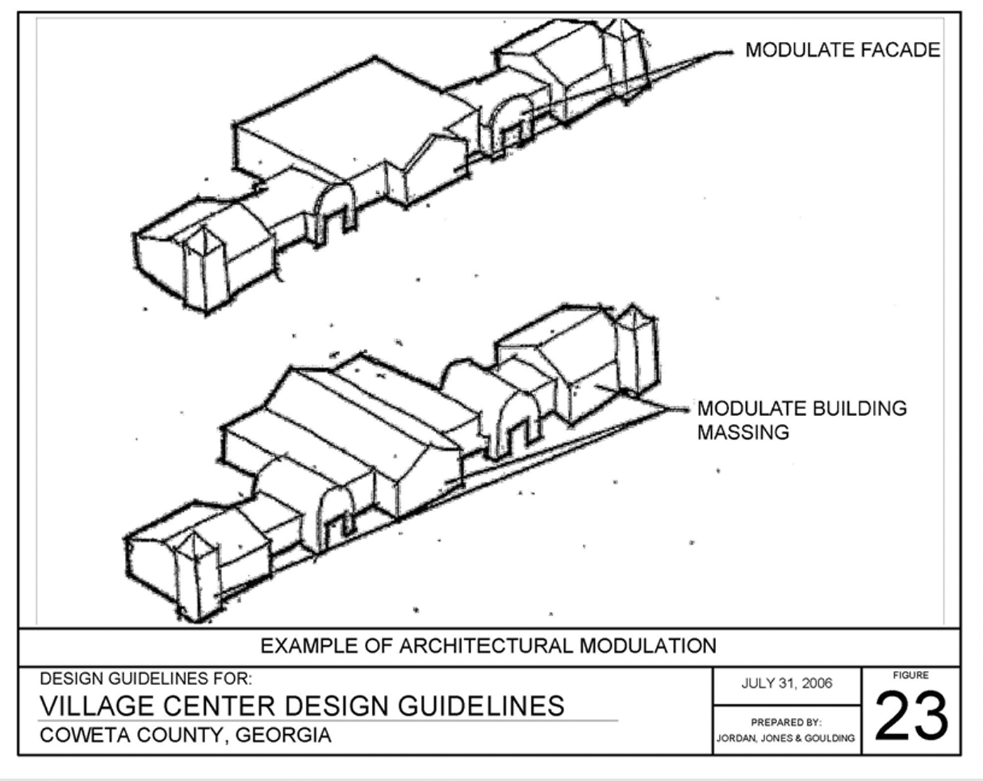
Architectural modulation: Variation in materials, massing, fenestration and ornamental detail of a facade that divides a facade into unique components or identities, as distinguished from a uniform facade without variation. Architectural modulations of a facade should break the vertical plane by more than two feet in depth, measured from the forward plane of the facade. See figure 23 of the Coweta County Village Center Design Guidelines.
Arterial: A street classified as a principal arterial or minor arterial on the Coweta County thoroughfare map or a street meeting the standards of figure 14 of the village center design guidelines that functions as an arterial street by virtue of its role of providing access for through traffic passing between municipalities, village centers, or other major activity centers and connecting other arterial streets.
Bay window: An architectural element consisting of three or more window units projecting outward from the facade within a three-sided frame.
Bed and breakfast inn: An owner-occupied, single-family dwelling where between one and ten rooms not containing kitchen facilities are rented to overnight guests on a daily basis for periods not to exceed two weeks.
Bow window: An architectural element consisting of one or more window units projecting outward from the facade within a curved frame.
Buffer, transitional: That portion of a lot or parcel of land established for permanent vegetation and open space and intended to separate properties with different and possibly incompatible types of use or zoning classifications. This area is a distance as specified pursuant to this ordinance and typically as measured from the common property line of the different uses and/or zoning classifications.
Bulk: The volume of a building or structure with respect to regulatory limits on its size, height, and the location of exterior walls at all levels in relation to lot lines, streets, or other buildings.
Building, detached: A freestanding enclosed structure meeting applicable building and fire codes for commercial and/or residential occupancy that may be either in single ownership, or comprised of two or more attached units or buildings with separate owners, tenants, or uses.
Certificate of eligibility: A completed and approved form provided by the community development department that verifies the household income of a person of moderate income in accordance with subsection 138.8(4)(c) of the Coweta County Code of Ordinances.
Civic uses: Public parks, squares, plazas, greens, lawns, amphitheaters, stages, churches or places of worship, public or private schools, gymnasiums, assembly halls, community meeting rooms, community service centers, post offices, fire stations, libraries, museums, and other government or public service buildings and facilities except for those requiring outdoor storage or maintenance yards.
Collector: Collector streets channel local traffic into the major/minor collector and arterials system. Collectors provide land access and traffic circulation within residential neighborhoods, commercial, and industrial areas. Coweta County streets/roads are classified as major collectors or minor collectors by the Coweta County Thoroughfare Map. A collector is a street constructed in accordance with figure 15 of the village center design guidelines and serves as a collector street by virtue of its function of connecting local or neighborhood streets to other collector or arterial streets.
Column: One of a series of exposed, freestanding supports for a roof or upper floor constructed of wood, stone, or masonry, which is usually of a specific three-part architectural style or order, consisting of a base, shaft, and cap.
Commercial use: An occupation, place of employment, or enterprise that is carried on for profit by the owner, lessee, or licensee.
Compatible: Design of structures and landscapes that are consistent with structures and landscapes in the district of which they are a part, based on an objective comparison of identified physical elements such as architectural form, building mass, height, scale, land uses, and landscape architecture.
Comprehensive plan: Any part or element of the overall plan for development of Coweta County adopted by the Coweta County Board of Commissioners pursuant to O.C.G.A. § 50-8-1 and Chapter 110-12-1, standards and procedures for local comprehensive planning, as it may be amended from time to time.
Connectivity: The degree to which streets, sidewalks, trails, and bike paths form a continuous and interconnected system that allows full mobility and convenient access between all origins and destinations as they may be distributed throughout a developed area.
Conservation areas, primary: Areas of a parcel that are occupied by streams, wetlands, floodplain, slopes in excess of 25 percent, areas of exposed rock, private cemeteries, and burial grounds.
Conservation areas, secondary: Areas of a parcel that are occupied by land in water supply watersheds, aquifer recharge areas identified in the Coweta County Comprehensive Plan, stream and wetland buffers in excess of 25 feet in width, slopes in excess of 15 percent, significant habitat areas as identified in the Coweta County Comprehensive Plan, soils unsuitable for septic tanks, prime agricultural soils, mature hardwood forest, meadows, farm fields, pastures, and other areas of scenic value.
Consumer price index: The latest published version of the Consumer Price Index for All Urban Consumers (CPI-U) of the U.S. Department of Labor for the Atlanta, Georgia, metropolitan area.
Control period: The period of time between the date of the conditional use permit approval for construction of a moderately priced dwelling unit and the first sale of a unit to a qualifying buyer.
Covered porch entry: An element of residential building design that provides a roofed, and partially enclosed floor area of at least 60 square feet between the street and the front door of a dwelling and that is attached to the principal structure.
Cul-de-sac: A local street or road with only one outlet and having an appropriate terminal for the safe and convenient reversal of traffic movement.
Design guidelines: Graphic and text standards that are intended to further the purposes of the Coweta County Zoning and Development Ordinance by illustrating, refining, and interpreting its requirements.
Density bonus: A provision of the zoning and development ordinance that allows a parcel to accommodate additional square footage or additional residential units beyond the maximum otherwise permitted, in exchange for the provision of an amenity that provides a public benefit.
Density, gross: The number of square feet of a building, or number of lots or dwelling units on a tract of land divided by the total acres of a parcel or tract of land prior to development or subdivision; including all streets or rights-of-way, open space, floodplain, and other un-subdivided or unused portions of the tract of land.
Density, net: The number of square feet, lots, or dwelling units on a tract of land, less area for streets, rights-of-way, floodplain, wetland, and other unsubdivided or unused portions of the tract of land.
Diameter at breast height (DBH): A standard measure of the diameter of a tree trunk measured in inches at a height of four and one-half feet above the ground. If a tree splits into multiple trunks below four and one-half feet, then the trunk is measured at its most narrow point beneath the split.
Dormer: A small enclosure including a window and placed vertically in a sloping roof that is covered by a secondary roof element and intended to provide light and/or ventilation to an attic or room located on an upper floor.
Drive-thru window: An opening in the outside wall of a commercial building or structure intended to be used to provide for sales and/or service to patrons who remain in their vehicles.
Driveway: A vehicular access or curb cut that is in private ownership and provides access primarily to one property.
Duplex: A residential, multi-family building containing two dwelling units.
Eligible person: A person or household of moderate income holding a certificate of eligibility demonstrating that their income qualifies them to buy or rent a moderately priced dwelling unit pursuant to section 138.8 of the Coweta County Zoning and Development Ordinance.
Facade: The exterior side of a building that faces, and is most nearly parallel to, a public street. The facade includes the entire area of a building, extending from the roof or parapet to the ground and from one corner of the building to another. Buildings generally have one facade for each street frontage.
Four-sided architecture: Building design that gives similar attention to the architectural composition and materials on all sides of a building. An overall architectural character is created by using architectural modulation in combination with common elements such as, but not limited to, bay windows, transoms, porches, balconies, cornices, shutters, and masonry exteriors, and such exterior detailing is consistent on all four elevations. This eliminates "brick front" or "three sides brick" exterior treatments Blank walls on any elevation are not permitted.
Freestanding sign: See Coweta County Sign Ordinance Section 58-38.
Garage: An accessory use to a dwelling that consists of a permanent, enclosed structure with one or more doors and having a paved floor area designed for the storage of motor vehicles and related supplies. A garage may be within the principal building, attached to the principal building or detached in a separate building.
Green: A public open space area landscaped primarily of grassy areas and trees and intended for viewing and to support only passive recreation such as walking or sitting.
Ground sign: See "sign, ground."
Historic resource: A historic building, structure, property, site, or district that is recognized as having historic significance because of its association with historic events or architecturally or culturally significant periods or times.
Historic structure: Any structure that is:
a.
Listed individually in the National Register of Historic Places (a listing maintained by the Department of Interior) or preliminarily determined by the Secretary of the Interior as meeting the requirements of individual listing on the National Register;
b.
Certified or preliminary determined by the Secretary of the Interior as contributing to the historical significance of a registered historic district or a district preliminary determined by the Secretary to qualify as a registered historic district;
c.
Individually listed on a state inventory of historic places in states with historic preservation programs that have been approved by the Secretary of the Interior, or
d.
Individually listed on a local inventory of historic places in communities with historic preservation programs that have been certified either:
i.
By an approved state program as determined by the Secretary of the Interior, or
ii.
Directly by the Secretary of the Interior in states without approved programs.
Inn: A multiple-unit building or buildings providing more than three and up to 20 guest rooms, not containing kitchen facilities where overnight lodging and meals are provided for compensation. Meals may be served only to guests who are provided overnight lodging.
Landmark: A conspicuous object on land that marks a locality. An object or building may be considered a landmark because of its physical prominence, artistic or historic significance, or its identification with economically, culturally, or socially significant functions or activities in a locale.
Live-work unit: Owner-occupied dwelling that incorporates a ground level studio, workshop, or office that opens directly to the street, with a residential unit in the same structure that is usually upstairs.
Loft dwelling unit: A residential dwelling unit with a private entrance that is located on one or more floors above a commercial use that occupies the ground floor.
Lot, abutting: Touching at one point or along a common side, boundary, or property line. Two pieces of property that are separated by a street or right-of-way are adjacent, but not abutting.
Lot, adjacent: Parcels or lots that either are abutting or separated only by a public right-of-way.
Lot, reverse fronting: A double-frontage lot that is served from an interior collector or local street rather than from an adjacent collector or arterial street.
Major collector: Major collectors serve urban areas and other traffic generators of intra-county importance that are not served by higher systems. Major collectors link these places with nearby towns and cities or with routes of higher classification.
Major renovation: Any addition, replacement, or reconstruction of a building that constitutes more than 50 percent of the floor area of the building that existed prior to the renovation.
Major thoroughfare: A public street or highway classified either as an arterial or major collector as defined herein.
Massing: The exterior form of a building, a structure, or a series of buildings seen as a whole, encompassing bulk, shape, height, width, scale, proportion, and the spatial relationships of buildings, landscaping, and open space.
Mixed-use: A land use that includes two or more uses, typically commercial retail or services mixed with residential or offices. Uses may be mixed horizontally (side-by-side) or vertically in the same building. See "mixed-use building." Mixed-use developments and buildings may include different owners and tenants, but requires close and convenient interconnections of pedestrian and vehicular access and interconnection of parking areas, as well as unified site planning, signs, and architectural design.
Mixed-use building: A building housing two or more different uses, typically retail or services mixed with residential or offices. Residential portions of mixed-use buildings should have a separate entrance or entrances.
Moderate income: An income level that is established by the U.S. Department of Housing and Urban Development, not greater than 80 percent of the area median income for a given household size in the market area that is applicable to Coweta County, Georgia.
Moderately priced dwelling unit (MPDU): A dwelling unit that is subject to a limitation on its sales price or lease amount and shall be sold or leased only to an eligible household or person pursuant to the control period as provided in section 138.8 of the Coweta County Zoning and Development Ordinance.
Multifamily building: A building containing three or more dwelling units, not including single-family dwellings, duplexes or townhouses.
Neighborhood street: Local street in a village center district meeting the standards of figure 16 of the village center design guidelines.
Office, professional: A land use that includes one or more buildings that are used primarily for services rendered by occupations with specialized knowledge or expertise such as architects, engineers, lawyers, doctors, bankers, realtors, financial and insurance services, and similar services, as opposed to buildings used for manufacturing, storage, or sale of goods.
Outdoor recreation facilities: Permanent outdoor spaces and facilities; including greenways, trails, bikeways, paths, outdoor tennis courts, athletic fields, golf courses, swimming pools, clubhouses, lockers, bicycle facilities, equestrian facilities, beaches, docks, picnic areas, landscaping, and other land used for outdoor recreation and related facilities, but not including indoor recreation facilities or commercial forms of outdoor recreation such as bungee jumping, amusement rides, miniature golf, or racetracks.
Outdoor storage: The keeping, in an unenclosed area, of any goods, material, merchandise, or vehicles in the same place for more than 24 hours whether for storage, display, processing, or sale.
Out parcel: In a commercial subdivision, a small lot that is connected to a larger parcel in a planned center. The out parcel has a distinct tenant or use and has frontage on an abutting street, but may or may not be granted direct access to a public street.
Parking area: The land area within the polygon that includes the outer boundary of a surface parking lot or lots (if connected by driveways) located within a single parcel, including the parking spaces, internal aisles, sidewalks, and the landscaped areas that are internal to the parking lot and aisles, but not including the landscape strip between the parking lot and the public right-of-way.
Parking, off-street: A temporary (less than 48 hours) storage area for a motor vehicle that is directly accessible to an access aisle and that is not located on a dedicated street right-of-way.
Parking, on-street: Areas along curbs of a street that are authorized for temporary (less than 48 hours) storage of automobiles belonging to owners, tenants, customers, or visitors of adjacent or nearby properties.
Parking, shared: An approved method of reducing the total parking requirements for a mixed-use project or building based on the variation in actual parking usage over time for a diversity of uses. Shared parking facilities must have close and convenient vehicular and pedestrian interconnections for all associated uses.
Pervious: A surface that is capable of absorbing water; including natural ground, landscape materials, and approved pervious paving materials.
Pervious paving: Materials used for surfacing parking lots and driveways that are designed to meet the requirements of materials described in Volume 2—Technical Handbook of the Georgia Stormwater Management Manual (First Edition, August 2001) as the Porous Concrete or Modular Porous Paver Systems under the Limited Application Stormwater Structural Controls.
Physically sound: A structure that does not pose an imminent health or safety hazard in its current condition. A physically sound structure currently meets building code requirements, or is capable of meeting code requirements with economically feasible improvements.
Pilaster: An ornamental column or post that is attached to a wall.
Pillar: A freestanding vertical support for a roof or upper story with low proportions that may be constructed of wood or masonry, or a combination of wood and masonry.
Pitch, roof: The steepness of a sloped roof measured by the ratio of the vertical rise to the horizontal run.
Plan, concept: Written and graphic documents submitted to the director for review that document the intent of a developer in a conceptual form, indicating the types, general arrangement and density of uses, extent and pattern of subdivision, and the relationship of the intended uses to surrounding tracts.
Plat, final: A finished drawing or map of a subdivision or development site plan meeting all of the requirements of the Coweta County Subdivision Regulations and certified as necessary for recording.
Plat, preliminary: A tentative plan of a proposed subdivision or development meeting the specified requirements of this article and all applicable provisions of the Coweta County Subdivision Regulations showing the layout in sufficient detail to allow an evaluation of the proposed project.
Porch: A covered area attached to a building that is open on at least one side and raised at least 18 inches above grade.
Post: One of a series of exposed, freestanding vertical supports for a roof or upper floor that is usually constructed of wood and of a simple shape and design.
Preapplication conference: An initial and informal stage of development review at which the developer may make known concept plan proposals and the director may respond and/or advise the developer concerning the development regulations and other issues related to the development.
Primary conservation area: See "conservation area, primary."
Professional: When used in connection with "use" and "occupancy" of a use or occupancy by persons generally engaged in rendering personal, executive, sales, or administrative services or activities; including accountants, architects, professional engineers and land surveyors, doctors, lawyers, insurance offices, real estate offices, religious organizations, stockbrokers, and administrative agencies considered professional in character. The term, however, does not include repairs or sales of tangible personal property stored or located within the structure nor any use that would create any loud noise or noxious odors.
Property, adjacent: Property that is either abutting or on the opposite side of a common street, right-of-way, or easement that separates it from the subject property. Properties separated by a railroad track or freeway are not abutting or adjacent.
Public: Property or structures expressly donated to and accepted by Coweta County, or to another government.
Reverse fronting lot: See "lot, reverse fronting."
Right-of-way line: The outer edge or boundary of a public right-of-way where it abuts private property.
Screening: A method of shielding, obscuring, or buffering one use or building from another use or building by fencing, walls, densely planted vegetation, natural vegetation, including a transitional buffer or other means; a visual and acoustical barrier which is of such nature and density that provides year-round maximum capacity from the ground to a specified height.
Secondary conservation area: See "conservation area, secondary."
Sense of place: The characteristics of a location and its natural and built environment; including open space elements, type of housing, architectural style, and quality of life that contribute to its image, make it readily recognizable as being unique and different from its surroundings, and that provide a feeling of belonging to, or being identified with, that particular place.
Senior living unit: A residential development designed to accommodate residents 55 years of age or older. Senior living units are designed to enable seniors to live on their own, but with the security and conveniences of community living. Senior living units should provide barrier-free interior and exterior access and supportive design and equipment for persons with limited mobility or disabilities. They may also provide communal dining rooms and recreation facilities and other conveniences, services, and amenities that provide for healthy living for seniors.
Setback: Distance measured perpendicularly from the right-of-way line of future right-of-way to the nearest face or corner of a building or structure; except that a cornice, soffit, eave, entablature, roof overhang, downspout, sill, railing, balcony, marquee sign, flagpole, banner, or other similar form of architectural ornament permitted by this ordinance that extends less than 18 inches from the face or corner of a building is not considered when measuring a minimum setback.
Shared parking: See "parking, shared."
Sidelight: A narrow window unit oriented vertically and placed adjacent to a door in an entranceway.
Sight visibility triangle: A triangular-shaped area adjacent to the intersection of two public streets or adjacent to the intersection of a driveway with a public street in which nothing may be constructed, erected, placed, planted, or allowed to grow in such a manner that it limits or obstructs the sight distance of motorists entering or leaving the intersection. The size and shape of the sight visibility triangle for each intersection shall be established by the community development department.
Sign, canopy: A sign attached to or applied to the exterior surface of an awning or canopy. See Coweta County Sign Ordinance section 58-38.
Sign, freestanding: A sign that is not attached to a wall, building, or other structure; including a pole sign, incidental sign, temporary sign, real estate sign, or construction sign, but not including a ground sign. See Coweta County Sign Ordinance section 58-38.
Sign, ground: A freestanding sign, other than a pole sign, that is located near the ground and attached to and supported by a masonry wall or pilasters. See figure 13 of the village center design guidelines. See Coweta County Sign Ordinance section 58-38.
Sign, hanging canopy: A sign suspended below and supported from a canopy or awning and designed to be read by pedestrians passing below the canopy or awning. The lowest point of a hanging canopy sign shall be no less than seven feet above the top elevation of the floor or pavement that is beneath it. See Coweta County Sign Ordinance section 58-38.
Sign, incidental: A sign providing directions or other necessary information that has a purpose secondary to the use of the lot on which it is located. Incidental signs include a sign that contains information or a directive, such as "no parking," "entrance," "loading only," "telephone," but that contains no commercial message; a sign, such as a menu-board, that may contain a commercial message but that is not easily legible from the public right-of-way; outdoor table umbrellas; or signs incidental and integral to lawfully located and operated vending machines, newspapers, racks, telephone booths, or similar devices. See Coweta County Sign Ordinance section 58-38.
Sign, marquee: A sign projecting from an outside wall of a building or hanging from a bracket attached to the outside wall of a building. The lowest point of a marquee sign shall be no less than seven feet above the top elevation of the floor or pavement that is beneath it. See Coweta County Sign Ordinance section 58-38.
Sign, pole: A freestanding sign that is supported by one or more posts or poles, as distinguished from a ground sign. See Coweta County Sign Ordinance section 58-38.
Sign, wall: A sign that is permanently attached to the wall of an occupied building, other than a marquee sign or window sign. A wall sign shall not project more than six inches beyond the face of the wall to which it is attached. See Coweta County Sign Ordinance section 58-38.
Sign, window: A sign placed on the outside or inside of a glass window, door, or storefront and intended to be read from the exterior of the building. See Coweta County Sign Ordinance section 58-38.
Signage master plan: A plan prepared prior to approval of a preliminary plat or site development plan that provides an overall guide to the types, locations, sizes, and aggregate sign area proposed for a multi-tenant building. See Coweta County Sign Ordinance section 58-38.
Site development plan: A plan required by Coweta County that provides detailed information about the layout of private land development and required public improvements prior to preparation of construction drawings for a land development that does not include subdivision of property that would otherwise be subject to a preliminary plat.
Sod: Grass that is germinated and grown off-site and transplanted to form landscaped areas of a yard or site.
Spacing between buildings: The horizontal distance between the closest points of two adjacent buildings; including protruding eaves, overhangs, cornices, moldings, porches, railings, awnings, canopies, balconies, porches, decks, gutters, downspouts, and mechanical equipment.
Square: A landscaped public open space area that is surrounded by streets and buildings on at least three sides and designed for civic functions. A square contains landscaping as well as hard-surfaced areas for walking, standing, or sitting and may be furnished or decorated with fountains, monuments, or works of art. Squares shall have a length-to-width ratio no greater than 3:1.
Street trees: Trees required to be planted by this article or other ordinance that are located within the public right-of-way parallel to public streets and intended to provide shade and aesthetic enhancement for street corridors.
Townhouse: A residential building comprised of three or more attached dwellings, including single-family attached dwellings, that adjoin only along a vertical party wall, having entrances on the ground floor.
Trail, multi-use: A corridor designed for one or more alternative forms of transportation; including pedestrians, joggers, skaters, and slow-moving vehicles such as strollers, bicycles, and golf carts.
Transom: A narrow window unit oriented horizontally and placed above a door in an entranceway.
Usable floor area: The portion of a building that is heated, enclosed, and permitted for occupancy for an authorized use.
Window sign: See "sign, window."
Zero-emmission vehicle (ZEV): A vehicle that will produce no emissions or pollution of particulates (soot), hydrocarbons, carbon dioxide, carbon monoxide, or various oxides of nitrogen when stationary or operating. Types of zero-emissions vehicles include bicycles, electric vehicles, battery electric vehicles, and hybrid vehicles.
Zero-lot line dwelling: A single-family, detached residence having a side yard of zero feet on one side and a larger side yard on the other side. The non-zero side yard belongs to one owner, with an easement for maintaining the abutting exterior wall of the adjacent residence.
(Ord. No. 043-07, 12-6-07; Ord. No. 003-20, 1-7-20)
Sec. 130.- Intent and purpose of village centers.
1.
Intent. It is the intent of Coweta County to promote the health, safety, morals, general welfare and aesthetics of Coweta County by providing appropriate development standards and incentives for a significant share of the county's future growth to occur in planned village centers where public services can be provided in an efficient and economical manner.
2.
Purpose. The purposes of the village center districts are to:
a.
Encourage a clustered development pattern, with a mixture of uses, designed with a unique architectural theme and sense of place.
b.
Preserve and enhance both the historic features in the community and the environmental characteristics of the land.
c.
Provide for a balanced community that integrates land uses that support the activities of daily living, working, shopping, and recreation.
d.
Provide accessible and convenient neighborhood services in the developing areas of the county.
e.
Provide a diversity of housing types appropriate for all stages of life.
f.
Ensure that future development includes an adequate amount of open space to protect natural resources, provide places for outdoor community gatherings and recreation, and link residential and civic spaces along greenways and trails.
g.
Provide appropriate infrastructure and public facilities to support daily activities that are clustered within a convenient walking distance.
h.
Make efficient use of infrastructure and services.
i.
Establish standards for community design that encourage walking and biking, and short trips that reduce the need for automobiles.
Sec. 131. - Types of village centers.
There are hereby established three types of village centers, distinguished by their function and location, as follows:
1.
Mill villages. The board of commissioners may designate parcels of land for the mill village zoning district at locations that generally are consistent with those identified on the adopted future development map and known as:
a.
Arnco Mill Village.
b.
Sargent Mill Village.
c.
East Newnan Mill Village.
The exact property boundaries of mill villages are as approved by the board of commissioners pursuant to a rezoning action and thereafter to be shown on the official zoning map of Coweta County.
2.
[Reserved.]
3.
Crossroads service centers. Crossroads service centers are to be authorized by the board of commissioners at locations that generally are consistent with those identified on the adopted future development map or as otherwise approved by the Coweta County Board of Commissioners as provided in subsection 22.B.2.
The exact property boundaries of crossroads service centers are as approved by the board of commissioners pursuant to a rezoning action and thereafter to be shown on the official zoning map of Coweta County.
(Ord. No. 003-20, 1-7-20)
Sec. 132. - Procedures for rezoning property to the village center district.
1.
Procedures for rezoning property to the village center district.
a.
Application.
i.
[Reserved.]
ii.
Mill village centers shall be established by application of one or more owners of property within a proposed mill village center and supported by petitions of the owners or representatives of not less than 75 percent of the acreage of property within such proposed mill village center, and subject to approval of rezoning by the Coweta County Board of Commissioners in a public hearing conducted in accordance with section 293 of the Coweta County Zoning and Development Ordinance.
iii.
The rezoning application shall meet all requirements of article 29 with the additional requirements of section 138.
b.
Approval of mill village center. The board of commissioners may designate parcels of land for the mill village zoning district at locations that generally are consistent with those identified on the adopted future development map and known as:
i.
Arnco Mill Village.
ii.
Sargent Mill Village.
iii.
East Newnan Mill Village.
The exact property boundaries of mill villages are as approved by the board of commissioners pursuant to a rezoning action and thereafter to be shown on the official zoning map of Coweta County.
2.
Procedures for rezoning property to the crossroads service centers district.
a.
Application.
i.
Crossroads service centers shall be established pursuant to the application of one or more owners of property within such proposed crossroads service centers and supported by petitions of the owners or representatives of not less than 100 percent of the acreage of property within such proposed crossroads service centers subject to approval of rezoning by the Coweta County Board of Commissioners in a public hearing conducted in accordance with section 293 of the Coweta County Zoning and Development Ordinance.
ii.
The approval of a crossroads service centers shall be accompanied by a finding that the proposed boundaries contain not less than 20 acres, but not more than 100 acres of developable property, it is at least one mile from a mill village center, or another crossroads service center, and the proposed location of such crossroads service center receives a minimum total of 70 points from the sum of the following location standards:
Sites that are near existing or committed community facilities, scored as follows:
Sites that limit impact on the natural environment, scored as follows:
iii.
The rezoning application shall meet all requirements of article 29 with the additional requirements of section 138.
(Ord. No. 043-07, 12-6-07; Ord. No. 003-20, 1-7-20)
Sec. 133. - Development standards for village centers.
[Reserved for future use.]
Sec. 133.2. - Mill villages.
1.
Purpose of mill villages. The purpose of the mill village is to preserve a sense of place in Coweta County through the preservation and orderly expansion of historic communities into balanced and affordable communities for living, working, and playing and to sustain the historic resources of Coweta County through viable economic restoration, reuse, adaptation, and appropriate infill and redevelopment.
2.
Standards of use, development, and improvement.
a.
All the standards of use, development, and improvements in this article 13 shall apply to mill villages, except where the board of commissioners determines that such standards constitute a conflict with the overriding intent to preserve the historic character of the mill village and to establish compatibility between historic resources of the mill village and appropriate forms of new development.
b.
Development and redevelopment of public and private improvements in the mill village shall be pursuant to the preparation of a mill village center master plan approved by the Coweta County Board of Commissioners for property designated in accordance with section 131.1. The master plan shall conform to the standards of use, development, and improvement established in section 133.1., except for modifications that are approved by the board of commissioners, or as provided in article 28.
c.
Development and redevelopment of property within a mill village shall be subject to a concept plan approved by the director as provided in subsection 138.2.2.
d.
The concept plan shall be in substantial conformity with the applicable mill village master plan approved by Coweta County.
e.
The master plan for each mill village center shall identify two distinct zones:
i.
Village service zone. A mixed-use area providing community services and high-density housing in an arrangement that is conveniently accessed by walking a distance of not more than 1,320 feet from the nearest point within a public meeting place consisting of one of the following:
(A)
A school.
(B)
A public square.
(C)
A public green.
ii.
Village neighborhood zone. A predominantly residential neighborhood consisting of three or more types of housing, all of which is directly connected to the village service zone with a network of streets, sidewalks, and multi-use trails such that all occupied structures are within a village neighborhood zone, the outer boundary of which is not more than one-half mile from the public meeting place identified in paragraph 2.e.ii of this section.
f.
In addition to the information required in paragraph 2.e. of this section, the mill village master plan shall:
i.
Identify any areas of potential chemical storage, chemical spills, or other potential soil or water contamination, and prepare a clean up and mitigation plan for all such areas to be approved by the Georgia Department of Natural Resources and the Coweta County Board of Commissioners.
ii.
Identify the surveyed boundary locations of the historic resources (historic buildings, structures, properties, and historic districts) within the mill village with appropriate photographs, sketches, and surveys to accurately describe the extent and characteristics of the structures, sites, districts, and context that define its historic period and style. If it is determined that some or all of the mill village is appropriate for designation as a historic district under the authority of O.C.G.A. Title 44, Chapter 10 "Historic preservation," then the requirements and procedures of this article that shall be superseded by the requirements and procedures of such historic district that are enacted by Coweta County.
iii.
Identify the physical condition of the historic resources and prepare a feasible plan for appropriate restoration, reuse, adaptation, and/or addition to historic resources that are physically sound in accordance with applicable state and local laws.
g.
No historic structure shall be demolished, obscured, or defaced without the approval of the Coweta County Board of Commissioners. Such approval shall be based on a written report prepared by the applicant and reviewed and approved by the department documenting the physical soundness and integrity of the historic structure, its uniqueness, and the feasibility of restoration, reuse, adaptation, enlargement, and maintenance of such structure.
h.
To the maximum extent feasible, the mill village shall be planned and designed so as to include all contiguous property in designated historic districts as well as the majority of the historic structures that are to be restored, reused, added to, or adapted for future use. In return for such actions, the owner or developer may receive density bonuses when meeting the standards set forth in section 136.3.
i.
Wherever feasible, the development and redevelopment of property that is within the village service zone shall be planned with block patterns and block sizes that are consistent with the prevalent block patterns and sizes of the historic portions of the existing community.
j.
Architectural style and design of new construction and modification of existing structures in the mill village shall provide architectural elements that are similar to those that are prevalent in the historic portions of the existing community, such as, but not limited to:
i.
Roof type, pitch and dormers.
ii.
Massing, setback and orientation.
iii.
Porch location.
iv.
Window proportions and divisions.
v.
Entry placement and design.
vi.
Columns, pillars, posts and ballustrades.
k.
Moderately priced dwelling units (MPDU).
i.
At the option of the developer, and with the approval of a conditional use permit by the board of commissioners, up to 25 percent of the existing single-family dwelling units within a mill village that are of historic significance may be rehabilitated for sale or lease as moderately priced dwelling units (MPDU), subject to the provisions of section 135 (7) and section 138.8.
ii.
For each MPDU approved by the board of commissioners, the developer shall be entitled to the right to a bonus density incentive on residential property developed elsewhere within the village service zone of the mill village center at a location subject to approval of the board of commissioners at the time of approval of the conditional use permit. Such bonus density incentive shall be in accordance with subsection 136.3.
iii.
The conditional use permit application shall include a site plan indicating the number, lot location, building location, size, and architectural design of all MPDUs and also indicating the lot location, type, and number of additional dwelling units proposed to be constructed in accordance with the bonus density incentive associated with the MPDUs. The developer of MPDUs shall submit with the application for conditional use permit a written agreement approved by the county attorney as described in subsection 138.8.2.
l.
All owners of newly constructed buildings or buildings seeking permits for major renovations within the mill village shall be subject to a common agreement or covenants that require 100 percent of property owners of property undergoing development to be members of a property owners' association created pursuant to Georgia law. The property owners' association shall be responsible for the management and maintenance of privately held common areas within the development; such as, but not limited to, alleys, open space, landscaping, and private recreation facilities that are not contained within the lots of single-family detached or zero-lot line dwellings. The covenants and bylaws of such property owners' association shall be approved by the department prior to issuance of a building permit for any buildings within such village center.
3.
Service zone.
a.
[Authorized uses.] The authorized uses within the service zone of the mill village center shall be as provided in table 5, table of authorized principal uses and conditional uses and as provided in section 134.1.
b.
Land use mix. The service zone of each mill village center shall contain a mixture of types of land uses as indicated in table 2, authorized land use mix for service zone. Land use mix percentages shall be computed by dividing the total land area devoted to each use by the gross land area of the entire district. Percentages shall be maintained after right-of-way is known and subtracted from the area of each district. A mixed-use building shall be categorized by the type of land use that constitutes a majority of the usable floor area of the principal structure. If two or more uses are contained in separate buildings on the same parcel, the land use of the parcel shall be prorated to uses in proportion to their usable floor areas.
Table 2: Authorized Land Use Mix for Service Zone
c.
Transitional buffers. Within the service zone, transitional buffers are not required between zoning districts or uses, except as stipulated in this article 13.
d.
Architectural design standards for service zone.
i.
Building dimensions. No building in the service zone of a mill village center shall have a ground floor area in excess of 25,000 square feet nor a building length or width greater than 200 feet unless the board of commissioners issues a conditional use permit. The criteria for considering an application for a larger building shall include the following:
(A)
The property to be developed contains a minimum of three acres.
(B)
The property has safe and direct access to one or more arterial streets.
(C)
The property is to be occupied by a single major user.
(D)
The proposed use is needed in the mill village center but cannot be designed feasibly within a smaller footprint; such as a place of assembly, grocery store, department store, or building materials store.
(E)
No more than 20 percent of the required number of parking spaces will be placed in the front yard.
(F)
The parking lot will be designed to provide safe, direct, and convenient access for pedestrians from surrounding uses and streets.
(G)
Ample off-street loading is provided, and loading docks shall be screened from view by solid walls.
ii.
The maximum building height in the service zone shall be 50 feet, except that no building taller than 34 feet 11 inches shall be located within 1,000 feet of the perimeter of the village without a conditional use permit.
iii.
Within the service zone, no building fronting a major thoroughfare shall be less than 18 feet in height.
iv.
Facades of commercial buildings shall meet the requirements of paragraph (8) "exterior architectural standards" of section 69.7 and shall incorporate architectural modulations at intervals of no more than every 50 feet or 50 percent of the length of the building facade, whichever is less. See figure 23 of the village center design guidelines.
v.
Each dwelling unit within a mixed-use building that contains dwelling units must include a balcony, porch, patio, or deck not less than 75 square feet in area.
vi.
Buildings less than 5,000 square feet in ground floor area and two stories or less in height must have pitched roofs with a minimum 6:12 pitch.
vii.
Parking shall be as provided in section 246.5, except as stipulated below.
(A)
Maximum number of parking spaces. The maximum number of off-street parking spaces allowed for each use shall be the minimum required in section 136.5(1).
(B)
Up to 50 percent of the on-street parking spaces that are located within 500 feet of the nearest property line of the subject use may be used to meet off-street parking spaces, except that no more than 25 percent of the required minimum number of off-street parking spaces may be satisfied with on-street parking.
(C)
Shared parking is encouraged. The procedures for calculating the number of parking spaces required to satisfy the requirements of shared parking are available in Section 246.5.2(2)(d).
(D)
The procedures for calculating the number of parking spaces required to satisfy the requirements of shared parking are available upon request from the community development department.
4.
Neighborhood zone.
a.
Land use mix. The neighborhood zone of each mill village shall contain a mixture of types of land uses as indicated in table 3. Land use mix shall be computed by dividing the total land area devoted to each use by the gross land area of the entire district, after subtracting all rights-of-way in the district. A mixed-use building shall be categorized by the type of land use that constitutes a majority of the usable floor area of the principal structure. If two or more uses are contained in separate buildings on the same parcel, the land use of the parcel shall be prorated to uses in proportion to their usable floor areas.
Table 3: Authorized Land Use Mix for Mill Village Neighborhood Zone
b.
Supportive commercial uses in the mill village neighborhood zone. Within the neighborhood zone of a mill village, commercial retail and commercial service and office uses are permitted in live-work buildings and in freestanding commercial buildings subject to the following minimum requirements:
i.
The neighborhood zone contains at least 200 occupied residential units.
ii.
Commercial uses are intended principally for the convenience of residents of the mill village center.
iii.
Commercial uses shall be located only on the lowest two floors of a multistory building. One of the two lowest floors may include a basement story that has a storefront visible from the sidewalk and an entrance that is accessible from the sidewalk.
iv.
Each dwelling unit must include a balcony, porch, patio, or deck not less than 75 square feet in area.
v.
Commercial building facades shall incorporate modulations at intervals of no more than every 25 feet and shall meet the requirements of paragraph (8) "exterior architectural standards" of section 261 of the zoning and development ordinance.
vi.
Buildings must have pitched roofs with a minimum 8:12 pitch.
vii.
No commercial use within the neighborhood zone shall be located in a building with a ground floor greater than 5,000 square feet.
c.
Maximum building height. Maximum building height in the neighborhood zone shall be 34 feet 11 inches.
d.
Transitional buffers. Within the neighborhood zone, transitional buffers are not required, except as stipulated in this article 13.
e.
Fences and walls.
i.
Within the neighborhood zone, low fences and walls are encouraged as a means of defining property boundaries and the edges of property along streets and sidewalks.
ii.
Fences and walls may be combined with hedges or landscape strips designed to soften their appearance.
iii.
Fences or walls shall be constructed of decorative patterns of wood pickets, wrought iron, or brick.
iv.
Fences shall not be constructed of chainlink, wire mesh, barbed wire, or other similar material.
v.
No wall or fence shall exceed four feet in height in a front yard or eight feet in height in a side yard or rear yard.
vi.
Heights of fences, hedges, and other continuous foliage shall be measured from the adjacent top of the street curb, surface of an alley, or the adjacent grade, whichever is highest. On inside lot lines, the measurement shall be from the average grade of the lot line of the parcel or property having the lower elevation.
(Ord. No. 043-07, 12-6-07; Ord. No. 003-20, 1-7-20)
Sec. 133.3. - Crossroads service centers.
Purpose of the crossroads service centers.
a.
The purpose of the crossroads service center is to encourage the preservation and orderly expansion of a number of small service centers located at major intersections that can provide convenient services for surrounding rural and low-density residential areas.
b.
The crossroads service center designation should be used in traditional locations that provide a sense of place for the community.
1.
Standards of use, development, and improvement. The following development standards shall apply to crossroads service centers:
a.
Development and redevelopment of public and private improvements in the crossroads service centers shall be pursuant to the preparation of a crossroads service centers master plan approved by the Coweta County Board of Commissioners for property designated in accordance with section 131.3. The master plan shall conform to the standards of use, development, and improvement established in this article 13, except for modifications that are approved by the board of commissioners or as provided in article 28.
b.
Development of property within a crossroads service center shall be subject to a concept plan approved by the director as provided in subsection 138.2.2.
c.
The concept plan shall be in substantial conformity with the applicable crossroads service center master plan approved by Coweta County.
d.
The crossroads service center master plan shall:
i.
Identify one or more uses, sites, or structures that comprise a landmark or serve a function that provides a sense of place for the crossroads service centers. Examples are:
(A)
A church or other place of worship or community gathering that forms a landmark.
(B)
A park or cemetery that provides an attractive outdoor space.
(C)
A notable commercial function, such as a restaurant, convenience store, gas station, or other similar facility, frequented and known by members of the surrounding community and passersby.
ii.
Identify the surveyed boundary locations of the landmark or function (as identified in paragraph 2.d.i. of this section) within the crossroads service centers with appropriate photographs, sketches, and surveys to accurately describe the extent and characteristics of the structures or sites that define its significance. If it is determined that some or all of the crossroads service centers is appropriate for designation as a historic district under the authority of O.C.G.A. Title 44, Chapter 10, "historic preservation," then the requirements and procedures of this article that conflict with Title 44, Chapter 10 shall be superseded by the requirements and procedures of such historic district that are enacted by Coweta County.
iii.
Identify the physical condition of the significant landmark structure or site and identify any appropriate actions needed to ensure appropriate use and/or preservation in accordance with applicable state and local laws.
e.
No historic structure or building shall be demolished, obscured, or defaced without the approval of the Coweta County Board of Commissioners. Such approval shall be based on a written report prepared by the applicant and reviewed and approved by the department documenting the physical soundness and integrity of the historic structure, its uniqueness, and the feasibility of restoration, reuse, adaptation, enlargement, and maintenance of such structure.
f.
To the maximum extent feasible, the crossroads service centers shall be planned and designed so as to include the landmark structures or sites characteristic of the area. Historic structures that are to be restored, reused, added to, or adapted for future use within the crossroads service centers. In return for such actions, the owner or developer may receive density bonuses when meeting the standards set forth in section 136.3.
g.
Wherever feasible, the development and redevelopment of property that is within the crossroads service centers shall be planned with block patterns and block sizes that are consistent with the prevalent block patterns and sizes of the historic portions of the existing community.
h.
Architectural style and design of new construction and modification of existing structures in the crossroads service centers shall provide architectural elements that are similar to those that are prevalent in the historic portions of the existing community, such as, but not limited to:
i.
Roof type, pitch, and dormers.
ii.
Massing, setback, and orientation.
iii.
Porch location.
iv.
Window proportions and divisions.
v.
Entry placement and design.
vi.
Columns, pillars, posts, and ballustrades.
i.
Authorized uses in crossroads service centers. The authorized uses within the crossroads service center shall be as provided in Table 5, table of authorized principal uses and conditional uses and as provided in section 134.1.
j.
Transitional buffers. Within the crossroads service center, transitional buffers are not required, except as stipulated in this article 13.
k.
Building height. Maximum building height in the crossroads service center shall be 34 feet 11 inches, unless relief is granted pursuant to section 62 of the zoning and development ordinance.
l.
All owners of newly constructed buildings or buildings seeking permits for major renovations within the crossroads service centers shall be subject to a common agreement or covenants that require 100 percent of property owners of property undergoing development to be members of a property owners' association created pursuant to Georgia law. The property owners' association shall be responsible for the management and maintenance of privately held common areas within the development; such as, but not limited to, alleys, open space, landscaping, and private recreation facilities that are not contained with the lots of single-family detached or zero-lot line dwellings. The covenants and bylaws of such property owners' association shall be approved by the department prior to issuance of a building permit for any buildings within such village center.
(Ord. No. 003-20, 1-7-20)
Sec. 134. - Use standards for village centers.
[Reserved for future use.]
Sec. 134.1. - Authorized principal uses and conditional uses.
1.
Table 5—Table of authorized principal uses and conditional uses presents uses that are authorized by right, (R) in the village service zone, the village neighborhood zone, and the crossroads service center. Uses indicated (C) may be authorized upon approval of a conditional use permit as provided in article 28.
2.
When a proposed use is not specifically authorized, it may be authorized only if the director determines that the proposed use is sufficiently similar to a use authorized in Table 1 and that it would have no greater impact on adjacent uses, the natural environment, aesthetics, public health and safety, schools, traffic, and other community facilities than the similar use that is authorized. If the director is unable to make such a determination, an application for a proposed use shall be reviewed in accordance with article 28, criteria for variance and conditional uses.
Table 5: Table of Authorized Principal Uses and Conditional Uses
(Ord. No. 043-07, 12-6-07; Ord. No. 003-20, 1-7-20)
Sec. 134.2. - Prohibited uses.
All uses not specifically listed as authorized in Table 5 are prohibited in the village center district, unless the director finds the proposed use is very similar to an authorized use. The director may determine that a use not listed in Table 5 may be authorized based on a finding of similarity to an authorized use with respect to:
1.
Compatibility with surrounding land use.
2.
Architecture, massing, and visual character.
3.
Impacts on traffic, stormwater, wastewater treatment, and environmental quality.
(Ord. No. 003-20, 1-7-20)
Sec. 134.3. - Authorized accessory uses.
1.
Accessory uses. The following accessory uses are permitted on the same lot with primary residential uses:
a.
Garage, subject to the following standards:
i.
The garage must be set back at least 15 feet behind the facade of the dwelling.
ii.
The maximum floor area of the garage shall be 800 square feet.
iii.
If a block contains a majority of lots less than 65 feet in width, individual lot access for that block shall be from an alley located to the rear or side lot line, not from a public street.
iv.
No more than 35 percent of the dwelling units in a subdivision or single development phase of 20 or more single-family, detached dwelling units may be served by front-facing attached garages.
v.
Garage doors of front-facing, attached garages may occupy no more than 45 percent of the facade of the dwelling.
vi.
The architectural style of a garage, carport, or other accessory building shall be compatible with that of the principal unit: same type of building materials, similar roof pitch, and similar types and sizes of windows.
b.
Accessory dwelling units, subject to the following standards:
i.
One accessory unit is allowed by right for any single-family, detached dwelling with a lot size greater than 12,000 square feet.
ii.
Accessory units are not counted as units for density purposes.
iii.
Accessory units shall be owned by the owner of the principal dwelling.
iv.
Accessory units shall contain no less than 600 square feet in heated floor area, and no more than 50 percent of the floor area of the principal dwelling.
v.
Accessory units may be in a separate structure, attached to the principal structure, or located above a garage.
vi.
If in a separate structure or located above a garage, the building containing the accessory unit shall have a height no greater than the height of the principal dwelling.
vii.
Accessory units shall provide at least one additional parking space. Architectural style shall be compatible with the principal unit: same type of building materials, similar roof pitch, and similar types and sizes of windows.
2.
Other authorized accessory uses.
a.
Personal storage buildings less than 150 square feet in floor area.
b.
Swimming pools and associated dressing rooms and equipment/storage buildings.
c.
Tennis and basketball courts without outdoor lights taller than 12 feet.
d.
Other outdoor recreation that does not generate excessive traffic, noise, or light.
e.
Antennae, subject to the following standards:
i.
Located either in the rear yard or upon the roof near the rear of the dwelling.
ii.
Not to exceed the height of the dwelling by more than five feet.
3.
Accessory uses with primary commercial and mixed-use buildings. The following accessory uses are permitted on the same lot with primary commercial uses and mixed-use buildings, provided that the building type and exterior materials of accessory buildings are consistent with the primary building:
a.
Automated teller.
b.
Exercise/fitness and spa.
c.
Swimming pool.
d.
Tennis and basketball courts.
e.
Ball fields.
f.
Parking structures.
g.
Storage buildings less than 2,500 square feet in floor area.
h.
Utility structures for the sole use of the subject property.
Sec. 135. - Standards for authorized principal uses.
1.
Single-family, detached residential, in accordance with Figures 1 and 2 of the village center design guidelines.
a.
Maximum setback: 25 feet.
b.
Minimum setbacks:
i.
Front: 15 feet, except that front-facing garages shall be set back a minimum of 30 feet from right-of-way line. Front porches may encroach up to ten feet into front setback, except that no part of a front porch shall be closer than five feet to the right-of-way of a public street.
ii.
Rear: 35 feet (from principal structure, not including detached garage).
iii.
Interior side: Seven and one-half feet.
iv.
Corner side: 15 feet.
c.
Minimum spacing between detached buildings: 15 feet.
d.
Minimum lot width: 50 feet.
e.
Building height: Maximum three stories, except that no building shall have a height that is more than ten feet greater or lesser than the buildings on abutting properties.
f.
Maximum ground floor area, per building: 5,000 square feet gross floor area.
g.
Building length: Maximum 100 feet.
h.
Minimum lot size: 6,000 square feet. See also Table 6.
i.
Mix of housing options: A diversity of housing types is encouraged. Any contiguous area containing 50 or more newly constructed single-family, detached dwellings shall include a minimum of 20 percent of the total number of lots in each of the three of lot size categories shown in Table 6.
Table 6: Categories of Lot Sizes
1
Authorized for Single-Family
Detached Dwellings in Village Center
1 Average widths of all lots in each single-family category must differ by at least ten feet from average width of lots in all other single-family categories.
j.
House sizes.
i.
Minimum heated floor area: 1,450 square feet.
ii.
Each contiguous area of more than 50 newly constructed single-family dwellings in the village center shall have a range of house sizes as indicated in Table 7.
Table 7: Percentages of New Dwelling Units of Each House Size Category
k.
Maximum density:
i.
Base: 3 du/acre.
ii.
Bonus: 4.5 du/acre.
l.
Maximum impervious surface ratio.
i.
Thirty-five percent for single-family residential, large lot.
ii.
Forty percent for single-family residential, mid-size lot.
iii.
Forty-five percent for single-family residential, small lot.
m.
Architectural variety: The same front elevation shall not be used twice on the same block face and shall not be used on lots that are within 125 feet of one another.
n.
Single-family dwelling units in the village center shall be designed with common architectural design elements. See Figure 3 of the village center design guidelines. Each principal building in the village center district must utilize at least four of the following architectural design features:
i.
Dormers.
ii.
Bay or bow windows.
iii.
Separate garage.
iv.
Covered porch entry.
v.
Transoms and sidelights.
vi.
Off-sets on building face or roof (minimum two feet).
vii.
A roof with a pitch greater than 8:12.
viii.
Columns, pillars, or posts on facade.
o.
"Four-sided architecture" is required, such that architectural features and materials shall be used in a consistent manner on all sides of buildings.
p.
Landscaping of lots for single-family, detached dwellings.
i.
A minimum of 50 percent of front yard area shall be sodded.
ii.
Tree preservation and replacement shall result in at least six hardwood trees per acre (minimum 2-inch caliper dbh).
iii.
A single species of tree may be used for no more than 25 percent of the total number of new trees planted in a development.
iv.
All landscape materials required by this ordinance shall be maintained by the property owner or property owners' association. Such maintenance shall keep landscape materials healthy, neat, and orderly in appearance and free of litter and debris. Landscape materials that die shall be replaced by the property owner or property owners' association within 120 days.
2.
Single-family, zero-lot line dwellings, in accordance with Figure 4 of the Village Center Design Guidelines. Zero-lot line dwellings are single-family, detached dwelling units that have a side yard of zero feet on one side and a large side yard on the other side. Side yards are not common, they are controlled by one owner. This configuration makes it possible to provide a private space for each house on one side that adds to the perception of usable outdoor lot space for small lots. Specific development standards include:
a.
Maximum density:
i.
Base: 4 du/acre.
ii.
Bonus: 6 du/acre.
b.
Minimum lot size: 5,000 square feet.
c.
Minimum lot width: 50 feet.
d.
Maximum front yard setback: 25 feet.
e.
Minimum setbacks:
i.
Front: 15 feet, except covered front porch or balcony may encroach up to ten feet into front setback, provided it is no closer than five feet from street right-of-way.
ii.
Rear: 35 feet.
iii.
Interior side: Zero one side/15 feet other side. Wall construction shall meet international building code.
iv.
Corner side: 15 feet.
f.
Maximum impervious surface ratio: 45 percent.
g.
Minimum heated floor space per dwelling unit: 1,450 square feet.
h.
Prior to building permit approval, the applicant shall record an easement having a minimum width of five feet for each zero-lot line lot to guarantee rights for construction and maintenance of structures and yards. The easement prevents a fence, landscaping, or other obstruction that would interfere with maintenance of the exterior of the dwelling.
i.
Along the side walls, placement and design of windows, if any, shall protect the privacy of residents of both dwelling units that share the common property line.
3.
Single-family, attached dwellings in accordance with Figure 5 of the village center design guidelines.
a.
Maximum density.
i.
Base: 6 du/acre.
ii.
Bonus: 9 du/acre.
b.
Minimum lot size: 2,500 square feet per dwelling unit.
c.
Minimum lot width: 25 feet.
d.
Minimum lot depth: 100 feet.
e.
Maximum front yard setback: 25 feet.
f.
Minimum setbacks:
i.
Front: 15 feet, except covered front porch or balcony may encroach up to ten feet into front setback, provided it is no closer than five feet from street right-of-way.
ii.
Rear: 30 feet.
iii.
Interior: Zero feet.
iv.
Corner side yard: 15 feet.
g.
Minimum spacing between buildings of multiple units is 15 feet.
h.
Minimum building facade height is 18 feet.
i.
Maximum building height is three stories, subject to limitations of subsections 133.1.4.c and 133.3.2.1.
j.
Maximum building length, width, and depth is 200 feet.
k.
Maximum building floor area (all floors): 10,000 square feet.
l.
Minimum first floor building size (other than garages and unoccupied storage buildings): 2,000 square feet of heated floor area.
m.
Minimum heated floor space per dwelling unit: 1,200 square feet.
n.
Maximum impervious surface ratio: 65 percent of parcel.
o.
Exterior walls shall be constructed of brick, stone, stucco, or siding. Exposed concrete block is not permitted.
p.
"Four-sided architecture" is required, such that architectural features and materials shall be used in a consistent manner on all sides of buildings.
q.
Preliminary architectural building elevations of multifamily dwellings shall be submitted prior to approval of a rezoning application.
4.
Accessible living units.
a.
Accessible living units are attached or detached dwellings that facilitate independent living for persons of all ages with differing levels of ability. In order to qualify as an accessible living unit, a dwelling must meet the standards of section 4.34 of the "Uniform Federal Accessibility Standards".
b.
Maximum density.
i.
Base: 6 du/acre.
ii.
Bonus: 9 du/acre.
c.
Minimum lot size: 4,000 square feet per dwelling unit.
d.
Minimum lot width: 30 feet.
e.
Minimum lot depth: 125 feet.
f.
Maximum front setback: 25 feet.
g.
Minimum setbacks: Front: 15 feet, except that covered front porch or balcony may encroach up to ten feet into front setback, provided that no portion of the porch is closer than five feet from right-of-way.
i.
Rear: 35 feet (from principal structure, not including rear garage).
ii.
Interior: Zero feet for attached buildings.
iii.
Corner side: 15 feet.
h.
Minimum spacing between buildings: 15 feet.
i.
Maximum building height is two stories, subject to limitations of subsections 133.1.4.d and 133.3.2.k.
j.
Maximum building length is four dwelling units attached, or 200 feet, whichever is less.
k.
Maximum building size: 15,000 square feet.
l.
Maximum impervious surface ratio: 75 percent.
m.
Minimum heated floor space per dwelling unit: 1,200 square feet.
n.
Garages on lots narrower than 65 feet must be accessed from an alley located behind the rear yard.
o.
Accessible living units in attached units shall be in accordance with Figure 6 of the village center design guidelines. The exposed elevations of attached units shall be finished in brick or stone.
p.
Accessible living units that are single-family, detached units shall be designed with common architectural design elements. See Figure 3 of the village center design guidelines. Each principal building must utilize at least four of the following architectural design features:
i.
Dormers.
ii.
Bay or bow windows.
iii.
Separate garage.
iv.
Covered entry.
v.
Transoms and sidelights.
vi.
Off-sets on building face or roof (minimum two feet).
vii.
A roof with a pitch greater than 8:12.
viii.
Columns, pillars, or posts on facade.
q.
"Four-sided architecture" is required for accessible living units that are single-family detached units, such that architectural features and materials shall be used in a consistent manner on all sides of buildings.
5.
Live-work units in accordance with Figure 7 of the village center design guidelines.
a.
Maximum density:
i.
Base: 6 du/acre.
ii.
Bonus: 9 du/acre.
b.
Minimum lot size: 4,000 square feet.
c.
Minimum lot width: 30 feet.
d.
Minimum lot depth: 125 feet.
e.
Setbacks.
i.
Maximum front yard setback: 25 feet.
ii.
Minimum front yard setback: 15 feet, except that covered front porch or balcony may encroach up to ten feet into front setback, provided that no portion of the porch is closer than five feet from right-of-way.
iii.
Rear: 35 feet from principal structure, not including detached garage.
iv.
Corner side: 15 feet.
f.
Minimum spacing between buildings: 15 feet.
g.
Maximum building height: Three stories, subject to limitations of subsections 133.1.4.c and 133.3.2.1.
h.
Maximum building size: 15,000 square feet.
i.
Minimum number of dwelling units in a building is two.
j.
Maximum building length is 6 dwelling units attached, or 200 feet, whichever is less.
k.
Maximum impervious surface ratio: 75 percent.
l.
Each live-work unit shall contain a minimum heated floor area of 2,400 square feet.
m.
Minimum heated residential floor area is 1,400 square feet.
n.
Up to 1,200 square feet on the ground floor may be used for business purposes, such as a commercial office, studio, workshop, or business of the following types:
i.
Bed and breakfast inn.
ii.
Group home.
iii.
Barber.
iv.
Beauty shop.
v.
Music instruction.
vi.
Nail salon.
vii.
Professional office (engineering, real estate, marketing, counseling, computer software, or similar).
viii.
Professional studio (art, architecture, antiques, furniture, jewelry, sculpture, painting, photography, pottery, stained glass, textiles, woodwork, or similar).
ix.
Tanning salon.
x.
Tutoring.
o.
Bulk storage for the business is limited to 250 cubic feet on-premises.
p.
The fire marshall shall approve all businesses.
q.
Only services are allowed. Direct sales of merchandise are prohibited. Incidental sales of service-related merchandise is permitted.
r.
Hours during which customers are admitted shall be limited to 8 A.M. to 8 P.M.
s.
Fumes, odors, and vibrations associated with any business use may not leave the premises.
t.
The owner of the live-work unit shall be both the resident of the live-work unit and the owner/proprietor of the business activity within the live-work unit.
u.
The business activity shall not employ more than two persons other than the owner-proprietor.
v.
The live-work unit is entitled to either one wall sign or one window sign not larger than six square feet. No sign may be artificially illuminated.
w.
All live-work units shall include a minimum of two parking spaces per dwelling unit in an enclosed garage.
x.
At least one additional parking unit shall be provided (on-street or off-street) within 300 feet of the dwelling unit.
y.
Garages must be accessed from an alley located behind the rear yard.
z.
The exterior materials of principal buildings must be finished in brick or stone (70 percent) with siding or stucco no more than 30 percent of exterior wall area.
6.
Loft dwellings on upper stories of mixed-use buildings in substantial conformity with Figure 8 of the village center designs.
a.
Maximum density.
i.
Base: 8 du/acre.
ii.
Bonus: 12 du/acre.
b.
Minimum parcel size: 12,000 square feet.
c.
Minimum lot width: 75 feet.
d.
Maximum front yard setback: 25 feet.
e.
Minimum setback:
i.
Front yard: 15 feet, except that a covered front porch or balcony may encroach up to ten feet into front setback, provided that no portion of the porch is closer than five feet from right-of-way.
ii.
Interior side: Zero feet for attached structures.
iii.
Corner side: 15 feet.
iv.
Rear: 50 feet.
f.
Minimum building spacing: 15 feet.
g.
Maximum building size: 25,000 square feet.
h.
Maximum impervious surface ratio: 80 percent.
i.
Loft dwelling units may be in buildings with a maximum of 16 dwelling units per building.
j.
Minimum number of dwelling units in a building is two.
k.
Residential units must be accessed from entrances that are separated from the entrance for commercial space, approved by the fire marshal.
l.
Each dwelling unit shall contain a minimum heated floor area of 1,000 square feet.
m.
Parking as required in section 136.5.
n.
Garages must be accessed from an alley located behind the rear yard.
o.
Architectural standards for buildings containing loft dwellings:
i.
Building facades shall incorporate architectural modulations at intervals of no more than every 25 feet.
ii.
Each dwelling unit must include a balcony, porch, patio, or deck not less than 75 square feet in area.
iii.
Buildings must have pitched roofs with a minimum 8:12 pitch.
iv.
"Four-sided architecture" is required, such that architectural features and materials shall be used in a consistent manner on all sides of buildings.
v.
The exterior materials of principal buildings must be finished in brick or stone (70 percent) with siding or stucco no more than 30 percent of exterior wall area.
vi.
No exposed concrete masonry units may be used on exterior building walls.
vii.
Preliminary architectural building elevations of buildings containing loft dwellings shall be submitted prior to approval of rezoning.
7.
Moderately priced dwelling units.
a.
Minimum lot size: Per existing plat legally approved prior to December 31, 1956.
b.
Minimum lot width: Per existing plat legally approved prior to December 31, 1956.
c.
Minimum setbacks:
i.
Front: Not less than the setback of the existing dwelling unit or the prevailing setback of all lots on same block face as of date of approval of the conditional use permit, whichever is less. However, a covered front porch or balcony may encroach up to ten feet into the minimum required front setback, provided that no portion of the porch is closer than five feet from right-of-way.
ii.
Interior side: 7.5 feet.
iii.
Corner side: 15 feet.
d.
Minimum spacing between detached buildings: existing setbacks or 15 feet, whichever is less.
e.
Minimum heated floor area: 1,400 square feet.
f.
Maximum impervious surface ratio: 35 percent.
g.
Comparability to market rate units.
h.
The MPDUs shall be provided with the same form and quality of infrastructure (including water, sewer, and other utilities), same construction quality and materials and similar exterior appearance and design as other single-family dwelling units on the surrounding lots and blocks that are part of the historic mill village neighborhood but are not MPDUs.
i.
Architectural character.
j.
The MPDU shall, to the maximum extent practical, preserve the historic architectural character of the dwelling units constructed prior to December 31, 1956, including characteristic elements such as, but not limited to:
i.
Building height, massing, and scale.
ii.
Size, location, and design of porches.
iii.
Roof types, roof pitch, and overhangs.
iv.
Size, location, and design of fireplaces and chimneys.
v.
Size, location, proportion, and design of columns, pillars, posts, railings, and balustrades.
vi.
Size, location, proportion, and design of windows and doors.
vii.
Design and placement of cornices, mouldings, and headers.
viii.
Exterior building materials.
8.
Multifamily dwellings, in substantial conformity to Figure 9 of the village center design guidelines.
a.
Minimum parcel size: Two acres.
b.
Minimum parcel width: 200 feet of frontage on one or more public streets, plus ten additional feet of frontage for each dwelling unit in excess of 50.
c.
Maximum front yard setback: 25 feet.
d.
Minimum setbacks:
i.
Front yard: 15 feet, except that a covered front porch or balcony may encroach up to ten feet into front setback, provided that no portion of the porch is closer than five feet from right-of-way.
ii.
Rear: 50 feet.
iii.
Interior side: Zero feet for attached structures.
iv.
Corner side: 15 feet.
e.
Minimum building spacing: 15 feet (side); 50 feet (rear).
f.
Maximum building size: 7,500 square feet on ground floor.
g.
Maximum building height: 50 feet.
h.
No building shall contain more than eight multifamily dwelling units.
i.
Maximum impervious surface ratio: 65 percent for each parcel.
j.
Maximum density:
i.
Base: 12 du/acre.
ii.
Bonus: 18 du/acre.
k.
Minimum heated floor space: 1,000 square feet for each dwelling unit.
l.
Architectural standards for multifamily development:
i.
Building facades shall incorporate architectural modulations at intervals of no more than every 25 feet.
ii.
Each dwelling unit must include a balcony, porch, patio, or deck not less than 75 square feet in area.
iii.
Buildings must have pitched roofs with a minimum 8:12 pitch.
iv.
"Four-sided architecture" is required, such that architectural features and materials shall be used in a consistent manner on all sides of buildings.
v.
No exposed concrete masonry units may be used on exterior building walls.
vi.
Preliminary architectural building elevations of multifamily dwellings shall be submitted prior to approval of rezoning.
m.
Site design standards for multifamily development:
i.
A parcel containing multifamily dwellings shall not abut single-family, detached dwellings on more than one side and shall be separated from single-family, detached dwellings by a transitional buffer that is a minimum of 25 feet in width and is designed pursuant to a buffer plan approved by the Director that meets the standards of a planted buffer in article 25.
ii.
Open space requirement.
iii.
A minimum of 400 square feet of open space or landscaped outdoor recreation space shall provided for each multifamily dwelling unit.
iv.
Landscaping for multifamily development.
v.
Front yards shall either consist of naturally landscaped areas or sod.
vi.
Parking areas shall be screened from view from public streets by buildings or by an evergreen hedge, solid fence, or wall not less than four feet in height.
vii.
Streets and circulation:
(A)
Private streets must meet standards of public streets.
(B)
Multifamily developments with more than 100 units must have access to a collector or arterial street.
(C)
Adequate provision is made for pedestrian traffic to and from the proposed buildings, structures, and parking areas on the premises; including fire fighting and police equipment and personnel, ambulance service, garbage collection service, postal service, delivery service, and other public and private services and individuals who would require access to the premises from the surrounding community.
viii.
Parking for multifamily development:
(A)
Multifamily development shall meet the off-street parking requirements of section 136.5.
(B)
If parking is provided in covered garages or carports, such parking shall be within the principal building or in separate garages that are constructed of similar materials, roof slope, and design as the principal structure.
(C)
Parking for multifamily developments shall be provided in small parking lots that have no more than 100 parking spaces.
(D)
Parking areas shall provide at least two points of access to a public street for each 100 parking spaces.
(E)
Off-street parking is prohibited in front yards and shall be located in the rear or side yards, preferably on the interior of blocks.
9.
Commercial and services uses in substantial conformity with Figure 10 of the village center design guidelines.
a.
Minimum lot size: 5,000 square feet.
b.
Minimum lot width: 50 feet.
c.
Maximum front yard setback: 25 feet.
d.
Minimum setbacks:
i.
Front: Ten feet in village service zone; 25 feet in village neighborhood zone.
ii.
Rear: 50 feet.
iii.
Interior Side: Zero feet for structures attached at side lot lines; otherwise, maintain a minimum spacing of 15 feet between structures.
iv.
Corner Side: Ten feet if more than 50 percent of the area of the building face consists of storefronts and customer entrances; otherwise, 15 feet minimum side yard is required.
e.
Land use transition. Commercial buildings that are more than 35 feet in height shall not be closer than 75 feet from a single-family detached residence, and shall provide a 25-foot transitional buffer that is designed pursuant to a buffer plan approved by the director that meets the standards of a planted buffer in article 25.
f.
Minimum commercial building size: 1,500 square feet.
g.
Maximum commercial building size:
i.
Village service zone: 25,000 square feet on a ground floor.
ii.
Buildings over 25,000 square feet may be permitted if a conditional use permit is approved as provided in article 28, subject to consideration of factors in section 134.2.
iii.
Village neighborhood zone: 5,000 square feet on a ground floor; 15,000 square feet total.
h.
Maximum building length or width: 250 feet.
i.
Maximum impervious surface ratio:
i.
Eighty-five percent in village service zone.
ii.
Seventy-five percent in village neighborhood zone.
j.
Minimum open space: Ten percent of development or phase.
k.
Commercial density:
i.
Village neighborhood zone: 5,000 square feet per acre.
ii.
Village service zone, as follows:
l.
Parking for commercial uses. Commercial uses shall meet the off-street parking requirements of section 136.5.
10.
Mixed-use buildings, in substantial conformity with Figure 10 of the village center design guidelines. Mixed-use buildings are authorized, provided that no residential uses shall be permitted on the ground floor or street level of a mixed-use building that contains commercial retail, commercial services, civic, or office uses.
a.
Minimum lot size: 5,000 square feet.
b.
Minimum lot width: 50 feet.
c.
Maximum front yard setback: 25 feet.
d.
Minimum setbacks:
i.
Front: Ten feet, except that balconies on upper floors may encroach ten feet into the front setback.
ii.
Rear: 50 feet.
iii.
Interior side: Zero feet for structures attached at side lot lines; otherwise maintain a minimum spacing of 15 feet between structures that share a side property line.
iv.
Corner side: Ten feet if more than 50 percent of the area of the building face consists of storefronts and customer entrances; otherwise, 15 feet minimum side yard is required.
e.
Land use transition. Mixed-use buildings that are more than 35 feet in height shall not be closer than 75 feet from a single-family, detached residence and shall provide a 25-foot transitional buffer that is designed pursuant to a buffer plan approved by the director that meets the standards of a planted buffer in article 25.
f.
Maximum building size: 25,000 square feet on ground floor.
g.
Maximum building length or width: 250 feet.
h.
Maximum impervious surface ratio: 75 percent.
i.
Minimum open space: Ten percent of development or phase.
j.
Maximum density (includes all heated space, regardless of use):
i.
Base: 15,000 square feet/acre.
ii.
Bonus: 20,000 square feet/acre.
k.
Parking. See section 136.5.
11.
Civic/institutional, in substantial conformity with Figure 11 of the village center design guidelines.
a.
Location: Civic uses should be sited on prominent locations within the village service zone where they have good visibility and central accessibility.
b.
Minimum lot size: One acre.
c.
Minimum lot width: 100 feet.
d.
Maximum front yard setback: 25 feet.
e.
Minimum setbacks for principal structures:
i.
Front: Ten feet.
ii.
Rear: 50 feet.
iii.
Interior side: 15 feet.
iv.
Corner side: 25 feet.
f.
Minimum spacing between buildings: 15 feet.
g.
Maximum building size: 25,000 square feet on ground floor.
h.
Maximum impervious surface ratio: 75 percent of parcel.
i.
Maximum height: 50 feet.
j.
Land use transition. Civic uses that are more than 35 feet in height shall not be closer than 75 feet from a single-family, detached residence and shall provide a 25-foot transitional buffer that is designed pursuant to a buffer plan approved by the director that meets the standards of a planted buffer in article 25.
k.
Maximum density:
i.
Base: 12,000 square feet/acre.
ii.
Bonus: 15,000 square feet/acre.
l.
Open space.
i.
Minimum open space: Ten percent of parcel.
ii.
Open space shall meet the standards of sections 136.1 and 136.2.
m.
Signs. Signs for civic uses shall follow the standards for commercial signs in section 58-38 of the Coweta County Sign Ordinance.
n.
Architectural standards. Buildings designed for civic uses shall meet the standards for commercial buildings in section 135.8.
o.
Parking. See section 136.5.
(Ord. No. 043-07, 12-6-07)
Sec. 136. - Site development standards.
[Reserved for future use.]
Sec. 136.1. - Program for unified ownership and control.
1.
Phasing. A development within the village center or mill village district that consists of more than one parcel or more than one phase shall provide evidence of the unified control of the entire project. During the development process, more than one builder may participate in the development of the approved plan so long as each parcel of land remains subject to all of the terms and conditions of the plat approved by Coweta County for the property as a whole.
2.
Legal instrument for permanent protection of common areas and open space.
a.
The common areas and open space shall be protected in perpetuity from further development by a binding legal instrument that is recorded with the deed. If the common areas are to be controlled by an association of property owners, then membership in such association shall be mandatory for all property owners within the project.
b.
The instrument protecting the common areas from further development shall be one of the following:
i.
A permanent conservation easement in favor of either:
(A)
A land trust or similar conservation-oriented, non-profit organization with legal authority to accept such easements. The organization shall be bona fide and in perpetual existence, and the conveyance instruments shall contain an appropriate provision for transfer in the event the organization becomes unable to carry out its functions; or
(B)
A governmental entity with an interest in pursuing goals compatible with the purposes of this zoning and development ordinance; if the entity accepting the easement is not the county, then a third right of enforcement favoring the county shall be included in the easement.
ii.
As set forth in O.C.G.A. § 44-5-60(c) as hereinafter may be amended, a permanent restrictive covenant for conservation purposes in favor of a governmental entity.
iii.
An equivalent legal tool that provides permanent protection, if approved by the county.
c.
The instrument for permanent protection shall incorporate restrictions on the use of the open space contained in this section, as well as any further restrictions, as approved by the Coweta County Board of Commissioners.
Sec. 136.2. - Open space standards.
Open space areas shall be held in common ownership and shall conform to the requirements of section 136.1 and as follows:
1.
Categories of open space. Open space required in the village center, mill village, or crossroads service centers may consist of the following three categories of land:
a.
Primary conservation areas. Primary conservation areas include streams, required stream buffers, wetlands, floodplain, slopes in excess of 25 percent, areas of exposed rock, and private cemeteries and burial grounds. These areas shall be unsubdivided and undisturbed; except for the fewest possible perpendicular crossings of essential access roads, pedestrian pathways, and utility lines.
b.
Secondary conservation areas. Secondary conservation areas include land in water supply watersheds, aquifer recharge areas identified in the Coweta County Comprehensive Plan, riparian and wetland buffers in excess of the minimum required width, slopes in excess of 15 percent, significant habitat areas as identified in the Coweta County Comprehensive Plan, soils unsuitable for septic tanks, prime agricultural soils, mature hardwood forest, meadows, farm fields, pastures, and other areas of scenic value.
c.
Active recreation areas. Active recreation areas include greenways, trails, bikeways, paths, tennis, volleyball, handball, squash and basketball courts, ball fields, tracks, golf courses, swimming pools, clubhouses, toilets, dressing rooms, lockers, bicycle facilities, equestrian facilities, beaches, docks, amphitheaters, stages, band shells, fountains, plazas, walkways, greens, squares, public lawns, picnic shelters, picnic areas, landscaping, and other land containing outdoor recreation features and facilities as determined by the director.
2.
Open space design standards.
a.
All primary conservation areas of a site must be set aside as open space.
b.
Secondary conservation areas shall be set aside as open space to the maximum extent feasible.
c.
No more than 50 percent of required open space may consist of primary conservation areas.
d.
A minimum of 25 percent of required open space shall be used for passive parks, greenways, trails, squares, or greens.
e.
No more than ten percent of required open space may be areas of impervious surface.
f.
At least 50 percent of required common open space within a single development shall be located in a contiguous area.
g.
Open spaces that are not contiguous shall be interconnected by sidewalks, trails, or other pathways designed for pedestrians and bicyclists.
h.
No dwelling unit shall be more than 500 feet from a common open space area.
i.
Each open space area must comprise an area of least 5,000 square feet with a minimum dimension of 15 feet of width or depth.
j.
A system of pedestrian pathways consisting of sidewalks or trails shall be provided linking each lot containing one or more dwelling units to at least one open space area.
3.
Maintenance of open space areas.
a.
Open space areas shall be maintained in a manner that prevents them from being nuisances to health or safety risks.
i.
Open spaces shall be free from the accumulation of trash, litter, or debris.
ii.
Landscaped areas shall be kept free from dead or diseased trees, plants, or vegetation.
iii.
Hardscaped areas and appliances, such as fountains and recreational equipment, shall be maintained so as to be free of hazards, in good condition, and suitable for their intended use.
b.
In the event that the party responsible for maintenance of the open space within a village center, mill village, or crossroads service centers fails to maintain all or any portion of such open space areas in reasonable order and condition; upon 90 days' notice served to the owner, Coweta County may enter the premises, take corrective action, and assume responsibility for the maintenance of such areas until such time as the owner demonstrates ability to restore open spaces to their intended function and resume regular maintenance. The costs of such corrective action and maintenance by Coweta County may be charged to the individual owner, property owners' association, or individuals within the property owners' association and may include administrative costs and penalties. Such costs shall become a lien on the owners' properties until paid in full.
(Ord. No. 003-20, 1-7-20)
Sec. 136.3. - Bonus density incentives.
1.
Intent. To encourage superior performance in the preservation of open space, historic and natural resources, and in the provision of public services and incorporation of mixed-use development, the developer of property in village center districts shall be entitled to additional density of use, in addition to that otherwise allowed, as provided in Table 8.
Table 8: Bonus Density Incentives
2.
Maximum density, including bonuses. The developed density of any land using density bonuses shall not exceed the levels specified for bonus density for the given use in Table 9.
Table 9: Maximum Density With and Without Bonus Density Incentive
Sec. 136.4. - Land use transitions.
1.
Location. A suitable land use transition must be provided at the outer perimeter of property comprising a mill village, or crossroads service centers.
2.
Options. A land use transition shall consist of one of the following options:
a.
Where the mill village abuts an existing single-family residential subdivision, or property zoned for single-family residential use, the new lots that are inside and within 200 feet of the outer perimeter of the mill village shall be of a size that is no less than two and one-half acres in area and no less than 200 feet deep or lots may have the same area as lots in zoned subdivision(s) abutting the perimeter of the village center; or
b.
The applicant for preliminary plat approval shall submit a buffer plan meeting the standards of article 25 and the requirements of this paragraph. Provide a transitional buffer along the property line of parcels or lots abutting residential lots outside the village center district. The perimeter buffer shall be no less than 50 feet. The minimum 50-foot buffer shall be an undisturbed vegetated buffer and shall be established on each applicable lot either as community open space by conservation easement, or as privately owned buffer.
(Ord. No. 043-07, 12-6-07)
Sec. 136.5. - Off-street parking in village center districts.
1.
Minimum requirements. The minimum number of parking spaces required for each use in the Coweta County Village Center Districts shall be as follows, except where modified by on-street parking or shared parking standards that are available from the community development department:
a.
Residential single-family, detached, per dwelling unit: .....2.0 spaces
b.
Residential single-family, attached, per dwelling unit: .....1.75 spaces
c.
Accessible living unit, per dwelling unit: .....1.5 spaces
d.
Live-work unit, per dwelling unit: .....3 spaces
e.
Residential multifamily/mixed use, per dwelling unit: .....1.5 spaces
f.
Accessory dwelling unit, per dwelling unit: .....1.0 space
g.
Commercial: .....
i.
Retail uses, per 200 gross square feet .....1 space
ii.
Office/service uses, per 300 gross square feet .....1 space
iii.
Public assembly/place, per 3 seats or 300 gross square feet .....1 space
iv.
Parking for commercial and multifamily residential uses shall be provided in small parking lots that have no more than 200 parking spaces. If more than 200 spaces are required, two or more separate lots can be used if they are separated by a local public street or a continuous landscape strip at least 15 feet in width that is planted with large trees of two-inch caliper dbh that are placed no more than 40 feet on center or small trees placed no more than 20 feet on center and as required in section 137.3.
v.
All uses that are required to provide off-street parking spaces for motorized vehicles shall also provide bicycle parking spaces. Uses that require up to 50 off-street parking spaces for motorized vehicles shall provide at least one bicycle space, plus a minimum of one additional bicycle space for each additional 50 parking spaces required for motorized vehicles. The design of bicycle parking fixtures shall be approved by the director.
h.
Off-street parking for uses not listed in paragraph 136.5.1 shall be as required in section 243.
2.
Access. Parking lots shall provide at least two points of access to a public street for each 200 parking spaces, except where limited by county or state DOT.
3.
Locations.
a.
No more than 20 percent of the off-street parking requirements for commercial, mixed-use, civic or institutional uses may be located in front yards. Additional parking may be located in side or rear yards, preferably on the interior of blocks.
b.
No off-street parking space shall be more than 500 feet, by the most direct pedestrian route, from a door of the commercial use it intends to serve.
4.
Screening. Where a parking lot of five or more spaces is adjacent to a street or a parcel developed with single-family residences, the perimeter of the parking lot shall be screened by a minimum four-foot high, dense evergreen hedge in a ten-foot wide landscape strip lined with trees, or screened by a wall or fence not less than four feet high. See Figure 12 of the village center design guidelines.
5.
Landscaping. All parking areas containing 25 parking spaces shall be suitably landscaped with approved species of canopy trees and ground cover.
a.
A minimum of ten percent of all such parking areas shall be landscaped.
b.
Each landscaped island shall provide no less than 200 square feet of earth per tree.
c.
Landscaped areas within the interior of the parking area may be designed as bioretention areas, using inwardly draining swales without curbs, in lieu of raised planting areas surrounded by curbs, provided that each parking space provides a wheel stop and provided that depressed areas adjacent to driving aisles are surrounded by painted lines or flush curbing to separate landscaping from driving aisles.
d.
Landscape design and material selection shall consider practices of water conservation and xeriscape. Use of indigenous materials is encouraged. Plant materials should be arranged so that plants that require similar amounts of irrigation are placed together wherever possible.
(Ord. No. 003-20, 1-7-20)
Sec. 136.6. - Design standards.
1.
Building materials.
a.
All buildings constructed within the Mill village, or crossroads service centers shall be constructed of materials as provided below, except where the board of commissioners determines that other materials are more consistent with the historic or landmark character of a mill village or crossroads service centers:
i.
All portions of nonresidential buildings that face public streets shall be constructed with exterior building materials; including glass, brick, stone, textured masonry block, stucco, or similar building materials.
ii.
The use of stucco, wood, or cementious siding shall be limited to a maximum of 60 percent of the total exterior wall surface of a residential building and a maximum of 30 percent of a commercial or mixed-use building.
2.
Signs. See section 58-38 of the Coweta County Sign Ordinance.
Sec. 137. - Public improvements standards.
The following public improvement standards apply within the Mill village district.
Sec. 137.1. - Streets.
All streets in a mill village, except for alleys, shall be public streets and shall be designed as follows:
1.
Arterial (see Figure 14 of village center design guidelines).
a.
35-mph design speed.
b.
Minimum 110-foot right-of-way.
c.
Four travel lanes at 12 feet each.
d.
Two bike lanes at least four feet in width, each located adjacent to the outside travel lanes.
e.
Twenty-four-inch wide curb and gutter.
f.
Twenty-foot wide landscaped median.
g.
Five-foot (minimum) wide landscaped strip along outside curb (both sides of street).
h.
Six-foot wide (minimum) sidewalk outside landscaped strip.
i.
Street lights required in landscaped strip.
j.
Street trees required in landscaped strip. Large trees shall be spaced an average of 40 feet on center; small trees shall be spaced an average of 20 feet on center.
k.
Paving and base must be constructed to standards of Georgia Department of Transportation (GDOT) and Coweta County.
2.
Collector (See Figure 15 of village center design guidelines).
a.
Thirty mile per hour design speed.
b.
Minimum 64-foot right-of-way.
c.
Forty-two-foot paved section, back of curb to back of curb.
d.
Alternate lane configurations.
i.
Two travel lanes at 12 feet each and a two-way left turn lane 14 feet wide.
ii.
Two travel lanes and two on-street parking lanes with curbed bulb-outs at intersections, where appropriate. (See Figure 20 of village design guidelines.)
e.
Twenty-four-inch wide curb and gutter.
f.
Five-foot (minimum) wide landscaped strip along outside curb.
g.
Six-foot (minimum) wide sidewalk outside landscaped strip.
h.
Two bike lanes at least four feet in width, each located adjacent to the outside travel lanes.
i.
Maximum street grade of six percent.
j.
Street lights required in landscaped strip.
k.
Street trees required in landscaped strip. Spaced an average of 30 feet on center.
l.
Street furniture is encouraged. In neighborhood service zone (see Figure 22 of village design guidelines).
m.
Paving and base must be constructed to standards of GDOT and Coweta County.
3.
Neighborhood street (see Figure 16 of village design guidelines).
a.
Twenty-five-miles per hour design speed.
b.
Minimum 50-foot right-of-way; 70 feet in village service zone.
c.
Thirty-foot wide paved street to back of curbs (two travel lanes at ten feet each and one seven-foot wide, on-street, parallel parking lane with curbed bulb-outs at intersections, where appropriate).
d.
Twenty-four-inch wide curb and gutter.
e.
Five-foot (minimum) wide landscaped strip along outside curb.
f.
Five-foot (minimum) wide sidewalk outside landscaped strip; 15 feet in neighborhood service zone.
g.
Maximum street grade: 8 percent.
h.
Street lights required in landscaped strip (use type fixture shown in Figure 22 of village design guidelines).
i.
Street trees required in landscaped strip.
j.
Paving and base must be constructed to standards of Coweta County.
4.
Alleys (see Figure 17 of village center design guidelines).
a.
Alleys are to be private streets subject to easements providing for public access, and constructed to the following standards:
i.
Minimum width of right-of-way or easement: 20 feet.
ii.
Minimum 14-foot wide paved travel lane.
iii.
Twenty-four-inch rolled curb and gutter. Inverted crown asphalt may be used as an alternative to curb and gutter for drainage purposes.
iv.
Minimum four-foot building setback from the edge of the pavement. No obstructions are permitted in this clear zone.
v.
Utility easements as required by the director.
vi.
Maximum grade of eight percent.
vii.
Paving and base must be constructed to standards of Coweta County.
viii.
Alleys shall be signed, "Fire Lanes - No Parking".
5.
Multi-use trail (see Figure 18 of village center design guidelines).
a.
No motorized vehicles, except golf carts.
b.
Maximum grade of six percent.
c.
Minimum right-of-way or easement width: 14 feet.
d.
Minimum paved width of travel way: Ten feet.
e.
Shoulder width variable, based on topography.
f.
Five-foot flare at street intersections, with ramp to street and bollards spaced seven feet apart to block motorized traffic, except golf carts.
6.
Street network standards (see Figure 19 of village center design guidelines).
a.
An interconnected grid pattern is encouraged.
b.
No streets may be longer than 600 feet without an intersection with another public street.
c.
Blocks that are longer than 400 feet (measured inside right-of-way) must be divided by an alley.
d.
Average perimeter measured around right-of-way lines of all blocks in the development may not exceed 2,000 feet.
e.
Culs-de-sac are prohibited, except where approved by the director because of unusual site conditions such as steep topography, streams, lakes, floodplains, wetlands or stream crossings, safety hazards, or other unusual property development or access constraints.
f.
If a residential development or phase abuts another undeveloped parcel within the village neighborhood zone or village service zone (other than where the common property line or phase line falls along a stream), then the two abutting residential developments or phases shall be connected by at least one public street for each 600 feet of the common boundary or phase line. See Figure 19 of the village center design guidelines.
g.
Each new residential development within the village neighborhood zone or village service zone shall provide for the continuation of existing streets that can feasibly be extended from abutting properties.
h.
A twenty-foot wide, "no access" easement shall be required along the right-of-way of arterial and major collector streets. The easement shall be continuous except for the intersection with another public street. The "no access" easement shall contain a minimum ten-foot deep landscape strip within the easement. The landscape strip shall be continuous, except for 35-foot wide clear zones adjacent to the right-of-way of each intersecting street in order to maintain visibility at intersections (see Figure 19 of the village center design guidelines).
(Ord. No. 003-20, 1-7-20)
Sec. 137.2. - Crosswalks.
1.
All intersections shall contain crosswalks that connect to sidewalks in all quadrants.
2.
Crosswalks shall be demarcated either with brick pavers or stamped asphalt approved by the director.
(Ord. No. 003-20, 1-7-20)
Sec. 137.3. - Street trees and landscaping along streets.
1.
Street trees shall be provided in required landscaped strips adjacent to all streets.
2.
Street trees shall be a minimum of two inches (dbh) at the time of planting and be warranted by the developer for a period of two years.
3.
Spacing of street trees and streetlight standards may be adjusted to account for driveways, utility poles, fire hydrants, and other obstructions and to provide adequate visual clearance for intersections, driveways, and traffic control devices.
4.
No street tree or streetlight standard shall be placed within ten feet of another tree, streetlight standard, utility pole or within five feet of a fire hydrant.
5.
Appropriate street tree species include:
a.
Large trees. (Average spacing 40 feet on center).
i.
Nuttall Oak.
ii.
Shumard Oak.
iii.
Willow Oak.
iv.
Gingko (Variety: President, Autumn Gold, male gender).
v.
Princeton Elm.
vi.
Chinese Elm varieties Allee, Athena, Drake, Bosque.
vii.
Bald Cypress (variety: Shawnee Brave).
viii.
Zelkova (variety: Green Vase or Village Green).
ix.
Northern Red Oak.
x.
Autumn Maple.
b.
Small trees. (Average spacing 20 feet on center).
i.
Crepe Myrtle.
ii.
Saucer Magnolia (variety: Butterflies).
iii.
Chinese Fringe Tree.
iv.
Golden Rain Tree.
v.
Texas Redbud (Cercis reniformis).
vi.
Kousa Dogwood.
vii.
Washington Hawthorn "Princeton Sentry".
viii.
Zelkova (Variety: Wires).
c.
No more than 25 (or 25 percent of the total number, whichever is greater) of the trees installed may be of any one genus.
d.
No more than 25 percent of the street trees used in a development within the village center or mill village district shall be one of the small tree species.
e.
Landscape strips. Landscape strips along public streets shall be planted with trees, grass and a variety of low, hardy shrubbery and flowering plants with mulched beds. Areas of exposed earth shall not be allowed. Landscaping shall be approved by the director.
(Ord. No. 003-20, 1-7-20)
Sec. 137.4. - Streetlights.
Streetlights shall be provided on all arterials, collectors, and neighborhood streets. Only metal halide may be used (see Figure 21 of the village center design guidelines).
Sec. 137.5. - Underground utilities.
1.
For all new construction and redevelopment, utilities along public streets must be placed underground. The director may approve an exception, if subsurface rock or other unique hardship makes such installation infeasible.
2.
Water and sewer utilities shall be located in either street rights-of-ways or easements located at the outer edge of street rights-of-way.
3.
At the option of the county, electric, gas, telephone, and cable utilities may be located underground in easements located on the shoulders of alleys.
4.
When equipment boxes for underground utilities are required they shall be located outside the sight visibility triangle at intersections and shall be screened from view.
(Ord. No. 003-20, 1-7-20)
Sec. 137.6. - Stormwater management.
An area-wide detention/retention system should be designed and installed by the developer and maintained by a mandatory property owner's association. The open space within the village center should be designed to act as bioretention and infiltration areas to reduce the need for stormwater structures.
Sec. 137.7. - Escrow in lieu of improvements.
At the option of the county, the developer shall pay funds into an escrow account in lieu of making project improvements required in this ordinance. Such escrow account shall be established only for the purpose of coordination of such project improvements with a public improvement project that is part of an approved capital improvements program. The amount of the escrow fund shall be established by the director based on the projected construction cost of the improvements, based on the most recent edition of GDOT "Item Means Summary" or other comparable standardized cost estimation procedure.
(Ord. No. 003-20, 1-7-20)
Sec. 138. - Procedures.
[Reserved for future use.]
Sec. 138.1. - Procedures for rezoning.
After the effective date of this ordinance, application procedures for rezoning property to the village center district or applications for a major modification of an approved master plan, concept plan or preliminary plat prepared pursuant to this article 13 shall be as provided in article 29 of the Coweta County Zoning and Development Ordinance with the following modifications:
1.
All applications must meet the standards for nomination and location of the applicable type of village center as provided in sections 131 and 132.
2.
All such rezoning applications shall be accompanied by copies of a master plan as required by the community development department meeting the standards of sections 130 and 132 of this ordinance and providing all information necessary to demonstrate that it achieves the purpose and intent provided in section 130, as applicable. Hard copies of text and graphics shall be accompanied by one electronic file in a format and media approved by the director.
3.
The department shall review and comment on the master plan as a part of making recommendations regarding the Coweta County Board of Commissioners' action on the application for rezoning of the property. The review shall consider the applicable requirements of this article 13 and the zoning review standards enumerated in section 294 of the Coweta County Zoning and Development Ordinance.
4.
If the rezoning application is approved by the Coweta County Board of Commissioners, then such rezoning shall be conditioned to the applicant's developing in substantial conformity with the applicable village center master plan, including any conditions approved by the Coweta County Board of Commissioners or director pursuant to section 295.
5.
Traffic study. A traffic impact study shall be required.
i.
If the proposed development is not a development of regional impact (DRI), then the traffic study shall be consistent with the Coweta County Comprehensive Transportation Plan and estimate site level impacts following the procedures of the American Planning Association Planning Advisory Service Report Number 387, Traffic Impact Analysis, and the most current edition of the Institute of Transportation Engineers (ITE) Trip Generation Manual; or
ii.
If a determination is made that the proposed development is a development of regional impact (DRI), then the traffic study shall be done in accordance to the procedures of the Georgia Regional Transportation Authority (GRTA) DRI Technical Guidelines.
6.
Multi-modal access plan. A multi-modal access plan shall be required.
a.
The plan shall demonstrate connectivity within the system of streets, alleys, sidewalks, bike lanes, and multi-use trails shown for the subject property. Any existing or planned transit systems and associated facilities shall be included in the plan.
b.
The plan shall demonstrate connections to the Coweta County Greenway Master Plan, the Coweta County Bicycle Plan, the Coweta County Joint Comprehensive Transportation Plan, and other applicable plans as determined by the community development department.
c.
The plan shall show convenient pedestrian ways from sidewalks along streets to each building entrance and between adjacent buildings within the same development and to those on abutting property.
7.
[Fiscal impact analysis.] A fiscal impact analysis shall be required to determine the impact of the development upon delivery of government services. If county review of the costs and revenues associated with the development indicates a revenue deficit, the deficit may be mitigated through developer agreements or through establishment of a special tax district. The analysis shall be composed of four descriptive chapters (section 138.1(7)(a), (b), (c), and (d)) and a conclusion. The village center fiscal analysis forms are available from the community development department.
a.
Project description: Total acreage, acreage by land use class, build-out period. Description of residential uses shall include total acres in residential use, number of acres by dwelling class, number of units by dwelling class, average floor area for each dwelling class, school age children per unit by dwelling class, number of age restricted units, average selling price of each dwelling class, number of units by dwelling class constructed per year over build-out. Description of nonresidential uses shall include total acres in nonresidential use, number of acres by nonresidential land use class, total floor area for each nonresidential land use class, within each class state projected floor area marketed to retail uses as in small scale (200 to 3,000 square feet) or medium scale (3,001—10,000 square feet) or large scale (> 10,000 square feet). Indicate the floor area in sit down table service restaurants and in fast counter/drive thru restaurants. What the anticipated employment by nonresidential land use class is.
b.
Describe donated acreage by public purpose and need.
c.
Describe revenues generated by the proposed development over the course of build-out and at build-out. Revenues to quantify include real property tax, personal property tax, sales tax (short-term and long-term impact), business/professional and occupational tax, and miscellaneous revenues that include permit fees, impact fees, review fees, fines and forfeitures, education revenues per unit class for student generation (state aid to schools). Include a description of the potential for revenue leakage as this pertains to sales tax.
d.
Describe expenditures that will accrue to the local government and the public school system including debt service for bonds sold to finance expenditures. Expenditures will include general government capital costs for water, sewer, and road infrastructure to serve the development, buildings and equipment needed to maintain adequate public safety services for fire protection and police. Include capital costs for facilities and equipment needed by the school system to serve the new development. Include operating costs for both general government and school system to serve the new development (additional classroom, administrative, and maintenance personnel).
(Ord. No. 043-07, 12-6-07; Ord. No. 003-20, 1-7-20)
Sec. 138.2. - Procedures for review and approval of land development requiring subdivision.
Land development within the village center district that requires subdivision shall be authorized subject to the standards and procedures of the subdivision regulations of Coweta County, with the following exceptions:
1.
Pre-submittal conference. Prior to filing an application for preliminary plat approval or for land disturbance for a nonresidential use, it shall be mandatory for the applicant to schedule and attend a conference with the community development department to discuss the standards and procedures that apply.
2.
Concept plan application.
a.
Prior to application for preliminary plat approval, the developer shall prepare a concept plan and submit an application for concept plan approval, with the required review fee, to the community development department on a form provided by the department.
b.
All concept plan applications shall be accompanied by two copies of the following documents:
i.
Statement of intent. A narrative describing the proposed development and explaining how it meets the purpose and intent of the comprehensive plan and the purpose of this section of the zoning and development ordinance and is consistent with the master plan approved for rezoning, along with all conditions of rezoning approval. The narrative also shall provide a statistical summary of the distribution of land, lots, and dwellings for each phase of the development that indicates the location, acreage, and percentage of open space and the location and mix of land uses, building types, housing sizes, and lot sizes that demonstrates compliance with the requirements of this section.
ii.
Concept plan. A plan drawn to a designated scale of one inch equals 200 feet (1 in. = 200 ft.) and presented on a sheet having a maximum size of 30 inches × 40 inches. If presented on more than one sheet, match lines shall clearly indicate where the several sheets join. The concept plan shall represent the conceptual design of the property to be developed and also indicate the current uses, zoning, driveways, streets, streams, and trails on all adjacent and abutting properties that may have an impact on the design of the subject property. The concept plan shall include the following information with respect to the subject property:
(A)
Tax parcels, district, and land lot numbers, owners' names and street addresses for all property included in the approved village center district.
(B)
Boundaries of the entire property, with bearings and distances of the perimeter property lines.
(C)
Total area of the property in acres.
(D)
Approved zoning.
(E)
Scale and north arrow with north, to the extent feasible, oriented to the top of the plat and on all supporting graphics.
(F)
Location and names of streams, lakes, and other water bodies.
(G)
Approximate location and extent of any floodplains designated by the FEMA, USGS, or Coweta County and the delineation of any jurisdictional wetlands as defined by Section 404 of the Federal Clean Water Act.
(H)
Approximate location and extent of any grave, object, or structure marking a place of burial, if known, and a statement indicating how the proposed development will preserve the feature and provide access to it during and after construction.
(I)
A delineation of all existing structures and whether they will be retained or demolished.
(J)
Building use, location, square footage, density, and building height for all parcels that include a nonresidential use.
(K)
Parking areas, points of access to public rights-of-way, and vehicular and pedestrian circulation patterns within the subject property.
(L)
Areas to be held in joint ownership, common ownership, or control and the proposed method of control and management of these areas.
(M)
Indication that the property is served by public water and/or sewer or private water and/or septic field.
(N)
Location and width of required transitional buffers at external site boundaries.
(O)
Location of open space and recreation facilities.
(P)
Location, where applicable, of proposed greenways, multi-use trails, greens, squares, recreation areas, parks, schools, libraries, churches, and other public or community uses, facilities, or structures on the site.
(Q)
Public rights-of-way of streets abutting the property and any proposed improvements to the public rights-of-way.
(R)
Name, address, phone number, FAX number and email address (if any) of person preparing the plan.
iii.
Electronic files. Hard copies of text and graphics shall be accompanied by one electronic file in a format and media approved by the director.
3.
Concept plan review. If the application is complete, the community development department shall review the concept plan with respect to its conformity to each of the standards and requirements of this section and shall prepare a written report documenting its approval or disapproval of the concept plan within ten working days of certification of the complete concept plan. The community development department shall approve the concept plan as submitted, approve with conditions, or disapprove. The community development department's report shall document any conditions of approval, if approved, or reasons for disapproval, if disapproved.
a.
Approval. Concept plan approval shall be valid for no more than 180 days from the date of approval. After that time, if no site plan or preliminary plat is filed for the subject property, the concept plan approval shall be void.
b.
Resubmission. If the concept plan is disapproved or becomes void, the applicant shall not proceed with development activity until he/she resubmits a revised concept plan that meets the standards of this section and addresses the reasons for disapproval in a manner that is satisfactory to the community development department and receives written approval from the director.
4.
Modifications of approved concept plan requested by owner, developer or builder.
a.
Minor modifications:
i.
The director is authorized to approve minor changes in any previously approved concept plan, subject to the limitations in this subsection.
ii.
Minor modifications to an approved concept plan for a village center district may include, but are not limited to, refinements to the location of permitted uses provided such changes do not materially vary from the overall development concepts or nature of the approved development when compared with the approved master plan.
iii.
Minor modifications to an approved preliminary plan for a development within the village center district may include, but are not limited to minor shifting of the location of streets, public or private ways, utility easements, parks, or other public open spaces, or other incidental features of the plan, provided that such changes meet all of the following:
(A)
Do not increase densities.
(B)
Do not change the outside boundaries of the development tract.
(C)
Do not affect the form of ownership, control or maintenance of common areas.
b.
Major modification:
i.
Any modification of an approved village center concept plan requested by an owner or developer that does not qualify as a minor modification shall be a major modification.
ii.
Major modifications in an approved village center concept plan or a development within the village center district shall constitute a new application and shall require re-advertisement of public hearing dates and rehearing by the board of commissioners. In such case, the director shall require the applicant to pay an additional fee commensurate with a new application.
4.1.
Preliminary plat application.
a.
Following the approval of the concept plan, the applicant shall prepare an application for preliminary plat approval, as provided in article 24, section 244.3.
b.
The application for approval of a preliminary plat shall include all information and data contained in the concept plan and all information and data required in article 24, section 244.3, and by the following additional information:
i.
Preliminary architectural elevations. The preliminary plat application shall be accompanied by preliminary building elevations indicating compliance with the architectural standards of this article. Architectural elevations shall be at a scale of ⅛ inches = one foot or larger to allow readability.
ii.
Electronic files. Hard copies of text and graphics shall be accompanied by one electronic file in a format and media approved by the director.
5.
Review of preliminary plat.
a.
Preliminary plats prepared pursuant to this section shall be reviewed by the subdivision review staff, as provided in article 24, section 244.3.
b.
The review shall consider consistency of the proposed development with applicable provisions of the development regulations of article 24, the applicable village center master plan, the village center design guidelines and its conformity with each of the standards and requirements of this section, and all other applicable sections of the Coweta County Code of Ordinances.
6.
Resubmission. If the preliminary plat is disapproved or becomes void, the applicant shall not proceed with development activity until he/she resubmits a revised preliminary plat that meets the standards of this section and addresses the reasons for disapproval in a manner that is satisfactory to the department and receives written approval from the director.
7.
Modifications of approved preliminary plat requested by owner, developer or builder.
a.
Minor modifications. The director is authorized to approve minor changes in any previously approved preliminary plat, subject to the limitations in this subsection.
i.
Minor modifications to an approved preliminary plat for a village center district may include, but are not limited to, changes to the location of permitted uses provided such changes do not materially affect the development concepts or nature of the approved development.
ii.
Minor modifications to an approved preliminary plat for a village center or a development or phase within the village center district may include, but are not limited to minor shifting of the location of streets, public or private ways, utility easements, parks, or other public open spaces, or other incidental features of the plan, provided that such changes meet all of the following:
(A)
Do not increase densities.
(B)
Do not change the outside boundaries of the development tract.
(C)
Do not affect the form of ownership, control or maintenance of common areas.
b.
Major modifications.
i.
Any modification of an approved preliminary plat for a village center or a development or phase within the village center district that is requested by an applicant/developer that does not qualify as a minor modification shall be a major modification.
ii.
Major modifications in an approved preliminary plat for a village center or a development or phase within the village center district that is requested by an owner, developer or builder for a development or phase within the village center district shall constitute a new application and shall require re-advertisement of public hearing dates and rehearing by the board of commissioners. In such case, the director shall require the applicant to pay an additional fee commensurate with a new application.
(Ord. No. 003-20, 1-7-20)
Sec. 138.3. - Final plat.
1.
The applicant shall apply for final plat approval following installation, approval, and acceptance by Coweta County of all required site improvements.
2.
Final plat approval shall be required prior to approval of building permits for individual sites.
3.
The application for final plat approval shall conform to the requirements of article 24, section 244.5.
4.
Hard copies of text and graphics shall be accompanied by one electronic file in a format and media approved by the director.
(Ord. No. 003-20, 1-7-20)
Sec. 138.4. - Review of construction plans.
1.
The community development department shall review construction plans prepared pursuant to article 24, section 244.4, with respect to their consistency with the development regulations, the applicable village center master plan, the village center design guidelines, and the preliminary plat and the conformity of the construction plans with each of the standards and requirements of this section and all other applicable sections of the Coweta County Code of Ordinances.
2.
Include all documentation specified in section 32 of the Coweta County Subdivision Regulations, as applicable. In addition, the applicant shall submit one electronic file of construction plan documents containing all text and graphics in a media and format approved by the director.
a.
Within 21 working days of receipt of the completed application for approval of construction plans, the director shall prepare a written report documenting approval or disapproval of the construction plans. This report shall document any conditions of approval, if approved, or reasons for disapproval, if disapproved. If said report is not issued within 20 working days, the construction plans shall be deemed approved.
b.
If the construction plans are disapproved, the applicant shall have 90 days to resubmit revised construction plans that meet the standards of this section and address the reasons for disapproval in a manner that is satisfactory to the director. If said applicant fails to resubmit revised construction plans within 90 days, the preliminary plat shall be void and a new preliminary plat shall be submitted by the applicant.
c.
Approval of construction plans shall entitle the applicant to pay the land disturbance activities permit fee and thereafter receive a land disturbing activities permit for construction of site improvements required in this section and other requirements of the Coweta County Code of Ordinances.
(Ord. No. 003-20, 1-7-20)
Sec. 138.5. - Review of building plans.
1.
Prior to issuance of a building permit for any occupied structure to be located within a village center district, the builder shall provide architectural plans and elevations at a scale no smaller than 1/8 inch = one foot that demonstrate compliance with the requirements of this section. Hard copies of text and graphics shall be accompanied by one electronic file in a format and media approved by the director.
2.
The community development department shall have the authority to review and approve building plans for conformity with the requirements of this section, the village center design guidelines, building codes, and other requirements of the zoning and development ordinance.
(Ord. No. 003-20, 1-7-20)
Sec. 138.6. - Phasing of projects.
1.
Projects within the village center district that have two or more uses or include ten acres or more may be phased.
2.
In all cases where a project is to be phased, each phase of the project shall be consistent with the approved concept plan and shall contain the required streets, access, sidewalks, parking spaces, open space, recreation space, trees, landscaping, and utilities required for that phase unless specifically approved by the director subject to a developer agreement approved by the Coweta County Board of Commissioners.
(Ord. No. 003-20, 1-7-20)
Sec. 138.7. - Performance guarantee.
1.
The director shall have the authority to require the applicant to establish a performance guarantee or post performance bonds in a form acceptable to Coweta County in order to guarantee timely installation of required project improvements such as, but not limited to, streets, streetlights, utilities, drainage, sidewalks, landscaping, and multi-use trails within the subject development that are consistent with the applicable village center master plan and the village center design guidelines.
2.
Said performance guarantee shall consist of an irrevocable letter of credit or other form of security accepted by the county in an amount equal to or up to 110 percent of the construction cost estimated by a professional engineer registered in Georgia and approved by the director. The performance guarantee shall be for a term not to exceed 12 months, with six-month extensions subject to approval by the director.
3.
Release of the performance guarantee shall be upon inspection by the department and acceptance of all improvements by the county. This guarantee may be in addition to any other guarantee otherwise required by the Coweta County Code of Ordinances.
(Ord. No. 003-20, 1-7-20)
Sec. 138.8. - Procedures for approval of moderately priced dwelling units.
1.
Purpose and intent. Where moderately priced dwelling units are requested in a mill village in accordance with section 133.2(2)(k) this optional method of development is permitted in order to facilitate the construction of those units. The method permits an increase in residential density within the mill village service zone not to exceed the bonus density in Table 8 of section 136.3 of this article. The additional units that result from the density bonus incentive may be used to construct additional single-family detached residential dwelling units or other residential dwelling unit types that are permitted within the mill village service zone. The concept plan approval and subdivision development procedures of section 138.2(2), sections 135, 136, and 137 must be followed, and in addition the board of commissioners must approve the applicant's request for a conditional use permit subject to the provisions that are provided in this section 138.8.
2.
MPDU agreement required.
a.
Any applicant, in order to obtain approval of a conditional use permit containing MPDU's, must submit to the community development department, with the application for a conditional use permit, a written MPDU agreement approved by the director and the county attorney. The MPDU agreement must include the number, type, location, and plan for staging construction of all dwelling units and such other information as the department requires to determine the applicant's compliance with this article. The MPDU staging plan must be consistent with any applicable land use plan, subdivision plan, or site plan. The staging plan included in the MPDU agreement for all dwelling units must be sequenced so that no more than 50 percent of the market rate dwelling units are built until 100 percent of the MPDUs are built.
b.
If an applicant does not build the MPDU's contained in the staging plan along with or before other dwelling units, the director must withhold any later building permit to that applicant until the MPDU's contained in the staging plan are built.
c.
Recording of covenants. The applicant for a MPDU conditional use permit must execute and record covenants assuring that:
i.
The restrictions of this section run with the land for the entire period of control.
ii.
The covenants will bind the applicant, any assignee, mortgagee, or buyer, and all other parties that receive title to the property. These covenants must be senior to all instruments securing permanent financing.
d.
Later deeds. The seller must state, in any deed or instrument conveying title to an MPDU, that the conveyed property is a MPDU and is subject to the restrictions contained in the covenants required under this section during the control period until the restrictions are released.
3.
Maximum prices of MPDUs. Moderately priced dwelling units must not be sold at prices that exceed the maximum prices established under this section.
a.
Maximum initial sales price.
i.
The initial sales price of any MPDU, including closing costs and brokerage fees, must not exceed an applicable maximum sale price established from time to time by the U.S. Department of Housing and Urban Development.
ii.
The maximum sales prices shall be based upon the ability to pay of persons of moderate income in accordance with the most recent standards established by the U.S. Department of Housing and Urban Development or the Georgia Department of Community Affairs for the Coweta County real estate market. The housing authority of Newnan shall assist in determining the maximum sales price of each unit for the Coweta County real estate market. Sales prices will continue in effect until changed by later federal or state regulation and as directed by the Coweta County Board of Commissioners.
iii.
At the direction of the Coweta County Board of Commissioners, and with the assistance of the housing authority of Newnan, interim adjustments in maximum MPDU sale prices may be made when sufficient changes in costs justify an adjustment. Any interim adjustment must be based on the maximum MPDU sale prices previously established, adjusted by the percentage change in the Consumer Price Index.
4.
Sale of MPDUs to an eligible person or household to purchase for his or her own residence.
a.
Before offering any moderately priced dwelling units, the applicant must notify the director of the proposed offering and the date on which the applicant will be ready to begin the marketing to eligible persons. The applicant shall submit two copies of the notice. The notice shall set forth the number of units offered, the floor area for each unit type, a description of the amenities offered in each unit and a statement of the availability of each unit for sale, including information regarding any mortgage financing available to buyers of the designated unit. The director will submit one copy of the applicant's notice to the housing authority of Newnan. Submittal of the applicant's notice to the housing authority of Newnan initiates involvement of the housing authority of Newnan with certification of purchasers.
b.
The housing authority of Newnan shall certify each purchaser as a moderate income person or household prior to the purchaser entering a contract to purchase a MPDU.
5.
Enforcement.
a.
This section applies to all agents, successors and assigns of an applicant.
b.
A building permit must not be issued, and a concept plan, preliminary plat, or site plan including MPDU's must not be approved unless it meets the requirements of this section.
c.
The director may deny, suspend, or revoke any building or occupancy permit upon finding a violation of this section.
d.
Any prior approval of a preliminary plan of subdivision, development plan or site plan including MPDU's may be suspended or revoked upon the failure to meet any requirement of this section.
e.
No occupancy permit for a MPDU may be issued to any applicant, or a successor or assign of any applicant, for a building that does not comply with this section.
f.
Coweta County may take legal action to stop or cancel any transfer of an MPDU if any party to the transfer does not comply with all requirements of this section. The director of planning may recover any funds improperly obtained from any sale or rental of an MPDU in violation of this section.
g.
In addition to or instead of any other available remedy, Coweta County may take legal action to enjoin an MPDU owner who violates this section to cease and desist from further violation, or to immediately sell or rent the MPDU in question to an eligible person or household.
6.
Appeals.
a.
Any person aggrieved by any denial, suspension or revocation of approval of a concept plan including an MPDU may appeal to the board of commissioners.
b.
Any person aggrieved by any denial, suspension or revocation of a building or occupancy permit or denial, suspension or revocation of approval of a preliminary plat or site plan including an MPDU may appeal to the board of zoning appeals as provided in article 28.
(Ord. No. 043-07, 12-6-07; Ord. No. 003-20, 1-7-20)
Village Center Design Guidelines
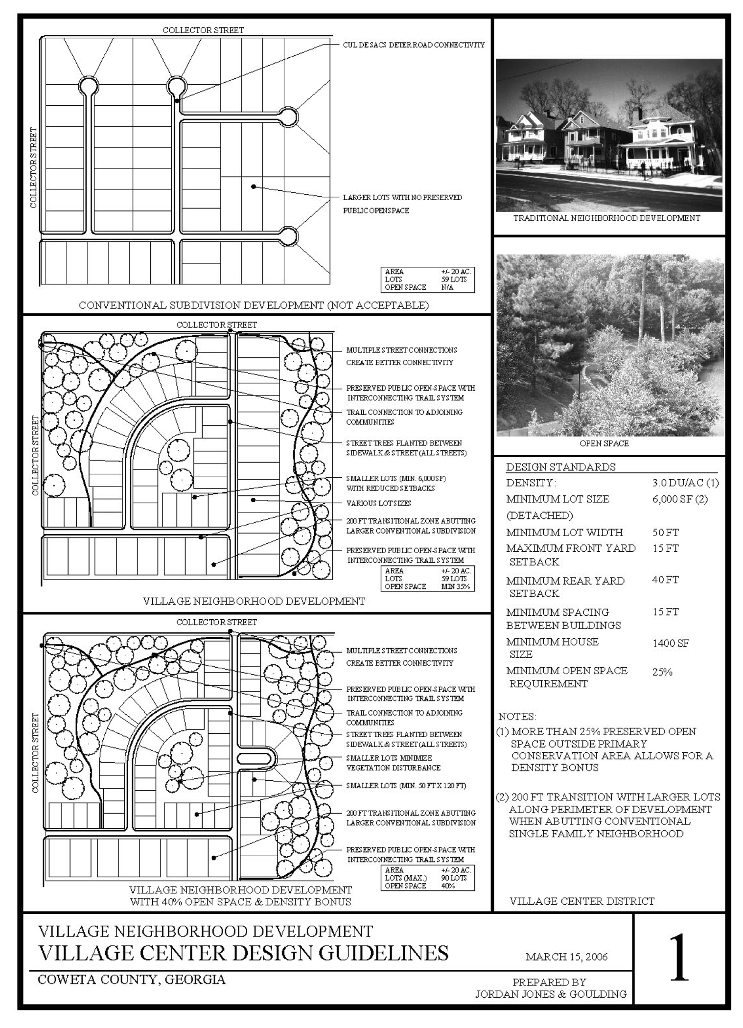
Figure 1
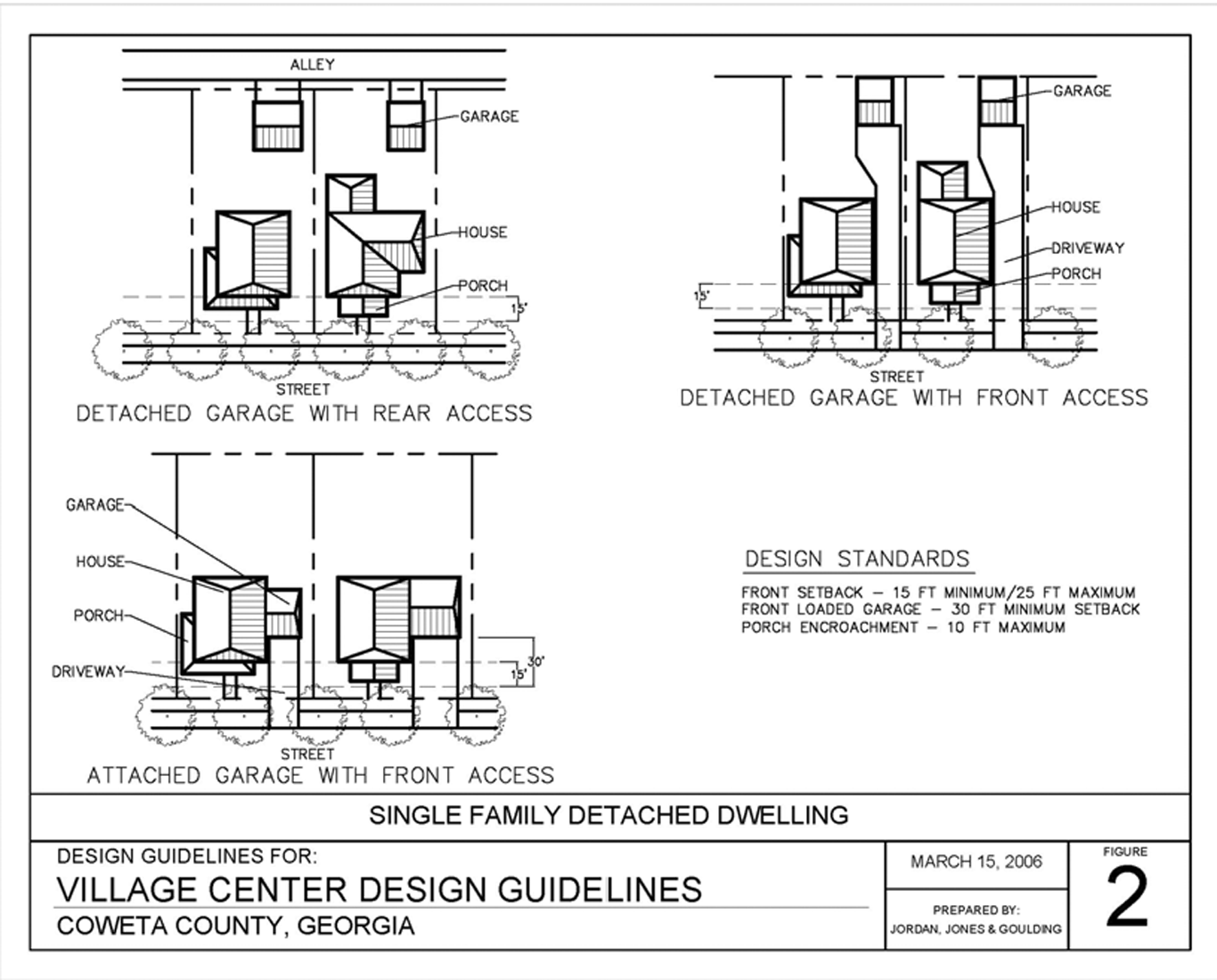
Figure 2
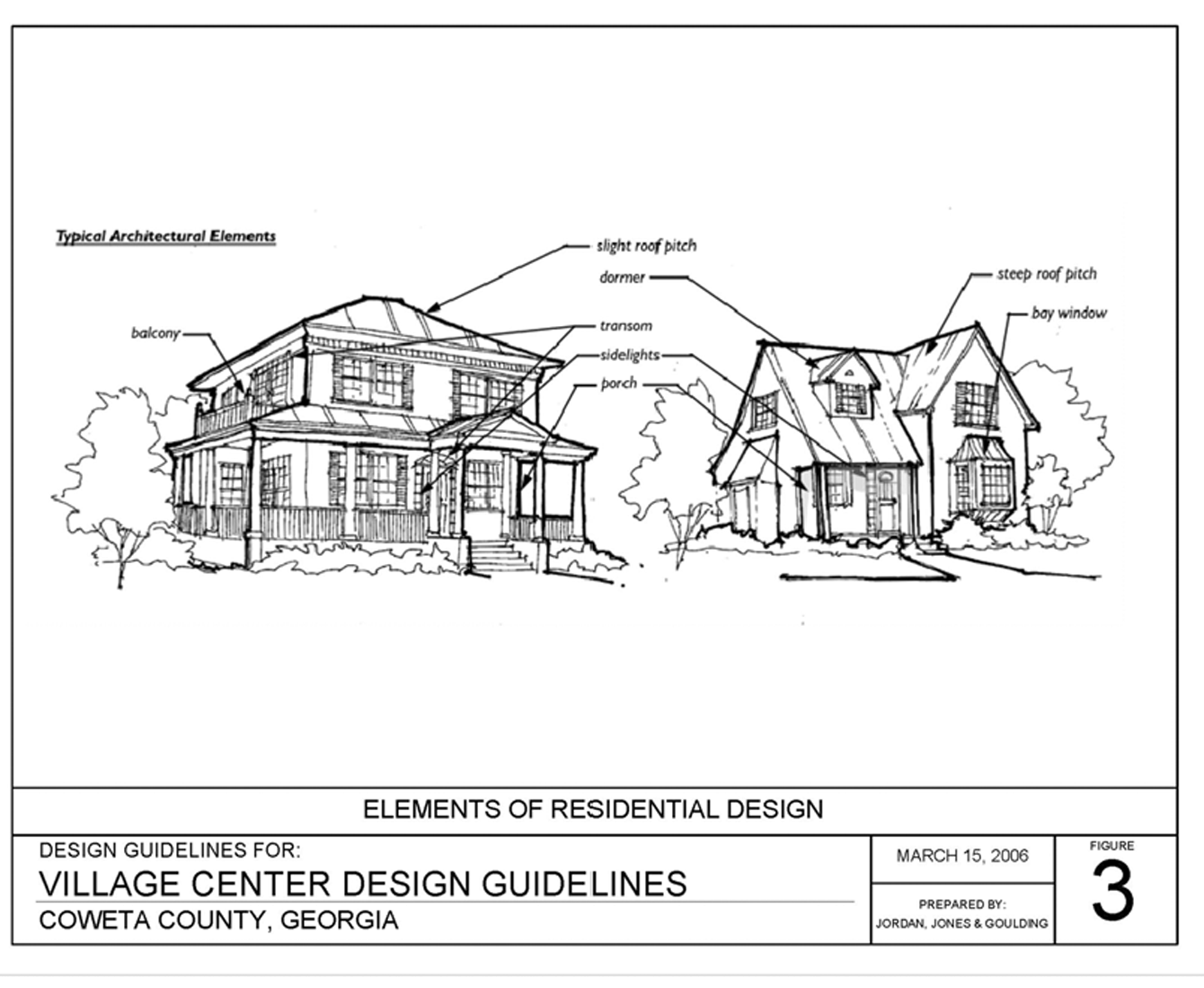
Figure 3
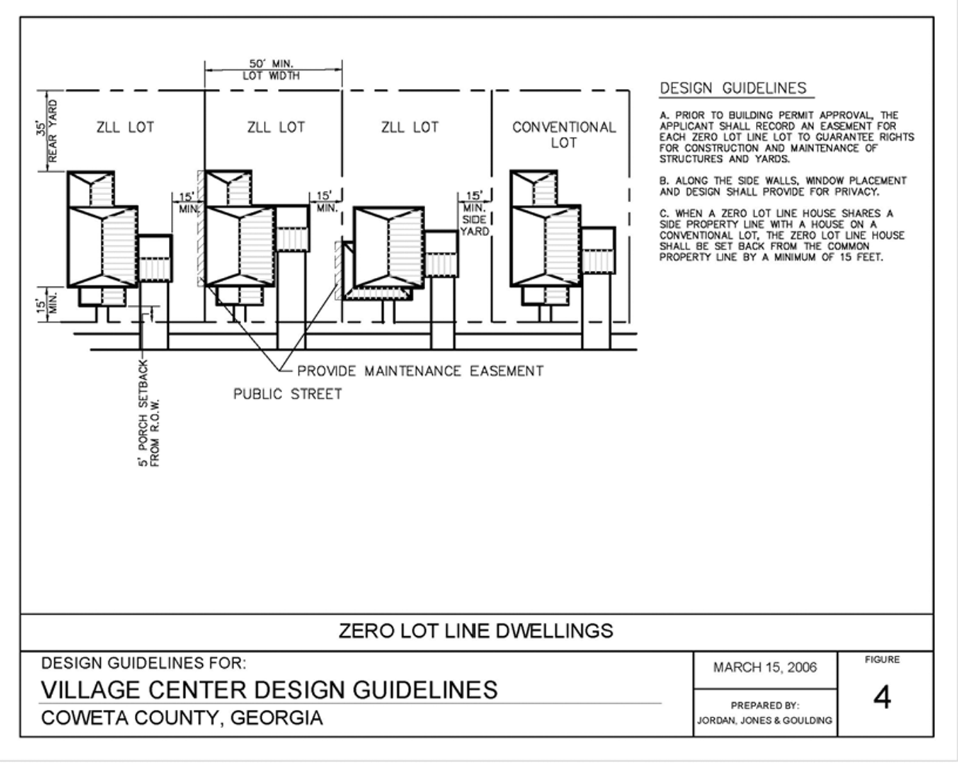
Figure 4
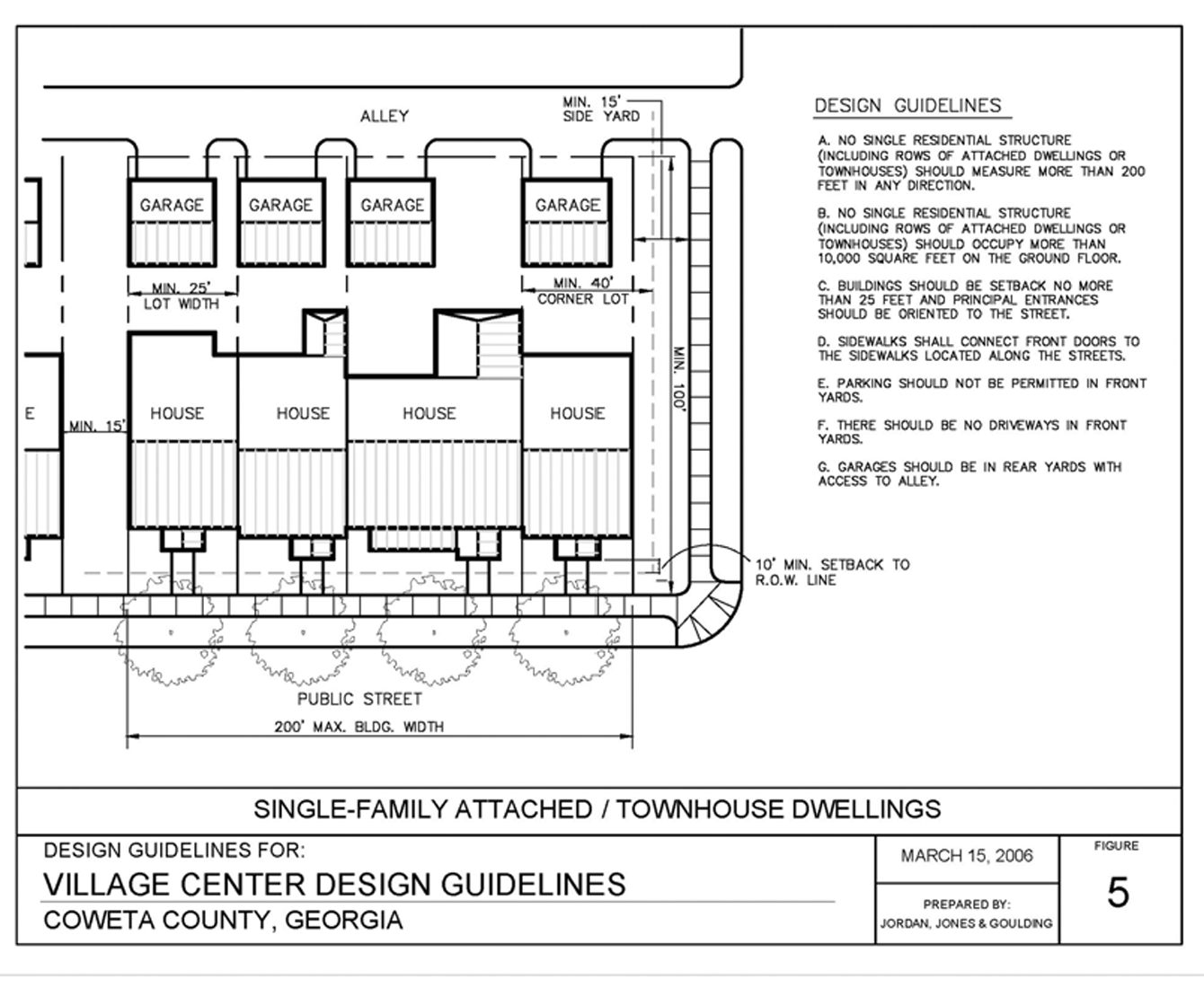
Figure 5
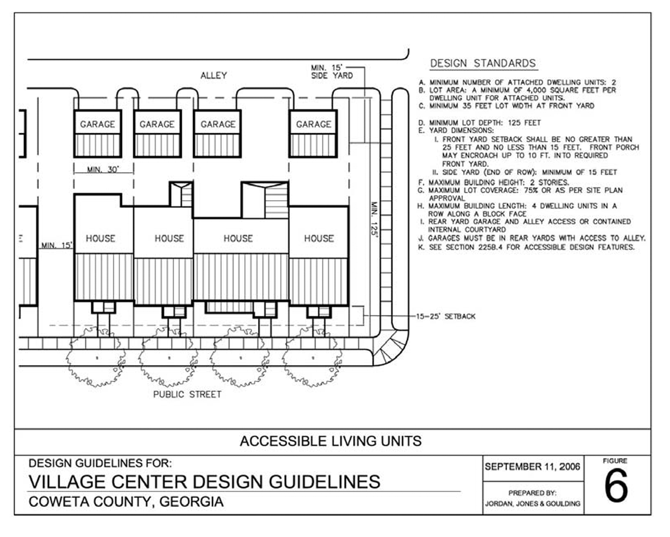
Figure 6
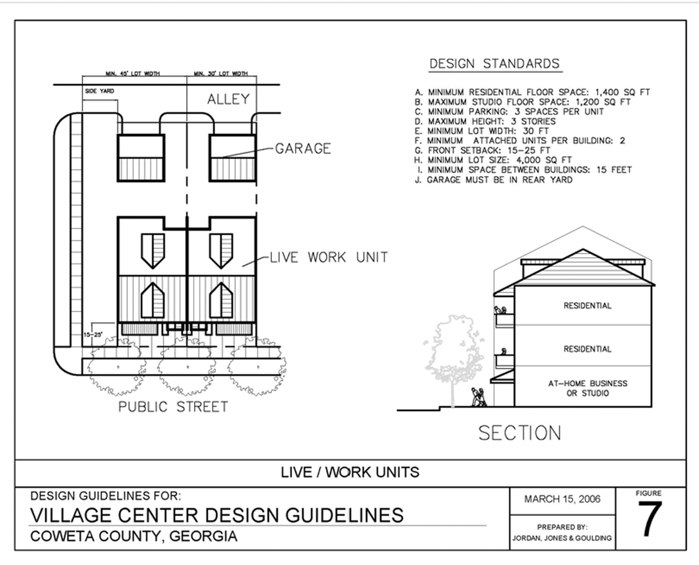
Figure 7
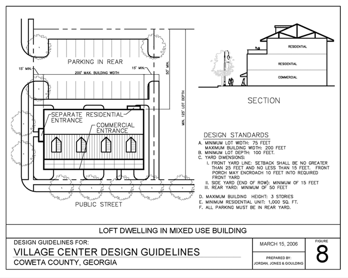
Figure 8
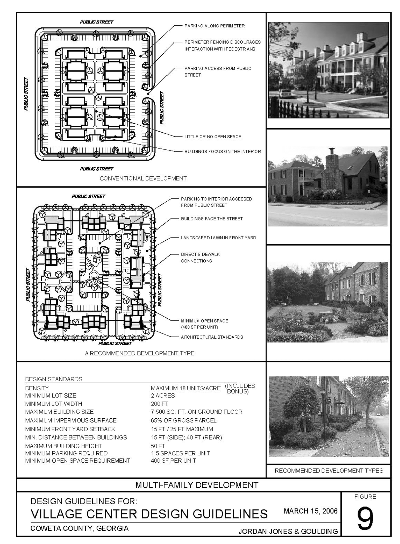
Figure 9
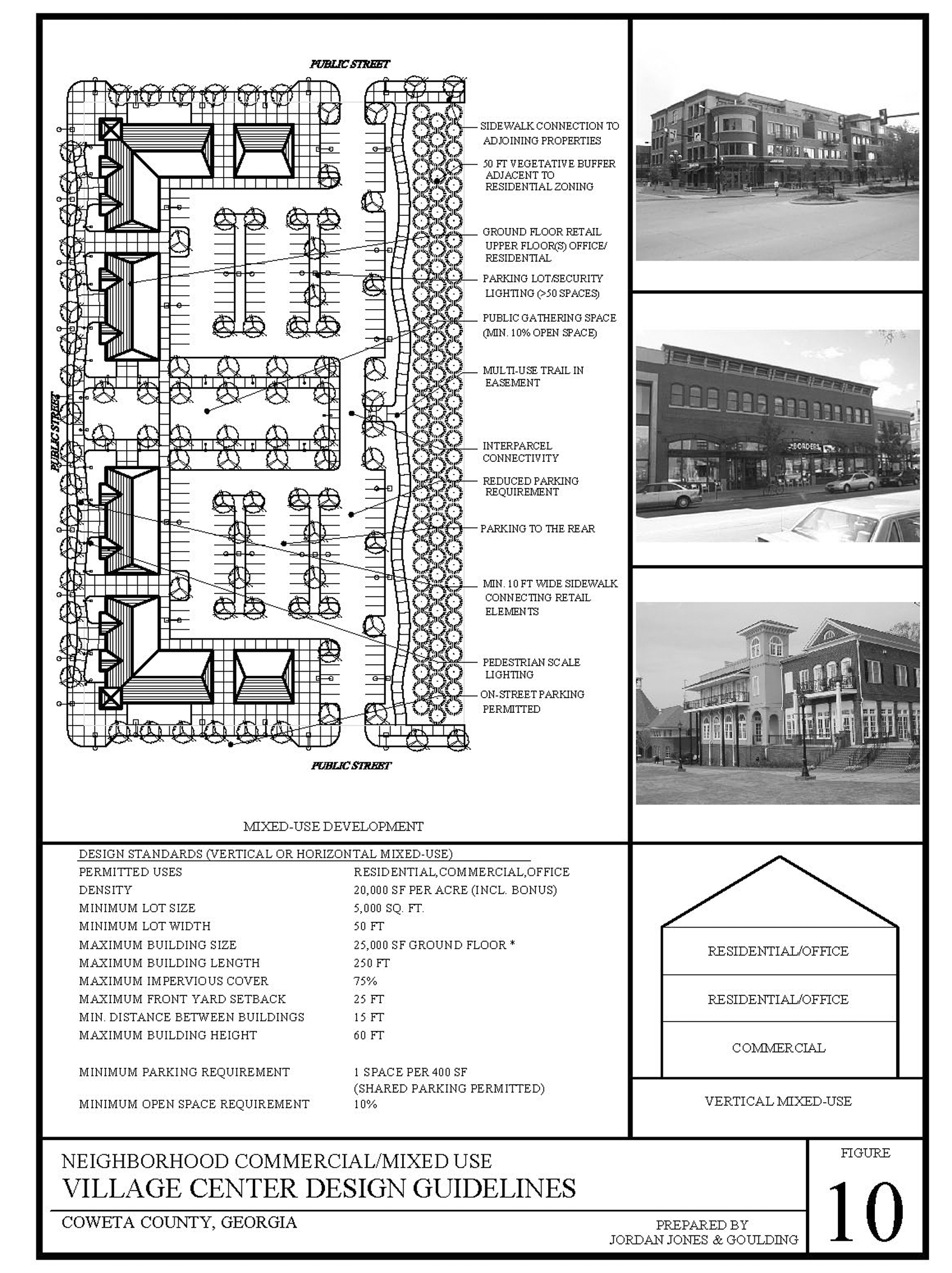
Figure 10
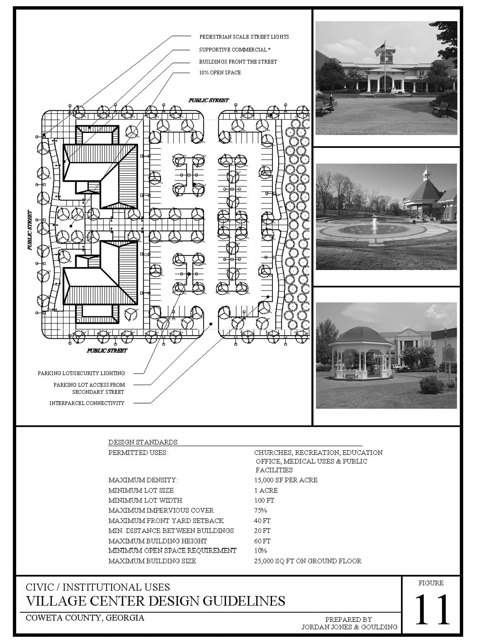
Figure 11
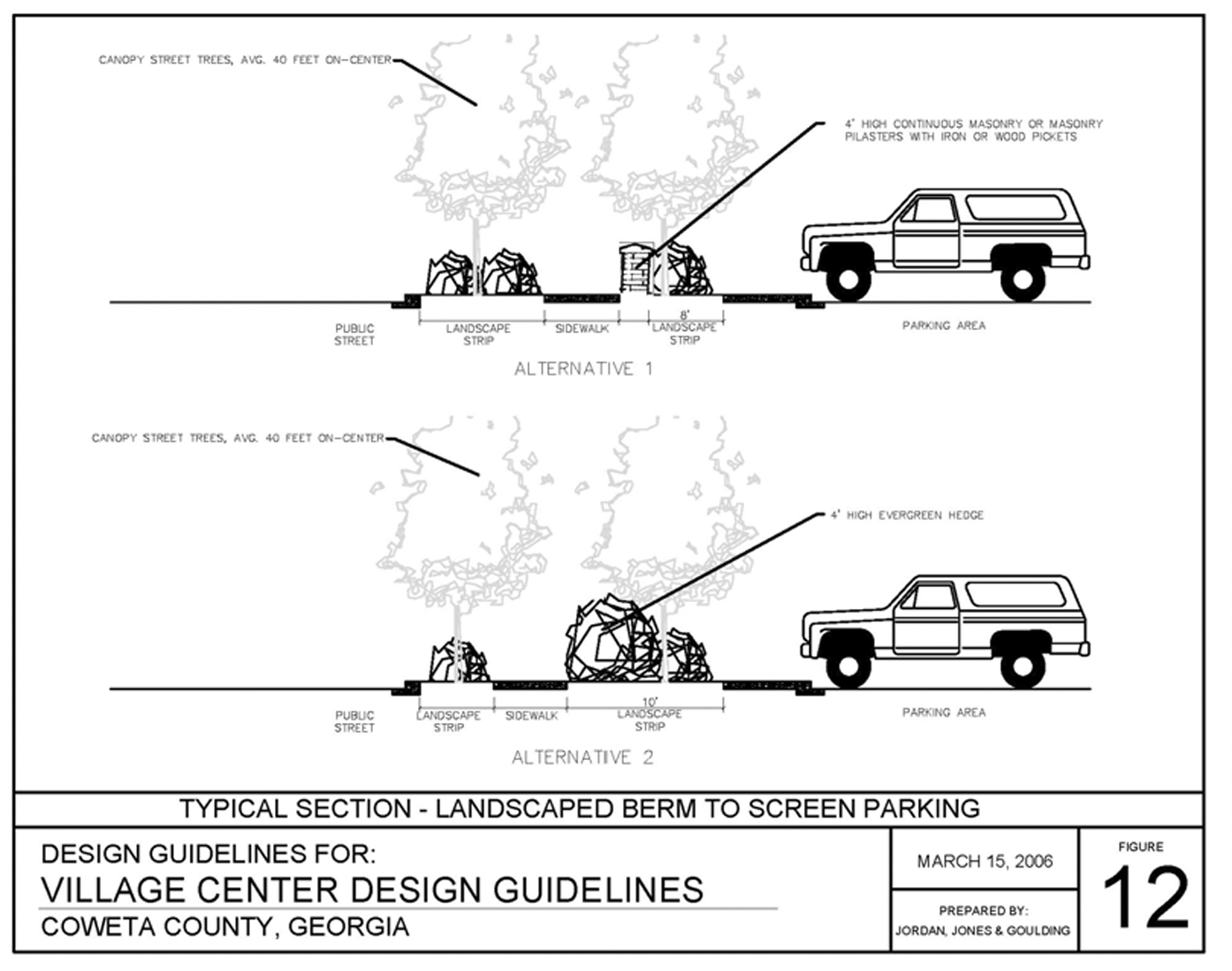
Figure 12
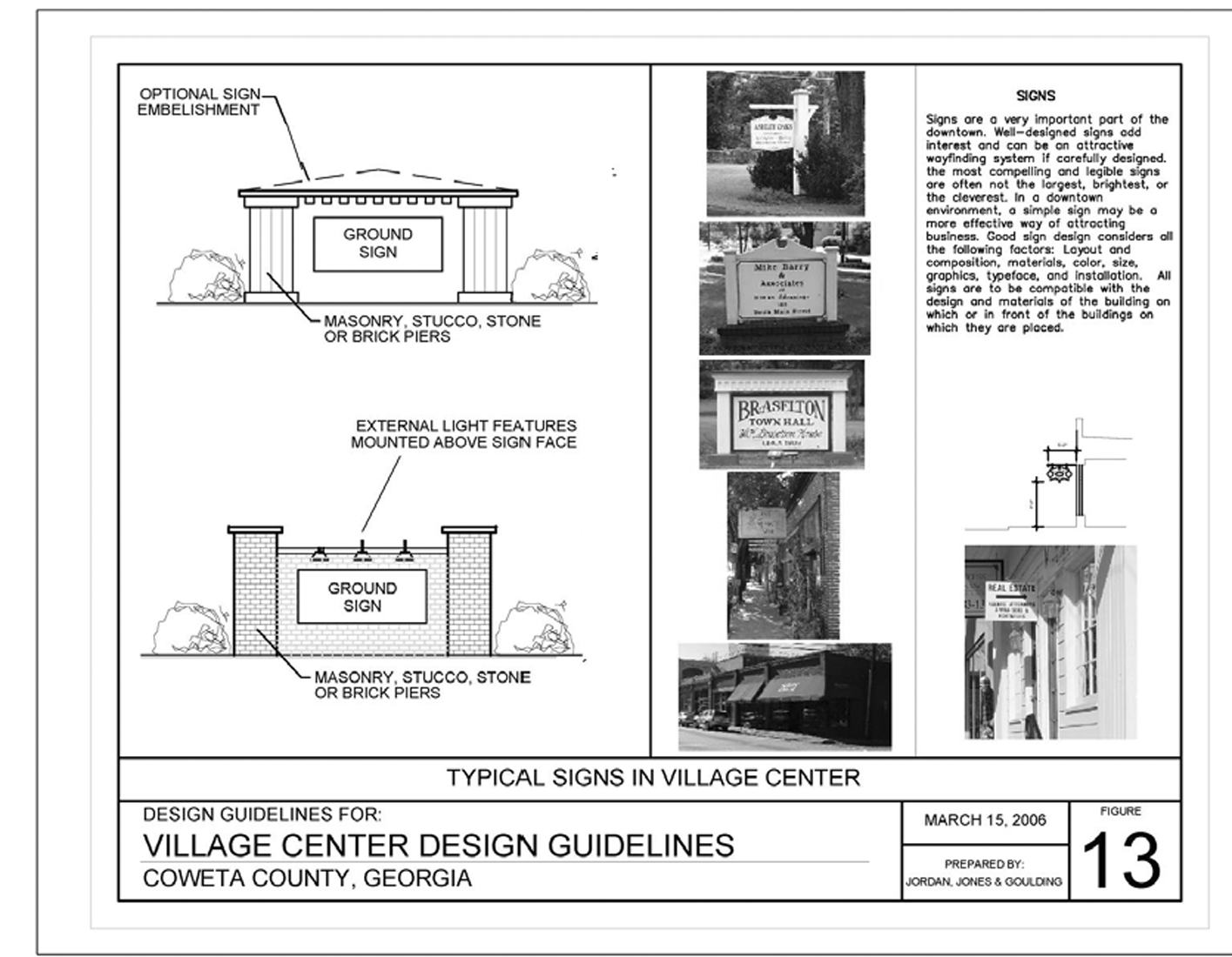
Figure 13
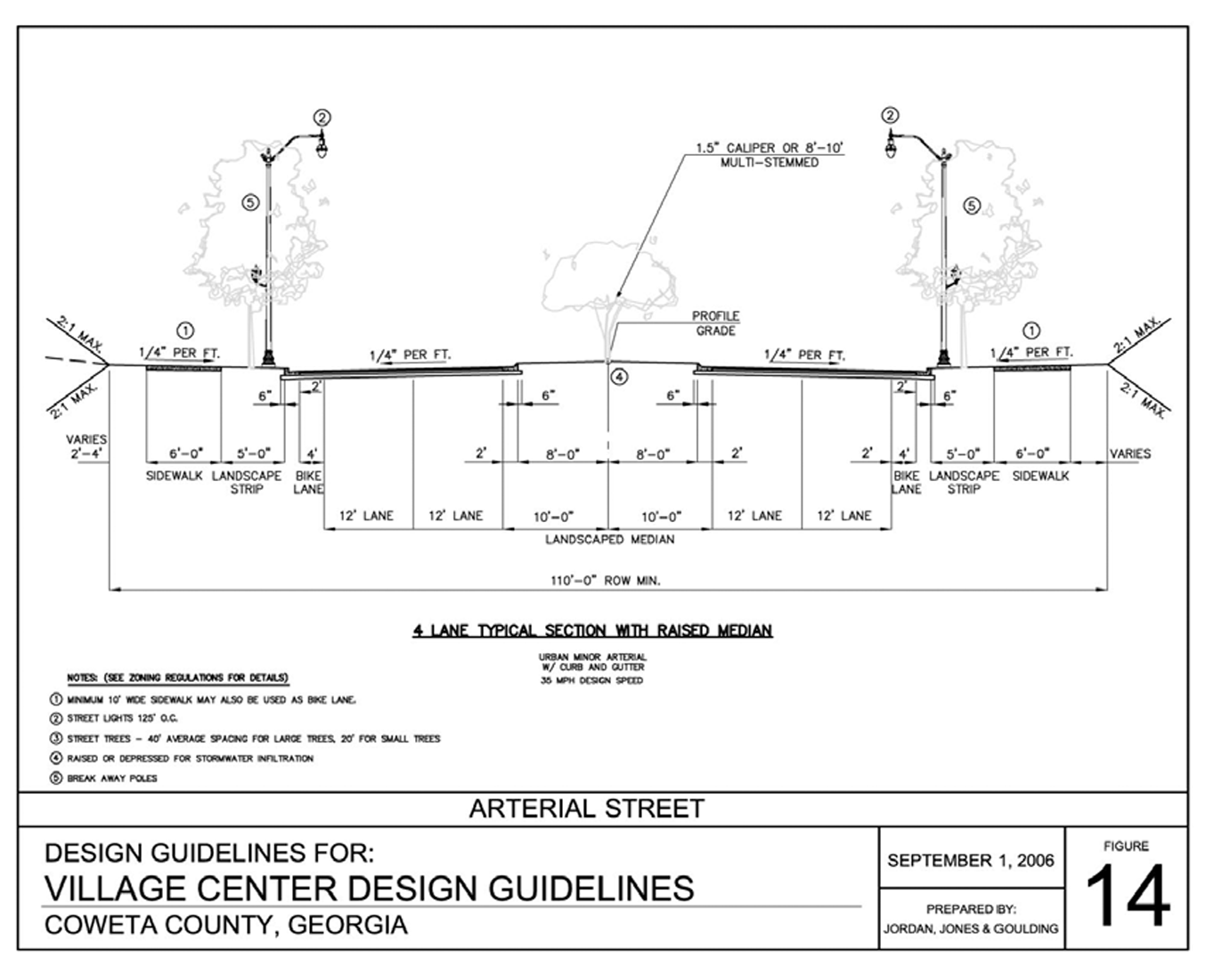
Figure 14
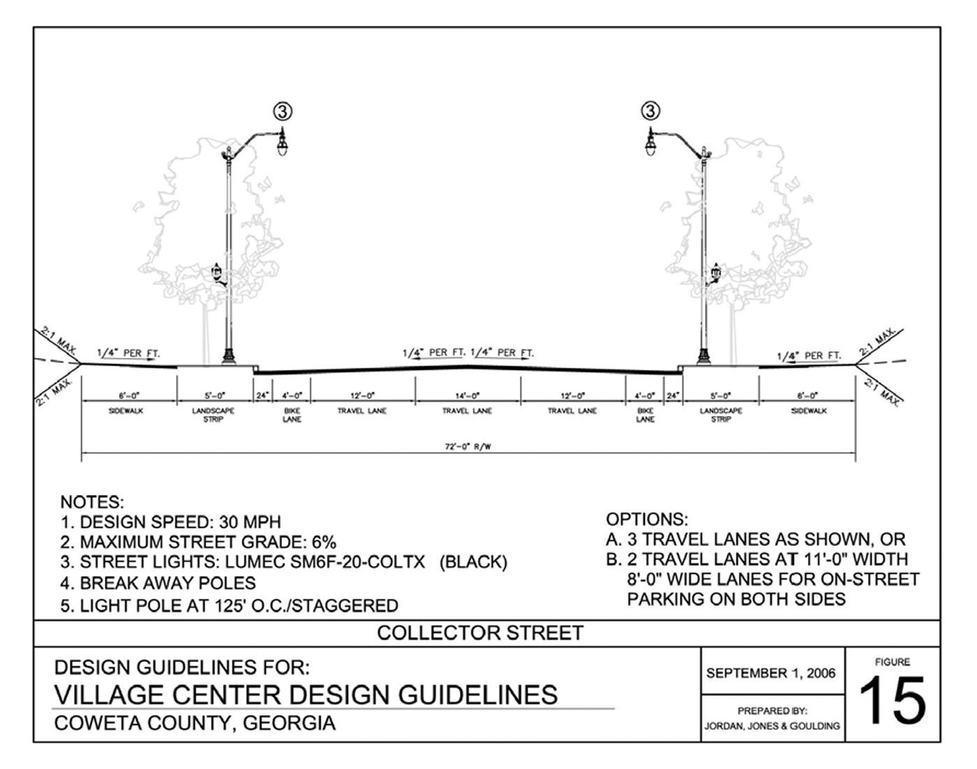
Figure 15
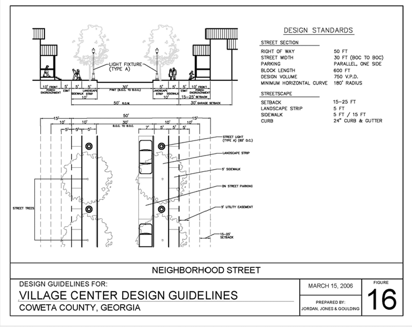
Figure 16
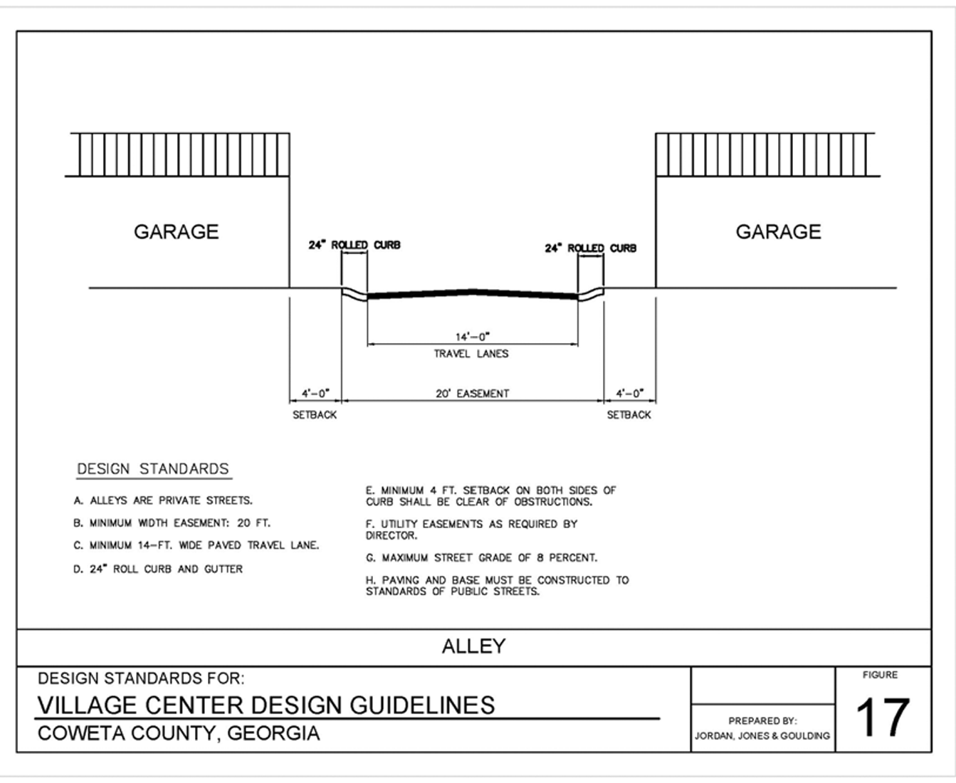
Figure 17
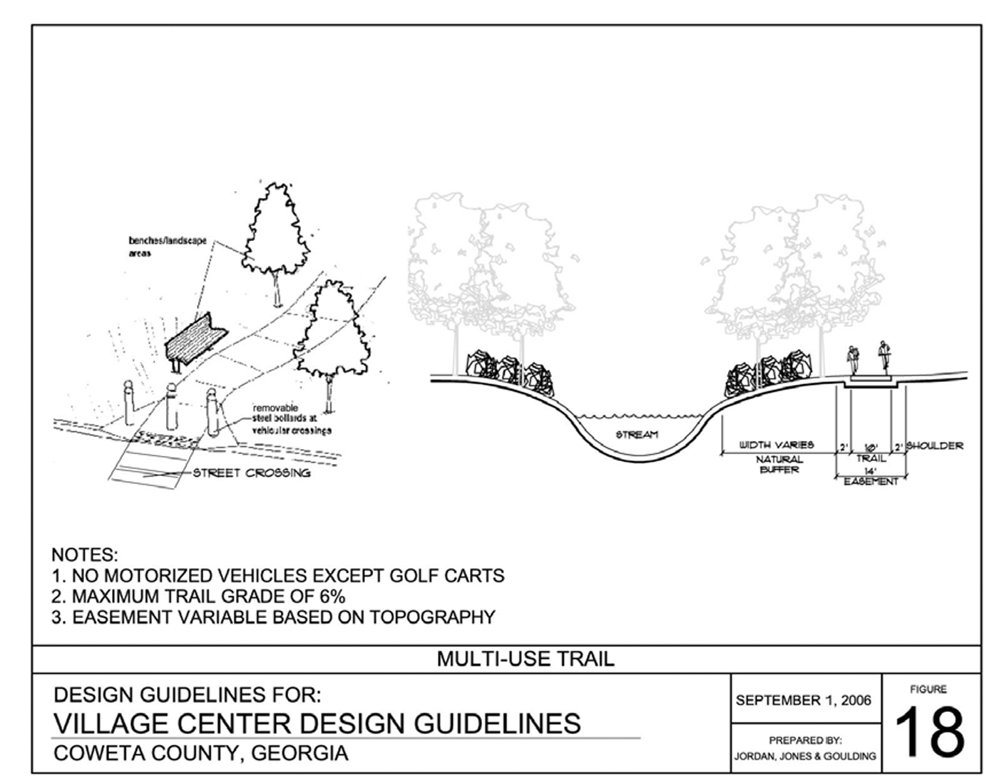
Figure 18
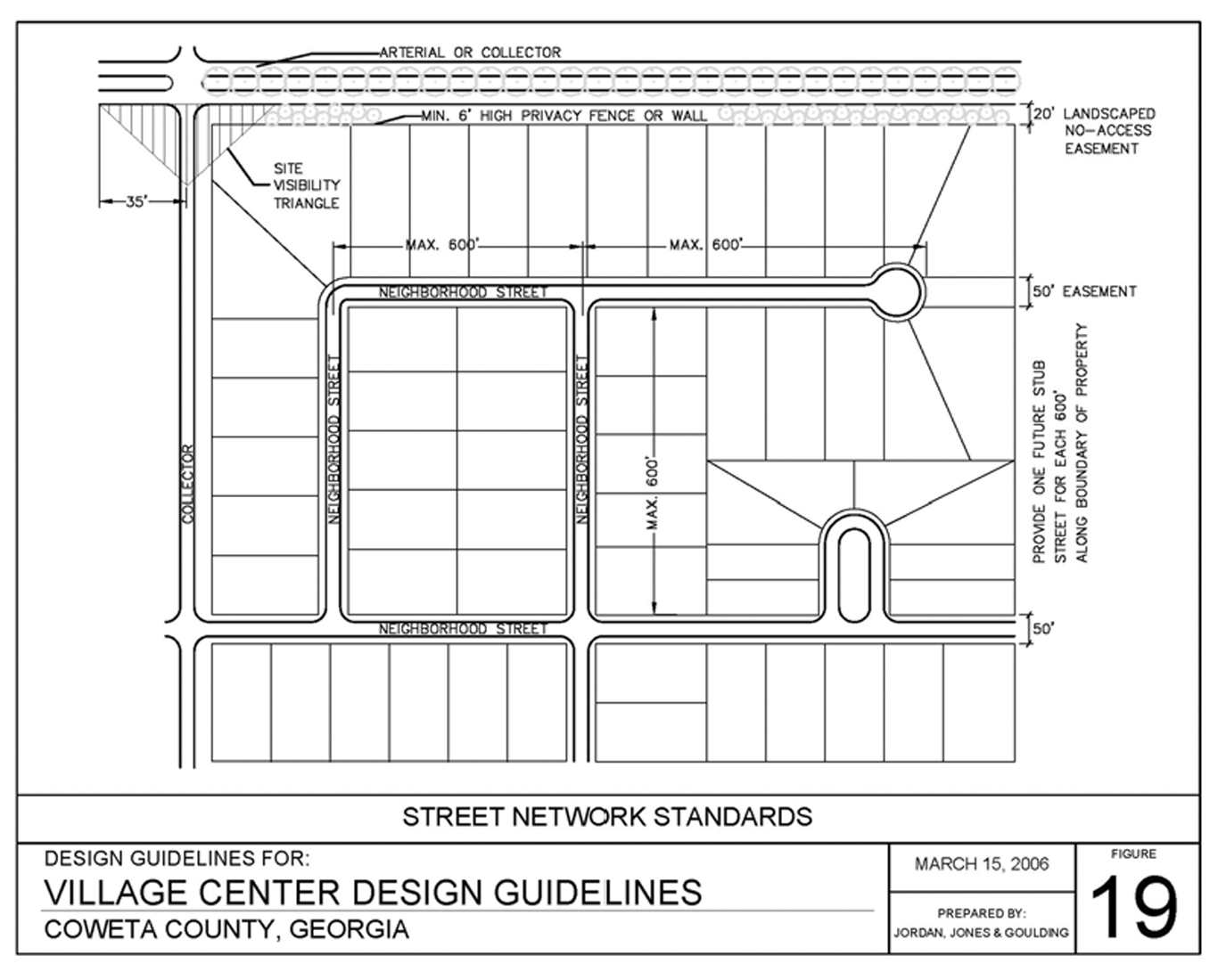
Figure 19
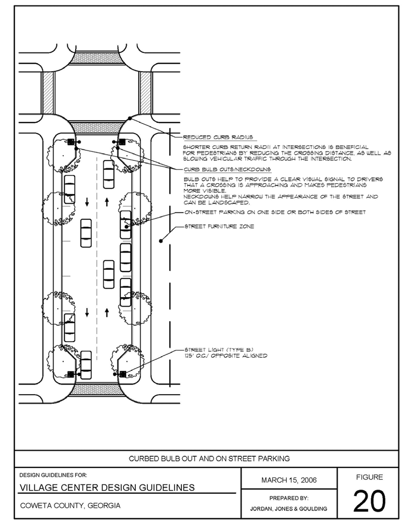
Figure 20
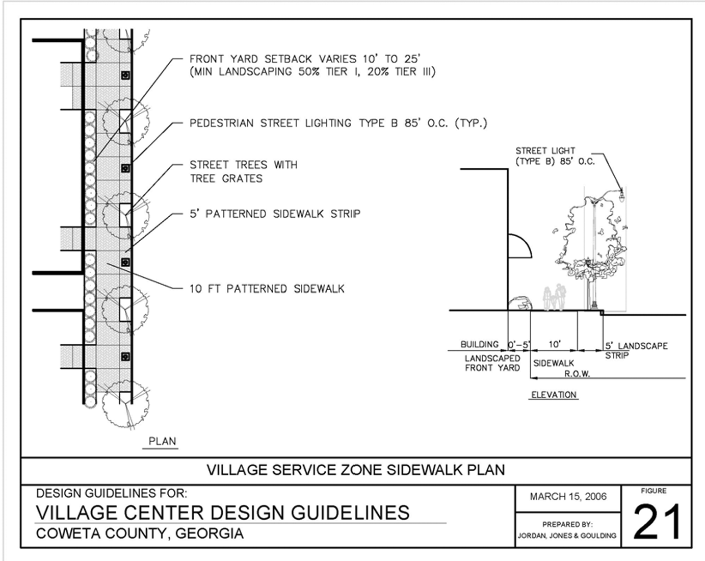
Figure 21
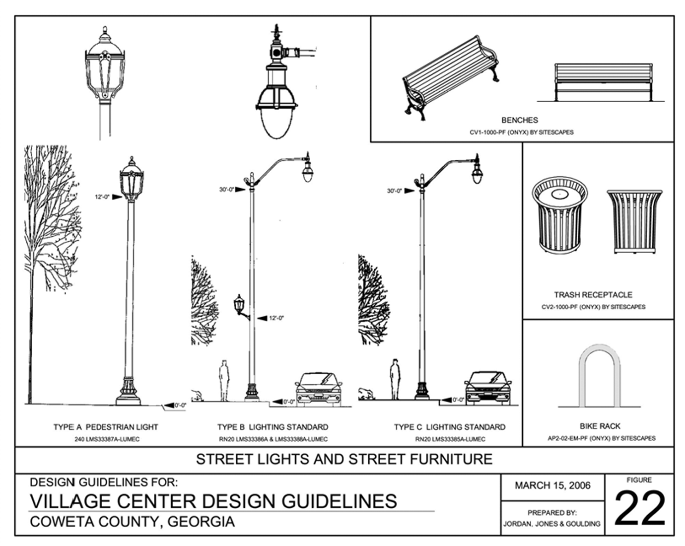
Figure 22