
Coweta County Unincorporated
City Zoning Code
City Zoning Code
ARTICLE 26
- OVERLAY DISTRICTS
Sec. 260.- Community unit plan.
A plan for the development of a tract of land, the proposed design of which makes it desirable to apply regulations more flexible than those contained in this ordinance, may be submitted to the board of commissioners for its consideration. Such a proposed development may contain residential uses of various types and allied uses such as churches, parks and day nurseries. After due public hearing and notice as described in the procedure for rezoning, the board of commissioners may approve such development upon a finding that the following conditions of fact exist:
(1)
That the tract of land on which the development is to take place comprises not less than 200 acres.
(2)
That the average lot area per family within the site, exclusive of streets, will not be less than 100 percent of the lot area per family required in the district in which the development is located.
(3)
That, where desirable, adequate and properly located areas are dedicated for public uses such as schools, parks and playgrounds.
(4)
That the property adjacent to the area included in the development will not be adversely affected, and that the public health, safety and general welfare will not be adversely affected.
Sec. 261. - Quality development corridor overlay district.
(A)
Purpose. The purpose of establishing the quality development corridor is to promote the health, safety and general welfare of the public; encourage harmonious community development; conserve natural resources; enhance the economic and aesthetic appeal and to promote orderly development of properties within the corridor. This ordinance is also intended to help reduce harmful effects resulting from heat, noise, and the glare of motor vehicle lights. The standards contained herein achieve the stated purpose by preventing or reducing traffic congestion and distracting visual clutter associated with development along major thoroughfares by addressing the following characteristic of development: buffer and landscaping, access, lighting, outdoor storage and impervious area.
(B)
District delineation. Quality development corridor requirements established herein shall be applicable to all nonresidential properties and uses within the districts listed below:
1.
State Route 34 East Corridor, being more particularly along that portion of State Highway 34 East from the City Limits of Newnan to Ebenezer Church Road as shown on the attached parcel base map entitled QDCD Map #34 E. Such standards shall only be applicable for a distance of 1,000 feet from the right-of-way line of State Highway 34 East. Said map and overlay are hereby adopted and made part of this ordinance.
2.
State Route 34 West Corridor, being more particularly along that portion of State Route 34 West from the City Limits of Newnan to Mountain Creek as shown on the attached parcel base map entitled QDCD Map #34 W. Such standards shall only be applicable for a distance of 1,000 feet from the right-of-way line of State Route 34 West. Said map and overlay are hereby adopted and made part of this ordinance.
3.
State Route 34 East at Fischer Road Corridor, being more particularly along that portion of State Route 34 East from 2,000 feet west of Fischer Road to State Route 34/54 Intersection as shown on the attached parcel base map entitled QDCD Map #34 E/54. Such standards shall only be applicable for a distance of 1,000 feet from the right-of-way line of State Route 34 East. Said map and overlay are hereby adopted and made part of this ordinance.
4.
State Route 16 West Corridor, being more particularly along that portion of State Route 16 West from the City Limits of Newnan to 2,000 feet west of Witcher Road Intersection as shown on the attached parcel base map entitled QDCD Map #16 W. Such standards shall only be applicable for a distance of 1,000 feet from the right-of-way line of State Route 16 West. Said map and overlay are hereby adopted and made part of this ordinance.
5.
State Route 16 East Corridor, being more particularly along that portion of State Route 16 East from the U.S. Highway 29 Intersection to Intersection of Land Lots 59 and 70 as shown on the attached parcel base map entitled QDCD Map #16 E. Such standards shall only be applicable for a distance of 1,000 feet from the right-of-way line of State Route 16 East. Said map and overlay are hereby adopted and made part of this ordinance.
6.
State Route 70 Corridor, being more particularly along that portion of State Route 70 from the City Limits of Newnan to 2,000 feet north of Leigh Avenue Intersection as shown on the attached parcel base map entitled QDCD Map #70. Such standards shall only be applicable for a distance of 1,000 feet from the right-of-way line of State Route 70 North. Said map and overlay are hereby adopted and made part of this ordinance.
7.
U.S. Highway 29 North Corridor, being more particularly along that portion of U.S. Highway 29 North from the City Limits of Newnan to Wahoo Creek as shown on the attached parcel base map entitled QDCD Map #29 N. Such standards shall only be applicable for a distance of 1,000 feet from the right-of-way line of U.S. Highway 29 North. Said map and overlay are hereby adopted and made a part of this ordinance.
8.
U.S. Highway 29 South Corridor, being more particularly along that portion of U.S. Highway 29 South from the City Limits of Newnan to the City Limits of Moreland as shown on the attached parcel base map entitled QDCD Map #29 S. Such standards shall only be applicable for a distance of 1,000 feet from the right-of-way line of U.S. Highway 29 S. Said map and overlay are hereby adopted and made part of this ordinance.
9.
State Route 154 Corridor, being more particularly along that portion of State Route 154 from the U.S. Highway 29 Intersection to the Transcontinental Gas Line Easement as shown on the attached parcel base map entitled QDCD Map #154. Such standards shall only be applicable for a distance of 1,000 feet from the right-of-way line of State Route 154. Said map and overlay are hereby adopted and made part of this ordinance.
10.
State Route 54 Corridor, being more particularly along that portion of State Route 54 from Shoal Creek to Line Creek as shown on the attached parcel base map entitled QDCD Map #54. Such standards shall only be applicable for a distance of 1,000 feet from the right-of-way line of State Route 54. Said map and overlay are hereby adopted and made part of this ordinance.
11.
State Route 34 Bypass Corridor, being more particularly along that portion of State Route 34 Bypass from 2,000 feet south of State Route 24 West and Ishman Ballard Road Intersection to current terminus at Turkey Creek Road as shown on the attached parcel base map entitled QDCD Map #34 Bypass. Such standards shall only be applicable for a distance of 1,000 feet from the right-of-way line of State Route 34 Bypass. Said map and overlay are hereby adopted and made part of this ordinance. Applicable to all areas on State Route 34 Bypass in unincorporated Coweta County only.
12.
State Route 34 Bypass Corridor, being more particularly along that portion of State Route 34 Bypass from current terminus at Turkey Creek Road to State Route 16 East as shown on the attached parcel base map entitled QDCD Map #34 Bypass Extension. Such standards shall only be applicable for a distance of 1,000 feet from the right-of-way line of State Route 34 Bypass. Said map and overlay are hereby adopted and made part of this ordinance.
13.
Vernon Hunter Parkway Corridor, being more particularly along that portion of Vernon Hunter Parkway from Intersection of Vernon Hunter Parkway and McIntosh Trail to Line Creek as shown on the attached parcel base map entitled QDCD Map Vernon Hunter Parkway. Such standards shall only be applicable for a distance of 1,000 feet from the right-of-way line of Vernon Hunter Parkway. Said map and overlay are hereby adopted and made part of this ordinance.
14.
Poplar Road Corridor, being more particularly along that portion of Poplar Road from S.R. 34 Bypass to the centerline of Hayes Road (a/k/a Hays Road) as shown on the attached parcel base map entitled QDCD Map Poplar Road. Such standards shall only be applicable for a distance of 1,000 feet from the right-of-way line of Poplar Road. Said map and overlay are hereby adopted and made part of this ordinance.
15.
Turkey Creek Road Corridor, being more particularly along that portion of Turkey Creek Road from the westerly line of Land Lot 27 to Interstate 85 as shown on the attached parcel base map entitled QDCD Map Turkey Creek Road. Such standards shall only be applicable for a distance of 1,000 feet from the right-of-way line of Turkey Creek Road. Said map and overlay are hereby adopted and made part of this ordinance.
(C)
Land use. The quality development corridor district shall not be construed to represent or used as a means for determining potential land use within the delineated district. The proper and acceptable tool for determining potential land use is the Coweta County future development map.
(D)
Exemptions. The following are exempt from the requirements of this ordinance:
1)
Alteration or renovation that involves 50 percent or less of the floor area of an existing building provided no additional alternation or renovation occur within a three-year period.
2)
Expansions of less than 50 percent of the floor area of the existing building, provided the same exterior materials on the existing structure(s) are used, or a superior material approved by the Building Official, and that no additional expansions, alterations, or renovations occur within a three-year period.
3)
Lots within an industrial park that by physical features, i.e., topography, existing structures, etc., will prevent new development from being highly visible from the roadway for which the district is named. Evidence in the form of topography maps, finished floor elevations, maximum height of buildings, photos, balloon test, or other applicable information shall be submitted to the director for an administrative exemption approval.
4)
Development approved prior to the adoption of this ordinance, provided the property is not rezoned from one category to another. If rezoning occurs, the requirements of this ordinance shall take full effect on the parcel or lot to the extent parcel dimensions will allow.
5)
Existing structures that were developed in accordance to the development regulations in effect at the time of construction where a change of use occurs or where such use has been abandoned for a period of five years and where no expansion of the structure is proposed shall not be required to meet the following requirements of this section: (a) building cladding to the extent that the director administratively waives such requirements in accordance to subsection 240.6(2)(b); and (b) site requirements, including landscaping and additional parking, and stormwater requirements upon a finding by the director that the change in use does not constitute a "redevelopment" as that term is defined in Chapter 30, Article IV of the code of ordinances, not more than 5,000 square feet of impervious surface is added to the site, such waiver or deviation does not create a safety hazard, and provided that the reduced cladding requirements specified in this section and Article 24 are met. This exemption/waiver shall not apply to new construction of additions or accessory buildings.
(E)
Development requirements.
1)
Landscaping and screening requirements. In addition to the provisions of article 24, site development standards, section 242.2, landscape requirements of the zoning and development ordinance, land development within a quality development corridor district shall also meet the following landscaping requirements below and elsewhere in this section:
a)
Landscape plan submission. The plan shall be submitted and approved as part of the predevelopment site plan as required by the provisions of this ordinance. The plan shall show lot or parcel dimensions, building dimensions, tree/landscape preservation areas, and the location and size of all tree and plant materials.
All landscape plans must be prepared and stamped by a registered landscape architect licensed to practice in the State of Georgia and should follow these general principles:
Preservation: an effort should be made to preserve as much of existing plant material and land form as possible; clear-cutting and mass grading are not acceptable practices.
Xeriscape: landscapes should emphasize native plant species and efficient use of water.
Permeability: the ease with which an individual is able to understand and navigate a place using landmarks and landscape clues.
Context: sensitivity to prevailing building and geographic context (color, material, mass, function, topography).
Place: forming a significant part of the urban landscape, landscapes are a tactile piece of the character of a place.
Creativity: landscape design goes a long way toward beautifying the built environment.
Quality: landscape design shall be designed in a sound manner and constructed according to accepted good planting procedures.
b)
Street planting. The street planting area is defined as the unpaved segment of land located between the property line that abuts a right-of-way and any building or vehicular use area and designed for the preservation and placement of plant materials. If a parcel or lot has more than one street planting area (i.e. more than one street frontage), each shall be considered separately. If a building site contains more than one parcel or lot, the entire site shall be treated by the landscape ordinance as a single entity.
The street planting area shall be a minimum of 20 feet in depth, as measured from the edge of the public right-of-way toward the center of the lot or parcel.
Within the required street planting area, measuring the total length of the project street frontage exclusive of drives, trees from the large category shall be planted at intervals of 40 feet with either one medium category or three small category trees in between; however, creativity is encouraged. Trees in the large category shall be three inches caliper and not less than 12 feet in height at planting. Trees in the medium category shall be two and one-half inches caliper and not less than ten feet in height at planting. Trees in the small category shall be two inches caliper and not less than six feet in height at planting. The remaining area shall be landscaped with shrubs and ground cover. The shrubs and ground cover shall be defined in three categories: large shrubs (at a minimum size of 7 gallon and 3-foot in height at time of planting), medium shrubs (at a minimum size of 3 gallon and 18 inches in height at time of planting), and ground cover (at a minimum size of 4 inch pots and 4 inches in height at time of planting). Each category shall comprise of the following percentages of required shrubbery: a minimum 15% large shrubs, a minimum 15% medium shrubs, and maximum 10% ground cover. All plants must meet ASFNS standards.
Signs may be placed within the street planting area, monument style, and placed at least ten horizontal feet from all property lines. No sign shall be erected that obstructs sight distance at an intersection or along a public right-of-way. In all zoning districts, no sign of any type or design that obstructs vision between the heights of three feet and 15 feet above grade shall be permitted within 20 feet of the intersection of the right-of-way lines of street and/or railroads. Traffic control signs and signals are exempt from this regulation.
c)
Perimeter planting. The perimeter planting area is defined as the unpaved swath of land located between the side and/or rear property lines of a parcel or lot and designed for the preservation and placement of plant materials. The perimeter planting area shall be a minimum of ten feet in depth, as measured from the edge of the property line toward the center of the lot or parcel.
Within the required perimeter planting, canopy trees from the large category shall be planted at intervals of 70 feet with either one medium category or three small category trees in between. Trees in the large category shall be three inches caliper and not less than 12 feet in height at planting. Trees in the medium category shall be two and one-half inches caliper and not less than ten feet in height at planting. Trees in the small category shall be two inches caliper and not less than six feet in height at planting. The remaining area shall be landscaped with shrubs and ground cover. The shrubs and ground cover shall be defined in three categories: large shrubs (at a minimum size of 7 gallon and 3-foot in height at time of planting), medium shrubs (at a minimum size of 3 gallon and 18 inches in height at time of planting), and ground cover (at a minimum size of 4 inch pots and 4 inches in height at time of planting). Each category shall comprise of the following percentages of required shrubbery: a minimum 15% large shrubs, a minimum 15% medium shrubs, and a maximum 10% ground cover. All plants must meet ASFNS standards.
When any parcel or lot abuts an incompatible zoning district, the perimeter planting area shall be measured from the inside edge of the undisturbed buffer required by Article 25, Buffer and Screening Requirements, of the zoning and development ordinance. However, developments requiring buffer widths in excess of 50 feet may incorporate the perimeter landscaping into the buffer area provided the ten-foot landscape area is adjacent to the development and not the adjoining properties.
d)
Interior planting. Shade trees shall be located in parking lot islands. Landscaped islands shall terminate each row of parking spaces. Terminal islands shall be at least ten feet wide and 18 feet long and include one shade tree. Trees shall be three inches caliper and not less than eight feet tall at planting. The remaining area of terminal islands shall be landscaped with shrubs and ground cover one foot high at planting.
Interior islands shall be provided within each row of parking spaces. One interior island shall be provided for every ten parking spaces or fraction thereof. Each interior island shall be at least ten feet wide and 18 feet long and shall include one shade tree. Trees shall be three inches caliper and not less than eight feet tall at planting. The remaining area of interior islands shall be landscaped with shrubs and ground cover one foot in height at planting.
The perimeter of terminal and interior islands shall be surrounded with a continuous raised curb. Island width and length shall be measured from the inside edge of the curb. Trees planted in islands must be allowed to grow to maturity and full canopy and shall not be pruned beyond requirements of basic maintenance.
Small or understory category: The size range for this category of trees is 15 to 25 feet in height and 15 to 20 feet in width. This category shall be used primarily where there are overhead obstructions or in a planting area which cannot accommodate an overstory or shade tree. The director shall have the authority to disallow trees that are not suitable for a specific location due to growth habits of the tree or site conditions. The director shall determine proper installation.
Medium category: The size range for this category of trees is 25 to 50 feet in height and 25 to 40 feet in width. These trees shall be used primarily as street and shade trees. The director shall have the authority to disallow trees that are not suitable for a specific location due to growth habits of the tree or site conditions. The director shall determine proper installation.
Large or overstory category: The size range for this category of trees is 50 to 100 feet in height and 30 to 50 feet in width. These trees will be used primarily as street and shade trees. The director shall have the authority to disallow trees that are not suitable for a specific location due to growth habits of the tree or site conditions. The director shall determine proper installation.
Minimal planting ares shall be defined as areas in which, although the minimum dimensional requirements of the landscaped island or strip have been met, there are other factors which limit the growth area for a tree as determined by the county arborist (including, but not limited to, necessary retaining walls and adjacent to buildings).
Additional trees in each category may be approved upon consultation with the director. In approving additional trees, factors considered shall include, but not be limited to, the following: growth rates and habits, form, hardiness with the planting zone, and resistance to pests and diseases. A list of any additional approved trees will be maintained in the community development department and available upon request.
e)
Lot remnant plantings. All land surfaces other than those that are covered by buildings, structures, paving, or other required site elements shall be landscaped with well maintained grass, flowers, shrubs, or other suitable plant materials approved by the planning department. The location and detail of all other landscaped areas shall be depicted on the required landscaping/tree protection plan.
f)
Buffer plantings. All required buffers must meet requirements as spelled out in article 25, buffer area and screening requirements.
g)
Right-of-way beautification. Developments within the quality development corridor shall obtain a landscape easement from the Georgia Department of Transportation to landscape the right-of-way fronting the project. The right-of-way shall be landscaped, at a minimum, with sod. If the state highway department refuses to issue a landscape easement, required by this ordinance, denial shall be in writing stating the reason(s) for denial.
2)
Impervious area. Impervious surface areas shall not be allowed to cover more than 75 percent of the lot.
3)
Traffic management plan. A traffic management plan, prepared by a qualified professional engineer shall be submitted at the discretion of the county engineer, based on the size and intensity of the development, and traffic conditions. The traffic management plan must identify any traffic problems that will be generated by the development and present reasonable solutions to those problems. This plan must be submitted to the county engineer for approval.
4)
Outdoor lighting. All outdoor lights or lighting arrangements used for purposes of advertising, security or night operations must be directed away from adjoining or nearby residential zoning lots and public roadways. Lighting shall be recessed.
5)
Outdoor storage and display.
a)
Objects not on a permanent foundation shall be considered outdoor storage. No outdoor storage will be permitted outside a fully enclosed building unless the storage area is entirely screened from the street and adjoining properties by a suitable fence or wall at least six feet in height above the finished grade. The required fence or wall must provide for a reasonable visual separation between the storage area and all adjoining property.
b)
Objects must be on a permanent foundation to be considered an outdoor display. A plan for outdoor display areas must be submitted to the community development department. If approval is granted, the director shall require such conditions that will, in his/her judgment, secure substantially the objectives of this ordinance. Swing sets, storage buildings, and other similar items as determined by the director, shall not constitute an outdoor display within the quality development corridor district for approval under this article. Any items for which an outdoor display plan has not been approved shall be subject to the outdoor storage provisions in the previous paragraph.
6)
Utilities and service equipment. All utilities shall be located underground. All entry fixtures and other service equipment shall be located in side and rear yards and away from high use or high visibility areas, unless the development review committee determines that placement elsewhere is warranted due to the topography of the land or other site conditions. These fixtures shall be adequately screened with a masonry wall, wood privacy fencing, or plantings.
7)
Decorative fences and walls.
a)
All required opaque fences or walls shall be constructed of one or a combination of the following: decorative wood, stone, stucco on block, decorative block, or brick. These fences or walls shall not exceed six feet in height.
b)
Decorative wrought iron fencing may be used for architectural and security purposes only.
c)
Chain link, unfinished concrete or cinder block, plastic or fiberglass, barbed or razor wire, and plywood fences, or like materials are prohibited. Paint shall not be considered a finish material.
8)
Exterior architectural standards. In addition to the provisions of article 24, development regulations, subsection 246.1.5. of the Coweta County Zoning and Development Ordinance, nonresidential building(s) within the quality development corridor district shall meet the following exterior wall materials requirement:
Category "A" materials shall comprise 80 percent or more of the area of each wall and shall be limited to one or a combination of the following:
a)
Hard burned clay (brick).
b)
Stone with either a weathered face or a polished fluted broken face. No quarry-faced stone shall be used unless in retaining walls.
c)
Glass.
Category "B" materials may comprise no more than 20 percent of the area of each wall and shall be limited to one or a combination of the following:
a)
Masonry backed stucco.
b)
Exterior insulation finish system (E.I.F.S.).
c)
Fiber cement boards.
Architectural openings. All closing materials for architectural openings (i.e. windows, doors) must be glass.
The director may accept alternative door systems on a case-by-case basis related to security purposes, shipping access, carwashes, mini-warehouse facilities, auto service facilities and similar uses. In reviewing an exception, the director may require one or more of the following as condition of approval:
a)
Panel sections, glass or similar materials, provided the total area of panels represent at least 50 percent of the face/frame of the door;
b)
Painted door systems that blend in color with the adjacent Category A materials with the exception of the panels;
c)
Tinted panels;
d)
Other stipulations, as deemed by the director that help carry out the intent of this article.
Unique and special uses. It is recognized that on occasion buildings with unique and special uses will be desired within the quality development corridor district, which may not be able to meet the exterior architectural standards. If such a building is desired, then an appeal may be made to the director for an administrative variance. A covered tennis court, swimming pool, greenhouse, would be examples of unique and special buildings.
9)
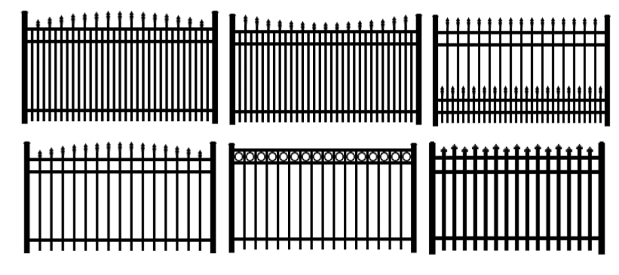
Detention facility screening. All detention facilities shall be completely screened from all adjoining lots and roadways with shrubs at three feet in height, when installed, shall be planted at intervals of four feet around the perimeter of the pond.
All security fencing and required detention pond fencing must be constructed of decorative metal and must be colored black or have a natural earth tone color. Security fencing and required detention pond fencing in rear yards may utilize black vinyl coated chain link fencing.
The following are acceptable security fence styles:
10)
Prohibited uses and structures.
a)
Peddling. Peddling is strictly prohibited within the quality development corridor district.
b)
Outdoor advertising signs (billboards) as defined in the Coweta County Sign Regulations.
c)
Towers such as radio and telecommunication towers.
11)
Administrative variance. Where the director finds that extraordinary and unnecessary hardships may result from strict compliance with these development standards, the director may vary the standards so that substantial justice may be done and the public interest secured; provided that such variations will not have the effect of nullifying the intent and purpose of these development standards. Where the director finds that, due to special circumstances of a particular lot, use, or building, the director may waive applicable development standards, provided the modification does not waive the required standard by more than 15 percent. The following factors where relevant, shall be considered in evaluating an administrative variance:
1)
The dimensions of a lot;
2)
Natural features of the property, such as topography, watercourses, rock formations, and similar conditions;
3)
Unique and special uses; and
4)
Building design and construction.
In granting variances and modifications, the director shall require such conditions that will, in the director's judgment, secure substantially the objectives of the standards or requirements so varied or modified.
The following shall be submitted to the director when an administrative variance is being requested:
1)
An administrative variance fee in the amount prescribed in the fee schedule.
2)
A denial letter from the development review division of the planning department indicating the reason(s) for noncompliance.
3)
A letter from the applicant stating their appeal including reasons for noncompliance and provide suggested mitigated measures, if any.
4)
Copy of warranty deed.
5)
If applicable, a plat of property indicating all existing and proposed structures in relation to nearby streets, property lines, and driveways; dimensions are to be accurate (submit two copies of the plat).
Appeals of an interpretation or of an administrative variance denial by the director relative to the requirements of these development standards may be submitted to the board of zoning appeals in accordance with the procedures in article 28, criteria for variances and conditional uses, of the zoning and development ordinance.
(Ord. No. 029-07, 9-18-07; Ord. No. 007-08, 3-13-08; Ord. No. 033-08, 11-13-08; Ord. No. 035-08, 11-18-08; Ord. No. 006-10, 5-18-10; 033-10, 9-9-10; Ord. No. 012-14, § 3, 3-4-14; Ord. No. 010-15, 3-17-15; Ord. No. 041-15, 9-22-15; Ord. No. 024-16, 7-19-16; Ord. No. 007-20, 1-7-20)
Sec. 262. - Planned development project (PDP) overlay district.
(A)
Purpose. The purpose of the planned development project overlay district is to encourage unified development of tracts of land by allowing much more creative and flexible concepts in site planning than would otherwise be possible through strict application of the underlying district requirements.
(B)
Rezoning process. Applications to establish a PDP sub-type, as described beginning in Item F of this section must be made in accordance with article 29 Amendments; however, where there are conflicts with that article, the items listed below shall prevail:
1.
A pre-submittal meeting shall be held at least two weeks in advance of filing a rezoning application for any planned development project.
2.
The applicant shall provide:
i.
Renderings of the proposed structures to be placed on the site;
ii.
A conceptual site plan meeting the requirements of section 290, Item (2); however, the applicant must also identify all areas of the underlying zoning district in which they are requesting a deviation from the standards;
iii.
A proposed list of standards for all items which are normally governed by the dimensional requirements of article 23;
iv.
Notwithstanding the proposed standards in subsection (iii) above, the planned development project shall comply with the standards contained within this zoning and development ordinance.
3.
A traffic study shall be provided unless exempted by the public works director during the pre-submittal meeting. For applications not required to submit a traffic study, the public works director will notify the applicant of any required transportation improvements to adequately serve the proposed development. The rezoning application shall not be considered complete until the public works director accepts the traffic study.
4.
Once the rezoning application is accepted, the applicant shall have five business days to proffer any zoning conditions to accompany the application. Staff shall then evaluate the proposal in accordance with scoring methodology for each PDP sub-type defined in section 262. Once complete, the scoring worksheet will be forwarded to the applicant and the board of commissioners prior to the public hearing. The scoring for each PDP sub-type shall be considered by the board of commissioners, along with the normal review factors contained in article 29.
(C)
Designation on the official zoning map. Once a rezoning application to a PDP sub-type has been approved by the board of commissioners, it shall be reflected on the official zoning map in a manner approved by the community development director and carrying the label of the relevant sub-type.
(D)
Modifications. The following modifications to a planned development project shall require a rezoning application. Changes that would not significantly alter the original rezoning application may be approved administratively at the discretion of the community development director.
1.
Any change that would alter the scoring of the original rezoning application.
2.
Changes affecting the number or location of entrances.
3.
Changes that would increase density.
(E)
Reversion. Unless a land disturbance permit has been issued and site work has commenced within one year from the date in which the PDP overlay district was approved, said overlay district shall be subject to reversion back to the underlying zoning district by the board of commissioners. A reversion rezoning shall be initiated by the board, with proper notification to the owner(s) of record and acted upon after a duly advertised public hearing in accordance with article 29. The property owner may request a single extension of up to 60 days prior to the public hearing, which may be approved administratively by the community development director. Extensions beyond 60 days shall be submitted to the board of commissioners for consideration.
(F)
Residential-planned development project (R-PDP) overlay.
1.
Purpose. The purpose of the Residential-Planned Development Project overlay is to allow enhanced density in areas with access to existing infrastructure. The ordinance provisions are designed to ensure adequate provision of infrastructure for these higher density developments, provide adequate open space for the residents of these communities, minimize potential cost burdens to the larger community through efficient use of infrastructure - all of which also contributes to the ability to preserve rural character in areas of the county.
2.
Pre-requisites for filing a rezoning application for the R-PDP overlay district.
i.
The subject property shall be a minimum of five acres zoned RC, Rural Conservation.
ii.
The subject property shall be contiguous with a municipality as defined in O.C.G.A. § 36-36-20, provided, however, that the municipality is located within the boundary of Coweta County.
iii.
The subject property shall have access to public water and sewer services, as evidenced by a will-serve letter. The Coweta County Water and Sewerage Authority shall have the first right of refusal for providing water and sewer services.
3.
Scoring of R-PDP rezoning applications. After acceptance of the application package and prior to the public hearing, staff shall provide the applicant and the board of commissioners with a score for the proposed R-PDP. The score shall be determined by staff in accordance with Table 1: Residential Planned Development Project Scoring Methodology.
Table 1: Residential Planned Development Project Scoring Methodology
4.
Permitted uses. The following uses are permitted within the R-PDP overlay district, subject to the provisions of the Code of Ordinances:
i.
Single-family, detached dwellings.
ii.
Customary accessory buildings and uses, pool house, amenity center, etc.
iii.
Home occupations.
iv.
Fee-simple townhouses when served by private/gated community streets meeting the standards in section 246.12 of this ordinance.
5.
Dimensional requirements. R-PDP applications shall comply with the overlay districts dimensional requirements table in article 23. There shall be no deviation or variances granted from the maximum density specifically established for this district.
6.
Additional design standards.
i.
Proffered open space shall comply with article 24, section 246.4 - Open Space.
ii.
Greenway donations for any portion of the development tract identified on the Greenway Master Plan shall be processed alongside the final plat; said donations shall be deemed as open space.
iii.
The development shall comply with chapter 30 - Environment of the Coweta County Code of Ordinances. Adequate easements for maintenance of all stormwater systems shall be provided to the satisfaction of the community development director. Pursuant to article 24, section 244.1 - Preapplication, a stormwater concept plan shall be submitted for review and approval.
(G)
Interstate gateway mixed-use planned development project (IGMU-PDP).
1.
Intent and purpose. IGMU-PDP districts are defined as planned development projects for the establishment of the complementary arrangement of residential, with commercial, office, institutional, and, or light industrial uses. The intent of the IGMU-PDP is to allow flexibility in design regulations and residential density in exchange for innovative and high design standards that include walkability, open space, and public amenities within a cohesive architectural theme improving the viability of the interstate gateway character area.
2.
Applicability.
i.
IGMU-PDP overlay districts shall be located within the interstate gateway character areas as defined by the county comprehensive plan.
ii.
Seventy-Five percent of the total gross acreage of an IGMU-PDP project shall be located within the interstate gateway.
iii.
The development shall be a minimum of 30 acres.
iv.
As evidenced by a will-serve letter, the subject property shall have access to public water and sewer services. The county water and sewerage suthority shall have the first right of refusal for providing water and sewer services.
3.
General conditions.
i.
Whenever there is a conflict or difference between the provisions of this article and other chapters of the Code of Ordinances, this article shall prevail.
ii.
The respective provisions in the Code shall govern subjects not covered by this article.
iii.
When an IGMU-PDP is presented as a redevelopment project, the underlying zoning at the time of enactment of the overlay remains effective until such time as the property owner elects to proceed with a redevelopment project in accordance with IGMU-PDP regulations.
iv.
Developments within an approved IGMU-PDP overlay district are intended to be planned and developed as a single, entire unit of land. For projects where ownership may be constituted by an assembly of landowners and parcels, the applicant shall provide evidence of the unified control of the entire parcel or parcel assemblage. More than one owner may participate in the development of the approved plan, provided that each parcel of land remains subject to all of the terms and conditions of the concept plan approved for the property as a whole.
v.
Variance requests. Applications requesting rezoning to an IGMU-PDP must identify all variance requests in the rezoning application and represent such requests in the site plan and concept plan.
4.
Application process. The IGMU-PDP rezoning process shall follow the same process for rezoning as prescribed in section 262, with the following additions:
i.
Phasing plan. A phasing plan shall be submitted with the rezoning application and is subject to approval by the board of commissioners unless the entire development is to be completed at one time. The phasing plan shall describe and illustrate in a written and graphic format the incremental implementation of the IGMU-PDP development timeline, including the sequence, timing, responsibility for the construction of each building, support facilities, infrastructure, and utilities. The phasing plan shall provide an accurate map delineating each phase for which approval is being requested, showing the location of all infrastructure and buildings to be constructed, and a designation of the specific use for each building. Single-family residential need only show building setback lines and other design constraints for individual lots. Additionally, the phasing plan should include the following information:
a.
Concurrency. The phasing plan must include a concurrency schedule for the IGMU-PDP development.
1.
For an IGMU-PDP district, the developer is required to obtain a certificate of occupancy for a significant component, not less than 20 percent of the commercial-office square feet prior to completing the development or receiving a certificate of occupancy (CO) for any residential element, excluding model homes, and vertical mixed-use buildings where the entire ground floor is commercial.
2.
Light-industrial. The combined floor area of all said light-industrial uses holding occupancy permits shall equal or exceed 30 percent of the total ground floor dedicated to light-industrial use before a certificate of occupancy shall be issued for residential use excluding vertical mixed-use.
3.
For developments approved for high-performance office building incentives, the developer is required to obtain a certificate of occupancy for a minimum of 25 percent of the required square feet for high-performance office space or 55 percent of general non-residential square feet must be built concurrently with residential land use, excluding vertical mixed-use buildings.
4.
Model homes. Model homes may be constructed for single-family detached homes per section 246.2. For multi-dwelling (MD) elements, a maximum of one MD unit may be constructed before the issuance of a CO for the required 20 percent non-residential. The model MD unit shall not exceed 5,000 square feet on the ground floor. Vertical mixed-use buildings with ground floors entirely comprised of commercial/office/institutional use will not count toward the residential percentage. Vertical mixed-use is attributed to the commercial percentage.
ii.
Concept plan. A conceptual plan for an IGMU-PDP must meet all requirements from section 262 referenced above for PDP applications. In addition, IGMU-PDP concept plans must provide information indicating the following:
a.
Gross and net development acreage for each land use element in square feet and percentage.
b.
Ground floor area for each land use element in square feet and percentage.
c.
Site plan must identify the location and delineate the boundaries for each land use element.
d.
Location, boundary, and amount of open space in square feet and percentage of net development acreage.
e.
Location, boundary, and amount of common space in square feet and percentage of total open space.
f.
Such other project data as may be requested by the community development director to evaluate the project.
g.
Project narrative. The IGMU concept plan must include a project narrative. The development must be defined as a new development, revitalization, or redevelopment project.
1.
The project narrative requires the intent, purpose, goals, and community benefit to be identified.
2.
Revitalization and redevelopment projects must also address any potential impacts on the existing land use from the proposed project.
3.
The narrative must also include a summary of the proposed transportation connectivity. The connectivity information should include available information on private and public streets; significant vehicular parking and loading areas; the provision of bicycle parking areas, paths, sidewalks, and other similar features; and interconnections to adjoining property.
h.
Light-industrial. Any project requesting light industrial use shall provide a description and summary of the light-industrial use to include proposed square feet of the ground floor area, projected business, projected employees, and salaries.
1.
The applicant must also provide a narrative defining the use(s), employment profile, and provide the character of operations, and confirm emissions and by-products do not create adverse effects beyond the boundaries of the property.
i.
Streetscape design. The concept plan must include the location and specifications of improvements in public rights-of-way, including streetlights, bike racks, trash receptacles, benches, seating, street trees, landscaping, and other relevant items. Streetscape elements shall be as provided in accordance with appendix A.
j.
Unified lighting. A light plan must be submitted with the concept plan. Such lighting must provide adequate vehicular and pedestrian visibility and security in on-site areas such as building entrances, open spaces, parking, service delivery, and pedestrian walkways.
k.
Buffer plan. The applicant shall submit a buffer plan meeting the standards of article 25 and the requirements of the IGMU. The concept shall show a transitional buffer between light industrial use and along the property line of parcels or lots abutting residential lots outside the IGMU-PDP.
iii.
Tree protection plan. The IGMU-PDP concept plan must include a tree protection plan in conformity with article 253A.
iv.
Multi-modal access plan. A multi-modal access plan shall be required.
a.
The plan shall demonstrate connectivity within the system of streets, alleys, sidewalks, bike lanes, and multi-use trails shown for the subject property. Any existing or planned transit systems and associated facilities shall be included.
b.
The plan shall demonstrate connections to the county greenway master plan, the county bicycle plan, the county joint comprehensive transportation plan, and other applicable plans as determined by the community development department.
c.
The plan shall show convenient pedestrian ways from sidewalks along streets to each building entrance and between adjacent buildings within the same development and to those on abutting property.
v.
Incentive application. An applicant shall state their intent to request density incentives. The applicant shall submit sufficient documentation with their concept plan to verify their project complies with the density incentives.
vi.
Architectural design. The applicant shall prepare and submit preliminary architectural plans and elevations of all proposed buildings for review by the director of community development. The director shall review the checklist, plans, and elevations to determine if they conform and are substantially consistent with the intent of the IGMU-PDP.
vii.
High-performance office buildings. Projects approved for incentives must include the conceptual design of the proposed building(s). A summary that states the intent to fulfill the requirements of the IGMU-PDP, including the total square footage of all high-performance office buildings.
5.
Scoring of R-PDP rezoning applications. After acceptance of the rezoning application package and prior to the public hearing, staff shall provide the applicant and the board of commissioners with a project score worksheet for the proposed IGMU-PDP. The development score illustrates the compatibility between a proposed project and the IGMU-PDP overlay zoning district. The score shall be determined by staff in accordance with table 2: Interstate Gateway Mixed-Use Planned Development Project Score Worksheet.
Table 2. Interstate Gateway Mixed-Use Planned Development Project Score Worksheet
6.
Permitted use.
i.
Residential. All residential uses that are permitted and conditional in all zoning districts may be considered for inclusion. Higher-density residential dwellings may be considered where they may serve a proximate employment center. The inclusion of higher-density residential dwellings is subject to administrative review and approval by the board of commissioners.
ii.
Commercial, office, and institutional. All commercial, office, and institutional uses that are permitted and conditional in all zoning districts, excluding C-8, and M industrial districts, may be considered for inclusion and are subject to administrative review and approval by the board of commissioners.
iii.
Light industrial. Light industrial use may be considered for the IGMU-PDP. The rezoning application must include a narrative defining the use, employment profile, and provide that the character of operations, and confirm emissions and by-products do not create adverse effects beyond the boundaries of the property. The inclusion of light industrial use in an IGMU-PDP is subject to administrative review and approval by the board of commissioners.
7.
Prohibited use.
i.
In an IGMU-PDP district, the following uses are specifically prohibited:
a.
Gas stations, similar fueling stations, and convenience stores.
b.
Drive-thru restaurants and commercial service.
c.
Automobile repair and maintenance.
d.
Storage facility.
e.
Distribution center.
f.
Warehouse.
g.
Heavy industrial use.
h.
Laundromat.
i.
Car wash.
j.
Industrial welding.
ii.
The director of community development may determine that a use not listed above may be prohibited for reasons that may include:
a.
Incompatibility with surrounding land use.
b.
Lack of cohesive architectural design and visual character.
c.
Potential for adverse impacts on traffic, stormwater, wastewater treatment, and environmental quality.
d.
Identified to have the potential of creating a nuisance because of noise, light, smoke, odor, dust, or gas.
8.
IGMU-PDP land use configuration.
i.
To meet the intent and purposes of the IGMU-PDP, the district shall be a mixture of residential and commercial, and, or office, institutional use with an option to include light industrial use. Land use is shown in the spatial arrangement of land and the built environment.
a.
Land uses mix refers to the spatial arrangement of the land use as shown on the site plan and to meet the requirements of table 3.
b.
Land use percentage refers to the built environment calculated with the ground floor area for each land use category. Land use percentage is used to determine the built environment's permitted land use percentage and permitted density and identify the development tier from table 5.
ii.
Land use mix of total development. An IGMU-PDP shall contain a mixture of land uses as indicated in table 3. Land use mix defines the spatial arrangement of land use within the development. The land use mix shall be shown on the site plan and computed by dividing the total land area devoted to each use by the gross land area of the entire district after subtracting all rights-of-way and open space in the district.
Table 3. Land Use Mix For IGMU-PDP
a.
Residential land use percentage. No less than 45% of the total residential use shall comprise single-family dwellings.
b.
Vertical mixed-use buildings do not count toward the total residential land use and are attributed to commercial land-use.
9.
Density.
i.
Residential density.
a.
The minimum lot size for single-family dwellings shall be 8,500 square feet. The minimum lot size may be reduced based on the application for incentives pursuant to section 262.F.14.
b.
Maximum dwelling units per acre (duac) is 12 duac. The maximum dwelling units may be increased based on the application for incentives pursuant to section 262.F.14 and approval of the board of commissioners.
c.
Residential density calculation.
1.
Residential density. IGMU-PDP developments shall delineate the land area used for residential use, excluding residential included in vertical mixed-use buildings.
i.
Acreage of non-residential land use shall not be used to calculate the net acre density of residential use.
ii.
Land dedicated to open space shall not be used to calculate residential density. Designated open space or undeveloped land greater than 1 acre shall not be included in the residential net development acreage.
iii.
Residential density calculations shall be performed by multiplying the net residential development acreage by the permitted density and rounding down to the nearest whole number. This density cap shall be the maximum number of residential units allowed, provided all other requirements of this section are met, including, but not limited to, the standards contained in article 23 and article 24.
10.
Floor area ratio (FAR). FAR quantifies the intensity of non-residential development by calculating the ratio of a building's total floor area in proportion to the lot size upon which it is built. FAR is expressed as a decimal number.
i.
Commercial/office/institutional use. The maximum floor area ratio shall be 1.25 FAR. The maximum FAR may be increased based on the application for incentives pursuant to section 262.F.14 and approval of the board of commissioners.
ii.
Light industrial use. The maximum floor area ratio shall be 2.0 FAR. The maximum FAR may be increased based on the application for incentives in section 262.F.14.
iii.
Vertical mixed-use allows for a combination of residential and commercial/office/institutional use within the same building.
a.
Vertical mixed-use buildings, where the entire ground floor is commercial with residential use above, will adhere to the permitted floor area ratio (FAR) for commercial development.
11.
Dimensions and area, dimensional requirements. The regulations on dimensions and area for structures, lots, the required land area, parking and circulation area, standards, and regulations that would be required for each type of building and use should be applied to the IGMU-PDP if it were submitted as a separate planned development project unless otherwise specified in this section.
Table 4. IGMU- PDP District, Dimensions and Area.
12.
Overall district design. Architectural and building standards are intentionally broad and general to allow maximum flexibility and creativity. An IGMU-PDP district shall create a pedestrian-friendly neighborhood, incorporating a mix of housing, retail, entertainment, and workplace uses with integral nodes for transportation access, all within a short walk.
i.
Building materials. All buildings constructed within the IGMU-PDP shall be constructed of materials as provided below, except where the board of commissioners determines that other materials are more consistent with the intent of the IGMU.
a.
All portions of nonresidential buildings that face public streets shall be constructed with exterior building materials, including glass, brick, stone, textured masonry block, stucco, or similar building materials.
b.
The use of stucco, wood, and cementitious siding shall be limited to a maximum of 60 percent of the total exterior wall surface of a residential building and a maximum of 30 percent of a commercial or mixed-use building.
ii.
Building design. All building designs are subject to the review of the director of community development, or their designee, prior to the issuance of a building permit. All building designs shall follow the approved concept plan. Innovative and unique designs are encouraged but must be compatible with surrounding buildings and must be in keeping with any cohesive or enhanced architectural design. Compatibility shall not be achieved through uniformity or the replication of existing buildings but through variations in architectural elements to facilitate individual building identity. Utilizing the building methodology of traditional main street buildings typically employs a variety of architectural styles, sometimes informed by the geographic location or the time period of construction.
a.
The IGMU-PDP is created to allow flexibility in architectural design. Residential and commercial buildings within an IGMU-PDP development must incorporate details that facilitate a sense of human scale, a pedestrian-oriented streetscape, and, most importantly, break down the bulk of more significant buildings.
b.
Locate the taller portions of nonresidential projects away from adjoining residential properties to provide height transitions between taller and lower buildings and to maximize light, air, and privacy for units.
c.
For projects adjacent to low-density areas, reduce the visual and shadow impact of upper stories.
d.
IGMU-PDP developments shall be created with consistent design integrity, exhibited by all building components including, but not limited to, building mass, articulation, roof forms, fenestrations (proportion and design), building materials, façade details, fencing, and landscaping.
iii.
Architectural requirements.
a.
Fenestration. Non-residential and mixed-use buildings shall have a primary entrance door facing a public sidewalk. Entrances at building corners may be used to satisfy this requirement. Building entrances may include doors to individual shops or businesses, lobby entrances, entrances to pedestrian-oriented plazas, or courtyard entrances to a cluster of shops or businesses.
b.
Buildings with commercial on the ground floor should create defined street edges and provide upper-story details that offer an overlook on the street, open space, and plazas. Zero setbacks from the sidewalk may be considered if the design creates a pedestrian-centered walkway and cover for pedestrians.
c.
Pedestrian level façades. All building façades facing a street (public or private) or sidewalk utilized to define specified block requirements shall be subject to the following requirements:
1.
Building façades greater than 100 feet of continuous length shall include a variety in façade treatments. Treatments may be in the form of materials, textures, window and door patterns, and colors.
2.
The length of a façade without intervening fenestration shall not be greater than 20 feet.
3.
All residential and/or office buildings shall provide at least one major entry via a sidewalk-level lobby.
4.
All retail uses shall provide direct access to adjoining sidewalks or pedestrian ways.
5.
All façades must contain no less than 60 percent fenestration.
iv.
Land use transition. IGMU-PDP provides the opportunity for design flexibility based upon pedestrian and vehicular connectivity, open space and the type of common space areas, architectural design, and density, with a cumulative objective to maintain the health and well-being of the greenspace and its existing trees.
a.
A suitable land use transition must be provided at the outer perimeter of the property comprising an IGMU-PDP.
b.
Wherever there is a distinct change in land use, such as from residential to commercial use, a buffer area of open space or protective landscaping shall be placed between the uses. This serves to protect each land use from any undesirable effects of the other.
c.
Light-industrial use shall be buffered from adjoining land uses by green space with designated pocket parks that serve as buffers.
d.
Buffers abutting light industrial use shall be no less than 75 feet. The minimum 75 foot buffer shall be a vegetated buffer and shall be established as open space by a conservation easement, or as a privately owned buffer.
v.
Tree protection. Tree protection shall conform with article 25A.
a.
IGMU-PDP developments shall have a 16 tree unit density per acre for gross development acreage.
13.
Air quality and odor scrubbing. Where residential uses are located with other non-residential uses within the same building, odor scrubbing equipment shall be required of the non-residential tenant to eliminate obnoxious odor as deemed appropriate for each use.
14.
Parking.
i.
The parking standards and regulations required for each type of building and use shall be applied to the IGMU-PDP if it were submitted as a separate planned development project. Required parking, loading, and other supplemental regulations applicable to this district are set forth in article 24 unless otherwise specified in this section.
ii.
Flexibility in design may be extended to parking design in the IGMU-PDP district. An IGMU-PDP development may reduce the required off-street parking by up to 50 percent if it is shown that the unique characteristics of the IGMU-PDP will reduce parking space for the project. Reduction in parking facilities is subject to administrative review and approval from the director of public works to be considered by the board of commissioners.
iii.
No surface parking lots shall be permitted between any street and the front façade of any building. Off-street parking areas shall be located at the rear or side of buildings.
15.
Incentives. The IGMU-PDP district offers incentives to increase allowable residential density, FAR, and maximum land use for light industrial while also providing incentives to lessen the required open space. The intent of the incentives is to increase public benefit while preserving project feasibility. The density incentives use a tiered system, with the base tier consisting of the permitted density and FAR and then three successive tiers of increasing density. As the permitted density increases, required provisions for community benefits increase accordingly. The different tiers also require specific information for the application processes. Incentives will be applied according to table 5: density incentives. Incentives are offered for the following elements.
i.
Greenway donation and bike-ped amenities. Greenway donations for any portion of the development tract identified on the greenway master plan shall be processed alongside the final plat; said donations shall be deemed as open space.
ii.
Enhanced architectural design.
a.
Incentives for enhanced architectural design intend to encourage developments to demonstrate excellence in architectural and site design. To qualify for enhanced architectural design incentives, the concept plan must identify the cohesive architectural style and type for the entire development. Each principal building on the site shall have clearly defined elements that illustrate the cohesive architectural style and type.
b.
Architectural style. All dwelling units in the IGMU-PDP shall be designed with common architectural design elements. The concept plan must identify the selected architectural style. The architectural styles below are recommended for the IGMU-PDP district:
1.
Craftsman.
2.
Neoclassical revival.
3.
Art deco.
4.
International.
5.
New classicism.
6.
Beaux-arts.
7.
Local vernacular.
c.
To be eligible, four sided architecture is required, such that architectural features and materials shall be used in a consistent manner on all sides of the building. All elevations of the dwelling units and garages, front, rear and side façades shall incorporate materials, style, color, and features that complement and are compatible with adjacent buildings and, or the cohesive architectural design.
d.
Each principal building in the IGMU-PDP must be in the selected architectural style of the dwelling units or utilize a compatible style as approved by the director of community development.
e.
All dwelling units and principal buildings in the IGMU-PDP shall utilize at least four of the following architectural design features.
1.
Dormers.
2.
Bay or bow windows.
3.
Detached garage.
4.
Covered porch for all entry doors.
5.
Transoms and sidelights.
6.
Off-sets on building face or roof (minimum two feet).
7.
A roof with a pitch greater than 8:12.
8.
Columns, pillars, or posts on the front facade.
9.
A wrap-around porch on the front façade with an accompanying screened porch on the rear elevation.
f.
The following elements shall be in keeping with the development's cohesive architectural style.
1.
Exterior materials and colors shall complement the architectural style of the development.
2.
Entryways and front facade. Architectural details of entryways and front façades should provide orientation and aesthetically pleasing architectural style and character to the building and surrounding landscape. Entrances should be accented with elements that clearly identify the architectural style and type. Where appropriate, entries should be defined by recessed entrances, cornices, piers, ornamental lights, columns, vestibules, or lobbies with doorways that are in keeping with the selected architectural style.
3.
Fenestration. The doors and windows should be in keeping with the enhanced architectural style.
4.
Roof. Materials, massing, and slope must be compatible with the identified architectural style.
5.
Building mass must be compatible with or complement the identified architectural style.
6.
Additionally, landscaping amenities and structural elements of open space should be in keeping with the selected architectural style. Courtyards, play areas, parks, and plazas shall create a community space that reflects its architectural style through its design, materials, and colors. Accessories provided such as railings, benches seating areas, public art, trash receptacles, signage, and/or bicycle racks shall complement the building design and style.
iii.
Redevelopment and revitalization. This incentive encourages developers to redevelop properties that are identified as deteriorated or non-conforming or that revitalization creates a substantial community benefit to housing availability, job creation, and other community benefits from economic development. To qualify, the project must meet the criteria listed below:
a.
Redevelopment area must be 65 percent or greater of the gross project acreage.
b.
The proposed project must redevelop 100 percent of any areas identified as deteriorated or non-conforming on the development site to qualify for the density incentive. Additionally, the project must rehabilitate any existing multi-family that is not demolished and update the structures to meet all requirements of this regulation.
c.
The applicant shall provide a site analysis that includes an inspection report of the property containing written and photo-documented evidence of the existing, deteriorated conditions onsite. A scaled plan and strategy for redevelopment and any rehabilitation of the existing conditions that ensure the safety and welfare of future inhabitants and remediates any environmental impacts.
d.
Revitalization projects include existing community conditions reports and provide information to show the community benefits provided by the development.
iv.
High-performance office building. For this section, high-performance office buildings are defined as office buildings that deliver a higher level of design, energy efficiency, technology, and amenities than required by building codes or other regulations. The eligibility for high-performance office building incentive is subject to approval by the board of commissioners.
a.
To qualify, the development must include 15 percent of the total commercial square feet or 50,000 square feet, whichever is greater, as high-performance office buildings. The intent of high-performance office buildings is to facilitate an integrated design approach incorporating a list of performance design objectives. Through this integrated design, high-performance office buildings shall offer owners and users the opportunity for increased worker satisfaction and productivity, improved health, greater flexibility, and enhanced energy and environmental performance. For structures to qualify as high-performance office buildings, the following elements should be integrated into their design and proposed amenities:
1.
In-building dining options.
2.
Daycare centers.
3.
Integration of natural light where applicable.
4.
Integrated acoustic environment.
5.
On-site building management and security.
6.
Indoor air quality monitoring.
7.
Fast, reliable Wi-Fi.
8.
Covered parking garages where feasible.
9.
Gyms and locker areas.
10.
Private outdoor recreation areas and/or roof space.
11.
Common community and social areas.
12.
Attended lobbies.
13.
Concierge services.
14.
Valet services when applicable to the business sector.
15.
Other amenities as offered.
Table 5. IGMU-PDP Density Incentives*
*Density tiers are not cumulative. The applicant may select only one tier.
**Requires 15 percent of non-residential use to be commercial
***Restricted to developments that are less than 50 acres.
16.
Property owners association. The applicant shall submit a declaration of protective covenants, together with the articles of incorporation and corporate bylaws that will provide for a property owners association or a similar approved entity. Open space, common areas, stormwater management facilities, floodplains, and wetland areas shall be owned in fee-simple by a mandatory property owner's association or a similar approved entity. At a minimum, the property owner's association bylaws or covenants shall contain the following provisions:
i.
Governance of the association by the Georgia Property's Association Act (O.C.G.A § 44-3-220 et seq.) or a successor to that act that grants lien rights to the association for maintenance expenses and tax obligations.
ii.
Responsibility for maintenance of the open space or common area, including any necessary landscape easements.
iii.
Responsibility for insurance and taxes.
iv.
Automatic compulsory membership of all lot purchasers and their successors; and compulsory assessments.
v.
Conditions and timing of transferring control of the association from the developer to the lot owners.
vi.
Guarantee that the association will not be dissolved without the advance approval of the board of commissioners.
17.
Additional standards. The development shall comply with chapter 30 - environment of the Code. Adequate easements for the maintenance of all stormwater systems shall be provided to the satisfaction of the community development director. Pursuant to article 24, section 244.1 - Preapplication, a stormwater concept plan shall be submitted for review and approval.
i.
All IGMU-PDP developments shall provide pedestrian and bicycle circulation and access facilities throughout the development to include access to all vehicular access points.
18.
Changes to the approved concept plan. Because of the unique nature and complexity of IGMU-PDP developments, the community development director may approve minor changes and deviations from the approved conceptual plan which follow the provisions set forth in section 262 and the intent of the IGMU-PDP district and which do not depart from the principal concept of the approved conceptual development plan.
i.
Any modification of an approved IGMU-PDP concept plan requested by an owner or developer that does not qualify as a minor modification shall be a major modification.
ii.
Major modifications in an IGMU-PDP concept plan or a new development not defined in an established IGMU-PDP shall constitute a new application and shall require re-advertisement of public hearing dates and rehearing by the board of commissioners. In such a case, the director shall require the applicant to pay an additional fee commensurate with a new application.
19.
Board review. The IGMU-PDP overlay district may be approved upon findings that the development is congruous with the county's comprehensive and strategic development and accomplishes the overlay district's purpose and intent. The administrative report may recommend, and the board of county commissioners may require any reasonable condition necessary to ensure that there shall be no departure from the purpose and intent of these regulations. An IGMU-PDP is inherently more complex than a single-use development because each IGMU-PDP project must be tailored to the existing community, topography, transportation network, and neighboring uses; the standards and special conditions for IGMU- PDP cannot be inflexible.
(Ord. No. 019-21, 8-10-21; Ord. No. 031-22, 12-1-22; Ord. No. 044-23, 11-16-23; Ord. No. 001-25, 1-9-25)