
Coweta County Unincorporated
City Zoning Code
City Zoning Code
ARTICLE 24
- DEVELOPMENT REGULATIONS
Sec. 240.- Authority and purpose.
1.
Authority. These Development Regulations are enacted pursuant to the Constitution of the State of Georgia, Article 9, Section 2, Paragraphs 1 and 3; by Coweta County's planning authority granted by the Constitution of the State of Georgia, Article 9, Section 2 Paragraph 4 and O.C.G.A. § 36-70-1 et seq; by Coweta County's authority to enact regulations and exercise powers granted by local laws and by county's general police powers; and by other powers and authority provided by federal, state and local laws applicable hereto.
The Board of Commissioners of Coweta County does hereby ordain and enact into law the following articles and sections:
2.
Purpose.
a.
The purpose of this article is to establish procedures and standards for the development and subdivision of land which facilitates the creation of functional subdivisions enhancing the quality of life for the immediate residents, adjoining communities, and the county as a whole;
b.
This article is designed to further facilitate adequate provision for water, sewer, schools, and other public services; for the dedication of rights-of-way or easements for streets and utility purposes; to insure the proximity of residential areas to centers of employment and shopping; to facilitate the further subdivision of larger tracts into smaller parcels of land; and to provide proper land records for the convenience of the public and for better identification and permanent location of real property boundaries;
c.
This article is also designed to protect and enhance the environmental quality of the county by encouraging the preservation and protection of significant environmental features; reducing the impact of development on the community's storm drainage system; assisting in soil conservation, flood control, air pollution, and noise reduction; conserving the county's water supply; and enhancing the visual and aesthetic appearance of the community;
d.
To encourage the development of economically sound and stable communities;
e.
To assure the provision of required streets, utilities, and other facilities and services to new land developments;
f.
To assure the adequate provision of safe and convenient traffic access and circulation, both vehicular and pedestrian, in new land developments;
g.
To assure the provision of needed public open spaces and building sites in new land developments through the dedication or reservation of land for recreational, educational, and other public purposes;
h.
To assure, in general, the wise development of new areas in harmony with the current county comprehensive plan of the county; and
i.
To protect the public health, safety, and general welfare.
Sec. 240.1. - Title.
This article shall be known and may be cited as the "Development Regulations of Coweta County, Georgia," and may be referred to as the "development regulations."
Sec. 240.2. - Jurisdiction.
These regulations govern the development of property within the limits of Coweta County.
Sec. 240.3. - Separability.
Should any section or provision of this article be decided by a court of competent jurisdiction to be unconstitutional or invalid, such decision shall not affect the validity of this article as a whole or any part thereof other than the part so declared to be unconstitutional or invalid.
Sec. 240.4. - Relation to other ordinances.
It is not intended that this article repeal, abrogate, annul, impair, or interfere with any existing easements, covenants, deed restrictions, agreements, rules, regulations or permits previously adopted or issued pursuant to law. However, where this article imposes greater restrictions, the provisions of this article shall govern.
Sec. 240.5. - Exemptions.
Sec. 240.6. - Administration.
1.
Administration. These rules and regulations shall be administered by the Coweta County Planning Department. The county board of commissioners may from time to time issue instructions and operating procedures to be followed in the administration of these regulations to the end that the public may be informed and that approval of plats may be expedited.
a.
Any person proposing to subdivide land within the county shall submit to the planning department plats of the proposed development, which shall conform to all requirements set forth in these regulations.
b.
No developer shall proceed with any construction work on a proposed development before obtaining a land disturbance permit from the county planner, as certified thereon.
c.
The transfer of, sale of, agreement to sell, or negotiation to sell land by reference to or exhibition of, or other use of a plat of a development that has not been given final approval by the county and recorded in the office of the clerk of superior court of Coweta County is prohibited, and the description by metes and bounds in the instrument of transfer or other documents shall not exempt the transaction from compliance with this regulation.
d.
No land dedicated as a public street shall be accepted, opened or improved, unless such street shall have been accepted or opened as, or otherwise shall have received the legal status of a public street prior to the adoption of these regulations, or unless such street corresponds in its location and lines with a street shown on a final plat given final approval by the designated development review staff with its stamps and signatures properly placed on the mylar or print that will be recorded in the clerk of court's office.
2.
Variances and waivers.
(a)
Procedures.
i.
Where the county planner finds that, due to special circumstances of a particular plat, the provision of certain required improvements is not requisite in the interest of public health, safety or the general welfare or is inappropriate because of inadequacy or lack of connecting facilities adjacent or in proximity to the proposed development, he may vary such requirements subject to appropriate conditions. In addition, where the county planner finds that extraordinary and unnecessary hardships will result from strict compliance with these regulations, he may vary the regulations so that substantial justice may be done and the public interest secured; provided that such variations will not have the effect of nullifying the intent and purpose of these development regulations or other applicable county regulations or standards.
ii.
In granting variances and modifications, the county planner shall require such conditions as will, in his judgment, secure substantially the objectives of the standards or requirements so varied or modified.
iii.
Appeals of an interpretation or administrative action by the county planner relative to the requirements of these regulations shall first be submitted in writing to the county planner, who shall review the request in a timely manner and receive comments from other affected departments. The appeal shall then be forwarded to the board of commissioners for final action in their normal course of business.
(b)
Exceptions for existing structures. Where a structure has been abandoned for a period of five years or more, no expansion of the structure is proposed, and said structure was properly permitted at the time it was constructed, the county planner shall have the authority to grant administrative approval of deviations and waivers from the zoning and development regulations for the following purposes:
(1)
Roof pitch including parapets, four-sided architecture, fenestration, projections and recesses, building silhouette changes and existing drive-thrus and loading docks, provided that the reduced cladding requirements contained in paragraph (2) below are met.
(2)
Reduction in the building cladding requirements provided that a minimum of 40 percent of each wall must meet the relevant Category A requirements (either consisting of a perimeter base or an approved equivalent design resembling architectural features). The rear wall may be excepted from the material percentages provided that a corresponding amount of Category A material is included in the front façade for a total of 80 percent. The remainder of the building shall be finished to compliment the base or design material which may include painted brick.
(3)
Site requirements, including landscaping, and additional parking and stormwater requirements to the extent that the change in use does not constitute a "redevelopment" as that term is defined in Chapter 30, Article IV of the Coweta County Code of Ordinances, not more than 5,000 square feet of impervious surface is added to the site, such waiver or deviation does not create a safety hazard, and provided that the reduced cladding requirements contained in paragraph (2) above are met.
This exemption/waiver shall not apply to new construction of additions or accessory buildings.
3.
Construction.
a.
Conformance to construction plans. Improvements must be installed according to final construction plans as approved by the planning department. One copy of the approved construction plans must be at the job site when work is in progress.
b.
Stop work orders. A stop work order may be issued upon a finding by any inspecting department that improvements have not been installed according to the approved construction plans. A written notice shall be sent to the developer setting forth the measures necessary to achieve compliance with the approved construction plans. All stop work orders shall remain in effect until the corrective measures required by the inspecting department are completed.
c.
Maintenance period. Once inspections have been made and approved at the proper phases of road construction and road has been accepted into the county road system, a maintenance period as determined by the development and engineering department, will begin promptly. A bond shall be posted by the developer in favor of the county to insure that all required maintenance is provided.
(Ord. No. 006-10, 5-18-10; Ord. No. 012-14, § 2, 3-4-14)
Sec. 241. - Definitions.
1.
Interpretation of certain terms and words. For the purpose of interpreting this article certain words or terms used herein shall be defined as follows:
a.
Words used in the present tense include the future tense. Words used in the singular number include the plural number, and words used in the plural number include the singular number. The word "person" includes a firm, association, organization, partnership, corporation, trust, and company as well as an individual. The word "lot" includes the word "plot," "tract," or "parcel." The word "building" includes the word "structure." The word "shall" is always mandatory.
2.
List of definitions. Except as specifically defined herein or within article 3 of these regulations, all words used in this article shall carry their customary meanings as defined in a standard dictionary.
a.
Alley or service drive. A minor, permanent, private serviceway used primarily for vehicular service access to the back or the side of properties otherwise abutting on a street.
b.
As-built survey. A survey or other drawing based on predevelopment site plan or if no predevelopment site plan then based on a field survey, which shows existing features or components and horizontal or vertical information (grades or location of improvements); also known as the record drawing.
c.
Block. A piece or parcel of land entirely surrounded by public streets, other than alleys, or other major barriers.
d.
Building. Any structure constructed and used for residence, business, industry, or other public or private purposes or accessory thereto and including tents, lunch wagons, dining cars, trailers, mobile homes, sheds, garages, carports, animal kennels, or structures, storerooms, billboards, signs, gasoline pumps and similar structures, whether stationary or movable.
i.
Principal building. A building in which is conducted the main or principal use of the lot on which said building is situated.
e.
Certificate of occupancy. A permit issued by the building official indicating that the use of the building or land in question is in conformity with this ordinance or that there has been a legal variance therefrom as provided by this ordinance.
f.
Cladding. The finish covering of an exterior wall of a frame building.
g.
County or Coweta County, Georgia. The government of Coweta County, Georgia or all land lying within the unincorporated area of Coweta County, Georgia, as now or hereafter situated.
h.
County board of commissioners. The Coweta Board of Commissioners; also known as board of commissioners.
i.
Coweta County Development Review Staff. This body is composed of representatives from the planning department, development and engineering department, environmental health department, natural resource conservation service (NRCS), Coweta County Water and Sewerage Authority, and the building department and such other representatives as may be designated by the board of commissioners; also known as the review committee or the development review committee.
j.
Cul-de-sac. A street intersecting another at only one end and designed to be permanently terminated by a vehicular turnaround as specified in these regulations.
k.
Dams. A body of water confined by a barrier; a barrier preventing the flow of water; a barrier built across a watercourse for impounding water.
l.
Dead-end street. A stub street in a development that will, at a later time, continue into another portion of the development.
m.
Developer. Any person, individual, firm, partnership, association, corporation, estate or trust, or any group of trusts, or any group or combination of groups acting as a unit, dividing, or proposing to divide land to constitute a subdivision as herein defined, including any agent of the developer.
n.
Development. The conversion of raw land into lots to be used for nonagricultural purposes upon which buildings and related improvements are to be located.
o.
Drainage plan. A plan or element thereof for the regulation or control of surface runoff and drainage.
p.
Easement. A grant by the property owner of a strip of land for use by the public, the county, a corporation or other persons for specified purposes.
q.
Fenestration. Openings in the building facade/wall allowing light and views between interior and exterior. Fenestration is measured as glass area (excluding muntins and similar window frame elements with a dimension greater than one inch) for conditioned space and as open area for parking structures or other unconditioned, enclosed space.
r.
Environmental health department. The Coweta County Environmental Health Department.
s.
Improvement. Anything built, installed, or established by the developer, whether upon, above or beneath the ground, which tends to facilitate the sale of lots and serves those uses proposed for such lots.
t.
Land subject to flooding. Land which upon hydrological analysis is found to be subject to local flooding.
u.
Loop street. A street that connects to another street, which is not a cul-de-sac or single-access loop street, at two points, forming a horseshoe or loop.
v.
Loop street, single access. A street that connects to another street at one point and intersects itself at some point, forming a "p" or similar shape.
w.
Lot. A portion of a subdivision, or any other parcel of land, intended as a unit for transfer of ownership or for development or both. In determining the area and dimensions of a lot, no part of the public right-of-way of a road or walkway may be included. An easement may be counted when determining the area and dimensions of a lot if the nature of the easement will not eliminate an adequate building site.
i.
Corner lot. A lot abutting upon two or more streets at their meeting point.
ii.
Double front lot. A lot, other than a corner lot, abutting upon two or more streets.
x.
Multi-use trail. A recreation corridor intended for the use of nonmotorized alternate forms of transportation such as, but not limited to, walking, running, bicycles, inline skates, and equestrians. Golf carts are permitted where designated on private developments and as designated on the Coweta County Greenway Master Plan.
y.
Plan, comprehensive. A plan, which may consist of several maps, data, and other descriptive matter, for the physical development of the county or any portion thereof, including any amendments, extensions, or additions thereto adopted by the county board of commissioners, indicating the general location for major streets, parks, or other public utilities, zoning districts, or other similar information. The county comprehensive plan, of which the transportation plan is a part, shall be based upon and include appropriate studies of the location and extent of present and anticipated population, social and economic resources and problems, and other useful data.
z.
Planning department. The agency that receives all predevelopment site plans, final as-built site plans, preliminary plats, construction plans, and final plats from developers for submission to the development review staff for technical review and approval.
aa.
Plat, final. A finished drawing of a subdivision showing completely and accurately all legal and engineering information and certification necessary for recording.
bb.
Plat, preliminary. A drawing that shows the proposed layout of a subdivision in sufficient detail to indicate unquestionably its workability, but is not in final form for recording and the details are not completely computed.
cc.
Private and gated community streets. A private vehicular accessway shared by and being the only means of ingress/egress for more than six residential lots. Private and gated community streets are not dedicated to the public and are not publicly maintained.
dd.
Septic wastewater facility (individual). A natural system or mechanical device used to collect, treat, and discharge or reclaim wastewater on an individual building site without the use of community-wide sewers or a centralized treatment facility. Also known as "on-site septic system."
ee.
Sewer wastewater facility (centralized). A collection and treatment system, owned and operated by a public utility, containing collection sewers and a centralized treatment facility. Centralized systems are used to collect and treat large volumes of wastewater. The collection system typically requires large-diameter deep pipes, major excavation, and frequent manhole access. At the treatment facility, the wastewater is treated to standards required for discharge to a surface water body. The large amounts of biosolids (sludge) generated in treatment are treated and either land applied, placed on a surface disposal site, or incinerated.
ff.
Street. A dedicated and accepted right-of-way for vehicular traffic, whether designated as a highway, thoroughfare, lane, road, boulevard or otherwise.
gg.
Subdivision. All divisions of a tract or parcel of land into two or more lots, building sites, or other divisions for the purpose, whether immediate or future, of sale, lease, legacy, or building development, and includes all division of land involving a new street or a change an existing street, and includes resubdivision of property, and where appropriate to the context, relates to the land or area subdivided; provided however, that the following are not included within this definition:
i.
The combination or recombination of portions of previously platted lots where the total number of lots in not increased and the resultant lots are equal to the standards of the county.
ii.
Divisions or sale of land by judicial decree.
iii.
The divisions of a tract or parcel of land which is not determined to be a common development under EPD regulations and wherein all lots are at least five acres, provided that the easement regulations contained in Section 246.2.3(2)(e) shall still be met.
iv.
The divisions of a tract or parcel of land for homestead lot as defined in article 7 and where the maximum number of divisions does not exceed three over a three-year period.
v.
Nonresidential development where division of a tract or parcel of land does not exceed three over a three-year period.
hh.
Walkway. A right-of-way within a block dedicated to public use, ten feet or more in width, intended primarily for pedestrians and from which motor-propelled vehicles are excluded.
ii.
Four-sided architecture. Building design that gives similar attention to the architectural composition and materials on all sides of a building. An overall architectural character is created by using architectural modulation in combination with common elements such as, but not limited to, bay windows, transoms, porches, balconies, cornices, shutters, and masonry features, and such major features of exterior detailing are consistent on all four elevations. This eliminates "brick front" or "three sides brick" exterior treatments. Blank walls on any elevation are not permitted.
(Ord. No. 034-07, 10-16-07; Ord. No. 035-08, 11-18-08; Ord. No. 011-16, 4-12-16; Ord. No. 015-20, 3-3-20; Ord. No. 021-20, 5-19-20)
Sec. 242. - Conformance to the county comprehensive plan.
1.
All proposed developments should conform to the current Coweta County Comprehensive Plan in effect at the time of submission to the county.
2.
All highways, streets, and other features of the current county comprehensive plan shall be platted by the developer in the location and to the dimensions indicated on the county comprehensive plan. In developments related to or affecting any state or federally numbered highway, the approval of the state department of transportation may be required.
3.
Where features of the current county comprehensive plan (land use and thoroughfare plan), other than local streets, collector streets, or arterials which shall be dedicated to Coweta, such as school sites, park sites, library sites, fire station sites, sites for other public facilities or for public use or open space, are located in whole or in part in a proposed development or when any of said features have not been anticipated by the county comprehensive plan, but are considered essential to or extremely important to the development of the county or to that development or portion of the county within which the development lies, by the county development review committee, such feature or features shall be shown as dedicated or as reserved on the preliminary and final plats. If the developer shows any such feature as reserved and it is not acquired by gift, purchase, condemnation or otherwise nor optioned by the appropriate public agency within two years from the date of recording the development, the developer may petition the board of commissioners to claim the original reservation, or part thereof, and to subdivide same in a manner suitable to the developer, subject to the provisions of these regulations. The board of commissioners shall answer any such petition within 90 days of receipt thereof.
4.
The county planner may waive the above-mentioned platting and reservation requirements of this section whenever the public body responsible for land acquisition executes a written release stating that such a planned feature is not being acquired.
5.
Whenever the plat proposed the dedication of land to public use and the county board of commissioners or the appropriate agency finds that such land is not required or suitable for public use, the county planner may refuse to approve said plat or he may require the rearrangement of lots to include such land.
Sec. 243. - Site plans.
Various sections of the zoning and development ordinance require site plans for specific types of development at various stages of the development process. Three types of site plans are required including (1) conceptual site plans, (2) predevelopment site plans, and (3) final as-built site plans. Refer to article 29 for requirements regarding conceptual site plans. This article 24, development regulations, includes requirements and standards for predevelopment site plans and final as-built site plans.
Sec. 243.1. - Preapplication.
243.1.1.
Submittal process.
1.
Preapplication review and meeting. For the purpose of expediting applications and reducing site plan design and development costs, the developer shall be required to consult informally with the planning department staff and a representative of the Coweta County Board of Education. The developer shall submit two copies of sketch plans showing one or more designs for the proposed development and a map of the vicinity showing the relationship between the proposed development and nearby physical features, streets, subdivisions, and/or acreage tracts.
The developer shall not be bound by the determination of the preapplication conference, nor shall the planning department staff be bound by any such review.
2.
A development of regional impact (DRI) site plan must meet the requirements of the zoning and development ordinance and is subject to the regional and state DRI review process prior to commencement of local review as specified in article 27, of the zoning and development ordinance. See the Three Rivers Regional Commission for additional information regarding the DRI review process and review criteria.
3.
Stormwater concept plan and consultation meeting. The landowner or developer is recommended to conduct a stormwater concept plan and consultation meeting with the county development and engineering department. See chapter 30, environment, article IV, post-development stormwater management for new development and redevelopment ordinance of Coweta County for requirements regarding stormwater management procedures.
243.1.2.
Submittal specifications. [Reserved.]
243.1.3.
Permits and fees. See appendix, fee schedule of the zoning and development ordinance.
(Ord. No. 027-09, 9-1-09)
Sec. 243.2. - Predevelopment site plans.
243.2.1.
Submittal process. As specified in article 27 of the zoning and development ordinance, the county development review staff is required to review and approve, disapprove, or approve with modifications predevelopment site plans for most types of development, prior to the issuance of a development permit. The planning director may postpone review of DRI site plans until findings and recommendations from regional and state reviews are submitted to the county planner commencing local review. Said predevelopment site plans shall meet the standards and content specifications set forth herein.
All predevelopment site plans submitted to the planning department for approval which meet the various requirements set forth in these regulations shall be considered by the development review committee not later than 21 working days (excluding weekends and holidays) from the date of receipt of the predevelopment site plan and its required accompanying documents. The applicant for approval may waive this requirement and consent to an extension of time.
243.2.2.
Submittal specifications.
1.
Submitted predevelopment site plans shall meet the following criteria. Said submitted predevelopment site plans shall be prepared upon a base drawing stamped and sealed by a Georgia registered professional surveyor, civil engineer, landscape architect or land planner and shall contain seven sets of copies of each of the following elements, except only three sets of copies of building design elevations, unless determined inapplicable to a specific development by the planning director. Scale of the following elements shall be a legible scale to show sufficient detail.
a.
Site analysis. A site analysis and topographic map shall include information on all existing manmade and natural features, utilities, all streams and easements, and features to be retained, moved, or altered. The existing shape and dimensions of the existing lot to be built upon including the size, measurement and location of any existing buildings or structures on the lot shall be included.
b.
Site plan. A site plan showing compliance with all regulations and calculations required by the zoning and development ordinance which shall include but not be limited to information on all proposed improvements including proposed building footprints, doors, densities, parking ratios, open space, height, sidewalks, yards, under- and overhead utilities, streets and street names, internal circulation and parking, landscaping, grading, lighting, drainage, amenities, and similar details including their respective measurements.
c.
Landscape plan. A site plan showing compliance with all regulations and calculations required by the zoning and development ordinance which shall include but not be limited to information on buffers, site improvements, grading and drainage, landscaping, tree species and the number of all plantings and open space including the landscaping that is being preserved, removed and that which is replacing the landscaping that is removed. In addition, landscape plan shall show an estimate by a registered landscape architect of annual water requirements for retained and new plantings. Landscape plans shall be designed with water-efficiency as a goal. Landscapes shall use zones of plant materials according to their microclimate needs and water requirements to facilitate water conservation. Plants having similar water use shall be grouped together in distinct hydrozones, which shall be shown on the landscape plan.
d.
Building design. The building design elements showing compliance with all regulations and calculations required by the zoning and development ordinance which shall include but not be limited to scaled elevation drawings of proposed structures and information on building materials, features, exterior finish legend, windows, doors, colors, and items affecting exterior appearance, such as signs, air conditioning, grills, compressors, and similar details including their respective measurements. The applicant shall submit the following information and drawings as part of the predevelopment site plan:
i.
Exterior buildings elevations and dimensions of all sides of existing and proposed structures.
ii.
Exterior building elevations and dimensions of all existing or proposed solid waste and recycling containment areas.
iii.
The exterior finish material selection for each building shall be clearly noted for each building elevation and may be illustrated using a detail inset. For each elevation, the area covered by each finish material shall be given as a percentage of the total area of the elevation and shown in tabular format on the drawing.
iv.
To aid in evaluating the exterior design, the applicant shall submit schematic floor plans showing window, door and loading dock locations, and other exterior features that clearly define the intent of the completed exterior of the structure.
v.
Heating, ventilating, air conditioning and electrical equipment heights, locations and screening materials shall be clearly noted.
vi.
Colored renderings clearly indicating color choices or exterior building and finish material samples may be submitted.
vii.
Sign package which meets the requirements of the zoning and development ordinance.
viii.
Other information as may be deemed necessary by the director of planning and building official to evaluate the appearance of the completed structure.
e.
Erosion and sedimentation control. See chapter 30, environment, article II, Coweta County Soil Erosion and Sedimentation Control Ordinance and Manual for Erosion and Sediment Control in Georgia for additional requirements regarding erosion and sediment control.
The construction of single-family residences are exempt from erosion and sediment control submittal, when such construction disturbs less than one acre and is not a part of a larger common plan of development or sale with a planned disturbance of equal to or greater than one acre and not otherwise exempted under this paragraph; provided, however, that construction of any such residence shall conform to the minimum requirements as set forth in section 30-34 of the Coweta County Soil Erosion and Sedimentation Control Ordinance.
f.
Stormwater management analysis and plan in accordance with the Georgia Stormwater Management Manual.
g.
Wetlands delineation as specified in article 21C, wetlands protection district.
h.
In addition, any development to be served with an on-site septic system is required to submit a soil analysis prepared by and bearing the seal of Georgia Department of Human Resources (DHR) certified soil classifier. If roads are involved then DHR certified soil classifier must also be a registered geotechnical engineer in the State of Georgia. The soil analysis must be a comprehensive soil analysis at a minimum DHR level 3 soil survey showing soil classifications, predicted and/or measured seasonal high groundwater levels, perched water tables, or other restrictive layers such as rock. The report shall also include wetland delineation and any soil features or conditions which may affect the proper function of subsurface sewage disposal, including absorption rates at specific depths. Six copies shall be submitted carrying the following certificates printed or stamped thereon substantially as follows:
Soil Analysis Certificate:
I hereby certify that this document is a true representation of the results of a comprehensive soil analysis at a minimum DHR level 3 soil survey by me or under my supervision and that areas are shown that are not acceptable sites for individual septic systems as required by the local and/or State Health Department.
By Georgia Department of Human Resources (DHR) certified soil classifier: _____
Certification No: _____
Date: _______
Coweta County Environmental Health Department Certificate:
Pursuant to the State Health requirements, this comprehensive soil analysis at a minimum DHR level 3 soil survey was given final approval by the Coweta County Environmental Health Department on ________, ___. All of the conditions of approval having been completed, this document is hereby accepted.
Date: _______
_____
Coweta County Environmental Health Department Official
2.
All required predevelopment site plans shall also include the following supporting components:
a.
A location map showing the subject property relative to all arterial and collector streets, and other significant landmarks, within two miles of the proposed development (no scale is required).
b.
Location and elevation of the 100-year floodplain.
c.
Bearings and dimensions of the boundary of the tract.
d.
Date, north arrow, and datum.
e.
Scale of the site plan.
f.
Name, address, and telephone number of the owner of the property and the developer responsible for the development.
g.
Name, address and telephone number of the surveyor and/or engineer in charge of the project.
h.
Zoning of the property and any special conditions attached to said zoning.
i.
Acreage of the project site with a separate calculation of the acreage of any land included in a 100-year floodplain and any land included within a utility easement greater than 20 feet in width.
j.
Layout of all proposed landscaping, driveway, parking, and loading/unloading areas including the number of such parking and loading spaces and square footage of such areas.
k.
Locations, dimensions, square footage, and proposed use of all proposed structures.
l.
Locations and widths of all private streets to be included in manufactured home parks, industrial parks, apartment complexes, commercial centers, and/or office parks.
m.
For residential developments, the locations, character and square footage of all recreation and common areas.
n.
For manufactured home parks, the appropriate dimensions of all spaces, building lines for spaces, and locations of refuse collection pads and/or compactors.
o.
Locations, dimensions, and character of proposed buffer areas.
p.
Seal or stamp of surveyor and/or engineer responsible for the project.
q.
For multifamily developments, the minimum size of each type of dwelling unit (efficiency, one-bedroom, etc.) and the number of dwelling units by such type in each building.
r.
The boundary line for grading and clearing activities.
s.
Dimensions of each type of parking space, parking aisle, loading zone and related buffers, screening and landscaping.
t.
Certain environmentally fragile lands are indispensable and are protected under the zoning and development ordinance. Predevelopment site plans must meet the standards and specifications established for environmentally fragile lands that are located in protection districts established for stream corridors, river corridors, wetlands, water supply watersheds, and groundwater recharge areas.
u.
Such other information as the building official/planning director reasonably determines is necessary to determine compliance with the zoning and development ordinance.
3.
Scale of predevelopment site plans. All predevelopment site plans shall be of the scales indicated below unless the development and engineering department approves a different scale for the specific development prior to submission of the plan:
a.
Multifamily projects: One inch equals 50 feet or be a legible scale to show sufficient detail.
b.
Manufactured home parks: One inch equals 50 feet or be a legible scale to show sufficient detail.
c.
Other projects. One inch equals 20 feet or be a legible scale to show sufficient detail.
243.2.3.
Permits and fees. See appendix, fee schedule of the zoning and development ordinance.
(Ord. No. 035-08, 11-18-08)
Sec. 243.3. - Final as-built site plans.
243.3.1.
Submittal process. Final as-built site plans shall be required for all developments requiring a predevelopment site plan and shall be at the same scale as the predevelopment site plan for the same project. The as-built site plan shall contain the same information as the predevelopment site plan requirements for the same project. The county development review staff may, if they deem it appropriate, accept a certification by the owner and surveyor/engineer that the project was built in conformity with the approved predevelopment site plan except for specific changes indicated on the plan. A final as-built site plan, for every project requiring a predevelopment site plan, shall be submitted to and approved by the development review committee prior to the issuance of a certificate of occupancy.
243.3.2.
Submittal specifications.
1.
As-built site plan.
2.
Stormwater management certificate.
3.
Stormwater management facility maintenance agreement.
4.
Certificate of landscape compliance. Upon completion of the landscape improvements, the site shall be inspected by the planning department for compliance with the approved landscape plan. A certificate of compliance must be issued before a certificate of occupancy can be issued for any related structures. When occupancy of a related building is desired prior to completion of the required landscaping, a temporary certificate of occupancy may be issued if a financial guarantee in the amount equal to 100 percent of the cost for landscaping improvements is provided and acceptable in form to the county attorney, provided that all attorney's fees are paid by the applicant.
243.3.3.
Permits and fees. See appendix, fee schedule of the zoning and development ordinance.
Sec. 244. - Plats.
Various sections of the zoning and development ordinance require plats for specific types of development at various stages of the development process. Three types of plats or plans are required including (1) preliminary plats, (2) construction plans, and (3) final plats. This article 24, development regulations, includes requirements and standards for preliminary plats, construction plans, and final plats.
Sec. 244.1. - Preapplication.
244.1.1.
Submittal process.
1.
Preapplication review meeting.
a.
For the purpose of expediting applications and reducing subdivision design and development costs, the developer shall be required to consult informally with the planning department staff and a representative of the Coweta County Board of Education. The developer shall submit two copies of sketch plans showing one or more designs for the proposed development and a map of the vicinity showing the relationship between the proposed development and nearby physical features, streets, subdivisions, and/or acreage tracts. The developer shall not be bound by the determination of the preapplication conference, nor shall the planning department staff be bound by any such review.
b.
Stormwater concept plan and consultation meeting. The landowner or developer is recommended to conduct a stormwater concept plan and consultation meeting with the county development and engineering department. See chapter 30, environment, article IV, post-development stormwater management for new development and redevelopment ordinance of Coweta County for requirements regarding stormwater management procedures.
244.1.2.
Submittal specifications. [Reserved.]
244.1.3.
Permits and fees. [Reserved.]
244.1.4.
Exemption. For developments without new streets, the Coweta County Development Review Committee may, at its discretion, omit the preliminary plat process and/or allow concurrent submissions of the construction plans and final plat. In such cases, the review committee may require additional data during the review of the construction plans and final plat(s) as needed to show compliance with applicable provisions of the Coweta County Zoning and Development Ordinance.
(Ord. No. 015-20, 3-3-20)
Sec. 244.2. - Reserved.
Editor's note— Ord. No. 015-20, adopted March 3, 2020, repealed App. A, § 244.2, which pertained to yield plan. See Code Comparative Table for complete derivation.
Sec. 244.3. - Preliminary plat.
244.3.1.
Submittal process.
1.
Preparation of preliminary plat and application for approval. The developer shall provide a preliminary plat of the subdivision drawn and sealed by a professional registered engineer, land surveyor, or landscape architect as outlined in section 244.2 of the development regulations. Fifteen copies of the plat, along with the following documents shall be filed in the planning department with the county planner.
a.
A letter requesting review and approval of the preliminary plat, and giving the name and address of a person to whom a copy of the preliminary plat shall be sent after review by the county development review staff.
b.
A soil analysis overlaying the preliminary plat prepared by and bearing the seal of Georgia Department of Human Resources (DHR) certified soil classifier. If roads are involved then DHR certified soil classifier must also be a registered geotechnical engineer in the State of Georgia. The soil analysis must be a comprehensive soil analysis at a minimum DHR level 3 soil survey showing soil classification, predicted and/or measured seasonal high groundwater levels, perched water table, or other restrictive layers such as rock. The report shall also include wetland delineation and any soil features or conditions, which may affect the proper function of subsurface sewage disposal, including absorption rates at specific depths. Six copies shall be submitted carrying the Soil Analysis Certificates printed or stamped thereon.
c.
A letter, email or other correspondence from the United States Postal Service indicating the type of mail delivery that will be available to the proposed development shall be provided. The correspondence should also indicate, either by description or attached drawing, that the proposed location for the cluster mailbox station(s), if applicable, is acceptable to the postal service.
2.
Review of preliminary plat. The planning department will review the documents and forward copies of the preliminary plat to the county development review staff. The review staff will meet as necessary to discuss any problems or corrections necessary before action on the preliminary plat is taken.
3.
Action by the planning department. After receipt of recommendations by the county development review staff, the county planner shall do one of the following:
a.
Issue a certificate of preliminary plat approval.
b.
Issue a certificate of conditional preliminary plat approval subject to any necessary modifications, the nature of which shall be indicated on a copy of the preliminary plat or attached to it in writing, that conditions shall be satisfied on or before the date of final plat approval.
c.
Disapprove the preliminary plat or any portion thereof on the grounds that the proposed subdivision would not meet the requirements of the development regulations, or would create conditions which would be unfavorable to, or adversely affect, the health, safety, convenience, prosperity, or general welfare of the citizens of Coweta County. In such case, the county planner shall notify the applicant in writing of the county's decision.
4.
Time limit for review. All preliminary plats submitted to the planning department for approval which meet the various requirements set forth in these regulations shall be considered by the development review committee not later than 21 working days from the date of receipt of the preliminary plat and its required accompanying documents (excluding weekends and holidays). The applicant for approval may waive this requirement and consent to an extension of time.
5.
Preliminary plat approval binding one year. Approval of the preliminary plat shall be effective and binding upon the county for a period not to exceed one year from the date of approval and shall thereafter expire and be null and void except to the extent that work on the subdivision has progressed, unless a request for an extension of time has been submitted to and is subsequently approved by the county planning department.
6.
What approval of the preliminary plat constitutes. Approval of the preliminary plat is an expression of approval of the layout submitted on the preliminary plat as a guide to the preparation of the construction documents and the final plat, and is not to be considered as approval of the final plat.
7.
Effect on status of dedication. The approval of a preliminary plat by the county shall not be deemed to constitute or affect an acceptance by the county of any street or other ground shown upon the plat.
8.
Improvements authorized. Notwithstanding preliminary approval or conditional preliminary approval, no improvements are authorized before approval of construction plans by the planning department as set forth in section 244.3, construction plans, of the development regulations. Improvements must be installed according to construction plans. Any modifications must be approved by the appropriate department or agency representative authorized to approve such changes.
244.3.2.
Submittal specifications.
1.
The preliminary plat shall be clearly and legibly drawn at a standard engineering scale of not less than 100 feet to one inch. The preliminary plat shall be prepared by a registered professional engineer, landscape architect, or land surveyor, and seal of the certifier shall be shown on the plat.
2.
The proposed name of the subdivision and any required street names shall be submitted to Coweta County 911 for review.
Guidelines for selecting acceptable names are as follows:
a.
Names duplicating or phonetically similar to existing names will be rejected. Furthermore, street names within the same development cannot be replicated by switching the street type.
b.
Developments choosing locational names that do not have a geographic or historic relationship to the area where the development will occur will be rejected; e.g. a development with the name Brown's Mill must have an approximate location to the Brown's Mill Battlefield Historic Site.
c.
Use road names that do not exceed 15 characters in length (excluding the street type); this is because of sign-space limitation.
d.
Names must be easy to pronounce and should affect a positive connotation.
e.
Double street types are not allowed; e.g. Deer Path Lane.
f.
All street names must have an acceptable type; e.g. Road, Lane, Path.
g.
Punctuation is not allowed; e.g. periods, hyphens, apostrophes.
h.
Directional and numbers are not allowed; e.g. North Star Lane, Four Corners Drive.
i.
Names must use the common historic spelling for a word; e.g. Dakota vs. Dakotah or Senoia vs. Senoya
j.
Names should be pleasant sounding, appropriate and easy to read so that the public can communicate the name in an emergency situation.
k.
A new road name cannot begin with the name "New" or "Old" if the road name has historically been in use or is found in the Official Street Name Index.
l.
The name of the subdivision should be incorporated into the name of the primary entrance street in a way that is consistent with the other naming criteria listed herein.
Coweta County 911 shall determine whether proposed street and development names are compliant with the guidelines above.
The development and street name index is maintained by Coweta County 911 and can provide information on existing names; the index, along with an approved street type list, can be accessed online at http://www.coweta.ga.us
Approved development and street names must be denoted on all development plans (whether subdivision or site plan) prior to the final plan approval. Only plans reflecting acceptable street names placed on the particular streets they represent will receive approval.
Reserved development and street name(s) shall expire two years from the date of acceptance. However, once a preliminary plat is approved, names shall remain reserved for the life of the development unless the development is determined abandoned by the applicable governing authority. A subdivision/project can be declared abandoned because of inactive progress to file a final plat for recording.
3.
The preliminary plat shall contain the following:
a.
Proposed name of subdivision.
b.
Name and address of the owner of record.
c.
Name, address, and telephone number of the developer.
d.
Date of survey, north point and graphic scale, source of datum, date of plat drawing, and space for revision dates.
e.
Preliminary certificates and statements specified in item 1 of this section.
f.
Location (land section, district, and lot) and total acreage of subdivision, plus acreage in street rights-of-way and other proposed public grounds within the subdivision.
g.
Location sketch placing the subdivision in relation to the surrounding area with regard to well-known landmarks such as major thoroughfares, railroads, or others, the names of owners of record of adjoining property. Sketches may be drawn in freehand and at a scale sufficient to show clearly the information required, but not less than one inch to 2,000 feet. U.S. Geological Survey maps may be used as a reference guide for the location sketch.
h.
Name of former subdivision if any or all of the preliminary plat had been previously subdivided.
i.
Exact boundary lines of the tract indicated by a heavy line giving lengths and bearings. The boundary lines shall include the entire tract to be subdivided eventually and date as required herein shall apply to the entire tract.
In subdivision of over 100 acres, preliminary plat specifications may be modified to exclude information relating to contours and ground elevation, if in the judgment of the county planner, presentation of detailed data relating thereto is not necessary to evaluate the entire subdivision proposal. In such cases, however, a long-range development schedule for the entire development and a preliminary plat in accordance with the specifications for the sections of the subdivision not accepted shall be submitted. It is the intent of this provision that in all cases sufficient information shall be provided for an adequate evaluation of the public service needs in the area.
j.
Ground elevations (USGS datum) on the tract based on field surveys or photogrammetric methods from aerial photographs. The basis for the topographic information shall be shown. Contour lines shall be drawn at accuracy intervals of not more than two feet. If the tract is to be developed on a public sewerage system, or into lots having a minimum area of 40,000 square feet, a contour accuracy interval of five feet shall be acceptable. Note: See policy statement for soil analysis and topographical requirement for subdivisions.
k.
Natural features within the proposed subdivision, including drainage channels, bodies of water, wooded areas, and other significant features. On all watercourses leaving the tract, the direction of flow shall be indicated, and for all watercourses entering the tract, the direction and acreage of the drainage area above the point of entry shall be noted. Floodplains shall be accurately outlined.
l.
Cultural features within, or adjacent to, the proposed subdivision, right-of-way and pavement widths, names of existing and platted street, all easements, city and county lines, and other significant information, including the distance from the entrance to the subdivision to the nearest local, state, or federal road intersection, with the names of the intersecting roads identified. Location and dimensions of bridges, utility lines, and structures, buildings, culverts and other features shall also be indicated.
m.
Proposed layout including lot lines with dimensions, lot numbers, block letters, street and alley lines with proposed street names, right-of-way widths, utility easement five feet outside and adjacent to the right-of-way on both sides of the dedicated street, sites reserved through covenants, easements dedicated or otherwise for drainage or other public uses, for single-family dwellings, for nonresidential uses, and for multifamily dwellings. (Drainage easements shall be located along property lines, but such easements shall not be maintained by Coweta County.)
n.
Unit division or stage development, if any, as proposed by the developer.
o.
Provisions for water supply, sewerage and drainage.
p.
Delineation of the building site on each lot, by depicting the minimum required front, side, and rear building setback lines as specified in the county zoning regulations. In addition, the dimensions of all lots shall be shown, plus the total acreage in each lot and the land out of the floodplain in each lot, which must comply with zoning and development ordinance requirements.
q.
Identification of the zoning district classification(s) applicable to the subdivision site as shown on the county's zoning district map.
r.
When new roads are planned, a soil analysis overlaying the preliminary plat prepared by and bearing the seal of an engineer registered in the State of Georgia who is practicing geotechnical engineering. The soil analysis must be a comprehensive soil analysis showing soil classification, predicated and/or measured seasonal high groundwater levels, perched water table, or other restrictive layers such as rock. The report shall also include wetland delineation and any soil features or conditions, which may affect the proper function of subsurface sewage disposal, including absorption rates at specific depths.
Exemption: Any subdivision, where all lots are three acres or larger and no new streets are involved, is exempted from providing a soil analysis. The environmental health department, however, may require soil data on questionable lots to ensure that adequate area be available for an acceptable on-site subsurface sewage disposal system.
4.
Plat certificates. Each preliminary plat submitted to the Planning Department shall carry the following certificates printed or stamped thereon substantially as follows:
a.
Preliminary surveying certificate:
"I hereby certify that this preliminary plat is a true representation of the results of an actual survey by me or under my supervision, conforming to the normal standards of care of professional surveyors practicing in the State of Georgia and that all monuments shown hereon actually exist or are marked "future" and that the surveying requirements for preliminary plats of the "Development Regulations" and "Zoning Regulations" of Coweta County, Georgia, have been fulfilled. According to the State of Georgia Safe Dams Act Map for Coweta County, Georgia, I have determined this development does not lie in a basin below a Category II Dam."
By: _______
Registered Land Surveyor No.: _______
Date: _______
OR
Preliminary surveying certificate:
"I hereby certify that this preliminary plat is a true representation of the results of an actual survey by me or under my supervision, conforming to the normal standards of care of professional surveyors practicing in the State of Georgia and that all monuments shown hereon actually exist or are marked "future" and that the surveying requirements for preliminary plats of the "Development Regulations" and "Zoning Regulations" of Coweta County, Georgia, have been fulfilled. According to the State of Georgia Safe Dams Act Map for Coweta County, Georgia, I have determined this development does lie in a basin below a Category II Dam."
By: _______
Registered Land Surveyor No: _______
Date: _______
b.
Preliminary engineering certificate:
"I hereby certify that the engineering requirements for this preliminary plat as set forth in the Development Regulations of Coweta County, Georgia, has been fulfilled."
By: _______
Registered Professional Engineer No: _______
Date: _______
c.
Preliminary plat approval certificate:
"All requirements of the Coweta County Development Regulations relative to the preparation and submission of a preliminary plat have been fulfilled, approval of this preliminary plat is hereby granted, subject to the further requirement of said Regulations."
This certificate shall expire (date): _______
Date of execution: _______
By County Planner: _______
d.
Each preliminary plat must contain the additional language:
"PRELIMINARY PLAT, NOT TO BE RECORDED"
e.
Preliminary soil survey certificate:
Soil Analysis Certificate:
"I hereby certify that this document is a true representation of the results of an actual comprehensive soil analysis at a minimum DHR level 3 soil survey by me or under my supervision and that areas are shown that are not acceptable sites for individual septic system as required by the local and/or State Health Department."
By Georgia Department of Human Resources (DHR) certified soil classifier: _______
_______
Certification No.: _______
Date: _______
Coweta County Environmental Health Department Certificate:
"Pursuant to the State Health requirements, a comprehensive soil analysis at a minimum DHR level 3 soil survey was given final approval by the Coweta County Environmental Health Department on, _______ all of the conditions of approval having been completed, this document is hereby accepted."
Date: _______
244.3.3.
Permits and fees. Fee for filing a preliminary plat: At the time of filing an application for preliminary plat approval, a fee shall be paid to the county. See appendix, fee schedule of the zoning and development ordinance.
(Ord. No. 025-14, 7-15-14; Ord. No. 029-16, 9-8-16; Ord. No. 042-17, 12-19-17; Ord. No. 012-20, 2-18-20)
Sec. 244.4. - Construction plans.
244.4.1.
Submittal process.
1.
Preparation of construction plans and application for approval. Upon approval of the preliminary plat, the developer shall submit to the county planning department the following:
a.
A letter requesting review and approval of the construction plans, giving the name, address and telephone number of the developer submitting the plan.
b.
Seven copies of the construction plans certified by a registered professional engineer.
c.
The planning department shall distribute the plans to the county development review committee, which is composed of representatives of the following agencies:
Planning Department: 770-254-2635
Development and Engineering Department: 770-254-3775
Environmental Health Department: 770-254-7422
Natural Resource Conservation Service (NRCS): 770-251-4283
Water and Sewer Department: 770-254-3710
2.
Review of construction plans. It is recommended that the developer contact all agencies represented on the Development Review Committee. Some agencies may contact the developer to hold a special meeting, if necessary. All agencies must approve or disapprove the construction plans within 21 working days of the date of receipt (excluding weekends and holidays). If the plans are disapproved, the developer shall be notified in writing of the reasons for disapproval. If the plans are approved, the planning department is then authorized to issue a land disturbing permit and a grading permit so that the developer may begin construction and development.
3.
Expiration of plans. Approval of construction plans shall expire 12 months from the date of approval if construction is not actively underway to the satisfaction of the Coweta County Planner or the planner's authorized representative.
244.4.2.
Submittal specifications.
1.
Erosion and sedimentation control. See chapter 30, environment, article II, Coweta County Soil Erosion and Sedimentation Control Ordinance and Manual for Erosion and Sediment Control in Georgia for additional requirements regarding erosion and sediment control. The construction of single-family residences are exempt from erosion and sediment control submittal, when such construction disturbs less than one acre and is not a part of a larger common plan of development or sale with a planned disturbance of equal to or greater than one acre and not otherwise exempted under this paragraph; provided, however, that construction of any such residence shall conform to the minimum requirements as set forth in section 30-34 of the Coweta County Soil Erosion and Sedimentation Control Ordinance.
2.
Items to be included in construction plans. A complete set of construction plans shall include the following:
a.
Preliminary plat;
b.
Plans and profiles of streets;
c.
Typical road sections;
d.
Locations, calculations (pipe size, velocity, grade, drainage area, quantity runoff) and profiles for all drainage structures;
e.
Water and sanitary sewer plans which comply with all county development standards. (Copies of the standards are available from the Coweta County Water and Sewerage Authority, 230 East Newnan Road, Newnan, Georgia and may be purchased);
f.
A specification sheet with all pipe gauges and other pertinent specifications;
g.
Site grading plan with soil erosion and sedimentation control plan in accordance with the Manual for Erosion and Sediment Control in Georgia. See section 30-35 in the Coweta County Soil Erosion and Sedimentation Control Ordinance for additional requirements regarding application/permit process.
i.
Site disturbance and grading. No permanent excavation or site grading shall be allowed which has a slope exceeding 3:1 (horizontal measure: vertical measure) unless approved by the County Development Review Staff.
h.
The 100-year floodplain must be depicted accurately and bear the certification of a registered professional engineer or professional surveyor, and the sources of all data shall be identified on the plat. See article 22, flood damage prevention in the zoning and development ordinance for additional requirements regarding floodplain.
i.
Stormwater management shall be designed per the stormwater ordinance and the Georgia Stormwater Management Manual.
j.
Pursuant to the Georgia Safe Dams Program, when an existing Category II dam is reclassified to a Category I dam because of proposed development downstream of the dam, the developer shall provide for review to the State of Georgia the following information:
i.
Location of the Category II dam and the proposed development; and
ii.
A surveyed cross section as required by the Georgia Safe Dams Act of the stream valley at the location of the proposed development including proposed finished floor elevations.
k.
Construction standards and details.
i.
A dam breach analysis using the Dambreak computer model to establish the height of the floodwave in the downstream floodplain. The Dambreak modeling shall be completed in accordance with the Safe Dams Program Quality Assurance Program by a qualified registered engineer. The dam breach analysis shall identify all existing structures within the dam breach zone area, if any, and the use of each structure. Inventory information regarding Category II Dams within Coweta County may be obtained through the Georgia Safe Dams Program.
3.
Landscape plan requirements. A site plan, at a legible scale to show sufficient detail, showing compliance with all landscape regulations and calculations required by the zoning and development ordinance which shall include but not be limited to information on buffers, site improvements, grading and drainage, landscaping, tree species and the number of all plantings and open space including the landscaping that is being preserved, removed and that which is replacing the landscaping that is removed.
244.4.3.
Permits and fees. All residential, commercial, and industrial developers shall submit all construction and/or development plans to the planning department for review and approval before a land disturbance permit will be issued for the development. A fee will be charged for review of these plans and for the land disturbance permit. See appendix, fee schedule of the zoning and development ordinance.
(Ord. No. 035-08, 11-18-08)
Sec. 244.5. - Final plat.
244.5.1.
Submittal process. Whenever the subdivision of property in Coweta County is proposed and the developer has complied with the requirements in sections 244.2 and 244.3, and received the necessary approval of the preliminary plat, the developer shall proceed under these guidelines after construction of all required improvements.
1.
Preparation of final plat and application for approval. The developer shall provide a final plat of the subdivision drawn and sealed by a professional registered land surveyor as outlined in subsection 244.4.2, submittal specifications, of the development regulations. Five copies of the plat shall be filed in the planning department with the county planner, along with the following:
a.
A letter requesting review and approval of the final plat, and giving the name and address of a person, to whom a copy of the final plat shall be sent after review by the county development review staff.
b.
Payment to cover the cost of recording the final plat.
c.
Copy of existing and proposed covenants.
d.
A copy of deed to the property.
e.
Proof that taxes on the property has been paid.
f.
A soil analysis overlaying the final plat prepared by and bearing the seal of Georgia Department of Human Resources (DHR) certified soil classifier. If roads are involved then DHR certified soil classifier must also be a registered geotechnical engineer in the State of Georgia. The soil analysis must be a comprehensive soil analysis at a minimum DHR level 3 soil survey showing soil classification, predicted and/or measured seasonal high groundwater levels, perched water table, or other restrictive layers such as rock. The report shall also include wetland delineation and any soil features or conditions, which may affect the proper function of subsurface sewage disposal, including absorption rates at specific depths. Six copies shall be submitted carrying soil analysis certificates printed or stamped thereon.
2.
Affidavit from developer. At the time the final plat is submitted to the planning department the developer must also submit an affidavit signed by his engineer certifying that the streets, drainage structures and any other design features have been constructed according to the development construction drawings (or to approved modifications) approved by the appropriate county department. This will include street grades, drainage structures, drainage pipe size and profiles, street paving specifications, utility locations, dam construction and any other facilities incorporated into the development.
In lieu of completing all required improvements in a subdivision at the time final plat approval is requested, the developer may deposit surety for the completion of such improvements and present the final plat for approval in accordance with the provisions set forth below:
a.
To assure the construction and installation of required improvements, the developer shall deliver to the board of commissioners a certified check, surety bond, or other acceptable surety in such amounts as is estimated by the governing authority to be the total cost of the construction and installation of all public improvements which are the responsibility of the developer.
b.
Bonds or other surety posted shall run to Coweta County, Georgia, and shall provide that the developer, his heirs or successors, and assigns, and their agents and servants, will comply with all applicable requirements; will faithfully perform and complete the work of constructing and installing said facilities or improvements in accordance with the regulations and any other applicable requirements; and that the developer shall be responsible to the county for any unnecessary expense incurred through the failure of the developer, his heirs, successors, and assigns, or their agents, or servants, to complete the work of said construction in an acceptable manner, and from any damages growing out of negligence in performing or failing to perform said construction and installation. Before acceptance, any surety shall be approved by the board of commissioners. If a bond is offered, it shall be executed by a surety or guaranty company qualified to transact business in the State of Georgia.
c.
Bonds and/or other surety posted pursuant to these regulations shall be released and returned, as the case may be, when the facilities guaranteed thereby have been installed and accepted. Acceptance shall be in writing, accurately identifying the improvements covered. Facilities shall not be accepted unless they conform to the applicable specifications and requirements.
d.
Completion of bonded improvements: The following time limitations are established for the completion of any items of work or improvements that are required by the county for which performance bonds or other surety (approved by Coweta County) have been provided by the developer:
a)
Within three months of the issuance of certificate(s) of occupancy for buildings or structures that would comprise 51 percent build-out of the phase or unit of development; or
b)
Within two years of the recording of the final plat, whichever occurs first.
Failure to accomplish or complete the items of work or improvements that have been bonded or otherwise secured by surety within the time periods allowed above will be deemed as default. Upon default, Coweta County may redeem the bond(s) or other surety and use the proceeds to complete the item(s) of work. To the extent that any portion of the bond or surety proceeds are not required or used, the unused portion shall be repaid to the bonding company or surety.
Upon satisfactory completion or performance by the developer of the items of work covered by the bond(s) or surety, the county shall release and return the bonds or other surety. Satisfactory completion or performance shall mean the fulfillment of all applicable requirements to the standards and specifications that are set forth by the county.
e.
When surety is deposited to guarantee completion of requirement improvements, the following form shall be printed on the final plat:
"I certify that a surety bond or certified check in the amount of $_______, has been received to assure completion of all required improvements in the subdivision plat attached hereto in the event of default by the developer."
3.
Maintenance bond. Upon submission of the final plat for a subdivision in which all required improvements have been completed, the developer must provide written proof that a maintenance bond, cash deposit, escrow account, letter of credit, or other surety, which must be acceptable by Coweta County, and in amount established by the transportation and engineering department has been posted payable to Coweta County for maintenance or repairs for any items which will be under perpetual maintenance by the county as well as the stormwater management facilities for the development. This surety shall be provided for a minimum of three years and shall cover defects in materials and workmanship, erosion and sedimentation control deficiencies, acts of theft or vandalism and damage caused by subsequent construction.
Should the development consist of more than one phase, the developer shall provide a maintenance bond for each phase of the development. Expiration of the maintenance bond shall occur three years after completion of all required improvements based on each individual phase.
To secure county acceptance of new roads, the developer must submit to the director of development and engineering all documentation and guarantees as specified herein and as required by the director of development and engineering. Such documentation and guarantees include, but are not necessarily limited to, a final plat identifying all roads proposed for acceptance by the county, a warranty deed to such roads and a maintenance bond or other acceptable instrument in an amount and form approved by the director of transportation and engineering.
All required documentation and guarantees must be submitted by the developer to the director of development and engineering no later than nine working days, excluding weekends and holidays preceding the meeting date of the board of commissioners when acceptance of such roads will be considered.
4.
Street markers: All subdivision, commercial and industrial developers shall provide adequate and proper street markers and traffic control signs, according to the requirements set forth by the development and engineering department, or shall place funds adequate to cover purchase and installation of same with the department of development and engineering for final approval of said development. Proof of payment for street markers shall be provided to the development and engineering department at the time the final plat is submitted.
5.
Final plat should conform substantially to preliminary plat. The final plat shall conform substantially to the preliminary plat as approved, including all conditions specified by the planning department. If desired by the developer, the plat may constitute only that portion of the approved preliminary plat, which the developer has developed or proposed to develop and record at that time, provided, however, that such portion conforms to all requirements of these regulations.
6.
Review of final plat. The planning department shall review the documents and forward copies to the county development review staff for its technical advice. The review staff will meet in session to discuss any problems or corrections necessary before final approval is granted. After the review staff has completed its review of the final plat and granted approval, each department will stamp and sign the mylar. If the final plat is disapproved, a notation of this action shall be made on the mylar or via letter and all prints of the final plat, including a statement of the reasons for disapproval. If action is not taken by the planning department within 21 working days of the date of receipt (excluding weekends and holidays) the final plat shall be considered approved and a certificate of approval shall be issued on demand, provided that streets have been accepted by the board of commissioners, and the water and sewer facilities have been approved by the environmental health department and/or the Coweta County Water and Sewerage Authority.
7.
Mylar and copies of the approved final plat. Once the subdivision mylar has been approved, stamped and signed by the review staff, and the planning department has obtained a digital version of the final product, meeting the standards listed below, the county planner will record the plat with the clerk of superior court to obtain a plat book and page number, for the subdivision.
Digital data submission standards.
a.
File format. The computer aided drawing file shall be submitted in one of the following formats:
i.
AutoCAD Drawing .dwg, .dxf (preferred format)
ii.
ESRI Shape files .shp
iii.
MapInfo .mif/.mib
iv.
Intergraph/Microstation Design .dgn
b.
Transfer media and labeling. Digital submission shall take place on one of the following forms of digital transfer media:
i.
3.5" diskettes (floppy disk)
ii.
CD-ROM (preferred media)
iii.
IOMEGA Zip disk
Each media submission should be labeled with the following information:
iv.
Development name
v.
Contact name/phone number
vi.
Tax I.D. # of the parent tract
c.
Required layers. The following layers shall be required when applicable:
i.
Transportation layer
(A)
Back of curb or edge of paving (lines only)
(B)
Road names
(C)
Road centerlines
(D)
Any other transportation feature deemed necessary by the county engineer
ii.
Cadastral layer
(A)
Land lot lines
(B)
Parcel lines
(C)
Right-of-way lines
(D)
Building setback lines
(E)
Any other cadastral feature deemed necessary by the county planner
iii.
Hydrology layer
(A)
Lake and pond lines
(B)
Rivers, streams and creeks
(C)
Stormwater drainage structures
(D)
Bridges, dams
(E)
Any other hydrology feature deemed necessary by the county engineer
iv.
Other utility layer
(A)
Water utility lines
(B)
Sewer utility lines
The planning department will supply copies of the plat to the developer at cost. The mylar with county approvals affixed shall be kept by the planning department.
8.
Recording of the final plat. it shall be the planning department's responsibility to record the final plat. The developer shall be responsible for payment of the recording fee at the time of submitting the final plat as set forth above under "preparation of final plat and application for approval." In the event the final plat is not approved for recording, said recording fee shall be returned to the developer.
9.
Authority to grant final approval. The review staff shall grant final plat approval if a developer meets the requirements of these regulations.
10.
Revised final plat.
a.
Consultation with planning department necessary. When it becomes necessary to revise a recorded final plat due to some error, required adjustment or desired adjustment, the developer shall confer with the planning department to verify that such proposed revision will comply with the requirements of the zoning and development ordinance and the development regulations.
b.
Preparation of revised plat. If it is established that such a revision is feasible, the developer shall have such developer's surveyor make the necessary corrections on a new mylar of that portion of the subdivision involved. The subdivision name, date, and book and page number of the original recording shall be noted on the new plat. Revisions and a notation explaining the revisions shall also be shown on the revised plat. The revised plat shall be filed with the county planner.
c.
Review of revised final plat. The planning department shall review the documents and forward copies to the county development review staff for its technical advice. The review staff will meet in session to discuss any problems or corrections necessary before approval of the revised plat is given. After the review staff has completed its review of the revised final plat, each department will stamp and sign the mylar.
d.
Copies of the approved revised final plat. After the mylar of the subdivision has been approved and stamped and signed by the members of the review staff, the county planner will obtain a plat book and page number for the subdivision for recording with the clerk of superior court. The planning department will supply copies of the plat to the developer at cost. The mylar with county approvals affixed shall be kept by the planning department.
e.
Denial for revised final plat. Any revised plat that does not receive approval shall be returned to the developer with written notification stating the reasons for denial attached thereto.
11.
Plat approval. No subdivided portion of a development tract shall be conveyed to a separate party until final plat approval is granted. With exception of model homes as provided in section 246.2.3(3), no permits may be applied for or granted before final plat approval and recording.
244.5.2.
Submittal specifications.
1.
The final plat shall be clearly and legibly drawn on permanent mylar material. The mylar reproducible of the final plat shall be submitted to the planning department for review. The scale of the final plat shall be not less than 100 feet to one inch. Sheet size shall be 18 inches by 24 inches. The planning department will supply copies of the final plat to the developer at cost. The mylar with county approvals affixed shall be kept by the planning department.
2.
The final plat shall conform to the preliminary plat and it may constitute only that portion of the approved plat which the developer proposed to record and develop at any one time, provided that such portion conforms to the staging established in preliminary plat procedure and to the requirements of these rules and regulations.
3.
The final plat shall contain the following information:
a.
Name of subdivision and street names.
b.
Name and address of the owner of record.
c.
Name, address, and telephone number of the developer.
d.
Date of plat drawing, graphic scale, and north point.
e.
Location of tract, (Land section, district and lot) giving total acreage of subdivision, plus acreage in street right-of-way and other proposed public grounds within the subdivision.
f.
Name of former subdivision if any or all of the final plat has been previously subdivided.
g.
Location sketch placing the subdivision in relation to the surrounding area with regard to well-known landmarks such as major thoroughfares, railroads, or others, the names of owners of record of adjoining property. Sketches may be drawn in freehand and at a scale sufficient to show clearly the information required, but not less than one inch to 2,000 feet. U.S. Geological Survey maps may be used as a reference guide for the location sketch.
h.
Courses and distance to the nearest existing street intersection from the entrance to the subdivision, benchmarks, and permanent monuments. In addition, the distance from the entrance to the subdivision to the nearest local, state or federal road intersection, with the names of the intersecting roads identified, shall be shown.
i.
Exact boundary lines of the tract, to be indicated by a heavy line giving distances to the nearest one-tenth foot and angles to the nearest second, which shall be balanced and closed with an error of closure of one to 5,000 feet. The error or closure shall be stated. Tract boundaries shall be determined by accurate survey in the field.
j.
Municipal, county, or land lot lines accurately tied to the lines of the subdivision by distance and angles when such lines traverse the subdivision.
k.
Exact location, widths, and names of all streets and alleys within and immediately adjoining the plat and the exact location and widths of all walkways.
l.
Street centerlines showing angles of deflection and standard curve data of intersection, radii, length of tangents, and arcs, and degrees of curvature with basis of curve data.
m.
Lot lines with dimensions to the nearest one-tenth foot, necessary internal angles, arcs, and chords and tangent or radii of rounded corners.
n.
Building setback lines (front, side, and rear) with dimensions of all lots, plus total acreage in each lot and the "buildable area" in each lot, which must meet or exceed the minimum lot requirements specified in the zoning and development ordinance.
o.
When lots are located on a curve or when side lot lines are at angles other than 90 degrees, the lot width at the building setback line shall be shown.
p.
Lots or sites numbered in numerical order and blocks lettered alphabetically.
q.
Location, type and dimensions of all drainage structures and any easements, including slope easements, if required, and of public service utility right-of-way lines, and any areas to be reserved, donated, or dedicated to public use or sites for other than residential use with notes stating their purpose and limitations; and of any areas to be reserved by deed covenant for common use of all property owners.
r.
Accurate location, material and description of monuments and monuments to be placed after final street improvements shall be designated as "future".
s.
Places for certificates and statements specified in item 4 of this section.
t.
An approved "as-built" drawing must show the exact location of water lines, cut-off valves and fire hydrants as approved by the Coweta County Water and Sewerage Authority.
u.
Water and sewer plans must comply with all county development standards. (Copies of the Coweta Water and Sewerage Authority standards are available for review at the Coweta County Water and Sewerage Authority, 230 East Newnan Road, and may be purchased there.) In subdivisions where wells will provide the water supply, and septic tanks and drainfields will provide sewage disposal, the geographic boundaries of acceptable and suitable locations on each lot for the installation of wells and the installation of septic tanks and fields shall be identified, and shall be subject to the approval of the environmental health department. Notations on the plat shall clearly delineate preferred locations for the installation of such facilities on each lot. See section 246.9, water and sewer, of the development regulations.
v.
Identification of the zoning district classification(s) applicable to the subdivision site as shown on the county's zoning district map.
w.
Required open space notes and information.
i.
This subdivision is an "open space development". Further division of property is prohibited.
ii.
A statement of the private covenants, if they are brief enough to be put directly on the plat; otherwise, a statement as follows:
"This plat is subject to the covenants set forth in the separate document(s) attached hereto dated _______, which hereby becomes a part of this plat," recorder _______ (date) _______.
iii.
Total acreage of common open space, natural areas and recreational, agricultural or conservational areas.
iv.
The description of amenities to be constructed within the common open space area, including the perpetual maintenance of all such facilities.
x.
A statement indicating the type of mail delivery available by the United States Postal Service (i.e. delivery to individual mailboxes or central delivery via cluster mailbox station(s)) shall be on the plat. The location and related improvement shall be shown on the final plat for each cluster mailbox station.
4.
Plat certificates. Each final plat submitted to the planning department for approval shall carry the following certificates printed or stamped thereon substantially as follows:
a.
Final plat surveying certificate:
"I hereby certify that this final plat is a true representation of the results of an actual survey by me or under my supervision, conforming to the normal standards of care of professional surveyors practicing in the State of Georgia and that all monuments shown hereon actually exist or are marked "future" and that the surveying requirements for final plats of the "Development Regulations" and "Zoning Regulations" of Coweta County, Georgia, have been fulfilled. According to the State of Georgia Safe Dams Act Map for Coweta County, Georgia, I have determined this development does not lie in a basin below a Category II Dam."
By: _______
Registered Land Surveyor No: _______
Date: _______
OR
b.
Final Plat surveying certificate:
"I hereby certify that this final plat is a true representation of the results of an actual survey by me or under my supervision, conforming to the normal standards of care of professional surveyors practicing in the State of Georgia and that all monuments shown hereon actually exist or are marked "future" and that the surveying requirements for final plats of the "Development Regulations" and "Zoning Regulations" of Coweta County, Georgia, have been fulfilled. According to the State of Georgia Safe Dams Act Map for Coweta County, Georgia, I have determined this development does lie in a basin below a Category II Dam."
By: _______
Registered Land Surveyor No: _______
Date: _______
c.
Final Plat Engineering Certificate:
"I hereby certify that the accepted engineering procedures and design methods were used to establish the layout of this development; that the streets, drainage structures and any other design features have been constructed according to the development construction drawings and revisions approved by the Coweta County Subdivision Review Committee; and that all applicable engineering requirements of the "Land Subdivision Regulations" for residential, commercial and/or industrial subdivisions and all applicable requirements of the "Zoning Regulation" of Coweta County, Georgia, have been fulfilled, except as otherwise approved by the review committee.
By: _______
Registered Professional Engineer No: _______
Date: _______
d.
Owner's acknowledgement:
"The owner of the land shown on this plat whose name is subscribed thereto, and in person or through a duly authorized agent, acknowledges that this plat was made from an actual survey, certifies that all state and county or other assessments now due on this land have been paid, and dedicates to the use of the public forever, all streets, which comprise a total of _______ acres, for the purposes therein expressed.
e.
Soil Analysis Certificate:
"I hereby certify that this document is a true representation of the results of an actual comprehensive soil analysis at a minimum DHR level 3 soil survey by me or under my supervision and that areas are shown that are not acceptable sites for individual septic system as required by the local and/or State Health Department."
By Georgia Department of Human Resources (DHR) certified soil classifier:
_____
Certification No.: _______
Date: _______
Coweta County Environmental Health Department Certificate:
"Pursuant to the State Health requirements, a comprehensive soil analysis at a minimum DHR level 3 soil survey was given final approval by the Coweta County Environmental Health Department on, _______ all of the conditions of approval having been completed, this document is hereby accepted."
Date: _______
_____
Coweta County Environmental Health Department Official
f.
Place for approval of the environmental health department.
g.
Final plat approval certificates:
"Pursuant to the Coweta County Development Regulations, this plat was given final approval by the Coweta County Development Review Committee at the meeting held on _______, _______. All of the conditions of approval having been completed, this document is hereby accepted and this approval granted under the authority of said regulations.
244.5.3.
Permits and fees.
1.
Fee for filing final plat. At the time of filing an application for the final plat approval, a fee shall be paid to the county. This fee shall be for each submission, plus one revision. Additionally, a one-time fee per lot shall be charged for administrative costs, which includes reviews by all county personnel for all facets of the subdivision pursuant to county ordinances or state or federal departments. No portion of the fee collected shall be used by the county to serve new growth and development. This per lot fee is payable to the development and engineering department prior to a building permit being issued for each lot. See appendix, fee schedule of the zoning and development ordinance.
2.
Fee for filing revised plat. At the time of filing an application for revised final plat approval, a fee shall be paid to the county. See appendix, fee schedule of the zoning and development ordinance.
(Ord. No. 035-08, 11-18-08; Ord. No. 007-09, 4-16-09; Ord. No. 029-09, 9-1-09; Ord. No. 034-13, 11-19-13; Ord. No. 025-14, 7-15-14)
Sec. 245. - Inspections.
245.1.
Preconstruction meetings. Preconstruction meetings shall be held with the development and engineering department.
245.2.
Semimonthly erosion and sedimentation reports. Upon the issuance of the land disturbance permit, the operator shall insure that a semimonthly erosion and sedimentation report outlining the status of the project is delivered to the development and engineering department on or before the 1st and the 15th day of each month. The report will be prepared by a qualified professional engineer/architect/landscape architect or an individual meeting the education and certification requirements of section 30-38 of the Coweta County Soil Erosion and Sedimentation Control Ordinance. Should this report not be received by 5:00 p.m. on the said dates, a stop work order will be issued for the project.
245.3.
Required inspections.
1.
Inspections required. The following inspections shall be required on all residential, commercial, and industrial developments during the construction of same:
a.
Clearing and grubbing, and erosion and sedimentation control. All erosion and sediment control facilities must be installed and inspected before grading is allowed. The control facilities must be continuously maintained throughout the construction permit. (Inspection by development and engineering department.)
b.
Drainage. (Inspection by development and engineering department.)
c.
Curbing. (Inspection by development and engineering department.)
d.
Subgrade and base. (Inspection by development and engineering department.)
e.
Paving. 1) Base; and 2) Topping. (Inspection by development and engineering department.)
f.
Development entrance. (Inspection by development and engineering department.)
g.
Water and sewer lines as required by the Coweta County Water and Sewerage Authority. (Inspection by Coweta County Water and Sewerage Authority.)
h.
Landscape. (Inspection by planning department.)
i.
A 24-hour notice shall be given to the inspecting department prior to every requested initial inspection and/or reinspection.
2.
Consult the water and sewer development fee schedule and land disturbance and inspection fee sheet for applicable fees.
245.4.
Project close out. See subsection 244.4, final plat and subsection 243.3, final as-built site plan for additional requirements regarding project close out.
(Ord. No. 035-08, 11-18-08)
Sec. 246. - Design standards and required improvements.
1.
Purpose/intent. This article identifies requirements that are applicable to the uses in all zoning district classifications. The purpose and intent of this article is to provide site development standards for development, to ensure adequate landscaping and protection of the natural environment, to encourage design consistency, to ensure uncongested roads, and to protect the health, safety, and welfare of the citizens of Coweta County.
2.
Modifications.
a.
Modifications of the provisions set forth in the development regulations may be made by the county planner in specific cases provided each of the following standards and criteria are met.
i.
Undue hardship will result from strict compliance.
ii.
The granting of the modifications will not adversely affect the general public or nullify the intent of the development regulations.
iii.
Any modifications granted by the county planner shall be made in writing to the developer and made a part of the county records and the plat.
b.
Applications for any modification must be filed in writing with necessary supporting documents with the planning department by the developer and shall explain in detail the reasons and facts supporting the application.
3.
Suitability of land.
a.
Land not meeting requirements of the state health department and land within the 100-year floodplain or land subject to flooding, improper drainage, and erosion, as determined by the county development review staff, and any land deemed by the planning department or environmental health department to be unsuitable for development for reasons of health and safety shall not be platted for any uses which may continue such conditions or increase danger to health, safety, life, or property unless steps are taken to eliminate the above-mentioned hazards, but shall either be combined with buildable lots or shown as one or more lots with restrictions.
b.
The portion of any lot within a one-hundred year floodplain or covered by water shall not be included within the lot area used for determining the minimum required "building site" of each lot as specified in the zoning and development ordinance.
c.
The above-mentioned land requirements and hazards for development shall be shown on the plat for a proposed subdivision.
Sec. 246.1. - Building design.
See appendix design standards for additional requirements regarding architectural nomenclature and fenestration.
246.1.1.
Purpose and intent.
1.
The purpose of this section is to establish minimum standards for the exterior architecture of all buildings, to ensure a high standard of development, redevelopment and compatibility with evolving architectural or planning themes that contribute to a community image of quality, permanence and stability which are in the best interest of the citizens of the county. These standards are intended to preserve the integrity of the property for all landowners and developers, as well as the tax base of Coweta County.
2.
These standards are further intended to ensure coordinated design of building exteriors, additions and accessory structure exteriors in order to prevent visual disharmony and minimize adverse impacts on adjacent properties from buildings which are or may become unsightly, and buildings that detract from the character and appearance of the area. It is not the intent of this section to unduly restrict design freedom when reviewing and approving project architecture in relationship to the proposed land use and site characteristics.
246.1.2.
General requirements.
1.
Address identification.
a.
Required address identification for non-single family residential uses.
i.
New and existing buildings shall have approved address numbers, building numbers or approved building identification placed in a position that is plainly legible and visible at all times from the street or road fronting the property.
ii.
These address numbers shall be a minimum of four inches (101.6 mm) high with a minimum stroke of 0.5 inch (12.7 mm) and shall contrast in color with the background on which they are affixed.
iii.
New and existing properties utilizing a mailbox or signage for address identification shall post numbers on both sides, meeting the requirements of paragraphs i. and ii. above, that can be viewed from either direction of vehicular travel.
iv.
Buildings or lots with multiple buildings utilizing one street address and containing multiple commercial occupancies with separate entry doors shall post suite numbers or letters above the main entry door to each occupancy or building meeting the requirements of paragraphs i. and ii. above.
v.
For multiple properties that share a common single private drive, each owner shall display address numbers at the vehicular access point to the private drive and at the vehicular access point to each individual building meeting the requirements of paragraphs i. and ii. above.
b.
Required address identification for all single family residential uses.
i.
New and existing residential properties shall have approved address numbers placed in a position that is plainly legible and visible at all times from the street or road fronting the property.
ii.
These address numbers shall be a minimum of four inches (101.6 mm) high with a minimum stroke width of 0.5 inch (12.7 mm) and shall contrast in color with the background on which they are affixed.
iii.
New and existing residential properties utilizing a mailbox or signage for address identification shall post numbers on both sides, meeting the requirements of paragraphs i. and ii. above, that can be viewed from either direction of vehicular travel.
iv.
Neighborhoods, subdivisions, or residential properties utilizing a cluster mailbox or utilizing a post office box and not having individual mailboxes to use as address identification shall post individual address identification signage meeting the requirements of paragraphs i., ii., and iii. above.
A.
Address signage shall be no more than ten feet from the driveway and no more than 25 feet from the road.
B.
For multiple residential properties that share a common single private drive, each owner shall display address numbers at the vehicular access point to the private drive and at the vehicular access point to each individual structure meeting the requirements of paragraphs i., ii., and iii. above.
c.
All new residential, office, institutional, commercial and industrial lots shall be numbered with the approved street address number and suite numbers or letters, if applicable, at the time the certificate of occupancy or the certificate of completion is issued.
d.
It shall be the responsibility of the property owners to post and maintain the address identification at all times.
2.
Cluster mailboxes. In situations where the U.S.P.S. determines that individual mail delivery will not be available to a new development, the following requirements shall apply:
a.
Installation of the mailbox unit(s), as well as any associated shelters, lighting, parking, and other related amenities shall be the responsibility of the developer.
b.
Maintenance of the mailbox unit(s), as well as any associated shelters, lighting, parking, and other related amenities shall be the responsibility of the homeowners. The establishment of a homeowners' association is strongly encouraged in developments where individual mail delivery will be unavailable.
c.
Cluster mailbox units shall be prohibited within the public right-of-way.
d.
Cluster mailbox units, and any associated structures, shall not adversely impact sight distance to any driveway or road intersection, as determined by the Coweta County transportation and engineering department. Whenever feasible, the mailbox unit should be located within an amenity center, if one is proposed for the development.
e.
Cluster mailbox unit(s) shall be located in area(s) that will best allow for vehicle stacking or parking without creating pedestrian safety or vehicle safety issues, as determined by the Coweta County transportation and engineering department.
f.
A paved area with adequate ingress/egress, designed to meet the requirements of the Coweta County transportation and engineering department, shall be provided to allow vehicles to pull off the county roadway safely while retrieving mail.
g.
All access to cluster mailbox unit(s) shall comply with current Americans with Disabilities Act and the Georgia Accessibility Code. Any sidewalks required by other provisions of this Ordinance shall be incorporated into the mailbox area(s).
h.
The mailbox unit(s) must be installed according to the manufacturer's standards.
i.
The mailbox unit(s) and shelter, if any, shall be exempt from the normal setback requirements; however, shelters or other structures must be submitted to the building official for review and must meet all applicable building codes.
j.
Any required cluster mailbox station and related improvements shall be installed and approved prior to the recording of the final plat.
246.1.3.
Additional requirements for single-family residential zoning districts.
1.
Garage door treatment.
a.
If the garage door faces the street it shall be a maximum of seven feet in height and ten feet in width for a single access door and seven feet in height and 18 feet in width for a double access door.
b.
The preferred material shall be paneled wood. If another material is used, the door shall be paneled with a panel depth of no less than one-fourth of an inch.
c.
The garage door casing shall match the window casings on the front facade.
246.1.4.
Additional requirements for multifamily residential zoning districts.
1.
Building design.
a.
Minimum roof pitch for multifamily buildings, including detached garages, shall be 5:12 with eaves extending a minimum of 24 inches. Roof pitches of 6:12 or greater may have eaves extending a minimum of 18 inches. Roofs with gable ends must have one or more gables facing the street (such as dormers). Large roofs (defined as having a ridgeline of 40 feet or longer) shall minimize the apparent bulk by utilizing a combination of dormers, shifts in height, cupolas, chimneys, or other approved features.
b.
Floor delineation. Delineation of building floors at the third story above sidewalk level and lower shall be executed through windows, belt courses, cornice lines or similar architectural detailing.
c.
Multifamily building design should incorporate visually heavier and more massive elements at the building base, and lighter elements above the base. All buildings should be designed to provide complex massing configurations with a variety of different wall and roof planes. Plain, monolithic structures with long, monotonous, unbroken wall surfaces of 50 feet or more are prohibited. At least every 50 linear feet, wall planes shall contain offsets or setback with a differential in horizontal plane of at least four feet.
d.
Four-sided architecture is required. All facades or sides of a building shall be designed with architectural style and building materials consistent with the front facade.
e.
Exterior stairs and corridors are not permitted, unless covered by the building roof and located within the footprint of the foundation.
f.
Garage entries, carports, storage areas, parking areas, parking structures, or other similar structures and accessory uses shall be internalized in building groupings or oriented away from street frontage. Garage doors of attached garages shall not comprise more than 50 percent of the total length of a multifamily building's facade, and every two single-bay garage doors or every double garage door shall be offset by at least four feet from the plane of an adjacent garage door. Garages, carports and accessory buildings must be architecturally compatible and constructed of the same materials as the primary buildings.
g.
The height of buildings on the perimeter of the development should be compatible with surrounding uses and site considerations. Buildings in excess of two stories in height should be set back generally proportional to the building height (the taller the building the greater the setback), depending on the adjacent land uses and size. Taller buildings should be concentrated in the interior of the property. Special attention should be given to the perimeter of the project when adjacent to single-family residences or property zoned for single-family. Building setbacks for lots adjacent to single-family residential districts or property used for single-family dwellings should be at least 60 feet. At grade, ground level apartments are encouraged to meet the needs of senior and special needs populations.
h.
Fire protection.
i.
Multifamily residential buildings shall be equipped with an automatic sprinkler system in accordance with NFPA 13, NFPA 13R, or NFPA 13D of the edition adopted in the Minimum Fire Safety Standards Chapter 120-3-3, as adopted in the Rules and Regulations of the Georgia Safety Fire Commissioner.
ii.
Fire department connections for sprinkler systems shall be equipped with 2½-inch connections. Fire department sprinkler connections shall not be located on buildings. Fire department sprinkler connections shall be installed in a location approved by the fire chief or his designee. Each sprinkler system and/or building shall have a listed indicating valve to allow for the system to be shut down for system maintenance or to replace sprinkler heads.
iii.
In multifamily residential subdivisions and multifamily residential apartment complexes at least eight-inch water mains shall be installed to provide a minimum of 1,500 gallons per minute. Water mains shall be approved by the Coweta County Water and Sewerage Authority. Larger mains and fire flows may be required by the fire chief or his designee. Fire hydrants shall be three-way hydrants and spaced not to exceed 400 feet. Fire hydrant locations shall be approved by the fire chief or his designee to allow firefighting equipment to be placed within 15 feet of said hydrants. A minimum of two hydrants shall be provided in multifamily residential subdivisions and multifamily residential apartment complexes.
iv.
Fire alarm systems shall be installed in multifamily residential buildings and shall be activated by the sprinkler system or by means of a manual pull station. When activated the fire alarm shall notify all occupants of the affected building and shall be monitored to notify Coweta County E-911. Fire alarm systems shall be installed in accordance with the current State of Georgia adopted edition with amendments for NFPA 72 National Fire Alarm Code as modified.
v.
Any code edition change adopted by the State of Georgia or any changes or modifications to the Minimum Fire Safety Standards Chapter 120-3-3 shall automatically apply to this ordinance.
2.
Building materials. Exterior surface materials of buildings shall be divided into Category A materials and Category B materials, and application of materials shall be subject to the following:
a.
Category A materials:
i.
Natural stone. Types of stonework are based on the shape and the surface treatment, or finish of the stone. The term "ashlar" means only that the stone face showing on the finished surface has its sides squared. Fieldstone always has a rough, irregular appearance, as the natural surface or broken surface of the stone is exposed. Cut stone usually consists of large, thin slabs of stone with the face smooth, slightly textured or polished.
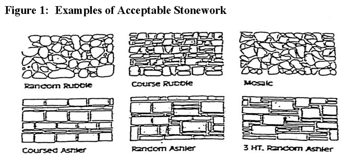
ii.
Cultured stone. Stone that has the appearance of natural stone may be used subject to approval by the building official or his designee.
iii.
Brick. Modular units of fired clay. Typical size four inches thick by two and two-thirds inches high by eight inches long (nominal dimensions).
iv.
Glass. Glass is used most commonly to glaze a building's window, sash, and skylight openings. Variations of glass commonly encountered are:
1.
Heat absorbing or tinted glass.
2.
Safety-laminated glass.
3.
Insulating glass which consists of layers separated by a sealed airspace.
b.
Category B materials:
i.
Fiber-cement planks and panels (common product name: Hardiplank).
A.
Patterns are typically:
I.
Lap siding.
II.
Shingle siding.
III.
Vertical siding.
ii.
Masonry-backed stucco. This finish system is typically a two-coat Portland cement material (total thickness five-eighths inch) applied directly to masonry or concrete surfaces that are rigid and structurally sound. A variety of textures are possible, from smooth, troweled finishes to floated, sandy or pebbled surfaces. A range of colors may be attained through the use of colored sand, stone chips, and pigment.
iii.
Exterior insulation finish system (EIFS). Exterior insulation finish systems are non-load bearing exterior wall cladding systems generally consisting of an insulation board, an adhesive and/or mechanical attachment of the insulation board to the substrate, glass fiber reinforcing mesh, a base coat on the face of the insulation board, and an aggregated polymer binder based finish coat. A variety of decorative trims and surface textures are available, as well as a large range of colors which are integrally mixed in the finish coat of this system.
iv.
Hollow metal doors and frames. Refers to doors and frames constructed of cold rolled steel which is field-painted. Sidelights, transoms, and windows may be constructed as well from hollow metal framing members. All hollow metal doors must be paneled and painted to blend.
c.
[Composition:] Buildings, including accessory buildings, shall incorporate categories of materials in the following manner:
i.
Category A materials shall compose 75 percent or more of the area of each wall. Category B materials may compose no more than 25 percent of the area of each wall. Gable areas shall be calculated in the total of the elevation. The brick and stone material shall not be painted or defaced in any manner.
ii.
Buildings must be comprised of at least three exterior materials from Categories A and B above, excluding hollow metal doors and frames.
iii.
Accent materials. Materials used to emphasize or create a design feature (other than awnings) must be chosen from either Category A or B materials. Accent materials shall not exceed 25 percent of the area of each wall.
iv.
Expansions of less than 50 percent of the floor area of the existing building may use the same or superior materials as the existing structure.
v.
Expansions and/or renovations involving 50 percent or more of the floor area of existing buildings must meet the requirements of this ordinance.
d.
[Roofing material.] Exposed roof materials shall be architectural asphalt shingle; however, standing seam or lap seam roofing may be used for accent areas of no more than ten percent. On accessory structures, a standing seam or lap seam roofing may comprise 100 percent. Architectural asphalt shingles for the purposes of this document shall mean a premium grade shingle with one or more of the following characteristics:
i.
Thickened butt edges.
ii.
Cutout and embossed patterns.
iii.
Color range.
iv.
All the features described above are intended to aid in giving the roof plane textural interest.
e.
Maintenance of materials. The owner shall be responsible for the maintenance of all required exterior architectural materials associated with newly erected or altered multifamily buildings. In addition, it shall be unlawful for said owner to change or alter the required exterior architectural standards as set forth under article 24, development regulations, without meeting the requirements of and complying with the zoning and development ordinance.
246.1.5.
Additional requirements for commercial and office zoning districts.
1.
Building materials. Exterior surface materials of buildings shall be divided into Category A materials and Category B materials, and application of materials shall be subject to the following:
a.
Category A materials.
i.
Natural stone. Types of stonework are based on the shape and the surface treatment, or finish of the stone. The term "ashlar" means only that the stone face showing on the finished surface has its sides squared. Fieldstone always has a rough, irregular appearance, as the natural surface or broken surface of the stone is exposed. Cut stone usually consists of large, thin slabs of stone with the face smooth, slightly textured or polished.
ii.
Brick. Modular units of fired clay. Typical size four inches thick by two and two-thirds inches high by eight inches long (nominal dimensions).
iii.
Split face (rough textured face) integrally colored concrete block. Refers to concrete masonry units which have been manufactured with a color additive yielding a uniform appearance.
iv.
Masonry-backed stucco. This finish system is typically a two-coat Portland cement material (total thickness five-eighths inch) applied directly to masonry or concrete surfaces that are rigid and structurally sound. Avariety of textures are possible, from smooth, troweled finishes to floated, sandy or pebbled surfaces. A range of colors may be attained through the use of colored sand, stone chips, and pigment.
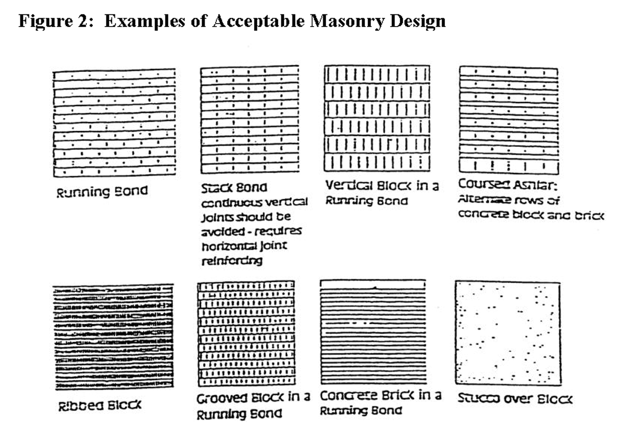
Figure 2: Examples of Acceptable Masonary Design
v.
Architecturally precast or tilt-up concrete panels. Panels typically are exactly eight feet wide; the height of each is determined by building eave height. These panels may be smooth or textured in exterior finish. Smooth panels are suitable for painting while the textured surface results from exposed aggregate or textured liners used to cast the concrete. Textured panels may be painted or sealed. Precast panels are typically delivered to the building site ready to be placed in a final wall assembly. Tilt-up panels are typically cast on-site using the floor slab as a casting surface.
vi.
Glass. Glass is used most commonly to glaze a building's window, sash, and skylight openings. Variations of glass commonly encountered are:
(A)
Heat-absorbing or tinted glass.
(B)
Safety-laminated glass.
(C)
Wired glass.
(D)
Insulating glass which consists of layers separated by a sealed airspace.
vii.
Glass storefront and window systems. Refers to the combination of aluminum entrance doors and window wall framing employing standard aluminum profiles. Factors to consider in determining finished appearance include:
(A)
Overall profile of aluminum members (face width and frame depth).
(B)
Material and color of frame.
(C)
Type and size of glass.
(D)
Composition of linear elements.

Figure 3: Examples of Typical Storefront System
viii.
Wood. Wood wall finishes typically refer to vertical board siding patterns, horizontal board siding patterns or shingle patterns. Siding may be painted or stained.
(A)
Vertical board patterns.
• Patterns are typically:
• Board and batten
• Tongue and groove
• Reverse board and batten
• Diagonal
(B)
Horizontal board patterns.
• Patterns are typically:
• Lap siding
• Shingle siding
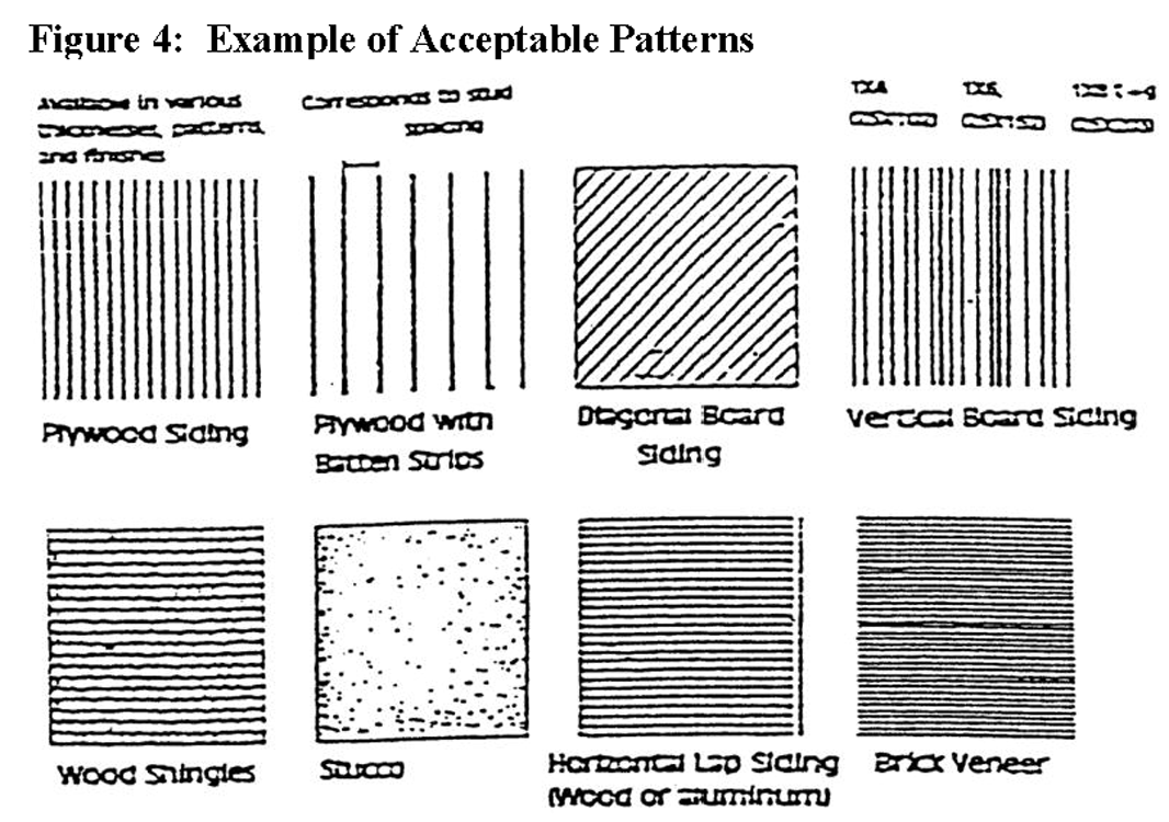
Figure 4: Example of Acceptable Patterns
ix.
Fiber-cement planks and panels (common product name: Hardiplank).
• Patterns are typically:
• Lap siding
• Shingle siding
• Vertical siding
b.
Category B materials.
i.
Ceramic. Refers to a glazed modular unit similar to brick or terra cotta tiles.
ii.
Glass block. Modular glass units either hollow or solid, which are used in wall construction for light transmission, insulation, solar heart, decoration and privacy. Glass block is available clear, primed for light diffusion, with or without glass fiber inserts, textured with various patterns, and with or without a ceramic glaze on one face.
iii.
Architectural metal panels. Refers to rolled metal wall panels typically of 24, 26, or 28 gage galvanized steel with additional galvanized steel with additional coats. In this case, it refers to a panel with a deeper rib than the typical one inch to one and one-half inch rib.
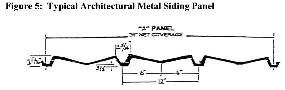
Figure 5: Typical Architectural Metal Siding Panel
iv.
Exterior insulation finish system (EIFS). Exterior insulation finish systems are non-load bearing exterior wall cladding systems generally consisting of an insulation board, an adhesive and/or mechanical attachment of the insulation board to the substrate, glass fiber reinforcing mesh, a base coat on the face of the insulation board, and an aggregated polymer binder based finish coat. A variety of decorative trims and surface textures are available, as well as a large range of colors which are integrally mixed in the finish coat of this system.
v.
Hollow metal doors and frames. Refers to doors and frames constructed of cold rolled steel which is field-painted. Sidelights, transoms, and windows may be constructed as well from hollow metal framing members.
vi.
Integrally colored concrete block. Refers to concrete masonry units which have been manufactured with a color additive yielding a uniform appearance. The block is available in a variety of surface textures as follows: (1) smooth, (2) scored (vertical groove at middle), (3) split rib (vertical ribbed face).
vii.
Plywood. 303-6 SW at minimum thickness of 19/32 inch or ⅝ inch.
(A)
Patterns available in Atlanta area are:
• Texture: One through 11; grooved at four inches, eight inches, and 12 inches.
• Reversed board and batten
• Rough-sawn surface treatments
viii.
Vinyl. Commercial grade having a minimum thickness of 0.044 inches.
c.
Buildings shall incorporate categories of materials in the following manner:
i.
Category A materials shall compose 67 percent or more of the area of each wall. Category B materials may compose no more than 33 percent of the area of each wall. Gable areas shall be calculated in the total of the elevation.
ii.
Buildings may be constructed primarily of one specific Category A material provided the design is of a recognizable architectural style, promotes creative design that is more than an aggregation of random elements, and provides at least 25 percent fenestration on sides that front streets.
iii.
Accent materials. Materials used to emphasize or create a design feature (other than awnings) must be chosen from either Category A or B materials. Accent materials shall not exceed 25 percent of the area of each wall.
iv.
All closing materials for architectural openings (i.e. windows, doors) must be of Category A or Category B material. Overhead door openings facing a street must be closed with architectural metal door systems. Door openings for carwashes, miniwarehouse facilities, auto service facilities and similar uses, determined by the planning director, are exempted from the architectural metal door systems.
v.
Expansions of less than 50 percent of the floor area of the existing building may use the same or superior materials as the existing structure.
vi.
Expansions and/or renovations involving 50 percent or more of the floor area of existing buildings must meet the requirements of this ordinance.
d.
Solid waste, recycling containers, or mechanical equipment that are part of the primary and accessory structure shall be screened and shall be constructed of the same materials used for the elevation of which the screen is a part. Solid waste, recycling, and mechanical equipment containment areas that are accessory structures shall be constructed of the material that is the primary exterior material used for the primary structure that it serves. See section 246.2, site design of the development regulations and article 25, buffer area and screening requirements of this ordinance for additional requirements regarding screening.
e.
Exposed roof materials shall be architectural asphalt shingle, wooden shingle, standing seam metal roof or lap seam metal roofing panel. Architectural asphalt shingles for the purposes of this document shall mean a premium grade shingle with one or more of the following characteristics:
i.
Thickened butt edges.
ii.
Cutout and embossed patterns.
iii.
Color range.
iv.
All the features described above are intended to aid in giving the roof plane textural interest.
f.
Attached awnings, either metal or fabric, shall be complimentary to the main wall. All trim and decorative bands shall be selected from Category A or B materials and shall be harmonious with walls although they are selected for accent.
g.
Maintenance of materials. The owner shall be responsible for the maintenance of all required exterior architectural materials associated with newly erected or altered commercial or office buildings. In addition, it shall be unlawful for said owner to change or alter the required exterior architectural standards as set forth under article 24, development regulations without meeting the requirements of and complying with the zoning and development ordinance.
2.
Building design.
a.
Roof. Structures less than 10,000 square feet shall have a minimum 5:12 roof slope. Structures greater than 10,000 square feet should have a pitched roof proportional to the building's size. Flat roofs and roofs with less than a 5:12 roof slope are prohibited unless screened with an appropriate parapet wall.
b.
Floor delineation. Delineation of building floors at the third story above sidewalk level and lower shall be executed through windows, belt courses, cornice lines or similar architectural detailing.
c.
Discontinuous building massing. Every building shall reduce its perceived height and bulk by dividing the building mass into smaller scale components. Building walls exceeding 100 continuous linear feet shall utilize offsets, such as projections, recesses, and changes in floor level, to add architectural interest and variety, and to relieve the negative visual effect of a simple long wall.
d.
Variation in building silhouettes. Variation in the roofline of buildings and offsets in pitched roofs and gables shall be required. Parapets in building masses exceeding 100 continuous linear feet shall be varied in height and projection and shall use decorative elements such as crown moldings, brick soldier courses, or similar detail.
e.
Building step backs. Buildings in excess of 50 feet in height shall be required to step back that portion of the building greater than 50 feet in height a minimum linear distance of ten feet away from the building.
f.
Pedestrian entrance. The primary pedestrian access to all sidewalk level uses and business establishments with public or private street frontage:
i.
Shall face and be visible from the public street when located adjacent to such street. When located adjacent to a street that functions as an arterial street or a collector street, said entrance shall face and be visible from such street.
ii.
Shall be directly accessible and visible from the sidewalk adjacent to such street.
iii.
Shall remain unlocked during business hours for nonresidential uses.
g.
Fenestration or other architectural features, such as arcades and display windows, shall be provided along the ground floor of the building facade for a minimum of 40 percent of the length of all primary street frontages. Arcades may only be used to satisfy 50 percent or less of this requirement.
h.
Fenestration shall not utilize painted glass. Entrances may be counted towards fenestration requirements.
i.
Four-sided architecture shall be required.
(Ord. No. 035-07, 10-16-07; Ord. No. 035-08, 11-18-08; Ord. No. 025-14, 7-15-14)
Sec. 246.2. - Site design.
246.2.1.
Purpose and intent. The purpose of this section is to establish minimum standards that encourage high quality in the site design, organization, and construction of new developments and subdivisions. These standards promote community interconnectivity and low impact design principles. The development of a positive, progressive and attractive community image and sense of place is vital to the economic health and vitality of Coweta County.
246.2.2.
General requirements.
1.
Screening. Screening of dumpsters, loading areas and mechanical systems.
a.
All dumpsters shall be enclosed with a wall of equal or greater height on three sides, the material of which shall be similar to the material on the outside of the main building served by said dumpster.
b.
Dumpsters shall be placed in the rear yard unless the development review committee determines that conditions of the site warrant placement elsewhere.
c.
Loading areas shall not face any public street. Properties that are both within an industrial park and outside of a quality development corridor district, as outlined in Section 261, shall be exempt from this requirement.
d.
Loading dock entrances for nonresidential uses shall be screened so that loading docks and related activity are not visible from the public right-of-way. Properties that are both within an industrial park and outside of a quality development corridor district, as outlined in section 261, shall be exempt from this requirement.
e.
All loading and dumping activities located within 150 feet of a single-family residential property, measured in a straight line from the nearest point of said activity to the nearest property line of the residential property, shall occur only between the hours of 7:00 a.m. and 10:00 p.m.
f.
Accessory mechanical systems and features including air and heating systems shall not be visible from the public right-of-way.
g.
All necessary utility boxes/ cabinets located above ground shall be screened from view from the street with plant material (existing or proposed minimum four-foot height at planting), and painted a neutral earth tone color such as beige, brown, or dark green.
246.2.3.
Additional requirements for single-family residential uses.
1.
For residential uses with the exception of all RC districts.
a.
Access shall be provided from the site of every use to a public street or system of common streets and ways connecting with the public street system.
b.
House lots shall generally be accessed from interior streets.
2.
Access.
a.
Every development and every lot within the development shall have frontage on a publicly dedicated street, except for those circumstances listed in this section and subsection 246.2.5 of the development regulations.
b.
Every development shall be designated and developed so that adequate street access is provided from the development's streets to a collector or higher roadway classification county thoroughfare. Access may be granted on a local street if adequate improvements are made to this street per the approval of the director of community development. To this end, every development with lots not fronting entirely on an already existing county street shall include at least one subdivision street which has direct access to a collector or higher roadway classification county thoroughfare. If a development contains 50 or more, but fewer than 250 lots not fronting on an already existing collector or higher roadway classification county thoroughfare, the design and development of said subdivision shall include at least two subdivision street outlets which have direct access to a collector or higher roadway classification county thoroughfare. If a development contains 250 or more lots, but fewer than 500 lots not fronting on an already existing collector or higher roadway classification county thoroughfare, the design and development of said subdivision shall include at least three subdivision street outlets which have access to a collector or higher roadway classification county thoroughfare. If a development contains 500 or more lots, not fronting on an already existing collector or higher roadway classification thoroughfare, the design and development of said subdivision shall include at least four subdivision street outlets which have direct access to a collector or higher roadway classification thoroughfare. Insufficient road frontage for two entrances on the same roadway, as determined by the county community development department or Georgia Department of Transportation will limit the number of potential lots to 99.
c.
New subdivision lots may not be platted with access through an existing subdivision if such new subdivision lots would exceed the limitations set forth above requiring a provision of additional access streets which have direct access to a higher-traffic-capacity county thoroughfare.
d.
If the existing subdivision street(s) does not meet current subdivision street standards, access shall be denied unless the developer improves the existing subdivision street(s) to meet current requirements including sufficient rights-of-way and construction standards.
e.
Any subdivision of property shall provide each lot with direct abutting frontage to an existing public street or to a public street contained within the proposed development. Exceptions may be authorized provided that the following are met:
i.
Standards for private ingress/egress/utility easements:
A.
For divisions of property defined as a subdivision in Section 241, at the initial design of the residential development, the developer is allowed one ingress/egress/utility easement constructed from a public street with no more than three lots allowed (notwithstanding the exceptions provided for in Section 73.4(3)(b) and Section 73.5(3)(b) related to the EL-A and EL-5 development types), provided the following additional requirements are met:
1.
The minimum width of the ingress/egress/utility easement shall be 30 feet, unless additional width is required by the Community Development Department based on topography and drainage concerns. The drive shall be a minimum of ten feet in width, surfaced with gravel or other paving material, and aligned so as to allow emergency vehicle access.
2.
Every property served by a private ingress/egress/utility easement under these provisions must be bound to a privately managed perpetual maintenance agreement that must be reviewed and approved by the county attorney prior to approval of the final plat.
3.
When subdivision development type, as regulated by Article 7, specifically allows for multiple easements, the connection points to right-of-way must meet Georgia Department of Transportation specifications for spacing of driveways from one another. If it is necessary to locate private ingress/egress/utility easements closer than GDOT prescribed spacing, the property owner/developer must design and dedicate improvements and additional public right-of-way to accommodate safe queuing, and to remove mail delivery and school buses from existing travel lanes. The improvements must meet Coweta County Public Works Department standards and will most often result in the construction/dedication of a cul-de-sac street.
4.
The clearing width of private/ingress/egress/utility easements must be maintained at 15 feet.
5.
Private ingress/egress/utility easements must be constructed to the appropriate width to support the weight of applicable fire department apparatus. This may include additional surface materials and geotechnical design for certain geographic features and must accommodate water transport vehicles when public water is not readily available. The finished product shall be proof-rolled with a loaded 17-ton tandem dump truck and be approved by the county development inspector prior to the issuance of a certificate of occupancy for the first house that the easement serves.
6.
Private ingress/egress/utility easement entrances must be paved 18 feet wide from the existing edge of roadway pavement to the right-of-way. The paving must meet the pavement design Section prescribed in Figure 7 of this ordinance. Subgrade shall be proof-rolled with a loaded 17-ton tandem dump truck and be approved by the county development inspector prior to asphalt pavement.
7.
No private ingress/egress/utility easement may cross a pond dam.
8.
Private ingress/egress/utility easements may not have grades that exceed seven percent unless an administrative variance is granted by the director of community development in accordance with Article 24, Section 240.6(2). Variances and waivers.
9.
All drainage conveyances shall be designed per Subsection 246.10.2(2).
f.
Any new connection to a public street shall meet minimum sight distance requirements as set forth by American Association of State Highway and Transportation Officials (AASHTO).
3.
Provisions and standards for permitting model homes prior to final plat approval.
a.
No more than three model home permits shall be issued for every 100 lots under construction for the development on a phase-by-phase basis. If the subdivision has less than 100 lots/units, then a total of three homes will be allowed.
b.
Model homes must be accessed by internal subdivision streets and may not have direct access to a pre-existing public road.
c.
Prior to issuance for a permit for a model home, the lot must be served by a street with the first layer of asphalt (binder) with such road built to current county standards.
d.
Any streets serving the model homes must have clear travel lanes maintained and not be obstructed with barriers, construction equipment, materials, parked vehicles, or other items that may impede safe and orderly travel.
e.
Prior to issuance for a permit for a model home, water service must be installed and pressurized to serve the model home and a fire hydrant must be located within the required distance for fire suppression as approved by the Coweta County Fire Marshal.
f.
The builder/developer shall indemnify the county for any loss or damages related to the model home lots until the final plat has been approved and recorded in a form that is approved by the county attorney.
g.
A model home must follow the normal process for submitting and attaining a building permit for single-family dwelling.
h.
A model home may not be used for business purposes other than that of a sales office solely for the development in which the model is located. The model home used as a sales office must meet the codes as a business occupancy and the ADA codes for accessibility.
i.
A certificate of completion shall not be issued until the lot upon which a model home park is located has been given final plat approval and the final plat has been recorded.
j.
Prior to the certificate of occupancy issuance for any model homes, all development, zoning, and building code requirements for the model home area must be completed.
246.2.4.
Additional requirements for multifamily residential uses.
1.
Access.
a.
Primary vehicle access to a multifamily development shall be from an arterial or major collector roadway, as identified on the Coweta County Functional Classification and Thoroughfare Map.
b.
Large multifamily developments shall have multiple primary access points and/or emergency vehicular access points from a public street as follows:
i.
Development with 200—350 dwelling units shall provide a second primary access into the development;
ii.
One additional primary access is required for each additional 150 dwelling units, or portion thereof, over 350 dwelling units; and
iii.
Additional access above that in this document may be required by the fire department.
c.
Drive entrances shall be installed with decorative brick pavers or decorative color stamped asphalt or concrete (stone or brick paver design). The minimum length of the decorative entrance section shall be 20 feet. Entrance design shall be approved by the appropriate department, i.e., the Georgia Department of Transportation for state highways or the County Engineering Department for county roadways. Brick pavers or stamped asphalt/concrete shall not be installed in acceleration or deceleration lane.
d.
For gated multifamily developments, the provisions contained in subsection 246.12.2(3) shall apply.
e.
A traffic management plan, prepared by a qualified professional engineer shall be submitted at the discretion of the county engineer, based on the size and intensity of the development, and traffic conditions. The traffic management plan must identify any traffic problems that will be generated by the development and present reasonable solutions to those problems. This plan must be submitted to the county engineer for approval.
2.
Pedestrian circulation.
a.
Pedestrian connections are required at the following:
i.
The primary entrance or entrances to each principal multifamily building;
ii.
To any sidewalks or walkways on adjacent properties that extend to the boundaries shared with the multifamily development;
iii.
Any sidewalk system along the perimeter streets adjacent to the multifamily development;
iv.
Any adjacent commercial land uses, including, but not limited to, retail shopping centers, office buildings, restaurants, or personal service establishments; and
v.
Any adjacent park, greenway, or other public or civic use, including, but not limited to, schools, places of worship, public recreational facilities, or government offices.
vi.
Additionally, the provisions of subsection 246.5.2(3)(d)(iv) shall apply to multifamily developments.
b.
Each point at which the on-site pedestrian walkway system must cross a parking lot or internal street or driveway to make a connection shall be clearly marked through the use of change in paving materials, height, or distinctive colors.
c.
If the project abuts any portion of a greenway as set forth in the adopted Greenway Master Plan, a direct linkage from the development, including recreational open space, to such existing or future greenway should be provided.
3.
Screening.
a.
All entry fixtures and other service equipment shall be located in side and rear yards and away from high use or high visibility areas. These fixtures shall be adequately screened with a masonry wall, wood privacy fencing, or plantings. All utilities shall be underground.
b.
Decorative fences and walls.
i.
All required opaque fences or walls shall be constructed of one or a combination of the following: Decorative wood, stone, stucco on block, decorative block, or brick. These fences or walls shall not exceed six feet in height.
ii.
Decorative wrought iron fencing may be used for architectural and security purposes only.
iii.
Chain link, unfinished concrete or cinder block, plastic or fiberglass, barbed or razor wire, and plywood fences, or like materials are prohibited. Paint shall not be considered a finish material.
c.
Architectural screens and enclosures are required for all meters, equipment, solid waste, recycling containers, or mechanical equipment within a complex. Solid waste, recycling, and mechanical equipment containment areas shall be constructed of the material that is the primary, opaque exterior material used for the primary structure that it serves. See section 246.2, site design, of the development regulations and article 25, buffer area and screening requirements of this ordinance for additional requirements regarding screening.
d.
No refuse containers or parking areas should be located within 60 feet of adjacent property zoned or used for single-family dwellings.
e.
Storage areas for boats and other recreational vehicles must be screened from view.
4.
Yards in group developments. More than one multifamily building may be located upon a lot in a zoning district where such a use would be permitted; but such buildings shall not encroach upon the front, side or rear yards required for the building site. For multifamily buildings the open space between the buildings shall not be less than 20 feet for one-story buildings, 30 feet when either building is a two-story building, 40 feet when either building is a three-story building, and 40 feet plus an additional ten feet for each story over three stories when either building is over three stories in height. The minimum dimension perpendicular to the building of the yard upon which any entrance or exit of a dwelling faces will be 20 feet. Except, however, that this section shall not apply to village centers (VC) district.
246.2.5.
Additional requirements for all uses except for single-family residential.
1.
Access.
a.
The subdivision of property shall provide each lot with direct abutting frontage to an existing public street or to a public street contained within the proposed development. The following exceptions shall be authorized:
i.
Private streets:
(A)
Private streets may be allowed within zoning districts containing office, institutional, industrial, or commercial zoning. Access shall be similar to and have the same function as a public street. Design of these streets shall be prepared in a manner to discourage through traffic, and shall have a 60-foot wide vehicular access easement. Dimensional requirements shall meet subsection 246.5.2, general requirements for parking and driveways of the development regulations. Lots being served by an access easement shall meet the minimum frontage requirements of the zoning and development ordinance. All new private roadways must be constructed to ensure the health, safety and general welfare of the general public and their ownership and maintenance responsibility by private party(ies) must be clearly established on the final plat of the development.
2.
Drive-through service windows and drive-in facilities shall not be located between a building and the street.
3.
Accessory service structures and associated vehicular services shall not be located between a building and the street, such as, but not limited to air pumps and car washes.
4.
Inter-parcel vehicle access points between all contiguous commercial, office, industrial or multifamily residential tracts shall be provided to facilitate movement between and among parcels adjoining arterial and collector streets, and thereby improve overall safety. However, when the natural grade along a common property line exceeds 15 percent throughout its length, such access shall be at the option of the property owners. Also, the planning director may waive the requirement if it is demonstrated that an inter-parcel connection is not feasible due to traffic safety or conflicting land uses.
5.
The finish grade surface of a retaining wall that has vertical drops on its opposite side of more than 30 inches below the grade shall have a suitable barrier, such as a fence or wall, of not less than four feet in height.
(Ord. No. 035-07, 10-16-07; Ord. No. 035-08, 11-18-08; Ord. No. 025-09, 8-18-09; Ord. No. 025-19, 6-18-19; Ord. No. 015-20, 3-3-20; Ord. No. 006-22, 3-8-22; Ord. No. 045-23, 11-16-23)
Sec. 246.3. - Lot/yard.
See appendix design standards for additional requirements regarding reverse frontage with protective screen easement.
246.3.1.
Purpose and intent. This section establishes standards for setback measurement and required yard areas. These provisions are intended to ensure open areas around primary structures maintain clear visibility for traffic safety and pedestrian access, buffer incompatible land uses, and establish natural and visual light and air space for privacy, landscaping, and recreation.
246.3.2.
General requirements.
1.
Front yards in commercial and multifamily districts. Lots with a lot area of less than 20,000 square feet shall be permitted to have automobile parking located within the front yard, provided the front yard parking area shall be limited in area to a maximum of 30 percent of the total lot area and all parking lot landscaping requirements shall be met.
2.
Insofar as practical, side lot lines shall be perpendicular or radial to street lines.
3.
To facilitate the enforcement of the provisions of the zoning and development ordinance, the size, shape, and orientation of every lot shall be subject to approval of the county planner for the type of development and use contemplated.
4.
Every lot shall conform to the minimum dimension and area requirements of the zoning and development ordinance, provided that every lot not served by a public sewer or community sewerage system and/or public water shall meet the dimension and area requirements of the environmental health department if they are greater than the minimum requirements of the zoning and development ordinance.
5.
Building setback lines shall not be less than the yard requirements of the zoning and development ordinance.
6.
No more than seven lots shall be platted so as to have their access from the "turn-around" circle of the cul-de-sac.
7.
Lot remnants (lots below minimum area or width left over after subdiving tracts of land) shall be prohibited. Such remnant areas shall be added to community-accessible open space or provided for future vehicular or pedestrian connectivity, rather than remain an unusable parcel.
8.
The subdividing of land adjacent to or surrounding an existing or proposed lake, shall be such that lots abutting that lake shall be drawn to the centerline of the lake. Such requirements may be waived upon submittal to the planning department of an acceptable substitute method that provides equal or greater protection for the maintenance of the lake and any recreational operations to be provided thereon. The portion of any lot within a 100-year floodplain or covered by water shall not be included within the lot area used for determining the minimum required "building site" of each lot as specified in the zoning and development ordinance.
9.
Reserved.
10.
Monuments. Permanent monuments shall be accurately set and established:
a.
Where plat boundary lines intersect with land lot lines.
b.
Permanent bench markers shall be placed at all land lot corners on the property being developed. These markers shall be concrete with brass marking. Placement (to be verified by visual inspection) shall extend no less than six inches above the finished grade.
c.
All corners shall be marked with an iron rebar or pin, at least one-half inch in diameter and 18 inches long driven so as to extend no less than one inch above finished grade.
d.
The accurate location, material, and size of all existing monuments shall be shown on the final plat, as well as the future location of monuments to be placed after street improvements have been completed.
246.3.3.
Additional requirements for single-family residential uses.
1.
Double-frontage and reverse-frontage lots shall be required for residential developments along arterial and collector streets where internal access can be provided. A no-access easement of at least ten feet in width, across which there shall be no right-of-access, shall be provided along the line of lots abutting such a traffic artery. When located along arterial or collector streets, the no-access easement shall be planted with a single line of shrubs or trees, or contain a solid or decorative fence, or contain such other landscaping treatments or grade changes which will produce a partial screening effect, as may be proposed by the developer and approved by the county planner.
2.
At the approval of the county director of development and engineering, properties shall be permitted to have a minimum frontage of 300 feet along arterial and collector streets to which they front. When extraordinary, exceptional, or peculiar conditions exist for a particular tract of land, an administrative action may be granted for driveway connections. In any case, drive connections shall be placed to meet the visibility requirements of the development regulations and/or provide the maximum sight distance available for the tract.
246.3.4.
Additional requirements for all uses except single-family residential. [Reserved.]
Sec. 246.4. - Open space.
246.4.1.
Purpose and intent.
1.
Open space, as described herein, is intended to preserve the desirable scenic, environmental, and aesthetic qualities of rural or natural landscapes in developing areas and to create new community-oriented spaces in areas of new development and in those places where there are no existing forms of spaces.
2.
It is the purpose and intent of this ordinance to insure preservation of open space within developments; create new community open spaces in areas where no existing community open spaces exist; provide flexibility to allow for creativity in developments; minimize the environmental and visual impacts of new development on critical natural resources and historically and culturally significant sites and structures; provide an interconnected network of permanent open space; encourage a more efficient form of development that consumes less open land and conforms to existing topography and natural features; reduce erosion and sedimentation by minimizing land disturbance and removal of vegetation; enhance the community character; permit clustering of houses and structures which will reduce the amount of infrastructure, including paved surfaces and utility lines; encourage street design that controls traffic speeds and creates street interconnectivity; and promote construction of convenient and accessible walking trails and bike paths to reduce reliance on automobiles.
246.4.2.
General requirements.
1.
Definition of open space: Open space is the portion of the development that has been set aside for permanent protection and on which activities are restricted in perpetuity through the use of an approved legal instrument. However, in the case of multifamily developments, any area meeting the open space definition in article 3 of this ordinance shall also be included. All open space shall be designated as either primary conservation areas or secondary conservation areas and shall be configured to create or maintain a network of open space.
a.
Primary conservation areas. Active recreation areas are prohibited in primary conservation areas unless approved by the county planning director. Primary conservation areas, as defined by this ordinance, include the following, unless the applicant demonstrates that this provision would constitute an unusual hardship and be counter to the purposes of this article:
i.
The 100-year floodplain;
ii.
Stream buffers as required by article 21, stream corridor protection district;
iii.
Slopes greater than 25 percent occurring over a contiguous area of 5,000 square feet or more;
iv.
Wetlands that meet the definition used by the Army Corps of Engineers pursuant to the Clean Water Act;
v.
Populations of endangered or threatened species, or habitat for such species; and
vi.
Archaeological sites, cemeteries and burial grounds.
b.
Secondary conservation areas.
i.
Undeveloped (unconstrained) but buildable land and protected (constrained) lands; and
ii.
Impervious surface setbacks defined by article 21, stream corridor protection district, except that lots with area of less than one acre shall exclude these areas.
2.
Uses of open space may include the following:
a.
Conservation of natural, archeological or historical resources;
b.
Meadows, woodlands, wetlands, wildlife corridors, game preserves, or similar conservation-oriented areas;
c.
Important historic sites;
d.
Existing healthy, native forests of at least one acre contiguous area;
e.
Other significant natural features and scenic viewsheds such as ridgelines, peaks and rock outcroppings, particularly those that can be seen from public roads;
f.
Walking or bicycle trails;
g.
Passive recreation areas, such as open fields;
h.
Active noncommercial recreation areas, provided that they are limited to no more than ten percent of the total open space and are not located within primary conservation areas. Active recreation areas may include impervious surfaces. Active recreation areas in excess of this limit must be located outside of the protected open space. (Less than one-half or five percent, not within 100 feet of abutting property and parking (gravel, unlighted, and less than ten spaces));
i.
Prime agricultural lands of at least five acres contiguous area as recommended by the American Farmland Trust (A.F.T);
j.
Agriculture, horticulture, silviculture or pasture uses/equestrian facilities, provided that all applicable best management practices are used to minimize environmental impacts, and such activities are not conducted within primary conservation areas; livestock facilities that cause routine offensive odors, dust, and insect problems are prohibited.
k.
Landscaped stormwater management facilities (such as, but not limited to water quality features), community wastewater disposal systems and individual wastewater disposal systems located on soils particularly suited to such uses, and water supply. Such facilities shall be located outside of primary conservation areas except where topography dictates; areas devoted to traditional detention/retention facilities shall be prohibited from counting towards the open space requirements.
l.
Easements for drainage, access, and underground utility line right-of-way;
m.
Other conservation-oriented uses compatible with the purposes of this ordinance;
n.
Parks or plazas;
o.
Lakes;
p.
Bridle paths, provided that adequate provisions are made to minimize conflict with and ensure safety of pedestrians;
q.
Environmentally sensitive areas, provided that the natural function of such areas is protected;
r.
Significant structures. Structures of historic, acrchitectural, or cultural significance existing prior to development may be retained, provided that the structure and proposed use are compatible with these regulations and nearby residential uses. Easements to enter or cross open space for the purpose of vehicular access to such uses may be permitted, subject to review and approval of planning department;
s.
Open space may also include planted areas; fountains; parks; plazas; trails and paths; the landscaped portions of streets; hardscape elements related to sidewalks, cluster mailbox stations, and plazas; and similar features.
t.
Aboveground utility rights-of-way and small areas of impervious surface may be included within the protected open space but cannot be counted towards the minimum area requirement (exception: historic structures and existing trails may be counted). Large areas of impervious surface shall be excluded from the open space.
3.
Prohibited uses of open space:
a.
Golf courses, except when certified under the Audubon International Signature Program Certification (bronze, silver or gold). Parking and driving ranges or miniature golf shall not be included;
b.
Roads, parking lots and impervious surfaces, except as specifically authorized in the previous sections;
c.
Alteration of views by removing trees or placing buildings or other structures on highly visible hilltops and ridges or blocking unique views by placing structures in inappropriate locations, except as approved by planning department that adverse aesthetic and economic impacts on the rest of the open space development and on the surrounding community are minimized. Particularly important views should be available from areas accessible to all residents of the open space development;
d.
Unsuitable open space that fails to preserve the desirable aesthetic, environmental, and cultural qualities of rural or natural landscapes, because a tract has insignificant levels of such qualities (for example, because the tract is too small or has undergone harvesting of timber) or such qualities would be significantly diminished by development;
e.
Other activities as determined by the applicant and recorded on the legal instrument providing for permanent protection.
4.
Implementation and maintenance.
a.
All open space including buffers, setbacks, sidewalk clear zones, sidewalk zones and open spaces shall be fully implemented prior to occupancy and if not completed, the occupancy permit shall not be issued.
b.
A property owner or homeowners association representing residents of the development shall own the open space. Membership in the association shall be mandatory and automatic for all homeowners of the subdivision and their successors. The homeowners' association shall have lien authority to ensure the collection of dues from all members. The responsibility for maintaining the open space and any facilities located thereon shall be borne by the property owner or homeowner's association.
c.
In the event the party responsible for maintenance of the open space fails to maintain all or any portion in reasonable order and condition, the county may assume responsibility for its maintenance and may enter the premises and take corrective action, including the provision of extended maintenance. The costs of such corrective action and/or maintenance may be charged to the property owner, homeowners' association, or to the individual property owners that make up the homeowners' association, and may include administrative costs and penalties. Such costs shall become a lien on all properties within the development.
5.
Legal provisions for the open space.
a.
Covenants, easements (including conservation easements), or other provisions legally sufficient, as noted below, shall be required:
i.
To permanently protect the open space from development other than as provided in these regulations;
ii.
To ensure the availability of the open space for common use by all residents of the development; and
iii.
To ensure that no damage to or use of the open space to the exclusion or detriment of other residents of the development is permitted.
b.
Open space shall be approved subject to the submission of a legal instrument, setting forth a plan for the permanent care and maintenance of such open space recreation areas and communally owned facilities. Such instrument shall be approved by the county attorney as to legal form and effect. This instrument shall be placed on the open space concurrent with the final plat approval.
c.
Covenants or other legal arrangements shall specify ownership of the open space; method of and responsibility for maintenance; taxes and insurance; compulsory membership and assessment provisions; and shall be incorporated into legal instruments sufficient to ensure that the open space criteria are maintained.
d.
Multifamily developments shall be exempt from these legal provisions for the open space, unless such development is classified as a condominium.
246.4.3.
Additional requirements for single-family residential uses.
1.
Design requirements.
a.
At least 75 percent of the open space shall be contiguous. The open space shall adjoin any other neighboring areas of open space, other protected areas, and nonprotected natural areas that would be candidates for inclusion as part of a future area of protected open space. Parcels that qualify toward the minimum open space requirements generally shall have a length to width ratio of 4:1 and a width of at least 50 feet. Exceptions will be made for entrances to trails and particular other uses as deemed appropriate by the planning department.
b.
The open space shall be directly accessible to the largest practicable number of lots within the development. Non-adjoining lots shall be provided with safe, convenient access to the open space.
c.
Access to open space. Access to open space shall meet the following requirements:
i.
Minimum width. Walkways or "fingers" of open space created to provide access from individual lots to a larger expanse of open space or to provide for connection of noncontiguous tracts of open space shall have a minimum width sufficient to accommodate a path or multi-use trail, given the existing terrain, the center of which path or multi-use trail is at least 25 feet from any property line. Said paths or multi-use trails shall be no more than 12 feet in width, and shall be constructed so as to minimize soil erosion or damage to trees or other natural features.
2.
Legal instrument requirements.
a.
Open space shall be protected in perpetuity from further development by a binding legal instrument that is recorded with the deed. If the common areas are to be controlled by an association of property owners, then membership in such association shall be mandatory for all property owners within the project.
b.
The instrument protecting the open space from further development shall be one of the following:
i.
A permanent conservation easement in favor of either:
(A)
A land trust or similar conservation-oriented, non-profit organization with legal authority to accept such easements. The organization shall be bona fide and in perpetual existence, and the conveyance instruments shall contain an appropriate provision for transfer in the event the organization becomes unable to carry out its functions; or
(B)
A governmental entity with an interest in pursuing goals compatible with the purposes of this zoning and development ordinance; if the entity accepting the easement is not the county, then a third right of enforcement favoring the county shall be included in the easement.
ii.
As set forth in O.C.G.A. § 44-5-60(c) as hereinafter may be amended, a permanent restrictive covenant for conservation purposes in favor of a governmental entity; or
iii.
An equivalent legal tool that provides permanent protection, if approved by the county.
c.
The instrument for permanent protection shall incorporate restrictions on the use of the open space including:
i.
Restrictions to permanently protect the open space from development other than is provided in these regulations;
ii.
Restrictions to ensure the availability of the open space for common use by all residents of the development; and
iii.
Restrictions to ensure that no damage to or use of the open space to the exclusion or detriment of other residents of the development; and
iv.
As well as any further restrictions, as approved by the Coweta County Board of Commissioners.
d.
Where common areas are controlled by an association of owners, the association covenants shall specify ownership of open space; method of and responsibility of maintenance; taxes and insurance; assessment provisions; and shall be incorporated into legal instruments sufficient to ensure that the open space criteria are maintained.
246.4.4.
Additional requirements for multifamily residential uses.
1.
Design requirements.
a.
Multifamily developments shall incorporate recreational amenities from the list below in the following amounts:
i.
Developments with less than 25 dwelling units: One amenity.
ii.
Developments with 25 to 150 dwelling units: Two amenities.
iii.
Developments with more than 150 dwelling units: Three amenities.
b.
Allowable recreational amenities are:
i.
Swimming pool;
ii.
Resident clubhouse;
iii.
Two tot lots with a minimum size of 500 square feet per lot;
iv.
Basketball, volleyball, or other sport court;
v.
Two picnic areas with a minimum of two picnic tables and one barbeque grill/pit per area; and
vi.
Other amenity, if approved by the planning director.
c.
No active recreational areas should be located within 60 feet of any adjacent property zoned or used for single-family dwellings.
246.4.5.
Additional requirements for all uses except for single-family residential.
1.
Required yards, sidewalks and buffers which are constructed on private property may be counted towards this requirement. Areas devoted to public or private vehicular access shall be prohibited from counting towards this requirement.
2.
Open space may also include balconies, roof-top terraces, front yards, planted areas, fountains, parks, plazas, trails and paths, the landscaped portions of streets, hardscape elements related to sidewalks and plazas, and similar features which are located on private property.
(Ord. No. 025-09, 8-18-09; Ord. No. 025-14, 7-15-14)
Sec. 246.5. - Parking and driveways.
See appendix design standards for additional requirements regarding parking configuration/placement.
246.5.1.
Purpose and intent. The purpose and intent of this section is to ensure the provision of off-street parking, loading, queuing and on-site circulation facilities in proportion to the demand created by each use. By requiring such facilities, it is the intent of this section to ensure the provision of functionally adequate, aesthetically pleasing and safe off-street parking, loading, queuing and circulation areas. It is the intent of this regulation to provide standards for the layout and maintenance of display or parking areas, and to provide space for the use of landscape beautification and natural plant growth for developments where off-street parking and open-lot sales, display and service areas are provided.
246.5.2.
General requirements.
1.
Off-street parking, loading, and landscaping.
a.
Applicability. The standards of this section shall apply to all new development or existing development that is modified.
i.
New buildings or a change of use. Off-street parking and loading facilities in accordance with the development regulations shall be provided for any new building constructed and for any new use established or any change in occupancy in an existing building.
ii.
Additions and enlargements with no change of use. Off-street parking and loading facilities in accordance with the development regulations shall be provided for any addition to or enlargement of an existing building, existing use or existing manner of operation that would result in additional parking and loading spaces being required. The additional parking and loading spaces shall be required only in proportionate amount to the extent of the addition, enlargement, or change, not for the entire building. Renovations or additions to vehicular use areas shall provide landscape improvements in accordance with this section. Existing vegetation shall be preserved and incorporated into the landscaping for the vehicular use area.
2.
Off-street parking and loading location and use requirements.
a.
Location of required parking. The intent of this ordinance is to regulate all required off-street parking, except for fee simple developments with common parking. All buildings, structures, and uses of land shall provide, on the same lot with the principal use, off-street parking and loading spaces in an amount sufficient to meet the needs caused by the uses of the land. The location of off-street parking spaces shall not interfere with normal traffic flow or with operation of queuing and backup areas. Loading areas shall not obstruct pedestrian pathways. Each parking space shall be accessible from a driveway and maneuvering and turning areas shall be provided so that no vehicle will be required to back into a public street.
b.
[Adjacent parking.] Adjacent parking lots serving nonresidential or mixed-use buildings shall provide for future interconnectivity. Future interconnectivity provisions for parking lots serving residential development is optional.
c.
Location on other property. If the required automobile parking spaces cannot be reasonably provided on the same lot on which the principal use is conducted, such spaces may be provided on adjacent or nearby property within a similar zoning district, provided a major portion lies within 1,200 feet of the main entrance to the principal use for which such parking is provided per the approval of the county planning department.
d.
Use of required off-street parking areas. Off-street parking spaces shall be provided for the use of residents, customers, patrons, and employees. Required parking spaces shall specifically not be used for the storage, sale or display of goods or materials or for the sale, repair, or servicing of vehicles. All vehicles parked within off-street parking areas shall be registered and operable. Delivery vehicles shall utilize loading areas and not required parking spaces.
i.
Required off-street parking and loading spaces associated with newly erected or altered buildings or newly established uses of land shall be a continuing obligation of the owner of said building or land so long as the structure or use exists or its use requiring vehicle parking or loading facilities continues. In addition, it shall be unlawful for: 1) said owner to discontinue, change or dispense with, or to cause the discontinuance, or change of the required vehicle parking or loading spaces (apart from the discontinuance, sale or transfer of the building or use) without establishing alternative vehicle parking or loading spaces which meet the requirements of and are in compliance with this ordinance, or 2) any person to use a building or lot without providing vehicle parking or loading spaces which meet the requirements of and are in compliance with this ordinance.
ii.
The minimum required dimensions for regular parking spaces, handicapped parking spaces, loading spaces and access/circulation drives are set forth in subsection 246.5.2, item 2 of the development regulations, off-street parking area design and construction standards.
iii.
The maximum number of off-street parking and loading spaces shall be calculated based on the schedule of standards in Table 1 of the development regulations, maximum off-street parking and loading standards. However, in an effort to reduce the amount of impervious area on developed sites, the actual number of parking and loading spaces constructed shall be determined by the owners' engineer. In any event the minimum number of parking spaces provided shall be no less than 50 percent of the maximum number as identified in Table 1. The minimum number of required handicapped parking spaces is presented in Table 2.
iv.
Reduced, shared, or off-site parking for single-family residential districts shall be prohibited. For all other districts, the applicant may request a reduction of parking standards based on the following criteria:
(A)
Reduction of parking requirements through a shared parking arrangement may be permissible only through the permission of the planning department provided the arrangement shall avoid conflicting parking demands and provide for safe pedestrian circulation and access.
(B)
A to-scale map indicating location of proposed parking spaces shall be provided.
(C)
A shared or off-site parking calculation projection shall be provided that demonstrates that each use will have adequate parking provisions at all times.
(D)
For contiguous properties sharing parking spaces under this provision, cross-easements shall be filed establishing access to the parking spaces in perpetuity.
(E)
A reduction in the number of parking spaces that would otherwise be required for each of the various uses on a multiple-use property must be clearly shown on the development plan. If shared or off-site parking is proposed for a combination of contiguous properties, a plan must be submitted covering all of the properties that will be sharing the parking spaces.
(F)
A written agreement among all owners of record shall be provided and held on file with the planning director.
v.
For any use not listed in Table 1, the standards for the most similar use shall be applied. The county engineer shall determine the proper required number of spaces by classifying the use among the uses specified. In making a determination, any evidence of actual parking and loading demands shall be considered as well as other reliable traffic engineering and planning information that is available to ensure sufficient parking and loading spaces are provided to meet the needs caused by the uses of the land. If the number of parking and loading spaces are less than the maximum number calculated in Table 1, the owner shall reserve area on the site which will provide for the installation of additional spaces up to the maximum number. The reserve area shall be accessible from the driveway serving the constructed parking area. In the interim, the reserved parking site shall remain a grassed landscaped area. Based on accident reports, traffic studies, and other information related to the development, the county engineer may require the owner to install additional parking spaces to ensure public safety. If it is deemed by the county engineer that adequate parking has not been provided to serve the particular land use, additional parking shall be installed no later than 90 days from the date of official notice from the county engineer. Enforcement procedures shall be as provided in the Coweta County Zoning and Development Ordinance and the Coweta County Code of Ordinances. The cost for the installation of additional parking and/or associated traffic studies, required by the county engineer, shall be borne by the owner.
vi.
Stormwater quality and quantity requirements of the stormwater management ordinance shall be satisfied for all parking areas. Additional parking spaces, which exceed the maximum number calculated in Table 1, shall be constructed to allow the infiltration of stormwater by utilizing a permeable typical section with a pervious surface course. The pervious typical section and surface shall be designed in accordance with Section 3.3.8 of the Georgia Stormwater Management Manual. Striping and/or curbing may be excluded in the overflow parking area upon review and approval by the county engineer. The type of pervious material, conditions of the property, and the type of land use shall be considered in the decision to exclude the striping and/or curbing.
vii.
The maximum designated parking areas, constructed parking areas, and overflow parking areas, if applicable, shall be denoted on the approved predevelopment site plan and the approved final "as-built" as shown in Figure 6.
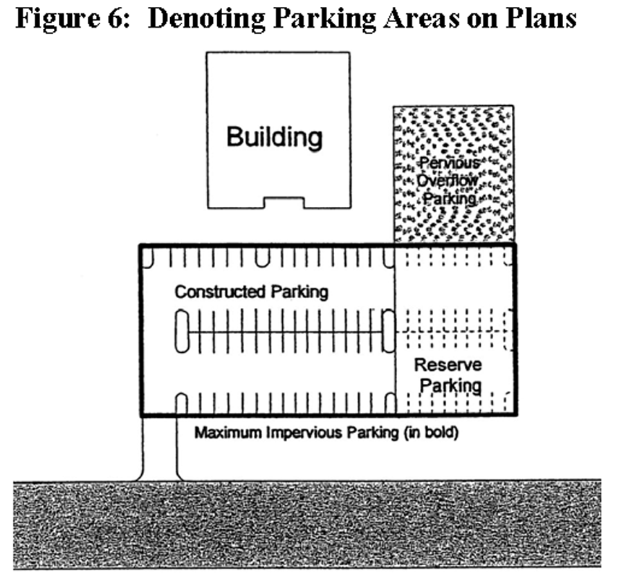
Figure 6: Denoting Parking Areas on Plans
viii.
Off street parking and loading spaces shall be provided in accordance with the following schedule of standards in Table 1, Table 2, and Table 3.
Table 1: Maximum Off-street Parking and Loading Standards
sf = square feet
N/A = Not Applicable
GFA = Gross (total) floor area in square footage of a building footprint
GLFA = Gross leasable floor area
Loading space ratio. The letter shown in the loading column of the schedule shall correspond to the following ratios:
a.
Standard "A": 1 space for the first 5,000 sf of floor area + 1 space for each additional 30,000 sf of floor area.
b.
Standard "B": 1 space for the first 10,000 sf of GFA + 1 space for each additional 15,000 sf of floor area.
c.
Standard "C": 1 space for the first 10,000 sf of GFA + 1 space for each additional 100,000 sf of floor area.
d.
Standard "D": 1 space per 50 beds for all facilities containing 20 or more beds.
The number of handicapped spaces required may be included within the overall total number of parking spaces required based on the maximum calculation in Table 1 and, if applicable, the number above the maximum spaces required. The maximum number of handicapped spaces shall comply with the following table.
Table 2: Handicapped Accessible Spaces Required
*Note—Per Table 1.
Note—Designated "van" accessible spaces are not required if all accessible spaces comply with "universal parking design".
Table 3: Summary of Parking Design Requirements
*Note—Shall meet access aisle requirements.
3.
Off-street parking area design and construction standards.
a.
Parking facilities shall be designed and located on the site in a manner that results in minimal visual impact along the street. Location, landscaping, earthwork, and buffering should all be implemented as necessary to reduce the negative visual impacts of parking facilities on the aesthetic quality of the street.
b.
There shall be safe, adequate, and convenient arrangement of pedestrian pathways, bikeways, roads, driveways, and off-street parking and loading spaces within parking areas. Streets, pedestrian walks, parking areas, and open space shall be designed as integral parts of an overall design which shall be properly related to existing and proposed buildings, adjacent uses, and landscaped areas.
c.
Parking facilities shall be maintained in a clean, safe, sanitary and attractive condition. Parking spaces and driving lanes shall be clearly defined and maintained as such. Parking lots shall not be operated when any damage impairs the drivability of the parking lot.
d.
All off-street parking, loading or open-lot sales areas established pursuant to this section shall be designed, constructed and continuously maintained in accordance with the following standards:
i.
Access. Adequate ingress and egress to such areas for vehicles shall be provided by means of clearly limited and defined paved drives. Each parking space shall have appropriate access to a street or an alley. Only dwelling units with no more than two units shall be allowed backward egress from a driveway onto a local street. In all other cases, maneuvering and access aisle area shall be sufficient to permit vehicles to enter and leave the vehicular use area in a forward motion.
ii.
Stacking. Adequate off-street stacking lanes or queuing areas shall be provided for vehicles entering the vehicular use area so as to avoid backup and congestion on adjacent public streets. A minimum queuing distance of 20 feet is required between the property line and the first parking space.
iii.
Parking access aisles. Adequate aisle width in vehicular use areas shall be provided for vehicle bypass and maneuvering areas to ensure efficient on-site circulation. See Table 3 for minimum requirements regarding aisle widths.
iv.
Pedestrian circulation. Structures, vehicular circulation lanes, parking spaces, driveways, and open spaces shall be designed to provide logical, impediment-free pedestrian movement. The site shall be arranged so that pedestrians moving between buildings are not unnecessarily exposed to vehicular traffic. Where off-street parking spaces directly face a structure, and are not separated from the structure by an access aisle, a paved pedestrian walkway shall be provided between the front of the structure and the parking spaces. The walkway shall be a minimum of four feet in width, exclusive of vehicle overhang, and shall be separated from the parking space by concrete wheel-stops or continuous curbing. If the pedestrian walkway adjacent to parking spaces is six feet, six inches wide with continuous curbing, then wheel-stops shall not be required. There shall be a pedestrian walkway a minimum width of four feet connecting ground level parking to the public sidewalks and to all building entrances. This provision shall not apply to residential vehicular use areas.
(A)
Surface parking lots shall include a pedestrian circulation system that provides access from the parking area to the building entrance, major bus stops or other critical access points. The circulation system shall be adequately lit and appropriately signed and marked. Shrub material taller than two feet in height is not recommended along pedestrian walkways within surface parking lots.
v.
Drainage of vehicular use areas. Areas used for display or parking shall be drained so as to eliminate surface water, unless the area or some portion of it is approved as a retention area by the director of development and engineering. Drainage is encouraged in infiltration swales located in the landscaped islands. See section 246.10, stormwater and drainage of the development regulations. The drainage design shall be reviewed and approved by the county engineer prior to the issuance of a permit.
vi.
Paving standards. All parking lots, accessways, storage lots, loading or open lot sales shall be paved and constructed of a minimum of four inches of concrete or two inches of asphaltic concrete on six inches of graded aggregate base (gab), or a base and surface material of equivalent durability as certified by the developer's engineer. Such paved areas shall be maintained in good condition by the owner to prevent any hazards, such as cracked asphalt or potholes. Responsibility for pavement failure occurring as a result of inadequate alternative base and surface material design shall fall on the certifying engineer. The following are exceptions to the above paving standards:
(A)
Storage lots serving facilities within an industrial or light industrial zoning district may be constructed of six inches of graded aggregate at a minimum provided the following requirements are met:
•
The storage area is set back a minimum of 100 feet from a public right-of-way excluding interstate highway rights-of-way.
•
Clearly limited and defined vehicular drives for ingress and egress to the storage area are provided; drive widths shall not exceed 30 feet.
•
A vegetated buffer 20 feet in width and consisting of evergreen plants is installed along the perimeter of the storage lot. The vegetative buffer shall create a visual screen that is 75 percent or more opaque and reaches a height of six feet within two years.
•
Water and other dust control measures shall be applied during the installation of graded aggregate.
(B)
Drives serving unmanned facilities may be constructed of six inches of graded aggregate provided the required drive, from the edge of the public roadway for a distance of 100 feet, meets the paving standards of this section.
vii.
Standard parking space dimensions and marking. Each required regular parking space shall measure a minimum of nine feet by 18 feet for perpendicular or angle parking, and a minimum of nine feet by 22 feet for parallel parking. Each parking space shall be delineated with white, street-marking paint with stripes four inches wide on each side for the required length of the parking or loading space.
viii.
Compact parking spaces. Developments where 30 or more parking spaces are provided may utilize compact parking spaces. No more than ten percent of the total parking provided may be compact spaces.
ix.
All parking space dimensions and markings shall be designed to conform to the geometric design standards of the Institute of Transportation Engineers (ITE).
x.
Handicapped parking space standards. Handicapped-accessible parking spaces shall meet the following requirements:
Table 4: Handicapped Parking Requirements
xi.
Loading space dimensions. Each required loading space shall measure a minimum of ten feet in width and 30 feet in length, with a 14-foot overhead clearance, except that loading spaces to be utilized by wholesale and industrial operations shall be a minimum of 50 feet in length.
xii.
Landscaping and curbing. Landscaped areas shall be provided and maintained around the perimeter and within the area used for parking, loading or open-lot sales as set forth hereinafter; concrete curbs of a design approved by the director of development and engineering shall be installed around the perimeter of all landscaped areas. Wheel-stops or continuous curbing shall be placed two and one-half feet back from walls, poles, structures, pedestrian walkways or landscaped areas.
xiii.
Lighting. If a vehicular use area is to be open for use after dark, it shall be lighted. Lighting shall be arranged and designed so that no source of light is directed toward any adjoining or nearby land used or classified for residential use. Lighting shall be designed to shield public streets and all other adjacent lands from direct or distracting glare, or hazardous interference of any kind.
(A)
Parking lot lighting shall be provided throughout after dark parking facilities to equal a minimum of one-fifth footcandle of light. A footcandle of light is a uniformly distributed flux of one lumen on a surface of one square foot in area. Where applicable, public street lighting may be utilized to either partially or totally fulfill the lighting requirements; however, where such street lighting is removed, it shall be the responsibility of the parking facility to independently provide these required levels of illumination.
(B)
Parking lots adjacent to residential buffer areas shall reduce light spillage onto residential properties by providing cutoff luminaires which have a maximum 90 degree illumination.
(C)
Parking deck lighting fixtures at a maximum of seven feet above grade shall not be visible from any public right-of-way.
xiv.
Signs. Traffic control signs and other pavement markings shall be installed and maintained as necessary to ensure safe and efficient traffic operation of all vehicular use areas.
xv.
Parking decks and structures. The following regulations shall apply to all parking decks and parking structures:
(A)
Parking deck facades shall conceal automobiles from visibility from any public right-of-way or private drive or street that are open to the general public, and shall have the appearance of a horizontal storied building.
(B)
All parking decks and parking structures shall have pedestrian walkways a minimum width of four feet connecting ground level parking to the public sidewalks and to all building entrances.
(C)
All parking decks and parking structures shall have a landscape strip a minimum width of six feet immediately contiguous to the parking facility for the whole of the exterior perimeter of the parking facility containing at least one understory or overstory tree, as appropriate, and additional shrubs, groundcover, or sod as specified in the landscape installation requirements of this section.
xvi.
Plan approval required. Plans for the layout and design of all areas to be used for parking, loading or open-lot sales must be approved by the planning department for compliance with the development regulations.
4.
Plan submission and required landscaping features for vehicular use areas.
a.
The areas used for the display or parking of any and all types of vehicles, boats or heavy construction equipment, whether such vehicles, boats or equipment are self-propelled or not, and all land upon which vehicles traverse the property as a function of the primary use, hereinafter referred to as "other vehicular uses," including, but not limited to, activities of a drive-in nature such as, but not limited to, filling stations, grocery and dairy stores, banks, restaurants, and the like, shall conform to the minimum landscaping requirements hereinafter provided, save and except areas used for parking or other vehicular uses under, on or within buildings, and parking areas serving single- and two-family uses as normally such residential areas are voluntarily landscaped. Additionally, the landscaping and screening requirements contained in article 26, section 261, of this ordinance shall also apply to multifamily developments.
b.
The applicant shall submit to the planning department six predevelopment site plans depicting the layout and design of the proposed off-street parking, loading and/or open-lot sale area, hereinafter identified as the "vehicular use area." Said plan depicting the layout and design of the proposed vehicular use area shall provide the information required for a predevelopment site plan as set forth in section 243.2, predevelopment site plans of the development regulations.
c.
All vehicular use areas shall comply with the following landscaping requirements:
i.
Perimeter landscape requirements. All exterior perimeters of all vehicular use areas shall have a perimeter landscaped area with no horizontal dimension less than five feet. A decorative masonry wall, earth berm, natural landscaping screen, new plantings, or some combination of these elements shall be installed in such a manner as to partially screen the vehicular use area from adjacent properties. Such screening shall be maintained at a minimum height of three feet. When abutting a public street right-of-way, landscaping areas shall have a minimum dimension of ten feet from the right-of-way line to the vehicular use area. In addition, the requirements for corner visibility article 6, section 66, of the zoning and development ordinance must be met.
ii.
Mandatory terminal island design. Each row of parking spaces shall be terminated by landscaped islands contoured as indicated in the diagram below. A terminal island shall be no less than nine feet in width and no less than 15 feet in length and shall include at least one tree having a clear trunk of at least five feet, with the remaining area adequately landscaped with shrubs, ground cover or other authorized landscaping material not to exceed three feet in height.
iii.
Mandatory interior island design. Interior landscaped islands shall be provided within each row of parking spaces and contoured as indicated in the diagram below. A minimum of one interior island shall be provided for every 15 parking spaces or fraction thereof. Landscaped interior islands shall measure not less than nine feet in width. The length of the interior islands shall be no less than the minimum required depth of parking space.
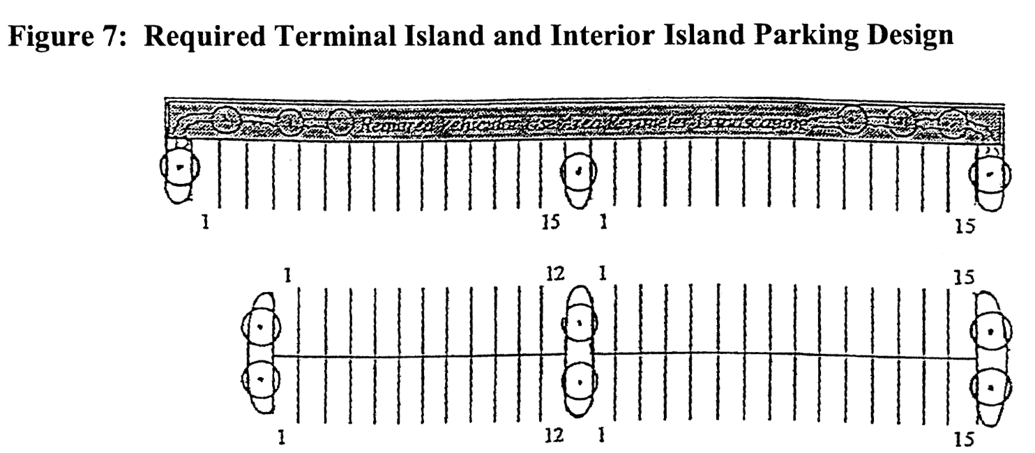
Figure 7: Required Terminal Island and Interior Island Parking Design
* Minimum one tree per landscape island as indicated.
iv.
The perimeter of terminal islands and interior islands shall be surrounded with a continuous, raised curb. Exemptions include those landscaped islands intended for stormwater retention/detention. See section 246.10, stormwater and drainage of the development regulations, for additional requirements regarding stormwater management. Landscape island width shall be measured from the inside edge of the curb. Trees planted in vehicular use areas shall be allowed to grow to a mature height and a full canopy. Pruning shall be limited to periodic trimmings to maintain the health of the trees or shrubs.
v.
Landscape installation requirements. All landscaping shall be installed in accordance with accepted good planting procedures.
(A)
New plant materials. All new living plant materials shall satisfy the requirements of number (1) or better as defined in the most current edition of Grades and Standards for Nursery Plants.
• All separate landscaped areas shall have a minimum variety of two living plant materials.
• Paving (other than walks) and artificial plants shall not be permitted within landscaping areas.
• Trees. A tree shall attain an average crown spread over 15 feet at maturity. Trees having an average crown spread less than 15 feet may be substituted by grouping the same so as to create the equivalent of a 15-foot crown spread. All trees shall be of a species which can be maintained with a minimum of five feet of trunk height. Trees shall have a minimum of two inches DBH (diameter at breast height) measured four and one-half feet above the ground and shall be a minimum of eight feet in overall height immediately after planting.
• Shrubs. Shrubs shall be a minimum of one foot in height when measured at the time of planting except where they are to act as screening for residential use or districts, in which case, they shall be a minimum of three feet in height at the time of planting and maintained at a minimum height of five feet at maturity, unless otherwise indicated in this section.
• Lawn grass and ground covers. Grass may be sodded, plugged, sprigged, or seeded except that solid sod shall be used in swales or other areas subject to erosion. In areas where plant material other than solid sod or grass is used, a fast-growing grass seed shall be sown for immediate effect and protection until coverage is otherwise achieved. Grass sod shall be clean and reasonably free of weeds and noxious pests or disease. Ground covers which present a finished appearance and reasonably complete coverage at time of planting may be used in lieu of grass sod.
(B)
Existing plant material. Desirable existing natural plant material shall be preserved to the extent feasible.
(C)
Earthwork. Earth berms may be utilized within a buffer or perimeter landscaping area. Berms shall be of variable height and slope with required landscaping material installed on top and slopes stabilized with ground cover. Swales and ponds shall be permitted for on-site retention of stormwater provided they are approved by the county engineer.
(D)
Encroachment. Landscaped areas, walls, structures, and walks shall require appropriate protection from vehicular encroachment by utilizing wheel-stops, curbs, posts, wood, brickwork, and/or other devices. Placement of these devices shall be located at least two and one-half feet from walks, walls, and structures and may be placed one foot from landscaped areas to prevent a vehicular overhang of no more than one and one-half feet of landscaping area which may be counted as part of the required depth of each parking space.
(E)
Maintenance. The owner or his agent shall be responsible for the maintenance of all landscaping which shall be maintained in good condition so as to present a healthy, neat, and orderly appearance and shall be kept free from refuse and debris. All landscaped areas shall be provided with a sprinkler system, and/or other readily available water supply with at least one faucet equipped with a double check valve located within 150 feet of all plant material to be maintained. The owner shall replace all landscaped materials required if, for any reason, they die or are severely damaged within one year of the final approval of the installation. The owner is thereafter responsible to maintain the landscaping in a healthy manner.
(F)
Planting bed. The planting bed for all landscaping materials shall be free of weeds, debris, and noxious material and shall consist of a healthy plant growth medium. The planting bed soil shall provide adequate support, drainage, and nutrients for the plants and thus may require the incorporation of sand, peat, and/or topsoil into the soil. Such planting soil shall be placed throughout the planting hole for each plant, and this hole shall be at least twice as wide as the width of the plant ball and one and one-half times as deep as the depth of the plant ball.
d.
Certificate of compliance. Upon completion of the landscape improvements, the site shall be inspected by the planning department for compliance with the approved landscape plan. A certificate of compliance must be issued before a certificate of occupancy can be issued for any related structures. When occupancy of a related building is desired prior to completion of the required landscaping, a temporary certificate of occupancy may be issued if a financial guarantee in the amount equal to 100 percent of the cost for landscaping improvements is provided and acceptable in form to the county attorney, provided that all attorney's fees are paid by the applicant.
5.
Driveways and curb cuts.
a.
Driveways. Adequate interior driveways shall connect each parking space with a public right-of-way. All interior driveways (serving 90-degree, angle, and parallel parking) shall be a minimum of 24 feet in width if designed for two-way traffic and 16 feet in width if designed for one-way traffic. The following types of drives or lanes may be a minimum width of nine feet upon approval by the planning director: bank drive-thru window, pedestrian pick-up/drop off, car washing queuing lane, ingress/egress drives serving mini-warehouses or other unmanned utility facilities (public or private), communication towers, and any similar use. All drives and lanes shall be measured from the inside of the drive curbing, if applicable, and free of any obstructions.
b.
All sidewalk paving materials shall be continued across any intervening driveway at the same prevailing grade and cross slope as on the adjacent sidewalk clear zone. A corresponding interior sign or painted bar on the driveway shall be provided adjacent to the sidewalk paving as it intersects the driveway which shall communicate that vehicles must stop or yield for the intervening sidewalk.
c.
Driveway curb cut widths shall be a minimum of 30 feet for two-way entrances and 16 feet for one-way entrances, unless otherwise permitted by the Coweta or Georgia Department of Transportation. For the purposes of this section, two curb cuts serving two one-way driveways shall only be counted as one curb cut provided that each curb cut does not exceed one lane in width.
d.
Driveway curb cuts shall not be permitted on any street that functions as an arterial street or collector street when access may be provided from a side or rear street located immediately adjacent to a contiguous property, with the exception of hotel patron drop-off drives. This may be exempt where pedestrian and vehicular safety will both benefit, per approval of the county director of development and engineering.
e.
Driveways, except for a driveway to reach the side yard or rear yard or an on-site parking facility, are not permitted between the sidewalk and a building, and shall be perpendicular to any adjacent street. This may be exempt where pedestrian and vehicular safety will both benefit, per approval of the county director of development and engineering.
f.
No more than one curb cut shall be permitted for each development, provided that properties with more than one street frontage may have one curb cut located on each street frontage. However, developments on properties with a single street frontage greater than 400 feet shall be permitted two curb cuts along one street frontage. This may be exempt where pedestrian and vehicular safety will both benefit, per approval of the county director of development and engineering.
g.
A common or joint driveway may be authorized by the development and engineering department if said driveway can be shown to not cause unsafe conditions.
h.
Access lanes and additional curb cuts (other than the primary access drive) shall be located to the side or rear of the property.
i.
Lot arrangements and street systems shall be designed so as to preclude, or reduce to the minimum, the need for driveway cuts from any lot to a public street other than to a minor (or local) subdivision street, as provided in subsection 246.3.4, item 1, double-frontage and reverse-frontage lots, of the development regulations.
j.
When a lot has multiple frontages, the driveway cut(s) shall be located on the street with the lowest functional classification.
i.
The sharing of curb cuts by lots shall be utilized to the maximum extent possible to reduce the number of curb cuts and allowed where reciprocal easement is recorded.
ii.
Driveways shall generally intersect streets at right angles, and the portion of a driveway located within a public right-of-way shall be paved, and maintained by the owner.
iii.
All other driveway curb cuts on public streets shall conform to standards established by the development and engineering department.
k.
Vehicle access control.
i.
It is the purpose and intent of this section to promote safe and efficient traffic movement while affording reasonable access to abutting land.
ii.
In addition, any such driveway or accessway intersecting an arterial or collector street may require deceleration lanes and/or left turn lanes, which are a minimum of 12 feet in width for their required length. The minimum length for deceleration lanes shall be 150 feet in length with a 50-foot taper on arterial streets (with a typical design speed of 55 miles per hour), and 100 feet in length with a 50-foot taper on collector streets (with a typical design speed of 45 miles per hour), except grade, distance from an intersection, design, speed or other factors may be modified with approval of the engineering and development director or the county engineer may determine that no deceleration lanes are required.
246.5.3.
Additional requirements for single-family residential uses.
1.
Driveways and curb cuts.
a.
Driveways serving single-family residences shall be not less than ten feet wide and no more than 12 feet wide at the right-of-way line and shall provide a radius to the back of the curb or edge of pavement of the roadway of no less than five feet and no more than eight feet.
246.5.4.
Additional requirements for all uses except for single-family residential.
1.
Bicycle parking for institutional and multitenant shopping developments and other developments within one mile of the multi-use trails as illustrated on the Coweta County Greenway Master Plan. Developments within the C-MU zoning district or within one-fourth mile of a public park, library, school, or existing multi-use trail shall provide bicycle parking racks at a ratio of at least one bicycle parking space for every 50 automobile parking spaces. No development within these areas shall have fewer than three bicycle parking spaces nor be required to exceed a maximum of 30 spaces. Bicycle parking spaces shall be located within the landscape zone a maximum distance of 100 feet of the building entrance, or shall be located at least as close as the closest automobile space and shall provide a concrete pad upon which the bicycle parking space shall be firmly rooted. Additionally, amenity centers within a subdivision development shall be required to meet these bicycle parking standards. The planning director, or his designee, may require that bicycle parking racks be located to the side of the building and/or screened with landscaping where appropriate.
2.
Driveways and curb cuts.
a.
Driveways serving duplex residences shall be not less than ten feet wide and no more than 12 feet wide at the right-of-way line and shall provide a radius to the back of the curb or edge of pavement of the roadway of no less than five feet and no more than eight feet.
b.
Driveways and accessways for multifamily, office, commercial, and industrial developments are prohibited from accessing single-family residential streets unless approved by the board of commissioners.
c.
Vehicle access control.
i.
Accessways serving two-family residences shall be not less than ten feet wide and no more than 20 feet wide at the street right-of-way line and shall provide a radius to the back of curb or edge of pavement of the roadway of no less than five feet.
ii.
All other driveways or accessways (for multifamily, office, commercial, or industrial uses) shall be located not less than 20 feet from the points of tangency of the curve connecting roadways at roadway intersections and no less than ten feet from the property line to the point of tangency. In addition, such driveways or accessways shall not exceed 30 feet in width measured at the street right-of-way line or front property line, and said maximum width of 30 feet shall be maintained for a distance of at least ten feet, to a line parallel to, and ten feet from, the street right-of-way line or front property line. Such driveways or accessways are prohibited from accessing single-family residential streets unless approved by the board of commissioners.
(Ord. No. 035-07, 10-16-07; Ord. No. 035-08, 11-18-08; Ord. No. 025-09, 8-18-09; Ord. No. 036-12, 11-6-12)
Sec. 246.6. - Streets.
See appendix design standards, for additional requirements regarding street intersections; typical cul-de-sacs for residential streets; cul-de-sac, single access loop street, and hammerhead termination; street designations; crosswalks; street with curb and gutter; street without curb and gutter; nonresidential major arterial section; nonresidential minor arterial section; two-lane collector street section; four-lane collector street section; minor collector and local and minor street section; typical utility placement section and plan; and typical cul-de-sac utility placement.
246.6.1.
Purpose and intent. It is the purpose of this section to establish minimum standards for public and private transportation facilities for vehicles, public transit, pedestrians, and bicycles, hereinafter constructed or improved as a condition of county approval of a development, or a transportation project constructed by the county. These standards are intended to preserve the community's quality of life and to minimize total costs over the life of the transportation facility.
246.6.2.
General requirements. All existing streets, public or private, shall be delineated and classified on the Coweta County Functional Classification and Thoroughfare Plan Map as adopted and updated from time to time by the board of commissioners. All street classification references within the ordinance shall be deemed pursuant to this map.
1.
All streets, public or private, shall be of one of the streets delineated in Table 5: Street regulations. Where provided streets shall be built at the specified dimensions and standards identified in table 5: street regulations and in the development regulations.
Table 5: Street Regulations
Note: If no curb present, all dimensions from edge of roadway pavement.
A All required sidewalks are to be located on both sides of the street, except in the RC district, where sidewalks may be located on one side of the street. This placement is also acceptable in instances where unique site constraints warrant, per approval of the county planning director.
B This may be exempt in RC districts at the discretion of the development and engineering department.
c This may be exempt if the minimum lot width at front setback line is 135 feet or greater, per approval of the county planning director.
D Left turn lanes shall be required if they are deemed necessary based on sight distance and volume of traffic generated by a particular land use, as determined by the county planner and the director of development and engineering.
2.
Streets design.
a.
Automobile traffic shall be prohibited on pedestrian ways.
b.
No new street may be extended through an existing, platted subdivision lot.
c.
Requirement for design by professional. Roadway design, including bicycle lanes (on-road) and trails (off-road), shall be by a Georgia-licensed professional engineer.
d.
The arrangement, character, extent, width, grade and location of all streets shall conform to the thoroughfare plan for Coweta County and shall be considered in their relation to existing and planned streets, to topographical conditions, to public convenience and safety, and in their appropriate relation to the proposed uses of the land to be served by such streets.
e.
Where such is not shown in the thoroughfare plan for the county, the arrangement of streets in a development shall either:
i.
Provide for the continuation or appropriate projection of existing streets in surrounding areas at the same or greater width, but in no case less then the required minimum width, or
ii.
Conform to a plan for a development approved or adopted by the county to meet a particular situation where topographical or other conditions make continuance or conformance to existing streets impractical.
f.
Minor or local streets shall be so laid out to create a calming effect on traffic and discourage through traffic, while maintaining an even distribution of traffic.
g.
Reserved.
h.
Where a development contains a dead-end street other than a cul-de-sac, the director of development and engineering or the county planner may require the developer to provide a permanent vehicular turnaround, when it is considered necessary for effective traffic circulation.
i.
Where a development abuts or contains an existing or proposed major or secondary thoroughfare, the planning department may require parallel collector or local streets, double-frontage lots with screen planting contained in a non-access reservation along the rear property lines, deep lots with rear service drives, or such other treatment as may be necessary for adequate protection of residential properties and to afford separation of through and local traffic.
j.
Where a development borders on or contains a railroad right-of-way, or limited access highway right-of-way, the planning department shall require a street approximately parallel to and on each side of such intervening land. Distances shall be determined with due regard for the requirements of approach grades and future grade separations as determined by the state department of transportation.
k.
Street right-of-way widths shall be dedicated based on the classification of the street in the thoroughfare plan for Coweta County, and shall be not less than as follows and as required by Table 5, street regulations.
i.
Cul-de-sac turnaround diameter:
(A)
Residential: 106 feet.
(B)
Commercial and industrial: 120 feet.
l.
Street paving widths, including curb and gutter, shall be based on the classification of the street and shall not be less than follows and as required by Table 5, street regulations.
i.
Cul-de-sac turnaround diameter:
(A)
Residential: 96 feet.
(B)
Commercial and industrial: 100 feet.
m.
Required deceleration lanes shall be built to State Department of Transportation design standards.
n.
Required left turn lane shall be located in front of the entrance of the development. Length of turn lane shall be as determined by traffic analysis.
o.
Where a development abuts an existing street, the developer shall dedicate or reserve additional right-of-way on said existing streets to meet the current county standard from the appropriate side of the centerline.
p.
The American Association of State Highway and Transportation Officials (AASHTO) book, A Policy on Geometric Design of Highway and Streets, (latest edition) is the standard reference to be used in the design of road grades, curvature and sight distance. Otherwise, use the criteria set forth in the following sections:
i.
Grades shall be:
(A)
Major and secondary arterials: Six percent maximum.
(B)
Collector streets: Eight percent maximum.
(C)
Local and minor streets: 12 percent maximum.
(D)
No street grade shall be less than two percent.
ii.
Alignment.
(A)
Minimum vertical. In residential subdivisions vertical curve lengths shall adhere to AASHTO standards and be based on the roadway design speed. No vertical curve shall be less than 200 feet. All roads shall have a crown on one-fourth inch per foot except where superelevation prevails.
(B)
In approaches to intersections, there shall be a suitable leveling of the street at a grade not exceeding a four percent algebraic difference in grade for a distance of not less than 50 feet, exclusive of any portion of a vertical curve, for local and minor streets, and 100 feet, exclusive of any portion of a vertical curve, for collector or major streets, from the nearest line of the intersection street.
(C)
Minimum horizontal radii of centerline curvature:
• Major and secondary arterials: 1,260 feet
• Collector streets: 500 feet
• Local and minor streets: 200 feet (and minimum 200 feet length)
• Cul-de-sac and loop streets: 100 feet
(D)
Tangents. Between reverse curves there shall be not less than the following minimum tangents:
• Major and secondary arterials: as specified by the State Department of Transportation.
• Otherwise: 200 feet
• Collector streets: 100 feet
• Local and minor streets: 50 feet
(E)
Visibility requirements:
• Minimum vertical midblock visibility (measured between two points with one at three and one-half feet and the other at two feet above pavement level) shall be:
• Major and secondary arterials: as specified by state department of transportation.
• Otherwise: 500 feet
• Collector streets: 300 feet
• Local and minor streets: 200 feet
• Minimum horizontal midblock visibility measured on centerline shall be:
• Major and secondary arterials: as specified by State Department of Transportation.
• Otherwise: 500 feet
• Collector streets: 300 feet
• Local and minor streets: 200 feet
• At the intersection where traffic is to be controlled by stop signs on the minor road, said minor road shall be designed to intersect the major road in accordance with the standards imposed by the State Department of Transportation, where applicable; and where not applicable the minor road shall intersect at such location as will provide minimum sight distance in either direction along the major road as required by AASHTO Intersection Sight Distance Recommendations.
q.
Street intersections.
i.
Intersections shall be as nearly at right angles as possible, and no intersection shall be at an angle less than 80 degrees. Detailed designs of intersections may be required.
ii.
Curb line radius at street intersections shall be a minimum of 25 feet and where the angle of street intersection is less than 90 degrees, the development and engineering department may require a greater radius. Where turning ability is clearly demonstrated, curb line radius at street intersections may be a minimum of 15 feet, per approval of the county director of development and engineering.
iii.
Right-of-way radius at street intersection shall parallel the curb line radius.
r.
Street jogs with centerline offsets of less than 125 feet shall not be permitted.
s.
A cul-de-sac or single-access loop street shall be measured from a street, which has at least two outlets onto another public street, which is not a cul-de-sac or single-access loop street. A cul-de-sac shall be measured from its intersection with a street as described above to the center of its diameter. A single-access loop street shall be measured from its intersection with a street as described above to the furthermost point from such intersection. No "off-set" turn-around circle shall be allowed on a cul-de-sac that is scheduled to be extended at a later date.
t.
Alleys or service drives may be required on any lot to be used for multiple-family, commercial, or industrial developments, but shall not be provided in single-family residential blocks except where the developer produces evidence satisfactory to the planning department of the need for alleys or service drives.
u.
Half-streets along property lines shall be prohibited.
v.
Reserve strips controlling access to streets, alleys, or public grounds shall not be permitted unless control is definitely placed in the county under conditions acceptable to the planning department.
3.
Blocks.
a.
The lengths, widths, and shapes of blocks shall be determined with due regard to:
i.
Provisions for adequate building sites suitable to the special needs of the type of use contemplated.
ii.
Zoning requirements as to the lot size and dimensions unless a community unit plan is contemplated.
iii.
Need for convenient access, circulation, control, and safety of street traffic.
iv.
Limitations and opportunities of topography.
b.
Maximum block length without an intersecting street shall be 600 feet. Developments with more than 600 feet of frontage along a single street shall be divided by streets into blocks having a maximum length of 600 feet, as measured from street curb to street curb. This may be exempt where topographic constraints warrant, per approval of the county planning director.
c.
In blocks of 600 feet in length, the county planner may, when existing or proposed public gathering places so justify, require walkways across the block.
d.
Streets, sidewalks and/or multi-use trails used to divide properties into blocks shall meet all of the design requirements of this zoning and development ordinance.
4.
Street grading.
a.
All street rights-of-way shall be cleared and graded to the standards of Coweta County. These standards, and other standards of the county referred to in these regulations are on file in the offices of the development and engineering department, the water and sewer department, the environmental health department, the Natural Resource Conservation Service (NRCS), and the planning department. Selected elements of these standards are presented in the appendix design standards of the zoning and development ordinance.
5.
Street paving.
a.
Roadways, constructed in each development or used as a required development entrance, shall be paved according to the standards adopted by Coweta County in place at the time the development is built.
b.
Street paving widths shall be in conformance with standards set forth in Table 5, street regulations.
6.
Curbs and gutters.
a.
Curbs and gutters shall be installed on all new streets in accordance with standards adopted by Coweta County.
b.
Curb and gutters shall be six inches by 24 inches with a six-inch high back.
c.
Curb and gutter may be exempt from residential development wherein all lots are at least two acres, at the discretion of the community development director.
7.
Roadway construction specifications.
a.
Testing. Any testing and reports or tests shall be the responsibility and at the expense of the developer. All test results shall be submitted to the county engineer for review and/or approval.
b.
Soil density test. Soil density tests shall be made on the sub-base by an independent testing lab experienced in such work. Prior to the placement of any base material, tests on each street shall consist of laboratory or in-place field tests conducted on all fills. The number of tests and depths to which testing shall be performed will be determined by the county engineer. Sub-base compaction shall be 98 percent of the maximum dry density and all other fills shall be 95 [percent] of the maximum dry density.
i.
The subgrade of the roadways shall be proof rolled prior to the placement of any base material. This test shall be scheduled through the engineer's office and observed by the engineer or his representative.
c.
Base material and asphaltic concrete:
i.
Base material. The base material shall be placed and proof rolled prior to the placement of any asphalt. Core samples shall be taken of the base material at an interval of 300 feet. These cores shall be taken at the quarter points of the roadway and alternate between travel lanes. Cul-de-sacs shall be tested in a triangular pattern halfway from the radius point to the edge of pavement or as directed by the engineer. Any unacceptable deficiencies shall be isolated and corrected.
ii.
Asphaltic concrete. The mix of asphaltic concrete shall be approved by the engineer with verification of the mix furnished by the contractor.
8.
Crosswalks.
a.
General. Crosswalk placement and design shall be in accordance with the MUTCD. To help ensure the use of marked crosswalks in heavy pedestrian concentration areas, special consideration shall be given to their location relative to construction or proximity of sidewalks, paths, guardrails, retaining walls, or shrubbery as a means for controlling existing pedestrian crossing movements within a defined path. See appendix design standards of the zoning and development ordinance for additional information regarding typical crosswalks.
b.
Standards for crosswalks:
i.
Minimum configuration at signalized intersections. Marked ladder-style crosswalks on all roadways of the intersection configured in accordance with typical crosswalk in appendix design standards of the zoning and development ordinance. ADA compliant curb cuts at the end point of all crosswalks, pedestrian WALK/DON'T WALK signals at intersection.
ii.
Minimum configuration at stop sign intersections. Marked ladder-style crosswalks on all roadways of the intersection configured in accordance with typical crosswalk in appendix design standards of the zoning and development ordinance. ADA compliant curb cuts at the end point of all crosswalks, crosswalk signs placed on the through roadway. Possible enhancements: raised pavement markers placed an appropriate distance in front of the crosswalk on the through roadway; flashing lights on crosswalk signs.
iii.
Minimum configuration at mid-block locations. Marked crosswalk in accordance with typical crosswalk in appendix design standards of the zoning and development ordinance, ADA compliant curb cuts at the end points of crosswalk, advanced crossing warning signs, raised pavement markers placed an appropriate distance in front of the crosswalk, restrict parking on roadway to ensure visibility.
iv.
Minor streets and local streets shall be exempt from the requirements of subsection 246.6.2(8)(a)—(b).
c.
Signage. A crossing sign (W11-2 in the MUTCD) shall be installed immediately adjacent to each mid-block marked pedestrian location. The crossing sign may be enhanced with a diagonal downward pointing arrow plaque (W16-7P in the MUTCD) in areas where a high degree of activity and distraction may require enhanced signage. An additional crossing sign may be installed in advance of a series of marked crosswalks or may be installed in advance of each crosswalk location within a heavy pedestrian concentrations area. The need for advance crossing signs shall be based on comments received by the county development and engineering department considering the relative spacing of crosswalks, roadside development and other factors. Except that minor streets and local streets shall be exempt from subsection 246.6.2(8)(c).
d.
Possible enhancements. Overhead crosswalk signs, flashing lights on crosswalk signs, pedestrian refuge island, stop sign and stop bar painted upstream from crosswalk, light guard system of strobe lights.
e.
Minimum configuration at parking lot and service drive locations. Marked ladder-style crosswalk in accordance with typical crosswalk in appendix design standards of the zoning and development ordinance and ADA compliant curb cuts at the end points of crosswalk.
f.
The engineer conducting the crosswalk study shall consider pedestrian and vehicular volume, the number of traffic lanes the crosswalk will cross, visibility, lighting and other safety factors in order to make recommendations for the use of possible crosswalk enhancements.
9.
Bicycle lanes.
a.
Design guide for bicycle facilities. Bicycle lanes and paths should be designed in accordance with the latest edition of the "Guide for the Development of Bicycle Facilities" published by the American Association of State Highway Officials (AASHTO).
b.
Provision requirement. All new road construction, or major reconstruction of existing roads, may accommodate bicycle traffic through the provision of on-road bicycle lanes as described in Table 5, street regulations.
c.
Connection requirement. New bicycle lanes and paths shall connect to existing bicycle lanes and paths.
d.
Bicycle lane construction. On-road bicycle lane construction shall not differ in construction (i.e. type of materials used, level of compaction, or cross-sectional thickness of materials) from adjacent vehicle traffic lanes. Bicycle lanes shall be designed and constructed in accordance with the "Guide for the Development of Bicycle Facilities" published by the American Association of State Highway Officials (AASHTO).
e.
Bicycle lane markings. Pavement marking dimensions and placement shall be consistent with Part 9, MUTCD and include lane edge lines, a bike symbol (rather than the optional word "Bike"), the word "Lane", and a directional arrow. "No Parking" signs (R8-3a in the MUTCD) shall be installed as a subplate to the bicycle lane sign (R3-17 in the MUTCD). The dotted line lane edge marking as indicated in the MUTCD shall be used for all bus stops and locations with heavy right turn motor vehicle volumes.
f.
Curb inlets, storm drains, and other potential hazards. Where hazards to bicyclists cannot be eliminated, the typical obstruction pavement marking is required to make the hazard more visible as depicted in Figure 9C-7 of the MUTCD.
10.
Traffic control devices.
a.
A design review meeting shall be required with the development and engineering department prior to final traffic control device design.
b.
Design guide for traffic control devices. As required by Title 23 of the Code of Federal Regulations, Part 655.603, all traffic control devices including signs, signals, markings and other devices used to regulate, warn or guide traffic placed on, over, or adjacent to a street, highway, pedestrian facility, or bikeway shall be designed and installed in accordance with the latest edition of the "Manual on Uniform Traffic Control Devices (MUTCD)," U.S. Department of Transportation.
11.
Utility placement.
a.
See appendix design standards for additional requirements regarding typical utility placement section and plan and typical cul-de-sac utility placement.
b.
Where above-ground utility service lines exist on a parcel proposed for development or redevelopment, the relocation of such utility service lines underground is strongly encouraged.
c.
Utility placement specifications. Utility placement along streets with curb and gutter shall meet the following location requirements within the right-of-way or easement recorded on the approved final plat:
i.
Cable TV: Locate 4 feet behind the back of curb at a depth of 2 feet.
ii.
Waterlines and water meters: Locate 10 feet behind the back of curb at a depth of 4 feet.
iii.
Telephone: Locate 12 feet behind the back of curb at a depth of 2 feet.
iv.
Gas: Locate 10 feet behind the back of curb at a depth of 3 feet.
v.
Power: Locate 15 feet behind the back of the curb at a depth of 4 feet.
vi.
Sewer: Locate along the centerline of the street a minimum depth of 5 feet.
vii.
In subdivisions without curb and gutter, all dimensions will be from the edge of pavement and approved alternates may be proposed for staff approval where stormwater channels are to be avoided.
viii.
Associated surface mounted or surface access utility shall not be located within the sidewalk nor create conflict with each nor create disruption with stormwater flows and maintenance activities. Field adjustments within the easement for electrical transformers, fire hydrants and water meters/valves may be necessary.
246.6.3.
Additional requirements for single-family residential uses. Residential blocks shall be wide enough to provide two tiers of lots, except where adjacent to arterial or collector streets, or prevented by topographical conditions or size of the property, in which case the county planner may require and/or approve a single tier of lots of minimum depth.
246.6.4.
Additional requirements for all uses except single-family residential. [Reserved.]
(Ord. No. 035-08, 11-18-08; Ord. No. 037-12, 11-6-12; Ord. No. 005-17, 3-7-17; Ord. No. 015-20, 3-3-20; Ord. No. 007-23, 3-7-23)
Sec. 246.7. - Streetscape elements.
See appendix, design standards for additional requirements regarding curb ramp at street intersection and street tree planting in landscape zone plan and section.
Sec. 246.7.1.
Purpose and intent.
1.
The purpose of these regulations is to maintain the county's quality and character by enhancing its visual appearance through the requirements of a landscape zone and sidewalk clear zone to accomplish the following:
a.
Enhance pedestrian circulation and create open space opportunities.
b.
Create a vibrant pedestrian environment in the street right-of-way that attracts pedestrians.
c.
Strengthen connections between residential enclaves and other County amenities by improving the streetscape for pedestrians, bicycles and transit patrons.
d.
Support economic activity in subdivisions by creating an attractive and welcoming "front door" for pedestrians.
246.7.2.
General requirements.
1.
In addition to the requirements below, the county may provide developers with adopted typical streetscape designs for designated areas. Such design may include additional materials, details and specifications regarding street trees, streetlights, litter containers, benches and similar sidewalk-related items. Conformity with the county greenway master plan is also required where applicable. In addition, properties with required landscape or sidewalk clear zones which are located on private property shall provide a permanent easement arrangement with the county to ensure public access to said zones.
2.
Sidewalks.
a.
Sidewalks shall be defined as consisting of two zones: a landscape zone and a sidewalk clear zone. Said sidewalk shall meet the requirements of Table 5, street regulations.
b.
If there is insufficient space for a landscape zone and/or a sidewalk clear zone within the street right-of-way, then said zones shall be placed in or extend into a seven-foot sidewalk easement located immediately adjacent to the street right-of-way.
c.
Separate sidewalks shall be provided with all new road construction, or major reconstruction. Sidewalks in RC district may be located on one side of the street. This placement is also acceptable in instances where unique site constraints warrant, per approval of the county planning director. Sidewalks shall not be mandatory on publicly funded roadway projects. Developments with a minimum lot width greater than 135 feet at the front setback line shall be exempt from the sidewalk requirement.
d.
If the street under construction or reconstruction is within one-half of a mile from the following, then a sidewalk must be provided, regardless of street classification/designation or lot width:
i.
County park or recreation facility;
ii.
Public school.
e.
If the street under construction or reconstruction is within 500 feet of an existing commercial area, then a sidewalk must be provided, regardless of street classification/designation.
f.
If there exists a multi-use trail within 100 feet of the development, then sidewalk connectivity must be provided to the closest possible point adjacent to the existing multi-use trail.
g.
If a multi-use trail for public use is located in the designated area for the sidewalk, the sidewalk requirement may be exempt if the development provides connecting sidewalks to said multi-use trail.
h.
In the C-MU zoning district, sidewalks, a minimum of ten feet in width, shall be provided between the front landscape strip and the proposed building.
i.
Sidewalks disturbed by development. Any development that disturbs existing county-funded sidewalks including the sidewalk clear zone and landscape zone shall be replaced by the property owner to its pre-disturbance state and condition.
3.
Landscape zone requirements.
a.
Said zone shall be located immediately adjacent to the curb and shall be continuous. Said zone shall meet the requirements of Table 5, street regulations.
b.
This zone may be used for street lights, benches, planters, trash receptacles, bicycle parking racks and other street furniture, pedestrian lights, landscaping, sod, or drainage facilities. Additional pavement or other similar elements shall be permitted only as approved by the county planning department.
c.
A landscape zone, at minimum width shown in Table 5, street regulations, shall be provided within which drainage swales may be contained.
d.
A sidewalk or multi-use trail not less than four feet and not more than 12 feet in width shall be provided adjacent to the landscape zone substantially parallel to the street.
e.
Street trees and other shrubbery that may be retained or planted shall be placed or retained so as not to obstruct sight distance at street intersections.
4.
Sidewalk clear zone requirements.
a.
Said zone shall be located immediately contiguous to the landscape zone and shall be continuous. Said zone shall meet the requirements of Table 5, street regulations.
b.
Said zone shall be hardscape, and shall be unobstructed for a minimum height of eight feet. Special paving within the sidewalk clear zone shall be permitted only as approved by the county planning department.
c.
Where newly constructed sidewalks abut narrower existing adjacent sidewalks, the newly constructed sidewalk shall provide an adequate transitional clear zone width for the purposes of providing a safe facilitation of pedestrian traffic flow between the adjacent sidewalks, as approved by the county planning department.
d.
Sidewalk clear zone construction shall meet the following requirements:
i.
Construction shall be four inches thick and 3,000 pound mix concrete.
ii.
Compactions shall be a minimum of 95 percent.
iii.
Width of sidewalk clear zone shall be minimum four feet. See Table 5, street regulations, of the development regulations.
iv.
All sidewalks and curb ramps at intersections shall meet the current rules and regulations established by the Americans with Disabilities Act.
5.
Reserved.
6.
Exterior and street lighting.
a.
Exterior and/or street lighting shall be designed and located to minimize spillage onto adjoining properties and the public right-of-way.
b.
Exterior and/or street lighting shall provide shielding to direct lighting downward (90-degree angle or less).
c.
Exterior and/or street lighting shall be kept to a minimum to preserve the night sky and to reduce glare, and the illumination source shall not be visible from the public right-of-way.
d.
Neon lighting shall be prohibited in all residential districts.
246.7.3.
Additional requirements for single-family residential.
1.
Streetlights.
a.
Street lights shall be installed at the option of the developer. All street light installation shall be in accordance with standards and requirements specified by the development and engineering department.
i.
All petitions and procedures may be obtained at the Coweta County Planning Department.
ii.
Establishing a streetlight district. Residents of an existing development may petition the county to have their community established as a streetlight district. Each phase of the development shall be handled by a separate application and as a different project. As a streetlight district, the county will handle the billing for the monthly light bill. Each lot will be assessed an annual fee that will be attached to their property tax bill. The fee is presently $48.00 for each lot per year. This fee is subject to change due to inflation or price hikes established by the utility company. The board of commissioners will periodically adjust the fee schedule accordingly.
iii.
If residents of an existing development desire to petition the board of commissioners to accept their phase of development as a Coweta County Streetlight District, the following must be met:
(A)
At least 80 percent of the project lots are developed and each dwelling unit has been issued a certificate of occupancy.
(B)
The applicant must submit signed petitions from at least 80 percent of the residents in the community. Each residence shall be counted as one vote. Affirmative approval from the lot owner shall also be indicated on each petition.
(C)
The required fees are paid according to the Coweta County Streetlight District Procedures. The application fee for a streetlight district is $75.00, plus $5.00 per lot.
(D)
A letter from the utility company is submitted indicating that the installation for the streetlights and poles have been paid for and the number of lights the county will receive billing on.
(E)
Three copies of the approved final plat for the development phase shall be submitted.
iv.
Removal of a streetlight district. Residents of an existing development may petition the board of commissioners to remove their phase of development as a Coweta County Streetlight District. The following must be met:
(A)
The applicant must submit signed petitions from at least 80 percent of the residents in the community. Each residence shall be counted as one vote. Affirmative approval from the lot owner shall also be indicated on each petition.
(B)
Removal application fee of $75.00, plus $5.00 per lot.
(C)
Applications submitted prior to June 1, must be accompanied with the current years prorated fees at a rate of $4.00 per lot, per month to ensure removal of annual fees from the upcoming year's tax bill. Applications received after June 1 will require reimbursement of the annual fee, subsequent to the board of commissioners dissolving the streetlight district.
2.
Coweta County Streetlight District Procedures.
a.
The object of the Coweta County Street Lighting Program is to illuminate the streets of participating developments in accordance with standards of the American National Standard Practice for Roadway Lighting, 1973. It is not the objective of this program to illuminate private property.
b.
The Coweta County Street Lighting Program will be administered by the county planning department.
c.
There are two power companies servicing Coweta County: Georgia Power Company and Coweta Fayette EMC. Their rates may vary slightly. Georgia Power and Coweta Fayette EMC installs the high pressure "sodium" (14,500 lumen); both companies will utilize existing poles as much as possible. Spacing between lights will vary from 250 feet to 500 feet, or approximately every other utility pole. The cost of the poles, lights, and installation will be worked out between the residents and the utility companies. Verification of the installation charges paid by the community will have to be submitted by letter from the utility company to the planning department.
d.
Property owners within a streetlight district will be billed annually on their county tax bill for the previous year's use of lights. Cost for street lighting will be $48.00 per year, per lot, or $4.00 per month.
e.
The following is a schedule of payments that an applicant must pay initially if the streetlight district is received after January 1, for the first year:
January, per lot .....$48.00
February, per lot .....$44.00
March, per lot .....$40.00
April, per lot .....$36.00
May, per lot .....$32.00
June, per lot .....$28.00
July, per lot .....$24.00
August, per lot .....$20.00
September, per lot .....$16.00
October, per lot .....$12.00
November, per lot .....$8.00
December, per lot .....$4.00
f.
If there are less than 100 percent contributories, the applicant will have to bear the cost of the remaining lots where the petition was disapproved or refused.
3.
Requirements for approval of a streetlight district. In order for a proposed streetlight district to be considered for approval, the following steps are necessary:
a.
Obtain a petition from the Coweta County Planning Department.
b.
All residents and property owners of the proposed district must be contacted and the applicant must submit petitions for each lot; eighty (80) percent participation is required. For those residents not wishing to participate, indication of disapproval or refuse to sign must be noted on their petition. If both husband and wife are joint legal owners, both signatures will be required. The "Mr. & Mrs." signature is not acceptable. Each resident/owner must sign individually. In the event a property owner cannot be personally contacted, the receipt from a registered letter will be accepted. For those residents that rent or lease their home, a copy of the rent or lease agreement must be submitted with their petition. The resident(s) signature on the petition must coincide with the name(s) on the rent or lease agreement. No signatures may be withdrawn from the petition after it is filed with the county planning office. The purpose of the witness's signature is to verify the property owner's/resident's signature, if in question.
c.
The completed petitions shall be returned to the planning department where they will be checked to ensure requirements compliance. Petitions will be returned to the applicant if they do not meet all requirements. Petitions meeting requirements will be presented to the board of commissioners at an official bimonthly meeting for approval or disapproval.
d.
The representative of the group requested approval for a proposed streetlight district and returning petitions to the planning department must also furnish the following:
i.
Three copies of the final plat of the development. These plats may be obtained from the clerk of court office, Coweta County Justice Center, Newnan, Georgia.
ii.
Application fee for a streetlight district. The fee shall be $75.00, plus $5.00 per lot. In addition the first year's payment if the streetlight district request is received after January 1st for the first year.
iii.
A letter from the utility company stating that the installation for the streetlights has been paid for and the number of lights for which the county will receive billing.
Coweta County
Petition for Streetlight Districts
I/We, the undersigned, being property owner(s) of lot # _______ within _______ Development, do hereby petition the Coweta County Board of Commissioners to establish our community as a streetlight district.
I/We do hereby pledge and consent to the levying of a lien by Coweta County against property I/we own for the purpose of payment of my/our pro-rata share of the cost of operating the street lights in _______ Development if I/we fail to pay my/our portion of the cost. This petition represents _______ affirmative votes of this district to be effected in this request.
Your signature on this petition indicates that you have read and fully understand all information.
Personally appeared before me a notary public, the undersigned affidavit, who says on oath that he/she is one of the subscribing witnesses to the within instrument; that each of said witnesses signed the same as purported.
Sworn to and subscribed before me this _______ Day of _______, _______.
Coweta County
Application for Streetlight District
(Please Print)
Name of Applicant: _____
Address of Applicant: _____
Phone Number of Applicant: _____
Streetlight District: _____
Total # of Streetlights in District: _____
Total # of Lots in District: _____
Total # of Petitions Returned: _____
The returned petitions represent _______ of affirmative votes of the district.
Total amount of application fee submitted: _____
Total amount of outstanding fees submitted: _____
Name of Power Company serving the streetlights: _____
Are the following attached?
□ Letter from Utility Company
□ Three (3) copies of the recorded plat of district.
Office Use Only
Date Received by the Planning Department: _____
Petition to Remove Streetlight District
I/We, the undersigned, being property owner(s) of lot # _______ within _______ Development, do hereby petition the Coweta County Board of Commissioners to remove our community as a streetlight district.
I/We do hereby pledge and consent to the levying of a lien by Coweta County against property I/we own for the purpose of payment of any outstanding or future costs associated with terminating this district. This petition represents _______ affirmative votes of this district to be effected in this request.
Your signature on this petition indicates that you have read and fully understand all information.
Personally appeared before me a notary public, the undersigned affidavit, who says on oath that he/she is one of the subscribing witnesses to the within instrument; that each of said witnesses signed the same as purported.
Sworn to and subscribed before me this _______ Day of ________, ___.
(Subscribing Witness)
Notary Public
Coweta County, State of Georgia
Coweta County
Application for Streetlight District Removal
(Please Print)
Name of Applicant: _____
Address of Applicant: _____
Phone Number of Applicant: _____
Streetlight District: _____
Total # of Streetlights in District: _____
Total # of Lots in District: _____
Total # of Petitions Returned: _____
The returned petitions represent _______ of affirmative votes of the district.
Total amount of application fee submitted: _____
Total amount of outstanding fees submitted: _____
Name of Power Company serving the streetlights: _____
Are the following attached?
□ Application Fees
□ Property Owner Petitions
Office Use Only
Date Received by the Planning Department: _____
246.7.4.
Additional requirements for all uses except for single-family residential. [Reserved.]
(Ord. No. 035-08, 11-18-08; Ord. No. 017-09, 7-21-09; Ord. No. 032-10, 9-9-10; Ord. No. 037-12, 11-6-12)
Sec. 246.8. - Multi-use trail.
246.8.1.
Purpose and intent. This section promotes policies contained within the county comprehensive plan and encourages the implementation of the Coweta County Greenway Master Plan by establishing standards for multi-use trails. By providing for recreational opportunities and an alternate form of transportation, multi-use trails promote safe and efficient circulation, lessen congestion in the streets, maintain air quality, and assure mobility and access for all residents.
246.8.2.
General requirements.
1.
Multi-use trail shall be optional, unless required per zoning district.
2.
Multi-use trails consist of two types:
a.
Hard surface. Permitted users: walkers, joggers, bicyclists, strollers, rollerbladers, golf carts where designated on private developments and as designated on Coweta County Greenway Master Plan, and other nonmotorized forms of transportation. Equestrian uses not permitted on hard surface trails.
b.
Soft surface. Permitted users: equestrian, walkers, joggers, bicyclists, and strollers.
3.
Motorized vehicles are prohibited from all multi-use trails, except authorized County/City maintenance, utility, law enforcement and emergency vehicles. Golf carts are permitted on hard surface multi-use trails, only where designated on private developments and as designated on the Coweta County Greenway Master Plan.
4.
Multi-use trails shall be so located and safeguarded as to minimize contacts with automotive traffic.
5.
All types of multi-use trails for public use shall be permitted on all properties. Connections to these trails from a property shall be permitted in all areas.
6.
A design review meeting shall be required with the county planning department prior to final multi-use trail design.
7.
Multi-use trail location shall correspond with the Coweta County Greenway Master Plan.
8.
Multi-use trails shall be permitted to be counted towards the open space requirements of this ordinance.
9.
Developments abutting existing or proposed pedestrian trails identified in the Coweta County Greenway Master Plan shall provide for the future extension of such pedestrian trails through the dedication of easements or right-of-way. The developer shall be responsible for trail surfacing, as approved by the county. Trails shall be constructed to allow for adequate drainage and erosion control.
10.
In dedicating an easement or right-of-way for public trails, the owner shall demonstrate compliance with the following criteria:
a.
Trail easements or rights-of-way shall be 25 feet. This standard may be reduced if the director finds this standard to be impractical due to physical constraints. In all cases the adopted easement or right-of-way must accommodate trails built to the standards adopted by the county.
b.
Trail easements or rights-of-way shall allow for future construction of trails in accordance with specifications as to width and surfacing as contained in this ordinance and the Coweta County Greenway Master Plan.
c.
Trail easements or rights-of-way shall be located within a site in such a manner as to allow the trail to be buffered (by means of fences, landscaping, berms, etc.) from existing and proposed dwellings on the site and on adjacent properties, and to maintain the maximum feasible privacy for residence.
d.
Trail easements or rights-of-way shall be located within a site so that future trails construction will avoid parking and driveway areas and other activity areas which might conflict with pedestrian movements.
e.
Site area included within a trail easement or right-of-way shall be counted as a portion of the landscaped and open space area required for the proposed development.
11.
Multi-use trails that are appropriately located, designed and constructed may be combined with other easements, per the approval of the County Planning Director.
12.
Construction shall meet the following requirements:
a.
Multi-use trails shall have two-foot minimum clear, unobstructed shoulders on either side.
b.
Multi-use trail shall have five-foot flare at street intersections, with ramp to street and bollards spaced six feet apart to block motorized traffic. Bollards shall be removable when trail is used by emergency and service vehicles.
c.
All road crossings must be clearly marked with signage for vehicles and trail users and a painted crosswalk. See appendix, design standards for additional information regarding typical crosswalks.
d.
All multi-use trail signage shall meet the standards of Part 9 of the Municipal Uniform Traffic Code Division (MUTCD). In addition, Mile/kilo/elevation designation marker signage shall be posted on all multi-use trails for user safety at a maximum increment of one-half mile.
e.
Tunnel design to be approved by the county development and engineering department.
f.
Hard surface trail construction shall meet the following additional requirements:
i.
Permitted materials: Portland cement, concrete, asphalt, or similar material approved by the county planning director.
ii.
Minimum width: Eight feet.
iii.
Hard surface multi-use trails shall originate and terminate at the intersection of an adjacent public sidewalk where sidewalks are present.
iv.
Hard surface multi-use trails for use by bicyclists shall be a minimum eight feet wide trail consisting of a five inch thick concrete trail, 3,000 psi with medium broom finish and compacted subgrade. Although other hard surface materials as listed in this section are acceptable, a concrete bicycle trail is preferred due to its durability and ease of maintenance. Hard surface multi-use trails that are anticipated to carry some degree of motor vehicle traffic for service, emergency or other purposes, shall be constructed with surface and base specifications suitable for service drive loads. Additionally, off-street hard surface multi-use trails for use by bicyclists shall be designed and constructed in accordance with the "Guide for the Development of Bicycle Facilities" published by the American Association of State Highway Officials (AASHTO).
v.
Where golf carts are permitted, hard surface multi-use trails shall be a minimum ten feet wide.
vi.
Hard surface multi-use trails shall have ten feet minimum vertical clear zone in which all vegetation shall be removed within ten feet minimum vertical height of the trail and two feet on either side.
g.
Soft surface trail construction shall meet the following additional requirements:
i.
Permitted materials: decomposed granite, native soil, crusher dust, or similar material approved by the county planning director.
ii.
Minimum width: Eight feet.
iii.
Minimum four-inch base with 90 percent compaction.
iv.
Remove all rock and debris and grade smooth.
v.
Maximum grade: Ten percent; 20 percent maximum grade is acceptable for distances less than 50 yards.
vi.
In instances where the soft surface trail is adjacent to a roadway or parking lot, a split rail or four-plank wooden fence (minimum height four feet) shall provide separation.
vii.
Soft surface multi-use trails shall have 12-foot minimum vertical clear zone in which all vegetation shall be removed within 12 feet minimum vertical height of the trail and two feet on either side.
viii.
Warning signs shall be provided if buried irrigation or utility lines are within ten feet of the edge of trail.
ix.
At all water crossings, there shall be a concrete or metal culvert or wooden bridge a minimum width of eight feet. Railing (minimum four-foot height) shall be provided for all water crossings 36 inches or higher. Grade of water crossing not to exceed ten percent.
13.
The following regulations apply to the use of multi-use trails:
a.
No person shall use a multi-use recreational trail from one hour after sunset to one hour before sunrise unless specifically authorized to do so by the county.
b.
No person shall operate motorized vehicle, except golf carts where designated on private developments and as designated on the Coweta County Greenway Master Plan, over, through, across, or upon a multi-use recreational trail unless specifically authorized by the county.
c.
No person shall operate a golf cart on a multi-use recreational trail in manner that endangers other users of the trail.
d.
No person shall operate a bicycle on a multi-use recreational trail in manner that endangers other users of the trail.
e.
No person shall ride a horse on a multi-use recreational trail in manner that endangers other users of the trail.
f.
No person shall consume or possess alcoholic beverages while on a multi-use recreational trail.
g.
No person shall be under the influence of alcohol while on a multi-use recreational trail to the extent that he or she endangers or frightens other users of the trail.
h.
No person shall dump, throw, leave or deposit trash or litter on a multi-use recreational trail or property adjacent to trail. All trash or litter shall be placed in designated trash receptacles.
i.
No person shall deface a multi-use recreational trail with paint, crayon, or other substance.
j.
No person shall disfigure a multi-use recreational trail by the use of force, fire or other means.
246.8.3.
Additional requirements for single-family residential uses. Pedestrian/maintenance access: Residential developments shall provide one access point per 15 lots (minimum width 35 feet) for all multi-use trail types, but access to any designated agriculture greenway shall be appropriately restricted.
246.8.4.
Additional requirements for all uses except single-family residential. [Reserved.]
(Ord. No. 041-09, 11-12-09)
Sec. 246.9. - Water and sewer.
See chapter 78, utilities for additional requirements regarding all utilities.
246.9.1.
Purpose and intent. The purpose of this section is to further the public health by providing clear rules for when connection to public sewer is required or prohibited. Nothing in this section shall be construed to permit violation of regulations for on-site sewage disposal systems promulgated by the Georgia Department of Health or local governments.
246.9.2.
General requirements.
1.
Water supply.
a.
If, in the opinion of the Coweta County Water and Sewerage Authority, an adequate public water supply is within 1,000 feet of the development, the developer shall install or have installed a system of water mains and connections to each lot which shall be in accordance with adopted standards of the Coweta County Water and Sewerage Authority.
b.
Where a public water supply is not available, each lot in a development shall be furnished with a water supply system approved by the environmental health department, if such system consists of community wells located on community land and serving individual lots; and any other non-public water supply system shall be approved by the county water and sewer department and the DNR EPD drinking water division.
2.
Sanitary sewage disposal.
a.
When in the opinion of the county water and sewer department, public sanitary sewers are available to the development, the developer shall provide sanitary sewer services to each lot within the bounds of the development. All sewer lines in the development shall be installed by the developer. All sewer development must comply with the water and sewer development standards of Coweta County.
b.
When in the opinion of the county water and sewer department, a public sanitary sewer is not accessible; an alternate method of sewage disposal for each lot may be used when in compliance with environmental health department requirements. The use of community sewage disposal systems may be considered; however, the water and sewer department and the Georgia DNR EPD must approve such systems. The water and sewer department reserves the right to retain consulting engineers to review proposed community sewage disposal systems. The developer shall pay the cost associated with these reviews. The county reserves the right to reject the use of these systems should the state require the county to own, maintain, operate, and/or hold the permit. The county also reserves the right to reject the use of this system if in the opinion of the county the installation of such system would have an adverse impact or would not be in keeping with the overall land use plan for Coweta County.
c.
When in the opinion of the county planner and/or the county water and sewer department, a development lies in a drainage basin that could be designated for sewer service, the county reserves the right to require easements for future sewer collector systems.
d.
All septic systems require approval by the environmental health department, and must comply with all local, state, and federal regulations concerning this type system.
e.
No part of any septic tank drain system shall be closer than 150 feet to any impoundment, which shall be used for human consumption. See subsection 244.4.2 of the development regulations. No part of any septic tank drain system shall be closer than 150 feet to a stream designated for potential future water supply by the state DNR EPD or the South Metro Water Task Force. No part of any septic tank drain system shall be within 100 feet of any lake built on any stream designated by the state DNR EPD or the South Metro Task Force.
f.
Development and installation of any sanitary sewerage disposal system shall comply with Newnan Utilities requirement if more restrictive than requirements of this section.
3.
Fire hydrants.
a.
Fire hydrants are required in compliance with development standards of the county water and sewer department.
246.9.3.
Additional requirements for single-family residential uses. [Reserved.]
246.9.4.
Additional requirements for all uses except for single-family residential. [Reserved.]
(Ord. No. 035-08, 11-18-08)
Sec. 246.10. - Stormwater and drainage.
See Georgia Storm Water Management Manual; chapter 30, environment, stormwater management ordinance; article 21 SCP stream corridor protection district; article 21A CRCP Chattahoochee River corridor protection district; article 21B water supply watershed protection district; article 21C wetlands protection ordinance; article 21D groundwater recharge protection district; and article 22 flood damage prevention ordinance for additional requirements regarding stormwater and drainage.
246.10.1.
Purpose and intent.
1.
Prevent surface and groundwater quality degradation and prevent erosion and sedimentation of creeks, streams, ponds, lakes, wetlands and other water bodies;
2.
Prevent damage to property from increased runoff rates and volumes;
3.
Protect the quality of waters for drinking water supply, recreation, fishing and other beneficial uses;
4.
Establish sound developmental policies which protect and preserve the county's water resources;
5.
Protect county roads and rights-of-way from damage due to inadequately controlled runoff and erosion;
6.
Preserve and enhance the aesthetic quality of the county's water resources;
7.
Protect the health, safety and welfare of the inhabitants of the county;
8.
Maintain existing groundwater levels, in-stream flows, and available water supply volumes;
9.
Further the goals of no net negative impact caused by quantity of runoff entering streams and no net negative change in the quality of runoff entering streams through the implementation of best management practices; and
10.
Minimize erosion and control sediment from land development and land disturbing activities.
246.10.2.
General requirements.
1.
Dams.
a.
Any land disturbing activity that involves a property which is proposed to contain a dam shall comply with the provisions of this article as well as the provisions contained in article 22, flood damage prevention.
b.
New dams which become subject to the requirements of the Georgia Safe Dams Act and rules for dam safety, which are proposed to be 25 feet or more in height or proposed to have an impounding capacity of 100 acre-feet or more at maximum water storage elevation or otherwise defined by the Georgia Safe Dams Act shall be subject to the following:
i.
The developer of any new dam in which development exists within the proposed breach zone shall be subject to the requirements of the Georgia Safe Dams Act and rules for dam safety adopted by the Georgia Department of Natural Resources. The developer shall obtain necessary approvals and permits from the environmental protection division of the Georgia Department of Natural Resources for the project and the dam prior to securing a development permit from the Coweta County Planning Department (hereafter called the department). The developer of any new dam which development does not exist within the proposed breach zone shall submit four copies of the construction plans to the department for review of the project and the dam prior to securing a development permit.
ii.
If the developer elects to construct the new dam in accordance with the design standards for new dams as contained in the rules for dam safety, then new development shall be permitted within the dam breach zone. However, the dam shall meet the design standards for new dams as contained, in the rules for dam safety if development currently exists or is proposed in the dam breach zone.
iii.
If the developer elects to construct the new dam in accordance with the design standards for new dams as contained in the rules for dam safety, then four copies of a dam breach analysis for the dam shall be submitted along with four copies of the construction plans for reviewprior to securing a development permit from the department. The design engineer shall utilize the computer model entitled "DAMBRK" for the dam breach analysis.
iv.
Should the new dam not meet the design standards for new dams as contained in the rules for dam safety, then only the following uses and structures shall be permitted within the dam breach easement:
(A)
Agriculture, which requires no structures for human habitation within the dam breach zone including forestry, livestock raising, and agricultural and forestry access roads.
(B)
Fences.
(C)
Outdoor advertising signs provided the signs meet the minimum requirements as specified under the Coweta County Sign Ordinance.
(D)
Roads, driveways, and parking areas.
(E)
Utility poles, towers, pipelines, water treatment outfalls and facilities, or similar facilities and structures.
v.
For any new dam proposed not to meet the design for new dams as contained in the rules for dam safety, the developer shall obtain a dam breach easement, recorded with the clerk of superior court, from any off-site property owner where it is proposed for the dam breach zone to extend off the property where the dam is being constructed. The developer shall also cause a dam breach easement to be recorded upon the property being developed.
vi.
Prior to recording of a final plat or at completion of a building foundation, as appropriate, an as-built certification from a registered professional engineer shall be submitted to the department. The certification shall state that the dam is constructed in accordance with the provisions of these regulations as well as the authorized construction plans.
vii.
The dam owner(s) shall provide the name and address of the person or persons owning the dam, the person having direct responsibility for the operation of the dam and a plan for inspection and maintenance to be put into effect by the owner(s) or operator of the dam.
c.
Quality assurance plan.
i.
Because of the safe dams program, when an existing Category II dam is reclassified to a Category I dam because of proposed development downstream of the dam, the developer shall provide for review to the State of Georgia the following information:
(A)
Location of the Category II dam and the proposed development; and
(B)
A surveyed cross-section as required by the Georgia Safe Dams Act of the stream valley at the location of the proposed development including finished floor elevations; and
(C)
A dam breach analysis using the Dambreak computer model to establish the height of the floodwave in the downstream floodplain. The dambreak modeling shall be completed in accordance with the safe dams program quality assurance program by a qualified registered engineer.
d.
Inventory information regarding the Category II Dams within Coweta County may be obtained through the Georgia Safe Dams Program.
2.
Storm drainage.
a.
Every development shall be served by storm drainage facilities such as drains, sewers, catch basins, culverts, detention areas, and other facilities as described in the Georgia Storm Water Management Manual. For developments without new streets, exceptions to the requirement for storm drainage facilities may be authorized, at the discretion of the professional engineering staff of the Coweta County Community Development Department, based on existing and proposed topography, as well as the potential for drainage concerns.
b.
All drainage facilities shall be so designed to serve the entire drainage area in which these facilities are located, and to preclude runoff from the development site at a rate higher than before the development was built.
c.
Whenever drainage ditches are used, such ditches shall retain natural design characteristics and be so designed that they do not present a hazard to life or safety.
d.
All drainage features shall be in accordance with standards and specifications of Coweta County and no extension shall be made (leading to or) from the street drainage through abutting property without approval of the county. Should it become necessary to pipe or otherwise convey roof, groundwater and/or yard drainage to the county stormwater system, prior to doing so, a plan shall be submitted to the community development department for consideration. Chapter 30, article V of the Code of Ordinances strictly prohibits unpermitted connections, and chapter 54, article III of the Code of Ordinances prohibits maintenance of unpermitted connections by county forces.
e.
The perimeter of all detention/retention ponds shall be planted with shrubs, at a minimum spacing of four feet on center. Detention/retention areas with ponding depths over four feet shall be enclosed with fencing of at least six feet in height with a ten-foot wide access gate. For detention/retention ponds that are no more than four feet in ponding depth, the development review committee may waive the shrub requirements provided that the slopes are gentle enough to be grassed and mowed. Detention ponds should be constructed in the rear of the property to avoid obstructing or impacting views from the public right-of-way. However, at the discretion of the county development review staff, detention/retention ponds may be located within the front or side yard of a development based on the topography of the land. Detention/retention areas adjacent to residentially zoned property or property in residential use shall be a minimum of 50 feet from the residential property line. The setback shall be measured from the nearest applicable property line to the outside edge of the pond's top of bank or any area of the pond where water will be impounded. Additionally any outlet structure associated with a detention/retention area must be set back a distance of 30 feet from a residential property line. Multifamily developments shall also meet the detention facility screening requirements contained in article 26, section 261, quality development corridor overlay district, of this ordinance.
f.
When the construction of a proposed public road makes it necessary to cross a storm drain, the developer shall provide and install the required size and length of pipe acceptable to the county (based on 25 frequency storm; 100-year frequency if the drainage basin is 50 acres or greater);
i.
In cases where the developer chooses not to develop the land through which the drain runs, then the trench may be left open; however, in any case, a 20-foot easement shall be shown on the plat and no building or driveway shall be built over or within 40 feet of the open drainage easement. No building permit will be approved unless the installation meets the requirements of the county.
ii.
When the developer chooses to leave the drain open and a driveway crosses the drain, the engineer designing the development shall determine the size of the pipe, and no building permit will be approved unless the installation meets the requirements of the county.
iii.
Storm drainage shall have rip rap extensions, which extend at least 30 feet beyond the minimum required front yard setback.
g.
Improvements, such as widening, deepening, relocating, clearing, protecting, or otherwise improving existing lakes and shorelines, streambeds, and other watercourses, for the control of mosquitoes and public health nuisances, shall be provided by the developer in accordance with standards and requirements of the environmental health department, EPD, and U.S. Corps of Engineers.
h.
Any water impoundment structure shall be constructed so as to minimize mosquito breeding and other nuisance hazards. The outside toe of any dam shall be at least 50 feet away from the toe of any street right-of-way slope. No roads shall be allowed over dams. Any dam to be constructed within the county shall require approval of the county, and shall be constructed in accordance with standards and specifications of the State of Georgia.
i.
Stormwater management facilities such as detention areas, GI/LID practices, and other facilities as described in the Georgia Stormwater Management Manual require a 20-foot access and maintenance easement from public right-of-way. The easement area will be shown on the final plat and will be further delineated in a recorded stormwater inspection and maintenance agreement.
3.
Drainage systems shall be designed and certified by a Georgia registered professional engineer, and shall meet the following standards:
a.
Capacity. The street drainage system shall have adequate capacity to accommodate the flow from a 25-year storm except as noted above in this section, item 2, storm drainage.
b.
Storm drain systems.
i.
Roadway crossings: an appropriate class of reinforced concrete structures will be required on all roadway crossings.
ii.
Longitudinal and conveyance systems: an appropriate class of bituminous coated galvanized corrugated metal pipe, aluminized steel, type 2 corrugated pipe conforming to AASHTO M 274, polymer coated steel corrugated pipe conforming to AASHTO M 246, or reinforced concrete pipe conforming to AASHTO M 170 will be used on storm drain systems which run longitudinal to the roadway or convey stormwater to or from a roadway crossing. Minimum class or thickness of pipe shall be in accordance with Georgia Department of Transportation Standard 1030 D based upon the proposed cover and height of fill.
iii.
Privately owned and maintained storm drain systems, excluding systems installed for private gated subdivisions, shall use an appropriate size, type, and class of pipe, meeting the specifications of the Georgia Department of Transportation.
c.
Headwalls and tailwalls. All drains 48 inches and larger shall have concrete headwalls. All drains smaller than 48 inches shall have flared end sections installed as part of the overall system.
d.
Cross-drains. In all developments, storm drainage shall have rip rap extensions which extend at least 30 feet beyond the minimum required front yard setback.
e.
Distance between access points. Storm drains shall not exceed 300 feet of continuous length between an inlet, manhole or junction box access.
f.
Drainage easements. Drainage easements 20 feet wide shall be shown on a final plat.
g.
Curb and gutter requirements. New streets constructed within Coweta County shall have curb and gutters constructed in accordance with county standards. However, developments in which all lots are two and one-half acres or larger shall be exempt from curb and gutter requirements.
h.
Curb inlets. Curb inlets shall be spaced to intercept 85 percent of the stormflow in the gutter section, based on a ten-year storm. Inlets shall be designed to prevent significant stormwater from crossing an intersection.
i.
Ditches. Drainage ditches shall have a minimum bottom width of two feet and the ditches having the potential for velocities exceeding five feet per second shall be stabilized as specified by a registered professional engineer.
246.10.3.
Additional requirements for single-family residential uses. [Reserved.]
246.10.4.
Additional requirements for all uses except for single-family residential. [Reserved.]
(Ord. No. 035-08, 11-18-08; Ord. No. 025-09, 8-18-07; Ord. No. 018-19, 4-23-19; Ord. No. 015-20, 3-3-20; Ord. No. 038-20, 12-3-20; Ord. No. 019-21, 8-10-21)
Sec. 246.11. - Removal of debris.
Removal of debris shall comply with federal, state, and local requirements.
Sec. 246.12. - Private/gated communities.
246.12.1.
Purpose and intent. The intent of this section of the Development Regulations of Coweta County is to assure the orderly development of residential subdivisions which utilize private and/or gated streets.
246.12.2.
General requirements.
1.
Private/gated communities.
a.
The general provisions of the Coweta County Zoning and Development Ordinance and Coweta County Development Regulations, shall apply to all private/gated development, except as otherwise provided herein.
2.
Design and construction standards.
a.
Private streets shall conform to the same standards regulating the design and construction of public streets, unless a variance is approved by the county planner pursuant to section 247, administration of the development regulations, and with the recommendation of the director of development and engineering. These standards shall include, but are not limited to the following:
i.
Transportation element of the county comprehensive plan;
ii.
Thoroughfare design standards of the master transportation plan; design standards for paving (including horizontal and vertical alignments for public streets), drainage, water and sanitary sewer, Coweta County Zoning and Development Ordinance and Coweta County Development Regulations;
iii.
Street naming and addressing policy;
b.
Streets shown on the thoroughfare plan of the transportation element of the comprehensive plan shall not be used, maintained, or constructed as private streets. In addition, the director of planning or the director of development and engineering shall prohibit the creation of any other private street if, in their judgment, the private street would negatively affect traffic circulation on public streets or impair access to property either on-site or off-site to the subdivision, impair access to or from public facilities including schools, parks and libraries, or delay the response time of emergency vehicles.
3.
[Gate installation requirements.] All gate installations must conform to the following provisions:
a.
All gate installations must be approved by the director of development and engineering, the fire marshal, and the director of emergency management prior to installation. The installation must be completed and tested prior to the approval of the final plat for the residential subdivision.
b.
A landscaped entrance median must be provided separating the entry and exit lanes. The entrance shall be designed in such a manner as to allow traffic to return from the entry and into the exit lane before reaching the gate.
c.
Gate design may incorporate one or two gate sections to meet the required minimum gate width of 24 feet. If the entrance will incorporate a median, guard shack or similar structure that necessitates a divided gate arrangement, the gate widths may be reduced if approved by the director of development and engineering, but in no case shall any single gate or street pavement have a clear opening of less than 16 feet.
d.
If a gate design incorporates any overhead obstruction, said obstruction must be a minimum of 14 feet above the finished road surface.
e.
Approach and departure areas on both sides of a gated entrance must provide adequate setbacks and proper alignment to allow free and unimpeded passage of emergency vehicles through the entrance area. All entry gates must be set back a minimum of 100 feet from any adjacent public street right-of-way to allow for vehicle stacking out of the public travel lanes. Any exception, when equal protection of public safety is demonstrated, must be approved by the director of development and engineering and the director of emergency management.
f.
Automatic gate installations must conform to the design and performance guidelines established by the fire chief, director of development and engineering, and director of emergency management.
g.
All components of the gate system must be maintained in an approved operating condition, with all components serviced and maintained on a regular basis as needed to insure proper gate operation. A proper power supply shall be maintained to all electrical and electronic components at all times. In the event the power supply is interrupted, the gates must be kept open.
h.
Each security gate regulated under this section will be subject to a performance test as determined by either the fire chief or director of emergency management. Upon failure of a performance test, the security gate system shall be disabled and maintained in the open position until repaired, and shall not be placed back in service until tested and authorized by the fire chief or director of emergency management.
i.
All streets, gates, and other fire protection features, signage, and equipment are subject to periodic inspection by the county and must be repaired immediately if found to be in condition of disrepair. The county shall have the right to enter the subdivision and disable, open, or remove any gate, device, or other feature that impedes or controls vehicle access at the sole expense of the property owners' association. Emergency repairs shall be assessed against the property owners' association. The county shall provide reasonable notifications prior to inspection(s) and/or request(s) for repairs.
j.
Anti-directional devices at entrances and exits, such as metal spikes that can cause tire damage, are prohibited.
k.
The person or corporation in control of the property is responsible for, and liable for any violations of this section. This includes, but is not limited to, the developer, property owner, the property owners' association and its officers, if applicable, or others who may own or exercise control over the property.
4.
Property owners' association required.
a.
Subdivisions developed with private/gated community streets must have a mandatory property owners' association which includes all property served by private streets. The association shall own and be responsible for the maintenance of private/gated community streets, parks, and other property owners' association appurtenances. The association must employ and/or consult at least annually with a Certified Manager of Community Associations (CMCA). The association documents shall be reviewed by the county attorney and subject to approval by the county to insure that they conform to this and other applicable county ordinances and concerns. The documents shall be filed and recorded with the clerk of superior court prior to the approval of the final plat. Lot deeds may not be dissolved without the prior written consent of the county. No portion of the association documents pertaining to the maintenance of the private/gated community streets and assessments pertaining to the maintenance of said streets therefore may be amended without the written consent of the county.
5.
Private/gated community street parcel.
a.
Private/gated community streets must be constructed within a separate parcel owned by the property owners' association and approved by the county engineering department. This parcel must conform to the county's standards for public street right-of-way width.
An easement covering the street parcel shall be granted to the county providing unrestricted use of the property for utilities and utility providers including telecable companies, operating within the county. This ordinance shall not alleviate any utility company from their normal obligations, in similar situations occurring on private property, to repair the private street(s) or other infrastructure when damages are caused by their actions. The easement shall also provide the county with the right of access for any purpose related to the exercise of a governmental service or function, including, but not limited to, fire and police protection, inspection and code enforcement. The easement shall permit the county to remove any vehicle or obstacle within the street parcel that impairs emergency access.
6.
Construction and maintenance cost.
a.
The county shall not pay for any portion of the cost of construction or maintaining a private/gated community street. The property owners' association shall maintain a reserve account pursuant to the property owners' association covenants and as approved by the county for all road maintenance.
7.
County utilities.
a.
Water, sewer and drainage facilities placed within the private street parcel shall be installed to county standards. All county regulations relating to infrastructure, financing, developer cost participation and capital cost recovery shall apply to developments with private/gated community streets, with the exception of those applying to internal street construction.
b.
Street lights, if applicable, and signs shall be installed and maintained by the property owners' association subject to approval by the county.
8.
Plans and inspections.
a.
Developments proposed with private/gated community streets must submit to the county the same plans and engineering information required to construct public streets and utilities. Requirements pertaining to inspection and approval of improvements prior to approval of the final plat shall apply. Inspection fees charged for these services shall also apply.
b.
The county may periodically inspect private/gated community streets and require repairs necessary to insure emergency access.
9.
Waiver of services.
a.
The development final plat, property deeds and property owners' association documents shall contain the following notice: "This development (as shown on this plat where the above-referenced property is located) is a "Private/Gated Community" as that term is defined by the Coweta County Development Regulations. Due to the nature of this development, Coweta County shall not provide services to this development/lot: for example, street lighting, enforcement of traffic and parking ordinances, and any other services that cannot be provided due to the nature of the development. By acquisition of (this property, or any lot shown on this plat, the owner waives his or her right to demand such county services. Further, the street system (for this development, which serves this lot) is PRIVATELY OWNED and is not part of the county road system. Therefore, Coweta County shall not maintain or repair the streets (serving this lot, as shown on this plat)."
10.
Petition to convert to public streets.
a.
The association may request the county to accept private/gated community streets and the associated property as public streets and right-of-way upon written notice to all association members and the favorable vote of at least 75 percent of the membership. However, in no event shall the county be obligated to accept said private/gated community streets as public. Should the county elect to accept the private/gated community streets as public, the county may inspect the private/gated community streets and assess the lot owners for the expense of needed repairs concurrent with the county's acceptance of the private/gated community streets.
11.
Hold harmless.
a.
On the subdivision final plat shall be language whereby the property owners' association, as owner of the private/gated community streets and appurtenances, agrees to release, indemnify, defend and hold harmless the county, and any other governmental entity and public utility for damages to the private/gated community street(s) occasioned by the reasonable use of the private/gated community street(s) by the county, governmental entity or public utility (specifically excluding repairs required pursuant to paragraph 6., herein), and for damages and injury (including death) arising out of the reasonable use by the county, governmental entity or public utility of any restricted access gate or entrance. Further, such language shall provide that all the owners of all lots shall release the county, governmental entities and public utilities for such damages and injuries.
12.
Sidewalks and bikeways.
a.
The design of all sidewalks, pedestrian access, and bikeways within the private/gated community street parcel or any other common areas shall be subject to the approval of the director of development and engineering.
13.
Drainage and storm sewers.
a.
General requirements.
i.
All plats shall conform to the Coweta County Zoning and Development Ordinance and Coweta County Development Regulations for drainage facilities.
b.
Design of facilities.
i.
Design of storm sewer systems shall be in accordance with the Coweta County Stormwater Ordinances as well as state and federal regulations.
14.
Secondary access.
a.
All gated subdivisions shall provide a secondary access point accessible by means approved by the director of development and engineering and the director of emergency management. All private/gated community subdivisions shall also comply with subsection 246.2.3 of the development regulations regarding the required number of access points.
15.
Signage.
a.
Signage of private/gated community streets shall meet the requirements of the Manual for Traffic Control Devices.
b.
A sign, at least one and one-half feet by two feet, and of a design approved by the director of planning, shall be placed at all entrances to any private/gated community street development identifying that the streets are privately owned and maintained.
246.12.3.
Additional requirements for single-family residential uses. [Reserved.]
246.12.4.
Additional requirements for all uses except for single-family residential. [Reserved.]
Sec. 246.13. - Transportation analysis.
246.13.1
Purpose and intent. The intent of this section is to identify potential transportation impacts of discretionary development on the transportation system. The transportation analysis will be used by the county to ensure consistency with the Code of Ordinances, comprehensive transportation plan, and level of service (LOS) standards.
246.13.2
Applicability. Transportation analysis shall be required for all development projects and zoning map amendments including conditional uses, rezoning petitions, and special uses that would generate more than 50 average daily trips.
246.13.3.
Standards of transportation analysis.
1.
Trip generation. Institute of Transportation Engineers (ITE) Trip Generation Manual (ITE Manual). The latest version of the ITE Manual shall be used to estimate project traffic and exempted trips traveling to and from the site and trips associated with existing entitlements. Other rates may be required by the county or may be used if requested by the applicant and approved by the county's public works director.
2.
Level of service (LOS). Existing and projected performance of the transportation system, including level of service (LOS) and volume/capacity ratios (V/C) for all intersections and road segments, as appropriate, within the study area.
3.
Level of service (LOS) standards. Levels of service from A through D are considered to be acceptable. Levels of service E or F are considered to be below the acceptable standard.
246.13.4
General requirements.
1.
Traffic study.
a.
Performance. Traffic studies shall be performed either by county staff or a county appointed consultant. The traffic study shall be performed at the developer's expense in addition to other application, development, and permit fees. Upon completion, traffic studies shall be provided to the applicant and the county (if performed by a consultant) for review.
b.
Minor traffic study. A minor traffic study shall be required for developments generating more than 50 and less than or equal to 750 average daily trips.
Minor traffic studies shall include, but not limited to, the following information:
i.
A description of the proposed project;
ii.
Each future land use category and zoning district classification proposed;
iii.
Type and size of project (number of dwelling units or square feet);
iv.
An estimate of the number of daily and AM/PM peak hour trips generated, by direction, for each directly accessed segment;
v.
The percent of capacity consumed by the project traffic;
vi.
The analysis of intersections, as necessary, to ensure acceptable operating conditions at major intersections in the project vicinity are maintained.
The impact of project traffic on the first directly accessed segment, as well as specified intersections, shall be evaluated to determine the expected impacts to the roadway segment or intersection's operation and level-of-service. Additional impacted segments may be added at the discretion of the public works director. A determination shall be made by the public works director or designee whether or not the roadway facilities are adequate to maintain adopted LOS standards upon build-out of the proposed development.
If the minor traffic study indicates the LOS standards of affected roadway segments or intersections will fall below the adopted standard, then the applicant may elect to request a major traffic study.
c.
Major traffic study. A major traffic study shall be required for all developments generating more than 750 average daily trips.
Methodology meeting. Upon submission of an application for development or a zoning map amendment, the county will contact the applicant to setup a methodology meeting with the applicant or applicant's representative.
The date of the methodology meeting will be determined within seven days after submission of the application to the county.
At or prior to the methodology meeting, the applicant or applicant's representative shall provide a detailed diagram depicting site access. This diagram shall provide sufficient detail to adequately depict existing and proposed ingress/egress to the site (pavement width, median cuts, opposite driveway cuts and intersecting streets, acceleration/deceleration lanes, and left turn storage). Site access for the proposed development shall be consistent with the requirements of the county and other jurisdictions, as applicable.
The county or the county-appointed consultant shall prepare and submit a methodology statement for the applicant's review no later than 14 days after the methodology meeting. The purpose of the methodology statement is to establish agreed upon methodologies and assumptions prior to the start of the study. The county will initiate the traffic study no later than seven days after the applicant has accepted the methodology statement. The methodology statement shall not be amended while the traffic study is being performed.
At a minimum, the following elements will be specifically addressed:
i.
Collection of traffic counts;
ii.
Description of land uses, site location, build-out schedule, and phasing, including any interim uses generating traffic;
iii.
Study area;
iv.
Access locations;
v.
Trip generation;
vi.
Internal capture/passerby;
vii.
Background growth procedure;
viii.
Distribution and assignment.
Major traffic studies shall include, but not limited to, the following information:
i.
Title page;
ii.
Table of contents;
iii.
List of figures;
iv.
List of tables;
v.
An introduction which includes a description of the project, project location, size of the project, and summary of methodologies agreed to in the pre-application meeting;
vi.
Identification of existing conditions for the peak hour to include existing traffic volumes and roadway characteristics for all segments within the study area; and
vii.
Identification of future conditions for the peak hour to include background traffic, project traffic, and total traffic for all segments within the study area. In order to accomplish this, the applicant shall include the following:
1.
Trip generation estimates based on ITE Trip Generation data or similar local land uses, as approved by the county;
2.
Percent of new trips and internal capture estimates;
3.
Traffic distribution and assignment methodology;
4.
Area of influence (determination of road segments to be included in study network);
5.
Traffic volumes of impacted segments (peak and off-peak);
6.
Intersection analysis, in the existing, no build, and build conditions, as required;
7.
Roadway needs (identification of proposed improvements);
8.
Internal site circulation and access needs;
9.
Appendix (as applicable to the specific traffic impact study);
10.
Traffic count data;
11.
Trip generation, internal and adjacent street capture worksheets;
12.
Trip distribution and assignment worksheets;
13.
Intersection capacity analysis worksheets using the Highway Capacity Manual latest edition or associated software;
14.
Link capacity analyses;
15.
Computerized modeling documentation (if performed); and
16.
Other analysis worksheets.
d.
Timelines and recommendations. the time to complete a study depends on the size of the project, associated complexities, and promptness in the applicant's responses to questions from the county.
i.
Minor traffic study. the county will initiate a minor traffic study within 14 days of an application for development or a zoning map amendment and shall complete the minor traffic study within 35 days of application.
ii.
Major traffic study. the county will initiate a major traffic study in accordance with subsection d., methodology meeting.
Beginning on the date in which the methodology statement was accepted by the applicant, a period of 45 days shall be allowed for the collection of necessary traffic data and preparation of the major traffic study report unless an alternate time frame is agreed upon by the applicant and the county.
Upon completion and distribution of the completed traffic study, the county shall have a minimum of 15 days to review and prepare a statement of recommendations.
The results of the traffic study will be used by the county and included as part of staff review and recommendations regarding the application.
If there are any unresolved issues with the methodology statement, traffic study, or staff recommendations once the traffic study and staff review have been provided to the applicant, the applicant shall address said issues directly to the board of commissioners at the appropriate public hearing.
(Ord. No. 012-22, 5-3-22)
Sec. 247. - Remedies and penalties.
1.
Remedies. Every violation of the terms of these regulations by any person, firm or corporation shall be termed a nuisance and a continuing nuisance if such violation may be continued and such violation may be subject to abatement as a nuisance as provided by the laws of this state.
2.
Penalties. Any firm, person or corporation who shall do anything prohibited by these regulations as the same exist or as they may hereafter be amended, or who shall fail to do anything required by these regulations as they now exist or as they hereafter be amended, upon conviction of a violation shall be subject to punishment by law. Each day that such a violation exists shall be deemed a separate offense. The owner or any building or premises or part thereof where anything violating this regulation shall be placed or shall exist and any architect, builder, contractor or agent of the owner who may have assisted in the commission of such violation shall be punished as for a misdemeanor. Upon conviction, the person or persons shall be fined not more than $500.00 for each offense. The guilty party shall pay all court cost as determined by the court. Each day's continuance of a violation shall be considered a separate offense. Citations may be issued by the building official, code enforcement officer, and county planner.
Sec. 248. - Legal status.
1.
Repeal of previous development regulations. The land development regulations previously adopted by the Board of Commissioners of Coweta County, are hereby repealed.
2.
Conflict with other regulations. Whenever the requirements of these development regulations conflict with the requirements of any other statute, the more restrictive provisions shall govern.
3.
Severability and validity. It is hereby decreed to be the intention to the board of commissioners of Coweta County that the sections, paragraphs, sentences, clauses and words of this regulation are severable and if any word, words, clause or clauses, sentence or sentences, paragraph or paragraphs, section or sections of this resolution shall be declared unconstitutional by the valid judgment or decree of any court of competent jurisdiction, such unconstitutionality shall not affect any of the remaining words, clauses, sentences, paragraphs, and sections of this regulation as the same would have been enacted by the board of commissioners of Coweta County without the incorporation in these regulations of any such unconstitutional word or word, clause or clauses, sentence or sentences, paragraph or paragraphs, section or sections.
(Ord. No. 037-12, 11-6-12; Ord. No. 007-23, 3-7-23)
Sec. 249. - Figures.
Architectural Nomenclature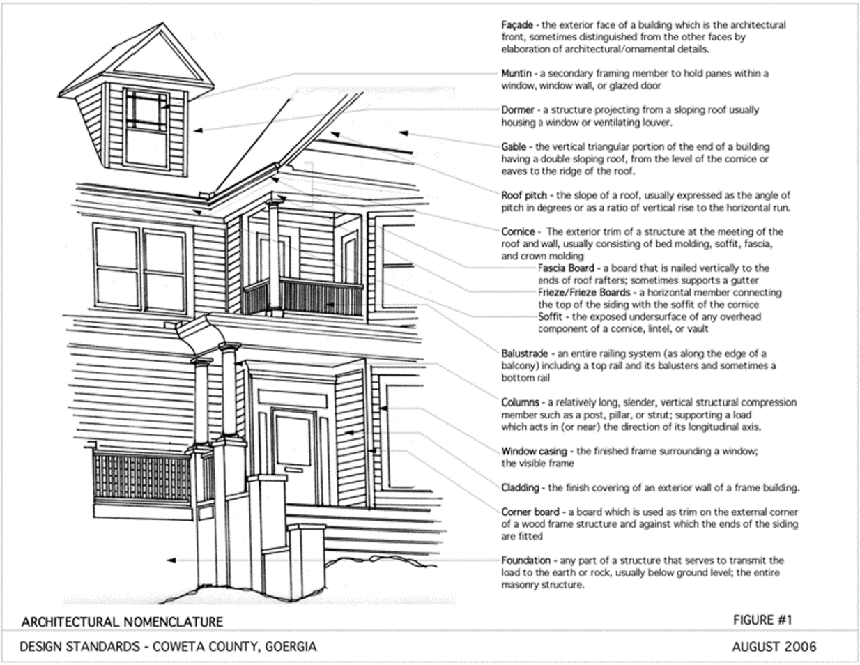
Fenestration (Streetfront Windows)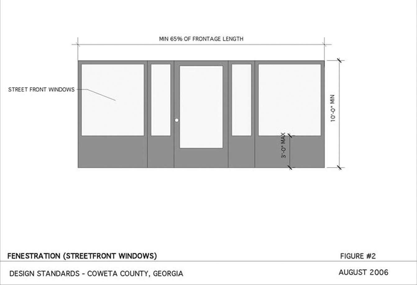
Parking Configuration/Placement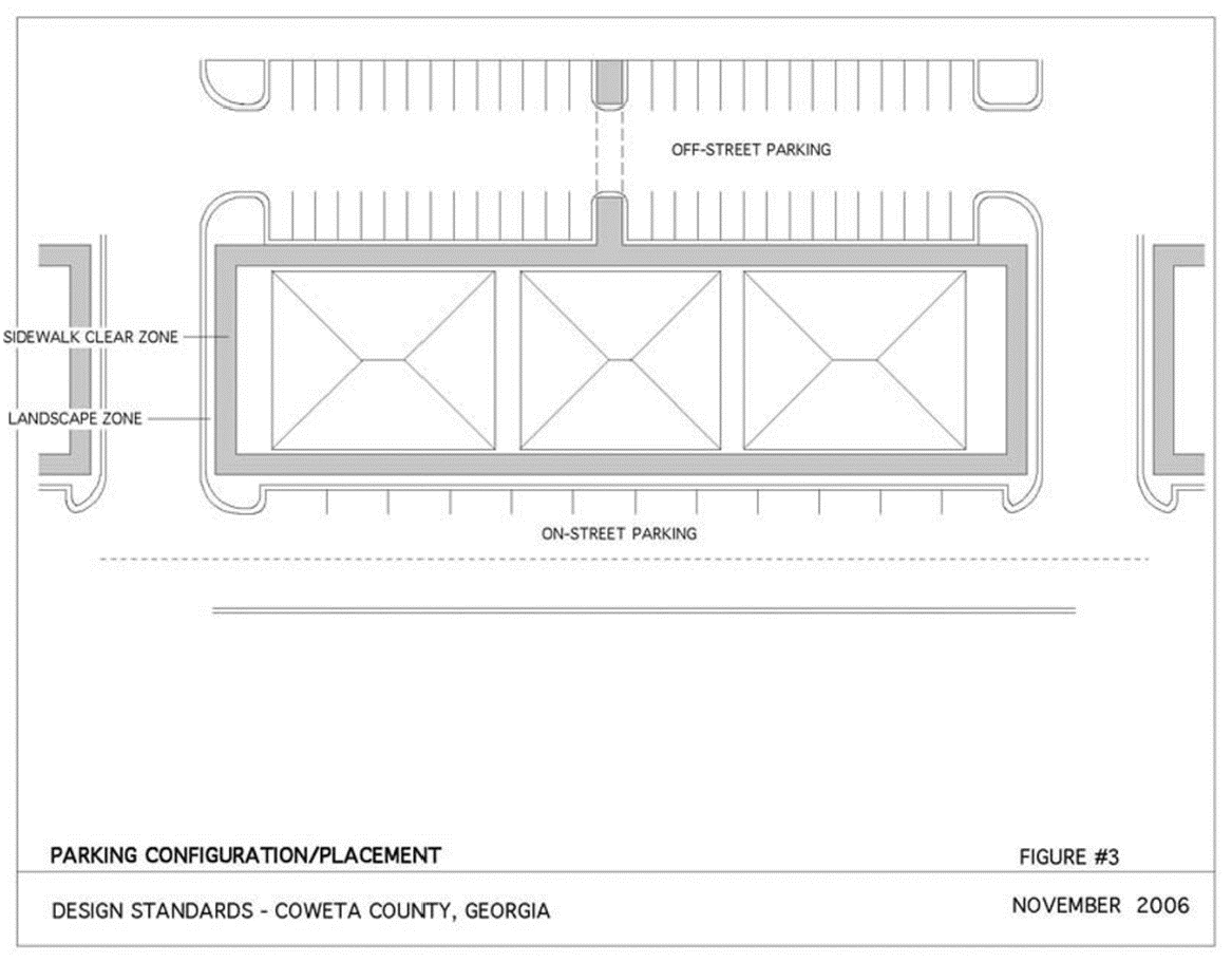
Typical Cul-de-sacs for Residential Streets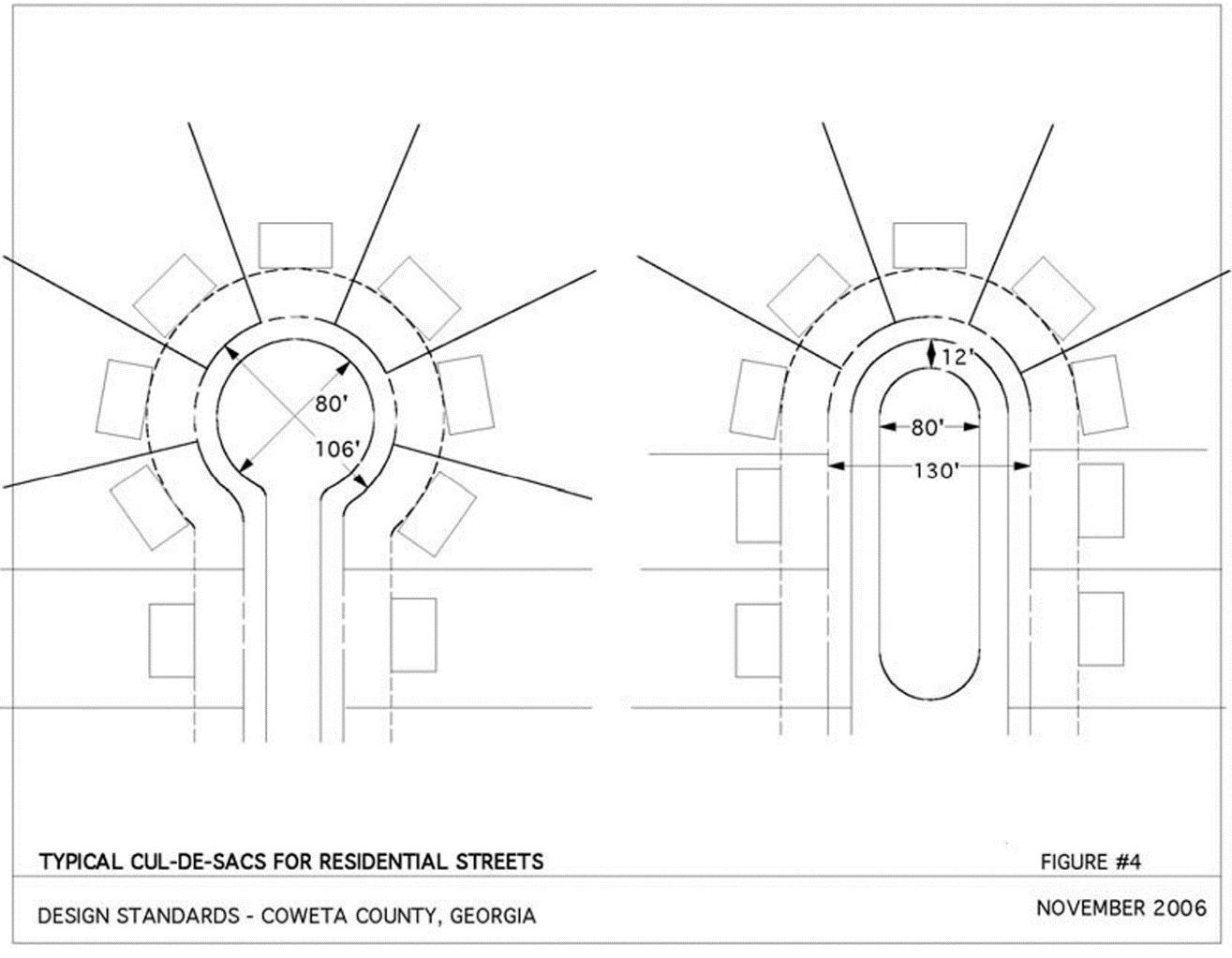
Cul-de-sac, Eyebrow, and Hammerhead Termination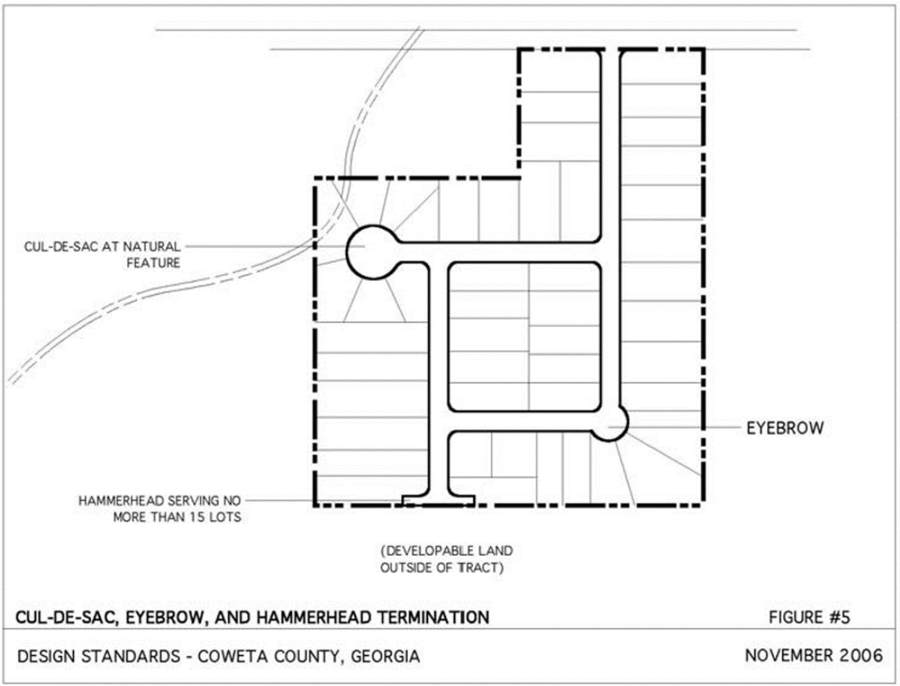
Crosswalks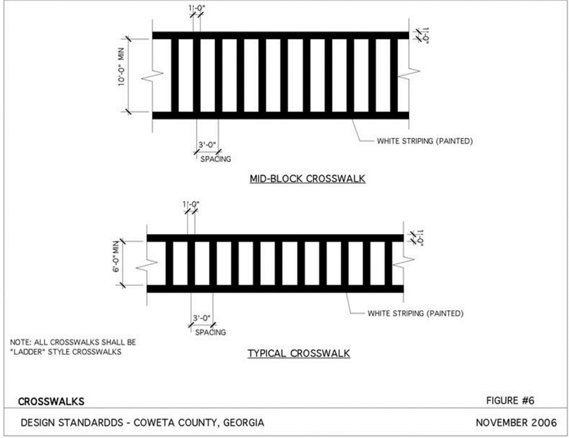
Standard Details for Subdivision Streets with Curb and Gutter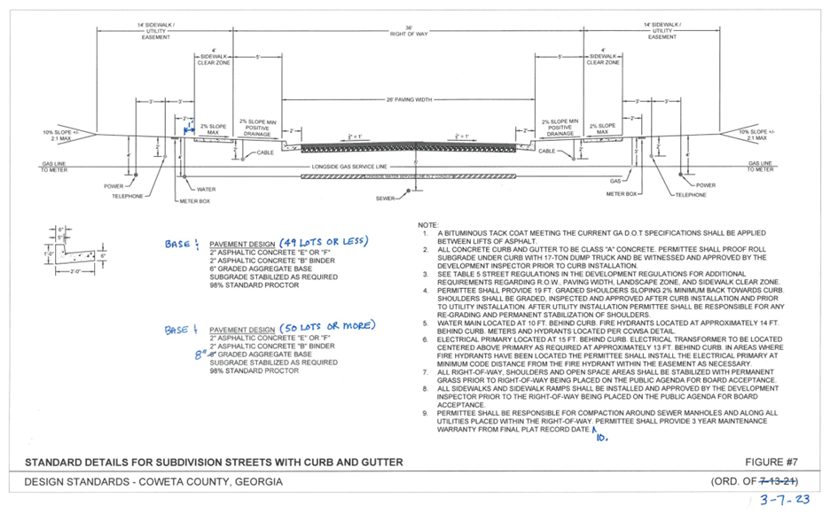
Standard Detail for Subdivision Streets Without Curb and Gutter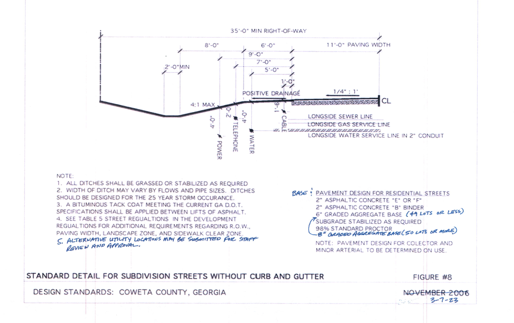
2-Lane with Turning Lane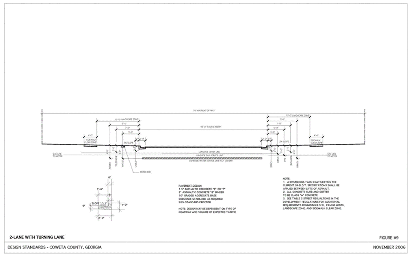
4-Lane with Raised Median Street Section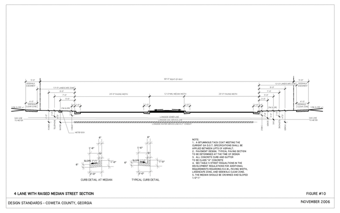
Typical Residential Cul-de-sac Utility Placement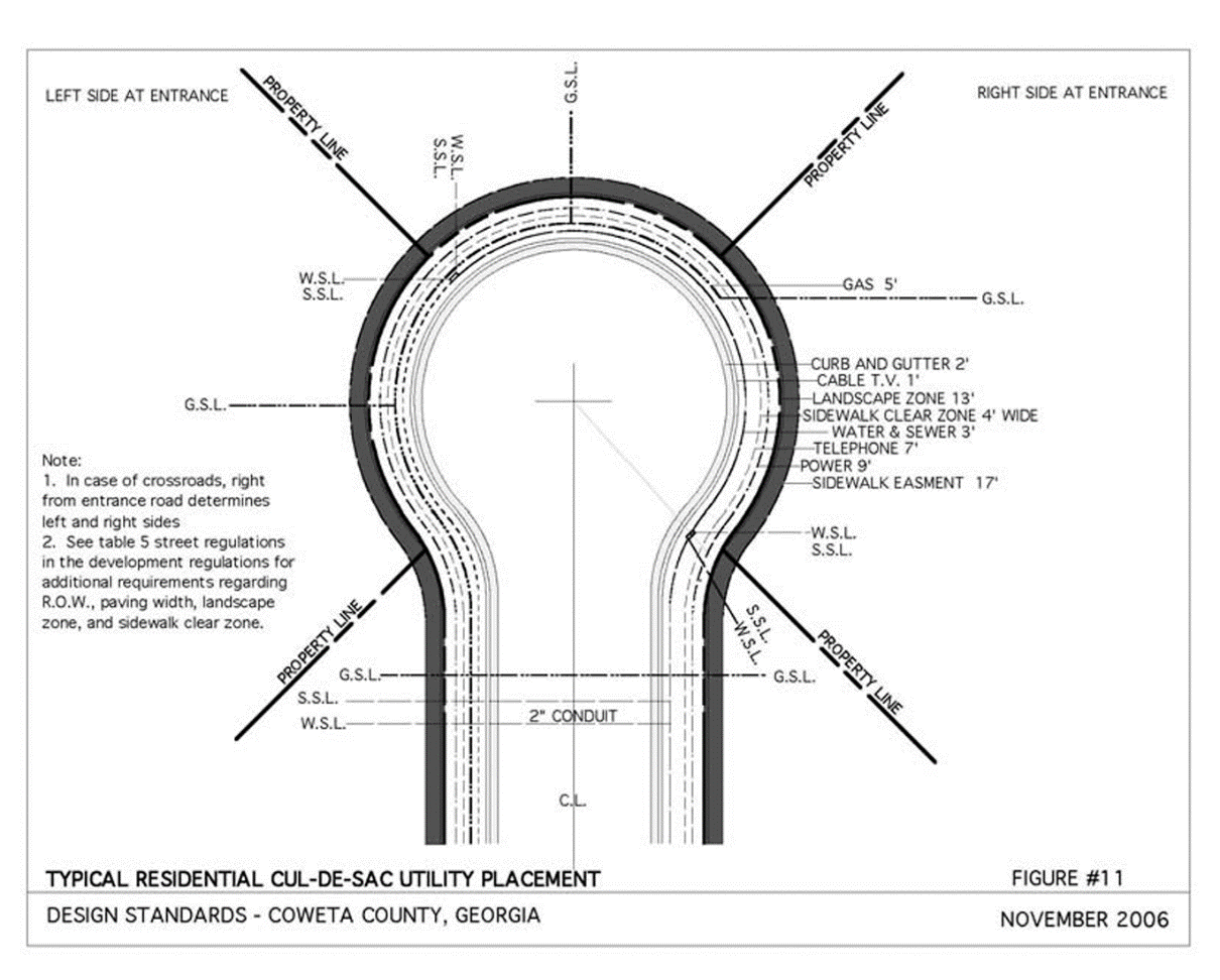
Curb and Street Intersection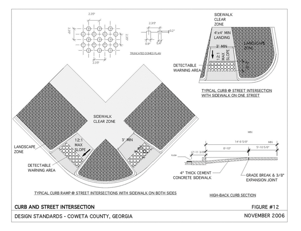
Street Tree Planting in Landscape Zone - Plan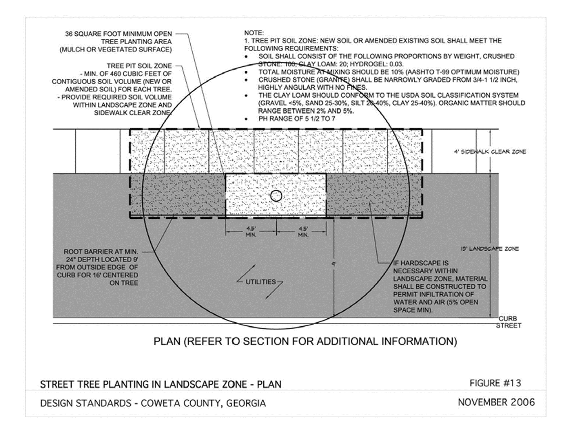
(Ord. No. 007-23, 3-7-23)