
Dunnellon City Zoning Code
ARTICLE VIII
INTENT AND PURPOSE OF ZONING DISTRICTS
The zoning districts specified in the code are intended to implement and be consistent with the comprehensive plan future land use categories. Zoning districts are considered consistent with the comprehensive plan future land use categories if the permitted uses, density, impervious surface ratio and height are the same or more restrictive than the future land use category. The following table identifies the zoning districts that are consistent with the future land use category. Development orders and development permits that are consistent with the zoning district in which they are located shall be deemed consistent with the comprehensive plan future land use category as indicated in this table.
Section 8.1 - One-family dwelling (R-1).
This is a single-family residential district. The R-1 zoning district is permitted only in the low density residential and medium density residential land use categories. Densities in this category shall not exceed one dwelling unit per gross acre.
Certain structures and uses required to serve governmental, educational, religious, noncommercial, recreational, and other immediate needs of such areas are permitted outright or are permissible as special exceptions subject to restrictions and requirements intended to preserve and protect their single-family residential character.
Section 8.2 - Single-family residential (R-1A).
This district is a more intense zoning district than the R-1 district. Other than a distinction as to lot area, width and density, the nature of the use of property is the same as in the R-1 zoning district. The R-1A district is permitted only in the low density residential and medium density residential land use categories. Densities in this district shall not exceed 2.5 dwelling units per gross acre. The maximum allowable density is consistent with the allowable density in the medium density land use category in that it is set at less than five dwelling units per acre. Houses of worship are permitted by special exception subject to restrictions and requirements intended to preserve and protect the district.
Section 8.3 - Single-family residential (R-1B).
This is the highest density single family district. Other than a distinction as to lot area, width and density, the nature of the use of property is the same as in the R-1 zoning district. The R-1B zoning district is permitted only in the medium density land use category. Densities shall not exceed 5.0 dwelling units per gross acre. Houses of worship are permitted by special exception subject to restrictions and requirements intended to preserve and protect the district.
Section 8.4 - One- and two-family dwelling (R-2).
This district is intended to serve the same needs as the R-1 district, subject to the limitations, requirements and procedures specified for the single-family district, plus the additional use of duplexes and two dwellings on one lot. The R-2 district is permitted only in the medium density residential land use category. Densities shall not exceed 5.0 dwelling units per gross acre. Most of the areas designated R-2 are primarily rental property rather than single owned properties. Certain uses permitted only by special exception in the single-family dwelling districts are permitted without exception in these districts. Houses of worship are permitted by special exception subject to restrictions and requirements intended to preserve and protect the district.
Section 8.5 - Multiple dwelling (R-3).
This district is intended to be a high density residential area permitting single-family, two-family and multiple-family residences and also related uses in keeping with the residential character of the district. The R-3 district is permitted only in the high density residential land use category. The R-3 district shall have an allowable density from greater than 5.0 dwelling units per acre to 12.0 dwelling units per gross acre. Houses of worship are permitted by special exception subject to restrictions and requirements intended to preserve and protect the district.
Section 8.6 - Tourist-oriented residential (R-5).
This district is permitted only in the Traditional Neighborhood (8 DUA and 12 DUA) and Commercial land use categories. This district permits areas for sleeping and living quarters for transient visitors and tourists. While certain uses are permitted to operate for profit, the area is to be considered a business zone. Such uses are limited to restaurants, overnight accommodations, rental and incidental supply shops, and other tourist-oriented small business uses. Convenience stores, fast food drive-in restaurants and dock fueling facilities are strictly prohibited. Certain indoor and outdoor activities are permitted for the convenience of guests as a special exception. Certain offices which are compatible with the general residential character of the neighborhood are also permitted as special exceptions. Houses of worship are permitted by special exception subject to restrictions and requirements intended to preserve and protect the district.
All development in the tourist-oriented commercial land use category shall comply with the following standards:
(a)
Any required parking shall not be located adjacent to the river, unless a minimum 25-foot vegetated buffer is provided adjacent to the river.
(b)
Landscape buffering with plant material native to the area shall be required to be placed between the structure and river bank. Further, landscaping buffers of not less than five feet in width shall be installed adjacent to all noncommercial land uses.
(c)
Redevelopment shall include site plan design providing for stormwater treatment on-site.
Section 8.7 - Mobile home park or subdivision (MH).
This district is permitted only in the low density, medium density and high density residential land use categories and is designed particularly to serve the needs of mobile home parks or subdivisions. Because of relatively high density parks, such districts shall be located with particular attention to access, drainage, utilities and compatibility with present and future development of the area. Standards are set to ensure compatibility of such developments with other existing or future developments in the general area where the mobile home park or subdivision is located. Gross density shall not exceed the density limits prescribed in the land use category of the comprehensive plan in which the mobile home facility is located. Houses of worship are permitted by special exception subject to restrictions and requirements intended to preserve and protect the district.
Section 8.8 - Planned unit development (PUD).
This district implements the mixed use land use category of the future land use map and requires that a proposed development include at least three land uses based on the following percentage requirements, as measured based on acreage:
Residential uses or recreational vehicle parks: 40%—80%
Commercial uses: 10%—50%
Institutional uses: 5%—10%.
For the purpose of this section, institutional uses include churches/houses of worship, civic/public uses, community facilities, and similar uses that are not commercial or considered ancillary to residential.
For the purpose of calculating the percentages, only net development areas shall be included in the calculation, which shall include principal and accessory uses. Net development areas exclude: right-of-way and open space of all types. If a structure or lot includes more than one use and the uses are integrated in a manner that does not allow the acreage of each use to be distinguished, then the percentages shall be calculated based on the gross floor area of such uses. Section 7.1 further defines whether a particular use requires a special exception or is subject to any specific supplemental standards.
Development shall be consistent with the requirements of the mixed use land use category in the comprehensive plan. Unless specifically exempted in this section, development shall comply with all requirements of this Code of Ordinances. Without limiting the intent of the foregoing, lands designated as PUD shall be subject to all standards set forth in chapters 74, 78 and 98. Subdivision plats shall be consistent with, and based on, the approved PUD development plan, which shall be reviewed pursuant to section 16.14 of this appendix A.
The PUD district is intended to achieve innovative design and provide flexibility to encourage the integration of mixed use and to preserve and enhance site features. The following standards and procedures apply:
(a)
Except for development standards set forth in chapter 74 and 78, an applicant may request a waiver to a development standard where it can be demonstrated that such waiver will further the preservation of a site feature or provide more creative design, provided that such waiver is not inconsistent with the requirements of the mixed use land use category and will not result in an incompatible impact on lands adjacent to the PUD. An applicant proposing a waiver shall provide an analysis documenting the rationale for the waiver and demonstrating that the waiver will not result in an incompatible impact on land uses adjacent to the PUD. The city council shall identify any approved waivers and related conditions in the development order for the PUD development plan.
(b)
Properties comprised of 40 acres or more may be developed based on new urbanism design principles, provided that the PUD is served by central water and sewer. Applicants proposing a new urbanism design shall follow the "transect" form of development and design, and shall submit a conceptual master plan and proposed set of regulatory development standards that will guide development within each area as identified on the conceptual master plan. The city council shall have the discretion as to whether to accept and adopt the regulatory standards for a proposed new urbanism PUD. Following approval of a conceptual plan, each development site shall be approved pursuant to the development plan review process in section 13.4.
(c)
Setbacks along the perimeter of the PUD shall be no less than the corresponding minimum setback requirement in the code applicable to each adjoining property line. In the event that a perimeter property line adjoins multiple properties with multiple setback requirements, the minimum required setback shall be met for each adjoining zoning district along that property line. There shall be an additional one foot of setback from the perimeter of the PUD for each additional two feet of building height allowed as compared to the adjoining zoning along the perimeter property line.
(d)
Compatibility, frontage and perimeter buffers required by article X shall be applied along the boundaries of the PUD and shall not apply to lots that are internal to the PUD. The PUD shall provide parking and drainage buffers on all lots where applicable.
(e)
Each lot shall provide a minimum 25-foot street setback from publicly dedicated right-of-way and 50 feet from the centerline of any private street lying within or adjacent to the PUD district.
(f)
The minimum distance between structures shall be 15 feet from wall to wall.
(g)
The mixed use land use category is intended to achieve an urban development plan that necessitates the provision of central water and sewer. Prior to the availability of both central water and central sewer to serve the PUD, a maximum allowable interim density of one unit per five gross acres shall apply. If an applicant chooses to develop pursuant to the interim density, the applicant shall submit an interim development plan, which shall be designed such that the interim development can be functionally integrated with future urban development within the PUD. The interim development plan shall cluster the units on lots no larger than a half-acre if central water is not available and one-quarter acre if central water is available. Recreational uses and residential accessory uses may be included in the interim plan. Commercial and institutional uses are not permitted in the interim development plan. If an interim development plan is approved, a development order condition shall require the recording of deed restrictions, which state that the property is subject to PUD regulations.
(h)
PUDs over 40 acres may be phased. Applicants proposing a phased PUD shall submit a conceptual plan that identifies wetland and upland habitats, any jurisdictional determinations for wetlands within the previous five years, listed species known to utilize the site based on Florida Natural Area Inventory, historic/archaeological resources, other unique site features, topography, adjacent land uses, existing street network, and nearest water and sewer connection points and size of pipes. The conceptual plan shall identify proposed habitat preservation areas, proposed major street network and proposed land uses for each phase. The conceptual plan shall demonstrate that the percentage mix of uses will be achieved at buildout. The planning commission shall review the conceptual plan and recommend to the city council whether to approve with conditions or deny the conceptual plan and any requested waivers based on the requirements of the comprehensive plan and Code. The city council shall review the recommendations of the planning commission and approve with conditions or deny the conceptual plan and any requested waivers based on the requirements of the comprehensive plan and Code. All notice and procedural requirements shall be followed in the same manner as required by section 16.14 for a development plan. Any modification to a conceptual plan shall comply with the same review requirements.
It shall be the responsibility of the applicant to ensure compliance with federal, state, water management district and other applicable regulatory programs. If an applicant obtains conceptual approval or phase approval without first obtaining permits from other applicable regulatory programs, the applicant shall be required to modify the conceptual plan and/or individual phase plan to be consistent with any subsequently issued permit from another regulatory permitting agency. In that case, the applicant shall pay all applicable fees for such modifications. No claim of vested rights shall be asserted or recognized for any development approval granted by the city based on an application submitted without accompanying permits from other applicable regulatory agencies with jurisdiction.
Individual phases shall be consistent with the approved conceptual plan. Individual phases shall not be less than five acres. Phase 1 shall be submitted in conjunction with the conceptual plan. Individual phases shall comply with the development plan requirements of section 16.14.
(i)
Bonus provisions. The base density for the PUD district shall be five dwelling units per gross acre where the PUD property is served by central water and central sewer. Additional density shall be allowed based on the following public benefits:
(1)
Providing central water and sewer: All uses allowed in the B-4 zoning district that are consistent with the mixed use land use category.
(2)
Providing more than 350 square feet of recreational land per unit: One additional dwelling unit per gross acre for each 20 percent increase beyond the minimum requirement.
(3)
Providing public access to the Rainbow or Withlacoochee Rivers: Two additional dwelling units per gross acre and all uses allowed in the B-6 zoning districts that are consistent with the mixed use land use category.
(4)
One additional dwelling unit per gross acre for each five percent increase in the sum of the minimum open space required for habitat communities.
(5)
Providing a landscaping plan of greater than 40 percent native or drought-tolerant vegetation: One additional dwelling unit per gross acre for each five percent increase.
(6)
Granting of bonuses shall not exceed a maximum permitted density of 12 dwelling units per gross acre.
Section 8.9 - Residential business office (RBO).
This district is intended to be a mixed use district that is primarily residential in character with limited office and business development comprised of buildings and structures of high character and attractive surroundings, so controlled as to be compatible with single-family and multifamily dwellings. Permitted office uses shall include medical, dental and other professional offices, and bed and board establishments as well as neighborhood serving commercial, such as barber, beauty, photography shops and other personal service and retail businesses that do not generate more than 50 trips per weekday per 1,000 square feet based on the most recently published Institute of Traffic Engineers Trip Generation Manual at the time of development application. Houses of worship shall also be permitted in this district. This district is permitted only in the Traditional Neighborhood (8 DUA and 12 DUA) land use category. All non-residential developments shall have a land area sufficient to meet all development design standards in this code, including but not limited to, land required to provide setbacks from abutting rights-of-way, buffers, off-street parking and circulation, and any other provisions which may require land area to be set aside. After October 1, 2018, proposed developments approved within this district shall be developed as residential or with a mix of permitted residential and non-residential uses. Lots developed or approved exclusively with non-residential uses on or before October 1, 2018 shall be considered conforming uses.
Section 8.10 - Neighborhood business residential (NBR) district.
(a)
Intent. The NBR zoning district is intended to provide opportunities for property owners and developers to achieve creative and innovative site design. The district is intended to be consistent with traditional neighborhood development and with the concepts of new urbanism. These concepts allow the development of land uses including residential, professional office, retail, recreation, open space, and civic uses within close proximity to one another.
(b)
Purpose. The NBR provides design standards that enhance or promote the following characteristics within neighborhoods:
(1)
Mix of uses, including residential, commercial, civic, and open space in close proximity to one another within the neighborhood;
(2)
Mix of housing styles, types, and sizes, from apartments over storefronts to single-family homes with yards, to accommodate households of all ages, sizes, and incomes;
(3)
Integration of parks and public spaces into each neighborhood;
(4)
Building appearance that reflects typical and compatible architectural designs of the city and that enhances the visual character of the neighborhood;
(5)
Interconnection of street networks, sidewalks, and bikeways;
(6)
Small lots; and
(7)
Accessibility of lots to retail and recreation by non-motorized means.
Section 8.10-1 - Applicability.
(a)
A rezoning to NBR shall be processed according to the PUD review process.
(b)
Where there are conflicts between the requirements of this section and other sections of the Dunnellon Code of Ordinances, the NBR requirements shall apply.
Section 8.10-2 - NBR development standards.
The following standards apply to all development within the neighborhood business residential zoning district:
(a)
The uses within NBR shall be proposed by the property owner. The proposed uses shall be consistent with the TND land use category, and shall be established only when a site plan is approved by the city council, after a recommendation by the planning commission. The city council may impose special conditions in regard to hours of operation and buffering when approving a site plan that abuts residentially used property.
(b)
No individual building shall exceed 3,000 square feet of gross floor area. Nonetheless, the limitation on square footage is not intended to limit the number of buildings on site, so long as the impervious surface ratio specified in table 8.10-1 is not exceeded.
(c)
Drive-in facilities, including drive-up or drive-through facilities, are prohibited in the NBR district.
(d)
Parking standards.
(1)
Location:
a.
Off-street parking areas shall be located in side and rear yards, except where existing building placement necessitates that the parking lot is located in the front yard.
b.
Parking lots shall not abut street intersections, parks, or occupy lots which terminate a street vista.
(2)
Number and design.
a.
The number of parking spaces shall not exceed the parking standard set forth in article V.
b.
Parking and loading areas shall comply with the design guidelines set forth in article V.
c.
The interior of parking lots shall be landscaped as provided in article X and buffers shall be required based on article X.
d.
Shared parking areas are preferred and shall comply with the requirements of appendix A, section 5.4.
(3)
Bicycle parking.
a.
Bicycle parking spaces shall be provided for retail uses, one space per ten parking spaces, or fraction thereof.
b.
Bicycle parking shall be provided through secure stationary racks that are anchored or bolted to the ground for security of bicycle property. The design of bicycle racks and placement shall be subject to approval by the city.
c.
Facilities shall be located so as not to interfere with pedestrian or vehicular movement. A fence, wall, or curb, or at least five feet of open area, may be used to separate bicycle parking from other areas. The bicycle parking shall be marked to prohibit motor vehicle parking.
d.
Bicycle parking may be shared by tenants occupying one or more buildings on the same site.
e.
Bicycle parking shall be exempt for building remodeling or renovations that do not include a change in use or an increase in total parking spaces.
f.
Where bicycle parking spaces are required, the property owner or developer may choose to make a payment to the city in lieu of providing on-site bicycle parking spaces.
(e)
Sign standards. Signs shall be designed to meet the following standards:
(1)
Signs shall be consistent with the style, color, material, and finish of the principal buildings on the site.
(2)
Signs shall include no more than five different colors on the sign face.
(3)
Any freestanding sign shall be located perpendicular to the street and shall be a monument sign.
(4)
Multiple tenant buildings or shopping centers shall have a unified sign design.
(5)
Animated or moving signs, script, or video graphics are prohibited in the NBR district. Temporary banners are also prohibited.
(6)
Signs may be illuminated only as follows:
a.
The lighting may be internal or ground mounted.
b.
Flood lights and neon lights are prohibited. Also prohibited are any animated or moving lights or objects.
c.
Sign lighting shall be shielded to prevent glare onto adjacent public rights-of-way and adjacent properties. Sign lighting shall be directed toward the face of the sign and so shielded that no direct rays from the light are visible elsewhere than on the lot where the illumination occurs. Lighting shall be steady and even over the entire sign face.
d.
All lighting fixtures and elements shall be maintained in good working condition. Exposed bulbs shall not exceed 15 watts in power.
e.
Signs shall be illuminated only during the times the establishment displaying the sign is operating or open for business.
f.
Where sign faces are internally lit, the area of all the letters and numbers, plus the entire area of illuminated background, shall be counted as sign area for the purposes of meeting the city's sign code.
(7)
Monument signs.
a.
One monument sign is allowed per site.
b.
The maximum size of a monument sign is 24 square feet.
c.
The maximum height of a monument sign is four feet above finished grade.
d.
Monument signs are to be on the ground with landscaping all around the base.
(8)
Wall signs.
a.
One wall sign is allowed per building façade having frontage on a public street.
b.
The maximum size of a wall sign is 12 square feet.
c.
No portion of the sign face may extend above the eave of the building façade.
(9)
Construction and location.
a.
All signs shall be constructed to meet applicable building codes and regulations.
b.
No sign shall be placed within 25 feet of any residentially zoned property.
(10)
Visibility triangle.
a.
No sign, either temporary or permanent, shall be located within the visibility triangle.
b.
No construction or planting which would interfere with traffic visibility shall be maintained within 20 feet of the intersection of the curb lines at street corners. This shall not apply to fences or shrubbery not more than two feet in height on private property. See figure 8.10-1 for an illustration of the visibility at intersections.
Figure 8.10-1: Visibility at Intersections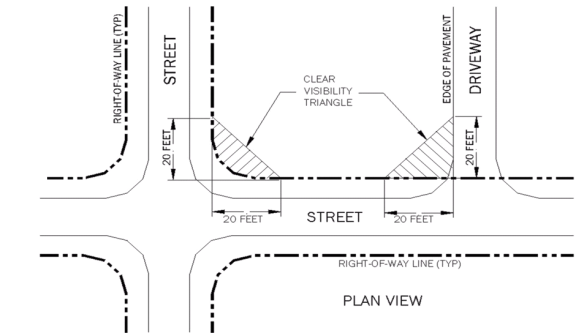
(f)
Residential density standards.
(1)
Lots located directly on West Pennsylvania Avenue or Cedar Street, and having at least 100 feet of frontage, shall have a maximum residential density of 12 units per acre.
a.
All other lots in the NBR zoning district shall not exceed eight units per acre.
b.
Transient lodging and bed and breakfast uses shall be limited to an equivalent of eight units per acre. Each guest bedroom shall be considered a unit. Supplemental standards contained in section 9.1-3 apply to this use.
(g)
Intensity and dimensional standards. The following intensity and dimensional standards shall apply to all development within the NBR district.
Table 8.10-1 NBR Intensity and Dimensional Standards
1 Existing lots of record, as defined in appendix A, section 3.5, are exempt from the minimum lot width and shall comply with setback requirements as specified in section 3.5, unless the applicant elects to unify two or more lots to meet the minimum lot with requirement, in which case, a unified development plan shall be required and shall be reviewed accordingly.
2 A unified plan of development and unity of title is required for any proposed development including more than one lot, in which case, required setbacks shall apply to the perimeter of the unified parcel. A unity of title shall be required as a condition of an approval of a unified plan of development and shall be recorded as a deed restriction.
3 The maximum height for all principal buildings and structures, excluding towers, cupolas, steeples, domes, antennas, chimneys, stacks, and roof structures used only for ornamental purposes. Proposed developments on greater than two acres are permitted a building height of 40 feet.
(h)
Architectural design features. The architectural features, materials, and articulation of the façade of a building shall be continued on all sides visible from a public street. The decorative facing shall consist of brick, masonry, stone, or wood material.
(i)
Fences or walls shall meet the following standards:
(1)
Chain link fences shall be limited to rear yards, as defined in article II; such fencing may begin at the rear line of the main building;
(2)
Fences or walls visible from a public street shall be landscaped on the street-side or with a continuous hedge or vine to soften the view of the fence;
(3)
Fences or walls adjacent to a residence shall be approved at site plan review and shall be subject to any conditions imposed by the city council to buffer adjacent residences.
(4)
Fences shall comply with the requirements of article X. To the extent this section conflicts with article X, the more stringent requirement shall apply.
Section 8.10-3 - Development on a single-lot of less than five acres.
In addition to the standards in section 8.10-2, development of a single, platted lot within the NBR district shall meet the following standards:
(a)
A single lot within the NBR district may contain either a single use or a combination of residential and non-residential uses.
(b)
Where a non-residential use is proposed on a single platted lot, one residential unit may be permitted.
(c)
The residential use may be located within the principal structure. If the residential use is on the first floor, the residence shall be located to the side or rear of the structure.
(d)
Where the residential use is located in a detached building, the following standards shall be met:
(1)
The residential use shall be located either in the side or rear yard of the principal structure.
(2)
Structures shall be separated by at least ten feet.
(3)
The residential use shall not exceed 50 percent of the total building area located on site.
(4)
All front, side, and rear setbacks shall be met by both the principal structure and the residential use.
(5)
The impervious surface standard in table 8.10-1 shall not be exceeded.
(6)
The detached structure shall use architectural features, building materials, and exterior colors that are the same or complementary to the principal structure.
(e)
Accessory uses shall be those permitted in appendix A, section 7.1.
(1)
All accessory uses in the NBR shall meet the location and setback requirements as provided in appendix A, section 3.12, accessory uses and structures.
(2)
The impervious surface standard in table 10-8.1 shall not be exceeded.
Section 8.10-4 - Development of two or more unified lots of less than five acres.
In addition to the standards in section 8.10-2, where development is proposed on two or more unified lots with a combined area of less than five acres, the following development standards shall apply:
(a)
The proposed uses may contain either a single use or a mixture of uses;
(b)
Where mixed uses are proposed, residential uses shall not exceed 50 percent of the total building area located on the property.
(1)
Residential uses may be located within the principal structure. If located on the first floor, the residence shall be on the side or rear of the structure.
(2)
Where residential uses are located in a detached building, the residential uses shall be located in the side or rear yard.
(c)
All front, side, and rear setbacks shall be met by both the principal structure and the residential use.
(d)
The impervious surface standard in table 8.10-1 shall not be exceeded.
(e)
The detached structure(s) shall use architectural features, building materials, and exterior colors that are the same or complementary to the principal structure.
(f)
Accessory uses shall be those permitted in appendix A, section 7.1.
(1)
All accessory uses in the NBR shall meet the location and setback requirements as provided in appendix A, section 3.12, accessory uses and structures.
(2)
The impervious surface standard in table 8.10-1 shall not be exceeded.
Section 8.10-5 - Development on five or more acres.
In addition to meeting the standards in section 8.10-2, a lot or combination of unified lots containing five or more acres shall meet the following standards:
(a)
The development shall contain at least two different uses, and residential uses shall not exceed 65 percent of the development site.
(b)
All uses, including accessory structures, mechanical and service equipment, and utility structures shall be integrated with the design of the principal building.
(c)
Appearance standards for buildings.
(1)
The architectural features, materials, and articulation of the façade of a building shall be continued on all sides visible from a public street. The decorative facing shall consist of brick, masonry, stone, or wood material.
(2)
The front door of the principal building shall face onto a public street.
(3)
Each principal building on a site shall have clearly defined, highly visible entrances featuring at least one of the following:
a.
Awnings;
b.
Porticos;
c.
Cupolas;
d.
Galleries;
e.
Overhangs;
f.
Porches;
g.
Recesses or projections.
(4)
Non-residential buildings on corner lots shall have corner entrances whenever possible.
(5)
The ground floor of all buildings shall be designed to encourage and complement pedestrian activity by the use of windows and doors arranged as follows:
a.
Not less than 60 percent of the total surface area of the front facade shall be public entrances and windows, including retail display windows, for non-residential uses.
b.
Windows shall be transparent, not mirrored or tinted dark.
c.
Solid walls shall not exceed 20 feet in length.
d.
Street level retail uses with sidewalk frontage shall provide an entrance to the building from the sidewalk in addition to any other access that may be provided to the building.
(6)
Where a residential lot contains a front facing garage, the garage shall be setback a minimum of four feet behind the front lateral of the principal structure.
(d)
Design of new streets and alleys.
(1)
A circulation system shall be designed based on a grid type network and shall include streets, sidewalks, and pedestrian and bicycle trails. This circulation system shall connect all uses and areas.
(2)
Culs-de-sac may be included in the street design if necessary to preserve a scenic view at the termination of a street. Buildings shall not be placed to obscure this preserved view.
(3)
The circulation system will provide interconnections among uses within a neighborhood and with the external transportation system.
(4)
Arterial roadways may be located adjacent to a NBR, but shall not bisect the NBR.
(e)
Landscape and streetscape design.
(1)
Proposed new streets within the NBR shall include:
a.
Street trees shall be planted within the right-of-way and no closer than five feet to the edge of pavement.
b.
One tree shall be planted every 50 linear feet, measured from tree center to center, using existing trees where possible. Trees may be planted in a staggered pattern on alternate street-sides, but shall include no less than one tree for every 50 linear feet per street side.
c.
Trees shall be selected from the list provided in article X.
(2)
Street medians shall be landscaped with understory trees, shrubs, and plants.
(3)
Sidewalks.
a.
Provide paved sidewalks within the right-of-way on both sides of the street.
b.
Sidewalks may meander where required to avoid existing protected features or vegetation.
c.
Sidewalks may be designed to include benches, bicycle parking, and other street furnishings that complement the predominant architectural style of principal buildings, based on materials, color, and architectural design features.
(f)
Lighting.
(1)
Only decorative lighting shall be allowed within the NBR development.
(2)
The maximum height of street lighting shall be 22 feet.
(3)
Exterior lighting for parking areas and building security shall be shielded and directed to avoid direct illumination of adjacent properties, using best available technologies.
Section 8.10-6 - Enforcement.
Enforcement of the design standards in this section shall be in accordance with section 16.5.
Section 8.11 - Neighborhood business (B-2)
This district is intended to serve the local shopping needs of neighborhoods and is permitted only in the traditional neighborhood (8DUA and 12DUA) and commercial land use categories. The B-2 district is intended to occur near the periphery of neighborhoods rather than in the interior and at a small scale that is compatible with single family neighborhoods. The following standards shall apply to uses in the neighborhood business district:
(a)
Impervious surfaces shall not exceed 65 percent of the lot area.
(b)
Minimum building setbacks shall be equal to the greatest setbacks required by adjacent residential zoning districts.
(Ord. No. 2020-02, § 2, 3-9-2020)
Section 8.12 - Central business (B-3).
This district is included to serve the downtown shopping and office needs of a large community and is permitted only in the traditional neighborhood (8 DUA and 12 DUA) and commercial land use categories. Houses of worship are permitted by special exception subject to restrictions and requirements intended to preserve and protect the district.
The following standards shall apply to uses in the central business district:
(a)
There is no minimum distance between adjacent buildings, nor a minimum building setback from a property line, provided that one of the first two of the following conditions are met:
(1)
If the distance from the exterior wall to the property line is less than five feet, the applicant must show evidence of a maintenance easement from adjacent property owner(s); or
(2)
The structure shall be built on the property line and the owner shall give an easement to the adjacent property owner(s).
(3)
When a building exceeds 25 feet in height, the minimum distance from an adjacent building or property line shall be increased by two feet for each story above two. (For example, where a two-story building is adjacent to a three-story building, and the minimum distance between the buildings is less than seven feet, a maintenance easement shall be required as stated in above. The same procedure applies where three or more buildings are clustered. For each story above two in each building, two feet are added to the minimum distance allowed between the buildings without evidence of a maintenance easement.)
(4)
Development in the central business district may be built up to a proposed right-of-way line of an abutting roadway. There are no building setbacks from an abutting right-of-way in the central business district. However, buildings, signs or other structures shall not obstruct the vision of vehicle operators nor protrude into the right-of-way.
Section 8.13 - General business (B-4).
The B-4 general business district is intended to apply to arterial streets and trafficways where business establishments primarily not of a neighborhood or community service type may be properly located to serve large sections of the city and metropolitan area. Such businesses generally require considerable ground area, do not cater directly to pedestrians and need a conspicuous and accessible location convenient for motorists. Such uses may include personal service establishments, professional offices, trade service establishments, commercial (limited wholesale, storage), amusements and retail stores. This district is permitted only in the commercial land use category. Houses of worship are permitted by special exception subject to restrictions and requirements intended to preserve and protect the district.
Section 8.14 - Wholesale business (B-5).
The wholesale business districts are intended for certain repair and other services, wholesale, storage and warehouse uses and sales of large or heavy machinery and equipment. They serve large sections of the city rather than nearby residential areas, and they do not primarily cater to retail trade. In order to minimize conflict and protect the health, safety and well-being of the city residents, residential and institutional uses are not permitted in these districts. Uses permitted in this district include: wholesale business, warehouses, lumber and storage yards, equipment sales and other uses as specified in article VII. This district is permitted only in the commercial land use category of the future land use map.
Section 8.15 - Water-oriented commercial (B-6).
The water-oriented commercial district permits commercial uses which provide goods and services which are directly associated with water-dependent or waterway uses, such as recreation or dining. This district is permitted only in the traditional neighborhood and commercial land use categories where abutting the water front. Redevelopment in the water-oriented commercial land use category shall include site design providing for stormwater treatment on-site.
(a)
Bonus provisions. A decrease in the 35 percent open space requirement for new development may be granted with the following public access provisions:
(1)
Providing a public boat ramp: Up to 20 percent decrease in open space requirement.
(2)
Providing a public fishing pier: Up to 20 percent decrease in open space requirement.
(b)
Preference will be given to development which combines smaller lot development into larger sites.
Section 8.16 - Agricultural (A-1).
The A-1 district applies to areas intended for agricultural use, including solar farms by special exception, and low density residential. The regulations of this district are intended to permit a reasonable use of property while preventing the creation of conditions which would blight or prevent the proper future use of nearby property. The allowable density shall be one unit per ten acres, except that a density of one dwelling unit per five gross acres shall be allowed for Conservation Subdivision, approved with the requirements of Chapter 97.
(Ord. No. 2020-10, § 2, 2-8-2021)
Section 8.17 - Public (P).
(a)
The public (P) zoning district is permitted in only the public land use category.
(b)
The public (P) district is intended to provide for areas where public and semipublic facilities serve the needs of the community. Solar farms are permissible in this zoning district by special exception.
(c)
Front, side, and rear setbacks shall be no less than the corresponding minimum setback requirement in the code applicable to each adjoining property line. In the event that a front, side, or rear property line adjoins multiple properties with multiple setback requirements, the minimum required setback shall be met for each adjoining zoning district along that property line.
(d)
Maximum height shall be limited to the lowest maximum height allowed of the adjacent properties.
(Ord. No. 2020-10, § 2, 2-8-2021)
Section 8.18 - Parklands (PK).
(a)
The parklands (PK) zoning district is permitted in only the recreation land use category.
(b)
The parklands (PK) district is intended to provide open space areas within the city that present opportunities for active or passive recreation activities. Active recreation activities are those which involve some direct and specialized physical manipulation by the participant such as swimming, hiking, boating, team or individual sports, etc. Passive recreation activities are those which are more mental than physical, such as sightseeing, nature study, scenic appreciation, etc.
(c)
Front, side, and rear setbacks shall be no less than the corresponding minimum setback requirement in the code applicable to each adjoining property line. In the event that a front, side, or rear property line adjoins multiple properties with multiple setback requirements, the minimum required setback shall be met for each adjoining zoning district along that property line.
(d)
Maximum height shall be limited to the lowest maximum height allowed of the adjacent properties.
Section 8.19 - Parklands-open space (PKO).
(a)
The parklands-open space (PKO) zoning district is permitted in the conservation future land use category.
(b)
The parklands-open space (PKO) district is intended to protect wetland areas. Uses shall be limited to those uses specified in the conservation land use category.
(c)
Minimum front, side, and rear setbacks shall all be 25 feet, except where the River Corridor Protection Area requires a greater setback.
(d)
Maximum height shall be one story.