
Edwardsville City Zoning Code
CHAPTER 1242
ZONING DISTRICTS; REGULATIONS3
Cross reference— Purpose of zoning Code, § 1240.01; special use permits, § 1244.02.2; variances, § 1244.02.3; accessory buildings, § 1248.02; lot coverage and utilization, chapter 1250; use and bulk regulations, § 1248.01.3; construction of terms, § 1252.01; overall district requirements, § 1252.01; nonconforming uses, § 1248.03; application of district regulations, § 1248.01; street graphic control ordinance, chapter 94; off-street parking and loading, § 1250.13.
1242.01 - Conservation district (C).
(a)
Description: The conservation district encompasses areas that are presently underdeveloped or sparsely developed and that, for various reasons, should remain so for the foreseeable future. Some tracts of land in this district are fertile and relatively level and best suited for agricultural development. Other tracts within this district have such poor soils, steep slopes, inadequate natural drainage and or other problems - or are simply so distant from existing developed areas that the provision and maintenance of roads, utilities and stormwater drainage systems would be impractical or burdensomely expensive to the tax paying public.
(b)
Permitted uses: There shall be no permitted uses.
(c)
Special uses: The following uses may be allowed by special use permit:
(1)
Any use permitted in an R-1 single-family residence district (see subsection 1242.02.2(b)(7) of this chapter).
(2)
Agricultural uses, including expansion of existing uses or new uses. (Land being used for agricultural purposes in this district or any other classification at the time of its annexation to the city may continue that use under provisions of a nonconforming use.)
(d)
Lot and building requirements:
(1)
Lot size: No new zoning lot less than five acres may be established after the annexation procedures have begun.
(2)
Dwelling standards: Same as the R-1 district (see subsection 1242.02.2(b)(1) of this chapter).
(3)
Yard requirements: Same as the R-1 district (see subsection 1242.02(b)(4)C of this chapter).
(4)
Maximum floor ratio: Same as the R-1 district (see subsection 1242.02.2(b)(4)E of this chapter).
(5)
Signs: See Street graphics control ordinance (chapter 94).
(Ord. No. 5930-2-14, § 4, 2-18-2014)
1242.02.1 - Residential land use.
The intent is to establish three distinctly separate residential districts throughout the city. These categorical classifications shall be:
(a)
R-1 Single-family residence district.
(b)
R-EL Single-family residence estate lot district.
(c)
R-2 Multiple-family dwelling district.
(Ord. No. 5930-2-14, § 4, 2-18-2014)
1242.02.2 - Single-family residential district (R-1).
(a)
Description: In the R-1 single-family district, land is principally used for, or is best suited for detached single-family dwellings and related facilities. The regulated uses are intended to stabilize and preserve sound existing neighborhoods developed at varying densities. The differing regulatory uses are also intended to promote the development of a range of new single-family housing that is appropriate for persons having variable social needs and income levels.
(b)
Use restrictions:
(1)
Dwelling standards: Every one-story dwelling hereafter erected in any R-1 single-family residence district shall have a total ground floor area of not less than 750 square feet, measured from the outside of the exterior walls including utility rooms but excluding cellars, basements, open porches, breezeways, garages and other spaces that are not used frequently or during extended periods for living, eating or sleeping purposes. Every dwelling of more than one story hereafter erected in any R-1 single-family area shall have a total ground floor area of not less than 1,000 square feet, measured from the outside of the exterior walls, including utility rooms but excluding cellars, basements, open porches, breezeways, garage and other spaces that are not used frequently or during extended periods for living, eating or sleeping purposes.
(2)
Building allowance: In the R-1 single-family district only one principal building shall be erected on any lot.
(3)
Accessory use restrictions:
A.
Height:
1.
Except as provided in [subsection] 1242.02.2(b)(3)A.3.b, for lots with principal structure heights of 35 feet or less, no accessory use shall be higher than 15 feet above grade.
2.
Except as provided in [subsection] 1242.02.2(b)(3)A.3.a, for lots with principal structure heights greater than 35 feet, no accessory use shall be higher [than] 15 feet above grade unless all of the following criteria are adhered to:
a.
The height of the accessory structure exceeding 15 feet may not be higher than two-thirds (66 percent) the height of the principal structure, as measured from the immediately adjacent grade of the accessory structure to the roof peak, or 28 feet whichever is less.
b.
Roof pitch for accessory structures exceeding 15 feet in height must be constructed at a similar pitch as the majority of the roof pitch on the principal structure. A deviation of plus or minus 8.33 percent shall be allowed. For example, if the majority of the roof pitch on the principal structure is 9/12, then the roof pitch on the accessory structure may be as little as 8/12 or as much as 10/12.

c.
Building materials for accessory buildings exceeding 15 feet in height must be the same type and percentage of distribution over the exterior surfaces as the principal structure. For example, if the front of the principal structure is 40 percent stone masonry and 60 percent fiber cement siding, the front of the accessory structure must be 40 percent stone masonry and 60 percent fiber cement siding.
d.
The use of accessory structure space as sleeping quarters, an accessory dwelling unit, or for commercial or home occupation activity is prohibited.
e.
Accessory structures with flat or mansard roofs shall not be higher than 15 feet above grade as measured from the immediately adjacent grade of the accessory structure to the roof peak.
3.
Exceptions:
a.
For lots with principal structures greater than 35 feet in height and within the Leclaire National Historic District, the St. Louis Street National Historic District or the downtown historic district, or is a designated national or local historic landmark on record at the time of application with the Edwardsville Historic Preservation Commission, the property owner shall follow the historic preservation certificate of appropriateness process set forth in chapter 284. An approved certificate of appropriateness (COA) shall be obtained prior to the issuance of any building permits. The certificate of appropriateness and subsequent building plans must specifically address the following:
1.
The use of exterior building facade materials, including percentage breakouts of exterior facade materials to be used for the accessory structure;
2.
Roof type and pitch;
3.
Garage door appearance;
4.
Any other exterior feature that the historic preservation commission may determine is necessary and appropriate given the historic character of the principal structure and/or surrounding historic district.
b.
For lots with principal structures 35 feet in height or less and within the Leclaire National Historic District, the St. Louis Street National Historic District or the downtown historic district, or is a designated national or local historic landmark on record at the time of application with the Edwardsville Historic Preservation Commission, the property owner may be allowed to build an accessory structure greater than 15 feet under the following conditions:
1.
The accessory structure may not be higher than two-thirds (66 percent) the height of the principal structure, as measured from the immediately adjacent grade of the accessory structure to the roof peak.
2.
The use of accessory structure space as sleeping quarters, an accessory dwelling unit, or for commercial or home occupation activity is prohibited.
3.
Accessory structures with flat or mansard roofs shall not be higher than 15 feet above grade as measured from the immediately adjacent grade of the accessory structure to the roof peak.
4.
The applicant shall follow the historic preservation certificate of appropriateness process set forth in chapter 284. An approved certificate of appropriateness (COA) shall be obtained prior to the issuance of any building permits. The certificate of appropriateness must specifically address the following:
1.
The use of exterior building facade materials, including percentage breakouts of exterior facade materials to be used for the accessory structure;
2.
Roof type and pitch;
3.
Garage door appearance;
4.
Any other exterior feature that the historic preservation commission may determine is necessary and appropriate given the historic character of the principal structure and/or surrounding historic district.
B.
Setbacks: No accessory use shall be located within the front yard area as determined from the principal building. No accessory building use shall be located within ten feet of the principal building, or less than five feet from side and/or rear property lines.
C.
Yard coverage: Accessory uses shall not cover more than 30 percent of a required rear yard.
D.
Use as a dwelling: Use of any accessory structure as a dwelling is strictly prohibited.
(4)
Lot and building requirements:
A.
Minimum lot size
[4]
.....7,500
square feet
B.
Minimum lot width [5] .....75 feet
C.
Minimum setbacks: .....
From front lot line .....25 feet
Side yards [6] .....10 feet
Rear yard: .....30 feet
For R-1 single-family properties with a rear yard directly adjacent to a lake or other natural body of water, nature preserve, cemetery, MCT bike trails, or similarly undevelopable property as determined by the Public Works Director or designee, a covered patio or deck may encroach into the 30-foot rear yard setback subject to the following requirements:
1.
The covered patio or deck may encroach into the required rear yard setback a maximum of 15 feet.
2.
The setback exception shall apply to the covered patio or deck only.
3.
The area of encroachment cannot exceed an overall square footage of 200 square feet.
4.
For the purposes of this Section, a "covered patio or deck" is defined as a one story structure attached to the principal structure.
5.
If enclosed, the covered patio or deck shall only be enclosed fully by the principal structure on one side. Structures enclosed with insect screening are permitted, along with supporting guardrails or walls. However, the remaining sides not enclosed by the principal structure shall remain 50 percent open.
6.
The proposed patio or deck shall comply with floodplain regulations.
7.
The proposed patio or deck shall comply with the maximum lot coverage provisions as outlined in this section.
D.
Maximum building height .....40 feet
E.
Maximum floor area ratio ½ square foot of floor space .....for each 1
square foot of lot area
F.
Maximum percent of lot building coverage .....30 percent for lots 10,000 sq. ft. in area or above
Exception. For R-l properties between 5,000 square feet and 9,999 square feet, a property owner may apply to the department of public works for an administrative variance in order to exceed the 30 percent maximum total lot coverage up to a maximum total lot coverage of 36 percent.
In order to apply for an administrative variance to exceed the 30 percent maximum lot coverage, the applicant must provide the following:
1)
Sufficient information to the public works department staff to evaluate the impacts of the proposed increase. At the discretion of staff, this will include an engineered site plan with storm water calculations and information demonstrating how storm water direction of flow from the subject tract is planned to change compared to the current conditions.
2)
Names and addresses of immediately adjoining property owners in all directions so the city can notify these owners of the administrative variance request via certified mail.
Public works staff will use the information provided as well as any other data and input available from other resources to determine whether to allow for the requested administrative variance and, if so, what [is] the maximum percent of increase greater than 30 percent (up to 36 percent maximum) which will be allowed. As part of its review, staff will weigh conditions and adequacy of nearby public and private storm water facilities. The estimated overall percent of impervious surface area draining to these facilities will be calculated. Impacts on adjoining properties will be evaluated by staff and used to weigh whether and how much of an increase in impervious surface will be allowed.
The use of techniques or technologies which offset impervious surfaces such as pervious concrete pavement, porous asphalt pavement, green roof technology or methods can be submitted and considered as part of an administrative variance application. If these methods are utilized. Public works staff will determine the amount of equivalent offset.
In no case, however, shall an administrative variance for the maximum total lot coverage percentage for an individual lot be allowed to exceed 36 percent.
Minimum setback requirements may not be waived or reduced as a result of an administrative variance for this subsection. Therefore, in instances where subsection (4)C (Minimum setbacks) and subsection (4)F (Maximum percentage of lot building coverage) are contradictory as a result of an administrative variance, the requirement to meet minimum yard setbacks in subsection (4)C shall take precedence over the provisions of subsection (4)F.
(5)
Off-street parking and loading (see section 1250.13 of this title).
(6)
Permitted uses:
A.
Detached single-family dwelling.
B.
Parks and recreational areas when publicly owned or privately owned, when opened to the general public on a regular basis.
C.
Accessory uses.
(7)
Special uses:
A.
Schools; public, denominational or private including playgrounds and athletic fields auxiliary thereto.
B.
Churches and other places of worship.
C.
Home occupations.
D.
Golf courses of regulation size but not including "par 3" golf courses or golf driving ranges; and provided that no clubhouse, parking lot or accessory building is located nearer than 500 feet to any dwelling unit or other zoning district.
E.
Planned unit developments.
F.
Food pantry.
(Ord. No. 5925-2-14, § 2, 2-4-2014; Ord. No. 5930-2-14, § 2, 2-18-2014; Ord. No. 5900-4-13, § 2, 4-16-2013; Ord. No. 6038-03-17, § 4, 3-21-2017; Ord. No. 6797-05-2024, § 2, 5-6-2024)
Editor's note— For lots containing 5,000—7,499 sq. ft. and between 40 and 49 feet, 11 inches in width plated prior to March 21, 1995. See section 1250.06.02 Small Lot Overlay.
--- (5) ---
At established building line.
--- (6) ---
Editor's note— Where a side yard adjoins a street the minimum width shall be increased to 20 feet.
1242.02.2.1 - Single-family residence estate lot district (R-EL).
A.
Description. The purpose of the residence estate lot district (R-EL) is to allow for development of single-family dwellings and related facilities on lots greater than or equal to one-half acre. This district will preserve the community character of the area with well-buffered. well-landscaped neighborhoods, while allowing for other residentially-related uses such as churches, parks and recreational areas, conservation areas, and schools which are compatible with the character of the district.
B.
Uses. Permitted, special, and accessory land uses are permitted as follows:
(1)
Permitted uses.
(a)
Dwellings, single-family detached.
(b)
Parks, playgrounds and recreational areas when publically or privately owned when opened to the general public on a regular basis.
(c)
Accessory uses per section 1252.02.
(d)
Local public utility facilities provided that:
i.
Minimum front, rear and side yard requirements for any building or structure with a building foundation or footprint size greater than 400 square feet shall be 25 feet.
ii.
Any installation other than poles and equipment attached to the poles, shall be:
A.
Adequately screened with landscaping, fencing or walls or any combination thereof; or
B.
Placed underground; or
C.
Enclosed in a structure in such a manner so as to blend with and complement the character of the surrounding area.
(2)
Special uses:
(a)
Churches and other places of worship when comprised of a minimum of five acres.
(b)
Schools: public, denominational or private including playgrounds and athletic fields auxiliary thereto when comprised of a minimum of five acres.
(c)
Home occupations (per section 1248.02.7 Home occupations).
C.
Principal structure lot and building requirements.
(1)
The minimum lot size for residential uses shall be one-half acre (21,780 square feet).
(2)
The minimum yard setback from the front property line shall be 30 feet.
(3)
The minimum yard setback from the rear property line shall be 35 feet.
(4)
The minimum yard setback from any side yard property line shall adhere to the following criteria:
(a)
Lots from 21,780 square feet (0.50 acre) to 43,560 square feet (one acre): Fifteen feet.
(b)
Lots 43,561 square feet (1 acre) and above: Twenty-five feet.
(5)
Yard exceptions: See section 1248.02.3.
(6)
Building height.
(a)
The maximum building height shall be 50 feet for all structures: residential and nonresidential. The standard for determining the measurement of building height is established in section 1252.02 Definitions ("Building height").
(b)
Upon approval of a special use permit to allow for churches and other places of worship, church spires may extend to 100 feet from ground level to the top of the spire.
(c)
Any nonresidential structure. except those defined as "Telecommunications services and facilities" per section 1248.04 and authorized via special use permit, which exceeds 50 feet in height shall be set back from all property lines at least one additional foot for every foot of height above 50 feet.
(7)
Off-street parking and loading requirements. Off-street parking and loading requirements and setbacks for parking areas, loading spaces, and internal drives are set forth in section 1250.12, Off-street parking and loading except:
(a)
Parking lots on lots with a principal building shall not be located within any front yard.
(b)
Parking lots on lots without a principal building shall be set back at least 30 feet from the front and side property lines.
(8)
Landscaping. Landscaping for all non-residential lots shall adhere to the requirements of chapter 1228 (Landscaping and screening), including section 1228.06(d).
(9)
Signs. Signs shall adhere to the requirements of chapter 94 (Signs).
D.
Accessory use restrictions.
(1)
Height: The height of the accessory structure may not be higher than two-thirds (66%) the height of the principal structure. as measured from the immediately adjacent grade of the accessory structure to the roof peak, or 28 feet whichever is less.
(2)
Roof pitch for accessory structures must be constructed at a similar pitch as the majority of the roof pitch on the principal structure. A deviation of plus or minus 8.33 percent shall be allowed. For example, if the majority of the roof pitch on the principal structure is 9/12, then the roof pitch on the accessory structure may be as little as 8/12 or as much as 10/12.
(3)
Building materials for accessory buildings must be the same type and percentage of distribution over the exterior surfaces as the principal structure. For example, if the front of the principal structure is 40 percent stone masonry and 60 percent fiber cement siding, the front of the accessory structure must be 40 percent stone masonry and 60% fiber cement siding.
(4)
The use of accessory structure space as sleeping quarters, an accessory dwelling unit, or for commercial or home occupation activity is prohibited.
(5)
Accessory structures with flat or mansard roofs shall not be higher than 15 feet above grade as measured from the immediately adjacent grade of the accessory structure to the roof peak.
(6)
Setbacks: No accessory use shall be located within the front yard area as determined from the principal building. No accessory building use shall be located within ten feet of the principal building, or less than ten feet from side and/or rear property lines.
(7)
Yard coverage: Accessory uses shall not cover more than 30 percent of a required rear yard.
(Ord. No. 5930-2-14, § 4, 2-18-2014)
1242.02.3 - Multiple-family residential district (R-2).
(a)
Description: It is the purpose this district to encourage the creation and maintenance of a stable multiple-residence environment. To do this limitations are imposed on the use, character and density, or development of land so as to take advantage of, or to avoid conflict with natural topography, existing development, arrangements and location of existing or planned community facilities and the social needs of the city. This district may also be utilized in redevelopment areas where obsolescence and socioeconomic demand would suggest higher densities are necessary to encourage the reuse of such areas.
(b)
Use restrictions:
(1)
Dwelling standards:
A.
Any single-family structure shall have a total floor area of not less than 750 square feet, measured from the outside of the exterior walls including utility rooms, but excluding cellars, basements, open porches, breezeways, garage and other spaces that are not used frequently or during extended periods for living eating or sleeping purposes.
B.
Two-family dwelling structures shall have a total floor area of not less than 600 square feet for each dwelling unit measured from the outside walls including utility rooms, but excluding all other areas not used for living or sleeping purposes.
C.
Multiple-family dwelling structures shall have a total floor area of not less than 700 square feet for each dwelling unit, measured from the outside walls, including utility rooms, but excluding all other areas not used for living or sleeping purposes.
D.
Conversion of a single-family dwelling into a two-family dwelling which meets the following requirements. (This regulation is intended to serve neighborhoods which are undergoing a transitional stage of development.)
1.
Two-family dwelling structures shall have a total floor area of not less than 600 square feet for each dwelling unit, measured from the outside walls including utility rooms, but excluding all other areas not used for living or sleeping purposes.
2.
Within the dwelling unit a minimum of 600 square feet, bath and kitchen. Separate exit to outside is required.
(2)
Accessory use restrictions:
A.
Height: No accessory use shall be higher than 15 feet above grade.
B.
Setbacks: No accessory use shall be located within the front yard area as determined from the principal building. No accessory building use shall be located within ten feet of the principal building, or less than five feet from side and/or rear property lines.
C.
Yard coverage: Accessory uses shall not cover more than 30 percent of a required yard.
D.
Accessory structure: No accessory structure may be constructed prior to completion of principal structure.
E.
Use as dwelling: Use of any accessory structure as a dwelling is strictly prohibited.
(3)
Lot and building requirements:
A.
Lot size: Every detached dwelling hereafter erected shall be located on a lot having the following minimum area requirements:
B.
Efficiency apartments: See special use requirements [7].
C.
Yard areas: No building shall be erected or enlarged unless the following yards are provided and maintained:
1.
Front yard: On every zoning lot a front yard shall be provided of not less than 25 feet. For buildings exceeding 25 feet in height the minimum front yard shall be increased by one foot for each two feet or fraction thereof by which the building height exceeds 25 feet but in no case shall a front yard of more than 40 feet be required.
2.
Side yard: For every two-family and multiple family dwelling unit, the side yard on each side of the main building shall be a minimum of ten feet in width plus an additional two feet in width for each additional story above two stories in height. On corner lots there shall be maintained a side yard of not less than 20 feet on the side adjacent to the street which intersects the street upon which the building maintains frontage, and in case of a reversed corner lot there shall be maintained a setback from the side street of not less than 50 percent of the front yard required on the lots in the rear of such corner lots, but such setback need not exceed 20 feet. No accessory building on such reversed corner lot shall project beyond the front yard required on the adjacent lot to the rear nor be located nearer than five feet to the side lot line of such adjacent lots. On a lot improved with a nonresidential building there shall be a side yard of not less than 12 feet on each side of the main building and a combined total of side yards of not less than 30 feet.
3.
Rear yard: On every zoning lot a rear yard shall be provided of not less than 30 feet in depth. For buildings exceeding 25 feet in height the minimum rear yard shall be increased by one foot for each two feet or fraction thereof by which the building height exceeds 25 feet but in no case shall the rear yard of more than 50 feet be required.
D.
Lot coverage: Not more than 40 percent of the area of a lot may be covered by buildings and structures including accessory buildings.
E.
Maximum floor area ratio: The maximum floor area ratio shall not exceed 1.5.
(4)
Off-street parking and loading (see section 1250.13 of this title).
(5)
Permitted uses:
A.
Multiple-family dwellings.
B.
Condominiums.
C.
Apartment buildings.
D.
Parks and recreational areas when publically owned or privately owned, when opened to the general public on a regular basis.
(6)
Special uses:
A.
Single-family resident dwelling.
B.
Schools; public, denominational or private including playgrounds and athletic fields auxiliary thereto.
C.
Churches and other places of worship.
D.
Cemeteries.
E.
Home occupations.
F.
Golf courses of regulation size but not including "par 3" golf or driving ranges; and provided that no clubhouse, parking lot or accessory building is located nearer than 500 feet to any dwelling unit or other zoning district.
G.
Offices of professionals such as but not limited to physicians, dentists, attorneys at law, planners, architects, engineers, musicians, artists, teachers, accountants, photographers, real estate agents, insurance agents, public stenographers, brokers, business consultants and other professional offices which are licensed and/or registered.
H.
Rest homes, nursing homes, hospitals, sanitariums, skilled care facilities, extended care facilities, group care facility, group homes and group medical care centers (for human beings only), which are licensed and/or registered.
I.
Agriculture, horticulture, forestry.
J.
Dormitories.
K.
Barber shops.
L.
Beauty shops.
M.
Planned unit developments.
N.
Mobile home parks.
Cross reference— Special use permits, § 1244.02.2.
1242.03 - Business (B-1, B-2 and B-3).
(a)
Description:
(1)
Business land usage: The intent is to establish distinctly separate business districts within the city. These categorical classifications shall be:
B-1 Central business district
B-2 Commercial/business district
MU-1 Downtown mixed use
(Ord. No. 6623-11-19, § 2(Exh. D), 11-5-2019)
1242.03.1 - Central business district (B-1).
(a)
Purpose: Land uses and development in the core of Edwardsville's business and cultural center are managed through the B-1 central business district. The district facilitates a mix of retail, service, office, residential and community uses, within a primarily pedestrian oriented character. District regulations support a scale and form of development reflecting its pedestrian and historic characters, while responding to opportunities for modern development stemming from the city's position as a regional hub and role as a vibrant community.
(b)
Blockface: In order to regulate portions of the B-1 central business district in a way that best reflects unique characteristics of structures, rights-of-way, and land use in such subareas, the district is subdivided into blockfaces. A blockface is the collection of lots along one side of a street, in between two cross streets.
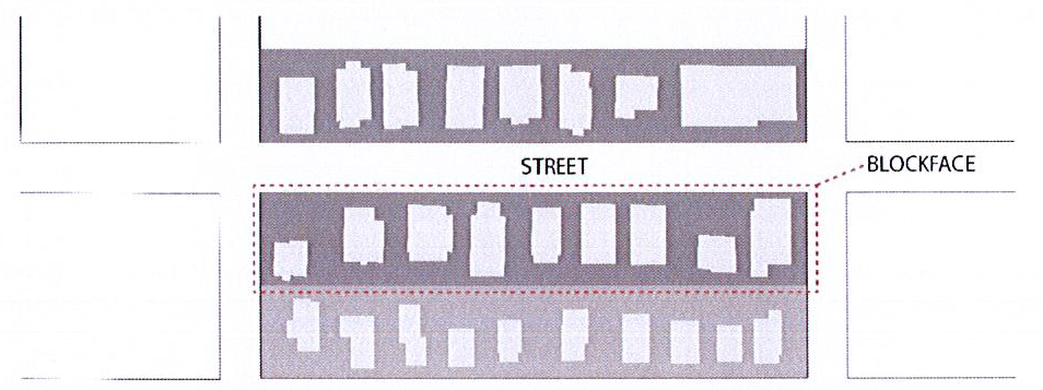
Figure 1: Blockface Example
(1)
Each blockface in the B-1 central business district shall be assigned a designation with specific standards for future development. Blockface designations shall be as indicated in figure 2 below.
(2)
Where a property fronts on more than one blockface designation, the blockface allowing development with greater height or less setback shall be applied to development of the subject property. Any development which has frontage on Main Street, shall have Main Street as the primary facade and primary entrance.
(3)
Each blockface designation shall have defined setback and height requirements as shown in section 1242.03.l(c)(4) below. The blockface designations are:
1.
Central Main Street district (B-1-A): This designation acknowledges the Main Street commercial corridor as a focus of the city's business, historic, and community functions. Regulations respect the pedestrian character of the Main Street corridor, and support renovation and redevelopment of structures in keeping with the area's varied roles in the city.
2.
Mid-Downtown district (B-1-B): This designation seeks to facilitate development in the B-1 district in the central portions of the area, where larger development is appropriate and can be accomplished in keeping with the downtown's overall character and roles in the community.
3.
Downtown transition district (B-1-C): This designation seeks to facilitate development in the B-1 district near single-family residential uses, and to mitigate potential adverse impacts on those residential areas.
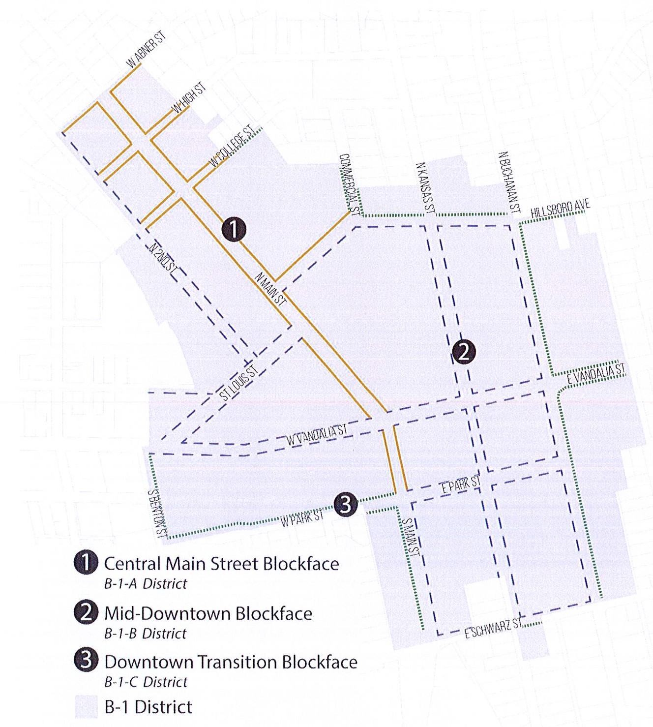
Figure 2: B-1 Blockface Designations—This map is conceptual and official blockface
designations are noted on the city's official zoning map.
(c)
Lot and building requirements: Every building erected in the B-1 central business district shall conform to the requirements indicated below:
(1)
Minimum height: Two stories.
(2)
Minimum lot area: None.
(3)
Minimum lot width: Twenty-five feet at the established building line.
(4)
Blockface bulk standards:
i.
Central Main Street (B-1-A):
a.
Maximum height: Five stories, not to exceed 65 feet. Any story above the 3rd shall be setback a minimum of 25 feet.
b.
Setback:
1.
Front yard: Structures shall be built to front property line.
2.
Side yard: N/A.
3.
Rear yard: N/A.
c.
For any building with frontage on Main Street and another roadway, the setback as required in subsection (4)i.a above shall be located facing the Main Street frontage.
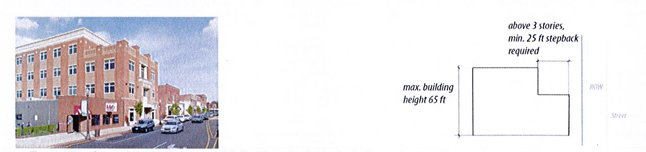
Figure 3: Example of required setback on Main Street above 3rd story
ii.
Mid-Downtown (B-1-B):
a.
Maximum height: Five stories, not to exceed 65 feet. Any new building taller than three stories located in the B-1-B district shall be developed as a PUD when it is adjacent to property zoned R-1 or is located across a right-of-way from property zoned R-1.
b.
Setback:
1.
Front yard: minimum five feet and maximum 20 feet, to accommodate visual relief and enhance pedestrian character with areas such as courtyards, plazas, and seating.
2.
Side yard: N/A.
3.
Rear yard: minimum of 45 feet to accommodate parking and service areas.
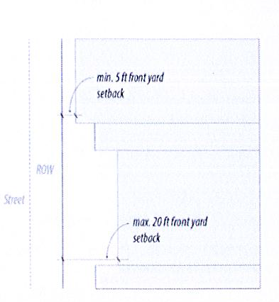
Figure 4: Front yard setback in Downtown Core & Edge
iii.
Downtown transition (B-1-C):
a.
Maximum height: Three stories, not to exceed 40 feet.
b.
Setback:
1.
Front yard: minimum five feet and maximum 20 feet to accommodate visual relief and enhance pedestrian character with areas such as courtyards, plazas, and seating.
2.
Side yard: N/A.
3.
Rear yard: minimum of 15 feet.
(5)
Minimum lot depth: None.
(6)
Maximum floor area ratio: None.
(7)
Maximum percentage of lot building coverage: None.
(d)
Permitted uses: Provided all the use restrictions of this district are observed, the following uses are permitted:
(1)
Banks, savings and loans and other financial institutions.
(2)
Educational institutions.
(3)
Governmental building.
(4)
Libraries.
(5)
Museums.
(6)
Public transit facilities.
(7)
Offices located above the first floor in the B-l-A district, or on any floor in the B-1-B and B-l-C districts.
(8)
Retail establishments.
(9)
Services-Business or personal.
(10)
Theaters (indoors).
(11)
Restaurants/cafes/saloons.
(12)
Dwelling units, located above the first floor.
(e)
Special use: Provided all the use restrictions of this district are observed, the following uses may be allowed by special use permit:
(1)
Automobile service stations.
(2)
Day care center-Children.
(3)
Office, when located on the first floor and part of a site designated as in the B-1-A District, Central Main Blockface.
(4)
Group assembly uses such as religious uses or auditoriums.
(5)
Hotels.
(6)
Parking lot or garage.
(7)
Public utility.
(f)
Drive through facilities: No drive through uses are permitted on a property within the B-1 district. Businesses with drive through lanes in existence prior to November 1, 2024 shall be allowed to remain subject to the following requirements:
(1)
The use shall not be discontinued for more than one year.
(2)
Repairs, maintenance, structural additions and enlargements to the building can be made provided that the use of the drive through is not intensified or enlarged in any way.
(3)
Unsubstantial transfers for a like use shall be permitted subject to compliance with the requirements of this section. However, if the land use changes. the non-conforming drive through shall be discontinued.
(g)
Conditions of use: All uses and structures in this district shall be subject to the following requirements:
(1)
Dwelling units are not permitted on the ground floor.
(2)
Unenclosed activities: Sidewalk dining may be permitted in front of indoor restaurants subject to sidewalk dining license regulations provided in chapter 22 of this Code. Merchandise may be displayed or sold on the sidewalk in front of business establishments subject to sidewalk display/sales permit regulations provided in chapter 22 of this Code.
(3)
Properties developed with parking located between the principal building and front property line shall be approved only as a planned unit development.
(4)
Parking: See section 1250.13 of this title, and the additional regulations in the subsections below.
(5)
Signs: See street graphics control ordinance.
(h)
Development standards: All newly constructed buildings or buildings for which existing total square footage is increased by more than 200 square feet in the B-1 central business district shall be subject to the following development standards. These standards shall be in addition to any otherwise applicable requirements of the development under the Edwardsville City Code, including those subject to zoning entitlement procedures (special use, planned unit development, or zoning amendment) as may be considered by the plan commission and approved by the city council. In any instance where the development standards below conflict with other City Code standards, the more restrictive regulation shall apply, as determined by the zoning administrator.
(1)
Location of parking: No parking may be located on a property in the B-1 district between the principal building and front property line, unless otherwise authorized under this Code.
(2)
Landscaping and screening of parking: See section 1228.01 of this title. In addition to section 1228.01, the following landscaping and screening requirements shall be met. NOTE: The requirements of this section shall apply even in instances where meeting said requirements results in exceeding the minimum landscaping point totals required by section 1228.01.
a.
Any parking spaces abutting a right-of-way shall be screened and located behind a hedge of not less than three feet in height (at time of planting) and creating a solid landscaped screen, designed and installed to minimize views of vehicles from the public way.
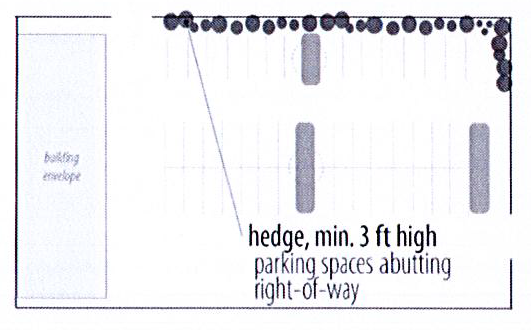
Figure 5: Parking area screening required
b.
The zoning administrator may allow for wrought iron fences or masonry walls to be used in lieu of landscaping if parking areas are limited in size, make landscaping impractical or create adverse impacts on the site or adjacent right-of-way. In no instance shall any landscaping block views of parking area access or drive aisles or create an unsafe driving or walking condition.
c.
Where possible, existing mature trees should remain on site.
d.
Interior landscaping shall be provided and dispersed throughout all parking areas:
i.
A minimum of five percent of the interior parking and drive areas shall be landscaped.
ii.
As part of the landscaped requirement, a landscaped island shall be located at the end of any double row of parking spaces (landscape islands shall be the size of two parking spaces).
iii.
Where any row of parking exceeds 15 spaces, a landscaped island shall be installed.
iv.
Landscape islands as regulated by this subsection shall include two trees and live plant material (ground cover and/or shrubs) covering a minimum of 75 percent of the landscape island ground area.
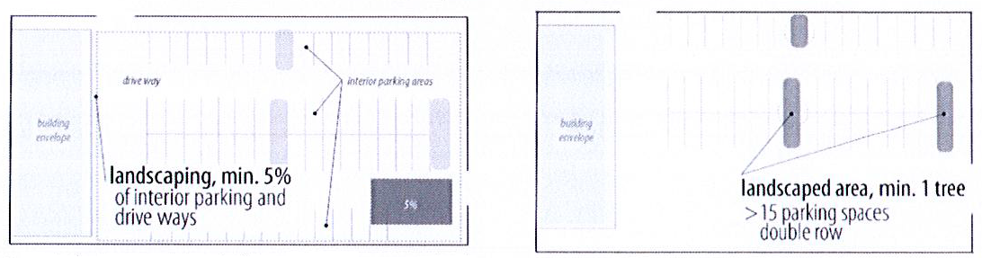
Figure 6: Interior parking lot landscaping required
(3)
Building design and location.
a.
Building massing: Building designs shall have characteristics illustrating a base, middle and top.
b.
Relationship to adjacent buildings: The use of building elements shall, to the extent possible, be used to align with and complement such elements on adjacent buildings. This may include location and size of windows, building stories, columns, awnings, roof details, and other structural and architectural elements.
Figure 7: Example of relating adjacent buildings
i.
Building stories: The stories of a building interior shall be discernable from the exterior of the structure and convey logically proportioned upper floors by use of design elements such as: orientation or spacing of windows, use of moldings, window sills, lintels, brick detailing, or stringcourses, or application of other architectural elements. These design elements shall create a comfortable pedestrian scale at the ground floor of the building as reflected in signage, seating areas, window size, etc.
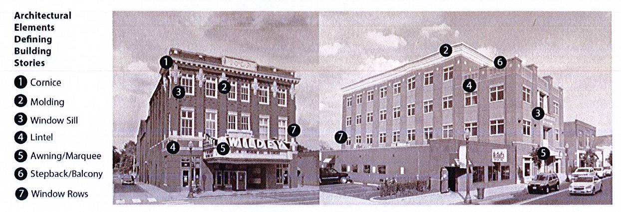
Figure 8: Elements that define building stories
c.
Horizontal building elements: Horizontal building elements are encouraged to create visual interest in a building. Cornices or awnings are examples of such elements that may be used to accomplish this objective.
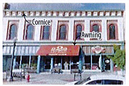
Figure 9: Horizontal Building Elements
d.
Vertical building elements: The use of architectural elements is required to create visual interest, breaks in horizontal areas, and articulation in the building. This may be provided by design elements such as the orientation or spacing of windows, trim located on the building, columns, or application of other architectural features.
e.
Building orientation:
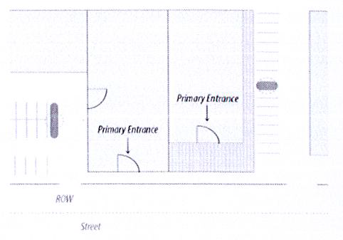
Figure 10: Building oriented to street
i.
Buildings shall be oriented with primary facades toward the front property line.
ii.
The primary entrance of buildings shall be directly from the public sidewalk or prominently visible and accessible from the public sidewalk via a plaza or walkway.
iii.
A secondary building entrance may be located to the side or rear of a building.
f.
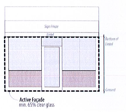
Active facades: Ground floor facades visible from a public sidewalk shall include a minimum of 65 percent clear glass.
g.
Mechanical equipment: Mechanical and utility equipment located on building rooftops or on the ground shall be located or screened so as not to be readily visible by pedestrians on adjacent sidewalks or from a distance.
h.
Where a parking lot is located on the side of a building or between two buildings, and in either condition said buildings have a front yard setback of zero to five feet, use of a design element such a pergola, trellis or decorative fence is encouraged to maintain or represent the street wall characteristic of the blockface.
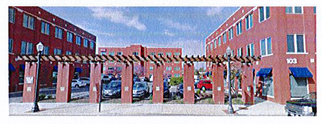
Figure 11: Example of design element at edge of parking area
(4)
Service functions: Buildings should be sited so that portions of the building designed for service uses, such as loading docks and dumpster enclosures, are not readily visible from the street or sidewalk. All refuse generated Figure 12: Active facade by any establishment located within this district shall be stored in tightly-covered containers.
(5)
Screening: Along the side and rear lot lines of any lot abutting any residential district, screening (a wall, solid fence, or closely planted shrubs) at least six feet high and of sufficient density to completely block the view from the adjacent residential property shall be installed.
In the B-1 district, this screening provision may be applied in lieu of some or all of the transitional buffer yard requirement and landscaping standards (section 1228.08) should the zoning administrator find that strict application of section 1228.08 is 1) impractical due to space limitation, given the B-1 setback requirements, and 2) that adequate screening, meeting the intent of section 1228.08, can be provided under the requirements of this subsection.
(Ord. No. 6623-11-19, § 2(Exh. A), 11-5-2019; Ord. No. 6805-12-2024, § 2(Exh. A), 12-3-2024)
1242.03.2 - Commercial/business district (B-2).
This district is intended to accommodate and regulate commercial/business development outside of the central business district (B-1). These typically require direct access to major streets and large lots for off-street parking and loading.
(a)
Use restrictions:
(1)
Uses: These uses shall deal directly with consumers.
(2)
Unenclosed activities: In this district, outside display of inventory is allowable of up to ten percent of the indoor floor space.
(3)
Refuse containers: All refuse generated by facilities located within this district shall be stored in tightly covered containers and placed in visually screened areas.
(4)
Screening: Along the side and rear lot lines of any lot abutting any residential district, screening (a wall, solid fence, or closely planted shrubbery) at least six feet high and of sufficient density to completely block the view from the adjacent residential property shall be installed.
(5)
Parking: See section 1250.13 of this title.
(6)
Signs: See chapter 94 of this Code.
(b)
Lot and building requirements: Every principal building erected in this district shall conform to the requirements indicated below:
(1)
Minimum lot size: 15,000 square feet.
(2)
Minimum lot width: 100 feet at the established building line.
(3)
Minimum setbacks:
Front yard setback: 50 feet.
Side yards: 25 feet.
Rear yard setback: 25 feet.
(4)
Maximum floor area ratio: Two square feet of floor space for each one square foot of lot area.
(5)
Maximum percentage of lot building coverage: 50 percent.
(c)
Permitted uses: Provided all the use restrictions of this district are observed, the following uses are permitted:
(1)
Auditoriums, meeting rooms, and other places of assembly.
(2)
Banks, savings and loans and other financial institutions.
(3)
Clubs and lodges.
(4)
Commercial establishments.
(5)
Libraries, museums.
(6)
Mass transit facilities.
(7)
Offices.
(8)
Printing and publishing.
(9)
Restaurants/saloons.
(10)
Retail, commercial and wholesale when used in connection with retail.
(11)
Schools, music studios, dance studios.
(12)
Service establishments.
(13)
Theaters (indoors).
(14)
Adult-use cannabis dispensing organizations.
(d)
Special uses:
(1)
Any use that involves commercial, service or storage activities conducted more than 25 percent outside a completely enclosed building.
(2)
Any use such as, but not limited to, drive-in restaurants, drive-in banks, service stations that offer goods or services directly to customers waiting in parked vehicles, or that sell food or beverages for consumption on the premises in parked motor vehicles.
(3)
Dwelling units, if located above the first story, except in hotels and motels.
(4)
Public utility.
(5)
Auto: New and/or used car lots.
(6)
Warehouses.
(7)
Bus terminals and/or mass transit facilities.
(8)
Car washes using mechanical, blowers or other conveyance means.
(9)
Churches or other places of worship.
(Ord. No. 6625-11-19, § 4, 11-19-2019)
1242.03.3 - Downtown mixed-use district (MU-1).
(a)
Purpose statement:
(1)
The downtown mixed use district (MU-1) represents a transition area where residential and commercial uses are integrated. Density is recognized as key to supporting the businesses in both this district and nearby central business district (B-1). While walkability and bikeability are key components of this transition area, the use of automobiles is also acknowledged. Although the MU-1 district aims to maintain and enhance the character of existing neighborhoods, the standards set forth in this section will also facilitate redevelopment at a scale and intensity consistent with surrounding areas.
(b)
Lot and building requirements. All lots located within the MU-1 district shall conform to the requirements below, dependent on their use.
(1)
Lots used only for residential uses:
A.
Minimum lot area—Five thousand square feet.
B.
Maximum lot area—One acre; developments over one acre may be permitted as planned unit development.
C.
Front setback:
i.
Minimum—None.
ii.
Maximum—Fifteen feet.
D.
Side setbacks—Side setbacks may vary, provided the principal structure width is a minimum of 60 percent of the lot width and a maximum of 80 pecent of the lot width.
E.
Minimum rear setback—Thirty feet.
F.
Maximum lot coverage—Thirty-six percent.
G.
Maximum building height—Thirty-six feet.
H.
Density—Fourteen units per acre or 3,111 square feet of lot area required per unit.
(2)
Lots used for only business/commercial uses.
A.
Minimum lot area—None.
B.
Maximum lot area—One acre; developments over one acre may be permitted as a planned unit development.
C.
Front setback.
i.
Minimum—None.
ii.
Maximum—Fifteen feet.
D.
Side setbacks—Side setbacks may vary, provided the principal structure width is a minimum of 60 percent of the lot width and a maximum of 80 percent of the lot width.
E.
Minimum rear setback—Forty-five feet.
F.
Maximum lot coverage—Fifty percent.
G.
Maximum building height—Thirty-six feet.
(3)
Lots used for mixed-use:
A.
Minimum lot area—Seven thousand five hundred square feet.
B.
Maximum lot area—One acre; developments over one acre may be permitted as a planned unit development.
C.
Front setback:
i.
Minimum—None.
ii.
Maximum—Fifteen feet.
D.
Side setback—Side setbacks may vary, provided the principal structure width is a minimum of 60 percent of the lot width and a maximum of 80 percent of the lot width.
E.
Minimum rear setback—Forty-five feet.
F.
Maximum lot coverage—Fifty percent.
G.
Maximum building height—Thirty-six feet.
H.
Density—Fourteen units per acre or 3,111 square feet of lot area required per dwelling unit.
(c)
Permitted uses:
(1)
Detached single-family dwellings.
(2)
Townhomes.
(3)
Dwelling units located above the first floor.
(4)
Retail establishments.
(5)
Art studios and artisan production under 3,000 square feet in area and which occur indoors only.
(6)
Art galleries.
(7)
Restaurants without a drive-through.
(8)
Services—Business or personal.
(9)
Health clubs, gyms, and spas.
(10)
Medical offices 4,000 square feet or smaller.
(d)
Special uses:
(1)
Dwelling units located on the first floor of a multi-story building.
(2)
Multiple-family dwellings.
(3)
Hotels.
(4)
Adult and child daycare.
(5)
Art studios over 3,000 square feet in area or any part of which takes place outdoors.
(6)
Nursing homes, skilled care facilities, assisted living, and independent living facilities.
(7)
Pet grooming and pet shops.
(8)
Educational institutions, trade and business schools (limited to 15,000 square feet).
(9)
Group assembly uses such as religious uses or auditoriums.
(10)
Tavern, saloon, or lounge.
(11)
Automotive service stations.
(12)
Medical offices 4,000 square feet or larger.
(e)
Conditions of use:
(1)
Bicycle/pedestrian accommodation—For lots where ten or more parking spaces are provided, bicycle parking shall be provided at a rate of 0.2 bicycle parking spaces per automobile parking space, up to maximum of ten required bicycle parking spaces.
(2)
Drive-through facilities—No drive through facilities shall be permitted in the MU-1 district.
(3)
Active facade—Newly constructed buildings which are commercial only or mixed use, shall also provide a minimum of 65 percent clear glass on any street-facing first-floor facade. Existing structures shall not decrease the amount of clear glass that exists on the building.
(4)
Unenclosed activities—Sidewalk dining shall be permitted subject to restrictions set forth in Chapter 22 of the Codified Ordinances of the City of Edwardsville.
(5)
Screening: Along the side and rear lot lines of any lot abutting any residential district, screening (a wall, solid fence, or closely planted shrubbery) at least six feet high and of sufficient density to completely block the view from the adjacent residential property shall be installed.
A.
In the MU-1 district, this screening provision may be applied in lieu of some or all of the transitional buffer yard requirement and landscaping standards (section 1228.08) should the zoning administrator find that strict application of section 1228.08 is (1) impractical due to space limitation, given the MU-1 setback requirements, and (2) that adequate screening, meeting the intent of section 1228.08, can be provided under the requirements of this subsection.
B.
Lots used solely for single-family residential dwellings shall be exempt from this requirement.
(6)
Principal buildings per lot—In the MU-1 district, only one principal building shall be permitted per lot, unless otherwise approved as a planned unit development
(7)
Parking standards.
A.
Parking location.
i.
No parking may be located on a property in the MU-1 district between the front property line and the principal building, unless otherwise authorized by this Code.
ii.
For lots where parking exists in the front yard, this parking may remain, provided no additional parking is added in the front yard. Any additional parking shall be in the rear yard or side yard, as required in subsection (5)(G).
B.
Landscaping and screening of parking.
i.
Any parking spaces abutting a right-of-way shall be screened and located behind a hedge of not less than three feet in height, designed and installed to minimize views of vehicles from the public way.
ii.
The zoning administrator may allow for fences or walls to be used in lieu of landscaping if parking areas are limited in size, making landscaping impractical or creating adverse impacts on the site or adjacent right-of-way.
C.
Access to parking.
i.
Access to parking shall be provided via a drive aisle that is a minimum of 20-feet wide and a maximum of 24-feet wide for bi-directional traffic. For one-way traffic, a drive aisle that is a minimum of 12 feet wide shall be required.
D.
Number of spaces required.
i.
All properties in the MU-1 district shall meet the requirements set forth in the section 1250.13(r), "number of spaces required."
(Ord. No. 6623-11-19, § 2(Exh. B), 11-5-2019)
1242.04 - Light manufacturing (M-1).
(a)
Description:
(1)
Manufacturing land usage: The intent is to establish a single distinctly separate manufacturing classification within the city. The designation shall be M-1 light manufacturing district.
(2)
Purpose: The purpose of this district is to provide areas within the community where manufacturing facilities, research facilities, research parks, warehouses, and wholesale businesses may locate, while providing compatibility with other nonmanufacturing areas of the community. It is intended that this particular district will generally provide for manufacturing of an assembly nature from finished goods, warehousing and wholesale activities. Supportive services for manufacturing are generally of a nonretail or personal service character and should be encouraged to locate in this district.
(b)
Use restrictions: All permitted uses are subject to the following conditions:
(1)
Performance standards: Any production, processing, cleaning, servicing, testing, repair or storage of goods, materials or products shall conform with the performance standards set forth in section 1250.09 of this title.
(2)
Enclosed buildings: All business, production, servicing and processing shall take place within completely enclosed buildings. Storage may be outdoors if storage area is completely enclosed by a solid wall or fence (including doors and gates) at least eight feet high.
(3)
Parking: See section 1250.13 of this title.
(4)
Signs: See chapter 94.
(c)
Lot and building requirements: Every building erected in the M-1 light manufacturing/industrial district shall conform to the requirements indicated below:
(1)
Minimum lot area: None.
(2)
Minimum lot width: None.
(3)
Minimum lot depth: None.
(4)
Minimum setbacks:
Rear yard: None.
(5)
Maximum floor area ratio: One and one-half square feet of floor space for each one square foot of lot area.
(6)
Maximum percentage of lot building coverage: None.
(d)
Permitted uses: Provided all the use restrictions of this district are observed the following uses are permitted:
(1)
Assembly, production, processing, wholesaling or warehousing, or manufacturing of any commodity from semi-finished (other than raw) materials, provided explosives, flammable materials, nuclear or hazardous materials, or livestock are not involved.
(2)
Research and development facilities or parks, provided explosives, flammable materials, nuclear or hazardous materials, or livestock are not involved.
(3)
Local cartage and express facilities.
(4)
Freight terminals.
(5)
Intermodal terminal facilities (IMT). The IMT use shall include, but not be limited to, the transfer of trailers, bogies, containers and chassis ("intermodal equipment") between highway and rail transportation modes as well as the use of other equipment related thereto; the assembly and disassembly of intermodal equipment; the handling of intermodal equipment between rail and highway modes; the parking and storage (including overnight storage) of intermodal equipment and road tractors; the storage of items transported in intermodal equipment; the performance of repairs and maintenance to intermodal equipment and transfer equipment; and the switching and storage of railroad cars.
(6)
Reserved.
(7)
Adult-use cannabis craft grower organization.
(8)
Adult-use cannabis dispensing organization.
(9)
Adult-use cannabis infuser organization.
(10)
Adult-use cannabis processing organization.
(11)
Adult-use cannabis transporting organization.
(e)
Special uses: Provided all the use restrictions of this district are observed the following uses are permitted:
(1)
Assembly, production, processing, wholesaling or warehousing, or manufacturing of any commodity involving raw materials.
(2)
Research and development facilities or parks involving explosives, flammable materials, nuclear or hazardous materials, or livestock.
(3)
Fuel sales and storage.
(4)
Junkyards.
(5)
Wastewater/sewage treatment facilities.
(6)
Adult businesses.
(7)
Public utility.
(8)
Wind energy systems.
(9)
Any other use not specifically permitted.
(Ord. No. 6103-5-19, § 2C, 5-21-2019; Ord. No. 6625-11-19, § 5, 11-19-2019; Ord. No. 6715-12-2021, § 2, 12-21-21)
1242.05 - Institutional and public service district (IP).
(a)
Public service land usage: The intent is to establish a single city-wide overlay district encompassing all zoning districts. This classification shall be: IP institutional and public service district.
(b)
Description: An overlay district intended to delineate areas which are designated for public use.
(c)
Use restrictions:
(1)
Uses: These uses shall be owned by a public taxing unit.
(2)
Residential district: Public facilities in residential districts shall have the following restrictions:
A.
Minimum yard requirement is 25 feet for side, front and rear yards.
B.
Lighting must be shielded from glare onto adjoining residential lots and dwellings.
C.
Landscaping screening is required.
D.
Refuse containers should be screened per requirement under section 98-5(d) of this title.
E.
Parking: See section 1250.13 of this title.
F.
Signs: See chapter 94.
(d)
Lots and building requirements: Every building erected in this district shall conform to the requirements indicated below.
(e)
Permitted uses:
(1)
Municipal facilities.
(2)
County government facilities.
(3)
State government facilities.
(4)
Schools.
(5)
Parks (publicly owned).
(6)
Any taxing district facility.
(f)
Special uses: None.
1242.06 - Floodplain (FP).
(a)
Floodplain land usage: The intent is to establish a single overlay district encompassing all zoning districts as appropriate. The designation shall be: FP floodplain overlay district.
(b)
Description:
(1)
The FP floodplain overlay district delineates areas subject to periodic flooding. In the absence of flood protection measures, these areas are subject to periodic flooding which may result in injury to or loss of life and property, disruption of private and governmental services, impairment of the municipal tax base, and the need for extraordinary relief measures. The regulations of this section are intended to restrict permitted development in floodplains to: 1) uses which inherently have low flood damage potential; and 2) other uses allowed in zoning districts provided appropriate protective measures have been taken.
(2)
This overlay district has no effect on the classification (whether permitted, special or prohibited) of uses in zoning districts. Rather, this overlay imposes additional restrictions on both permitted and special uses.
(c)
Purpose: This chapter is enacted pursuant to the powers of this city by 65 Illinois Compiled Statutes, 5/1-2-1, 5/11-12-12, 5/11-30-2, 5/11-30-8 and 5/11-31-2, in order to accomplish the following purposes:
(1)
To prevent development from increasing the flood or drainage hazards to others;
(2)
To protect new buildings and major improvements to buildings from flood damage;
(3)
To protect human life and health from the hazards of flooding;
(4)
To lessen the burden on the taxpayer for flood control projects, repairs to flood-damaged public facilities and utilities and flood rescue and relief operations;
(5)
To maintain property values and a stable tax base by minimizing the potential for creating flood blighted areas;
(6)
To make federally-subsidized insurance available for property in the city; and
(7)
To provide for the orderly growth and development that is especially sensitive to changes for human activity.
1242.06.1 - Definitions.
For the purposes of this chapter, the following definitions are adopted:
Base flood: The flood having a one percent probability of being equaled or exceeding in any given year. The base flood is also known as the 100-year flood. The base flood elevation at any location is as defined in this chapter.
Building: A structure that is principally above ground and is enclosed by walls and a roof. The term includes a gas or liquid storage tank in order that such tanks will be constructed to the same flood damage protection standards. The term includes a mobile home or prefabricated building which is affixed on a permanent site and connected to the required utilities. The term does not include recreational vehicles or travel trailers.
Development:
(a)
Any man-made change to real estate, including:
(1)
Construction, reconstruction or placement of a building or an addition to a building valued at more than $1,000.00;
(2)
Drilling, mining, installing utilities or facilities, construction of roads, bridges or similar projects valued at more than $1,000.00;
(3)
Construction or erection of levees, walls or fences;
(4)
Filling, dredging, grading, excavating or other nonagricultural alteration of the ground surface;
(5)
Storage of materials; or
(6)
Any other activity that might change the direction, height or velocity of flood or surface waters.
(b)
Development does not include:
(1)
Maintenance of existing buildings and facilities such as reroofing buildings or resurfacing roads;
(2)
Repairs made to a damaged building that do not change the building's exterior dimensions and that are valued at less than 50 percent of the value of the building before the damage occurred; or
(3)
Gardening, plowing and similar agricultural practices that do not involve filling, grading or construction of levees.
FPE: Flood protection elevation; that elevation located beneath the lowest elevated floor of an elevated residential building, where all electrical, plumbing, ventilating, heating and air conditioning equipment, related ductwork, and utility meters shall be located at or above said FPE (flood protection elevation).
Flood: A general and temporary condition of inundation of normally dry land areas from the overflow, the unusual and rapid accumulation, or runoff of surface waters from any source.
Floodway: That portion of the SFHA (special flood hazard area) required to store and convey the base flood. If not prohibited, building or placing obstructions in a floodway will increase flood damage to other properties.
Riverine SFHA: Any SFHA subject to flooding from a river, creek, intermittent stream, ditch, or any other identified channel. This term does not include areas subject to flooding from lakes (except public bodies of water), ponding areas, areas of sheet flow, or other areas not subject to overbank flooding.
SFHA or special flood hazard area: Lands within the jurisdiction of the city that are subject to inundation by the base flood. The SFHAs of the city are generally identified as such on the flood insurance rate map of the city prepared by the Federal Emergency Management Agency and dated May 1, 1979, and/or as revised.
1242.06.2 - Base flood elevation.
This chapter's protection standard is the base flood according to the best data available to the Illinois State Water Survey's floodplain repository. Whenever a party disagrees with the best available data, he/she may finance the detailed engineering study needed to replace the existing data with the better data and submit to the Illinois State Water Survey.
(a)
The base flood elevation of the SFHAs of Cahokia Creek, Dunlap Lake and Mooney Creek shall be as delineated on the 100-year flood profiles in the flood insurance administration and dated July 18, 1983.
(b)
The base flood elevation for each of the remaining SFHAs delineated as an "A Zone" on the flood insurance rate map shall be the 100-year flood depth calculated according to the formulas presented in "Depth and Frequency of Floods in Illinois", published by the U.S. Geological Survey 1979, as amended.
1242.06.3 - Development permit.
No person, firm, corporation or other governmental body not exempted by law, shall commence any development in the SFHA without first obtaining a development permit from the zoning administrator. The zoning administrator shall not issue a development permit if the proposed development does not meet the requirements of this chapter.
(a)
Application for a development permit shall be made on a form provided by the zoning administrator. The application shall be accompanied by drawings of the site, drawn to scale showing the property line, dimensions, and:
(1)
Existing grade elevations and all changes in grade resulting from excavation or filling;
(2)
The direction of flow or surface drainage and flood flows;
(3)
The location of all watercourses and drainage facilities;
(4)
The location and dimensions of all buildings and additions to buildings; and
(5)
The elevation of the lowest floor (including basement) of all buildings subject to the requirements of this chapter.
(b)
Upon receipt of an application for a development permit, the zoning administrator shall compare the elevation of the site to the base flood elevation. Any development located on land higher than the base flood elevation is not in the SFHA and therefore not subject to the requirements of this chapter.
(c)
The zoning administrator shall inform the applicant of any and all other local, state and federal permits that may be required for this type of development activity. The development permit will only be issued on the condition that the other specified permits be obtained. The zoning administrator shall not issue a certificate of compliance unless all required permits have been obtained.
1242.06.4 - Preventing increased damages.
No development shall create a damaging or potentially damaging increase in flood heights or velocity or threat to the public health and safety.
(a)
For development proposals located in an identified floodway or within a riverine SFHA where the floodway has not yet been identified, the following rule shall apply: The zoning administrator shall review the development plans to discern if:
(1)
A new obstruction to flood flows would be created;
(2)
The project will involve a channel crossing such as a bridge or pipeline; or
(3)
The project will modify the shape of the channel.
1242.06.5 - Protecting buildings.
(a)
In addition to the damage prevention requirements of this chapter, all buildings to be located in the SFHA shall be protected from flood damage below the FPE. This building protection requirement applies to the following situations:
(1)
Construction or placement of a new building valued at more than $1,000.00;
(2)
Improvements made to an existing building that increase the first floor area by more than 20 percent;
(3)
Reconstruction or repairs made to a damaged building that are valued at or more than 50 percent of the value of the building before the damage occurred; and
(4)
Installing a mobile home on a new site or a new mobile home on an existing site. This building protection requirement does not apply to returning a mobile home to the same site as it formerly lawfully occupied.
(b)
The building protection requirements may be met by any one of the following methods:
(1)
A building may be constructed on permanent landfill in accordance with the following:
A.
The area to be filled shall be cleared of all standing trees, brush, down timber, trash and other growth or object unsuitable for use as foundation material.
B.
The fill shall be placed in layers no greater than one foot deep before compaction.
C.
The surface of the fill shall be at or above the FPE. The fill shall extend at least ten feet beyond the foundation of the building before sloping below the FPE.
D.
The fill shall be protected against erosion and scour during flooding by vegetative cover, riprap or bulk-heading. If vegetative cover is used, the slopes shall be no steeper than four horizontal to one cover (4:1).
E.
The fill shall not adversely affect the flow of surface drainage from or onto neighboring properties.
F.
The bottom or the lowest floor, including joists, if any, and all utility meters shall be located at or above the FPE.
G.
The zoning administrator shall maintain a record of the "as built" elevation of the lowest floor of the building.
(2)
A building may be elevated in accordance with the following:
A.
The building or improvements shall be elevated on stilts, piles, walls, crawl space or other foundation that is permanently open to flood waters and not subject to damage by hydrostatic pressures.
B.
The foundation and supporting members shall be anchored, shaped and aligned so as to minimize exposure to known hydrodynamic forces such as current, waves and floating debris.
C.
All mobile homes to be placed within an A zone on the flood insurance rate map shall be anchored to resist flotation, collapse or lateral movement by providing over the top and frame ties to ground anchors. Specific requirement shall be that:
1.
Over-the-top ties be provided at each of the four corners of the mobile home, with two additional ties per side at intermediate locations and mobiles homes less than 50 feet long requiring one additional tie per side.
2.
Frame ties be provided at each corner of the home with five additional ties per side at intermediates points and mobile homes less than 50 feet long requiring four additional ties per side.
3.
All components of the anchoring system be capable of caring a force of 4,800 pounds; and
4.
Any additions to the mobile home be similarly anchored.
D.
All areas below the FPE shall be constructed of materials resistant to flood damage. The bottom of the lowest floor or floor joists, if any, and all utility meters shall be located at or above the FPE.
E.
The zoning administrator shall maintain a record of the "as built" elevation of the lowest floor.
F.
No area below the FPE shall be used for storage of items or materials subject to flood damage unless such items or materials are declared "property not covered" by a standard flood insurance program.
G.
Any future alteration of the area below the FPE that violates the requirements of this section shall be deemed a violation of this chapter. The zoning administrator shall inform the applicant that any such alteration is considered a willful act to increase flood damages and therefore will cause coverage by a standard flood insurance policy be suspended.
(3)
A nonresidential building may be flood-proofed in accordance with the following:
A.
A registered professional engineer shall certify that the building has been designed so that below the FPE, the structure and attendant utility facilities are watertight and capable of resisting the effects of the base flood. The building design shall take into account flood velocities, duration, rate of rise, hydrostatic and hydrodynamic forces, the effects of buoyancy and impacts from debris or ice.
B.
Flood-proofing measures shall be operable without human intervention and without an outside source of electricity.
C.
The zoning administrator shall maintain the engineer's certificate and a record of the "as built" elevation to which the building was flood-proofed.
1242.06.6 - Other development requirements.
The city council shall take into account flood hazards, to the extent that they are known, in all official actions related to land management, use and development.
(a)
The city council shall not approve any annexation agreement or plat of subdivision located outside the corporate limits unless such agreement or plat is in accordance with the provisions of this chapter. The zoning administrator shall obtain the best available SFHA maps and date for the unincorporated areas.
(b)
New subdivisions, mobile home parks and planned unit developments (PUDs) shall meet the requirements of chapters 1244 and 1246 of this title. Plats or plans for new subdivisions, mobile home parks and planned unit developments (PUDs) shall include a signed statement by a registered professional engineer that the plat or plans account for changes in the drainage or surface water in accordance with the Plat Act, 765 Illinois Compiles Statutes, 205/2.
(c)
Plats or plans for new subdivisions, mobile home parks and planned unit developments (PUDs) shall display the following flood data:
(1)
The boundary of the SFHA;
(2)
The boundary of the floodway, as shown on available SFHA maps;
(3)
Easements of land dedicated to the city for access for channel maintenance purposes; and
(4)
The FPE for each building site. Where the base flood elevation is not available from an existing study filed with the Illinois State Water Survey, the applicant shall be responsible for calculating the FPE and submitting it to the state water survey for review and approval as best available elevation data.
(d)
Plans for the development activities to be undertaken by the city in the SFHA shall be reviewed by the zoning administrator to ensure that they comply with this chapter. Except as exempted by law, no other local government shall commence any development activity in the SFHA without first obtaining a development permit from the zoning administrator.
(e)
The city plan commission shall take the following into consideration when preparing or revising the comprehensive plan, community development program, housing assistance plan or other land use or development programs:
(1)
Preserving SFHA land for open space uses such as farming or recreation;
(2)
Acquiring and removing frequently flooded buildings;
(3)
Prohibiting hospitals, water treatment plants, natural gas storage and other critical or especially hazardous facilities from locating in the SFHA;
(4)
Identify the elevation of the base flood and past floods at entrances to public buildings, on street signs or other prominent locations; and
(5)
Other flood hazard mitigation or floodplain management activities that could help accomplish purposes of this chapter.
1242.06.7 - Variance.
Whenever the standards of this chapter place undue hardship on a specific development proposal, the applicant may apply to the zoning board of appeals for a variance. The zoning board of appeals shall review the applicant's request for a variance and act upon same.
(a)
No variance shall be granted unless the applicant demonstrates that:
(1)
The development activity cannot be located outside the SFHA;
(2)
A substantial economic hardship would result if the variance were not granted;
(3)
The relief requested is the minimum necessary;
(4)
There will be no additional threat to public health or safety or creation of a nuisance;
(5)
There will be no additional public expense for flood protection, rescue or relief operations, policing or repairs to road, utilities or other public facilities; and
(6)
The provisions of this chapter can still be met.
(b)
The zoning administrator shall notify an applicant in writing that a variance from these requirements would lessen the degree of protection to a building and will:
(1)
Result in increased premium rates for flood insurance up to amounts as high as $25.00 for $100.00 of insurance coverage;
(2)
Increase the risks of life and property; and
(3)
Require that the applicant proceed with knowledge of these risks and that he/she will acknowledge in writing that he/she assumes the risk and liability.
(c)
A variance from the requirements of this chapter may be granted to permit a "wet flood-proofed" building, that is; a building to be intentionally flooded during a flood, provided:
(1)
No part of such a building below the FPE may be subject to flood damage;
(2)
The variance shall be conditioned on the contents being:
A.
Of materials resistant to flood damage;
B.
Items declared "property not covered" by a standard flood insurance policy of the National Insurance Program;
C.
Readily movable to a place of protection during a flood, provided there will be personnel available and adequate warning.
(3)
Any future alteration of the area below the FPE that violates the conditions of the variance shall be deemed a violation of this chapter. The zoning administrator shall inform the applicant that any such alteration is considered a willful act to increase flood damages and therefore will cause coverage by a standard flood insurance policy be suspended.
(d)
Variance requested in connection with restoration of a site or building documented as worthy of preservation by the Illinois Department of Conservation may be granted by using criteria more permissive than the requirements of this section.
1242.06.8 - Disclaimer of liability.
The degree of flood protection required by this chapter is considered reasonable for regulatory purposes and is based on available information derived from engineering and scientific methods of study. Larger floods may occur or flood height may be increased by man-made or natural causes. This chapter does not imply that development either inside or outside of the SFHA will be free from flooding or damage. This chapter does not create liability on the part of the city or any officer or employee thereof for any flood damage that results from reliance on this chapter or any administrative decision made lawfully thereunder.
(a)
Flood letter notification and responses:
(1)
Inquiries: Requests for flood letters are directed by the city planning and zoning offices.
(2)
Responses: Responses to inquiries are generated via letter to the requester and should contain a certification that such property is or is not within a floodplain, referencing the latest floodplain map available.
(b)
Fees: Such certifications and response as sent by the appropriate office to the requester of the letter requires a $25.00 charge for each inquiry.
1242.06.9 - Penalty.
The zoning administrator may determine upon due investigation that a violation of the minimum standards of this section exist and after such owner fails after ten days' notice to correct his property, the city may make application to the circuit court for an injunction requiring conformance and secure compliance with this section. Any person who violates this section shall upon conviction thereof, be fined not less than $25.00 nor more than $500.00. A separate offense shall be deemed committed each day during or on which a violation occurs or continues. Failure to comply with the requirements of a permit or conditions of a variance shall be deemed to be a violation of this section. Nothing herein shall prevent the city from taking such other lawful action to prevent or remedy any violations. All costs connected therewith shall accrue to the person or persons responsible.
1242.06.10 - Abrogation and greater restrictions.
This chapter is not intended to repeal, abrogate or impair any existing easements, covenants or deed restrictions. However, where this chapter and other ordinance, easement, covenant or deed restriction conflict or overlap, whichever imposes the more stringent restrictions shall prevail.
1242.06.11 - Participation in flood insurance program.
Pursuant to the legal authority to adopt land use control measures to reduce future flood losses set out in 65 Illinois Compiled Statutes 5/11-13-1 and 5/11-30-2, it is the intent of the city council to require the recognition and evaluation of flood hazards in all official actions relating to land use in the floodplain areas having special flood hazards. The city therefore:
(a)
Assures the administrator of the Federal Insurance Administration that it will enact as necessary, and maintain in force for those areas having flood hazards, adequate land use and control measures with effective enforcement provisions consistent with the criteria set forth in section 1910 and of the National Flood Insurance Program Rules and Regulations.
(b)
Vests the mayor with the responsibility, authority and means to:
(1)
Delineate or assist with such information as the administrator may request concerning present uses and occupancy of floodplain areas.
(2)
Provide such information as the administrator may request concerning present uses and occupancy of floodplain areas.
(3)
Cooperate with federal, state and local agencies and private firms which undertake to study, survey, map and identify floodplain areas, and cooperate with neighboring communities with respect to management of adjoining floodplain areas, in order to prevent aggravation of existing hazards.
(4)
Upon occurrence, notify the administrator in writing whenever the boundaries of the community have been modified by annexation or the community has otherwise assumed or no longer has authority to adopt and enforce floodplain management regulations for a particular area. In order that all flood insurance rate maps accurately represent the community's boundaries, include within such notification a copy of a map of the community suitable for reproduction, clearly delineating the new corporate limits or a new area from which the community has assumed or relinquished floodplain management regulatory authority.
(5)
Submit an annual report to the administrator on the progress made during the past year within the community in the development and implementation of floodplain manage
ment measures, including all variances issued in flood hazard areas.
(c)
Appoints the zoning administrator to maintain for public inspection and furnish upon request, for the determination of applicable flood insurance risk premium rates within all areas having special flood hazards identified on a flood insurance rate map, any certificates of floodproofing and information on the elevation, in relation to mean sea level, of the level of the lowest habitable floor, including basement, of all new or substantially improved structures, and include whether or not such structures contain a basement, and if the structure has been floodproofed, the elevation in relation to the mean sea level, to which the structure was floodproofed.
(d)
Agrees to take such official actions as may be reasonably necessary to carry out the objectives of the program.
1242.07 - Enterprise zone.
(a)
Description: The area precisely described in Exhibit "A", as amended, on file in the city clerk's office and hereby made a part hereof as if fully set out herein, is hereby designated an enterprise zone pursuant to and in accordance with the "Illinois Enterprise Zone Act of 1982", (hereinafter referred to as "Act") and the "Southwestern Illinois Development Authority Act" (hereinafter referred to as "SWIDA").
(b)
Qualifications: The city hereby declares and affirms that the zone area is qualified for designation as an enterprise zone in accordance with the provisions of the Act and the Southwestern Illinois Development Authority Act, and further affirms the following:
(1)
That the zone area is a contiguous area;
(2)
That the zone area comprises a minimum of one-half of a square mile, and is not more than 12 square miles in total area;
(3)
That the zone area is a depressed area;
(4)
That the zone area satisfies any additional criteria established by Illinois Department of Commerce and Community Affairs, (hereinafter referred to as "IDCCA");
(5)
That on the sixth and eleventh days of August 1997, public hearings were conducted within the zone area on the question of whether to create the zone, what local plans, tax incentives and other programs should be established in connection with the zone, and what the boundaries of the zone should be;
(6)
That public notice was given in at least one newspaper of general circulation within the zone area, not more than 20 days nor less than five days before the above mentioned public hearing;
(7)
That the zone area addresses a reasonable need to encompass portions of more than one municipality and an unincorporated area of a county;
(8)
That the zone area is located within the southeastern portion of Chouteau Township and/or the southwestern portion of Edwardsville Township along FAR 310.
(c)
Enterprise zone designation: The area described in subsection (a) of this section is hereby designated as an enterprise zone, subject to the approval of IDCCA and the Southwestern Illinois Development Authority, in accordance with state law.
(d)
Term and effect: The term of the zone shall commence with the date the enterprise zone is approved and certified by the Illinois Department of Commerce and Community Affairs and shall be in effect for 20 calendar years and shall terminate at 12:00 midnight of December 31 of the final calendar year of the certified term.
(e)
Name of the zone: The name of said enterprise zone shall be "Gateway Commerce Center Enterprise Zone".
(f)
Sales tax exemptions: Pursuant to 35 Illinois Compiled Statues 120/5k, as amended, each retailer whose place of business is within the unincorporated area of Madison County or the corporate limits of the city or the Village of Pontoon Beach and who makes a sale of building materials to be incorporated into real estate located in the zone area by remodeling, rehabilitation or new construction, may deduct receipts from such sales when calculating the tax imposed by the Retailers' Occupation Tax Act.
(g)
Property tax abatement: Pursuant to 35 Illinois Compiled Statutes 200/18-170, as amended, the city council authorizes and directs the Madison County Clerk to abate ad valorem taxes imposed upon real property, located within the enterprise zone area, upon which new improvements have been constructed or upon which existing improvements have been renovated or rehabilitated, subject to the following conditions:
(1)
That the improvements or renovations are of the scope and nature for which a building permit is required and has been obtained;
(2)
That any abatement of taxes on any parcel shall not exceed the amount attributable to the construction of the improvements and the renovation or rehabilitation of existing improvements on such parcel;
(3)
That such abatement shall be allowed only for commercial, industrial or manufacturing property located within the zone area; provided, however that no such abatement shall be applicable to any enterprise zone property located within the boundaries of a tax increment financing district;
(4)
That such abatement shall be at the rate of 100 percent of the value of the improvements, for the first assessment year in which the improvements are fully assessed, and the six assessment years immediately following the year in which the improvements were fully assessed; 70 percent of the value of the improvements on the seventh year following the year in which the improvement were fully assessed; 40 percent of the value of the improvements on the eighth year following the year in which the improvements were fully assessed; and ten percent of the value of the improvements on the ninth year following the year in which the improvements were fully assessed; and in the tenth year following the year in which the improvements were fully assessed, the county clerk will no longer abate ad valorem taxes on the improvements; and
(5)
That such abatement shall continue and be in full force as set forth in this section for any improvements that are completed within the term of the enterprise zone as specified in subsection (d) of this section.
(h)
Zone management: Upon designation as an enterprise zone by the Illinois Department of Commerce and Community Affairs and the Southwestern Illinois Development Authority, a zone management board comprised of the chairmen of the County Board of Madison County, the mayor of Edwardsville, the village president of Pontoon Beach and the executive director of SWIDA, who will be an "ex officio" member with no voting rights, will be formed. This zone management board will be the governing body of the enterprise zone and will be responsible for all decisions within the zone. The chairman of the zone management board shall be the chairman of the Madison County Board.
(i)
Zone administrator:
(1)
Pursuant to 20 Illinois Compiled Statutes 655/8, as amended, the position of "zone administrator" is hereby created. The zone administrator shall be the Madison County Board Chairman. The duties of the zone administrator shall be performed in addition to the regular duties of the position of Madison County Board Chairman.
In addition to the authority granted pursuant to 20 Illinois Compiled Statutes 655/8 it shall be the responsibility of the zone administrator to:
A.
Supervise the implementation of the provisions of the Illinois Enterprise Zone Act;
B.
Act as a liaison between Madison County, SWIDA, Edwardsville, Pontoon Beach, Illinois Department of Commerce and Community Affairs, designated zone organizations and other state, federal and local agencies or planning groups, whether public or private, in support of the enterprise zone program and plan;
C.
Conduct an on-going evaluation of the enterprise zone program and to submit such reports annually to the zone management board, and the Illinois Department of Commerce and Community Affairs;
D.
Promote the coordination of other relevant programs, including, but not limited to, housing, community and economic development, small businesses, and financial assistance and employment training within the enterprise zone;
E.
Recommend qualified designated zone organizations to the zone management board;
F.
Perform such other duties as specified by the zone management board.
(2)
To accomplish the above-described duties and tasks, the zone administrator will appoint an assistant zone administrator who will receive technical and professional support from an economic development committee, consisting of professionals whose organizations have active and on-going economic development programs within the enterprise zone.
The duties of the assistant zone administrator shall be performed in addition to this person's current job responsibilities. The person selected to assume this position must meet the following minimum job requirements, as set by the enterprise zone administrator: a) be a current employee of Madison County; and b) have a minimum of three years' experience in the economic development profession.
In addition to the above-described duties, the responsibilities of the assistant zone administrator will be to:
A.
Act as program manager responsible for the enterprise zone's day-to-day operations;
B.
Establish and chair an economic development committee that will serve as the primary technical and professional vehicle for triggering the implementation of the enterprise zone program objectives;
C.
Collect and analyze data and submit reports required by the zoning administrator, the zone management board, SWIDA or the Illinois Department of Commerce and Community Affairs on a timely basis;
D.
Coordinate planning activities and program implementation with other county and/or municipal departments;
E.
Market available sites and buildings available for business and industrial use, and to prepare documentation with specifics on all available sites and buildings;
F.
Identify areas needing infrastructure improvements within the enterprise zone and work with various units of government to assure such facilities are constructed to meet the business needs of the area;
G.
Work to enhance the enterprise zone's existing and future export potential through activities which will expand the foreign trade zone and intermodal product handling services now available within Madison County;
H.
Encourage modifications in county and municipal, zoning and building standards as appropriate to further the purposes of the enterprise zone plan;
I.
Examine and recommend local incentives and programs to accomplish enterprise zone program objectives;
J.
Conduct educational forums and programs to market the incentives of the enterprise zone to businesses;
K.
Coordinate with business and industry to identify state regulations or restrictions that adversely affect economic development within the enterprise zone, and to relay this information to the zone administrator, zone management board, and the Illinois Department of Commerce and Community Affairs to facilitate the easing of said regulations and restrictions;
L.
Coordinate available and future economic development incentives within the enterprise zone by "networking" with economic development professionals, developers and realtors and maintaining contact with previous plant locations as well as prospects;
M.
Assist enterprise zone businesses in obtaining available local, state or federal economic development incentives and benefits; and
N.
Perform other duties as specified by the zoning administrator or zone management board.
(j)
Designated zone organizations: Pursuant to 20 Illinois Compiled Statutes 655/8, as amended, the zone administrator may recommend to the zone management board one or more organizations that qualify as a designated zone organization (DZO), under the provisions of the Act. Upon approval by the zone management board, for a term of years set by same, the DZO may do the following:
(1)
Provide or contract for provisions of services including, but not limited, to crime watch patrols within zone neighborhoods; volunteer daycare centers; or other types of public services as provided by ordinance or regulation;
(2)
Provide a forum for business, labor and government action on enterprise zone innovations;
(3)
Receive title to publicly owned land;
(4)
Solicit and receive contributions to improve the quality of life in the zone area;
(5)
Recommend qualified DZO projects to the zone management board; and
(6)
Perform such other functions as specified by either the zone administrator or the zone management board.
(k)
Intergovernmental agreement: The chief elected official of the city shall have and is hereby given authority to execute an intergovernmental agreement between Madison County, Southwestern Illinois Development Authority and the municipalities of Edwardsville and Pontoon Beach indicating the willingness and desire of the city to participate in the enterprise zone program and setting forth the criteria for cooperation, participation and management of said enterprise zone.
1242.08 - I-55 zoning corridor.
The Development Code for the I-55 zoning corridor; See appendix B of this appendix.
(Ord. No. 6016-07-16, 7-19-2016; Ord. No. 6753-08-2022, § 2A, 8-16-2022)