
El Monte City Zoning Code
Division 13
Specific Plans
Chapter 17.131 - GATEWAY SPECIFIC PLAN [8]
Note— The Gateway specific plan was adopted as the Transit District specific plan in 2007 and was renamed the El Monte Gateway specific plan in 2011.
Chapter 17.134 - DOWNTOWN SPECIFIC PLAN [9]
Note— The Downtown Specific Plan was adopted as the Downtown Main Street Transit-Oriented Specific Plan in 2017.
Chapter 17.135 - ESPERANZA VILLAGE SPECIFIC PLAN[10]
Editor's note— Ord. No. 3023, § 4.B(Exh. B), adopted May 2, 2023, repealed the former Ch. 17.135, §§ 17.135.010—17.135.070, and enacted a new Ch. 17.135 as set out herein. The former Ch. 17.135 pertained to similar subject matter and derived from Ord. No. 3018, § 7(Exh. B), adopted Nov. 29, 2022.
17.130.010 - Purpose.
The specific plan designation serves as a planning tool to enhance development options when current zoning does not adequately provide for an optimal design or development program. The purpose of this chapter is to establish uniform procedures for the adoption and implementation of a specific plan. The intent of the specific plan designation is as follows:
A.
To promote comprehensive planning for quality land development, with a viable program for building the infrastructure necessary to support it;
B.
To encourage a more efficient use of the land;
C.
To encourage a range of housing and employment activities so as to give imagination and variety in the physical development pattern of the city;
D.
To encourage the implementation of sustainable community design principles as well as use of renewable construction materials and incorporation of environmental friendly design concepts whenever possible; and
E.
To facilitate development within the city in accordance with the general plan by permitting greater flexibility and encouraging more creative design development projects.
(Ord. No. 3053, § 3(Exh. A), 5-14-2025)
17.130.020 - Applicability.
The minimum project area for a specific plan shall be five (5) acres. A variance shall not be permissible to deviate from this requirement. The project area may be one property under single ownership, or a combination of adjoining lots subject to a unified planning concept. For a specific plan initiated by the city, the area can extend over several blocks of land.
(Ord. No. 3053, § 3(Exh. A), 5-14-2025)
17.130.030 - General procedures.
A.
Application.
1.
Applications for a specific plan shall be made on the appropriate form. The Community Development Director shall determine the minimum filing procedures, content and form of materials which must be submitted before the Planning Commission and City Council can review and take action on the request. The filing procedures and applications shall be published and made available to the public. No application shall be received unless it complies with all filing requirements. Refer to Section 17.10.080 (General Regulations—Projects with Multiple Applications or Actions) of this title if more than one permit or action is necessary for the project.
2.
The following may submit or initiate an application for a specific plan or specific plan amendment:
a.
A majority of the City Council;
b.
The Community Development Director; or
c.
An owner or authorized applicant of property for which a specific plan is sought. If the property is under more than one ownership, all of the owners or their authorized agents shall join in filing the application. The Community Development Director shall also have the authority to initiate expanding the boundaries.
B.
Records. Applications filed pursuant to this chapter shall be numbered consecutively in the order of their filing and shall be part of the permanent official records of the Planning Commission and City Clerk.
C.
Public Notice. Public notices shall be provided and processed in a manner consistent with the provisions of Section 65090 and/or 65091 of the California Government Code, and shall be given by the methods specified as follows:
1.
Publish a notice once in a newspaper of general circulation in the city a minimum ten (10) days prior to each public hearing. The notice shall include the date, time, place of hearing and location of the property and the nature of the request.
2.
Mail a notice, postage prepaid, to the applicant and to owners of all properties within a specified radius:
a.
The notice shall be mailed a minimum ten (10) days prior to each public hearing. The applicant shall use the last known name and address of such owners as shown upon the last assessment roll of the city.
b.
The mailing radius shall be five hundred (500) feet of the exterior boundaries of the specific plan boundary. The Community Development Director may direct the applicant to increase the mailing radius, but in no event shall it be greater than seven hundred (700) feet.
c.
If the number of effected properties exceed one thousand (1,000), the Community Development Director or City Clerk may reduce the mailing radius to three hundred (300) feet or, in lieu of a mailed or written notice, provide notice by placing a display advertisement of at least one-eighth page in at least one newspaper of general circulation.
3.
Post the Property. A minimum of one notice shall be posted along each street frontage. The posting shall be placed in the ground or on a fence, wall or building façade that is set back no more than ten (10) feet from the street property line. If the number of effected properties exceeds five (5), the Community Development Director or City Clerk may remove this requirement.
D.
Public Hearings. Public hearings as provided for in this chapter shall be held before the Planning Commission at the time and place for which public notice has been given as before required in this chapter.
1.
At the Planning Commission public hearing, the Planning Commission may recommend the City Council approve the specific plan, approve with revisions, or deny.
2.
At the City Council public hearing, the City Council may approve or deny the specific plan or refer the specific plan back to the Planning Commission for further consideration.
E.
Decisions. The Planning Commission shall make its recommendation or decision by resolution. The City Council shall make its decision by ordinance or resolution in compliance with Section 65453 of the California Government Code.
(Ord. No. 3053, § 3(Exh. A), 5-14-2025)
17.130.040 - Preparation and content.
The specific plan shall include detailed information in the form of text and diagrams, organized in compliance with Section 65451 of the California Government Code. The following information shall be provided:
A.
Boundary Survey Map. The specific plan shall include the property or project area with a calculation of the gross land area covered by the plan. A tentative tract or parcel map may be substituted if processed concurrently;
B.
Land Uses and Development Standards. The specific plan shall include the distribution, location, and extent of land uses proposed within the proposed area, including open space areas. The specific plan shall also include development standards, design requirements and landscape guidelines by which development would proceed;
C.
Infrastructure. The specific plan shall show the location of existing public utilities on and adjacent to the area. In addition, it shall show the distribution, extent, intensity, and location of major components of public and private circulation/transportation, drainage, energy, sewers, solid waste disposal, water, and other essential facilities proposed on and adjacent to the area covered by the plan and needed to support the land uses described in the plan;
D.
General Plan. The specific plan shall include a discussion of the relationship of the specific plan to the goals, policies, and objectives of the general plan;
E.
Administrative Procedures. The specific plan shall address the procedures and conditions for amending, adjusting standards, and interpreting the specific plan, consistent with Section 17.130.030 of this chapter;
F.
Implementation Measures. The specific plan shall include a program of implementation measures, including financing, regulations, programs, and public works projects, necessary to carry out the proposed land uses, infrastructure, and development and conservation standards and criteria; and
G.
Additional Information. The specific plan shall contain additional information deemed to be necessary by the Community Development Director.
(Ord. No. 3053, § 3(Exh. A), 5-14-2025)
17.130.050 - Specific plans, the general plan and the zoning code and map.
A.
Specific Plans and the general plan.
1.
The specific plan shall be consistent with the general plan. If the general plan needs to be amended to be consistent, then an application for a general plan amendment shall be submitted concurrent with the specific plan.
2.
General Plan Land Use Map. The specific plan shall be consistent with the general plan's land use map. If a general plan needs to be amended to be consistent, then an application for a general plan land use map amendment shall be submitted concurrent with the specific plan. In cases where the specific plan is not consistent with any existing category listed in the general plan land use map, a new category shall be added.
B.
Specific Plans and the Zoning Code and Map.
1.
In connection with the approval of a specific plan, the zoning map shall be amended by an ordinance adopted by the City Council to rezone and reclassify the area covered by the specific plan. The specific plan district shall be indicated on the zoning map by an SP designation and a number.
2.
An existing zone, or zones, may be specified as the underlying zoning district(s) for the area covered by a specific plan. Exceptions to the zoning and development standards of the zoning district(s) shall be provided in the specific plan.
3.
The specific plan zoning and development standards shall, upon adoption, supersede the zoning previously established for the area covered by the specific plan. Violations of the specific plan zoning and development standards shall carry the same penalties and shall be enforceable in the same manner as other violations of this title.
4.
Unless otherwise provided in a specific plan, adoption of a specific plan shall have no effect upon other requirements under state law or the El Monte Municipal Code (EMMC) for development approval including, but not limited to, subdivision maps, grading, design, engineering and location.
(Ord. No. 3053, § 3(Exh. A), 5-14-2025)
17.130.060 - Necessary findings.
Before a specific plan may be granted, the Planning Commission (on recommendation) and City Council shall make all of the following findings:
A.
The specific plan will not be detrimental to the public health, safety or welfare or injurious to the city;
B.
The subject property (or properties) proposed for the specific plan has unique characteristics such as topography, location, size or surroundings that are enhanced by special land use and development standards;
C.
The specific plan results in the development of desirable character and use types that will be compatible with the surrounding area and provides effective buffering from adjacent uses as found necessary; and
D.
The specific plan is consistent with the purpose, goals and policies of the city's general plan and its comprehensive design guidelines.
(Ord. No. 3053, § 3(Exh. A), 5-14-2025)
17.130.070 - Time period.
A specific plan shall become effective thirty (30) days following the second reading of the ordinance.
(Ord. No. 3053, § 3(Exh. A), 5-14-2025)
17.130.080 - Appeals.
Denials of the Planning Commission regarding this chapter are appealable to the City Council. Refer to Section 17.10.100 (General Regulations—Ability to Appeal) of this title for additional information.
(Ord. No. 3053, § 3(Exh. A), 5-14-2025)
17.130.090 - Amendments.
A.
An adopted specific plan may be amended through the same procedure specified by this chapter for the adoption of a specific plan.
B.
The specific plan may be amended as often as deemed necessary by the City Council, in compliance with Section 65453 of the California Government Code.
(Ord. No. 3053, § 3(Exh. A), 5-14-2025)
17.131.010 - Purpose and applicability.
This chapter summarizes the development standards and guidelines for the Gateway specific plan. Regulations are provided for commercial, mixed use, open space and residential uses. Application of these regulations is intended to create a harmonious relationship among the land uses and districts, and protect the health, safety and welfare of the community. The specific plan also lays the foundation for the design guidelines and development regulations. The development standards contained in this chapter shall apply to parcels within the specific plan's project area boundaries. All new projects, including additions to buildings and changes in use, are subject to the provisions of this chapter.
(Ord. No. 3053, § 3(Exh. A), 5-14-2025)
17.131.020 - Vision and guiding principles.
The Gateway specific plan's guiding principles are intended to serve as a benchmark for the analysis of future proposals and design concepts to determine if they are supportive of the spirit and intent of the specific plan.
A.
Guiding Principle 1. Positively influence the creation of a daytime employment and residential population.
B.
Guiding Principle 2. Coordinated land use, urban design, transportation and infrastructure planning.
C.
Guiding Principle 3. Strategic implementation of land use and activities that foster citywide economic development.
D.
Guiding Principle 4. Enhanced pedestrian utilization, public mass transit use and high occupancy vehicle (HOV) access that foster stronger connections in the downtown area and the regional marketplace.
E.
Guiding Principle 5. Preservation, creation and enhancement of public parks and public open space.
F.
Guiding Principle 6. Provision of community-accessible social and recreational amenities.
G.
Guiding Principle 7. Provision of childcare and education facilities.
H.
Guiding Principle 8. Housing opportunities for persons with a variety of income levels and household compositions.
I.
Guiding Principle 9. Provision of more retail and dining choices for residents and business in the community.
J.
Guiding Principle 10. Provision of a hotel, conference center and meeting facilities.
K.
Guiding Principle 11. Planning, design and development that respects the respects the history and character of El Monte.
L.
Guiding Principle 12. A predictable, streamlined discretionary review process that fosters high quality design and development.
M.
Guiding Principle 13. A vibrant mixed use environmental, providing a complimentary mix of housing, retail, commercial and recreation opportunities.
N.
Guiding Principle 14. Implementation of sustainable development principles that encourage the conservation of resources in the natural and man-made environment.
O.
Guiding Principle 15. Physical and functional connections with adjacent neighborhoods and commercial centers that foster utilization by the local community.
(Ord. No. 3053, § 3(Exh. A), 5-14-2025)
17.131.030 - Summary of subdistricts.
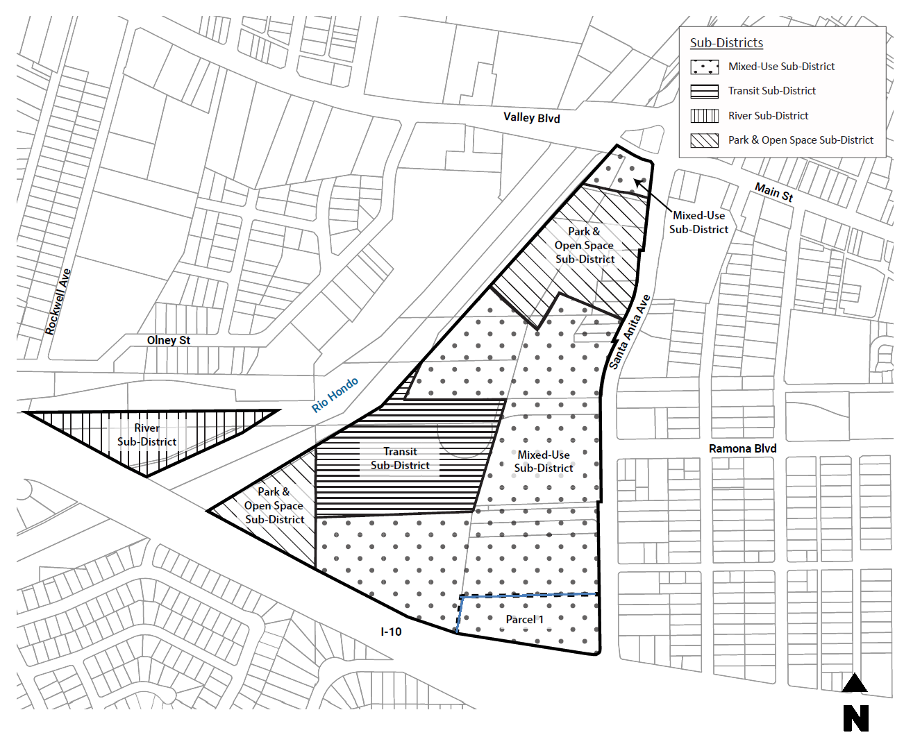
The land use plan for the Gateway specific plan provides for the development of a vibrant, pedestrian-oriented, mixed-use community. Organized into four (4) distinct land use subdistricts, the land use plan allows for a variety of housing, employment, entertainment and commercial opportunities, as well as community, open space and transportation uses that will complement and expand the urban fabric of downtown El Monte, as well as strengthen the citywide economy.
At build-out, the specific plan will serve as a key community activity center and further enhance the city's desire to create a vibrant, mixed-use downtown environment with enhanced connectivity to local neighborhoods and the region, through the Rio Hondo River, METRO and the Emerald Necklace. Each land use subdistrict is planned around a variety of creative and functional physical connections that incorporate the unique opportunities of the project site, including the El Monte Bus Station and the Rio Hondo River. The following describes the envisioned land use mix for each of the four (4) subdistricts, as well as their relationship to each other and the surrounding environment. Refer to Figure 17.131-1 for a map of the subareas.
A.
Mixed Use (MU) Subdistrict—The Mixed Use Subdistrict is intended to provide a complimentary mix of residential, commercial, entertainment and retail uses. Mixed use development is encouraged in vertical and horizontal forms, providing for an interaction between various land use types to encourage pedestrian utilization throughout the subdistrict. The area northwest of Santa Anita Avenue and Brockway Street is intended to provide the southern gateway into the Gateway specific plan. Design guidance for this sub-district is provided through three (3) distinct "villages," including the: Rio Paseo; North Promenade and South Promenade Villages.
B.
Transit (T) Subdistrict—The Transit Subdistrict is intended to preserve existing and expand facilities and services for public transportation. In addition, it calls to provide ancillary uses and services that improve the transit experience.
C.
River (R) Subdistrict—The River Subdistrict is intended to provide additional open space opportunities within the Gateway specific plan. The subdistrict is intended to provide necessary facilities for the periodic collection and detention of peak stormwater discharge during storm events. The River Subdistrict may also serve as a holding district for future transit, commercial and industrial uses, provided subsequent entitlement planning and environmental analysis is conducted.
D.
Park and Open Space (POS) Subdistrict—The Park and Open Space Subdistrict is intended to provide active and passive open space and recreational facilities for a variety of users. The subdistrict will provide integrated connections within the Gateway specific plan and regional recreational trail system.
Figure 17.131-1 Map of Subdistricts—Gateway specific plan
(Ord. No. 3053, § 3(Exh. A), 5-14-2025)
17.131.040 - Summary of land use buildout.
Table 131-1 identifies the distribution of land uses among the five (5) land use subdistricts in the Gateway specific plan:
Table 17.131-1—Specific Plan Buildout—Gateway specific plan
Notes:
2 Based on gross density and gross floor area.
3 Estimate of total square footage is for 1,850 units.
4 Estimate of total square footage is for 200 hotel rooms.
(Ord. No. 3053, § 3(Exh. A), 5-14-2025)
17.131.050 - Permitted uses.
A.
Permitted Uses. Table 17.131-2 prescribes the land use regulations for the Gateway specific plan. Additional regulations are denoted in the right-hand column. These designations apply strictly to the permissibility of land uses; applications for building structures may require other discretionary review.
B.
Unlisted Uses. Any land use not listed in Table 17.131-2 is not permitted in the Gateway specific plan, except as outlined in Section 17.12.050 (Rules and Measurements—Additional Permitted Uses) of this title.
Table 17.131-2—Permitted Uses—Gateway specific plan
Key:
* Use is pedestrian oriented and may occupy the ground floor of vertical mixed-use buildings. Other uses shall not be permitted on the ground floor.
⁁ Use is pedestrian oriented and may occupy the ground floor of buildings facing Santa Anita Avenue. Other uses shall not be permitted on the ground floor.
— Not permitted.
P Use permitted by-right.
M Use permitted after review and approval of a Minor Use Permit (MUP).
C Use permitted after review and approval of a Conditional Use Permit (CUP).
Z Use permitted after review and approval of a Director Level Zoning Clearance (ZCD).
G Gateway specific plan.
Notes:
5 Residential units shall be limited to 100 in the MU Subdistrict, Parcel 1, as part of a vertical mixed-use project.
6 For vertical mixed-use projects with residential, a minimum 50% of the total floor area shall be residential.
7 Alcohol sales can be for beer and wine or beer, wine and distilled spirits. However, they shall be considered different levels of alcohol sales. Therefore, if a use has approval for beer and wine wants to add spirits, a new CUP or MUP will be required.
8 Only applicable to assembly and entertainment uses permitted in the underlying zoning district.
9 Car sharing shall be permitted by-right if there is no on-site parking of vehicle (i.e. it is only an office use).
(Ord. No. 3053, § 3(Exh. A), 5-14-2025)
17.131.060 - Development standards.
Refer to Chapter 6 (Development Standards) of the Gateway Specific Plan.
(Ord. No. 3053, § 3(Exh. A), 5-14-2025)
17.131.070 - Design guidelines.
A.
Purpose and Intent. The following guidelines are intended to provide both a vision of the El Monte Gateway overall character, and specific aesthetic and experiential expectations regarding the various components of the El Monte Gateway.
B.
Introduction.
1.
The Primacy of Pedestrian Experience. The Gateway Specific Plan is dedicated first and foremost to the creation of a highly vitalized pedestrian environment, achieved through well-designed density and interaction of mixed uses.
2.
Scale. All future development projects should be designed with a human scale that acknowledges pedestrian perception and experience.
3.
Themes and Variations. While the Gateway will have over-arching themes that include intensive small-scaled density; architectural expression of sustainable design; a contemporary glassy openness; and continuity of selected public materials, amenities, lighting and graphics, the area should also be a place of great experiential diversity. It will achieve this by two (2) means:
a.
The creation of the separate villages, each with the character of a special neighborhood; and
b.
The encouragement of themes with multiple detailed variations within each of the various villages.
4.
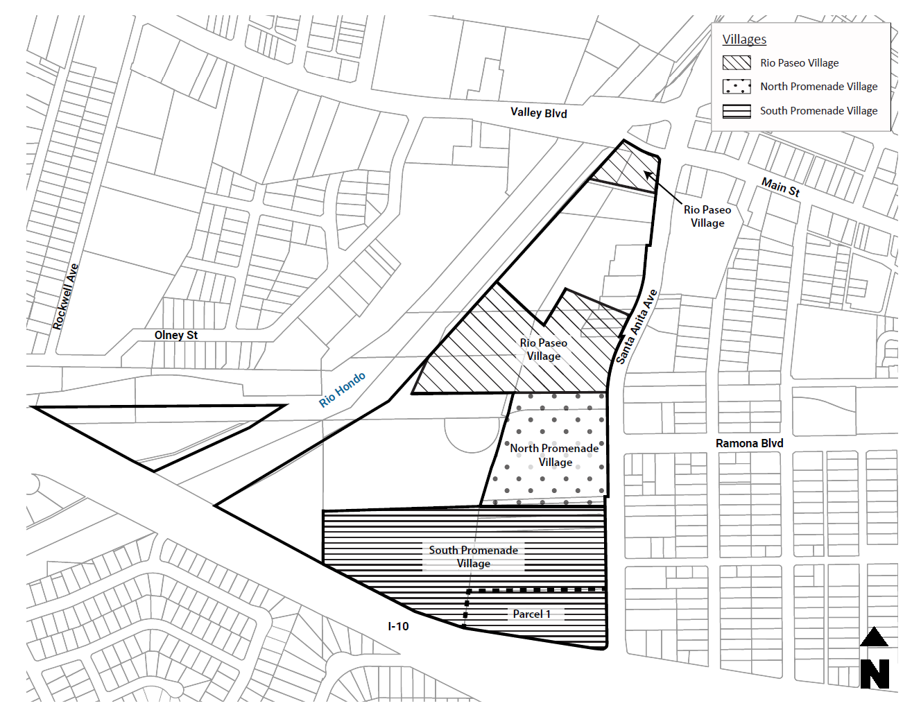
The Villages. The general design guidelines will be complemented by specific design guidelines for the following three (3) villages. Each village is envisioned to contain both specific types of uses and specific qualities that will make each village unique and identifiable. Refer to Figure 17.131-2 for a map of the villages:
a.
Rio Paseo Village;
b.
North Promenade Village; and
c.
South Promenade Village.
Figure 17.131-2 Map of Villages—Gateway specific plan
C.
General Design Guidelines—Broad Themes/Goals. Embracing a wide diversity of architectural expression, new development should embrace the following over-arching themes.
1.
Contemporary Architecture. The architecture should be clearly of the 21st Century, looking forward, with dynamic building forms, expressive structure, and a rich use of glass, tying together El Monte's past, present and the future.
2.
Sustainability. Sustainable architecture should be a major shaping force in defining the visual expression of the Gateway. Building form should respond in design to such issues as energy conservation, daylighting, natural ventilation, and solar energy harvesting.
3.
Rich Native Landscape. Acknowledging both the authentic value and the sustainable value of native landscape, the landscape design should provide a rich backdrop and overhead canopy for human activity. The landscape should extend the existing regional context of the Rio Hondo River and linear park, and should be influential throughout the pedestrian/ground plane of the Gateway. Landscape and water features or waterscape should be thematic throughout all of the villages.
4.
Detail and Diversity. All buildings fronting on pedestrian activity should have design rhythms, details, texture, and scale appropriate to the pedestrian. Harmonized visual richness and diversity should support rich human experiences.
5.
Formal Integrity. Buildings and building masses should have three hundred sixty-degree integrity. Buildings with multiple frontages should have a continuous harmony of materials and expression around the corner and not be merely façades.
D.
Village Parks and Open Space Design Guidelines.
1.
Open Space Overview. The parks and open space component of Gateway is dedicated to the creation of quality active and passive parks and open spaces that provide "green" linkages and physical connections to the river, the community and the regional transportation network that has its hub at the Gateway. The Gateway's approach to parks, open space, trails and walkways will focus on the connectivity and continuity and that open space and parks will be provided throughout the entire gateway site. It is intended that the parks and open space become an integral component of the overall Gateway character, resulting in a popular public destination, which is lively, secure, distinct, and promotes a healthy, community-based, urban lifestyle.
The following design goals will be considered in all aspects of the outdoor environment and will act as touchstones to guide exterior development and enhancements throughout the parks and public open spaces.
a.
Variety of Outdoor Experiences. Provide a variety of outdoor experiences for people of all ages and user types—residents, commuters, visitors and employees. Promote opportunities for inter-generational activities, physical, social and cultural growth that will promote a healthy lifestyle and a sense of well being.
b.
Pedestrian-Friendly Environments. Create pedestrian friendly environments to encourage walking, interaction and a sense of discovery at each turn. A comprehensive system of trails and walkways will link all areas of the site and tie into the greater regional trail system and "Emerald Necklace" that parallels the major waterways in the area. Fitness stations and mileage markers will be incorporated into trail circuits.
c.
Celebrate Nature. Celebrate nature in all its forms-riparian landscape character, natural habitats and enhancement of open space with attractive flora and fauna. Create opportunities to showcase and experience nature in the urban context.
d.
Celebrate the Rio Hondo. Celebrate the Rio Hondo River and the role of water in our Southern California climate. Provide educational opportunities to inform the public about the water cycle and the greater watershed that replenishes our critical groundwater supply. Provide a gateway feature to direct and encourage public access to the river and greater regional recreation resources associated with the Emerald Necklace.
e.
Attractive and Functional Park and Open Space. Create attractive and functional park space to promote outdoor recreation venues, outdoor dining, performance and art exhibit areas, historical interpretation, and "open air" learning opportunities. Provide open space to promote natural habitat and passive walking and observation of native flora and fauna.
f.
Civic Space. Create attractive public spaces that are flexible and can become destinations for community gatherings and civic events.
g.
Sustainable Design. Demonstrate sustainable design principles through the appropriate use of drought tolerant and native plant materials, utilization of recycled products, composting practices, low energy and low water consumption requirements, and water quality management practices. Reclaimed water will be used wherever it is possible.
2.
Pioneer Park. Pioneer Park will be a mix of active and passive recreation uses including two (2) rebuilt and improved sports fields. The raised sports field area will provide a central gathering area for lighted softball, baseball and overlay soccer play. The surrounding more passive park and open space offers a variety of recreation experiences from walking and bike trails to children's play areas, an informal amphitheater, a community recreation building, family picnic tables, and featured historical and interpretive elements.
a.
Sports Plaza. The two (2) ball diamonds will be interconnected by a sports plaza. The plaza will feature a concession/restroom building with concession area, restrooms, two (2) storage rooms and shaded patio area. Aluminum bleachers will be positioned behind the backstops. Fabric shade structures, picnic tables, benches and drinking fountains will be located within the plaza area for visitors' convenience.
b.
Ballfields.
i.
The ballfields will be defined by vinyl coated chain link fence backstops with backboards and descending sideline fences to protect spectators. The dugouts will be at grade with shade fabric, team benches, bat racks, and convenient drinking fountains for players. The fields, dugouts, drinking fountains for players. The fields, dugouts, drinking fountains and spectator areas will be American with Disabilities Act (ADA) compliant. The field may be artificial turf or traditional grass per city approval.
ii.
The ballfield lighting will be state-of-the-art, poles with minimum light spill off the field areas. An electronic scoreboard with remote controls to a scorer's table at the backstop will be located at each field. A public address system will also be provided with a localized speaker system to minimize sound travel beyond the limits of the field.
c.
Riverside Promenade.
i.
A riverside promenade will parallel the Rio Hondo and provide a linear pedestrian and bicycle linkage between Pioneer Park and Fletcher Park to the south. The promenade will feature a number of trail and path options including the asphalt paved regional bike trail running directly adjacent to the Rio Hondo, an ADA accessible walkway and a meandering trail traversing the slope that separates the elevated field area from the riverbanks. Benches will be provided along the paths and trails to encourage bird watching and restful enjoyment of the open space and the wildlife it attracts.
ii.
The character of this riverside promenade area will be enhanced to reflect a riparian vegetation type with appropriate planting on the ground. Bioswales incorporating water quality enhancing plant species coupled with water movement through swales may be incorporated where possible along the riverside area. Interpretive signage will be used to guide and inform visitors.
iii.
An informal outdoor amphitheater nestled into the slope overlooking the Rio Hondo will provide a small venue for nature talks, gathering spot for a walking tour or a small presentation or performance. Trees will be planted to interrupt the terraces and anchor the landform.
iv.
Main walks and trails throughout the site will be lighted with security lights to provide directed illumination and visual surveillance. Fixtures will be selected for minimum light spill, durability, and appropriate aesthetic character.
v.
Wayfinding signage with a common style will be provided throughout the park and open space areas to direct visitors to destinations or connections within and outside of the Gateway development.
d.
Themed Play Area.
i.
The park will feature a themed children's play area. The area will be buffered with planting and enclosed by a decorative ornamental steel fence as needed to control the access of children and protect them from street traffic. The play area will feature equipment and site furnishing components that tie into the end of the Santa Fe Trail theme and historical roots of El Monte. Separate play equipment will be provided for two- to five-year-old tots and five- to twelve-year-old children. Equipment will meet ADA access standards and Consumer Product Safety Commission standards.
ii.
Shade trees or fabric shade canopies will be used to shade the play equipment. Benches with backs will be provided adjacent to the play area for convenient and safe adult supervision.
iii.
Picnic tables may also be located adjacent to the play area for family use. A paved travel way may be incorporated in the play area to accommodate a tricycle course.
iv.
A small water/sand play feature may be incorporated into the themed play area for seasonal use or manipulative play.
e.
Gateway Entry to The Emerald Necklace. A broad tree-lined entry drive will occur south of the park along Santa Anita Avenue and will act as a major pedestrian entry to Emerald Necklace and the park. This roadway/linear plaza must be wide enough to accommodate a Los Angeles County fire lane. It will terminate at a large riverfront overlook. Pedestrian walkways and decomposed granite trails will link into this key public space.
f.
Community Building Area. A new community building will be added to the park. It may be a one- or two-story structure with an assembly room, lobby, restrooms, kitchen, storage and meeting rooms.
g.
Landscape and Irrigation Improvements.
i.
The Gateway specific plan will encourage the use of native or drought tolerant materials, as appropriate, and require a minimum of supplemental fertilization and maintenance. Because of the variety of conditions on the site, the species selected for a given area shall be compatible with the microclimate exposure, soil conditions and user demands. Shrubs and groundcovers should be perennial type, noninvasive and require a minimum of trimming.
ii.
Irrigation of plant materials shall be efficiently managed through state-of-the-art automated irrigation control systems appropriate to the unique needs of trees, shrubs and turf.
3.
Fletcher Park Design Guidelines. Fletcher Park may remain in its current configuration. However, it may be renovated to meet the quality standards associated with the redeveloped Pioneer Park. The intent is to connect Fletcher Park into the overall high quality park and open space associated with the Gateway specific plan development.
E.
Rio Paseo Village Design Guidelines.
1.
Rio Paseo Village Features. The Rio Paseo will be a regional feature, where visitors can come to dine along a narrow river channel. This channel will loop through the heart of the project, providing a walkable linkage as well as a romantic place of dining and passive recreation.
a.
In character, the Rio Paseo should have the informality of river and canal districts around the world, with rich landscaping and a relaxed use of natural materials.
b.
The Rio Paseo should be lush and romantic. Well-lit at night, it should also have a special character of light, allowing for a rich play of shadows, highlights, accent and feature lighting of landscape.
c.
The principal commercial uses along Rio Paseo (dining and drinking, coffee houses, bakeries, specialty shops that could potentially sell goods for consumption on property) should be evident to the stroller both from signage and from literal visual contact between goods offered and pedestrian movement.
The typical storefront should be seen as a simple, minimal mediation between the street and the interior. Both the generous use of glass and the use of flexibly open storefronts (folding glass doors or French doors) should be encouraged.
d.
While diversity of storefronts and awnings are encouraged, the terrace along the Rio Paseo should have a feeling of public continuity and not be sub-divided by tenants (e.g. continuity of outdoor paving, street furniture, umbrellas, etc.).
At the same time, individuation at storefront lines should be encouraged via personalized devices such as greeting stands, and artisanal sign boards and handwritten menu boards.
The overall test of successful design, both of the terraces and the storefronts, should be that they provide a consistently romantic and sophisticated ambience, avoiding explicit historic references or "cuteness."
e.
The fire lane should be usefully employed to support internal walking, with a richness of surface pattern that belies its use as a fire lane.
f.
Bay widths should be modest and in keeping with the constrained width of the Rio Paseo itself.
g.
The river channel should be of modest width, varying from fifteen (15) to thirty (30) feet.
h.
In the spirit of world-class, small-scaled, highly pedestrian environments, services to Rio Paseo restaurants should be structured at dedicated off-hours from the adjacent parking garages.
i.
Restaurant pads and storefronts with frontage along Santa Anita Avenue are critical invitational components of the Gateway. On the one hand, these frontal pads are the most likely to draw strong national and regional tenants. At the same time, it is highly important that the character that is projected along Santa Anita Avenue offers the intimate, natural and special qualities that will characterize the interior of the Gateway.
First, these restaurants should transform the character of the sidewalk. In conjunction with enhanced paving and street landscaping, the basic setting should be one of lush tree canopy and natural materials to the extent that a continuous sidewalk cafe environment draws the public from Santa Anita Avenue into the heart of the project.
Further, in keeping with the character of the more intimate internal restaurants, with the exception of the kitchen/service areas, these larger restaurant pads should maintain either a glassy or wholly open storefront character to the street.
The design character of these storefronts should be simple, but include a rich palette of materials, and a vision that incorporates layers of detail and landscape.
2.
Rio Paseo Village Guidelines.
a.
Residential development should have a modest public lobby at the public or semi-public deck level containing mail functions and resident access to upper levels. These lobbies should have a slightly more marked presence at the deck level than individual unit entries and yards at the deck level.
b.
For deck level units, there should be a hierarchy from most public space (e.g. the shared, landscape deck area), to semi-private space (e.g. modest front yards or porch areas) to unit entries.
c.
Deck-level unit yards/porches should have a semi-public feeling, with an identifiable edge that also allows visual permeability (e.g. low hedges, partial low walls, etc.). While over parking, the public and semi-public decks should convey a quality of lush landscaping.
d.
Architectural character should be consonant with generous unit daylighting (especially to the north). Through the generous use of glass, the architecture should exude a quality of exterior design that is airy, lightweight, and open to the lush natural environment surrounding it as well as the multiple distant view opportunities.
e.
Development in the Rio Paseo Village should have a sense of generosity, both in terms of distance between units/views, and in terms of common and private outdoor recreational space.
F.
Shared Rio Paseo Village and North Promenade Village Design Guidelines.
1.
The essential character of both Rio Paseo Village and North Promenades at the pedestrian level should be one of considerable intimacy, both of scale and detail. It should have the density and compaction of a narrow pedestrian-oriented shopping street. These shops will, by geometry, be limited in depth and scale and their character should reflect this smallness.
2.
Internal bridge crossings between the retail areas should aggressively acknowledge the pedestrian with generosity of scale and specially designed surface articulation.
3.
To encourage maximized access between uses, lobbies for vertical access to both residential and commercial floors that are above the ground retail level should be secured. However, they should still have a visible and well designed identity to the streetscape.
4.
Storefronts should use great amounts of glass, with significant articulation, detail, eclecticism and diversity of storefront arcades should be encouraged while avoiding the overuse of historical references. Diversity of storefront overhanging canopy design should be encouraged.
5.
There shall be a virtual semi-public zone/porch area at the frontage of each leasing bay which should allow for small, lacy projected specialty signs, non-permanent canopies and banners and individualized amenities that should reflect an artisanal approach to shop-keeping (e.g. potted landscaping, chalkboards and unique standing signage).
6.
Residential units above the first two (2) stories should not encroach beyond the retail storefront line (including residential balconies).
7.
The architecture of the residential units should be shaped to a large extent by the buildings' east and west exposures, suggesting appropriate façade depth, outdoor/indoor balcony rhythms, etc. East-facing Santa Anita Avenue units should also develop a clear cadence, lending rhythm and distinction to the street. All residential units should allow for a simple, but variegated, contemporary design expression with a generous use of glass.
8.
Consistent with the sustainable goals of the Gateway, the major lower roof platforms of the North and South Promenade Villages should be developed as green roofs. The design criteria for these roofs should be designed to:
a.
Create landscaped view-sheds for residents;
b.
Create semi-public shared space for residents and conference center users;
c.
Enhance energy conservation and sustainability; and
d.
Provide dynamic views for rooftop users.
9.
The promenades should have a dedicated off-street truck service area from which goods can be carted throughout the pedestrian promenade system.
10.
Pedestrian activities, and amenities such as seating, kiosks, and dining are gathering places that should be integrated into the overall design.
G.
North Promenade Village—Specific Design Guidelines.
1.
All frontages to the Rio Paseo, whether restaurant or retail, should project a glassy or fully open presentational aspect to pedestrian passersby. Unarticulated, solid walls facing the Rio Paseo or any of the internal pedestrian streets should not be permitted.
2.
In hierarchy of character, the north promenade should "mediate" between Pioneer Park, at the north of the project, and the increasingly formal urban landscape of the South Promenade Village. The landscape should create a sense of lushness, without being overly formal. It should be appropriate to a narrow-laned urban setting. There should be a combination of in-ground planting and tenant planters in rhythms that anticipate a casual and surprising impact from the overall landscape patterns along the promenade lanes. The emphasis should be on maintaining an informal but continuous overhead canopy of trees and/or vines.
3.
The easterly internal street of the north promenade, especially at its junction with Ramona Avenue, should be envisioned as the most activated core of the project with a sense of "town square" openness, with enough excess width in the street to accommodate street performers and moving crowds at considerable density. The Ramona Boulevard/Santa Anita Avenue cafes and outdoor dining should line Ramona and provide excitement to visitors as they enter the Gateway. An area within the north promenade is envisioned as the most activated core area of the project with a sense of "town square," with enough excess width in the street to accommodate street performers and moving crowds. The town square should be airy and spacious. It should be a democratic place, for passage, for people watching, and for entrepreneurial street entertainment. The town square "floor" should be of an enriched paving material, lending both detail and color.
H.
South Promenade Village—Specific Design Guidelines.
1.
North/south lanes of the South Promenade Village will share the same character and guidelines as the North Promenade Village. The south promenade will open up in width and present a more formal and broad entrance to the hotel, office towers and regional retailers.
2.
The east-west pedestrian walkway of this promenade should be designed in a formal way, with visual signage of prominent retailers contiguous along its edge. Additionally, stately and generous landscape should be continuous along its edge. There should be an overall sense of generous scale along this pedestrian way. Vertical elements should be of a scale to provide armatures for banners.
3.
A water feature of significant scale should be part of this east/west axis.
4.
Outdoor vending concessions should be allowed in the east-west lane of this village as a way to further enliven its pedestrian life.
5.
This village will be an important visual focus for the Gateway to the freeway and to the south. In consistency with the architecture throughout the Gateway, its design should be contemporary, and expressive of sustainable architecture. Along with the office buildings to the west, this building should most fully epitomize the progressive values of the general design guidelines at the beginning of this section.
6.
Motor court and arrival areas should provide for enhanced surface paving, with articulated detail, under-car and under-foot continuously to the entry lobby.
7.
Publicly accessible lobby spaces should present an open, welcoming quality to the street as well as to the village promenade area.
8.
The architecture of buildings in this village should epitomize the general design guidelines in terms of sustainability, contemporaneousness and a literally green setting. The buildings should maximize glassiness and views. As the tallest buildings in the Gateway, design should capitalize on views of the San Gabriel Mountains and downtown Los Angeles. And with their strong exposure to I-10 Freeway, they will serve as landmarks that exemplify the quality and character of the entire project.
9.
Retail lease space, even if shallow in depth, shall be provided continuously along the edge of any parking structure facing the promenade. The parking structure lobbies should be marked in contrast to these retail elements with a vertical identity. Lobbies should discharge in a place along the promenade to be most stimulating for pedestrian activity.
10.
The width of the east-west South Village Promenade should be gracious, with rich formal tree canopy and the capacity to contain crowds for major events.
11.
Storefronts should be designed to accommodate two (2) different readings:
a.
During weekdays, the base of the buildings should be read as glassy outlet storefronts consistent with the contemporary decorum of the office buildings above.
b.
There will be an active marketplace in the north promenade that is open during weekends. It should be designed as a vibrant indoor/outdoor market, with outlet goods rolled onto the pedestrian streets or brought similar to a farmers' market operation.
(Ord. No. 3053, § 3(Exh. A), 5-14-2025)
17.131.080 - Other requirements.
When a development standard is not identified in the Gateway specific plan, this title shall apply.
(Ord. No. 3053, § 3(Exh. A), 5-14-2025)
17.132.010 - Purpose and applicability.
This chapter sets the regulatory and design framework for the Mountain View Specific Plan area, while implementing the city's general plan goals as they relate to the development of specific plans. The provisions of this chapter apply to building additions, exterior remodels, relocations, or new construction requiring a building permit within the specific plan.
(Ord. No. 3053, § 3(Exh. A), 5-14-2025)
17.132.020 - Goals and objectives.
These goals are aimed at guiding the development of the Mountain View Specific Plan to create a neighborhood which will be in harmony with surrounding land uses and to develop a distinctive sense of community for its residents.
A.
To implement development objectives, policies and programs of the general plan;
B.
To implement affordable housing goals. Ten (10) percent of the project will be restricted to first-time affordable buyers. These units will be set aside for low-income and moderate-income households;
C.
To provide specific planning and development standards for the property;
D.
To provide streets with sufficient capacity for efficient and safe travel movements, incorporating neo-traditional design concepts that reduce vehicle speeds and noise and better accommodate pedestrians;
E.
To provide a cohesive architectural style and produce a high-quality residential community, unique in design and visual character;
F.
To provide infrastructure and utilities to meet the demands generated by the project and to not only minimize impacts on adjacent land uses but improve functionality of adjacent land uses. Coordinating with Mountain View High School to add a crosswalk, stop signs, disabled ramps and loading lanes to improve traffic flow and safety; and
G.
To create a uniquely identifiable neighborhood character through landscaping, interface treatments and architectural theme and details.
(Ord. No. 3053, § 3(Exh. A), 5-14-2025)
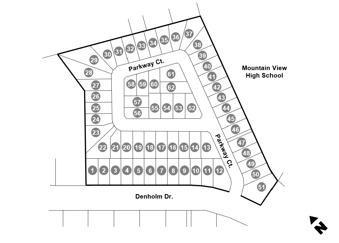
17.132.030 - Development plan.
See Figure 17.132-1 for a development map of the Mountain View Specific Plan.
Figure 17.132-1 Map—Mountain View Specific Plan
(Ord. No. 3053, § 3(Exh. A), 5-14-2025)
17.132.040 - Permitted uses.
A.
Residential dwelling, single-family, one on a lot.
B.
Accessory Structures. Shall be limited to swimming pools, spas, porte cochères, covered patios (attached or detached), gazebos and cabanas.
C.
Accessory dwelling unit (ADU) and junior ADU (see Section 17.110.030 of this title).
D.
Home occupation business (see Section 17.110.050 of this title).
(Ord. No. 3053, § 3(Exh. A), 5-14-2025)
17.132.050 - Development standards.
A.
Residential dwellings.
1.
Minimum Front Yard Setback. The existing area between the street curb and the front line of the dwelling as shown on Figure 17.132-1.
2.
Street Side Yard Setback (for Lots 12, 13, 52, 56, 58 and 61). The existing area between the street curb and the side line of the dwelling. The areas enclosed by a masonry wall with a minimum height of five (5) feet shall be considered part of the rear yard.
3.
Other Minimum Development Standards. Refer to Table 17.132-1.
Table 17.132-1—Residential Development Standards—Mountain View Specific Plan
B.
Entryways and Doorways. The main entryway shall face the front yard. Other doorways may face the rear yard. However, doorways shall be prohibited along the street side and along the interior side yard.
C.
Parking. Each dwelling unit shall have an attached garage for two (2) fully enclosed parking spaces. The garage shall also have automated roll-up doors. Driveways shall have a minimum depth of eighteen (18) feet to allow two (2) open parking spaces. There shall also be a minimum of thirty (30) on-street parking spaces for residents and guests.
D.
Accessory Structures.
1.
Covered Patios (Attached or Detached), Gazebos and Caban. Dwellings may have one accessory structure limited to the rear yard. It shall not exceed an area of one hundred (100) square feet and height of twelve (12) feet. In addition, it shall maintain a minimum setback of five (5) feet from any property line.
2.
Porte Cochères. Dwellings may have one detached porte cochère located in front of the garage and across the driveway, provided neither of the adjacent dwellings have a porte cochère. It shall have a minimum setback of eight (8) feet from the front property line.
3.
Exterior Spas, Hot Tubs or Swimming Pools. Shall be limited to the rear yard.
E.
Paving and Landscaping.
1.
Paving in the Front Yard and Street Side Yard. Shall be limited to a driveway (with a maximum width of twenty (20) feet) and a pedestrian walkway (with a maximum width of four (4) feet to access the main entryway and a gate to the rear yard.
2.
Refuse Pad. A three (3) foot by nine (9) foot concrete pad shall be maintained within the interior side yard at all times for refuse containers.
3.
Other Paving. Shall be limited to a maximum of two hundred (200) square feet within the interior side yard and rear yard.
4.
Landscaping. One twenty-four-inch box tree shall be planted along the parkway in front of each dwelling. This shall be increased to two (2) twenty-four-inch box trees for dwellings on corner lots. In addition, one twenty-four-inch box tree shall be planted in the rear or interior side yard of each dwelling.
F.
Walls and Fences.
1.
Front and Street Side Yards.
a.
Lots 1 Through 12. May have a front yard fence with a maximum height of three (3) feet. It shall be decorative, painted white and made of wood or vinyl materials.
b.
All Other Lots. Walls and fences shall be prohibited.
2.
Interior Side and Rear Yards.
a.
Facing a Street. Walls shall be constructed of split face block, except where gates occur.
b.
Not Facing a Street. Walls shall be constructed of split pace block or grey precision block.
c.
Walls shall not exceed a height of six (6) feet, not including the retaining portion of retaining walls. Walls and gates shall be of uniform design throughout the Mountain View Specific Plan.
(Ord. No. 3053, § 3(Exh. A), 5-14-2025)
17.132.060 - Design guidelines.
Refer to Chapter 6.0 (Architectural Design Guidelines) of the Mountain View Specific Plan for information on building layout and massing, architectural style, architectural details and materials and colors.
(Ord. No. 3053, § 3(Exh. A), 5-14-2025)
17.132.070 - Other requirements.
A.
When a development standard is not identified in the Mountain View Specific Plan, this title shall apply.
B.
Implementation and Administration. Refer to Chapter 5.0 (Implementation and Administration) of the Mountain View Specific Plan for additional requirements with regards to required actions and entitlements, permits and discretionary actions, expiration of approval and extensions, severability, applicability, administration and enforcement and specific plan amendments.
(Ord. No. 3053, § 3(Exh. A), 5-14-2025)
17.134.010 - Purpose and applicability.
This chapter sets the regulatory and design framework for developers, designers, city staff, and review bodies to develop and implement projects as they proceed through the entitlement process. The provisions of this chapter apply to building additions, exterior remodels, relocations, or new construction requiring a building permit within the Downtown Specific Plan.
(Ord. No. 3053, § 3(Exh. A), 5-14-2025)
17.134.020 - Vision and guiding principles.
The vision for Downtown El Monte has been one that has been continually evolving over the past one hundred (100) years. The Downtown Specific Plan builds upon the existing historical context of the city while at the same time incorporating ongoing planning efforts to create a vision that emphasizes transit-oriented strategies, multi-modal options and public realm enhancements. Through interactive design exercises, stakeholder interviews and community feedback, crucial elements were identified that are necessary to make the downtown a beautiful, safe, historic and lively regional destination. The following serve as the specific plan's guiding principles:
A.
Mixed-Use, Pedestrian and Transit-Oriented Urban Village—Create a mixed-use, pedestrian and transit-oriented urban village focused around a pedestrian-friendly Main Street containing a mix of shops and supportive uses woven together by attractive streetscape improvements and paseos connecting to adjacent neighborhoods and transit centers.
B.
Central Shopping and Entertainment District—Transform the downtown into a central shopping and entertainment district that contains retail stores, neighborhood services, office spaces, and restaurants with outdoor dining; complemented by broad sidewalks, plazas and parks designed with music and performance areas for resident and visitor enjoyment.
C.
Enticing Place for Investment—Make downtown an enticing place for investment by designing an active and vibrant street environment that attracts new businesses downtown and by providing incentives to developers, downtown merchants, and property owners to locate in this area.
D.
Variety of Housing Opportunities—Incorporate a variety of housing opportunities throughout the downtown that include a mix of densities and product types that use engaging architecture to further define El Monte's historic downtown.
E.
Expanded and Improved Public Transit System—Create a downtown supported by an expanded and improved public transit system, including a new trolley route throughout the downtown core with connections to El Monte Bus Station and Metrolink Station.
F.
Blend of Old and New—Provide a blend of old and new, where new development takes its design cues from the existing El Monte culture, character, and history. Define unique public plazas and green-space improvements connected by distinctive streetscapes interconnected with pedestrian paseos.
G.
Balanced System of Multimodal Streets—Provide a well-connected and balanced system of multimodal streets (bus, auto, bike) connected to pedestrian linkages designed to accommodate all users regardless of age or ability.
H.
Entryways at Key Intersections—Create entryways at key intersections to denote entries into the Downtown Specific Plan through improved streetscapes and signage.
(Ord. No. 3053, § 3(Exh. A), 5-14-2025)
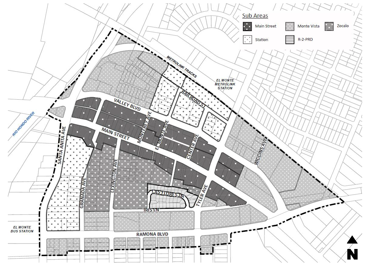
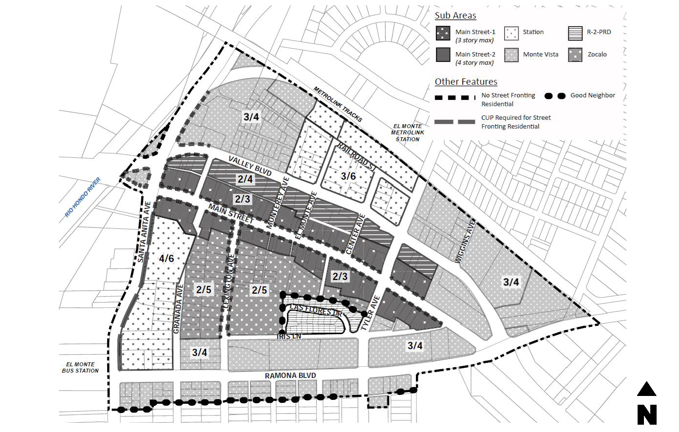
17.134.030 - Summary of subareas.
The Downtown Specific Plan is divided into the following four (4) subareas. Refer to Figure 17.134-1 for a map of the subareas.
A.
Main Street (MS) Subarea—This subarea is the economic, cultural and historic "heart" of the city. It includes many existing mom-and-pop retail and dining establishments. Much of Main Street has been improved with wide sidewalks, street furnishings and pockets of enhanced landscaping. A network of alleys and paseos allow for access to/from parking areas and adjacent subareas. The subarea is envisioned to be revitalized with façade improvements and vertical mixed-use development with residential or office above retail and restaurants. Buildings up to three (3) stories in height will line Main Street and buildings up to four (4) stories in height will front along Valley Boulevard.
B.
Zócalo (Z) Subarea—Zócalo means "public square" which is a term that characterizes the physical location of this subarea. Today this subarea mostly includes residential, retail and office uses that are linked to the Main Street Subarea via paseos, alleys and Lexington Avenue. One large centrally located parking area is utilized for Downtown events and provides parking for the businesses along Main Street. This Subarea is envisioned to transform underutilized parking areas into retail and housing opportunities centered around outdoor open space. This plaza will provide space for community arts and cultural events to occur. Artist live/work units and urban housing developments up to five (5) stories in height will support Main Street retail uses a short walk away. Along Lexington Avenue, retail and professional offices will provide an extension of Main Street uses and support the surrounding residences with various job opportunities.
Within the Zócalo Subarea is a well-established residential neighborhood that is unlikely to change during the life of the Downtown Specific Plan. This area is exempt from the regulations and guidelines of the specific plan and shall follow the Low-density Multiple-family Dwelling (R-2) Zoning District standards.
C.
Station (ST) Subarea—This subarea embodies the transit-oriented elements of the Downtown Specific Plan. Broken into two (2) areas, the Station Subarea includes the El Monte Metrolink Station and properties across the street from the El Monte Bus Station. Both transit stops are within a comfortable five- to ten-minute walking distance to downtown restaurants, shops and services. This subarea is envisioned to include a complementary mix of retail, urban housing and transit uses. Stand-alone multi-family residential uses such as townhomes, studio flats and apartments up to six (6) stories will provide housing opportunities for transit users in close proximity to downtown.
D.
Monte Vista (MV) Subarea—This subarea is located along the southern and northern edges of the Downtown Specific Plan and is comprised of office, residential and public uses including the El Monte United States Post Office which occupies a large portion of the subarea. The area contains downtown supporting uses and creates a buffer to surrounding residential uses. This subarea will be enhanced with street corridor beautification, mixed-use development and downtown entry treatments in key locations. New development is limited to a maximum of four (4) stories to ensure an appropriate transition from the downtown core to areas outside the specific plan boundary.
Figure 17.134-1 Map of Subareas—Downtown Specific Plan
(Ord. No. 3053, § 3(Exh. A), 5-14-2025)
17.134.040 - Permitted uses.
A.
Permitted Uses. Table 17.134-1 prescribes the land use regulations for the Downtown Specific Plan. Additional regulations are denoted in the right-hand column. These designations apply strictly to the permissibility of land uses; applications for building structures may require other discretionary review.
B.
Unlisted Uses. Any land use not listed in Table 17.134-1 is not permitted in the Downtown Specific Plan, except as outlined in Section 17.12.050 (Rules and Measurements—Additional Permitted Uses) of this title.
Table 17.134-1—Permitted Uses—Downtown Specific Plan
Key:
* Use is pedestrian oriented and may occupy the ground floor of vertical mixed-use buildings. Other uses shall not be permitted on the ground floor.
⁁ Use is pedestrian oriented and may occupy the ground floor of buildings facing Main Street west of Tyler Avenue. Other uses shall not be permitted on the ground floor.
— Use not permitted.
P Use permitted by-right.
M Use permitted after review and approval of a Minor Use Permit (MUP).
C Use permitted after review and approval of a Conditional Use Permit (CUP).
Z Use permitted after review and approval of a Director Level Zoning Clearance (ZCD).
Notes:
11 Ground-floor residential facing Santa Anita Avenue shall require approval of a CUP.
12 For vertical mixed-use residential, a minimum 50% of the total floor are shall be residential, with exception to projects in the Main Street DOR-1.
13 Only permitted in Main Street DOR-2 and Zócalo Subareas. Shall not be permitted in Main Street DOR-1.
14 If a use only has approval for beer and wine and wants to add distilled spirits, a new CUP or MUP shall be required.
15 Only applicable to assembly and entertainment uses permitted in the underlying zoning district.
16 If a use only has approval for beer and wine and wants to add distilled spirits, a new CUP or MUP shall be required.
17 Funeral home or mortuary shall not include crematories.
18 Car sharing shall be permitted by-right if there is no on-site parking of vehicle (i.e. it is only an office use).
(Ord. No. 3053, § 3(Exh. A), 5-14-2025)
17.134.050 - Development standards.
A.
General Development Standards.
1.
Table 17.134-2 prescribes the development standards for the Downtown Specific Plan. This includes maximum height, maximum Floor Area Ratio (FAR), minimum density and maximum density (by right and through the development opportunity reserve (DOR)). Figure 17.134-2 graphically prescribes the information provided in Table 17.134-2, as well as ground floor limitations on residential uses.
Table 17.134-2—Development Standards—Downtown Specific Plan 19 20
Notes:
19 Minimum density only applies to residential-only projects. Maximum Floor Area Ratio (FAR) only applies to non-residential square footage.
20 The maximum height, number of stories and FAR permitted shall be prior to any density bonus or other state provision that permits a higher density than allowed in this title.
Figure 17.134-2 Height and Ground Floor Uses—Downtown Specific Plan
2.
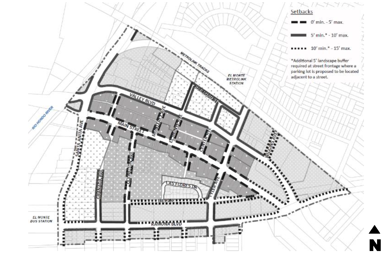
Figure 17.134-3 graphically prescribes minimum and maximum street setbacks. Street setbacks may be reduced by five (5) feet to accommodate Los Angeles County Fire requirements through the design review or minor design review process.
Figure 17.134-3 Street Setbacks—Downtown Specific Plan
B.
Site Development Standards. Site planning and design is key to quality development. The following standards promote orienting buildings toward the street, minimizing curb cuts and improving pedestrian connectivity and safety.
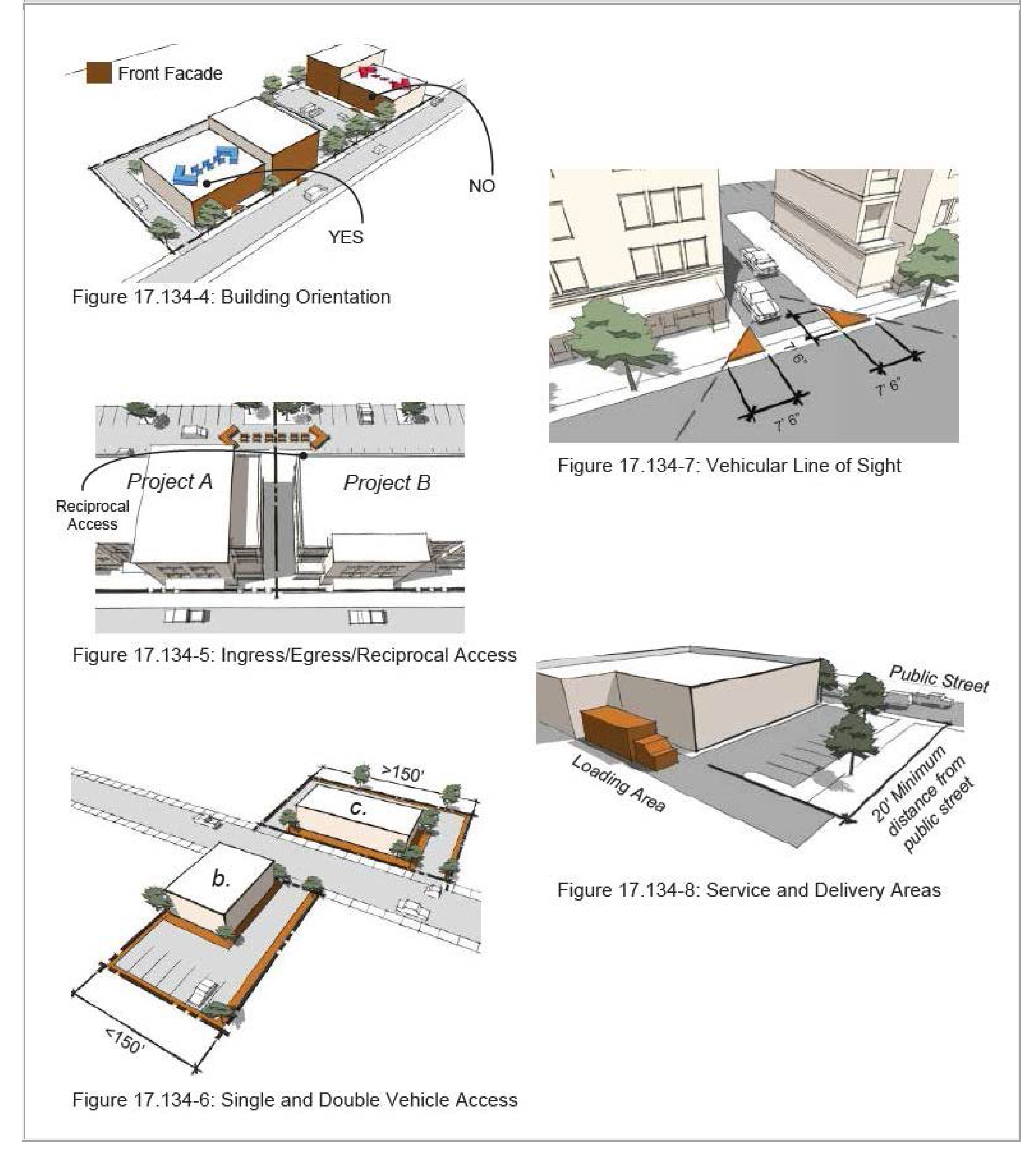
1.
Building Location. Building shall be oriented toward the street. Refer to Figure 17.134-4. The minimum separation between building shall be ten (10) feet.
2.
Ingress and Egress.
a.
All Downtown Streets. Reciprocal ingress and egress with adjacent properties shall be provided for parcels fronting public streets. The city may waive this depending on location of existing structures, infrastructure or failure to reach an agreement between owners. Refer to Figure 17.134-5.
b.
Main Street. Only access to parking structures is permitted from Main Street. All other vehicular access shall be provided via an alley.
c.
Valley Boulevard, Ramona Boulevard and Santa Anita Avenue.
i.
Access should be taken from alleys where the condition exists.
ii.
A maximum of one vehicle access point shall be provided from a primary public street for parcels with less than one hundred fifty (150) linear feet of street frontage and/or a parcel less than fifteen thousand (15,000) square feet.
iii.
A maximum of two (2) vehicle access points shall be provided from a primary public street for parcels with more than one hundred fifty (150) linear feet of street frontage. Refer to Figure 17.134-6.
3.
Vehicle Line of Sight. The clear zone shall consist of an isosceles right triangle with seven and one-half (7½) sides from the edge of the curb. The clear zone shall not be occupied by a site feature or landscaping that is higher than three (3) feet. Refer to Figure 17.134-7.
4.
Service and Delivery.
a.
Loading docks and service areas shall not be visible from Main Street and Lexington Avenue.
b.
For all other streets, loading docks and service areas shall be located a minimum of twenty (20) feet from a public street and be screened from view. Refer to Figure 17.134-8.
c.
Refuse and recycling enclosures shall not be located adjacent to a public street and shall be located as far as possible from the on-site/off-site residential uses.
5.
Lot Coverage.
a.
Main Street and Zócalo Subareas. One hundred (100) percent.
b.
Station Subarea. Ninety (90) percent.
c.
Monte Vista Subarea. Eighty (80) percent.
Figures 17.134-4 through 17.134-8
6.
Building setbacks:
a.
Street. Refer to Figure 17.134-3.
b.
Interior Side. Five (5) feet for Monte Vista. Zero feet for all other subareas.
c.
Rear. Ten (10) feet for Monte Vista. Zero feet for all other subareas.
d.
Alley. Eight (8) feet.
C.
Frontage Regulations.
1.
Street Fronting Façades in all Subareas.
a.
Buildings shall have a primary entrance door facing public streets. Entrances at building corners may be used to satisfy this requirement. Figure 17.134-9.
b.
A combination of architectural design elements shall be used on the building façade, along with streetscape elements at the street level, to animate and enliven the streetscape. These design elements may include, but are not limited to: ornamentation; molding; changes in material or color; architectural lighting; works of art; fountains; display areas; awnings; balconies; porches; towers; landscaped planter boxes; trellises; columns; cornices; arches; decorative tiles; decorative grillwork and outdoor furniture along street frontages.
2.
Non-Street Fronting Façades in all Subareas. Shall not exceed fifty (50) feet without a change in wall plane, roof-line and/or change in material. Refer to Figure 17.134-10.
3.
Main Street and Lexington Avenue Façades. The following requirements are intended to create building forms that are pedestrian friendly and are representative of El Monte's historical character. Refer to Figures 17.134-11 and 17.134-12.
a.
Buildings shall provide a primary entrance and façade on Main Street and Lexington Avenue.
b.
A minimum fifty (50) percent of the ground floor façade for retail uses facing a street shall have transparent glazing. Opaque or reflective glazing shall not be permitted.
c.
A minimum thirty (30) percent of the ground floor façade for other uses facing a street shall have transparent glazing. Opaque or reflective glazing shall not be permitted.
d.
Buildings with more than forty (40) feet of linear street frontage shall be designed to replicate a traditional twenty-feet to forty-feet storefront façade with a minimum six-inch variation in wall plane.
e.
Building roof-lines shall provide variations in height for a maximum distance of forty (40) feet in wall plane length.
f.
Parcels backing or siding onto paseos, parks or plazas shall be designed with building articulation requirements consistent with Main Street and Lexington Avenue façade requirements.
4.
Station Subarea and Monte Vista Subarea Façades. Refer to Figure 17.134-13.
a.
A minimum thirty (30) percent of the ground floor façade facing a street shall have transparent glazing. Opaque or reflective glazing shall not be permitted.
b.
No building façade shall extend more than one hundred (100) feet in length without a five-feet minimum variation in the wall plane.
c.
Building roof-lines shall provide variations in height a maximum distance of one hundred (100) feet in wall plane length.
5.
Ground Floor Plate Height. Refer to Figure 17.134-14.
a.
Commercial Storefronts. The minimum height shall be twelve (12) feet floor-to-floor.
b.
Residential Fronts. The minimum height shall be nine (9) feet floor-to-floor.
c.
Director's Adjustments. The Community Development Director may reduce the minimum ground floor plate height by ten (10) percent if lower heights are necessary to meet Los Angeles County Fire Department requirements. However, the elevation should still be designed to give the appearance that the standard is being met.
Figures 17.134-9 through 17.134-14

D.
Residential Open Space Requirements. Table 17.134-3 prescribes the open space requirements for mixed-use or residential only projects for properties located within the Downtown Specific Plan.
Table 17.134-3—Residential Open Space Requirements—Downtown Specific Plan 21
Notes:
21 The minimum open space requirements shall be prior to any density bonus or other State provision that permits a higher density than allowed in this title.
22 Vertical mixed-use projects in the Main Street Subarea DOR-1 may reduce the overall open space requirement to 140 sq. ft. per unit.
1.
Private Open Space. Private open space shall be provided as outlined in Table 17.134-3 above. It shall be directly accessible from the unit it serves and enclosed by a fence or building wall on all sides. The minimum dimension may be reduced to four (4) feet in the form of a balcony or deck.
2.
Common Open Space. Common open space shall be provided as outlined in Table 17.134-3 above and shall be conveniently located and accessible to all units.
3.
Indoor Open Space. The Review Authority may reduce the minimum size and/or dimensions to provide a recreational amenity.
E.
Public Open Space Requirements. Proposed projects with more than three thousand five hundred (3,500) square feet of nonresidential space shall include a public open space amenity, or some form of physical interface for the pedestrian. The minimum size of the space shall be ten (10) percent of the combined nonresidential footprint. The space may be divided into subareas, provided each subarea is a minimum three hundred fifty (350) square feet. Such space may include, but not be limited to:
1.
Formal Plazas. A formal plaza would be a publicly accessible open space which has a design that is influenced by classical urban planning design. A formal plaza would typically include some sort of central water fountain and/or symmetrical landscaping. The formal plaza shall have a minimum dimension of fifteen (15) linear feet horizontally in each direction with an unobstructed vertical height of seven (7) feet.
2.
Urban Gardens. An urban garden can be located on the ground level, or on upper levels of a structure. Urban gardens may include ornamental landscaping arranged in raised or at-grade planters or planting areas, potted plants and trees. Sculptures or other forms of public art would typically be included within the urban garden. The urban garden shall have a minimum dimension of 15 linear feet horizontally in each direction and shall be uncovered.
3.
Covered Colonnades. Colonnades are linear in design and provide a comfortably wide, covered pathway that is adjacent to the openings of a building. Sometimes the second floor of a building is utilized to create the "covered" element of the colonnade. Covered colonnades shall have a minimum depth of ten (10) feet with an unobstructed vertical height of seven (7) feet.
4.
Sidewalk Dining. Sidewalk dining may occur wherever a sidewalk space is ample enough to accommodate dining furniture without impeding pedestrian access of the sidewalk. Sidewalk dining may be defined with a railing or planters, or be open and accessible.
5.
Pedestrian Alleys and Walkways. A pedestrian alley or walkway is typically a "lane" that does not follow the alignment of a vehicular street, but provides a pedestrian access to a public space or some other feature within the interior of a development. It must be designed in such a manner as to be inviting to pedestrians. Therefore, issues such as lighting, security, line of sight, cleanliness and visual appeal are important considerations to a well-designed pedestrian alley or walkway. Public art, street furniture and access to shops and public spaces are features of pedestrian alleys and walkways. Pedestrian alleys or walkways shall have a minimum walkway width of ten (10) feet and shall be uncovered.
F.
Good Neighbor Buffer Development Standard. Such standards are provided to ensure future development within the Downtown Specific Plan is compatible with adjacent developments on residentially zoned properties.
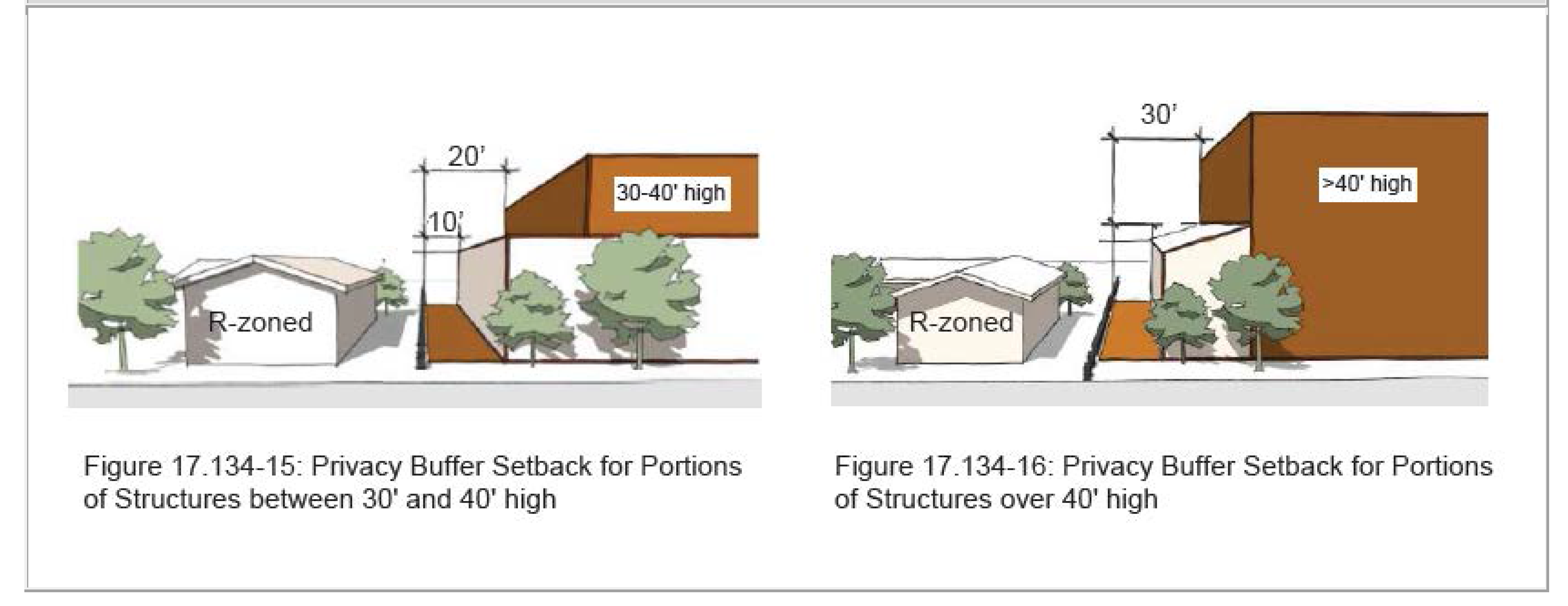
1.
Building Setbacks from Residentially-Zoned Properties.
a.
Buildings shall be setback a minimum ten (10) feet from the property line.
b.
Portions of a building between thirty (30) feet and forty (40) feet in height shall be setback a minimum twenty (20) feet from the property line.
c.
Portions of a building forty (40) feet high or greater shall be setback a minimum thirty (30) feet from the property line.
d.
Subsection 17.60.030.B. (Height Exceptions and Restrictions—Variable Height Requirements) of this title shall not apply.
e.
Refer to Figures 17.134-15 and 17.134-16:
Figures 17.134-15 and 17.134-16
2.
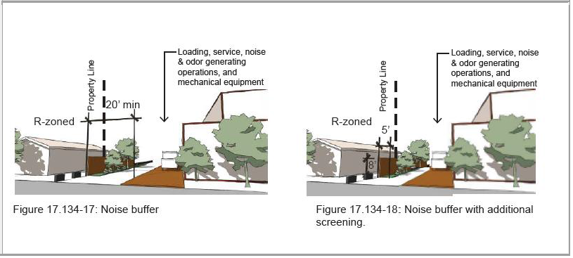
Loading docks, service areas and other noise generating operations from residentially zoned properties:
a.
Such operations shall be set back a minimum twenty (20) feet from the property line. See Figure 17.134-17;
b.
The Planning Commission may reduce this setback if the operations are buffered with an eight-feet high masonry wall and a five-feet wide landscape planter. See Figure 17.134-18:
Figures 17.134-17 and 17.134-18
3.
Mechanical Equipment from Residentially-Zoned Properties. HVAC systems, refrigeration units and other mechanical equipment shall be selected based on their noise rating or designed with features to reduce such noise. This may include parapet walls, equipment enclosures and/or placement of equipment.
G.
Other Development Standards. Table 17.20-3 denotes additional development standards found in other chapters or sections of this title that apply to one-family dwelling zoning districts:
Table 17.134-4—Other Development Standards
(Ord. No. 3053, § 3(Exh. A), 5-14-2025)
17.134.060 - Development opportunity reserve (DOR).
A.
Purpose and Overview.
1.
The intent of the development opportunity reserve (DOR) is to encourage increased development intensity concurrent with the delivery of public improvements or other community benefits to satisfy the increased demand for public amenities that come with the increased development intensity.
2.
Each subarea within the Downtown Specific Plan has development standards on permitted maximum height, number of stories, nonresidential floor area ratio (FAR) and residential density by-right. A "development bonus" or DOR is also provided for in each sub-area. Through the DOR process, the applicant may increase the height, number of stories, nonresidential FAR and residential density, subject to the delivery of additional amenities by the applicant or payment of an in-lieu fee.
3.
The DOR supports an inventory of public improvements and amenities determined to be necessary to support development intensity within the Downtown Specific Plan. The applicant may deliver the improvements and amenities or pay an in-lieu fee.
B.
Types of DOR Credits. Increased levels of development intensity are permitted as consideration for the delivery of public improvements as measured by "residential DOR credit(s)" and "commercial DOR credit(s)," collectively "DOR credits," as described below:
1.
One residential DOR credit permits the development of one residential dwelling unit greater than the number permitted by-right, up to the maximum permitted under the specific plan DOR.
2.
One commercial DOR credit permits the development of two thousand (2,000) gross square feet of nonresidential square footage greater than the number permitted by-right, up to the maximum permitted under the specific plan DOR.
3.
Projects that exceed the height or number of stories permitted by-right, but do not exceed the number of residential dwelling units permitted by-right or the nonresidential square footage greater than the number permitted by-right. The minimum number of DOR Credits shall equal the number of residential dwelling units or nonresidential square footage that are located in the portions of the project that exceeds the height or number of stories permitted by-right. For example, if a property permits fifty (50) units and a height of two (2) stories by-right, and an applicant proposes fifty (50) units and a height of three (3) stories (allowed through the DOR process), the applicant will need to secure DOR credits for all the units that are fully or partially located on the third floor.
4.
The DOR credit in-lieu fee shall be as adopted by the most recent City Council fee resolution.
C.
Application. A DOR permit shall require the approval of a director level zoning clearance.
D.
DOR Credits—Private Improvements. The applicant may propose the following improvements, amenities and incentives on private property to receive DOR Credits:
1.
Affordable Housing.
a.
One very low income unit shall be equal to one and one-half (1½) DOR credit.
b.
One lower income unit shall be equal to one DOR credit.
c.
One moderate income unit shall be equal to one-half DOR credit.
2.
Arts or Cultural Space. One DOR credit for each two thousand (2,000) square feet of arts or cultural space.
3.
Parcel Consolidation. One DOR credit for each parcel consolidated into one parcel with a minimum total area of twenty thousand (20,000) square feet. Therefore, if four (4) parcels were consolidated to create one parcel with an area of twenty thousand (20,000) square feet, the project will be eligible for four (4) DOR credits.
4.
Parking Spaces.
a.
Privately-Accessible Parking Spaces. One DOR credit for every six (6) parking spaces in excess of the minimum required per Chapter 17.70 (Parking Regulations) of this title.
b.
Publicly-Accessible Parking Spaces. One DOR credit for every four (4) publicly accessible parking spaces in excess of the minimum required per Chapter 17.70 (Parking Regulations) of this title.
5.
Façade Remodel for Existing Structures. One DOR credit for each fifty (50) feet of linear building façade that will be remodeled. Minor improvements such as new paint and signage shall not constitute a façade remodel.
6.
Public Art.
a.
One DOR credit when public art in installed on-site or on a nearby site and the art has a minimum value of one-half percent of the total project cost; or
b.
Two (2) DOR credits when public art is installed on-site or on a nearby site and the art has a minimum value of one and one-quarter (1¼) percent of the total project or exceeds the public art cap by more than ten (10) percent as adopted by the most recent City Council fee resolution.
7.
Publicly Accessible Open Space.
a.
Residential Only Projects. One Residential DOR Credit for each four hundred (400) square feet of publicly accessible open space, for a maximum of five (5) residential DOR credits.
b.
Nonresidential Projects or Mixed-Use Projects with Residential.
i.
Projects with three thousand five hundred (3,500) square feet or less of nonresidential space. One DOR credit for each four hundred (400) square feet of publicly accessible open space, for a maximum of eight (8) DOR credits.
ii.
Projects with more than three thousand five hundred (3,500) square feet of nonresidential space. One DOR credit for each four hundred (400) square feet of publicly accessible open space in excess of what is required in subsection 17.134.040.E. of this chapter, for a maximum of ten (10) DOR credits.
c.
Examples of Open Space. Examples include, but are not limited to, formal plazas, urban gardens, park/green space, open space and courtyard space.
8.
Other Publicly-Accessible Improvements, Amenities or Other Incentives. Other proposals to secure DOR credits may be considered by the Community Development Director on a case-by-case basis. The Community Development Director may also refer the request to the Planning Commission for consideration.
E.
DOR Credits—Public Improvements. The applicant may propose improvements within the public right-of-way and on other city property to receive DOR credits:
1.
Calculations. The number of DOR credits shall be based on the value of the public improvement(s) in comparison to the DOR credit in-lieu fee. Therefore, if the value of the public improvement(s) is four (4) times the DOR credit in-lieu fee, the project will be eligible for four (4) DOR credits.
2.
Process. The contract for the delivery of public improvements shall be awarded through a public bid process managed by the city.
3.
Underpayment. To the extent that the actual contact amount is less than the equivalent amount of DOR credits required for the project, the applicant may deliver additional public improvements or pay the DOR credit in-lieu fee.
4.
Overpayment. To the extent that the actual contact amount is greater than the equivalent amount of DOR credits required for the project, the applicant may request a credit from the city for the difference. At the city's discretion, the city may reimburse the applicant with funds from the DOR Public Improvement Fund, or the city may wait for receipt of additional in-lieu payments from which it will reimburse the applicant. The applicant may not utilize the credits on another project without the expressed permission of the Community Development Director.
5.
Quality and Design of Improvements. The Community Development Director and Public Works Director must approve the design, plans and specifications for all public improvements delivered. All public improvements must meet or exceed city standards.
6.
Timing to Deliver the Public Improvements.
a.
The work shall be completed prior to the issuance of building permits; or
b.
A contract to complete the award shall be signed prior to the issuance of building permits. The applicant shall be responsible for maintaining a completion bond sufficient to cover the scope of the public improvements until the city has issued a certificate of completion for the public improvements. The cost of the competition bond may be included in the calculation of the contract amount and equivalent DOR credits in-lieu fee.
F.
DOR Credits—In-lieu Fee. The applicant may propose to pay an in-lieu fee to receive DOR credits. Payments shall be due at time of building permit issuance. Payments shall go into a DOR Public Improvement Fund. Such funds shall only be used to support the delivery of public improvements on the DOR Public Improvements list within the Downtown Specific Plan.
(Ord. No. 3053, § 3(Exh. A), 5-14-2025)
17.134.070 - Design guidelines.
A.
Historic Compatibility. When a new development or rehabilitation of an existing is adjacent to or in the immediate area of an historic property, the development or rehabilitation shall comply with Secretary of Interior's Standards and Guidelines for the Treatment of Historic Properties. In addition, it shall be consistent with the following design guidelines for historic compatibility:
1.
Maintain historic features and elements of existing buildings.
2.
Restore existing historic features that may have been altered from past remodels (e.g. remove a false façade on a building to reveal its original brick exterior).
3.
New construction should respect and complement the original period and style of adjacent buildings without mimicking them exactly.
4.
New construction should avoid a false "historical" look.
B.
Sustainability. Sustainability includes the protection and conservation of irreplaceable non-renewable resources. The transit-oriented nature of the Downtown Specific Plan is inherently sustainable as the intent is to connect nearby residential neighborhoods to transit facilities, services, shopping and dining establishments through a series of walkable streets and paseos. This will lead to a reduction in auto dependency, encourage an active lifestyle and add a sense of vibrancy to Main Street.
1.
General Sustainable Design Guidelines.
a.
Residences should be within one-quarter mile or less from services, transit and other daily needs, and should be linked with strong pedestrian connections.
b.
Auto-dependency should be reduced by providing pedestrian linkages through walkways or bike paths.
c.
Public parks and plazas should provide well-linked active and passive open space for an opportunity for exercise and recreation.
d.
Buildings should be oriented to maximize active and/or passive solar gain; this allows the façades to let light in, reduce glare, and reduce overheating to the building interior.
e.
Architectural elements such as skylights and high-performance glazing should be used to conserve energy, where possible.
f.
Climatic factors such as prevailing winds shade trees, window and door orientation, and the positioning of buildings should be coordinated to maximize energy conservation.
2.
Stormwater Management Design Guidelines.
a.
The project site should be designed to maintain natural stormwater flows by promoting infiltration.
b.
Impervious surfaces should be minimized.
c.
Site drainage should be designed to integrate a decentralized system that distributes stormwater across a project site.
d.
Various devices should be considered that filter water and infiltrate water into the ground.
e.
For areas with poor drainage conditions, the provision of drainage chimneys/wells, subsurface water storage or the provision of bioswales to clean the water and transfer off-site should be provided.
f.
Practices to control pollution should be incorporated. Examples include phased construction, seeding, non-invasive grading, mulching, filter socks, stabilized site entrances, sediment controls, fiber rolls and stabilized channels and outlets.
3.
Existing Building Reuse Design Guidelines.
a.
The reuse of existing structures should be considered. The energy required to reuse a structure is potentially less than the energy required to develop a new structure.
b.
Reused buildings should incorporate new architectural elements in juxtaposition with old ones where appropriate.
4.
Cool Roof and Green Roof Design Guidelines. Both cool roofs and/or green roofs should be considered for buildings.
5.
Solar System Design Guidelines.
a.
Buildings should be designed to take advantage of solar orientation to ensure that windows, walls and floors are built to collect, store and distribute solar heat efficiently.
b.
New residential and non-residential buildings should have solar-ready roofs.
c.
Solar panels should be incorporated in parking lots.
C.
Site Design. The following guidelines are designed to enhance the overall site layout to achieve the pedestrian-oriented vision for the Downtown Specific Plan.
1.
Buildings. Should be oriented toward the street and/or a publicly accessible space such as a plaza.
2.
Focal Points. Should be developed at intersections, corners and the end of streets and pedestrian walkways to create a sense of identification. Plazas, landscape, fountains, artwork, textured pavement and vertical building features may be combined to create focal points.
3.
Landscaping.
a.
Landscaping should be installed between the street and the sidewalk and/or trees planted in tree wells to buffer the sidewalk from traffic and to provide enhanced pedestrian areas.
b.
Landscaping within parking areas should be protected from encroaching vehicles by concrete curbing or raised planting areas.
4.
Outdoor Spaces.
a.
Outdoor spaces should have a clear purpose that reflects careful planning and not simply "left over" areas between structures. Such spaces should be landscaped and/or provide pedestrian amenities, including benches, bicycle racks, fountains and/or public art and should be coordinate with the city as part of a development proposal.
b.
Communal Open Spaces (e.g. plazas, common green spaces) should be integrated within commercial areas and residential developments to provide places for residents and visitors to relax, play and interact.
5.
Parking Areas.
a.
Parking lots should be provided behind buildings, subterranean or within parking structures, where possible.
b.
Parking areas should be landscaped to minimize glare and heat buildup and reduce negative visual impacts associated with large paving areas.
c.
Dead-end drive aisles should be avoided.
d.
The primary entry drive to parking lots, as well as pedestrian paths of travel within a parking lot, should be accented with enhanced paving and landscaping. Permeable or semi-permeable surfaces such as pavers are preferred for accent paving.
6.
Loading and Delivery Areas. Should be located at the rear or side of buildings and should be screened with decorative walls, trellises/vines, berms with landscaping and/or trees.
D.
Pedestrian and Vehicular Connections. The circulation pattern throughout the Downtown Specific Plan will play a pivotal role in the success of attracting visitors and potential tenants to the downtown. It is important to establish a well-connected system of streets and paths, both internally and to surrounding uses, to allow users to choose from a variety of transportation modes including public transit, walking and biking.
1.
Plazas and outdoor use areas should be enhanced with shade trees or shade structures and pedestrian amenities such as benches, fountains, landscaping and public art.
2.
Pedestrian paths and paseos should be designed as integral circulation routes to foster a vibrant environment that encourages walking and enhances the pedestrian experience.
3.
Access between transit stops and Main Street should be clearly defined.
4.
Surfaces made from permeable materials such as pavers should be provided, where possible.
5.
Outdoor furniture and fixtures should be compatible with the project's architecture and should be carefully considered as integral elements of the project.
E.
Building Form and Mass. Design building forms to create interesting architecture that relates to pedestrian scale, creates a downtown character, and minimizes the appearance of large box-like buildings.
1.
Variation in wall and roof planes should be used on large monolithic structures to break up the boxlike appearance. Surface detailing, such as score lines, should not serve as a substitute for distinctive massing.
2.
Building designs should incorporate three hundred sixty-degree architecture. Such architecture is full of articulation on every building elevation. This includes variation in massing, roof forms, and wall planes, as well as surface articulation.
3.
Architectural elements that add visual interest, scale and character such as projecting balconies, trellises, recessed windows, window detailing and door detailing should be incorporated to create shadow patterns and help articulate façades and blank walls.
4.
Building surfaces that face walkways should be effectively articulated to enhance the pedestrian experience.
5.
Contrasting base materials and/or molding elements should be used to anchor the building to the ground plane.
6.
Entries, display windows, awnings, arcades and outdoor eating areas should be provided to create inviting public spaces.
7.
The visual impact of large monolithic structures should be minimized by creating a cluster of smaller buildings or the appearance of a series of smaller buildings.
8.
Stairways should be designed as an integral part of the overall architecture of the building and not appear as tacked on.
F.
Roof Form and Mass. Roof forms should be used to distinguish various building forms, create an interesting roof-line, and help to break up the building massing.
1.
Buildings with flat or low-pitched roofs should incorporate parapets or architectural elements to break up long horizontal rooflines.
2.
Deep roof overhangs are encouraged to create shadow and add depth to façades. Exposed structural elements (beams, rafter tails) are encouraged as roof overhang details.
3.
Full roofs are desirable. Hipped or gable roofs covering the entire building are preferred to mansard roofs and segments of pitched roofs applied at the building edge.
4.
Roof parapets should be well-detailed, be three (3) dimensional and of substantial size to complement the building. They should include one or more of the following detail treatments: pre-cast elements; continuous banding or projecting cornices; dentils; caps; corner details or variety in pitch (sculpted).
5.
Parapets should be designed to avoid visibility of the interior. If the interior side of a parapet is visible from pedestrian view, it should be finished with the same materials and a similar level of detail as the front façade.
6.
Parapets should not appear "tacked on" and should convey a sense of permanence.
G.
Windows, Doors and Entries.
1.
Window, doors and entry design and materials should complement the desired architectural style of the building.
2.
Entry design should incorporate two (2) or more of the following methods:
a.
Change in wall/window plane;
b.
A projecting element above the entrance;
c.
A change in material or detailing;
d.
Architectural elements and decorative fixtures;
e.
A portico or formal porch projecting from or set into the surface;
f.
Changes in the roofline or a tower;
g.
Front porch; and
h.
Decorative detailing or placement of art.
3.
Where recessed entries occur, a decorative paving material, such as tile, marble or slate, is encouraged on the ground plane.
4.
Windows should be articulated with accent trim, sills, shutters, window flower boxes, balconies, awnings or trellises authentic to the architectural style of the building.
5.
Windows should be inset from building walls to create shade and shadow detail.
6.
Faux shutters should be proportionate to the windows to create the appearance of a real and functional shutter.
7.
Long, monotonous balconies and exterior corridors that provide access to multiple units should be avoided. Instead, access points should be clustered.
H.
Awnings.
1.
All lots with more than one commercial occupant sharing contiguous frontage should maintain a common location and design for building awnings.
2.
The bottom edge of awnings should be a minimum of eight (8) feet off the ground.
3.
All awnings should be constructed with noncombustible materials such as a fireproof canvas or vinyl.
4.
Awnings should be centered over doorways and windows.
5.
Awnings should be in proportion to door and window openings.
6.
Awnings should be of a color which is appropriate to the overall colors of the façade.
7.
The shape, size, and number of awnings should be appropriate to the overall façade design and building size.
8.
Awning structure should be sufficient to support safely the awning and withstand the pressures of wind and weather.
9.
Awnings which become ripped, tattered, or damaged must be repaired or replaced within three (3) months of the occurrence/appearance of the damage.
10.
Barrel awnings should not be permitted.
I.
Materials and Colors.
1.
To convey a sense of high-quality design and permanence, building colors and materials should be selected to simulate authentic and timeless materials.
2.
Contrasting colors are encouraged to accentuate details such as trim, windows, doors and key architectural elements, as long as selected colors reinforce the desired architecture style.
3.
Fluorescent paints and bright colors are strongly discouraged.
4.
Building base materials should be selected that are durable and highly resistant to pedestrian traffic such as pre-cast concrete, stone, masonry, brick, and commercial grade ceramic tile.
5.
Recommended Façade Materials.
a.
Exterior plaster (smooth troweled preferred);
b.
Cut stone, rusticated block (cast stone), stone tile, and pre-cast concrete;
c.
Brick veneer, new or re-used; and
d.
Ceramic tiles.
6.
Façade Materials That Are Discouraged.
a.
Imitation and crushed rock;
b.
Mirrored or reflective glass and heavily tinted glass;
c.
Windows with "tape on" divisions/mullions;
d.
Corrugated fiberglass;
e.
Vinyl and aluminum siding;
f.
Painted or baked enamel metal awnings;
g.
Rough "Spanish lace" stucco finish;
h.
Exposed concrete masonry units and split faced concrete masonry;
i.
Imitation brick; and
j.
Plywood siding.
7.
Recommended Roof Materials.
a.
Roof tiles made of clay, slate, or integrally colored concrete;
b.
Roof tiles with "Mission" or "Barrel" shaped roof profiles;
c.
Metal roof panels with standing seam texture; and
d.
Ridge and hip caps and/or flashing should coordinate with field colors.
8.
Roof Materials That Are Discouraged.
a.
Brightly colored material;
b.
Low-profile composition roof tile, wood and/or hard board, or synthetic shingles and shakes;
c.
Simulated clay tile roofs in metal;
d.
Corrugated metal roof panels; and
e.
Roof tiles with S-profile.
J.
Walls and Fencing/Screening.
1.
Walls and fences should be designed with materials and finishes that complement the project's architecture and should be planted with vines, shrubs and/or trees.
2.
All fences and walls required for screening purposes should be of solid material. Chain link or similar metal wire fencing with slats is prohibited for screening purposes.
3.
A combination of low walls and landscaping should be used to screen unsightly elements of the project and define private and semi-private areas.
4.
Fences and walls should be constructed as low as possible while still performing screening, noise attenuation and security functions.
5.
Service areas are to be separate and screened from public areas by the use of walls and landscaping as much as possible.
K.
Lighting.
1.
Light fixtures should be designed to relate in color, material, size, location and illumination with the building architecture.
2.
All building entrances should be well-lit.
3.
Exterior building lighting designated to illuminate signs should be mounted above the sign on the facade and should be appropriate to the size and scale of the signage.
4.
Alley lighting, marking building entries, should be surface mounted and may be either flush with, recessed, or extended from the wall. No fluorescent lighting is allowed for this purpose.
5.
Fluorescent lighting tubes shall be concealed by a shade or lens.
6.
Parking lots, pedestrian walkways and paseos should be illuminated to ensure safe nighttime conditions.
7.
Light fixtures should be sited, directed and/or shielded to prevent spot lighting, glare or light spillage beyond property lines.
8.
The lighting of building elements and trees is an effective and attractive lighting technique that is encouraged; however, light sources for wall washing and tree lighting should be hidden and located so as to not shine in the eyes of pedestrians.
9.
Low-voltage/high efficiency lighting should be used in the landscape.
10.
Security lighting fixtures should not project above the fascia or roofline of the building and should not be substituted for parking lot or walkway lighting fixtures.
11.
Timers and sensors should be incorporated to avoid unnecessary lighting in low volume pedestrian traffic areas.
L.
Refuse Enclosures. Carefully design, locate and integrate trash enclosures into the site plan.
1.
Enclosures should be located away from adjacent residential uses to minimize nuisances to neighboring properties.
2.
Self-clinging vines are encouraged to discourage graffiti.
3.
Enclosures should be separated from adjacent parking stalls with a planter and paved surface behind the curb to provide easy access to a vehicle as well as adequate screening.
4.
Refuse enclosures should be designed with similar finishes, materials and details as the primary building(s) within the project area.
5.
Chain link or similar metal wire fencing with slats is prohibited.
6.
Enclosures should be unobtrusive and conveniently located for refuse disposal by tenants and collection by service vehicles.
7.
Where possible, a pedestrian entrance to the trash enclosure should be provided so that the large access doors do not have to be opened as frequently.
M.
Mechanical Equipment Screening.
1.
Mechanical equipment on the ground should be completely screened from street level view with attractive planting, masonry walls, or iron fencing with planting which compliment building architecture.
2.
All roof-mounted mechanical equipment should be located behind a permanent parapet wall and completely screened from ground level view.
N.
Parking Structures. Parking structures that seamlessly integrate with surrounding buildings are appropriate for Downtown El Monte. This can be accomplished by wrapping portions of the first floor with commercial uses and by articulating upper floors with elements that reflect an occupied building.
1.
Decorative and interesting architectural elements, such as towers and rotundas, should be utilized at street intersections. These elements could be used for stairwells and/or elevator towers.
2.
Parapets should be added to key areas on the structure to change the roof-line and reduce its horizontal appearance.
3.
Horizontal openings should be broken up with vertical columns to create a rhythm of openings.
4.
Framing should be added to openings to mimic windows. The framing should have vertical members to deemphasize the horizontal lines of the structure.
5.
Landscaping should be used to screen and enhance the structure. Landscaping and vines planted on structure façades can help reduce the visual impact of the structure while berms and trees planted at the perimeter of the garage can screen lower levels.
6.
Where commercial uses are not provided on the ground floor, the structure should be surrounded by landscaping so that the structure does not directly abut paved areas. A minimum five (5) feet wide landscaping strip should be provided between paved areas and the structure.
(Ord. No. 3053, § 3(Exh. A), 5-14-2025)
17.134.080 - Other requirements.
The Downtown Specific Plan includes six (6) parts. Refer to the following for additional requirements:
A.
Introduction and Background. This includes an overview of the Downtown Specific Plan, its boundaries and setting, its relationship to other planning documents and its vision and guiding principles. The vision and guiding principles are also incorporated in this chapter.
B.
Land Use. This includes areawide development standards, the Main Street Subarea, the Zócalo Subarea, the Station Subarea, the Monte Vista Subarea and areawide design guidelines. The parking requirements are incorporate in Chapter 17.70 (Parking Regulations) of this title. The signage regulations are incorporate in Chapter 17.80 (Signage Regulations) of this title. The remaining information is incorporated in this chapter.
C.
Mobility and Beautification. This includes the transit network, pedestrian network, bicycle network, roadway network, streetscape beautification, public signage and wayfinding signs.
D.
Infrastructure and Public Facilities. This includes water systems, wastewater systems, storm drainage system, solid waste disposal, energy system, police protection services, parks and recreation, schools and libraries.
E.
Implementation. This includes attracting private investment and public funding benefits, key development opportunity sites, potential funding mechanisms and implementation action plan.
F.
Administration. This includes the Downtown Specific Plan's authority and adoption, specific plan administration and permitted land uses, nonconforming uses and structures, exceptions, specific plan building intensity, specific plan amendments, specific plan amendment process and development opportunity reserve (DOR).
(Ord. No. 3053, § 3(Exh. A), 5-14-2025)
17.135.010 - Purpose and applicability.
This chapter provides the development standards and design guidelines for the Esperanza Village specific plan. The regulations apply to the residential and mixed community-serving vision of the specific plan. Application of these regulations are intended to create a harmonious relationship among the land uses, and protect the health, safety and welfare of the specific plan area and its immediate surroundings. The development standards contained in this chapter shall apply to parcels within the specific plan area boundaries. All new projects, including additions to buildings and changes in use, are subject to the provisions of this chapter.
(Ord. No. 3053, § 3(Exh. A), 5-14-2025)
17.135.020 - Vision and guiding principles.
The vision for the Esperanza Village specific plan is to provide a well-designed and high- quality mix of affordable multi-family residential dwelling units, community-serving facilities, and open space and recreational areas that serve the need of residents within and surrounding the specific plan. It is envisioned that development in the specific plan would be cohesive and would be compatible with the surrounding residential neighborhood. The following guiding principles are intended to allow the specific plan to be developed as it is envisioned. The guiding principles provide the foundation for the development standards and design guidelines.
A.
Guiding Principle 1. Encourage revitalization of an underutilized property by providing a mix of complementary uses that serve the needs of the surrounding community.
B.
Guiding Principle 2. Increase affordable housing opportunities for low-income persons and families, transitional age youth, and senior citizens in a region with severe overcrowding and extremely high housing costs.
C.
Guiding Principle 3. Provide development that is high quality, well designed, and enhances the visual character of the Esperanza Village specific plan area and the surrounding residential neighborhood.
D.
Guiding Principle 4. Create active recreational amenities that are accessible to residents of the Esperanza Village specific plan area and the surrounding community.
E.
Guiding Principle 5. Provide community gathering spaces that are accessible to residents, employees, and other users of the Esperanza Village specific plan area.
F.
Guiding Principle 6. Encourage development that respects the character of the surrounding neighborhood.
G.
Guiding Principle 7. Improve circulation issues along the streets adjacent to the Esperanza Village specific plan area.
H.
Guiding Principle 8. Provide for and improve the transportation and utility infrastructures to support development in the Esperanza Village specific plan area.
I.
Guiding Principle 9. Provide neighborhood-serving medical facilities that serve the needs of the residents in the community.
(Ord. No. 3053, § 3(Exh. A), 5-14-2025)
17.135.030 - Summary of subareas.
The Esperanza Village specific plan is divided into four (4) subareas. Refer to Figure 17.135-1 for a map of the subareas.
A.
Residential (R) Subarea—The Residential Subarea is intended to provide affordable residential dwelling units for low-income individuals and families. The subarea is envisioned to have two (2) residential structures with housing units that are affordable to low-and extremely low-income persons, families, and seniors. Each structure would be up to three (3) stories in height.
B.
Mixed-Use (MU) Subarea—The Mixed-Use Subarea is intended to provide facilities that serve and are beneficial to residents of the Esperanza Village specific plan and the residential neighborhood surrounding the specific plan. This may include a senior care center, community medical clinic and job training center. The subarea is envisioned to have one building that would be up to two (2) stories in height.
C.
Common Circulation Areas(CC) Subarea—the Common Circulation Area includes a northern portion that wraps around the Community Park Subarea and a southern area the encircles the Residential and Mixed-Use Subareas. The subarea will include driveway entrances, vehicular parking, loading areas, pick-up/drop-off points and pedestrian walkways.
D.
Community Park (CP) Subarea—The Community Park Subarea is intended to provide active open space and recreational facilities that serve the needs of the surrounding neighborhood. The subarea is envisioned to have a soccer field, tennis courts, basketball courts, barbeque area, flex event lawn, walking promenade, fitness areas, restrooms, walking and jogging paths, raised pavilion/gazebo, native botanical garden, children's playmound, and children's discovery garden.
Figure 17.135-1 Map of Subareas—Esperanza Village specific plan
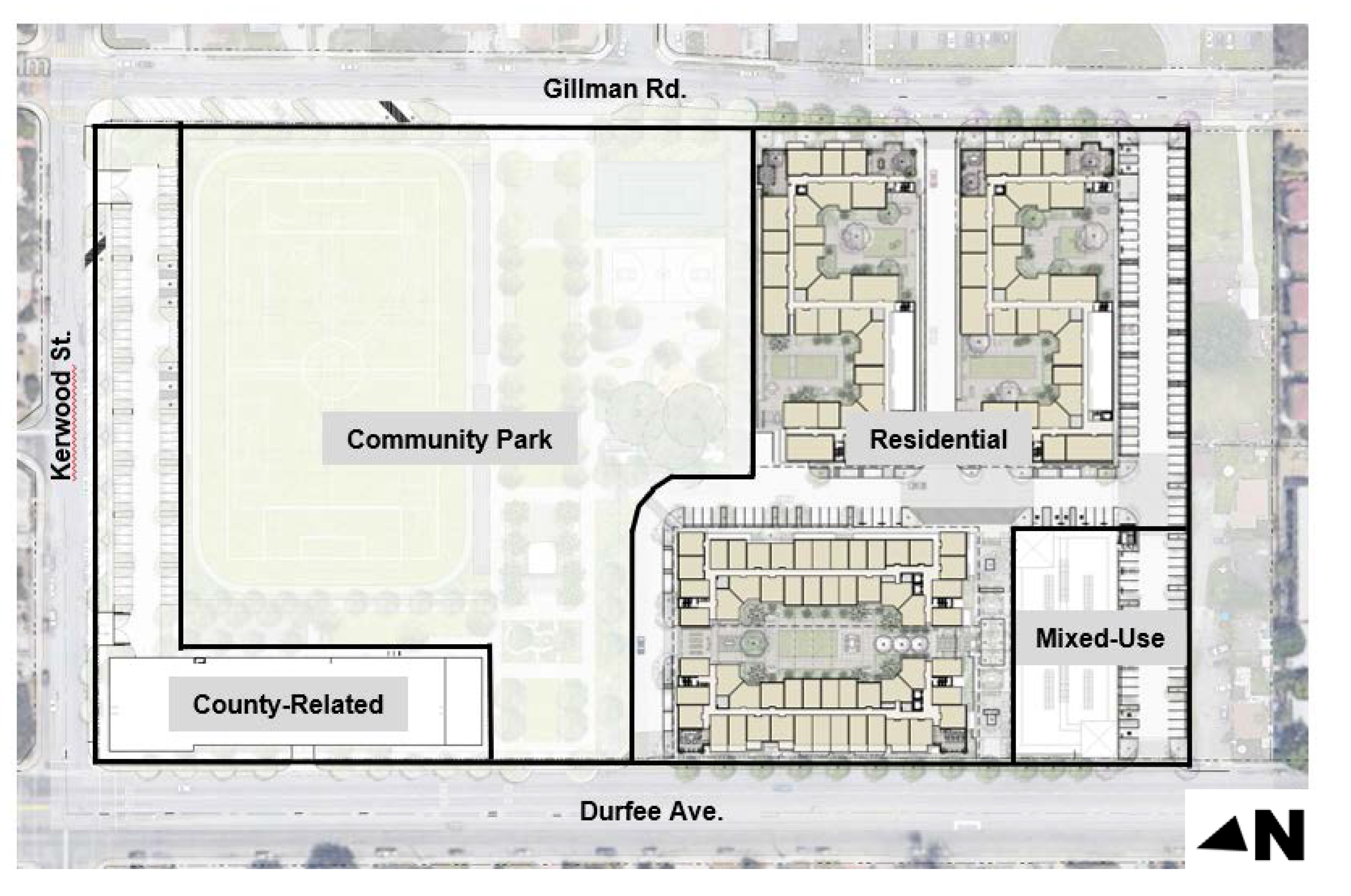
(Ord. No. 3053, § 3(Exh. A), 5-14-2025)
17.135.040 - Permitted uses.
A.
Permitted Uses. Table 17.135-1 prescribes the land use regulations for the Esperanza Village specific plan. Additional regulations are denoted in the right-hand column. These designations apply strictly to the permissibility of land uses; application for building structures may require other discretionary review.
B.
Unlisted Uses. Any land use not listed in Table 17.135-1 is not permitted in the Esperanza Village specific plan, except as outlined in Section 17.12.050 (Rules and Measurements—Additional Permitted Uses) of this title.
Table 17.135-1—Permitted Uses—Esperanza Village specific plan
Key:
— Use not permitted.
P Use permitted by-right.
M Use permitted after review and approval of a Minor Use Permit (MUP).
Z Use permitted after review and approval of a Director Level Zoning Clearance (ZCD) .
Notes:
23 Specialized education and training shall be limited to job training only.
(Ord. No. 3053, § 3(Exh. A), 5-14-2025)
17.135.050 - Development standards.
A.
Table 17.135-2 prescribes the development standards and Table 17.135-3 prescribes the parking requirements for the Esperanza Village specific plan:
Table 17.135-2—Development Standards 24
Notes:
24 The R and MU Subareas and southern portion of the CC Subarea shall be considered 1 property, and the CP and northern portion of the CC Subarea shall be considered 1 property when calculating setbacks, floor area and lot coverage.
25 Refer to Section 17.60.030 of this title for height exceptions for ancillary roof mounted equipment. Variable height requirements shall not apply.
26 The R and MU Subareas and southern portion of the CC Subarea shall be considered 1 property, and the CP and northern portion of the CC Subarea shall be considered 1 property when calculating setbacks, floor area and lot coverage.
Table 17.135-3—Parking Requirements 27
Notes:
27 Fractional spaces shall be rounded to the nearest whole number as follows:
A) Fractional spaces for guest parking and reserved for a specific unit shall be rounded up;
B) Other fractional spaces of 0.5 or greater shall be rounded up; and
C) All other fractional spaces less than 0.5 may be rounded down.
B.
Building Entrances and Façades:
1.
Buildings shall have entrances face public streets and/or publicly accessible areas. Entrances at building corners may be used to satisfy this requirement.
2.
Building façades facing the public right-of-way and on the sides and rear of buildings shall not exceed fifty (50) feet without a change in wall plane and/or architectural design element. Variations in wall planes and design elements may include but are not limited to, changes in material, color, landscaped planter boxes, roof lines, trellises, arches, and decorative tiles.
3.
Reflective building materials shall not be permitted, except as allowed in this section.
4.
The use of clear glass is required on the ground floor of a building, facing the public right-of-way, a driveway or required parking. After installation, clear glass windows at the ground floor shall not be treated later so as to become opaque or to be blocked so as to prevent visibility of the ground floor interior.
5.
Reflective glazing shall not be permitted on building façades fronting a public street right-of-way.
6.
Reflective glass, tinted glass, or other mirror-like materials that are highly reflective shall not cover more than twenty-five (25) percent of a structure's surface.
C.
Landscaping.
1.
A minimum of seventy-five (75) percent of all landscaping shall be drought tolerant.
2.
A minimum of one 24-inch box specimen tree shall be planted in the street setback or parkway area every thirty-five (35) linear feet of lot frontage, excluding driveways.
3.
A minimum of twenty-five (25) percent of all common open space areas shall be landscaped. A mix of trees, shrubs, and ground cover shall be provided. Landscaping shall be pedestrian friendly and provide areas of shade and accents.
4.
Street setback areas shall be fully landscaped with a mix of trees, shrubs, and ground covers that are compatible with the architectural style of the development.
5.
Landscaping shall not obstruct views of motorists or pedestrians.
6.
Water features shall be placed away from areas of full sun to reduce evaporation and reduce water required for operation. Reclaimed water shall be used for water features.
7.
Drought-tolerant trees and plants and artificial turf shall be used for courtyards and flexible spaces.
8.
Landscape maintenance shall be performed on a regular basis to maintain the visual quality of the landscaped areas.
9.
Permanent and automatic irrigation facilities shall be provided in all permanent landscaped areas, except potted containers.
10.
Irrigation of plant materials shall be efficiently managed through automated irrigation control systems appropriate to the unique needs of trees, shrubs, and turf.
11.
A minimum of one 24-inch box specimen tree shall be required for every six (6) parking spaces, or portion thereof, and shall be located throughout the surface parking area except where vehicle canopies equipped with solar panels are located above the parking spaces. This requirement shall be in addition to the required trees planted in the street setback areas.
D.
Lighting.
1.
All exterior lighting shall focus internally within the property to decrease light pollution onto neighboring residential properties.
2.
All exterior lighting and other means of illumination shall be shielded, equipped, and oriented in a manner as to prevent any glare or direct illumination on any public street, residential zoning district, or other property.
3.
Light poles and wall-mounted lights shall not exceed a maximum height of twelve (12) feet.
4.
Light poles and fixtures shall complement the overall site architecture and design in terms of scale, color, and style.
5.
Lighting levels shall be sufficient for the safety and security of vehicular and pedestrian traffic but shall not spill onto adjacent residential properties.
6.
Lighting shall be provided in all parking, vehicular and pedestrian circulation areas, loading areas, and courtyards. Lighting fixtures shall be designed and placed in a manner to provide uniform illumination over all parking areas.
7.
Exterior lighting shall be placed in a manner to ensure adequate lighting levels and to create an even level of illumination.
E.
Loading Areas.
1.
Exterior loading areas shall be located a minimum of seventy (70) feet from a public street and residential zoning district.
2.
Loading areas shall be screened from view from public street rights-of-way, residential zoning districts, and public parks.
3.
Loading spaces shall be clearly marked as being distinct from required parking spaces and aisles.
F.
Open Space.
1.
For residential developments, private open space shall be provided in the form of a balcony or patio and shall be directly adjacent to and accessible from the unit it serves.
2.
If balconies are provided for residential units, balconies shall not be place in a location that would overlook the backyard of any residential properties.
3.
Courtyards and roof decks may satisfy the common open space requirement provided they are available for use by all units.
4.
Common open space areas shall be conveniently located and accessible to all units.
5.
Common open space shall have a minimum dimension of twenty (20) feet in any direction.
6.
Ground level areas that are used as common open space area shall have a minimum area of six hundred (600) square feet.
7.
Roof decks that are used as common open space shall have a minimum area of four hundred (400) square feet.
8.
Street yard setbacks shall not be used to satisfy the common open space requirement.
G.
Parking.
1.
Residential parking shall be designated and signed or separated from other required non- residential parking.
2.
Non-guest spaces for residential uses shall be reserved.
3.
Exterior parking stalls and driveways shall be separated from buildings by a pedestrian walkway and/or landscape strip.
4.
Guest parking for residential development shall be clearly identified with the words "Guest Parking" painted in the space with minimum eight (8) inch letters or be provided with a sign in front of the parking spaces.
5.
Electric vehicle (EV) charging stations shall be reserved for parking and charging of EV only. Each EV charging station shall be posted with signage indicating the space is reserved for EV charging purposes.
6.
Parking spaces may be open, enclosed or partially enclosed.
H.
Pedestrian Walkways. Pedestrian walkways shall be a minimum of five (5) feet wide.
I.
Trash and Recycling Enclosures.
1.
External trash and recycling enclosures shall be located a minimum of fifty (50) feet from a public street right-of-way and residential zoning district.
2.
All trash and recycling enclosures shall be designed to architecturally integrate within the overall architectural theme of the Esperanza Village specific plan.
3.
Common trash enclosures shall be provided in sufficient quantity to accommodate all refuse and recycling generated.
4.
A refuse plan shall be submitted for review and approval by the city's solid waste service provider. The plan shall be approved prior to the approval of any entitlements.
J.
Walls, Fences, and Gates.
1.
A five (5)-foot wide landscape buffer shall be placed along the property line that adjoins a residential zoning district.
2.
Walls and fences within twenty (20) feet of a public right-of-way shall not exceed forty-two (42) inches in height. In all other areas, walls and fencing shall not exceed a height of six (6) feet. A solid six (6)-foot tall slumpstone or masonry wall shall be installed and maintained adjacent to the property line that adjoins a residential zoning district, except within twenty (20) feet of a public right-of-way.
3.
Fencing that is installed within twenty (20) feet of a public right-of-way shall have one decorative block pilaster placed every ten (10) feet in length.
4.
Fences and gates that separates the residential and circulation/open space parcels from the public park shall be a minimum fifty (50) percent open. The materials shall be made of decorative wrought iron. Decorative block pilasters shall be placed at each corner and at the end of the fencing. Within twenty (20) feet of public right-of-way, the fences and gates shall not exceed forty-two (42) inches in height. In all other areas, fences and walls shall not exceed six (6) feet in height.
5.
Fences and gates that are placed at a driveway entrance, within an on-site driveway, or on-site parking area shall be a minimum fifty (50) percent open. The materials shall be made of decorative wrought iron. Fences and gates shall not exceed six (6) feet in height.
6.
Barbed, pointed, spiked, razor, piercing or other similar materials shall not be attached to any walls, fences, or gates. Chain link fencing shall not be permitted.
K.
Other Requirements. With the exception of what is required by the Esperanza Village specific plan, all development shall conform with the requirements in Chapters 17.50 (Performance Standards), 17.60 (General Development Standards), 17.70 (Parking Regulations), 17.72 (Landscape Requirements) and 17.80 (Signage Regulations) of the EMMC.
L.
Limitations and Exceptions to Permitted Uses and Structures. Exceptions may be allowed for design flexibility within the Esperanza Village specific plan and shall be approved by the City Planning Commission. The following findings shall be made prior to the granting of any exceptions:
1.
Compliance with a development specification would preclude an effective and attractive design solution that fulfills the desired form, function, and character of the area as specified in the Esperanza Village specific plan.
2.
The granting of an exception will not constitute a grant of special privilege inconsistent with the limitations upon other properties that are subject to the same development specification.
3.
The granting of an exception will not be detrimental to the health, safety or general welfare of persons residing or working in the Esperanza Village specific plan and the surrounding neighborhood.
4.
The granting of the exception will not be detrimental or injurious to properties and improvements in the surrounding neighborhood or to the general welfare of the city.
(Ord. No. 3053, § 3(Exh. A), 5-14-2025)
17.135.060 - Design guidelines.
A.
Purpose. The following design guidelines establish the quality and character of the built environment and create an aesthetically cohesive appearance of the Esperanza Village specific plan. The design guidelines provide both a vision of the specific plan's overall character, and specific aesthetic expectations regarding the various components of the specific plan. More specifically, the purpose of the design guidelines is as follows:
1.
To provide the City of El Monte with assurance that the Esperanza Village specific plan will be designed and developed in accordance with the quality and character described within this specific plan.
2.
To provide guidance to developers, architects, landscape architects, builders, engineers, and other professionals needed to achieve and maintain the desired design quality.
3.
To provide guidance to city staff, the Planning Commission, and the City Council in the review of future development projects within the Esperanza Village specific plan.
4.
To provide clear, understandable, and achievable design components for development in the Esperanza Village specific plan to achieve a cohesive appearance.
B.
Intent. The design guidelines are a design framework for the buildings and landscape to convey an aesthetically interesting community identity within an infill setting. The design guidelines are intended to create quality development while allowing flexibility, promoting engaging aesthetics without limiting the product type or configuration of the built environment.
C.
Architectural Design Guidelines:
1.
Architectural Design and Style:
a.
The architectural styles for development in the Esperanza Village specific plan should be expressive of and authentic to that style.
b.
Building design should be compatible with and complement adjacent land uses while maintaining or enhancing the character of development.
c.
Structures and their related architectural elements should be visually consistent to provide a unified architectural theme.
d.
All building elements, such as materials and colors, detail elements (balconies, courtyards, surface treatments, and materials), and functional elements (exterior stairs, guardrails, gutters, screen walls) should be consistent with and integral to the overall building design, consistent with the architectural vernacular of the building and complement the surrounding neighborhood. A unified palette of materials should be used on all sides of buildings.
2.
Building Façades:
a.
Building façades that face public streets, sidewalks, open space areas, and other pedestrian areas should incorporate articulation and detailing that create visual interest and reinforce the pedestrian scale. This includes variation in massing, roof forms, and wall planes, as well as surface articulation.
b.
The design of building façades should vary. Variations may include changing the rooflines, introducing vertical architectural features (such as columns and pilasters), and changes in building materials and colors.
c.
Buildings should maintain a consistent quality and character in terms of the articulation, detailing, and finishes on all elevations visible from public streets, open space areas, and parking areas, not just the primary façade.
d.
Avoid the creation of uninterrupted blank wall surfaces on all building façades, particularly adjacent to a public street or open space area. The maximum length of any continuous blank wall facing shall not exceed thirty (30) feet.
e.
All elevations should have building façades articulated through the use of offset massing elements, complementary colors and materials, and/or variations in building setbacks. Building surfaces should be effectively articulated to enhance the pedestrian experience.
3.
Building Forms.
a.
Building forms should be well proportioned, resulting in a balanced composition of elements along public streets.
b.
Provide variations in roof forms, such as a combination of changes in plane, form, ridgelines, and/or heights appropriate to the architectural style.
4.
Building Massing.
a.
Building mass and scale should not overwhelm the surrounding uses.
b.
Variation in wall and roof planes should be used to break up the massing of large structures.
5.
Building Entrances and Windows.
a.
Main building entrances should be clearly defined and provide a focal point for the building as a whole. Building entrances should be identifiable and accentuated through changes in massing, color, façade articulation, and/or building materials. Strategies for architecturally defining building entries may include the use of architectural features such as columns, pilasters, and different materials.
b.
Buildings on parcels adjacent to a public street should have entrances facing the street or corner of the building adjacent to the street. Buildings on internal parcels should have entrances facing publicly accessible open space areas.
c.
The design and materials used for building entrances and windows should complement the architectural style of the building.
d.
Building entrances shall incorporate two (2) or more of the following:
i.
Change in wall and/or window plane;
ii.
A projecting element above the entrance;
iii.
A change in material or detailing;
iv.
Architectural elements and decorative fixtures; and/or
v.
Changes in the roofline.
e.
Windows should be inset from building walls to create shade and shadow detail.
f.
The patterns of openings (windows and doors) should correspond with the overall rhythm of the building and should be consistent in form, pattern, and color of the architectural style.
g.
Window trim used on elevations facing the streets should be repeated on all sides.
6.
Building Materials and Colors.
a.
Durable, high-quality exterior building materials should be used to convey the sense of quality, minimize maintenance concerns, and promote buildings that will last over time. Examples of appropriate materials include stone, tile, terra cotta, brick, metal, glass and architectural concrete. Other materials are acceptable if they meet the same standards for durability and visual quality. Stucco should be of smooth finish. Wood may be acceptable depending on its sturdiness and appearance.
b.
Building materials and colors should be used to unify and provide visual interest to building exteriors and reinforce building identity.
c.
Contrasting colors are encouraged to accentuate details such as trim, windows, doors, and key architectural elements. Colors of the trim and architectural details should be subtly contrasting but complementary of the overall building color. The colors should reinforce the desired architecture style.
d.
Materials, colors, and materials should be selected with the design objectives of avoiding monotony, providing depth and interest, and promoting visual diversity along public streets. Colors should complement the architectural style and overall color scheme of the building.
7.
Functional Elements.
a.
Loading areas, storage areas, trash bins, and mechanical equipment shall be placed to the rear or side of buildings away from public street rights-of-way and residential zoning districts. These elements shall be physically screened from public view and should be designed to be compatible with the architectural style and character of the associated development, such as through the use of similar finishes, materials, and details as the associated structures. These elements should be designed, located, or screened so as not to be readily identifiable from adjacent streets.
b.
Ground mounted equipment and meters shall be visually concealed and should be designed to not detract from the building architecture.
c.
Exterior stairways should be designed as an integral part of the overall architecture of the building and not appear as tacked on.
d.
Trash enclosures should be designed with similar finishes, materials, and details as the primary building(s) within the project area.
8.
Lighting.
a.
Lighting should be designed as an integral part of the development and should be consistent with the architectural building style and character.
b.
Building illumination should be focused on building entrances and signs. Overly bright and indiscriminate illumination of building façades should be avoided.
9.
Open Space Areas.
a.
Open space areas should be integrated into the overall design of the development.
b.
Common and public open space areas, outdoor furniture, and fixtures should be designed to be compatible with the architectural style of the development.
c.
Common and public open space areas should be well-defined by buildings and landscaping, be designed at a pedestrian scale, landscaped for shade and ornamentation, furnished with areas for sitting and dining, and lighted for evening use.
d.
Pedestrian-scaled elements and amenities shall be provided in common and public open space areas.
e.
Create attractive and flexible common and public open space areas that promotes outdoor recreation and community gathering while being sensitive to the privacy needs of adjacent residences within the Esperanza Village specific plan and the surrounding neighborhood.
f.
Common and public open space should provide shaded areas, such as seating under tree canopies and overhead shade elements.
g.
Buildings and residential units should be designed to overlook common and public open space areas to ensure safety and visibility.
h.
Common and public open space areas should be designed as a place for residents and visitors to relax, play, and interact. Development should include a mix of amenities in common and public open space areas that provide opportunities for community gatherings, interactions, and quiet spaces. Amenities may include barbecue areas, shade trees, shade structures, sculptural play structures, tables and chairs for community dining, flexible lounge seating, quiet bench seating, flex lawns, water features, outdoor couches, gathering spaces with firepit, trellises, and overhead lighting.
i.
The perimeter of common open space areas shall be landscaped with a mix of trees, shrubs, and groundcovers.
j.
Decorative and accent pavers and tiles shall be consistent with the architectural style of the development.
10.
Parking.
a.
Surface parking lots should not be located in the setback area between a building façade and a public street right-of-way.
b.
Where possible, limit views of parking areas from public street rights-of-way by placing parking spaces behind buildings. If surface parking lots are provided and are visible from a public street right-of-way, views of the surface parking lot should be softened with landscaping.
11.
Signage.
a.
Signage should be constructed of high-quality materials that enhances the character of the development.
b.
Signage should be designed to be consistent with the architectural style of the development. The materials, colors, scale, and proportion of the signs should complement the architectural style of the development.
12.
Walls, Fences, and Gates.
a.
Walls, fences, and gates should be designed with materials and finishes that complement the architectural style of the development. Landscaping, such as vines, shrubs, and/or trees, should be provided adjacent to the walls and fences.
b.
Walls that are used for screening purposes should be of solid material. Chain link or similar metal wire fencing with slats is prohibited for screening purposes.
13.
Sustainable Design.
a.
The driveway entrances to surface parking lots, driveway intersections, and pick- up/drop-off areas should be accented with enhanced paving and landscaping. Permeable or semi-permeable surfaces such as pavers are preferred for accent paving.
b.
The use of solar carports at surface parking lots are encouraged.
c.
Demonstrate sustainable design principles in open space areas through the appropriate use of drought tolerant and native plant materials, utilization of recycled products, and/or low energy and low water consumption requirements. Reclaimed water should be used wherever possible.
14.
Safety Design.
a.
Incorporate appropriate Crime Prevention Through Environmental Design (CPTED) features in the design of spaces as territorial reinforcement, strategic natural surveillance, well-lit spaces, and appropriate maintenance.
D.
Landscape Design Guidelines.
1.
Plant Palette.
a.
The tree and plant palette are provided in Figures 4-4 and 4-5, respectively, of the Esperanza Village specific plan. The plant palette establishes a base palette for the specific plan area's landscape design. Other similar plant materials may be substituted for these species, provided the replacement plants are drought-tolerant, complement the architectural style of development, and create year-round interest.
b.
The plant palette should include shrubs and groundcovers that are commonly used throughout Southern California and complement the Esperanza Village specific plan's design theme and setting. The plant materials should be water-efficient species, rated low or moderate by the Water Use Classification of Landscape Species (WUCOLS), native to Southern California or naturalized to the arid Southern California climate.
c.
Encourage the use of native (California-Mediterranean) and/or drought tolerant materials. Shrubs and groundcovers should be perennial type, non-invasive, and require minimal trimming.
2.
Streetscape.
a.
Where possible on Gilman Road, Kerrwood Street, and Durfee Avenue, the following minimum parkway width should be placed between the sidewalk and the street:
i.
Durfee Road—four (4) foot wide continuous parkway
ii.
Gilman Road—five (5) foot wide continuous parkway
iii.
Kerrwood Street—ten (10) foot wide continuous parkway
The parkway should be landscaped with a mix of ground covers, shrubs, and trees to buffer the sidewalk from traffic and to provide an enhanced pedestrian area. If a parkway cannot be accommodated due to insufficient space, landscaped planters with street trees should be installed in lieu of the landscaped parkway.
b.
The street trees should be a minimum of 24-inch box specimen.
3.
Other Landscape Design Guidelines.
a.
Landscaping should enhance building façades, complement architectural features, emphasize focal points, provide shade, and add visual interest.
b.
Landscaping should be compatible with the architectural style of the development.
c.
Landscaping should be used to activate building façades, screen less attractive elements, provide shade, and add color, texture and visual interest. Landscape materials should be of high quality and suitable for the Southern California climate.
d.
Outdoor furnishing should be high quality, durable, and consistent in style with the landscape design and architectural style of the development.
e.
Canopy trees should provide shade and visual comfort in common and public open space areas, as well as other areas with pedestrian activities.
f.
Shading materials should be used to shade open space areas and outdoor seating and dining areas. The shading materials should complement the architectural style of the development.
g.
Landscaping should be provided along the perimeter of common open space areas.
(Ord. No. 3053, § 3(Exh. A), 5-14-2025)
17.135.070 - Other requirements.
A.
When a development standard is not identified in the Esperanza Village specific plan, this title shall apply.
B.
Implementation and Administration. Refer to Chapter 5.0 (Implementation and Administration) of the Esperanza Village specific plan for additional requirements with regards to required actions and entitlements, permits and discretionary actions, expiration of approval and extensions, severability, applicability, administration and enforcement and specific plan amendments.
(Ord. No. 3053, § 3(Exh. A), 5-14-2025)