
El Monte City Zoning Code
Division 7
Parking and Landscaping Regulations
17.70.010 - Purpose.
These on-site parking requirements are established to:
A.
Provide properly designated parking areas adequate in design, capacity and location to prevent traffic congestion and avoid hazards to the public's safety and welfare.
B.
Ensure on-site parking areas are established in proportion to the needs of the facilities served and appropriate to the demand generated by a particular use and in such a manner as to maximize usefulness, protect the public safety and buffer adjacent land uses from potential negative impacts.
C.
Offer opportunities and incentives for projects to reduce the number of required automobile parking stalls through alternative methods of accommodating arrival to a site and encouraging alternative modes of transportation (e.g. bicycling, transit use, walking, carpooling) to reduce demand for automobile parking.
D.
Require that parking areas are designed to reduce potential environmental impacts, including minimizing stormwater runoff and the heat island effect.
E.
Provide loading and delivery facilities in proportion to the needs of allowed uses.
(Ord. No. 3053, § 3(Exh. A), 5-14-2025)
17.70.020 - Applicability for on-site parking and loading spaces.
A.
Tables 17.70-1 prescribes when projects are required to comply with the on-site parking and loading space requirements of this chapter. Nonconforming uses shall also comply with Sections 17.16.040 and 17.16.050 (Nonconforming Provisions—Nonconforming Residential Uses and Nonresidential Uses, respectively) of this title:
Table 17.70-1—Applicability for On-site Parking and Loading Spaces
(Ord. No. 3053, § 3(Exh. A), 5-14-2025)
17.70.030 - General requirements.
A.
Timing of Parking Requirements. On-site parking and loading facilities required by this chapter shall be submitted for approval and constructed at the same time or prior to the issuance of a certificate of occupancy for the uses that they serve. All plans shall clearly indicate the proposed development, including parking location, size, design, lighting, landscaping, curb cuts, ingress and egress.
B.
Existing Parking and Loading. Parking and loading spaces shall not be reduced or changed in design, location or maintenance below the requirements for such use. Refer to Section 17.70.070 of this chapter for exceptions to this requirement.
C.
Nonconforming Uses. Nonconforming uses shall comply with Section 17.16.040 (Nonconforming Provisions—Nonconforming Residential Uses) of this title.
D.
Advertising on Vehicles. Vehicles shall not be parked solely for the purpose of advertising. Advertising shall comply with Chapter 17.80 (Sign Regulations) of this title.
E.
Maintenance. All parking areas shall be permanently maintained in a safe and clean condition free of physical obstructions and in good condition. All areas, including landscaping, shall be kept free of trash and weeds. Any alteration, enlargement, maintenance or repairs shall be subject to the provisions of this chapter.
F.
Additional Parking Space Requirements. Additional parking over and above the minimum standards required in this chapter may be required, upon determination of the Planning Commission or Zoning Review Committee that the specific type of business or use generates a greater demand for parking than the requirements of this chapter.
G.
Right-of-way Parking. Land within the right-of-way of an existing or proposed street shall not be used to provide required parking and loading facilities.
H.
Use of Parking Spaces. Required parking areas shall be used exclusively for vehicle parking in conjunction with a permitted use. Required parking spaces must be available for the use of residents, customers or guests of the use. Required parking spaces cannot be used for the parking of equipment or storage of goods or inoperative vehicles. In addition, required parking spaces cannot be rented out or used for another property except as permitted through subsection 17.70.070.D. of this chapter.
(Ord. No. 3053, § 3(Exh. A), 5-14-2025)
17.70.040 - Required on-site parking for residential uses.
A.
Tables 17.70-2 and 17.70-3 prescribe the on-site parking requirements for single-family and multiple-family residential uses, respectively:
Table 17.70-2—On-Site Parking Requirements for Single-family Dwellings
Notes:
1 Dwelling size or number of bedroom, whichever is stricter
Table 17.70-3—On-Site Parking Requirements for Multiple-family Dwellings 2
Notes:
1 Dwelling size or number of bedrooms, whichever is greater.
2
Enclosed spaces—When less than 2 spaces are required, the unit shall have 1 enclosed/reserved space.
When 2 or more spaces are required, the unit shall have 2 enclosed/reserved spaces.
Fractional spaces—Fractional spaces shall be rounded to the nearest whole number as follows: 1) fractional
spaces for guest parking and reserved for a specific unit shall be rounded up; 2)
other fractional spaces of 0.5 or greater shall be rounded up; and 3) all other fractional
spaces less than 0.5 may be rounded down.
Density bonuses and other state provisions—The minimum parking requirements shall be prior to any density bonus or other state
provision that permits a higher density than allowed in this title.
3 Requirements for applicable densities within the MMU and UMU zoning districts and within the Downtown Specific Plan (SP-4).
4 Requirements for applicable densities within the UMU zoning district and SP-4.
B.
Table 17.70-4 prescribes the on-site parking requirements for other residential uses:
Table 17.70-4—On-Site Parking Requirements for Other Residential Uses 5
Notes:
5 Where less than 2 spaces are required, the unit shall have 1 enclosed/reserved space. Where 2 or more spaces are required, the unit shall have 2 enclosed/reserved spaces. Fractional spaces may be open and shall be unreserved. If they are reserved for a specific unit, the fractional space for each unit shall be rounded up.
6 For projects with market-rate units, the reduced parking ratios shall only apply to the affordable units. Market-rate units shall comply with the parking requirements of the underlying zoning districts. For projects with a density bonus, refer to Section 17.100.060 of this title.
7 For projects with market-rate units, guest parking shall comply with Table 17.70-3.
8 For projects with a density bonus, refer to Section 17.100.060 of this title.
(Ord. No. 3053, § 3(Exh. A), 5-14-2025)
17.70.050 - Required on-site parking for nonresidential uses.
A.
Table 17.70-5 prescribes the on-site parking requirements for nonresidential uses (per square feet of gross floor area (GFA) or other metric):
Table 17.70-5—On-Site Parking Requirements for Nonresidential Uses
Notes:
9 Refer to Section 17.112.190 for additional parking information.
10 Refer to Section 17.112.200 for additional parking information.
11 Refer to Section 17.112.220 for additional parking information.
12 Refer to Section 17.70.070.C. for additional parking information.
B.
For uses that are not listed in Table 17.70-5, the on-site parking requirements may be determined through either of the following:
1.
The Community Development Director may determine the parking requirements for the proposed use based on similar uses listed in this chapter, subject to the following:
a.
The Community Development Director finds that the proposed use will not have a negative impact related to traffic, noise, air quality, parking or public safety;
b.
The Community Development Director finds that the proposed use will not have a negative effect on the welfare of other businesses or individuals in the underlying zoning district or surrounding area;
c.
The applicant submits information that is substantial and compelling to support the Community Development Director's findings; and
d.
The applicant agrees to any conditions placed by the Community Development Director to ensure the use is not altered over time to be inconsistent with the original request and approval.
e.
Once the necessary information has been submitted, the Community Development Director shall make a Director's Determination in writing within thirty (30) days approving or denying the request. The director, at his or her discretion, may also refer the decision to the Planning Commission. The decision shall constitute the precedent for all future uses that match the same characteristics. The Director also has the authority to initiate the determination of additional parking requirements without a request from an applicant.
2.
The applicant submits a parking demand study prepared by a traffic engineer and approved by the city that supports the proposed number of parking spaces. The request and supporting information shall be presented to the applicable review authority for final consideration and approval.
(Ord. No. 3053, § 3(Exh. A), 5-14-2025)
17.70.060 - Required on-site loading spaces.
A.
Thresholds for On-site Loading Spaces. Refer to Section 17.70.020 of this chapter.
B.
Required Spaces. On-site loading spaces shall be provided in compliance with Table 17.70-6.
C.
Amounts are Cumulative. Square footages shall be cumulative. If a grocery store is forty-five thousand (45,000) square feet in area, it will require one small loading space and two (2) full-size loading spaces. This shall also apply to additions. If an existing office is thirty thousand (30,000) square feet in area and constructs a forty thousand (40,000) addition, the loading shall be based on seventy thousand (70,000) square feet.
D.
Loading Space Size. Small loading spaces shall be a minimum fifteen (15) feet wide by twenty-five (25) feet long. Full size loading spaces shall be a minimum fifteen (15) feet wide by forty (40) feet long with a clearance height of 14 feet.
E.
Turning Radius. The minimum turning radius shall be thirty (30) feet for a small loading space and forty (40) feet for a full-size loading space.
Table 17.70-6—On-site Loading Requirements
F.
Common Loading Facilities. The on-site loading requirements of this section may be satisfied by the permanent allocation of the identified number of spaces for each use in a common truck loading facility serving uses on adjacent properties and under different ownership.
1.
The total number of loading spaces shall not be less than the sum of the combined square footages of all the uses.
2.
An attested copy of a contract between the parties concerned containing an agreement to the joint use of the common truck loading facility shall be filed with the Planning Division.
G.
Location and Access. Loading spaces shall not be located in required setbacks. All loading spaces shall have adequate ingress and egress and be designed and maintained so the maneuvering, loading and unloading of vehicles does not interfere with the orderly movement of traffic and pedestrians on any street or sidewalk. Vehicles shall not have to back in from, or onto, a public street.
H.
Striping. Loading spaces shall be striped indicating the loading spaces and identifying the spaces as "loading only." The striping shall be permanently maintained by the property owner/tenant in a clear and visible manner at all times. "Loading only" signs may also be posted, but only in addition to striping requirements.
I.
Screening of Loading Spaces. All full-size loading spaces shall be screened from adjacent streets. The screening may be a fence, hedge or wall with a minimum height of six (6) feet.
(Ord. No. 3053, § 3(Exh. A), 5-14-2025)
17.70.070 - Parking reductions and adjustments.
Notwithstanding any other provision of this chapter, a reduction in on-site parking requirements may be authorized in accordance with this section.
A.
Downtown Parking.
1.
Table 17.70-7 prescribes the maximum allowable parking reductions for areas within the boundary of the Downtown Main Street specific plan. The reduced parking requirements shall not apply to any other area of the city.
Table 17.70-7—Reduced Parking Requirements (% reduced from Table 17.70-5)
13 Reductions shall be based on the parking requirements for the MMU zoning district.
2.
Change of Use. No additional parking shall be required for a change of use in the Main Street and Zocalo Sub-areas for buildings constructed prior to January 1, 2022. This shall not apply to buildings that are reconstructed or the square footage of additions.
B.
Downtown Parking Credits.
1.
Applicability. This subsection shall only apply to the areas within the boundary of the Downtown Main Street specific plan.
2.
Applications. Parking credits shall require the approval of a Director Level Zoning Clearance.
3.
Land Uses. Parking credits shall not be available for residential uses in the Monte Vista Subarea and shall not be available for legal non-conforming uses in any Subarea. It may be available for all other residential and nonresidential uses permitted within the Downtown Main Street specific plan.
4.
Pool of Public Spaces. Only public parking spaces shall be eligible for parking credits. This includes spaces within public parking lots and spaces along the street that are striped. A maximum subscription factor of two (2) shall apply towards the pool of public spaces (i.e. each public parking space shall equal two (2) parking credits). One parking credit shall be equal to one required parking space.
5.
Requests. The requested number of parking credits shall be available for public parking (i.e. available within the pool of public spaces). The maximum number of parking credits an applicant may receive is fifty (50) credits. In addition, parking credits shall not exceed fifty (50) percent of the parking requirements for the Monte Vista Subarea. Public parking spaces shall not be reserved for a specific use or property.
6.
Compliance with Parking Requirements. The use requesting the parking credits shall comply with the parking requirements outlined in this chapter. This may be through a combination of on-site parking spaces, shared parking and parking credits. The applicant shall not receive more parking credits than the use requires. A Minor Variance shall not be permitted to reduce the number of required parking spaces.
7.
Nontransferable. The parking credits shall not satisfy the parking requirements for any other use and shall not be transferred to another property.
8.
Written Contract and Payments. Parking credits shall require a contract between the applicant and the City of El Monte. Payments for the parking credits shall be due annually at the time of business license application/renewal.
9.
Time Periods. Parking credits shall be valid for one year. If the applicant has proceeded in good faith towards the implementation of the project, as determined by the Community Development Director, the applicant may request a 12-month extension. The extension shall be considered within thirty (30) days of the request. No further extensions shall be given and the number of parking credits shall return to the pool of public parking. If the property has been vacated for more than twelve (12) months, the application shall be null and void and the parking credits shall return to the pool of public parking.
C.
Car Sharing, Residential Uses.
1.
Applicability. This subsection shall only apply to residential uses permitted in the zoning districts and specific plan areas identified in Table 17.70-8.
2.
Applications. Car sharing shall require the approval of a Minor Use Permit.
3.
Land Uses and Properties. Car sharing may be available for one residential project with a minimum of twenty (20) dwelling units. In addition, it may be available for adjacent residential projects that have a combined twenty-five (25) or more dwelling units.
4.
Compliance with Parking Requirements. Each car sharing vehicle shall have its own dedicated parking space. Car sharing vehicles shall count as required parking at a ratio of one car sharing space to five (5) standard spaces. Table 17.70-8 prescribes the maximum reductions from the required parking. Car sharing parking spaces shall also meet the requirements outlined in Table 17.70-9.
5.
Calculating Spaces. Car sharing spaces shall not be included in the reductions outlined in Table 17.70-8. For example, if a project requires one hundred (100) parking spaces and is located in the Multiuse zoning district, the maximum percent reduction applied would be twenty (20) percent and the number of spaces required may be reduced to eighty (80) spaces. The car sharing calculation would be based on the 1:5 ratio for the twenty (20) spaces. Therefore, a minimum of four (4) of the eighty (80) spaces would need to be car sharing spaces.
Table 17.70-8 Maximum Parking Reduction for Car Sharing
6.
Operations. Car sharing vehicles shall be administered by a car sharing company/organization and shall be accessed directly by users without any assistance or supervision by company personnel.
7.
Annual Reporting. Verification of continued service shall be submitted to the Planning Division by January 1 st of each year.
8.
End of Service. In the event that the car sharing service ends, the property owner and/or the property management company shall notify the Community Development Director within thirty (30) days, with a report identifying the deficiency in parking spaces as a result of the program ending, and the plans to bring the use into compliance with parking requirements. Options to bring the property into compliance include the following:
a.
Entering into a contract with another comparable car sharing service;
b.
Securing parking credits (for projects within the Downtown Specific Plan);
c.
Constructing additional parking spaces on-site or off-site; and
d.
Demonstrate compliance in some other manner.
9.
Additional Findings. In addition to the required findings outlined in Section 17.123.030 (Conditional and Minor Use Permit—Necessary Findings) of this title, the following finding shall be made:
a.
The adequacy of the proposed car sharing will equal or exceed the level that would have been expected had the minimum parking requirements outlined in Table 17.70-4 been met.
D.
Shared Parking.
1.
Applicability. This subsection shall apply to all nonresidential districts.
2.
Applications. Shared parking shall require the approval of a Director Level Zoning Clearance.
3.
Properties.
a.
Same Property. May be two (2) or more uses on the same property.
b.
Separate Properties. Uses and properties may be separated a maximum of two thousand (2,000) feet walking distance. This may be exceeded if there is a plan for shuttle services or other accommodation to move between the use and parking, including a demonstrated commitment to continue such accommodations indefinitely.
4.
Parking Spaces.
a.
Underutilized. A minimum twenty (20) percent of the parking for one or more use is unoccupied during the proposed shared parking period.
b.
Analysis. The applicant shall submit a parking analysis using peer-reviewed methodologies developed by an acknowledged professional planning or engineering association [2] sufficient to determine the parking is underutilized and can be reasonably shared between the uses to fulfill parking requirements.
5.
Decisions.
a.
The Director shall approve the request if the application fully complies with this subsection.
b.
The Director may approve or deny the request if the application does not fully comply with subsections 3. or 4. above.
6.
Conditions of Approval.
a.
Parking Agreement. If the application includes separate properties, a shared parking agreement shall be recorded against all the properties.
b.
Annual Reporting. Verification of continued service shall be submitted to the Planning Division by January 1 st of each year.
E.
Transitional Uses.
1.
Minor Reduction. Transitional uses are permitted a twenty-five (25) percent parking reduction over what the required number of spaces for the transitional use would be if located in the General Commercial (C-3) zoning district.
2.
Major Reduction. A twenty-six (26) to fifty (50) percent reduction may be approved by the Planning Commission or Zoning Review Committee if substantiated by a parking analysis using peer reviewed methodologies developed by an acknowledged professional planning or engineering association 15 . Options for allowing this reduction may include, but are not limited to, tandem parking, shared off-site parking, placing limits on the transitional use to reduce impacts (e.g. hours of operation, maximum occupancy, etc.) and partially demolishing the existing building.
F.
Transit Oriented. Minimum parking requirements shall not be required for residential, commercial or other development project if the project is located within ½-mile of a Major Transit Stop, as defined in Section 21155 of the California Public Resources Code, and in accordance with Section 65863.2 of the California Government Code. However, this reduction shall not apply to disabled parking requirements, electric vehicle charging space/station requirement and projects subject to Downtown Parking Credits.
G.
Other Reductions or Adjustments. Table 17.70-9 lists additional parking reductions and adjustments. A Minor Variance shall not be required to reduce the number of parking spaces.
Table 17.70-9 Parking Reductions and Adjustments
16 For existing projects constructed prior to January 1, 2022.
(Ord. No. 3053, § 3(Exh. A), 5-14-2025)
Examples of professional planning associations include the Urban Land Institute, National Parking Association and International Council of Shopping Centers.
17.70.080 - Parking lots, spaces and driveways development and design standards.
A.
Access and Safety. All on-site parking facilities shall be designed so as to provide safe and reasonable maneuverability for vehicles within the parking area and enable a vehicle entering the parking area to move from one location to any other location within the parking area without entering a public street.
B.
Drainage. Drainage facilities shall be provided in all public parking areas capable of handling and maintaining the drainage requirements of the subject property and surrounding properties. Drainage facilities shall be designed to dispose of all surface water consistent with Regional Water Quality Control Board standards. Surface water from parking lots shall not drain over sidewalks or adjacent parcels.
C.
Lighting, Nonresidential Uses. Lighting for parking lots shall be a minimum one foot candlepower across eighty-five (85) percent or more of the lot. Lighting shall not exceed one foot candlepower on any adjacent property zoned residential. Refer to Section 17.60.050 (General Development Standards—Outdoor Lighting) of this title for additional requirements.
D.
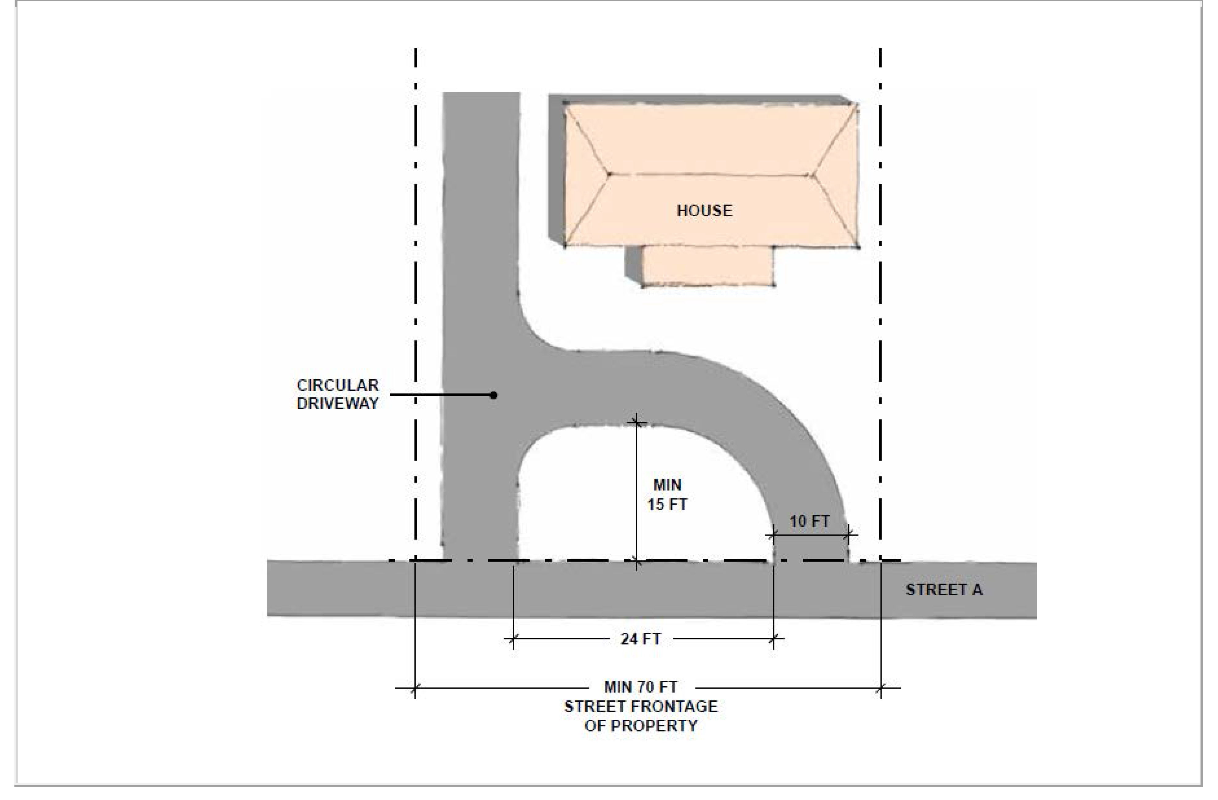
Additional Parking Standards. Refer to Table 17.70-10 for additional parking lot and parking space standards:
Table 17.70-10—Parking Standards
Notes:
17 Los Angeles County Fire Department may require additional driveway widths.
Figure 17.70-1—Parking Space Degrees
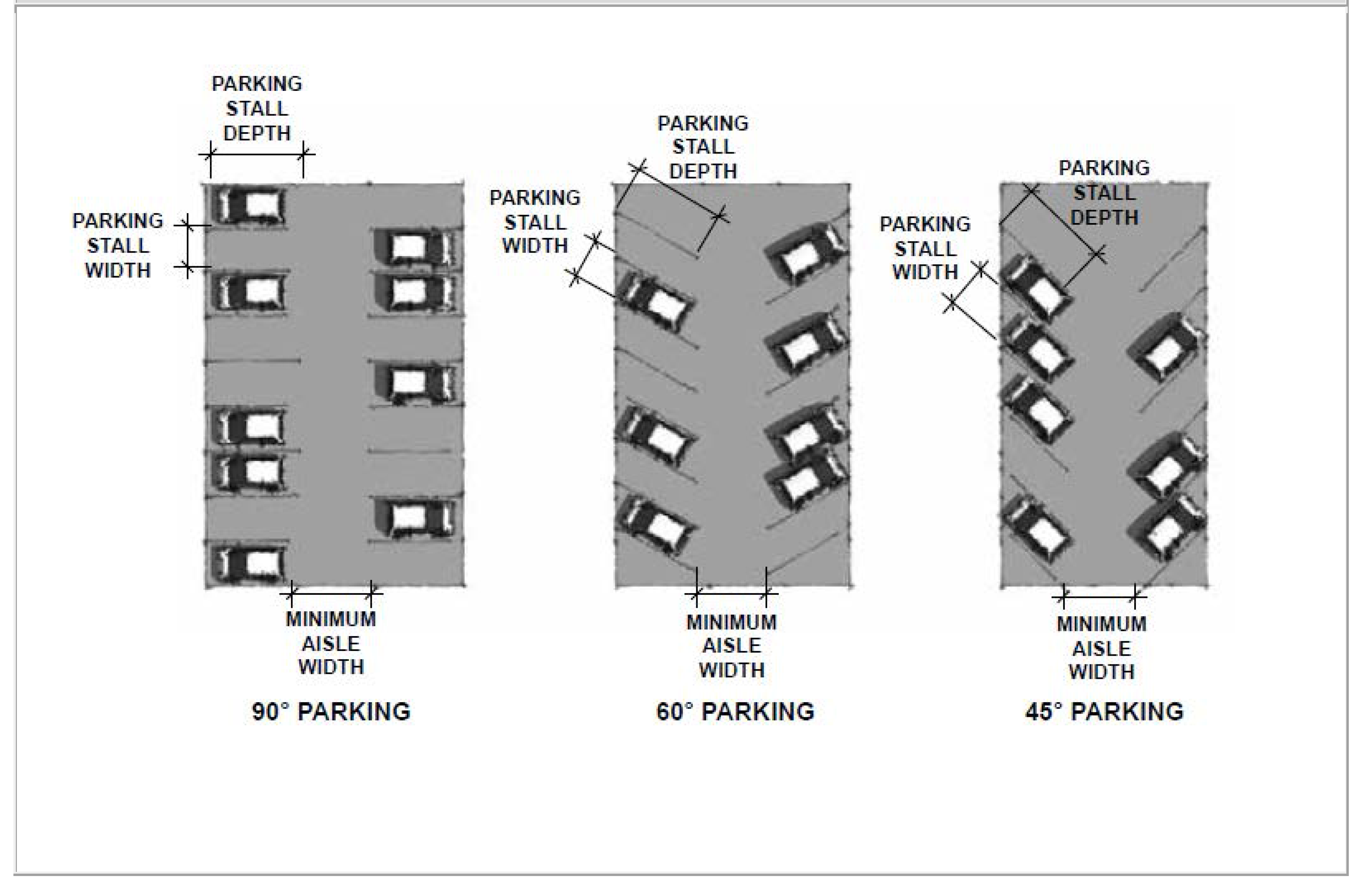
Figure 17.70-2—Access Triangle in Front of Garage Entrance
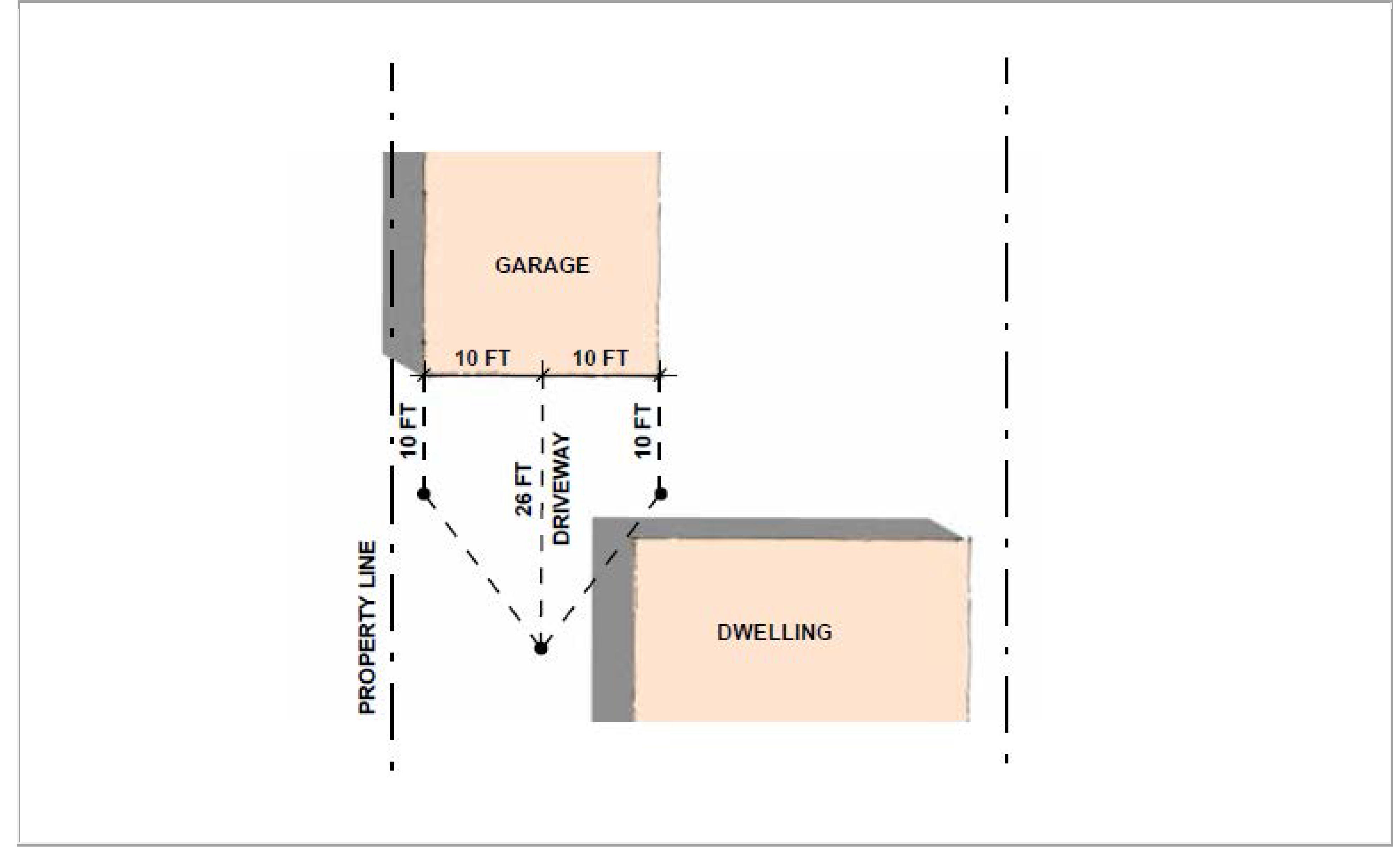
Figure 17.70-3—Circular Driveway
(Ord. No. 3053, § 3(Exh. A), 5-14-2025)
17.70.090 - Electric vehicle charging spaces/stations.
A.
Residential Thresholds. Residential Construction (minimum Level 1). The following thresholds shall apply:
1.
Single-Family or Multiple-Family Residential Construction. Any new enclosed parking spaces shall be EV-capable, pre-equipped for electric vehicle (EV) charging units.
2.
Multiple-Family Residential Construction with Ten (10) or More Units. Provide electrical charging stations at a rate of fifteen (15) percent of the required guest parking spaces, or two (2) spaces, whichever is greater.
B.
Nonresidential Thresholds. Nonresidential Construction (minimum Level 1 for office uses; minimum Level 2 for all other uses). The following thresholds shall apply:
1.
New Projects. Shall comply with EV charging space requirements based on the number of parking spaces required for the new project.
2.
Building Expansions. Shall comply with EV charging space requirements based on the number of new parking spaces required for the building expansion.
3.
Existing Parking Lots. Shall comply with EV charging space requirements if the entire parking lot is being reconstructed based on the total number of parking spaces. If only a portion of the parking lot is being reconstructed, the EV charging space requirements shall be based only on the number of spaces being reconstructed. EV charging spaces shall not be required if the parking lot is only being resurfaced (i.e. slurry seal or seal coat) and/or being restriped.
C.
Number of Spaces. Table 17.70-11 prescribes the required number of capable and installed EV charging spaces and stations. For projects with ten (10) or more parking spaces, a conversion rate of two (2) Level 1 or 2 equipment stations for each Level 3 equipment stations may apply:
Table 17.70-11—Required Electric Vehicle (EV) Spaces
D.
CALGreen Standards. When the requirements of this section differ from those of the California Green Building Standards Code, the stricter of the two (2) shall apply.
(Ord. No. 3053, § 3(Exh. A), 5-14-2025)
17.70.100 - Bicycle parking.
A.
Thresholds. The following thresholds shall apply:
1.
New Projects. Shall comply with short-term and long-term bicycle parking space requirements.
2.
Building Expansions. Shall comply with short-term and long-term bicycle parking space requirements based on the added building square footage or added number of vehicular parking spaces, whichever is greater.
3.
Tenant Improvements. Shall comply with long-term bicycle parking space requirements if more than fifty (50) percent of the interior walls are being demolished.
4.
Existing Parking Lots. Shall comply with short-term bicycle parking space requirements if the entire parking lot is being reconstructed. If only a portion of the parking lot is being reconstructed, the bicycle parking space requirements shall be based on the number of spaces reconstructed. Bicycle parking spaces shall not be required if the parking lot is only being resurfaced (i.e. slurry seal or coat) and/or being restriped.
5.
Condition of Approval. Short-term bicycle parking space requirements may be added as a condition of approval by any review authority.
B.
Short-term Bicycle Parking. Shall be conveniently located and within two hundred (200) feet of all main building entrances for nonresidential uses.
C.
Long-term Bicycle Parking. Shall be conveniently located from the street and shall meet one of the following:
1.
Covered, lockable enclosures with permanently anchored racks for bicycles;
2.
Lockable bicycle rooms with permanently anchored racks; or
3.
Lockable, permanently anchored bicycle lockers.
D.
Number of Spaces. Table 17.70-12 prescribes the required number of bicycle parking spaces:
Table 17.70-12—Required Bicycle Parking
E.
Showers and Changing Rooms for New Office Construction:
1.
Less than thirty thousand (30,000) square feet (single building or complex): None.
2.
Thirty thousand (30,000) square feet to one hundred thousand (100,000) square feet (single building or complex): One.
3.
Greater than one hundred thousand (100,000) square feet (single building or complex): Two (2).
F.
CALGreen Standards. When the requirements of this section differ from those of the California Green Building Standards Code, the stricter of the two (2) shall apply.
(Ord. No. 3053, § 3(Exh. A), 5-14-2025)
17.70.110 - Recreational vehicles (RVs) and other vehicle storage.
A.
Recreational Vehicles (RVs).
1.
Single-Family Residential Uses.
a.
Definition. Recreational vehicles include, but are not limited to, motor homes, boats, dune buggies, campers, camper buses and RV trailers.
b.
Location. The recreational vehicle shall be located on an approved paved area within the interior side yard or rear yard. It shall be prohibited within the front yard and street side yard. In addition, it shall not extend over any public sidewalk or public right-of-way.
c.
Quantity. A maximum of one recreational vehicle may be parked on each property.
d.
Registration. The recreational vehicle shall have a valid registration and be registered at the location where it is stored or parked. In addition, it shall be in operable condition.
e.
Screening. The recreational vehicle shall be screened from public view by existing structures or solid walls or fences with a minimum height of six (6) feet.
f.
Other. The recreational vehicle shall not be used for dwelling purposes and the connection of utilities, water, except for temporary maintenance purposes, are strictly prohibited.
2.
Other Residential Uses. In addition to the requirements set forth in subsection A. above, a recreational vehicle shall not occupy or block access to required parking or required open space.
3.
Mixed-Use Projects and Nonresidential Uses. The parking of recreational vehicles shall be prohibited, except as permitted for approved vehicle related uses.
B.
Other Vehicles.
1.
Residential Uses.
a.
Permitted. Other passenger vehicles up to ten thousand (10,000) pounds (up to Class 2) and construction-related vehicles and equipment (for a maximum of forty-eight (48) hours or through a valid building permit in effect for construction).
b.
Inoperable Vehicles. Any such vehicle must be parked within a fully enclosed garage. However, a single-family residential property may also park one additional inoperable vehicle within the interior side yard or rear yard, provided it is screened from public view by existing structures or solid walls or fences with a minimum height of six (6) feet. It shall be prohibited within the front yard and street side yard.
c.
Prohibited. The parking of all other vehicles and equipment shall be prohibited, except as permitted for approved vehicle related uses.
2.
Mixed-Use and Nonresidential Uses.
a.
Permitted. Passenger vehicles up to fourteen thousand (14,000) pounds (up to Class 4) and construction-related vehicles and equipment (for a maximum of forty-eight (48) hours or through a valid building permit in effect for construction).
b.
Prohibited. The parking of all other vehicles and equipment shall be prohibited, except as permitted for approved vehicle related uses.
(Ord. No. 3053, § 3(Exh. A), 5-14-2025)
17.72.010 - Purpose.
A.
To establish a framework to review landscape and irrigation plans consistently and improve the physical appearance of the city by providing visual and ecological relief in the urban environment;
B.
To establish minimum landscape development standards for the design, provision and maintenance of landscaped areas, and encourage irrigation methods and suggested plant species to develop a measure of uniformity and quality in overall landscaping design;
C.
To promote the value and long-term benefits of landscapes to provide an attractive living, working and recreating environment, while recognizing the need to invest water and other resources as efficiently as possible; and
D.
To establish a structure for designing, installing, and maintaining water efficient landscapes for expansion of the existing buildings and new projects.
(Ord. No. 3053, § 3(Exh. A), 5-14-2025)
17.72.020 - Applicability.
A.
New Projects. New landscaping and irrigation shall be required according to the provisions of this chapter. When the requirements of this chapter and Chapter 17.74 (Water Efficiency) of this title differ, the stricter of the two (2) shall apply.
B.
Residential Expansions. New landscaping and irrigation shall be required for the following:
1.
The construction of one or more new dwelling unit through new construction. This shall also include the construction of a new urban dwelling but not include the construction of detached accessory dwelling units (ADUs).
2.
Remodels that involve demolishing more than fifty (50) percent of a residential building's exterior walls; and
3.
Additions that are more than fifty (50) percent of the gross floor area (GFA) or seven hundred fifty (750) square feet, whichever is greater. This shall not include the construction of attached ADUs or junior ADUs. If the additions include multiple residential buildings, the calculation shall be based on the combined square footages.
C.
Nonresidential Expansions. New landscaping and irrigation shall be required for the following:
1.
Additions that are more than thirty-five (35) percent of the GFA or one thousand five hundred (1,500) square feet, whichever is greater;
2.
The construction of new parking lots or reconstruction of existing parking lots. The new landscaping and irrigation will be limited to the parking lot areas and will not be required if the parking lot is only being resurfaced (i.e. slurry seal or seal coat) and/or restriped; and
3.
Condition of Approval. Landscaping and irrigation requirements may be added as a condition of approval by any review authority.
(Ord. No. 3053, § 3(Exh. A), 5-14-2025)
17.72.030 - Exemptions.
New landscaping and irrigation plans shall not be required for properties that are already in compliance with the state of California's Model Water Efficiency Landscape Ordinance (MWELO) or Chapter 17.74 (Water Efficiency) of this title.
(Ord. No. 3053, § 3(Exh. A), 5-14-2025)
17.72.040 - Landscaping requirements—General.
A.
All Landscaping Areas. All existing and proposed landscaping areas, including those below the thresholds listed in Section 17.72.020 of this chapter, shall comply with the following:
1.
Required Planting Palette. The city does not have a required list of trees, shrubs and groundcover. However, the city encourages the use of drought-tolerant and/or native or indigenous plant material and does have suggested planting lists which is consistent with the city's goal for water efficient landscapes;
2.
Mixture of Plant Materials. Landscaping shall consist of combinations of trees, shrubs and ground covers with careful consideration given to eventual size and spread, susceptibility to disease and pests, durability, and adaptability to existing soil and climatic conditions;
3.
Location of Plant Materials. Trees shall not be planted within five (5) feet of any building or structure, or under any eave, overhang or balcony. In addition, landscape materials shall not be located such that at maturity they interfere with safe site distances for vehicular, bicycle or pedestrian traffic or conflict with overhead utility lines; and
4.
Maintenance. Landscaping shall be maintained in an orderly and healthy condition in compliance with this chapter. This includes proper pruning, staking, sowing of lawns, weeding, removal of litter, fertilizing, monitoring for pests and disease, replacement of plants when necessary and regular watering.
B.
New Projects, Residential Expansions and Nonresidential Expansions. All landscaping areas subject to Section 17.72.020 of this chapter shall comply with the following:
1.
Plans and Drawings. Landscape and irrigation plans shall be prepared by a licensed landscape architect or licensed landscape contractor or any other person authorized to design a landscape. Landscaping shall be planned as an integral part of the overall project design and not simply located in remanent spaces after buildings and parking areas have been designed. The installation shall be in accordance with the approved plans and shall be required prior to final occupancy; and
2.
Additional Requirements. In addition to the minimum landscaping required in this chapter, additional landscaping may be deemed necessary to relieve solid, unbroken elevations or soften continuous wall expanses. Additional landscaping may also be required to break up expansive parking areas, channelize traffic and screen trash enclosures, on-site utilities or other similar land uses or elements.
C.
Planting of Landscaping. When new landscaping is proposed or required, the following shall be followed:
1.
Trees. Specimen trees (e.g. twenty-four-, thirty-six- or forty-eight-inch box) shall be planted at the minimum quantities outlined in this chapter. New trees should also be staked or guyed.
2.
Shrubs.
a.
A minimum of one shrub shall be provided for every fifty (50) square feet of landscaped area for residential projects and every twenty-five (25) square feet for nonresidential projects. A minimum seventy-five (75) percent of the required shrubs shall be a minimum of five (5) gallons.
b.
All five-gallon and one-gallon size shrubs, when planted as high ground cover, shall be of low, spreading type evergreen shrubs placed eighteen (18) inches on center.
3.
Ground Covers.
a.
Materials such as crushed rock, redwood chips, pebbles and stones are not satisfactory substitutes for live plant materials, although they may be used in limited amounts.
b.
Depending on the type of ground cover planted, ground cover should be spaced at a maximum of one foot on center.
c.
Ground cover areas shall be planted with well rooted cuttings or container stock. Turf areas shall be planted with field-grown established sod or hydroseed.
4.
Artificial Turf Standards. The use of artificial turf shall be permitted as follows:
a.
Setback and Percentage Requirements.
i.
Residential Zoning Districts. Artificial turf may be used in lieu of natural turf and ground cover for up to forty (40) percent of street yard setbacks. There shall be no limitation in other areas.
ii.
Nonresidential zoning districts. Artificial turf may be used in lieu of natural turf and ground cover for up to sixty (60) percent of street yard setbacks. There shall be no limitation in other areas.
iii.
Slope restrictions. The installation of artificial turf on slopes greater than six (6) percent shall be prohibited.
b.
Installation.
i.
General. Should be installed over a compacted and porous road base material and shall be anchored at all edges and seams. Seams shall be glued and not sewn. An infill medium consisting of clean sand or other approved mixture shall be brushed into the fibers to ensure that the fibers remain in an upright position and to provide ballast that will help hold the turf in place and provide a cushioning effect.
ii.
Over Subterranean or Podium Parking or on a Roof. Should be installed with porcelain or turf tray pavers in conjunction with raised pedestals and deck support systems.
iii.
Minimum Height. Should consist of pile fibers a minimum height of one and three-quarters (1¾) inch.
iv.
Drainage. Shall include a proper drainage system installed underneath the turf to prevent excessive run-off or pooling.
c.
General Appearance. Artificial turf shall be installed and maintained to effectively simulate the appearance of a well maintained lawn. The Planning Department shall maintain and make available for public inspection a sample of various artificial turf products that meet this standard of appearance.
d.
Prohibited Uses. The use of indoor or outdoor plastic or nylon carpeting and/or the use of synthetic shrubs, flowers, trees and vines instead of artificial turf and/or live plant materials shall be prohibited.
(Ord. No. 3053, § 3(Exh. A), 5-14-2025)
17.72.050 - Landscaping requirements—Residential uses.
A.
All Residential Projects.
1.
Street Setbacks Areas. All street setback areas shall be fully landscaped with a mixture of trees, shrubs and ground covering, with exception to approved paved driveways and walkways. The paved area of the front yard and required street side yard, including driveways and walkways, shall not exceed forty (40) percent.
2.
Trees. A minimum of one, twenty-four-inch box specimen tree shall be planted in street setback areas every thirty-five (35) linear feet of lot frontage, excluding driveways.
3.
Driveway Planter. A minimum three-feet wide planter shall be located between the interior side property line and length of the driveway. The planter shall be planted with low growth, wide-spreading ground cover material or clustered five-gallon dwarf evergreen shrubs. Trees may be planted if the driveway planter is five (5) or more feet in width.
B.
Residential Projects with Three (3) or More Units.
1.
Private Open Space Areas. A minimum of one, twenty-four-inch box specimen tree shall be planted in private open space areas that are at grade and have a minimum area of four hundred (400) square feet.
2.
Common Open Space Areas—At Grade.
a.
A minimum fifty (50) percent of the common open space areas shall be landscaped. The rest may be improved with a combination of decorative paving and resident amenities (e.g. seating and barbeque areas, etc.).
b.
A minimum of one twenty-four-inch box specimen tree shall be planted for every five hundred (500) square feet of common open space area.
3.
Common Open Space Areas—Over Subterranean or Podium Parking or on a Roof.
a.
A minimum twenty-five (25) percent of the common open space areas over subterranean or podium parking and fifteen (15) percent of common open space areas over other roofed areas shall be landscaped. The rest may be improved with a combination of decorative pavers and resident amenities (e.g. seating and barbeque areas, etc.).
b.
When common open space areas are over subterranean or podium parking, a minimum one fifteen-gallon tree shall be planted in a tree well. An additional tree shall be planted for each eight hundred (800) square feet of common open space area.
c.
Appropriate drainage shall be provided for planters, tree wells and the soil covering the parking or roof deck.
4.
Street setbacks, driveways and walkways to unit entrances shall not count towards private or common open space area requirements.
5.
Parking and Circulation. All landscaping shall be separated from parking and vehicular circulation areas by a raised, continuous six-inch Portland Cement concrete curb. Other materials which accomplish the same purpose may also be used.
C.
Mixed-Use Projects. For vertical or horizontal mixed-use projects, the project shall follow this section for residential open space areas and Section 17.72.060 of this chapter for all street setbacks, areas around at-grade nonresidential uses, surface parking lots and unused areas.
(Ord. No. 3053, § 3(Exh. A), 5-14-2025)
17.72.060 - Landscaping requirements—Nonresidential uses.
A.
Street Setback Areas.
1.
Street Setbacks Areas. All street setback areas shall be fully landscaped with a mixture of trees, shrubs and ground covering, with exception to approved driveways, walkways and other areas specifically permitted in this title.
2.
A minimum of one, twenty-four-inch box specimen tree shall be required for every thirty-five (35) linear feet of lot frontage, excluding driveways.
B.
Parking and Vehicular Access Areas.
1.
Percent of Landscaping for Off-Street Parking Lots.
a.
Equal to or less than fifty (50) parking spaces. A minimum of five (5) percent shall be landscaped.
b.
Greater than fifty (50) parking spaces. A minimum of eight (8) percent shall be landscaped.
c.
Landscaping shall be distributed throughout the parking lot.
d.
The landscaping percentages required above shall not include required street setbacks.
e.
Parking spaces shall not include loading spaces. For manufacturing uses, areas used exclusively for loading, and fully enclosed by a solid masonry wall with a minimum height of six (6) feet, shall not trigger or require landscaping.
2.
Number of Trees. A minimum of one, twenty-four-inch box specimen tree shall be required for every six (6) parking spaces, or portion thereof, and shall be located throughout the parking area. This shall be in addition to required trees planted in the street setback areas.
3.
Perimeter Landscaping. All parking lots shall have a landscape planter with a minimum width of five (5) feet adjacent to all interior side and rear property lines.
4.
Planter Size. All landscape planters shall be a minimum width of five (5) feet. The depth of parking stalls may be reduced by two (2) feet if the minimum planter width is six (6) feet, or if the minimum plant width is seven (7) feet and two (2) rows of vehicles are overhanging the planter.
5.
Parking and Circulation. All landscaping shall be separated from parking and vehicular circulation areas by a raised, continuous six-inch Portland Cement concrete curb. Other materials which accomplish the same purpose may be approved by the Planning Division.
C.
Mixed-Use Projects. For vertical or horizontal mixed-use projects, the project shall follow this section for all street setbacks, areas around at-grade nonresidential uses, surface parking lots and unused areas and Section 17.72.050 of this chapter for residential open space areas.
D.
Unused Areas. All areas of a project site not intended for a specific use, including pad sites held for future development, shall be landscaped in accordance with this chapter.
(Ord. No. 3053, § 3(Exh. A), 5-14-2025)
17.72.070 - Landscaping reductions and adjustments.
The applicable review authority may consider any of the following landscaping requirements reductions:
A.
Residential Projects.
1.
Driveway Planter. The minimum three (3) feet planter width between the interior side property line and length of the driveway may be waived as follows:
a.
When the property has a street frontage of fifty (50) feet or less; and
b.
For residential expansions, as outlined in subsection 17.72.020.B. of this chapter, when the existing driveway is situated between the existing dwelling and interior side property line, and the setback between the existing dwelling and interior property line is less than fifteen (15) feet.
2.
Common Open Space Areas. The minimum number of trees may be reduced because of the proposed planting plan (e.g. the species selected) or programming (e.g. the project includes a swimming pool or gazebo).
3.
Street Setback Areas. The minimum number of trees or minimum percentage of landscaping for street setback areas may be reduced for buildings that are constructed ten (10) feet or less to the public right-of-way.
B.
Nonresidential Projects.
1.
Street Setback Areas. The minimum number of trees or minimum percentage of landscaping for street setback areas may be reduced for buildings that are constructed ten (10) feet or less to the public right-of-way.
2.
Vehicle Dealerships. The minimum number of trees may be reduced and/or the tree species may be modified for vehicle dealerships within the city's Auto District (as illustrated in General Plan Figure LU-2).
3.
Solar Facilities. The minimum number of parking lot trees may be reduced and/or the tree species may be modified for parking lots that include vehicle canopies equipped with solar panels.
4.
Podium Parking and Structured Parking. The minimum number of parking lot trees may be reduced and/or the tree species may be modified for podium parking areas and the upper level of structured parking.
5.
Perimeter Landscaping for Parking or Vehicular Access Areas. The minimum planter width may be reduced or waived for properties less than one hundred (100) feet wide or one hundred (100) feet deep. However, reductions to perimeter landscaping shall not be permissible if the adjacent property is zoned residential.
C.
Tree Mitigation Fund. The applicant shall pay into the city's Tree Mitigation Fund for each required tree that is not planted.
(Ord. No. 3053, § 3(Exh. A), 5-14-2025)
17.72.080 - Tree preservation.
Refer to Chapter 14.03 (Tree Protection and Preservation) of Title 14 (Sustainable Development) of the El Monte Municipal Code (EMMC) to review the city's regulations to protect and preserve trees.
(Ord. No. 3053, § 3(Exh. A), 5-14-2025)
17.74.010 - Purpose.
A.
The state legislature has found that:
1.
The waters of the state are of limited supply and are subject to ever increasing demands;
2.
The continuation of California's economic prosperity is dependent on the availability of adequate supplies of water for future uses;
3.
It is the policy of the state to promote the conservation and efficient use of water and to prevent the waste of this valuable resource;
4.
Landscapes are essential to the quality of life in California by providing areas for active and passive recreation and as an enhancement to the environment by cleaning air and water, preventing erosion, offering fire protection and replacing ecosystems lost to development;
5.
Landscape design, installation, maintenance and management can and should be water efficient; and
6.
Section 2 of Article X of the California Constitution specifies that the right to use water is limited to the amount reasonably required for the beneficial use to be served and the right does not and shall not extend to waste or unreasonable method of use.
B.
Consistent with these legislative findings, the purpose of the Model Water Efficiency Landscape Ordinance (MWELO) is to:
1.
Promote the values and benefits of landscaping practices that integrate and go beyond the conservation and efficient use of water;
2.
Establish a structure for planning, designing, installing, maintaining and managing water efficient landscapes in new construction and rehabilitated projects by encouraging the use of a watershed approach that requires cross-sector collaboration of industry, government and property owners to achieve the many benefits possible;
3.
Establish provisions for water management practices and water waste prevention for existing landscapes;
4.
Use water efficiently without waste by setting a maximum applied water allowance as an upper limit for water use and reduce water use to the lowest practical amount;
5.
Promote the benefits of consistent landscape ordinances with neighboring local and regional agencies;
6.
Encourage local agencies and water purveyors to use economic incentives that promote the efficient use of water, such as implementing a tiered-rate structure; and
7.
Encourage local agencies to designate the necessary authority that implements and enforces the provisions of this chapter or its local landscape ordinance.
C.
Landscapes that are planned, designed, installed, managed and maintained with the watershed based approach can improve California's environmental conditions and provide benefits and realize sustainability goals. Such landscapes will make the urban environment resilient in the face of climatic extremes. Consistent with the legislative findings and purpose of this chapter, conditions in the urban setting will be improved by:
1.
Creating the conditions to support life in the soil by reducing compaction, incorporating organic matter that increases water retention, and promoting productive plant growth that leads to more carbon storage, oxygen production, shade, habitat and esthetic benefits;
2.
Minimizing energy use by reducing irrigation water requirements, reducing reliance on petroleum based fertilizers and pesticides, and planting climate appropriate shade trees in urban areas;
3.
Conserving water by capturing and reusing rainwater and graywater wherever possible and selecting climate appropriate plants that need minimal supplemental water after establishment;
4.
Protecting air and water quality by reducing power equipment use and landfill disposal trips, selecting recycled and locally sourced materials, and using compost, mulch and efficient irrigation equipment to prevent erosion; and
5.
Protecting existing habitat and creating new habitat by choosing local native plants, climate adapted non-natives and avoiding invasive plants. Utilizing integrated pest management with least toxic methods as the first course of action.
(Ord. No. 3053, § 3(Exh. A), 5-14-2025)
17.74.020 - Applicability.
A.
This chapter shall apply to all of the following landscape projects:
1.
New construction projects with an aggregate landscape area equal to or greater than five hundred (500) square feet requiring a building or landscape permit, plan check or design review;
2.
Rehabilitated landscape projects with an aggregate landscape area equal to or greater than two thousand five hundred (2,500) square feet requiring a building or landscape permit, plan check, or design review; and
3.
Existing landscapes limited to Sections 17.74.220, 17.74.230, and 17.74.240 of this chapter.
B.
Any project with an aggregate landscape area of two thousand five hundred (2,500) square feet or less may comply with the performance requirements of this section or conform to the prescriptive measures contained in Table 17.74-5.
C.
For projects using treated or untreated graywater or rainwater captured on site, any lot or parcel within the project that has less than two thousand five hundred (2,500) square feet of landscape and meets the lot or parcel's landscape water requirement (estimated total water use) entirely with treated or untreated graywater or through stored rainwater captured on site is subject only to Table 17.74-5 Section E. This section does not apply to:
1.
Registered federal, state or local historical sites;
2.
Ecological restoration projects that do not require a permanent irrigation system;
3.
Mined-land reclamation projects that do not require a permanent irrigation system; or
4.
Existing plant collections, as part of botanical gardens and arboreta open to the public.
(Ord. No. 3053, § 3(Exh. A), 5-14-2025)
17.74.030 - Provisions for new construction or rehabilitated landscapes.
The city may designate by mutual agreement, another agency, such as a water purveyor, to implement some or all of the requirements contained in this section. Local agencies may collaborate with water purveyors to define each entity's specific responsibilities relating to this chapter.
(Ord. No. 3053, § 3(Exh. A), 5-14-2025)
17.74.040 - Compliance with landscape documentation package.
A.
Prior to construction, the city shall:
1.
Provide the project applicant with the ordinance and procedures for permits, plan checks, or design reviews;
2.
Review the landscape documentation package submitted by the project applicant;
3.
Approve or deny the landscape documentation package;
4.
Issue a permit or approve the plan check or design review for the project applicant; and
5.
Upon approval of the landscape documentation package, submit a copy of the water efficient landscape worksheet to the local water purveyor.
B.
Prior to construction, the project applicant shall submit a landscape documentation package to the city.
C.
Upon approval of the landscape documentation package by the city, the project applicant shall:
1.
Receive a permit or approval of the plan check or design review and record the date of the permit in the certificate of completion;
2.
Submit a copy of the approved landscape documentation package along with the record drawings, and any other information to the property owner or his/her designee; and
3.
Submit a copy of the water efficient landscape worksheet to the local water purveyor.
(Ord. No. 3053, § 3(Exh. A), 5-14-2025)
17.74.050 - Penalties.
The city may establish and administer penalties to the project applicant for non-compliance with the ordinance to the extent permitted by law.
(Ord. No. 3053, § 3(Exh. A), 5-14-2025)
17.74.060 - Elements of the landscape documentation package.
A.
The landscape documentation package shall include the following six (6) elements:
1.
Project information:
a.
Date;
b.
Project applicant;
c.
Project address (if available, parcel and/or lot number(s));
d.
Total landscape area (square feet);
e.
Project type (e.g., new, rehabilitated, public, private, cemetery, homeowner-installed);
f.
Water supply type (e.g., potable, recycled, well) and identify the local retail water purveyor if the applicant is not served by a private well;
g.
Checklist of all documents in landscape documentation package;
h.
Project contacts to include contact information for the project applicant and property owner; and
i.
Applicant signature and date with statement, "I agree to comply with the requirements of the water efficient landscape ordinance and submit a complete landscape documentation package."
2.
Water efficient landscape worksheet:
a.
Hydrozone information table;
b.
Water budget calculations:
i.
Maximum Applied Water Allowance (MAWA); and
ii.
Estimated Total Water Use (ETWU).
3.
Soil management report;
4.
Landscape design plan;
5.
Irrigation design plan; and
6.
Grading design plan.
(Ord. No. 3053, § 3(Exh. A), 5-14-2025)
17.74.070 - Water efficient landscape worksheet.
A.
A project applicant shall complete the water efficient landscape worksheet in Table 17.74-2, which contains information on the plant factor, irrigation method, irrigation efficiency, and area associated with each hydrozone. Calculations are then made to show that the evapotranspiration adjustment factor (ETAF) for the landscape project does not exceed a factor of 0.55 for residential areas and 0.45 for nonresidential areas, exclusive of special landscape areas. The ETAF for a landscape project is based on the plant factors and irrigation methods selected. The maximum applied water allowance is calculated based on the maximum ETAF allowed (0.55 for residential areas and 0.45 for nonresidential areas) and expressed as annual gallons required. The estimated total water use (ETWU) is calculated based on the plants used and irrigation method selected for the landscape design. ETWU must be below the MAWA.
1.
In calculating the maximum applied water allowance and estimated total water use, a project applicant shall use the Reference Evapotranspiration (ETo) values found in Table 17.74-1. Since the City of El Monte is not included in the list, it shall use data from other cities located nearby and in the same ETo.
B.
Water budget calculations shall adhere to the following requirements:
1.
The plant factor used shall be from Water Use Classification of Landscape Species (WUCOLS) or from horticultural researchers with academic institutions or professional associations as approved by the California Department of Water Resources (DWR). The plant factor ranges from 0 to 0.1 for very low water using plants, 0.1 to 0.3 for low water use plants, from 0.4 to 0.6 for moderate water use plants, and from 0.7 to 1.0 for high water use plants.
2.
All water features shall be included in the high water use hydrozone and temporarily irrigated areas shall be included in the low water use hydrozone.
3.
All special landscape areas shall be identified and their water use calculated as shown in Table 17.74-2.
4.
ETAF for new and existing (non-rehabilitated) special landscape areas shall not exceed 1.0.
(Ord. No. 3053, § 3(Exh. A), 5-14-2025)
17.74.080 - Soil management report.
A.
In order to reduce runoff and encourage healthy plant growth, a soil management report shall be completed by the project applicant as follows:
1.
Submit soil samples to a laboratory for analyses and recommendations:
a.
Soil sampling shall be conducted in accordance with laboratory protocol, including protocols regarding adequate sampling depth for the intended plants.
b.
The soil analyses shall include:
i.
Soil texture;
ii.
Infiltration rate determined by laboratory test or soil texture infiltration rate table;
iii.
pH;
iv.
Total soluble salts;
v.
Sodium;
vi.
Percent organic matter; and
vii.
Recommendations.
c.
In projects with multiple landscape installations (i.e. production home developments) a soil sampling rate of one in seven (7) lots or approximately fifteen (15) percent will satisfy this requirement. Large landscape projects shall sample at a rate equivalent to one in seven (7) lots.
2.
The project applicant shall comply with one of the following:
a.
If significant mass grading is not planned, the soil analysis report shall be submitted to the city as part of the landscape documentation package; or
b.
If significant mass grading is planned, the soil analysis report shall be submitted to the city as part of the certificate of completion.
3.
The soil analysis report shall be made available, in a timely manner, to the professionals preparing the landscape design plans and irrigation design plans to make any necessary adjustments to the design plans.
4.
The project applicant shall submit documentation verifying implementation of soil analysis report recommendations to the city with certificate of completion.
(Ord. No. 3053, § 3(Exh. A), 5-14-2025)
17.74.090 - Landscape design plan.
A.
For the efficient use of water, a landscape shall be carefully designed and planned for the intended function of the project. A landscape design plan meeting the following design criteria shall be submitted as part of the landscape documentation package.
1.
Plant Material.
a.
Any plant may be selected for the landscape, providing the estimated total water use in the landscape area does not exceed the maximum applied water allowance. Methods to achieve water efficiency shall include one or more of the following:
i.
Protection and preservation of native species and natural vegetation;
ii.
Selection of water-conserving plant, tree and turf species, especially local native plants;
iii.
Selection of plants based on local climate suitability, disease and pest resistance;
iv.
Selection of trees based on applicable local tree ordinances or tree shading guidelines, and size at maturity as appropriate for the planting area;
v.
Selection of plants from local and regional landscape program plant lists; and
vi.
Selection of plants from local fuel modification plan guidelines.
b.
Each hydrozone shall have plant materials with similar water use, with the exception of hydrozones with plants of mixed water use, as specified in subsection 17.74.100(a)(2)(D) of this chapter.
c.
Plants shall be selected and planted appropriately based upon their adaptability to the climatic, geologic, and topographical conditions of the project site. Methods to achieve water efficiency shall include one or more of the following:
i.
Use the sunset western climate zone system which takes into account temperature, humidity, elevation, terrain, latitude, and varying degrees of continental and marine influence on local climate;
ii.
Recognize the horticultural attributes of plants i.e. mature plant size, invasive surface roots to minimize damage to property or infrastructure (e.g., buildings, sidewalks, power lines); allow for adequate soil volume for healthy root growth; and
iii.
Consider the solar orientation for plant placement to maximize summer shade and winter solar gain.
d.
Turf is not allowed on slopes greater than twenty-five (25) percent where the toe of the slope is adjacent to an impermeable hardscape and where twenty-five (25) percent means one foot of vertical elevation change for every four (4) feet of horizontal length (rise divided by run × 100 = slope percent).
e.
High water use plants, characterized by a plant factor of 0.7 to 1.0, are prohibited in street medians.
f.
A landscape design plan for projects in fire-prone areas shall address fire safety and prevention. A defensible space or zone around a building or structure is required per subsections 4291(a) and (b) of the California Public Resources Code. Avoid fire-prone plant materials and highly flammable mulches. Refer to the local fuel modification plan guidelines.
g.
The use of invasive plant species, such as those listed by the California Invasive Plant Council, is strongly discouraged.
h.
The architectural guidelines of a common interest developments, which include community apartment projects, condominiums, planned developments and stock cooperatives, shall not prohibit or include conditions that have the effect of prohibiting the use of low-water use plants as a group.
2.
Water Feature.
a.
Recirculating water systems shall be used for water features.
b.
Where available, recycled water shall be used as a source for decorative water features.
c.
Surface area of a water feature shall be included in the high water use hydrozone area of the water budget calculation.
d.
Pool and spa covers shall be used when pool or spa is not in use to minimize the loss of water due to evaporation.
3.
Soil Preparation, Mulch and Amendments.
a.
Prior to the planting of any materials, compacted soils shall be transformed to a friable condition. On engineered slopes, only amended planting holes need meet this requirement.
b.
Soil amendments shall be incorporated according to recommendations of the soil report and what is appropriate for the plants selected (see Section 17.74.080 of this chapter).
c.
For landscape installations, compost at a rate of a minimum of four (4) cubic yards per one thousand (1,000) square feet of permeable area shall be incorporated to a depth of six (6) inches into the soil. Soils with greater than six (6) percent organic matter in the top six (6) inches of soil are exempt from adding compost and tilling.
d.
A minimum three-inch layer of mulch shall be applied on all exposed soil surfaces of planting areas except in turf areas, creeping or rooting groundcovers, or direct seeding applications where mulch is contraindicated. To provide habitat for beneficial insects and other wildlife, up to five (5) percent of the landscape area may be left without mulch. Designated insect habitat must be included in the landscape design plan as such.
e.
Stabilizing mulching products shall be used on slopes that meet current engineering standards.
f.
The mulching portion of the seed/mulch slurry in hydro-seeded applications shall meet the mulching requirement.
g.
Organic mulch materials made from recycled or post-consumer shall take precedence over inorganic materials or virgin forest products unless the recycled post-consumer organic products are not locally available. Organic mulches are not required where prohibited by local fuel modification plan guidelines or other applicable local ordinances.
B.
The landscape design plan, at a minimum, shall:
1.
Delineate and label each hydrozone by number, letter, or other method;
2.
Identify each hydrozone as low, moderate, high water, or mixed water use. Temporarily irrigated areas of the landscape shall be included in the low water use hydrozone for the water budget calculation;
3.
Identify recreational areas;
4.
Identify areas permanently and solely dedicated to edible plants;
5.
Identify areas irrigated with recycled water;
6.
Identify type of mulch and application depth;
7.
Identify soil amendments, type, and quantity;
8.
Identify type and surface area of water features;
9.
Identify hardscapes (pervious and non-pervious);
10.
Identify location, and installation details, and twenty-four-hour retention or infiltration capacity of any applicable stormwater best management practices that encourage on-site retention and infiltration of stormwater. Project applicants shall refer to the city or regional Water Quality Control Board for information on any applicable stormwater technical requirements. Stormwater best management practices are encouraged in the landscape design plan and examples are provided in Section 17.74.190 of this chapter;
11.
Identify any applicable rain harvesting or catchment technologies, as discussed in Section 17.74.190 of this chapter and their twenty-four-hour retention or infiltration capacity;
12.
Identify any applicable graywater discharge piping, system components and area(s) of distribution;
13.
Contain the following statement: "I have complied with the criteria of the ordinance and applied them for the efficient use of water in the landscape design plan"; and
14.
Bear the signature of a licensed landscape architect, licensed landscape contractor, or any other person authorized to design a landscape (See Sections 5500.1, 5615, 5641, 5641.1, 5641.2, 5641.3, 5641.4, 5641.5, 5641.6, 6701, 7027.5 of the California Business and Professions Code, Section 832.27 of Title 16 of the California Code of Regulations, and Section 6721 of the California Food and Agriculture Code).
(Ord. No. 3053, § 3(Exh. A), 5-14-2025)
17.74.100 - Irrigation design plan.
A.
This section applies to landscaped areas requiring permanent irrigation, not areas that require temporary irrigation solely for the plant establishment period. For the efficient use of water, an irrigation system shall meet all the requirements listed in this section and the manufacturers' recommendations. The irrigation system and its related components shall be planned and designed to allow for proper installation, management, and maintenance. An irrigation design plan meeting the following design criteria shall be submitted as part of the landscape documentation package.
1.
System.
a.
Landscape water meters, defined as either a dedicated water service meter or private submeter, shall be installed for all nonresidential irrigated landscapes of one thousand (1,000) square feet but not more than five thousand (5,000) square feet (the level at which California Water Code 535 applies) and residential irrigated landscapes of five thousand (5,000) square feet or greater. A landscape water meter may be either:
i.
A customer service meter dedicated to landscape use provided by the local water purveyor; or
ii.
A privately owned meter or submeter.
b.
Automatic irrigation controllers utilizing either evapotranspiration or soil moisture sensor data utilizing non-volatile memory shall be required for irrigation scheduling in all irrigation systems.
c.
If the water pressure is below or exceeds the recommended pressure of the specified irrigation devices, the installation of a pressure regulating device is required to ensure that the dynamic pressure at each emission device is within the manufacturer's recommended pressure range for optimal performance.
i.
If the static pressure is above or below the required dynamic pressure of the irrigation system, pressure-regulating devices such as inline pressure regulators, booster pumps, or other devices shall be installed to meet the required dynamic pressure of the irrigation system.
ii.
Static water pressure, dynamic or operating pressure, and flow reading of the water supply shall be measured at the point of connection. These pressure and flow measurements shall be conducted at the design stage. If the measurements are not available at the design stage, the measurements shall be conducted at installation.
d.
Sensors (rain, freeze, wind, etc.), either integral or auxiliary, that suspend or alter irrigation operation during unfavorable weather conditions shall be required on all irrigation systems, as appropriate for local climatic conditions. Irrigation should be avoided during windy or freezing weather or during rain.
e.
Manual shut-off valves (such as a gate valve, ball valve, or butterfly valve) shall be required, as close as possible to the point of connection of the water supply, to minimize water loss in case of an emergency (such as a main line break) or routine repair.
f.
Backflow prevention devices shall be required to protect the water supply from contamination by the irrigation system. The project applicant shall refer to Section 13.08.040 (Backflow Prevention Devices) of Title 13 (Public Services) of the EMMC for additional backflow prevention requirements.
g.
Flow sensors that detect high flow conditions created by system damage or malfunction are required for all on nonresidential landscapes and residential landscapes of five thousand (5,000) square feet or larger.
h.
Master shut-off valves are required on all projects except landscapes that make use of technologies that allow for the individual control of sprinklers that are individually pressurized in a system equipped with low pressure shut down features.
i.
The irrigation system shall be designed to prevent runoff, low head drainage, overspray, or other similar conditions where irrigation water flows onto non-targeted areas, such as adjacent property, non-irrigated areas, hardscapes, roadways, or structures.
j.
Relevant information from the soil management plan, such as soil type and infiltration rate, shall be utilized when designing irrigation systems.
k.
The design of the irrigation system shall conform to the hydrozones of the landscape design plan.
l.
The irrigation system must be designed and installed to meet, at a minimum, the irrigation efficiency criteria as described in Section 17.74.070 of this chapter regarding the maximum applied water allowance.
m.
All irrigation emission devices must meet the requirements set in the American National Standards Institute (ANSI) standard, American Society of Agricultural and Biological Engineers'/International Code Council's (ASABE/ICC) 802-2014 "Landscape Irrigation Sprinkler and Emitter Standard." All sprinkler heads installed in the landscape must document a distribution uniformity low quarter of 0.65 or higher using the protocol defined in ASABE/ICC 802-2014.
n.
It is highly recommended that the project applicant or city inquire with the local water purveyor about peak water operating demands (on the water supply system) or water restrictions that may impact the effectiveness of the irrigation system.
o.
In mulched planting areas, the use of low volume irrigation is required to maximize water infiltration into the root zone.
p.
Sprinkler heads and other emission devices shall have matched precipitation rates, unless otherwise directed by the manufacturer's recommendations.
q.
Head to head coverage is recommended. However, sprinkler spacing shall be designed to achieve the highest possible distribution uniformity using the manufacturer's recommendations.
r.
Swing joints or other riser-protection components are required on all risers subject to damage that are adjacent to hardscapes or in high traffic areas of turfgrass.
s.
Check valves or anti-drain valves are required on all sprinkler heads where low point drainage could occur.
t.
Areas less than ten (10) feet in width in any direction shall be irrigated with subsurface irrigation or other means that produces no runoff or overspray.
u.
Overhead irrigation shall not be permitted within twenty-four (24) inches of any non-permeable surface. Allowable irrigation within the setback from non-permeable surfaces may include drip, drip line, or other low flow non-spray technology. The setback area may be planted or unplanted. The surfacing of the setback may be mulch, gravel, or other porous material. These restrictions may be modified if:
i.
The landscape area is adjacent to permeable surfacing and no runoff occurs;
ii.
The adjacent non-permeable surfaces are designed and constructed to drain entirely to landscaping; or
iii.
The irrigation designer specifies an alternative design or technology, as part of the landscape documentation package and clearly demonstrates strict adherence to irrigation system design criteria in subsections A.1.h. and A.1.i. above. Prevention of overspray and runoff must be confirmed during the irrigation audit.
v.
Slopes greater than twenty-five (25) percent shall not be irrigated with an irrigation system with an application rate exceeding 0.75 inches per hour. This restriction may be modified if the landscape designer specifies an alternative design or technology, as part of the landscape documentation package, and clearly demonstrates no runoff or erosion will occur. Prevention of runoff and erosion must be confirmed during the irrigation audit.
2.
Hydrozone.
a.
Each valve shall irrigate a hydrozone with similar site, slope, sun exposure, soil conditions, and plant materials with similar water use.
b.
Sprinkler heads and other emission devices shall be selected based on what is appropriate for the plant type within that hydrozone.
c.
Where feasible, trees shall be placed on separate valves from shrubs, groundcovers, and turf to facilitate the appropriate irrigation of trees. The mature size and extent of the root zone shall be considered when designing irrigation for the tree.
d.
Individual hydrozones that mix plants of moderate and low water use, or moderate and high water use, may be allowed if:
i.
Plant factor calculation is based on the proportions of the respective plant water uses and their plant factor; or
ii.
The plant factor of the higher water using plant is used for calculations.
e.
Individual hydrozones that mix high and low water use plants shall not be permitted.
f.
On the landscape design plan and irrigation design plan, hydrozone areas shall be designated by number, letter, or other designation. On the irrigation design plan, designate the areas irrigated by each valve, and assign a number to each valve. Use this valve number in the hydrozone information table (see Table 17.74-2). This table can also assist with the irrigation audit and programming the controller.
B.
The irrigation design plan, at a minimum, shall contain:
1.
Location and size of separate water meters for landscape;
2.
Location, type and size of all components of the irrigation system, including controllers, main and lateral lines, valves, sprinkler heads, moisture sensing devices, rain switches, quick couplers, pressure regulators, and backflow prevention devices;
3.
Static water pressure at the point of connection to the public water supply;
4.
Flow rate (gallons per minute), application rate (inches per hour), and design operating pressure (pressure per square inch) for each station;
5.
Recycled water irrigation systems as specified in Section 17.74.170 of this chapter;
6.
The following statement: "I have complied with the criteria of the ordinance and applied them accordingly for the efficient use of water in the irrigation design plan"; and
7.
The signature of a licensed landscape architect, certified irrigation designer, licensed landscape contractor, or any other person authorized to design an irrigation system (See Sections 5500.1, 5615, 5641, 5641.1, 5641.2, 5641.3, 5641.4, 5641.5, 5641.6, 6701, 7027.5 of the California Business and Professions Code, Section 832.27 of Title 16 of the California Code of Regulations, and Section 6721 of the California Food and Agricultural Code).
(Ord. No. 3053, § 3(Exh. A), 5-14-2025)
17.74.110 - Grading design plan.
A.
For the efficient use of water, grading of a project site shall be designed to minimize soil erosion, runoff, and water waste. A grading plan shall be submitted as part of the landscape documentation package. A comprehensive grading plan prepared by a civil engineer for other city permits satisfies this requirement.
1.
The project applicant shall submit a landscape grading plan that indicates finished configurations and elevations of the landscape area including:
a.
Height of graded slopes;
b.
Drainage patterns;
c.
Pad elevations;
d.
Finish grade; and
e.
Stormwater retention improvements, if applicable.
2.
To prevent excessive erosion and runoff, it is highly recommended that project applicants:
a.
Grade so that all irrigation and normal rainfall remains within property lines and does not drain on to non-permeable hardscapes;
b.
Avoid disruption of natural drainage patterns and undisturbed soil; and
c.
Avoid soil compaction in landscape areas.
3.
The grading design plan shall contain the following statement: "I have complied with the criteria of the ordinance and applied them accordingly for the efficient use of water in the grading design plan" and shall bear the signature of a licensed professional as authorized by law.
(Ord. No. 3053, § 3(Exh. A), 5-14-2025)
17.74.120 - Certificate of completion.
A.
The certificate of completion (see Table 17.74-4 for a sample certificate) shall include the following six (6) elements:
1.
Project information sheet that contains:
a.
Date;
b.
Project name;
c.
Project applicant name, telephone, and mailing address;
d.
Project address and location; and
e.
Property owner name, telephone, and mailing address.
2.
Certification by either the signer of the landscape design plan, the signer of the irrigation design plan, or the licensed landscape contractor that the landscape project has been installed per the approved landscape documentation package:
a.
Where there have been significant changes made in the field during construction, these "as-built" or record drawings shall be included with the certification.
b.
A diagram of the irrigation plan showing hydrozones shall be kept with the irrigation controller for subsequent management purposes.
3.
Irrigation scheduling parameters used to set the controller (see Section 17.74.130 of this chapter).
4.
Landscape and irrigation maintenance schedule (see Section 17.74.140 of this chapter).
5.
Irrigation audit report (see Section 17.74.150 of this chapter); and
6.
Soil analysis report, if not submitted with landscape documentation package, and documentation verifying implementation of soil report recommendations (see Section 17.74.080 of this chapter).
B.
The project applicant shall:
1.
Submit the signed certificate of completion to the city for review;
2.
Ensure that copies of the approved certificate of completion are submitted to the local water purveyor and property owner or his or her designee.
C.
The Community Development Director shall:
1.
Receive the signed certificate of completion from the project applicant; and
2.
Approve or deny the Certificate of Completion. Community Development Director decisions regarding this chapter are appealable to the Planning Commission. The Planning Commission's decisions shall be final. Refer to Section 17.10.100 (General Regulations—Ability to Appeal) of this title for additional information.
(Ord. No. 3053, § 3(Exh. A), 5-14-2025)
17.74.130 - Irrigation scheduling.
A.
For the efficient use of water, all irrigation schedules shall be developed, managed, and evaluated to utilize the minimum amount of water required to maintain plant health. Irrigation schedules shall meet the following criteria:
1.
Irrigation scheduling shall be regulated by automatic irrigation controllers.
2.
Overhead irrigation shall be scheduled between 8:00 p.m. and 10:00 a.m. unless weather conditions prevent it. If allowable hours of irrigation differ from the local water purveyor, the stricter of the two shall apply. Operation of the irrigation system outside the normal watering window is allowed for auditing and system maintenance.
3.
For implementation of the irrigation schedule, particular attention must be paid to irrigation run times, emission device, flow rate, and current ETo, so that applied water meets the estimated total water use. Total annual applied water shall be less than or equal to maximum applied water allowance (MAWA). Actual irrigation schedules shall be regulated by automatic irrigation controllers using current ETo data (e.g. California Irrigation Management Information System (CIMIS)) or soil moisture sensor data.
4.
Parameters used to set the automatic controller shall be developed and submitted for each of the following:
a.
The plant establishment period;
b.
The established landscape; and
c.
Temporarily irrigated areas.
5.
Each irrigation schedule shall consider for each station all of the following that apply:
a.
Irrigation interval (days between irrigation);
b.
Irrigation run times (hours or minutes per irrigation event to avoid runoff);
c.
Number of cycle starts required for each irrigation event to avoid runoff;
d.
Amount of applied water scheduled to be applied on a monthly basis;
e.
Application rate setting;
f.
Root depth setting;
g.
Plant type setting;
h.
Soil type;
i.
Slope factor setting;
j.
Shade factor setting; and
k.
Irrigation uniformity or efficiency setting.
(Ord. No. 3053, § 3(Exh. A), 5-14-2025)
17.74.140 - Landscape and irrigation maintenance schedule.
A.
Landscapes shall be maintained to ensure water use efficiency. A regular maintenance schedule shall be submitted with the certificate of completion.
B.
A regular maintenance schedule shall include, but not be limited to, routine inspection; auditing, adjustment and repair of the irrigation system and its components; aerating and dethatching turf areas; topdressing with compost, replenishing mulch; fertilizing; pruning; weeding in all landscape areas, and removing and obstructions to emission devices. Operation of the irrigation system outside the normal watering window is allowed for auditing and system maintenance.
C.
Repair of all irrigation equipment shall be done with the originally installed components or their equivalents or with components with greater efficiency.
D.
A project applicant is encouraged to implement established landscape industry sustainable best practices or environmentally-friendly practices for all landscape maintenance activities.
(Ord. No. 3053, § 3(Exh. A), 5-14-2025)
17.74.150 - Irrigation audit, irrigation survey, and irrigation water use analysis.
A.
All landscape irrigation audits shall be conducted by a city landscape irrigation auditor or a third party certified landscape irrigation auditor. Landscape audits shall not be conducted by the person who designed the landscape or installed the landscape.
B.
In large projects or projects with multiple landscape installations (i.e. production home developments) an auditing rate of one in seven (7) lots or approximately fifteen (15) percent will satisfy this requirement.
C.
For new construction and rehabilitated landscape projects, the following shall occur as described in Chapter 17.152 (General Definitions) of this title:
1.
The project applicant shall submit an irrigation audit report with the certificate of completion to the city that may include, but is not limited to: inspection, system tune-up, system test with distribution uniformity, reporting overspray or run off that causes overland flow, and preparation of an irrigation schedule, including configuring irrigation controllers with application rate, soil types, plant factors, slope, exposure and any other factors necessary for accurate programming; and
2.
The city shall administer programs that may include, but not be limited to, irrigation water use analysis, irrigation audits, and irrigation surveys for compliance with the maximum applied water allowance.
(Ord. No. 3053, § 3(Exh. A), 5-14-2025)
17.74.160 - Irrigation efficiency.
For the purpose of determining estimated total water use, average irrigation efficiency is assumed to be 0.75 for overhead spray devices and 0.81 for drip system devices.
(Ord. No. 3053, § 3(Exh. A), 5-14-2025)
17.74.170 - Recycled water.
A.
The installation of recycled water irrigation systems shall allow for the current and future use of recycled water.
B.
All recycled water irrigation systems shall be designed and operated in accordance with all applicable state and local laws.
C.
Landscapes using recycled water are considered special landscape areas. The Estimated Total (ET) Adjustment Factor for new and existing (non-rehabilitated) special landscape areas shall not exceed 1.0.
(Ord. No. 3053, § 3(Exh. A), 5-14-2025)
17.74.180 - Graywater systems.
Graywater systems promote the efficient use of water and are encouraged to assist in on-site landscape irrigation. All graywater systems shall conform to Title 24, Part 5, Chapter 16 of the California Plumbing Code and any applicable local ordinance standards. Refer to Section 17.74.020.D. of this chapter for the applicability of this section to landscape areas less than two thousand five hundred (2,500) square feet with the estimated total water use met entirely by graywater.
(Ord. No. 3053, § 3(Exh. A), 5-14-2025)
17.74.190 - Stormwater management and rainwater retention.
A.
Stormwater management practices minimize runoff and increase infiltration which recharges groundwater and improves water quality. Implementing stormwater best management practices into the landscape and grading design plans to minimize runoff and to increase on-site rainwater retention and infiltration are encouraged.
B.
Project applicants shall refer to the city or Regional Water Quality Control Board for information on any applicable stormwater technical requirements.
C.
All planted landscape areas are required to have friable soil to maximize water retention and infiltration. Refer to subsection 17.74.090.A.3. of this this chapter.
D.
It is strongly recommended that landscape areas be designed for capture and infiltration capacity that is sufficient to prevent runoff from impervious surfaces (i.e. roof and paved areas) from either:
1.
The one inch, twenty-four-hour rain event; or
2.
The 85 th percentile, twenty-four-hour rain event, and/or additional capacity as required by any applicable federal, state, regional or local regulation.
E.
It is recommended that stormwater projects incorporate any of the following elements to improve on-site stormwater and dry weather runoff capture and use:
1.
Grade impervious surfaces, such as driveways, during construction to drain to vegetated areas.
2.
Minimize the area of impervious surfaces such as paved areas, roof and concrete driveways.
3.
Incorporate pervious or porous surfaces (e.g., gravel, permeable pavers or blocks, pervious or porous concrete) that minimize runoff.
4.
Direct runoff from paved surfaces and roof areas into planting beds or landscaped areas to maximize site water capture and reuse.
5.
Incorporate rain gardens, cisterns, and other rain harvesting or catchment systems.
6.
Incorporate infiltration beds, swales, basins and drywells to capture stormwater and dry weather runoff and increase percolation into the soil.
7.
Consider constructed wetlands and ponds that retain water, equalize excess flow, and filter pollutants.
(Ord. No. 3053, § 3(Exh. A), 5-14-2025)
17.74.200 - Public education.
A.
Publications. Education is a critical component to promote the efficient use of water in landscapes. The use of appropriate principles of design, installation, management and maintenance that save water is encouraged in the community.
1.
The city's Water Division and other water suppliers/purveyors for the city shall provide information to owners of permitted renovations and new, single-family residential homes regarding the design, installation, management, and maintenance of water efficient landscapes based on a water budget.
B.
Model Homes. All model homes that are landscaped shall use signs and written information to demonstrate the principles of water efficient landscapes described in this section:
1.
Signs shall be used to identify the model as an example of a water efficient landscape featuring elements such as hydrozones, irrigation equipment, and others that contribute to the overall water efficient theme. Signage shall include information about the site water use as designed per the local ordinance; specify who designed and installed the water efficient landscape; and demonstrate low water use approaches to landscaping such as using native plants, graywater systems, and rainwater catchment systems.
2.
Information shall be provided about designing, installing, managing, and maintaining water efficient landscapes.
(Ord. No. 3053, § 3(Exh. A), 5-14-2025)
17.74.210 - Environmental review.
The city must comply with the California Environmental Quality Act (CEQA), as appropriate.
(Ord. No. 3053, § 3(Exh. A), 5-14-2025)
17.74.220 - Provisions for existing landscapes.
The city may, by mutual agreement, designate another agency, such as a water purveyor, to implement some or all of the requirements contained in this section. Local agencies may collaborate with water purveyors to define each entity's specific responsibilities relating to this section.
(Ord. No. 3053, § 3(Exh. A), 5-14-2025)
17.74.230 - Irrigation audit, irrigation survey, and irrigation water use analysis.
A.
This section shall apply to all existing landscapes that were installed before December 1, 2015 and are over one acre in size:
1.
For all landscapes in this subsection that have a water meter, the city shall administer programs that may include, but not be limited to, irrigation water use analyses, irrigation surveys, and irrigation audits to evaluate water use and provide recommendations as necessary to reduce landscape water use to a level that does not exceed the maximum applied water allowance for existing landscapes. The maximum applied water allowance for existing landscapes shall be calculated as: MAWA = (0.8)(ETo)(LA)(0.62).
2.
For all landscapes in subsection A.1. above that do not have a meter, the local agency shall administer programs that may include, but not be limited to, irrigation surveys and irrigation audits to evaluate water use and provide recommendations as necessary in order to prevent water waste.
B.
All landscape irrigation audits shall be conducted by a certified landscape irrigation auditor.
(Ord. No. 3053, § 3(Exh. A), 5-14-2025)
17.74.240 - Water waste prevention.
A.
The city shall prevent water waste resulting from inefficient landscape irrigation by prohibiting runoff from leaving the target landscape due to low head drainage, overspray, or other similar conditions where water flows onto adjacent property, non-irrigated areas, walks, roadways, parking lots, or structures. Penalties for violation of these prohibitions shall be established locally.
B.
Restrictions regarding overspray and runoff may be modified if:
1.
The landscape area is adjacent to permeable surfacing and no runoff occurs; or
2.
The adjacent non-permeable surfaces are designed and constructed to drain entirely to landscaping.
(Ord. No. 3053, § 3(Exh. A), 5-14-2025)
17.74.250 - Effective precipitation.
The city may consider effective precipitation (twenty-five (25) percent of annual precipitation) in tracking water use and may use the following equation to calculate maximum applied water allowance: MAWA = (ETo−Eppt) (0.62) [(0.55 × LA) + (0.45 × SLA)] for residential areas. MAWA = (ETo−EPPT) (0.62) [(0.45 × LA) + (0.55 × SLA)] for nonresidential areas.
(Ord. No. 3053, § 3(Exh. A), 5-14-2025)
17.74.260 - Reporting.
A.
The city is responsible for administering this chapter and submitting an annual report to the California Department of Water Resources on January 31 st of each year.
B.
The city's annual report shall address the following:
1.
Define the reporting period. The reporting period shall commence on January 1 st of each year and end on December 31 st of each year.
2.
State if the city is using a locally modified Water Efficient Landscape Ordinance (WELO) or the MWELO. If the city is using a locally modified WELO, state how it differs from MWELO, is at least as efficient as MWELO and whether there are any exemptions specified.
3.
State the entity responsible for implementing this chapter.
4.
State number and types of projects subject to this chapter during the specified reporting period.
5.
State the total area (in square feet or acres) subject to this chapter over the reporting period, if available.
6.
Provide the number of new housing starts, new commercial projects, and landscape retrofits during the reporting period.
7.
Describe the procedure for review of projects subject to this chapter.
8.
Describe actions taken to verify compliance. Is a plan check performed; if so, by what entity? Is a site inspection performed; if so, by what entity? Is a post-installation audit required; if so, by whom?
9.
Describe enforcement measures.
10.
Explain challenges to implementing and enforcing the ordinance.
11.
Describe educational and other needs to properly apply this chapter.
C.
List of Worksheets and Tables.
1.
Table 17.74-1—Reference Evapotranspiration (ETo).
2.
Table 17.74-2—Sample Water Efficient Landscape Worksheet.
3.
Table 17.74-3—ETAF Calculations.
4.
Table 17.74-4—Sample Certificate of Completion.
a.
Part 1: Project information sheet.
b.
Part 2: Certification of installation according to the landscape documentation package.
c.
Part 3: Irrigation schedule.
d.
Part 4. Schedule of landscape and irrigation maintenance.
e.
Part 5: Landscape irrigation audit report.
f.
Part 6: Soil management report.
5.
Table 17.74-5—Sample Certificate of Completion.
a.
Part A: Submitting a landscape documentation package.
b.
Part B: Incorporating compost.
c.
Part C: Plant materials.
d.
Part D: Turf areas.
e.
Part E: Irrigation systems.
f.
Part F: Nonresidential projects with landscape areas greater than one thousand (1,000) square feet.
Table 17.74-1—Reference Evapotranspiration (ETo) 18
Notes:
18 The values in this table were derived from: (1) California Irrigation Management Information System (CIMIS); (2) Eto Zones Map, UC Dept. of Land, Air and Water Resources and California Dept. of Water Resources 1999; (3) Eto for California, University of California, Department of Agriculture and Natural Resources (1987) Bulletin 1922; and (4) Determining Daily Eto, Cooperative Extension UC Division of Agriculture and Natural Resources (1987), Publication Leaflet 21426.
Table 17.74-2—Sample Water Efficient Landscape Worksheet
Notes:
19 Hydrozone #/Planting Description e.g. front lawn, low water use plantings and medium water use planning.
20 Irrigation Method—Overhead spray or drip
21 Irrigation Efficiency—0.75 for spray head/0.81 for drip
22 ETWU (Annual Gallons Required) = ETo × 0.62 × ETAF × Area. Where 0.62 is a conversion factor that converts acre-inches per year to gallons per square foot per year.
23 MAWA (Annual Gallons Allowed) = (ETo)(0.62)[(ETAF × LA) + ((1-ETAF) × SLA)]. Where 0.62 is a conversion factor that converts acre-inches per acre per year, to gallons per square foot per year, LA is the total landscape area in square feet, SLA is the total special landscape area in square feet, and ETAF is 0.55 for residential areas and 0.45 for nonresidential areas.
Table 17.74-3—ETAF Calculations
Table 17.74-4—Sample Certificate of Completion 24
Notes:
24 This certification is filled out by the project applicant upon completion of the landscape project.
Table 17.74-5—Sample Certificate of Completion
(Ord. No. 3053, § 3(Exh. A), 5-14-2025)