
El Monte City Zoning Code
Division 1
Introduction
17.10.010 - Purpose.
The purpose and intent of this title is for the following:
A.
To implement the goals, objectives and policies of the city's general plan, any applicable specific plan and the most current housing element;
B.
To consolidate and coordinate all existing zoning regulations and provisions into one comprehensive Zoning Code in order to designate, regulate and control the location and uses of buildings, structures and land;
C.
To foster a harmonious relationship among land uses and ensure compatible infill development;
D.
To preserve the character and integrity of residential neighborhoods and protect and enhance the quality of the city's natural and built environment;
E.
To support economic development and job creation;
F.
To provide for the housing needs of all economic segments of the community;
G.
To facilitate high quality commercial and residential development with regards to the site plan, architecture, materials, colors, signing and landscaping/open space; and
H.
To promote the safe and efficient mobility for passenger vehicles, transit riders, bicyclists and pedestrians.
(Ord. No. 3053, § 3(Exh. A), 5-14-2025)
17.10.020 - Compliance with regulations.
This title shall apply, to the extent permitted by federal and state law, to all private property within the City of El Monte, including all uses, structures and land owned by any person, firm, corporation or organization. The regulations shall be subject to the following interpretations, applications and exceptions:
A.
Entitlements. Prior to the issuance of any land use entitlement, the Planning Division must determine that the proposed building, structure or use is consistent with the general plan, the Zoning Code and any applicable specific plan.
B.
Permitted Uses. No building or structure shall be erected, and no existing building or structure shall be moved, altered, added to or enlarged, nor shall any land, building or premises be used, designed or intended to be used for any purpose or in any manner other than a use listed in this title as permitted in the respective zoning district in which such land, building or premises is located.
C.
Nonconforming Uses. No business, occupation or activity which is or may lawfully be conducted shall be altered, expanded or substantially changed in any manner so as to make it nonconforming to any provision of law, ordinance or resolution applicable to the premises or to the property or the business or activity conducted thereon.
D.
Nonconforming Buildings or Structures. No building or structure shall be erected nor shall any existing building or structure be moved, altered, enlarged or rebuilt, nor shall any open spaces surrounding any building be encroached upon or reduced in any manner except in conformity with the building site requirements and the area and yard regulations established by this title for the zoning district in which such building is located.
(Ord. No. 3053, § 3(Exh. A), 5-14-2025)
17.10.030 - Zoning code organization.
Division 1: Introduction. This division includes the rules and regulations of this title, identifies the Zoning District and Overlay Zones and outlines certain processes such as appeals.
Divisions 2, 3 and 4: Zoning Districts and Overlays. This division provides regulations that control the height, bulk and location of structures for the city's Zoning Districts.
Division 5: Performance Standards. This division provides a list of environmental standards that properties and uses must meet to mitigate impacts such as noise, air quality and energy usage.
Division 6: General Property Development Standards. This division provides development standards for items that may apply to some or all properties. Examples include height exceptions, refuse storage facilities and walls.
Division 7: Parking and Landscaping Regulations.
Division 8: Signage and Billboard Regulations.
Division 9: Wireless Regulations.
Division 10: Affordable Housing Regulations. This division provides regulations to incentivize the construction of affordable housing by allowing density bonuses.
Division 11: Regulations Applicable for Certain Uses. This division provides regulations for specific land uses such as Accessory Dwelling Units (ADUs), hotels and motels, outdoor dining and vehicle service stations.
Division 12: Administration of Applications and Permits. This division contains detailed procedures for the administration of this title, and includes common procedures, processes and standards for discretionary entitlement applications and other permits.
Division 13: Specific plans. This division includes the procedures, processes and standards to establish a specific plan. It also includes the land use regulations for existing specific plans in the city.
Division 14: Design Guidelines. This division provides information needed to ensure projects throughout the city follow high design standards. Portions of the Design Guidelines are found in numerous chapters of this title. However, the complete Guidelines are found in Division 14 of this title.
Division 15: Definitions. This division furnishes use classifications, articulates terms and provides definitions used throughout this title.
(Ord. No. 3053, § 3(Exh. A), 5-14-2025)
17.10.040 - Effective date of this title.
A.
Projects Approved Prior to the Adoption of this title:
1.
Any building or structure for which a Building Permit has been issued may be completed and used in accordance with the plans, specifications, and permits on which said Building Permit was granted, provided construction is diligently pursued and completed within twelve (12) months of permit issuance. No extensions of time, except as provided for in Title 15 (Building and Construction) of the El Monte Municipal Code (EMMC), shall be granted for commencement of construction, unless the applicant has secured an allowed permit extension from the Building Official.
2.
Any previously approved permit, entitlement or subdivision map shall remain vested, subject to the requirements of the title in effect on the effective date of approval, unless the approval expires.
B.
Pending Projects. Planning permit applications that are subject to the Permit Streamlining Act, that have been submitted to the city prior to the effective date of this title, which do not require a plan amendment, rezone, or other legislative decision, shall be subject to the title under the rules in effect at the time the application was deemed complete. However, the applicant may choose to use the updated provisions of this title in their entirety.
(Ord. No. 3053, § 3(Exh. A), 5-14-2025)
17.10.050 - Planning authorities.
A.
City Council. The powers and duties of the City Council as the legislative body under this title include, but are not limited to, the following:
1.
Consider and decide General Plan Amendments (including changes to the Land Use Plan or Map), Zoning Map Amendments (Zone Changes), Zoning Code Amendments, Special Sign Districts), specific plans and specific plan Amendments;
2.
Initiate new plans and ordinances and amend existing plans and ordinances;
3.
Consider and decide applications for Development Agreements;
4.
Make environmental determinations on projects subject to the California Environmental Quality Act (CEQA);
5.
Hear and decide appeals from decisions of the Planning Commission;
6.
Establish, by Resolution, a Master Fee Schedule listing fees and charges for various applications and services provided; and
7.
Designate the authority of the Planning Commission and Zoning Review Committee.
B.
Planning Commission. The powers and duties of the Planning Commission under this title include, but are not limited to, the following:
1.
Consider and make decisions on land use entitlements;
2.
Make recommendations to the City Council on General Plan Amendments (including for the Land Use Plan or Map), Zoning Map Amendments (Zone Changes), Zoning Code Amendments, Special Sign Districts, specific plans and specific plan Amendments;
3.
Make recommendations to the City Council on Development Agreements;
4.
Make or recommend that the City Council make environmental determinations on projects subject to CEQA;
5.
Hear and decide appeals from decisions of the Zoning Review Committee and Community Development Director; and
6.
Other duties and powers assigned or directed by the City Council.
C.
Zoning Review Committee:
1.
The provisions of the Zoning Review Committee under this title include the following:
a.
Membership. The Zoning Review Committee shall consist of a member of the Planning Commission (as annually elected by the full Planning Commission), the Building Official and the Community Development Director. If any are unable to attend a meeting or disqualified from an agenda item, a designated alternate may attend on their behalf.
b.
Secretary and Chairperson. The Planning Commission Secretary shall serve as the Zoning Review Committee Secretary, and the records of said Zoning Review Committee shall at all times be available to the Planning Commission. The Chairperson of the Zoning Review Committee shall be the Planning Commission member thereon. Minutes of all Zoning Review Committee meetings shall be distributed to all members of the Planning Commission.
c.
Meetings. The Zoning Review Committee shall meet prior to the first Planning Commission of each month, unless all three (3) members or their alternates are unable to attend the meeting or there is a lack of applications to consider. The Chairperson of the Zoning Review Committee may call a special meeting to consider applications.
d.
Actions by the Zoning Review Committee:
i.
No application upon which the Zoning Review Committee has the authority and the duty to act under this title may be approved except by the unanimous affirmative vote of all of the members of the Zoning Review Committee. If any application is disapproved by two (2) or more members of the Committee, the application shall be deemed to have been denied.
ii.
If only one member of the Zoning Review Committee disapproves an application, such application shall automatically be referred to the Planning Commission for decision.
iii.
The Zoning Review Committee may, in its discretion, refer to the Planning Commission any application for decision by the Planning Commission without further fee to the applicant.
2.
The powers and duties of the Zoning Review Committee under this title include, but are not limited to, the following:
a.
Consider and make decisions on Minor Variances and Minor Use Permits as outlined in this title;
b.
Make environmental determinations on projects subject to CEQA; and
c.
Other duties and powers assigned or directed by the City Council.
D.
City Manager. The powers and duties of the City Manager under this title include, but are not limited to, the following:
1.
Negotiate the components and provisions of Development Agreements for recommendation to the Planning Commission and City Council; and
2.
Consider and make decisions on Administrative, Section 6409 and Temporary Wireless Permit appeals.
E.
Community Development Director. The powers and duties of the Community Development Director under this title include, but are not limited to, the following:
1.
Maintain and administer this title, including acceptance and processing of applications, abatements and other enforcement actions;
2.
Make recommendations to the City Council, Planning Commission and Zoning Review Committee on all applications, appeals and other matters upon which the Community Development Director has the authority and the duty to act under this title;
3.
Negotiate the components and provisions of Development Agreements for recommendation to the Planning Commission and City Council;
4.
Consider and make decisions on Minor Design Review items, Zoning Clearances(Director Level), Temporary Use Permits and other Director level reviews as outlined in this title;
5.
Consider and make Director Determinations on Zoning Code interpretations and additionally permitted use interpretations of this title;
6.
Refer items to the Planning Commission where, in his or her opinion, the public interest would be better served by Planning Commission consideration;
7.
Issue administrative regulations for the submission and review of applications subject to the requirements of this title;
8.
Delegate administrative functions as deemed appropriate to members of the Planning Division staff; and
9.
Other duties and powers assigned or directed by the City Manager.
F.
Planner (Planning Division Staff). The powers and duties of the Planning Division staff under this title include, but are not limited to, the following:
1.
Consider and make decisions on Zoning Clearances (Staff Level), Business Occupancy Permits and Master Sign Plans;
2.
Review applications for ministerial permits and licenses for conformation with this title and issue a permit when the proposed use or building is allowed by-right and conforms to all applicable development and use standards and other requirements of this title;
3.
Review applications for discretionary permits and approvals to make a preliminary determination as to whether a project is subject to review under CEQA; and
4.
Other duties assigned or directed by the Community Development Director.
(Ord. No. 3053, § 3(Exh. A), 5-14-2025)
17.10.060 - Applicant responsibilities.
A.
The applicant shall bear the burden of providing sufficient documents and exhibits to allow the Advisory Body, Review Authority or Appeal Body to render a decision upon the application under consideration. The Advisory Body, Review Authority or Appeal Body may request additional information before rendering a decision.
B.
It is the applicant's responsibility to certify the information contained therein. The filing of an application also grants city staff the right to enter the property to make any inspections necessary to render a decision on the application. All inspections shall be conducted with the owner's knowledge and advance notice shall be provided.
C.
For all calculations, it is the applicant's responsible to supply drawings that illustrate the measurements that apply to a project. These drawings shall be drawn to scale and of sufficient detail to allow easy verification upon inspection by the Community Development Director and Planning Division staff.
(Ord. No. 3053, § 3(Exh. A), 5-14-2025)
17.10.070 - Review authority for planning permits and actions.
Table 17.10-1 lists the different permits or actions under the authority of the Planning and Building Divisions. For information on extensions, refer to the listed chapter or section:
Table 17.10-1—Planning Permits and Actions
1 Only the applicant shall have the authority to appeal Ministerial Actions.
2 This permit does not apply to Minor Design Review items for properties in the RHOD.
3 All items shall return to the original review authority except the Planning Commission shall review all major changes involving items that were originally authorized by the City Council, with exception to changes involving a Development Agreement, which shall be reviewed by the City Council.
4 The appeal body shall be dependent on the review authority for the major change. For example, if the review authority was the Zoning Review Committee, then the appeal shall be reviewed by the Planning Commission. If the review authority was the Planning Commission, then the appeal shall be reviewed by the City Council.
5 A General Plan Amendment can be for the text or any plan, map, table, graphic or other illustration.
(Ord. No. 3053, § 3(Exh. A), 5-14-2025)
17.10.080 - Projects with multiple applications or actions.
A.
Concurrent Filing. An applicant for a project that requires the filing of more than one application (e.g., Conditional Use Permit, Subdivision Map, etc.), shall file all related applications concurrently, together with all required application fees, unless these requirements for concurrent filing are waived by the Community Development Director.
B.
Concurrent Processing. Multiple applications for the same project shall be processed concurrently and shall be reviewed and acted upon by the highest review authority for which designated by this title. For example, if a project included a Minor Design Review and Minor Use Permit, the review authority for both entitlements shall be the Zoning Review Committee. For an additional example, if a project included a Minor Design Review and a Conditional Use Permit, the review for both entitlements shall be the Planning Commission.
C.
Multiple Projects. Multiple applications for different projects on the same property shall be prohibited. For example, an application for a commercial project cannot be submitted for a property that already has an application pending for a residential project.
(Ord. No. 3053, § 3(Exh. A), 5-14-2025)
17.10.090 - Continuing public hearings.
The City Council, Planning Commission or Zoning Review Committee may continue a public hearing to a date certain without additional noticing, provided the date, time and place to which the hearing will be continued is announced before adjournment or recess of the hearing. Planning Division staff or the applicant may continue a public hearing a maximum of three (3) times to a date certain without additional noticing. If a public hearing is continued a fourth time, additional noticing shall be required.
(Ord. No. 3053, § 3(Exh. A), 5-14-2025)
17.10.100 - Ability to appeal.
The ability to appeal a decision by the Planning Commission, Zoning Review Committee, Community Development Director and Planning Division staff is outlined below:
A.
Appeals on Planning Commission Decisions:
1.
Decisions on appeals of Minor Design Review items for new developments or additions that result in more than one story in the Rurban Homesteads Overlay District(RHOD). If an applicant or any interested party is dissatisfied with any requirement, ruling, finding or disapproval by the Planning Commission, he or she may file an appeal with the City Clerk to have the case reviewed by the City Council.
2.
Decisions on appeals of all other Minor Design Review Items. If an applicant is dissatisfied with any requirement, ruling, finding or disapproval by the Planning Commission, he or she may file an appeal with the City Clerk to have the case reviewed by the City Council.
3.
Decisions on appeals of all other Community Development decisions. The decision of the Planning Commission shall be final, unless otherwise noted.
4.
Decisions on denials of Amendments and specific plans that were initiated by the City Council. Two (2) members of the City Council may request, in writing to the City Clerk, the item be set for a hearing before the City Council for review. At its next regular meeting, after the filing of the appeal with the City Clerk, the City Council shall set a date for a public hearing by the City Council.
5.
All other Planning Commission decisions. If an applicant or any interested party is dissatisfied with any requirement, ruling, finding or disapproval by the Planning Commission, he or she may file an appeal with the City Clerk to have the case reviewed by the City Council, unless otherwise noted.
B.
Appeals on Zoning Review Committee Decisions. If an applicant or any interested party is dissatisfied with any requirement, ruling, finding or disapproval by the Zoning Review Committee, he or she may file an appeal with the Planning Commission Secretary to have the case reviewed by the Planning Commission.
C.
Appeals on Community Development Director and Planning Division Staff Decisions:
1.
Decisions on wireless permits (including administrative, temporary or Section 6409 permits). If an applicant is dissatisfied with any requirement, ruling, finding or disapproval by the Community Development Director, he or she may file an appeal with the City Clerk to have the case reviewed by the City Manager. The decision of the City Manager shall be final.
2.
Minor Design Review decisions in the Rurban Homesteads Overlay District (RHOD). If an applicant or any interested party is dissatisfied with any requirement, ruling, finding or disapproval by the Community Development Director, he or she may file an appeal with the Planning Commission Secretary to have the case reviewed by the Planning Commission, and ultimately the City Council.
3.
All other Community Development Director and Planning Division staff decisions. If an applicant is dissatisfied with any requirement, ruling, finding or disapproval by the Community Development Director, he or she may file an appeal with the Planning Commission Secretary to have the case reviewed by the Planning Commission, unless otherwise noted.
D.
Submittal Requirements. The appeal shall be made in writing and shall state the basis for disputing the determination. In addition, it should include any tangible evidence and/or authority supporting the appellant's position.
E.
Time Limits and Effective Date. The appeal must be submitted within ten (10) days following the date of the decision. If City Hall is closed on the tenth day, the deadline shall automatically extend to the next day City Hall is open to the public. For decisions that may be appealed by the public, the effective date of the decision shall not commence until the deadline to appeal has expired.
F.
Public Noticing. Notice shall be given in the same manner as that required for the original application. A public hearing shall also be required if one was required for the original application.
G.
Permits. An approval shall not be valid and no other permits dependent on its approval shall be issued until the appeal period has expired without the filing of an appeal. This shall not apply to approvals where only the applicant may appeal.
(Ord. No. 3053, § 3(Exh. A), 5-14-2025)
17.10.110 - Application resubmittals.
When a discretionary land use permit, entitlement or amendment is denied or revoked, a new application for the same or substantially similar discretionary permit, entitlement or amendment for the same property shall not be filed for a minimum of twelve (12) months. This requirement may be waived by the Community Development Director if he or she is presented with compelling new evidence or proof of changed circumstances, or the application was denied without prejudice.
(Ord. No. 3053, § 3(Exh. A), 5-14-2025)
17.10.120 - Inactive applications.
An incomplete application may be considered inactive if ninety (90) or more days have passed since the application was deemed incomplete. The Community Development Director may, at his or her discretion, send the applicant a letter stating the application will be administratively withdrawn in thirty (30) days, unless one of the following occurs: (a) the applicant resubmits the application addressing all or substantially all of the corrections noted in the incomplete letter; or (b) the applicant requests the application be withdrawn, at which point the applicant may be eligible for a partial refund. However, if neither occurs, the application shall be administratively withdrawn and the applicant shall not be eligible for a refund.
(Ord. No. 3053, § 3(Exh. A), 5-14-2025)
17.10.130 - Changes to an approved project.
A.
Project Development or a New Land Use. Any entitlement granted in compliance with this title shall be established only as approved by the applicable review authority and subject to any conditions of approval, except where changes to the project are approved in compliance with this section.
B.
Request for a Change. Requests for a change to an existing entitlement shall include the following:
1.
The applicant shall request the desired changes in writing and shall also furnish appropriate supporting materials and an explanation of the reasons for the request.
2.
The application for the changes shall be processed, and may be appealed, in compliance with the same procedures required for the original permit application.
3.
The review authority shall make the same findings required for the original approval, and an additional finding that there are changed circumstances sufficient to justify revising the original approval.
C.
Minor Change:
1.
The Community Development Director shall review and approve, conditionally approve, deny or refer to the Planning Commission an application for a Minor Change to an Approved Project, subject to all of the following requirements:
a.
Is consistent with all applicable provisions of this title;
b.
Does not involve a feature of the project that was specifically addressed in, or was a basis for findings in a Negative Declaration (ND), Mitigated Negative Declaration (MND) or Environmental Impact Report (EIR);
c.
Does not involve a feature of the project that was specifically addressed in or was a condition of approval that was specifically considered by the applicable review authority;
d.
Does not expand the approved floor area, height or any outdoor activity area by ten (10) percent or more over the life of the project;
e.
Does not significantly revise the colors or materials of a structure and the planting plan of a landscape area;
f.
Does not include revising a Development Agreement; and
g.
Does not increase the number of residential units.
2.
The Community Development Director shall make a decision within thirty (30) days after a complete request is filed. Notice shall not be required. Decisions of the Community Development Director are appealable to the Planning Commission. The Planning Commission's decision shall be final. Refer to Section 17.10.100 of this chapter for additional information.
D.
Major Change. Changes to the project that do not comply with subsection C. above shall be considered a major change and an application for a major change to an approved project shall be submitted. All items shall return to the original review authority except that the Planning Commission shall review all major changes involving items that were originally authorized by the City Council, with exception to changes involving a Development Agreement. Notice shall be given in the same manner as what was required for the original application. A public hearing shall also be required if one was required for the original application.
(Ord. No. 3053, § 3(Exh. A), 5-14-2025)
17.10.140 - Revocation of permits.
Any entitlement or permit granted under this title may be revoked or revised for cause if any of the conditions or terms of the permit are violated or if any law or ordinance is violated.
A.
Applicability. All entitlements and permits approved by the City Council, Planning Commission, Zoning Review Committee Community Development Director (and Public Works Director for permits issued for items in the public right-of-way) or Planning Division staff shall remain in full force and effect as long as the use, building or structure remains in operation. Any entitlement granted pursuant to this title is transferable and assignable; however, all successors in interest shall abide by all of the original conditions.
B.
Initiation of Proceeding. Revocation proceedings may be initiated by the City Council, Planning Commission or Community Development Director (or Public Works Director for permits issued for items in the public right-of-way). The City Council shall act on any approval that included a Development Agreement. The Planning Commission shall act on all other items approved by the City Council. All other approvals shall be considered by the original decision maker.
C.
Notice to the Applicant. The applicant shall be given a written summary outlining the reasons for initiating revocation proceedings and a minimum ten (10) days to address all items written in the summary. If the items have not been addressed to the satisfaction of the Community Development Director (or Public Works Director for permits issued for items in the public right-of-way), he or she may move forward with the revocation.
D.
Public Notice and Hearing. Notice to the applicant shall be provided a minimum ten (10) days prior to considering a decision. Notice to the public shall be given in the same manner as what was required for the original application. A public hearing shall also be required if one was required for the original application. The notices outlined in this subsection and subsection C. above may occur concurrently.
E.
Findings. Any entitlement or permit may be revoked if one or more of the following conditions exist:
1.
The entitlement or permit was obtained in a fraudulent manner;
2.
The use, building or structure has expanded beyond what is set forth in the permit or has changed in character;
3.
The entitlement permit is being, or has been, exercised contrary to the conditions of approval imposed upon such permit;
4.
The use in question has ceased to exist or has been suspended for twelve (12) months or more;
5.
The entitlement permit is being, or has been, exercised in violation of any federal, state, and local law; and/or
6.
The use for which the entitlement or permit was granted is being exercised so as to be detrimental to the public health or safety, or so as to constitute a nuisance.
F.
Other Decisions. In lieu of revoking the entitlement or permit, the original decision body may revise, remove and/or add conditions of approval to address items written in the summary, as well as other items of concern.
G.
Appeals. Planning Commission decisions regarding this section are appealable to the City Council. Community Development Director and Public Works Director decisions regarding this section are appealable to the Planning Commission and ultimately, the City Council. If the decision body revokes the permit and an appeal is not submitted within the specified deadline, the use shall cease operations the day the revocation becomes effective. If the decision body revokes the permit and an appeal is submitted and unsuccessful, the use the use shall cease operations the day the revocation becomes effective. Refer to Section 17.10.100 of this chapter for additional information.
(Ord. No. 3053, § 3(Exh. A), 5-14-2025)
17.10.150 - Fees.
Before accepting an application for filing, the Planning Division shall collect a fee for the purpose of defraying the expenditures incidental to the proceedings prescribed in this chapter. The amount of the fees collected shall be in accordance with the most recently adopted City Council Resolution, which shall be posted on the Planning Division webpage.
(Ord. No. 3053, § 3(Exh. A), 5-14-2025)
17.10.160 - Enforcement.
The purpose of this section is to establish procedures to ensure that the provisions of this title and any land use entitlement granted by the city are diligently pursued to completion, and to provide effective administration of this title, in order to promote the city's planning efforts and to protect the public health, safety, general welfare and peace.
A.
Administration. The provisions of this title shall be interpreted and administered by the Community Development Department. Any decision of the Department may be appealed to the Planning Commission, and/or City Council in accordance with the provisions contained herein.
B.
Enforcement. The Community Development Department, which includes the Planning Division, Building Division and the Code Enforcement Division, along with their respective deputies, employees and subordinates, are authorized to enforce the provisions of this title. All departments, officials and public employees of the city vested with the duty or authority to issue permits or licenses shall conform to the provisions of this title and shall not issue permits or licenses for uses, buildings or purposes in conflict with the provisions of this title. Any such permit or license issued in conflict with the provisions of this title shall be null and void.
C.
Violation or Penalty. Any person, entity or corporation violating any provision of this title or any condition imposed upon a land use entitlement, shall be guilty of a misdemeanor which shall be punishable as provided in Chapter 1.24 (General Penalty) Title 1 (General Provisions) of the EMMC.
D.
Abatement:
1.
Any building or structure erected altered, expanded or maintained, or any use of property, contrary to the provisions of this title or any condition imposed upon a land use entitlement shall be, and the same is declared to be, unlawful and a public nuisance.
2.
The City Attorney, at his or her discretion, may immediately commence actions and proceedings for the abatement, removal and enjoinment thereof, in the manner provided by law. The City Attorney may request a court with jurisdiction to abate or remove such building, structure or use and restrain any individual, entity, company or corporation from erecting, enlarging or maintaining such building or structure, or using any property contrary to the provisions of this title or any condition imposed upon a land use entitlement. Subsequent to the abatement of the public nuisance, a lien will be filed against the property in order to recover all costs associated with the abatement of said nuisance.
E.
Cumulative Remedies. This title may also be enforced by an injunction issued from the Superior Court upon the city suing the owner or occupant of any real property affected by such violation or prospective violation. This method of enforcement shall be cumulative and in no way effect the penal provisions hereof.
(Ord. No. 3053, § 3(Exh. A), 5-14-2025)
17.12.010 - Purpose.
The purpose and intent of this chapter is to provide rules to resolve questions about the meaning or applicability of any part of this title. The provisions of this chapter are intended to ensure the consistent interpretation and application of the requirements of this title and the general plan. In addition, this chapter explains how various measurements referred to in this title shall be calculated.
(Ord. No. 3053, § 3(Exh. A), 5-14-2025)
17.12.020 - Rules of interpretation.
In interpreting the various provisions of this title, the following rules shall apply:
A.
Abbreviated Titles and Phrases:
1.
The City of El Monte General Plan may be referred to as the "General Plan."
2.
The City of El Monte Municipal Code may be referred to as the "Municipal Code" or the "EMMC."
3.
The City of El Monte Zoning Code may be referred to as this "Zoning Code" or "Title."
4.
The City of El Monte may be referred to as the "City" or a "local government." The County of Los Angeles may also be referred to as a "local government."
5.
The City of El Monte's City Council may be referred to as the "City Council."
6.
The City of El Monte Planning Commission may be referred to as the "Planning Commission" or "Commission."
7.
The City of El Monte Zoning Review Committee maybe referred to as the "Zoning Review Committee" or "Committee."
8.
The Community and Economic Development Department may be referred to as the "Community Development Department" or "Department."
9.
The Director of Community and Economic Development may be referred to as the "Community Development Director" or "Director." Any responsibility or task of the Community Development Director may be performed by his or her designee.
B.
Terminology:
1.
The particular controls the general.
2.
The words "shall," "will," "is to," and "are to" are always mandatory; the word "should" is not mandatory but is strongly recommended; and the word "may" is permissive.
3.
The present tense includes the past and future tenses and the future tense includes the present.
4.
The singular number includes the plural number, and the plural the singular, unless the natural construction of the word indicates otherwise.
5.
The words "include," "includes," and "including," mean "including but not limited to."
6.
The word "and" means that all connected words or provisions apply; and the word "or" means that the connected words or provisions shall apply singly or in any combination.
7.
The words "either … or" indicates that the connected words or provisions shall apply singly, but not in combination.
C.
State Law Requirements. Where this title references applicable provisions of state law (e.g., the California Government Code, Subdivision Map Act, California Public Resources Code, etc.), the reference shall be construed to be to the applicable state law provisions as they may be amended from time to time.
D.
Conflicting Requirements. Any conflicts between different requirements of this title or between this title and other regulations, shall be resolved as follows:
1.
Development Agreements or Specific Plans. In the event of any conflict between the requirements of this title and standards adopted as part of any development agreement or specific plan, the requirements of the development agreement or specific plan shall control. However, in the event a chapter of this title is devoted to a specific plan, the chapter shall control.
2.
EMMC provisions. In the event of any conflict between requirements of this title and other regulations of the city, the Community Development Director shall determine which provision shall control.
3.
Private Agreements. It is not intended that the requirements of this title shall interfere with, repeal, abrogate, or annul any easement, covenant, or other agreement that existed when this title became effective. This title applies to all land uses and development regardless of whether it imposes a greater or lesser restriction on the development or use of structures or land than an applicable private agreement or restriction, without affecting the applicability of any agreement or restriction. The city shall not enforce any private covenant or agreement unless it is a party to the covenant or agreement.
4.
City Adopted Guidelines. In the event of any conflict between requirements of this title and any city adopted guidelines, this title shall control.
(Ord. No. 3053, § 3(Exh. A), 5-14-2025)
17.12.030 - Uses expressly prohibited.
A.
A proposed land use within a zoning district must expressly be listed as a permitted use per the applicable zoning district or overlay zone in order to be authorized under this title, except as authorized per Section 17.12.050 of this chapter. Home occupation businesses and nonresidential uses shall require a Business Occupancy Permit.
B.
The express enumeration and authorization in this title of a particular class of building, structure, premises or use in a designated zoning district shall be deemed a prohibition of such building, structure, premises or use in all zoning districts of a more restrictive classification, unless otherwise noted.
(Ord. No. 3053, § 3(Exh. A), 5-14-2025)
17.12.040 - Procedures for interpretations.
A.
Authority. The Community Development Director, in consultation with the City Attorney, shall have the responsibility and authority to interpret the meaning and applicability of all provisions and requirements of this title.
B.
This Title and Other Laws and Ordinances. Where any provision of this title imposes more stringent requirements, regulations, restrictions or limitations than are imposed or required by the provisions of any other EMMC law or ordinance, the provisions of this title shall govern.
C.
This Title and Development Agreements or Specific Plans. Where the requirements of this title and standards adopted as part of any development agreement or specific plan are in conflict, the requirements of the development agreement or specific plan shall control.
D.
Requesting an Interpretation. An applicant may request an interpretation of a provision or requirement of this title. The request shall be in writing and may include any supporting information. The Community Development Director shall make a director's determination in writing within thirty (30) days of the request. The decision shall constitute the precedent for all future interpretations of the provision or requirement. The Director also has the authority to initiate interpretations without a request from an applicant.
E.
Appeals. Decisions of the Community Development Director are appealable to the Planning Commission. The Planning Commission's decision shall be final. Refer to Section 17.10.100 (General Regulations Ability to Appeal) of this title.
(Ord. No. 3053, § 3(Exh. A), 5-14-2025)
17.12.050 - Additional permitted uses.
A.
Uses that are not specifically listed in a specific zoning district of this title may be permitted, provided the Community Development Director finds and determines all of the following:
1.
The use is similar to other uses permitted in the respective zoning district;
2.
The use will not have a negative impact related to traffic, noise, air quality, parking or public safety;
3.
The use will not have a negative effect to the welfare of other businesses or individuals in the respective zoning district or surrounding area;
4.
The applicant has submitted information that is substantial and compelling to support his or her request; and
5.
The applicant has agreed to any conditions placed by the Community Development Director to ensure the use is not altered over time to become inconsistent with the original request and approval.
B.
Once the necessary information has been submitted, the Community Development Director shall make a director's determination in writing within thirty (30) days approving or denying the request. The Director, at his or her discretion, may also refer the decision to the Planning Commission. The decision shall constitute the precedent for all future uses that match the same characteristics. The Director also has the authority to initiate the determination of additional permitted uses without a request from an applicant.
(Ord. No. 3053, § 3(Exh. A), 5-14-2025)
17.12.060 - Measurements and calculations.
A.
Distance:
1.
Measurements are the Shortest Distance. when measuring a required distance, such as the minimum distance between a structure and a lot line, the measurement is made at the closest or shortest distance between the two (2) objects.
2.
Distances are Measured Horizontally. When determining distances for setbacks and structure dimensions, all distances are measured along a horizontal plane from the appropriate line, edge of building, structure, storage area, parking area, or other object. These distances are not measured by following the topography of the land.
3.
Measurements Involving a Building or Structure. Measurements involving a structure are made to the closest support wall of the structure. Structures or portions of structures that are entirely underground are not included in measuring required distances.
4.
Measurements for Vehicle Stacking or Travel Areas. Measurement of a minimum travel distance for vehicles, such as garage entrance setbacks and stacking lane distances, are measured down the center of the vehicle travel area. For example, curving driveways and travel lanes are measured along the center arc of the driveway or traffic lane.
5.
Measurements for a Radius. When measuring a radius from a property or multiple properties, it is measured in a straight line, without regard to a city boundary or intervening structures, from the outer portion of the property or multiple properties. All properties within the radius, either in full or part, shall be considered within the radius.
6.
Measurements for Use Separations. When a specified land use is required to be located a minimum distance from another land use, the minimum distance is measured in a straight line, without regard to a city boundary or intervening structures, from the nearest portion of the property line for the one use to the nearest property line of the other use. If multiple properties are linked through access easements or other methods (e.g. a shopping center made up of several legal parcels), the distance shall be measured from the specific parcel the land use is located. When multiple applications for uses are submitted and must be separated from each other, the application submitted first shall be processed and the others may be deemed incomplete.
7.
Measurements for Walking Distance. When a specified land use is required to be located a minimum walking distance from another land use or specific object (e.g. transit stop), the minimum distance is measured along sidewalks from the nearest portion of the property line for the one use to the nearest property line of the other use or the actual specific object (e.g. the sign for the transit stop). If no sidewalk exists, it shall be measured along the edge of the street curb or paved area (if no curb exists).
8.
Measurements for Yard Setbacks. When a specific item is to meet a required street side, interior side yard and rear yard setback, it only needs to meet the minimum distance required in this title, regardless the actual setback of the structure. In all other instances, it shall mean the established distance.
B.
Floor Area Gross and Net. The following shall apply to calculate gross floor area (GFA) and net floor area (NFA) of a building or structure:
1.
Residential Only Projects.
a.
The GFA. The sum of the horizontal areas of all floors of a building or structures and other areas enclosed by a minimum of seventy-five (75) percent. Measurements shall be from the exterior walls of the building or structure. Staircases shall only be counted once. Any space where the floor-to-ceiling height is less than six (6) feet shall not be counted. Any portion of a structure over seventeen (17) feet in height shall be counted twice.
b.
The NFA. The total GFA minus the following:
i.
All Residential Projects. Up to one hundred twenty (120) square feet for one storage structure shall not be counted.
ii.
One-Family and Two-Family Projects. Up to six hundred fifty (650) square feet for enclosed parking per unit shall not be counted.
iii.
Multiple-Family Projects. Lobby areas, hallways, stairways and elevator shafts used to access individual units or common open space areas shall not be counted. In addition, areas used exclusively for vehicle parking or loading shall not be counted.
c.
For floor area requirements, the NFA shall always apply.
2.
Nonresidential Projects:
a.
The GFA. The sum of the horizontal areas of all floors of a building or structures including hallways, service areas, mechanical rooms and attic areas having a height of more than seven (7) feet. Elevator shafts and stairwells shall only be counted once. Fully subterranean basements, courtyards, outdoor passageways and areas used exclusively for vehicle parking or loading shall not be counted. Measurements shall be from the interior walls of the building or structure.
b.
The NFA. The sales area or customer area of a business. It shall include register areas, bar areas, waiting areas and display areas that may not be directly accessible to customers. It shall not include hallways, offices, restrooms, courtyards, fitting rooms, kitchens and break areas.
c.
When the floor area requirements are not specified. The GFA shall apply.
3.
Multiuse Projects. The residential portion of the buildings or structures shall comply with subsection 1. above and the nonresidential portion of the buildings or structures shall comply with subsection 2. above.
C.
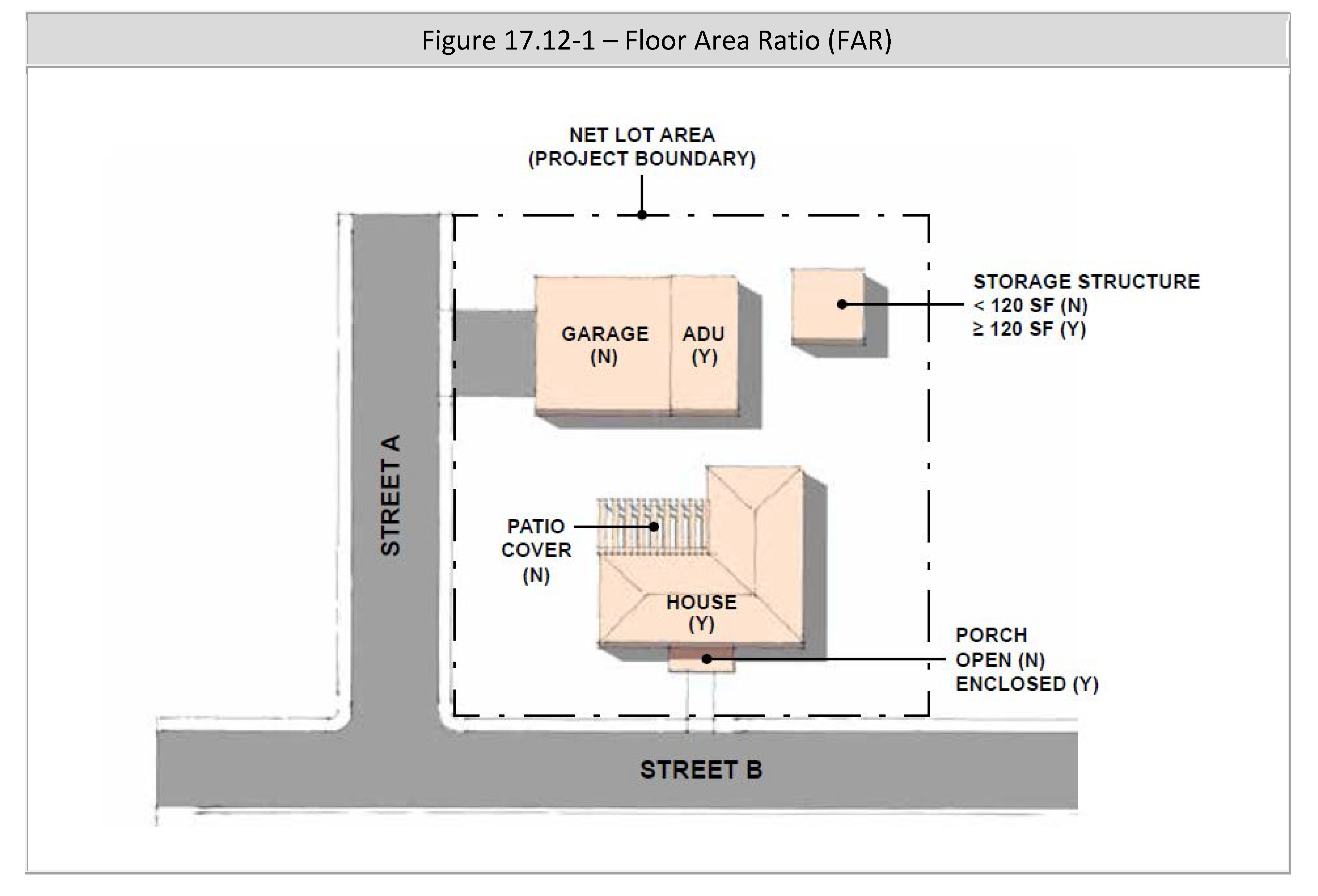
Floor Area Ratio (FAR). To calculate FAR, the net floor area is divided by the net lot area and is expressed as a decimal. For example, if the net floor area of all buildings on a site totals twenty thousand (20,000) square feet, and the net lot area is ten thousand (10,000) square feet, the FAR is expressed as 2.0. Refer to Figure 17.12-1 for information in a graphics form:
D.
Fractions:
1.
General Rounding. Fractions of one-half or greater shall be rounded up to the nearest whole number and fractions of less than one-half shall be rounded down to the nearest whole number, except as otherwise noted.
2.
Residential Units Rounding. The maximum number of units permitted shall always be rounded down to the nearest whole number (e.g. 3.8 units = 3.0 units), except as described in subsection D.3. below.
3.
Exceptions:
a.
Sections 17.70.090 (Parking Regulations Electric Vehicle Charging Spaces/ Stations) and 17.70.100 (Parking Regulations Bicycle Parking) of this title. Calculations for the number of spaces shall be rounded up to the nearest whole number.
b.
Chapter 17.100 (Density Bonus Provisions) of this title. The base density of permitted units, for projects eligible for a bonus density pursuant to Section 695915 of the California Government Code, shall be rounded up to the next whole number. In addition, any fractional number of permitted bonus density units shall be rounded up to the next whole number.
c.
Chapter 17.102 (Inclusionary Housing) and Section 17.110.080 (Standards for Specific Residential Uses Religious Institutions Housing) of this title. In calculating the required number of inclusionary units, for projects up to twenty (20) units, fractions of three-quarters or greater shall be rounded up to the nearest whole number and fractions of less than three-quarters shall be rounded down to the nearest whole number. For projects with more than twenty (20) units, fractions of one-half or greater shall be rounded up to the nearest whole number and fractions of less than one-half shall be rounded down to the nearest whole number.
E.
Height:
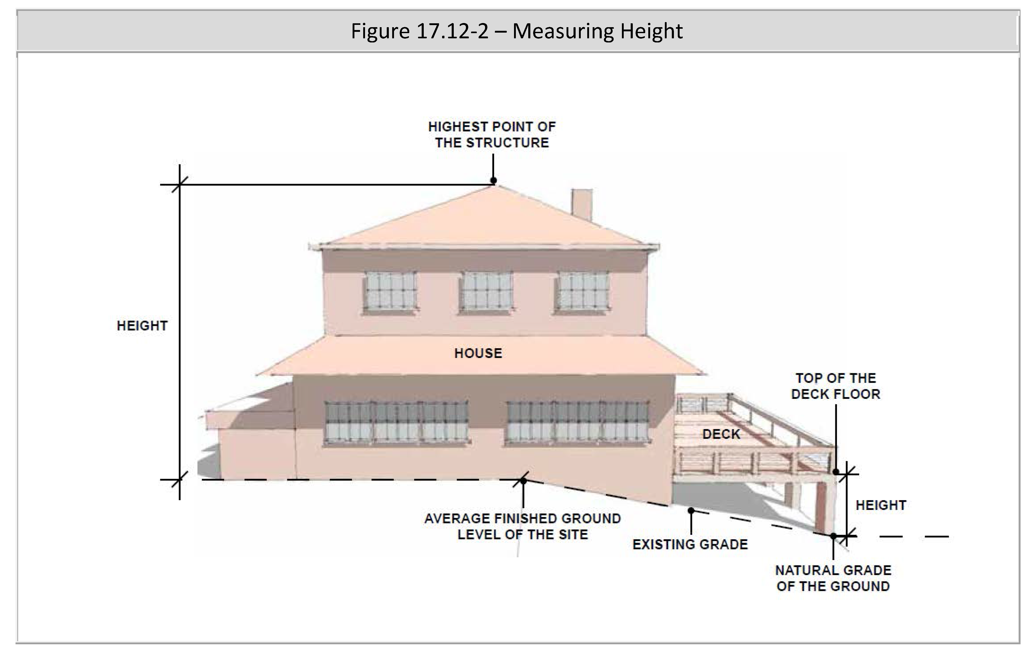
1.
Measuring the Height of a Building or Structure. Building height is measured from the average finished ground level of the site to the highest point of the structure, not including the exceptions outlined in Section 17.60.030 (General Property Development Standards Height Exceptions and Restrictions) of this title.
2.
Measuring the Height of Decks. Deck height is determined by measuring from the natural grade of the ground to the top of the floor of the deck.
3.
Measuring the Number of Stories in a Building. A balcony or mezzanine shall be counted as a full story if its floor area exceeds one-quarter of the total area of the nearest full floor directly below it or if it is enclosed on more than three (3) sides, unless Title 15 (Building and Construction) provides for other balcony or mezzanine definitions based on building construction type and other factors.
4.
Refer to Figure 17.12-2 for information in a graphics form.
F.
Lot Area—Gross and Net. The gross lot area (GLA) means the total horizontal area within the lot lines of a lot. The following shall not be included in determining the net lot area (NLA):
1.
Private streets in the One-family Dwelling (R-1) zoning district;
2.
The pole portion of flag lots; and
3.
Any future street dedications.
G.
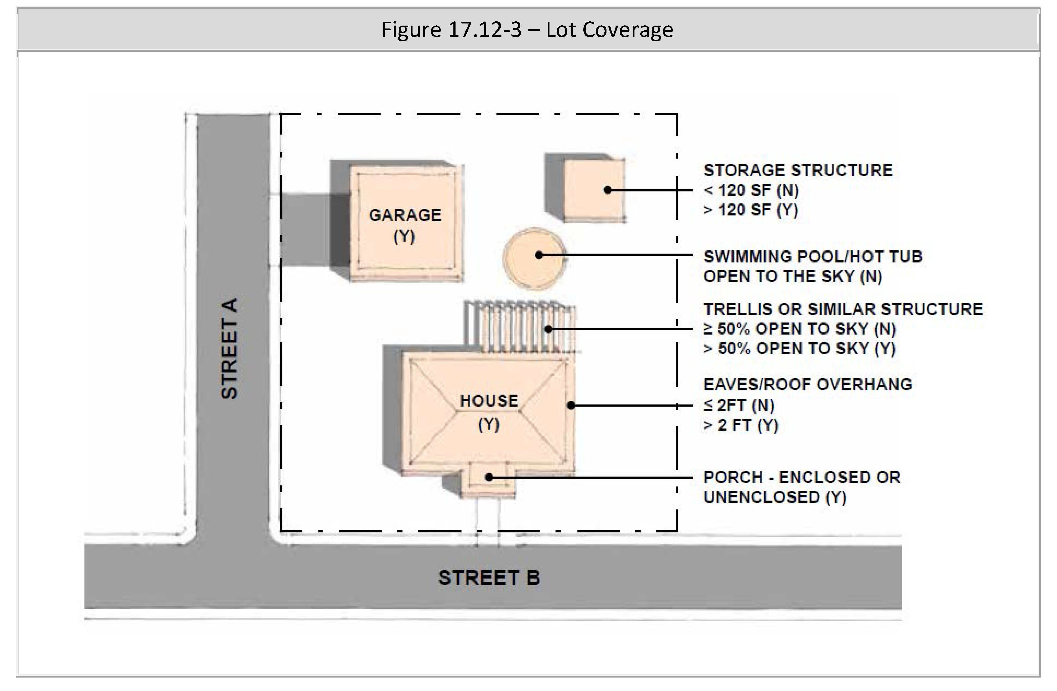
Lot Coverage. Lot coverage is the ratio of the net footprint area of all roofed structures on a lot compared to the net lot area. The following shall not be included in the net footprint area:
1.
Eaves and roof overhangs that project a maximum two (2) feet;
2.
Trellises and similar structures that are a minimum fifty (50) percent open to the sky;
3.
Patios and landings that are a minimum fifty (50) percent open to the sky;
4.
Unenclosed stairways;
5.
Up to one hundred twenty (120) square feet for one storage structure;
6.
Outdoor swimming pools and hot tubs that are open to the sky; and
7.
Solar panel structures in nonresidential zoning districts (this exception shall not apply to solar panels constructed on the roof of enclosed garages or structures that can be occupied).
8.
Refer to Figure 17.12-3 for information in a graphics form.
H.
Lot Line and Frontage. A line of record bounding a parcel that divides one parcel from another parcel or from a public or private street or any other public space.
1.
Front Lot Line. The parcel line separating a parcel from a street right-of-way. In the case of a corner parcel, the line separating the narrowest street frontage of the parcel from the street shall be considered the front. For parcels that have identical or near identical street frontage dimensions, the Community Development Director may determine which is the front. The lot frontage shall mean the horizontal distance between the side lot lines measured along the front lot line.
2.
Rear Lot Line. The parcel line opposite and most distant from the front lot line. In the case of a triangular or otherwise irregularly shaped parcel, a line fifteen (15) feet in length entirely within the parcel, parallel to, and at a maximum distance from the front lot line.
3.
Side Lot Line. Any parcel line other than a front or rear lot line.
4.
Street Side Lot Line. A side lot line of a corner parcel that is adjacent to a street.
I.
Residential Density:
1.
Residential-Only Projects. Density shall be measured in dwelling units per square feet or acres of net lot area. For example, if a project proposed ten (10) dwellings on a two (2) acres site, it has a residential density of five (5) dwelling units per acre. Accessory Dwelling Units (ADUs) or Junior ADUs shall not be included in the calculation.
2.
Mixed-Use Projects. The square footage or acreage of the net lot area shall be included in the calculation, including portions of the project site which feature only nonresidential uses.
J.
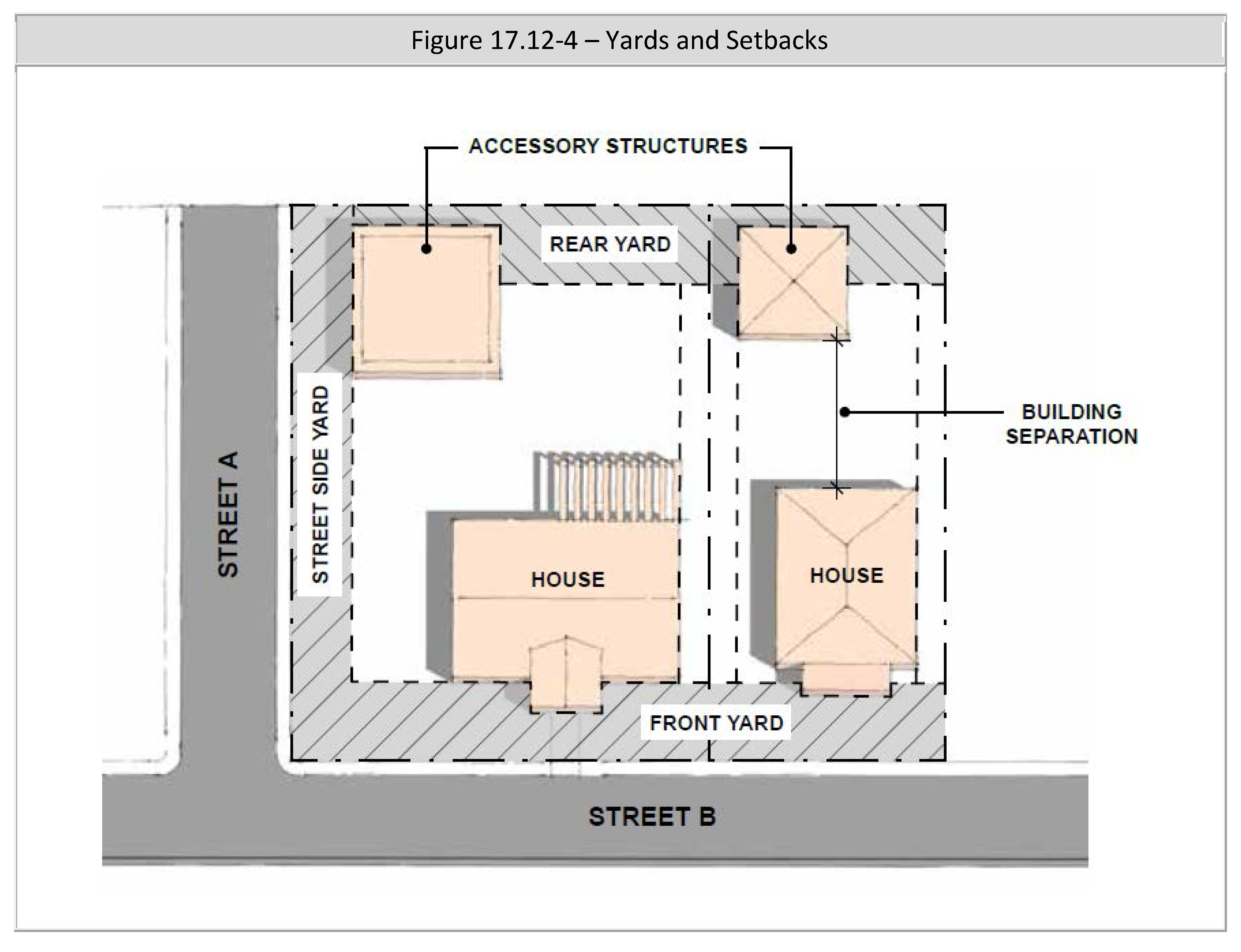
Separation. Building or other structure separation shall be measured from eave to eave (i. e. the separation is the area open to the sky).
K.
Setbacks and Yards:
1.
A setback is the distance between the property line and a building, structure or post (not including permitted projections) that must be kept clear and open.
2.
Rules:
a.
The setback shall be measured parallel to and at the specified distance from the corresponding property line.
b.
The area that must be kept clear and open is the yard.
c.
Yards shall be measured from any future street dedication line.
d.
If a side yard abuts an alley, the yard shall be considered an interior side yard rather than a street side yard.
3.
Front Yard. The area extending across the full width of the lot, the depth of which is the minimum horizontal distance between the front lot line and a line parallel to the main building closest to the front of the lot.
4.
Rear Yard. The area extending across the full width of the lot between the most rear main building and the rear lot line. The depth of the required rear yard shall be measured horizontally from the nearest part of a main building towards the nearest point of the rear lot line.
5.
Side Yard. The area between the main building and the side lot line extending from the rear line of the required front yard, or the front lot line where no front yard is required, to the rear yard and the width of which side yard shall be measured horizontally from, and at right angles to, the nearest point of a side lot line towards the nearest part of a main building.
6.
Street Side Yard. The area between the main building and any adjacent public street right-of-way or private street.
7.
Refer to Figure 17.12-4 for information in a graphics form:
(Ord. No. 3053, § 3(Exh. A), 5-14-2025)
17.12.070 - Properties and project areas that are split zoned.
The following shall apply to properties or project sites that are split zoned and properties or project sites that cross jurisdictional boundaries:
A.
Permitted Uses:
1.
Projects Within the City. The proposed use (e.g. residential, retail, office, etc.) must be permitted in both zoning districts, unless the use in the zoning district that it is not permitted is solely for access, parking, landscaping and signage.
2.
For projects crossing jurisdictional boundaries:
a.
The proposed use must be permitted in the city, unless the use in the city portion is solely for access, parking, landscaping and signing.
b.
The Community Development Director shall determine whether the city or other jurisdiction will be the lead agency.
B.
Lot Coverage, Floor Area Ratio (FAR) and Residential Density:
1.
Projects Within the City. Lot coverage, FAR and/or residential density may be transferrable from one zoning district to another, subject to the approval of a Conditional Use Permit and all the following:
a.
The proposed use is permitted in both zoning districts (e.g. residential is permitted in both zoning districts);
b.
The transferred lot coverage, FAR and/or residential units may extend a maximum one hundred (100) feet within the adjacent zoning district; and
c.
Structures within the transferred area shall comply with the maximum height and minimum ground floor setback requirements of the underlying zone. For all other development standards, the structures may comply with either zoning district.
2.
Projects Crossing Jurisdictional Lines. The El Monte portion shall follow the standards of the city. Lot coverage, FAR and residential density shall not be transferrable from one jurisdiction to another.
3.
Planned residential developments may follow the requirements of Chapter 17.127 (Planned Residential Development) of this title.
C.
All Other Development Standards. For projects within the city, the standards for each zoning district shall be followed. For projects that cross jurisdictional boundaries, the El Monte portion shall follow the standards of the city.
(Ord. No. 3053, § 3(Exh. A), 5-14-2025)
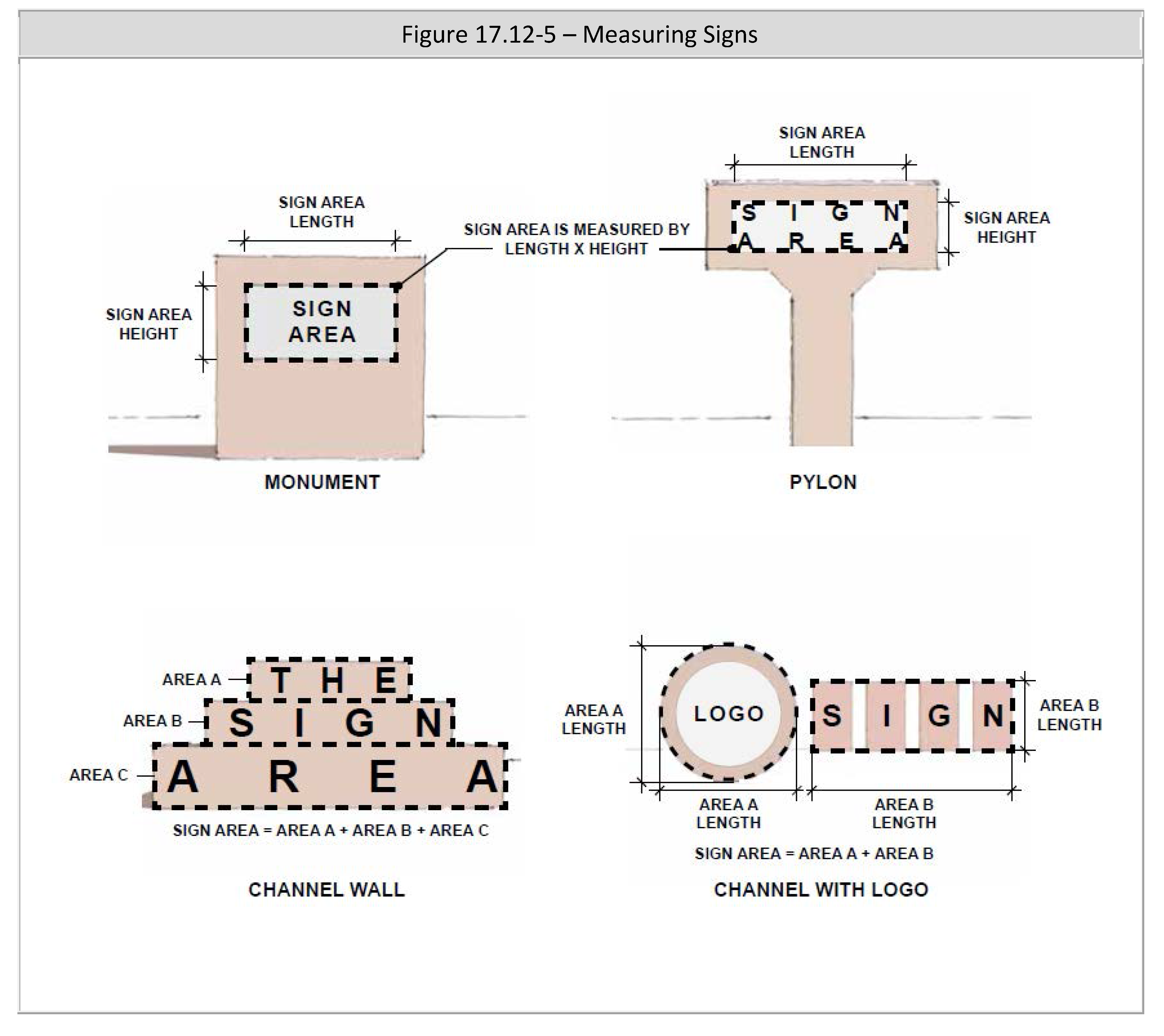
17.12.080 - Measuring signs.
A.
Sign Area. The area of an individual sign shall be calculated as follows:
1.
Single-Faced Signs. Sign area shall include the entire area within a single continuous perimeter composed of squares or rectangles (consisting of horizontal and vertical lines and no more than twelve (12) corners) that enclose the extreme limits of all sign elements, including, but not limited to, sign structures or borders, written copy, logos, symbols, illustrations, and color. Supporting structures such as sign bases and columns are not included in the sign area, provided they contain no lettering or graphics except for addresses or required tags.
2.
Double-Faced Signs. Where two (2) faces of a double-faced sign are parallel, or less than an interior angle of forty-five (45) degrees or less from one another, the sign area shall be computed as the area of one face. Where the two (2) faces are not equal in size, the larger sign face shall be used. Where two (2) faces of a double-faced sign are located more than forty-five (45) degrees from one another, both sign faces shall be counted toward sign area.
3.
Multi-Faced Signs. On a three-faced sign, where at least one interior angle is 45 degrees or less, the area of two (2) faces (the largest and smallest face) shall be summed to determine sign area. In all other situations involving a sign with three (3) or more sides, sign area shall be calculated as the sum of all faces.
4.
Three-Dimensional Signs. Signs that consist of, or have attached to them, one or more three-dimensional objects (i.e., balls, cubes, clusters of objects, sculpture, or statue-like trademarks), shall have a sign area of the sum of two (2) adjacent sides of the smallest cuboid that will encompass the sign.
B.
Sign Height. The height of a sign is the vertical distance measured from the ground level directly beneath the sign to the highest point at the top of the sign.
C.
Sign Clearance. Sign clearance shall be measured as the smallest vertical distance between finished grade and the lowest point of the sign, including any framework or other embellishments.
D.
Building Frontage. Building frontage is the building facade that directly abuts a public street, private street or on-site parking area. For buildings with two (2) or more frontages, the length of the wall and allowable sign area shall be calculated separately for each building frontage.
E.
Refer to Figure 17.12-5 for information in a graphics form:
(Ord. No. 3053, § 3(Exh. A), 5-14-2025)
17.14.010 - Purpose.
The City of El Monte has established a series of zoning districts, overlay zones and specific plans to achieve the following:
A.
To classify and regulate the type and intensity of land uses;
B.
To regulate and establish limitations on the height and bulk of buildings;
C.
To regulate the area of yards other open spaces around buildings; and
D.
To regulate the allowable density of residential units.
(Ord. No. 3053, § 3(Exh. A), 5-14-2025)
17.14.020 - Classifications.
Table 17.14-1 lists the city's zoning districts, specific plans, overlay zones and special districts:
(Ord. No. 3053, § 3(Exh. A), 5-14-2025)
17.14.030 - City zoning map.
For convenience of use, the city zoning map (ZM-1), as heretofore adopted and made a part of this title, and as thereafter from time to time amended. A printed copy shall be made available to the public at the Planning Division and an electronic version shall be placed on the city's website. Each zoning district, specific plan, overlay zone and special district shall be identified by a different solid color, striped color and/or bold outline.
(Ord. No. 3053, § 3(Exh. A), 5-14-2025)
17.14.040 - Boundaries of zoning districts.
Where uncertainty exists as to the boundaries of any zoning district shown on said map, the following rules shall apply:
A.
The zoning boundary shall extend to the centerline of streets, whether they are public or private, unless shown otherwise on the city zoning map;
B.
Where such boundaries are indicated as approximately following street and alley lines or lot lines, such lines shall be construed to be such boundaries;
C.
In unsubdivided property or where a zoning district boundary divides a lot, the location of such boundary, unless the same is indicated by dimensions, shall be determined by use of the scale appearing on the map;
D.
Where any public street or alley is officially vacated or abandoned, the regulations applicable to abutting property shall apply to such vacated or abandoned street or alley;
E.
Where any private right-of-way or easement of any railroad, railway, canal transportation or public utility company is vacated or abandoned, the regulations applicable to abutting property shall apply to such vacated or abandoned property;
F.
All property in the city not otherwise classified, and all property hereafter annexed and not zoned upon annexation, shall be classified as being zoned One-family Dwelling (R-1A); and
G.
In case any uncertainty exists, the Planning Commission shall determine the location of the boundaries.
(Ord. No. 3053, § 3(Exh. A), 5-14-2025)
17.16.010 - Purpose.
The purpose and intent of this chapter is to permit nonconforming uses and structures to continue until they are removed, restricted or abandoned, but not to encourage their existence. Nonconforming uses and structures are declared to be incompatible with permitted uses in the same district. Nonconforming uses and structures shall not be enlarged upon, expanded or extended, except as expressly provided herein, nor shall the existence of a nonconforming use or structure be grounds for adding other uses or structures prohibited in the same district.
(Ord. No. 3053, § 3(Exh. A), 5-14-2025)
17.16.020 - Nonconforming buildings or structures.
A nonconforming building or structure may be continued in use as long as it remains otherwise lawful, subject to the following provisions:
A.
Changing Nonconforming Buildings or Structures. Nonconforming buildings or structures may not be enlarged, expanded or altered in any way which increases its nonconformity , except as permitted in this title. The building or structure may be altered to decrease its nonconformity.
B.
Damaged Nonconforming Buildings or Structures. Whenever a building or structure which is deemed to be nonconforming by virtue of this chapter, and is damaged by an act of nature, the following shall apply:
1.
A residential building or structure that is damaged up to seventy-five (75) percent of its replacement value may be restored to its state prior to such damage, provided the restoration is started within three hundred sixty-five (365) days of the date of damage and diligently pursued to completion. The most recent residential use may reoccupy the building or structure.
2.
A residential building or structure that is damaged over seventy-five (75) percent of its replacement value may be restored to its state prior to such damage, subject to the following:
a.
Minor Design Review is granted in compliance with Chapter 17.122 (Design and Minor Design Review) of this title, within three hundred sixty (360) days of the date of damage;
b.
The restoration is started within one hundred eighty (180) days of the date of Minor Design Review or Design Review approval; and
c.
The most recent residential use may reoccupy the building or structure.
3.
A nonresidential building or structure that is damaged up to fifty (50) percent of its replacement value may be restored to its state prior to such damage, provided the restoration is started within one hundred eighty (180) days of the date of damage and diligently pursued to completion. The most recent nonresidential use may reoccupy the building or structure.
4.
A nonresidential building or structure that is damaged over fifty (50) percent of its replacement value shall comply with all development standards of this title. In addition, the use shall comply with the zoning district of the property.
5.
If the property includes more than one building or structure, the replacement cost shall be based on the value of all the buildings or structures on the property.
6.
The replacement cost shall be determined by the Building Official, whose decision may be appealed to a Hearing Officer.
C.
Legality of Buildings or Structures. Planning Division staff may use the following to determine whether a residential building, accessory structure or additional improvement was legally established (note: the building or addition may still be subject to additional permit requirements from the Building Division, Public Works Department or Los Angeles County Fire Department):
1.
Los Angeles County Assessor Records show the building or addition were given an assessed value for property tax purposes prior to January 1, 1979; and/or
2.
It is confirmed the building or addition existed when the property was annexed to the city.
D.
Nonconforming Yard Setbacks. Additions and structural alterations to a building or structure constructed prior to January 1, 2022, that has nonconforming yard setbacks:
1.
Front Yard. That the alteration or addition for a dwelling on a lot shall not exceed twenty-five (25) percent of the existing floor area of the structure and a length of twenty (20) feet. In addition, the structure's front yard setback shall not be made further nonconforming. In no case shall the front yard setback be less than ten (10) feet for a dwelling, unless a minor variance has been reviewed and approved in accordance with this title.
2.
Interior Side Yards. That the alteration or addition shall not exceed fifty (50) percent of the existing floor area or a length of thirty (30) feet, whichever is less. In addition, the structure shall not be made further nonconforming. In no case shall the interior side yard setback be less than three (3) feet for the dwelling and less than one foot for an accessory structure.
3.
Rear Yards. That the alteration or addition shall not exceed fifty (50) percent of the existing floor area and a length of twenty (20) feet. In addition, the structure shall not be made further nonconforming. In no case shall the rear yard setback be less than ten (10) feet for a main dwelling and one foot for an accessory structure.
(Ord. No. 3053, § 3(Exh. A), 5-14-2025)
17.16.030 - Nonconforming lots.
A nonconforming lot may be constructed upon provided that, the lot was legally created and the structure or structures and uses conform to all other provisions of the El Monte Municipal Code (EMMC).
(Ord. No. 3053, § 3(Exh. A), 5-14-2025)
17.16.040 - Nonconforming residential uses.
A.
Applicability. This section shall apply to the following:
1.
Subsections B. and C. shall apply to properties with existing residential uses where the zoning district does not permit residential uses or the existing number of residential units exceed the maximum density permitted.
2.
Subsection D. shall apply to properties with existing residential units that do not meet the minimum parking and/or open space requirements.
B.
Development Standards. Table 17.16-1 prescribes which zoning designation shall be followed when additions are proposed to an existing nonconforming residential unit.
Table 17.16-1—Development Standards
C.
Necessary Permits. Table 17.16-2 prescribes the permit necessary, based on the size of the additions in gross square feet, to expand one or more existing nonconforming unit.
Table 17.16-2—Necessary Permits
D.
Parking and Open Space. Table 17.16-3 prescribes when parking and open space shall be upgraded for residential units, based on the size of the additions in gross square feet or when one or more new unit is proposed.
Table 17.16-3—Parking and Open Space
E.
The percentages and square footages identified in subsections C. and D. above shall be cumulative for all units on the property and over a five (5) year period.
F.
If the nonconforming residential use is superseded by a permitted use, such use shall thereafter conform to the regulations for the zoning district, and the nonconforming residential use shall not be resumed.
(Ord. No. 3053, § 3(Exh. A), 5-14-2025)
17.16.050 - Nonconforming nonresidential uses.
The use may or may not occupy a building or structure. A nonconforming commercial, industrial or other nonresidential use may be continued so long as it remains otherwise lawful, subject to the following provisions:
A.
Enlarging or Expanding a Use. The nonconforming nonresidential use may not be enlarged, extended, moved or altered, except as specifically permitted in this chapter or to change the use of a structure or land to a use permitted in the zoning district in which it is located.
B.
Superseded by a Permitted Use. If the nonconforming nonresidential use is superseded by a permitted use, such use shall thereafter conform to the regulations of the zoning district and the nonconforming use shall not be resumed.
C.
In Residential Zoning Districts. When a nonconforming nonresidential use of a structure or land is discontinued or abandoned for a continuous period greater than three hundred sixty-five (365) days, the subsequent use shall conform to the regulations of the zoning district in which the property is located or may be a transitional use as outlined in Section 17.110.100 (Standards for Residential Uses Transitional Uses) of this title.
D.
In Multiuse, Commercial and Manufacturing Zoning Districts. When a nonconforming nonresidential use of a structure or land is discontinued or abandoned for a continuous period greater than three hundred sixty-five (365) days, the subsequent use shall conform to the regulations of the zoning district in which the property is located.
E.
Multi-Tenant Buildings with Three (3) or More Tenant Spaces:
1.
In all Zoning Districts. If an existing, nonconforming multi-tenant commercial or industrial building has vacancies of fifty (50) percent or less of the total gross square footage of the multi-tenant building, then the vacant tenant space may be occupied by the most recently occupied use, or a similar use as determined by the Community Development Director.
2.
In Residential Zoning Districts. If an existing, nonconforming multi-tenant commercial or industrial building has vacancies greater than fifty (50) percent of the total gross square footage of the multi-tenant building, then the vacant tenant space shall be occupied by a conforming use or a transitional use as outlined in Section 17.110.100 (Standards for Residential Uses Transitional Uses) of this title.
3.
In Nonresidential Zoning Districts. If an existing, nonconforming multi-tenant commercial or industrial building has vacancies greater than fifty (50) percent of the total gross square footage of the multi-tenant building, then the vacant tenant space shall be occupied by a conforming use.
F.
Proof of Operation. In order for the business to prove continued operation, the business must submit a valid city business license for the entire period in question, and may be supported by the following evidence subject to the review and approval by the Community Development Director:
1.
Receipts, invoices, payments, bank statements and other accounting records showing accounts payable and receivable for entire period in question. These must show actual and continuous business activity. These may be redacted to protect confidentiality of business clients or business bank account or credit card numbers; and/or
2.
Utility bills showing service to the specific business for the entire period in question.
(Ord. No. 3053, § 3(Exh. A), 5-14-2025)
17.16.060 - Repairs and maintenance.
On any nonconforming structure, or on any nonconforming structure containing a nonconforming use, routine maintenance work may be performed, or repair or replacement of nonbearing walls, fixtures, wiring or plumbing may take place. However, the value of repair or replacement work during any five (5) year period shall not exceed fifty (50) percent of the replacement cost of the whole structure. In addition, the square footage of the structure, whether conforming or nonconforming, shall not be increased and no more than fifty (50) percent of the bearing walls may be repaired and/or replaced as part of repair and maintenance work for the structure.
(Ord. No. 3053, § 3(Exh. A), 5-14-2025)
17.16.070 - Loss of a legal nonconforming status.
A.
The right to continue a nonconforming use shall terminate when it is determined to be a public nuisance by order of an independent Hearing Officer pursuant to procedures provided in Chapter 8.44 (Property Maintenance) of Title 8 (Health and Safety) of the EMMC or order of a court of competent jurisdiction and the nuisance is not abated in the manner and within the time stated in the order of the Hearing Officer or the order of the court. In addition to the specific grounds for finding a nuisance as set forth in Chapter 8.44 (Property Maintenance) of Title 8 (Health and Safety) of the EMMC, a nonconforming use is a public nuisance if:
1.
The use interferes with the enjoyment of life or property in the neighborhood; or
2.
The use is a business establishment which permits persons to congregate for unreasonably long time periods in parking areas and/or pedestrian walkways resulting in unreasonable noise levels in residential areas during the hours of 9:00 p.m. to 7:00 a.m., or resulting in said persons obstructing or interfering with the free passageway in said parking areas or on said pedestrian walkways, or which becomes a place where an unreasonable number of violations of Chapter 9.12 (Alcoholic Beverages) of Title 9 (Public Peace, Morals and Welfare) of the EMMC or violations of alcoholic beverage control regulations occur; or
3.
The use is injurious to the health of persons in the neighborhood.
B.
The right to continue the use of a nonconforming structure shall terminate when the structure and/or the parcel on which it is located is determined to be a public nuisance by order of the Hearing Officer made pursuant to Chapter 8.44 (Property Maintenance) of Title 8 (Health and Safety) of the EMMC, or by judgment or order of a court of competent jurisdiction and the nuisance is not abated in the manner and within the time stated in the order of the Hearing Officer or order of the court. If the abatement of the nuisance required demolition of the structure the order, judgment or order of the court shall find that in fairness and in justice there is no other way reasonably to correct the nuisances other than by demolition of the structure.
C.
Where it cannot be found that demolition of a structure is appropriate, the Hearing Officer may permit the structure to remain in existence, but may impose one or more conditions to bring the structure into conformity with the requirements of this title so far as is reasonable in addition to any other conditions necessary to abate the public nuisance.
(Ord. No. 3053, § 3(Exh. A), 5-14-2025)
17.16.080 - Legal nonconforming massage and alternative financial services establishments.
A.
Amortization Period and Extensions. Table 17.16-4 prescribes the amortization periods and extensions for massage and alternative financial services establishments.
B.
Application for an Extension:
1.
The application shall be made in writing on a form prescribed by the Community Development Director. A complete application shall include all of the following:
a.
The applicant's name and street address of business;
b.
The address to which notice is to be mailed, at the applicant's option, a telephone number and/or email address;
c.
The applicant's signature;
d.
The term of the requested extension; and
e.
Documentation relevant to the factors listed in subsection B.4. below.
2.
The applicant requesting to extend the amortization period shall bear the burden of proof in establishing that the amortization period established by this section is unreasonable.
Table 17.16-4—Amortization Permit and Extensions
3.
Within sixty (60) days after a complete application is filed, the Planning Commission shall hear and act on the application. The applicant shall be notified in writing of the meeting date a minimum ten (10) days prior to the meeting. Public noticing shall not be required.
4.
In determining whether to grant an extension of the amortization period, and in determining the appropriate length of such an extension, the Planning Commission and, the City Council on appeal, shall consider:
a.
The amount of investment in the business;
b.
The present actual and depreciated value of business improvements;
c.
The applicable Internal Revenue Service (IRS) depreciation schedule or functional non-confidential equivalent;
d.
The remaining useful life of the business improvements;
e.
The remaining lease term;
f.
The ability of the massage or alternative financial services establishment and/or land owner to change the use; and
g.
The opportunity for relocation to a legally permissible site and the cost of relocation.
5.
Denials. If the Planning Commission denies the request, the establishment shall close as prescribed in this section. In addition, all signs, advertisements and displays related to the establishment shall be removed within thirty (30) days thereafter.
6.
Appeals. Planning Commission decisions regarding this section are appealable to the City Council. Refer to Section 17.10.100 (General Regulations Ability to Appeal) of this title for additional information.
(Ord. No. 3053, § 3(Exh. A), 5-14-2025)