
Englewood City Zoning Code
CHAPTER 3
COMMUNITY AND SUBDIVISION DESIGN
16-3-1: - Intent.
The intent of the Community and Subdivision Design standards is to:
A.
Enhance the image of Englewood and emphasize distinct areas of the City through investments in streets, open spaces, and good civic design.
B.
Improve the environmental performance and safety of the transportation system by integrating multi-modal options into transportation investments.
C.
Expand the reach of our regional transit system through land use and transportation investments.
D.
Emphasize street design and streetscape elements that create more welcoming public spaces and capitalize on the economic value of a walkable and bike accessible community.
E.
Maintain the City's well established street network and block structure, and capitalize on the mobility, access, and urban design potential offered by the grid and alley system.
F.
Coordinate access, utilities, site design, and building orientation for all lots in association with larger systems of streets, blocks, and infrastructure.
G.
Ensure that additional demands on public facilities and improvements necessary to serve new development are appropriately attributed and accounted for as development occurs.
16-3-2: - Applicability.
Community and Subdivision Design elements shall be shown on plats and site improvement plans, according to the application requirements in Chapter 2 of this Title. Specifically, the standards in this Chapter apply to:
A.
All major subdivision applications.
B.
Minor subdivision applications and site improvement plans to the extent they add dwelling units, require additional public utility capacity, or affect the design and construction of rights-of-way.
C.
Specific plans or planned unit developments that impact public facilities, affect public or common spaces, or that require internal access and circulation to serve multiple lots or parcels within a block.
D.
Neighborhood- or property-owner initiatives to improve streets and rights-of-way, or other block-scale public improvements.
E.
Capital investments by the City should follow these standards to the extent practical, but may deviate in ways that balance the intent of this Section with the constraints of a specific project, and best meet the public health, safety, and welfare.
16-3-3: - Street and Block Patterns.
A.
Street Networks and Circulation. The layout of streets shall comply with the street classification and configuration designated in the Englewood Comprehensive Plan, and with the Master Street Plans or other adopted transportation plans.
1.
The proposed street layout shall extend and connect to existing or planned streets in the surrounding area unless the City determines it is undesirable for specific reasons of topography or design.
2.
The City may require rights-of-way and construction of streets stubbed to the property line where streets are required to connect with planned streets.
3.
When a proposed street does not allow intersections to be aligned, the center of the proposed street not in alignment shall be offset by at least 150 feet.
4.
Whenever there exists a dedicated or platted half street or alley adjoining or abutting the property to be developed, the other half of the street or alley shall be platted or dedicated.
B.
Closed-end Streets. In any case where streets are not required to connect by these standards or where closed-end streets are justified by exceptions, alternative designs such as loops, courtyard layouts, or closes are preferred over dead ends and cul-de-sacs.
1.
In all cases closed-end streets shall be no more than 600 feet and have no more than 30 dwelling units per access point.
2.
The City may require pedestrian and bicycle passages connecting the closed-end street to the street network street when necessary to permit easy access to adjacent transit service or community facilities such as parks or schools, or commercial and employment centers.
3.
Closed ends of the street shall facilitate appropriate turning movements and emergency access, as specified in the Englewood Design and Construction Standards and Specifications.
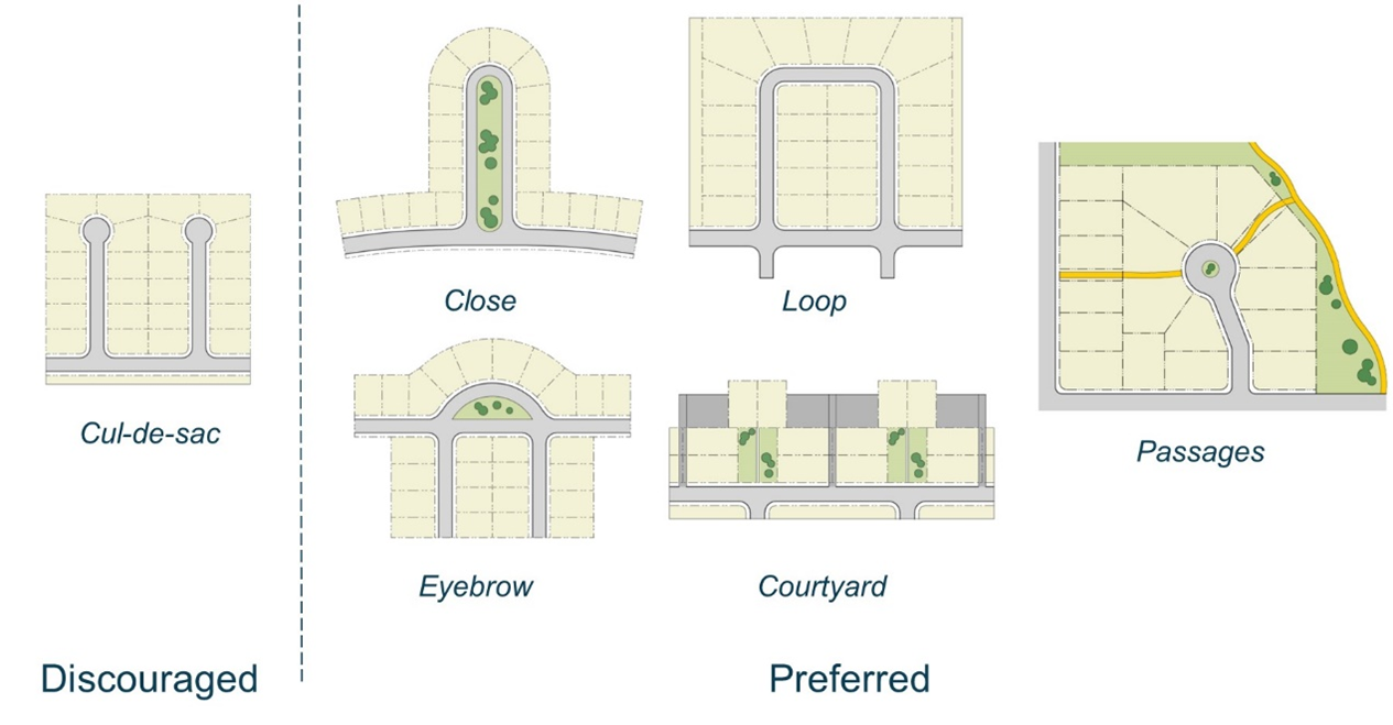
Figure 3-1. Where closed end streets are justified, configurations of lots that create civic spaces, focal points, or maintain internal connectivity are preferred.
C.
Private Streets. Large development sites in areas that do not match the typical block structure may provide private streets and internal circulation, provided:
1.
The internal street layout corresponds to the surrounding block structure;
2.
The internal street design mimic public streetscape designs in EMC § 16-3-4 to the greatest extent practical;
3.
The access to development sites within the project from the internal streets meets the access standards in Chapter 7, Access and Parking, of this Title, including the use of alleys and shared lanes for lot access where appropriate; and
4.
Ongoing maintenance of the internal streets is clearly assigned to a property management association or one or more property owners, and there is the administrative and financial capacity to maintain the streets.
D.
Block Size and Arrangement.
1.
All blocks shall be laid out to have two tiers of lots unless dictated by existing development patterns outside of the control of the project or by access management on major arterial streets. Blocks shall generally only have lots that back to streets, in cases where additional buffers or trails integrate the back sides of lots with the abutting streetscape.
2.
Blocks shall generally be no longer than 670 feet, except in unusual circumstances of topography, natural features, or intervening regional transportation priorities.
3.
All blocks shall preserve existing alley access, except where otherwise justified by a transportation study. All new blocks or redevelopment of existing blocks without alleys shall consider alleys or common internal block access easements in coordination with the standards in EMC § 16-7-3.B, Alleys and Internal Circulation, and to accommodate the appropriate frontage designs in EMC § 16-5-4.B.(residential frontages) and EMC § 16-6-4 (nonresidential frontages).
4.
In no case shall a block be longer than 1,000 feet or larger than 6 acres without providing a system of internal access drives or private streets according to EMC § 16-7-3.B. Alleys and Internal Circulation.
5.
On any block longer than 670 feet, or any other area where the block structure interrupts important pedestrian and bicycle connections, the City may require walkways and bicycle paths through the block and enhanced crosswalks corresponding with the connection.
6.
Where a block abuts or includes rail rights-of-way or other significant regional transportation facilities that interrupt the development pattern, block and lot patterns shall address for grade separation, buffers, and other appropriate transitions.
7.
Any required buffers or through block pedestrian or bicycle connections shall be designed in coordination with standards in EMC § 16-3-5 Open and Civic Space Design
E.
Lot Arrangement.
1.
The minimum dimensions of lots shall be in accordance with the requirements of the applicable zone district.
2.
All lots shall result in buildable areas according to the applicable development and design standards.
3.
Any separate tracts or other unbuildable areas shall serve a design or functional need of the associated development, and require ownership by one or a group of property owners of developable lots.
4.
Each lot shall abut and front on a public street. Lots shall only front on a private street, internal access, or common space where specifically allowed by these regulations.
5.
All blocks and lots shall be laid out to ensure access and circulation meeting the standards of EMC § 6-7-3, Access and Circulation and the appropriate frontage designs in EMC § 16-5-4.B (residential frontages) and EMC § 16-6-4 (nonresidential frontages).
6.
Side lines of lots shall be approximately at right angles or radial to the street line.
7.
The shape of lots shall be appropriate to the topography, block structure, and type of development, provided they are laid out in a manner that provides consistent relationships to the streetscape.
F.
Easements. All blocks shall include easements for all utilities, required improvements, access, and open spaces necessary to serve each lot. Easements shall be granted by the owner to the appropriate entity, and be accessible from the public right-of-way. Unless otherwise specified through the development review process, utility easements shall be as specified in Table 3-1, Easements.
G.
Drainage. Where a subdivision is traversed by a watercourse, drainageway, or stream, stormwater facilities shall be designed and integrated into the block structure, street networks, and open and civic spaces to avoid redundant and inefficient facilities on individual lots. Areas used for stormwater may be integrated into streets cross sections under EMC § 16-3-4 or count to the open space requirements under EMC § 16-3-5.B provided it meets the following:
1.
It is integrated into the design of the space in a manner that it is an aesthetic amenity and is consistent with the design character of the space.
2.
The design does not impact the utility of the space for either purpose (i.e stormwater functions do not compromise the use and value of the space as intended open space or streetscape amenity, and streetscape or open space are able to serve stormwater functions).
3.
The maintenance and management of the portion of the facility serving stormwater functions is clearly identified, whether that is a public dedication or whether it is an obligation of the owner or property owners' association.
Otherwise, stormwater facilities shall be reserved from development in appropriate easements.
16-3-4: - Street Design.
A.
Applicability. Street design and streetscape improvements shall be based on the following development scenarios.
1.
New or Full Block Sections. Any development impacting more than 75% of a complete block face shall be required to meet the new street cross sections in Table 3-2.
2.
Incremental Sections. Any development impacting more than 75 feet but less than 75% of a block face shall be required to meet the urban design features for the street cross sections for portions beyond the curb, including the landscape and sidewalk features. Curb relocations are not required, and street sections and improvements may be adapted for the context and competing priorities within the existing constraints using the Complete Streets Design Guide in Table 3-3.
3.
Infill Development. Any development impacting less than 75 feet of frontage shall be required to meet the minimum sidewalk standards for the street cross sections in Table 3-2. Other urban design and street section features are not required to be adjusted unless the Director determines that they can be done on an incremental basis considering the entirety of the street and block, and the costs are proportionate to the level of investment in the site or involves construction of elements that are otherwise occurring.
B.
New or Full-block Street Types and Cross Sections. The street types in Table 3-2 implement context-based street design to meet the complete streets and multi-modal transportation policies for Englewood. These sections shall be used for all development that requires new or full-block streetscape designs. Specific design types within each functional classification shall be based on the context of the site, the comprehensive plan and any related transportation plans, and the following criteria for specific street types:
1.
Neighborhood Streets. Generally appropriate for all residential streets.
2.
Mixed-use or Pedestrian Streets. Generally appropriate for all mixed-use area or commercial areas where improved pedestrian accommodations and movement are prioritized.
3.
Standard Streets. Other circumstances where traffic movements are prioritized or where no particular planning or urban design context warrants the Neighborhood, Mixed-use, or Pedestrian street design types.
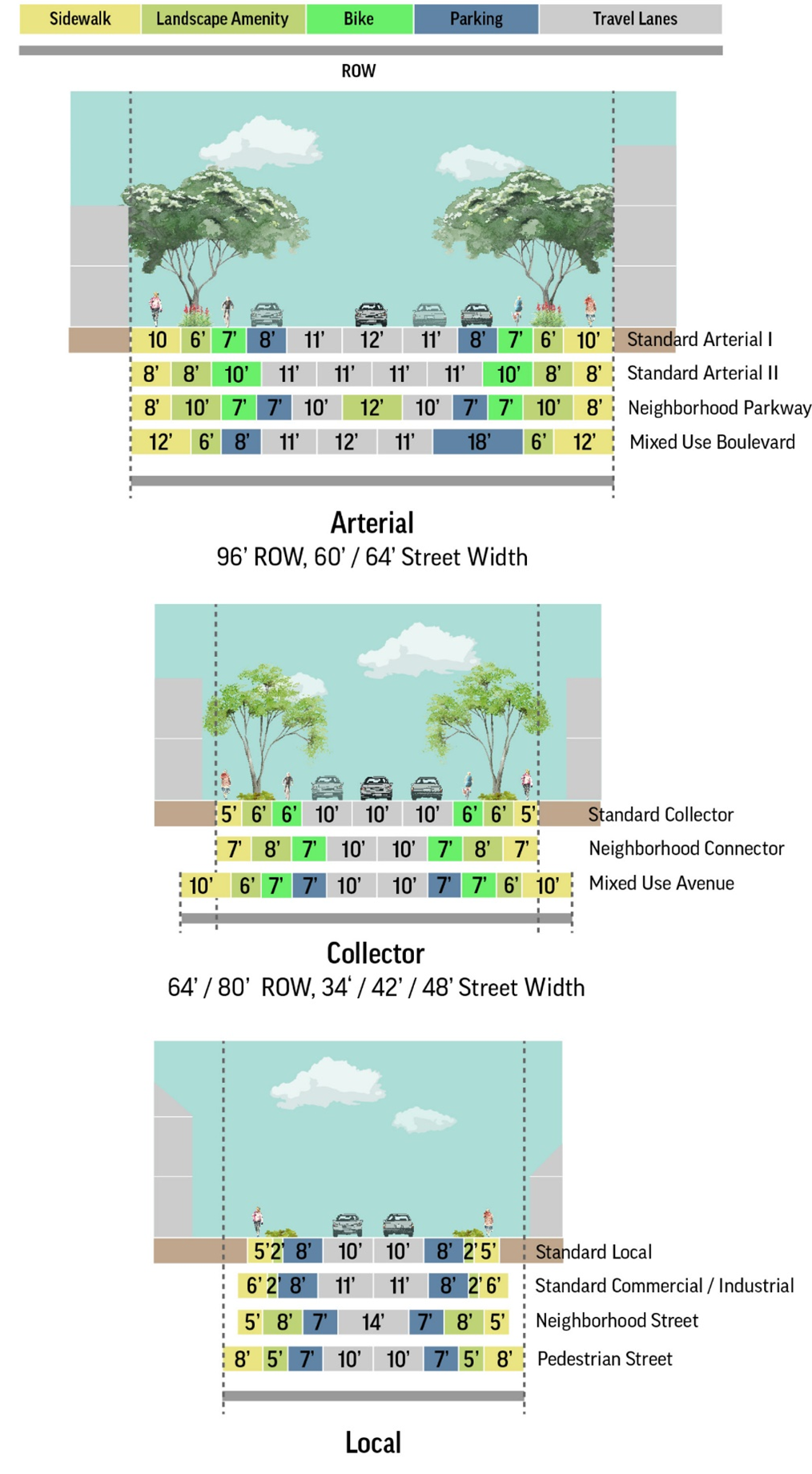
Figure 3-2. Street cross sections should be designed based on a functional class to determine the continuity and capacity within the network, and street design types to determine streetscape components that control the design, speeds, and relationship to abutting property on a particular block.
C.
Complete Street Design Guide. When adjusting the typical cross-sections or allocating space for specific contexts or constraints, and particularly for incremental improvements or infill development, the guidelines in Table 3-3: Complete Street Design Guide should apply. These guidelines should be used to bring street designs closer to the new cross sections in Table 3-2 when full improvements are not required.
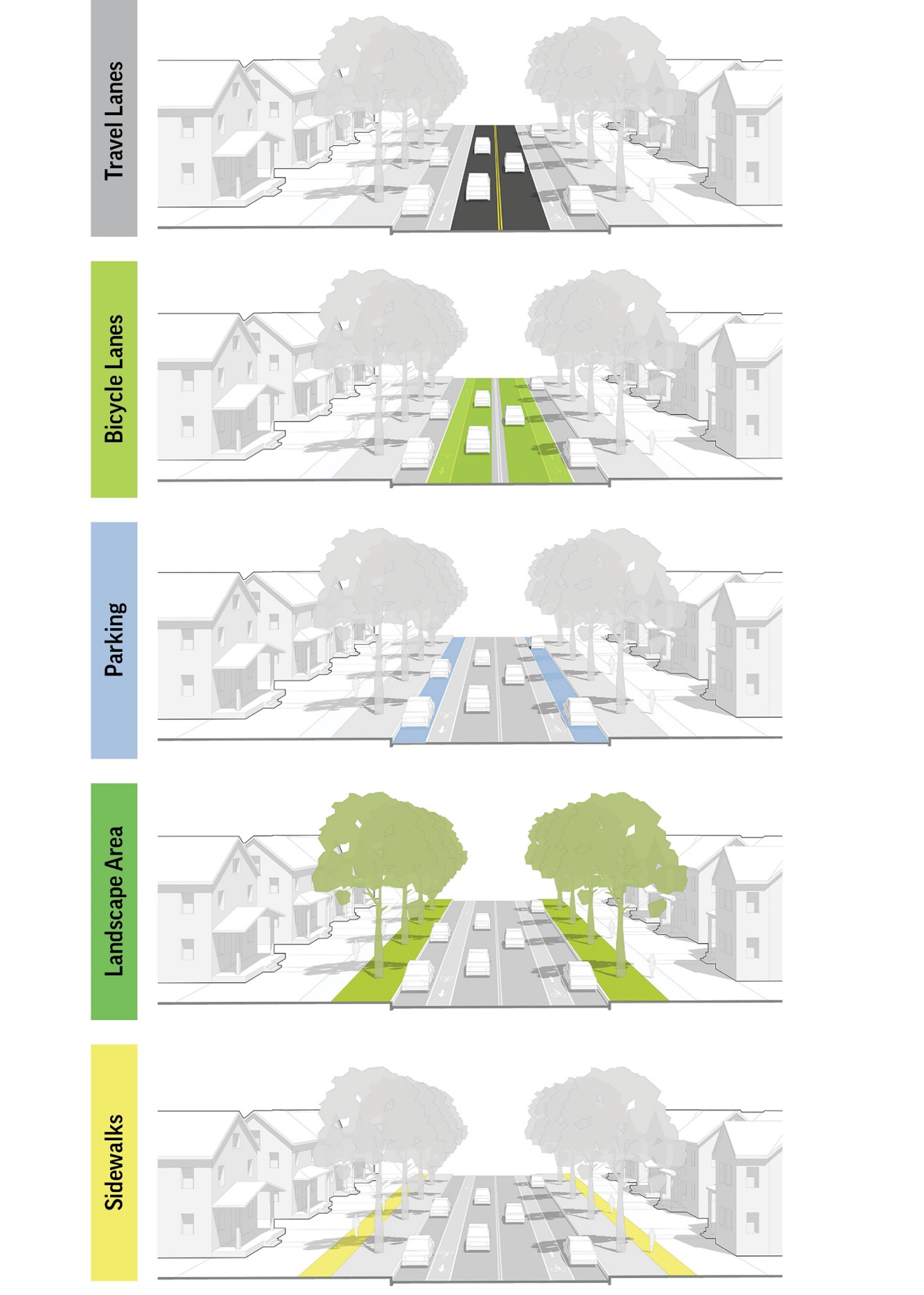
Figure 3-3. Streetscape elements may be adjusted to reflect different priorities for different components of streets in a specific context or to address or to address ROW constraints. Table 3-3 provides a guide for adjusting elements within the requirements of the Street Design Types in Table 3-2.
D.
Intersection Design.
1.
Curb Radii. Curb radii shall be designed according to the Englewood Design and Construction Standards and Specifications. However, to balance the competing interest of vehicle turning movements and the distance and safety of pedestrians crossing the street, the Director may recommend, and the Commission or Council may approve, decreases in the specified corner radii based on the following considerations:
a.
The context of the development, and particularly whether walkable development patterns are a priority and whether neighborhood or mixed-use street types in Table 3-2 are used.
b.
The impact that the specified radius has on increasing the distance that pedestrians must cross.
c.
The desired speeds of vehicles in the roadway and the desired speeds and volume of turning vehicles.
d.
The connectivity of the street network and whether vehicles have multiple alternative routes that minimize frequent turning movements.
e.
The effective turning radius of vehicles considering other features of the specific cross section, including bicycle lanes, on-street parking, or other configurations that impact the actual path of turning movements.
f.
The likelihood that large vehicles will make frequent turning movements at a particular location, compared with the ability of over-sized vehicles or unusual turning movements to compensate and safely encroach into other areas of the street.
2.
Sight Distances. Proper lines of sight shall be maintained at all intersections. The proper line of sight shall be an unobstructed view from the stopping point on the approaching street to all points three feet above the roadway along the centerline of the intersecting street. The distance of the unobstructed view shall be based upon the design speed of the intersecting street specified in Table 3-4, Clear Sight Distance.
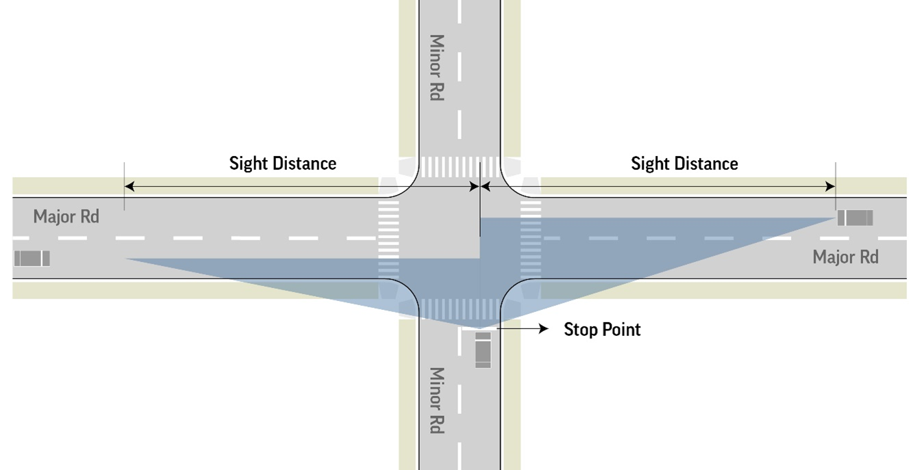
Figure 3-4. Clear sight distances shall be based on the stopping point of intersecting vehicles and the design speeds of intersecting streets as specified in table 3-4.
a.
No building or other type of visual obstruction shall be placed or maintained within the triangle created by the centerline of the street intersection, the stopping point on the approaching street, and the sight distance specified in Table 3-4 to the centerline of the intersecting street.
b.
Street trees, light poles or other limited narrow obstructions are allowed within the sight triangle provided they do not have any foliage, limbs, or other obstructions between 2.5 and eight feet and are no closer than ten feet to the intersecting right-of-way line.
c.
Fully controlled intersections where signalization establishes and prioritizes safe turning movements may deviate from the above sight triangle standards if site conditions warrant and based upon a recommendation of the Director.
3.
Pedestrian Crossings. All intersections and crosswalks shall be designed to address conditions at each specific location. In general, sidewalks intersecting with public streets or similar internal streets shall have pedestrian crossings meeting the following standards:
a.
Curb ramps meeting ADA accessibility standards shall provide a direct, non-diverted approach from the sidewalk to the designated or protected crossing area.
b.
All intersections of collector streets or higher classification shall be considered for enhanced crossings including pavement markings, bulb outs, refuge islands or other traffic-calming measures that are appropriate to the context of the intersection.
c.
Where blocks exceed more than 670 feet between intersections or at other locations of high pedestrian activity, mid-block crossings shall be considered. Mid-block crossing designs and locations are subject to a specific recommendation and approval of the Director.
E.
Engineering and Construction Specifications. All other engineering specifications, horizontal and vertical alignment, design details, and technical or construction specifications for constructing streets shall be covered by the Englewood Design and Construction Standards and Specifications and administered by the Public Works Director.
16-3-5: - Civic and Open Space Design.
A.
Dedication of Open Space. At the time of final plat or other final approval, the Council shall determine whether to accept open space dedication or have the applicant pay a fee-in-lieu of dedication, or a combination of dedication and paying the fee.
1.
Quantity. The applicant shall dedicate 10.7 acres per 1,000 people based on the following:
a.
2.15 residents per dwelling unit of detached houses, multi-unit house, or row house.
b.
1.8 persons per dwelling unit for apartments or all other multi-unit residential buildings.
c.
1.5 persons per unit within a development intended for, and qualifying as, "housing for older persons" pursuant to the Federal Fair Housing Act (42 U.S.C. Section 3607(b)(2)). If a property fails to qualify for this status under the Fair Housing Act, relinquishes or otherwise fails to maintain this status, additional land dedication or fee-in-lieu payment shall be required as provided in this Section.
2.
Applicability and Exemptions. The dedication requirements apply to the following residential developments and subdivisions:
a.
Land being annexed into the City and zoned for residential use;
b.
Rezoning which allows for residential uses, or changes to approved development plans that increase dwelling units;
c.
Subdivision, replat, or plat amendments that result in new or additional residential lots, or otherwise increase dwelling units;
d.
Development of existing undeveloped residential lots; and
e.
Development of a planned unit development, condominium, or other similar residential projects involving multi-unit residential dwelling units.
f.
Exemptions. Nursing homes and similar residential accommodations providing care and supervision to persons who are disabled or confined to the care facility for medical, physical, or mental reasons, are exempt from the land dedication requirements of this Section. If a facility is converted to a non-care residential use, land dedication or fee-in-lieu payment shall be required at the time of conversion.
3.
Design and Location. The dedication shall be based on an official master plan for the type of facility, identifying the general location and extent of the facility. All dedications shall be suitable for the intended purpose, and to the maximum extent practical incorporate any outstanding natural features, prominent landscape, or other cultural, historic, or archaeological resources. In general, this may include:
a.
Public parks and open spaces;
b.
Trails; or
c.
Other public recreation facilities.
4.
Method. All lands or interests required to be conveyed under this Section shall be conveyed to the City by proper dedication upon a plat or by general warranty deed, without restriction, and free and clear of all liens, restrictions, covenants, and encumbrances, except that trails may be conveyed by an easement.
5.
Other Facilities. The applicant may be required to construct all public facilities associated with the specific open space dedication. Any dedication or construction shall comply with all applicable City design and construction standards and any other rules or regulations adopted pursuant to this subsection.
6.
Fee-in-Lieu of Dedication. When the development is not within the area of a planned or existing open space, or the City otherwise determines that a proposed dedication is not acceptable, the City may accept a fee-in-lieu of dedication from the applicant.
a.
The amount shall equal the fair market value of the land area required to be dedicated.
b.
Fee-in-lieu payments shall be paid to the City by certified check and deposited in a City account to be used solely for the acquisition and development of parks, trails, open space, and related facilities reasonably proximate to the subject residential development.
7.
Timing. Dedication of land or payment in lieu of dedication shall occur in coordination with the final plat or other associated final development approval. The City may approve an alternate timing as part of a phased development project, and any payment of fees shall be based on the population of each phase.
B.
Design and Type. Table 3-5 specifies the type, size, and service areas of different open and civic spaces that may meet the open space requirement.
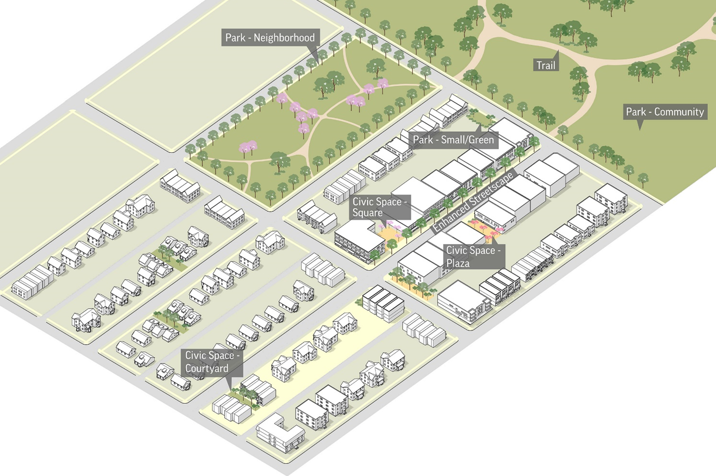
Figure 3-5. Open space design should support the context, including small, formal spaces in urban contexts, and more spacious natural spaces for lower intensity areas, and a network of streetscapes and trails that link these spaces into a larger system of civic space.
C.
Coordination with Common or Private Space. Land set aside and reserved for the exclusive use of the residents of the subdivision or development project shall be designated on the final plat. The applicant shall provide information concerning the method of ownership, management, development, and maintenance to control such land and shall, at time of filing of final plat, submit additional documents or records required by this Title or by the Commission, specifying the intended methods of control. To the maximum extent practical, the design and location of these spaces shall be coordinated with the public open space requirements in EMC § 16-3-5.B, any existing public open spaces, and any private open space requirements in EMC § 16-5-4.D Residential Open Space design, or EMC § 16-6-6 Nonresidential Open Space design.
16-3-6: - Required Improvements.
A.
Improvements. The following improvements are required to be constructed, except where facilities sufficient to serve the subdivision exist and have been approved by the city or otherwise provided in a development agreement between the City and applicant. The size, type and general location of each improvement shall be included as part of the building permit.
1.
Water and sanitary sewer mains shall be at least eight-inch diameter; however, based on a capacity analysis and application of the design criteria of the City, larger or smaller may be required.
2.
Stormwater management plans shall address all aspects of drainage, water quality, and flood hazards relative to the development, including storm sewer lines, natural and constructed conveyances, infiltration systems, retention or detention facilities, and similar facilities.
a.
Site specific plans shall prevent and control soil erosion, sedimentation and water pollution, and be approved by the City prior to any grading, clearing of vegetation, or development.
b.
All proposed discharges shall require a permit from the Colorado Department of Health and Environment, Water Quality Division, demonstrating compliance with the Colorado Discharge Permit System and Federal Clean Water Act.
3.
Fire hydrants and other fire suppression facilities and water lines sized and located to meet the requirements of the Fire and Utilities Departments.
4.
Communication, electric lines, and other similar utility services shall be installed underground except for:
a.
Expansions of existing principal residential buildings of less than 33% of the habitable gross floor area.
b.
Transformers, switching boxes, terminal boxes, meter cabinets, pedestals, ducts and similar accessory facilities
c.
Facilities reasonably necessary to connect underground facilities to existing or permitted overhead or over-ground facilities.
d.
Overhead electric transmission lines and distribution feeder lines over 110KV, and overhead communication long distance, trunk, and feeder lines.
e.
Existing utility facilities and structures, which shall not be required to be removed or replaced.
All facilities shall be in easements or the right-of-way subject to the design specifications and approval of the City through the plat review process. Property owners are encouraged to install appropriate location indicators or tracers with all utilities placed underground. Above ground facilities shall be located in accessible locations close to corner lot lines but minimize their appearance through streetscape design, landscape materials, or other site planning and urban design strategies that minimize their impact on the public realm.
5.
Streets and rights-of-way required by EMC § 16-3-3 and EMC § 16-3-4, including any street lights, traffic safety and control devices, and street signs.
6.
Open and civic space required by EMC § 16-3-5, including all grading, drainage, retaining walls, and other landscape required for these spaces.
7.
Access and circulation meeting the requirements of EMC § 16-3-3 and EMC § 16-7-3, including any alleys or easements where shared or cross-access is proposed.
B.
Capacity. The Director, Planning and Zoning Commission, or City Council may require technical studies to assess the capacity and potential impacts of all development on any required improvements as provided in EMC § 16-2-1.J Technical Studies. Individual projects will be evaluated for adequacy based on specific studies provided by the applicant and accepted by the City that demonstrate:
1.
The location of the proposed development relative to existing facilities and service;
2.
The ability of the project to access those facilities and services; and
3.
The capacity of existing facilities and services to serve the new project while maintaining acceptable levels of service for existing development.
C.
General Requirements.
1.
All required improvements shall be incorporated into the final design at the time of final plat as provided in EMC § 16-2-7.
2.
The applicant shall post a performance bond, letter of credit or similar security instrument drawn in favor of the City in an amount equal to 125% of the estimated cost of the construction of improvements, determined by the Public Works Director.
3.
Required improvements shall be constructed in accordance with the City standards and specifications.
4.
Finished plans for all public improvements as built shall be required before the city shall accept improvements. Construction shall begin within one year following approval of the plan and not be suspended for longer than one year. Any plans not completed prior to these times shall be resubmitted for review and approval subject to the design standards and specifications at the time of resubmittal. The approved design plans are acceptable if they remain true after construction and if attested to by a registered engineer.
5.
The performance guarantee shall be released upon written request by the applicant, and after all improvements are completed, inspected and finally accepted by the City.
6.
The applicant shall be responsible for the repair, replacement and maintenance of any required improvement which fails to function or meet the standards of the City due to defects in material or workmanship, within three years from the date of final acceptance.
D.
Reimbursement Agreements. Applicants constructing required improvements for their property or to serve their project shall be responsible for the entire cost of the improvements. When any improvements are part of a planned future facility for the City serving an area larger than the project and its impact, the City may require the applicant to build to the planned or anticipated capacity, and reimburse the applicant for any portion constructed beyond their impact.