
Ennis City Zoning Code
ARTICLE IV
Zoning Districts
4.1.1 - Zoning Districts Established
This article establishes the zoning districts within the City of Ennis, Texas. This Article (IV) and Article V: Use Standards, identify the dimensional standards established and uses allowed within the districts. Article VI: Building and Urban Design Standards, identifies any zoning district-specific standards applying to development in the districts.
The following Table 4.1-1 provides a summary of the zoning districts established.
4.1.2 - Zoning District Map
(1)
The zoning districts are shown on the City of Ennis Zoning Map (Zoning Map). The boundaries of zoning districts established in this Ordinance are delineated upon the Zoning Map and adopted as part of this Ordinance as fully as if the same were set forth in this section in detail. Procedures for amending the Zoning Map are set forth in Article III: Review Procedures.
(2)
The Administrator shall keep a complete set of the Official Zoning Maps in any convenient format, either electronically or in hard copy. The Official Zoning Maps shall be kept up to date by posting any subsequent zoning changes as soon as practical after the change occurs. These maps shall be available for public inspection.
(3)
Administrative modifications to the Zoning Map shall be made by the Administrator.
4.1.3 - Zoning District Boundaries
(1)
When uncertainty exists as to the boundaries of districts as shown on the Official Zoning Map, the Administrator shall be responsible for interpretation of the zoning map in accordance with the following rules:
(2)
Boundaries indicated as approximately following the centerlines of streets, highways, alleys, or railroad rights-of-way are construed to follow those centerlines.
(3)
Boundaries indicated as approximately following platted lot boundaries or city limit boundaries are construed as following those boundaries.
(4)
Boundaries indicated as approximately following the centerlines of streams, creeks, rivers, canals, lakes, or other bodies of water are construed to follow those centerlines. The centerline is interpreted as being midway between the shorelines of the body of water or along the middle of designated floodways. If the centerlines or floodways change, the boundaries are construed as moving with the centerline or floodway.
(5)
Where a zoning district boundary line traverses a large parcel of land or acreage in a recorded subdivision, and such large parcel or acreage has been divided by metes and bounds without indication upon the recorded plat, or where it may hereafter be divided into blocks and lots, the district boundaries shall be construed to be the centerline of a street or alley or the property line resulting from such division nearest to the district line shown on the Official Zoning Map, so long as the zoning district boundary is not varied more than 100 feet from its location on the Official Zoning Map.
(6)
When the district boundary line is not otherwise determined, it shall be determined by the scale of the Official Zoning Map from a given line.
(7)
Whenever a street, alley, or other public way is vacated by official action of the city, the zoning district line adjoining each side of the vacated street, alley, or other public way automatically extends to the centerline of the vacated right-of-way.
(8)
When there is a question as to the boundary of a tract and that question cannot be resolved by the application of Subsections above, the Planning and Zoning Commission shall determine the boundary by interpreting the official zoning district map and ordinances amending the map.
(9)
If, because of error or omission on the Official Zoning Map, any property in the city is not shown to be included in a zoning district, such property shall be classified as the "A" Agricultural district until changed by a zoning map amendment.
4.1.4 - Annexed Territory
(1)
When any territory is brought into the jurisdiction of the City of Ennis, by annexation or otherwise, such territory shall be deemed to be in the "A" Agricultural district unless the City Commission designates another zoning district at the time of annexation after review and recommendation by the Planning and Zoning Commission, giving due consideration to the surrounding existing uses, the Comprehensive Plan, and property owner request, and provides notice that complies with the notice requirements of Article III: Review Procedures. This provision shall not preclude subsequent rezoning of such property by amendment in the manner set forth in Article III: Review Procedures.
4.2.1 - General Purposes of Residential Zoning Districts
The residential zoning districts are intended to:
(1)
Provide appropriate locations for residential development that are consistent with the Future Land Use Plan and Comprehensive Plan.
(2)
Ensure adequate light, air, and privacy for all dwelling units.
(3)
Appropriately address multi-modal transportation access and ensure adequate availability of public services and utilities.
(4)
Allow for a variety of housing types that meet the diverse needs of residents.
(5)
Protect residential development from the encroachment of uses that are incompatible with a residential use.
(6)
In all residential zoning districts, complementary uses such as parks, open space, public schools, religious assemblies, minor public or private utilities, Accessory Buildings, and certain temporary uses are also allowed.
4.2.2 - Agricultural (A)
| (1) Purpose: | (2) Density | |
The Agricultural district is intended to accommodate agricultural uses on large acreage
(two acre min.). This district can also accommodate single-family detached residential
uses and Accessory Buildings. It may be used as a holding zoning when property is
first annexed into the city. The district provisions allow compatible agricultural
uses that are in keeping with the rural character of these neighborhoods. Figure i: Lot Dimension Measurement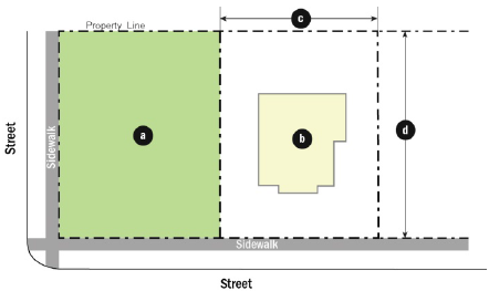 Figure ii. Setback Measurement Figure ii. Setback Measurement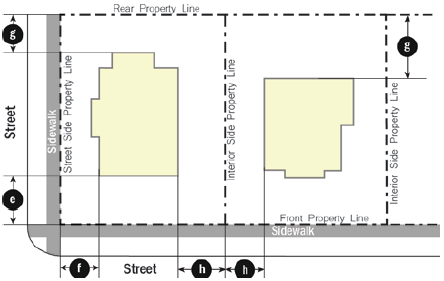 Figure iii. Height Measurement Figure iii. Height Measurement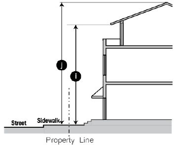 | Dwelling Units/Acre (maximum) | 0.5 |
| (3) Lot Dimensions | ||
| (a) Lot Area (minimum) | 2 acres | |
| (b) Gross Living Area (minimum) sq. ft. | 1,000 | |
| (c) Lot Width (minimum) feet | 150 | |
| (d) Lot Depth (minimum) feet | NA | |
| (4) Setbacks | ||
| (e) Street, Front (minimum) feet | ||
| Arterial or Collector | 30 | |
| Local Street | 20 | |
| (f) Street, Side (minimum) feet | ||
| All roadways | 15 | |
| Alleys/private easements | 10 | |
| (g) Rear (minimum) feet | 10 | |
| Alley | 5 | |
| Any residential lot | 10 | |
| (h) Side, Interior (minimum) feet | 10 | |
| (5) Height (maximum) feet | ||
| (i) To highest level eave or parapet | 35 | |
| (j) To top of the roof structure | 45 | |
| (6) Lot Coverage (maximum) Percentage | ||
| All buildings on the lot | 30% | |
(Ord. No. 19-0917-07, § 2, 9-17-19)
4.2.3 - Residential Estate (RE)
| (1) Purpose: | (2) Density | |
The Residential Estate (RE) district is intended to accommodate large estate style
(one-acre) single-family detached residential uses and Accessory Buildings. The district
provisions allow compatible agricultural uses that are in keeping with the rural character
of these neighborhoods. Figure i: Lot Dimension Measurement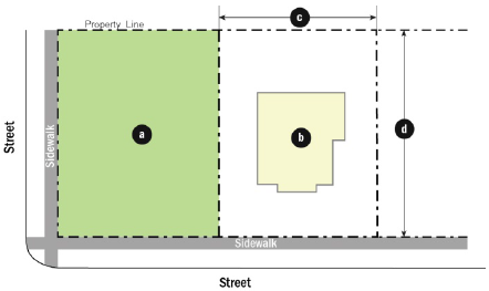 Figure ii. Setback Measurement Figure ii. Setback Measurement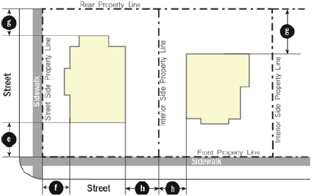 Figure iii. Height Measurement Figure iii. Height Measurement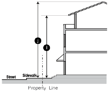 | Dwelling Units/Acre (maximum) | 1.0 |
| (3) Lot Dimensions | ||
| (a) Lot Area (minimum) sq. ft. | 43,560 | |
| (b) Gross Living Area (minimum) sq. ft. | 1,000 | |
| (c) Lot Width (minimum) feet | 100 | |
| (d) Lot Depth (minimum) feet | 120 | |
| (4) Setbacks | ||
| (e) Street, Front (minimum) feet | ||
| Arterial or Collector | 30 | |
| Local Street | 20 | |
| (f) Street, Side (minimum) feet | ||
| All roadways | 15 | |
| Alleys/private easements | 10 | |
| (g) Rear (minimum) feet | 10 | |
| Alley | 5 | |
| Any residential lot | 10 | |
| (h) Side, Interior (minimum) feet | 10 | |
| (5) Height (maximum) feet | ||
| (i) To highest level eave or parapet | 35 | |
| (j) To top of the roof structure | 45 | |
| (6) Lot Coverage (maximum) Percentage | ||
| All buildings on the lot | 40% | |
4.2.4 - Single-Family Residential District - 10 (R-10)
| (1) Purpose: | (2) Density | |
The Single-Family Residential District 10 (R-10) district is intended to accommodate
suburban style large-lot (10,000 sq. ft.) single-family detached residential uses
and Accessory Buildings. The district provisions discourage any use that would substantially
interfere with the development of single-family detached dwellings or the quiet residential
nature of the district. Figure i: Lot Dimension Measurement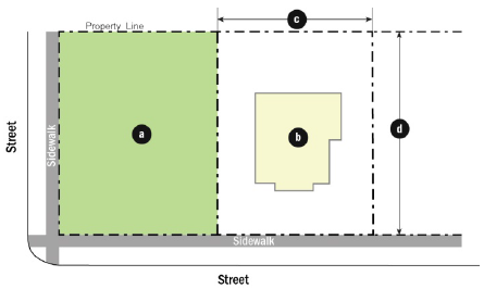 Figure ii. Setback Measurement Figure ii. Setback Measurement Figure iii. Height Measurement Figure iii. Height Measurement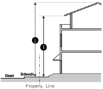 | Dwelling Units/Acre (maximum) | 4.0 |
| (3) Lot Dimensions | ||
| (a) Lot Area (minimum) sq. ft. | 10,000 | |
| (b) Gross Living Area (minimum) sq. ft. | 1,000 | |
| (c) Lot Width (minimum) feet | 70 | |
| (d) Lot Depth (minimum) feet | 100 | |
| (4) Setbacks | ||
| (e) Street, Front (minimum) feet | ||
| Arterial or Collector | 30 | |
| Local Street | 20 | |
| (f) Street, Side (minimum) feet | ||
| All roadways | 15 | |
| Alleys/private easements | 10 | |
| (g) Rear (minimum) feet | 10 | |
| Alley | 5 | |
| Any residential lot | 10 | |
| (h) Side, Interior (minimum) feet | 10 | |
| (5) Height (maximum) feet | ||
| (i) To highest level eave or parapet | 35 | |
| (j) To top of the roof structure | 45 | |
| (6) Lot Coverage (maximum) Percentage | ||
| All buildings on the lot | 45% | |
4.2.5 - Single-Family Residential District - 7 (R-7)
| (1) Purpose: | (2) Density | |
The Single-Family Residential District 7 (R-7) district is intended to accommodate
smaller lots (7,000 sq. ft.) with single-family detached residential uses and Accessory
Buildings. The district provisions discourage any use that would substantially interfere
with the development of single-family detached dwellings.qa> Figure i: Lot Dimension Measurement Figure ii. Setback Measurement Figure ii. Setback Measurement Figure iii. Height Measurement Figure iii. Height Measurement | Dwelling Units/Acre (maximum) | 6.0 |
| (3) Lot Dimensions | ||
| (a) Lot Area (minimum) sq. ft. | 7,000 | |
| (b) Gross Living Area (minimum) sq. ft./unit | 1,000 | |
| (c) Lot Width (minimum) feet | 50 | |
| (d) Lot Depth (minimum) feet | 100 | |
| (4) Setbacks | ||
| (e) Street, Front (minimum) feet | ||
| Arterial or Collector | 25 | |
| Local Street | 20 | |
| (f) Street, Side (minimum) feet | ||
| All roadways | 15 | |
| Alleys/private easements | 10 | |
| (g) Rear (minimum) feet | 10 | |
| Alley | 5 | |
| Any residential lot | 10 | |
| (h) Side, Interior (minimum) feet | 10 | |
| (5) Height (maximum) feet | ||
| (i) To highest level eave or parapet | 35 | |
| (j) To top of the roof structure | 45 | |
| (6) Lot Coverage (maximum) Percentage | ||
| All buildings on the lot | 45% | |
(Ord. No. 21-1207-F1, § 2(Exh. A), 12-7-21)
4.2.6 - Single-Family Residential District - 5 (R-5)
| (1) Purpose: | (2) Density | |
The Single-Family Residential District 5 (R-5) district is intended to accommodate
smaller lots (5,000 sq.ft.) with single-family detached residential uses and Accessory
Buildings. Homes in this district may also be designed as zero lot-line houses. The
district provisions discourage any use that would substantially interfere with the
development of single-family detached dwellings. Figure i: Lot Dimension Measurement Figure ii. Setback Measurement Figure ii. Setback Measurement Figure ii-a. Setback Measurement for Zero Lot Line Figure ii-a. Setback Measurement for Zero Lot Line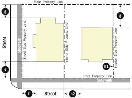 | Dwelling Units/Acre (maximum) | 8.0 |
| (3) Lot Dimensions | ||
| (a) Lot Area (minimum) sq.ft. | 5,000 | |
| (b) Gross Living Area (minimum) sq. ft. | 1,000 | |
| (c) Lot Width (minimum) feet | 50 | |
| (d) Lot Depth (minimum) feet | 60 | |
| (4) Setbacks | ||
| (e) Street, Front (minimum) feet | ||
| Arterial or Collector | 20 | |
| Local Street | 20 | |
| (f) Street, Side (minimum) feet | ||
| All roadways | 10 | |
| Alleys/private easements | 5 | |
| (g) Rear (minimum) feet | 5 | |
| Alley | 5 | |
| Any residential lot | 10 | |
| (h) Side, Interior (minimum) feet | 5 | |
| Setbacks for Zero Lot Line: | ||
| (h1) Side, Interior (minimum) feet (on one interior side) | 0 | |
| (h2) Side, Interior (minimum) feet (on other interior side) | 15 | |
| (5) Height (maximum) feet | ||
| (i) To highest level eave or parapet | 35 | |
| (j) To top of the roof structure | 45 | |
| (6) Lot Coverage (maximum) Percentage | ||
| All buildings on the lot | 45% | |
Figure iii. Height Measurement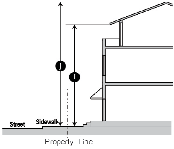 | ||
(Ord. No. 19-0917-07, § 3, 9-17-19; Ord. No. 21-1207-F1, § 3, 12-7-21; Ord. No. 21-1207-F2, § 2, 12-7-21; Ord. No. 22-0201-F2, § 2(Exh.A), 2-1-22)
4.2.7 - Neighborhood Conservation District (NC)
| (1) Purpose: | (2) Density | |
The Neighborhood Conservation (NC) district is intended to preserve the existing pattern
of traditional neighborhoods with predominantly single-family detached residential
uses with accessory dwelling units or granny flats and accessory buildings. Additional
standards per Article VI shall apply. Figure i: Lot Dimension Measurement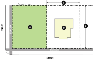 Figure ii. Setback Measurement Figure ii. Setback Measurement Figure iii. Height Measurement Figure iii. Height Measurement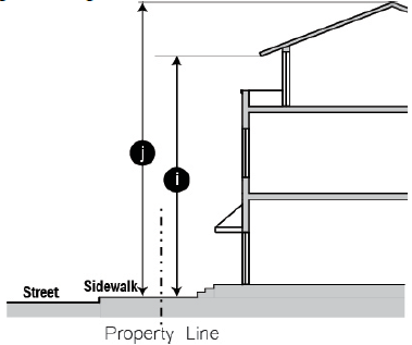 | Dwelling Units/Acre (maximum) | 8 |
| (3) Lot Dimensions | ||
| (a) Lot Area (minimum) sq. ft. | 5,000 | |
| (b) Gross Living Area (minimum) sq. ft. | 1,000 | |
| (c) Lot Width (minimum) feet | 40 | |
| (d) Lot Depth (minimum) feet | 60 | |
| (4) Setbacks | ||
| (e) Street, Front (minimum) feet | Avg. setback along the block | |
| Street, Front (maximum) feet | 40 | |
| (f) Street, Side (minimum) feet | ||
| All roadways | 10 | |
| Alleys/private easements | 5 | |
| (g) Rear (minimum) feet | ||
| Alley/private easement | 5 | |
| Any residential lot | 10 | |
| (h) Side, Interior (minimum) feet | 5 | |
| (5) Height (maximum) feet | ||
| (i) To highest level eave or parapet | 35 | |
| (j) To top of the roof structure | 45 | |
| (6) Lot Coverage (maximum) Percentage | ||
| All structures on the lot | 70% | |
| Note: | ||
| For NC-MF1 see: 4.2.9 Multi-Family Residential District 1 (MF-1) | ||
| For NC-MF2 see: 4.2.10 Multi-Family Residential District 2 (MF-2) | ||
| For NC-D see: 4.2.7 Residential Duplex District (D) | ||
| Per Article 5.2.2: | ||
| • In the NC Zoning district, Duplex shall only be permitted on lots designated as NC-D on the Zoning Map | ||
| • In the NC Zoning district, Multi-family uses shall only be permitted on lots designated as NC-MF1 and NC-MF2 on the Zoning Map | ||
(Ord. No. 19-0917-07, § 4, 9-17-19; Ord. No. 21-1207-F1, § 3, 12-7-21)
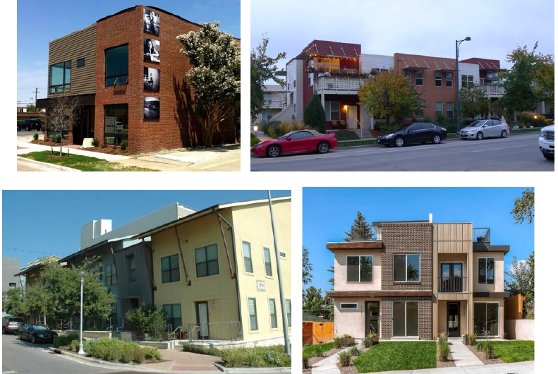
4.2.8 - Residential Duplex District (D)
| (1) Purpose: | (2) Density | |
The Residential Duplex (D) district is established and intended to encourage a wide
range of low- to medium-density housing types, especially single-family attached and
duplexes, though single-family detached is also allowed to meet the diverse needs
of city residents. The district standards are designed for transition from areas of
single-family neighborhoods to multi-family districts at appropriate locations throughout
the city. Maximum residential density is limited to 12 units per gross acre. Figure i: Lot Dimension MeasurementFigure ii. Setback Measurement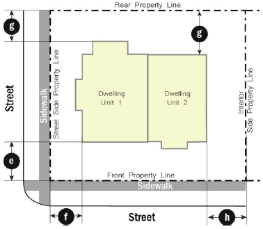 Figure iii. Height Measurement Figure iii. Height Measurement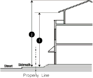 | Dwelling Units/Acre (maximum) | 12 |
| (3) Lot Dimensions | ||
| (a) Lot Area (minimum) sq. ft. | 5,000 | |
| (b) Gross Living Area (minimum) sq. ft./unit | 800 | |
| (c) Lot Width (minimum) feet | 60 | |
| (d) Lot Depth (minimum) feet | 60 | |
| (4) Setbacks | ||
| (e) Street, Front (minimum) feet | 20 | |
| (f) Street, Side (minimum) feet | ||
| All roadways | 10 | |
| Alleys/private easements | 5 | |
| (g) Rear (minimum) feet | ||
| Alley/private easement | 5 | |
| Any single-family residential lot | 10 | |
| (h) Side, Interior (minimum) feet | 5 | |
| (5) Height (maximum) feet | ||
| (i) To highest level eave or parapet | 35 | |
| (j) To top of the roof structure | 45 | |
| (6) Lot Coverage (maximum) Percentage | ||
| All structures on the lot | 70% | |
(Ord. No. 21-1207-F1, § 3, 12-7-21; ; Ord. No. 22-0201-F1, § 2(Exh.A), 2-1-22)
4.2.9 - Townhome District (TH)
| (1) Purpose: | (2) Density | |
The Townhome (TH) district is established and intended to encourage a range of medium-density
housing types, especially single-family attached or rowhomes (not to exceed 4 dwelling
units/lot). The district standards are designed for transition from areas of single-family
neighborhoods to multi-family districts at appropriate locations throughout the city. Figure i: Lot Dimension Measurement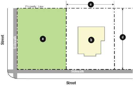 Figure iia. Setback Measurement (Single Family Detached) Figure iia. Setback Measurement (Single Family Detached) Figure iib. Setback Measurement (4 units per lot) Figure iib. Setback Measurement (4 units per lot) | Dwelling Units/Acre (maximum) |
14 (Option 1)
16 (Option 2) |
| (3) Lot Dimensions (Option 1) | ||
| (a) Lot Area (minimum) sq. ft./each unit | 3,000 | |
| (b) Gross Living Area (minimum) sq. ft./unit | 1,000 | |
| (c) Lot Width (minimum) feet | 43 | |
| (d) Lot Depth (minimum) feet | Varies | |
| (4) Lot Dimensions (Option 2) Rear Parking Via Alley Required | ||
| (a) Lot Area (minimum) | 2,500 | |
| (b) Gross Living Area (minimum) sq. ft./unit | 1,000 | |
| (c) Lot Width (minimum) feet | 25 | |
| (d) Lot Depth (minimum) feet | Varies | |
| (5) Setbacks | ||
| (e) Street, Front (minimum) feet |
20 (Option 1)
10 (Option 2) | |
| (f) Street, Side (minimum) feet | ||
| All roadways | 5 | |
| Alleys/private easements | 5 | |
| (g) Rear (minimum) feet | ||
| Any single-family residential lot |
20 (Option 1)
10 (Option 2) | |
| (h) Side, Interior (minimum) feet | ||
| h1 Single-Family attached | 0 | |
| h2 Multi-family (no more than 4 units per lot) | 5 | |
| (6) Height (maximum) feet | ||
| (i) To highest level eave or parapet | 35 | |
| (j) To top of the roof structure | 45 | |
| (7) Lot Coverage (maximum) Percentage | ||
| All structures on the lot | 70% | |
Figure iii. Height Measurement | ||
(Ord. No. 21-0601-E1, § 2, 6-1-21; Ord. No. 21-1207-F1, § 3, 12-7-21; Ord. No. 22-1101-E2, § 2, 11-1-22)
4.2.10 - Multi-Family Residential District 1 (MF-1)
| (1) Purpose: | (2) Density | |
The Multi-Family Residential district 1 (MF-1) is established to provide opportunities
for medium- density multi-family residential uses with a maximum density of 18 dwelling
units per acre, which are designed to be compatible with their sites and surroundings. Figure i: Lot Dimension Measurement Figure ii. Setback Measurement Figure ii. Setback Measurement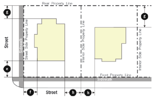 Figure iii. Height Measurement Figure iii. Height Measurement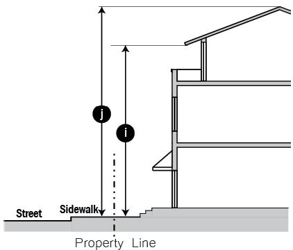 | Dwelling Units/Acre (maximum) | 18 |
| (3) Lot Dimensions | ||
| (a) Lot Area (minimum) sq. ft. | 6,000 | |
| (b) Average Gross Living Area (minimum) sq. ft./unit | 800 | |
| (c) Lot Width (minimum) feet | 60 | |
| (d) Lot Depth (minimum) feet | 100 | |
| (4) Setbacks | ||
| (e) Street, Front (minimum) feet | 10 | |
| (f) Street, Side (minimum) feet | ||
| All roadways | 5 | |
| Alleys/private easements | 5 | |
| (g) Rear (minimum) feet | ||
| Alley/private easement | 5 | |
| Any single-family residential lot | 10 | |
| (h) Side, Interior (minimum) feet | 5 | |
| (5) Height (maximum) feet | ||
| (i) To highest level eave or parapet | 45 | |
| (j) To top of the roof structure | 55 | |
| (6) Lot Coverage (maximum) Percentage | ||
| All structures on the lot | 75% | |
(Ord. No. 21-1207-F1, § 3, 12-7-21; Ord. No. 23-0207-G2, 2-7-23)
4.2.11 - Multi-Family Residential District 2 (MF-2)
| (1) Purpose: | (2) Density | |
The Multi-Family Residential district 2 (MF-2) is established to provide opportunities
for medium-density multi-family residential uses with a maximum density of 22 dwelling
units per acre, which are designed to be compatible with their sites and surroundings. Figure i: Lot Dimension Measurement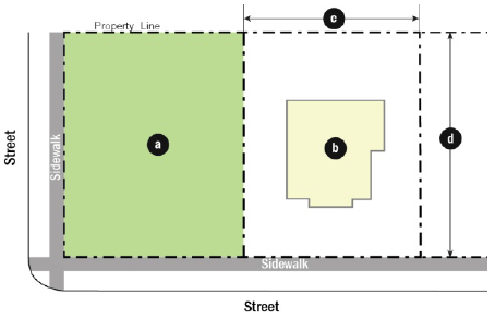 Figure ii. Setback Measurement Figure ii. Setback Measurement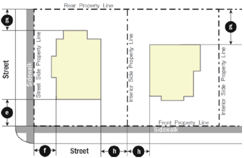 Figure iii. Height Measurement Figure iii. Height Measurement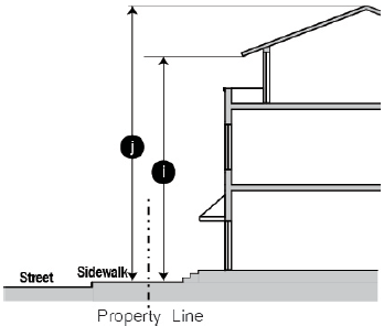 | Dwelling Units/Acre (maximum) | 22 |
| (3) Lot Dimensions | ||
| (a) Lot Area (minimum) sq. ft. | 6,000 | |
| (b) Average Gross Living Area (minimum) sq. ft./unit | 800 | |
| (c) Lot Width (minimum) feet | 60 | |
| (d) Lot Depth (minimum) feet | 100 | |
| (4) Setbacks | ||
| (e) Street, Front (minimum) feet | 10 | |
| (f) Street, Side (minimum) feet | ||
| All roadways | 5 | |
| Alleys/private easements | 5 | |
| (g) Rear (minimum) feet | ||
| Alley/private easement | 5 | |
| Any single-family residential lot | 10 | |
| (h) Side, Interior (minimum) feet | 5 | |
| (5) Height (maximum) feet | ||
| (i) To highest level eave or parapet | 45 | |
| (j) To top of the roof structure | 55 | |
| (6) Lot Coverage (maximum) Percentage | ||
| All structures on the lot | 75% | |
(Ord. No. 21-1207-F1, § 3, 12-7-21)
4.2.12 - Manufactured Home District (MH)
| (1) Purpose: | (2) Density | |
The Manufactured Home (MH) district provides for an affordable option for single-family
residential accommodations. These standards provide appropriate requirements for density,
spacing, and uses and to provide for a separate district designated for the specific
purpose of providing, at appropriate locations, areas for the development of Manufactured
Homes. Figure i: Lot Dimension Measurement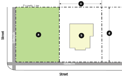 Figure ii. Setback Measurement Figure ii. Setback Measurement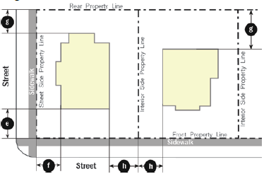 Figure iii. Height Measurement Figure iii. Height Measurement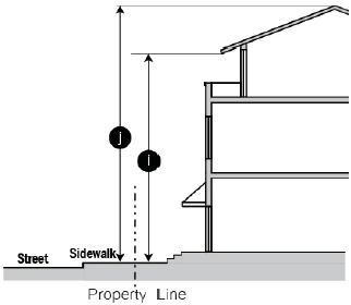 | Dwelling units/Acre (maximum) | 8 |
| (3) Lot Dimensions (minimum) | ||
| (a) Lot Area (minimum) sq. ft. | 5,000 | |
| (b) Gross Living Area (minimum) sq. ft. | 700 | |
| (c) Lot Width (minimum) feet | 40 | |
| (d) Lot Depth (minimum) feet | 60 | |
| (4) Setbacks | ||
| (e) Street, Front (minimum) feet | ||
| Arterial or Collector | 20 | |
| Local Street | 15 | |
| (f) Street, Side (minimum) feet | ||
| All roadways | 10 | |
| Alleys/private easements | 5 | |
| (g) Rear (minimum) feet | 5 | |
| Alley/private easement | 5 | |
| Any residential lot | 10 | |
| (h) Side, Interior (minimum) feet | 5 | |
| (5) Height (maximum) feet | ||
| (i) To highest level eave or parapet | 35 | |
| (j) To top of the roof structure | 45 | |
| (6) Lot Coverage (maximum) Percentage | ||
| All structures on the lot | 60% | |
(Ord. No. 19-0917-07, § 5, 9-17-19; Ord. No. 21-1207-F1, § 3, 12-7-21)
4.3.1 - General Purposes of Commercial Zoning Districts
The commercial zoning districts are intended to:
(1)
Accommodate a range of non-residential uses including office, retail, commercial, and service uses needed by Ennis.
(2)
Encourage site planning, land use planning, and architectural design that create interesting and attractive environments.
(3)
Maintain and enhance the city's economic base and provide a range of shopping, entertainment and employment opportunities for the residents and visitors of Ennis.
(4)
Minimize potential negative impacts of commercial development on adjacent residential neighborhoods.
(5)
Help ensure that the appearance and operational impacts of commercial developments do not adversely affect the character of the areas in which they are located.
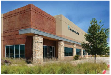
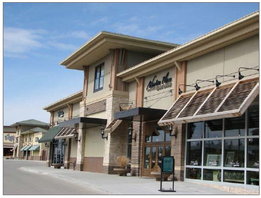
4.3.2 - Neighborhood Commercial (C)
| (1) Purpose: | (2) Density | |
| The Neighborhood Commercial (C) zoning district is intended to provide for locally serving office, retail, personal service, and businesses. Development should be compatible in scale, character, and intensity with adjacent neighborhoods while having convenient access to both pedestrians and automobiles. The district's standards are intended to protect adjacent residential areas. This district could be located adjacent to residential uses. | Dwelling units/acre | NA |
| (3) Lot Dimensions | ||
| Lot Area (minimum) square feet | 5,000 | |
| (4) Setbacks (minimum) feet | ||
| Street | ||
| Freeway, freeway frontage road, or arterial roadway | 20 | |
| All other streets | 10 | |
| Interior | ||
| Side | 10 | |
| Rear | 10 | |
| Adjacent to single-family residential (side or rear) | 20 | |
| (5) Height stories and feet (maximum) | ||
| To the highest level eave or parapet |
2 stories or
35 feet | |
| (6) Lot Coverage (maximum) percentage | ||
| All structures on the lot | 60% | |
| Illustrative Images | ||
 |  | |
 |  | |
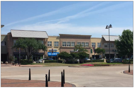
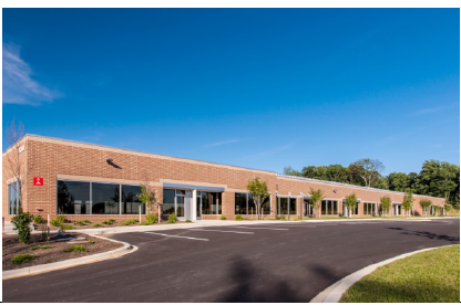
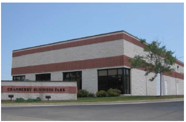
4.3.3 - Business Park District (BP)
| (1) Purpose: | (2) Density | |
| The Business Park (BP) zoning district is intended to provide for the development of a range of office, employment, professional service, and business support uses including office and business parks, corporate campuses, and garden-style offices near or adjacent to residential neighborhoods. This district is appropriate along the US 287 highway corridor and portions along the IH-45 Corridor. Landscaping along the highway frontage, adequate street access and parking capacity should be available to serve the office uses. | Dwelling units/acre | NA |
| (3) Lot Dimensions | ||
| Lot Area (minimum) square feet | 5,000 | |
| (4) Setbacks (minimum) feet | ||
| Street | ||
| Freeway, freeway frontage road, or arterial roadway | 20 | |
| All other streets | 10 | |
| Interior | ||
| Side | 20 | |
| Rear | 10 | |
| Adjacent to single-family residential (side or rear) | 20 | |
| (5) Height stories and feet (maximum) (measured to the top of the eave or parapet) | ||
| Within 50 feet of any single-family residential uses | 2 stories OR 35 feet | |
| All other | 5 stories or 75 feet | |
| (6) Lot Coverage (maximum) percentage | ||
| All structures on the lot | 60% | |
| Illustrative Images | ||
 |  | |
 | 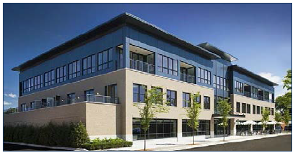 | |
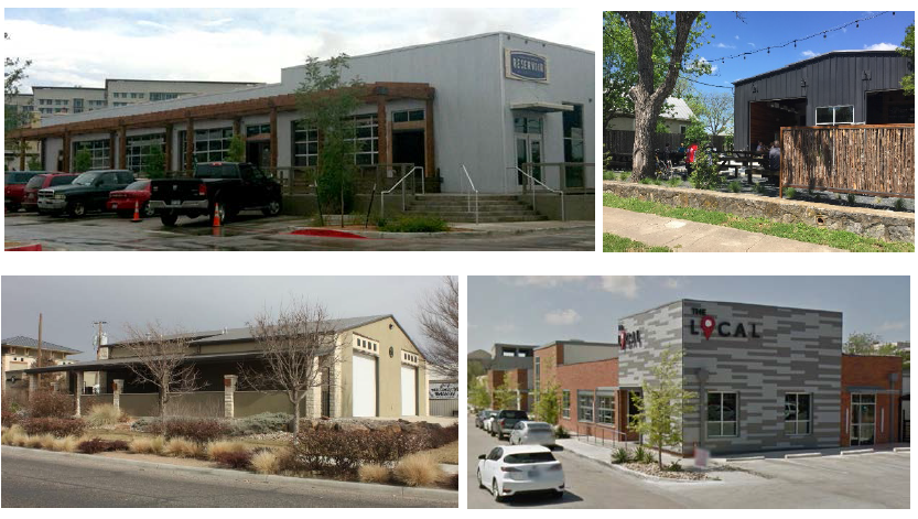
4.3.4 - Commercial Corridor District (CC)
| (1) Purpose: | (2) Density | |
| The Corridor Commercial (CC) district is intended primarily to provide sites for community and regional retail shopping centers including stores selling items such as home furnishings, apparel, electronics, etc.; restaurants, commercial recreation; business, personal, and financial services. These uses are subject to frequent view by the public given their location along major regional arterials such as Business 287 (Ennis Avenue) and IH-45, and they should provide an attractive appearance with landscaping, well-designed and appropriately located parking, and controlled traffic movement. Traffic generated by the uses may include high volumes of vehicle traffic, and trucks and commercial vehicles as appropriate for sites adjacent to regional roadways. Although surface parking along the roadway is permitted, strip-type development along the entire highway or arterial frontage is strongly discouraged. | Dwelling units/acre | NA |
| (3) Lot Dimensions | ||
| Lot Area (minimum) square feet | 10,000 | |
| (4) Setbacks (minimum) feet | ||
| Street | ||
| Freeway, freeway frontage road, or arterial roadway | 20 | |
| All other streets | 20 | |
| Interior | ||
| Side | 20 | |
| Rear | 20 | |
| Adjacent to single-family residential (side or rear) | 40 | |
| (5) Height stories and feet (maximum) (measured to the top of the eave or parapet) | ||
| Within 50 feet of any single-family residential uses | 2 stories or 35 feet | |
| All other | 5 stories or 75 feet | |
| (6) Lot Coverage (maximum) percentage | ||
| All structures on the lot | 75% | |
| Illustrative Images | ||
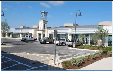 |  | |
 |  | |
4.4.1 - General Purposes of Industrial Zoning Districts
The industrial zoning districts are intended to:
(1)
Accommodate a range of industrial uses including storage, logistics, assembly, and manufacturing uses in Ennis.
(2)
Encourage site planning, land use planning, and architectural design that create attractive but functional environments.
(3)
Maintain and enhance the city's economic base and provide a range of employment and manufacturing opportunities for Ennis residents.
(4)
Minimize potential negative impacts of industrial uses on other adjacent uses.
(5)
Help ensure that the appearance and operational impacts of industrial developments do not adversely affect the character of the areas in which they are located.
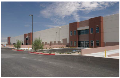
4.4.2 - Light Industrial and Manufacturing District (L-IM)
| (1) Purpose: | (2) Density | |
| The Light Industrial and Manufacturing (L-IM) district is intended to provide for the development of research, light industrial, processing, assembly, high-tech manufacturing, warehousing, logistics, and other indoor light industrial uses, as well as supporting business service and office uses. Uses permitted in this district are intended to serve community and regional needs. This district is intended to be located away from low- and medium-density residential development with good regional roadway access. | Dwelling units/acre | NA |
| (3) Lot Dimensions | ||
| Lot Area (minimum) square feet | 10,000 | |
| (4) Setbacks (minimum) feet | ||
| Street | ||
| Freeway, freeway frontage road, or arterial roadway | 20 | |
| All other streets | 20 | |
| Interior | ||
| Side | 10 | |
| Rear | 10 | |
| Adjacent to single-family residential (side or rear) | 30 | |
| (5) Height stories and feet (maximum) (measured to the top of the eave or parapet) | ||
| Within 50 feet of any single-family residential uses (as measured from the residential property line) | 2 stories or 35 feet | |
| All other | 5 stories or 75 feet | |
| (6) Lot Coverage (maximum) percentage | ||
| All structures on the lot | 80% | |
| Illustrative Images | ||
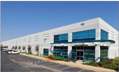 |  | |
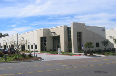 |  | |
4.4.3 - Heavy Industrial and Manufacturing District (H-IM)
| (1) Purpose: | (2) Density | |
| The Heavy Industrial and Manufacturing (H-IM) district is intended to provide for the development of heavy industrial and manufacturing uses, as well as supporting business and office uses. Uses permitted in this district are intended to serve community and regional needs. This district is intended to be located away from low and medium density residential development and buffered from other adjoining uses. | Dwelling units/acre | NA |
| (3) Lot Dimensions | ||
| Lot Area (minimum) square feet | 10,000 | |
| (4) Setbacks (minimum) feet | ||
| Street | ||
| Freeway, freeway frontage road, or arterial roadway | 20 | |
| All other streets | 10 | |
| Interior | ||
| Side | 10 | |
| Rear | 10 | |
| Adjacent to single-family residential (side or rear) | 50 | |
| (5) Height stories and feet (maximum) (measured to the top of the eave or parapet) | ||
| Within 75 feet of any single-family residential uses (as measured from the residential property line) | 2 stories or 35 feet | |
| All other | 5 stories or 75 feet | |
| (6) Lot Coverage (maximum) percentage | ||
| All structures on the lot | 80% | |
| Illustrative Images | ||
 |  | |
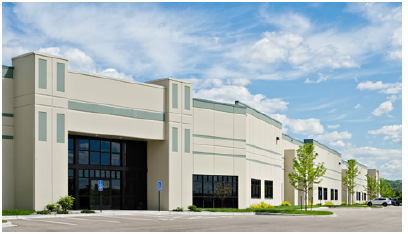 |  | |
4.5.1 - General Purposes of Public Zoning Districts
The public/institutional zoning districts are intended to:
(1)
Accommodate a range of public and civic uses with the city's residential and commercial districts.
(2)
Encourage site planning, land use planning, and architectural design that allow public and civic uses to better fit the adjoining context.
(3)
Encourage the preservation of environmentally sensitive areas as parks and open space where appropriate.
(4)
Ensure that any adverse impacts associated with public uses such as parking and traffic are considered with the context of the neighborhood and adjoining uses.
(5)
Help ensure that the appearance and operational impacts of public and civic uses do not adversely affect the character of the areas in which they are located.
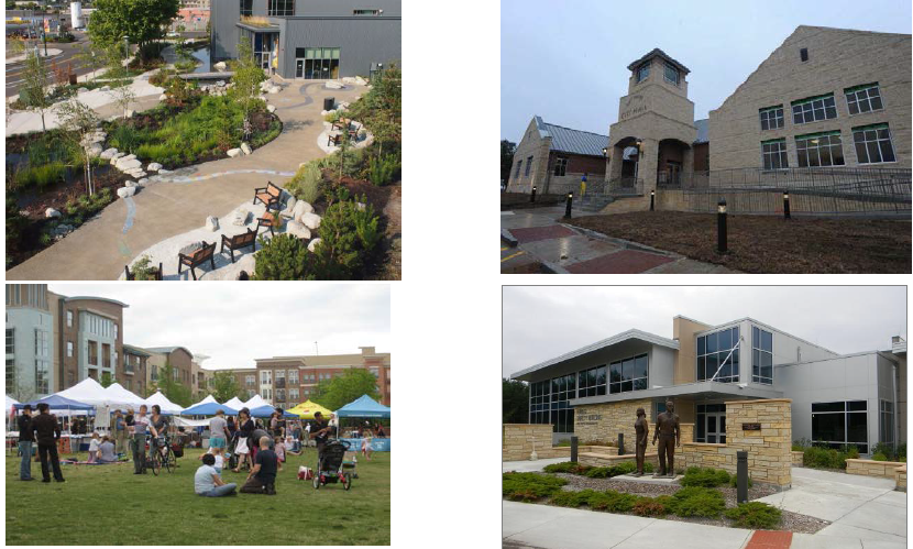
4.5.2 - Public and Parks (PP)
| (1) Purpose: |
|
The PP zoning district is intended to provide for public and park sites. These include
city, county and other government offices and facilities, parks and other public facilities.
Depending on the type of facility, site design and standards need to address access,
transitions, and integration into the neighborhood. Civic and public buildings should
occupy prominent sites within a neighborhood such as at the end of a terminated vista
or a center of a block or public plaza. Standards for this zoning district shall be
flexible based on the use and/or building proposed.
Public parks and open space should be integrated with the neighborhood and provide for a variety of open space types including generally equal acreages of active and passive spaces. |
| Illustrative Images |
 |
4.5.3 - Institutional and Civic (IC)
| (1) Purpose: |
| The IC zoning district is intended to provide for a range of institutional and civic uses. These include religious institutions, schools, community centers, hospitals, and similar uses that provide a service to the community at large. Depending on the type of facility, site design and standards need to address access, transitions, and integration into the neighborhood. Standards for this zoning district shall follow the zoning district standards for adjoining uses with flexibility to address site-specific concerns. |
| Illustrative Images |
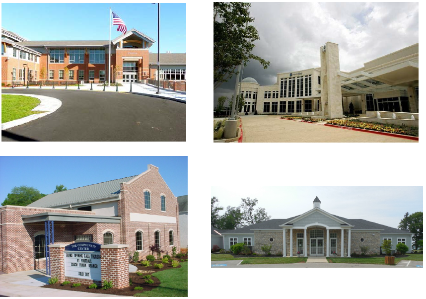 |
4.6.1 - General Purposes of Special Zoning Districts
The special zoning districts are intended to:
(1)
Implement the vision for key areas within the city such as Downtown, the Lake Bardwell/US 287 Neighborhoods and Kaufman Corridor.
(2)
Provide for a flexible zoning tool in the form of planned development standards intended to implement different development projects that can better respond to changing market demand.
(3)
Encourage site planning, land use planning, and architectural design that create interesting, pedestrian-friendly and walkable environments.
(4)
Maintain and enhance the city's economic base and provide shopping, entertainment and employment opportunities close to where people live and work.
(5)
Provide for a range of housing types within the context of mixed use, walkable developments to maximize long-term sustainability.
4.6.2 - Planned Development
(1)
Purpose and Intent: The Planned Development (PD) District is established to provide an alternative to the base zoning districts and special zoning districts established in this Ordinance. The PD district is intended to accomplish the following:
(a)
To permit greater flexibility for new development or redevelopment projects to best utilize the physical features of the particular site in exchange for greater public benefits that would otherwise be achieved through development under this Ordinance.
(b)
To ensure that any development impact that occur through the use of greater flexibility in development standards and uses are offset by public benefits and any negative impacts are mitigated to the extent feasible so as minimize the impacts on adjoining properties.
(c)
To encourage the provision and preservation of meaningful and usable open space.
(d)
To encourage innovative and integrated design of buildings and uses within a larger master planned context of the PD district.
(2)
Review Procedures: The review and approval procedures in Article III: Review Procedures under Concept Plans, Development Plan, and Site Plan shall apply.
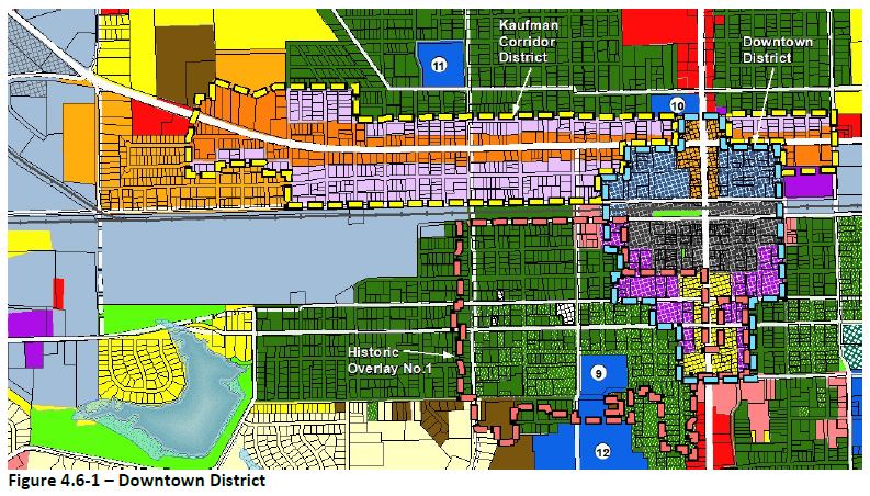
4.6.3 - Downtown District
(1)
The standards in Downtown District in Article VI: Building and Urban Design Standards shall form the exclusive regulations for all development within the boundary of the Downtown District.
The area defined as the Downtown District is illustrated in Figure 4.6-1.
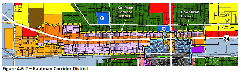
4.6.4 - Kaufman Corridor District
Boundaries of the Kaufman Corridor District and associated sub-districts are each based on Figure 4.6-2 - Kaufman Corridor District Zoning Map. The Kaufman Corridor District shall be composed of two sub-districts - Core and Transition. The following section provides the standards for setbacks, height, and density within the Kaufman Corridor sub-districts.
(1)
Kaufman Corridor Core District
| A. Purpose | B. Density | |
| The KC-Core zoning district is intended to provide for the gradual transition of the Kaufman Corridor into a more walkable street with redevelopment and infill along the underutilized corridor. Adequate streets and connections already exist, so the focus is to create more activation of the frontage along Kaufman St. Such activation should allow property owners additions to the building fronts along Kaufman such as outdoor patios, canopies, and kiosks to create a more inviting character. Kaufman St. should evolve into a more bike and pedestrian friendly street with continuous sidewalks and streetscape improvements. All off-street parking in this district shall be placed to the rear or to the side of the primary buildings. | Dwelling units/acre | NA |
| C. Lot Dimensions | ||
| Lot Width (minimum) feet | 20 | |
| D. Setbacks (minimum and maximum) feet | ||
| Street | ||
| Kaufman St. | 10 min.; 20 max. | |
| All other streets | 5 min.; no max. | |
| Interior | ||
| Side | 0 min. or per fire separation standards | |
| Rear | 5 min. | |
| E. Height stories and feet (maximum) | ||
| To the highest-level eave or parapet | 3 stories or 45 feet | |
| F. Lot Coverage (maximum) percentage | ||
| All structures on the lot | 90% | |
| G. Frontage Build-out | ||
| Min. build out required along Kaufman St. | 70% | |
| Illustrative Images | ||
 | ||
(2)
Kaufman Corridor Transition District
| A. Purpose | B. Density | |
| The KC-Transition district is intended to provide for the development of smaller lot live-work, residential and office and small-scale retail uses that can provide a transition from the higher intensity along the Kaufman Corridor to the residential character of the adjoining neighborhoods. This district shall generally extend a half to a block on either side of the Core district. Adequate streets and connections already exist, so focus on creating frontages that are pedestrian friendly and building heights and scales that respect the neighborhood integrity are important. | Dwelling units/acre | 20 |
| C. Lot Dimensions | ||
| (1) Lot Width (minimum) feet | 25 | |
| (2) Single-family Detached Gross Living Area (minimum) square feet | 1,000 | |
| D. Setbacks (minimum) feet | ||
| Street | ||
| Primary Street | 10 | |
| Secondary Streets | 5 | |
| Interior | ||
| Side | 0 or per fire separation standards | |
| Rear | 5 | |
| Adjacent to single-family residentially zoned lots (side or rear) | 5 | |
| E. Height stories and feet (maximum) | ||
| To the highest-level eave or parapet | 2 stories or 35 feet | |
| F. Lot Coverage (maximum) percentage | ||
| All structures on the lot | 70% | |
| Illustrative Images | ||
 | ||
(Ord. No. 19-0917-07, § 6, 9-17-19)
4.6.5 - Regional Mixed Use District Standards
(1)
General. The Regional Mixed Use District is intended to implement the land use and development goals of the US 287/Lake Bardwell Focus area recommendations in the 2015 Comprehensive Plan Update. The Zoning Framework Plan shall be established by applicants through the creation of Concept Plans at the time of zoning change to the RMU District.
(2)
Sub-districts Established:
(a)
Highway Mixed Use. Intended to be used for commercial uses and mixed use developments for urban, semi-urban or suburban developments. Generally, this sub- district should only be used for lots that are contiguous with US 287 Highway.
(b)
Mixed Use Transition. Intended to have a mix of neighborhood services, small office and variety of housing types (including multi-family) to appropriately transition from neighborhood residential to commercial uses.
(c)
Mixed Use Neighborhood. Primarily single-family residential with a variety of housing types and lot sizes.
(3)
Concept Plan: A Concept Plan shall be required with a zoning change application and shall include the minimum acreage required for a Concept Plan in the RMU district. All zoning change requests to the RMU District shall include a Concept Plan with delineation of the sub-districts and meeting the following requirements:
(a)
At least two of the three sub-districts shall be used within a Concept Plan.
(b)
If Mixed Use Neighborhood is used in conjunction with Highway Mixed Use, the Mixed Use Transition sub-district shall be located in between the two as a transition or buffer.
(c)
Generally, if the RMU district is adjacent to existing or planned single-family zoning district or any neighborhood land use designation, the Highway Mixed Use sub-district shall be placed at least 200 feet from the single-family use /zoning district property line, with Mixed Use Transition and/or Mixed Use Neighborhood being designated within that 200-foot area.
(d)
Street Types: Pedestrian Oriented Streets are used within the Concept Plan to achieve a higher level of pedestrian activity and connectivity. The amount of the required Pedestrian Oriented Streets in any one Concept Plan is determined by the sub-district, within the Development Standards Table in Section (5) below. Pedestrian Oriented Streets include design considerations as follows:
i.
Low-speed design to keep vehicle speeds at or below 25 mph
ii.
Include the use of traffic calming designs (narrowing of pavement section, striping, elevated crosswalks, brick pavers, etc.)
iii.
Limiting use of curb cuts along the Pedestrian Oriented Street
iv.
Planting street trees between the curb and the sidewalk, or within tree wells in the sidewalk area
v.
Adhering to the setback range according to the Development Standards Table
vi.
Utilizing shading devices along the non-residential or mixed-use building frontage, such as porches, awnings, pergolas and other similar shade devices
(e)
In order to produce a Concept Plan, the development standards in Table 4.6-1 shall be used. Where items are marked as "flexible" the applicant shall provide a proposed standard with Concept Plan submittal.
Note— 1 All lots 49' and less in width shall have alley served garages.
4.7.1 - Historic Overlay Districts
(1)
Purpose and Intent: The City of Ennis has different historic neighborhoods including the Templeton-McCanless neighborhood and downtown. The purpose of the Overlay District standards is to provide for the protection, preservation, and enhancement of buildings, structures, sites, and areas of architectural, historical, archaeological, or cultural importance or value. Specifically, each Overlay District has the following expressed purposes:
(a)
To stabilize and improve property values
(b)
To encourage neighborhood conservation
(c)
To foster civic pride in the beauty and accomplishments of the past
(d)
To protect and enhance neighborhood reinvestment
(e)
To strengthen and help diversify the economy of the city
(f)
To promote the use of historical, cultural and architectural landmarks for the education, pleasure, and welfare of the community
(2)
Historic Overlay No. 1 District Standards: The Historic Overlay No. 1 (Figure 4.7-1) implements Ordinance 97-11-13 that created the originally referenced Residential Historic District #1, also referred to as the Templeton-McCanless Historic Area. The standards applicable to development in the Historic Overlay No. 1 are located in Article VI: Building and Urban Design Standards.
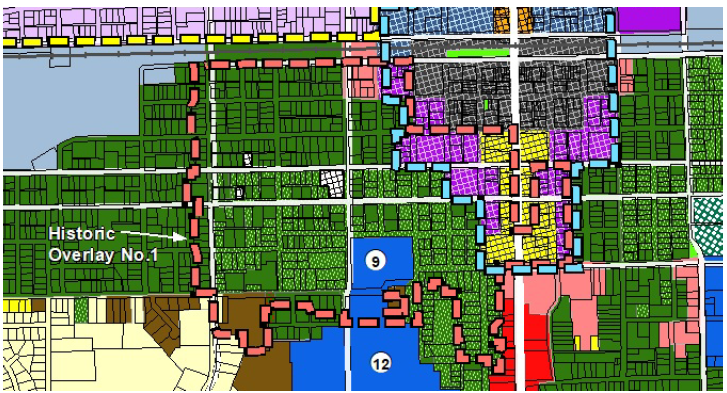
Figure 4.7-1: Historic Overlay No. 1
Historic Overlay No. 2 District Standards: The standards applicable to development in the Historic Overlay No. 2, also known as the Historic Downtown District Standards, are located in Article VI: Building Design Standards and Section 6.7, Historic Downtown District Standards.