
Ennis City Zoning Code
ARTICLE IX
Subdivision Regulations
9.1.1 - Title
This article is known as the Subdivision Regulations of the City of Ennis.
9.1.2 - Purposes
The purposes of these regulations are:
(1)
To protect and provide for the public health, safety, and general welfare of the community by promoting sustainable development of the area both within the city and within its extraterritorial jurisdiction.
(2)
To guide the future growth and development of the city in accordance with this Ordinance, Ennis' Comprehensive Plan, and any adopted constituent elements, and all other development-related ordinances of the city.
(3)
To promote safety from fire, flood, and other danger, and to prevent overcrowding of the land and undue congestion of population.
(4)
To ensure that public and private development are served by adequate public facilities and services with sufficient capacity for efficient transportation, water, sanitary sewer, drainage, and other public requirements and facilities, and that the development bear its fair share of the cost of providing the facilities and services.
(5)
To establish policies governing traffic flow and safety on street facilities, minimize traffic congestion, improve traffic safety and flow, and ensure that traffic generated from the proposed development can be adequately and safely served by the existing and future street system.
(6)
To establish reasonable standards of design and procedures for platting to further the orderly layout and use of land and to promote proper legal descriptions and monumenting of platted land.
(7)
To minimize the pollution of streams and ponds; to provide for the adequacy of drainage facilities; to control stormwater runoff; to minimize erosion and siltation problems; to safeguard the water table; to encourage the wise use and management of natural resources; and enhance the stability and beauty of the community and the value of the land.
(8)
To remedy the problems associated with illegally subdivided lands and/or previously platted lands, including premature subdivision, incomplete subdivision, or scattered subdivision of land.
9.1.3 - Applicability
(1)
The owner or proprietor of any tract of land who desires to subdivide land (i.e., to create a "subdivision") shall submit a plat of the subdivision to the Administrator.
(2)
No person shall subdivide land without making and recording a plat and complying fully with this article, and the subdivision procedures in Article III: Review Procedures.
(3)
No person shall sell or transfer ownership of any lot or parcel of land by reference to a plat of a subdivision before the plat is duly recorded with Ellis County, unless the subdivision was created prior to the adoption of this article.
(4)
The following are allowed only if they conform to this Ordinance:
(a)
The issuance of a development approval or certificate of occupancy for any plat, map, or plan that was created prior to subdivision approval under this Ordinance.
(b)
The issuance of a development approval or certificate of occupancy for any parcel or plat of land that was created by subdivision after the effective date of this Ordinance.
(c)
The excavation of land or construction of any public or private improvements.
(5)
A subdivision plat is not required for any of the following:
(a)
The public acquisition by purchase of strips of land for the widening or opening of streets.
(b)
In accordance with Section 212.004(a) of the Texas Local Government Code (TXLGC), a division of land under this article does not include a division of land into parts greater than five (5) acres where each part has access and no public improvement is being dedicated.
9.2.1 - Division of Property
(1)
Every owner of any tract of land who divides the tract into two or more parts shall cause a plat to be made, which accurately describes and locates the entire tract by metes and bounds as required in this Article.
(2)
A division of a tract under this Ordinance includes a division regardless of whether it is made by using a metes and bounds description in a deed of conveyance or in a contract for a deed, by using a contract of sale or other executory contract to convey, or by using any other method.
(3)
No plat may be recorded and no transfer of title to any part of a tract of land shall be made until a plat, accurately describing the property to be conveyed, is approved in accordance with these provisions and recorded.
9.2.2 - Permits for Construction Activity or Public Improvements
(1)
Except as provided in Section 9.1.3: Applicability, and remaining in the same configuration, the Administrator shall not issue permits for any construction activity or allow any public improvements for a development until a plat is approved and filed of record.
(2)
Upon written request from the developer, the Administrator may allow the construction of public improvements prior to plat recording with accepted plans and development agreements.
(a)
In order for the request to be granted, the developer must demonstrate that an inability to record the plat within a reasonable timeframe is the result of recording requirements that do not have a substantive impact upon the development of the land.
(b)
If the city allows the development of public improvements prior to plat recording, the city shall not accept those improvements until a plat is filed of record.
(3)
No building permit shall be issued nor shall any public utility service be provided for land without a plat as required by this article unless exempt under TXLGC 212.
9.2.3 - Guiding Policies for Administration of this Article
Proposed plats or subdivisions that do not conform to the purposes listed above and the following policies and regulations shall be denied. In lieu of being denied, the City may approve the subdivision subject to the guiding policies in this section. These regulations shall be administered in accordance with the following policies:
(1)
Conformity with Comprehensive Plan: Plats and proposed public improvements shall conform to the City's Comprehensive Plan and any adopted constituent elements, including the Master Thoroughfare Plan, and all other plans or development related ordinances of the city.
(2)
Conformity with Unified Development Ordinance: No subdivision shall be approved unless it complies with all applicable zoning, design, and development regulations set forth in this Ordinance, including but not limited to:
(a)
The requirements of the zoning district in which the property is located (See Article IV: Zoning Districts)
(b)
The requirements relevant to specific uses (See Article V: Use Standards)
(c)
Generally applicable development and design standards (See Articles VI, VII, and VII)
(3)
Sites and Access for Comprehensive Plan Elements: Adequate sites and convenient access for schools, parks, playgrounds, and other community services indicated in the City's Comprehensive Plan and all applicable ordinances shall be provided in accordance with the intent, policies, and provisions of this Ordinance.
(4)
Developer Responsibility: The developer is responsible for the accuracy of all information furnished in the design of facilities as they pertain to both the proposed development and other properties affected by the proposed development. The City's concurrence in the design does not relieve the developer of this responsibility.
(5)
Effect of Development on General Welfare: The nature, shape, and location of land to be platted or developed shall enable it to be used without danger to health or increased risk of fire, floods, erosion, stormwater pollution, landslides, or other menaces to the general welfare.
(6)
Applicability in the ETJ - The standards in Article shall apply to all subdivision in the city's Extra Territorial Jurisdiction (ETJ) subject to the provisions in TXLGC Chapter 212 as amended.
9.2.4 - Incorporation of Infrastructure Design Standards
The city's adopted infrastructure design criteria and construction standards for public improvements are hereby incorporated and collectively referenced as the Infrastructure Design Standards. The Infrastructure Design Standards shall be maintained in the Public Works office and are available upon request.
9.3.1 - Provision of Adequate Public Facilities
Each subdivision shall provide adequate public facilities. Adequate public facilities shall include adequate water, sanitary sewer, drainage, and transportation facilities necessary to serve the proposed development, whether or not the facilities are to be located within the property being platted or offsite.
9.3.2 - Criteria for Adequate Public Facilities
Public facilities are considered adequate if they meet the minimum level of service established in the appropriate sections of this Ordinance and the following standards:
(1)
Street Access: All platted lots shall have safe and reliable street access for daily use and emergency purposes. All platted lots shall have direct access to a paved public street, private street, or an approved access easement. (See Section 9.4.1: Street and Right-of-Way Requirements).
(2)
Water: All platted lots shall be connected to a public water system that provides water for health and emergency purposes. The water system shall be consistent with the City of Ennis water system plan and all adopted city codes and ordinances and Infrastructure Design Standards.
(3)
Wastewater/Sanitary Sewer: All platted lots shall be connected to a public sanitary sewer collection and treatment system where available. On-site sanitary sewer treatment systems shall only be permitted if no public sanitary sewer is available within 1,000 feet of the property and shall meet the city's adopted standards for on-site sanitary sewer. The sanitary sewer system shall be consistent with any adopted Wastewater System Model and Master Plan and Infrastructure Design Standards of the City of Ennis, as amended. (See Section 9.4.4: Water and Wastewater Utilities).
(4)
Drainage and Stormwater Management: Drainage and stormwater facilities are adequate when (See Section 9.4.5: Drainage and Environmental Standards):
(a)
Stormwater runoff attributable to new development or redevelopment complies with the minimum standards of this Ordinance and the city's Infrastructure Design Standards and iSWM Criteria Manual.
(b)
To the maximum extent practicable, permanent Best Management Practices (BMPs), as described in the iSWM Criteria Manual as adopted by the city, shall maintain the predevelopment characteristics of any natural creek that ultimately receives stormwater runoff from the development.
(5)
Electricity: All platted lots shall have access to a public utility that provides electricity for retail consumption.
(6)
Telecommunications: All platted lots shall have access to a public utility that provides telecommunications for retail consumption.
9.3.3 - Dedication Statement
DEDICATION STATEMENT (to be used in all instances)
NOW THEREFORE, KNOW ALL MEN BY THESE PRESENTS; THAT (OWNER'S NAME) ACTING HEREIN BY AND THROUGH ITS DULY AUTHORIZED OFFICERS, DOES HEREBY ADOPT THIS PLAT DESIGNATING THE HEREIN ABOVE DESCRIBED PROPERTY AS (SUBDIVISION NAME), AN ADDITION TO THE CITY OF ENNIS, TEXAS AND DOES HEREBY DEDICATE, IN FEE SIMPLE, TO THE PUBLIC USE FOREVER, THE STREETS, ALLEYS, AND PUBLIC USE AREAS SHOWN HEREON, AND DOES HEREBY DEDICATE THE EASEMENTS SHOWN ON THE PLAT FOR THE PURPOSES INDICATED TO THE PUBLIC USE FOREVER, SAID DEDICATIONS BEING FREE AND CLEAR OF ALL LIENS AND ENCUMBRANCES EXCEPT AS SHOWN HEREIN. NO BUILDINGS, FENCES, TREES, SHRUBS, OR OTHER IMPROVEMENTS SHALL BE CONSTRUCTED OR PLACED UPON, OVER, OR ACROSS THE EASEMENTS ON SAID PLAT. UTILITY EASEMENTS MAY ALSO BE USED FOR THE MUTUAL USE AND ACCOMMODATION OF ALL PUBLIC UTILITIES DESIRING TO USE OR USING THE SAME UNLESS THE EASEMENT LIMITS THE USE TO A PARTICULAR UTILITY OR UTILITIES, SAID USE BY PUBLIC UTILITIES BEING SUBORDINATE TO THE PUBLIC'S AND CITY OF ENNIS' USE THEREOF. THE CITY OF ENNIS AND ANY PUBLIC UTILITY SHALL HAVE THE RIGHT TO REMOVE AND KEEP REMOVED ALL OR PART OF ANY BUILDINGS, FENCES, TREES, SHRUBS, OR OTHER IMPROVEMENTS OR GROWTHS WHICH IN ANY WAY ENDANGER OR INTERFERE WITH THE CONSTRUCTION, MAINTENANCE, OR EFFICIENCY OF ITS RESPECTIVE SYSTEM ON ANY OF THESE EASEMENTS AND THE CITY OF ENNIS ON ANY PUBLIC UTILITY SHALL AT ALL TIMES HAVE THE RIGHT OF INGRESS AND EGRESS TO AND FROM AND UPON ANY OF SAID EASEMENTS FOR THE PURPOSE OF CONSTRUCTING, RECONSTRUCTING, INSPECTING, PATROLLING, MAINTAINING, AND ADDING TO OR REMOVING ALL OR PART OF ITS RESPECTIVE SYSTEM WITHOUT THE NECESSITY AT ANY TIME OF PROCURING THE PERMISSION OF ANYONE. (OWNER'S NAME) DOES HEREBY BIND ITSELF, ITS SUCCESSORS AND ASSIGNS TO FOREVER WARRANT AND DEFEND ALL AND SINGULAR THE ABOVE DESCRIBED STREETS, ALLEYS, EASEMENTS, AND RIGHTS UNTO THE PUBLIC AGAINST EVERY PERSON WHOMSOEVER LAWFULLY CLAIMING OR TO CLAIM THE SAME OR ANY PART THEREOF. THIS PLAT APPROVED SUBJECT TO ALL PLATTING ORDINANCES, RULES, REGULATIONS, AND RESOLUTIONS OF THE CITY OF ENNIS.
WITNESS MY HAND THIS DAY OF, 20 __.
Signature of Owner
______________________________
Name:______________________________
Title: ______________________________
Company:______________________________
Signature of Lienholder (if applicable)
______________________________
Name:______________________________
Title: ______________________________
Company:______________________________
If there is no lien holder, add the following statement:
To the best of my knowledge, there are no liens against this property.
______________________________
Signature of Owner
9.3.4 - Dedication Required
(1)
Generally: Property necessary for the orderly development of streets, roadways, thoroughfares, utilities, stormwater facilities, or other public purposes shall be dedicated to the City as required by this Ordinance and in accordance with the Comprehensive Plan, the Master Thoroughfare Plan, and other adopted plans. Dedication of and acceptance by the City of the property is a condition of plat approval.
(2)
Proportionality Required: The dedication requirements for a specific plat shall be roughly proportional to the projected impact of the proposed development and shall be determined as set forth in Section 212.904 of the TXLGC.
(3)
Property Owners' Association
(a)
Property Owners' Association Allowed: When a subdivision contains common areas, drainage ways, screening walls or other facilities not located within the public right-of-way nor subject to city maintenance, or if landscaping, sidewalks, or other amenities are provided within the public right-of-way for which a license agreement is required by the city, a property owners' agreement, as evidenced by the covenants establishing the association, shall be placed on the plat. Such homeowners' agreement (the covenants, conditions and restrictions) shall be approved as part of the preliminary plat process and shall be filed of record prior to recording of the Final Plat.
The City Attorney will review the association documents as to form. The following six (6) statements shall appear on the face of the plat and in a single article in the association's covenants, conditions and restrictions:
i.
The owner of fee simple title to every individual lot of land within the subdivision must be a member of the homeowners association.
ii.
The homeowners association must have the authority to collect membership fees.
iii.
The homeowners association must be responsible for the maintenance of all common areas and screening walls.
iv.
The homeowners association must grant the city the right of access to common areas to abate any nuisances thereon, and attach a lien for the prorated cost of abatement upon each individual lot. The homeowners association shall indemnify and hold the city harmless from any and all costs, expenses, suits, demands, liabilities, damages, or otherwise including attorney's fees and costs of suit, in connection with the city's maintenance of common areas.
v.
The homeowners association shall enter into a license agreement with the City of Ennis where additional right-of-way has been dedicated for the purpose of providing landscaping, additional areas for sidewalks, walls, or other amenities, and shall be responsible for the installation and maintenance of all landscape areas that are in the public right-of-way.
(b)
Alternative Funding Mechanisms: If a property owners' association fails to collect reserve funds to maintain property such as private streets, access easements, privately-maintained drainage features, or pools, the city may assess property owners within the subdivision served by the amenity or facility the costs associated with addressing matters of public safety.
(4)
Platting Exemptions for Single Tracts Prior to Construction: Any owner of an unplatted single tract of land shall submit for approval and have filed of record a plat of the tract prior to the commencement of construction or issuance of a building permit. However, nothing in these regulations requires a plat to be approved and recorded as a prerequisite to construction under the following conditions:
(a)
The tract is zoned residential in accordance with Article IV: Zoning Districts, and the construction is for any of the following purposes, and the addition or alteration conforms with the Unified Development Ordinance:
i.
Adding to or altering an existing lawfully conforming single-family building or structure
ii.
Adding a fence on the tract
iii.
Adding an accessory building or structure to an existing lawfully conforming single-family use
(b)
The tract is not zoned residential as noted above or is zoned residential but contains a permitted non-residential land use, the construction is for any of the following purposes, and the alteration conforms with the Unified Development Ordinance:
i.
Adding an accessory building to an existing lawfully conforming use on the same tract
ii.
Adding a fence on the tract
iii.
Remodeling or altering an existing commercial or industrial building
iv.
Adding a wireless communications antenna to an existing utility transmission tower or existing telecommunications tower
v.
Any improvement that does not create infrastructure impacts or more intensive development than the exceptions listed above
9.4.1 - Street and Right-of-Way Requirements
(1)
Basic Policy: The following general requirements apply to all plats.
(a)
Streets and right-of-way shall conform to any adopted Master Thoroughfare Plan, as amended, the city's Infrastructure Design Standards and the standards in this Ordinance.
(b)
An adequate off-site street and thoroughfare system shall be designed and constructed in order to:
i.
Provide for streets of suitable location, width, or other improvements to accommodate existing traffic, traffic anticipated from the development, and traffic anticipated from other developments impacting the same roadways.
ii.
Afford satisfactory access to adjoining properties.
iii.
Accommodate police, firefighting, sanitation, and street maintenance equipment.
(c)
The proposed streets of the development shall effectively relate to the present and future street system and to the development of the surrounding area in order to assure continuity of thoroughfares, coordination of intersections, the limitation of median breaks, and the promotion of livable neighborhoods.
(d)
The plat shall provide for appropriate continuation or termination of any existing streets, whether constructed or dedicated, which extend to the limits of the proposed subdivision.
(e)
Adequate provision of access to adjoining lands shall be made.
(f)
The developer shall design and construct adequate roadway facilities, whether on-site or off-site.
(g)
The developer shall be responsible for all costs associated with meeting the requirements of this article.
(2)
Adequacy of Offsite Roadway Network Required
(a)
Adequacy Required: Prior to plat approval, the Administrator shall determine whether the roadway network serving the development to be platted has adequate capacity to accommodate existing traffic, traffic reasonably anticipated from the development, and traffic reasonably anticipated from other developments approved or to be approved within a reasonable period. The standards for compliance with this requirement are set out in subsections (b) through (d), below. The Administrator's determination shall be based on information provided by the developer in the plat application and supporting studies, unless the study is waived.
(b)
Analysis of Adequacy
i.
For any property submitted for platting that meets the criteria contained in Section 9.3 Adequate Public Facilities and Dedication Required, the developer shall provide, at the developer's expense, a traffic study that analyzes the adequacy of the roadway network to serve the development.
ii.
Adequate capacity of the roadway network shall be determined as described in the City's adopted Master Thoroughfare Plan and/or Infrastructure Design Standards.
(c)
Determination of Adequacy: The roadway network shall be considered adequate if:
i.
There is sufficient capacity on each existing and proposed link and intersection of the network
ii.
The roadway conditions are adequate for each existing link and intersection of the network
(d)
Determination of Inadequacy: In the event that the traffic study shows a result of a level of service "D", "E", or "F", as defined in the Highway Capacity Manual, or the Administrator or City Engineer determines that the off-site roadway network serving the development to be platted is not adequate, the following shall be provided:
i.
Proposed solutions to the transportation issues resulting from the proposed development
ii.
The degree of local congestion
iii.
The availability of alternate routes to service the increased traffic
iv.
The degree to which the increased congestion is attributable to the applicant's project
(e)
After the information is reviewed, the city may:
i.
Disapprove the plat
ii.
Require that development of the property be phased to coordinate the timing of building permits with the provision of adequate capacity
iii.
Require the developer, in lieu of denial or phasing of the plat, to construct off-site and/or on-site improvements to City standards or as otherwise permitted by the Administrator to provide adequate capacity for the roadway network. Construction may be required to use standards in excess of any adopted Master Thoroughfare Plan or city Infrastructure Design Standards if warranted based on the available capacity and proportional impact of the proposed development.
(3)
Traffic Study Requirements
(a)
Traffic Study Submittal: The traffic study shall be prepared in accordance with the criteria established in the city's Infrastructure Design Standards.
(b)
Acceptance of Traffic Study: Prior to forwarding any plat to the Planning and Zoning Commission (P&Z), the traffic study shall be accepted by the city. The acceptance of the traffic study will be based on the completeness of the traffic study, the thoroughness of the impact evaluation, and the consistency of the study with the proposed access and development plan.
(4)
Requirement for Access to the Street Network
(a)
Acquisition of Access Required: The developer shall acquire right-of-way and/or necessary easements and construct any offsite roadways and/or access ways necessary to connect the development with an adequate offsite, existing city roadway network.
(b)
Residential Access Limited
i.
Arterial Streets: No single-family, townhouse, or duplex residential development shall have direct access to an arterial street unless no other means of access is available. In cases where access is permitted to an arterial street, a private access easement adjacent to the thoroughfare is required. Any lot that has direct access to an arterial street is required to provide head-out egress.
ii.
Collectors: Single-family, duplex, and townhouse residential lots may have direct driveway access to collectors if the following development standards are complied with:
1.
An additional setback of 10 feet shall be required along the Collector Street frontage. The setback shall be measured from the ultimate ROW of the Collector Street as identified in the adopted Master Thoroughfare Plan.
2.
Driveway separation may be allowed only with a minimum of 240 feet separation with shared driveways.
(c)
Private Access Easements: To the maximum extent practicable, private access easements shall be required between and/or across any non-residential lots fronting on arterial and collector streets in order to minimize the total number of access points along those streets and to facilitate traffic flow between lots. The location and dimensions of the easement shall be in accordance with the city's Infrastructure Design Standards. A note shall be provided on the plat indicating the lots served by the private access easement. The minimum width of a private access easement shall be 20 feet. The easement shall be increased to 24 feet when it functions as a required fire lane. For 24-foot and 22-foot local standards, private access easements are required to provide rear access to residential lots. For this use, the private access easement width may be reduced by the Administrator if not needed for fire access..
(d)
Maintenance of Private Access Easement: Maintenance of any private access easement is the responsibility of the property owner or property owner's association, as applicable. When an easement is created by plat, a maintenance note as approved by the Administrator shall be added to the plat acknowledging maintenance responsibility. When the easement is created by separate instrument, the maintenance responsibility shall be acknowledged with the separate instrument.
(e)
Adequate Access: Each single-family residential subdivision shall have at least two constructed points of public ingress and egress, except:
i.
When 30 or fewer residential units are constructed with one point of street ingress and egress.
ii.
The Administrator may approve up to 40 units with one point of access when requested. In evaluating a request, the Administrator shall consider factors including the timing of construction of other public improvements that provide a second point of access, public safety, and convenience, especially if undeveloped property is adjoining the subdivision and future stub streets are provided.
iii.
The City Commission may grant a waiver to these regulations for more than 40 units with one point of access only when unique topographic or infill circumstances exist.
(f)
Stub Streets Required: Street stubs for future connections shall be required to any adjoining undeveloped property at a minimum spacing of 1,000 feet. A street stub for a future connection may provide the justification for the waiver of the Adequate Access (see (e) above) requirement.
(5)
Street Layout Requirements
(a)
Intersections
i.
Intersection Offsets
1.
No street intersecting an arterial or collector street shall vary from a 90 degree angle of intersection by more than 10 degrees.
2.
The number of collector or local street offsets shall be minimized. However, when approved by the Administrator because no other reasonable alternative exists, a minimum centerline offset distance of 125 feet shall be maintained.
3.
There shall be a minimum of 600 feet between intersections of arterials or collector type streets.
ii.
Arterial streets shall be intersected only by collector streets or other arterial streets, unless the only means of ingress and egress to a subdivision is from the arterial street. In this event, the local street intersection may be required to be configured to accommodate stacking and turning traffic with a flared intersection per the city's Infrastructure Design Standards. All costs associated with the construction of this flare configuration shall be borne by the developer.
iii.
Visibility triangles, as required by Article VII, shall be provided at the intersection of all public streets. In addition, visibility easements may be required where sight distance may be limited due to topography, roadway curvature, vegetation, or other sight hindrance. The easement shall be dedicated by plat.
(b)
Residential Block Length: The following standards shall be followed in the design of residential blocks.
i.
Block lengths and cul-de-sacs shall be appropriate to the density and type of development as follows:
1.
Generally, the maximum length of any block in a residential zone district shall be 600 feet.
2.
If utilizing rural standards, the maximum block length shall be 1000 to 1200 feet with a maximum of 12 lots.
ii.
Reserved.
iii.
Alternative Block Lengths
1.
The Administrator may approve alternative block lengths under the following conditions:
a.
Proximity to a railway, expressway, waterway
b.
Topographic features
c.
An infill development with no alternate access
2.
When considering a request for alternative block lengths, the Administrator shall consider the following:
a.
Alternative designs which would reduce block length
b.
The effect of long blocks on access, congestion, and delivery of municipal services
c.
Means of mitigation, including but not limited to mid-block turnarounds, limitation on the number of lots to be created and served, temporary points of access, and additional fire protection measures
(c)
Curvilinear Street Design Requirements
i.
Roadway layout may include curvilinear design. If curvilinear street design is utilized, then local and collector streets shall be designed with a maximum of 50 percent of the lots within the subdivision to have curved frontage.
ii.
The roadways shall also conform to the following:
1.
Fit the road to natural topography
2.
Avoid monotony of lot appearance
3.
Reduce speeds through neighborhoods
4.
Discourage through traffic intrusions by eliminating straight views from one block to the next
iii.
Local and collector streets that connect one major collector or arterial to another major collector or arterial directly are discouraged.
(d)
Culs-de-Sac: Dead end streets are permitted only where a future extension or connection is anticipated or planned into adjacent property. If the dead end is greater than 150 feet measured from the property line, a turnaround facility will be required. The developer shall be responsible for acquiring the right-of-way or easement and constructing the turnaround. The turnaround will be considered temporary until the street is extended or a permanent cul-de-sac is constructed. The temporary turnaround may be constructed without curb and gutter but shall meet all other design criteria. The turnaround shall be constructed off-site, unless the developer is unable to obtain off-site right-of-way. The Administrator may approve the construction of the turnaround within the limits of the development based on phasing and timing of future connectivity.
i.
A cul-de-sac shall have a 50-foot right-of-way radius at the closed end. The radius of the paved area of the turnaround shall be a minimum of 39 feet.
ii.
To the maximum extent practicable, culs-de-sac shall provide direct pedestrian/bicyclist access to the closest street or pedestrian/bicyclist connection.
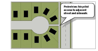
Figure 9.2 Pedestrian Access from Cul-de-Sac to closest street
iii.
Maximum length of a dead-end street permitted shall be 600 feet.
iv.
Provisions shall be made for drainage at the ends of dead-end streets.
v.
When an existing dead-end street with temporary turnaround, whether on-site or off-site, is extended, the developer extending the street shall be responsible for removing the turnaround facilities, constructing the extension or cul-de-sac to the standards in these regulations, and restoring the affected area.
vi.
If the developer chooses not to extend an existing dead end-street, then that developer shall provide right-of-way and construct a permanent turnaround or cul-de-sac.
(6)
Rights-of-Way
(a)
Rights-of-way for major arterials, arterials, and collectors are required and shall be established in Table 9.3-1 unless it meets the standards as established in the city's adopted Master Thoroughfare Plan.
(b)
Mid-block and Intersection Requirements: Mid-block and intersection rights-of-way and geometric design for streets are required as shown in the Master Thoroughfare Plan and the city's Infrastructure Design Standards. Based on site conditions and the proposed development, additional ROW may be required to be dedicated to facilitate access ramp and/or signal construction as follows:
i.
A 10-foot by 10-foot clip for local/local street intersections.
ii.
An 80-foot radius for arterial/arterial intersections and arterial/departure side of major collector street intersections. See City's Infrastructure Design Standards for layout.
iii.
A 15-foot by 15-foot clip for all other intersections.
(c)
Local Streets: For local streets, the right-of-way can vary depending on the standards utilized as shown in Table 9.3-2 below:
i.
Rural Design: A rural design for a local street includes 28 feet of pavement with no curb and gutter. This standard shall only be used in residential developments with lots one acre or greater in size. On street parking shall not be permitted.
ii.
Flare at Intersection: Right-of-way for all local streets shall flare to 60 feet at intersections with any arterial street.
(d)
Alleys:
i.
Residential alleys shall be a minimum of 20-foot wide ROW with a minimum 12-foot wide pavement.
ii.
Commercial alleys shall be minimum 24-foot wide ROW with a minimum 24-foot wide pavement.
(7)
Sidewalks
(a)
Sidewalks Required: The developer shall install sidewalks on all public streets within and abutting the development and standards shall meet Article VII. Sidewalks are not required for the local rural streets where the lots are one acre or larger in area. A waiver of sidewalks may be granted by the Administrator if it is determined that construction is not feasible at time of development for engineering reasons or inappropriate due to the nature of the project.
(b)
Standards: Sidewalks shall be built in accordance with the City's Infrastructure Design Standards, any adopted Trail Plan, and Texas Accessibility Standards.
(c)
The developer may, at his own option, choose to provide additional private access easements for sidewalks, walkways, or bicycle facilities. Construction and maintenance of these private access easements will be the responsibility of the developer and/or subsequent owners.
(8)
Development Requirements
(a)
State Roadways: The developer may be required to construct curbs, gutters, and sidewalks to TxDOT's standards on developments abutting roadways designated as state highways, or on right-of-way or land owned by the State.
(b)
Coordination with Planned Street Projects: Where a development will abut an existing street for which construction plans have been prepared for future improvements, the plans for the development shall be coordinated with the street construction plans. If the developer requests an alteration to the construction plans, and the City agrees to the alteration, the developer shall pay to revise the plans as necessary and escrow any increased construction costs. The escrow will not be refundable.
(c)
Street Appurtenances with Construction: All public street construction shall include streetlights, street signs, signals, and pavement markings as required by the City's Infrastructure Design Standards. The developer will be responsible for all costs associated with the design and construction or installation of these street appurtenances. Streetlights shall also be required on all perimeter public streets along the frontage of the development. Conduit for fiber optic cables may be required at signalized intersections and along roadways identified in the city's network fiber plan. All street appurtenances shall be designed and constructed in accordance with the City's Infrastructure Design Standards.
(d)
Payment Requirements
i.
Payment May be Collected for Site Required Facilities: Upon the developer's request to defer construction of any required public improvements, at the city's sole option, a payment in lieu of construction may be collected for required improvements. The Administrator/City Engineer may agree to defer construction of required improvements and accept payment when construction of the required improvements is not feasible at the time of development. The payment amount shall be estimated based on the total estimated cost of design, utility relocation, and construction of the improvements unless otherwise specified in this section. Payment shall be made to an escrow account to be utilized solely for the construction of the required public improvements.
ii.
Easements Required: The developer shall provide the right-of-way/easements even if construction is determined not to be feasible and payment is accepted at the time of subdivision.
(9)
Development Agreements:
(a)
Standard development agreements executed by the developer and the city are required for all public improvements. The agreements shall include two-year maintenance bonds, performance bond, payment bond, insurance, and other requirements and fees as detailed in the City's Infrastructure Design Standards.
(b)
Ownership and Maintenance: All public facilities constructed within dedicated public rights-of-way or public easements shall be and shall remain the property of the city and, after expiration of the maintenance bonds, shall be maintained by the city.
(10)
Private Streets
(a)
Design and Construction Requirements: Private street widths, cross-sections, and design criteria shall comply with city standards and shall meet the minimum construction standards for public streets, including its appurtenances such as streetlights, street signs, and pavement markings. If the development will be gated, it shall comply with the gated entry guidelines in the City's Infrastructure Design Standards.
(b)
Streets shown on the Master Thoroughfare Plan shall not be used, maintained, or constructed as private streets. In addition, the city may deny the creation of any other private street if, in the city's judgment, the private street would have any of the following effects:
i.
Negatively affect traffic circulation on public streets
ii.
Impair access to property either on-site or off-site to the subdivision
iii.
Impair access to or from public facilities including schools, parks and libraries
iv.
Delay the response time of emergency vehicles
(c)
Private streets shall be constructed within a separate lot owned by the property owners' association. This lot shall conform to the city's standards for public streets and rights-of-way. An easement covering the street lot shall be granted to the city providing unrestricted use and maintenance of the property for public utilities. This right shall extend to all utility providers operating within the city. The easement shall also provide the city with the right of access for any purpose related to the exercise of a governmental service or function, including but not limited to, fire and police protection, inspection, and ordinance enforcement. The easement shall permit the city to remove any vehicle or obstacle within the street lot that impairs emergency access.
(d)
Cost of Private Streets: The city shall not pay for any portion of the cost of constructing or maintaining a private street and its appurtenances.
(e)
Inspections: Inspections of private streets shall be performed by the city at the developer's cost or by a third party in accordance with requirements outlined in the City's Infrastructure Design Standards.
(f)
Maintenance: Developments with private streets shall have a mandatory property owners' association that includes all property served by private streets to ensure maintenance of the private street.
(g)
Waiver of Services: The subdivision's recorded plat, property deeds, and property owner association documents shall note that certain City services may not be provided on private streets. Among the services that may not be provided are: street maintenance, routine police patrols, enforcement of traffic and parking ordinances, and preparation of accident reports. Depending on the characteristics of the proposed development, other services may not be provided.
(11)
Street Names: The developer shall name streets in conformance with the city's Infrastructure Design Standards. The city shall have final approval of all street names.
(12)
Alternative Local Street Standards: Alternative street designs may be allowed in accordance with development specific ordinances in PDs and Special Districts approved by the City Commission. There shall be no waivers from construction specifications.
9.4.2 - Lots and Blocks
(1)
Lots
(a)
Buildings on a Lot: Except as otherwise permitted by this Ordinance, every building shall be located on a lot.
(b)
Frontage: All lots shall front on a public or private street or private access easement and shall have a minimum lot width as indicated in Article IV.
(c)
Lot Size: Platted or replatted lots must comply with the minimum lot size regulations of the zoning district in which the lot is located.
(d)
Setbacks: Lot setbacks shall be determined by the applicable zoning district and not by platted building lines.
(2)
Blocks
(a)
Lots within Blocks: Lots shall be arranged in a contiguous pattern within blocks or abutting a cul-de-sac.
9.4.3 - Easements
(1)
Width of Easements
(a)
Utility: The minimum width for utility easements shall be in accordance with the standards outlined in the city's Infrastructure Design Standards and shall be adequate for the installation and maintenance of utilities that are likely to be located in the easement.
(b)
Drainage: The minimum width for City drainage easements shall be as required by the city's Infrastructure Design Standards.
(c)
Storm Drainage or Floodway: Where a Subdivision is traversed by a watercourse, drainage way or channel, a storm drainage easement or right-of-way shall be provided that conforms substantially with such course and of such additional width as may be designated by the Administrator and/or City Engineer, subject to determination according to proper engineering considerations. The required width shall conform to the requirements set forth by the Federal Emergency Management Agency (FEMA), the U.S. Army Corps of Engineers, and/or the city. Parallel Streets or parkways are encouraged adjacent to creek or drainage ways to provide maintenance access and/or public access and visibility into public open space or recreation areas. In this regard it is required that at least 50% of the edge along creeks/drainage ways be designated for public access - either trail or street frontage. Utilities may be permitted within a drainage or floodway easement only if approved by the Administrator and/or City Engineer and any other applicable entity requiring the drainage or floodway easement.
(d)
Other: The width of easements for other utility providers, such as for gas, electric, telephone or cable television, shall be as required by that particular entity. It shall be the Applicant/Developer's responsibility to determine appropriate easement widths required by other utility companies.
(2)
Location of Easements: Easements shall be located to accommodate the optimal design (as determined by the City Engineer) of the various utility and drainage systems that will serve the subdivision, and shall be provided in locations to accommodate any public purpose deemed necessary to protect the public health safety and welfare. In residential subdivisions, where alleys are not provided, a minimum 10-foot wide utility easement shall be provided along the front of all lots, parallel to and flush with the street ROW line for the potential placement of utility facilities.
(3)
Computation of Lot & Buildable Area: The area of a lot shall be computed inclusive of all easements. However, there shall be a minimum buildable area, exclusive of required easements, buffer zones and setbacks for each lot. The minimum buildable area shall be an area half (1/2) of the required minimum lot size. When an entire lot is not buildable, the Developer shall submit verification in writing that the buildable area is adequate for the type of housing product (or nonresidential building) proposed for that lot. Final approval of the allowed buildable area for any lot shall be by the Administrator.
(4)
On-Site Easements Shown on Plat: For new development, all necessary on-site easements shall be established on the Plat and not by separate instrument, and they shall be labeled for a purpose, such as for franchised public utilities. Other examples include, but are not limited to, the following: a drainage easement, which is dedicated to the city for a drainage structure; an access easement, which is dedicated to the public for unrestricted access purposes; a fire lane easement, which is dedicated to the city and its fire suppression and emergency medical service providers for access purposes; and an electrical, gas, or telephone easement which is dedicated to the specific utility provider that requires the easement.
(5)
Visibility Triangles: Visibility triangles meeting the standards in Article VII shall be designated as visibility easements on the plat.
(a)
The maximum height of fences, walls, signs, and other similar fixed items shall be 30 inches within the visibility easement.
(b)
Landscaping: All landscaping (and any other fixed feature) within the triangular visibility easement shall be designed to provide unobstructed cross-visibility at a level between 30 inches and eight feet. A limited number of single-trunked trees may be permitted in this area provided they are trimmed in such a manner that no limbs or foliage extend into the cross-visibility area. Landscaping, except grass and low ground cover, shall not be located closer than three feet from the edge of any street pavement.
9.4.4 - Water and Wastewater Utilities
(1)
Connections for Water: All new Subdivisions shall be connected with the city's water system or other public water supply system approved by TCEQ. The water system shall be capable of providing water for health and emergency purposes, including fire protection. The design and construction of water system shall comply with the following standards:
(a)
Applicable regulations of the Texas Commission on Environmental Quality (TCEQ).
(b)
Standards in the city's Infrastructure Design Standards.
(c)
Fire protection and suppression standards in accordance with the city's policies and ordinances including Fire Code adopted by the city. Additional development will not be allowed without water pressure meeting these standards.
(2)
Connections for Wastewater:
(a)
All new subdivisions shall be served by a wastewater collection and treatment system authorized and permitted by the TCEQ, except as provided below. The design and construction of the wastewater system improvements shall be in accordance with the standards in the City's Infrastructure Design Standards, and in accordance with TCEQ standards.
(b)
On-site sewage facilities such as septic or aerobic systems may be permitted where each lot is one acre or more in area, if the subdivision is 1,000 feet or more from a connection to a wastewater collection system. They shall meet the city's adopted standards for on-site sewage facilities.
(3)
Subdivider Responsibilities: The Subdivider shall be responsible for the following:
(a)
Phasing of development or improvements in order to maintain adequate water and wastewater services
(b)
Extensions of utility lines (including any necessary on-site and off-site lines) to connect to existing utility mains of adequate capacity
(c)
Providing and/or procuring all necessary easements for the utilities (whether on-site or off-site)
(d)
Providing proof to the city of adequate water and wastewater service
(e)
Providing for future expansion of the utilities if such will be needed to serve future developments, subject to the city's policies, if applicable
(f)
Providing all operations and maintenance of the private utilities, or providing proof that a separate entity will be responsible for the operations and maintenance of the utilities
(g)
Providing all fiscal security required for the construction of the utilities
(h)
Obtaining approvals from the applicable utility providers if other than the city
(i)
Complying with all requirements of the utility providers, including the city
(4)
Location of Lines: Extension of water and wastewater lines shall be made along the entire frontage of the subdivision adjacent to a street or thoroughfare in rights-of-way or dedicated Easements.
(a)
If the subdivision is not adjacent to a thoroughfare, the extension of utilities shall be to the edge of the Subdivision's perimeter property line adjoining any undeveloped property or accomplished in such a manner as to allow future connections to said utilities by new subdivisions.
(b)
If new subdivisions are not likely to be developed beyond the proposed subdivision (due to physical constraints), the Administrator may waive the requirement for adjacent utility line construction at the time of Preliminary Plat approval and prior to construction of the subdivision.
(c)
The city shall determine the location and routing of water and sewer extensions and shall retain the authority to reject any extension not deemed to be in the best interest of the city.
(5)
Utilities Not Specified: Installation, operations and maintenance of utilities not specifically referenced herein shall comply with regulations of the TCEQ and with any other applicable State rules and regulations, whichever is the most stringent.
(6)
Dead-End Water Lines
(a)
Dead-end water lines should be avoided, but when deemed necessary, they should be extended to, and then through, the property sought to be subdivided.
(b)
All dead-end water lines shall be valved and provided with a valve and fire hydrant located at the extreme end of the line instead of the blow-off mechanism for their flushing, in accordance with current city Infrastructure Design Standard specifications.
(7)
Payment of Pro-Rata Charges: Where the proposed subdivision would abut and utilize an existing water main and/or sanitary sewer main of the city, the Developer may be required to pay to the city any applicable "pro rata" charge per requirements of the city or previous pro rata agreement.
9.4.5 - Drainage and Environmental Standards
(1)
Drainage System Generally
(a)
Drainage improvements shall accommodate runoff from the upstream drainage area and shall be designed to prevent overloading the capacity of the downstream drainage system or adversely impacting either upstream or downstream properties.
(b)
The city may require the phasing of development, the use of control methods such as retention or detention, or the construction of off-site drainage improvements in order to mitigate the impact of the proposed development.
(c)
No storm water collection system shall be constructed unless it is designed by a licensed professional engineer and in accordance with this section and with the city's Infrastructure Design Standards, and unless it is reviewed and approved by the Administrator/City Engineer.
(d)
All plans submitted to the Administrator/City Engineer for approval shall include a layout of the drainage system together with supporting calculations for the design of the system.
(e)
Drainage Easements shall be kept clear of all obstructions, such as but not limited to, fences, buildings, trees and shrubs, or other structures or improvements which in any way endanger or interfere with the construction, maintenance, or operation of any drainage system.
(2)
Off-Site Drainage:
(a)
The applicant/developer/property owner of the subject property to be developed shall be solely responsible for all storm drainage flowing on or from the subject property. This responsibility includes the drainage directed to that property by prior development as well as drainage naturally flowing through the property by reason of topography.
(b)
Adequate consideration shall be given by the applicant/developer/property owner in the development of property to determine how the discharge leaving the proposed development will affect downstream property. As part of any application for development that will affect downstream property, the applicant/developer/property owner shall furnish the city with a letter signed by a Texas Professional Engineer stating that the development as designed will not damage downstream property due to the development's impact on off-site drainage.
(c)
Storm water runoff that has been collected or concentrated on lots or tracts of five acres or more shall not be permitted to drain onto adjacent property except into existing creeks, channels or storm sewers, unless proper drainage easements or notarized letters of permission from any affected downstream property owner(s) are provided.
(3)
Cross-lot Drainage Prohibited: Drainage between residential lots is the responsibility of the affected applicant/developer/property owner. Applicants/developers/property owners are required to drain surface runoff from an individual lot to a public ROW or to an underground drainage system contained in a public easement and will not be allowed to surface drain onto another lot. The Administrator shall have the discretion to allow modifications to the lot-to-lot drainage requirements where adherence to these requirements would be in conflict with other city ordinances and/or regulations.
(4)
Erosion & Sedimentation Control: All erosion and sedimentation controls shall conform to the city's Infrastructure Design Standards and the current National Pollution Discharge Elimination System (NPDES) regulations.
(5)
Changing Existing Ditch, Channel, Stream or Drainage Way: No person or entity shall deepen, widen, fill, reclaim, reroute or change the course or location of any existing ditch, channel, stream or drainage way without first obtaining written permission of the Administrator/City Engineer and any other applicable agency (such as FEMA or the U.S. Army Corps of Engineers) having jurisdiction. The Administrator/City Engineer may require preparation and submission of a CLOMAR, LOMR, other appropriate map revision or flood study for a proposed development if there are concerns regarding storm drainage on the subject property or upstream or downstream from the subject property. The costs of such study, if required, shall be borne by the developer.
(6)
Siting of Lots & Building Sites: In order to help reduce storm water runoff, and resulting erosion, sedimentation and conveyance of nonpoint source pollutants, the layout of the street network, lots and building sites shall, to the greatest extent possible, be sited and aligned along natural contour lines, and shall minimize the amount of cut and fill on slopes in order to minimize the amount of land area that is disturbed during construction.
(7)
Approval: Lots in any proposed subdivision shall not be approved until drainage facilities adequate to prevent flooding have been installed or necessary arrangements made for such installation as required under this Article IX.
(8)
Issuance of Building Permits: On any lot/subdivision designated by the Administrator/City Engineer as requiring completion or partial completion of drainage improvements prior to building construction, no building permits shall be issued prior to a release authorized by the Administrator.
9.5.1 - Generally
The requirements as set forth below are designed and intended to ensure that, for all subdivisions subject to this Article, all improvements as required herein are installed properly and:
(1)
The city can provide for the orderly and economical extension of public facilities and services
(2)
All purchasers of property within the subdivision shall have a usable, buildable parcel of land
(3)
All required public improvements are constructed in accordance with city's Infrastructure Design Standards
9.5.2 - Adequate Public Facilities Policy
The land to be divided or developed must be served adequately by essential public facilities and services. No plat shall be recorded unless and until adequate public facilities exist or provision has been made for water facilities, wastewater facilities, drainage facilities, electricity and street facilities which are necessary to serve the development proposed, whether or not such facilities are to be located within the property being platted or off-site. Wherever the subject property adjoins undeveloped land, or wherever required by the city to serve the public good, utilities shall be extended to adjacent property lines to allow connection of these utilities by adjacent property owners.
9.5.3 - Public Improvements Required
Public improvements that are required by the City of Ennis for the acceptance of any subdivision by the City shall include the following:
(1)
Water and wastewater facilities
(2)
Storm water drainage, collection and conveyance facilities
(3)
Water quality, erosion and sedimentation controls
(4)
Streets
(5)
Street lights
(6)
Street signs
(7)
Alleys (if provided)
(8)
Sidewalks, including ADA approved ramps at street intersections and other appropriate locations
(9)
Perimeter landscaping, screening and/or retaining walls (where required)
(10)
Common area improvements
(11)
Traffic control devices required as part of the project
(12)
Appurtenances to the above, all designed and constructed in accordance with ADA standards, if applicable, and any other public facilities required as part of the proposed subdivision
9.5.4 - Compliance Required
All aspects of the design and construction of public improvements shall comply with the city's current Infrastructure Design Standards and any other applicable City codes and ordinances, including preparation and submittal of engineering plans and construction inspection.
9.5.5 - Utility Lines
All utility lines that pass under a street or alley shall be installed before the street or alley is paved. When it is necessary that utility lines pass under the street or alley pavement, they shall be installed to a point at least three feet beyond the edge of the pavement.
9.5.6 - Monuments
(1)
Block Corner Monuments: Monuments consisting of 3/4-inch diameter steel rods 24 feet long and set flush with the top of the ground shall be placed at all corners of block lines, the point of intersection of alley and block lines, and at points of intersections of curves and tangents of the subdivision. Each block corner monument shall be marked in a way that is traceable to the responsible RPLS or associated employer.
(2)
Lot Corner Monuments: Lot corner monuments shall be placed at all lot corners (except corners which are also block corners), consisting of iron rods or pipes of a diameter of not less than ½-inch and 24 inches in length, and set flush with the top of the ground.
(3)
Curve Point Markers: In addition, curve point markers shall be established of the same specifications as lot corners.
(4)
View between Monuments Obstructed: Where, due to topographic condition, permanent structures, or other conditions, the view is obstructed between any two adjacent monuments, intermediate monuments shall be so set as to assure a clear view between adjacent monuments.
(5)
Installed Prior to Acceptance & Filing: All required block, lot, and curve monuments shall be installed prior to the final acceptance of the subdivision by the city and prior to filing the plat at the county.
(6)
Precision and Error of Closure: All survey work around the boundary area, as well as within the subdivision, shall satisfy the following precision requirements and otherwise comply with 66 Texas Admin. Code §663.13, as applicable:
(a)
The actual relative location of corner monuments found or set within the corporate limits of the city shall be reported within a positional tolerance of 1:10,000 + 0.10 feet.
(b)
The actual relative location of corner monuments found or set within the extraterritorial jurisdiction of the city shall be reported within a positional tolerance of 1:7,500 + 0.10 feet.
(c)
The actual relative location of corner monuments found or set in all rural areas outside the corporate limits and extraterritorial jurisdiction of the city shall be reported within a positional tolerance of 1:5,000 + 0.10 feet.
(d)
Areas, if reported, shall be produced, recited, and/or shown only to the least significant number compatible with the precision of closure.
(e)
Survey measurement shall be made with equipment and methods of practice capable of attaining the tolerances specified by these standards.
(f)
Positional tolerance of any monument is the distance that any monument may be mislocated in relation to any other monument cited in the survey.
9.5.7 - Subdivisions Containing 5 Acres or More
A subdivision containing five acres or more shall have at least two monuments set by the RPLS, if not already existing, for two corners of the subdivision, and such monuments shall be located at opposite ends (or at widely separated corners) of the subdivision and clearly shown on the Final Plat prior to filing at the county. The Final Plat shall also show clear ties to existing monuments in the vicinity of the subdivision.
9.5.8 - Street Lights
Street light locations and installations shall be coordinated by the applicant/developer with the power company and the city. Street lighting shall conform to the latest edition of the Illuminating Engineering Society Handbook. Street lights shall be as manufactured by Kim Standards or a comparable street light approved by the Administrator. Street lights shall be installed a maximum distance of 600 feet apart, at intersections, and at the ends of culs-de-sac. The applicant/developer shall pay for the electricity used by the street lights until building permits are issued for 80 percent of the lots, after which time the city shall pay for the cost of electricity used.
9.5.9 - Street Names and Signs
Street names must be submitted to the city for review and approval in accordance with this section and the city's guidelines for the naming of streets.
(1)
Preliminary Plat: Proposed Street names shall be submitted for review as a part of the Preliminary Plat application, and shall become fixed at the time of approval of the Preliminary Plat.
(2)
Final Plat: On the Final Plat, street names shall not be changed from those that were approved on the Preliminary Plat unless special circumstances have caused the major realignment of streets or a proposed street name(s) is discovered to have already been used elsewhere in the city (or some other similar eventuality). If additional street names are needed for the Final Plat, then they must be submitted for review and approval by the city, along with the Final Plat application.
(3)
Streets Named for Corporations/Businesses Prohibited: The names of corporations or businesses shall not be used as street names, unless approved by the City Commission.
(4)
List of Street Names Maintained: The city will maintain a list of existing street names that are essentially "reserved" names that have been previously been approved on a Preliminary Plat, and will update the list as new streets are platted.
(5)
Duplication & Similarities Prohibited: New street names shall not duplicate existing street names either literally or in a subtle manner (for example, Smith Street vs. Smythe Street; Oak Drive vs. Oak Place vs. Oak Court vs. Oak Circle; Lantern Way vs. Land Tern Way; Cascade Drive vs. Cascading Drive); shall not be so similar as to cause confusion between names (for example, Lakeside Drive vs. Lake Side Drive vs. Lake Siding Drive).
(6)
Extension of Existing Streets: Any new street that extends an existing street shall bear the name of the existing street unless otherwise approved by the P&Z Commission and City Commission.
(7)
Street Sign Installation
(a)
Street name signs shall be installed by the applicant/developer/property owner at all intersections within or abutting the subdivision. Such signs shall be of a type approved by the city and shall be installed in accordance with standards of the city. Traffic signs shall be furnished in accordance with the latest Texas Manual on Uniform Traffic Control Devices (MUTCD).
(b)
Timing of Installation: All street signs shall be installed before final acceptance of the subdivision by the city.
9.5.10 - Street and Alley Improvements
(1)
Facilities Constructed by the Developer: All facilities, such as internal streets and alleys, existing or proposed streets located immediately adjacent to the property, that are required to be constructed or improved in order to adequately serve the development, shall be constructed by the developer at the developer's expense, unless otherwise allowed by this Article IX.
(2)
Construction and Design: All streets and alleys shall be designed and constructed to meet the city's Infrastructure Design Standards and shall conform in width and section to any approved development specific ordinance, this Article IX or adopted Master Thoroughfare Plan.
(3)
Paving Standards: The developer shall construct all streets and alleys according to the standards contained within the city's Infrastructure Design Standards.
(4)
ADA Compliance: In addition to the above-mentioned minimum standards, barrier-free ramps for physically challenged persons shall be constructed at all street intersections, driveway approaches, appropriate mid-block crosswalks, and in locations where accessible parking spaces are provided. All barrier-free ramps and other accessibility considerations shall comply with the Highway Safety Act, as amended, and with the Americans with Disabilities Act (ADA), as amended.
(5)
Signs and Barricades: All signs and barricades shall be in conformity with the city's Infrastructure Design Standards, with ADA standards, and with specifications for uniform traffic control devices, as adopted by the city, Ellis County, Texas Department of Transportation, or the Texas Department of Public Safety, as applicable.
9.5.11 - Subdivision Perimeter Fencing, Buffering and Landscaping
(1)
Subdivision Perimeter Fencing shall be required per standards in Article VII or per a development specific ordinance as approved by the P&Z and the City Commission.
(2)
Buffering and Landscaping for any common areas or public improvements shall be required per standards in Article VII or per a development specific ordinance as approved by the P&Z and City Commission.
(3)
The developer shall provide (at his/her expense) such required fencing, buffering and/or landscaping prior to acceptance of a subdivision by the city.
9.5.12 - Subdivision Identification Signs
(1)
Subdivision Identification Signs are permitted at the entrance of residential subdivisions which are bisected by one or more streets. Such subdivisions must have:
(a)
10 or more platted single-family or duplex, triplex, quad-plex residential lots
(b)
20 or more multi-family units
(2)
Subdivision Identification Signs may be free standing or may be incorporated on a subdivision perimeter fence located in an appropriate easement.
(3)
Standards:
(a)
The maximum size of a Subdivision Identification Sign shall be 50 square feet per sign with a maximum height of six feet unless an alternative design is otherwise approved by the City Commission.
(b)
Signs may be located at each corner of an intersection of an entrance street or within the median of a divided street, but shall not be located in within visibility triangles.
(c)
The design of the Subdivision Identification Sign shall be in accordance with the city's Sign Ordinance or Infrastructure Design Standards, as applicable.
(d)
The design of the Subdivision Identification Sign (including any related perimeter fence) shall be reflected on materials/plans submitted along with the Preliminary Plat and the engineering plans.
9.5.13 - Water and Wastewater Requirements
(1)
Installation: The design, construction and installation of all water and wastewater lines shall be in conformance with this Article IX and any adopted master plans and city Infrastructure Design Standards and shall be approved by the Administrator/City Engineer.
(2)
Provision for Water & Wastewater Required: No Final Plat shall be approved nor subdivision accepted within the city or its extraterritorial jurisdiction until the applicant/developer/property owner has made adequate provision for a water system, fire protection, and a sanitary sewer system per the requirements of this Article IX.
(3)
Safe Water Supply & Fire Protection: Water system mains of sufficient size and having a sufficient number of outlets to furnish adequate and safe domestic water supply and to furnish fire protection to all lots shall be provided.
(4)
Water and Wastewater Mains to Property Line: Water and wastewater mains shall extend to the farthest property line in order to allow future connections into adjacent undeveloped property unless otherwise authorized by this Article IX.
(5)
Utilities to Property Line of Each Lot: Services for utilities shall be made available to the property line of each lot in such a manner as will minimize the necessity for disturbing the street pavement and drainage structures when connections are made.
(6)
Fire Protection: Fire hydrants and protection apparatus shall be provided in accordance with the city's Infrastructure Design Standards, and with any other city policy or ordinance pertaining to fire protection or suppression.
(a)
The Administrator/Fire Marshall/Fire Chief shall have the authority to approve the locations and placement of all fire hydrants, fire lanes, and easements in accordance with the adopted Fire Code. Fire hydrant spacing or fire lane placement may be modified based upon special design or distance circumstances with approval of the Administrator/Fire Marshall/Fire Chief.
(b)
Vertical construction (i.e., any building construction above foundation/slab level) shall not commence until all required fire lanes are properly installed and accepted by the city, nor until all fire hydrants have been installed, inspected, tested and accepted by the city.
9.5.14 - Storm Drainage & Water Quality Controls
(1)
Adequate Storm Sewer System Required: An adequate storm sewer system consisting of inlets, pipes and other underground structures with approved outlets shall be constructed where runoff of storm water and the prevention of erosion cannot be accomplished satisfactorily by surface drainage facilities.
(2)
Areas Subject to Flood Conditions or Storm Water Retention: Areas subject to flood conditions or inadvertent storm water retention, such as standing or pooling water, as determined by the Administrator, will not be considered for development until adequate drainage has been provided.
(3)
Design: The criteria for use in designing storm sewers, culverts, bridges, drainage channels, and other drainage facilities shall conform to the requirements of this Article IX and any adopted city Infrastructure Design Standards.
(4)
Maintenance Bond:
(a)
The developer shall ensure that all drainage improvements within public easements or rights-of-way are functioning properly prior to the expiration of the maintenance/performance bond.
(b)
Responsibility: The developer shall be responsible for removing any significant build-up of sediment or debris from drainage improvements, through maintenance/performance bond time period for the applicable facilities.
(c)
City Inspection: The city shall inspect the improvements to determine any maintenance or correction of deficiencies at the conclusion of this period.
(5)
Storm Water Pollution Prevention Plan (SWPPP):
(a)
An SWPPP shall be provided for storm water discharge in accordance with Texas Pollutant Discharge Elimination System (TPDES) general permit, TXR150000, and/or Environmental Protection Agency (EPA) regulations. This shall include the assumption of responsibility of said pollution prevention system, including the design and implementation of said system, complete in place. Moreover, when it comes to SWPPP, only the developer/contractor has the sole authority, responsibility and control over plans and specifications of the said SWPPP and can make changes to those specifications for the entire project as deemed necessary or needed to remain in compliance with the Texas Commission on Environmental Quality (TCEQ) and/or EPA regulations.
(b)
When site stability is achieved in accordance with the SWPPP, the developer shall remove the control apparatuses, devices, and systems and remove accumulated silt and debris.
9.5.15 - Private Utilities
(1)
Utility companies shall submit plans when constructing new overhead lines, underground lines, and upgrading existing lines within the rights-of-way. The city shall review and permit such plans per the requirements in this Ordinance, any applicable state laws, and the city's Infrastructure Design Standards. Non-emergency utility work shall be coordinated with the city's Capital Improvements Plan to reduce disruption due to construction to the community. Utility companies are not required to obtain a permit in the event of an emergency in order to restore service.
(2)
All subdivision plats shall provide for utility services such as electrical, gas, telephone, and cable TV utility (lateral and/or service distribution) lines and wires including, but not limited to, street lighting, to be placed underground.
(3)
The Developer shall be responsible for obtaining verification from the utility companies for easement locations and widths prior to the final approval of construction plans by the city. Any changes during construction shall be approved by the utility companies and the city.
(4)
Where existing overhead service or lateral/distribution utilities lines are located within the land proposed for development and the lines must be relocated to accommodate the development, the Developer is responsible for relocation and placement of the lines underground.
(5)
All new service lines to individual lots in a subdivision shall be placed underground.
(6)
In special or unique circumstances or to avoid severe hardships that are not financial, the city may authorize waivers to this requirement and permit the construction and maintenance of overhead electric utility lateral or service lines and of overhead telephone or cable TV lines and may approve any plat with such approved exceptions. Such waivers may only be approved by City Commission prior to Final Plat approval and upon the execution of the 30 day waiver by the applicant.
(7)
Where electrical service is to be placed underground, all other utilities, including circuits for street and site lighting, except street lighting standards, shall also be placed underground.
(8)
Each of the utility companies shall be responsible for developing administrative policies and cost reimbursement procedures for the installation and extension of their underground utilities. Each utility company shall have the right to charge or recover costs associated with installing underground utilities in accordance with the respective utility's Tariff for Service and/or Line Extension Policy. No utility company shall be required to begin construction of underground facilities unless and until the owner or Developer of the subdivision has made arrangements with the respective utility company for payment in accordance with that respective utility's Tariff for Service and/or Line Extension Policy governing utility installations and their cost.
(9)
Temporary construction service may be provided by overhead electric lines and facilities without obtaining a waiver, provided that when the underground utility service to any portion of a subdivision is completed, such overhead electric lines and facilities are promptly removed.
(10)
All installations regulated by this section shall also conform to the standards for utility construction as per the city's Infrastructure Design Standards.
9.5.16 - Pro Rata Charge Imposed
Prior to a subject property's subdivision within city limits, the city may install, or cause to be installed, subdivision improvements, such that the improvements are in conjunction with an adjoining or proximate property's subdivision or development. A charge, which shall be known as the pro rata, shall be proportional to the benefit of the improvement to the land being charged the pro rata fee, shall be made against each lot or tract of land potentially benefitting from said improvements and the charge shall be on file in the city secretary's office.
(Ord. No. 20-0218-11, § 2, 2-18-20)
9.6.1 - Withholding City Services and Improvements until Acceptance
(1)
General Policy
(a)
The city will withhold all city services and lot permits of any type until all required improvements are properly constructed according to the approved engineering plans and to City's Infrastructure Design Standards, and until such public improvements are dedicated to and accepted by the city.
(b)
The city will withhold all permits until all development-related fees, including park fees have been paid.
9.6.2 - Guarantee of Public Improvements
(1)
Developer's Guarantee: Before final acceptance of a subdivision located all or partially within the city or its extraterritorial jurisdiction, the city must be satisfied that all required public improvements have been constructed in accordance with the approved engineering plans and with the requirements of this Article IX.
(2)
Development Agreements & Guarantee: The Administrator may waive the requirement that the developer/applicant complete and dedicate all public improvements prior to final acceptance of the subdivision, and may permit the developer to enter into a Development Agreement by which the developer pledges to complete all required public improvements no later than two years following the date upon which the remainder of the subdivision is accepted. The Administrator may also require the developer to complete or dedicate some of the required public improvements prior to final acceptance of the subdivision, and to enter into a Development Agreement for completion of the remainder of the required improvements during such two-year period. The Development Agreement shall contain such other terms and conditions as are agreed to by the developer and the city and shall be approved by the City Commission.
(3)
Development Agreement Required for Oversize Facility Reimbursement: The city may participate in the oversizing of water and sewer facilities required to serve the land areas and improvements beyond the subdivision. The city shall require a Development Agreement pertaining to any public improvement for which the developer shall request reimbursement from the city for oversize costs. Such agreements shall only be approved by the City Commission.
(4)
Financial Guarantee:
(a)
Whenever the city permits a developer/applicant to enter into a Development Agreement, it shall require the developer/applicant to provide sufficient financial guarantee, covering the completion of the public improvements. The financial guarantee shall be in the form of cash escrow or, where authorized by the city, a Performance Bond or letter of credit or other instrument acceptable to the Administrator and the City Attorney. The financial guarantee shall be in an amount equal to 110 percent of the estimated cost of completion of the required public improvements and lot improvements. The City Engineer shall review and approve the cost estimates provided by the developer.
(b)
Additional Financial Guarantee. If the financial guarantee on any Performance Bond furnished by the developer/applicant is declared bankrupt, or becomes insolvent, or its right to do business is terminated in the State of Texas, or if the financial guarantee ceases to meet the requirements listed in Circular 570, the developer shall, within 20 calendar days thereafter, substitute another Performance Bond which must be acceptable to the city.
(c)
Withholding Until Improvements or Other Financial Guarantee: The city may withhold building permits, certificate of occupancy permits or utility connections until required public improvements are completed or other financial guarantee is provided to the city.
(d)
Reducing Amount of Financial Guarantee: As portions of the required public improvements are completed, the developer/applicant may make written application to the city to reduce the amount of the original financial guarantee. If the city is satisfied that such portion of the improvements has been completed in accordance with approved plans and city's Infrastructure Design Standards, the Administrator may allow the amount of the financial guarantee to be reduced by such amount that is deemed appropriate, so that the remaining amount of the financial guarantee adequately insures the completion of the remaining required public improvements.
(5)
Escrow Policies and Procedures for Streets:
(a)
Whenever this Article IX requires a developer/applicant to construct a street or thoroughfare, the developer/applicant may petition the city to construct the street or thoroughfare, usually at a later date, in exchange for deposit of escrow as established in this section.
(b)
The basis of such petition shall be the existence of unusual circumstance(s), such as a timing issue due to pending street improvements by the city or another agency such as TxDOT or Ellis County that would present undue hardships or that would impede public infrastructure coordination or timing.
(c)
The City Commission shall review the particular circumstances involved, and shall determine, at its sole discretion, whether or not provision of escrow deposits will be acceptable in lieu of the developer's obligation to construct the street or thoroughfare at the time of the subdivision development.
(d)
Whenever the City Commission agrees to accept escrow deposits in lieu of construction by the developer of the street or thoroughfare, the developer shall deposit in escrow with the city an amount equal to costs of the following:
i.
Administration
ii.
Advertisements
iii.
Bidding
iv.
Bonds
v.
Contingency
vi.
Testing
vii.
Design
viii.
Construction
ix.
Permits
x.
Reviews and approvals
xi.
Inspections
xii.
Any additional land acquisition
xiii.
An appropriate (and realistic) inflation factor to ensure that the actual "future dollar" costs will be covered when actual construction occurs in the future
(e)
Determination of Escrow Amount. The amount of the escrow shall be determined by using the maximum comparable "turn-key" bid price of construction of the street or thoroughfare improvements (including the items listed in subparagraph (d) above).
(f)
The escrow amount shall be paid prior to release (approval) of engineering plans by the City Engineer. The obligations, responsibilities, and related liability of the developer shall become those of the developer's transferees, successors and assigns.
(g)
Escrowed amounts, along with any interest accrued on such amount, may be used for the purposes outlined in subparagraph (d) above in order to undertake construction of the facilities that are required as part of the development for which the escrow was submitted.
(h)
Escrows, or portions of escrowed amounts, which have been placed with the city under this section and which have been held for a period of 10 years from the date of such payment or agreement, in the event that the city has not authorized the preparation of plans and specifications for construction of such street facilities for which the escrow was made, shall, upon written request, be returned to the Developer, along with its accrued interest. Such return does not remove any obligations of the developer for construction of the required facilities if a building permit has not been issued on the subject lot or if a new building permit is applied for.
(i)
If any street or thoroughfare for which escrow is deposited is constructed by a party other than the city, or is reconstructed by another governmental authority at no cost to the city, the escrowed funds and accrued interest shall be refunded to the developer/applicant who originally paid the escrow amount after completion and acceptance of the public improvements. In the event that a portion of the cost is borne by the city and the other portion of the cost by another party or governmental authority, the difference between the developer's actual proportionate cost and the escrowed funds, including accrued interest, if any, shall be refunded after completion and acceptance of the improvements.
9.6.3 - Temporary Improvements
(1)
Responsibility: The developer/applicant shall build and pay for all costs of any temporary improvements required by the city, and shall maintain such improvements for the period specified by the city.
(2)
Temporary Easement: Any temporary improvement (e.g., a temporary cul-de-sac, alley turnout, drainage swale, erosion control device, etc.) shall be placed within a temporary easement established specifically for that purpose. The recording information of the instrument establishing the temporary easement shall not be shown on the Final Plat unless it is a permanent easement for the subdivision. A temporary easement may be abandoned with the Administrator's written consent.
9.6.4 - Failure to Complete Improvements
In those cases where a Development Agreement has been executed and financial guarantee has been posted, and the required public improvements have not been installed within the terms of the agreement, the city may:
(1)
Declare the agreement to be in default and require that all the public improvements be installed regardless of the extent of completion of the development at the time the agreement is declared to be in default.
(2)
Suspend any previously authorized building construction activity within the Subdivision until the public improvements are completed, and record a document to that effect for the purpose of public notice.
(3)
Obtain funds under the financial guarantee and complete the public improvements itself or through a third party.
(4)
Assign its right to receive funds under the financial guarantee to any third party, including a subsequent owner of the subdivision for which public improvements were not constructed, in whole or in part, in exchange for that subsequent owner's promise to complete the public improvements on the property.
(5)
Exercise any other rights or remedies available under the law.
9.6.5 - Maintenance Guarantee
(1)
A developer shall furnish a good and sufficient maintenance bond issued by a reputable and solvent corporate surety approved by the Texas Insurance Commission, in favor of the city, to indemnify the city against and guarantee the costs of any repairs which may become necessary to any part of the construction work performed in connection with the subdivision, arising from defective workmanship or materials used therein, for a full period of two years from the date of final acceptance of the entire project or a phase of the project, if the city elects to accept a particular phase before the entire project is completed.
(2)
A separate maintenance bond must be furnished for work done under each contract for each part of such construction work unless otherwise authorized by the city.
(3)
Final acceptance will be withheld until said maintenance bond is furnished to and approved by the City Attorney. The maintenance bond shall have attached thereto a copy of the construction contract for such improvements and such other information necessary to determine the validity and enforceability of such bond. When the bond has been examined and approved, the City Attorney shall so specify in writing to the Administrator. No permits shall be issued by the City on any piece of property other than an original or a re-subdivided lot in a duly approved and recorded subdivision or on a lot of separate ownership of record prior to the approval of any required maintenance bond.
(4)
The Administrator may waive the requirement for a maintenance bond for projects with a construction cost of $5,000 or less.
9.6.6 - Construction Procedures
(1)
Site Development Permit: A Site Development Permit shall be required from the city prior to beginning any site development-related work in the city or its extraterritorial jurisdiction which affects erosion control, grading, storm drainage, clear-cutting of trees, or a floodplain.
(2)
Conditions Prior to Authorization: Prior to issuing a Site Development Permit, the Administrator shall be satisfied that the following conditions have been met:
(a)
The Final Plat has been approved by the P&Z (and any conditions of such approval have been satisfied)
(b)
All required engineering plans and documents are completed and approved by the city
(c)
All contractors participating in the construction shall be presented with a set of approved plans bearing the stamp of approval of the city, and at least one set of these plans shall remain on the job
(d)
A complete list of the contractors, their representatives on the site, and telephone numbers where a responsible party may be reached at all times must be submitted to the city
(e)
All applicable fees must be paid to the city
(3)
Nonpoint Source Pollution Controls and Tree Protection: All nonpoint source pollution controls, erosion controls, and tree protection measures and devices shall be in place, to the City Engineer's satisfaction, prior to commencement of construction on any property.
9.6.7 - Inspection and Acceptance of Public Improvements
(1)
The developer shall provide inspection service per the city's standards to ensure that construction is being accomplished in accordance with the plans and specifications approved by the city.
(2)
The developer shall notify the city at least 48 hours prior to commencement of construction. This notice shall give the location and date of the start of construction.
(3)
The city shall have the right to inspect any construction work being performed to ensure that it is proceeding in accordance with the intent of the provisions of this Article IX.
(4)
If the City finds, upon inspection, that any of the required public improvements have not been constructed in accordance with the approved construction plans, the city's standards and/or Infrastructure Design Standards, then the developer shall be responsible for completing and correcting the deficiencies (at the developer's expense) such that they are brought into conformance with the applicable standards.
(5)
Letter of Satisfactory Completion:
(a)
The city will only deem required public improvements satisfactorily completed when the developer's engineer or RPLS has certified to the city (through submission of detailed sealed "as-built", or record, drawings of the property [digital and hard copy]) drawings that indicate all public improvements and their locations, dimensions, materials and other information required by the city, and when all required public improvements have been completed.
(b)
When the requirements of subsection (a) above have been met to the Administrator's and City Engineer's satisfaction, and when a maintenance bond has been received and approved as required in Section 9.6.5: Maintenance Guarantee, the Administrator shall issue a Letter of Satisfactory Completion.
(6)
Effect of Acceptance: Acceptance of the development shall mean that the developer has transferred all rights to all the public improvements to the city for use and maintenance, subject to the two year Maintenance Bond (see Section 9.6.5: Maintenance Guarantee).
9.6.8 - Issuance of Building Permits and Certificates of Occupancy
(1)
Building Permit:
(a)
A building permit shall only be issued for a lot, building site, building or use after the lot or building site has been officially recorded by a Final Plat approved and filed per Article III, and after all public improvements have been completed per this Article IX.
(b)
Notwithstanding the (a) above, a permit may be issued as outlined below, provided that an agreement providing sufficient financial guarantee (see Section 9.6.2: Guarantee of Public Improvements) is approved for the completion of all remaining Public Improvements.
i.
Building "Foundation-Only" Permit: A building "foundation only" permit may be issued for a nonresidential or multi-family development. However, the building permit shall not be issued and building construction shall not be allowed to surpass the construction of fire protection improvements. In other words, the building shall not proceed above the slab level until all required fire lanes have been completed, and until all water lines serving fire hydrants have been completed, inspected and tested.
ii.
Possible Release of Lots. The Administrator may release some residential building permits for not more than 10 percent of the lots within a new residential subdivision, provided that all public improvements have been completed for that portion of the development including those required for fire and emergency protection. No lot may be sold nor title conveyed until the Final Plat has been recorded with Ellis County.
(2)
Certificate of Occupancy:
(a)
A Certificate of Occupancy shall only be issued for a building or the use of property after a Final Plat has been approved and filed per Article III, and after all subdivision improvements have been completed and accepted.
(b)
Notwithstanding (a) above, a Certificate of Occupancy may be issued provided that an agreement providing sufficient financial guarantee (see Section 9.6.2: Guarantee of Public Improvements) is approved for the completion of all remaining Public Improvements, and provided that the structure is safely habitable in accordance with the city's adopted building codes. No Lot may be sold nor title conveyed until the Final Plat has been recorded with Ellis County.