
Estero City Zoning Code
CHAPTER 5
- SITE DEVELOPMENT STANDARDS
SECTION 5-12.- REFUSE AND SOLID WASTE DISPOSAL FACILITIES
5-1201.
All new construction except construction of a single-family residence dwelling shall provide sufficient on-site space for the placement of garbage containers or receptacles and for recyclable materials collection containers. At minimum, each development shall provide an area reserved for refuse and solid waste disposal in accordance with the standards in Table 5-12: Refuse and Solid Waste Disposal Facility Requirements.
5-1202.
A minimum overhead clearance of 22 feet is required. A 12-foot wide unobstructed access opening shall be provided to accommodate all storage areas/containers.
5-1203.
All storage areas/containers shall be shielded on three sides in accordance with Sec. 5-410, Screening of Trash Receptacles, Storage, Service Areas and Garden Canters.
5-1204.
Developments using a compactor for garbage collection shall provide sufficient space for the compactor (including receiver) in addition to the space required for recyclable collection.
5-1205.
Container space shall not be located within or encroach into the required perimeter landscape buffer (see Sec. 5-406, Perimeter Buffers). Concrete wall enclosures shall not be located within a public utility or drainage easement.
5-101.- Overview.
Chapter 5: Site Development Standards includes specific development standards grouped by subject. These standards are initially reviewed as a part of certain applications to the Village.
5-102. - General Standards.
The following standards apply to all development in the Village:
A.
Lands proposed for development shall be suitable for the purposes in the application for development order approval.
B.
The size, shape, and orientation of a lot and the siting of buildings shall be designed to provide development logically related to trees, topography, solar orientation, natural features, streets, and adjacent land uses. All development shall be designed to maximize the preservation of natural features, trees, tree masses, unusual rock formations, watercourses, and sites which have historical significance, scenic views, or similar assets. The U.S. Secretary of the Interior's Standards for Rehabilitation are the recommended guidelines for all development involving historic resources.
C.
All proposed development shall be specifically adapted and designed for the uses anticipated, including lot configuration, access, and internal circulation, and that the development will be consistent with the comprehensive plan and the standards of this chapter.
D.
The developer shall demonstrate that the proposed development complies with all other provisions this LDC and all other laws, ordinances and regulations, as applicable.
E.
The developer shall be responsible for the full cost of site-related improvements.
5-201.- Purpose and Intent.
The purpose of this section is to establish off-street parking and loading standards to ensure developments provide appropriate parking and loading for zoning districts and uses. The standards in this section are intended to provide for adequate off-street parking, bicycle parking, and loading while supporting walkability in appropriate locations. They are also intended to provide the flexibility needed to accommodate alternative parking solutions.
5-202. - Applicability.
A.
New Development. All new development shall provide off-street parking, bicycle parking, and loading areas in accordance with the standards of this section.
B.
Existing Development.
1.
Change in Use. Except as identified in subsection 4 below, any change in use shall be accompanied by the additional off-street parking, bicycle parking, and loading spaces required for the new use.
2.
Expansion. Any expanded or enlarged (in terms of the number of dwelling units, floor area, number of employees, or seating capacity) structure or use shall provide additional off-street parking, bicycle parking, and loading spaces for the expanded or enlarged part of the structure or use only.
3.
Repair from Damage. A structure that suffers damage in excess of 50 percent of its appraised value shall update off-street parking, bicycle parking, and loading areas to comply with the requirements of this section.
4.
Upgrading of Nonconforming Parking. Nonconforming off-street parking facilities upon an enlarged, expanded, or altered structure or use shall be updated to comply with the requirements of this section in accordance with the standards of Chapter 9: Nonconformities.
5-203. - Parking and Loading Plan Required.
All development applications subject to review for compliance with the standards of this section shall include a parking and loading plan. This may be combined with the circulation plan required in Sec. 5-302.B, Circulation Plan. The parking and loading plan shall identify the number and location of required parking spaces, access aisles, driveways, and bicycle parking facilities (if applicable); illustrate the relationship of the off-street parking facilities to the development they are designed to serve; show how the parking facilities coordinate with the pedestrian, bicycle, transit, and vehicular circulation systems for the development; and show how the off-street loading areas (if applicable) are designed.
5-204. - Off-Street Parking Standards.
A.
General Standards for Off-Street Parking and Loading Areas.
1.
Use of Parking and Loading Areas.
A.
General
1.
Off-street parking areas required by this section shall be used solely for the parking of licensed motorized vehicles in operating condition, except as provided below. Required parking spaces and loading berths may not be used for the display of goods for sale (except that farmers' markets may be permitted to operate within parking areas), or for the sale, lease, storage, dismantling, or service of any vehicles, boats, motor homes, campers, mobile homes, building materials, equipment, or supplies.
2.
The Director may approve the installation of charitable drop-off collection stations, automatic teller machines (ATMs), or similar facilities within a designated off-street parking area upon determining that these facilities:
(a)
Do not reduce off-street parking required by this section; and
(b)
Do not create a traffic or pedestrian hazard.
3.
Residential property owners are not prohibited from the occasional servicing of their own noncommercial vehicle or conducting normal residential accessory uses.
4.
Off-street parking areas required by this section may be used for carnivals, fairs, and amusement attractions and devices in accordance with the following standards:
(a)
The off-street parking area shall have enough spaces to comply with the minimum requirements for both the uses served by the off-street parking area and the carnival, fair, or amusement attraction or device. Prior to obtaining a temporary use permit (see Sec. 2-505.C, Temporary Use Permit) for the temporary use of a parking lot, the applicant shall submit a site plan that demonstrates there will be no net loss or reduction in the number of parking spaces required for any existing principal use that relies on the off-street parking area.
(b)
The temporary use may not be located in an off-street parking area that is nonconforming as to the number of spaces needed for the existing uses.
B.
Identified as to Purpose and Location. Off-street parking areas and off-street loading areas shall include painted lines, wheel stops, or other methods of identifying individual parking spaces and loading berths, and distinguishing such spaces or berths from aisles. Specific dimensional and marking standards are defined in Sec. 5-204.A.4, Markings.
2.
Surfacing. All off-street parking areas, as well as off-street loading areas, shall be surfaced with asphalt, concrete, brick, stone, pavers, or an equivalent hard, dustless, and bonded surface material. Use of surfacing that includes recycled materials (e.g., glass, rubber, used asphalt, brick, block, and concrete) is encouraged. These surfaces shall be maintained in a smooth, well-graded, clean, orderly, and dust-free condition.
3.
Location and Arrangement.
A.
Safe and Convenient Access.
1.
Access Points.
(a)
Each parking area shall have distinct access points with the following dimensions, except where the Director determines that high traffic volumes or other special circumstances require modifications of these standards:
i.
A one-way access shall be at least 15 feet wide at the property line.
ii.
A two-way access shall be at least 24 feet wide at the property line.
iii.
The maximum width of an access shall be 35 feet at the property line.
(b)
Access points shall not exceed a 6 percent grade for 20 feet into any lot or parcel, provided that where a pedestrian way crosses the access point, the maximum grade shall be 2 percent.
(c)
Access points shall not enter a street right-of-way or easement at an angle of less than 90 degrees without the Director's approval.
2.
Off-street parking and loading areas shall be arranged for convenient access between an adjacent road and all parking spaces and loading berths to facilitate ease of mobility, ample clearance, and safety of vehicles and pedestrians. Each off-street parking space and loading berth shall have adequate, unobstructed means for the ingress and egress of vehicles.
3.
Off-street parking areas shall be arranged so no parking or maneuvering incidental to parking shall occur on a public road or sidewalk, except for off-street parking areas serving single-family detached and two-family dwellings.
4.
Except for off-street parking areas serving single-family detached or two-family dwellings, off-street parking areas shall be arranged so an automobile may be parked or un-parked without moving another automobile, unless within an automated or mechanical parking deck or garage.
5.
A maximum of a two-foot overhang is allowed from a curb or wheel stop onto a non-paved surface for all off-street vehicular parking spaces except parallel spaces. The two-foot overhang areas may not intrude onto pedestrian walkways, landscaped buffers, accessways, rights-of-way, or adjacent property not a part of the site. Off-street loading areas shall be arranged so no loading berth extends into the required aisle of a parking area.
6.
In parking areas that provide more than one tier of parking spaces, pedestrian accommodations shall be provided.
B.
Backing onto Streets Prohibited. All off-street parking and loading areas shall be arranged so that no vehicle is required to back out from such areas directly onto a road or accessway, except for parking areas serving as driveways of single-family detached dwellings, two-family dwellings, or coach homes with garages.
4.
Markings.
A.
Each required off-street parking area and space, and each off-street loading area and berth, shall be identified by surface markings that are arranged to provide for orderly and safe loading, unloading, parking, and storage of vehicles, except for parking areas serving single-family detached and two-family dwellings. Such markings—including striping, directional arrows, lettering on signs and in handicapped-designated areas, and labeling of the pavement—shall be maintained to be readily visible at all times.
B.
One-way and two-way accesses into required parking facilities shall be identified by directional arrows. Any two-way access located at any angle other than 90 degrees to a street shall be marked with a traffic separation stripe running the length of the access. (This requirement does not apply to vehicular use area (parking area) drive aisles.)
5.
Drainage. All off-street parking and loading areas shall be properly drained to eliminate standing water and prevent damage to adjacent land and public streets and alleys. The slope of the street surface shall be one percent or greater, and the slope of gutters shall be 0.3 percent or greater.
6.
Exterior Lighting. Off-street parking and loading areas shall comply with the standards of Section 5-6, Exterior Lighting Standards.
7.
Landscaping. Off-street parking areas and loading areas shall comply with the standards of Section 5-4, Landscape Standards.
8.
Accessible Parking for Physically Disabled. Development required to provide off-street parking spaces shall ensure that a portion of the total number of required off-street parking spaces are specifically designated, located, and reserved for use by persons with physical disabilities, in accordance with the standards in F.S. ch. 316; the Florida Accessibility Code for Building Construction, adopted in accordance with F.S. § 553.503; and the standards in the Federal Americans with Disabilities Act Accessibility Guidelines. Access aisles shared between two disabled spaces shall be no less than five feet wide and shall be part of an accessible route to the closest building or facility entrance.
9.
Maintained In Good Repair. All off-street parking and loading areas shall be maintained in safe condition and good repair at all times so as not to constitute a hazard to public safety or a visual or aesthetic nuisance to surrounding land.
10.
Completion. All off-street parking and loading areas shall be completed prior to the issuance of a certificate of compliance for the development they serve.
B.
Off-Street Parking Space Standards.
1.
Minimum Number of Off-Street Parking Spaces.
A.
Development subject to the requirements of this section shall provide the minimum number of off-street parking spaces in accordance with Table 5-204.B.1: Minimum Number of Off-Street Parking Spaces.
B.
Uses with variable parking demands or unlisted uses shall comply with Sec. 5-204.B.2, Unlisted Uses.
2.
Unlisted Uses. An applicant proposing to develop an unlisted use shall meet the minimum parking requirement in Table 5-204.B.1: Minimum Number of Off-street Parking Spaces, for the use most similar to that being requested, subject to the discretion of the Director.
3.
Multiple Uses. Development containing more than one use shall provide parking spaces in an amount equal to the total of the standards for all individual uses.
4.
Maximum Number of Off-Street Parking Spaces.
A.
Except as provided in paragraph C below, for any commercial use, the maximum number of off-street parking spaces shall not exceed 125 percent of the minimum number of parking spaces required for that use, except as allowed at the discretion of the Director.
B.
Except as provided in paragraph C below, for any mixed-use development located in the areas identified as Town Center or Transitional Mixed Uses on the FLUM of the comprehensive plan, the maximum number of off-street spaces shall not exceed 115 percent of the computed minimum requirements, except that parking spaces in excess of that amount may be allowed for general public use or made available for sharing with other uses not associated with the development.
C.
Parking spaces in excess of the maximum allowed by this subsection may be provided if grass is used as the parking surface. The grass surface shall be maintained in good repair in accordance with Sec. 5-204.A.9 above.
5.
Electric Vehicle (EV) Charging Stations.
A.
Up to ten percent of the required number of off-street parking spaces may be used and designated as electric vehicle (EV) charging stations. The Director shall have authority to approve the use and designation of additional required parking spaces as electric vehicle charging stations, provided that such additional spaces shall count as only one-half of a parking space when computing the minimum number of parking spaces required. Parking spaces used as electric vehicle charging stations shall consist of one or more group(s) of contiguous spaces located where they can be readily identified by electric vehicle drivers (e.g., through directional signage), and where their use by non-electric vehicles is discouraged.
B.
An off-street parking area with more than 50 parking spaces and less than 150 parking spaces shall provide at least one EV charging station.
C.
An off-street parking area with 150 or more parking spaces shall provide at least three EV charging stations.
6.
Driveways Used to Satisfy Standards. For single-family detached and two-family dwellings, driveways may be used to satisfy minimum off-street parking space standards, provided a minimum of 20 feet of driveway length is available outside a street right-of-way, easement, or sidewalk to store the length of a general purpose vehicle.
C.
Dimensional Standards for Parking Spaces and Aisles.
1.
General. Standard vehicle parking spaces and parking lot aisles shall comply with the minimum dimensional standards established in Table 5-204.C: Dimensional Standards for Parking Spaces and Aisles, which references the illustration in Figure 5-204.C: Measurement of Parking Space and Aisle Dimension.
FIGURE 5-204.C: Measurement of Parking Space and Aisle Dimension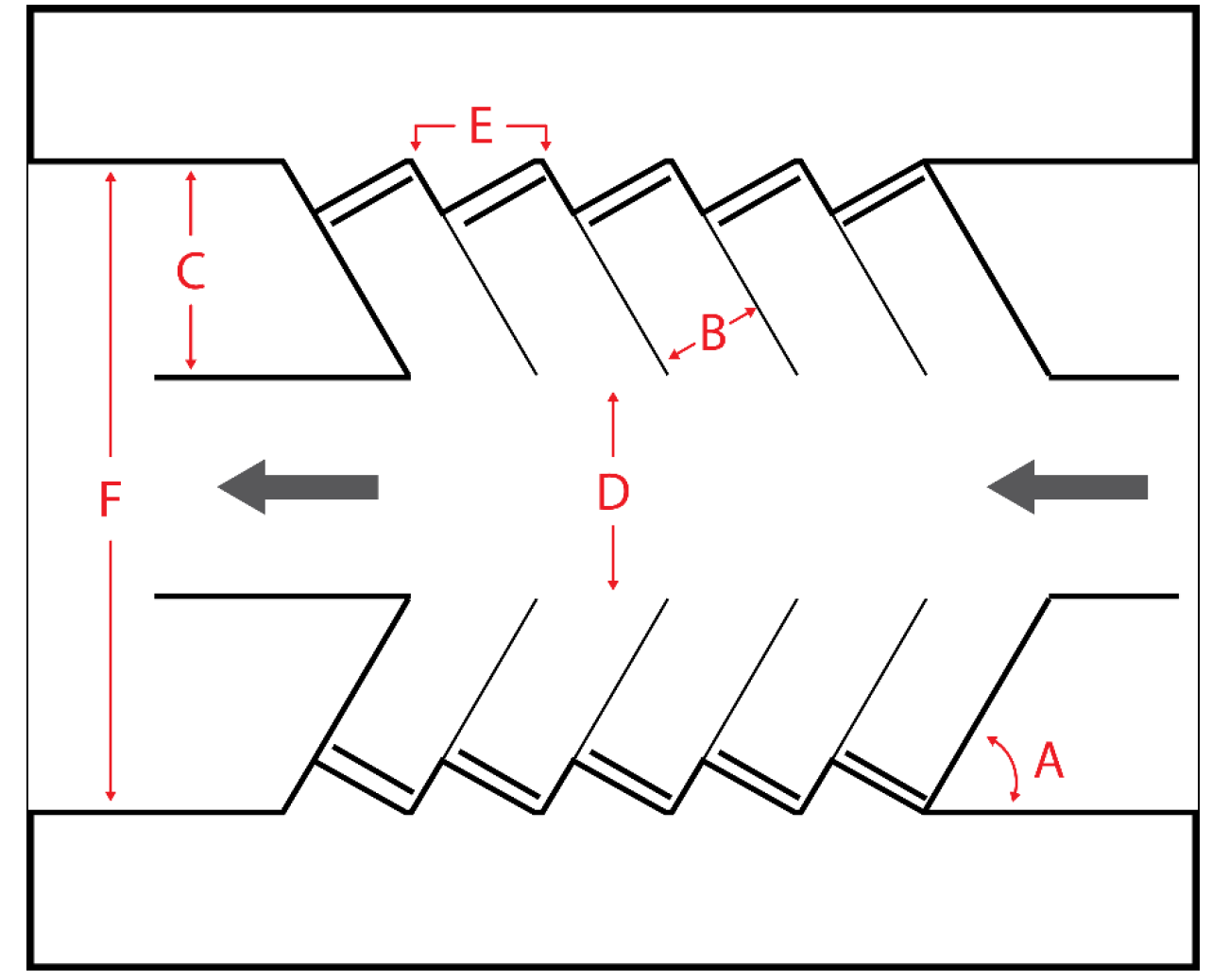
2.
Vertical Clearance. All off-street parking spaces shall have a minimum overhead clearance of seven feet for vehicle parking, and 8.2 feet for van-accessible parking.
3.
Cart Amenities. The minimum required parking for a use may be reduced by one space for every two designated golf cart spaces, up to a maximum reduction of 10 percent of the total number of spaces required by Table 5-204.B.1: Minimum Number of Off-street Parking Spaces, if:
A.
Golf carts will be used as a means of travel to the proposed use;
B.
The use is accessed by a road where golf cart travel has been approved by the Village or Lee County, as appropriate; and,
C.
Designated golf cart parking is provided that meets the dimensional and other standards of this subsection.
5-205. - Bicycle Parking Standards.
A.
Minimum Required Bicycle Parking. In all commercial and multifamily developments subject to the requirements of Sec. 5-202, Applicability, safe and secure bicycle parking that complies with the requirements of this subsection shall be provided in the following quantities unless a deviation from these standards is allowed (see Sec. 2-506.C, Deviation):
1.
Bicycle parking spaces equal to five percent of the off-street vehicular parking spaces required to be provided in accordance with Table 5-204.B.1: Minimum Number of Off-Street Parking Spaces, up to 500 vehicular parking spaces; and
2.
Four additional bicycle parking spaces for every 500 vehicular parking spaces in excess of 500.
B.
General Bicycle Parking Space Standards. All bicycle parking shall be constructed and maintained to the standards of the most recent edition of the Bicycle Parking Guidelines published by the Association of Pedestrian and Bicycle Professionals.
5-206. - Loading Area Standards.
A.
Applicability. The requirements of this subsection apply to commercial, industrial, and other nonresidential uses.
B.
Access.
1.
Street access to off-street loading areas shall comply with the provisions set forth in this section for access to off-street parking.
2.
Except as provided in subsection F below, off-street loading areas shall be spatially or physically separated from off-street parking areas and pedestrian walkways.
3.
Service roads shall be a minimum of 12 feet wide for one-way usage and 24 feet for two-way operations.
C.
Lighting, Maintenance, and Drainage. The provisions of this section relating to site lighting, maintenance, and drainage apply to loading areas.
D.
Other Use of Loading Areas. Off-street loading areas shall not be used for the sale, repair, dismantling, or servicing of any vehicles or equipment except on an emergency or temporary basis or in accordance with Sec. 5-204.A.1, Use of Parking and Loading Areas.
E.
Screening. When off-street loading areas are located adjacent to residential uses or zoning districts, and are not entirely visually screened at ground level, a continuous visual screen along the lot line abutting the residential use shall be provided in accordance with Section 5-5, Fence and Wall Standards.
F.
Off-Street Loading Area Requirements.
1.
General. Commercial, industrial, and nonresidential uses that receive or ship goods via large semitrailer or full trailer trucks shall provide an off-street loading area. Establishments that receive or ship commodities via small panel trucks or vans will not be required to provide off-street loading areas and may utilize the parking area, provided:
A.
Deliveries are received before or after the hours the establishment is open to the public;
B.
No delivery truck remains in the parking lot for more than four hours; and
C.
Deliveries do not interfere with pedestrian or vehicle movements.
2.
Design Requirements. Off-street loading areas shall comply with the following requirements:
A.
Each loading area shall be located on the lot or parcel it serves;
B.
Surfaced portions of loading areas, excluding driveways, shall be set back 20 feet from right-of-way lines and ten feet from property under separate ownership or control; and
C.
Loading areas may not obstruct, hinder, or endanger the movement of vehicles and pedestrians.
3.
Dimensional Requirements. The off-street loading area shall have a minimum width of ten feet and minimum depth of 30 feet.
G.
Number of Spaces. Establishments that receive or ship goods via large semitrailer or full trailer trucks shall provide a minimum of one loading space for the first 10,000 square feet of floor area, plus one space for each additional 20,000 square feet of floor area or major fraction thereof.
5-301.- Purpose and Intent.
The purpose of this section is to ensure that developments are served by a coordinated multimodal transportation system, to the maximum extent possible. The multimodal transportation system should permit the safe and efficient movement of motor vehicles, emergency vehicles, transit vehicles, bicyclists, and pedestrians within a development and between a development and external transportation systems, neighboring development, and local destination points such as places of employment, schools, parks, and shopping areas. Such a multimodal transportation system is intended to:
A.
Provide transportation options;
B.
Promote healthy walking and bicycling;
C.
Facilitate use of public transportation;
D.
Contribute to the attractiveness of the development and community;
E.
Connect neighborhoods and increase opportunities for interaction between neighbors;
F.
Reduce greenhouse gas emissions;
G.
Improve air quality;
H.
Minimize congestion and traffic conflicts; and
I.
Preserve the safety and capacity of the Village's transportation systems.
5-302. - Applicability.
A.
Developer Responsibility for Improvements.
1.
The developer shall provide road, street, bikeway, sidewalk, and other access and circulation improvements in accordance with the standards for design and construction in this section and this LDC. The developer shall dedicate any required rights-of-way or easements.
2.
The developer may make a fee-in-lieu contribution to the Village instead of constructing bicycle or pedestrian facilities required by this section in any of the following circumstances:
A.
If a bike or pedestrian facility is located where the right-of-way is scheduled for improvement within two years in accordance with the current Village or Lee County CIP and the scheduled right-of-way improvement would result in the destruction of the facility.
B.
The developer clearly demonstrates that:
1.
Bicycle or pedestrian facilities are impractical or infeasible due to the presence of natural features or other site constraints that do not allow connections to be made; or
2.
A bicycle facility is not needed due to an established bicycle facility already within or abutting the development.
C.
The Director determines that construction of the facility would be contrary to public safety;
D.
The Director determines that facilities can be established through "other available means" as defined in the Administrative Manual; or
E.
The Director determines that it is appropriate to provide a waiver from the requirement to construct facilities along privately maintained roads.
3.
Any fee-in-lieu contribution shall be equal to the estimated cost of constructing the improvement in accordance with the provisions set forth in the Administrative Manual. The in-lieu fee shall be paid prior to issuance of a development order, limited development order, or plat, as applicable.
B.
Circulation Plan. Development applications shall include a circulation plan that demonstrates how the development complies with the requirements of this section. The plan shall also provide information about the safety of the vehicular, bicycle, and pedestrian facilities proposed to be included in the development, including details about how conflict points between different road users will be managed to ensure the safety of all users.
C.
Timing of Construction. All facilities required in this section shall be constructed prior to issuance of a certificate of compliance for the infrastructure of the development unless the developer posts a bond or other surety in accordance with this section that is acceptable to the Village as assurance of completion of the improvements. As an alternative to posting surety, the Director has the discretion to accept a phasing plan that will provide for the continuous extension of a sidewalk facility and establish a bona fide construction schedule for the facility prior to issuance of a building permit for vertical construction on property adjacent to the proposed facility.
D.
Additional Standards. In addition to the standards specifically listed in this section, all facilities shall be designed and constructed following the criteria included in the Administrative Manual,the Florida Greenbook, the FDOT Design Manual (for state roads), and the Americans with Disabilities Act (ADA) guidelines for accessibility.
5-303. - Multimodal Transportation System.
All new development, to the maximum extent practicable, shall be served by a system of sidewalks, paths, roads, accessways, and other facilities designed to provide for multiple travel modes (vehicular, transit, bicycle, and pedestrian), as appropriate to the development's size, character, relationship to surrounding development and development patterns, and existing and planned community transportation systems. To the maximum extent practicable, the access and circulation systems for all modes of travel shall be coordinated and integrated to provide all users of the transportation network—a development's occupants as well as visitors—multiple options to enhance safe and efficient mobility throughout the development and the community.
5-304. - Vehicular Access and Circulation.
A.
Vehicular Access and Management.
1.
Management of Access to Roads. The ability of any development to access existing public roads, new public roads, or new private roads, including proposed modification of existing access to public roads, is subject to the standards of this section.
A.
Connection Separation.
1.
In development and redevelopment that is subject to the requirements of this section, except for lots serving a single-family or two-family residential use, new or modified connections to Village roads or Village access roads, whether by an intersecting public or private road or by driveway or accessway, shall be separated in accordance with the minimum centerline distances designated in Table 5-304.A.1.A: Connection Separation.
2.
Measurement of Separation Distance
(a)
For existing roads not proposed to be widened, separation distance is measured from the edge of the outermost through lane of the road to the nearest edge of pavement of the proposed intersecting connection.
(b)
For existing roads with a proposed widening funded in the Village's Capital Improvement Program, the separation distance is measured based on the actual proposed design of the road if available, or a typical section of the type of road project being designed.
(c)
The measurement of distance between connection points along multi-lane median-divided arterials or collectors with restrictive medians will be between connections on the same side as the proposed connection. Existing or approved median openings will be treated as connections on both sides. Roads designed by private parties for multi-lane construction or widening that will be Village-maintained arterials or collectors, or roads that are included in the current Village CIP and verified to incorporate a median divider, will be evaluated as such under this provision.
3.
Driveways to a single residential building of two dwelling units or less on local roads may be spaced closer than the connection spacing requirements specified in Table 5-304.A.1.A.
B.
Functional Classification. Each road in the Village shall be assigned a functional classification to reflect its role within the Village's transportation system. The current classification of roads is included in the comprehensive plan Map TR-1. All public roads and private roads not listed on Map TR-1 shall be classified by the Public Works Director, and shall be designated as "local" roads if not otherwise assigned.
C.
Limitation on Direct Access for Residential Lots. Where a residential through lot or corner lot fronts on roads of different classifications, direct driveway access to the lot shall be provided only from the lower-classified fronting road, to the maximum extent practicable.
D.
Limitation on Access Via Local Streets. Development shall be designed to minimize traffic impacts on surrounding areas, particularly to prevent incompatible traffic such as large semi-trailers servicing commercial establishments from using residential areas. Main access points to a development shall not be established where traffic is required to travel over local streets through areas with significantly lower densities or intensities (for example, multi-family development that provides access through a single-family neighborhood) except where adequate mitigation can be provided.
E.
Additional Access Rules.
1.
Any development order shall contain appropriate conditions requiring all roads to which the project proposes access to be constructed or improved to meet the standards in this section, in particular Sec. 5-310, Design Standards and Requirements.
2.
Improvements to offsite roads necessary to provide access to the project shall extend, at minimum, from the project's access point to the point at which the road connects to a County, Village, or privately maintained road meeting the standards in Sec. 5-310, Design Standards and Requirements.
3.
Access roads intersecting another road that also intersects the parallel arterial or collector shall have an outer separation of at least 125 feet from the edge of pavement of the arterial or collector.
4.
Existing corner commercial parcels on an arterial road are permitted a right-in/right-out connection at a minimum of 330 feet from the intersecting public road, if the parcel is not large enough to provide standard spacing, and if the owner agrees to shared access with the adjoining property. If shared access on the arterial road is not practical, the connection may be right-out only, if downstream of the nearby intersection; and right-in only, if upstream of the nearby intersection. Any property so small that this minimum cannot be met will be granted a temporary right-in/right-out connection on the arterial road or one temporary single direction connection on each of the roads as described above, to be used until an access road is provided. Lot splits and subdivisions will not be allowed on corner lots that cause new parcels to be too small to meet the minimum connection separation standards in Table 5-304.A.1.A: Connection Separation, unless the property owner provides an alternative form of access to the new corner parcel.
5.
Existing corner commercial parcels on a collector road are permitted a right-in/right-out connection at a minimum of 245 feet from the intersecting public road if the parcel is not large enough to provide standard spacing, and if the owner agrees to shared access with the adjoining property. If shared access on the collector road is not practical, the connection may be right-out only, if downstream of the nearby intersection; and right-in only, if upstream of the nearby intersection. Any property so small that this minimum cannot be met will be granted a temporary right-in/right-out connection on the collector or one temporary single direction connection on each of the roads as described above, to be used until an access road is provided. Lot splits and subdivisions will not be allowed on corner lots that cause new parcels to be too small to meet the minimum connection separation standards in Table 5-304.A.1.A: Connection Separation, unless the property owner provides an alternative form of access to the new corner parcel.
6.
Approval of connection locations along multi-lane divided roads, or along roads identified in plans as multi-lane divided roads, does not guarantee that the connection is permitted a crossover through the median divider. In these instances, approval of the median opening or turning movement will be determined on a case-by-case basis. The purpose of this subsection is to make it clear that even though a parcel may be entitled to access to the Village road system, there is no entitlement to a median opening or left-in movement in conjunction with an approved access point.
7.
Development shall not cause traffic hazards or congestion that results from narrow or poorly aligned roads or from excessive exit and entrance points along arterial and collector roads.
8.
Ingress and egress areas shall be of sufficient width to provide for servicing of utilities, refuse collection, and access for emergency vehicles.
9.
The Village retains the right and authority to modify or restrict access, turning movements, median openings, and use of traffic control devices on or affecting Village rights-of-way as it deems necessary to address operational and safety issues. This provision is applicable to existing as well as future development in the Village.
2.
Turn lanes.
A.
Access to roads or accessways shall not be permitted unless turn lanes are constructed by the applicant where turning volumes make such improvements necessary to protect the health, safety, and welfare of the public or to reduce adverse traffic impacts on the adjacent road system. Turn lanes shall be designed in accordance with standards in this LDC and the Administrative Manual.
B.
Wherever turn lanes are installed, the surface materials of the added lanes shall match the surface materials of the existing lanes. If the addition of a turn lane requires a lateral shift of the centerline or other lanes, the entire pavement area shall be re-surfaced to create matching surfaces throughout. New and replacement pavement markings shall be provided.
C.
On arterial or collector roads with restrictive medians where an access road is not otherwise required, existing parcels with insufficient road frontage to meet the minimum connection spacing required in Table 5-304.A.1.A: Connection Separation, may be required to provide a continuous right-turn lane on the adjacent arterial or collector road.
3.
Required Road Access. Each development shall be designed so as not to create remnants and landlocked areas, unless those areas are established as common areas.
4.
Development Entry Points.
A.
All development shall abut and have access to a public or private road designed, and constructed or improved, to meet the standards of Sec. 5-310, Design Standards and Requirements.
B.
All development shall provide adequate ingress to and egress from the development.
C.
Residential development of more than five acres and commercial or industrial development of more than ten acres, including redevelopment, shall provide more than one means of ingress or egress for the development. Access points designated for emergency use only shall not be used to meet this requirement. A deviation or variance from the access point (ingress/egress) requirements stated in this subsection shall be obtained through the public hearing process. If a variance or deviation from this section is approved, a notice to all future property owners shall be recorded by the developer in the public records of Lee County prior to the issuance of a development order allowing construction of the access to the development. The notice shall articulate the emergency access plan and provide information as to where a copy of this plan may be obtained from the developer or developer's successor.
D.
Nothing in this subsection shall limit the total number of roads providing access to the road system outside a development, or exempt a development from meeting all applicable external road connectivity standards.
E.
Where feasible, additional access points shall not be onto the same road.
F.
Development shall be exempted from these standards if it is demonstrated that one of the following conditions apply:
1.
No other road access points can be located due to existing lot configurations, absence of connecting roads, or environmental or topographic constraints;
2.
The appropriate permitting agency owning the road will not authorize the required number of entrances; or
3.
Alternative access can be provided in a manner acceptable to the Village.
5.
Privately Maintained Roads.
A.
Privately maintained roads may be permitted and approved if they meet each of the following standards:
1.
They comply with the road design standards and the road construction specifications of this LDC, including reservation of right-of-way for utility services; and
2.
The appropriate notation is made on the development order, limited development order, or the plat, as applicable, to identify it as a private road.
B.
A legally responsible organization (i.e. homeowners association, special district, etc.) is established to maintain the private roads. Documents to assure private responsibility of future maintenance and repair by a homeowners association or similar entity shall be approved as to form by the Director and Village Land Use Attorney.
C.
A private road maintenance agreement, satisfactory to the Director and the Village Land Use Attorney, shall be recorded by the developer and/or property owner(s) in the public records of Lee County. The agreement shall:
1.
Specify lot owners' responsibilities for maintenance of private roads and drainage systems, and provide for assessments to finance all maintenance activities; and
2.
For gated or controlled access subdivisions, specify the method by which continuous accessibility to subdivision lots for the provision of public service and emergency vehicles will be provided.
6.
Reservation of Future Rights-of-Way. The comprehensive plan includes Map TR-4 which identifies future road projects and their projected cross-sections. Development is encouraged to be set back from the rights-of-way shown on Map TR-4 to accommodate future road construction plans. Developers are encouraged to voluntarily dedicate these rights-of-way.
7.
Emergency Access. Development shall be designed to allow for adequate access by emergency vehicles.
B.
Vehicular Road Connectivity.
1.
External Street Connectivity.
A.
General. Road layouts of new developments shall be designed to integrate with and continue the existing road layout outside the development, and to provide for future extension of the development's road network to provide the maximum number of interconnections and points of ingress and egress.
B.
The arrangement of roads in a development shall provide for the alignment and continuation of existing roads to provide access to:
1.
Adjacent developments and subdivisions platted for such connections; and
2.
Adjacent lands where the adjacent lands are undeveloped and deemed appropriate for future development.
C.
A road connection or stub shall be provided for development where practicable and feasible in each direction (north, south, east, and west) for development that abuts vacant lands.
D.
Except for residential subdivisions, at all locations where roads terminate with no road connection but a future connection is planned or accommodated, a sign shall be installed with the words "FUTURE STREET CONNECTION" to inform land owners.
E.
The final plat (see Section 5-9, Plat Standards) shall identify all stub streets and include a notation that all street stubs are intended for connection with future roads on adjoining lands.
F.
Stub streets that exceed 150 feet in length shall include a temporary turn-around. When adjoining lands are subsequently developed, the developer of the adjoining land shall pay the cost of extending the road and restoring it to its original design cross section.
G.
All roads proposed for dedication to the public shall be indicated on the development order, limited development order, or plat, as appropriate, and shall connect to or be an extension of an existing public road.
2.
Shared Access to Public Streets.
A.
Shared access between adjoining lots is encouraged and, in the case of lot frontages that cannot be served individually due to the access spacing requirements in Table 5-304.A.1.A: Connection Separation, may be required to limit direct vehicular access along streets.
B.
To ensure the development will have perpetual access to the site, easements allowing cross-access to and from lands served by a shared access, along with agreements defining maintenance responsibilities of land owners, shall be recorded in the public records of Lee County before issuance of a development order for the development proposing the shared access. Such easements shall stipulate that both owners shall share in the costs and responsibility of maintaining the access easement.
3.
Cross-Access Between Adjoining Developments. To encourage shared parking, minimize access points along roads, and improve traffic circulation, development shall comply with the following standards:
A.
The internal vehicular circulation system shall be designed and constructed to provide vehicular cross-access between the development's parking area and those on adjoining parcels containing a nonresidential or mixed-use development, or to the boundary of vacant land. (See Figure 5-304.B.3: Cross-Access Between Parking Areas of Adjoining Developments.)
Figure 5-304.B.3: Cross-Access Between Parking Areas of Adjoining Developments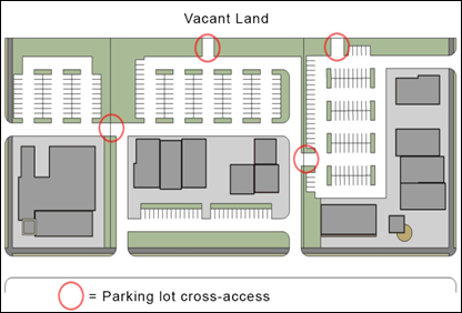
B.
Cross-accessways shall provide for two-way vehicular traffic between the parking areas on the adjoining lots through the use of a single drive aisle or accessway that is at least 24 feet wide or through two one-way aisles or accessways that are each at least 14 feet wide.
C.
If the applicant is unable to execute a cross-access agreement, then access roads and parking shall still be oriented so as to facilitate future cross-access connections with adjacent parcels. Abutting properties developed or redeveloped at a later date shall at that time be required to enter into the requisite cross-access agreement.
D.
Easements allowing cross-access to and from lands served by a vehicular cross-access, along with agreements defining maintenance responsibilities of land owners, shall be recorded in the public records of Lee County before issuance of a certificate of compliance for the development.
C.
Vehicle Stacking Space for Drive-through and Related Uses.
1.
Required Number of Stacking Spaces.
A.
In addition to meeting the off-street parking standards in Table 5-204.B.1: Minimum Number of Off-Street Parking Spaces, uses with drive-through facilities and other auto-oriented uses where vehicles queue up to access a service facility shall comply with the minimum number of stacking spaces established in Table 5-304.C: Minimum Stacking Spaces for Drive-through Facilities and Related Uses.
2.
Design and Layout. Required stacking spaces shall:
A.
Be a minimum of ten feet wide and 20 feet long;
B.
Not impede on-site or off-site vehicular traffic movements or movements into or out of off-street parking spaces;
C.
Not impede onsite or offsite bicycle or pedestrian traffic movements; and
D.
Be separated from other internal driveways by raised medians or pavement markings for traffic movement and safety.
D.
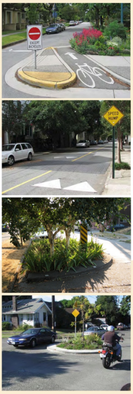
Local Road Traffic-Calming Measures.
1.
Road widths not in excess of basic design standards, short block lengths, on-street parking, controlled intersections, roundabouts, and other traffic-calming measures are encouraged on all local roads that connect between two nodes, provided they do not interfere with emergency vehicle access.
2.
Residential development may employ measures to interrupt direct vehicle flow on linear road segments where determined to be necessary by the Village.
5-305. - Pedestrian Access and Circulation.
A.
Required Pedestrian Access.
1.
General Pedestrian Access. All new development, except the development of an individual single-family dwelling or two-family dwelling on an individual lot, shall be served by an internal pedestrian circulation system (including sidewalks, pedestrian paths, and/or trails) that permits safe, convenient, efficient, and orderly movement of pedestrians among the following origin and destination points within the development, as well as between the adjoining parts of an existing or planned external, community-wide pedestrian circulation system and any adjoining transit stops, public parks, greenways, schools, and shopping areas:
A.
The primary entrance(s) of principal buildings (or the buildable area of lots for subdivisions), including any outparcels;
B.
Off-street parking bays;
C.
Any designated or planned transit stations or bus stops and shelters (on-site or on an adjacent road); and
D.
Recreation facilities and other common use areas and amenities.
2.
Sidewalks Required
A.
Development is required to install sidewalks (see street cross-section in Appendix D: Illustrations and Cross-Sections):
1.
On both sides of all roads within commercial development;
2.
On one side of all roads within residential subdivisions;
3.
Along all roads that connect the development to existing public roads; and
4.
Along existing roads along the entire frontage of the development site and project frontage roads (unless an existing sidewalk meeting Village standards is already in place).
B.
Residential development shall install sidewalks along existing roads up to ¼ mile (measured along the principal perimeter street) from the development where the sidewalk would:
1.
Connect to a pedestrian generator such as schools, parks, playgrounds, shopping centers, employment centers, or transit facilities; or
2.
Connect to an existing or proposed sidewalk shown on the Bicycle and Pedestrian Master Plan;
C.
Where a development site fronts an existing road with insufficient right-of-way width to accommodate installation of a required sidewalk along the frontage, the landowner/developer shall install a sidewalk on the development site within a dedicated widening of the right-of-way or dedicated public easement running parallel and adjacent to the public road.
D.
All new development shall upgrade or replace sidewalks that do not meet Village standards.
E.
Sidewalks constructed in accordance with this section shall comply with the following standards:
1.
The minimum width of the sidewalk shall be six feet on Village, County, and state-maintained road frontages, and five feet elsewhere.
2.
Where practicable, a minimum three-foot wide strip shall be provided between the road and the sidewalk.
3.
A planting strip with street trees may be provided behind the sidewalk.
4.
A minimum four-foot wide passage clear of obstacles shall be maintained within the entire sidewalk. If it is impossible to meet this standard along the entire sidewalk due to natural features or other site constraints, or for other reasons deemed acceptable by the Director, the sidewalk shall include a passing space of at least five feet long by five feet wide every 200 linear feet along the section that does not meet the four-foot passage standard.
5.
Where the applicant proposes to widen an existing road that includes a sidewalk and the sidewalk exceeds the minimum standards of this subsection regarding width and clear passage, the replacement sidewalk shall meet the minimum standards of the existing sidewalk.
6.
The sidewalk shall meet the accessibility standards of the Americans with Disabilities Act.
7.
Curb ramps are required at all intersections with road curb and gutter.
8.
Construction Requirements.
(a)
Except as provided in subsection (b) below, the sidewalk shall be constructed in accordance with the following specifications:
i.
Four-inch thick Portland cement concrete (in which case all driveway crossings shall be a minimum of six inches thick); or
ii.
A minimum of 1.5-inch asphaltic concrete of FDOT type S-III on a four-inch limerock base and six-inch type B sub-grade.
(b)
The applicant may submit an alternative design, subject to the approval of the Director, provided it is structurally equal to or better than the options set forth in this subsection.
B.
Pedestrian Connectivity.
1.
All new multifamily, townhouse, nonresidential, and mixed-use development shall comply with the following standards:
A.
The internal pedestrian circulation system of the development shall be designed to allow for pedestrian walkway cross-access between the development's buildings and parking areas and those on adjoining lots containing a multifamily, townhouse, nonresidential, or mixed-use development, or to the boundary of adjoining vacant land zoned to allow multifamily residential, nonresidential, or mixed-use development.
B.
If the applicant is unable to execute a cross-access agreement with the landowners of the adjoining lot, pedestrian circulation shall still be oriented to facilitate future cross-access connections with adjacent parcels. Abutting properties developed or redeveloped at a later date shall at that time be required to enter into the requisite cross-access agreement.
C.
Easements allowing cross-access to and from properties served by a pedestrian cross-access, along with agreements defining maintenance responsibilities of land owners, shall be recorded in the public records of Lee County before issuance of a certificate of occupancy for the development.
2.
Pedestrian walkways (including sidewalks) shall be provided to connect to each public vehicular entrance to a project (excluding ingress and egress points intended primarily for service, delivery, or employee vehicles) and each current or future transit stop identified in Sec. 5-307.A, Required Transit Facilities, to the internal pedestrian circulation system described in this subsection.
3.
To the extent possible, development shall be designed to promote bicycle and pedestrian street crossings at traffic control signals, crosswalks, or intersections.
4.
Pedestrian Walkways through Parking Areas and Parking Garages.
A.
All parking areas and parking structures shall provide a clearly identified pedestrian path between parking areas and the primary pedestrian entrance(s) to the building(s) served by the parking areas, or to a pedestrian walkway providing direct access from the furthest extent of the parking area to the primary building entrance(s).
B.
Pedestrian walkways providing access between parking areas and associated buildings may be extended to provide the connections to abutting street sidewalks or to adjoining development otherwise required by this section.
C.
Pedestrian Walkway Requirements. Pedestrian walkways shall meet the same standards as sidewalks in Sec. 5-305.A.2.E above, with the exception that wherever possible, the surface of a pedestrian walkway shall include specialty pavers, concrete, colored concrete, or stamped concrete patterns that accentuate and highlight pedestrian areas.
5-306. - Bicycle Access and Circulation.
A.
Required Bicycle Access.
1.
Internal and Adjoining Bicycle Access. All new commercial development shall allow for internal bicycle circulation such that bicycle access to the development's primary use is safe, convenient, and intuitive, specifically by providing the following, in coordination with Lee County and FDOT:
A.
Bicycle parking facilities required by Sec. 5-205, Bicycle Parking Standards, in areas near the primary entrance(s) of principal buildings;
B.
Connections to any adjacent existing or planned on-street or off-street bicycle facilities outside the development (including facilities in the comprehensive plan or the Bicycle and Pedestrian Master Plan) or internal bicycle systems in adjacent developments;
C.
Connections to any designated or planned transit stops and shelters (on-site or on an adjacent road); and
D.
Connections to any recreational amenities internal to the development, such as open space set-asides.
2.
Required Bikeway Network Improvements.
A.
Commercial and multi-family development shall install bike lanes, bike paths, or other bicycle improvements included in the comprehensive plan or the Bicycle and Pedestrian Master Plan.
B.
All new residential development shall install bikeways up to ¼ mile (measured along the principal perimeter street) from the development where the bikeway would connect to an existing or proposed bikeway shown on the Bicycle and Pedestrian Master Plan;
C.
Additional bikeway network improvements are encouraged where appropriate, such as within large development sites and to provide additional connections to nearby bicycle routes. Establishment of the facilities shall include an agreement and/or easements which provide assurances for their continued maintenance.
D.
Where a development site fronts an existing road with insufficient right-of-way width to accommodate installation of a required bike path along the frontage, the applicant may install a bike path on the development site within a public easement running parallel and nearby the public road. Such bicycle paths shall not be restricted from public use and shall allow physical passage at all times.
B.
Bicycle Connectivity Between Developments. All new multifamily, townhouse, nonresidential, and mixed-use development shall comply with the following standards:
1.
Any internal bicycle circulation system shall be designed and constructed to provide bicycle cross-access between it and any internal bicycle circulation system on adjoining parcels containing a multifamily, townhouse, nonresidential (except industrial), or mixed-use development, or to the boundary of adjoining vacant land zoned to allow townhouse, multifamily, nonresidential (except industrial), or mixed-use development.
2.
If the applicant is unable to execute a cross-access agreement with the landowners of the adjoining parcels, bikeways shall still be oriented so as to facilitate future cross-access connections with adjacent parcels. Abutting properties developed or redeveloped at a later date shall at that time be required to enter into the requisite cross-access agreement.
3.
Easements allowing cross-access to and from lands served by a bicycle cross-access, along with agreements between owners of lands that provide and are served by the cross-access defining the owners' maintenance responsibilities, shall be recorded in the public records of Lee County before issuance of a building permit for the development.
C.
Bikeway Layout and Design. Required on-street bike lanes shall be designed and provided in accordance with the cross-section, paving, and other standards applicable to the roads of which they are a part.
5-307. - Transit Access and Circulation.
A.
Required Transit Facilities.
1.
A residential development with more than 100 dwelling units, and any commercial development with less than 30,000 square feet of total floor area, shall be subject to the following requirements:
A.
If a bus stop is within ¼ mile of the vehicular entrance to the property, measured by the existing pedestrian access to the stop, a paved pedestrian walkway or sidewalk shall be constructed to the nearest bus stop.
B.
If there is no bus stop within ¼ mile of property, measured by the existing pedestrian access, but the property abuts either an existing bus route or a future bus route identified in the comprehensive plan, the developer shall provide signage and a bicycle rack for a new bus stop at a location designated as a future bus stop by the Director in consultation with the relevant transit agency.
2.
A residential development with more than 500 units, and any commercial establishment with 30,000 square feet or more of total floor area, shall be subject to the following requirements:
A.
If a bus stop is within ¼ mile of the vehicular entrance to the property, measured by the existing pedestrian access to the stop, a paved pedestrian walkway or sidewalk shall be constructed to the nearest bus stop, and a bicycle storage rack that meets the standards of Sec. 5-205.B, General Bicycle Parking Space Standards, and supports at least two bicycles shall be provided.
B.
If there is no bus stop within ¼ mile of the vehicular entrance to the property, measured by the existing pedestrian access, but the property abuts either an existing bus route or a future bus route identified in the comprehensive plan, the developer shall provide the following, at a location designated as a future bus stop by the Director and in consultation with LeeTran:
1.
A pedestrian walkway or sidewalk with adequate lighting to the future bus stop;
2.
A concrete pad that meets the current standards of the Village or the FDOT Transit Facilities Design office and LeeTran, as applicable;
3.
A bus pull-out area that meets the current standards of the Village or FDOT and LeeTran, as applicable; and
4.
A bus shelter.
B.
Waiver. The Director may waive the requirement to provide a pedestrian walkway or sidewalk to a bus stop where a developer has provided bikeways, pedestrian ways, or sidewalks that provide equivalent access.
C.
Developments are encouraged to accommodate the use of public transportation vehicles on primary roads within the development.
5-308. - Traffic Impact Study (TIS).
A.
Purpose. A Traffic Impact Study (TIS) is intended to survey current and anticipated traffic conditions and public transportation in order to identify potential traffic impacts that will be created by a development proposal.
B.
Requirement.
1.
If traffic generated by a proposed development is expected to add 300 or more external vehicle trips during the peak hour to the adjacent road system, the developer shall submit a TIS providing a comprehensive assessment of the development's impact on the surrounding road system in accordance with the TIS guidelines which are available from the Director.
2.
If traffic generated by the proposed development is not expected to meet the threshold in paragraph 1, the developer shall submit a TIS providing information regarding the development's traffic generation and impacts at the development's access points onto the adjacent road system.
C.
Required Elements of Study. A TIS required in accordance with subsection B above shall comply with the following standards:
1.
The TIS shall include, at a minimum, information regarding the development's traffic generation and impacts at the development's access points onto the adjacent road system, and at the nearest intersection of a local road and an arterial or collector road if the development's direct access is to a local road;
2.
The TIS shall be prepared in accordance with the current edition of the forms, procedures, and guidelines which are provided by the Director and/or included in the Administrative Manual. The developer or the developer's representative shall assume full occupancy and a reasonable build-out of the development in the preparation of the TIS;
3.
The TIS shall be prepared by a qualified professional in the field of civil or traffic engineering, or transportation planning; and
4.
The TIS shall be submitted to the Director for review of the study's sources, methodology, technical accuracy, assumptions, and findings.
D.
Approval Required.
1.
The Director shall review and decide whether to reject or approve the TIS' sources, methodology, technical accuracy, assumptions, and findings, based on professional transportation engineering principles.
2.
Approval of the TIS shall be revoked after one year has expired since the date of approval if the assumptions upon which the TIS was approved are no longer valid.
3.
A significant change in the development proposal may result in the revocation of a previous approval of the TIS by the Director.
5-309. - Traffic Impact Study Mitigation Plan.
A.
Plan Required. Upon approval of the TIS by the Director, the developer shall prepare a Traffic Impact Study Mitigation Plan (TIS Plan) based on the approved TIS.
B.
Purpose. The purpose of the TIS Plan is to:
1.
Provide information to staff who evaluate development applications about the traffic impacts generated by a proposed development;
2.
Ensure that safe and efficient access is provided to the development;
3.
Minimize the proposed development's adverse traffic impacts and minimize traffic congestion on the road system;
4.
Monitor growth and development for the preparation of subarea and corridor transportation studies;
5.
Provide the technical background and assumptions needed to plan road improvements;
6.
Relate the various needed road improvements to the occupancy and use of developed land, particularly regarding the relative timing of occupancy and availability of the road improvements; and
7.
Identify which participants in the development process are responsible for different elements of the road improvement process and who will be responsible for the costs of the road improvements.
C.
Requirements. The TIS Plan shall comply with the following standards:
1.
It shall be reasonably based on the assumptions and findings embodied in the approved TIS;
2.
It shall include elements that meet or exceed the minimum actions required to alleviate the adverse impacts on the surrounding or adjacent road network; and
3.
It shall be consistent with all other local policy, particularly the comprehensive plan, impact fees, any applicable development agreements, and all other applicable requirements of this LDC.
D.
Required as Condition of Development Order.
1.
The development order shall require timely implementation of the TIS Plan.
2.
No certificate of occupancy or other permit to occupy or use developed land may be issued until the TIS Plan is implemented and improvements are in place in proportion to the demand the development generates.
5-310. - Design Standards and Requirements.
A.
All roads and bridges shall be designed, constructed, and improved in accordance with the specifications set out in this Appendix C: General Road Specifications, as well as the other requirements of this section. Any deviations from the standards in this section shall comply with the standards and criteria established by FDOT in the Florida Greenbook with consideration of the FDOT Plans Preparation Manual, and are subject to review by the Director. Road design illustrations and cross-sections are included in Appendix D: Illustrations and Cross-Sections.
B.
In addition, the following standards and criteria shall apply: American Association of State and Highway Transportation Officials (AASHTO), A Policy on Geometric Design of Highways and Streets, as modified by the FDOT Florida Greenbook, FDOT Design Standards, FDOT Drainage Manual and FDOT Standard Specifications, current editions, with supplements, and such other applicable publications, editions, and amendments as may be adopted by FDOT, and sound engineering principles.
C.
Construction on State facilities shall be done in accordance with applicable State statutes and regulations.
5-311. - Liability Insurance Requirement.
As a condition applicable to the issuance of a development order requiring a Village right-of-way permit to construct improvements within Village owned or controlled right-of-way property, the applicant shall obtain liability insurance coverage for the benefit of the Village. The condition shall require the insurance to be effective coincident with the start of construction. Proof of insurance shall be submitted to the Village upon commencement of construction. The amount and type of coverage shall be in accordance with Village standards in effect at the time the insurance is obtained. The insurance coverage shall remain in effect until the approved project obtains a certificate of compliance or the Village formally accepts the right-of-way improvements for maintenance.
5-312. - Maintenance.
A.
Facilities Constructed within Village Right-of-Way. The Village will maintain bike and pedestrian facilities located within the Village right-of-way that are built to the standards set forth in this LDC and other applicable regulations.
B.
Facilities Constructed within Easement Granted to the Village. The Village shall maintain bike and pedestrian facilities constructed adjacent to the Village right-of-way within a perpetual right-of-way easement on privately held property where:
1.
The facilities are constructed in compliance with the standards set forth in this LDC;
2.
An easement instrument, along with the legal description and sketch of the easement area, is submitted by the applicant for review and approval by the Village Land Use Attorney prior to issuance of development order approval;
3.
Upon completion of the facilities and prior to issuance of the certificate of compliance allowing the facility to be opened for public use, the easement is formally approved and maintenance responsibility is accepted by the Village Council; and
4.
The approved easement is recorded in the public records of Lee County, at the property owner's expense, prior to issuance of the certificate of compliance allowing public use of any facility.
C.
Facilities along Frontage Roads. Where a sidewalk or bikeway is installed along a project frontage road, the property owner shall provide for maintenance of the adjoining planting strip unless the Village formally accepts responsibility for maintenance.
D.
Facilities along Private Roadways. Bicycle and pedestrian facilities along private roads shall be maintained by the property owners' association or other similar legal entity through operation and maintenance covenants.
5-401.- Purpose.
A.
The purpose of this section is to establish landscaping standards that integrate landscape, hardscape, and open space standards to:
1.
Enhance the appearance of the Village by integrating landscape design elements with architectural forms and variable site relationships;
2.
Provide trees for shade and heat and glare reduction;
3.
Support soil erosion control and water conservation;
4.
Screen incompatible land uses and parking lots, and differentiate incompatible architectural relationships and site elements; and
5.
Improve air quality.
B.
This is intended to be achieved by:
1.
Establishing a hierarchy of plantings with emphasis on creating defined public open space and implementing plantings that shade and provide passive cooling;
2.
Organizing landscaping patterns and materials based on the site's context and implementing the patterns across the site to visually unify the development and integrate it with its surroundings;
3.
Using distinctive landscape and hardscape to create focal points;
4.
Using plantings and hardscapes as space-defining elements between the public and private realm and to separate pedestrian paths from vehicles;
5.
Positioning building perimeter plantings to complement the building's architecture; and
6.
All outdoor light fixtures and light elements must meet DOE Energy Star requirements or be in the top 25% of efficiency for similar products. The Director may allow exceptions to this requirement on finding the applicant demonstrates it is unreasonable or impractical due to cost, availability, or similar factors.
5-402. - Applicability.
A.
General. Unless exempted in accordance with subsection B below, or expressly stated to the contrary in this section, the standards in this section apply to:
1.
All new development;
2.
Any expansion or alteration of a building if the expansion increases the building's floor area by 50 percent or more, or the alteration involves 50 percent or more of the building's floor area (including interior alterations), provided that where there are inherent problems retrofitting existing sites, the Director may waive some or all requirements if other equivalent enhancements are provided; and
3.
Any change in use.
B.
Exemptions. Single family detached and two family dwellings are exempt from this section, except each lot shall plant one or two trees per lot in accordance with Sec. 5-405.B, General Tree Standards.
5-403. - Plant Palette and Material Standards.
A.
Plant Suitability. Plant materials shall be suited to the climate and suited for their planting location at maturity. The invasive exotic plants identified in Table 5-403.A: Prohibited Invasive Exotic Plants, are prohibited and shall be removed. Methods to remove and control invasive exotic plants shall be included in development orders or limited development orders, as applicable. A statement shall also be included in development orders or limited development orders that the development area will be maintained free from invasive exotic plants in perpetuity.
B.
Plant Material Standards. Plant materials installed in cultivated landscapes shall comply with the following standards:
1.
Quality. Meet the standards for Florida No. 1 or better, as set out in Grades and Standards for Nursery Plants, Parts I and II, Department of Agriculture, State of Florida. Root ball sizes on all transplanted plant materials shall also comply with state standards.
2.
Native varieties. At least 75 percent of the trees and 50 percent of the shrubs used to comply with the requirements of this section shall be native Florida species.
3.
Trees and Palms. All required trees shall be a minimum 12-foot in height measured from the adjacent grade of the development site, with a five-foot spread and two and one half-inch caliper and 45 gallon container size or field grown at the time of planting. Palms shall have a minimum of ten feet of clear trunk at planting. Trees adjacent to walkways, bike paths, and rights-of-way shall be maintained with eight feet of clear trunk. Trees shall provide 15-foot clearance from light poles and buildings; palms shall provide an eight-foot clearance. Trees shall provide a six-foot clearance from hardscapes; palms shall provide a four-foot clearance. Root barriers are required for all trees planted within ten feet of hardscape or utilities. See Table 5-403.B.3: Tree and Palm Plant Material Standards.
4.
Measurement of Height. The height of all trees and shrubs shall be measured from the final adjacent grade of the development site.
5.
Shrubs. Shrubs shall be a minimum of 24 inches (48 inches for Type F Buffers) in height, at time of planting. Saw palmettos (Serenoa repens) and coonties (Zamia floridana) may be used as shrubs, provided they are 12 inches in height at time of planting. All shrubs shall be installed at an appropriate height to meet the minimum specified height after one growing season or one year from time of installation, whichever is more restrictive and be spaced an average of 18 to 36 inches on center. They shall be at least 36 inches (60 inches for type F Buffers) in height, and maintained in perpetuity at a height of no less than 36 inches (60 inches for Type F Buffers). Shrubs shall be installed to maintain an 18-inch clearance from hardscapes and 36-inch clearance from buildings.
6.
Mulch Requirements. A two-inch minimum layer, after watering-in, of mulch or other organic mulch materials shall be placed and maintained around all newly installed trees, shrubs, and groundcover plantings. Each tree shall have a ring of mulch no less than 24 inches beyond its trunk in all directions. The use of cypress mulch is prohibited.
5-404. - Tree Preservation.
A.
Purpose.
1.
A "tree worthy of preservation" includes: any tree listed in the Florida Champion Tree Records compiled by the state, any heritage tree (live oak, South Florida slash pine, or longleaf pine 20-inch caliper dbh or greater), or any native tree which is four-inch caliper dbh or greater, of the species listed in Appendix F: Protected Tree List, including 39 families of trees and including healthy sabal palms that are a minimum eight-foot clear trunk.
2.
Tree preservation standards are established to meet the goal of maintaining green spaces and trees in the Village landscape by:
A.
Defining trees that are "worthy of preservation."
B.
Requiring an application and permitting process for removal of trees.
C.
Requiring protection of trees that are "worthy of preservation" at time of site development.
B.
Applicability. Unless exempted in accordance with subsection C below, no person shall deliberately cut down, destroy, remove, relocate, defoliate through the use of chemicals or other methods, or otherwise damage any "tree worthy of preservation" under this section, without first obtaining a tree removal permit as provided in Sec. 2-505.D, Tree Removal/Vegetation Permit.
C.
Exemptions.
1.
No notice, application, approval, permit, fee, or mitigation is required for the pruning, trimming, or removal of a tree on residential property if the property owner obtains documentation from an arborist certified by the International Society of Arboriculture or a Florida licensed landscape architect that the tree presents a danger to persons or property.
2.
In addition, the following is exempt from this subsection:
A.
The removal of trees on public rights-of-way conducted by or on behalf of a federal, state, county, Village, or other governmental agency in carrying out its lawful activities in the construction or improvement of public rights-of-way or in the performance of other official duties.
B.
The removal of a "tree worthy of preservation" that is dead or which is destroyed or damaged by natural causes or an act of God, and is beyond saving or which is a hazard and constitutes an immediate peril to life and property.
C.
The removal of trees by duly constituted communication, water, sewer or electrical utility companies, or federal, state, county, or Village engineer or surveyor agencies, working under a contract with federal, state, county, or Village entities, or when such tree removal is done as a governmental function of such agency.
D.
The removal of trees by duly constituted communication, water, sewer, or electrical utility companies in or adjacent to a public easement or right-of-way, provided such removal is limited to those areas necessary for maintenance of existing lines or facilities, or for construction of new lines or facilities in furtherance of providing utility service to its customers, and provided that such removal is conducted to avoid any unnecessary damage or removal of trees.
E.
The removal of trees by a state-licensed land surveyor in the performance of the land surveyor's duties. The removal of such trees in a manner which requires clearing a swath of greater than three feet in width shall require approval of the Director prior to such removal and clearance.
F.
The removal of trees on a lot zoned for single-family residential use or that is being used lawfully by a single-family dwelling or mobile home where the residence or proposed residence is located on a lot no greater than five acres in area.
G.
The removal of trees "worthy of preservation" on the premises of a licensed plant or tree nursery or tree farm where such trees are intended for sale in the ordinary course of the licensee's business.
H.
Land used for bona fide agricultural purposes that meets the standards of or has been designated as wetlands.
D.
Suspension. Upon the declaration of a state of emergency in accordance with F.S. ch. 252, the Director may suspend the enforcement of the requirements of this subsection for a period of 30 days in order to expedite the removal of damaged and destroyed trees in the interest of public safety, health, and general welfare.
E.
Tree Protection During Development of Land.
1.
A tree inventory identifying the location, species, and sizes of trees "worthy of preservation" on the site, as well as a tree health assessment, shall be submitted with the application for a development order or limited development order, as applicable.
2.
Prior to the land clearing stage of development, the owner or developer shall clearly mark all trees "worthy of preservation" and other protected trees for which a tree removal permit is not issued, and shall erect barriers for the protection of the trees according to the following:
A.
Around an area at or greater than a six-foot radius of all species of mangroves and protected cabbage palms;
B.
Around an area at or greater than the full dripline of all protected native pines;
C.
Around an area at or greater than two-thirds of the dripline of all other protected species.
3.
No person shall attach any sign, notice, or other object to any trees "worthy of preservation" or protected tree or fasten any wires, cables, nails, or screws to any such tree in any manner that could prove harmful to the tree "worthy of preservation" or protected tree, except as necessary in conjunction with activities in the public interest.
4.
During the construction stage of development, the owner or developer shall not cause or permit the cleaning of equipment or material within the outside perimeter of the crown (dripline) or on the nearby ground of any tree or group of trees which is to be preserved. Within the outside perimeter of the crown (dripline) of any tree or on nearby ground, the owner or developer shall not cause or permit storage of building material and/or equipment, or disposal of waste material such as paints, oil, solvents, asphalt, concrete, mortar, or any other material harmful to the life of the tree.
5.
No person shall permit any unnecessary fire or burning within 30 feet of the dripline of a protected tree.
6.
Any landscaping activities within the barrier area shall be accomplished with hand labor.
7.
Prior to the issuance of a certificate of occupancy or compliance for any development, all trees designated to be preserved that are destroyed during construction shall be replaced by trees of the same species and equivalent dbh tree caliper, before occupancy or use, subject to processing of an amendment to the development order. (See Sec. 2-505.D, Tree Removal/Vegetation Permit.)
8.
The Director may conduct periodic inspections of the site during land clearing and construction.
F.
Restoration Standards. If a violation of this section has occurred and upon agreement of the director and the violator, or, if they cannot agree, then upon decision by a Special Magistrate, a restoration plan must be ordered in accordance with the following standards:
1.
The restoration plan must include the following minimum planting standards:
A.
The plan must include a planting plan for all protected trees. Replacement stock must be computed on a three for one basis according to the total number of unlawfully removed trees. The phrase "three for one" in this section refers to the requirement of replacing an illegally removed tree with three live trees according to the provisions of this section. Replacement trees must be nursery grown, containerized, and sized to satisfy the standards of Sec. 5-403.B.3 above. It is within the discretion of the Director to allow a deviation from the ratio specified in this subsection. When such deviation is sought, the total of heights and calipers must equal or exceed that specified in the standards set out in this subsection. An example of this might be one in which trees four feet in height might be planted in a ratio of five replacement trees to one illegally removed tree. Justification for such a deviation must be provided to the Director. Where situations create an inability to meet the three to one (3:1) replacement standards, a two to one (2:1) replacement may be applied so long as the replacement trees are 16-feet in height (16'H), eight feet in spread (8'S), four inch caliper (4:CAL), and 100 gallon (100G) in size. Palms must be 16-feet clear trunk (16'CT).
B.
The plan must include a planting plan for understory vegetation. Understory vegetation must be restored to the area from which protected trees were unlawfully removed or mutilated. The plant selection must be based on that characteristic of FLUCFCS. Shrubs, ground cover, and grasses must be restored as delineated in FLUCFCS. Up to seven species may be utilized with relative proportions characteristic of those in FLUCFCS. The exact number and type of species required must also be based upon the existing indigenous vegetation on adjacent property. Replacement stock must be no less than one-gallon-sized nursery-grown containerized stock planted at no less than three feet on center in the area from which protected trees were unlawfully removed or mutilated. This area must be defined by the dripline of the trees. The number of shrubs must not exceed, but may be less than, 25 shrubs per tree unlawfully removed or mutilated. The understory of the restored site must be protected for a period of no less than ten years, unless its removal is a provision of a development order which has been approved after the restoration of the site.
C.
If the unlawful removal or mutilation of trees has caused any change in hydrology or surface water flows, then the hydrology or surface water flows must be restored to pre-violation condition.
2.
Massing of replacement stock will be subject to agreement of the parties or if appropriate then by the Special Magistrate, as long as the minimum number of trees and/or seedlings are provided. Replacement stock, with the exception of palms, shall be Florida No. 1 or better grade. Replacement stock shall have a guaranteed 80 percent survivability for a period of no less than five years. A maintenance provision of no less than five years must be provided in the restoration plan to control invasion of exotic vegetation. Replacement stock may not be located on any property line, underground utility, or county easement. The Director may at his/her discretion allow the replacement stock to be planted off-site where approved development displaces areas to be restored. In these situations, off-site plantings shall be on lands under the control of a public agency. The off-site location is subject to the approval of the Director.
3.
In the event of impending development on property wherein protected trees were unlawfully removed, the restoration plan shall indicate the location of the replacement stock consistent with any approved plans for subsequent development. For the purposes of this section, impending development shall mean that a developer has made application for a preliminary development order or applied for a building permit.
4.
If identification of the species of trees is impossible for any reason on property wherein protected trees were unlawfully removed, then a presumption is raised that the trees illegally removed were of a similar species and mix as those found on adjacent properties.
5.
A monitoring report shall be submitted to the Director on an annual basis for five years describing the conditions of the restored site. The monitoring report shall be submitted on or before each anniversary date of the effective date of the restoration plan. Mortality estimates per species planted, estimated causes for mortality, growth of the vegetation, and other factors which would indicate the functional health of the restored systems shall be included in the monitoring report. Failure to submit the report in a timely manner shall constitute a violation of this section. When mitigation is required pursuant to this section, monitoring reports are necessary to ensure that the mitigation efforts have been successful. In order to verify the success of the mitigation efforts and the accuracy of the monitoring reports, periodic inspections by Village staff are necessary. In order that the Village be compensated by the violator for the costs of these periodic inspections of the restored site by Village staff, a schedule of inspection fees shall be established by the Village Council.
5-405. - General Tree and Street Tree Standards.
A.
Purpose. The purpose of this subsection is to establish standards that maintain green spaces and trees in the Village landscape by requiring the planting of trees in new development and incentivizing tree preservation with credits against those standards.
B.
General Tree Standards. Development subject to the requirements of this subsection shall comply with the requirements of Table 5-405.B: General Tree Standards. All required trees shall be a minimum of 12 feet in height measured from final grade of the project site, with a five-foot spread (5'S) and have two and one half-inch caliper (2-1'2" CA) and 45 gallon (45G) or field growth (FG) in size at the time of planting, except that palms shall have a minimum of ten feet of clear trunk at time of planting.
C.
Offsets and Credits.
1.
Credits. The credits identified in Table 5-405.C.1: Offsets and Credits Against General Tree Standards, shall be provided against the general tree standards for preserving the following types of existing trees.
A.
A tree location plan shall be submitted when general trees located within a designated preserve are being claimed for credit. The tree location plan shall include specific information about all trees that are being preserved for credit within the entire development footprint. In addition, the tree location plan shall: (1) be at the same scale as the site plan for the development order or limited development order, as applicable; (2) show the location of trees to be saved; (3) state the caliper for each tree (three-inch minimum caliper measured at four and one-half feet above ground level); and (4) identify the species of each tree.
B.
Except for prohibited invasive exotic species as identified in Table 5-403.A: Prohibited Invasive Exotic Plants, above, every consideration shall be given to retaining as much of the existing plant material on a site as possible.
C.
Each existing indigenous native tree preserved in place, which has a trunk diameter of four inches or greater measured at four and one-half feet above the ground (dbh), shall receive a credit of five trees against the general tree standards. Native palms preserved in place that are eight feet or greater from ground level to base of fronds shall receive a credit of three trees. Existing sabal palms that are relocated onsite shall be given a two tree credit. Credits for existing trees may not be used to reduce the required canopy trees required in parking areas. Existing native trees in buffers may be used for credit provided they occur within the required buffer segment.
D.
Credits shall apply only when the trees are labeled as protected-credit trees. If the protected-credit trees die within three years from the date a certificate of compliance is issued for the development, they shall be replaced by the number of trees for which credit is given.
E.
Credits shall apply where the preserved tree is in a barricaded area that is at least two-thirds the radius of the crown spread of the credited tree measured from the trunk center, except in no case may this area radius be less than two and one-half feet. For indigenous native pine trees, the barricaded area may be no less than the full crown spread of the tree, unless other measures such as tie-walls or special slope treatment are constructed for additional protection. Prior to the land clearing stage of development, the owner, developer, or agent shall erect protective barriers that are at a minimum made of a three-foot high silt fence, a three-foot high orange construction fence, or approved alternative barricading material. For all native, indigenous open space areas, including shrubs and ground cover, barricades shall be erected around the perimeter of the vegetation. The owner or developer or an agent shall not cause or permit the movement of equipment or the storage of equipment, material, debris, or fill within the required protective barrier. The protected trees shall be alive and healthy at the end of the construction for the credit to apply.
F.
Credit shall not be given for spartina.
2.
Larger Trees. General tree standards may be reduced by up to 50 percent through the planting of larger trees. Larger trees are at least four inches in diameter at 12 inches above the ground and at least 16 feet in height at the time of planting.
3.
Alternative Landscape Betterment Plan. General tree standards may be reduced through approval of an alternative landscape betterment plan. Alternative, creative designs are encouraged for difficult sites for landscape design, including but not limited to infill developments, existing developments, and irregularly shaped parcels. The approval of the alternate landscape betterment plan shall be reviewed and approved by the Director, and may include conditions to ensure that the overall landscape design complies with the intent of this section. An alternative landscape betterment plan shall comply with the following standards:
A.
The plan shall not deviate from the minimum open space requirements of this LDC.
B.
The plan shall be labeled as an alternate landscape betterment plan, and delineate, identify, and locate all changes to the requirements of this section.
C.
The betterment plan shall not deviate from the native species requirements of this LDC.
D.
The plan shall designate the location of all plant material to be installed.
E.
The plan shall exceed the intent of the minimum landscape standards.
F.
Any changes to an approved plan shall be reviewed as a minor change.
4.
Street Trees. Development constructed with street trees on both sides of all streets, to the maximum extent possible, may count the street trees toward the general tree planting requirements of this section, subject to the following requirements.
A.
A street tree plan shall be submitted at time of review that demonstrates compliance with sight triangles and line of sight at intersections and driveways.
B.
On-center spacing for street trees shall be an average of 50 feet, with a maximum of 70 feet.
5-406. - Perimeter Buffers.
A.
Purpose. The purpose of perimeter landscape buffers is to provide screening and buffers between parcels on which there are incompatible land uses, and to provide screening and buffering along road rights-of-way.
B.
Perimeter Buffer Standards.
1.
Buffers Required. A buffer area is required along the entire perimeter of a proposed development when it abuts a different use category. The existing use category of the development or, where vacant, the permitted uses allowed by the zoning district of abutting vacant land determines the type of buffer area required for the proposed development. Buffer areas shall not be located on any portion of an existing or dedicated street right-of-way or road easement except a buffer may be located within slope easements, as long as appropriate planting soil is provided on the slope.
2.
Use Categories. In applying the standards of this section, uses are classified into the use categories identified in Table 5-406.B.2: Uses.
3.
Buffer Type. Table 5-406.B.3: Buffer Types (Per 100 Linear Feet), establishes the required composition and dimension of the different buffer types required by this subsection.
4.
Buffer Type Required. Table 5-406.B.4: Buffer Type Required, identifies the buffer type required when a proposed use will abut an existing use or, in the absence of an existing use, vacant land in a zoning district.
5-407. - Building Perimeter Planting Standards.
A.
Purpose. Standards for plantings around commercial building perimeters help to provide integration of landscaping with the built environment, complement the building's architecture, and contribute to the Village's character and appearance.
B.
Applicability. All new development in commercial zoning districts and commercial components of planned development districts and DRIs shall provide building perimeter plantings equal to ten percent of the proposed building gross ground level floor area, in accordance with this subsection.
C.
Building Perimeter Planting Standards. The planting areas for building perimeter plantings shall be located abutting three sides of a building, with emphasis on the sides most visible to the public (not including the loading area). The perimeter planting area shall consist of landscape areas, raised planters, or planter boxes that are a minimum of ten feet wide. These planting areas shall include shrubs and ground cover plants with a minimum of 75 percent coverage of the planting area at the time of planting. Trees and shrubs shall comply with the size standards of this subsection. Groundcover plants shall be a minimum one-gallon container size at installation and spaced not less than 24 inches on center. General trees may be planted within the building perimeter planting area; especially effective are clusters (three or more) of palms. Turfgrass is considered acceptable for compliance with minimum Building Perimeter Plantings. Water management areas may not be a part of the planting area. Pedestrian accessways may cross and loading areas may be placed in the perimeter planting area, but may not be used to meet minimum planting area or open space requirements.
D.
Shopping Centers. An enlarged perimeter planting area is required in the front of shopping centers and freestanding retail development uses that constitute a large development (a project of ten acres or more in land area or two acres or more in impervious area). An area that is at least five percent of the size of the parking area shall be developed as green space within the front of shopping centers and other retail establishments and be an enlargement to the front building perimeter planting area. It is not a requirement that this area directly abut the front of the building. The enlarged perimeter planting areas shall consist of landscape areas, raised planters, or planter boxes that are a minimum of ten feet wide. These enlarged perimeter planting areas shall include trees, shrubs, and ground cover plants with a minimum of four trees per 100 linear feet of building and 75 percent coverage of the landscape area at the time of planting. The trees placed around the building shall be applied to the general tree requirement. Trees and palms may be installed in clusters and do not need to be located within a 100 linear foot segment. Clusters of trees and palms at the corners of buildings or framing entrances are especially effective. Trees and shrubs shall comply with the size requirements of this subsection. Groundcover plants shall be a minimum one-gallon container size. Taller palms (16-to 20-foot clear trunk) shall be used when building height is greater than 35 feet. Turfgrass is discouraged and is limited to ten percent of the landscape area. Water management areas shall not be a part of this enlarged planting area. Decorative paving areas incorporating courtyards, walkways, water features, plazas, covered seating and outdoor eating spaces may be used to meet up to 20 percent of the required building foundation planting area.
E.
Wall and Trellis. In addition to required building perimeter plantings, buildings may incorporate live plant material growing immediately on the building, shrubs or vines trained to grow upright on wire or trellises next to blank walls, or window boxes, planter boxes, or hanging flowers.
5-408. - Open Space and Stormwater Management Areas.
A.
Purpose. Minimum standards for open space and the design of stormwater management areas enhance the appearance of development.
B.
Applicability. All new development shall comply with the open space and the stormwater management design standards of this subsection. Sufficient open space shall be provided for the use of the occupants of the development. Every effort must be made to locate required open space to protect archaeological sites.
C.
Open Space Standards. Development subject to the requirements of this subsection shall comply with the open space standards in Table 5-408.C: Open Space Standards.
D.
Open Space Calculation. The following features on a site shall count toward the open space standards of this subsection, if the minimum dimensions are met:
1.
Native and indigenous preservation areas, where such vegetation is onsite.
2.
Outdoor active and passive public use areas such as plazas, atriums, courtyards, and other similar space, up to a maximum of 50 percentof the required open space. These areas when used with those noted in subsection 6 below may not combine for more than 50 percent of the overall required open space for the site.
3.
Buffers and vehicular use area landscaping.
4.
Dry detention areas.
5.
Existing or proposed bodies of water, including stormwater management areas and areas subject to saltwater inundation, up to a maximum of 50 percent of required open space.
6.
Active and passive recreation areas, such as playgrounds, golf courses, nature trails, bikeways, pedestrian ways, tennis courts, swimming pools, and other similar open spaces, if no more than 20 percent of the recreational area credited as open space consists of impervious surface. These areas when used with those noted in subsection 2 above may not combine for more than 50 percent of the overall required open space for the site.
7.
Archaeological sites that are designated as significant historic resources.
E.
Open Space Designation Priorities. The priority for the designation of open space on a specific development site is encouraged to be as follows, in order of priority:
1.
Preservation of native and indigenous vegetation onsite.
2.
Open space of public interest where no such vegetation is onsite for preservation. See subsection G below for design elements.
F.
Native and Indigenous Vegetation.
1.
Where indigenous and native vegetation is located onsite, every consideration shall be given to retaining as much of the existing plant material as possible. A minimum of 50 percent of the required open space shall be met with onsite preservation of indigenous and native vegetation. Indigenous and native vegetation preserve areas shall be a minimum of 20 feet from buildings. For indigenous plant communities subject to fire, such as pine flatwoods, palmetto prairie, and xeric scrub, a 30-foot setback is required for fire protection.
2.
As part of the development application, an indigenous vegetation management plan shall be submitted for the long-term maintenance of vegetation in indigenous open space areas. This plan shall address the following:
A.
The method and frequency of pruning and trimming.
B.
The methods to remove and control all exotic and nuisance plants in perpetuity.
C.
Debris removal.
D.
Protected species conditions.
E.
Drafts of educational materials (signage and brochures) to be provided to the residents about the purpose and function of these areas.
F.
Monitoring reports, including photos that narratively document preserve area conditions; agreement that a monitoring report, including photos that narratively document preserve area conditions as well as document ecological restoration activity that has occurred in the preserve areas, will be provided after project construction with the application for a certificate of compliance; and agreement that if review of the monitoring reports reveals death or significant decline to preserve vegetation, then revision of the management plan and restoration will occur.
G.
Open Space of Public Interest.
1.
Places of public interest/open space are intended to provide for areas of public interest within commercial developments and shall be provided where possible. These areas shall be equipped with amenities such as seating areas, structures that provide shade, drinking fountains, and other amenities. For example, see Figure 5-408.G: Open Space of Public Interest.
2.
Open-air restaurants and cafes are encouraged.
3.
Landscaping elements such as plantings, fencing, and changes of paving material are encouraged to demarcate change in function of a public area and adjacent road. Where necessary, traffic calming devices shall be applied to slow down traffic.
Figure 5-408.G: Open Space of Public Interest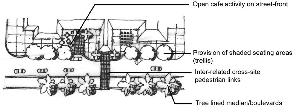
H.
Minimum Open Space Dimensions.
1.
The minimum average width of open space areas shall be ten feet.
2.
The minimum area of open space shall be 180 square feet.
3.
For projects less than ten acres in size, indigenous open space areas shall have a minimum average width of 20 feet and a minimum area of 400 square feet.
4.
For projects ten acres or larger in size, indigenous open space areas shall have a minimum average width of 40 feet and a minimum area of 1,500 square feet.
5.
Open space preservation areas shall be designed with adequate widths to preserve and allow the continued growth and viability of existing native trees.
6.
Native tree preservation areas shall extend to the full drip line of slash pine, three-quarter drip line for all canopy trees, and six feet from the trunk of any native palm, or other protective means, such as retaining walls, shall be provided. Except for work related to approved ecological restoration activities, no filling, grading, or excavating is allowed in open space preservation areas.
7.
Surface water management systems may overlap with native tree preservation areas only where it can be clearly demonstrated that the effects of water management system construction or operation will not cause death or harm to the preserved tree and indigenous plant community of protected species.
I.
Stormwater Management Area Design.
1.
Water Management Lakes. Water management lakes are to appear natural and landscaped with lakeside amenities to enhance their appeal to residents and visitors.
2.
Stormwater Ponds. The shape of stormwater ponds shall be designed to appear natural by having a meandering shoreline. Stormwater pond configurations that are generally rectangular or triangular in shape are prohibited. See Figure 5-408.I: Example Stormwater Ponds.
Figure 5-408.I: Example Stormwater Ponds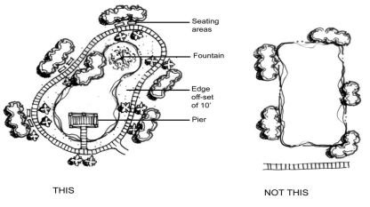
3.
Dry Detention Basins. All dry detention basins shall be planted with wetland type plant species (such as spartina), in minimum one-gallon containers, not more than 36 inches on center, throughout the extent of the basin. Dry detention basins shall be designed to incorporate low-impact design standards by integrating general tree and the required herbaceous basin plantings into their design.
4.
Wet and Dry Detention Areas. Wet and dry detention areas exceeding 20,000 square feet in cumulative area and located adjacent to a public right-of-way are considered park areas and an attractor for pedestrian activity. These areas shall incorporate into the overall design of the project at least two of the following elements:
A.
A five-foot wide walkway with trees an average of 50 feet on center, and shaded benches a minimum of six feet in length located on average every 150 feet;
B.
A public access pier with a covered structure and seating;
C.
An intermittent shaded plaza/courtyard, a minimum of 200 square feet in area, with benches and/or picnic tables adjacent to the water body;
D.
A permanent fountain structure; or
E.
A continuous pedestrian way around the waterbody.
5.
Planted Littoral Shelf (PLS). The following features are considered sufficient to mimic the function of natural systems, improve water quality, and provide habitat for a variety of aquatic species, including wading birds and other waterfowl.
A.
Size Requirements. The PLS shoreline length shall be calculated at 25 percent of the total linear feet of the lake at control elevation.
B.
Location Criteria.
1.
The PLS shall be concentrated at one location of the lake, preferably adjacent to a preserve area, to maximize its habitat value and minimize maintenance efforts. The required PLS may be divided and placed in multiple locations, if the PLS area is smaller than 1,000 square feet. To the maximum extent practicable, the PLS shall be located away from residential lots to avoid maintenance and aesthetic conflicts with residential users.
2.
The PLS may be located adjacent to control structures and pipe outlets or inlets to maximize water quality benefits and not impede flow.
3.
If contained within a lake, the PLS shall function as a typical freshwater marsh in ponds with slopes from 6H:1V to not more than 4H:1V.
C.
Shelf Configuration.
1.
The PLS shall be designed to include a minimum 20-foot-wide littoral shelf extending waterward of the control elevation, at a depth of no greater than two feet below the control elevation.
2.
A detailed cross section of the PLS shall be depicted on the approved development order or limited development order, as applicable.
D.
Plant Selection.
1.
Herbaceous plants shall be selected based on the expected water level fluctuations and maximum water depths in which the selected plants will survive. The PLS areas shall be planted with at least four different native herbaceous plant species.
2.
The required number of herbaceous plants is calculated based on placement spaced two feet on center for the total area encompassed by the PLS. The PLS shall be planted with a minimum two-inch liner container of herbaceous plants.
3.
The total number of plants for the PLS shall be calculated by taking the total linear feet of shoreline multiplied by 25 percent, then multiplied by the 20-foot-wide shelf and divided by four to obtain the two-feet on-center spacing.
4.
Native wetland trees may be substituted for up to 25 percent of the total number of herbaceous plants required. One tree (minimum ten-foot height with a two inch caliper, with a four-foot spread) may be substituted for 100 herbaceous plants. Trees shall meet the minimum standards set forth in this section.
5.
The design elevation of the PLS shall be determined based upon the ability of the PLS to function as a marsh community and the ability of selected plants to tolerate the expected range of water level fluctuations.
6.
Bulkheads, Riprap Revetments, or Other Similar Hardened Shoreline Structures. Bulkheads, riprap revetments, or other similar hardened shoreline structures may comprise up to 20 percent of an individual lake shoreline. A compensatory littoral zone equal to the linear footage of the shoreline structure shall be provided within the same lake and meet the following standards:
A.
A five-foot wide littoral shelf planted with herbaceous wetland plants that provides 50 percent coverage at time of planting and not less than liner size material planted not more than 18 inches on center or one-gallon material above the mean high water line not more than 36 inches on center. To calculate the littorals for this shelf design, the number of linear feet of shoreline structure shall be indicated, multiplied by five feet for the littoral shelf width, multiplied by 50 percent for the plant coverage at time of planting;
B.
An 8:1 slope littoral shelf with herbaceous wetland plants that provide 50 percent coverage at time of planting; or
C.
An equivalent littoral shelf design approved by the Director.
7.
Restoration of Existing Approved Bank Slopes and Littoral Designs.
A.
Restoration of existing bank slopes that have eroded over time and no longer meet the minimum slope design standards applicable at the time the lakes were excavated will be strongly encouraged to use the slope protection measures identified above. Restoration activities will require review and approval through the limited development order process. As part of this review, the previously approved littoral plants and deep lake management plan requirements shall be included on the development or limited development order, as applicable. If the lake shoreline to be restored is either owned or controlled by a property owners association, CDD, or similar maintenance entity, the application for approval shall be filed by the association and encompass the entire lake shoreline in order to avoid slope restoration in a piecemeal fashion by individual lot owners.
B.
The use of an appropriate geosynthetic turf reinforcement mat (TRM), a cellular confinement system, or similar shoreline stabilization technique that does not include hardened structures, such as those identified in subsection 6 above, is allowed. Use of hardened structures for slope restoration is discouraged, but may be approved by the Director, based on the following standards:
1.
The application for the hardened structure demonstrates it is the most appropriate and minimum stabilization technique necessary, as designed and sealed by a licensed professional engineer.
2.
The application also demonstrates compliance with subsection 5 above for compensatory littorals, as well as previously approved littoral and deep lake management plan requirements.
8.
Lake Maintenance Plan. A lake maintenance plan shall be submitted for the long-term maintenance of a lake and lake shoreline areas. The plan shall be included as part of the application for development order. Once approved, the lake maintenance plan shall be recorded in the public records of Lee County as part of the property owner's or homeowners' association documents. The lake maintenance plan shall include the following elements:
A.
Identification of the entity responsibility for the maintenance of the lake area, including the lake shoreline.
B.
Identification of the methods to remove and control exotic and nuisance plants, in perpetuity.
C.
Requirements that ensure littoral vegetation and palms remain in a healthy and vigorous state, in perpetuity. (The use of trimming, mowing, and herbicides to remove littoral plants are prohibited.)
D.
Demonstration about how surface water runoff quantities and flow velocities will be controlled to prevent bank erosion, including but not limited to routing roof drains away from lake shorelines.
E.
Requirements that educational materials be provided to residents describing the purpose and function of the bank slope and littoral areas. The materials shall also explain the individual property owner's responsibilities with respect to compliance with bank slope and littoral area management plans. Educational materials may take the form of signs and brochures.
9.
Excess Spoil Removal. Removal of spoil shall only be in accordance with Sec. 7-206.G.2.A, Approval of an Excess Spoil Removal Plan.
5-409. - Landscaping of Parking Areas, and Vehicular Access.
A.
Purpose. The purpose of this subsection is to establish standards for the landscaping of parking areas to provide visual relief and cooling effects, and to channelize and define logical areas for pedestrian and vehicular circulation.
B.
Applicability. The standards of this subsection apply to:
1.
New parking areas;
2.
To the maximum extent practicable, existing nonconforming landscaping in parking areas that are enlarged or substantially modified (except for restriping of lots/drives); and
3.
Landscaping in parking areas where the structure has been vacant for a period of one year or more and a request for an occupational license to resume business is made.
C.
Standards.
1.
Development subject to the requirements of this section shall comply with the standards in Table 5-409.C: Landscaping Standards for Parking Areas. (See also Figure 5-409.C: Example of Parking Area Landscaping.)
Figure 5-409.C: Example of Parking Area Landscaping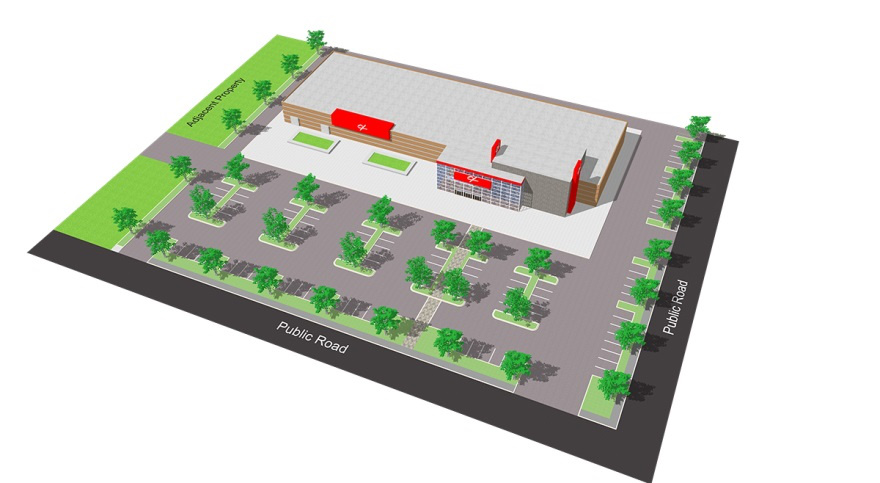
2.
Parking areas located along public rights-of-way shall be adequately screened from pedestrian and vehicular travel along the fronting road with a continuous wall, hedge, or combination, with a minimum height of three feet.
3.
Vertical trellis or other landscaping shall be incorporated in parking garage designs.
5-410. - Screening of Trash Receptacles, Storage, Service Areas and Garden Canters.
A.
Purpose. The purpose of this subsection is to establish standards for the screening of trash receptacles and storage and service areas, to obscure their view from the public realm.
B.
Standards.
1.
Shielding.
A.
All loading areas and docks (including delivery truck parking), outdoor storage, trash collection, heating/air conditioning and other similar mechanical equipment, solid waste disposal facilities, trash compaction, recycling, and other similar service function areas shall be adequately shielded by a landscaped screen or solid fencing along at least three sides. Use of chain link fencing to meet this requirement is prohibited.
B.
These areas shall be fully shielded from adjacent properties and road rights-of-way when viewed from ground level. The shielding shall extend vertically a distance equal to or greater than the items, delivery trucks, or facilities being shielded. Shielding material and design shall be consistent with design treatment of the primary façades of the building or development and the landscape plan.
C.
Garden centers located in shopping centers or associated building materials sales establishments or department stores etc., shall shield all materials (except plants) from adjacent properties and road rights-of-way from view at ground level.
D.
Rooftop mechanical equipment shall be shielded from view at ground level by a parapet or similar architectural features. See Sec. 5-707.C, Rooftop Mechanical Equipment and Other Utilities.
2.
Open Storage.
A.
Fencing and Screening. All commercial or industrial outdoor storage shall be shielded behind a continuous visual screen at least eight feet in height when visible from a residential development or residential zoning district, or six feet in height when visible from any road right-of-way or road easement.
B.
Storage Area. Storage areas are not required to be paved. Grass or other ground cover may be used if it is kept in a sightly and dust-free manner.
5-411. - Landscape Installation and Maintenance Standards.
A.
Purpose. Requirements for landscaping installation ensure the survivability of landscaping.
B.
Applicability. All development shall comply with the landscape installation and maintenance standards.
C.
Installation.
1.
Plant materials shall be installed in soil conditions that are conducive to the proper growth of the plant material. Limerock located within planting areas shall be removed and replaced with native or growing quality soil before planting.
2.
A plant's growth habits shall be considered in advance of conflicts that might be created (e.g. views, signage, overhead power lines, lighting, buildings, and circulation). Trees shall not be placed where they may interfere with site drainage, subsurface utilities, or overhead utility lines, or where they will require frequent pruning in order to avoid interference with overhead power lines. Light poles shall be located outside of all parking islands containing required trees. See Figure 5-411.C.2: Light Pole Placement in Parking Area.
Figure 5-411.C.2: Light Pole Placement in Parking Area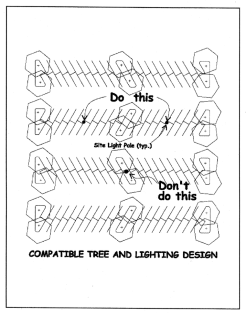
D.
Installation of Landscape Materials. All landscape materials shall be installed in a horticulturally correct manner. At a minimum, the following installation requirements shall be met:
1.
All landscape areas shall be mulched unless vegetative cover is already established.
2.
Trees and shrubs used in a buffer shall be planted in a minimum width area equal to one-half the required width of the buffer. In no case shall the planting area be less than five feet in width.
3.
All landscaped areas shall be provided protection from encroachment by any type of vehicle.
4.
All required plants used in a buffer and landscaping areas shall be installed using Florida friendly principles. Florida friendly principles include water conservation through drought-tolerant landscaping, the use of appropriate plant material, mulching, and the reduction of turf areas.
5.
Utility or drainage easements may overlap required buffers. No required trees or shrubs shall be located in any utility or drainage easement unless a written statement, from the entity holding the beneficial interest in the easement, is submitted specifically stating that the entity has no objection to the landscaping and that the proposed landscaping will not interfere with the long-term maintenance of the infrastructure within the easement. No required landscaping shall be located in a road easement or right-of-way. To avoid conflicts with overhead utility lines, only trees less than 20 feet in height at maturity may be used directly adjacent to an overhead line. Variances or deviations from the requirements of this subsection are prohibited unless approved by the Village and the easement or ROW holder for the planting of street trees.
6.
Where an accessway intersects a right-of-way or when a property abuts the intersection of two or more rights-of-way, a minimum safe sight distance triangular area shall be established. Within this area, vegetation shall be planted and maintained in a way that provides unobstructed visibility at a level between 30 inches and eight feet above the crown of the adjacent road. Landscaping shall be located in accordance with the roadside recovery area provisions of the FDOT Greenbook, where appropriate.
7.
All trees and shrubs located within a landscape buffer shall be located not to block the view of signage.
8.
If a wall or fence is proposed, but not required, then the required buffer plantings shall be installed on the exterior side (between the wall and the abutting property or street right-of-way) of the wall or fence.
E.
Maintenance of Landscaping. The owner is responsible for maintaining the required landscaping in a healthy and vigorous condition at all times, in perpetuity. Tree and palm staking shall be removed within 12 months after installation. All landscapes shall be kept free of refuse, debris, disease, pests, and weeds. There shall be ongoing maintenance to prohibit the establishment of prohibited invasive exotic species.
F.
Pruning.
1.
Required vegetation shall only be pruned to promote healthy, uniform, and natural growth of the vegetation and be in accordance with American National Standard for Tree Care Operations - Tree, Shrub, and Other Woody Plant Maintenance - Standard Practices (Pruning) (A300, Part 1) by the American National Standard Institute, and Best Management Practices: Tree Pruning by the International Society of Arboriculture (ISA).
2.
Trees shall not be severely pruned to permanently maintain growth at a reduced height or spread. Pruning shall not interfere with the design intent of the original installation. Severely pruned trees shall be replaced by the property owner. Replacement trees shall meet the tree size requirements of this section. A plant's growth habits shall be considered in advance of conflicts which might arise (i.e. views, signage, overhead power lines, lighting, circulation, sidewalks, buildings, and similar conflicts).
G.
Indigenous Vegetation Management Plan. An indigenous vegetation management plan and associated monitoring reports are required in accordance with Sec. 5-408.F, Native and Indigenous Vegetation, and shall be provided with the application of a development order or limited development order, as applicable, and at time of certificate of completion.
H.
Landscape Certificate of Compliance. The applicant's landscape architect shall inspect and certify that all open space areas and landscaping and the irrigation system are in substantial compliance with the landscape and irrigation plans approved as part of the development order or limited development order, as applicable. A landscape plan highlighting any changes to the approved plans shall be included as a minor change to the development order with the landscape architect's certification. Any changes to an alternative landscape betterment plan (see Sec. 5-405.C.3, Alternative Landscape Betterment Plan) shall be approved by a minor change to the development order or limited development order, as applicable.
I.
Cultivated Tree Removal/Renovation. For properties with an approved landscape plan and subject to a development order or limited development order which proposes the removal of a tree or trees, the following restrictions apply due to extensive changes to mature landscaping having the potential to negatively impact a project's aesthetic appearance, buffering, and community character:
1.
Trees proposed for removal and replacement shall be documented to meet one of the conditions for removal in accordance with Sec. 2-505.D.3, Tree Removal Standards.
2.
Replacement Trees shall be a specimen identified within Table F-1: Recommended Shade Trees and meet the size requirement of Sec. 5-405.C.2, Larger Trees.
3.
No more than ten percent of the required trees within an existing approved Landscape Plan may be replaced within a one year period.
4.
Replaced or removed trees shall not be located entirely within one contiguous area and shall be evenly dispersed throughout the project.
5.
Shall comply with the process described within Sec. 2-505.E, Cultivated Tree Removal/Renovation.
5-412. - Supplemental Landscape Standards For Specific Uses.
A.
Purpose. Supplemental landscape standards for specific uses are established to ensure the compatibility and minimization of visual intrusion by intense activities and uses on less intense activities and uses, and to protect natural resources.
B.
Applicability. The standards of this subsection apply to the specific types of development identified below.
C.
Uses Requiring Additional Landscaping or Screening.
1.
Display, Sale, Rental, or Storage Facilities for Motor Vehicles, Boats, Recreational Vehicles, Trailers, Mobile Homes, or Equipment
A.
Right-Of-Way Buffer Landscaping
1.
Landscaping adjacent to rights-of-way external to the development project shall be located within a landscape buffer easement that is a minimum of 25 feet in width.
2.
An undulating berm with a maximum slope of 3:1 shall be constructed along the entire length of the landscape buffer. The berm shall be constructed and maintained at a minimum average height of two feet. The berm shall be planted with ground cover (other than grass), shrubs, hedges, trees, and palms.
3.
The required number of trees is five canopy trees per 100 linear feet. Three sabal palm trees may be clustered to meet one canopy tree requirement. Palms are limited to a maximum of 50 percent of the right-of-way tree requirement. Palms shall be clustered and planted in staggered heights, a minimum of three palms per cluster, spaced at a maximum of four feet on center, with a minimum of a four-foot difference in height between each tree.
4.
All of the trees shall be a minimum of 12 feet in height at the time of installation. Trees shall have a minimum three inch caliper at 12 inches above the ground and a six-foot spread. At installation, shrubs shall be a minimum of three gallon, 24 inches in height at time of planting, and be maintained at a minimum of 36 inches in height within one year of planting. The shrubs shall be planted three feet on center.
B.
Landscaping Adjacent to All Other Property Lines. Side property and rear property boundaries (other than those adjacent to rights-of-way) shall be planted with a single hedge row consistent with the minimum requirements of this section. The hedge shall be a minimum of 24 inches in height at planting, planted at three feet on center, and shall be maintained at a height of 36 inches within 12 months of planting.
2.
Minor Utilities. Structures or equipment (excluding transmission poles) exceeding three feet in height or which individually or collectively on the same parcel exceed 27 cubic feet in volume shall be of neutral, non-glare color or finish, and shielded on all sides by shrubs at least 36 inches high at time of planting.
3.
Automobile Service Stations and Convenience Food and Beverage Store Selling Gas. For purposes of this subdivision only, the term automobile service station includes convenience food and beverage stores that sell gas.
A.
Automobile Service Station Buffering to Residential Property. Automobile service station buffers adjacent to land in a residential district or residential development shall include an architecturally designed eight-foot high masonry wall or fence utilizing materials similar in color, module, and texture to those utilized for the building. Landscaping shall be planted on the side of the fence or walladjacent to the residential district or residential development.
B.
Automobile Service Station Right-Of-Way Buffer.
1.
Landscaping adjacent to rights-of-way external to the development project shall be located within a landscape buffer easement that is a minimum of 25 feet in width.
2.
A horizontal undulating berm with a maximum slope of 3:1 shall be constructed along the entire length of the landscape buffer. The berm shall be constructed and maintained at a minimum average height of three feet. The berm shall be planted with ground cover (other than grass), shrubs, hedges, trees, and palms.
3.
The required trees and palms shall be clustered in double rows with a minimum of three trees per cluster. Canopy trees shall be planted a maximum of 20 feet on center within a cluster. The use of palms within the right-of-way buffer shall be limited to landscaped areas adjacent to vehicular access points. Palms shall be planted in staggered heights to a minimum of three palms per cluster, spaced at a maximum of eight feet on center, with a minimum of a four foot difference in height between each tree. Exceptions will be made for Roystonea spp., Bismarka spp., and Phoenix spp. (not including roebelenii), which may be planted one palm per cluster. A maximum distance of 25 feet between all types of tree clusters shall be maintained.
4.
At installation, shrubs shall be a minimum of ten gallon, five feet in height with a three-foot spread, and planted four feet on center.
4.
Development Abutting Natural Waterway. There shall be a 50-foot-wide vegetative buffer landward of non-seawalled natural waterways as measured from the high water line or FEMA designated Floodway, whichever is further landward.
A.
In residential subdivisions, the buffer shall be located within a common area or tract, and outside of all private property boundaries.
B.
Existing native vegetation within the buffer area shall be retained. The natural waterway buffer shall include, at a minimum, six native canopy trees and 50 native shrubs per 100 linear feet, which may be met through credits from the existing native vegetation within the waterway buffer area at a 1:1 credit ratio. If existing native vegetation is not present to meet the buffer vegetation standards, a planting plan shall be submitted for review. All proposed plantings within the natural waterway buffer area shall be installed to mimic a natural system, and all plantings shall comply with the plant standards set forth in Sec. 5-403, Plant Palette and Material Standards. The use of heavy mechanical equipment such as bulldozers, front end loaders, hydraulic excavators, or similar equipment is prohibited, unless prior written approval is obtained from the Director.
C.
The natural waterway buffer shall be designed to incorporate the natural resources maintenance easement required in accordance with Sec. 7-206.F.1, Open Drainage Easements. Vegetation removal within the buffer is limited to:
1.
Routine removal of exotics and downed vegetative debris; and
2.
Limited removal to allow access of vehicles for maintenance of the waterway.
D.
Prior to removal of native vegetation, approval shall be obtained from the Director.
5-413. - Irrigation Standards.
A.
Purpose. The purpose of this subsection is to improve the survivability of landscaping through efficient irrigation systems.
B.
Applicability. All development with cultivated landscape areas shall include an automatic irrigation system that complies with the standards of this subsection. At time of development permitting, non-conforming irrigation shall be brought into compliance with this subsection to the greatest extent practicable. Where existing irrigation systems are modified requiring the acquisition of a permit, automatic activation systems and overriding moisture detection devices shall be installed.
C.
Design Standards.
1.
All required irrigation systems shall be designed to eliminate the application of water to impervious areas, including roads, drives, and other vehicle areas.
2.
Required irrigation shall also be designed to avoid impacts on existing native vegetation.
3.
Systems shall include a controller set to conserve water. Devices such as rain switches, soil moisture sensors, and moisture detection devices shall be installed in all automatic sprinkler systems to override the sprinkler activation mechanism during periods of increased rainfall.
4.
Water shall be conserved by allowing differential operation schedules based on hydrozone.
5.
Soil, slope, and other site characteristics shall be considered in order to minimize water waste, including overspray or overflow to impervious surfaces.
6.
Low trajectory spray heads and/or low volume water distributing or application devices shall be used.
7.
Reuse water shall be used where approved systems are available.
8.
The use of drought-tolerant site-specific and shade producing plants is encouraged to diminish irrigation demands.
9.
All required underground sleeves shall be shown on the development order site drainage plan.
10.
All irrigation systems will be designed to separate low and high watering demand areas into separate zones.
5-501.- Purpose and Intent.
The purpose and intent of this section is to establish standards for the location, height, and appearance of fences and walls in the Village to:
A.
Maintain Visual Harmony. Maintain visual harmony within neighborhoods and throughout the Village;
B.
Protect Adjacent Lands from Unsightly Fences and Walls. Protect adjacent lands from the indiscriminate placement and unsightliness of fences and walls; and
C.
Ensure Safety, Security, and Privacy of Lands. Ensure the safety, security, and privacy of land.
5-502. - Applicability.
The standards in this section shall apply to all construction, reconstruction, or replacement of all fences, walls, and entrance gates at least 25 inches in height in the Village.
5-503. - General Location Standards.
A.
Fences or walls shall be located outside of the public right-of-way.
B.
Fences or walls are allowed on the property line between two or more lots held in private ownership.
C.
Fences or walls may be located within any required setbacks.
D.
Fences or walls may be located within required landscaping areas, subject to the approval of a landscaping plan.
E.
Fences or walls located within utility easements shall receive written authorization from the easement holder or the Village, as applicable. The Village shall not be responsible for damage to, or the repair or replacement of, fences or walls that are removed to access utility easements or facilities.
F.
Fences or walls shall not be located where they would block or divert a natural drainage flow onto or off of any land, or fail to accommodate on-site detention/retention facilities in accordance with SFWMD requirements. (Nothing in this subsection shall be construed to prevent the installation of temporary fencing to protect existing trees, limit sedimentation, or control erosion).
G.
Fences or walls shall not be located where they would prevent immediate view of, or access to, fire hydrants or other fire-fighting water supply devices, in accordance with the Fire Code.
H.
Fences or walls shall be prohibited in accordance with Sec. 10-303.S, Sight Triangle.
I.
Fences or walls shall not block access from a window or door.
J.
Fences or walls shall not be allowed in a location the Director determines will create or worsen a traffic hazard.
5-504. - Height Standards.
A.
General. Unless otherwise stated in subsection B below, fences or walls shall comply with the standards in Table 5-504.A: Fence or Wall Height.
B.
Exceptions.
1.
Customary fencing provided as a part of a permitted tennis court, athletic field, or other recreational facility is exempt from the standards of this section.
2.
Fences up to six feet in height are allowed around community gardens.
3.
Fences up to ten feet in height are allowed around major utilities, wireless communication towers, government facilities, and other public safety uses.
5-505. - Materials.
A.
General. Unless otherwise specified in Sec. 5-505.B, Prohibited Materials, fences or walls shall be constructed of conventional and traditional building materials, including but not limited to any one or more of the following materials:
1.
Concrete block;
2.
Brick;
3.
Painted wood, pressure treated wood, or rot-resistant wood;
4.
Decorative aluminum;
5.
Iron or steel;
6.
Chain link painted black or bronze;
7.
Composite materials designed to appear as wood, metal, or masonry; or
8.
Any material demonstrated by the applicant to have a similar or equal appearance and durability as a material listed in this subsection.
B.
Prohibited Materials. The following fence types or materials are prohibited:
1.
Tires, mufflers, hubcaps, and similar materials.
2.
Fabric, plastic, metal, or vinyl sheets, nets, or slats as part of a fence or attached to a fence for the purpose of effecting privacy or screening.
3.
Barbed wire, spire tips, sharp objects, hog wire, game fence, horse wire, or other similar materials, or electrically charged fences except:
A.
Barbed wire or electrically charged fences may be used to control livestock on bona fide agricultural uses in the AG district.
B.
The use of hog wire as permitted on land owned, for purposes of conservation, by the Village, Lee County, the state, or other governmental entities.
C.
Perimeter Fences and Walls Abutting Street Right-of-Way. Fences or walls shall be constructed to present the finished side of the fence or wall to the adjoining lot or any abutting right-of-way. The Director may waive this requirement where an existing fence, wall, or continuous landscape hedge is already present on the adjoining parcel.
5-506. - Appearance.
Fences and walls on each property shall be of uniform materials, design, and color. Additions to existing fences or walls shall maintain uniformity of materials, design, and color with the existing fence or wall.
5-507. - Construction.
Fences or walls shall comply with the Florida Building Code, shall receive the proper permits prior to construction, and shall be constructed in accordance with the proposed finished grade elevation.
5-508. - Gates.
A.
All gates shall have hardware to secure the gate in a closed position.
B.
All unattended gates and gates opening onto a public sidewalk area shall be self-closing, self-latching, and locked when not in use.
5-509. - Maintenance.
Fences or walls and associated landscaping shall be maintained in good repair and in a safe and attractive condition, in perpetuity. Maintenance of fences or walls shall include, but not be limited to, the replacement of missing, decayed, or broken structural or decorative elements and the repair of deteriorated or damaged fence and wall materials, including but not limited to, weathered surfaces visible from the public right-of-way, sagging sections, and posts. Fences and walls shall be maintained as to appear vertical to the unassisted eye.
5-510. - Residential Project Walls.
For purposes of this subsection, a residential project fence is a wall or fence erected around a residential subdivision (but not individual lots) or a development of ten or more dwelling units. A residential project fence:
A.
May be up to eight feet in height around the perimeter of the project if the Director determines the fence does not interfere with vehicle visibility requirements at traffic access points.
B.
May include architectural features such as columns, cupolas, fountains, or parapets at a height not to exceed twice the fence or wall height, provided they are compatible with the project form and design and with adjacent development.
C.
Shall be landscaped on the exterior side (between the wall or fence and the adjacent property or street right-of-way) with a minimum of five trees per 100 lineal feet and shrub hedges, within a minimum plantable area that is at least seven and one-half feet wide located on the exterior side of the fence or wall.
1.
Hedges shall be planted and maintained to form a 36-inch-high continuous visual screen within one year after time of planting.
2.
Trees adjacent to a right-of-way shall be appropriately sized in mature form so that conflicts with overhead utilities, lighting, and signs are avoided. (The clustering of trees and use of palms adjacent to the right-of-way will add design flexibility and reduce conflicts.)
3.
Where decorative aluminum railing type fencing is applied, 50 percent of the required landscaping can be placed on the inside of the fence for aesthetic purposes.
D.
Shall be designed to ensure that historic water flow patterns are accommodated and all stormwater from the site is directed to on-site detention/retention areas in accordance with SFWMD requirements.
E.
Shall not be permitted until legally sufficient documents are recorded in the public records of Lee County providing for the maintenance of the project fence and landscaping.
5-601.- Purpose and Intent.
The purpose and intent of this section is to regulate exterior lighting to:
A.
Ensure all exterior lighting is designed and installed to maintain adequate lighting levels on site;
B.
Assure that excessive light spillage and glare are not directed at adjacent lands, neighboring areas, and motorists;
C.
Curtail light pollution, reduce skyglow, and preserve the nighttime environment for the enjoyment of residents and visitors;
D.
Conserve energy and resources to the greatest extent possible; and
E.
Provide security for persons and land.
5-602. - Applicability.
A.
General. Unless exempted by subsection B below, the standards of this section apply to:
1.
All new development;
2.
Any individual expansion or alteration of a building if the expansion increases the build's floor area by 50 percent or more, or the alteration involves 50 percent or more of the building's floor area (including interior alterations); and
3.
The replacement of any existing outdoor lighting fixture.
B.
Exemptions. The following types of lighting are exempted from the standards of this section:
1.
Lighting exempt under state or federal law;
2.
FAA-mandated lighting associated with a utility tower;
3.
Lighting for public monuments and statuary;
4.
Lighting solely for signage (see Chapter 6: Signage);
5.
Temporary lighting for circuses, fairs, carnivals, and theatrical and other performance areas, provided such lighting is discontinued upon completion of the performance;
6.
Temporary lighting of construction sites, provided such lighting is discontinued upon completion of the construction activity;
7.
Temporary lighting for emergency situations, provided such lighting is discontinued upon abatement of the emergency situation;
8.
Security lighting controlled and activated by motion sensor devices for a duration of 15 minutes or less;
9.
Underwater lighting in swimming pools, fountains, and other water features;
10.
Outdoor light fixtures producing light directly by the combustion of fossil fuels, such as kerosene and gasoline;
11.
Holiday or festive lighting, provided such lighting does not create unsafe glare on road rights-of-way; and
12.
Outdoor lighting fixtures in use as ofJanuary 27, 2021 that do not comply with provisions of this section, so long as they are not replaced.
5-603. - Photometric Plan Required.
Development applications subject to this section shall include a photometric plan that illustrates compliance with the standards of this section, including the angle of cut-off and other characteristics of the light emissions including references to the standards of this section. The photometric plan shall designate the number, location, height, and type of illuminating devices, fixtures, lamps, supports, reflectors and other devices, and include manufacturer's catalog cuts and drawings with pictures, sections, and proposed wattages for each fixture, as appropriate.
5-604. - General Standards.
A.
Hours of Illumination.
1.
All uses (except for those listed in subsection 2 below) that are adjacent to existing residential development shall extinguish all exterior lighting—except lighting necessary for security or emergency purposes—by 10:00 P.M. or within one hour of closing, whichever occurs first. For the purposes of this subsection, lighting "necessary for security or emergency purposes" shall be construed to mean the minimum amount of exterior lighting necessary to illuminate possible points of entry or exit into a structure, illumination of exterior walkways, or illumination of outdoor storage areas. Lighting activated by motion sensor devices is strongly encouraged.
2.
The uses that are not subject to these restrictions are:
A.
Residential dwelling uses (not including mixed-use sites that incorporate dwelling uses);
B.
Recreational facilities, outdoor; and
C.
Agriculture uses, including accessory agricultural uses.
B.
Illumination Levels.
1.
Illumination requirements for specific uses are established in Table 5-604.B: Illumination Level Requirements. Except for the specific standards included in Table 5-604.B, the standards contained in the latest edition of the Illuminating Engineering Society of North America (IESNA) Handbook shall apply.
2.
Except for street lighting, all exterior lighting and indoor lighting visible from outside shall be designed and located so that on property in the RSF district, a residential development in a planned development, or other residential development, the illumination does not exceed 0.0 foot-candles measured 10 feet onto the residential property from the property line. The maximum illumination shall not exceed 0.5 foot-candles at ground level at a lot line if the adjoining property is in any other zoning district, or includes any other type of development.
C.
Maximum Mounting Height. Except for street lighting, the height of exterior light fixtures, whether mounted on poles, walls, or by other means, shall comply with the standards in Table 5-604.C: Maximum Mounting Height for Exterior Lighting.
D.
Full Cut-Off and Fully Shielded Fixtures Required. All exterior luminaries, including security lighting, shall be full cut-off fixtures that are directed downward and fully shielded, consistent with Figure 5-604.D: Full Cut-Off Fixtures. In no case shall lighting be directed above a horizontal plane through the lighting fixture.
Figure 5-604.D Full Cut-Off Fixtures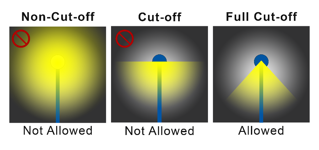
E.
Standards for LED Luminaries. All exterior luminaries that include LED light sources shall comply with the following Illuminating Engineering Society of North America (IES) standards:
1.
The Correlated Color Temperature (CCT) shall not exceed 3,000 K;
2.
Backlight (B) shall not exceed 1;
3.
Uplight (U) shall be 0; and
4.
Glare (G) shall not exceed 1.
5-605. - Standards for Specific Uses and Site Features.
A.
Off-Street Parking Areas. Decorative light poles and fixtures shall be used throughout all parking areas.
B.
Sports or Performance Venues.
1.
Lighting fixtures for outdoor sports areas, athletic fields, and performance areas shall be equipped with a glare control package (e.g., louvers, shields, or similar devices) and aimed so that their beams are directed and fall within the primary playing or performance area.
2.
Lighting for outdoor recreational uses such as ball diamonds, football fields, soccer fields, other playing fields, tennis courts, and similar uses shall comply with the following standards:
A.
Light poles shall be no more than 30 feet in height, except at ball diamonds, football fields, and other playing fields, where they can be 40 feet in height;
B.
Maximum illumination at the property line shall be 2.0 foot-candles except when abutting residential property when maximum illumination shall be 0.2 foot-candles;
C.
Maximum illumination 10 feet onto any adjacent property with a residential use shall be 0 foot-candles; and
D.
The lighting shall be extinguished no later than 10:00 p.m.
C.
Pedestrian Area Lighting.
1.
Light fixtures for sidewalks, walkways, trails, and bicycle paths, outside of parking areas, except for pedestrian bollard lamps, shall comply with the following standards:
A.
Provide at least 1.0 foot-candles of illumination, but not exceed 1.8 foot-candles;
B.
Have a maximum height of 15 feet; and
C.
Be placed a maximum of 100 feet apart.
2.
Any pedestrian bollard lamps shall be mounted no higher than four feet above grade, shall not exceed 900 lumens for any single lamp, and shall have a Coordinated Color Temperature (CCT) that does not exceed 3,000 K. (See Figure 5-605.C.2: Examples of Pedestrian Bollard Lamps.)
Figure 5-605.C.2: Examples of Pedestrian Bollard Lamps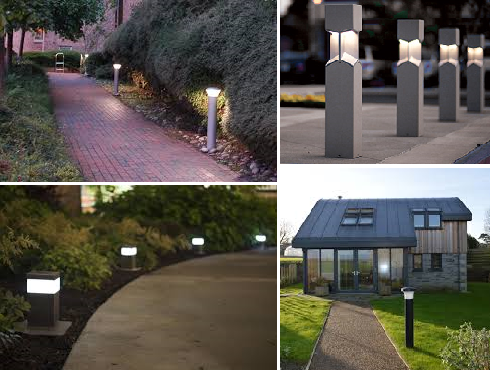
D.
Wall Pack Lights. Wall packs on the exterior of the building shall comply with the following standards:
1.
Be fully shielded (e.g., true cut-off type bulb or light source not visible from off-site) to direct the light vertically downward;
2.
Not exceed 1,600 lumens for any single fixture; and
3.
The top of the fixture not exceed the height of the parapet, the roof, or 25 feet, whichever is lowest.
E.
Canopy.
1.
Areas under a canopy shall be designed so as not to create glare off-site. Acceptable methods to address this include one or all of the following:
A.
A recessed fixture incorporating a lens cover that is either recessed or flush with the bottom surface (ceiling) of the canopy that provides a full cutoff or fully-shielded light distribution;
B.
A surface mounted fixture incorporating a flat glass that provides a full cutoff or fully-shielded light distribution; or
C.
Indirect lighting as long as all direct illumination is focused exclusively on the underside of the canopy and no bulb is visible.
2.
The sides of a canopy shall not be illuminated.
F.
Decorative and Landscape Lighting. Outdoor light fixtures used for decorative effects shall comply with the following standards:
1.
Decorative lighting intended to enhance the appearance of a building and/or landscaping shall be located, aimed, and shielded so that light is directed only on those features.
2.
Decorative lighting fixtures shall not exceed 1,600 lumens for any single fixture.
5-606. - Street Lights.
A.
All street lights shall be located inside full cut-off fixtures with recessed bulbs and flat lenses mounted on non-corrosive poles served by underground wiring.
B.
The light structure and light color of street lights in an individual subdivision or development shall be consistent throughout the subdivision or development and comply with the standards in Sec. 5-604.E, Standards for LED Luminaries.
C.
The maximum height of street lights shall be 15 feet in Residential districts and 25 feet elsewhere.
D.
Street light improvements shall be maintained and operated through a covenant that runs with the land in the form of deed restrictions, a property owners' or condominium association, or another legal mechanism, acceptable to the Village, which assures the beneficiaries of the service that the street lighting will be continually operated and maintained. The beneficiaries of the service shall in all cases be provided with a legal right to enforce the assurance that the lighting will be continually operated and maintained. The legal documents that provide for the continual maintenance and operation of the lighting shall be accepted and recorded with the public records of Lee County only after they are reviewed and approved by the Village Land Use Attorney for compliance with this section.
5-607. - Prohibited Lighting.
The following exterior lighting is prohibited:
A.
Light fixtures that imitate an official highway or traffic control light or sign;
B.
Light fixtures that outline buildings, awnings, roofs, windows, doors and other components, except for festive holiday lighting;
C.
Light fixtures that have a flashing or intermittent pattern of illumination, except signage with an intermittent pattern of illumination allowed in accordance with Chapter 6: Signage;
D.
Searchlights, except when used by federal, state, or local authorities, or where they are used to illuminate alleys, parking garages, and working (maintenance) areas, so long as they are shielded and aimed so that they do not result in lighting on any adjacent lot or public right-of-way exceeding 2.0 foot candles;
E.
Lights that create a mix of colors unless specifically approved by the Director for a cause shown; and
F.
Mercury vapor light fixtures or lamps.
5-608. - Illumination Measurement.
A.
Illumination measurements shall be made at the lot line of the land upon which light to be measured is being generated. If measurement on private property is not possible or practical, light level measurements may be made at the boundary of the public road right-of-way that adjoins the land. Measurements shall be made at finished grade (ground level), with the light-registering portion of the meter held parallel to the ground.
B.
Illumination measurements shall be taken with a light meter that has been calibrated within two years of the date of the measurement.
5-701.- Purpose.
A.
The purpose of these architectural, form, and design standards is to complement, enhance, and enrich the urban fabric of the Village by contributing to a sense of place, the economy, and the vitality of the Village.
B.
The goal for future land use in the comprehensive plan is to ensure development provides distinct urban form and aesthetic design, recognizing the influence that architecture has upon the sense of place. To implement this goal, development shall have architectural features and patterns that provide visual interest from the perspective of the pedestrian, reduce building mass, recognize local character, and respond to site conditions. The purpose of this section is to provide standards to accomplish this goal by:
1.
Defining the architectural vernaculars for the Village.
2.
Establishing placemaking standards for all mixed-use development.
3.
Defining standards for the design of a site in the context of its surroundings.
4.
Establishing form standards for the design of a site so it is consistent and harmonious within the community identity by incorporating views, pedestrian orientation (including CPTED principles), climate responsiveness, complementary design transitions, and human scale elements.
5-702. - Applicability.
A.
General. Unless otherwise expressly stated to the contrary in this section, the following shall comply with the standards of this section:
1.
All exterior façades of buildings shall be treated as primary façades and employ the architectural, site, and landscaping design elements outlined herein, including colors and materials, to provide a unified architectural theme.
2.
All new, redevelopment, renovation, or change in use of commercial, light industrial, multi-family, institutional, religious, public, and mixed-use development or projects.
A.
Renovation and Redevelopment. In the case of additions or renovations to, or redevelopment of, an existing building, where the cumulative increase in total floor building area exceeds 30 percent of the square footage of the existing building being enlarged or renovated, the provisions of this section shall apply. Where there are inherent problems retrofitting existing buildings, the Director may waive some or all requirements if other equivalent enhancements are provided.
B.
Change of Use. Where there are inherent problems retrofitting existing buildings when there is a change in use, the Director may waive some or all requirements if other equivalent enhancements are provided.
3.
Provisions apply at time of development order, limited development order, building permit, or zoning action, as applicable.
4.
Compliance with the standards set forth in this section shall be demonstrated on the drawings or site development plans submitted in conjunction with an application for development order approval or with a building permit application if a development order is not required. This will not prevent simultaneous applications for a development order and building permit on the same parcel. However, the development order approval shall precede the building permit approval.
B.
Review. Compliance with the standards in this section shall be demonstrated on the pattern book, drawings, or site development plans submitted in conjunction with an application.
5-703. - Architectural Styles and Characteristics.
A.
Primary Architectural Styles. Mediterranean Revival and Florida Vernacular styles are designated as the Village's primary architectural styles. The application of these styles is dependent on the context of the intended development.
1.
Mediterranean Revival. The Mediterranean Revival architectural style includes these sub-styles within the Village as further described in Sec. 5-703.A.1.E: Mission Revival, Italian Renaissance Revival, Italian Countryside, Spanish Revival, and Spanish Colonial.
A.
The Mediterranean Revival style is articulated with varied massing and architectural features. Towers, balconies, loggias, porticos, chimneys, trellises, and exterior staircases are assembled to form picturesque buildings. The result is buildings that are rich in shade and shadow, with multiple building volumes and setbacks, and varied building heights.
B.
Building composition is typically asymmetrical. Base, middle, and top are defined by moldings, changes in window pattern and size, and cornice lines. Arcades and loggias are also commonly used to reinforce the base, middle, and/or top of the building.
C.
The Mediterranean Revival building is typified as asymmetrical and eclectic. Columns, posts, wooden and masonry balustrades, and brackets are contributing elements of the style. It is common to have multiple building volumes and varied interior and exterior spaces. Building massing tends to be irregular with a variety of shapes and heights; however, the appearance of solidary and permanence is critical.
D.
Mediterranean Revival Style architecture includes the key characteristics identified in Table 5-703.A.1.D: Mediterranean Revival Style Characteristics. See also Figure 5-703.A.1.D: Mediterranean Revival Defining Elements.
Figure 5-703.A.1.D: Mediterranean Revival Defining Elements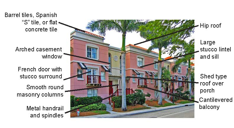
E.
The Mediterranean Revival architectural style includes these sub-styles within the Village:
1.
Mission Revival: The Mission Revival style includes mission-shaped dormers and/or roof parapet; wide, overhanging eaves with exposed rafter beams; red-tiled roof; stucco walls; and arched windows or doors on the ground level.
2.
Italian Renaissance Revival: The Italian Renaissance Revival style includes low-pitched, hipped roofs, often with ceramic tiles; rooflines with wide, overhanging eaves with large, decorative brackets under the roofline; doors and windows are often framed with round arches, primarily on the first floor, sometimes in the form of an Italian loggia, or covered patio; the entryway will often be framed with classical columns with occasional pediments and the façade is usually symmetrical.
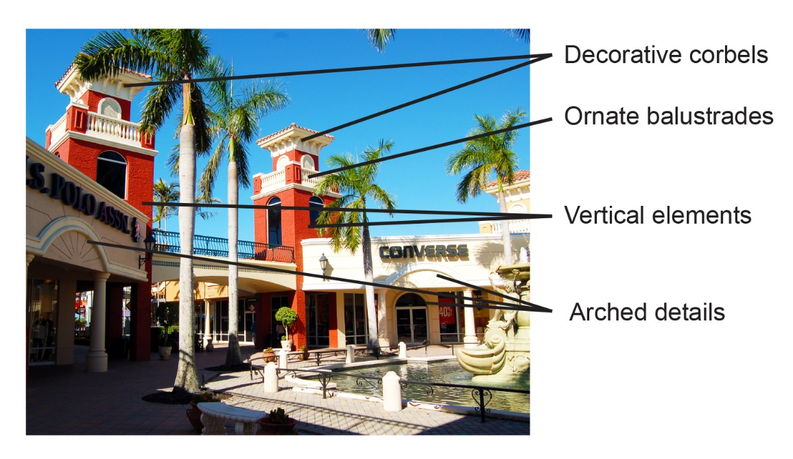
3.
Italian Countryside: The Italian Countryside style includes two or three stories, rarely one story; low-pitched roof, decorative parapet, widely overhanging eaves; large, decorative brackets under an ornamental cornice; tall, narrow windows commonly arched or curved above; an occasional square cupola or tower (campanile); and elaborate wrap-around porch (or smaller entry porch) with decorative Italianate double columns.
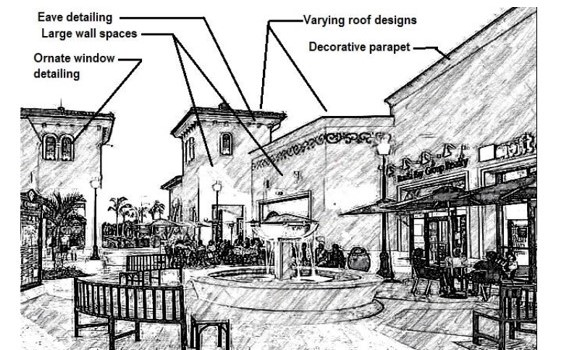
4.
Spanish Revival: The Spanish Revival style includes red clay barrel tile or Spanish tile; wrought iron work, including balconies; stucco exterior finishes; paneled doors; decorative vents and rondels; arcades; and low-pitched, usually gable roofs with little or no eave overhang. Detailing includes plaster and terra cotta highlighting of arches, columns, window surrounds, cornices, and parapets; and wrought iron grilles with façades that are generally asymmetrical.
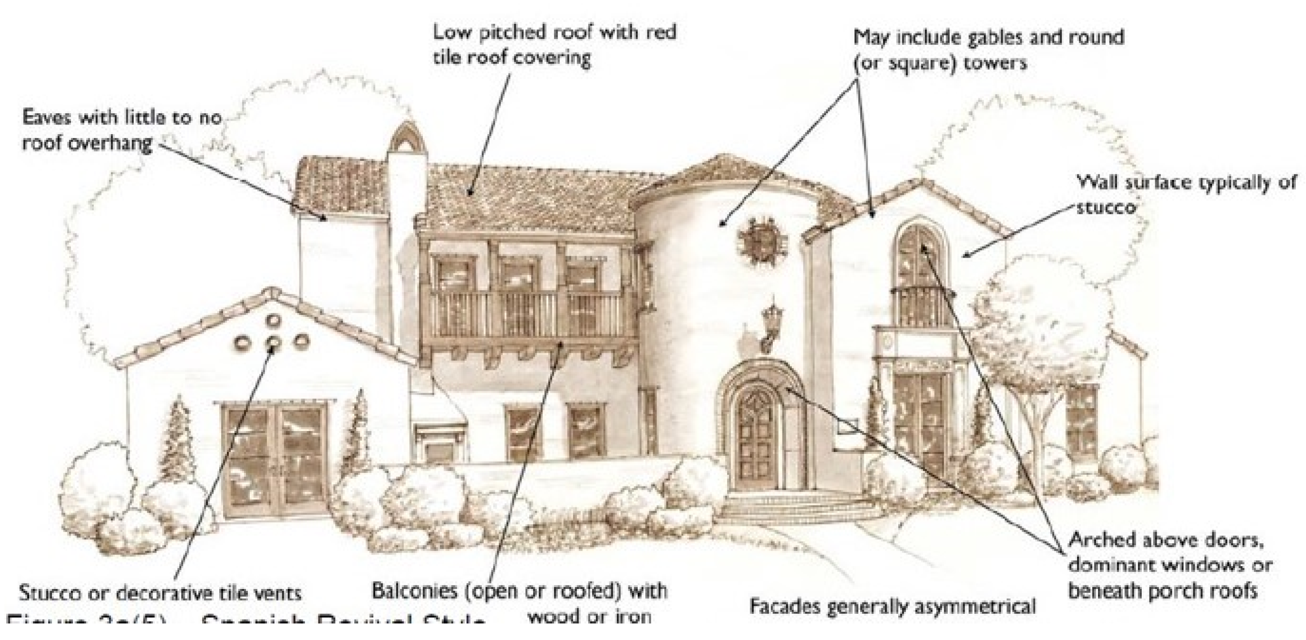
5.
Spanish Colonial: The Spanish Colonial style includes defined entrances; simple detailing with ornate work used for major locations; use of repetitive elements; covered walkways; and high profile roof tile.
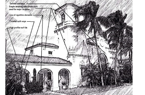
2.
Florida Vernacular. The Florida Vernacular architectural style includes these sub-styles within the Village as further described in Sec. 5-703.A.2.D: Florida Plantation, Florida Key West or Cracker, and Historic Koreshan.
A.
The Florida Vernacular style of architecture is native to the region. It is most typically constructed with a wooden frame and finished with wood or wood-look alternative siding. Stucco and fiber cement siding are also used.
B.
Florida Vernacular features porches as integral to the style and prominent on the front façades. Porches extend along a large percentage of the ground floor elevations, often wrapping the corners to continue at some length alongside façades.
C.
Florida Vernacular Style architecture includes the key characteristics identified in Table 5-703.A.2.C: Florida Vernacular Style Characteristics. See also Figure 5-703.A.2.C: Florida Vernacular Defining Elements.
5-703.A.2.C: Florida Vernacular Defining Elements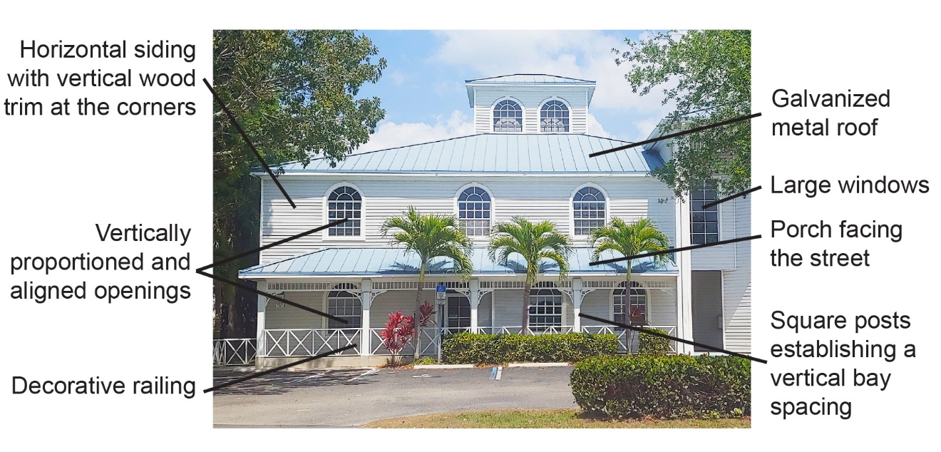
D.
The Florida Vernacular architectural style includes these sub-styles within the Village:
1.
Florida Plantation: The Florida Plantation style includes the use of pediment and gable end for accents and columned entry.
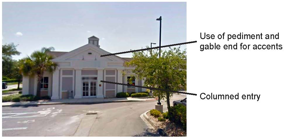
2.
Florida Key West or Cracker: The Florida Key West or Cracker style includes a foundation of wood or wood-look alternative posts, limestone, brick, or concrete piers; horizontal weatherboard or clapboard as the primary exterior material; a low-pitched gable roof, with wood or wood-look alternative shingles or pressed metal shingles; full façade wrap-around porch; louvered vents, doors, and window shutters; and centrally placed main entrance with transom light above.
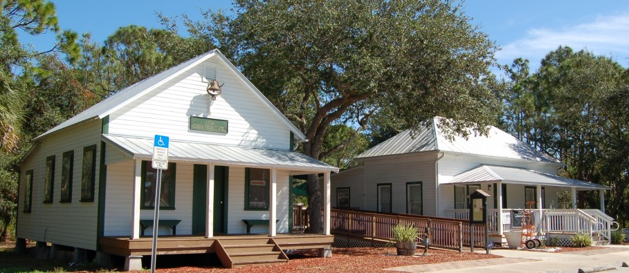
3.
Historic Koreshan: The Historic Koreshan style includes simple shape massing; hip and gable roofs; covered porches; exposed members; decorative roof elements; and clapboard siding.
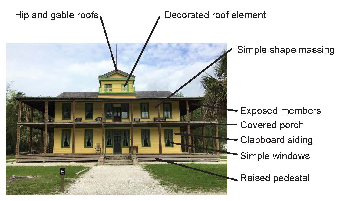
B.
Alternative Styles. To provide for flexibility and stimulate creative project designs while fostering compatibility with surrounding developments, the following alternative architectural styles may be proposed and be determined appropriate in the Village in accordance with the criteria in this section.
1.
Prairie: The Prairie style includes low-pitched hipped or flat roof; broad overhanging eves; strong horizontal lines; clerestory windows arranged in horizontal bands; wide use of natural materials, especially stone and wood or wood-look alternative with strong horizontal lines; and restrained ornamentation such as friezes around windows and doors, or as bands under the eaves.
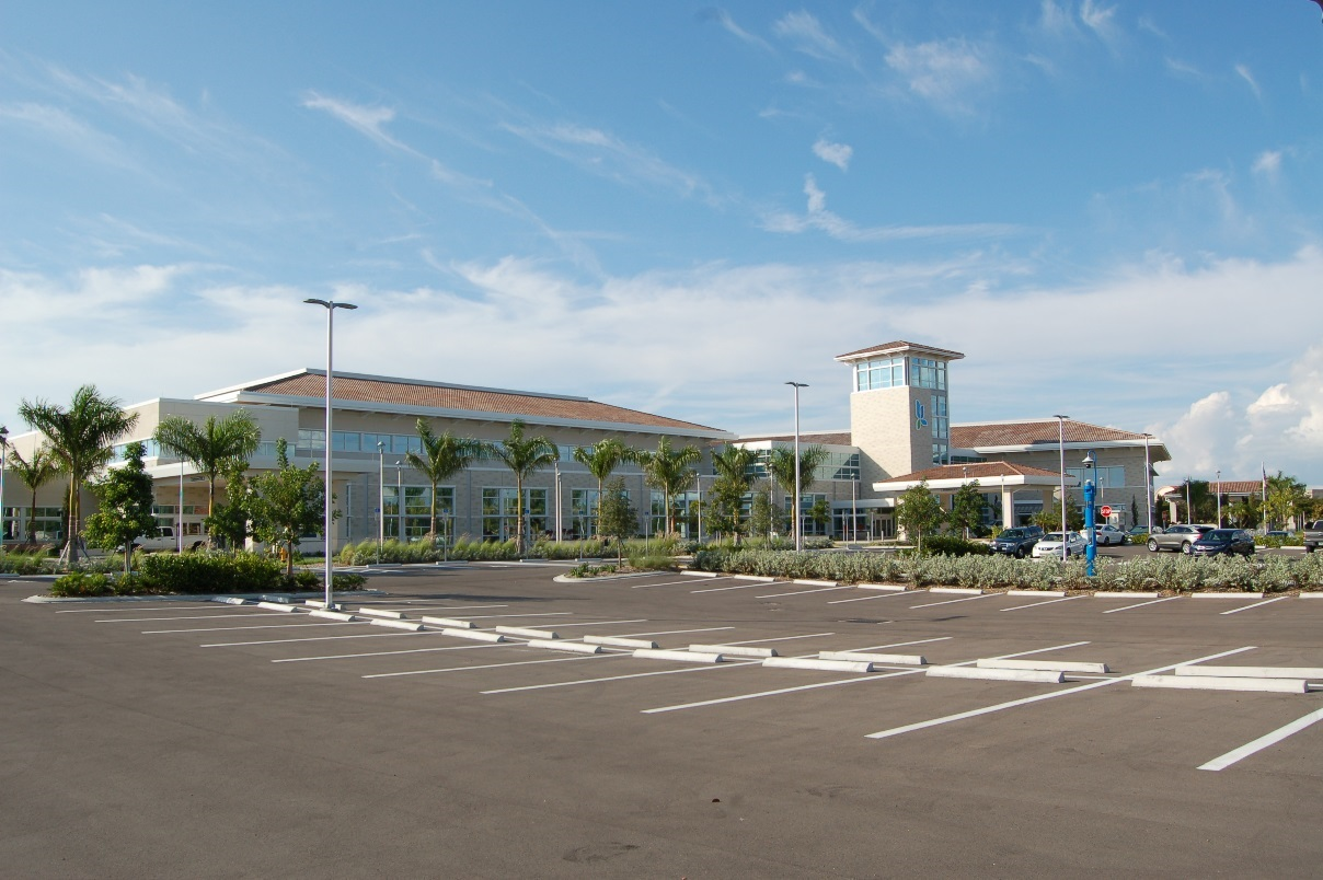
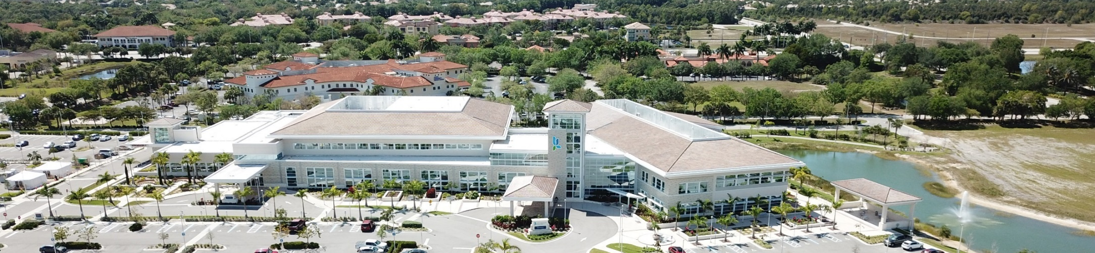
2.
Iconic: Civic buildings and public gathering places require important sites to reinforce the community identity. Buildings that are used for civic purposes and that are adjacent to public gathering places require distinctive form, because their role is different from that of other buildings and places that constitute the fabric of the community. Such buildings may be evaluated to allow iconic architecture as an alternative style.
3.
An applicant may propose Prairie or Iconic architecture as an alternative architectural style, subject to approval through the design review process as part of the review of the development application. Approval of a proposed alternative architectural style shall be based upon the following findings:
A.
The plan and architectural style for the proposed development is in conformity with good taste, good design, and in general contributes to the image of the Village as a place of beauty, spaciousness, harmony, taste, fitness, and high quality.
B.
The plan and architectural style for the proposed development is not, in its exterior design and appearance, of inferior quality such as to cause the nature of the existing and evolving Village environment to materially depreciate in appearance and value.
C.
The plan and architectural style for the proposed development conforms with the standards of this LDC and other applicable ordinances, particularly with respect to the location and appearance of the buildings and structures proposed in the development.
D.
The plan and architectural style for the proposed development is compatible with the existing and any proposed surrounding development, and is consistent with the comprehensive plan.
E.
The building is constructed with material that is sufficient and of such high technical quality to allow for continuing renovation and adaptive reuse well beyond the expiration of initial planned use or cost recovery.
F.
The building is designed to share some of the design characteristics of neighboring buildings or public spaces where applicable.
5-704. - Historic Preservation Regulations.
A.
A certificate of appropriateness shall be approved in accordance with Sec. 2-504, Historic Preservation Certificate of Appropriateness, prior to modification of any structures designated by the Village or Lee County prior to Village incorporation as historically significant to assist in the continued preservation of the structure and the appropriate, compatible, and sensitive development of new construction and additions to the structure.
B.
The certificate of appropriateness shall be decided based upon the criteria listed in the U.S. Secretary of the Interior's Standards for Rehabilitation, 36 CFR 67 (1983).
5-705. - Site Contextual Standards.
A.
Purpose and Intent.
1.
The purpose of these site contextual standards is to ensure the site design of development supports an image that is attractive and consistent with the desired community identity. This is achieved by providing for architectural and site design treatments that will enhance the visual appearance of development in the Village, while providing for design flexibility.
2.
These site contextual standards are intended to stimulate creative project designs, while fostering compatibility with surrounding development, and create an integral distinct community image?one that will enhance, unify, and harmonize development throughout the Village.
B.
Views.
1.
To the maximum extent practicable, development shall be designed to maximize the preservation of natural features, trees, tree masses, and sites which have historical significance, scenic views, or similar assets.
2.
To the maximum extent practicable, buildings and open space on sites shall be located to maximize the potential for terminating vistas, so that views from vantage points of approaching roads are completed by an intentionally placed building, structure, or grand open space feature such as a fountain, gazebo, pergola, signature tree, or natural habitat.
C.
Mixed-Use Development Design Standards. At the time of planned development, development order, or limited development order review, as appropriate, the plans for an integrated horizontal mixed-use development or a vertical mixed-use development shall demonstrate compliance with the following standards:
1.
Placemaking
A.
The placemaking standards in Table 5-705.C.1: Placemaking Standards, in a way that is context driven.
| TABLE 5-705.C.1: PLACEMAKING STANDARDS | ||
|---|---|---|
| Placemaking Amenity | Basic requirement for integrated horizontal or vertical mixed-use development sites | |
| Mix-of-use ratio |
No more than a maximum of 80 percent of the gross habitable floor area shall be dedicated
to either a residential or nonresidential use to achieve a mix of residential and
non-residential uses. (A clubhouse (with dining and recreational opportunities) and
maintenance facilities are not considered nonresidential for the purposes of this
subsection.)
Waiver: The Director may waive this ratio requirement if it is demonstrated that the proposed development site has a mix of residential and non-residential uses that can be reached within a ¼-mile walk of the subject site via continuous pedestrian facilities. | |
| Housing choices |
The development shall include a mix of at least two distinctly different housing types.
Housing types include detached houses including two-family dwellings, apartment houses,
cottages and side-yard houses, row houses, live-work buildings, courtyard buildings,
or mixed-use buildings. No more than 80 percent of dwelling units may be comprised
of a single housing type.
Waiver: The Director may waive this ratio requirement if it is demonstrated that the overall size of the mixed-use development is less than five acres and consequently cannot reasonably support two different types of housing types, and the project complies with the mix of use ratio above. | |
| Gathering place |
The site's open space shall include a gathering place, which shall be a minimum of
ten percent of the project site.
Gathering places include outdoor spaces such as plazas, parks, and farmers' markets; cultural venues such as theaters and museums; civic spaces that include meeting rooms; businesses such as restaurants, coffee shops, and fitness centers; places of worship, social institutions; and amenities adjoining sidewalks and trails such as benches, exercise stations, and gazebos. The gathering place shall be visible and easily accessible from a public road, and shall be clearly located and designed so that it can be used by both occupants and the public. Accessibility to the public shall be provided through an access easement or other equivalent means. (Non-residential uses meant for use by residents of the project and only accessible to the public by rent, lease, or membership (uses such as meeting rooms, banquet halls, fitness centers, or golf courses) do not qualify as gathering space). | |
| Multimodal and integrated Mobility | Development, to the maximum extent practicable, shall be served by an integrated system of sidewalks, roads, accessways, and other facilities designed to provide for multiple travel modes (vehicular, transit, bicycle, and pedestrian), as appropriate to the development's size, character, relationship to surrounding development and development patterns, and existing and planned community transportation systems. | |
| Connectivity |
The internal road circulation system shall be well connected and integrated, with
an appropriate classification of roads, sidewalk on both sides of the road, and street
trees. Where site conditions are appropriate, a block layout is encouraged. Cross-access
between the development and those on adjoining parcels shall be established, where
appropriate.
Roads shall be designed to integrate with and connect to existing roads external to the site, and where appropriate, provide for future extension of the development's road network to provide the maximum number of interconnections and points of ingress and egress. | |
| Roads |
Roads shall not end in dead ends, cul-de-sacs, hammerheads, or other forms that do
not connect with other roads, except in instances where connections are not reasonably
feasible.
Where appropriate, alleys shall be designed to absorb parking and service loads. To the maximum extent practicable, the outer faces of blocks shall be pedestrian in nature with sidewalks a minimum of six feet wide on both sides of streets, street trees, and pedestrian level lighting. Traffic calming features shall be used, where appropriate, in the design of streets and driveways. Features may include roundabouts or rotaries, rumble strips, chicanes, speed tables, raised crosswalks, etc. | |
| Parking | 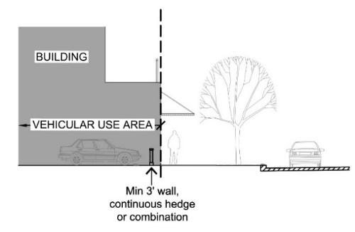 | A minimum of 50 percent of the off-street parking shall be placed to the side of buildings or behind the buildings, subject to the landscape requirements of Sec. 5-409, Landscaping of Parking Areas, and Vehicular Access. |
| Transit | Where LeeTran provides or plans to provide service, the development shall include a transit stop or shelter in the project design, subject to LeeTran approval. Where LeeTran does not provide service, space shall be dedicated for a transit stop or shelter to be developed in the future. | |
| Community identity | A gateway monument shall be provided at the primary vehicular entrance or entrances to the project. | |
| Community heritage |
The development shall, to the maximum extent practicable:
(1) Preserve an historic structure or landmark that is located on the site, and preserve any specimen trees; or (2) Include educational signage, a monument, or a statue that memorializes the Village's history or culture. Waiver: The Director may waive this requirement if it is demonstrated that the site has no existing features to preserve, or no potential to include a feature, that relate to the heritage of the Village. | |
| Arts, culture and creativity | The development shall include public art displayed in a prominent location, such as a plaza or civic space. | |
| Environmental feature |
The development shall include one of the following on the site:
(1) Green infrastructure, such as rain gardens, roadside bioswales, etc.; (2) A nature trail that is accessible to the public; or (3) Environmental educational signage. Waiver: The Director may waive this requirement if it is demonstrated that the site has no existing environmental features, nor the potential to include a feature that relates to green infrastructure or environmental protection. | |
B.
The development shall establish connections to off-site placemaking amenities that can be reached with a ¼-mile walk of the subject site by continuous pedestrian facilities, or programmatic or physical connections in a way that establishes continuity between the places.
2.
Additional Mixed-Use Development Standards. The following additional mixed-use development standards also apply to all mixed-use development in any District, to the extent set forth herein:
A.
General Criteria. Wherever the standards and forms governing mixed-use development under this Code do not provide either a clear solution to an issue of interpretation or make a specific determination regarding an issue arising during the development approval process, the following general criteria shall be deemed to be guiding principles which shall be applied. The goal of such a process shall be to provide consistent standards to apply in order to be achieve the goals for mixed-use development as set forth in the Comprehensive Plan.
1.
Accessibility. Public space shall be designed to be walkable and accessible to the users of the development and be part of an integrated system of sidewalks, pedestrianways, bikeways, civic spaces, and similar features, and designed to be easily accessed by pedestrians. Accessibility shall be based on the primacy of the human scale over the automobile.
2.
Streets. Streets shall be provided that are part of a connected, continuous street network which is designed to encourage and support mixed-use development. Where the mixed-use development is of the size to support a mixture of different types of development character and neighborhoods, different types of streets which connect the different neighborhoods and other types of development shall be used (to minimize the traffic load and the need for increased capacity on any one street). To the maximum extent feasible, streets shall not end in dead ends, cul-de-sacs, hammerheads, or other forms which do not connect with other streets.
3.
Street Design. Where a new set of streets is developed, or the existing street system is modified, to the maximum extent feasible, ensuring the distances between street intersections and the general street design shall support traffic calming, and slow traffic at intersections to allow pedestrians to cross streets quickly. In addition, establishing a general street design that enhances walkability and pedestrian connections as well as street connections. Where appropriate, landscaped medians, narrower street width, and two-way streets are encouraged to achieve these criteria. On-street parking, where appropriate and feasible, is encouraged, to protect pedestrians from the actual and perceived danger of moving traffic.
4.
Lots and Blocks. Where the mixed-use development is of sufficient size that it is appropriate to establish a network of local streets within the development, a variety of blocks should be designed, along with lots within those blocks. The variation in the size and dimensions of blocks and lots should be designed to support walkability, and strong pedestrian connections through the use of sidewalks, pedestrianways, bikeways, trails, street trees, the use of open space, and alleys (where appropriate). The outside of the blocks, which should be bordered by sidewalks, streets, and street trees, should form a part of the public space and should be defined by the types and varieties of streets within the development. Where appropriate, alleys should be used for parking and service loads, allowing the outer faces of blocks to become more intensely pedestrian in nature. The variety of widths and depths of individual lots within the blocks should determine the range of building types and densities that will eventually establish the intended mixed-use development fabric.
5.
The Visual Edge. The sidewalks, setbacks, building façades, and other characteristics of the visual edge of a street that is publicly accessible to the mixed-use development is also important in establishing the character of the mixed-use development. The height of the buildings, setbacks, and projections along the street define the enclosure of the street. The maximum width and height of buildings define a building's mass, while the architectural features of the building, especially the interrelationship of the design and the public space will ultimately determine the vitality of the street. So too are the characteristics of built form and landscape design which are deemed to be mutually dependent. All these factors should be considered in the design of the buildings and their relationship to the visual edge of a street.
6.
Architecture. Architectural variety of buildings in the mixed-use development, and unique approaches to design and structure are valued and should be considered in the design of the buildings within the development. Also important are the adjacent buildings and public spaces. They shall be considered in the design of the buildings, and where appropriate, the design of the buildings within the mixed-use development should share some of the characteristics of its neighbors to create a cohesive framework.
7.
Quality of Buildings. Buildings within a mixed-use development are like permanent fixtures in the landscape of the Village. They should be constructed with sufficient material and high technical quality to allow for their continuing renovation and adaptive reuse well beyond the expiration of their initial planned use or cost recovery. Building design and construction are encouraged to be cognizant of southwest Florida's unique climate, and ecologically sensitive in their use of materials, particularly recyclables, and with respect to their energy demands.
B.
Pattern Books Specific to Mixed-Use Development. In addition to the requirements of Sec. 5-702.D.3, the Pattern Book prepared should also include the following:
1.
Illustrative Site Plan. An illustrative site plan, that includes the following additional information:
(a)
The location, shape, and size of proposed detention and retention areas.
(b)
The location and size of development tracts, labeled with approximate acreages and with proposed uses.
(c)
The location and cross-sections of streets, sidewalks, and off-street facilities for walking or biking.
(d)
The configuration and phasing of all connecting streets. This should also include the streets behind/between outparcels and other planned local streets, along with all access points from adjoining streets, as shown on the development plan with cross-sections for each.
(e)
A three-dimensional diagram or rendering that shows the scale and massing of buildings proposed in each development tract.
(f)
The location and size of common parking areas.
(g)
The location and approximate size of lots.
(h)
The landscaped areas and buffers, preserved areas, open spaces, civic spaces, gathering places, natural and cultural resources, and community facilities, where applicable.
2.
Façade Detailing. Typical façade detailing for all sides of all buildings.
3.
Pad Sites or Outparcels Developed Separately. Where pad sites or outparcels are to be developed separately, a plan with detailed examples, figures, or photographs that indicates what unifying themes will be common to those sites (architecture, signage, landscaping, etc.).
4.
Tracts, Blocks, or Parcels Controlled for Security. For tracts, blocks, or parcels where access would be controlled for security, a plan diagram that shows what land would have controlled access, the proposed method and extent of access control along with the features thereof, and architectural elevations that depict the appearance of the controlled area from the outside of such parcel. The access plan diagram shall also show the layout of the vehicular, pedestrian, and bicycle network, the proposed operation of the access control features, and the proposed locations of sidewalks, trails, bicycle paths, drives, streets, fencing, gates, and walls, and their role in the security for such areas.
3.
Crime Prevention Through Environmental Design (CPTED). The CPTED standards in Table 5-705.C.1.B: CPTED Standards (illustrated in the following figures):
Figure 5-705.C.1.B-1: CPTED Natural Surveillance Design Elements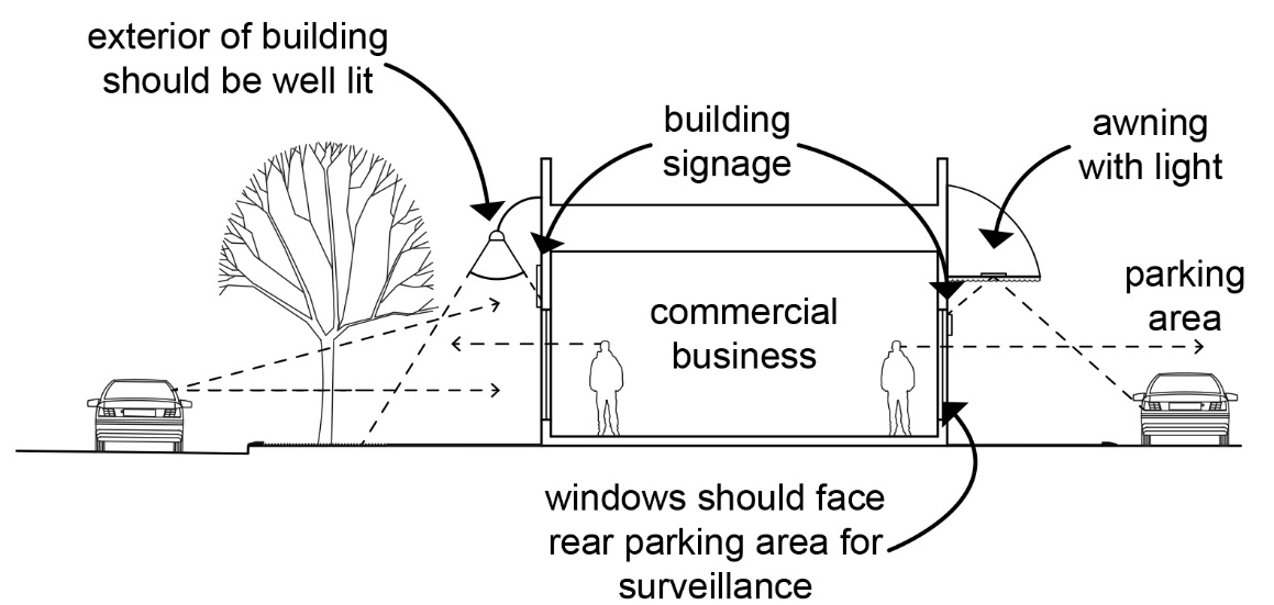
Figure 5-705.C.1.B-2: CPTED: Natural Access Control
Figure 5-705.C.1.B-3: CPTED: Territorial Reinforcement
4.
Climate Responsiveness. The following climate responsiveness standards:
A.
The size, shape, and orientation of a lot and the siting of buildings shall be designed to provide development logically related to trees, topography, solar orientation, and natural features.
B.
Building design and layout shall optimize solar orientation, to the maximum extent practicable. Larger roof overhangs shall provide shade. Porches and glazing adjustments shall provide for filtering sunlight.
C.
To the maximum extent practical, public open space, recreation areas, plazas, and courtyards shall be located to take advantage of solar orientation, provide protection from prevailing wind, and to take advantage of summer shade and winter sunshine.
D.
Along roads, awnings or arcades shall protect pedestrians from natural elements. Awnings and similar overhangs may encroach in rights-of-way as long as a minimum six-foot width of clear sidewalk is maintained and a minimum clear distance of nine feet above the sidewalk is maintained.
E.
The building design and construction shall be cognizant of southwest Florida's unique climate and be ecologically sensitive in use of materials, particularly recyclables, and be respectful of energy demands.
5-706. - Building Design Standards.
A.
Purpose and Intent. The purpose of the building design standards is to supplement other development standards in the LDC with specific building design standards. The intent is to:
1.
Stimulate creative project designs;
2.
Create and maintain a positive ambiance and strong community image and identity in the Village by enhancing the visual appearance of development; and
3.
Provide for design flexibility.
B.
Complementary Design Transitions. Development shall be designed to relate to adjacent structures in a complementary manner. Transitions from adjoining development to the subject site shall be provided by incorporating:
1.
Building massing that relates to the existing adjacent building heights that are in compliance with the requirements of the LDC.
2.
Patterns of roof structures, colors, cornices, and other architectural elements that relate to adjacent buildings that are in compliance with the requirements of the LDC. See Figure 5-706.B: Building Transition.
Figure 5-706.B: Building Transition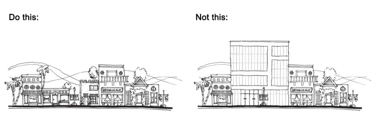
C.
Building Entries and Façades.
1.
The main entrance of the structure shall be oriented toward the public right-of-way on which the structure fronts. On a corner lot or site, the main entrance may be oriented to either the road or the corner.
2.
For compliance with building design standards, exterior façades of out-parcel buildings shall be treated as primary façades and employ architectural, site, and landscaping design elements that are common to the theme used in the main development on site, including colors and materials associated with the main building. The purpose of this requirement is to assure a unified architectural theme and site planning between out-parcels and the main buildings on site, enhance visual impact of the buildings, and provide for safe and convenient vehicular and pedestrian access and movement on site.
3.
For compliance with building design standards, all sides of a building are subject to architectural design elements.
4.
Overhead doors facing a public right-of-way are prohibited.
5.
Blank wall areas shall be interrupted with an opening or relief work including one or more of the following:
A.
Recessed or clearly defined entryways (a minimum of six feet applies to recessing of entryways);
B.
Varying rooflines, pitches, and shapes;
C.
Dormers, balconies, and staircases;
D.
Transparent window or door areas or display windows that provide visibility into the building interior. (No reflective or darkly tinted glass may be used at ground level);
E.
Overhangs, awnings, and marquees;
F.
Building ornamentation and varying building materials, colors, decorative tiles, edifice detail such as trellises, false windows, or recessed panels reminiscent of window, door, or colonnade openings and wall murals;
G.
Shrubs or vines trained to grow upright on wire or trellises next to blank walls;
H.
Architectural features such as cornices, articulated roof parapets, porticos, towers, or other details that alter the building height;
I.
Application of a contrasting base that is a minimum one-foot high and extends along the entire front of the building and at least ten feet along the sides of the building.
6.
Horizontal Plane Offsets
A.
For buildings with a gross ground floor area up to 10,000 square feet, horizontal wall planes shall be interrupted with an offset dimension of at least eight inches to change the horizontal plane at the following maximum intervals: every 40 linear feet for façades facing roads or providing primary entrances, and every 75 linear feet for all other façades.
B.
For buildings with a gross ground floor area between 10,000 and 35,000 square feet, horizontal wall planes shall be interrupted with an offset dimension of at least 16 inches to change the horizontal plane at the following maximum intervals: every 75 linear feet for façades facing roads or providing primary entrances, and every 100 linear feet for all other façades.
C.
For buildings with a gross ground floor area over 35,000 square feet, horizontal wall planes shall be interrupted with an offset dimension of at least two feet to change the horizontal plane at the following maximum intervals: every 100 linear feet for façades facing roads or providing primary entrances, and every 150 linear feet for all other façades.
D.
Exterior Building Color.
1.
Exterior building colors shall be neutral, warm earth tones or subdued pastels. White or gray are prohibited as a predominant color. Where applicable, brightly colored trims, cornices, or columns may be used to create a special effect or setting. However, these contrasts shall create a harmonious impact, complementing the principal structure as well as existing surrounding building structures.
2.
Brighter colors can be utilized to create focal points of interest in locations including on doors, windows, and architectural details.
3.
Buildings shall not exceed three colors on one architectural detail in composite.
4.
Contrasting accent colors of any wall, awning, or other feature shall be limited to no more than ten percent of the total area for any single façade.
E.
Exterior Building Materials.
1.
Exterior building materials contribute significantly to the visual impact of a building on the community. They shall be well-designed and integrated into a comprehensive design style for the project. The following exterior building materials cannot be used on more than ten percent of the building façade area:
A.
Corrugated or reflective metal panels;
B.
Tile (prohibition does not apply to roofs);
C.
Smooth, scored, or rib-faced concrete block;
D.
Any translucent material, other than glass; or
E.
Any combination of the above.
2.
Building trim and accent areas, consistent with the overall building, are limited to ten percent of the affected wall area, with a maximum trim width of 24 inches.
F.
Roof Treatments. Variations in roof lines shall be used to reduce the massing of buildings and to add visual interest. Roof features and materials shall be in scale with the building's mass and complement the character of adjoining and/or adjacent buildings and neighborhoods. The following standards identify appropriate roof treatments and features:
1.
The roof edge and/or parapet shall have a vertical change from the dominant roof condition, in two locations. At least one such change shall be located on a primary façade.
2.
Roofs shall be designed to also meet three or more of the following requirements:
A.
Parapets used to conceal rooftop equipment and flat roofs.
B.
Three or more roof slope planes per primary façade.
C.
Sloping roofs, which do not exceed the average height of the supporting walls, that have an average slope equal to or greater than 4V:12H but not greater than 12V:12H.
D.
Additional vertical roof changes with a minimum change in elevation of two feet (flat roofs shall have a minimum of two changes).
E.
Three-dimensional cornice treatments which are a minimum of ten inches in height with a minimum of three reliefs.
3.
The following roof types and materials are prohibited:
A.
Roofs utilizing less than or equal to a 2V:12H pitch unless utilizing full parapet coverage or mansard;
B.
Mansard roofs, except roofs with a minimum vertical distance of eight feet and an angle between 45 and 70 degrees from horizontal; and
C.
Asphalt shingles, unless utilized in Old Florida style architecture.
G.
Windows.
1.
Windows shall not appear to be false or applied.
2.
Along roads, 60 percent of the nonresidential ground floor façade shall be designed with windows to provide some visual interest for pedestrians and to support the crime prevention principle of eyes on the street.
H.
Awnings.
1.
Awnings and similar overhangs may encroach in rights-of-way as long as a minimum six-foot width of clear sidewalk is maintained and a minimum clear distance of nine feet above the sidewalk is maintained.
2.
The design, materials, and color of the awnings shall complement the architecture of the building and not obscure its features.
3.
Materials shall be durable and weather resistant. Plastic or shiny materials are prohibited. Fabric awnings shall not turn corners and shall be associated with a window, group of windows, or other openings. Fabric awnings shall not exceed 14 inches beyond a window or door in the horizontal direction and three feet in the vertical direction. Fabric awnings are prohibited as roof structures.
4.
Awnings shall be consistent with the visual scale of the building.
5.
Awnings shall be placed at the top of openings. The awning shape shall correspond with the shape at the top of the opening. Flat canopies are discouraged except in circumstances where it is accompanied by a valance. See Figure 5-706.H.5: Awning Placement.
Figure 5-706.H.5: Awning Placement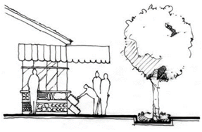
I.
Columns, Posts, and Piers.
1.
Aesthetic details are encouraged to be created using columns, posts, piers, or pillars, where appropriate.
2.
Columns may be either round or square.
3.
All columns shall include a capital and a base.
4.
Column, post, and pier materials shall be durable and weather resistant, and limited to the following:
A.
Wood or wood alternatives;
B.
Stone or faux stone materials;
C.
Stucco;
D.
Precast; or
E.
Any combination of the above.
J.
Lighting.
1.
Building entryways shall be lighted at the pedestrian level, with features such as lighted bollards or doorway lighting.
2.
Light fixtures shall complement the overall development.
3.
Light poles and fixtures should complement the architecture of the development. Except for pedestrian light fixtures, all outdoor light fixtures shall be fully shielded.
4.
Lighting plans shall be coordinated with landscape plans to identify and eliminate potential conflicts with required landscaping.
5.
No light poles shall be located in parking area islands that contain required landscaping.
6.
The following lighting designs are prohibited with the exception that temporary seasonal lighting during the months of November and December is excluded from these prohibitions:
A.
Buildings, awnings, roofs, windows, doors and other elements may not be outlined with light.
B.
Exposed neon or LED tubing.
C.
Backlit awnings.
5-707. - Supplemental Design Standards for Specific Uses.
A.
Purpose. Supplemental design standards for specific uses are implemented to ensure compatibility and minimization of visual intrusion by intense land uses on the Village's less intense land uses.
B.
Parking Garages.
1.
Sixty (60) percent of the primary façade of a parking garage shall incorporate the following:
A.
Transparent windows, with clear or lightly tinted glass, where pedestrian-oriented businesses are located along the façade of the parking structure;
B.
Display windows;
C.
Decorative metal grille-work or similar detailing, which provides texture and partially or fully covers the parking structure openings; or
D.
Vertical trellis or other landscaping or pedestrian plaza area.
2.
Where a proposed parking garage is located on a parcel adjacent to or abutting an existing taller residential development, all exposed parking spaces on the top level of the garage shall provide additional design treatments to obscure view of the spaces from residential use. Design treatments may include, but are not limited to, a combination of landscaped trellises, opaque covers, and permanent landscaping. In addition, surfaces of exposed parking aisles and drives shall be comprised of specialty pavers or colored stamped concrete having a nonreflective matte surface.
C.
Rooftop Mechanical Equipment and Other Utilities. Rooftop mechanical equipment shall be shielded from view at ground level by parapet or similar architectural features.
D.
Automobile Service Station and Convenience Food and Beverage Stores.
1.
The high levels of traffic, glare, and intensity of activity associated with automobile service stations and convenience food and beverage stores are incompatible with surrounding uses. Therefore, in the interest of protecting the health, safety, and general welfare of the public, all automobile service stations and convenience food and beverage stores shall comply with the following standards.
A.
Minimum lot frontage: 150 feet of frontage on a vehicular right-of-way.
B.
Minimum lot depth: 180 feet.
C.
Minimum lot or parcel area: 30,000 square feet.
D.
There shall be a minimum distance of 500 feet between the nearest points on any lot or parcel of land to be occupied by automobile service stations, and any lot or parcel for such use already occupied by an automobile service station, or for which a building permit has been issued, unless waived by the Director in accordance with subsection 11 below.
2.
All automobile service station and convenience food and beverage store structures shall comply with the following minimum setbacks.
A.
Front yard: 50 feet.
B.
Side yard: 40 feet.
C.
Rear yard: 40 feet.
3.
Landscaping buffers shall comply with Sec. 5-412.C.3, Automobile Service Stations and Convenience Food and Beverage Store Selling Gas.
4.
An eight-foot high enclosed trash area shall be integrated within the design of the service station or convenience food and beverage store.
5.
Motor vehicle fuel storage tanks shall be located below grade.
6.
Canopies.
A.
Flat roof canopies are prohibited. Roofs shall have at least two slopes on the long sides and a roof detail change a minimum of every 50 feet.
B.
Canopies shall be consistent with the architectural design and features of the principal structure.
C.
Canopy lighting shall comply with Sec. 5-605.E, Canopy.
7.
Colors on Buildings and Canopies. The color of all structures on site shall be of soft earth tones or pastels. Canopies shall be of one color, consistent with the predominant color of the principal structure, if a canopy is utilized in building design. Color accent banding on fuel pump canopy structures and all other structures is prohibited.
8.
Outside display or storage of products is prohibited.
9.
Each automobile service station shall provide the necessary infrastructure and pre-wiring to provide the capability for generator service in case of emergencies.
10.
No automobile service station shall have an entrance or exit for vehicles within 200 feet, along the same side of a street, as a school, public playground, child care center, church, hospital, or public library.
11.
The Director may grant a waiver of part or all of the minimum separation requirements set forth in subsection 1.D above if it is demonstrated by the applicant that the site proposed for development is separated from another automobile service station by natural or manmade boundaries, structures, or other features that offset or limit the necessity for such minimum distance requirements. The Director's decision to waive part or all of the distance requirements shall be based, in part, upon whether or not the nature and type of natural or manmade boundary, structure, or other feature lying between the proposed establishment and an existing automobile service station lessens the impact of the proposed automobile service station. Such boundary, structure, or other feature may include, but is not limited to, lakes, marshes, nondevelopable wetlands, designated preserve areas, canals, or a minimum of a four-lane arterial or collector right-of-way.
E.
Fast Food Restaurants and Car Washes.
1.
All stand-alone or accessory fast-food restaurants and car washes shall comply with the following standards.
A.
Minimum lot frontage: 150 feet of frontage on a vehicular right-of-way.
B.
Minimum lot depth: 150 feet.
C.
Minimum lot or parcel area: 25,000 square feet.
2.
All structures shall comply with the following minimum setbacks.
A.
Front yard: 50 feet.
B.
Side yard: 15 feet.
C.
Rear yard: 20 feet.
3.
Canopies.
A.
Flat-roof canopies are prohibited. Canopies shall be consistent with the architectural design and features of the principal structure.
B.
Canopy lighting shall comply with the requirements of Sec. 5-605.E, Canopy.
C.
Canopies shall be of one color, consistent with the predominant color of the principal structure.
4.
Accent Banding. Color accent banding on all structures, including canopies, is prohibited.
F.
Big Box Commercial.
1.
Applicability. Big box commercial means a single-use retailer with gross ground floor area of more than 50,000 square feet, or a multi-use development with gross ground floor area of more than 100,000 square feet, excluding outparcel development.
2.
Location.
A.
Big box commercial is prohibited adjacent to residentially developed property or a zoning district that allows residential uses.
B.
To the extent possible, big box commercial buildings shall be placed in a location that will satisfy functional needs while providing and being aesthetically pleasing for the community, the site, and the developer/retailer. See Figure 5-707.F.2: Big Box Placement Example.
Figure 5-707.F.2: Big Box Placement Example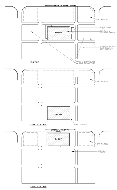
3.
Big Box Commercial Liner Buildings.
A.
Big box commercial buildings shall provide liner buildings along all primary façades and on a minimum of two sides of the building. See Figure 5-707.F.3: Liner Building Example.
Figure 5-707.F.3: Liner Building Example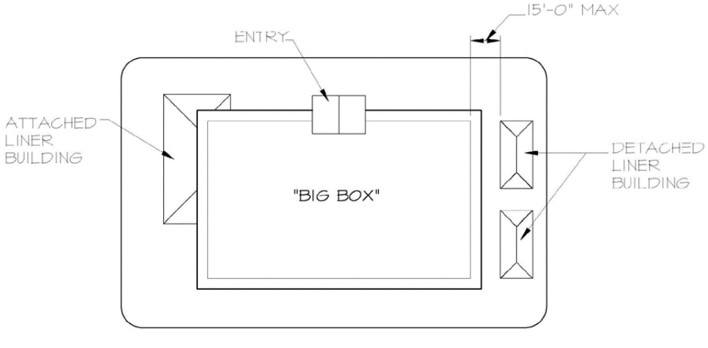
B.
The purpose of liner buildings is to break the big box commercial building down into smaller massing elements and conceal any blank walls or façades of the large retail structure while creating scale and architectural character.
C.
Liner buildings may be placed on any side of the building, but shall be placed along all walls of big box commercial buildings that face public rights-of-way (see Figure 5-707.F.3: Liner Building Example). Liner buildings shall be utilized on a minimum of two sides of each building larger than 50,000 square feet.
D.
Liner buildings shall cover a minimum of 40 percent of the primary building façade.
E.
The roof height of a liner structure shall be at least five feet lower or higher than the roof of the related big box commercial building.
F.
A liner building shall be designed to be complementary to the approved design standards for the project and shall include along its façade a minimum of 15 percent and a maximum of 75 percent glazing.
G.
Liner buildings may be used by a separate tenant or may be integrated for use by the associated big box user.
4.
Big Box Commercial Outparcels.
A.
Outparcels shall be placed to frame commercial road corridors, creating grand boulevards.
B.
Projects that exceed 50,000 square feet of retail floor area shall provide a berm or an outparcel pad along collector and arterial roads, with the majority of the parking located behind the building or berm. The berm shall be an average of four feet high and 30 feet wide for 75 percent of the public right-of-way that does not possess an outparcel pad. The berm shall have a minimum of ten trees per 100 linear feet, with a double hedge row. All plantings shall meet standard sizes as required in Section 5-4, Landscape Standards.
C.
Outparcels may be developed along internal access drive locations provided the majority of the parking is not placed along arterial or collector roadways. See Figure 5-707.F: Outparcel Placement Example.
Figure 5-707.F.4: Outparcel Placement Example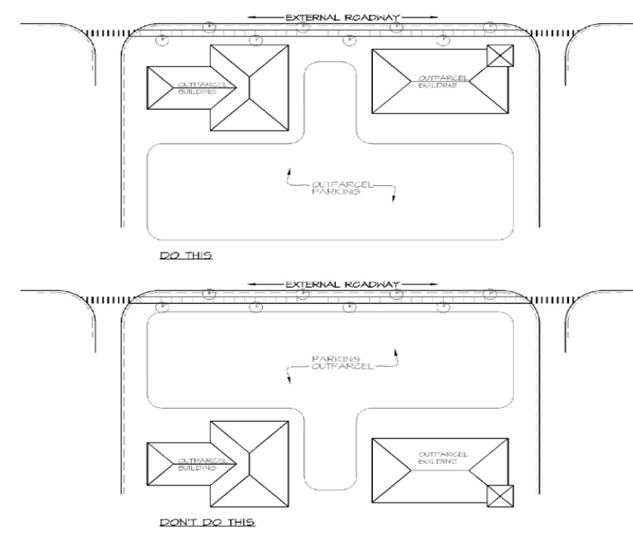
5.
Big Box Commercial Access.
A.
To the maximum extent practicable, access to, from, and within the big box commercial project shall be designed to create:
1.
A safe and memorable environment for vehicular and pedestrian access to and from the site;
2.
A minimal number of curb cuts on the major arterial roads by providing shared access to adjacent properties; and
3.
Convenient, safe, and attractive access around the project for vehicular and pedestrian movement.
B.
Internal access drives/roads to the property shall be developed at minimum intervals of 250 feet and maximum intervals of 1,400 feet in length, creating internal blocks for parking and buildings.
C.
Internal access shall be developed to encourage and support roads with sidewalks and trees, with an average tree separation of 30 feet and a 15-foot wide planting strip with a combination of plants and grass along the road/parking/building edge. The planting in these areas shall not contain more than 30 percent grass.
D.
Internal lanes shall be no less than ten feet in width for each lane.
E.
Street and sidewalk accesses shall be provided up to adjacent properties for future connectivity where not prohibited. The developer may provide an easement agreement in-lieu of the physical interconnection when no development is planned on an adjacent parcel.
F.
Landscaped pedestrian sidewalks shall be provided along the sides of large buildings with adjacent parking lots.
G.
All roads shall terminate at other roads, future roads, or a parking area. Cul-de-sacs or dead-end roads are to be avoided, to the maximum extent practicable.
H.
After 700 linear feet of roadway, five degrees (in plan) deflection or a landscaped median strip (minimum ten feet by 18 feet) shall be designed into the road for traffic calming purposes.
I.
On-street parking is encouraged on internal access roads where a "main street" type of development is desired. For the purposes of this subsection, "main street development" is defined as development where sidewalks and buildings or public spaces (excluding parking lots) are planned for the majority of both sides of the road.
J.
Internal road medians are encouraged. Median widths shall be a minimum of six feet and a maximum of 15 feet in width.
K.
Sidewalks (minimum five feet wide) shall be constructed on at least one side of all internal road or vehicular access areas (exclusive of parking lanes). In the alternative, walkways may be developed through the landscaped median areas, to facilitate access from the sidewalks along the rights-of way, provided the medians are increased by five feet to accommodate the walkway.
L.
Sidewalks along buildings shall be a minimum of eight feet in width, excluding landscaping.
M.
Each building shall be interconnected via a pedestrian pathway.
N.
Development shall be coordinated with LeeTran where transit access is to be provided to the area.
6.
Big Box Commercial Parking.
A.
The site shall be developed to create attractive parking areas that provide convenient and safe multimodal movement of vehicular, public transportation, bicycles, and pedestrian traffic.
B.
Parking areas shall be developed into parking pods that do not exceed 120 parking spaces, have a maximum of four entry/exit points, and are separated by a continuous double row hedge and large canopy trees at 30 feet on center.
C.
Parking areas shall provide landscaped islands in accordance with Sec. 5-409, Landscaping of Parking Areas, and Vehicular Access.
D.
Parking shall be distributed on three sides of the big box retail building and away from loading areas. Peak and employee parking areas shall be located on the sides of the building.
E.
All parking areas shall be interconnected.
F.
As an alternative to the parking pod set forth in this subsection, parking areas shall have a Type D buffer separating every four rows of parking, provided the big box building is screened by an outparcel buffer.
G.
The number of parking spaces developed as part of the big box development may not exceed the number of spaces required by Sec. 5-204.B.1, Minimum Number of Off-Street Parking Spaces, unless the increase complies with one of the following:
1.
Up to a 20 percent increase in parking spaces may be granted by the Director if:
(a)
Parking pods are used for all parking on the project site; or
(b)
All landscaping trees are increased to a minimum of 14 feet, 65-gallon, with a six-foot spread with a four-inch caliper at the time of planting.
2.
A parking space increase over 20 percent may be granted by the Director if the number of required trees is increased by 25 percent.
7.
Big Box Commercial Open Space.
A.
To the extent possible, big box commercial development shall be designed to manage open space for public benefit through combining a portion of the required open space into a usable component of the retail center.
B.
A minimum of ten percent of the required open space shall be aggregated together into a usable format called "open space squares." Retail is encouraged to develop around these squares, when possible.
C.
Open space squares shall be a minimum of 30 feet and a maximum of 65 feet wide.
D.
Open space squares shall be integrated into the site plan as either passive or active spaces.
E.
Open space squares may be interconnected to form a series of usable spaces for the project.
F.
Open space squares shall be counted towards open space requirements.
8.
Big Box Commercial Service and Loading Areas.
A.
To the maximum extent practicable, loading areas shall be designed to diminish both the visual and noise pollution that these facilities can create.
B.
Loading areas shall either be located out of view from all public roads, or adequately screened.
C.
When a loading area is facing a public right-of-way, a ten-foot high architecturally screened wall shall be provided on a four-foot berm located within a 25-foot landscaped buffer. Berm and wall breaks are required every 200 feet in order to diminish the height and length of the wall and berm.
9.
Big Box Commercial Shopping Cart Storage.
A.
To the extent possible, shopping cart storage shall be concealed from public view.
B.
Storage of carts shall be behind a wall or landscaped area with 80 percent opaqueness at planting.
C.
Temporary cart storage in the parking area shall be between two landscaped islands with a double row hedge and two trees.
10.
Big Box Commercial Building Design.
A.
To the extent possible, big box projects shall be designed to create buildings that respect the area in which they are located and create a place that is attractive and flexible over time.
B.
Unified Massing, Details, and Material. All buildings within the big box project shall be developed with similar design treatment to create unity among the elements and buildings. This may include, but is not limited to, exterior materials, roof pitches and treatments, colors, proportions, ornamentation, and trim in accord with the design standards for the development.
C.
If the primary entry does not face a public right-of-way, then additional design elements shall be added to create the appearance of a public entry. See Figure 5-707.F.10.C: Entry Placement Diagram.
Figure 5-707.F.10.C: Entry Placement Diagram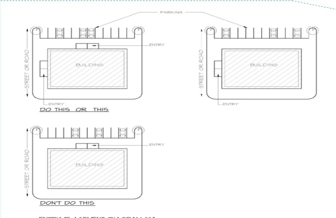
11.
Big Box Commercial Building Façade.
A.
The treatment of the front façade shall be continued, in its major features, around all sides of the building. Features shall be carried for a minimum of 15 percent of the nonprimary façade and be attached to the primary façade.
B.
Individual or individual looking exterior façades shall be faced with no more than four cladding materials. These cladding materials shall be combined on the façade in a horizontal manner only (i.e., base of building: one material; middle area: another material; and the top portion: a third type of material).
C.
Metal sided buildings are not permitted except as an accent material that does not exceed ten percent of the building façade.
D.
The ground floor of all building façades facing a public right-of-way shall be detailed and glazed as storefronts.
E.
Storefronts shall have glazed areas equal to at least 15 percent and not more than 75 percent of the ground level portion of the façade when facing a public right-of-way.
F.
Primary and secondary colors on the exterior of buildings shall be restricted to a minimum of two inches for their shortest dimension. See Figure 5-707.F.11.G: Primary and Secondary Accent Colors Diagram.
G.
Outdoor sales areas shall be designed with similar details, colors, and materials used in the primary façades of the building to which the outdoor sales area is attached.
Figure 5-707.F.11.G: Primary and Secondary Accent Colors Diagram
12.
Big Box Commercial Windows, Doors, and Other Openings.
A.
Openings. Windows, doors, arcades, and other openings in the façade shall be squared or vertical in proportion. Arched windows may be approved by the Director as a window or door type if they are square or vertical in their overall proportions. See Figure 5-707.F.12.A: Window Proportions.
Figure 5-707.F.12.A: Window Proportions
B.
Windows and Doors.
1.
"Non-motorized" sliding glass doors and sliding windows are prohibited at ground level.
2.
Glass may only be clear or lightly tinted.
3.
Shutters shall be sized and shaped to match the opening to which they are attached.
C.
Awnings.
1.
Awnings shall not have a bottom soffit panel or be backlit.
2.
Awnings shall be sized to match the window or door openings to which they correspond, and shall not extend more than two feet on either side of the opening.
3.
Awnings shall not be used at the corner of buildings to transition from one façade to the next.
13.
Big Box Commercial Roofs.
A.
Pitched Roof. All roofs shall be pitched between 30 degrees and 8:12 (unless flat). Ancillary roof structures may be flat or pitched between 30 degrees and 12:12.
B.
Flat Roof. Flat roofs shall have a full parapet at the perimeter of the roof. The parapet shall not be less than 24 inches or exceed 15 feet in height. The height will be measured from the deck of the flat roof to the highest point of the parapet, with the exception of non-habitable architectural elements.
C.
Roof Changes. Roof changes shall occur at a minimum of one per 15,000 square feet, with a minimum of three for any building.
14.
Big Box Commercial Walls and Fences.
A.
Walls and fences shall be designed to be complementary to the main façade elements of the building.
B.
Fences, when not associated within a landscaped double row hedge, shall be solid.
C.
Wall runs shall not exceed 100 feet in length without a horizontal change of three feet.
15.
Big Box Commercial Service Areas. Service function areas, including rooftop or ground equipment and dumpster areas, shall be fully screened and out of public view from ground level.
5-801.- Purpose and Intent.
The purpose of this section is to ensure development in the Village includes a minimum degree of green building features as a means of protecting and conserving resources and reducing greenhouse gas emissions by:
A.
Conserving energy;
B.
Promoting the use of alternative energy;
C.
Conserving water resources;
D.
Protecting water quality;
E.
Supporting walkable urbanism;
F.
Supporting a variety of mobility options;
G.
Promoting a healthy landscape;
H.
Supporting urban agriculture;
I.
Encouraging innovative, environmentally friendly building practices;
J.
Reducing landfill waste; and
K.
Promoting healthy and active lifestyles.
5-802. - Applicability.
A.
Unless exempted in accordance with subsection B below, the standards of this section shall apply to all new development.
B.
The following are exempt from the standards of this section:
1.
Residential development that contains fewer than six dwelling units;
2.
Nonresidential development with a gross floor area of less than 8,000 square feet;
3.
Buildings that have achieved requirements necessary to receive certification from the U.S. Green Building Council at the LEED® Gold level or above, or an equivalent level of development performance under an alternative rating system such as the National Green Building Standard™/NGBS Green or the International Code Council's International Green Construction Code, as determined by the Director; and
4.
Remodels, alterations, or expansions of an existing building.
5-803. - Green Building Standards.
A.
Minimum Amount of Points Required. Development subject to the standards of this section shall achieve the following minimum number of points from the menu of options shown in Table 5-803.B: Green Building Point System.
1.
Minimum Requirements for Residential Development.
A.
6 to 29 units: 3 points.
B.
30 or more units: 4 points.
2.
Minimum Requirements for Nonresidential Development.
A.
8,000 to 25,000 square feet: 3 points.
B.
More than 25,000 square feet: 4 points.
B.
Green Building Point System. Development subject to the standards of this section shall use Table 5-803.B: Green Building Point System, to determine compliance with this section.
C.
Documentation Required. Applicants shall provide documentation of techniques that will be used to satisfy the green building standards of this section at the time of submittal of a development application. Documentation for items that may not be visually verified as part of an inspection may be provided in the form of invoices, receipts, or delivery confirmation for the items in question.
5-804. - Failure to Install or Maintain Green Building Elements for Compliance.
Failure to install or maintain approved green building elements that are to be provided to comply with this section is a violation of this LDC, and may result in revocation of the development approval or permit.
5-901.- Purpose and Intent.
A.
The purpose of this section is to provide for the proper and orderly subdivision and recording of plats in compliance with the site development and dimensional standards in this LDC, and applicable state law.
5-902. - Applicability.
A.
The standards of this section apply to all development in the Village, unless exempted in accordance with subsection B below. All development subject to the requirements of this section shall receive approval of a plat prior to the sale, conveyance, or transfer of land.
B.
The following are exempt from the standards of this section.
1.
A development platted or approved by Lee County prior to January 28, 1983, provided that all required improvements are made, or that a security for the performance of the improvements has been posted and is current.
2.
The division of land for the conveyance of land to a federal, state, county, or Village entity, or a public utility.
3.
The division of land by judicial decree.
4.
A division of land of two or fewer lots out of a parent parcel approved in accordance with Sec. 2-502.B, Limited Development Order.
5-903. - Plat Standards.
A.
All land subject to this section shall be subdivided, and have a plat of the entire parcel of land that complies with F.S. ch. 177 pt. I, Platting, and the Administrative Manual. The subdivision plat shall be recorded in the official records of Lee County, prior to the approval of a building permit. Review copies of the plat shall be submitted with a development order or limited development order application, as applicable.
B.
The initial plat submittal shall include a boundary survey of the lands to be platted, in accordance with F.S. § 177.041.
C.
Plats are not required for an initial lot split granted as part of a Type E Limited Development Order (see Sec. 2-502.B, Limited Development Order) However, if, subsequent to an initial lot split, an additional lot split is requested, and that lot split results in the creation of more than four lots out of the original parent parcel as the parent parcel existed on January 28, 1983, then a plat in accordance with subsection A above is required.
D.
A building permit may be issued for model buildings and sales centers prior to recording of the plat, if evidence of unified control is provided and any certificate of occupancy issued for the development is only for model buildings or sales use, until the plat is recorded.
E.
Where a division of land will result in the creation of three or more lots out of a parent parcel that existed on January 28, 1983, where the lots did not previously require a plat:
1.
The plat required as a result of the additional lot split shall include all lots that were part of the parent parcel as it existed on January 28, 1983. However, if all parcels are not under common ownership with the parcel subject to the additional lot split, the applicant shall provide proof that the applicant made a bona fide, good faith effort to request, by certified mail, return receipt requested, that the property owners of lots not under common ownership be included in the plat, and those property owners refused to consent to the plat, or the current property owner failed to respond to the applicant's request after a reasonable time for a response.
2.
Where a property owners' association covering portions of the parent parcel has been formed to provide for the maintenance of common infrastructure, the owners of the lot to be created shall provide documentation consenting to become a member of the association.
3.
All platted parcels, including residual parcels, shall conform to the minimum regulations and requirements of this LDC for the zoning district in which the parcel is located.
5-904. - Lot Standards.
A.
General. The dimensions and area of a lot shall comply with the minimum requirements of the zoning district in which it is located in accordance with Chapter 3: Zoning Districts.
B.
Double Frontage Lots. Double frontage lots shall be permitted only where necessary to separate a development from an arterial or collector street or to overcome a disadvantage of topography and orientation.
C.
Lot Lines. Side lot lines shall be, as nearly as practical, at right angles to straight street lines and radial to curve street lines. Side lot lines and rear lot lines shall, where practical, consist of a straight line segment (this provision shall not apply to new platted lots). The Director may waive or modify this standard upon a showing of good cause, including, but not limited to, the following factors:
1.
Unusual size or shape;
2.
The size of lots;
3.
Existing ownership and development patterns;
4.
The location of existing structures on the lot(s); and
5.
Natural or man-made site features.
5-905. - Monuments.
A.
Permanent Reference Monuments (PRMs).
1.
Permanent reference monuments (PRMs) shall be placed as required by F.S. ch. 177, and approved by a licensed, registered state professional land surveyor on the boundary of all development.
2.
PRMs shall be set in the ground so that the top is flush or no more than one-half foot below the existing ground. Subsurface PRMs shall be exposed for inspection when a plat is submitted for review. If development of the subdivision occurs after a plat is reviewed, the PRMs shall be raised or lowered to be flush or no more than one-half foot below the finished ground. Subsurface PRMs shall be exposed for inspection at the time of final inspection of the development.
B.
Permanent Control Points (PCPs). Permanent control points (PCPs) shall be installed in accordance with F.S. ch. 177. When a plat is recorded prior to construction of the subdivision improvements, the PCPs shall be set following completion of construction. The surveyor shall certify that the PCPs are set, shall record the certification in the official record books of Lee County, and shall provide proof of recordation to the Village.
C.
Monuments. Monuments shall be installed in accordance with F.S. § 177.091(9).
5-906. - Lot Recombination.
The Director may approve the combination or recombination of platted lots of record created through a plat recorded in the official records of Lee County, provided the density established through the original plat is not increased and the resulting lots comply with all applicable requirements of this LDC.
A.
Application. The application for a lot recombination shall be made in writing on the form provided by the Director. The application shall include:
1.
A copy of the plat book and page, if applicable;
2.
Copies of the most recent deeds for all of the affected lots;
3.
Copies of the deeds establishing that the lots are lots of record, if the lots are unplatted;
4.
A statement signed by the applicant, under oath, stating the applicant is the owner or the authorized representative of the owner of the property and has authority to process the application on behalf of the owner;
5.
An area location map;
6.
A survey sketch showing the existing and proposed lot lines and the existing and proposed legal descriptions of the affected lots; and
7.
A written explanation of the reasons for the request.
B.
Relocation of Easements. All easements that are affected by a proposed lot recombination shall be vacated and relocated, if applicable, in accordance with state law.
C.
Not a Division. The combination of two or more lots of record into one lot is not a "division," and is not subject to the approval process described in this section. However, any easements that are affected by a lot combination shall be vacated and relocated, if applicable, in accordance with state law.
5-907. - Street Names.
Street names shall not be used which will duplicate or be confused with the names of existing streets. New streets that are an extension of or in alignment with existing streets shall bear the same name as the existing streets. All courts and circles shall have one name only. All proposed street names shall be approved in writing by Lee County E911 Addressing and the Director and be indicated on the plat, if any, and on the site plan.
5-1001.- General Standards.
A.
Development shall be designed to provide sufficient potable water and sanitary sewage services to prevent potential hazards to the health, safety, and welfare of the public, in accordance with the requirements of this section.
B.
Where a development is not required to connect a potable water system operated by a potable water utility in accordance with Sec. 5-1002, Potable Water Systems, or is not required to connect to a sanitary sewer service operated by a sewer utility in accordance with Sec. 5-1003, Sewer Systems, the water and sewage systems proposed to serve that development must be of sufficient capacity for the intended initial uses, and provisions must be made for expansion, increased capacity, and extensions for any future uses through appropriate and binding legal commitments, including the commitment to connect to a central system at such time as it is created or extended to the development in accordance with this section.
C.
Public water systems and public sewage systems shall be designed and constructed in accordance with Village, state, and federal standards, including the domestic requirements established by the appropriate state agency and the fire protection requirements established by the Uniform Fire Code (Sec. 6-551 et seq., Code of Ordinances), which is incorporated herein by reference. Public water systems and public sewage systems shall also be designed to the standard specifications and other requirements of the franchised utility provider which will provide service.
D.
A public sewage system, which shall be designed by a Florida licensed engineer, shall be designed, constructed, and maintained so it does not adversely affect the water quality of any existing stream, lake, or underground aquifer.
E.
No development order or limited development order, as appropriate, shall be issued for any development until provisions for sanitary sewage disposal and potable water service are made that satisfy the requirements of this section and the Florida Department of Health (FDOH) and the Florida Department of Environmental Protection (FDEP), as applicable.
F.
Sewage systems and potable water systems shall comply with the following general location and installation standards:
1.
All treatment facilities shall be located and constructed to minimize noise, odor, and other effects and impacts on the public health, safety, and welfare.
2.
All aboveground or partially aboveground facilities (active or passive) shall be set back at least 100 feet from any perimeter property line.
3.
Belowground disposal facilities (drainfields, mound drainfields, injection wells, etc.) shall be set back at least 50 feet from the nearest residential lot.
4.
The location of all facilities shall be in accordance with all applicable Village, state, and federal regulations.
5-1002. - Potable Water Systems.
A.
Connections Required.
1.
The following types of developments, when located within the boundaries of a certificated or franchised service area of any potable water utility, or within the County utilities' future water service areas as delineated on Map 6 in the Lee Plan, shall connect to that respective potable water system:
A.
Any residential development that exceeds 2.5 dwelling units per gross acre, except for a development that contains fewer than ten dwelling units in any phase or combination of phases located more than one-quarter mile from a point of connection;
B.
Any commercial or industrial development that exceeds 30,000 square feet of gross floor area or that will use more than 5,000 gallons per day of water;
C.
Any commercial or industrial development that will use more than 1,000 gallons per day of water that is located within 50 feet of a connection point, as measured from the property line;
D.
Any commercial or industrial subdivision consisting of more than five lots located less than one-quarter mile from a point of connection; and
E.
Any residential, commercial, or industrial development of any size where central water lines are or will be located in a public right-of-way or easement adjacent to any portion of the property and are made available for connection within 90 days of the issuance of the development order or limited development order, as appropriate.
2.
The provisions of this subsection become effective for each investor-owned utility upon the execution of an agreement with the Village demonstrating the availability of an equitable program of rebatable agreements.
B.
Private Systems. If the proposed development is not required to connect to a potable water system in accordance with subsection A above:
1.
A development order, limited development order, or plat, as appropriate, may be issued upon satisfactory documentation that the development will itself provide water service in accordance with the regulations of the FDOH, the FDEP, and the SFWMD.
2.
It is agreed that the private system approved under subsection 1 above shall be removed or abated, and connection to the public potable water system shall be made within 90 days from the date the public utility provides written notice to the property owner that potable water service is installed in a public right-of-way or easement adjacent to any portion of the property at the boundary of the development, is available for connection, and that connection is mandatory. An appropriate bond or equivalent security may, at the utility's option, be tendered to the affected utility to ensure compliance; and
3.
The private water system shall comply with Ch. 64E-8, F.A.C.
5-1003. - Sewer Systems.
A.
Connections Required.
1.
The following types of developments, when located within the boundaries of the certificated or franchised service area of any sewer utility, or within the County utilities' future sewer service areas as delineated on Map 7 in the Lee Plan, shall connect to that respective sewer system:
A.
Any residential development that exceeds 2.5 dwelling units per gross acre, except for a development that contains fewer than ten dwelling units in any phase or combination of phases located more than one-quarter mile from a point of connection;
B.
Any commercial or industrial development that exceeds 30,000 square feet of gross floor area or that will generate more than 5,000 gallons per day of sewage;
C.
Any commercial or industrial development that will generate more than 1,000 gallons per day of sewage that is located within 50 feet of a connection point, as measured from the property line;
D.
Any commercial or industrial subdivision consisting of more than five lots located less than one-quarter mile from a point of connection; and
E.
Any residential, commercial, or industrial development of any size where central sewer lines are or will be located in a public right-of-way or easement adjacent to any portion of the property and made available for connection within 90 days of the issuance of the development order or limited development order, as appropriate.
2.
The provisions of this subsection become effective for each investor-owned utility upon the execution of an agreement with the Village demonstrating the availability of an equitable program of rebatable agreements.
B.
Private Systems. If the proposed development is not required to connect to a sewer system in accordance with subsection A above:
1.
A development order, limited development order, or plat, as appropriate, may be issued upon satisfactory documentation that the development will itself provide sanitary sewer service in accordance with the requirements of the FDEP, or on-site sewage disposal in accordance with the requirements of the FDOH.
2.
It is agreed that the private system approved under subsection 1 above shall be removed or abated and connection to the utility shall be made within 90 days from the date the utility provides written notice to the property owner that sanitary sewer service is installed in a public right-of-way or easement adjacent to any portion of the property at the boundary of the development, is available for connection, and that connection is mandatory. An appropriate bond or equivalent security may, at the utility's option, be tendered to the affected utility to ensure compliance.
3.
The private sewage disposal system shall comply with Ch. 64E-6, F.A.C.
5-1004. - Reuse Water Systems.
A.
Wherever technically feasible, the irrigation of grassed or landscaped areas shall be provided for through the use of a second water distribution system supplying treated wastewater effluent or reuse water. This reuse water system shall be separate and distinct from the potable water distribution system and shall be constructed and operated in accordance with the rules of FDEP and Ch. 62-610, F.A.C.
B.
Use of Reuse Water.
1.
A proposed development shall be designed to maximize the use of reuse water if the following conditions are met:
A.
The proposed development is located in the franchised or certified service area of a sanitary sewer utility, or within the Village's or County's future sanitary sewer service area;
B.
The sanitary sewer utility is able to supply reuse water;
C.
The reuse water supplied by the sanitary sewer utility is of a quality and quantity commensurate with the irrigation needs of the proposed development; and
D.
The nearest property line of the development is located within one-quarter mile of the reuse distribution system.
2.
Any proposed development which is planned to rely on a private on-site wastewater treatment facility and whose design average daily flow is 100,000 gallons per day or more shall be designed to maximize the use of reuse water from the on-site wastewater plant.
3.
Reuse water may also be utilized for all uses permitted under state law.
5-1005. - Easements.
A.
General standards.
1.
Water Distribution and Sewer Collection Lines
A.
Water distribution and sewage collection lines shall not be installed under the paved traveled way of any arterial or collector street unless it is necessary that the lines cross under the street. Unless otherwise permitted by the Village, water distribution and sewage collection lines that cross under arterial or collector streets shall be installed perpendicular to the street and shall comply with the requirements of the Lee County Administrative Code for utility construction activities in either County-owned or County-maintained or Village-owned or Village-maintained street and drainage rights-of-way and easements. Water distribution lines and sewage collection lines shall not be installed in street rights-of-way or roadway easements unless the installation does not interfere with the ultimate cross section of the roadway and drainage within the right-of-way. Water distribution lines shall be located to accommodate future expansion of arterial and collector streets. For all new local streets or accessways in proposed developments, a minimum ten-foot-wide utility easement shall be provided on both sides of those streets or accessways; actual width shall be determined on a case-by-case basis so as to be accommodated within the utility easements.
B.
Water distribution lines shall be installed at the edge of the street right-of-way or street easement or outside of the right-of-way if the water distribution line will conflict with the ultimate cross section of the street.
C.
Sewage collection lines may be installed under the traveled way of local streets. Sewage collection lines shall be installed at the edge of street rights-of-way for arterial or collector streets or outside of the right-of-way if the sewage collection lines will conflict with the ultimate cross section of arterial or collector streets.
2.
Utility easements shall be shown on the approved development order or limited development order, as appropriate, and power lines, telephone lines, television lines, and gas lines shall be installed within the easements. Water distribution lines and sewage collection lines shall be installed within the right-of-way or within the easements as noted in subsection 1 above.
B.
Extension of Existing Utilities. The extension of existing utilities shall be in accordance with the prevailing conditions as they exist, provided no conflict is created after consideration is given to the ultimate cross section of the roadway and drainage within the right-of-way as determined by the Director. For new developments, where no physical or design conflict would be created, and where it is not prohibited by the regulations of FDOT, the Lee County Department of Transportation, FDEP, or FDOH, potable water mains shall be located on the north and west sides of the right-of-way or roadway, and sanitary sewer gravity or pressure lines, force mains, and reuse water distribution mains shall be on the side opposite that in which potable water is installed. An illustrative cross-section is included in Appendix D, Section I, Utility Placement in Local Roads. If it is determined after consultation with the Director that a conflict with the ultimate cross section is created by the utility, then the proposed utility extensions shall be offset to an easement that is not within the right-of-way when the proposed extension is to be constructed.
1.
Easements.
A.
Easements along rear lot line. When a utility company requests a utility easement along rear lot lines, the easement shall be 16 feet in width and shall be centered on the rear lot line through any block where lots are back to back, or eight feet in width where the adjacent land is vacant or subdivided, or ten feet in width and adjacent to the rear lot line when the adjacent property is a street right-of-way or street.
B.
Easements along side lot line. When a utility company requests a utility easement along a side lot line, the easement shall be a minimum of 12 feet in width and shall be centered on the lot line.
C.
Easements along drainage easement. When a utility company requests a utility easement along a side or rear lot line and there is to be a drainage easement along that lot line, the utility easement shall be provided adjacent to, and in addition to, the drainage easement.
2.
Reduction or waiver of requirements. The width of the utility easements otherwise specified in this section may be reduced, or the requirement for the utility easements may be eliminated, or the number and location of the utility easements may be reduced or modified, if all of the applicable utility companies state, in writing, that the easement may be eliminated or reduced in width. This reduction or waiver of the utility easement requirements may only be addressed at time of approval of a development order, limited development order or plat, as applicable.
5-1006. - Maintenance and Operation.
A.
Where the developer provides a public water or sewage system, the treatment plants, lines, and all other appurtenances shall be maintained and operated through a covenant which runs with the land, in the form of, but not limited to, deed restrictions, a homeowners' or condominium association, or such other legal mechanisms as will assure the beneficiaries of the service that the plant will be continually operated and maintained. Such operation and maintenance shall be in accordance with the rules and regulations of FDEP.
B.
Regardless of the method chosen to provide for the continual maintenance and operation of the plant, the beneficiaries of the service shall be provided with a legal right to enforce this assurance that the plant shall be continually operated and maintained.
5-1007. - Inspection.
A.
The Director shall periodically inspect all construction of water and sewage systems, including systems not to be dedicated to the public.
B.
The Director shall immediately call to the attention of the developer and the developer's engineer any failure of work or material.
C.
The Village Council, at the recommendation of the Director, may suspend work that is not in conformity with approved plans and specifications, and shall require inspections, as necessary.
D.
After required improvements have been installed, the developer's engineer shall be required to submit certification, including as-built drawings, to the Village that the improvements have been constructed substantially according to approved plans and specifications.
E.
Approval of completed water and sewage system improvements shall be given in writing by the franchiser to the Director.
5-1008. - Piping Materials.
Approved utility piping materials for use in rights-of-way are identified in Appendix E: Piping Materials.
5-1101.- General Standards.
All development shall include an adequate fire protection system. Fire protection systems and public water systems shall be designed by a Florida Registered Engineer and constructed in accordance with Village, state, and federal standards, including the domestic requirements established by the appropriate state agency and the fire protection requirements established by the Florida Prevention Fire Code.
5-1102. - Applicability and Interpretation.
A.
The provisions of this section apply to all development within the Village.
B.
Formal interpretations on water supplies and fire department access shall be made by the Director in consultation with the appropriate Fire Marshal.
5-1103. - Minimum Standards for All Developments.
A.
Fire Department Access. Suitable Fire Department access shall be provided to all structures in accordance with the provisions contained in Chapter 18.2, Florida Fire Prevention Code (NFPA 1, FIRE CODE, FLORIDA current edition). Exceptions to this requirement may be permitted where, in the opinion of the Director, in consultation with the appropriate Fire Marshal, a modified Fire Department access is required due to size, construction, location, or occupancy of a building.
B.
Fire Flows. Fire flows for all development shall be determined according to these standards before the issuance of a development order, limited development order, or plat, as appropriate.
1.
The Engineer, Contractor, or Installer of water supply systems in new development shall demonstrate, by actual test, that the capacity of the water supply system will meet fire protection design requirements as set forth in Chapter 18.4, Florida Fire Prevention Code (NFPA 1, FIRE CODE, FLORIDA current edition).
2.
A fire flow of the existing public water system shall be made before the issuance of a development order, limited development order, or plat, as appropriate, for all developments in or within one-quarter mile of an existing public water system.
3.
Fire flow tests shall be witnessed by the Fire Department and other authorities having jurisdiction.
4.
A minimum flow in all cases shall be 1,000 gallons per minute with a 20 pounds per square inch residual.
5.
Development not capable of delivering the required fire flow shall provide automatic sprinkler systems in accordance with all current state and local codes. Alternatively, the Director, in consultation with the appropriate Fire Marshall, may allow developments not capable of delivering the required fire flow to provide an additional source of water for fire protection in accordance with Sec. 5-1104 below.
6.
Reductions in Fire Flow Requirements. Fire flow requirements may be reduced if the building is protected by an automatic sprinkler system installed in accordance with all state and Village codes.
A.
The fire flow requirement may be reduced in accordance with Sections 18.4.5.1 and 18.4.5.2, Florida Fire Prevention Code (NFPA 1, FIRE CODE, FLORIDA current edition) for one- and two-family dwellings and buildings other than one- and two-family dwellings, respectively.
B.
The fire flow requirement for one- and two-family dwelling units may be reduced by 25 percent when the units are separated by a minimum of 30 feet.
C.
Water Main Installation. Water main installation shall be provided in accordance with the following standards:
1.
Water mains for one- and two-story residential buildings consisting of between one and six dwelling units per building shall be no less than eight inches in diameter, and constructed in an external loop connected to intersecting water mains at a maximum distance of 1,500 feet.
2.
Water mains for all commercial buildings and for residential buildings with more than six dwelling units per building or more than two stories in height shall be no less than ten inches in diameter, and shall be constructed in an external loop system with intersecting water mains installed every 2,000 feet.
3.
Water mains for all industrial areas and all hazardous storage areas shall be no less than 12 inches in diameter and constructed in an external loop system with intersecting water mains installed every 2,000 feet. Fire hydrants shall be installed on intersecting water mains.
4.
The maximum allowed dead-end water line shall be no longer than one-half the distance required between intersecting water mains.
5.
Any water main along an arterial street or considered by the utility company to be a main transmission line shall be sized to accommodate future growth, but in no case be less than specified in this section. A letter of approval from the utility company will be acceptable evidence of conformance with this requirement.
6.
The applicant may submit a request to the Director for a deviation in accordance with Sec. 2-506.C.2, Administrative Deviation, for alternatives to line sizing, dead-end and intersecting water main criteria if they embody sound engineering practices and are demonstrated by the applicant's professional engineer.
D.
Fire Hydrant Design and Spacing. The design and maximum spacing of fire hydrants shall be in accordance with the following standards.
1.
Fire hydrants are required for all development provided with a public water system.
2.
Fire hydrants shall be installed so that the 4½-inch streamer connection is no less than 18 inches and no more than 24 inches above finished grade.
3.
Fire hydrants shall be located within ten feet of the curb line of fire lanes, streets, or private roads when installed along such accessways.
4.
Fire hydrant spacing shall be determined using the last available hydrant on the public water system as the PCP.
5.
Fire hydrant spacing for all development shall be measured along the centerline of the road. For the purposes of this subsection, the term "road" includes all road frontage, including roadways, drives, streets, avenues, or any other road designation. Also included shall be any private drive designated as required Fire Department access. Fire hydrants shall be spaced at no greater than the distances indicated in Table 5-1103.D: Fire Hydrant Spacing Standards.
5-1104. - Development Not Provided With Public Water System.
A.
Development not provided with a public water system shall have a fire protection system designed by a Florida registered engineer in accordance with NFPA pamphlet #1142, Standard on Water Supplies for Suburban and Rural Fire Fighting, as modified by this section.
B.
Water for fire protection shall be made available on the fireground at a rate not less than the required fire flow.
C.
When bodies of surface water are available, drafting points consisting of a dry hydrant assembly, with eight-inch pipe and Fire Department connections, shall be provided unless the Fire Chief of the applicable fire district indicates, in writing, that the district will not accept a dry hydrant assembly for its use. In that event, an alternate means of fire protection in accordance with NFPA pamphlet #1142 shall be provided. A dry hydrant permit shall be approved by the Director in consultation with the appropriate Fire Marshal, and shall be obtained prior to installation of a dry hydrant.
D.
Drafting points shall be spaced at the same intervals of length as required for fire hydrant spacing.
E.
Extreme care shall be taken to ensure that the water supply required by this section will be available year-round. Means of maintaining the water supply shall be provided prior to issuance of a development order, limited development order, or plat, as appropriate. Means of maintenance shall include the supply of water, the means of storage of the water, and the associated piping arrangements necessary to deliver the water to the Fire Department.
5-1301.- Purpose.
The purpose of these residential impact standards is to ensure that residential uses are not adversely impacted by noise, parking, and other impacts from nearby commercial activity.
5-1302. - Applicability.
A.
General. Except as provided in subsection B below, standards of this section apply to all development orders and planned development rezonings that relate to the establishment, expansion, or intensification of a commercial use on land that:
1.
Contains residential uses;
2.
Is located within 300 feet of land containing residential uses; or
3.
Is located within 300 feet of land within the RSF, RM-2, MH, or RV zoning districts, or land zoned to a planned development district that includes or permits residential uses.
B.
Exemptions. The following activities are exempt from the standards of this section:
1.
The routine maintenance, repair, or replacement of building components, mechanical equipment, or appliances.
2.
The installation of ancillary features such as fences, landscaping, landscape features, lawn furniture, apparatus, or building components that do not increase the intensity of the use on a site.
5-1303. - Standards.
The following standards apply to development subject to this section:
A.
Off-Street Parking, Access, and Connectivity
1.
Notwithstanding the limitations in Sec. 5-202.B, Existing Development, all development shall provide the off-street parking required for the uses on the site in accordance with Sec. 5-204, Off-Street Parking Standards, and Table 5-204.B.1: Minimum Number of Off-Street Parking Spaces.
2.
Off-street parking areas shall be placed to minimize impact on adjacent residential properties.
3.
Access points shall be arranged to avoid conflict with traffic in residential areas.
4.
Parking lots that abut residential uses shall be screened from view by a perimeter buffer in accordance with Sec. 5-406, Perimeter Buffers, to mitigate their impact.
5.
Pedestrian connections to public sidewalks and nearby residential areas are encouraged.
B.
Perimeter Buffers. Based on the project design and surrounding development patterns, the PZDB may require development to provide additional landscaping and screening in addition to the requirements of Sec. 5-406, Perimeter Buffers if needed to adequately screen the development from nearby residential uses.
C.
Noise.
1.
Development shall be designed to ensure that noise levels will not exceed the limits established in the County Noise Ordinance, Ordinance No. 82-32, as amended by Ordinance No. 85-22, and as subsequently amended.
2.
Businesses with external noise generators such as outdoor live entertainment, drive-through facilities, and vehicle and boat rental and sales shall direct the noise sources away from nearby residences. The noise generated by these noise generators shall not be plainly audible more than 25 feet onto adjacent lands that contain residential uses or are zoned for residential use.
D.
Other Hazardous or Adverse Impacts. Development shall develop a mitigation plan to minimize or eliminate potential hazardous or adverse impacts to nearby residential uses or lands zoned for residential uses. The Village reserves the right to require additional mitigation when it finds the identified impacts are not adequately addressed.
E.
Operational Standards. Hours and days of operations of development subject to this section may be limited to minimize detrimental impacts to nearby lands that contain residential uses or are zoned for residential use.
5-1401.- General.
No land may be cleared, graded, excavated, filled, or otherwise altered except in conformity with the regulations contained in this LDC and other Village ordinances.
5-1402. - Site Grading and Surface Water Management Standards For Single-Family Residential and Duplex Lots.
A.
Site Grading During Construction Activities. The building site shall be graded and maintained during construction to:
1.
Prevent erosion of soil onto adjacent or abutting properties and road rights-of-way or improved drainage conveyances;
2.
Control surface water runoff to ensure that no surface water in excess of the preconstruction discharge flows onto developed adjacent or abutting properties; and
3.
Maintain the flow capacity and function of existing drainage conveyances on or abutting the site including adjacent road rights-of-way/easements or improved drainage conveyances.
B.
Final Site Grading.
1.
Final grading of a lot shall:
A.
Control and direct surface water runoff to ensure that surface water discharge is directed into an existing surface water management system or other offsite drainage conveyance; and
B.
Preserve or relocate existing drainage conveyances necessary to maintain preconstruction flow capacity and function.
2.
Final site grading plan features shall be maintained in perpetuity by the property owner. A property owner may not alter or modify the lot grading in a manner that will prevent continued drainage of the site in accordance with the lot grading plan in effect at the time the certificate of occupancy was issued.
C.
Lot Grading Plan.
1.
A grading and drainage plan demonstrating compliance with the performance standards outlined in subsections A and B above shall be submitted with the application for building permit approval.
2.
Prior to issuance of a certificate of occupancy, the building site shall be graded in accordance with the grading and drainage plan and a final inspection shall be approved by the Village.
5-1501.- Purpose and Intent.
The purpose and intent of this section is to establish regulations uniquely related to the development of elevated single-family homes to address safety, aesthetic and consistency interests where such structures are constructed in traditional single-family residential neighborhoods.
(Ord. No. 2023-02, § 1, 3-1-2023)
5-1502. - Elevated Single-Family Homes Standards.
Single-family homes, including conventional and modular homes, which are constructed to be elevated above the ground (commonly referred to as stilt homes) shall, whether elevated by metal beams, brick, piers or other structural support approved by the Florida Building Code, comply with the following standards:
A.
Be aesthetically consistent with the neighborhood.
B.
The open space between the ground level and the base of the residential structure must be enclosed with an 80% opaque visual barrier on all sides except the rear so as to obscure the view of the open area under the structure from surrounding properties.
C.
Provide doors, windows, garages, porches and/or landscaping to break up the appearance of the opaque visual barrier.
(Ord. No. 2023-02, § 1, 3-1-2023)