
Estero City Zoning Code
CHAPTER 7
- NATURAL RESOURCES
7-101. - Purpose and Applicability.
Chapter 7: Natural Resources includes specific standards and regulations grouped by subject that require development to protect natural, historic, and scenic resources, including air, surface, and subsurface waters, and preserve their ecological integrity. These standards are initially reviewed as a part of certain applications to the Village.
7-201. - Wildlife and Habitat Protection.
A.
Southern Bald Eagle.
1.
Purpose and Intent. The purpose of this subsection is to maintain a stable or increasing population of the southern bald eagle by protecting southern bald eagle critical nesting habitat. This is intended to be accomplished with incentives and proper habitat management through a management plan for land subject to imminent development.
2.
Applicability. The requirements of this subsection apply to lands within 660 feet of an active southern bald eagle nest.
3.
Southern Bald Eagle Standards Are Supplemental. This subsection does not replace the Federal Endangered Species Act, the Federal Migratory Bird Treaty Act, the Federal Bald and Golden Eagle Protection Act, the Florida Endangered Species Act, or the permitting requirements of FWC's Bald Eagle Permitting Framework, which is incorporated in FWC Rule 68A-16.002, F.A.C. Instead, it is intended to supplement those laws to ensure protection of southern bald eagle critical nesting habitat.
4.
Public Acquisition of Rights and Interest in Critical Eagle Nesting Habitat Lands. The Village may acquire rights and interests in land designated as southern bald eagle critical nesting habitat. When a developer or property owner cannot accommodate southern bald eagle critical nesting habitat through reasonable site planning or proper access, the Village may acquire an interest through:
1.
Receiving donations for acquisition of southern bald eagle critical nesting habitat lands;
2.
Purchase or conveyance by dedication of a perpetual conservation easement for southern bald eagle critical nesting habitat lands;
3.
Outright purchase or lease of southern bald eagle critical nesting habitat lands; or
4.
Implementation by the Village Council of any combination of these or other actions to acquire rights and interests that balance the public and private interests.
5.
Notification Procedure. The Director will notify the FWC and the United States Fish and Wildlife Service (USFWS) upon receipt of a development application for land located within 660 feet of a southern bald eagle nest. The notice shall include any available information gathered by the Village or Lee County regarding the behavior of the eagles that are occupying the nest.
6.
Mechanisms for the Protection of Southern Bald Eagle Critical Nesting Habitat.
A.
Construction of Single- or Two-family Dwellings (Including Accessory Structures). Appropriate conditions limiting or prohibiting development during the nesting season may be attached to any development approval or permit approved under this LDC for single-family or two-family development, where such conditions are deemed necessary to prevent a loss of southern bald eagle critical nesting habitat. Such conditions may include but are not limited to defining the dates, equipment, and hours of operation for exterior construction to avoid disturbing a nesting eagle, eggs, or nestlings; provisions for habitat enhancement; or other provisions to protect the viability of the nest.
B.
Agricultural Activities. Any person intending to conduct new agricultural activities on lands subject to this subsection shall consult with the Director prior to submitting any development application. If any improvements are proposed to occur within 330 feet of the critical nesting habitat, a bald eagle management plan consistent with the FWC Bald Eagle Management Plan shall be prepared, and mitigation and other design elements implemented to protect the habitat. Any proposal for improvements within 330 feet shall indicate that crop planting or harvesting will not occur during nesting season to avoid impacts to the critical nesting habitat.
C.
All Other Development.
1.
Any person intending to develop land that is subject to the requirements of this subsection is encouraged to consult with the Director as early in the planning and design process as possible, to ensure there is protection and enhancement of the critical nesting habitat. A bald eagle management plan that protects critical nesting habitat shall be prepared and submitted with any development application. The Director may determine the form and content of the management plan to ensure and enhance the protection of critical nesting habitat.
2.
Prior to consideration by the Village Council, all eagle management plans shall be reviewed by the Director and sent to the PZDB for review and comment.
3.
No construction (structures or site work) shall occur within 660 feet of the critical nesting habitat during the nesting season, unless this provision is modified in an approved bald eagle management plan.
4.
In determining whether the proposed development, management plan, and proposed conservation measures protect the southern bald eagle critical nesting habitat in accordance with this subsection, the Village Council shall consider the intensity of the proposed and existing development, the quality of the critical nesting habitat, the behavior of the specific nesting eagles, the extent of measures proposed in the management plan, and their consistency with the guidelines promulgated by FWC and the USFWS for the management plan. The Village Council may request technical assistance from the FWC or the USFWS, if appropriate. All these factors shall form the basis for the Village Council's decision on whether the proposed development and management plan protects the southern bald eagle critical nesting habitat and shall be approved, approved with conditions, or disapproved.
5.
All development within critical nesting habitat and buffer areas shall comply with an approved development order and the bald eagle management plan.
6.
A new or amended management plan will be required if subsequent development or a change in use is proposed that is inconsistent with an approved development order and management plan, or if a new or revised management plan is required in accordance with a condition included in the approved management plan.
7.
An approved management plan will remain effective notwithstanding the abandonment of a nest unless the abandonment occurs prior to the use of any incentives (see Sec. 7-201.A.7, Compensation Incentives for Protection of Critical Nesting Habitat) and the property owner relinquishes the incentives by amending the development order or taking other appropriate action.
7.
Compensation Incentives for Protection of Critical Nesting Habitat. If the Village Council elects not to acquire a critical nesting habitat, the Council may permit all or some of the following special compensation benefits as incentives to the developer or property owner to protect critical nesting habitat in exchange for the property owner's agreement to institute mechanisms for protection or enhancement of the critical nesting habitat on the property:
A.
For a buffer area of 330 feet in radius or an approximate equivalent acreage, the property owner shall be allowed to transfer density from within the buffer area to designated upland areas within the subject property at the same density permitted for the property as determined through the planned development process. For a buffer area or portion thereof composed of wetlands, an internal transfer of one development right per five acres applies.
B.
For a buffer area of 660 feet in radius or an approximate equivalent acreage, in addition to the benefit set forth in subsection (A), above, the eagle preserve may offset any indigenous preserve or open space requirement at a ratio of 1.5:1 (1.5 acre of indigenous preserve or open space area is offset by each acre of eagle preserve);
C.
The buffer areas shall be designated as critical nesting habitat and conveyed to the Village by either warranty deed or dedication of a perpetual conservation easement as a condition of receiving the incentives in this subsection.
8.
Violations and Penalties.
A.
Any person who violates this subsection is in violation of this LDC and may be punished as provided by Ordinance 2015-14. The person will also be responsible for costs and expenses involved in the case. Each day a violation continues will be considered a separate offense.
B.
Any person who violates this subsection may be required to restore the southern bald eagle critical nesting habitat to its original undisturbed condition. If restoration is not undertaken within a reasonable time after notice, the Village may take necessary corrective action, the cost of which will be placed as a lien upon the land where the violation occurs.
C.
Any violation of this subsection is a public nuisance and may be restrained by injunction by any interested party.
D.
The Village will notify the FWC of wildlife complaints or potential FWC rule violations. The Village will coordinate with FWC in enforcement activities.
B.
Manatee Protection.
1.
Purpose and Intent. The purpose of this subsection is to provide increased protection for the West Indian Manatee in the Village and Lee County.
2.
Approval of Manatee Protection Plan. The Lee County Manatee Protection Plan (Manatee Protection Plan), dated June 17, 2004, approved by the Lee County Board of County Commissioners on June 29, 2004, and as amended and in effect on December 31, 2014, is incorporated herein by reference. Incorporation of the Manatee Protection Plan by reference includes any subsequent amendments or designated replacement plan approved by the Village Council.
3.
Applicability.
A.
General. The standards of this subsection, including the Manatee Protection Plan, apply to all lands that are public navigable waters, creeks, bayous, canals, and channels, whether natural or manmade, and appurtenant adjacent lands within the Village.
B.
Manatee Protection Plan Provisions Prior to December 31, 2014. To the extent provisions of the Manatee Protection Plan written prior to December 31, 2014 include areas outside the jurisdiction of the Village, those provisions shall be considered nonbinding guidance.
4.
Standards. In reviewing a development application subject to the requirements of this subsection, the review body or person shall ensure the development proposal complies with the policies and requirements of theManatee Protection Plan.
C.
Habitat Protection for Additional Listed Species.
1.
Purpose and Intent. The purpose of this subsection is to provide standards, guidelines, and requirements to protect listed animal and plant species identified in Appendix G: Protected Species List, by safeguarding the habitat in which these species are found from the impacts associated with land development.
2.
Development Application Requirements. The following requirements shall be followed:
A.
Except as set forth in subsection D below, a survey shall accompany all planned development applications and all development order or limited development order applications, as applicable, where the Florida Land Use, Cover and Forms Classification System codes for the property indicate a possible presence of a species listed in Appendix G: Protected Species List:
1.
The survey shall be prepared using survey methods which are set forth in the Administrative Manual, except that an alternative method may be approved by the Director.
2.
The survey shall include the presence of listed species in the Village (sightings, signs, tracks, trails, nests, evidence of feeding, etc.), population estimates, and occupied habitat boundaries.
3.
A map and narrative shall describe the methodology, as applied, and the findings. The mapped information shall be at the same scale as the development order or limited development order, whichever is applicable, and include an aerial map at a scale of one inch is less than or equal to 400 feet.
B.
Approved species surveys are valid for five years from the date of approval. If the subject parcel has habitat that is significantly altered, the Director shall determine whether a partial or complete re-survey is required.
C.
A management plan shall be submitted with all planned development applications. A management plan shall be required for all development orders or limited development orders, whichever is applicable, if listed species are found on the property, except as set forth in subsection D below. The management plan shall meet the requirements of Sec. 7-201.C.3, Management Plan, and is subject to final approval by the Director. If the master concept plan on land approved as a planned development is vacated, a species survey and management plan will be required, unless the Director determines that prior surveys and management plans are adequate.
D.
Surveys and management plans are not required for:
1.
Projects less than ten acres in land area and less than two acres in impervious area; or
2.
Lands approved as a planned development (PD) prior to September 1, 1989 that are developed.
3.
Management Plan
A.
Components of Plan. The management plan required under this subsection shall include:
1.
A one inch equals 200 feet aerial map and a map at the scale of the development order, limited development order, or plat, whichever is applicable, and drawings that include the following:
(a)
Habitat classifications depicted using the Florida Land Use, Cover and Forms Classification System;
(b)
The location of individuals, nest sites, dens, burrows, feeding locations, roosting and perching areas, and trails, as appropriate; and
(c)
Areas to be preserved, including habitat and buffers;
2.
Recommended management activities; and
3.
An action plan with specific implementation activities, schedules, and assignment of responsibilities.
B.
Occupied Habitat Buffer Areas Established. Occupied habitat buffer areas shall be established for occupied habitat and shall extend at a distance appropriate for the listed species as set forth in Appendix G: Protected Species List, except where off-site mitigation is permitted in accordance with Sec. 7-201.C.4, Off-Site Mitigation. If the FWC has established the size and dimensions of an occupied habitat buffer area, those boundaries will supersede the distances shown in Appendix G: Protected Species List.
C.
Development and Occupied Habitat Areas. The occupied habitat buffer area shall remain free of development, except for development that will not degrade species existing on the site. Occupied habitat buffer areas may be impacted by development if off-site mitigation is utilized in accordance with Sec. 7-201.C.4, Off-Site Mitigation. These buffer areas shall be identified on all associated applications, as applicable. Buffer areas shall not be divided by lot lines unless the Director determines that the division of these buffer areas by lot lines is consistent with the protected species management plan. A conservation easement or similar property interest shall be granted to the Village for the preserved property as a condition of the development order, limited development order, or final plat approval, whichever is applicable, unless the Director determines it is not logistically or economically feasible for the Village to maintain the easement. Encroachments into occupied habitat and habitat buffer are permissible only after the incentives set forth in Sec. 7-201.C.3.E, Occupied Habitat Buffer Area Incentives, are exhausted or off-site mitigation is permitted in accordance with Sec. 7-201.C.4, Off-Site Mitigation.
D.
Conservation Easements. If adjacent parcels include conservation easements or other public interest in the land, diligent effort shall be made to connect the easements.
E.
Occupied Habitat Buffer Area Incentives. The Village allows specific development incentives for the preservation of occupied habitat areas under this subsection. This incentive system applies only to those areas where other incentives have not been utilized and that are not preserved in accordance with Sec. 7-201.C.4, Off-Site Mitigation. Occupied habitat buffer area incentives include the following:
1.
Allowing required occupied habitat buffer areas to be used to address any applicable minimum open space standards at a ratio of one unit habitat and habitat buffer to one and one half unit required open space. In no event shall this credit be interpreted to reduce any required occupied habitat buffer area.
2.
Single-family developments consisting solely of conventional single-family dwellings on lots 6,500 square feet in area or greater that do not have an open space requirement shall be exempt from Section 5-4, Landscape Standards, except for the minimum buffer requirements, so long as the applicant preserves occupied habitat buffer areas consisting of no less than ten percent of the development area.
3.
To the extent that occupied habitat buffer areas exceed applicable minimum open space requirements after the use of the above-described ratio in subsection 1, above, or as in subsection 2, above, exceeds ten percent of the development area, the Village shall allow encroachment into the occupied habitat.
F.
Consideration of State Guidelines for Listed Species. In cases where FWC has guidelines for a listed species, those guidelines shall be considered in the preparation of the management plan.
G.
When Determination Made Without State Expertise. If the FWC fails to review any plan in conjunction with the Village's allotted time schedules, determinations may be made without the benefit of FWC expertise.
H.
Responsibility for Implementation of Management Plan and Monitoring Report Review. Management plan implementation is the responsibility of the development owner and operator. A monitoring report on the condition of the habitat and management techniques applied to the habitat shall be submitted to the Director for review annually for five consecutive years, beginning with the date that the development order, limited development order, or plat, whichever is applicable, is approved.
I.
Management Plan Finalization. The management plan shall be finalized prior to issuance of the development order.
4.
Off-Site Mitigation.
A.
On-site mitigation is preferred. If the Director determines On-site mitigation is not possible, off-site mitigation is permitted in-lieu of the preservation of occupied habitat buffer areas as required in Sec. 7-201.C.3.B, Occupied Habitat Buffer Areas Established, to the extent it is consistent with the requirements of the USFWS and the FWC rules and guidelines.
B.
The applicant shall obtain and submit appropriate permits for off-site mitigation before a development order may be issued.
C.
A permanent management commitment for the relocation recipient site which is compatible with long-term protected species viability shall be ensured by either filing conservation easements for the site(s) in accordance with F.S. § 704.06, or other formal commitments that are approved by the Village Land Use Attorney and enforceable by the Village.
7-202. - Wellfield Protection.
A.
Purpose.
1.
General. The purpose of this subsection is to assist in protecting potable water supply by:
A.
Prohibiting or regulating abandoned wells and certain land uses and wellfields activities involving hazardous substances, toxic substances, and sanitary hazards within certain defined protection zones around the public utility potable water supply; and
B.
Providing standards for the regulation of activities that may allow the entrance of brackish water into identified protection zones surrounding existing wellfields, and prohibiting or regulating hazardous substances, toxic substances, and sanitary hazards within identified protection zones surrounding such wellfields, protecting existing public potable water supply wells from contamination.
2.
Intent. The subsection is intended to supplement the rules and regulations promulgated by the state and federal government concerning groundwater supplies, wellheads, public drinking water, potable water, monitoring, sanitary hazards, and similar public water supply provisions.
B.
Applicability.
1.
Unless exempted by subsection C below, this subsection applies to:
A.
All abandoned wells and certain public utility potable water supply wellfields.
B.
All areas surrounding a wellfield designated as wellfield protection zones on the Wellfield Protection Zone Map, which is incorporated herein as Appendix H: Wellfield Protection Zone Map.
C.
All storage facilities for petroleum products not regulated by F.S. § 376.317, or Ch. 62-761 and Ch. 62-762, F.A.C.
D.
Sanitary hazards.
2.
This section only applies to a residential or commercial land use or activity when:
A.
The aggregate sum of all quantities of any one regulated substance on a given parcel or in a certain building exceeds 110 gallons if the substance is a liquid, or 1,110 pounds if the substance is a solid; or
B.
No single substance exceeds the limits referenced in subsection A above, but the aggregate sum of all regulated substances present on a given parcel or in a given building exceeds 110 gallons if the substances are liquids, or 1,110 pounds if the substances are solids.
3.
Where regulated substances are dissolved in or mixed with nonregulated substances, only the actual quantity of the regulated substance present will be used to determine applicability. Where a regulated substance is a liquid, the total volume of the regulated substance present in a solution or mixture of the substance with other substances will be determined by volume percent composition of the regulated substances.
4.
This subsection applies to all existing activities regulated under this subsection within Village jurisdiction and relates back to September 1, 1989. Existing activities include all activities that were approved by the Village Council or by Lee County before December 31, 2014, under a valid building permit or occupational license.
C.
Exemptions.
1.
General Exemption. Certain existing or proposed public and quasi-public land uses and activities may be declared exempt from the provisions of this subsection by the Village Council. This exemption will be granted only upon a finding made by the Council in a public meeting that the existing or proposed land use or activity serves an overriding public need and that it would be economically impractical or scientifically impossible for the land use or activity to comply with the requirements of this subsection or be relocated to an area outside of the protection zones established by this subsection. As a basis for granting the exemption, the Council may impose conditions on the proposed land use or activity that are designed to ensure compliance with the provisions of this subsection, to the greatest extent possible.
2.
Special Exemptions. The following activities or uses are exempt from the provisions of Sec. 7-202.F, Prohibited and Regulated Activities Within Protection Zones:
A.
Application of Pesticides. The application of regulated substances used as pesticides, herbicides, fungicides, and rodenticides in recreation, agriculture, pest control, and aquatic weed control activities, provided that:
1.
Application of the substance is in strict conformity with the use requirements set forth in the EPA registry for that substance, and as indicated on the containers in which the substances are sold;
2.
The application is in strict conformity with the requirements set forth in F.S. ch. 482 and ch. 487; and Ch. 5E-2 and Ch. 5E-9, F.A.C.;
3.
The application of the pesticides, herbicides, fungicides, and rodenticides is flagged in the records of the certified operator supervising the use. The certified operator shall provide written notice to the applicators under the operator's supervision, indicating that they are working at a site located in Protection Zone 1, 2, 3, or 4 and that particular care is required. Records shall be kept of the date and amount of regulated substances applied at each location. These records shall be made available for inspection at reasonable times by the Director; and
4.
All nonresidential applicators applying regulated substances obtain a single operating permit covering all application operations using regulated materials, and comply with the requirements set forth in this subsection.
B.
Continuous Transit. The transportation of any regulated substance provided that:
1.
The transporting motor vehicle is in continuous transit; or
2.
The transport of regulated substances through existing permanent pipelines within Protection Zones 1, 2, and 3 is in accordance with the applicable regulations. In Protection Zone 4, transport activity is exempt, provided that permitted uses and activities are not changed and that leak detection and monitoring procedures are employed.
C.
Vehicular and Lawn Maintenance Fuel and Lubricant Use. The use of any regulated substance solely as lubricant or as fuel in a vehicle or in equipment used for lawn maintenance, mobile construction, or mining. (No operating permit is required.)
D.
Emergency Services and Public Utilities. Except for the maintenance and refueling of vehicles, existing fire, police, emergency medical services, county emergency management center facilities, and public utilities are exempt from the provisions of Sec. 7-202.F.1, Protection Zone 1 Regulated, provided they obtain an operating permit. (No operating permit is required in Protection Zones 3 and 4.)
E.
Retail Sales Activities. Retail sales establishments that store and handle regulated substances for resale in their original unopened containers are exempt from the prohibition in Sec. 7-202.F.1, Protection Zone 1 Regulated, provided those establishments obtain an operating permit. (No operating permit is required in Protection Zones 3 and 4.)
F.
Office Uses. Office uses, except for the storage, handling, or use of regulated substances.
G.
Construction Activities. The construction, repair, or maintenance of a facility or improvement within a Protection Zone provided that all contractors, subcontractors, laborers, suppliers and their employees who are using, handling, storing, or producing regulated substances use the applicable best management practices set forth in Sec. 7-202.I, Best Management Practices for the Construction Industry. No operating permit is required.
3.
Administrative Exemption.
A.
Any person affected by this subsection may petition the Director for an exemption from the prohibitions and monitoring requirements. The petition shall set forth competent and substantial evidence indicating:
1.
Special or unusual circumstances exist that support a waiver of the prohibition or monitoring requirements; and
2.
The technology that will be employed to isolate the facility or activity from the potable water supply in the event of a spill.
B.
The grant of an exemption may include conditions and safeguards necessary to protect the wellfield governed by this subsection.
D.
Wellfield Protection Zones Defined. Four types of Protection Zones are established in this subsection using scientific criteria relating to the physical characteristics of the water supply aquifer and the transport gradients caused by either natural forces or induced pumpage of the wellfields (see Sec. 7-202.H, Criteria for Establishing Protection Zones). The transport times associated with the protection zones are designed to allow adequate time to carry out mitigating procedures to prevent wellfield contamination in the event of spillage of any regulated substance.
1.
Protection Zone 1 Defined. Protection Zone 1, which is identified in Appendix H: Wellfield Protection Zone Map, consists of all land situated between the well and the water table aquifer six-month travel time zone demarcation.
2.
Protection Zone 2 Defined. Protection Zone 2, which is identified in Appendix H: Wellfield Protection Zone Map, consists of all land situated between the well and the planar geometric union of the largest of the following three travel time zones:
A.
Water table aquifer one-year travel time zone demarcation.
B.
Lower Tamiami aquifer one-year travel time zone demarcation.
C.
Sandstone aquifer one-year travel time zone demarcation.
3.
Protection Zone 3 Defined. Protection Zone 3, which is identified in Appendix H: Wellfield Protection Zone Map, consists of all land situated between the well and the planar geometric union of the largest of the following three travel time zones:
A.
Water table aquifer one-year travel time zone demarcation and the water table aquifer five-year travel time zone demarcation.
B.
Lower Tamiami aquifer one-year travel time zone demarcation and the Lower Tamiami five-year travel time zone demarcation.
C.
Sandstone aquifer one-year travel time zone demarcation and the Sandstone aquifer five-year travel time zone demarcation.
4.
Protection Zone 4 Defined. Protection Zone 4, which is identified in Appendix H: Wellfield Protection Zone Map, consists of all land situated between the well and the planar geometric unit of the largest of the following three travel time zones:
A.
Water table aquifer five-year travel time zone demarcation and the water table aquifer ten-year travel time zone demarcation.
B.
Lower Tamiami aquifer five-year travel time zone demarcation and the Lower Tamiami ten-year travel time zone demarcation.
C.
Sandstone aquifer five-year travel time zone demarcation and the Sandstone ten-year travel time zone demarcation.
E.
Regulated Hazardous or Toxic Substances and Sanitary Hazards. Regulated substances include, but are not limited to, those deleterious substances and contaminants that have one or more of the following characteristics:
1.
Substances, including degradation and interaction products, which because of quality, concentration or physical or chemical characteristics (including ignitability, corrosivity, reactiveness and toxicity), infectious characteristics, radioactivity, mutagenicity, carcinogenicity, teratogenicity, bioaccumulative effect, persistence (nondegradability) in nature, or any other characteristic relevant to a particular material, may cause significant harm to human health or the environment, including surface water and groundwater, plants or animals;
2.
Substances identified as hazardous under 40 CFR part 261, subpart D (List of Hazardous Wastes), 40 CFR 261, Appendix VIII (Hazardous Constituents) and 40 CFR 302 (Designation, Reportable Quantities, and Notification);
3.
Exhibit characteristics of ignitability, corrosivity, reactivity, or toxicity, as identified in 40 CFR 261.20-261.24 (Characteristics of Hazardous Waste);
4.
Are priority toxic pollutants listed in 40 CFR 129 (Toxic Pollutant Effluent Standards);
5.
Contain a degradation product which is toxic, including petroleum-based products;
6.
Are restricted-use pesticides, as that term is used in F.S. ch. 487, Pesticide Regulation and Safety, and listed in Chs. 5E-2, Pesticides, and 5E-9, Licensed Pesticide Applicators and Dealers, F.A.C.;
7.
Contain brackish or saline water that contains total dissolved solids in excess of 1,000 parts per million and chlorides in excess of 500 parts per million;
8.
Are raw or partially treated sewage; or
9.
Sanitary hazards.
F.
Prohibited and Regulated Activities Within Protection Zones.
1.
Protection Zone 1 Regulated.
A.
Prohibitions. Except as provided in Sec. 7-202.C, Exemptions, the following land uses or activities are prohibited in Protection Zone 1:
1.
The use, handling, production, or storage of regulated substances associated with land uses or activities regulated by this subsection in quantities greater than those set forth in Sec. 7-202.B, Applicability.
2.
Wastewater effluent disposal, except for public access reuse of reclaimed water and land application under the conditions set forth and defined in Ch. 62-610, part III, F.A.C. Where public access reuse is permitted, the chloride content shall be no greater than 500 milligrams per liter.
3.
Liquid waste disposal.
4.
Solid waste disposal.
5.
Earth mining within a 500-foot radius of an existing wellhead.
B.
Regulations.
1.
Except as provided in Sec. 7-202.C, Exemptions, land uses or activities involving the use, handling, production, or storage of regulated substances in quantities greater than those set forth in Sec. 7-202.B, Applicability, are prohibited within Protection Zone 1, unless an operating permit for the prohibited activity, issued on or before September 1, 1989, remains viable.
2.
The owners of any sanitary sewer, force main, gravity sewer, or lateral shall notify the Village of any break in the sewer lines within 24 hours of discovery. The purpose of this requirement is to allow the Village to monitor repairs to the line and any necessary cleanup activities.
3.
Stormwater or surface water discharges within this protection zone shall conform to existing SFWMD and DEP rules.
2.
Protection Zone 2 Regulated.
A.
Prohibitions. Except as provided in Sec. 7-202.C, Exemptions, the following land uses or activities are prohibited in Protection Zone 2:
1.
The use, handling, production, or storage of regulated substances associated with activities regulated by this subsection in quantities greater than those set forth in Sec. 7-202.B, Applicability.
2.
Wastewater effluent disposal, except public access reuse of reclaimed water and land application under the conditions set forth and defined in Ch. 62-610, part III, F.A.C, may be permitted. Where public access reuse is permitted, the chloride content shall be no greater than 500 milligrams per liter.
3.
Liquid waste disposal.
4.
Solid waste disposal.
5.
Earth mining within a 500-foot radius of an existing wellhead.
B.
Regulations.
1.
Except as provided in Sec. 7-202.C, Exemptions, land uses or activities involving the use, handling, production, or storage of regulated substances in quantities greater than those set forth in Sec. 7-202.B, Applicability, are prohibited within Protection Zone 2 unless an operating permit for the prohibited activity, issued on or before September 1, 1989, remains viable or, an administrative exemption is granted under Sec. 7-202.C, Exemptions, to allow issuance of an operating permit.
2.
Stormwater or surface water discharge within this protection zone shall conform to existing SFWMD and FDEP rules.
3.
Protection Zone 3 Regulated.
A.
Prohibitions. Except as provided in this subsection, the following land uses or activities are prohibited in Protection Zone 3:
1.
The use, handling, production, or storage of regulated substances associated with activities regulated by this subsection in quantities greater than those set forth in Sec. 7-202.B, Applicability.
2.
Wastewater effluent disposal, except that public access reuse of reclaimed water and land application under the conditions set forth in Ch. 62-610, part III, F.A.C., may be permitted. Where public access reuse is permitted, the chloride content shall be no greater than 500 milligrams per liter.
3.
Liquid waste disposal.
4.
Solid waste disposal.
B.
Regulations.
1.
Except as provided in Sec. 7-202.C, Exemptions, all land uses or activities involving the use, handling, production, or storage of regulated substances occurring within Protection Zone 3 shall be conducted in accordance with a valid operating permit.
2.
All operating permits shall be renewed annually.
3.
Stormwater or surface water discharged within this protection zone shall conform to existing SFWMD and FDEP rules.
4.
Protection Zone 4 Regulated.
A.
Prohibitions. Except as provided in Sec. 7-202.C, Exemptions, all activity involving the use, handling, production, or storage of a regulated substance in quantities greater than those set forth in Sec. 7-202.B, Applicability, is prohibited in Protection Zone 4, unless a valid operating permit is obtained.
B.
Regulations.
1.
Except as provided in Sec. 7-202.C, Exemptions, land uses or activities involving the use, handling, production, or storage of regulated substances in Protection Zone 4, shall be conducted in accordance with a valid operating permit.
2.
All operating permits shall be renewed annually.
3.
Stormwater or surface water discharged within this protection zone shall conform to existing SFWMD and FDEP rules.
G.
Abandoned Wells. Abandoned wells on property lying within the ten-year travel time zone of a well regulated by this subsection shall be physically plugged in accordance with the provisions of Lee County Ordinance No. 06-09, Section 9.3.4.
H.
Criteria for Establishing Protection Zones.
1.
The Wellfield Protection Zone maps (see Appendix H: Wellfield Protection Zone Map) have been developed based on steady state groundwater flow and transient contaminant transport to wells or wellfields regulated by this subsection that considers all, but not exclusively, the following factors:
A.
Mathematical solution considers three-dimensional flow of a homogeneous, incompressible fluid through a nonhomogeneous, anisotropic aquifer.
B.
Confined and unconfined aquifer flow conditions are applied as appropriate in layered aquifers calibrated to the county's hydrogeologic conditions for steady state, regional flow.
C.
Area-specific values of hydrogeologic parameters including both horizontal and vertical hydraulic conductivity are used.
D.
Aquifer-specific values of contaminant transport parameters, including longitudinal and transverse dispersivity coefficients, and effective porosity are used.
E.
Recharge from rainfall is assigned to be zero to establish consecutive calculations of the protection zones.
F.
Conservative contaminants that do not decay and do not absorb to the porous medium are assumed.
G.
Wellfield locations, and well locations within wellfields, are specified.
H.
Wellfield pumping rates are assigned as the greater of the average annual rate permitted by SFWMD or the maximum historical average annual rate, but not more than the present estimated capacity.
I.
Pumpage is distributed among individual wells in a wellfield by prorating total pumpage based on the present estimated capacity of each well.
J.
Identification of travel time contours is determined by determining distances where contamination would have been six months, one year, five and ten years in the past if theoretical contamination appeared in wells at the present. The travel time zones incorporate the influence of both the wellfield zone of influence due to pumping and the regional groundwater flow gradient.
2.
The protection zones indicated on the Wellfield Protection Zone Maps are the planar geometric union of the largest of the travel time protection zones determined as follows:
A.
Water table (surficial) aquifer system, as follows:
1.
Water table, six-months: The land situated between an existing public water supply well and the six-month travel time contour.
2.
Water table, one-year: The land area situated between the well and the one-year travel time contour.
3.
Water table, five-year: The land area situated between the well and the five-year travel time contour.
4.
Water table, ten-year: The land area situated between the well and the ten-year travel time contour.
B.
Lower Tamiami (surficial) aquifer system, as follows:
1.
Lower Tamiami, one-year: The land area situated between an existing public water supply well and the one-year travel time contour.
2.
Lower Tamiami, five-year: The land area situated between the well and the five-year travel time contour.
3.
Lower Tamiami, ten-year: The land area situated between the well and the ten-year travel time contour.
C.
Sandstone (intermediate) aquifer system, as follows:
1.
Sandstone, one-year: The land area situated between an existing public water supply well and the one-year travel time contour.
2.
Sandstone, five-year: The land area situated between the well and the five-year travel time contour.
3.
Sandstone, ten-year: The land area situated between the well and the ten-year travel time contour.
D.
Mid-Hawthorne (intermediate) aquifer system, referenced as Mid-Hawthorne, ten-year: The land situated between existing public water supply wells and the ten-year travel time contour.
E.
Lower Hawthorne (Floridan) aquifer system, referenced as Lower Hawthorne ten-year: The land situated between existing or proposed water supply wells and the ten-year travel time contour.
3.
The aquifers referenced in this subsection are identical to those listed in the report titled "Supporting Documentation for the Update of the Lee County Wellfield Protection Zones," dated January 2009 and "Supporting Documentation for the 2011 Update of the Lee County Wellfield Protection Zones," dated October 2011 by RMA GeoLogic Consultants, Inc.
I.
Best Management Practices for the Construction Industry.
1.
The general contractor or, if none, the property owner, shall be responsible for ensuring that each contractor or subcontractor evaluates each site before construction is initiated to determine if any site conditions may pose particular problems for the handling of any regulated substances. For example, handling regulated substances in the proximity of water bodies or wetlands may be improper.
2.
If any regulated substances are stored on the construction site during the construction process, they shall be stored in a location and manner which will minimize any possible risk of release to the environment.
A.
Any storage containers of 55 gallons, or 440 pounds, or more, containing regulated substances, shall have constructed below them an impervious containment system constructed of material of sufficient thickness, density, and composition that will prevent the discharge to the land, groundwaters, or surface waters of any pollutant which may emanate from the storage tanks.
B.
Each containment system shall be able to contain 150 percent of the contents of all storage containers above the containment system.
3.
Each contractor shall be required to be familiar with the manufacturer's safety data sheet supplied with each material containing a regulated substance and to be familiar with procedures required to contain and clean up any releases of the regulated substance. Any tools or equipment necessary to accomplish such containment and cleanup shall be available in case of a release.
4.
Upon completion of construction, all unused and waste-regulated substances and containment systems shall be removed from the construction site by the responsible contractor and disposed of in a proper manner as prescribed by law.
J.
Cease to Dewater Notice. If, as a result of monitoring, investigation, or analysis, the Village determines that groundwater resources have been adversely affected by dewatering activity, the Village may issue a cease to dewater notice. The notice may be issued to all persons involved in any dewatering activity. The existence of a permit does not prohibit the issuance of this notice.
K.
Aquifer Storage and Recovery Wells. The installation of a water supply well is prohibited within 2,640 feet of an existing or permitted aquifer storage and recovery well, unless confinement exists between the production zone of the water well and the storage/production zone of the aquifer storage and recovery well.
L.
Penalty for Violation of Chapter ? Additional Remedies. The violator of any provision of this Sec. 7-202, Wellfield Protection, will be subject to the following penalties upon conviction:
1.
Criminal penalties that are available under law.
2.
Civil penalties, as instituted by the Village Council in any court or before any administrative board of competent jurisdiction, in order to prevent, restrain, correct or abate any violation of Sec. 7-202, Wellfield Protection, or of any order or regulation made in connection with its administration or enforcement, and the court or administrative board will adjudge such relief by way of injunction, or any other remedy allowed by law, or otherwise, to include mandatory injunction, as may be proper under all the facts and circumstances of the case, in order to fully effectuate the regulations adopted under this subsection and any orders and rulings made.
M.
Retroactive Application to Existing Activities. The requirements and provisions of this subsection apply to all existing activities regulated under this subsection within the Village, and relate back to September 1, 1989. Existing activities include all activities that were approved by the Village under a valid building permit or occupational license, or by Lee County prior to Village incorporation.
7-203. - Wetlands Protection.
A.
Purpose. The purpose of this section is to incorporate state-approved wetland regulations.
B.
Applicability. The provisions of this section apply to all development in the Village.
C.
Permits Required. An environmental resource permit (ERP) is required prior to any development that will impact wetlands. The ERP is issued by either the Florida Department of Environmental Protection (FDEP) or the South Florida Water Management District (SFWMD) in accordance with F.S. ch. 373 and Ch. 62, F.A.C.
D.
Incorporation of State Permits into Local Permits. The Village shall incorporate the terms and conditions of all state authorizations relating to wetlands, including ERPs, into any applicable development permit.
E.
Compliance Enforcement.
1.
The Village may enforce the provisions of any state authorization relating to wetlands, including ERPs, issued and incorporated into an applicable development permit.
2.
The Village may prosecute violations of state wetland regulations and ERP applicable conditions or requirements incorporated into local permits in accordance with Ordinance 2015-14.
7-204. - Mangrove Protection.
A.
Purpose and Intent.
1.
The purpose of this subsection is to establish restoration standards and enforcement procedures for violations of FDEP mangrove protection rules, and to supplement and enhance FDEP enforcement efforts.
2.
The intent of this subsection is to discourage the illegal alteration of mangrove trees by improving enforcement of FDEP mangrove protection regulations and to ensure that adequate restoration is provided within the Village. It is not the intent of this subsection to diminish any mangrove protection requirements set forth in Sec. 7-203, Wetlands Protection.
B.
Applicability. This subsection applies to all development in the Village.
C.
State Permit Required. No person or development activity shall directly or indirectly alter any mangrove tree without first obtaining a permit, where applicable, from the FDEP in accordance with the requirements of F.S. § 403.9327, General Permit for Mangrove Trimming, and F.S. § 403.9328, Individual Permit to Trim or Alter Mangroves.
D.
Mangrove Identification.
Figure 7-204.D: Mangrove Identification, demonstrates how to identify different types of mangroves.
Figure 7-204.D: Mangrove Identification
E.
Restoration Standards.
1.
When any person violates FDEP mangrove protection requirements, the Director and the violator shall reach agreement on a restoration plan, or if they cannot agree, then, as a part of an appropriate enforcement order, a restoration plan shall be ordered in accordance with the standards in subsection 2 below. The restoration plan shall set forth replacement of the same mangrove species or any species approved by consent of the Director and violator, or by the terms of an enforcement order, as appropriate.
2.
The restoration plan shall include the following minimum planting standards:
A.
For each mangrove altered in violation of this subsection, three replacement mangroves shall be planted. If the number of altered mangroves cannot be determined, then the required number of replacement stock shall be computed according to the total area where all mangroves were unlawfully altered. The replacement stock shall be container grown mangroves no less than one year old and 24 inches in height. Replacement mangroves shall be planted at a minimum density of three feet on center. Higher density plantings may be required at the discretion of the Director based upon density and diameter of the mangroves on the site prior to the violation. If the density of mangroves cannot be determined where the violation occurred, then an assumption shall be made that the density was the same as on adjacent properties. The Director may allow a deviation from the above specified ratio. When such deviation is sought, the total of heights and diameter shall equal or exceed that specified in the above standards.
B.
Mangrove alteration violations due to filling, excavation, drainage, and/or clearing shall be restored to natural ground elevation and soil conditions prior to commencement of replanting.
C.
Replacement stock shall not be located on any property line or in any underground utility, drainage, or government easement.
D.
If the species of mangrove on property where mangroves were altered cannot be identified, then a presumption shall be made that the mangroves illegally altered were of a similar species and distribution as those found on adjacent properties.
E.
Replacement plantings shall have a minimum of 80 percent survival at the end of five years, with success monitored and evaluated on an annual basis, in accordance with subsection 3 below.
F.
The restoration plan shall include a maintenance provision of no less than five years for the control of invasive exotic vegetation.
G.
Within 90 days of completion of the restoration, a written report shall be submitted to the Director. The report shall include the date of completion, copies of the nursery receipts, a drawing showing the locations of the plantings, and color photographs of the planting areas taken from fixed reference points.
3.
Annual monitoring and maintenance of the restored area shall include the following:
A.
Removal of all exotic and nuisance vegetation in the area without disturbing the existing wetland vegetation.
B.
Replacement of dead mangroves that were planted in order to assure at least 90 percent coverage at the end of the five-year period. Replacement mangroves shall be nursery grown and of the same species and at least the same height as those originally planted.
C.
Submittal of a monitoring report to the Director on an annual basis for five years following the completion of the restoration describing the conditions of the mitigated site. The monitoring report shall include mortality estimates; causes for mortality (if known); growth, invasive and exotic vegetation control measures taken; and any other factors which would indicate the functional health of the planted mangroves.
D.
Failure to submit the report in a timely manner shall constitute a violation of this subsection and this LDC.
F.
Enforcement. Violations to Sec. 7-204, Mangrove Protection shall be subject to the following provisions in addition to general code enforcement:
1.
Any equitable, legal, or leasehold owner of property who knew, or should have known, that illegal or improper trimming and/or removal of mangroves was occurring on property on which that individual has any equitable, legal, or leasehold interest, and who permitted that activity to occur without notifying the Director of the person, organization, society, association, corporation, or any agency or representative thereof, shall be equally subject to any civil or criminal penalty available. When imposing a sentence, the court, hearing examiner, code enforcement board or any other appropriate body may, in mitigation, consider the successful replacement of mangroves illegally removed, and the restoration of the subject area when deemed by the court, the hearing examiner, the code enforcement board, or any other appropriate body that the action taken by the violator has eliminated or significantly decreased the ability of the mangrove system to recover or perform those functions for which it is being protected.
2.
In any enforcement action under Sec. 7-204, Mangrove Protection, each mangrove, so altered, will constitute a separate violation.
7-205. - Clean Water Provision.
A.
Purpose and Intent.
1.
The purpose of this subsection is to provide regulations with respect to discharges into the Village of Estero Municipal Separate Storm Sewer System (MS4) and other receiving waters. In order to comply with the requirements of the National Pollution Discharge Elimination System (NPDES) permit, the Village shall establish regulations that will prohibit illicit discharges into the MS4 and other receiving waters and provide sufficient means to monitor and enforce local discharge regulations.
2.
It is the intent of this subsection to prohibit any illicit, inappropriate, or harmful discharges into the MS4 or waters within the Village.
B.
Applicability. This subsection applies to all development in the Village.
C.
Prohibition. Unless exempted in accordance with subsection D below, there shall be no discharges into the Village MS4 except uncontaminated stormwater runoff.
D.
Exemptions. The following discharges into the Village MS4 are specifically exempt from the requirements of this subsection, unless identified as a source of pollutants:
1.
Waterline flushing;
2.
Landscape irrigation;
3.
Diverted stream flows;
4.
Rising groundwaters and discharges associated with Village declared emergencies;
5.
Uncontaminated groundwater infiltration (as defined in 40 CFR 35.2005(20)) to separate storm sewers;
6.
Uncontaminated pumped groundwater;
7.
Discharges from potable water sources;
8.
Fountain drains;
9.
Air conditioning condensate;
10.
Irrigation water;
11.
Springs;
12.
Water from crawl space pumps;
13.
Footing drains;
14.
Lawn watering;
15.
Individual residential car washing;
16.
Flows from riparian habitats and wetlands;
17.
Dechlorinated swimming pool discharge;
18.
Street wash waters; and
19.
Discharges or flows from emergency firefighting activities.
E.
Industrial Activity.
1.
Industrial Activity Classification.
A.
For purposes of this subsection, all industrial activity falls into one of two major categories:
1.
Construction-Related Activity. Construction-related activity, which includes sites of new development or significant redevelopment falling within the industrial activity categories in Secs. 7-205.E.1.D.9 and 10, below.
2.
On-going Industrial Activity. On-going industrial activity, which includes sites that encompass uses or activities that are identified in industrial activity categories in Secs. 7-205.E.1.D.1 through 8, and 11, below.
B.
Industrial activity development means those functions associated with an industrial site as defined in paragraph C below.
C.
An Industrial site is a site directly related to manufacturing, processing, or raw materials storage. This term includes, but is not limited to, industrial plant yards; immediate access roads and rail lines used or traveled by carriers of raw materials, manufactured products, waste material, or by-products used or created by the facility; material handling (including the storage, loading and unloading, transportation, or conveyance of any raw material, intermediate product, finished product, by-product or waste product) sites; refuse sites; sites used for the application or disposal of processed wastewaters; sites used for the storage and maintenance of material handling equipment; sites used for residual treatment, storage, or disposal; shipping and receiving areas; manufacturing buildings; storage areas for raw materials (including tank farms) and intermediate and finished products; and areas where industrial activity has taken place in the past and significant materials remain and are exposed to stormwater.
D.
In accordance with NPDES standards found in 40 CFR 122.26, the term "industrial site" also includes facilities engaging in the following categories of "industrial" activity:
1.
Facilities subject to stormwater effluent limitations guidelines, new source performance standards, or toxic pollutant effluent standards under 40 CFR Subchapter N;
2.
Facilities classified as Standard Industrial Classifications (SIC) 20, 21, 22, 23, 24, 25, 26, 27, 28, 285, 29, 30, 31, 32, 33, 34, 35, 36, 37, 38, 39, 4221, 4222, 4223, 4224 and 4225;
3.
Facilities classified as SIC 10 through 14 (mineral industry) including active or inactive mining operations (inactive mining operations are mining sites not being actively mined that have an identifiable owner/operator; inactive mining sites do not include sites where mining claims are being maintained prior to disturbances associated with the extraction, benefaction or possessing of mined materials, nor sites where minimal activities are undertaken for the sole purpose of maintaining a mining claim) and ore and gas exploration, production, processing, or treatment operations, or transmission facilities that discharge stormwater contaminated by contact with, or that has come into contact with, any overburden, raw material, intermediate products, finished products, byproducts, or waste products located on the site of such operation;
4.
Hazardous waste treatment storage, or disposal facilities, including those that are operating under interim status or a permit under subtitle C of the Resource Conservation and Recovery Act (RCRA);
5.
Landfills, land application sites, and open dumps that receive or have received any industrial wastes, including those facilities that are subject to regulation under subtitle D of RCRA;
6.
Steam electric power generating facilities;
7.
Transportation facilities classified as SIC 40, 41, 42, 43, 44, 45, and 5171 that have vehicle maintenance shops or equipment cleaning operations. Only those portions of the facility that are either involved in vehicle maintenance (including vehicle rehabilitation, mechanical repairs, painting, fueling, and lubrication), equipment clearing operations, or which are otherwise identified under Sec. 122.26(b)(14)(i)-(vii) or (ix)-(xi), F.A.C., are associated with industrial activity;
8.
Treatment works treating domestic sewage or any other sewage, sludge, or wastewater treatment device or system, used in storage treatment, recycling, and reclamation of municipal or domestic sewage, including land dedicated to the disposal of sewage sludge that are located within the confines of the facility, with a design flow of 1.0 millions of gallons per day (mgd) or more, or required to have an approved pre-treatment program under 40 CFR part 403. Not included are farm lands, domestic gardens, lands used for sludge management where sludge is beneficially reused (and not physically located in the confines of the facility), or areas that are in compliance with Sec. 405 of the Federal Clean Water Act;
9.
Any construction activity including clearing, grading, and excavation activities, except for operations resulting in the disturbance of less than one acre of total land area that are not part of a larger common plan of development or sale;
10.
Any construction activity including clearing, grading, and excavation activities resulting in disturbance of less than one acre where the property is part of a larger development that obtained approval after October 1, 1992, and was required to obtain an NPDES permit; and
11.
Facilities involved in the recycling of materials including metal scrap yards, battery reclaimers, salvage yards, and automobile junk yards, including but not limited to those classified as SIC 5015 and 5093.
2.
Construction Site Runoff.
A.
Compliance with this subsection applies to all construction associated with an industrial activity category (see Sec. 7-205.E.1, Industrial Activity Classification), that is not complete prior to July 1, 2003.
B.
All development approvals or permits for development of more than one acre, including development orders (Sec. 2-502.A, Development Order), limited development orders (Sec. 2-502.B, Limited Development Order), and building permits, shall address stormwater quality issues, including construction runoff, as follows:
1.
Submit a Stormwater Pollution Prevention Plan (SWP3) for construction meeting the criteria set forth in Sec. 7-205.F, Stormwater Pollution Prevention Plan (SWP3) Criteria, prior to development order or limited development order approval, as applicable. If a development order or limited development order is not required, then the SWP3 shall be submitted prior to issuance of a building permit or tree removal/vegetation permit (Sec. 2-505.D, Tree Removal/Vegetation Permit), whichever occurs first. At the discretion of the Director, an affidavit or certification from a Florida licensed professional engineer shall be submitted prior to the start of construction activity, attesting that the SWP3 for construction has been prepared in accordance with Sec. 7-205.F, Stormwater Pollution Prevention Plan (SWP3) Criteria, and will be on site and available for review during all phases of construction;
2.
Maintain a copy of the SWP3 on site, at all times, for review by the Village; and
3.
File a notice of intent (NOI) with Village and FDEP, in accordance with the direction of FDEP Document No. 62-621, at least 48 hours prior to start of construction.
3.
Industrial Site Runoff. Development that would cause industrial site runoff is not permitted.
F.
Stormwater Pollution Prevention Plan (SWP3) Criteria. For purposes of this subsection, all SWP3s shall:
1.
Comply with the requirements of 40 CFR 122.26;
2.
Use best management practices for sediment and erosion control as outlined in the Florida Stormwater Sedimentation Control Inspector's Manual or a similar quality guidance manual;
3.
Be prepared by a Florida licensed professional engineer in accordance with FDEP Document No. 62-621; and
4.
Remain on site and be available for review during all phases of construction and, if required, during on-going operations activity.
G.
Monitoring. The Director may require high risk runoff facilities to provide annual monitoring reports as a condition of development order or limited development order approval, whichever is applicable, or continued operation. Data collected by the facility to satisfy monitoring requirements for a NPDES or state discharge permit may be used to satisfy this requirement. At a minimum, the monitoring report shall include quantitative data on the following constituents:
1.
Any pollutants limited in an existing NPDES permit for the facility;
2.
Oil and grease;
3.
Chemical oxygen demand (COD);
4.
pH;
5.
Biochemical oxygen demand, five-day (BOD5);
6.
Total suspended solids (TSS);
7.
Total phosphorus;
8.
Total Kjeldahl nitrogen (TKN);
9.
Nitrate plus nitrite nitrogen; and
10.
Dry information on discharges required under 40 CFR 122.21(g)(7)(iii) and (iv).
H.
Enforcement.
1.
Responsibility. The Director may coordinate the enforcement of this subsection with the SFWMD, FDEP, and EPA.
2.
Procedure. In addition to any of the methods or procedures set forth in Ordinance 2015-14, the following enforcement actions are available to the Village. The choice of procedure rests with the discretion of the Village, based on the nature of the violation, the number of previous violations, and the magnitude of the violation and its threat to the public health, safety, and welfare.
A.
Specific Additional Cause for Stop Work Order.. The Director has the authority to issue a stop work order to ameliorate, minimize, or prevent irreparable harm if discharges from the site do not meet the minimum surface water quality standards set forth in FAC Rule 62-302.
B.
Referral to Appropriate State or Federal Agency. The Village may coordinate enforcement of this subsection with the county, SFWMD, FDEP, and EPA, in accordance with applicable Village, county, state and federal regulations. Pursuit of a remedy allowed under Village regulations shall not prevent the state or the EPA or any other federal agency from pursuing additional action against a violator.
7-206. - Surface Water Management.
A.
General Provisions.
1.
Purpose and Intent. The purpose and intent of this section is to that development be designed in accordance with applicable Village and SFWMD runoff, retention, and attenuation requirements and all other state and local drainage laws and regulations. Development shall be designed to avoid flooding or erosion damage to adjacent property and the Village drainage system and to avoid the creation of stagnant pools that encourage mosquito breeding. Development shall provide a method of continual maintenance, in accordance with this section, and shall ensure proper stormwater management to reduce the potential impacts of flooding.
2.
Stormwater System Required.
A.
A stormwater management system shall be provided for the adequate control of stormwater runoff that originates within a development or that flows onto or across the development from adjacent lands.
B.
All stormwater management systems shall be designed in accordance with SFWMD requirements, and provide for the attenuation/retention of stormwater from the site.
C.
For new private and public developments within the Village, the allowable discharge shall be based upon the comparison of pre-development hydrology calculations and the previously regionally accepted value of 0.06 or 0.09 cfs/acre, depending on the watershed. At the time of development order submittal, new development projects shall provide pre- and post-development hydrology calculations, and the post development discharge shall be limited to the pre-development levels or the 0.06 cfs/acre, whichever is less.
D.
For purposes of stormwater management calculations, the assumed water table shall be established by the design engineer in accordance with sound engineering practices. Detailed stormwater management calculations shall be provided with all development order and limited development order applications unless specifically waived by the Director.
E.
The Director shall review the proposed stormwater management system on all applications for development orders or limited development orders, whichever is applicable, for compliance with this subsection, and will require substantiation of all calculations and assumptions involved in the design of the stormwater management system.
3.
Surface Water Management Policies.
A.
All development shall be designed to comply with the policies included in INF-1.1 of the comprehensive plan or the Village's adopted Stormwater Master Plan, whichever is more stringent.
B.
New residential and commercial structures shall be designed so that the elevation of the first floor (habitable for residential structures) is at the applicable Base Flood Elevation (BFE), as defined on the effective FEMA Flood Insurance Rate Map, plus one foot or the 100 year, three day design stage elevation plus one foot, whichever is greater.
4.
Crown Elevation of Local Subdivision Streets. Except as provided in 4, below, minimum elevation of the crown of local subdivision streets interior to a project shall be 4.34 feet NAVD 88. In order to accommodate differences in elevation between interior streets and exterior roads, when such exterior roads exist below the minimum elevation, elevation variations along the interior roads necessary to provide a sloped lowering of the interior roads to meet the existing exterior road elevations may be permitted in accordance with applicable generally accepted engineering standards, if approved by the Director.
5.
Caution to Plan Adequate Elevation and Drainage Facilities. Many areas of the Village will require street crown elevations far exceeding the minimums identified in this section, and subdivision designers are cautioned to plan both adequate elevation and drainage facilities to prevent any flooding that could endanger health or property.
6.
Site Grading. Site grading for all development shall be performed in accordance with the plans approved under the development order or limited development order, whichever is applicable, and shall conform to all performance standards in this LDC.
B.
Roadside Swales.
1.
Roadside swales within road rights-of-way shall have side and back slopes no steeper than three to one. Roadside swales within road rights-of-way maintained by the Village shall have side and back slopes no steeper than four to one. The Director may authorize deviations from these standards.
2.
Roadside swales within road rights-of-way maintained by the Village shall have side and back slopes no steeper than four to one. The Director may authorize deviations from these standards.
3.
Normal swale sections shall be a minimum of 12 inches deep and a maximum of 36 inches below the outside edge of the street pavement.
4.
Runoff may be accumulated and carried in the swales in the right-of-way.
5.
Where flow velocities in excess of two feet per second are anticipated, curb and gutter or other erosion control measures shall be provided.
C.
Open Channels and Outfall Ditches. With the exception of roadside swales and major drainageways, open drainageways within 100 feet of school sites shall be discouraged and will only be permitted with approval by the Village Council. Drainage plans shall provide that stormwater be collected in properly designed systems of underground pipes, inlets, and other appurtenances, and be conveyed to an ultimate positive outfall. Where permitted, open drainageways shall retain natural characteristics and be designed and protected so that they do not present a hazard to life and safety. Protection against scour and erosion shall be provided, as required by the Director.
D.
Inlet Spacing. Drainage inlets for roads with closed drainage systems shall be designed in accordance with FDOT and the Lee County Department of Transportation guidelines. Inlets shall have the capacity to handle the design flow. When an existing swale is enclosed, inlets or manholes shall be provided at a maximum 200-foot spacing for any pipes 24 inches and smaller.
E.
Dedication of Drainage System and Maintenance Covenant.
1.
All necessary drainage easements and structures shall be dedicated to the appropriate entity or association at no expense to the Village. Dedication for drainage ditches shall include a berm (shoulder) width suitable for maintenance operations. The berm shall be cleared of trees, shrubs, and other obstructions and shall have adequate vehicular access. Suitable maintenance areas for the other drainage structures shall be located in drainage easements or rights-of-way. Dedications shall appear in the recorded plat, or by deed.
2.
The stormwater management system shall not be dedicated or accepted by the Village. This system shall be maintained through a covenant which runs with the land in the form of, but not limited to, deed restrictions, a homeowners' or condominium association, or such other legal mechanisms as will assure the beneficiaries of the stormwater management system that the drainage will be continually maintained. Regardless of the method chosen to provide for the continual maintenance of the stormwater management system, the beneficiaries shall be provided with a legal right to enforce the assurance that the drainage will be continually maintained. The legal documents which provide for the continual maintenance of the stormwater management system shall be accepted only after they are received and approved by the Village Attorney for compliance with this subsection.
F.
Drainage Easements.
1.
Open Drainage Easements. Where a proposed development is traversed by or abuts a watercourse, drainageway, canal, lake, pond, or stream, or where such a facility is proposed as part of a plan, the developer shall provide a drainage easement or right-of-way that conforms substantially with the limits of the watercourse, drainageway, canal, lake, pond, or stream. Additionally, on one side of the watercourse, drainageway, canal, lake, pond, or stream, the developer shall provide a 20-foot wide easement for maintenance purposes, unless a lesser width is approved by the Director. For canals, lakes or flow-ways greater than 50 feet wide, measured at the top of the bank, the developer shall provide a 20-foot-wide easement or right-of-way on both sides of the canal, lakes, or flow-way for maintenance purposes, unless a lesser width is approved by the Director. This easement or right-of-way shall be kept clear by the property owners and have satisfactory vehicle access. No portion of the required maintenance easement area may be located within the limits of a platted single-family residential lot. Residential docks/facilities may be located within the maintenance easements subject to Section 7-4, Marine Facilities, Structures, and Equipment Standards.
2.
Closed Drainage Easements. The width of closed drainage easements shall be based upon sound engineering principles including but not limited to, depth of cut, size of drainage pipe, and proximity of structures. Closed drainage easements shall be a minimum of 15 feet in width for pipes that are 48 inches or less in diameter. The easement width for multiple pipes or for pipes greater than 48 inches in diameter is 25 feet or more.
G.
Excavations.
1.
Applicability. This subsection provides the permitting and development order or limited development order requirements for all excavations except:
A.
The removal of surplus material generated from the construction of roads, sewer lines, storm sewers, water mains, or other utilities;
B.
Moving materials for purposes of surface water drainage (swales, ditches, or dry retention) or landscaping, provided the excavated materials are not removed from the premises and no blasting is proposed;
C.
The temporary removal of topsoil from a lot for landscaping purposes; or
D.
The removal of excess spoil material resulting from the excavation of a building foundation or swimming pool in conjunction with a valid building permit.
2.
Excavation Types and Required Approvals. Excavations are generally constructed either for stormwater retention, or as a development site amenity. A development order is required for these activities.
A.
Approval of an Excess Spoil Removal Plan.
1.
Applicability. The Director may authorize the removal of excavated excess spoil material in all zoning districts, with the exception of the EC district, for agricultural, residential, and commercial projects provided that:
(a)
A development order for the project is approved;
(b)
No blasting is proposed; and
(c)
The excess material to be removed results from the minimum excavation required to:
i.
Comply with SFWMD permit requirements; or
ii.
Provide a viable agricultural or recreational amenity that does not exceed eight feet below the dry season water table (DSWT) elevation.
2.
Excess Spoil Removal Plan.
(a)
A request for approval to remove excavated material to an off-site location shall include an "excess spoil removal plan" submitted with the development order application. The application shall contain sufficient information for the Director to determine whether off-site hauling may be approved administratively or if a public hearing will be required.
(b)
The excess spoil removal plan shall include:
i.
The approximate location, shape, and dimensions of the area to be excavated relative to all property lines, easements, rights-of-way, and existing and proposed structures;
ii.
The proposed slopes, maximum and average depth, and controlled water depth of the proposed excavation;
iii.
The estimated quantity of excavated material that will be hauled off-site;
iv.
The proposed truck traffic volume in trips per day;
v.
The duration of the off-site hauling;
vi.
The destination of the removed excavated material;
vii.
The proposed haul routes;
viii.
The proposed method to control dust, mud, and debris along the proposed haul route;
ix.
Identification of the proposed lake maintenance entity together with the submittal of documents creating the entity and establishing its obligations;
x.
Evidence that the "destination property" has received or is in the process of receiving a development order, indicating where and how the materials will be stored, stockpiled, leveled, contoured, and stabilized; and
xi.
Any other information deemed reasonably necessary by the Director.
3.
Minimum Requirements for Approval.
(a)
Prior to commencement of off-site hauling:
i.
Areas within the project proposed for development shall be cleared and filled to within one foot of final design grade; or
ii.
The amount of fill required to meet that requirement shall be stockpiled and stabilized on-site for future use.
(b)
If the material will be moved to a contiguous property, the receiving parcel shall also have a development order indicating how the material will be distributed and stabilized.
(c)
If the material will be moved to property that is not contiguous, the applicant shall show that the path of the hauling route will not adversely affect existing development such as residences, playgrounds, schools, etc.
(d)
The estimated period of hauling may not exceed one year from issuance of the development order.
4.
Director May Impose Conditions. The Director may impose any additional conditions of approval as the Director deems necessary to ensure compliance with the requirements of the excess spoil removal plan.
B.
Approval to Dewater. Where dewatering is proposed as part of a development project (of any size), except as provided in 3 below, the following shall be included in the development order application:
1.
General Submittal Requirements.
(a)
The dewatering method and procedure to be used to complete the excavation.
(b)
The estimated volumes of water to be extracted, impounded, or diverted per hour and per day for the duration of the dewatering.
(c)
A map specifically depicting the location of all dewatering pumps and withdrawal points.
(d)
A plan/map showing the disposition of the dewatered effluent, whether on or off the development site. The map shall depict the size and location of the proposed holding ponds or trenches as well as the calculations used to determine the size of the proposed holding ponds and trenches. A soils report shall be included that documents the ability of the sub-surface soils, in the subject location, to percolate the dewatered effluent. If an off-site location is proposed, the application shall include permission from each property owner whose property will be traversed or used to accomplish the dewatering as proposed. This permission/consent shall be in writing, signed by the property owner, and acknowledged before a notary. Consents signed by an agent of the property owner will not satisfy this requirement.
(e)
A copy of the SFWMD water use permit (WUP) application, staff report/recommendation, and WUP permit approval.
2.
Additional Submittal Requirements for Dewatering Sensitive Areas. If dewatering is proposed to facilitate development of a site known or believed to be subject to dewatering sensitive conditions (examples include but are not limited to: wetlands, existing wells, groundwater contamination, and karst-induced subsidence), or located in the vicinity of an area subject to dewatering sensitive conditions, then the following additional information may be required by the Director.
(a)
Engineering estimates of the monthly water balance for the projected highest, lowest, and average rainfall sequence for the operational life of the excavation. This estimate shall account for all sources of water input to the water recirculation facilities and processing steps, and all water outputs and losses from the system. The submittal shall also include a detailed explanation of the computation methods and assumptions used to derive the estimate.
(b)
If the excavation will extend below the normal wet season groundwater elevation, engineering estimates demonstrating that the proposed dewatering will not adversely impact adjacent wetlands and the groundwater resource aquifer supply shall be submitted.
(c)
A proposed groundwater level monitoring plan that specifies the location of all wells comprising the monitoring well network. The proposed water level monitoring plan and process shall be sufficient to document changes that are a result of the proposed dewatering with respect to groundwater levels and groundwater flow directions on and/or off the subject project site.
3.
Underground Utility Installation Exemption. Dewatering for underground utility installations are exempt from the requirements of this section.
3.
Standards. All new excavations for water retention and detention are subject to the following standards:
A.
Setbacks for Water Retention or Detention Activities.
1.
No excavations will be allowed:
(a)
Within 25 feet of an existing or proposed street right-of-way line or easement for a local road unless an administrative deviation is approved in accordance with Sec. 2-506.C.2, Administrative Deviation.
(b)
Within 50 feet of any existing or proposed right-of-way line or easement for a collector or arterial road unless an administrative deviation is approved in accordance with Sec. 2-506.C.2, Administrative Deviation. The setback may be reduced to a minimum of 25 feet if the developer provides for the protection of wayward vehicles through the use of guardrails, berms, swales, vegetation or other suitable methods as determined by the Director.
(c)
Within 50 feet of any private property line under separate ownership unless an administrative deviation is approved in accordance with Sec. 2-506.C.2, Administrative Deviation. The setback for an excavation from a private property line shall be a minimum of 25 feet. This setback does not apply to lots developed concurrently with the excavation for water retention when part of a development order.
2.
In all cases, the most restrictive setback shall apply.
3.
Excavation setbacks are measured from the mean high water (MHW) or the waterbody control elevation line.
B.
Setbacks for Buildings, Accessory Buildings, Equipment, and Other Structures. The required development order shall include setbacks for all accessory buildings or structures and comply with the setback requirements of the applicable zoning district.
C.
Maximum Controlled Water Depth. Excavations for water retention or detention permitted under this subsection shall not penetrate through impervious soil or rock layer that prohibits intermingling of various watery strata. Controlled water depth for water retention or detention excavations exceeding 12 feet shall comply with the following standards:
1.
Excavation depth may exceed 12 feet, to a maximum of 20 feet, if the water depth does not penetrate any impervious soil or rock layer. For all lakes deeper than 12 feet, a "Deep Lake Management Plan" shall be submitted and approved prior to approval of a development order. The Deep Lake Management Plan shall address long-term management strategies for lakes greater than 12 feet in depth that include, at a minimum, the following:
(a)
Installation of a destratification system in any lake that exceeds 12 feet in depth. Documentation that the proposed destratification system is adequately sized and designed shall be submitted prior to approval and shall be installed prior to issuance of a certificate of compliance for the development order.
(b)
The planting of native shade trees around the lake perimeter, calculated at one tree per 100 feet of lake shoreline measured at control elevation. The tree planting is in addition to other required trees and shall be coordinated with lake littoral plant requirements. The planting locations proposed to meet the wetland herbaceous plant requirements set forth in Sec. 5-408.I.5, Planted Littoral Shelf (PLS), and other additional trees, shall be graphically identified as part of the deep lake management plan. All required plantings shall be grouped or clustered together around the lake perimeter.
(c)
The recordation by the property owner of covenants, in a form acceptable to the Village Attorney, providing that the lake management techniques, including operation of the destratification system specified in the deep lake management plan will be maintained for the life of the lake.
2.
Submittal of a post-construction bathymetric survey, sealed by a professional surveyor and mapper, prior to certificate of compliance, for all lakes regardless of their depth. Spot elevations shall be provided to create a contour map on four-foot intervals depicting the entire lake profile including bank slopes.
3.
If the excavation exceeds the maximum controlled water depth of 20 feet, the developer will be liable for a fine of $2.00 per cubic yard (in-situ measure) for each cubic yard of material excavated beyond the maximum controlled water depth. This penalty may not exceed those in F.S. ch. 162.
D.
Bank Slopes. Excavation bank slopes for new projects shall comply with the following standards. The design of shorelines for retention and detention areas shall be sinuous rather than straight (See Sec. 5-408.I.5, Planted Littoral Shelf (PLS)). The banks of excavations permitted under this subsection shall be sloped at a ratio not greater than six horizontal to one vertical from the top of bank to a water depth of two feet below the dry season water table. The slopes shall not be greater than two horizontal to one vertical thereafter, except where geologic conditions would permit a stable slope at steeper than a two to one ratio. Excavation bank slopes shall comply with the shoreline configuration, slope requirements, and planting requirements for mimicking natural systems specified in this subsection. Placement of backfill to create lake bank slopes is prohibited unless, prior to the issuance of a certificate of compliance, the applicant provides signed and sealed test reports from a geotechnical engineer certifying that the embankment was placed and compacted to its full thickness to obtain a minimum of 95 percent of the maximum dry density (modified Proctor) for embankments that will support structures, and 90 percent of maximum dry density (modified Proctor) for other embankments in accordance with ASTM D1557.
E.
Lake Maintenance Plan. A lake maintenance plan shall be submitted for the long-term maintenance of the lake and lake shoreline areas. The plan shall be included as part of the application for development order and, once approved, shall be recorded in the public records as part of the property owners' association documents. The lake maintenance plan shall include the following elements:
1.
Identification of the entity responsibility for the maintenance of the lake area including the lake shoreline.
2.
Identification of the methods to remove and control exotic and nuisance plants, in perpetuity.
3.
Requirements that ensure littoral vegetation remains in a healthy and vigorous state, in perpetuity. (The use of trimming, mowing, and herbicides to remove littoral plants is prohibited.)
4.
Demonstration as to how surface water runoff quantities and flow velocities will be controlled to prevent bank erosion, including but not limited to routing roof drains away from lake shorelines.
5.
Requirements that educational materials be provided to residents describing the purpose and function of the bank slope and littoral areas. The materials shall also explain the individual property owner's responsibilities with respect to compliance with bank slope and littoral area management plans. Educational materials may take the form of signs and brochures.
F.
Fencing. The Director may require that a four-foot fence be placed around excavations for water retention when located less than 100 feet from any property under separate ownership.
G.
Excavation or Fill Material. All large projects where off-site removal is proposed shall provide soil displacement—cut/fill—calculations and plans certified by a registered engineer that provides the following information:
1.
The volume of material proposed to be excavated for water retention/detention purposes, with plans showing the areas and cross sections associated with the excavation(s);
2.
The volume of the excavated material to be used on-site, with plans showing the areas and cross sections associated with the on-site materials;
3.
The volume of material (if any) to be removed from or imported to the premises; and
4.
If the applicant proposes to remove from or import material to the premises, a map indicating the proposed access route to the nearest collector or arterial road.
H.
Larger Measures Prohibited. If the Director determines the water retention and detention measures do not qualify for administrative approval, the retention or detention is prohibited.
4.
Violations.
A.
Where removal of excess spoil activities is commenced prior to approval of a development order required by this subsection, a stop work order shall be issued and all excavation and excess spoil removal activities shall cease until an application to conduct the activities is submitted and approved in accordance with this LDC.
B.
An application to remove excess spoil after removal activities have commenced in violation of this subsection will be charged an application fee equal to four times the established fee for the type approval or permit required.
C.
Submittal of the application and payment of the application fee does not protect the applicant from additional enforcement remedies described in this LDC. Any of these forms of relief may be sought or maintained by the Village until the violation is abated.
D.
SFWMD shall receive a copy of any notice of violation issued by the Village with respect to dewatering activity.
H.
Outfall into Village Right-Of-Way (ROW). Approval for discharge into a Village, county, state, or federally maintained road right-of-way, watercourse, drainage way canal, lake, pond, or stream shall be part of a development order or limited development order. In addition to the application materials typically required, the application shall also include the following:
1.
Demonstration of all the existing and historic drainage from the site;
2.
The existing and proposed quantity of stormwater runoff; and
3.
A site evaluation that includes information about existing road drainage sufficient to determine if there are any impacts to existing Village drainage facilities all the way to the outfall.
7-301. - Administration.
A.
General.
1.
Scope. This section applies to all development that is wholly within or partially within any flood hazard area or special flood hazard area (see Sec. 7-303, Definitions), including, but not limited to, the subdivision of land; filling, grading, and other site improvements and utility installations; construction, alteration, remodeling, enlargement, improvement, replacement, repair, relocation or demolition of buildings, structures, and facilities that are exempt from the Florida Building Code; placement, installation, or replacement of manufactured homes and manufactured buildings; installation or replacement of tanks; placement of recreational vehicles; installation of swimming pools; and any other development.
2.
Purpose and Intent. The purpose and intent of this section and the flood load and flood resistant construction requirements of the Florida Building Code are to establish minimum requirements to safeguard the public health, safety, and general welfare, and to minimize public and private losses due to flooding through regulation of development in flood hazard areas to:
A.
Minimize unnecessary disruption of commerce, access, and public service during times of flooding;
B.
Require the use of appropriate construction practices in order to prevent or minimize future flood damage;
C.
Manage filling, grading, dredging, mining, paving, excavation, drilling operations, storage of equipment or materials, and other development which may increase flood damage or erosion potential;
D.
Manage the alteration of flood hazard areas, watercourses, and shorelines to minimize the impact of development on the natural and beneficial functions of the floodplain;
E.
Minimize damage to public and private facilities and utilities;
F.
Help maintain a stable tax base by providing for the sound use and development of flood hazard areas;
G.
Minimize the need for future expenditure of public funds for flood control projects and response to and recovery from flood events; and
H.
Meet the requirements of the National Flood Insurance Program for community participation as set forth in 44 CFR 59.22.
3.
Coordination with Florida Building Code. This section is intended to be administered and enforced in conjunction with the Florida Building Code. Where cited, ASCE 24 refers to the edition of the standard that is referenced by the Florida Building Code.
4.
Warning. The degree of flood protection required by this section and the Florida Building Code, as amended by the Village of Estero, is considered the minimum reasonable for regulatory purposes and is based on scientific and engineering considerations. Larger floods can and will occur. Flood heights may be increased by man-made or natural causes. This section does not imply that land outside of mapped special flood hazard areas, or that uses permitted within such flood hazard areas, will be free from flooding or flood damage. The flood hazard areas and base flood elevations contained in the Flood Insurance Study and shown on Flood Insurance Rate Maps and the requirements of 44 CFR Secs. 59 and 60, may be revised by the Federal Emergency Management Agency, requiring this community to revise these regulations to remain eligible for participation in the National Flood Insurance Program. No guaranty of vested use, existing use, or future use is implied or expressed by compliance with this section.
5.
Disclaimer of Liability. This section will not create liability on the part of the Village of Estero or by any officer or employee of the Village for any flood damage that results from reliance on this section or any administrative decision lawfully made under it.
B.
Applicability.
1.
General.
A.
Where there is a conflict between a general requirement and a specific requirement, the specific requirement will be applicable.
B.
This section applies to all flood hazard areas within the Village of Estero, as established in subsection C below.
C.
The Flood Insurance Study for Lee County, Florida and Incorporated Areas, effective November 17, 2022 and all subsequent amendments and revisions, and the accompanying Flood Insurance Rate Maps (FIRM), and all subsequent amendments and revisions to such maps, are adopted by reference as a part of this section and will serve as the minimum basis for establishing flood hazard areas. Studies and maps that establish flood hazard areas are on file at the Village Department of Community Development.
2.
Submission of Additional Data to Establish Flood Hazard Area. To establish flood hazard areas and base flood elevations, in accordance with Sec. 7-301.E, Site Plans and Construction Documents, the Floodplain Administrator may require submission of additional data. Where field surveyed topography prepared by a Florida licensed professional surveyor or digital topography accepted by the community indicates that ground elevations:
A.
Are below the closest applicable base flood elevation, even in areas not delineated as a special flood hazard area on a FIRM, the area will be considered as a flood hazard area and subject to the requirements of this section and, as applicable, the requirements of the Florida Building Code.
B.
Are above the closest applicable base flood elevation, the area will be regulated as a special flood hazard area unless the applicant obtains a Letter of Map Change that removes the area from the special flood hazard area.
3.
Other Laws. The provisions of this section will not be deemed to nullify any provisions of local, state, or federal law.
4.
Abrogation and Greater Restrictions. This section supersedes any regulations in effect for management of development in flood hazard areas. However, it is not intended to repeal or abrogate any existing regulations including, but not limited to, land development regulations, zoning resolutions, stormwater management regulations, or the Florida Building Code. In the event of a conflict between this section and any other regulations, the more restrictive will govern. This section will not impair any deed restriction, covenant, or easement, but any land that is subject to such interests will also be governed by this section.
5.
Interpretation. In the interpretation and application of this article, all provisions will be:
A.
Considered as minimum requirements;
B.
Liberally construed in favor of the governing body; and
C.
Deemed neither to limit nor repeal any other powers granted under state statutes.
C.
Duties and Powers of the Floodplain Administrator.
1.
Designation. The Village Manager is designated as the Floodplain Administrator and may delegate another person to serve in this capacity. The Floodplain Administrator may delegate performance of certain duties to other employees.
2.
General. The Floodplain Administrator is authorized and directed to administer and enforce the provisions of this section. The Floodplain Administrator will have the authority to render interpretations of this section consistent with the intent and purpose of this section and may establish policies and procedures in order to clarify the application of its provisions. Such interpretations, policies, and procedures will not have the effect of waiving requirements specifically provided in this section without the granting of a variance pursuant to Sec. 7-301.G, Variances and Appeals.
3.
Applications and Permits. The Floodplain Administrator, in coordination with other pertinent offices of the community, will:
A.
Review applications and plans to determine whether proposed new development will be located in flood hazard areas;
B.
Review applications for modification of any existing development in flood hazard areas for compliance with the requirements of this section;
C.
Interpret flood hazard area boundaries where such interpretation is necessary to determine the exact location of boundaries; a person contesting the determination will have the opportunity to appeal the interpretation;
D.
Provide available flood elevation and flood hazard information;
E.
Determine whether additional flood hazard data will be obtained from other sources or will be developed by an applicant;
F.
Review applications to determine whether proposed development will be reasonably safe from flooding;
G.
Issue floodplain development permits or approvals for development other than buildings and structures that are subject to the Florida Building Code, including buildings, structures and facilities exempt from the Florida Building Code, when compliance with this section is demonstrated, or disapprove the same in the event of noncompliance; and
H.
Coordinate with and provide comments to the Building Official to assure that applications, plan reviews, and inspections for buildings and structures in flood hazard areas comply with the applicable provisions of this section.
4.
Substantial Improvement and Substantial Damage Determinations. For applications for building permits to improve buildings and structures, including alterations, movement, enlargement, replacement, repair, change of occupancy, additions, rehabilitations, renovations, substantial improvements, repairs of substantial damage, and any other improvement of or work on such buildings and structures the Floodplain Administrator shall:
A.
Estimate the market value or require the applicant to obtain an appraisal of the market value prepared by a qualified independent appraiser of the building or structure before the start of construction of the proposed work; in the case of repair, the market value of the building or structure will be the market value before the damage occurred and before any repairs are made;
B.
Compare the cost to perform the improvement, the cost to repair a damaged building to its pre-damaged condition, or the combined costs of improvements and repairs, if applicable, to the market value of the building or structure;
C.
Determine and document whether the proposed work constitutes substantial improvement or repair of substantial damage; the determination requires evaluation of previous permits issued for repairs of flood-related damage; and
D.
Notify the applicant if it is determined that the work constitutes substantial improvement or repair of substantial damage and that compliance with the flood resistant construction requirements of the Florida Building Code and this section is required.
5.
Modifications of the Strict Application of the Requirements of the Florida Building Code. The Floodplain Administrator will review requests submitted to the Building Official that seek approval to modify the strict application of the flood load and flood resistant construction requirements of the Florida Building Code to determine whether such requests require the granting of a variance in accordance with Sec. 7-301.G, Variances and Appeals.
6.
Notices and Orders. The Floodplain Administrator will coordinate with appropriate local agencies for the issuance of all necessary notices or orders to ensure compliance with this section.
7.
Inspections. The Floodplain Administrator will make the required inspections as specified in Sec. 7-301.F, Inspections, for development that is not subject to the Florida Building Code, including buildings, structures and facilities exempt from the Florida Building Code. The Floodplain Administrator will inspect flood hazard areas to determine if development is undertaken without issuance of a permit.
8.
Other Duties of the Floodplain Administrator. The Floodplain Administrator will have other duties, including but not limited to:
A.
Establish, in coordination with the Building Official, procedures for administering and documenting determinations of substantial improvement and substantial damage in accordance with Sec. 7-301.C.4, Substantial Improvement and Substantial Damage Determinations;
B.
Requiring that applicants proposing alteration of a watercourse notify adjacent communities and the Florida Division of Emergency Management, State Floodplain Management Office, and submit copies of such notifications to the Federal Emergency Management Agency (FEMA);
C.
Requiring applicants who submit hydrologic and hydraulic engineering analyses to support permit applications to submit to FEMA the data and information necessary to maintain the Flood Insurance Rate Maps if the analyses propose to change base flood elevations, flood hazard area boundaries, or floodway designations; such submissions will be made within six months of such data becoming available;
D.
Reviewing required design certifications and documentation of elevations specified by this section and the Florida Building Code to determine that such certifications and documentations are complete;
E.
Notifying FEMA when the corporate boundaries of the Village are modified; and
F.
Advising applicants for new buildings and structures, including substantial improvements, which are located in any unit of the Coastal Barrier Resources System established by the Coastal Barrier Resources Act (Pub. L. 97-348) and the Coastal Barrier Improvement Act of 1990 (Pub. L. 101-591) that federal flood insurance is not available on such construction; areas subject to this limitation are identified on Flood Insurance Rate Maps as "Coastal Barrier Resource System Areas" and "Otherwise Protected Areas."
9.
Floodplain Management Records. Regardless of any limitation on the period required for retention of public records, the Floodplain Administrator will maintain and permanently keep and make available for public inspection all records that are necessary for the administration of this section and the flood resistant construction requirements of the Florida Building Code, including Flood Insurance Rate Maps; Letters of Map Change; records of issuance of permits and denial of permits; determinations of whether proposed work constitutes substantial improvement or repair of substantial damage; required design certifications and documentation of elevations specified by the Florida Building Code and this section; notifications to adjacent communities, FEMA, and the state related to alterations of watercourses; assurances that the flood carrying capacity of altered watercourses will be maintained; documentation related to appeals and variances, including justification for issuance or denial; and records of enforcement actions taken in accordance with this section and the flood resistant construction requirements of the Florida Building Code. These records are available for public inspection at the Village Hall.
D.
Permits.
1.
Permits Required. Any owner or owner's authorized agent also referred to as "applicant" who intends to undertake any development activity within the scope of this section, including buildings, structures and facilities exempt from the Florida Building Code, which is wholly within or partially within any flood hazard area shall first make application to the Floodplain Administrator, and the Building Official if applicable, and obtain the required permits and approvals. No such permit or approval will be issued until compliance with the requirements of this section and all other applicable codes and regulations has been satisfied.
2.
Floodplain Development Permits or Approvals. Floodplain development permits or approvals will be issued in accordance with this section for any development activities not subject to the requirements of the Florida Building Code including buildings, structures, and facilities exempt from the Florida Building Code. Depending on the nature and extent of proposed development that includes a building or structure, the Floodplain Administrator may determine that a floodplain development permit or approval is required in addition to a building permit.
3.
Buildings, Structures, and Facilities Exempt from the Florida Building Code. In accordance with the requirements of federal regulation for participation in the National Flood Insurance Program (44 CFR Secs. 59 and 60), floodplain development permits or approvals will be required for buildings, structures and facilities that are exempt from the Florida Building Code and any further exemptions provided by law, which are subject to the requirements of this section.
4.
Application for a Permit or Approval. To obtain a floodplain development permit or approval the applicant shall first file an application in writing on a form furnished by the Village. The information provided shall:
A.
Identify and describe the development to be covered by the permit or approval.
B.
Describe the land on which the proposed development is to be conducted by legal description, street address or similar description that will readily identify and definitively locate the site.
C.
Indicate the use and occupancy for which the proposed development is intended.
D.
Be accompanied by a site plan or construction documents as specified in Sec. 7-301.E, Site Plans and Construction Documents.
E.
State the valuation of the proposed work.
F.
Be signed by the applicant or the applicant's authorized agent.
G.
Give such other data and information as required by the Floodplain Administrator.
H.
For projects proposing to enclose areas under elevated buildings, include a signed Declaration of Land Restriction (Nonconversion Agreement). The agreement shall be recorded on the property deed prior to issuance of the Certificate of Occupancy.
5.
Validity of Permit or Approval. The issuance of a floodplain development permit or approval in accordance with this section shall not be construed to be a permit for, or approval of, any violation of this section, the Florida Building Codes, or any other Village regulations. The issuance of permits based on submitted applications, construction documents, and information will not prevent the Floodplain Administrator from requiring the correction of errors and omissions.
6.
Expiration. A floodplain development permit or approval shall become invalid unless the work authorized by such permit commences within 180 days after is issuance, or if the work authorized is suspended or abandoned for a period of 180 days after the work commences. A one-time extension of not more than 180 days may be requested in writing and justifiable cause shall be demonstrated by applicant.
7.
Suspension or Revocation. The Floodplain Administrator is authorized to suspend or revoke a floodplain development permit or approval if the permit was issued in error; on the basis of incorrect, inaccurate, or incomplete information; or in violation of this section or any other section, regulation, or requirement of the Village.
8.
Other Permits Required. Floodplain development permits and building permits shall include a condition that all other applicable state or federal permits be obtained before commencement of the permitted development, including, but not limited to, the following:
A.
SFWMD; F.S. § 373.036.
B.
Florida Department of Health for onsite sewage treatment and disposal systems; F.S. § 381.0065 and Ch. 64E-6, F.A.C.
C.
FDEP for activities subject to the Joint Coastal Permit; F.S. § 161.055.
D.
FDEP for activities that affect wetlands and alter surface water flows, in conjunction with the U.S. Army Corps of Engineers; Sec. 404 of the Clean Water Act.
E.
Federal permits and approvals.
E.
Site Plans and Construction Documents.
1.
Information for Development in Flood Hazard Areas.
A.
The site plan or construction documents for any development subject to the requirements of this section shall be drawn to scale and include, as applicable to the proposed development:
1.
Delineation of flood hazard areas, floodway boundaries and flood zone(s), base flood elevation(s), and ground elevations if necessary for review of the proposed development.
2.
Where base flood elevations, or floodway data are not included on the FIRM or in the Flood Insurance Study, they shall be established in accordance with Sec. 7-301.E.2.B or Sec. 7-301.E.2.C.
3.
Where the parcel on which the proposed development will take place will have more than 50 lots or is larger than five acres and the base flood elevations are not included on the FIRM or in the Flood Insurance Study, such elevations shall be established in accordance with Sec. 7-301.E.2.A.
4.
Location of the proposed activity and proposed structures, and locations of existing buildings and structures; in coastal high hazard areas, new buildings shall be located landward of the reach of mean high tide.
5.
Location, extent, amount, and proposed final grades of any filling, grading, or excavation.
6.
If the placement of fill is proposed, the amount, type, and source of fill material; compaction specifications; a description of the intended purpose of the fill areas; and evidence that the proposed fill areas are the minimum necessary to achieve the intended purpose.
7.
Extent of any proposed alteration of mangrove stands, provided such alteration is approved by FDEP.
8.
Existing and proposed alignment of any proposed alteration of a watercourse.
9.
Estimated labor and material costs.
B.
The Floodplain Administrator is authorized to waive the submission of site plans, construction documents, and other data that are required by this section but that are not required to be prepared by a registered design professional if it is found that the nature of the proposed development is such that the review of such submissions is not necessary to ascertain compliance with this section.
2.
Information in Flood Hazard Areas without Base Flood Elevations (Approximate Zone A). Where flood hazard areas are delineated on the FIRM and base flood elevation data have not been provided, the Floodplain Administrator shall:
A.
Require the applicant to include base flood elevation data prepared in accordance with currently accepted engineering practices.
B.
Obtain, review, and provide to applicants base flood elevation and floodway data available from a federal or state agency or other source or require the applicant to obtain and use base flood elevation and floodway data available from a federal or state agency or other source.
C.
Where base flood elevation and floodway data are not available from another source, where the available data are deemed by the Floodplain Administrator to not reasonably reflect flooding conditions, or where the available data are known to be scientifically or technically incorrect or otherwise inadequate:
1.
Require the applicant to include base flood elevation data prepared in accordance with currently accepted engineering practices; or
2.
Specify that the base flood elevation is two feet above the highest adjacent grade at the location of the development, provided there is no evidence indicating flood depths have been or may be greater than two feet.
D.
Where the base flood elevation data are to be used to support a Letter of Map Change from FEMA, advise the applicant that the analyses shall be prepared by a Florida licensed engineer in a format required by FEMA, and that it shall be the responsibility of the applicant to satisfy the submittal requirements and pay the processing fees.
3.
Additional Analyses and Certifications. As applicable to the location and nature of the proposed development activity, and in addition to the requirements of this section, the applicant shall have the following analyses signed and sealed by a Florida licensed engineer for submission with the site plan and construction documents:
A.
For development activities proposed to be located in a regulatory floodway, a floodway encroachment analysis that demonstrates that the encroachment of the proposed development will not cause any increase in base flood elevations; where the applicant proposes to undertake development activities that do increase base flood elevations, the applicant shall submit such analysis to FEMA as specified in Sec. 7-301.E.4, Submission of Additional Data, and shall submit the Conditional Letter of Map Revision, if issued by FEMA, with the site plan and construction documents.
B.
For development activities proposed to be located in a riverine flood hazard area for which base flood elevations are included in the Flood Insurance Study or on the FIRM and floodways have not been designated, hydrologic and hydraulic analyses that demonstrate that the cumulative effect of the proposed development, when combined with all other existing and anticipated flood hazard area encroachments, will not increase the base flood elevation more than one foot at any point within the community. This requirement does not apply in isolated flood hazard areas not connected to a riverine flood hazard area or in flood hazard areas identified as Zone AO or Zone AH.
C.
For alteration of a watercourse, an engineering analysis prepared in accordance with standard engineering practices which demonstrates that the flood-carrying capacity of the altered or relocated portion of the watercourse will not be decreased, and certification that the altered watercourse shall be maintained in a manner which preserves the channel's flood-carrying capacity; the applicant shall submit the analysis to FEMA as specified in Sec. 7-301.E.4, Submission of Additional Data.
D.
For activities that propose to alter mangrove stands in coastal high hazard areas (Zone V), an engineering analysis that demonstrates that the proposed alteration will not increase the potential for flood damage.
4.
Submission of Additional Data. When additional hydrologic, hydraulic or other engineering data, studies, and additional analyses are submitted to support an application, the applicant has the right to seek a Letter of Map Change from FEMA to change the base flood elevations, change floodway boundaries, or change boundaries of flood hazard areas shown on FIRMs, and to submit such data to FEMA for such purposes. The analyses shall be prepared by a Florida licensed engineer in a format required by FEMA. Submittal requirements and processing fees will be the responsibility of the applicant.
F.
Inspections.
1.
General. Development for which a floodplain development permit or approval is required will be subject to inspection.
2.
Development Other than Buildings or Structures. The Floodplain Administrator will inspect all development to determine compliance with the requirements of this section and the conditions of approval of a floodplain development permit.
3.
Buildings, Structures, and Facilities Exempt from the Florida Building Code. The Floodplain Administrator will inspect buildings, structures, and facilities exempt from the Florida Building Code to determine compliance with the requirements of this section and the conditions of approval of a floodplain development permit.
A.
Building Structures and Facilities Exempt from the Florida Building Code, Lowest Floor Inspection. Upon placement of the lowest floor, including basement, and prior to further vertical construction, the owner of a building, structure, or facility exempt from the Florida Building Code, or the owner's authorized agent, shall submit to the Floodplain Administrator:
B.
If a design flood elevation was used to determine the required elevation of the lowest floor, the certification of elevation of the lowest floor prepared and sealed by a Florida licensed professional surveyor; or
4.
If the elevation used to determine the required elevation of the lowest floor was determined in accordance with Sec. 7-301.E.2, Information in Flood Hazard Areas without Base Flood Elevations (Approximate Zone A), the documentation of height of the lowest floor above highest adjacent grade, prepared by the owner or the owner's authorized agent.
5.
Buildings, Structures, and Facilities Exempt from the Florida Building Code, Final Inspection. As part of the final inspection, the owner or owner's authorized agent shall submit to the Floodplain Administrator a final certification of elevation of the lowest floor or final documentation of the height of the lowest floor above the highest adjacent grade; such certifications and documentations shall be prepared as specified in Sec. 7-301.F.4, Building Structures and Facilities Exempt from the Florida Building Code, Lowest Floor Inspection.
6.
Manufactured Homes. The Building Official shall inspect manufactured homes that are installed or replaced in flood hazard areas to determine compliance with the requirements of this section and the conditions of the issued permit. Upon placement of a manufactured home, certification of the elevation of the lowest floor shall be submitted to the Building Official.
G.
Variances and Appeals.
1.
General. The Village Council, acting as the Board of Adjustment and Appeals pursuant to Section 553.73(5), F.S., shall hear and decide on requests for appeals and requests for variances from the strict application of this section. This section does not apply to Sec. 3109 of the Florida Building Code, Building.
2.
Appeals. The Village Council shall hear and decide appeals when it is alleged there is an error in any requirement, decision, or determination made by the Floodplain Administrator in the administration and enforcement of this section. Any person aggrieved by the decision may appeal such decision to the Circuit Court, as provided by state law.
3.
Limitations on Authority to Grant Variances. The Village Council will base its decisions on variances on technical justifications submitted by applicants, the considerations for issuance in Sec. 7-301.G.7, Considerations for Issuance of Variances, the conditions of issuance set forth in Sec. 7-301.G.8, Conditions for Issuance of Variances, and the comments and recommendations of the Building Official. The Village Council has the right to attach such conditions as it deems necessary to further the purposes and objectives of this section.
4.
Restrictions in Floodways. A variance will not be issued for any proposed development in a floodway if any increase in base flood elevations would result, as evidenced by the applicable analyses and certifications required in Sec. 7-301.E.3, Additional Analyses and Certifications.
5.
Historic Buildings. A variance is authorized to be issued for the repair, improvement, or rehabilitation of a historic building that is determined eligible for the exception to the flood resistant construction requirements of the Florida Building Code, Existing Building, Chapter 12 Historic Buildings, upon a determination that the proposed repair, improvement, or rehabilitation will not preclude the building's continued designation as a historic building and the variance is the minimum necessary to preserve the historic character and design of the building. If the proposed work precludes the building's continued designation as a historic building, a variance will not be granted and the building and any repair, improvement, and rehabilitation will be subject to the requirements of the Florida Building Code.
6.
Functionally Dependent Uses. A variance is authorized to be issued for the construction or substantial improvement necessary for the conduct of a functionally dependent use, as defined in this section, provided the variance meets the requirements of Sec. 7-301.G.4, Restrictions in Floodways is the minimum necessary considering the flood hazard, and all due consideration has been given to use of methods and materials that minimize flood damage during occurrence of the base flood.
7.
Considerations for Issuance of Variances. In reviewing requests for variances, the Village Council will consider all technical evaluations, all relevant factors, all other applicable provisions of the Florida Building Code, this section, and the following:
A.
The danger that materials and debris may be swept onto other lands resulting in further injury or damage;
B.
The danger to life and property due to flooding or erosion damage;
C.
The susceptibility of the proposed development, including contents, to flood damage and the effect of such damage on current and future owners;
D.
The importance of the services provided by the proposed development to the community;
E.
The availability of alternate locations for the proposed development that are subject to lower risk of flooding or erosion;
F.
The compatibility of the proposed development with existing and anticipated development;
G.
The relationship of the proposed development to the comprehensive plan and floodplain management program for the area;
H.
The safety of access to the property in times of flooding for ordinary and emergency vehicles;
I.
The expected heights, velocity, duration, rate of rise and debris and sediment transport of the floodwaters and the effects of wave action, if applicable expected at the site; and
J.
The costs of providing governmental services during and after flood conditions including maintenance and repair of public utilities and facilities such as sewer, gas, electrical and water systems, streets and bridges.
8.
Conditions for Issuance of Variances. Variances may be issued only upon:
A.
Submission by the applicant of a showing of good and sufficient cause that the unique characteristics of the size, configuration, or topography of the site limit compliance with any provision of this section or the required elevation standards;
B.
Determination by the Village Council that:
1.
Failure to grant the variance would result in exceptional hardship due to the physical characteristics of the land that render the lot undevelopable; increased costs to satisfy the requirements or inconvenience do not constitute hardship;
2.
The granting of a variance will not result in increased flood heights, additional threats to public safety, extraordinary public expense, nor create nuisances, cause fraud on or victimization of the public or conflict with existing local laws and regulations; and
3.
The variance is the minimum necessary, considering the flood hazard, to afford relief;
C.
If the request is for a variance to allow construction of the lowest floor of a new building, or substantial improvement of a building, below the required elevation, a copy in the record of a written notice from the Floodplain Administrator to the applicant for the variance, specifying the difference between the base flood elevation and the proposed elevation of the lowest floor, stating that the cost of federal flood insurance will be commensurate with the increased risk resulting from the reduced floor elevation (up to amounts as high as $25 for $100 of insurance coverage), and stating that construction below the base flood elevation increases risks to life and property.
H.
Violations. Any development that is not within the scope of the Florida Building Code but that is regulated by this section that is performed without an issued permit, that is in conflict with an issued permit, or that does not fully comply with this section, will be deemed a violation of this LDC. A building or structure without the documentation of elevation of the lowest floor, other required design certifications, or other evidence of compliance required by this section or the Florida Building Code is presumed to be a violation until such time as that documentation is provided.
1.
Authority. For development that is not within the scope of the Florida Building Code but that is regulated by this section and that is determined to be a violation, the Floodplain Administrator is authorized to serve notices of violation or stop work orders to owners of the property involved, to the owner's agent, or to the person or persons performing the work.
2.
Unlawful Continuance. Any person who continues any work after having been served with a notice of violation or a stop work order, except such work as that person is directed to perform to remove or remedy a violation or unsafe condition, will be subject to penalties as prescribed by law.
(Ord. No. 2022-13, § 1, 11-16-2022; Ord. No. 2025-04, § 1, 7-2-2025)
7-302. - Flood Resistant Development.
A.
Buildings and Structures.
1.
Building and Structures Exempt from Florida Building Code. In accordance with Sec. 7-301.D.3, Buildings, Structures, and Facilities Exempt from the Florida Building Code, buildings, structures, and facilities that are exempt from the Florida Building Code, including substantial improvement or repair of substantial damage of such buildings, structures and facilities, shall be designed and constructed in accordance with the flood load and flood resistant construction requirements of ASCE 24. Structures exempt from the Florida Building Code that are not walled and roofed buildings shall comply with the requirements of Sec. 7-302.G, Other Development.
2.
Florida Building Code, Technical Amendment: Substantial Damage. In the Florida Building Code, Building Section 202, and Florida Building Code, Existing Building Section 202, the term "Substantial Damage shall be as defined in Section 7-303, Definitions.
3.
Florida Building Code Administrative Amendments; Nonconversion Agreements. Applications for buildings with enclosures below the required elevation shall include signed declarations of land restrictions (nonconversion agreements), as defined in Section 7-303 - Definitions. The agreement shall be recorded on the property deed prior to issuance of the Certificate of Occupancy.
4.
Florida Building Code, Administrative Amendments; Certification Forms. (1) Where elevations of buildings in flood hazard areas are specified in applications, and where certification of the elevation of buildings in flood hazard areas is required, the FEMA Elevation Certificate shall be submitted; (2) Where certifications of the design of dry floodproofed non-residential buildings in flood hazard areas are required and where certification of the elevation of dry floodproofing is required, the FEMA Dry Floodproofing Certificate for Non-residential Structures shall be submitted.
5.
Florida Building Code Technical Amendments; Enclosures Below Required Elevations for Buildings in Flood Hazard Areas. Enclosed areas below the required elevation for buildings in flood hazard areas shall be limited as follows:
A.
The interior portion of such enclosed areas shall only be partitioned to separate parking areas from building access, (stairwells, ramps, and elevators) or storage areas, unless another partition is required by the fire code.
B.
Where perimeter walls are permitted, the limitation on partitions does not apply to loadbearing walls interior to perimeter wall (crawlspace) foundations.
C.
Access to enclosed areas shall be the minimum necessary to allow for the parking of vehicles (garage door) or limited storage of maintenance equipment used in connection with the premises (standard exterior door not to exceed 3.0 ft. by 8.0 ft.) or main entry to the building (one double door set to stairway or elevator).
B.
Subdivisions.
1.
Minimum Requirements. Subdivision proposals, including proposals for manufactured home parks and subdivisions, shall be reviewed to determine that:
A.
Such proposals are consistent with the need to minimize flood damage and will be reasonably safe from flooding;
B.
All public utilities and facilities such as sewer, gas, electric, communications, and water systems are located and constructed to minimize or eliminate flood damage; and
C.
Adequate drainage is provided to reduce exposure to flood hazards; in Zones AH and AO, adequate drainage paths shall be provided to guide floodwaters around and away from proposed structures.
2.
Standards for Subdivision and Other Development Proposals. Where any portion of proposed subdivisions, including manufactured home parks and subdivisions, lies within a flood hazard area, the following shall be required:
A.
Where the subdivision is greater than 50 lots or five acres and base flood elevations are not included on the FIRM, base flood elevations determined in accordance with Sec. 7-301.E.2.A; and
B.
Compliance with the site improvement and utilities requirements of Sec. 7-302.C, Site Improvements, Utilities and Limitations.
C.
Site Improvements, Utilities and Limitations.
1.
Minimum Requirements. All proposed new development will be reviewed to determine that:
A.
Such proposals are consistent with the need to minimize flood damage and will be reasonably safe from flooding;
B.
All public utilities and facilities such as sewer, gas, electric, communications, and water systems are located and constructed to minimize or eliminate flood damage; and
C.
Adequate drainage is provided to reduce exposure to flood hazards; in Zones AH and AO, adequate drainage paths shall be provided to guide floodwaters around and away from proposed structures.
2.
Sanitary Sewage Facilities. All new and replacement sanitary sewage facilities, private sewage treatment plants (including all pumping stations and collector systems), and on-site waste disposal systems shall be designed in accordance with the standards for onsite sewage treatment and disposal systems in Ch. 64E-6, F.A.C. and ASCE 24 Ch. 7 to minimize or eliminate infiltration of floodwaters into the facilities and discharge from the facilities into floodwaters, and impairment of the facilities and systems.
3.
Water Supply Facilities. All new and replacement water supply facilities shall be designed in accordance with the water well construction standards in Ch. 62-532.500, F.A.C. and ASCE 24 Ch. 7 to minimize or eliminate infiltration of floodwaters into the systems.
4.
Limitations on Sites in Regulatory Floodways. No development, including, but not limited to, site improvements, and land disturbing activity involving fill or regrading, may be authorized in the regulatory floodway unless the floodway encroachment analysis required in Sec. 7-301.E.3.A, demonstrates that the proposed development or land disturbing activity will not result in any increase in the base flood elevation.
5.
Limitations on Placement of Fill. Subject to the limitations of this section, fill shall be designed to be stable under conditions of flooding, including rapid rise and rapid drawdown of floodwaters, prolonged inundation, and protection against flood-related erosion and scour. In addition to these requirements, if intended to support buildings and structures (Zone A only), fill shall comply with the requirements of the Florida Building Code.
6.
Limitations on Sites in Coastal High Hazard Areas (Zone V). In coastal high hazard areas, alteration of mangrove stands will be permitted only if such alteration is approved by the FDEP and only if the engineering analysis required by Sec. 7-301.E.3.D demonstrates that the proposed alteration will not increase the potential for flood damage.
D.
Manufactured Homes.
1.
General.
A.
All manufactured homes installed in flood hazard areas shall be installed by an installer that is licensed in accordance with F.S. § 320.8249, and shall comply with the requirements of Ch. 15C-1, F.A.C. and the requirements of this section.
B.
The placement of manufactured homes or recreational vehicles is prohibited in coastal high hazard areas (Zone V), except in an existing manufactured home or recreational vehicle park or subdivision. A replacement manufactured home or recreational vehicle may be placed on a lot in an existing manufactured home or recreational vehicle park or subdivision, provided the anchoring standards of Sec. 7-302.D.3, Anchoring, and the elevation standards of Sec. 7-302.D.4, Elevation, are met. New or expanded manufactured home or recreational vehicle parks or subdivisions are prohibited until such time, if ever, that Village of Estero Plan Policy 80.1.2 is amended or repealed so as to allow such new or expanded manufactured home or recreational vehicle development.
2.
Foundations. All new manufactured homes and replacement manufactured homes installed in flood hazard areas shall be installed on permanent, reinforced foundations that:
A.
In flood hazard areas (Zone A) other than coastal high hazard areas, are designed in accordance with the foundation requirements of the Florida Building Code, Residential Section R322.2 and this section.
B.
In coastal high hazard areas (Zone V), are designed in accordance with the foundation requirements of the Florida Building Code, Residential Section R322.3 and this section.
3.
Anchoring. All new manufactured homes and replacement manufactured homes shall be installed using methods and practices which minimize flood damage and shall be securely anchored to an adequately anchored foundation system to resist flotation, collapse, or lateral movement. Methods of anchoring include, but are not limited to, use of over-the-top or frame ties to ground anchors. This anchoring requirement is in addition to applicable state and local anchoring requirements for wind resistance.
4.
Elevation. All manufactured homes that are placed, replaced, or substantially improved in flood hazard areas shall be elevated such that the bottom of the frame is at or above the elevation required, as applicable to the flood hazard area, in the Florida Building Code, Residential Section R3222.2 (Zone A) or Section R322.3 (Zone V and Coastal A Zone)
5.
Enclosures. Enclosed areas below elevated manufactured homes shall comply with the requirements of the Florida Building Code, Residential Sections R322.2 or R322.3, for such enclosed areas, as applicable to the flood hazard area.
6.
Utility Equipment. Utility equipment that serves manufactured homes, including electric, heating, ventilation, plumbing, and air conditioning equipment and other service facilities, shall comply with the requirements of the Florida Building Code, Residential Section R322, as applicable to the flood hazard area.
E.
Recreational Vehicles and Park Trailers.
1.
Temporary Placement. Recreational vehicles and park trailers placed temporarily in flood hazard areas shall:
A.
Be on the site for fewer than 180 consecutive days; or
B.
Be fully licensed and ready for highway use, which means the recreational vehicle or park model is on wheels or jacking system, is attached to the site only by quick-disconnect type utilities and security devices, and has no permanent attachments such as additions, rooms, stairs, decks, and porches.
2.
Permanent Placement. Recreational vehicles and park trailers that do not meet the limitations in Sec. 7-302.E.1, Temporary Placement, shall meet the requirements of Sec. 7-302.D, Manufactured Homes.
F.
Tanks.
1.
Underground Tanks. Underground tanks in flood hazard areas shall be anchored to prevent flotation, collapse, or lateral movement resulting from hydrodynamic and hydrostatic loads during conditions of the design flood, including the effects of buoyancy assuming the tank is empty.
2.
Above-Ground Tanks, Not Elevated. Above-ground tanks that do not meet the elevation requirements of Sec. 7-302.F.3, Above Ground Tanks, Elevated, shall:
A.
Be permitted only in flood hazard areas (Zone A) other than coastal high hazard areas, provided the tanks are anchored or otherwise designed and constructed to prevent flotation, collapse, or lateral movement resulting from hydrodynamic and hydrostatic loads during conditions of the design flood, including the effects of buoyancy assuming the tank is empty and the effects of flood-borne debris.
B.
Not be permitted in coastal high hazard areas (Zone V).
3.
Above Ground Tanks, Elevated. Above-ground tanks in flood hazard areas shall be attached to and elevated to or above the design flood elevation on a supporting structure that is designed to prevent flotation, collapse, or lateral movement during conditions of the design flood. Tank-supporting structures shall meet the foundation requirements of the applicable flood hazard area.
4.
Tank Inlets and Vents. Tank inlets, fill openings, outlets, and vents shall be:
A.
At or above the design flood elevation or fitted with covers designed to prevent the inflow of floodwater or outflow of the contents of the tanks during conditions of the design flood; and
B.
Anchored to prevent lateral movement resulting from hydrodynamic and hydrostatic loads, including the effects of buoyancy, during conditions of the design flood.
G.
Other Development.
1.
General Requirements for Other Developments. All development, including man-made changes to improved or unimproved real estate for which specific provisions are not specified in this section or the Florida Building Code, shall:
A.
Be located and constructed to minimize flood damage;
B.
Meet the limitations of Sec. 7-302.C.4, Limitations on Sites in Regulatory Floodways, if located in a regulated floodway;
C.
Be anchored to prevent flotation, collapse, or lateral movement resulting from hydrostatic loads, including the effects of buoyancy, during conditions of the design flood;
D.
Be constructed of flood damage-resistant materials; and
E.
Have mechanical, plumbing, and electrical systems above the design flood elevation, except that minimum electric service required to address life safety and electric code requirements is permitted below the design flood elevation provided it conforms to the provisions of the electrical part of the Building Code for wet locations.
2.
Non-elevated accessory structures. Accessory structures are permitted below elevations required by the Florida Building Code provided the accessory structures are used only for parking or storage and:
A.
If located in special flood hazard areas (Zone A/AE) other than coastal high hazard areas, are one-story and not larger than 600 sq. ft. and have flood openings in accordance with Section R322.2 of the Florida Building Code, Residential.
B.
If located in coastal high hazard areas (Zone V/VE), are not located below elevated buildings and are not larger than 100 sq. ft.
C.
Are anchored to resist flotation, collapse or lateral movement resulting from flood loads.
D.
Have flood damage-resistant materials used below the base flood elevation plus one (1) foot.
E.
Have mechanical, plumbing and electrical systems, including plumbing fixtures, elevated to or above the base flood elevation plus one (1) foot.
3.
Fences in Regulated Floodways. Fences in regulated floodways that have the potential to block the passage of floodwaters shall meet the limitations of Sec. 7-302.C.4, Limitations on Sites in Regulatory Floodways.
4.
Retaining Walls, Sidewalks and Driveways in Regulated Floodways. Retaining walls and sidewalks and driveways that involve the placement of fill in regulated floodways shall meet the limitations of Sec. 7-302.C.4, Limitations on Sites in Regulatory Floodways.
5.
Roads and Watercourse Crossings in Regulated Floodways. Roads and watercourse crossings, including roads, bridges, culverts, low-water crossings, and similar means for vehicles or pedestrians to travel from one side of a watercourse to the other side, that encroach into regulated floodways, shall meet the limitations of Sec. 7-302.C.4, Limitations on Sites in Regulatory Floodways. Alteration of a watercourse that is part of a road or watercourse crossing shall meet the requirements of Sec. 7-301.E.3, Additional Analyses and Certifications.
6.
Concrete Slabs Used as Parking Pads, Enclosure Floors, Landings, Decks, Walkways, Patios, and Similar Nonstructural Uses in Coastal High Hazard Areas (Zone V). In coastal high hazard areas, concrete slabs used as parking pads, enclosure floors, landings, decks, walkways, patios, and similar nonstructural uses are permitted beneath or adjacent to buildings and structures, provided the concrete slabs are designed and constructed to be:
A.
Structurally independent of the foundation system of the building or structure;
B.
Frangible and not reinforced, so as to minimize debris during flooding that is capable of causing significant damage to any structure; and
C.
Have a maximum slab thickness of not more than four inches.
7.
Decks and Patios in Coastal High Hazard Areas (Zone V). In addition to the requirements of the Florida Building Code, in coastal high hazard areas, decks and patios shall be located, designed, and constructed in compliance with the following:
A.
A deck that is structurally attached to a building or structure shall have the bottom of the lowest horizontal structural member at or above the design flood elevation and any supporting members that extend below the design flood elevation shall comply with the foundation requirements that apply to the building or structure, which shall be designed to accommodate any increased loads resulting from the attached deck.
B.
A deck or patio that is located below the design flood elevation shall be structurally independent from buildings or structures and their foundation systems and shall be designed and constructed either to remain intact and in place during design flood conditions or to break apart into small pieces to minimize debris during flooding that is capable of causing structural damage to the building or structure, or to adjacent buildings and structures.
C.
A deck or patio that has a vertical thickness of more than 12 inches or that is constructed with more than the minimum amount of fill necessary for site drainage shall not be approved unless an analysis prepared by a qualified registered design professional demonstrates no harmful diversion of floodwaters or wave runup and wave reflection that would increase damage to the building or structure or to adjacent buildings and structures.
D.
A deck or patio that has a vertical thickness of 12 inches or less and that is at natural grade or on nonstructural fill material that is similar to and compatible with local soils and is the minimum amount necessary for site drainage may be approved without requiring analysis of the impact on diversion of floodwaters or wave runup and wave reflection.
8.
Other Development in Coastal High Hazard Areas (Zone V). In coastal high hazard areas, development activities other than buildings and structures may be permitted only if it is also authorized by the appropriate federal, state, or local authority; if located outside the footprint of, and not structurally attached to, buildings and structures; and if analyses prepared by qualified registered design professionals demonstrate no harmful diversion of floodwaters or wave runup and wave reflection that would increase damage to adjacent buildings and structures. Such other development activities include but are not limited to:
A.
Bulkheads, seawalls, retaining walls, revetments, and similar erosion control structures;
B.
Solid fences and privacy walls, and fences prone to trapping debris, unless designed and constructed to fail under flood conditions less than the design flood or otherwise function to avoid obstruction of floodwaters; and
C.
On-site sewage treatment and disposal systems defined in Rule 64E-6.002, F.A.C., as filled systems or mound systems.
9.
Nonstructural Fill in Coastal High Hazard Areas (Zone V). In coastal high hazard areas:
A.
Minor grading and the placement of minor quantities of nonstructural fill may be permitted for landscaping and for drainage purposes under and around buildings.
B.
Nonstructural fill with finished slopes that are steeper than one unit vertical to five units horizontal may be permitted only if an analysis prepared by a qualified registered design professional demonstrates no harmful diversion of floodwaters or wave runup and wave reflection that would increase damage to adjacent buildings and structures.
10.
Critical Facilities. Critical facilities shall be located outside the limits of the special flood hazard area where feasible. Construction of new critical facilities shall be permissible within the special flood hazard area if no feasible alternative site is available. If permitted, critical facilities shall be elevated or protected to or above the base flood elevation, plus two feet, or the 500-year (0.2 percent chance) flood elevation, whichever is higher. Flood proofing and sealing measures shall be implemented to ensure that toxic substances will not be displaced by or released into floodwaters. Access routes elevated to or above the base flood elevation shall be provided to all critical facilities, to the maximum extent practicable. Critical facilities shall be designed to remain operable during such an event.
11.
Standards for Areas in the B, C, and X Zones. All new buildings not located in the areas of special flood hazard established in Sec. 7-301.B.1.C, shall have the lowest floor elevation (including basement) constructed at least 12 inches above the crown of the nearest local street, unless a variance is obtained due to extenuating circumstances that would preclude meeting that elevation.
(Ord. No. 2022-13, § 1, 11-16-2022; Ord. No. 2025-04, § 1, 7-2-2025)
7-303. - Definitions.
A.
General.
1.
Terms Defined in the Florida Building Code. Where terms are not defined in this section and are defined in the Florida Building Code, such terms will have the meanings ascribed to them in that code.
2.
Terms Not Defined. Where terms are not defined in this section or the Florida Building Code, such terms will have ordinarily accepted meanings such as the context implies.
B.
Definitions. Unless otherwise expressly stated, the following words and terms, for the purposes of this section only, have the meanings shown in this subsection.
Accessory Structure means a structure on the same parcel of property as a principal structure and the use of which is limited to parking and storage incidental to the use of the principal structure.
Alteration of a Watercourse means a dam, impoundment, channel relocation, change in channel alignment, channelization, or change in cross-sectional area of the channel or the channel capacity, or any other form of modification which may alter, impede, retard or change the direction and/or velocity of the riverine flow of water during conditions of the base flood.
Appeal means a request for a review of the Floodplain Administrator's interpretation of any provision of this section.
ASCE 24 means a standard titled Flood Resistant Design and Construction that is referenced by the Florida Building Code. ASCE 24 is developed and published by the American Society of Civil Engineers, Reston, VA.
Base Flood means a flood having a one percent chance of being equaled or exceeded in any given year. [Also defined in Florida Building Code, B, Section 1612.2.] The base flood is commonly referred to as the "100-year flood" or the "one-percent-annual chance flood."
Base Flood Elevation means the elevation of the base flood, including wave height, relative to the National Geodetic Vertical Datum (NGVD), North American Vertical Datum (NAVD) or other datum specified on the Flood Insurance Rate Map (FIRM).
Basement means the portion of a building having its floor subgrade (below ground level) on all sides.
Coastal High Hazard Area means a special flood hazard area extending from offshore to the inland limit of a primary frontal dune along an open coast and any other area subject to high velocity wave action from storms or seismic sources.
Conditional Letter of Map Revision (CLOMR) means a formal review and comment as to whether a proposed flood protection project or other project complies with the minimum NFIP requirements for such projects with respect to delineation of special flood hazard areas. A CLOMR does not revise the effective FIRM or Flood Insurance Study; upon submission and approval of certified as-built documentation, a Letter of Map Revision may be issued by FEMA to revise the effective FIRM.
Critical Facility means one or more of the following:
1.
Structures or facilities that commercially produce, use, or store highly volatile, flammable, explosive, toxic and/or water-reactive materials that are defined as extremely hazardous substances by the EPA under Sec. 302 of the Emergency Planning and Community Right-to-Know Act, Title III of the Superfund Amendments and Reauthorization Act of 1986, 42 USC;
2.
Nursing homes, hospitals, and social service homes;
3.
Structures used as law enforcement stations, fire stations, governmental vehicle and equipment storage facilities, and emergency operations centers that are needed for emergency response activities before, during, and after a flood incident; and
4.
Public or private utility facilities that are vital to maintaining and restoring normal services to flooded areas before, during, and after a flood incident.
Declaration of Land Restriction (Nonconversion Agreement). A form provided by the Floodplain Administrator to be signed by the property owner and recorded on the property deed in the Official Records of the Lee County Clerk of Courts. By signing, the owner agrees not to covert or modify enclosures below elevated buildings in any manner inconsistent with the terms of the building permit and these regulations.
Design Flood means the flood associated with the greater of the following two areas:
1.
Area with a floodplain subject to a one percent or greater chance of flooding in any year; or
2.
Area designated as a flood hazard area on the FIRM or otherwise legally designated.
Design Flood Elevation means the elevation of the "design flood," including wave height, relative to the datum specified on the FIRM. In areas designated as Zone AO, the design flood elevation will be the elevation of the highest existing grade of the building's perimeter plus the depth number (in feet) specified on the FIRM. In areas designated as Zone AO where the depth number is not specified on the map, the depth number will be taken as being equal to two feet.
Development means any man-made change to improved or unimproved real estate, including, but not limited to, buildings or other structures, tanks, temporary structures, temporary or permanent storage of equipment or materials, mining, dredging, filling, grading, paving, excavations, drilling operations, or any other land disturbing activities.
Encroachment means the placement of fill, excavation, buildings, permanent structures, or other development into a flood hazard area which may impede or alter the flow capacity of riverine flood hazard areas.
Existing Building and Existing Structure means any buildings and structures for which the "start of construction" commenced before September 19, 1984.
Existing Manufactured Home Park or Subdivision means a manufactured home park or subdivision for which the construction of facilities for servicing the lots on which the manufactured homes are to be affixed (including, at a minimum, the installation of utilities, the construction of streets, and either final site grading or the pouring of concrete pads) is completed before September 19, 1984.
Federal Emergency Management Agency (FEMA) means the federal agency that, in addition to carrying out other functions, administers the National Flood Insurance Program.
FEMA Elevation Certificate. Form issued by FEMA for documentation and certification of elevations and other information for buildings in flood hazard areas. When used to certify ground and building elevations referenced to datum, the forms shall be prepared, signed, and sealed by Florida licensed professional surveyors or registered design professionals qualified to perform elevation surveys.
FEMA Dry Floodproofing Certificate for Non-residential Structures. Form issued by FEMA for certification of design of dry floodproofing measures, certification of ground elevations and the elevation of at-built dry floodproofing measures, and certification that the measures were constructed as designed.
Flood or Flooding means a general and temporary condition of partial or complete inundation of normally dry land from:
1.
The overflow of inland or tidal waters.
2.
The unusual and rapid accumulation or runoff of surface waters from any source.
Flood Damage-Resistant Materials means any construction material capable of withstanding direct and prolonged contact with floodwaters without sustaining any damage that requires more than cosmetic repair.
Flood Hazard Area means the greater of the following two areas:
1.
The area within a floodplain subject to a one percent or greater chance of flooding in any year.
2.
The area designated as a flood hazard area on the FIRM or otherwise legally designated.
Flood Insurance Rate Map (FIRM) means the official map of the Village on which FEMA has delineated both special flood hazard areas and the risk premium zones applicable to the Village.
Flood Insurance Study (FIS) means the official report provided by FEMA that contains the FIRM, the Flood Boundary and Floodway Map (if applicable), the water surface elevations of the base flood, and supporting technical data.
Floodplain Administrator means the office or position designated and charged with the administration and enforcement of this section (may be referred to as the Floodplain Manager). The Village Manager serves as the Floodplain Manager in accordance with this section.
Floodplain Development Permit or Approval means an official document or certificate issued by the Floodplain Administrator, or other evidence of approval or concurrence, which authorizes performance of specific development activities that are located in flood hazard areas and that are determined to be compliant with this section.
Floodway means the channel of a river or other riverine watercourse and the adjacent land areas that shall be reserved in order to discharge the base flood without cumulatively increasing the water surface elevation more than one foot.
Floodway Encroachment Analysis means an engineering analysis of the impact that a proposed encroachment into a floodway is expected to have on the floodway boundaries and base flood elevations. The evaluation shall be prepared by a qualified Florida licensed engineer using standard engineering methods and models.
Florida Building Code means the family of codes adopted by the Florida Building Commission, including the Florida Building Code, Building: the Florida Building Code, Residential: the Florida Building Code, Existing Building; the Florida Building Code, Mechanical; the Florida Building Code, Plumbing; the Florida Building Code, Fuel Gas.
Functionally Dependent Use means a use which cannot perform its intended purpose unless it is located or carried out in close proximity to water, including only docking facilities, port facilities that are necessary for the loading and unloading of cargo or passengers, and ship building and ship repair facilities; the term does not include long-term storage or related manufacturing facilities.
Highest Adjacent Grade means the highest natural elevation of the ground surface prior to construction next to the proposed walls or foundation of a structure.
Historic Structure means any structure that is determined eligible for the exception to the flood hazard area requirements of the Florida Building Code, Existing Building, Chapter 12: Historic Buildings.
Letter of Map Amendment (LOMA) means an amendment based on technical data showing that a property was incorrectly included in a designated special flood hazard area. A LOMA amends the current effective FIRM and establishes that a specific property, portion of a property, or structure is not located in a special flood hazard area.
Letter of Map Change (LOMC) means an official determination issued by FEMA that amends or revises the FIRM or FIS. The LOMCs include Letter of Map Amendment (LOMA), Letter of Map Revision (LOMR), Letter of Map Revision Based on Fill (LOMR-F), and Conditional Letter of Map Revision (CLOMR).
Letter of Map Revision (LOMR) means a revision based on technical data that may show changes to flood zones, flood elevations, special flood hazard area boundaries and floodway delineations, and other planimetric features.
Letter of Map Revision Based on Fill (LOMR-F) means a determination that a structure or parcel of land has been elevated by fill above the base flood elevation and is, therefore, no longer located within the special flood hazard area. In order to qualify for this determination, the fill shall have been permitted and placed in accordance with this section.
Light-Duty Truck means as defined in 40 CFR 86.082-2, any motor vehicle rated at 8,500 pounds gross vehicular weight rating or less which has a vehicular curb weight of 6,000 pounds or less and which has a basic vehicle frontal area of 45 square feet or less, which is:
1.
Designed primarily for purposes of transportation of property or is a derivation of such a vehicle;
2.
Designed primarily for transportation of persons and has a capacity of more than 12 persons; or
3.
Available with special features enabling off-street or off-highway operation and use.
Lowest Floor means the lowest floor of the lowest enclosed area of a building or structure, including basement, but excluding any unfinished or flood-resistant enclosure, other than a basement, usable solely for vehicle parking, building access or limited storage provided that such enclosure is not built to render the structure in violation of the non-elevation requirements of the Florida Building Code or ASCE 24.
Manufactured Home means a structure, transportable in one or more sections, which is eight feet or more in width and greater than 400 square feet, and which is built on a permanent, integral chassis and is designed for use with or without a permanent foundation when attached to the required utilities. The term "manufactured home" does not include a "recreational vehicle" or "park trailer".
Manufactured Home Park or Subdivision means a parcel (or contiguous parcels) of land divided into two or more manufactured home lots for rent or sale.
Market Value means the value of buildings and structures, excluding the land and other improvements on the parcel. Market value is the actual cash value (in-kind replacement cost depreciated for age, wear and tear, neglect, and quality of construction) determined by a qualified independent appraiser, or tax assessment value adjusted to approximate market value by a factor provided by the Property Appraiser.
New Construction means for the purposes of this section and the flood resistant construction requirements of the Florida Building Code, structures for which the "start of construction" commenced on or after September 19, 1984 and includes any subsequent improvements to such structures.
Park Trailer means a transportable unit which has a body width not exceeding 14 feet and which is built on a single chassis and is designed to provide seasonal or temporary living quarters when connected to utilities necessary for operation of installed fixtures and appliances.
Recreational Vehicle means a vehicle, including a park trailer, which is:
1.
Built on a single chassis;
2.
400 square feet or less when measured at the largest horizontal projection;
3.
Designed to be self-propelled or permanently towable by a light-duty truck; and
4.
Designed primarily not for use as a permanent dwelling but as temporary living quarters for recreational, camping, travel, or seasonal use.
Repetitive Loss means flood-related damage sustained by a structure on two separate occasions during a ten-year period for which the cost of repairs at the time of each flood event, on the average, equals or exceeds 25 percent of the market value of the structure before the damage occurred.
Special Flood Hazard Area means an area in the floodplain subject to a one percent or greater chance of flooding in any given year. Special flood hazard areas are shown on FIRMs as Zone A, AO, Al-A30, AE, A99, AH, Vl-V30, VE or V.
Start of Construction. The date of issuance of permits for new construction and substantial improvements, provided the actual start of construction, repair, reconstruction, rehabilitation, addition, placement, or other improvement is within 180 days of the date of the issuance. The actual start of construction means either the first placement of permanent construction of a building (including a manufactured home) on a site, such as the pouring of slab or footings, the installation of piles, the construction of columns. Permanent Construction does not include land preparation (such as clearing, grading, or filling), the installation of streets or walkways, excavation for a basement, footings, piers, or foundations, the erection of temporary forms or the installation of accessory buildings such as garages or sheds not occupied as dwelling units or not part of the main buildings. For a substantial improvement, the actual "start of construction" means the first alteration of any wall, ceiling, floor or other structural part of a building, whether or not that alteration affects the external dimensions of the building.
Substantial Damage means damage sustained by a building or structure whereby the cost of restoring the building or structure to its before-damaged condition would equal or exceed 50 percent of the market value of the building or structure before the damage occurred. The term also includes buildings and structures that have experienced repetitive loss.
Substantial Improvement means any combination of repair, reconstruction, rehabilitation, alteration, addition, or other improvement of a building or structure, the cost of which equals or exceeds 50 percent of the market value of the building or structure before the improvement or repair is started. If the structure has incurred "substantial damage," any repairs are considered substantial improvement regardless of the actual repair work performed. The term does not include either:
1.
Any project for improvement of a building required to correct existing health, sanitary, or safety code violations identified by the Building Official and that are the minimum necessary to assure safe living conditions.
2.
Any alteration of a historic structure provided the alteration will not preclude the structure's continued designation as a historic structure.
Variance means a grant of relief from the requirements of this section, or the flood resistant construction requirements of the Florida Building Code, which permits construction in a manner that would not otherwise be permitted by this section or the Florida Building Code.
Watercourse means a river, creek, stream, channel, or other topographic feature in, on, through, or over which water flows at least periodically.
(Ord. No. 2022-13, § 1, 11-16-2022; Ord. No. 2025-04, § 1, 7-2-2025)
7-401. - General.
A.
State and Federal Permits. Permits issued in accordance with this section or development orders for work in the Village do not eliminate the need to obtain all applicable state and federal agency permits.
B.
Permits Required.
1.
A permit is required prior to starting any work applicable to the conditions and standards in Sec. 7-402, Dock and Shorelines Structure Standards, and Sec. 7-403, Marine Sanitation Standards.
2.
Work relating to industrial, commercial, or multi-family projects may require a development order (Sec 2-502.A, Development Order) or limited development order (Sec 2-502.B, Limited Development Order), as applicable. All development order applications will be reviewed for compliance with this section.
3.
In reviewing applications for permits and/or development orders, the Director may require:
A.
Construction drawings sealed by a qualified professional engineer or registered architect;
B.
A boundary or record survey, including labeled delineation of riparian lines, sealed by a professional surveyor and mapper (PSM) identifying the property boundary or riparian extensions into the waterbody in relation to construction or work. The survey submitted to meet this criteria shall be certified to the Village; and
C.
A post-construction as-built survey, sealed by a PSM and certified to the Village, prior to issuance of a certificate of completion for any permit approved that is required to comply with the standards of this section.
4.
The Director may conduct on-site inspections to determine if the proposed work or structure complies with the applicable standards of this section.
5.
A permit is required to repair or replace an existing structure. (The Director has the authority to exempt minor repairs.)
6.
The Director may authorize minor design alterations necessary to comply with the Americans with Disabilities Act.
7.
Permit approvals granted in accordance with this section shall be based upon the information submitted by the applicant. An approval under this section does not constitute a legal opinion regarding the riparian rights or boundaries of the subject property or adjacent property, and may not be used to substantiate a claim of right to encroach into another property owner's riparian rights area.
8.
Issuance of a permit for new construction, reconfiguration, or the repair of an existing structure that changes the configuration in a manner not consistent with the terms and conditions of the Manatee Protection Plan is prohibited.
C.
Variances. Variances from the requirements of this section may be requested in accordance with Sec. 2-506.A, Zoning Variance, only upon finding the following standards are met:
1.
The granting of a variance will not threaten or create an undue burden upon the health, safety, and welfare of abutting property owners or the general public;
2.
The requested variance is necessary to relieve an unreasonable burden placed upon the applicant by applying the regulations in question to the applicant's property; and
3.
The variance requested is consistent with the comprehensive plan and the Manatee Protection Plan.
D.
Exemption from Setback Requirement. Any structure permitted under this subsection shall not be subject to the 25-foot setback requirements from a canal or other waterbody set out in the dimensional tables in Chapter 3: Zoning Districts.
E.
Nonconforming Structures. Any nonconforming structure repaired, replaced, or altered in accordance with Chapter 9: Nonconformities, shall not increase the size or intensity of nonconformance with the Manatee Protection Plan and Sec. 7-402.E.2.C.
7-402. - Dock and Shorelines Structure Standards.
A.
Docking Facilities and Boat Ramps. Dock facilities are permitted in accordance with the following standards:
1.
Number of Slips
A.
No more than one private single-family watercraft mooring dock with two slips is permitted in natural waterbodies.
B.
A shared property line dock may be permitted for up to four slips with a joint use agreement in accordance with Sec. 7-402.A.8, Joint Use Agreements.
C.
Handrails shall be required to prohibit the mooring of watercraft in any area not designated as a watercraft slip. Handrails shall be permanently maintained.
2.
Length of Docks. No private single-family dock, including mooring area, may be permitted or constructed in a natural or artificial waterbody to exceed the least of any of the following lengths as measured from the mean high water line:
A.
Two hundred (200) feet;
B.
Twenty-five (25) percent of the navigable channel width. In artificial waterbodies, the navigable channel is measured from mean high waterline to mean high waterline. Watercraft mooring areas that are waterward of the dock will be deemed ten feet in width; or
C.
Up to 300 feet, at the discretion of the Director, provided the following findings are made:
1.
The proposed dock is approved by all applicable state and federal agencies;
2.
The increased length will not result in a hazard to navigation;
3.
The proposed dock is compatible with docks or other structures and uses on adjoining lots; and
4.
The increase in length will lessen the dock's impacts on seagrass beds or other marine resources.
3.
Maximum Dimensions
A.
Private single-family dock facilities in natural waterbodies shall comply with Table 7-402.A.3.A: Private Single-Family Docking Facilities Maximum Dimensional Standards.
| TABLE 7-402.A.3.A: PRIVATE SINGLE-FAMILY DOCKING FACILITIES MAXIMUM DIMENSIONAL STANDARDS | |
|---|---|
| Access Walkway | 4 feet in width |
| Terminal Platform | 160 square feet in area |
| Finger Piers | 3 feet in width |
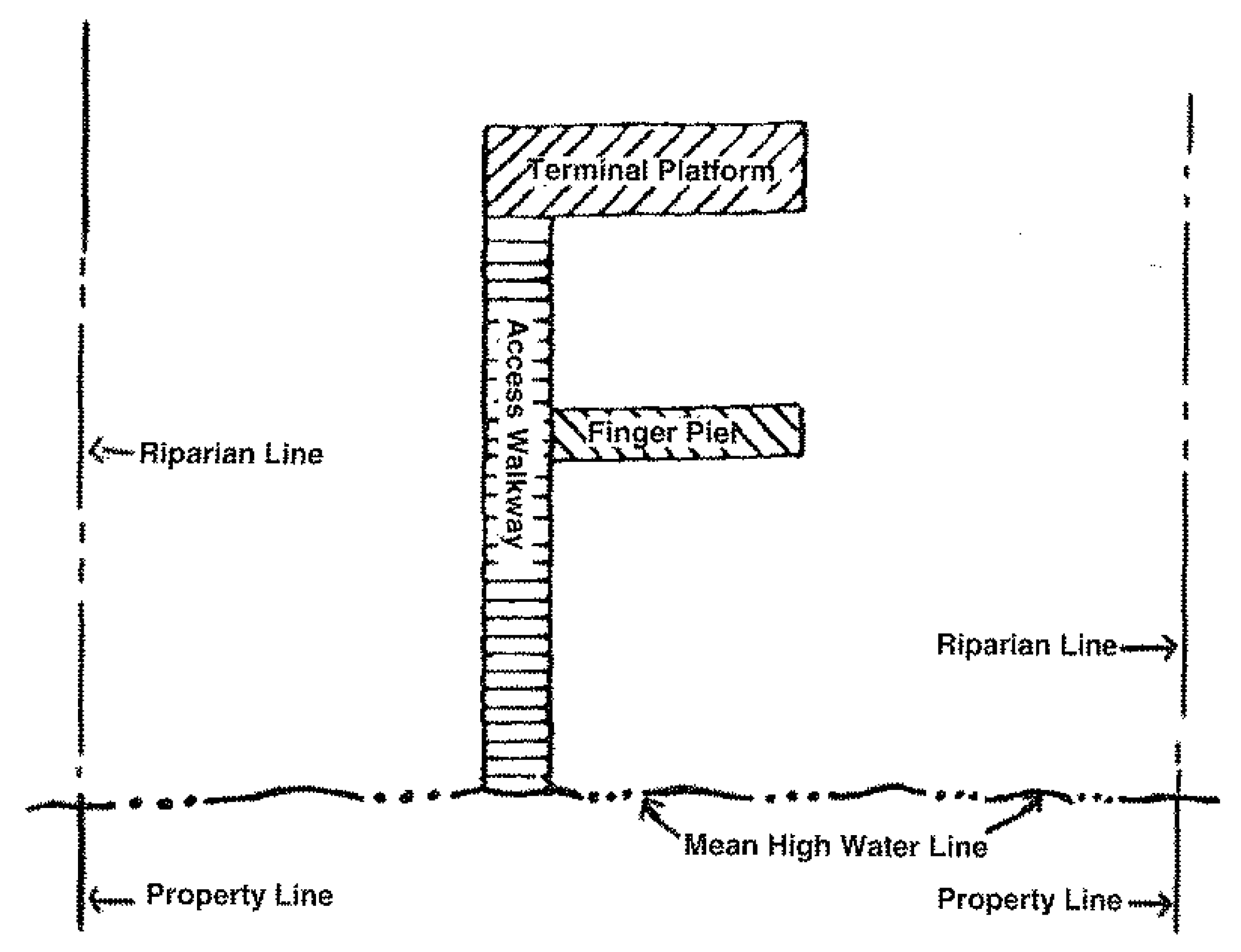 | |
B.
The Director may permit a dock of greater dimensions than subsection A above, if:
1.
The primary access to the property is by watercraft;
2.
No reasonable alternative access exists; and
3.
The increase in the dock dimensions is the minimum necessary to meet the needs of the property owner.
C.
Single-family dwelling boat ramps shall have a maximum width of 15 feet.
4.
Setbacks.
A.
All multi-slip dock facilities, except boat davits, in or adjacent to natural waterbodies, shall be set back a minimum of 25 feet from all adjoining side lot lines.
B.
All private single-family docking facilities in natural waterbodies shall be set back from all adjoining side lot and side riparian lines, as follows:
1.
Marginal docks shall be set back a minimum of ten feet.
2.
All other docks shall be set back a minimum of 25 feet.
3.
Boat lifts and mooring pilings shall be set back a minimum of ten feet.
C.
Side setback requirements may be reduced if:
1.
Adjoining property owners execute and record a written agreement agreeing to a setback less than that required, or to a zero setback; and
2.
Placement of the dock in accordance with the setback agreement will not increase environmental impacts.
D.
The Director may permit deviation from the setbacks required by this subsection, in accordance with Sec. 2-506.C.2, Administrative Deviation, if the facility is located as close to the required setback as possible, and:
1.
The width of the subject parcel is not wide enough to permit construction of a single-family dock facility, perpendicular to the shoreline at the midpoint of the shoreline property line, without a deviation; or
2.
Construction of the structure outside the setback area will not cause or will minimize damage to wetland vegetation or other environmental resources, or will not cause greater damage than will occur if the deviation is not granted.
E.
The Director's decision in subsection D above, may be appealed in accordance with Sec. 2-506.D, Appeal of Administrative Official Decision.
F.
All boat ramps shall be set back a minimum of ten feet from all adjoining side lot and side riparian lines.
5.
Location.
A.
Docking structures in natural or artificial waterbodies that create a hazard to navigation are prohibited.
B.
Boat ramps located in a manner that will result in a change in the mean high water line are prohibited.
C.
Docks located at the end of a canal may require a survey sealed by a PSM depicting the riparian area. The dock shall be designed to allow for adequate ingress/egress and mooring within the subject property's riparian area.
6.
Minimum Water Depths.
A.
Single-Family Dock Facilities. There shall be a minimum depth of three feet at mean low water for all watercraft slips on private single-family dock facilities in natural waterbodies.
B.
Water Depths Adjacent to and Within a Multi-Slip Dock Facility. For multi-slip dock facilities there shall be a minimum depth of one foot clearance between the deepest draft of a vessel (with the engine in the down position) and an unvegetated bottom or the top of submerged aquatic vegetation (e.g. seagrasses) at mean low water, with a minimum water depth of at least four feet within mooring areas, turning basins, and ingress and egress pathways.
7.
Interest in Land to Support Residential Dock Facility Approval. In order to obtain a permit for a residential dock and related facilities, the property owner or applicant shall have a recorded right to access the water, and comply with the following standards:
A.
Own a lot with a deed describing the residential lot with at least one boundary being the waterway along which the dock facility is proposed. The lot described shall be a buildable lot with sufficient area to comply with the dimensional standards of the zoning district in which it is located.
B.
Have a recorded easement granting access to the waterbody for purposes of constructing and using a dock facility meeting the following standards:
1.
The easement shall be over land contiguous to the residential lot such that an extension of the side lot lines will allow access to the water beyond the rear lot line;
2.
The easement shall be for the benefit of a residential lot that is a buildable lot under the minimum lot area standards for the applicable zoning district; and
3.
The easement shall be necessary to gain access to the waterbody over and through any waterway buffer and maintenance areas required for development approval under this LDC.
8.
Joint Use Agreements. Adjacent property owners seeking approval for a shared dock facility shall submit a draft joint use agreement. The agreement shall be approved by the Village Attorney and the Director prior to permit issuance, and shall:
A.
Identify each party by name, including mailing address. The parties shall be the owners of the property abutting each other that will benefit from the dock facility.
B.
Identify the physical location of the subject parcels, including STRAP numbers, a legal description, and an accompanying sketch.
C.
Identify the specific location of the docking facilities including: the name of the waterbody, the dimensions of the facilities, and the dimensions of the land that will be used in conjunction with the facilities.
D.
Provide, as an attachment to the agreement, a detailed sketch of the facility identifying the various docking facilities, subject property boundaries, and the upland area intended to be encumbered by the normal use of these facilities. This sketch shall be consistent with the statements made to comply with subsection C above.
E.
Specifically identify those areas that will be the subject of access easements to provide access, including ingress and egress to the docking facilities from each of the benefitted parcels. Depending on the facilities and parties involved, these easements may be reciprocal in nature. The easements shall be specifically granted to each party named in the agreement and shall run with the land (i.e. be part of the title to the primary residential parcel) in perpetuity. A grant of dock easement rights to parcels that do not abut the docking facility parcel is prohibited.
F.
Provide, as an attachment, a sketch prepared by a registered PSM, based on the legal description and identifying the access easements granted.
G.
Indicate who will be responsible for the cost of construction and maintaining the facilities. This can be accomplished by including cost sharing provisions.
H.
Indicate that the parties understand and agree to abide by all applicable federal, state, and local regulations pertaining to the construction, maintenance, and use of the facilities.
I.
Be submitted as a draft to the Director and the Village Attorney prior to recording, for approval.
J.
Be recorded in the public records of Lee County at the applicant's cost. A copy of the recorded agreement or a document identifying the recording information shall be submitted to the Village prior to permit issuance.
B.
Dock Boxes. Dock boxes on private single family dock facilities shall not exceed three feet in height and 100 cubic feet in area. Dock boxes do not require building or marine facility permits.
C.
Fishing Piers, Observation Decks, or Kayak/Canoe Structures. Fishing piers, observation decks, or kayak/canoe structures may be permitted in areas where water depth is insufficient for watercraft mooring. Kayak/canoe structures are for use with non-motorized watercraft. Fishing piers, observation decks, and kayak/canoe structures shall comply with the following standards.
1.
Design. The design and construction shall:
A.
Prohibit watercraft mooring;
B.
Provide access walkways and terminal platforms at five feet above mean high water; except that the terminal end of a kayak/canoe structure used for launching kayaks/canoes may be constructed lower than five feet above mean high water;
C.
Provide fixed handrails, including intermediate rails, installed around the perimeter of the structure, except for the terminal end of a kayak/canoe structure;
D.
Include a "no boat mooring" sign placed facing the water on the terminal platform of the structure; and
E.
Be set back from all adjoining side lot and riparian lines no less than 25 feet on natural water bodies. In manmade waterbodies, no setback is required.
2.
Dimensions. The design and construction shall:
A.
Provide access walkways that do not exceed a total of four feet in width in natural water bodies.
B.
Extend toward and into the water a maximum of 200 feet from the mean high waterline.
C.
Have a maximum area of 260 square feet for the terminal platform for fishing piers or observation decks;
D.
Have a maximum area of 160 square feet for the terminal platform for kayak/canoe structures; and
E.
Extend toward and into the water from the mean high waterline a maximum of 25 percent of the navigable channel width.
D.
Boathouses. The following requirements apply to all boathouses associated with private single-family dwellings, except where specifically superseded by other provisions of this section:
1.
Location.
A.
All boathouses shall be constructed adjacent to or over a waterway. The entirety of a boathouse constructed over land shall be located within 25 feet of the mean high water line.
B.
Boathouses over submerged bottoms containing areas of dense seagrasses or shellfish beds are prohibited.
C.
Boathouses, boat lifts, and davits designed with mooring inside the structure shall not extend beyond 25 percent of the width of a navigable channel.
2.
Setbacks.
A.
The minimum setbacks for boathouses shall be 25 feet for natural waterbodies and ten feet for artificial waterbodies. The setback shall be measured from side lot lines and riparian lot lines to the nearest point of the structural beam of the boathouse roof.
B.
When a boathouse is constructed on or adjacent to two or more adjoining lots under common ownership and control, the setbacks shall be measured from the exterior property lines.
3.
Design Criteria.
A.
Maximum Area. The maximum roofed area of a boathouse shall be 500 square feet.
B.
Height. The maximum height of a boathouse shall be 20 feet above mean high water, as measured from mean high water to the highest point of the boathouse.
C.
Permitted Uses.
1.
Use of a boathouse for living or fueling facilities is prohibited.
2.
Up to 25 percent of the total roofed area of a boathouse may be used for storage of items that relate directly to the use and maintenance of watercraft. Items that do not relate directly to the use and maintenance of watercraft shall not be stored in a boathouse.
D.
Decking. Access walkways not exceeding four feet in width are permitted in the area under the roof of a boathouse located over water. Additional decking in the area under the roof of a boathouse is prohibited. Decking on top of the boathouse is prohibited.
E.
Enclosure.
1.
Boathouses located over a waterbody or adjacent to a natural waterbody shall be open-sided. Safety rails 42 inches high or less are permitted.
2.
Boathouses located adjacent to an artificial waterbody shall meet the following requirements:
(a)
The boathouse shall be open-sided if the proposed side setback is between ten and 25 feet.
(b)
The boathouse may be open-sided or enclosed with wood lattice, chain-link, or other fencing materials if the side setback is 25 feet or more.
F.
Wind Load Standards. All boathouses shall comply with the building code wind load standards. (See Building Code.) See Figure 7-402.D.3.F: Boathouse Plan.
Figure 7-402.D.3.F: Boathouse Plan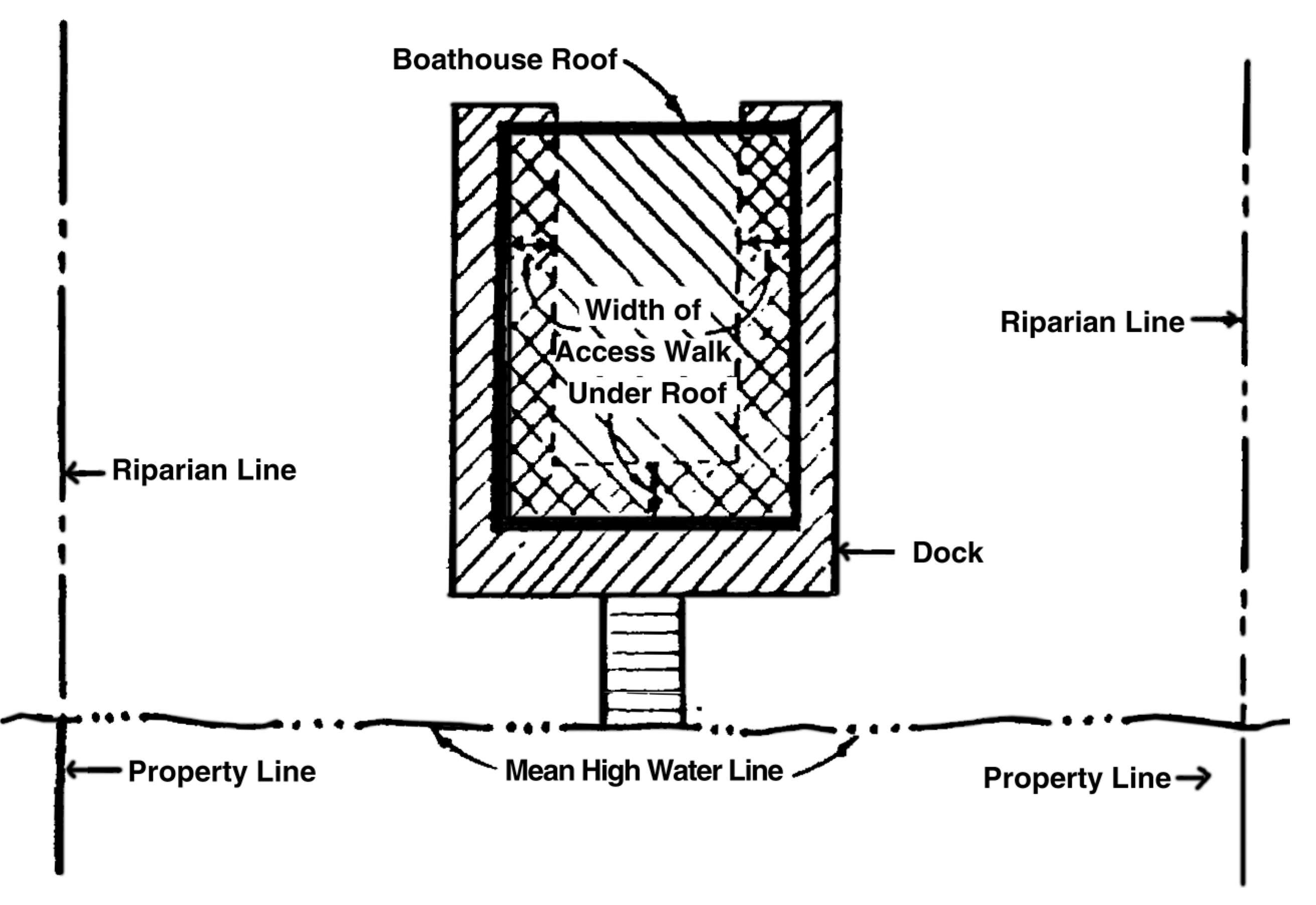
E.
Seawalls, Retaining Walls, and Riprap Revetment.
1.
Seawalls on Artificial Waterbodies and Retaining Walls.
A.
Seawalls may be permitted in an artificial canal with a minimum of 50 percent of the bank having seawalls, or for a linear distance of less than 300 feet where both adjoining properties have seawalls. A new or replacement seawall shall be installed in line with the existing seawall alignment or adjoining seawalls, and placed no greater than one foot waterward of an existing seawall. Until the backfill area is stabilized, silt fence or sod shall be placed immediately landward of the seawall cap to minimize erosion into the water.
B.
Riprap rock or other similar approved material shall be placed waterward along 50 percent of the linear length of a new or replacement seawall. This riprap is not required where it would interfere with designated watercraft tie-up areas. The rock shall be placed a minimum of three feet in height above the bottom, waterward of the seawall, or up to the mean high water line. The rock shall be a minimum average size of 12 inches in diameter.
2.
Seawalls on Natural Waterbodies
A.
New or expanded seawalls are not allowed along natural waterbodies.
B.
Other hardened structures, including but not limited to groins, fencing, and other similar structures, may be permitted along natural waterbodies.
C.
Lawfully existing seawalls along natural waterbodies may be maintained or repaired and may be replaced with the same type structure, built to the same dimensions and in the same location as the previously existing structure.
3.
Retaining Walls. Retaining walls shall be setback a minimum of five feet from the mean high water line or landward of any wetland vegetation.
4.
Riprap Revetment.
A.
Riprap shall be located and placed so as not to damage or interfere with the growth of wetland vegetation.
B.
Material used for riprap shall be sized properly for intended use, be a minimum average of 12 inches in diameter, and installed on top of filter fabric or equivalent material to prevent erosion of subgrade. Riprap shall be clean and free of debris and shall be deemed not harmful to the environment and public safety.
C.
Mangroves or other approved wetland vegetation shall be planted three feet on center in accordance with Sec. 7-402.F, Turbidity, for added shoreline stabilization and ecological benefit within the riprap. Other wetland mitigation techniques may be considered in-lieu of vegetation planting. No vegetation planting is required for riprap revetments constructed in artificial upland canals with a minimum of 50 percent of the bank having seawalls, or for a linear distance of less than 300 feet where both adjoining properties have seawalls.
F.
Turbidity. All structures shall be placed to provide the least possible impact to aquatic or wetland vegetation. During work that will generate turbidity, turbidity screens shall be installed and properly maintained until turbidity levels are reduced to normal (ambient) levels.
G.
Protection of Vegetation.
1.
Permit Conditions. Conditions for the protection of shoreline vegetation may be placed on permits issued in accordance with this section. The conditions may include the method of designating and protecting mangroves to remain after construction, and replacement planting for mangroves removed due to construction.
2.
Mangrove Replacement and Plantings.
A.
For each mangrove removed due to construction, three mangroves shall be replanted at an alternate location on the subject property. If planting on the subject property is not appropriate, alternative forms of mitigation, such as payment into a mitigation bank, may be allowed.
B.
Mangrove plantings shall be container grown, no less than one year old, eight inches in height, and have a guaranteed 80 percent survivability rate for at least a five-year period. Mangrove plantings shall be planted three feet on center. Mangrove replanting is required if the 80 percent survivability rate is not attained before the expiration of the five-year period.
3.
Mangrove Removal.
A.
Mangrove removal in conjunction with construction of riprap revetments, seawalls, or retaining walls along natural waterbodies is prohibited.
B.
Mangrove removal necessary for access walkway construction is limited to the minimum extent necessary to gain access to the dock facility. To the greatest extent possible, the access shall be located to:
1.
Use existing natural openings;
2.
Use areas infested with invasive exotic vegetation;
3.
Avoid larger mangroves; and
4.
Provide a maximum width of four feet and a maximum height of eight feet above the level of the walkway base.
7-403. - Marine Sanitation Standards.
A.
Purpose. The purpose of this subsection is to protect the water quality and the health of the citizens of the Village from pollution resulting from sewage and other waste or discharges from marine-related activities.
B.
Discharge of Waste Material Prohibited. It is unlawful for any person to discharge or permit or control or command to discharge any raw sewage, garbage, trash, or other waste material into the waters of the Village.
7-501. - Purpose and Intent.
The purpose of this section is to address the impacts created by residential development on hurricane shelter availability and evacuation capability in the Village. These requirements are intended to mitigate the growing hurricane shelter deficit, along with related effects on evacuation times and infrastructure, caused by permitting residential development without addressing the incremental impact on the Village's hurricane preparedness program.
7-502. - Applicability.
A.
The hurricane preparedness standards of this section apply to new residential development on land in Category 1, 2, or 3 storm surge areas that is required to obtain a development order (Sec. 2-502.A, Development Order) or limited development order (Sec. 2-502.B, Limited Development Order).
B.
For purposes of this section, residential development includes but is not limited to, all assisted living facilities, dwelling units, housing units, mobile homes, recreational vehicle developments, hotels and motels, nursing homes, hospitals, and social service homes.
7-503. - Authority.
A.
The Director shall decide the type and degree of acceptable hurricane preparedness mitigation for a proposed development subject to the requirements of this section, based upon the type and intensity of development, its location, and the incremental effect on the hurricane preparedness program it creates. The mitigation requested by the Village shall have a reasonable relationship to the incremental impact of the development. Calculation of impacts according to Sec. 7-505.A, Shelter Impacts, constitutes sufficient evidence of reasonable relationship.
B.
The Director shall deny acceptance of an applicant's proposed mitigation if the proposal is inappropriate for the location involved or would result in the creation of an unacceptable shelter facility (e.g. on-site shelter without appropriate shutters).
C.
The option chosen by the developer to mitigate shelter and evacuation impacts shall be approved prior to the issuance of a development order (Sec 2-502.A, Development Order) or limited development order (Sec 2-502.B, Limited Development Order), as appropriate. The payment-in-lieu established by this section shall be satisfied prior to the issuance of a building permit.
7-504. - Determination of Impacts.
A.
Shelter Impacts. Shelter impacts are largely related to building issues (i.e., availability of actual appropriate shelter space). Impact on hurricane shelter availability is calculated as follows:
1.
Residential Units. The following formula shall be used for dwelling units, housing units, mobile homes, recreational vehicle developments (including recreational vehicles qualifying as permanent residences under this LDC), nursing homes, hospitals, and social service homes.
A.
U × P = N
B.
N × Ssr = Sp(r)
2.
Hotel or Motel Units. The following formula shall be used for all hotels and motels.
A.
Hu × O = R
B.
R × Ssr = Sp(hu)
3.
Total Units. The following formula shall be used to calculate total shelter impacts for a development.
A.
Sp(r) + Sp(hu) = Sp(t)
B.
Sp(t) × Rfa = Sq(t)
4.
Formula Key. The terms in Table 7-504.A: Shelter Impacts Formula Key, shall be used in the formulas in subsections 1, 2, and 3 above.
B.
Evacuation Impacts. Evacuation impacts are largely related to the transportation infrastructure necessary to accommodate timely and efficient evacuation. Impacts on the evacuation time and infrastructure are calculated as in 1. and 2., below.
1.
Evacuating Vehicles for All Residential Units.
EV(t) = U × V
2.
Formula Key. The terms in Table 7-504.B: Evacuation Impacts Formula Key, shall be used in the formula in subsection 1 above.
7-505. - Mitigation.
A.
Shelter Impacts. Except for those developments listed in subsection 5 below, one or a combination of the following options may be used to address the impacts on the hurricane shelter program. The Director shall determine the acceptability and appropriateness of the mitigation proposed.
1.
Land Donation. If a donation of land is proposed, it shall meet the following requirements:
A.
The land shall be located outside the coastal high hazard area.
B.
The land shall be capable of being used to reduce hurricane shelter impacts in the Village.
C.
The Village shall receive marketable fee title to the land. Land donated shall not be encumbered by a restriction that it be used solely for hurricane shelter purposes.
D.
The value of the land donated shall be determined as of the earliest date the requirement to provide hurricane preparedness mitigation becomes applicable based upon formal Village action (i.e., rezoning (zoning map amendment), platting, development order approval, etc.).
2.
Donate Use of Private Structure. If a donation of the use of a private structure is proposed, it shall comply with the following requirements:
A.
The structure shall be located outside the coastal high hazard area.
B.
The structure shall be constructed and capable of use as a primary public hurricane shelter. Specifically, the structure and all required equipment and supplies shall be:
1.
Elevated to the anticipated land fall of a Category 3 hurricane's flood level;
2.
Constructed to withstand winds of at least 150 miles per hour according to the Florida Building Code;
3.
Constructed with a minimum of exterior glass, with all glazed openings provided with impact protection in accordance with the Florida Building Code;
4.
Equipped with emergency power and potable water supplies;
5.
Provided with adequate ventilation, sanitary facilities, and first aid equipment; and
6.
The structure and all restrooms and support facilities shall comply with all regulations regarding accessibility for persons with disabilities.
C.
For purposes of compliance with this subsection, the cost of providing or donating a structure for use as a primary hurricane shelter shall be determined as the incremental cost difference attributable to bringing the structure up to primary public shelter standards from the original primary proposed use.
3.
Payment In-Lieu of Donation of Land or Use of a Private Structure. If payment in-lieu is proposed, it shall be calculated using the following formula:
A.
Step One: Calculate Costs for Shelter Improvements. The following formula determines cost for increased wind speed standards and elevation:
1.
Shelter Improvement Costs = Sq(t) × $6.66
2.
Note: $6.66 is derived from adding $1.34 per square foot of shelter space for increased essential facility wind speed standards to $5.32 per square foot of shelter space for increase for elevation above storm surge for a Category 3 hurricane.
B.
Step Two: Emergency Power Costs.
1.
Emergency Power Costs = LPC × SF × PD × $200.00 ÷ 1000
2.
5 × 20 × 1 (representing one person) × $200.00 ÷ 1000 = $20.00 per person
C.
Step Three: Total Costs (not including shuttering). Total costs (not including shuttering) = (Sq(t) × $6.66) + ($20.00 × N)
D.
Formula Key. The terms in Table 7-505.A.3: Payment-In-Lieu Formula Key, shall be used in the formulas in subsections A, B, and C above.
4.
On-Site Shelter. Provision of an on-site shelter shall comply with the following requirements:
A.
The on-site shelter shall be located outside the coastal high hazard area unless it is constructed in accordance with the standards in Sec. 7-505.A.5.B, Facilities Requiring Special Care, for the uses referred to therein.
B.
The shelter space shall, at a minimum, equal the hurricane shelter space demand the proposed development is anticipated to create.
C.
The structure and all required equipment and supplies shall be:
1.
Elevated to the anticipated flood levels of a Category 3 hurricane;
2.
Constructed to withstand winds of at least 150 miles per hour according to the Florida Building Code;
3.
Constructed with a minimum of exterior glass with all glazed openings provided with impact protection in accordance with the Florida Building Code;
4.
Equipped with emergency power and potable water supplies;
5.
Provided with adequate ventilation, sanitary facilities, and first aid equipment; and
6.
The structure, and all restrooms and support facilities, shall comply with all regulations regarding accessibility for persons with disabilities.
D.
For purposes of compliance with this subsection, the cost of providing a structure for use as an on-site hurricane shelter will be determined as the incremental cost difference attributable to bringing the structure up to public shelter standards from the original or primary use.
E.
The developer shall arrange for the annual training for the on-site shelter manager. Training shall be conducted by the American Red Cross and approved by the Director.
5.
Facilities Requiring Special Care.
A.
This subsection applies to assisted living facilities, nursing homes, continuing care retirement communities, hospitals, and social service homes.
B.
The facilities subject to this subsection shall be located outside the coastal high hazard area unless designed to address shelter and evacuation impacts on-site as follows:
(a)
Be elevated to the anticipated storm surge from a land falling Category 5 storm.
(b)
Be constructed to withstand winds of 200 mph, in accordance with the Florida Building Code;
(c)
Be constructed with minimum exterior glass with all glazed openings provided with impact protection in accordance with the Florida Building Code;
(d)
Be equipped with emergency power and potable water supplies to last up to five days; and
(e)
Be protected with adequate ventilation, sanitary facilities, and first aid medical equipment.
2.
The developer or operator of the facility shall conduct annual training of the on-site shelter managers. The training is to be conducted by the Red Cross and approved by the Director.
3.
The developer or operator of the facility shall submit a post storm recovery plan including post storm evacuation plan for review and approval by the Director.
C.
Facilities located within Lee County Evacuation Zones A, B, or C as maintained by the Lee County Emergency Operations Center shall construct sufficient hurricane shelter space for its residents meeting the construction standards set forth in Sec. 7-505.A.4, On-Site Shelter. This requirement may not be satisfied by a payment in-lieu of constructing the shelter.
B.
Evacuation Impacts. One or a combination of the following options may be used to address the impacts on hurricane evacuation routes with respect to evacuation timing and infrastructure precipitated by a proposed residential development. The acceptability and appropriateness of the type of mitigation proposed shall be determined by the Director, with assistance from the Lee County Department of Transportation (LDOT).
1.
Roadway Elevation or Improvements. The acceptability and appropriateness of any proposed mitigation option shall be determined by the Director based on the residential development's vulnerability conditions. Mitigation under this option may include one or more of the following:
A.
Construction of roads in the development or subdivision that are built to meet the same elevation as the nearest segment of a designated evacuation route. Determination as to the applicable route or segment shall be made by the Director in consultation with LDOT.
B.
Construction of the main access or spine road in the development or subdivision to an elevation meeting the one in ten- to the one in 25-year storm event. The Director shall determine the applicable storm event standard.
C.
Improvement of an offsite road to be used by the subdivision or development for evacuation purposes. The road segment and standard for the road improvement shall be determined by the Director in consultation with LDOT.
2.
Evacuation Efficiency Improvements. This mitigation strategy involves the provision of funds to improve the ability to provide information to evacuees during actual evacuation situations or to improve the existing warning and notification system. Funds provided under this option may be used for items such as:
A.
Communications equipment to convey real-time conditions to the public on the roads.
B.
Information systems along major arterial evacuation routes to convey emergency information.
3.
Vertical Evacuation. The viability of a vertical evaluation mitigation option shall be based upon the following:
A.
The structure shall be elevated above the anticipated Category 3 land falling hurricane storm surge and shall be able to withstand wind speeds of at least 150 miles per hour.
B.
The structure shall be located outside the coastal high hazard area.
C.
Mitigation Options That Will Address Both Shelter and Evacuation Impacts. One or a combination of the following options will constitute full mitigation of both shelter and hurricane evacuation impacts for residential development, with the exception of those residential developments listed in Sec. 7-505.A.5.B, Facilities Requiring Special Care.
1.
Safe Room. Construction of a room, within a residential building, that is designed to withstand a hurricane and is capable of accommodating the occupants of the dwelling. Viability of this mitigation option shall be determined by the Director based upon the following:
A.
The room selected for this purpose shall be built to current FEMA safe room standards.
B.
The residential unit where the safe room is constructed shall be located outside the coastal high hazard area.
2.
Elevation Above Hurricane Flooding Levels. Construction of residential units above the Category 3 land falling storm surge level. This option is available only for construction located outside the coastal high hazard area and does not subject the construction to standards in excess of those applicable in the Village building code.
D.
Appropriate Spending. All funds collected in accordance with this section are required to be spent to provide hurricane mitigation options for the development paying the funds, in an amount proportionate to the funds paid.