
Farmington City Zoning Code
ARTICLE 11
- GRC GRAND RIVER CORRIDOR OVERLAY DISTRICT3
Editor's note— Ord. No. C-778-2015, § 1, adopted Aug. 24, 2015, set out provisions intended for use as Art. 11 §§ 35-138—35-144. Inasmuch as there were already provisions so designated, in part, Ord. No. C-778-2015 has been codified herein as §§ 35-141—35-147 at the discretion of the editor.
Sec. 35-141.- Authority.
Pursuant to authority granted in Section 125.3503 of the Michigan Zoning Enabling Act, this overlay district is written to permit flexibility in the regulation of development of land located within the boundary established in the Grand River Corridor Vision Plan, which is herein referenced in its entirety.
(Ord. No. C-778-2015, § 1, 9-21-15)
Sec. 35-142. - Intent.
This overlay district is intended to implement the Grand River Corridor Vision Plan, which is adopted as part of the city Master Plan, hereinafter referred to as the "Corridor Plan". The Corridor Plan articulates the following design principles and site development elements that support the vision for the corridor and gives examples of how sites along the corridor could redevelop. The regulations contained in this overlay district enumerate the principles of the Corridor Plan inasmuch as possible; however, reference to the published Corridor Plan is highly recommended. The purpose of this overlay district is to promote high-quality development that will provide the following:
A.
High-quality architecture and urban design elements/treatments that create a signature environment along the corridor.
B.
A safe and enjoyable environment for walking and biking, public transit, and automobiles for people of all ages and abilities with minimal conflicts among users.
C.
Economic success of the corridor, enhanced by a supporting balance of retail, office, institutional, and housing in a vibrant and integrated development pattern.
D.
A variety of housing options.
E.
A respect for the river corridor and development that will enhance and complement the environment.
F.
New public spaces that encourage community gathering and outdoor activity.
G.
Connections with surrounding areas that provide travel choices for people to move throughout the corridor, adjoining neighborhoods, centers of commerce, and public spaces.
H.
Best management practices in environmentally responsible planning and construction.
(Ord. No. C-778-2015, § 1, 9-21-15)
Sec. 35-143. - Applicability.
A.
Application of Regulations. Within the district, all requirements of the City of Farmington Zoning Ordinance with respect to the underlying zoning district shall apply, except as modified by this overlay district.
B.
Interpretations and Modifications. This overlay district is based in part on the Grand River Corridor Vision Plan adopted by the City. To implement the plan, flexibility on the mixture of uses, site layout or other dimensional modifications as part of the site plan review may be allowed, depending on the timing, location and nature of redevelopment. Modifications are discussed in section 35-144.
C.
Compliance with Overlay Regulations as to Building Requirements and General Development Requirements. It is acknowledged that implementation of the Corridor Plan is likely to occur gradually. The intention of this overlay district is that eventually, the requirements of the overlay district will be fully implemented as properties develop or redevelop. Use and development of land developed within this district shall be regulated as follows:
1.
Existing Buildings and Uses. The following activity shall be allowed according to the regulations of the underlying district:
a.
Uses in existence on the date of the ordinance amendment from which this article derives.
b.
Changes in use from one use to another use where the underlying zoning district does not require additional parking or building requirements.
c.
Maintenance of existing site and building conditions as of the date of the ordinance amendment from which this article derives.
d.
Additions of a size equal or less than ten (10) percent of the gross square footage of the building as it exists at the time of adoption of this article.
e.
Additions of a size greater than ten (10) percent but equal to or less than twenty-five (25) percent of the gross square footage of the building as of the date of adoption of the ordinance from which this article derives, provided they meet the requirements for lot size and coverage, setback, building height, transitions from abutting single-family residential uses, as listed in sections 35-145 and 35-146, unless modifications are allowed in accordance with section 35-147.
2.
New Buildings and Development and Major Expansions/Additions. New development projects and major expansions or additions (greater than twenty-five (25) percent of existing gross square footage at the time of adoption of the ordinance from which this article derives) proposed under this overlay district shall meet all requirements of this district, except as otherwise provided for in this article.
(Ord. No. C-778-2015, § 1, 9-21-15)
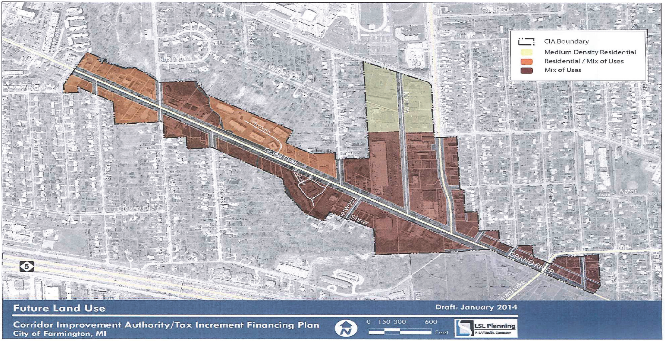
Sec. 35-144. - Zones and permitted uses.
A.
Zones. The GRC district shall be and is hereby divided into zones as enumerated on the zone map in subsection B below.
1.
Medium-Density Residential (MDR). This area is planned for medium density residential at 10-20 u/a. Residential development in this area should be supported by public and green spaces within or adjacent to the development. Residential developments should include sidewalks, street trees, and connections within and outside of the development.
2.
Residential Mixed Use (RMU). This area is planned for a mix of commercial and medium density residential of 10-20 u/a. Uses may be vertically or horizontally integrated. The overall mix of commercial to residential should have a residential focus. Development in this area should be supported by public and green spaces within or adjacent to the development.
3.
Mixed Use (MU). This area is planned for a mix of small to medium sized retail, office, and residential uses both vertically and horizontally. Within pedestrian areas, office uses should be encouraged on the second floor while retail uses should be reserved for the first floor and have a strong street presence. These areas should be carefully planned to complement the streetscape and help to create and define the public realm. Development should be connected via a pedestrian network.
B.
Zone Map. The Grand River overlay district boundary is hereby established as shown on the zoning map on file in the office of the city clerk. The boundary for each zone described above is hereby established as shown on the district zoning map below:
C.
Permitted Uses. Permitted uses within the zones noted on the zone map, shall include the following:
1.
Any of the uses permitted as allowed in the underlying zoning districts, as listed in their respective articles of the zoning ordinance, may be permitted.
2.
Uses allowed by the planning commission pursuant to section 35-30. Determination of similar use.
3.
Other uses as permitted in the table below, certain of which may require the use of the Planned Unit Development process in Article 10 of this zoning ordinance as set forth in section 35-147C below:
(Ord. No. C-778-2015, § 1, 9-21-15)
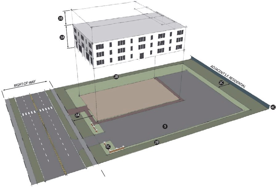
Sec. 35-145. - Building requirements.
A.
Streetscaping. The following shall be installed along all property lines that abut Grand River Avenue, as part of a comprehensive road and streetscape network:
B.
Building Requirements. Sites and buildings shall be designed according to Table 35-143:
| Table 35-143 Building Requirements | |||
|---|---|---|---|
| MDR | RMU | MU | |
| 1. Lot Size and Coverage | |||
| a. Minimum Lot Size | 8,500 sq. ft. | There are no minimum or maximum lot sizes | |
| b. Minimum Lot Width | 70 ft. | There are no minimum lot widths | |
| c. Maximum Building Coverage | 35% | There are no maximum coverage requirements, provided stormwater requirements are met | |
| 2. Minimum Setbacks | |||
| a. Front Yard Setback | 30 ft. | 0 ft. | |
| Upper floors may project into right-of-way pursuant to Section 35-147 | |||
| b. Side Yard Setback | 15 ft. | 5 ft. | 0 ft. |
| c. Rear Yard Setback | 30 ft. | As needed to achieve proper Transition (see below) | |
| 3. Building Height | |||
| a. Maximum | 42 ft. (3 stories) | 42 ft. (3 stories) | 54 ft. (4 stories) |
| Additional height per Section 35-147 | |||
| 4. Transitions from Abutting Single-Family Residential Uses | |||
| a. Building Step Backs | Subject to Section 35-171.C. | Buildings taller than 42 ft. shall include step backs back a distance equal to its height for each floor | |
| b. Screen Wall |
6 ft. screening wall required along the property line.
Also subject to section 35-49 | ||
 | |||
| 5. Parking Circulation and Driveways (see also section 35-142) | |||
| a. Parking Location | Subject to Article 14 of Ordinance 34 | Side or rear yard preferred. One single row of parking may be allowed in the front yard, provided there are no other reasonable alternatives that are more consistent with the Corridor Plan | |
| b. Parking Lot Design | Subject to Article 14 of Ordinance 34. Parking Structures that front Grand River Avenue shall include storefront liner buildings on the ground floor along the frontage that are at least 30 ft. in depth | ||
| A 36 in. high knee wall shall be installed along frontages where parking lots occupy any portion of the front yard | |||
| c. Driveway/Access Location | Subject to Article 14 of Ordinance 34 | Where a public alley or shared access is possible, driveway access to Grand River Avenue may only be granted upon demonstration that such is needed to provide reasonable access to the site | |
| 6. Windows and Doors | |||
| a. Entrances | At least one functioning door shall be provided for every street-facing storefront | ||
|
Second door for multi-family may face side or rear yard.
Connection to public sidewalk must be provided pursuant to section 35-45 | |||
| 7. Building and Roof Design | |||
| a. Flat Roof Design | A minimum 42 inch tall parapet shall be installed to conceal rooftop mechanical equipment visible from the street level | ||
(Ord. No. C-778-2015, § 1, 9-21-15)
Sec. 35-146. - General development requirements.
A.
Street Classification.
1.
A site's primary, secondary (side) and service street frontages shall be designated by the city planner or his/her designee. In making a determination the city planner shall consider the following standards:
a.
When a site abuts only one street, that street is the primary street frontage.
b.
In all cases, any frontage on Grand River Avenue shall be considered primary street frontage.
2.
On corner sites, one street is a primary street frontage and the other street or streets may be designated a primary street or a secondary street frontage. In determining the required primary street frontage, the city shall consider the following conditions:
a.
The street with the highest street classification;
b.
The existing and planned context of the built environment;
c.
The street abutting the longest face of the block; and
d.
The street parallel to an alley within the block.
3.
When a site runs from one street to another and has a double frontage, one street may be designated a service street frontage provided the following standards are met:
a.
The applicant controls the land along an entire block face;
b.
A site with a service street must have at least two street frontages and one street frontage must be a primary street; and
c.
Only one service street frontage may be designated abutting any block.
4.
When a site abuts four or more streets, two service street frontages may be designated provided that two or more primary street frontages are also designated.
B.
Building Elements.
1.
Corner buildings. Buildings located at a street corner shall have appropriate architectural features and details that accentuate its prominent corner location through additional building height and/or adding a building peak or tower element at the corner. Other creative techniques may be used, subject to the acceptance of the planning commission. Special architectural corner features may be permitted to exceed the maximum building height by up to ten (10) feet if deemed appropriate by the planning commission.
2.
Canopies and awnings shall comply with section 35-40.
3.
Balconies and overhangs. Balconies and overhangs may be added to façades with the following conditions:
a.
Balconies and overhangs shall not extend more than six (6) feet from the building face.
b.
Materials shall be compatible with the building and be integrally designed.
4.
Outdoor dining areas may be allowed pursuant to section 35-102, special provision (b).
5.
Exterior lighting.
a.
Exterior lighting shall comply with section 35-48. The Planning commission may grant the same modifications in this district that are allowed in the CBD.
b.
Illumination. Lighting shall provide illumination levels according to the following:
Note— fc = footcandles
6.
Activity within the right-of-way. Upon approval by all applicable road agencies, the city may allow upper floors of buildings to project over or one row of front yard parking to encroach into the public right-of-way in consideration of the following:
a.
The projection/encroachment is necessary to accommodate reasonable redevelopment of the site due to other constraints such as size, shape, depth or presence of natural features.
b.
The projection/encroachment will allow the development to better achieve the purpose of this district and the vision stated in the Grand River Corridor Vision Plan.
c.
The city has received all necessary insurance that indemnifies the city within the area of projection/encroachment.
C.
Parking. Off-street parking shall be subject to the provisions of Article 14, Off-Street Parking Requirements, with the following provisions:
1.
The number of spaces shall be as required in Article 14, Off-Street Parking and Loading Standards and Access Design. Notwithstanding the flexibility allowed in Article 14, the amount of parking may be reduced based on a determination that adequate parking for peak periods is provided for the mixture of proposed and future uses. In making its determination, the planning commission shall consider the expected amount of bicycle or transit travel to the site, the nature of the proposed land use, different peak hour parking demands, shared parking agreements, on-site parking management, employee transit incentives, provision of transit or bike amenities, bicycle parking, or other means that will otherwise reduce vehicular trips to the site that would otherwise be expected. The planning commission may require a parking study, prepared by a qualified professional, from the applicant to assist with making a determination.
2.
The city may allow one single row of parking in the front yard in consideration of the following:
a.
Such parking is necessary to accommodate reasonable redevelopment of the site due to other constraints such as size, shape, depth or presence of natural features.
b.
The additional parking is necessary to accommodate reasonable redevelopment of the site.
c.
The parking will allow for development that is generally more consistent with the purpose of this district and the vision stated in the Grand River Corridor Vision Plan than the development that would otherwise result.
3.
All developments shall provide one (1) bike rack for each twenty (20) vehicular spaces.
D.
Rouge River Frontage. For properties with frontage along the Rouge River, all buildings and structures shall be setback at least twenty-five (25) feet from the river's edge, with additional setback as determined by the city engineer on the basis of soil conditions and other such factors affecting the suitability of the land for placement of a structure. However, applicants are encouraged to orient the buildings such that the river will effectively be the street frontage for the property. In order to facilitate such alternative orientation, the planning commission may adjust (reduce or increase) the required front and rear yard setbacks to allow such orientation, giving due consideration to the impact on views along the river, including from across the river, and consistency with the setbacks of existing development on either side and across the street. The planning commission may also allow parking in the front or rear yard, or both, where it would best meet objectives for orientation toward the river and also for a consistent design along the street and the riverfront.
(Ord. No. C-778-2015, § 1, 9-21-15)
Sec. 35-147. - Administration.
A.
Corridor Improvement Authority Review. Applications shall be sent to the Grand River Corridor Improvement Authority for its review and recommendation.
B.
Deviations from Building Requirements (Section 35-145) and General Development Requirements (Section 35-146). It is recognized that certain existing site conditions may prohibit full compliance with this overlay district. The planning commission may modify the standards for this overlay district as applicable to new development projects and expansions or additions after considering the criteria below:
1.
The proposed development is consistent with the Corridor Plan, as amended.
2.
The proposed development is consistent with the purpose and development principles listed in section 35-142.
3.
The proposed modification will not prevent or complicate logical extensions of streets, parking, greenspace, or development of adjacent properties consistent with the Corridor Plan.
4.
Such modification is the minimum necessary to allow reasonable development that is consistent with the purpose of the Corridor Plan.
5.
The proposed development will not impair public safety and is not simply for convenience of the development.
C.
Planned Unit Development (PUD) for New Development Projects and Expansions or Additions.
1.
To promote redevelopment and stimulate reinvestment along the corridor, the additional uses listed in table 35-142 above are permitted, subject to the requirements of this Section 35-144.
2.
As to any new development projects and expansions or additions, the Planning Commission may grant additional flexibility or development options where one or more of the Recognized Benefits, listed below, are provided. Elements listed in Table 35-144 on the left are those items the City wishes to encourage. Items listed along the top show the types of regulatory flexibility or financial incentives that may be granted in return. One incentive must be provided in order to be considered for one incentive. More than one incentive may be granted when more than one Recognized Benefit is provided. In addition to other incentives that may be authorized by the City Council, the following incentives shall be considered:
a.
Lot Coverage or Setback Flexibility. Flexibility may be granted of the minimum lot coverage, building frontage, or setbacks (rear or side only) provided the resulting layout will not negatively impact nearby residences or the vision for the corridor as enumerated in the Grand River Corridor Vision Plan.
b.
Additional Building Height. The maximum building height may be increased by a maximum of two additional stories, provided all other provisions of this article and proper transitions are provided as required in section 35-145.
c.
Reduced Parking. The city may allow development with fewer parking spaces than is required upon proof that such reduction will not create negative impacts upon adjacent businesses or local residential streets.
d.
Stormwater/Utility Improvements. Where endorsed by the city's Public Works Department, reduced user and benefit fees may be granted.
e.
TIF Funding. Eligibility for tax increment financing, where the subject site falls within an established TIF district.
D.
Recognized Benefits. Additional building height or flexibility may be granted during the project review when one or more of the following recognized benefits are provided:
1.
Open Space or Public Space. Inclusion of five (5) percent of the total building area for civic or public spaces.
2.
Low Impact Development (LID) Applications. Use of alternative stormwater management design that includes green roofs, natural retention systems, porous pavement alternatives, or other energy or water conserving applications.
3.
Mixed Use. Development that includes a mix of different but compatible use types within the same building, and which are designed to accommodate predominantly retail uses on the ground-floor with offices or residential use on upper floors.
4.
Higher Quality Architecture. Application of architectural design above what is required.
5.
LEED/Green Buildings. Significant use of sustainable building and site design features such as: water use reduction, water efficient landscaping, innovative wastewater technologies, low impact stormwater management, optimize energy performance, on-site renewable energy, passive solar heating, reuse/recycled/renewable materials, indoor air quality or other elements identified as sustainable by established groups such as the U.S. Green Building Council (LEED) or ANSI National Green Building Standards.
6.
Enhanced Buffer. Inclusion of design elements such as additional landscaping, architectural amenities, or other improvements that are designed to benefit the general public.
7.
Pedestrian Facilities. Provision of public plazas, additional walkways, wider sidewalks or pedestrian-oriented features beyond those required.
8.
Integrated Parking. Where structured parking is provided as part of the development, the city may allow one additional story of building height.
E.
Contributions in Lieu. The city recognizes that certain physical elements may be best developed in a coordinated fashion rather than piecemeal as development occurs. Therefore, when requested by the applicant or where required by the city, payments in lieu of those improvements may be made in accordance with the following.
1.
Contributions in lieu may be accepted for the following improvements:
a.
Streetscaping as listed in Section 35-145A.
b.
Parking as discussed in Section 35-146.
2.
In cases where the elements above cannot reasonably be developed on a parcel, or for those where coordinated installation (parking and access, for example) is needed for logical development, the city may allow developers to defer construction in one of the following ways:
a.
Payment into a dedicated fund, of an amount equal to the cost to install all deferred improvements on the subject site. Improvement costs must also consider off-site improvements and utilities needed to serve the site. The developer shall submit to the city an estimate of costs to construct these items for verification by the city's engineer.
b.
The city may facilitate, through a special assessment district or other means, construction of streetscaping as development progresses. Developments who defer parking under this article shall agree to participate in a special assessment district, and agree to pay back the costs to serve their portion of the development. The assessment district may be created to install or replace some or all of the items listed above, the costs of which will be distributed amongst developed parcels consistent with the standards listed.
F.
PUD Process. New development projects and expansions or additions that are either designated "PUD" in table 35-145 or that utilize the additional flexibility or development options in this subsection shall comply with the requirements of Article 10, Planned Unit Development, of this zoning ordinance.
(Ord. No. C-778-2015, § 1, 9-21-15)