Ferndale City Zoning Code
ARTICLE 24
II ZONING DISTRICTS AND MAP
Sec 24-2.01 District Designations
For purposes of this Code, Ferndale is divided into the following zoning districts and overlay:

Sec 24-2.02 Zoning Map And District Boundaries
A. The boundaries of the City’s zoning districts are hereby established as shown on the Zoning Map.
B. Where, due to scale, lack of detail, or illegibility of the Zoning Map, there is any uncertainty, contradiction, or conflict as to the intended location of any zoning district boundary, the CED Director will interpret the map upon request. Any person aggrieved by such an interpretation may appeal to the Board of Zoning Appeals (BZA). The CED Director and the BZA, in interpreting the Zoning Map or deciding an appeal, must apply the following: zoning district boundary lines are intended to follow lot lines, or be parallel or perpendicular thereto, or to follow the centerlines of streets, alleys, easements, railroad rights-of-way and are to follow municipal boundary lines.
Sec 24-2.03 Zoning District Intents
A. R-1, Residential District. To encourage a mix of homes dwelling (one-unit; two-unit; and accessory dwellings (ADs) to create cohesive, walkable neighborhoods. Three-unit and four-unit dwellings are allowed by Special Land Use approval (up to a maximum of four-units per lot including an AD). Neighborhood serving amenities and services (such as religious institutions, parks, and recreation) are also permitted. The district is defined by tree-lined streets, homes of different architectural styles, and cohesive neighborhoods that facilitate social interaction (i.e., front porches, garages located to the side of the dwelling or detached at the rear of the property, etc.). The R-1 District prioritizes pedestrian activity via building design, traffic calming infrastructure, crosswalks, sidewalks, and bike lanes.
B. R-2, Residential District. To encourage a wider mix of dwellings (one-unit; two-unit; three-unit; four-unit; and ADs) as well as denser residential typologies of multiple-unit dwellings including: loft, residential terrace; neighborhood rowhouse; and corridor rowhouse. Live-work dwellings are allowed by Special Land Use approval, and all other uses permitted in the R-1 District. The district primarily encompasses neighborhoods surrounding the downtown core and serves as a transition zone between the R-1 District and other mixed-use districts. Pedestrian safety, traffic calming infrastructure, and protected bike lanes are prioritized.
C. MXD-1, Neighborhood Mixed Use District. To provide for the development, revitalization, and/or extension of mixed use neighborhoods, which are structured upon a network of interconnected pedestrian oriented streets, transit, and other public spaces. The district intends for a vertical and horizontal mix of uses, typically with retail or commercial space on the ground floor and office or residential uses on upper floors. Businesses in the MXD-1 District primarily serve the needs of the surrounding neighborhoods, providing convenience goods and services. The design and layout of buildings support walking, biking, and transit, and create a neighborhood character that is more place-based than auto-oriented. Development is appropriately scaled to adjacent residential uses.
D. MXD-2, Corridor Mixed Use District. To accommodate commercial and other uses along the City’s major transportation corridors (often served by transit)and to promote development that is comfortably accessible via all modes of transportation, including bicycles, and walking. Commercial uses in the MXD-2 District may be somewhat larger in scale and more intense than the MXD-1 District. While the ground floors along streets are intended for commercial uses, the upper stories are designed to accommodate residential and/or office uses. This district discourages undesirable strip commercial development and the concentration of larger scale, auto-oriented uses (such as drive-thru facilities).
E. CBD, Central Business District. To provide for a traditional mix of retail stores, restaurants, entertainment, public spaces, offices, and residential uses and related activities that are mutually supportive and serve the needs of both Ferndale and surrounding communities. The CBD encourages a lively social environment and economically viable downtown, with a variety of uses in a pedestrian-oriented setting. The CBD also accommodates the City’s highest intensity and density developments.
F. I-1, Industrial District. To provide for light manufacturing, assembling, fabricating businesses, and limited commercial activities which cause a minimum adverse effect beyond the boundaries of their site. These lower intensity industrial uses can be compatible with adjacent mixed use districts.
G. I-2, Industrial District. To provide suitable locations for manufacturing, assembling, and fabricating uses, including large-scale or specialized industrial operations requiring access by street and public and utility services. Such uses may generate noise, glare, odors, dust, vibration, or other nuisance characteristics that require additional buffering and other standards to protect the public.
H. PUD, Planned Unit Development. See Article 11.
I. WHH, Woodward Heights / Hilton Overlay. Applies to the first 300-feet of frontage from the street right-of-way (off Woodward Heights and Hilton) to provide pedestrian-oriented and form-based code design standards. The 300-foot measurement is approximate, the final extent of the overlay is subject to the CED Director. The underlying zoning district controls all other provisions.
Sec 24-2.04 Zoning Map

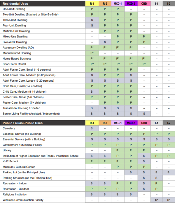
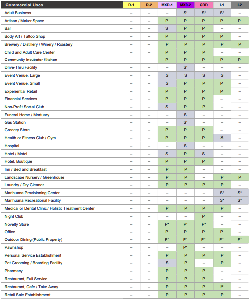
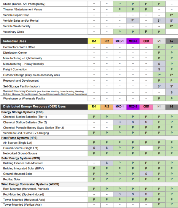
Sec 24-2.05 Schedule Of Permitted Uses

Sec 24-2.06 Schedule Of Regulations
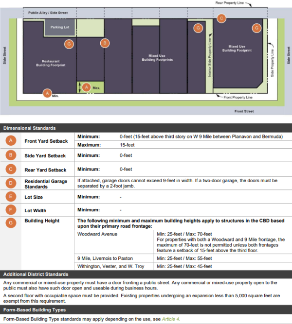
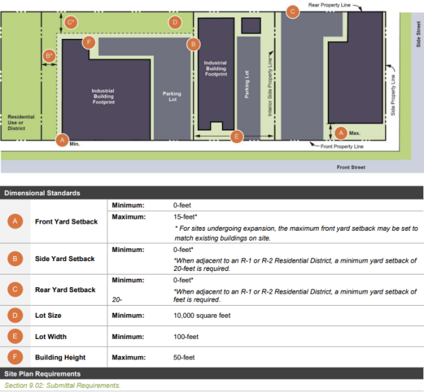
The following dimensional standards apply to each zoning district:
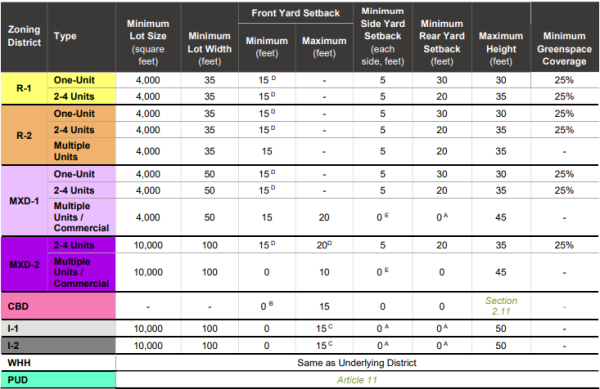
*A. When adjacent to an R-1 or R-2 Residential District, a minimum yard setback of 20-feet is required.
*B. 15-feet above the third story (on W 9 Mile between Planavon and Bermuda).
*C. For sites undergoing expansion, the maximum front yard setback may be set to match existing buildings on site.
*D. Where 50% or more of the frontage on the same block has been previously built upon, the front setback must be plus or minus 5-feet from a line established by using the average depth of the front yards of the five adjacent lots in either direction within the same zoning district eliminating the greatest and least distances measured from the front edge of the house, attached garage or covered front porch. This may result in a front yard setback less than the minimum above.
*E. When adjacent to an R-1 or R-2 Residential District, a minimum yard setback of 5' is required.
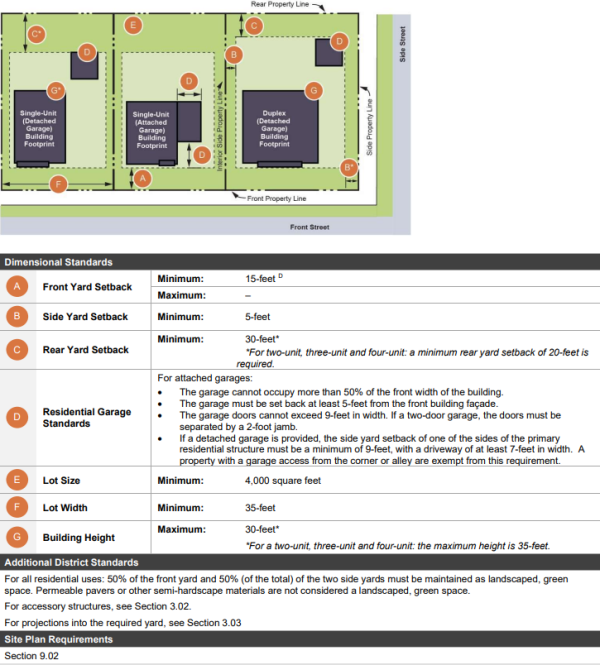
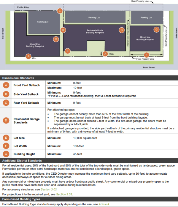
Sec 24-2.07 Lot And Yard Regulations
A. Required Yards. All front, side, and rear yards must be the minimum distance, measured perpendicular, from the principal building, excluding permitted encroachments or projections allowed by this Code.
B. Setback Measurements. Setback requirements from the street must be measured from the right-of-way line of a public street or alley or the easement line of a private road.
C. Double Frontage Lots. The front yard requirements apply on both street frontages. The two remaining yards are side yards, there is no rear yard.
D. Corner Lots. A corner lot has one front yard, which is the yard customarily designated with the street address. This is also known as the “Principal Frontage” for building design purposes. A corner lot also has one rear yard, which is directly opposite the designated front yard. The two remaining yards are side yards.
Sec 24-2.08 R-1 And R-2, Residential Standards
Sec 24-2.09 MXD-1, Neighborhood Mixed Use Standards
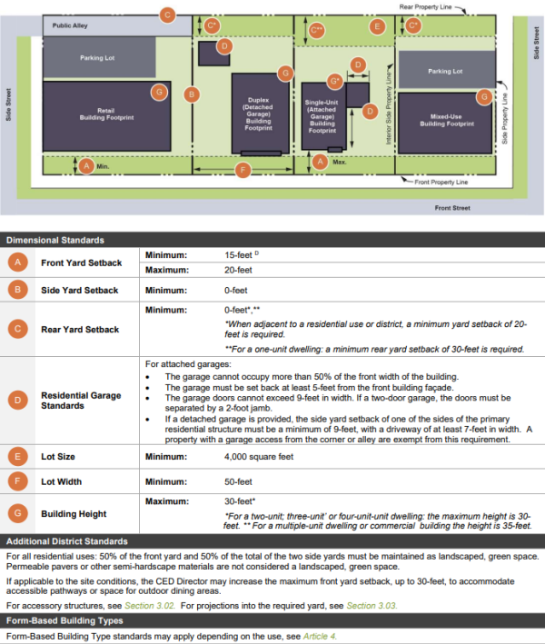
Sec 24-2.10 MXD-2, Corridor Mixed-Use Standards
Sec 24-2.11 CBD, Central Business District Standards