
Gainesville City Zoning Code
ARTICLE 9
8 - OVERLAY ZONES
CHAPTER 9-8-8. - HISTORIC PRESERVATION OVERLAY ZONE[1]
State Law reference— Georgia Historic Preservation Act, O.C.G.A. § 44-10-20 et seq.
Sec. 9-8-1-1. - Purpose and intent.
The purpose of the Airport Overlay Zone is to impose height and use restrictions necessary to ensure that structures and natural objects will not impair flight safety or decrease the operational capability of Lee Gilmer Memorial Airport. These zones overlay the various zoning districts and are intended to provide greater restrictions than the zoning districts otherwise provide with regard to heights and aircraft navigation.
(ULDC 2005, § 9-8-1-1)
Sec. 9-8-1-2. - Definitions.
The following words, terms and phrases, when used in this article, shall have the meanings ascribed to them in this section, except where the context clearly indicates a different meaning:
Airport means Lee Gilmer Memorial Airport.
Airport elevation means 1,277 feet above mean sea level.
Airport Overlay Zones means areas located on the ground that are defined in their boundaries by the airport surfaces overhead, including:
Approach zone means that area on the ground directly beneath an approach surface.
Conical zone means that area on the ground directly beneath the conical surface.
Horizontal zone means that area on the ground directly beneath the horizontal surface.
Navigable airspace zone means that area on the ground within six nautical miles of the airport reference point, and not included in any of the other airport zones.
Primary surface zone means that area on the ground that coincides with the primary surface for each runway.
Transitional zone means that area on the ground directly beneath the transitional surfaces.
Airport reference point means a horizontal reference point calculated in accordance with Federal Aviation Administration Advisory Circular 150/5300-4B. (For the airport configuration on July 1, 1990, the position is 34°16'22"N, 83°49'47"E.)
Airport surfaces means imaginary planes that define the lower limit of aircraft operational areas around an airport, including:
Approach surface means a surface centered on the extended runway centerline, extending outward and upward from the end of the primary surface at a slope designated by the Federal Aviation Administration (FAA).
Conical surface means a surface extending outward and upward from the periphery of the horizontal surface at a slope of 20 to one for a horizontal distance of 4,000 feet.
Horizontal surface means a horizontal plane 150 feet above the established airport elevation, the perimeter of which in plan is established by swinging arcs of 10,000 feet radii from the center of each end of the primary surface of each runway and connecting the adjacent arcs by drawing lines tangent to those arcs.
Primary surface means a surface longitudinally centered on a runway and extending 200 feet beyond each end of that runway. The elevation of any point on the primary surface is the same as the elevation of the nearest point on the runway centerline.
Transitional surfaces means surfaces that extend outward at 90-degree angles to the runway centerline and the runway centerline extended at a slope of seven feet horizontally for each foot vertically from the sides of the primary and approach surfaces to where they intersect the horizontal and conical surfaces.
Airport zone structure means an object, including a mobile object, constructed or installed by man, including, but without limitation, buildings, towers, cranes, smokestacks, earth formation, and overhead transmission lines.
Hazard to air navigation means an obstruction determined to have substantial adverse effect on the same and efficient utilization of the navigable airspace.
Height datum means the vertical distance above mean sea level elevation.
Navigable airspace surface means that area of airspace greater than 200 feet above ground level or above the established airport elevation (Lee Gilmer Memorial Airport elevation of 1,277 feet plus 200 feet equals 1,477 feet), whichever is higher, within three nautical miles (18,228 feet) of the established airport reference point, which height increases in the proportion of 100 feet for each additional nautical mile of distance from the airport to a maximum of 500 feet at six nautical miles (36,456 feet).
Obstruction or obstruction to air navigation means any structure, growth or other object, including a mobile object, which extends above an airport surface, as defined in this section.
Runway means a defined area on an airport prepared for landing and takeoff of aircraft along its length.
Runway designations means runways are numbered by the compass heading of approach for landing aircraft. At Lee Gilmer Airport, runways are: 4, at an approach heading of 40 degrees; 22, at an approach heading of 220 degrees; 11, at an approach heading of 110 degrees; and, 29, at an approach heading of 290 degrees.
Tree means a self-supporting woody plant that normally reaches a mature height of at least 15 feet.
(ULDC 2005, § 9-8-1-2)
Sec. 9-8-1-3. - Airport zones established.
In order to carry out the provisions of this chapter, there are hereby created and established certain zones within the Airport Overlay Zone which include all of the land lying beneath the primary surfaces, approach surfaces, transitional surfaces, horizontal surfaces, and conical surfaces as they apply to Lee Gilmer Memorial Airport. An area located in more than one of the following zones is considered to be only in the zone with the more restrictive height limitation. The airport zones are:
(1)
Primary zone. For runways 11 and 29, the primary surface is centered on the runway, 250 feet wide, and extends 200 feet beyond each end of the runway. For runways 4 and 22, the primary surface is centered on the runway, 500 feet wide, and extends 200 feet beyond each end of the runway.
(2)
Approach zone; runways 11 and 29. The inner edge of this approach zone coincides with the width of the primary surface which is 250 feet wide. The approach zone expands outward uniformly to a width of 850 feet at a horizontal distance of 3,000 feet from the primary surface. Its centerline is the continuation of the centerline of the runway.
(3)
Approach zone; runway 22. The inner edge of this approach zone coincides with the width of the primary surface which is 500 feet wide. The approach zone expands outward uniformly to a width of 1,400 feet at a horizontal distance 3,000 feet from the primary surface. Its centerline is the continuation of the centerline of the runway.
(4)
Approach zone; runway 4. The inner edge of this approach zone coincides with the width of the primary surface which is 500 feet wide. The approach zone expands outward uniformly to a width of 1,530 feet at a horizontal distance of 5,100 feet from the primary surface. Its centerline is the continuation of the centerline of the runway.
(5)
Transitional zones. The transitional zones are the areas beneath the transitional surfaces.
(6)
Horizontal zone. The horizontal zone is established by swinging arcs of 10,000 feet radii from the center of each end of the primary surface of each runway and connecting the adjacent arcs by drawing lines tangent to those arcs. The horizontal zone does not include the approach and transitional zones.
(7)
Conical zone. The conical zone is established as the area that commences at the periphery of the horizontal zone and extends outward for a horizontal distance of 4,000 feet.
(8)
Navigable airspace zones. These consist of four zones which are centered on each runway centerline, beginning 11,000 feet from the end of each primary zone and expanding outwardly as shown in table 9-8-1-1 as follows:
Table 9-8-1-1. Navigable Airspace Zones
(ULDC 2005, § 9-8-1-3)
Sec. 9-8-1-4. - Airport Overlay Zone map.
The various airport zones established by this chapter are illustrated on the approach plan and profile map of Lee Gilmer Memorial Airport, prepared by Mayes, Sudderth & Etheredge, Inc., and dated March 15, 1994, which is hereby adopted and made a part of this chapter.
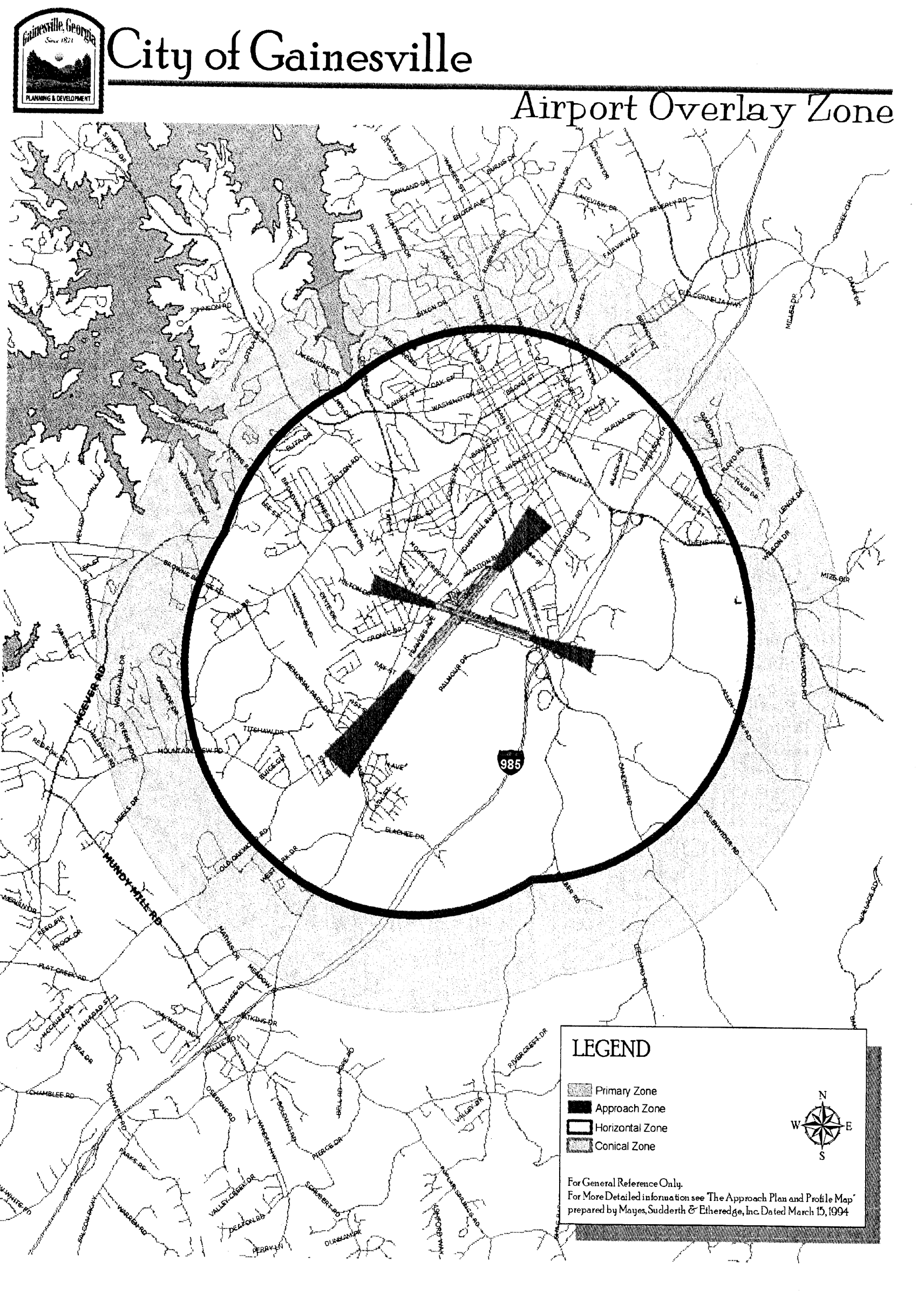
Airport Overlay Zone
(ULDC 2005, § 9-8-1-4)
Sec. 9-8-1-5. - Airport zone height limitations.
No structure shall be erected, altered, or maintained, and no tree shall be allowed to grow in any airport zone to a height in excess of the maximum height established for such zone, as shown in table 9-8-1-2; provided, however, that nothing in this section shall be construed as prohibiting the construction or maintenance of any structure or growth of any tree to a height up to 50 feet above the surface of land.
Table 9-8-1-2. Height Limitations by Airport Zone
(ULDC 2005, § 9-8-1-5)
Sec. 9-8-1-6. - Use restriction.
No use shall be located within any airport zone that would create electrical interference with navigational signals or radio communication between the airport and aircraft, make it difficult for pilots to distinguish between airport lights and others, result in glare in the eyes of pilots using the airport, impair visibility in the vicinity of the airport, create bird strike hazards, or otherwise in any way endanger or interfere with the landing, takeoff, or maneuvering of aircraft intending to use the airport.
(ULDC 2005, § 9-8-1-6)
Sec. 9-8-1-7. - Hazards shall not be increased.
No permit shall be granted that would allow the establishment or creation of an obstruction or permit a nonconforming use, structure, or tree to become a greater hazard to air navigation, than it was on the effective date of the ordinance from which this chapter is derived, or any amendments thereto, or a greater hazard than it is when the application for a permit is made.
(ULDC 2005, § 9-8-1-7)
Sec. 9-8-1-8. - Marking and lighting.
The owner of any existing nonconforming structure or tree within an airport zone must permit the installation, operation, and maintenance thereon of such markers and lights as shall be deemed necessary by the airport manager to indicate to the operators of aircraft in the vicinity of the airport the presence of such obstruction. Such markers and lights shall be installed, operated, and maintained at the expense of the city.
(ULDC 2005, § 9-8-1-8)
Sec. 9-8-1-9. - Nonconforming uses abandoned or destroyed.
Whenever the public works director determines that a nonconforming tree or structure has been abandoned or more than 50 percent torn down, physically deteriorated, or decayed, such tree or structure shall be removed or modified to the extent necessary to comply with the applicable height limit.
(ULDC 2005, § 9-8-1-9)
Sec. 9-8-1-10. - Variances.
Any person desiring to erect or increase the height of any structure, or permit the growth of any tree, or use property, not in accordance with the regulations prescribed in this section, may apply to the planning and appeals board for a variance from such regulations. The application for variance shall be accompanied by a determination from the FAA as to the effect of the proposal on the operation of air navigation facilities and the safe, efficient use of navigable airspace.
(ULDC 2005, § 9-8-1-10)
Sec. 9-8-1-11. - Staff review of application for variance.
Variance applications pursuant to this chapter shall be reviewed by the director of public works and the airport manager, and their response or recommendation must be received prior to action on any such variance.
(ULDC 2005, § 9-8-1-11)
Sec. 9-8-1-12. - Findings required to support variances.
A variance may be allowed only where it is duly found that the requirements of the variance procedures and standards contained in chapter 9-22-6 are met; and relief granted will not create a hazard to air navigation, as defined by this chapter or as determined by the FAA.
(ULDC 2005, § 9-8-1-12)
Sec. 9-8-1-13. - Marking and lighting a condition of variance approval.
Any variance granted shall be conditioned to require the owner of the structure or tree in question to install, at the owner's expense, such markings and lights as may be necessary, and to permit the city, at its own expense, to operate and maintain the necessary markings and lights.
(ULDC 2005, § 9-8-1-13)
Sec. 9-8-2-1. - Purpose and intent.
(a)
One of the key goals established in the comprehensive plan is the improvement of community quality, especially in the form of improved development quality. The perceived quality of new growth and development is an important element of community character and livability. An important element of quality of growth is the recognition of the importance of community gateways. Gateways refer to key points of entry into a community. In the case of the city, there are several gateway corridors that are important both from a functional transportation and a symbolic perspective.
(b)
Consistent with the recommendations of the comprehensive plan, this chapter establishes provisions to ensure that the design quality of new development in the city's identified gateway corridors are held to high standards, as applied via the site and architectural design review processes established in article 9-9.
(ULDC 2005, § 9-8-2-1; Ord. No. 2016-09, § VI, 6-21-2016)
Sec. 9-8-2-2. - Boundaries and map.
(a)
The boundaries of the Gateway Corridor Overlay Zone shall be as shown on a map titled Gateway Corridor Overlay Zone which is hereby adopted and made a part of this Code, and which may be amended from time to time in accordance with the procedures established in this Code.
(b)
The boundaries of the Gateway Corridor Overlay Zone include all those major roadways entering the city, with the exception of those corridors that are fully included within the Limestone and Midtown Overlay Zones. The Gateway Corridor Overlay Zone shall include all properties fronting on a gateway corridor designated on the overlay zone map.
(ULDC 2005, § 9-8-2-2)
Sec. 9-8-2-3. - Permitted uses.
All uses permitted by right or as special uses by the underlying zoning district shall be similarly permitted under the Gateway Corridor Overlay Zone. This chapter does not establish use limitations.
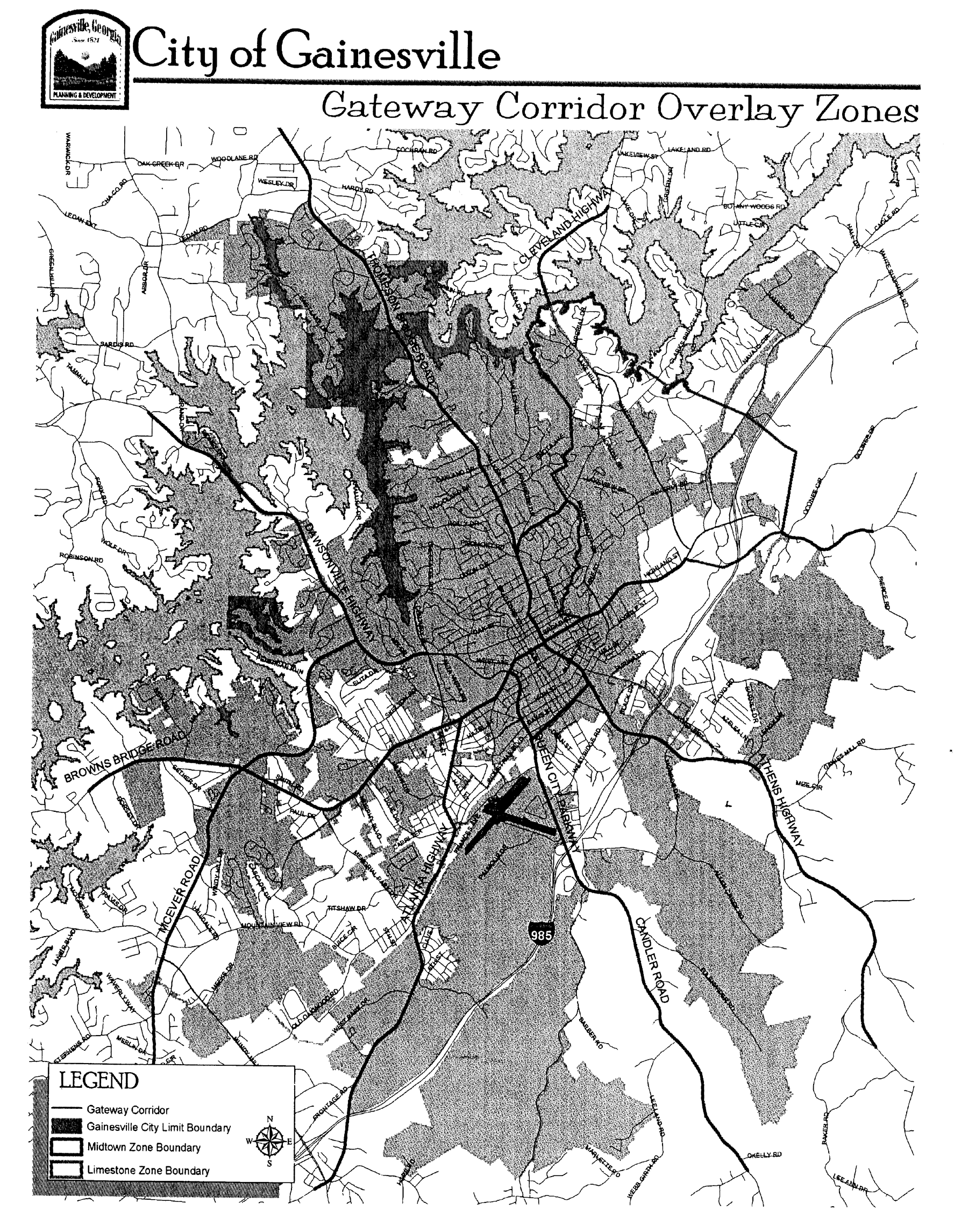
Gateway Corridor Overlay Zones
(ULDC 2005, § 9-8-2-3; Ord. No. 2016-09, § V, 6-21-2016)
Sec. 9-8-2-4. - Dimensional requirements.
This overlay zone does not establish dimensional requirements, except that nonresidential zoned lots 20 acres or larger shall require special use approval by the governing body to further subdivide. The governing body shall consider the following standards in deciding whether to grant special use approval to subdivide the lot, giving due weight or priority to those factors that are appropriate to the circumstances of each proposal:
(1)
Minimum subdivided lot size should be two acres.
(2)
Maximum impervious surface coverage should not exceed 75 percent of the subdivided lot.
(3)
Minimum landscaped open space should be a minimum of 20 percent of the subdivided lot.
(4)
Access should be limited to an internal access easement within the property, prior to any subdividing, to facilitate the movement of motor vehicles across the property. New driveways on existing public right-of-way areas should be discouraged.
(5)
The following uses are discouraged:
a.
Automated or non-automated car washes.
b.
Coin-laundry facilities.
c.
Dollar-type stores or thrift stores.
d.
Community donation boxes.
e.
Gas stations (located on lots less than two acres in size).
f.
Group homes, homeless shelters, roominghouse or crisis centers.
g.
Hookah, e-cigarette, and/or vapor lounge/bars.
h.
Indoor or outdoor commercial recreational facilities.
i.
Kennels.
j.
Liquor stores.
k.
Marine sales or repair stores.
l.
Massage parlors.
m.
Miniwarehouses, including climate-controlled self-service storage facilities.
n.
Motels or extended stay lodging.
o.
Motor vehicle sales or service.
p.
Pawnshops.
q.
Psychics, fortunetellers, clairvoyants and the like.
r.
Retail sales of alternative nicotine products.
s.
Sexually oriented adult uses.
t.
Tattoo parlors.
u.
Taxicab or limousine services.
v.
Tobacco or vaping stores.
w.
Vehicle emission testing facility.
x.
Veterinarian or animal hospitals with outdoor kennels.
y.
Wireless telecommunication facility or cell towers excluding co-location.
(6)
Unless otherwise stated, uses shall be subject to the applicable dimensional requirements for the underlying zoning district in which said uses are located.
(ULDC 2005, § 9-8-2-4; Ord. No. 2020-29, § I, 9-1-2020)
Secs. 9-8-2-5—9-8-2-11. - Reserved.
Editor's note— Ord. No. 2016-09, § VI, adopted June 21, 2016, repealed §§ 9-8-2-5—9-8-2-11 which pertained to buildings, freestanding walls and fences, off-street parking and loading, underground utilities, stormwater detention, grass areas, and compliance, respectively, and derived from Ord. No. 2009-47, §§ VIII—IX, adopted Dec. 15, 2009.
Sec. 9-8-3-1. - Purpose and intent.
(a)
The purpose of the Limestone Parkway Overlay Zone is to provide special design requirements for those properties located within the zone, regardless of their zoning classification, in order to maintain a consistent appearance along the parkway and throughout the zone, as applied via the site and architectural design review processes established in article 9-9. The intent of this zone is to create an identity for the area that will enhance its economic vitality and protect the value of properties within the zone.
(b)
It is also the intent of this chapter, relative to hillside developments, to retain an overall appearance similar to that of the natural terrain, i.e., to limit extreme alteration of the terrain and blend approved alterations into the natural shape of the land; specifically:
(1)
To preserve the most visually significant slope banks and ridgelines in their natural state by clustering developments;
(2)
To encourage only minimal grading which relates to the natural contour of the land;
(3)
To preserve visually significant rock outcropping, native plant materials, natural hydrology, and areas of visual significance;
(4)
To encourage variety in building types, padding techniques, grading techniques, lot sizes, site design, density, arrangement, and spacing of buildings in developments;
(5)
To encourage innovative architectural, landscaping, circulation, and site design;
(6)
To discourage mass grading of large pads and excessive terracing; and
(7)
To provide safe circulation of vehicular and pedestrian traffic to and within the hillside areas and to provide access for emergency vehicles necessary to serve the hillside areas.
(ULDC 2005, § 9-8-3-1; Ord. No. 2016-09, § VII, 6-21-2016)
Sec. 9-8-3-2. - Boundaries and map.
The boundaries of the Limestone Parkway Overlay Zone shall be as shown on a map titled Limestone Parkway Overlay Zone which is hereby adopted and made a part of this Code, and which may be amended from time to time in accordance with the procedures established in this Code.
(ULDC 2005, § 9-8-3-2)
Sec. 9-8-3-3. - Permitted uses.
All uses permitted by right or as special uses by the underlying zoning district shall be similarly permitted in the Limestone Parkway Overlay Zone.
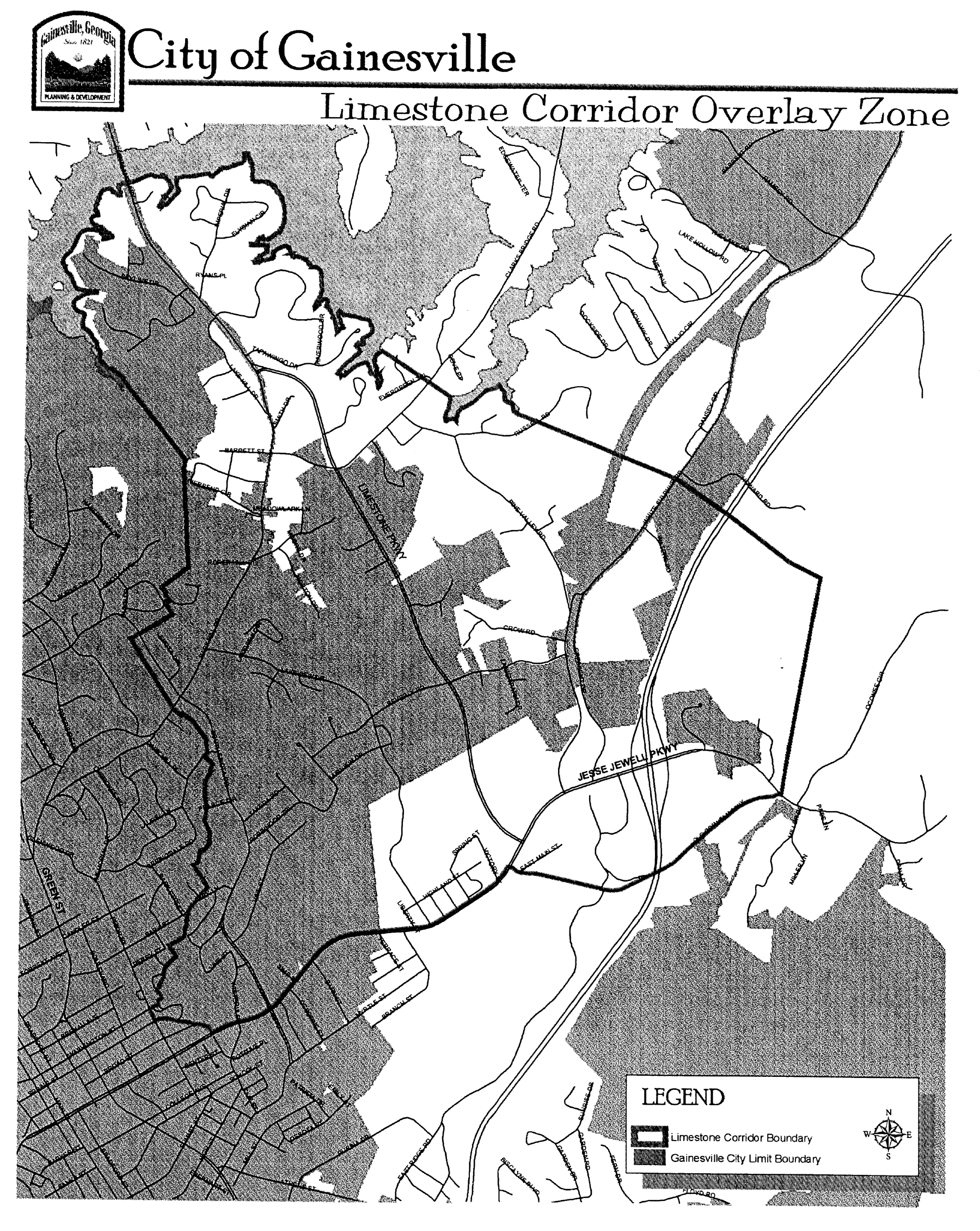
Limestone Corridor Overlay Zone
(ULDC 2005, § 9-8-3-3; Ord. No. 2016-09, § VII, 6-21-2016)
Sec. 9-8-3-4. - Dimensional requirements.
All properties located within the Limestone Parkway Overlay Zone shall conform to the dimensional requirements of table 9-8-3-1, where such requirements are more restrictive than the requirements of the underlying zoning district:
Table 9-8-3-1. Limestone Parkway Overlay Zone Dimensional Requirements
(ULDC 2005, § 9-8-3-4)
Sec. 9-8-3-5. - Increase in height.
(a)
Building height may be increased beyond the maximum to a total height of two stories for an additional lower story on the down-slope end of a building which is constructed on a hillside so that only one story is aboveground on the up-slope end.
(b)
Buildings of greater height are also permitted subject to additional setback from arterial roads and from property zoned for residential use. One additional story shall be permitted for each additional 15 feet front building setback provided beyond the minimum front setback requirement or one additional story for each additional 15 feet of side or rear building setback beyond the minimum required setback abutting property zoned for residential use.
(c)
As a condition to any such height increase based on the provision of greater setbacks than required, one large-species tree (over 40 feet in height at maturity) for each 30 feet of building perimeter shall be planted or retained between such buildings of greater height and adjoining property lines, in addition to any other trees required under this Code. Alternate height limits may be allowed through conditions of approval of the Limestone Parkway Overlay Zone for a specific development.
(ULDC 2005, § 9-8-3-5)
Sec. 9-8-4-1. - Purpose and intent.
The quality of public drinking water supplies must be ensured. Land-disturbing activities associated with development can increase erosion and sedimentation, which threaten the storage capacity of reservoirs and impair the quality of public drinking water supplies. Stormwater runoff, particularly from impervious surfaces, can introduce toxins, nutrients, and sediments into drinking water supplies, making water treatment more complicated and expensive and rendering water resources unusable for recreation. Industrial land uses that involve the manufacture, use, transport, and storage of hazardous or toxic waste materials result in potential risks of contamination of nearby public drinking water supplies. Therefore, land use activities within water supply watersheds must be regulated to ensure that public water supplies remain clean. This chapter establishes standards, consistent with the state department of natural resources' rules for environmental planning criteria for water supply watersheds (Rule 391-3-16-01) to ensure water quality in the watershed system is not compromised by land activities such as grading, septic systems, and accidental release of contaminants. The intent of this chapter is to minimize the transport of pollutants and sediment to the water supply, to maintain the yield of water supply watersheds, and to ensure water can be treated to meet federal and state drinking water standards, within the North Oconee River small water supply watershed.
(ULDC 2005, § 9-8-4-1; Ord. No. 2020-42, § V, 11-3-2020)
Sec. 9-8-4-2. - Definitions.
The following words, terms and phrases, when used in this article, shall have the meanings ascribed to them in this section, except where the context clearly indicates a different meaning:
Buffer means a natural or enhanced vegetated area with no or limited minor land disturbances, such as trails and picnic areas, located adjacent to water supply reservoirs or perennial streams within water supply watersheds.
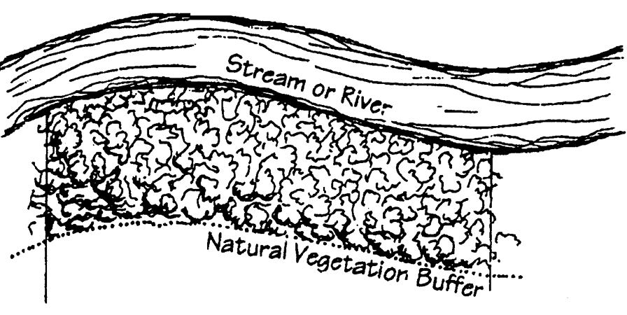
Buffer
Impervious surface means a manmade structure or surface that prevents the infiltration of stormwater into the ground below the structure or surface. Examples are buildings, roads, driveways, parking lots, decks, swimming pools, and patios.
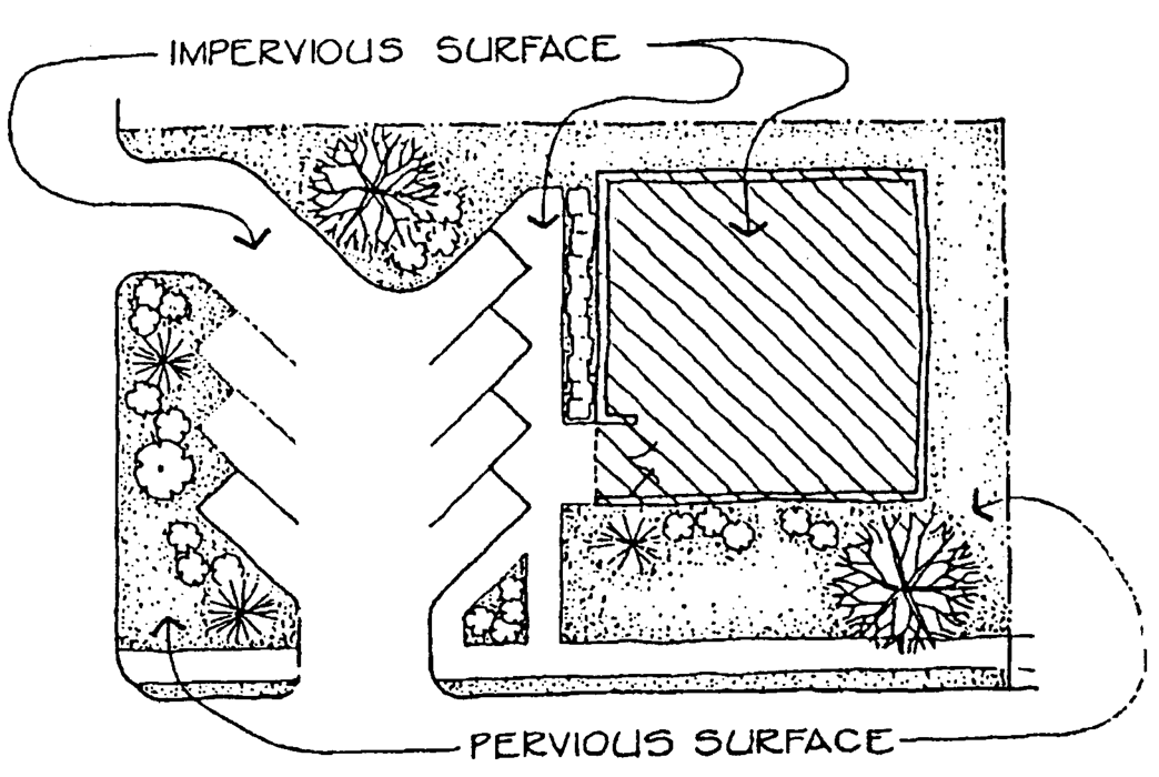
Impervious Surface
Perennial stream means a stream that has normal stream flow consisting of base flow (discharge that enters the stream mainly from groundwater) or both base flow and direct runoff during any period of the year.
Reservoir boundary means the edge of a water supply reservoir defined by its normal pool level.
Small water supply watershed means a watershed that contains less than 100 square miles of land within the drainage basin upstream of a governmentally owned public drinking water supply intake.
Utility means all public, private, and municipal, above or below ground, infrastructure systems providing water, stormwater, sanitary sewer, natural gas, electricity, telecommunications, cable television or Internet services; or any other service controlled by the state public services commission.
Water supply reservoir means a governmentally owned impoundment of water for the primary purpose of providing water to one or more governmentally owned public drinking water systems. The term "water supply reservoir" excludes the multipurpose reservoirs owned by the U.S. Army Corps of Engineers.
(ULDC 2005, § 9-8-4-2; Ord. No. 2020-42, § V, 11-3-2020)
Sec. 9-8-4-3. - Boundaries and map.
The North Oconee River Water Supply Watershed Protection Overlay Zone is hereby designated and shall consist of the land areas that drain to the proposed North Oconee River public water supply intake and water supply reservoir. The boundaries of the overlay zone are defined by the ridgelines of the watershed. The overlay zone boundaries are further delineated and defined on the North Oconee River Water Supply Watershed Protection Overlay Zone map, which is hereby incorporated and made a part of this chapter by reference.
(ULDC 2005, § 9-8-4-3; Ord. No. 2020-42, § V, 11-3-2020)
Sec. 9-8-4-4. - Permitted uses and use restrictions.
All uses allowed in the underlying zoning districts, as established by this Code, are permitted in this overlay zone, subject to standards established in this chapter, except for those listed or qualified below:
(1)
New hazardous waste treatment or disposal facilities are prohibited.
(2)
New sanitary landfills are allowed only if they have synthetic liners and leachate collection systems.
(3)
New facilities, located within seven miles of a water supply intake or water supply reservoir, which handle hazardous material of the types listed in section 312 of the Resource Conservation and Recovery Act of 1976 (excluding underground storage tanks) and amounts of 10,000 pounds or more on any one day, shall perform their operations on impervious surfaces and in conformance with any applicable federal spill prevention requirements or the requirements of the International Fire Code.
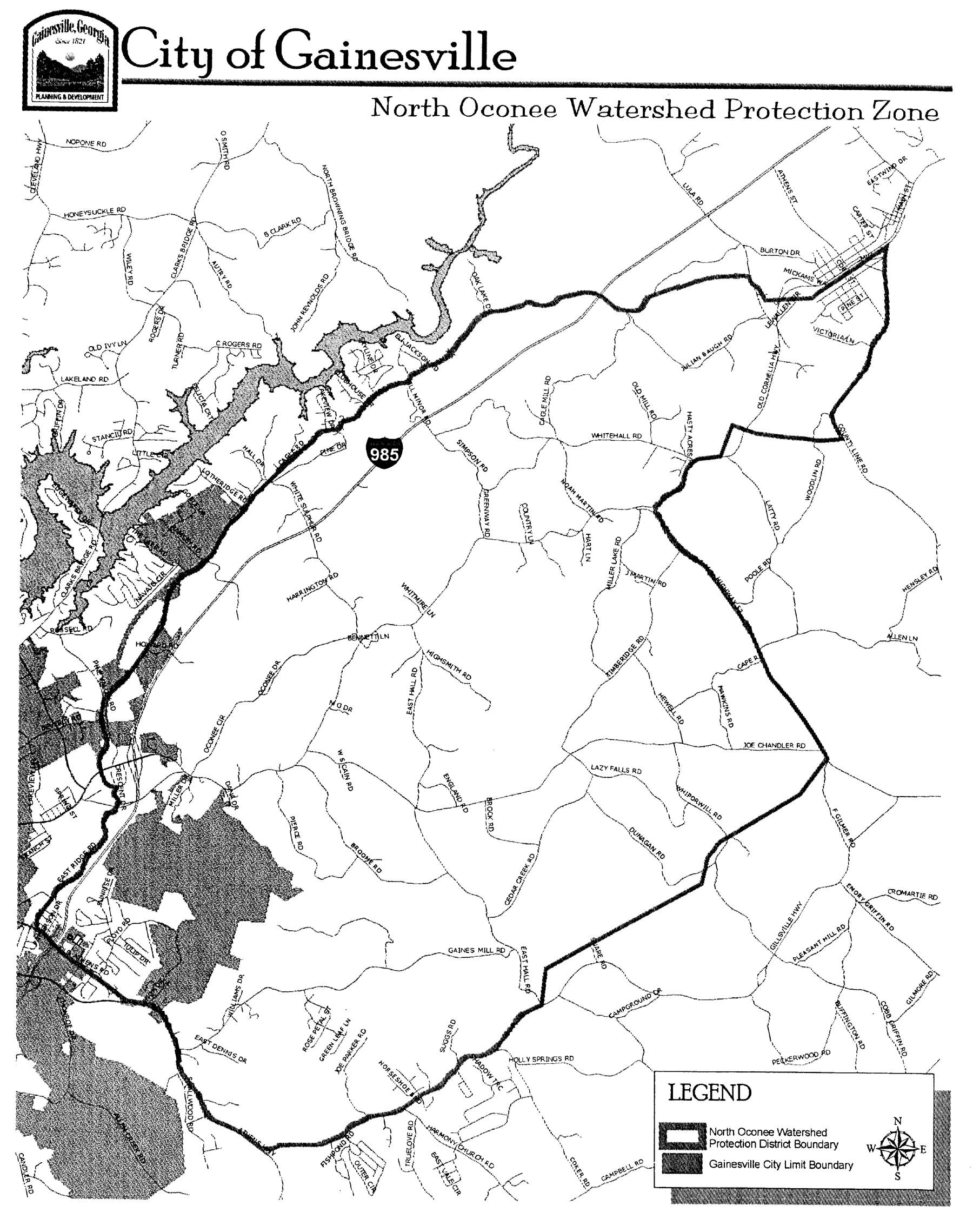
North Oconee Watershed Protection Zone
(ULDC 2005, § 9-8-4-4; Ord. No. 2020-42, § V, 11-3-2020)
Sec. 9-8-4-5. - Requirements within seven miles of intake.
Within a seven-mile radius upstream of the North Oconee River public drinking water supply intake, the following requirements shall apply to perennial stream corridors:
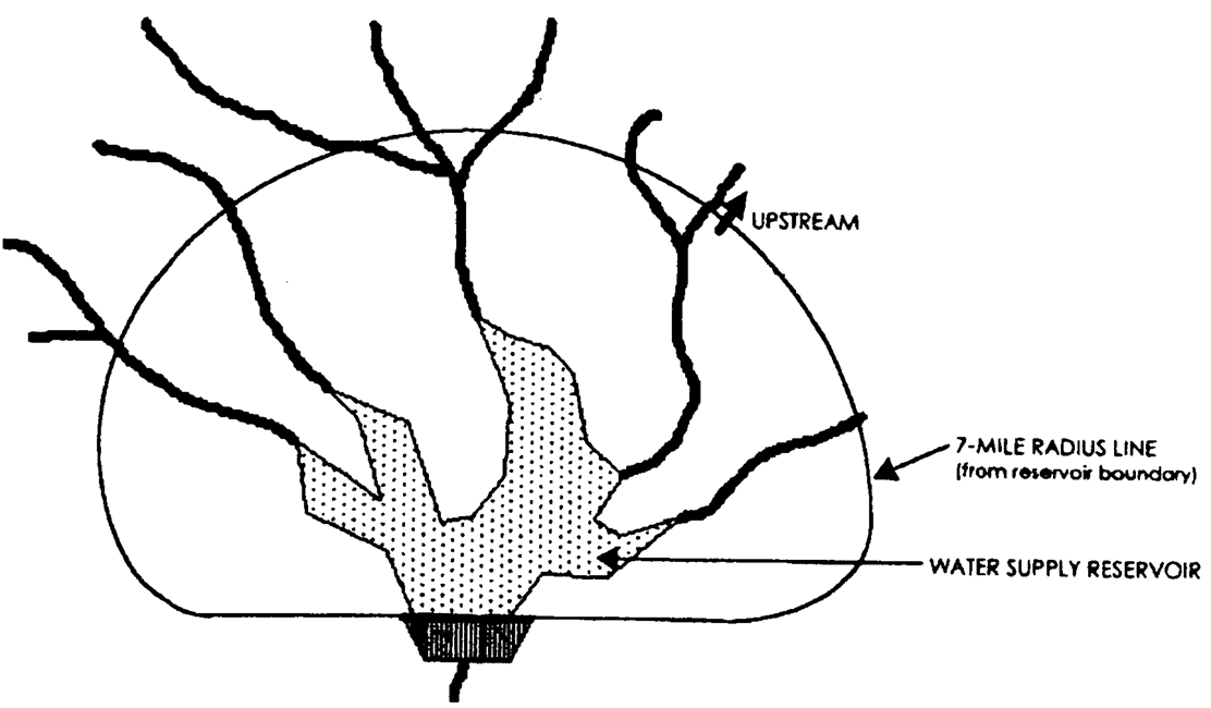
Requirements Within Seven Miles of Intake
(1)
A buffer shall be maintained for a distance of 100 feet on both sides of the perennial stream as measured from the stream banks.
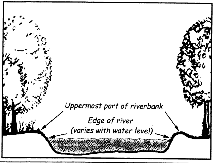
Buffer Maintained
(2)
No impervious surface shall be constructed within a 150-foot setback area on both sides of the perennial stream as measured from the stream banks.
(3)
Septic tanks and septic tank drainfields are prohibited in the buffer and impervious surface setback.
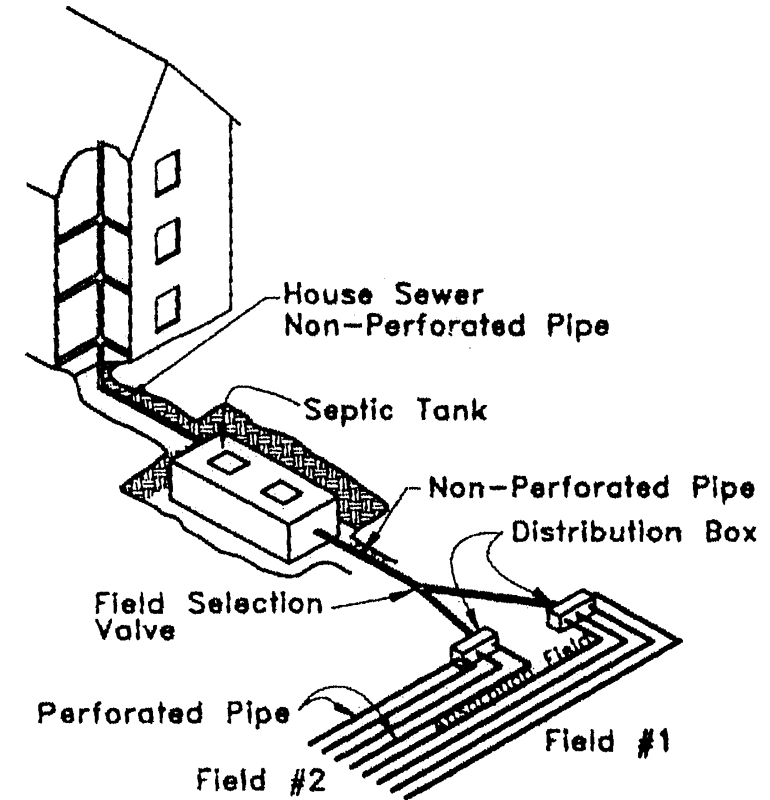
Septic Tanks and Drainfields
(ULDC 2005, § 9-8-4-5; Ord. No. 2020-42, § V, 11-3-2020)
Sec. 9-8-4-6. - Requirements beyond seven miles of intake.
Within the water supply watershed but outside a seven-mile radius upstream of the North Oconee River public drinking water supply intake, the following requirements shall apply to the perennial stream corridors:
(1)
A buffer shall be maintained for a distance of 50 feet on both sides of the perennial stream as measured from the stream banks.
(2)
No impervious surface shall be constructed within a 75-foot setback area on both sides of the perennial stream as measured from the stream banks.
(3)
Septic tanks and septic tank drainfields are prohibited in the impervious surface setback.
(ULDC 2005, § 9-8-4-6; Ord. No. 2020-42, § V, 11-3-2020)
Sec. 9-8-4-7. - Exemptions.
The following land uses and activities are exempted from compliance with this chapter:
(1)
Previously existing land uses. Land uses existing prior to the adoption of watershed protection regulations by the city (February 8, 2001). Any structure existing at that time which does not conform to the setback, buffer and/or impervious surface requirements of this chapter may be re-established if damaged or destroyed, provided the degree of nonconformity is not increased with the construction of the replacement structure.
(2)
Forestry and silviculture. Specific forestry and silviculture activities in the stream corridor buffer and setback areas, on land that is zoned for forestry, silviculture or agricultural uses, provided that activities are not incidental to other land development activities, activities are consistent with best management practices established by the state forestry commission or the state department of agriculture, and provided, further, that the activity shall not impair the quality of the drinking water stream.
(3)
Utility encroachment. If utilities cannot feasibly be located outside the buffer or setback areas required by this chapter, such utility locations can be exempted with permission of the director from the stream corridor buffer and setback area provisions subject to the following conditions:
a.
The utilities shall be located as far from the stream bank as reasonably possible.
b.
The installation and maintenance of the utilities shall be such to protect the integrity of the buffer and setback areas as best as reasonably possible.
c.
The utilities shall not impair the quality of the drinking water stream.
(ULDC 2005, § 9-8-4-7; Ord. No. 2020-42, § V, 11-3-2020)
Sec. 9-8-4-8. - Impervious surface limitations.
The impervious surface area, including all public and private structures, utilities, or facilities, of the entire small water supply watershed shall be limited to 25 percent, or existing use, whichever is greater.
(ULDC 2005, § 9-8-4-8; Ord. No. 2020-42, § V, 11-3-2020)
Sec. 9-8-4-9. - Compliance with reservoir management plan.
All development within the 150-foot buffer from any water supply reservoir boundary, and any uses of the reservoir itself, including docks, shall, as may be applicable, comply with any reservoir management plan adopted by the local government with jurisdiction and approved by the state department of natural resources.
(ULDC 2005, § 9-8-4-9; Ord. No. 2020-42, § V, 11-3-2020)
Sec. 9-8-4-10. - Annexation, rezoning or special use within the watershed.
When an application for annexation, rezoning or special use for land subject to this chapter is proposed, the director, planning and appeals board, and governing body shall consider the potential impacts of development resulting from the annexation, rezoning or special use if approved would have on the purposes of watershed protection established in this chapter. Any finding that development pursuant to the annexation, rezoning or special use if approved would result in excessive impervious surface or adverse impacts on water quality in the watershed shall be a sufficient basis for denial of the annexation, rezoning or special use application by the governing body.
(ULDC 2005, § 9-8-4-10; Ord. No. 2020-42, § V, 11-3-2020)
Sec. 9-8-5-1. - Purpose and intent.
(a)
Groundwater is among the nation's most important natural resources. It provides drinking water to urban and rural communities, supports irrigation and industry, sustains the flow of streams and rivers, and maintains riparian and wetland ecosystems. In many areas of the nation, the future sustainability of groundwater resources is at risk from contamination. Because groundwater systems typically respond slowly to human actions, a long-term perspective is needed to manage this valuable resource. This chapter is intended to implement rules of the state department of natural resources environmental protection division known as the rules for environmental planning criteria, as they specifically relate to groundwater recharge areas (Rule 391-3-16-.02).
(b)
It is essential to the health, safety, and welfare of the public that the quality of subsurface public drinking water supplies be maintained. Groundwater resources exist in underground reservoirs known as aquifers. These aquifers are zones of rock beneath the earth's surface that are capable of producing water through a well. They occupy vast regions of the subsurface and are replenished by infiltration of surface water runoff in zones of the surface known as groundwater recharge areas. Groundwater is susceptible to contamination when unrestricted development occurs within significant groundwater recharge areas.
(c)
Certain land use activities, such as septic tanks, underground tanks, and chemical spills, pose a threat to the quality of groundwater supplies. Therefore, it is necessary to manage land uses within groundwater recharge areas in order to ensure that pollution threats are minimized. To this end, this chapter establishes minimum lot sizes to provide for the orderly and safe development of property utilizing on-site sewage management systems.
(ULDC 2005, § 9-8-5-1; Ord. No. 2020-42, § VI, 11-3-2020)
Sec. 9-8-5-2. - Definitions.
The following words, terms and phrases, when used in this article, shall have the meanings ascribed to them in this section, except where the context clearly indicates a different meaning:
Acre-foot means the volume (as of irrigation water) that would cover one acre to a depth of one foot.
Aquifer means any stratum or zone of rock beneath the surface of the earth capable of containing or producing water for a well.
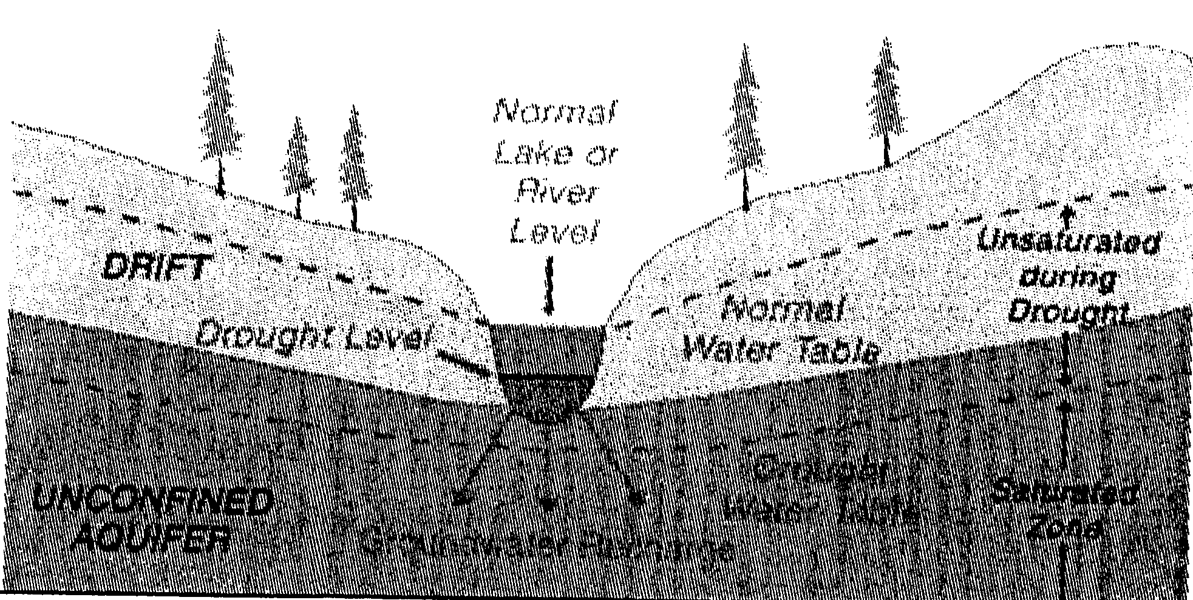
Recharge of Groundwater from
Surface Water, Normal and Drought Conditions
DRASTIC means the standardized system for evaluating groundwater pollution potential using the hydrogeologic settings described in U.S. Environmental Protection Agency document EPA-600-2-87-035. (Note: The DRASTIC methodology is the most widely used technique for evaluating pollution susceptibility).
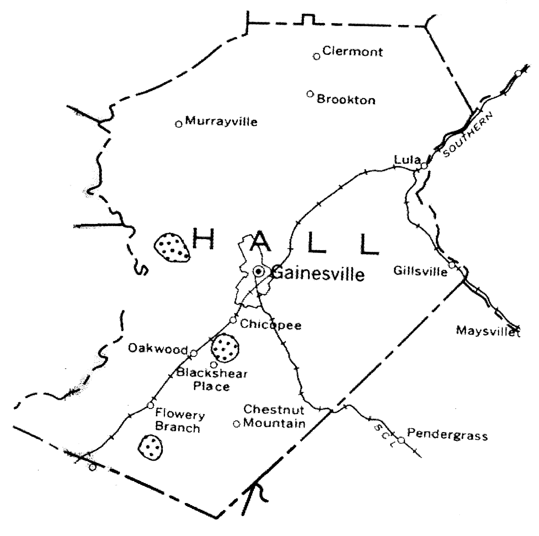
Hydrologic Atlas 18 means a map prepared by the state department of natural resources and published by the state geologic survey in 1989, which identifies the most significant groundwater recharge areas of the state as spotted areas labeled as "areas of thick soils."
Hydrologic Atlas 20 means a multicolored map of the state at a scale of 1:500,000, prepared by the state department of natural resources using the DRASTIC methodology and published by the state geologic survey in 1992, which shows areas of higher, average (or medium), and lower susceptibility of groundwater to pollution in the state. This map is also commonly known as the Groundwater Pollution Susceptibility Map of Georgia. Note: this map shows all areas in the county as lower-pollution susceptibility.
Pollution susceptibility means the relative vulnerability of an aquifer to being polluted from spills, discharges, leaks, impoundments, applications of chemicals, injections and other human activities in the recharge area. Each significant recharge area shown on Hydrologic Atlas 18 is classified on Hydrologic Atlas 20 as higher, average, or lower pollution susceptibility.
Recharge area means any portion of the earth's surface where water infiltrates into the ground to replenish an aquifer.
Significant recharge areas means those recharge areas mapped by the state department of natural resources in Hydrologic Atlas 18, 1989 edition, within the relevant portion of the county. Each significant recharge area shall be determined to have a pollution susceptibility of high, medium, or low based on Hydrologic Atlas 20. Note: all areas in the county are lower-pollution susceptibility.
(ULDC 2005, § 9-8-5-2; Ord. No. 2020-42, § VI, 11-3-2020)
Sec. 9-8-5-3. - Boundaries and map.
The Groundwater Recharge Area Protection Overlay Zone is hereby designated and shall consist of the land areas within the jurisdiction of the city that are mapped as significant recharge areas by the state department of natural resources in Hydrologic Atlas 18, 1989 edition. The boundaries of the overlay zone are defined by on the Groundwater Recharge Area Protection Overlay Zone map, which is hereby incorporated and made a part of this chapter by reference.
Groundwater Recharge Area
Protection Overlay Zone
(ULDC 2005, § 9-8-5-3; Ord. No. 2020-42, § VI, 11-3-2020)
Sec. 9-8-5-4. - Minimum lot size.
(a)
Within an area governed by this chapter, new homes or land uses served by a septic tank/drainfield system shall be on lots having minimum lot sizes of at least 110 percent of the subdivision minimum lot size calculated based on application of DHR table MT-1 within a low pollution susceptibility area, based on application of table MT-1 of the DHR manual (hereinafter "DHR table MT-1"). The minimums set forth in DHR table MT-1 may be increased further based on consideration of other factors set forth in sections A-F of the DHR manual, as determined by the county environmental health department.
(b)
Any lot of record approved prior to the adoption of groundwater recharge area regulations (February 8, 2001) shall be exempt from the minimum lot size requirements of this section.
(c)
Within an area governed by this chapter, no subdivision plat shall be recorded until and unless said plat has been reviewed and approved by the director as being in compliance with the minimum lot sizes established by this section.
(ULDC 2005, § 9-8-5-4; Ord. No. 2020-42, § VI, 11-3-2020)
Sec. 9-8-5-5. - Manufactured home parks.
Manufactured home parks are prohibited within this overlay zone.
(ULDC 2005, § 9-8-5-5; Ord. No. 2020-42, § VI, 11-3-2020)
Sec. 9-8-5-6. - Agricultural waste impoundment sites.
New agricultural waste impoundment sites which exceed 50 acre-feet in a significant recharge area shall contain a liner consisting of compacted clay having a thickness of one foot and a vertical hydraulic conductivity of less than five by 10 -7 cm/sec or other criteria established by the natural resource and conservation service.
(ULDC 2005, § 9-8-5-6; Ord. No. 2020-42, § VI, 11-3-2020)
Sec. 9-8-5-7. - Aboveground chemical or petroleum storage tanks.
Within an area governed by this chapter, new aboveground chemical or petroleum storage tanks having a minimum volume of 660 gallons shall have secondary containment for 110 percent of the volume of such tanks or 110 percent of the volume of the largest tank in a cluster of tanks. Such tanks used for agricultural purposes are exempt, provided they comply with all federal requirements.
(ULDC 2005, § 9-8-5-7; Ord. No. 2020-42, § VI, 11-3-2020)
Sec. 9-8-5-8. - Hazardous materials handling facilities.
Within an area governed by this chapter, new facilities that handle hazardous materials of the types listed in section 312 of the Resource Conservation and Recovery Act of 1976 (excluding underground storage tanks) and in amounts of 10,000 pounds or more on any one day, shall perform their operations on impervious surfaces and in conformance with any applicable federal spill prevention requirements or the requirements of the International Fire Code.
(ULDC 2005, § 9-8-5-8; Ord. No. 2020-42, § VI, 11-3-2020)
Sec. 9-8-5-9. - County environmental health department approval required.
No development permit or building permit shall be issued by the community and economic development department or the building official for a building, structure, or manufactured home to be served by a septic tank, unless the county environmental health department first approves the proposed septic tank installation as meeting the requirements of the state department of human resources manual.
(ULDC 2005, § 9-8-5-9; Ord. No. 2020-42, § VI, 11-3-2020)
Sec. 9-8-5-10. - Site guidance for groundwater infiltration best management practices (BMPs).
Permanent stormwater infiltration devices are prohibited by the Georgia Planning Act in areas having high pollution susceptibility. Avoid the use of infiltration devices at stormwater hotspots and in areas known to provide groundwater recharge to water supply aquifers unless adequate pretreatment is provided upstream and a liner is installed to prevent pollutants from reaching underlying groundwater aquifers. Infiltration BMPs should only be applied on development sites that have permeable soils (i.e., hydrologic soil group A and B soils) and that have a water table and confining layers (e.g., bedrock, clay lenses) that are located at least two feet below the bottom of the trench or basin. Follow design guidance in the Georgia Stormwater Management Manual (GSMM).
(Ord. No. 2020-42, § VI, 11-3-2020)
Sec. 9-8-6-1. - Purpose and intent.
Wetlands are indispensable and fragile natural resources with significant development constraints due to flooding, erosion, and soils limitations. In their natural state, wetlands serve man and nature. They provide habitat areas for fish, wildlife and vegetation; water quality maintenance and pollution control; flood control; erosion control; natural resource education; scientific study; and open space and recreational opportunities. In addition, the wise management of forested wetlands is essential to the well-being of communities in the state. Nationally, a considerable number of wetlands have been lost or impaired by draining, dredging, filling, excavating, building, pollution and other activities. Without additional regulation, piecemeal or cumulative losses of wetlands will continue to occur over time. Therefore, it is in the interest of public safety and the general welfare to avoid damage or destruction to wetlands. The purpose of this chapter is to promote wetlands protection by providing for the withholding of land use and building permits in areas designated as wetlands until a jurisdictional wetland determination is completed, and establishing permitted and prohibited land uses within wetlands.
(ULDC 2005, § 9-8-6-1)
Sec. 9-8-6-2. - Definitions.
The following words, terms and phrases, when used in this article, shall have the meanings ascribed to them in this section, except where the context clearly indicates a different meaning:
Generalized wetlands map means a map of wetlands provided in the city's comprehensive plan and/or any U.S. Fish and Wildlife Service National Wetlands Inventory (NWI) map showing wetlands within the local jurisdiction.
Jurisdictional wetland means an area that meets the definitional requirements for wetlands as determined by the U.S. Army Corps of Engineers.
Jurisdictional wetland determination means a delineation of jurisdictional wetland boundaries by the U.S. Army Corps of Engineers, as required by section 404 of the Clean Water Act, 33 USC 1344, as amended.
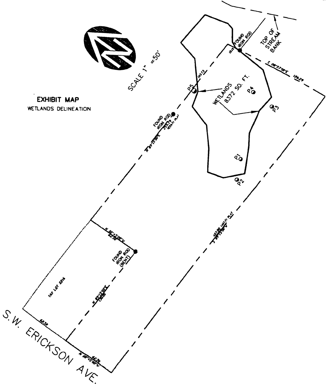
Illustrative Jurisdictional
Wetland Determination
Wetlands means those areas that are inundated or saturated by surface water or groundwater at a frequency and duration sufficient to support, and that under normal circumstances do support, a prevalence of vegetation typically adapted for life in saturated soil conditions. Wetlands generally include swamps, marshes, bogs, and similar areas. Wetlands shall include any area delineated as a wetland by the U.S. Army Corps of Engineers under its jurisdiction pursuant to section 404 of the Federal Clean Water Act, as amended; or any area shown on a one to 24,000 scale, United States Fish and Wildlife Service National Wetland Inventory Map as being a wetland; or any area shown on a one to 24,000 scale, state department of natural resources land cover database map as being a wetland; or any area shown on the generalized wetland map as a wetland.
(ULDC 2005, § 9-8-6-2; Ord. No. 2020-42, § VII, 11-3-2020)
Sec. 9-8-6-3. - Boundaries and map.
(a)
The generalized wetlands map, as defined by this chapter, together with all explanatory matter thereon, is hereby adopted by reference hereby made a part of this Code as if fully set forth herein.
(b)
The generalized wetland map is a general reference document and wetland boundaries indicated on the map are approximations. The purpose of the generalized wetland map is to alert developers/landowners if they are within proximity to a wetland, which means that there is a high likelihood of the presence of a jurisdictional wetland and a need for the developer/landowner to seek U.S. Army Corps of Engineers guidance as to whether a section 404 permit will be required prior to any activity. The generalized wetland map does not necessarily represent the exact boundaries of jurisdictional wetlands within the city and cannot serve as a substitute for a delineation of wetland boundaries by the U.S. Army Corps of Engineers, as required by section 404 of the Clean Water Act, as amended. Any local government action under this Code does not relieve the landowner from federal and state permitting requirements.
(ULDC 2005, § 9-8-6-3)
Sec. 9-8-6-4. - Prohibited uses.
All activities which are not exempted shall be prohibited without prior issuance of a local development permit. The following uses are prohibited within wetlands shown on the generalized wetlands map:
(1)
Receiving areas for toxic or hazardous waste or other contaminants.
(2)
Hazardous or sanitary waste landfills.
(ULDC 2005, § 9-8-6-4)
Sec. 9-8-6-5. - Permitted uses.
The following uses shall be allowed within an area shown as a wetland on the generalized wetlands map, to the extent that they are not prohibited by any other ordinance or law, including laws of trespass, and provided they do not require structures, grading, fill, draining, or dredging except as provided herein:
(1)
Conservation or preservation of soil, water, vegetation, fish and other wildlife, provided it does not affect waters of the state or of the United States in such a way that would require an individual 404 permit.
(2)
Outdoor passive recreational activities, including fishing, bird watching, hiking, boating, horseback riding, and canoeing.
(3)
Forestry practices applied in accordance with best management practices approved by the state forestry commission and as specified in section 404 of the Clean Water Act.
(4)
The cultivation of agricultural crops. Agricultural activities shall be subject to best management practices approved by the state department of agriculture.
(5)
The pasturing of livestock, provided that riparian wetlands are protected, that soil profiles are not disturbed and that approved agricultural best management practices are followed.
(6)
Education, scientific research, and nature trails.
(7)
Other uses permitted under section 404 of the Clean Water Act.
(ULDC 2005, § 9-8-6-5)
Sec. 9-8-6-6. - Land development permits.
(a)
Compliance required. No regulated activity will be permitted within the Wetland Protection Overlay Zone without prior approval by the city in the form of a local development permit. Issuance of a local development permit is contingent upon full compliance with the terms of this Code and other applicable regulations.
(b)
Assessment. Prior to issuance of a local development permit, the director shall assess whether the proposed activity is of a type that could result in a disturbance of wetlands and, if so, shall also assess whether the proposed activity is located within the Wetland Protection Overlay Zone or within 50 feet of the district.
(c)
Issuance. If the director determines that the proposed activity is of a type that could not result in a disturbance of wetlands, or if the proposed activity is not located within the Wetland Protection Overlay Zone or within 50 feet of the overlay zone, the director shall follow normal procedures for issuing a development permit.
(d)
Jurisdictional wetland determination. If the director determines that the proposed activity is of a type that could result in a disturbance of wetlands and that the proposed activity is located within the wetland protection district, or within 50 feet of the wetland protection district, a U.S. Army Corps of Engineers jurisdictional wetland determination shall be required prior to issuance of a local development permit.
(e)
Issuance after determination. If the U.S. Army Corps of Engineers determines that the proposed activity would not require a department of Army permit, the director shall proceed with normal procedures for issuing a local development permit. If a permit or permission is required by the Corps, the local development permit shall not be issued until compliance with Corps requirements is achieved or future compliance demonstrated.
(ULDC 2005, § 9-8-6-6)
Sec. 9-8-7-1. - Purpose and intent.
The purpose of the Midtown Overlay Zone is to protect the health, safety, and general welfare of the public and promote economic prosperity in the city's midtown in a manner consistent with the Redevelopment Plan—The Renaissance of Midtown Gainesville, and the city's comprehensive plan. The intent of this overlay zone is to set higher standards for the appearance and functionality of the land uses, as applied via the site and architectural design review processes established in article 9-9. It is also intended to encourage mixed-use development and the creation of more housing, employment, and recreational opportunities in midtown. Please refer to the Redevelopment Plan—The Renaissance of Midtown Gainesville for further information on the redevelopment of midtown.
(ULDC 2005, § 9-8-7-1; Ord. No. 2016-09, § VIII, 6-21-2016)
Sec. 9-8-7-2. - Definitions.
The following words, terms and phrases, when used in this chapter, shall have the meanings ascribed to them in this section, except where the context clearly indicates a different meaning:
Mixed-use development means development of a single building or single parcel to contain two or more of the following types of uses: residential, retail/commercial, office, or institutional. Mixed uses may be combined vertically within the same building or placed side by side on the same parcel, provided that they are in close proximity, planned as a unified and complementary whole, and functionally integrated to make use of shared vehicular and pedestrian access and parking areas.
Open space means areas that are set aside for common use and protected through a legal instrument approved by the city. The purpose of open space is to provide separation, resource protection, scenic enjoyment, recreation, or amenity to abutting developed property. Areas designated as open space shall not be included in minimum lot areas required by this Code.
Parking, bicycle, means an area in a parking lot or along a sidewalk that is designed and marked for the purpose of securing bicycles in an upright fashion, using a locker or open framework that is permanently attached to the ground and providing secure anchorage for three or more bicycles. Bicycle parking spaces should be in one or more convenient locations within 100 feet of the uses or principal entrances of buildings which they are intended to serve.
Pervious paving means materials used to surface parking lots and driveways that are designed to meet the requirements of materials described in the latest edition of Volume 2—Technical Handbook of the Georgia Stormwater Management Manual as the porous concrete or modular porous paver systems under the limited application stormwater structural controls.
Modular porous paver systems means a pavement surface composed of structural units with void areas that are filled with pervious materials such as sand or grass turf. Porous pavers are installed over a gravel base course that provides storage as runoff infiltrates through the porous paver system into underlying permeable soils.
Porous concrete means a mixture of coarse aggregate, Portland cement and water that allows for rapid infiltration of water and overlays a stone aggregate reservoir.
Use, supportive commercial, means a use of land or a building, or portion thereof, other than the principal use that may be located on the same parcel with such principal use in order to provide a convenient source of commercial goods or services for the occupants of the principal use of the land or building. Supportive commercial uses are intended and designed to reduce traffic and the need for occupants of surrounding buildings to make automobile trips for daily needs.
(ULDC 2005, § 9-8-7-2; Ord. No. 2016-09, § VIII, 6-21-2016; Ord. No. 2020-42, § VIII, 11-3-2020)
Sec. 9-8-7-3. - Boundaries and map.
The Midtown Overlay Zone is hereby designated and shall consist of the land areas further delineated and defined on the Midtown Overlay Zone map, which is hereby incorporated and made a part of this chapter by reference, and which may be amended from time to time. The Midtown Overlay Zone shall include that area bounded by the Norfolk Southern rail line on the southeast, E.E. Butler Parkway on the northeast, Jesse Jewell Parkway on the northwest, and Queen City Parkway on the southwest. Also included is a 200-foot buffer surrounding the midtown boundaries, where all of the requirements of this overlay zone apply as well.
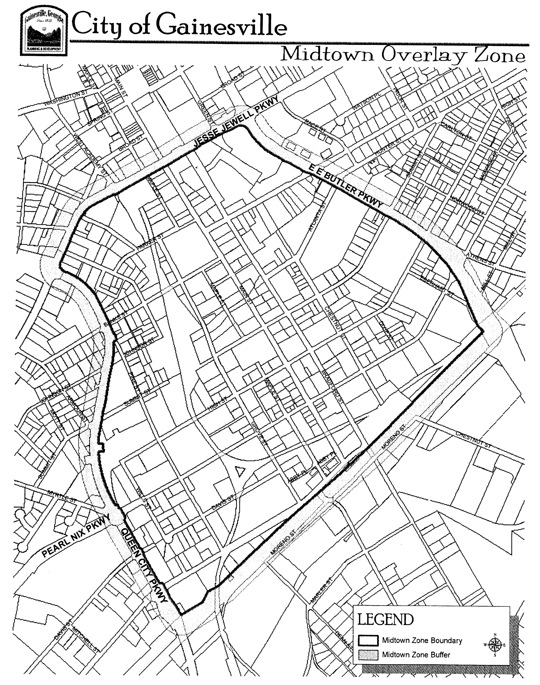
Midtown Overlay Zone
(ULDC 2005, § 9-8-7-3)
Sec. 9-8-7-4. - Effect of overlay zone provisions.
The Midtown Overlay Zone is supplemental to the zoning district classifications and any locally designated historic landmark or district established in this Code. The provisions of this overlay zone apply to all applications for zoning matters, land disturbance permits, plat approval, and building permits for all property and rights-of-way within the boundaries of the Midtown Overlay Zone; except locally designated historic landmarks and districts which must comply with design guidelines for that historic landmark and/or district. All plan reviews, plat approval, and permits for parcels located within this overlay zone shall meet all the requirements of the base zoning district in which it is located and, in addition, shall meet the requirements of the overlay zone applicable to the parcel. In any case where the standards and requirements of the overlay zone conflict with those of the base zoning district, the standards and requirements of the overly zone shall govern.
(ULDC 2005, § 9-8-7-4)
Sec. 9-8-7-5. - Administrative variances.
Administrative variances are governed by chapter 9-24-3.
(ULDC 2005, § 9-8-7-5; Ord. No. 2016-09, § VIII, 6-21-2016)
Sec. 9-8-7-6. - Prohibited and permitted uses.
(a)
All uses permitted by right or as special uses within the underlying zoning district shall be similarly permitted within the Midtown Overlay Zone, except the following uses shall not be permitted on any property within the Midtown Overlay Zone:
(1)
Automated or non-automated car washes.
(2)
Coin-laundry facilities.
(3)
Dollar-type stores or thrift stores.
(4)
Community donation boxes.
(5)
Gas stations (located on lots less than two acres in size).
(6)
Group homes, homeless shelters, roominghouses or crisis centers.
(7)
Hookah, e-cigarette, and/or vapor lounge/bars.
(8)
Industrial uses causing the emission of noise, vibration, smoke, dust, gas, fumes and odors.
(9)
Industrial uses with outdoor storage.
(10)
Jails/correctional facilities.
(11)
Kennels.
(12)
Liquor stores.
(13)
Marine sales or repair stores.
(14)
Massage parlors.
(15)
Miniwarehouses, including climate-controlled self-service storage facilities.
(16)
Motels or extended stay lodging.
(17)
Motor vehicle sales or service.
(18)
Pawnshops.
(19)
Psychics, fortune tellers, clairvoyants and the like.
(20)
Retail sales of alternative nicotine products.
(21)
Salvage yards.
(22)
Sanitation uses, including the storage of trash cans, dumpsters and porta-potties.
(23)
Sawmills.
(24)
Sexually oriented adult uses.
(25)
Tattoo parlors.
(26)
Taxicab or limousine services.
(27)
Tobacco or vaping stores.
(28)
Truck stops.
(29)
Vehicle emission testing facilities.
(30)
Veterinarian or animal hospitals with outdoor kennels.
(31)
Wireless telecommunication facilities or cell towers excluding co-location.
(32)
Wrecked motor vehicle compounds.
(b)
In addition, loft dwellings, single-family homes, condominiums and townhouses shall be permitted by right in any nonresidential district in the overlay zone, and shall not exceed a density of 12 dwelling units per acre unless approved as part of a planned unit development.
(ULDC 2005, § 9-8-7-6; Ord. No. 2018-25, §§ I, II, 11-6-2018; Ord. No. 2019-35, § III, 12-17-2019)
Editor's note— Ord. No. 2018-25, §§ I, II, adopted Nov. 6, 2018, amended § 9-8-7-6 in its entirety to read as herein set out. Former § 9-8-7-6 pertained to permitted uses.
Sec. 9-8-7-7. - Property design standards.
(a)
Minimum open space: 15 percent of gross acreage of tract that is two acres or larger before subdivision. Buffers can be included in the open space up to the discretion of the director.
(b)
Maximum impervious cover: 75 percent of parcel; not including portions of the parcel that are in floodplain or wetlands.
(c)
Maximum building height: 75 feet.
(d)
Maximum front yard setback: 50 feet.
(e)
Minimum front yard setback: 15 feet.
(ULDC 2005, § 9-8-7-7; Ord. No. 2009-47, § XI, 12-15-2009; Ord. No. 2016-09, § VIII, 6-21-2016; Ord. No. 2018-25, § III, 11-6-2018)
Secs. 9-8-7-8—9-8-7-18. - Reserved.
Editor's note— Ord. No. 2016-09, § VIII, adopted June 21, 2016, repealed §§ 9-8-7-8—9-8-7-18 which pertained to parking, screening, connectivity, street trees, landscaping, streetlights, signs, street furniture, underground utilities, escrow in lieu of improvements, and architectural standards, respectively, and derived from Ord. No. 2009-47, §§ XII—XIV, adopted Dec. 15, 2009.
Sec. 9-8-8-1. - Purpose and intent.
The purpose of this chapter is to establish a uniform procedure for use in providing for the protection, enhancement, perpetuation and use of places, districts, sites, buildings, structures, landscape features and works of art having a special historical, architectural, cultural or aesthetic interest or value; and is intended:
(1)
To stimulate revitalization and preservation of the business districts and historic neighborhoods;
(2)
To promote economic progress through heritage tourism;
(3)
To provide for the designation, protection, preservation, rehabilitation and restoration of historic districts and properties; and to participate in federal or state programs to accomplish the same.
(ULDC 2005, § 9-8-8-1)
Sec. 9-8-8-2. - Definitions.
The following words, terms and phrases, when used in this chapter, shall have the meanings ascribed to them in this section, except where the context clearly indicates a different meaning:
Designation means a decision by the governing body pursuant to chapter 9-23-2 to designate a district or property as "historic" and thereafter prohibit all material changes in appearance prior to the issuance of a certificate of appropriateness pursuant to chapter 9-23-3.
Historic district means a geographically definable area, which contains structures, sites, works of art or a combination thereof which is designated as historic pursuant to this chapter and chapter 9-23-2, and which:
(1)
Exhibits a significant historical, architectural, cultural or environmental character or value;
(2)
Represents one or more periods, styles or types of architecture typical of one or more eras in the history; and
(3)
Constitutes a visibly perceptible section of the municipality or county by reason of above.
Historic landmark means an individual structure, site or work of art, including the adjacent area necessary for the proper appreciation or use thereof, which is designated as historic pursuant to this chapter and chapter 9-23-2, and which is deemed worthy of preservation for one or more of the reasons listed below:
(1)
It is an outstanding example of a structure representative of an era;
(2)
It is one of the few remaining examples of a past architectural style;
(3)
It is a site or structure associated with an event or person of historic or cultural significance; or
(4)
It is a site of natural or aesthetic value that is continuing to contribute to the historical or cultural development and heritage.
Site means the location of a significant event; a prehistoric or historical activity; or a structure, whether standing, ruined, or vanished; where the location itself maintains historical, cultural or archaeological value regardless of the value of any existing structure.
(ULDC 2005, § 9-8-8-2)
Sec. 9-8-8-3. - Significance, boundaries and maps.
(a)
Designation of overlay zone; maps. The Historic Preservation Overlay Zone is hereby designated. It shall consist of the land areas further delineated and defined on the Historic Preservation Overlay Zone maps for each designated district and individual landmark as adopted as part of the official designation ordinance on file with the city clerk. The Historic Preservation Overlay Zone maps are hereby considered to be a part of the official zoning map of the city and this chapter by reference. In addition, the properties within the boundaries of the Historic Preservation Overlay Zone shall be clearly defined for individual properties on tax maps.
(b)
Description of individual landmarks and historic districts. The following subsections include a description of the physical boundaries and a statement of significance for all designated local historic districts and individual landmarks falling within the Historic Preservation Overlay Zone. Furthermore, in accordance with O.C.G.A. § 44-10-26, a list of all property owners, a legal description and map, and the provision for requiring a certificate of appropriateness be obtained prior to making a material change in the exterior appearance, whether regarding a district or an individual landmark, shall be made a part of the official designation ordinance which is kept on file in the office of the city clerk:
(1)
Big Bear Cafe individual landmark.
a.
Significance.
1.
The subject property, which contains three historic buildings, is located on Main Street within the midtown area of the city, which is one of the oldest sections of the city and has long since been a transitional area. The Big Bear Cafe landmark contains one of the first permanent commercial buildings constructed along Main Street in the midtown area, and as such, contributed to the city's community planning efforts.
2.
The building (which is the current home of Jayne's Flower Shop) was constructed around the turn of the 20th century, between 1900 and 1930. This building was constructed of local brick of poor quality and shaped as a parallelogram to face Main Street at an angle, and, thereby, creating an architectural effect that is distinctive. The building has housed various cafes and barber shops over time; such uses were particularly vibrant during World Wars I and II. The adjacent building, which houses The Big Bear Cafe, is an identical brick building that was constructed in 1936, a few months after the devastating tornado of April 6, 1936. As with the first building, the parallelogram shape of the building creates an optical illusion that makes Main Street appear to angle toward the right, and like the first, this second building consisted of two sides; the upper side held a cafe while the lower side next to the alleyway contained a butcher shop. The cafe was operated by Mr. G.C. Barron as one of the most colorful and exciting establishments on the main line of the Southern Railroad, which connected through major cities between New York and New Orleans. Because Mr. Barron had a black bear in a cage behind the cafe, local folks referred to the cafe as The Big Bear, and, although Mr. Barron did not like the name, he used it since it apparently was good for business. The third building, a large metal warehouse of approximately 4,900 square feet in size, was built by the Chambers Lumber Company in 1950; to store mantles, doors, windows, and fine millwork. In 1997, a small group of local artists worked with the owner to create an art studio within the building; movement which is hoped will bring about change in midtown.
3.
In summary, the one-story brick, parallelogram buildings are typical commercial buildings from the turn of the 20th century that are plain with commercial hardware characteristic of the period. The obtuse angles, creating the parallelogram shape, required custom fit for practically all of the structural elements and most of the interior finish as well.
b.
Boundaries. The subject property is bounded by Main Street, Bradford Street, a spur track of the CSX Railroad (formerly the Gainesville-Midland Railroad) which is no longer in use and property of the Norfolk Southern Railroad. More specifically, the boundary of the local historic landmark follows the property lines of the subject tract as described in the recorded deed and as shown on a recorded plat.
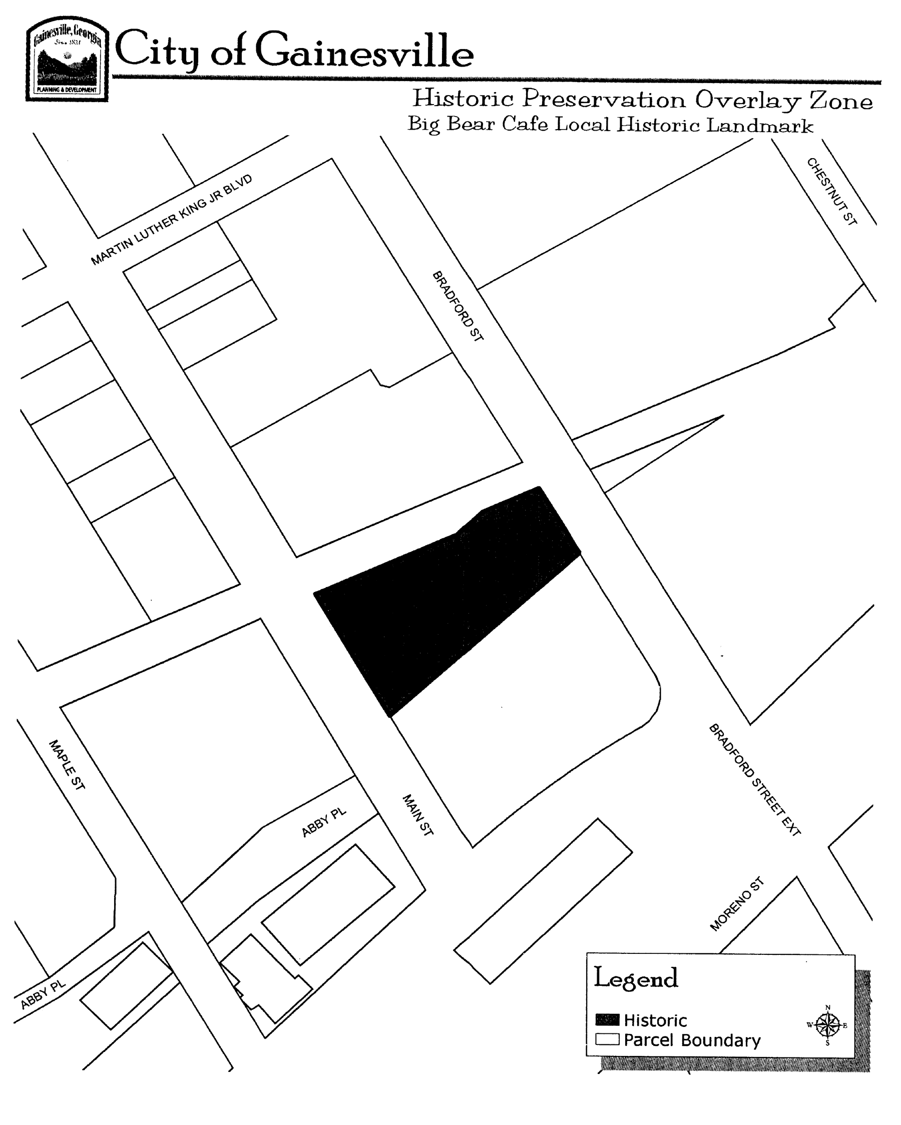
Big Bear Cafe
Local Historic Landmark
(2)
Ridgewood Neighborhood Local Historic District.
a.
Significance.
1.
The Ridgewood Neighborhood Local Historic District serves as a bridge between the Green Street historic area and the Rock Creek, Ivey Terrace and the Wilshire Parks. This area, which is a traditional residential neighborhood with sidewalks on either side of the street, is located within one of the oldest residential neighborhoods in the city. Forty-six of the 47 structures located in the district were built between 1910 and 1954, most of which were constructed in the 1930s with brick, asbestos siding or wood exteriors; the remaining structure was built in 1987. The 48th property located within the historic district is a small park, which is called the H.H. Dean Memorial Park in memory of the developer who originally owned much of the property within this neighborhood. The park/garden area is land that was given by H.H. Dean to the Northside Garden Club in the 1930's; at a time when much of the H.H. Dean Estate was subdivided to create the Ridgewood neighborhood area.
2.
The structures located within the district are representative of the type of historic residential architecture found in many of the state's towns and cities as well as reflect the prevailing national principles and practices of architecture of this time. Architecturally speaking, the district contains an outstanding group of examples of Craftsman and Victorian homes and English Tudor cottages; including one- and two-story designs. Many of the structures contain much of their original fabric, including plaster walls, windows and exterior building materials; but many have been renovated and altered since their original construction.
3.
The Ridgewood Neighborhood Local Historic District contains within its confines a high concentration of intact, historic residential structures that reflect architectural styles and building types found throughout the early and mid-20th century. The structures located within the proposed historic district together depict an era of architectural and historic character and are reflective of the social and cultural development of the city. Moreover, the proposed historic district represents a major period in the development of the city.
b.
Boundaries. The Ridgewood Neighborhood Local Historic District, which consists of residential structures that are predominantly owner-occupied, single-family homes; is located north of the central business district within the neighborhood conservation (N-C) zoning district along Ridgewood Avenue and includes 48 contiguous properties situated along Ridgewood Avenue, Denton Drive and Bradford Street.
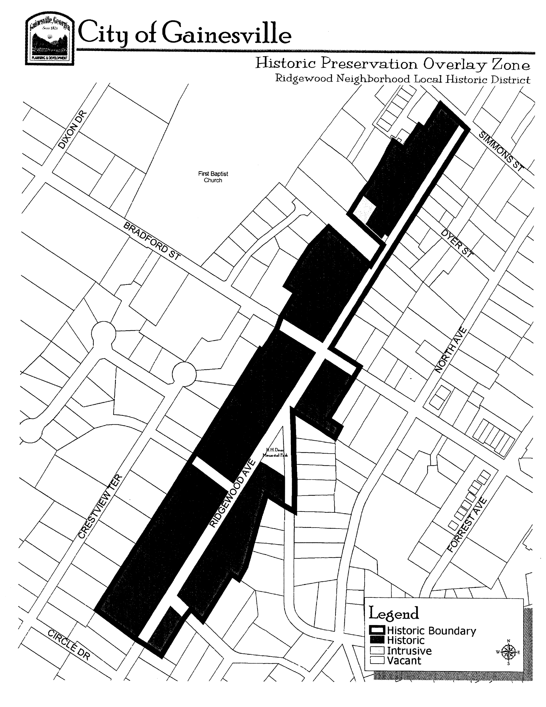
Ridgewood Neighborhood
Local Historic District
(3)
Green Street Local Historic District.
a.
Significance.
1.
This area of Green Street (a.k.a. North Green Street), which is comprised of various office and light retail commercial uses, originally was an Indian trail and wagon road to north Georgia. Around 1828, with the discovery of gold in north Georgia, the city became a trading center for gold mines, taverns, and agricultural products; and stores and offices were erected downtown. The city experienced little growth after the gold rush. After 1870, following the extension of the railroad to the city, North Green Street became the prime residential district, as the more affluent and leading business families began constructing residential dwellings along North Green Street. A streetcar track with horse-drawn cars was constructed in the late 1880s, extending from the railroad depot to various parts of the city, including North Green Street. In 1903, the streetcar was electrified.
2.
Green Street, which was an important transportation route to the mining regions, is a four-lane state highway that bisects the Green Street Local Historic District and is lined on both sides with some of the city's largest, oldest and most architecturally distinctive homes situated on large lots. Structures in the district date from the 1880's to the 1930's, although some were constructed later and are non-historic in nature. Many are 1½ to stories in height with a few having 2½ stories. A majority of the structures are wood-framed with clapboard siding; while a few are constructed of brick veneer or consist of synthetic siding added in recent times. Many of the structures, which were built by locally prominent architects and builders, including John Cherry and E. Levi Prater, served as residences for some of the city's important professionals and businessmen, educators and politicians. Historically speaking, the Green Street Local Historic District reflects prosperity of the agricultural and mining industries in the Gainesville area; and for over 50 years, this area was known to visitors as one of the outstanding residential neighborhoods in northeast Georgia.
3.
The Green Street Local Historic District contains within its confines a high concentration of intact, historic residential structures that reflect architectural styles and building types found throughout the late 19th and early 20th centuries. Moreover, the structures located within the district together depict an era of architectural and historical character, and are reflective of the social and cultural development of the city. Architecturally speaking, the Green Street Local Historic District contains an outstanding group of examples of Victorian and neoclassical revival homes dated from the turn of the 19th century. The various architectural styles found in the district include colonial review, folk Victorian, English vernacular revival, early classic revival and Italian renaissance. There are several late-Victorian structures located in the district, including the Smith-Palmer-Estes House which has Queen Anne massing and intricate Eastlake porch detailing. Also in the district, there is an excellent collection of high-style neoclassical structures with a variety of monumental one-and two-story porticos.
b.
Boundaries. The boundaries of the Green Street Local Historic District closely follow the boundary of the Green Street Historic District as listed in the National Register of Historic Places in 1975, and predominantly encompass properties fronting Green Street. This area also was included in an updated National Register nomination listed in 1985. Such nomination combined the existing 1975 Green Street and 1978 Brenau College National Register Historic Districts as well as encompassed adjacent historic neighborhoods to create one comprehensive district: the Green Street-Brenau-Green Street Circle Historic District.
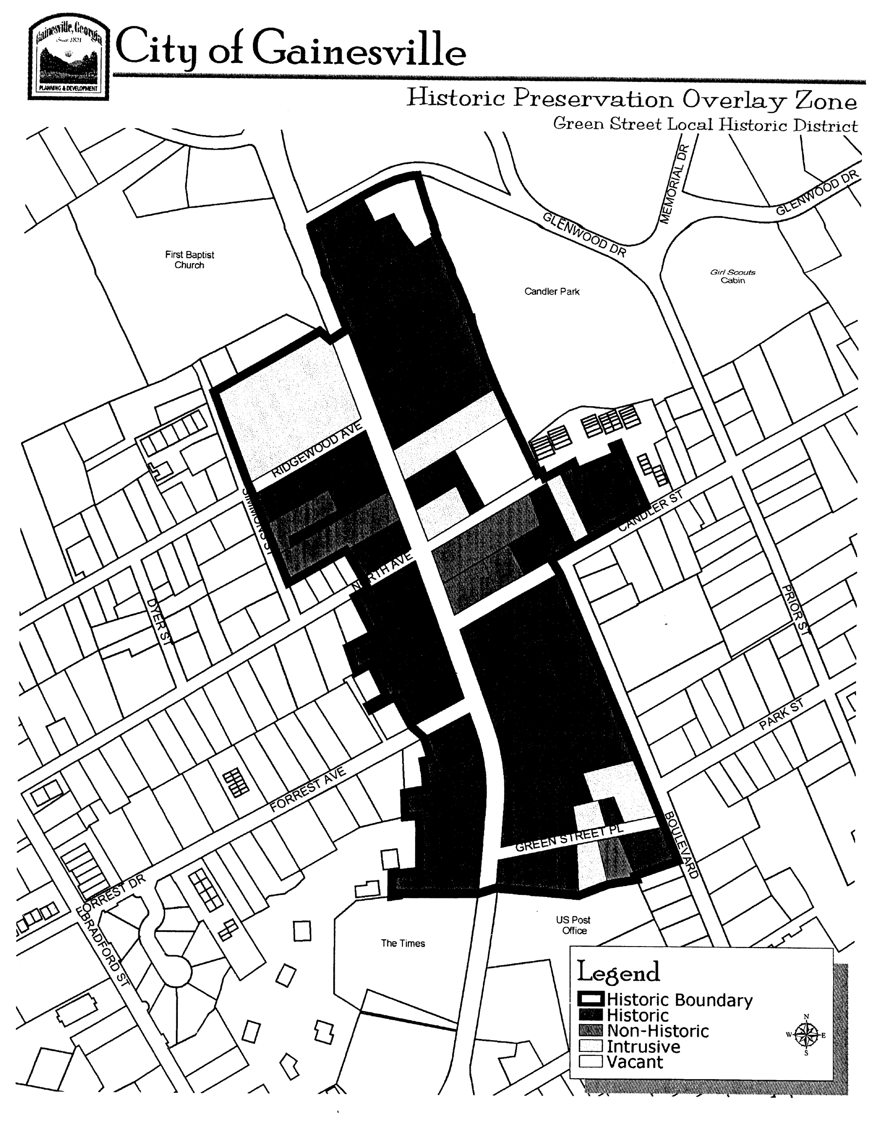
Green Street
Local Historic District
(ULDC 2005, § 9-8-8-3)
Sec. 9-8-8-4. - Amendments to the Historic Preservation Overlay Zone.
(a)
Local designations for either districts or individual landmarks may be proposed to be established or proposed to be rescinded by the governing body, the historic preservation commission, or property owner. Local designations shall be considered as amendments to the Historic Preservation Overlay Zone.
(b)
The Historic Preservation Overlay Zone and Historic Preservation Overlay Zone maps may be amended from time to time to include new or separate, noncontiguous designated historic districts, to modify existing local historic districts, to designate historic landmarks, or for other reason, provided that such amendment conforms to the provisions of chapter 9-23-2 and O.C.G.A. § 44-10-26, as applicable. The process, procedural requirements and criteria for considering an application for designation are specified in chapter 9-23-2.
(c)
In order to amend the Historic Preservation Overlay Zone, the description of the physical boundaries, the statement of significance, and boundary map pertaining to a designation ordinance shall be incorporated into this Code under section 9-8-8-3, along with a reference to the designation ordinance.
(ULDC 2005, § 9-8-8-4)
Sec. 9-8-8-5. - Use restrictions.
All uses permitted by right or as a special use by the underlying zoning district shall be similarly permitted under the Historic Preservation Overlay Zone, and the underlying zoning district use provisions of this Code shall remain in effect until modified.
(ULDC 2005, § 9-8-8-5)
Sec. 9-8-8-6. - Affirmation of building regulations and design guidelines.
(a)
Nothing in this chapter shall be construed as to exempt property owners or occupants from complying with applicable building codes, nor to prevent any property owner or occupant from making any use of the property not prohibited by other statutes, ordinances, or regulations.
(b)
Design and construction guidelines, which are standards for evaluating proposed material changes to structures located within the Historic Preservation Overlay Zone, are intended to offer guidance to owners and occupants, architects, developers and other individuals contemplating restoration, remodeling or new construction on how to maintain the architectural integrity of the structure and district as a whole. The design and construction guidelines adopted by the historic preservation commission shall remain in effect and may be amended by the historic preservation commission without the need to amend this chapter. Nothing in this chapter shall be construed as to exempt property owners and occupants from complying with applicable design and construction guidelines even though such guidelines are not law.
(ULDC 2005, § 9-8-8-6)
Sec. 9-8-8-7. - Requirement for a certificate of appropriateness.
(a)
This chapter and other chapters of this Code related to historic preservation shall pertain to the exterior material appearance of a building, structure, work of art, and site as a whole, or a combination thereof. Upon designation and inclusion of a district or individual landmark within the Historic Preservation Overlay Zone, a certificate of appropriateness shall be obtained from the city historic preservation commission, or from the community and economic development department for minor work projects, prior to any material change in the exterior appearance of a structure or site.
(b)
The process and criteria for considering an application for a certificate of appropriateness are specified in chapter 9-23-3. That chapter includes procedural requirements for obtaining a certificate of appropriateness.
(ULDC 2005, § 9-8-8-7)
State Law reference— Certificates of appropriateness, O.C.G.A. § 44-10-27 et seq.
Sec. 9-8-8-8. - Maintenance of historic properties.
(a)
Ordinary maintenance and repair. Ordinary maintenance or repair of any exterior architectural feature in or on an historic property to correct deterioration, decay or damage; or to sustain the existing form; and that does not involve a material change in design, material or exterior appearance, does not require a certificate of appropriateness. However, this provision does not exclude ordinary maintenance and repair work from the requirement of obtaining any necessary applicable building permits.
(b)
Failure to provide ordinary maintenance. Property owners of individual properties within a designated historic district or of designated historic landmarks shall not allow their buildings to deteriorate by failing to provide ordinary maintenance or repair. The historic preservation commission shall be charged with the following responsibilities regarding deterioration by neglect:
(1)
Notice to owner to remedy. If the historic preservation commission determines a property owner has failed to provide ordinary maintenance or repair (including, but not limited to, damaged windows, doors, siding, foundation or roof structure) the historic preservation commission shall notify the property owner and set forth the steps which need to be taken to remedy the situation. The property owner shall have 180 days in which to resolve the situation.
(2)
Failure by owner to remedy. If the condition is not remedied within 180 days, the owner shall be subject to the enforcement provisions as specified in chapter 9-24-2; or:
a.
Upon authorization and at the direction of the governing body, the historic preservation commission may perform such maintenance or repair as is necessary to prevent deterioration by neglect.
1.
The property owner shall be liable for the cost of such maintenance or repair.
2.
The cost of such maintenance or repair shall be a lien against the real property. The lien shall attach to the real property at the time of payment of all costs of maintenance or repair by the city.
b.
Nothing in this section shall be construed to impair or limit in any way the power of the governing body to define and declare nuisances and to cause their removal or abatement by summary proceedings or otherwise.
(ULDC 2005, § 9-8-8-8)
Sec. 9-8-8-9. - Undue hardship.
(a)
Where, by reason of unusual circumstances, the strict application of any provision of this chapter would result in the exceptional practical difficulty or undue hardship upon any owner of a specific property, the historic preservation commission shall have the power to vary strict adherence to said provisions, or to interpret the meaning of said provisions, so as to relieve such difficulty or hardship, provided that such variances or interpretations do not compromise the architectural or historical integrity of the property. In granting variances, the historic preservation commission may impose such reasonable and additional stipulations and conditions as deemed necessary. An undue hardship shall not be a situation of the person's own making.
(b)
The process, procedural requirements, and criteria for considering an application for an undue hardship variance are specified in chapter 9-23-4.
(ULDC 2005, § 9-8-8-9)