
Gainesville City Zoning Code
ARTICLE 9
13 - SUBDIVISIONS AND LAND DEVELOPMENT
Sec. 9-13-1-1.- Purpose and intent.
This article is intended to serve the following purposes, among others:
(1)
To protect and promote the health, safety and general welfare of the residents of the city;
(2)
To encourage economically sound and stable land development;
(3)
To ensure the provision of required streets, utilities, and other facilities and services to new land developments in conformance with public improvement plans of the city;
(4)
To ensure adequate provision of safe and convenient traffic access and circulation, both vehicular and pedestrian, in new land developments, especially for the purposes of assuring that all building lots will be accessible to firefighting equipment and other emergency and service vehicles;
(5)
To ensure the provision of needed open spaces and building sites in new land developments through conservation subdivision design and the dedication or reservation of land for recreational, educational, and other public purposes;
(6)
To ensure the adequate provision of water supply, sewage disposal, stormwater drainage, and other necessary improvements;
(7)
To ensure equitable handling of all subdivision plats and land development plans by providing uniform procedures and standards for the subdivider and land developer;
(8)
To ensure, in general, the wise development of new land areas, in harmony with the comprehensive plan of the city;
(9)
To ensure the accurate description of property and adequate and proper identification of property in public records;
(10)
To help conserve and protect the natural, economic and scenic resources of the city;
(11)
To help eliminate the costly maintenance problems which develop when streets and lots are laid out without proper consideration given to various public purposes;
(12)
To protect lot purchasers who generally lack the specialized knowledge to evaluate subdivision improvements and design.
(ULDC 2005, § 9-13-1-1; Ord. No. 2020-42, § XVIII, 11-3-2020)
Sec. 9-13-1-2. - Delegation of authority to administrative officers.
The governing body hereby delegates to the appropriate administrative officers the authority to administratively approve, conditionally approve, or disapprove preliminary plats, final plats, lot combination plats, boundary line adjustments, and dedication plats; provided, however, such delegation does not authorize appropriate administrative officers to accept public improvements for the governing body. The city director of community and economic development, the city director of public works, and the city director of water resources are vested with the authority, as more fully described in this section and article, to review, approve, conditionally approve, or disapprove subdivisions and land development plans and permits.
(1)
Director of community and economic development. This administrative officer shall have final authority with regard to the review and approval of land development plans and permits, preliminary plats and final plats.
(2)
Director of public works. This administrative officer shall review land development plans and permits and review of streets and related public improvements and recommendations for acceptance of public improvements by the governing body. The director of public works is further authorized to promulgate additional technical standards and construction specifications for land development improvements not already specified by this Code, including, but not limited to, streets, driveways, curb cuts related to traffic flow, and parking lots.
(3)
Director of water resources. This administrative officer shall have final authority with regard to the design of water, wastewater and stormwater for subdivisions and land developments. The director of water resources is further authorized to promulgate additional technical standards and construction specifications for land development improvements not already specified by this Code, including, but not limited to, water, sanitary sewer and stormwater systems.
(ULDC 2005, § 9-13-1-2; Ord. No. 2020-42, § XVIII, 11-3-2020)
Sec. 9-13-1-3. - Land is one lot until subdivided.
Until property proposed for subdivision has received final plat approval and been properly recorded, the land involving the subdivision shall be considered as one lot, or as otherwise legally recorded.
(ULDC 2005, § 9-13-1-3; Ord. No. 2020-42, § XVIII, 11-3-2020)
Sec. 9-13-1-4. - Subdivision of land.
(a)
No person shall subdivide land except in accordance with this article and Code. It shall be unlawful for any person, firm, corporation, owner, agent or subdivider, by deed or map, to sell, transfer, agree to sell, offer at public auction, negotiate to sell or subdivide any land until a preliminary plat, if required, and final plat have been approved by the community and economic development department director and final plat recorded in accordance with this article. Said restriction applies to lands subdivided for nonresidential as well as residential uses. The description by metes and bounds in the instrument of transfer or other document used in the process of selling or transfer shall not exempt the transaction from this article or from the penalties established for violations of this Code. The city through its attorney or other designated official may enjoin such transfer of, sale, or agreement by appropriate action.
(b)
The community and economic development department may require that a final plat for multiple (five or more) lots being subdivided off an existing road be validated by stamp from the public works department. The community and economic development department may also require that any final plat be validated by stamp from the department of water resources and/or county environmental health department.
(ULDC 2005, § 9-13-1-4; Ord. No. 2020-42, § XVIII, 11-3-2020)
Sec. 9-13-1-5. - Reference to state and federal land subdivision laws.
The subdivision of land shall comply, as applicable, with the federal and state full disclosure requirements for land sales. All subdivision plats shall also comply with applicable state law regarding accuracy and content of all such subdivision plats.
(ULDC 2005, § 9-13-1-5; Ord. No. 2020-42, § XVIII, 11-3-2020)
Sec. 9-13-1-6. - Special review of subdivisions along state routes.
(a)
No subdivision plat containing land which abuts a state route shall be approved until such plat has been submitted for review and comment by the state department of transportation, in accordance with the provisions of O.C.G.A. § 32-6-151.
(b)
Upon receiving such a plat, the city shall submit two copies of the proposed subdivision plat to the state department of transportation if such proposed subdivision includes or abuts on any part of the state highway system. The state department of transportation, within 30 days of receipt of the plat, shall recommend approval and note its recommendation on the copy to be returned to the community and economic development department director or recommend rejection. Failure of the state department of transportation to act within this 30-day period shall constitute approval. If the plat is recommended for rejection, the reasons for rejection and requirements for approval shall be given the community and economic development department director in writing; but such recommendation shall be advisory only and shall not be binding on the director or planning and appeals board.
(ULDC 2005, § 9-13-1-6; Ord. No. 2020-42, § XVIII, 11-3-2020)
Sec. 9-13-1-7. - Lots must comply with zoning requirements.
No person shall subdivide land, and the community and economic development department director shall not approve any subdivision of land, unless the lots created pursuant to said subdivision meet or exceed all applicable requirements of the zoning district and/or overlay zone, as applicable, and as may be amended from time to time.
(ULDC 2005, § 9-13-1-7; Ord. No. 2020-42, § XVIII, 11-3-2020)
Sec. 9-13-1-8. - Improvements required for final platting.
No final subdivision plat shall be approved by the director of community and economic development or accepted for recordation by the clerk of superior court until all improvements required by this article have been constructed in a satisfactory manner and approved by the director of public works or, in the case of drinking water, wastewater and stormwater improvements, the director of water resources.
(ULDC 2005, § 9-13-1-8; Ord. No. 2020-42, § XVIII, 11-3-2020)
Sec. 9-13-1-9. - Lot combinations and boundary line adjustments.
(a)
An existing lot line forming the boundary between two conforming platted lots located within the same subdivision or a lot line between lots or parcels that have merged to form one building lot may be removed or eliminated through a final plat revision process which conforms to the final plat requirements of chapter 9-13-14. Where separate lots of land are proposed to be combined, they shall be submitted to the community and economic development department director as a final plat for review, approval and recording. In the case no final plat applies to the subject lots or parcels, a boundary survey and plat depicting all lots involved in the lot combination shall be required to be approved by the community and economic development department director and recorded as a final plat. Such combination plat shall be titled with the same name as that of the original subdivision, if applicable, and shall indicate thereon that the replat is for the purpose of removing the lot lines between specific lots.
(b)
One or more existing lot lines forming boundaries between conforming platted lots located within the same subdivision, or one or more lot lines between abutting lots or parcels may be adjusted through a final plat revision process that requires the approval of the community and economic development department director and recording of a plat meeting the specifications of a final plat. In the case no final plat applies to the subject lots or parcels, a boundary survey and plat of the entire lots involved in the boundary line adjustment shall be required to be approved by the community and economic development department director and recorded. Such plat showing said boundary line adjustment shall be titled with the same name as that of the original subdivision and shall include thereon that the replat is for the purpose of adjusting the lot lines between specific lots.
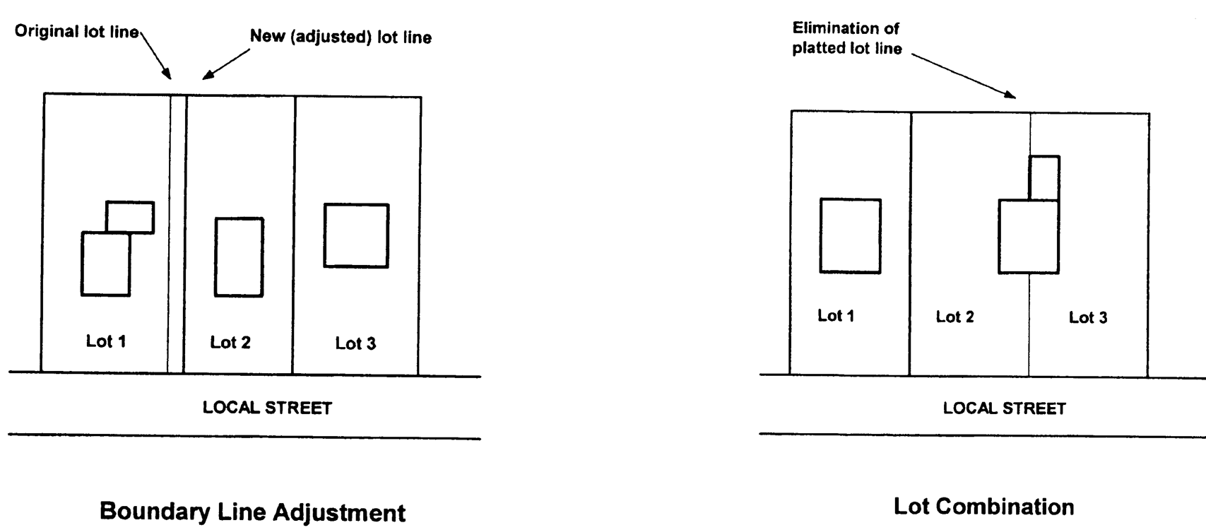
Boundary Adjustment;
Lot Combination
(ULDC 2005, § 9-13-1-9; Ord. No. 2020-42, § XVIII, 11-3-2020)
Sec. 9-13-1-10. - Recordation and transfer of land.
(a)
The clerk of superior court of the county shall not file or record a plat that would result in the division of a property into two or more lots that does not have the approval of the city as required by this article. The clerk of the superior court of the county shall not file or record a plat of a subdivision, whether evidenced as a plat or as an attachment to a deed, unless such plat is a final plat approved for recording by the community and economic development department director or designated representative and contains said officer's signature thereon.
(b)
Any deed or other instrument of conveyance, including a security deed, bond for title, or any other document purporting to convey, then or in the future, title to real estate, filed for record with the clerk of the superior court, wherein the property to be conveyed is described in some manner other than by reference to a recorded plat, shall be accompanied by a certificate signed by the party filing such deed or other instrument, which certificate shall be in the following form:
I, ___________, do hereby certify that the instrument herewith filed for record in the Office of the Clerk of the Superior Court of Hall County, Georgia, does not involve the subdivision of property and does not subdivide a tract of land into two or more tracts or lots.
This _____ day of _______, 20___.
(ULDC 2005, § 9-13-1-10; Ord. No. 2020-42, § XVIII, 11-3-2020)
Sec. 9-13-1-11. - Exemptions from plat approval.
The following types of land subdivisions, transfers, and sales are specifically exempted from the plat approval requirements of this article; provided, however, that such exemptions shall not apply to land development requirements and improvement requirements of this article or compliance with other applicable requirements of this Code:
(1)
The creation and sale of cemetery plots.
(2)
The sale of lots consistent with previously approved and recorded plats or deeds.
(3)
The creation of leaseholds for space within a multiple-occupancy building or the division of property into leaseholds (but not for sale) for commercial, industrial, or institutional use.
(4)
The creation of leaseholds (but not for sale) for the agricultural use of property where the use does not involve the construction of a building to be used as a residence or for other purposes not directly related to agricultural use of the land or crops or livestock raised thereon.
(5)
Any division of land to heirs through a judicial estate proceeding, or any division of land pursuant to a judicial partition, or any division of land occurring from the foreclosure of a deed of trust; provided, however, that such exemption shall not require the city to issue permits if the resulting lots or parcels fail to meet any applicable zoning provisions regarding lot size, lot width, or other dimensional requirements.
(ULDC 2005, § 9-13-1-11; Ord. No. 2020-42, § XVIII, 11-3-2020)
Sec. 9-13-1-12. - Development of land.
No person shall disturb or develop land except in accordance with this article and this Code. It shall be unlawful for any person, firm, corporation, owner, agent or subdivider to disturb or develop any land until land development plans have been approved by the city and a land development permit issued, if required, in accordance with this article and this Code. No person shall commence construction of any improvements on any lot, prior to the approval of a preliminary plat if required by this article, nor prior to approval of submission of civil drawings and construction plans and issuance of a land development permit for said improvements as required by this article and Code.
(ULDC 2005, § 9-13-1-12; Ord. No. 2020-42, § XVIII, 11-3-2020)
Sec. 9-13-3-1.- Suitability of land.
Land physically unsuitable for subdivision or development because of flooding, poor drainage, steep slopes, rock formations or other such features that may endanger health, life or property, aggravate erosion, increase flood hazard, or necessitate excessive expenditures of public funds for supply and maintenance of services shall not be approved for subdivision or development unless adequate methods are formulated by the subdivider or developer for solving the problems.
(ULDC 2005, § 9-13-3-1)
Sec. 9-13-3-2. - Conformance with comprehensive plan.
All proposed subdivisions shall conform to the comprehensive plan and development policies in effect at the time of submission to the community and economic development department director.
(ULDC 2005, § 9-13-3-2)
Sec. 9-13-3-3. - Block lengths and widths.
(a)
Intersecting streets shall be provided at such intervals so as to provide adequate cross traffic and connectivity. Blocks in residential subdivisions should not exceed 1,800 feet nor be less than 600 feet in length, except where topography or other conditions justify a departure from these standards. In blocks longer than 800 feet, pedestrian ways and/or easements through the block shall be required near the center of blocks.
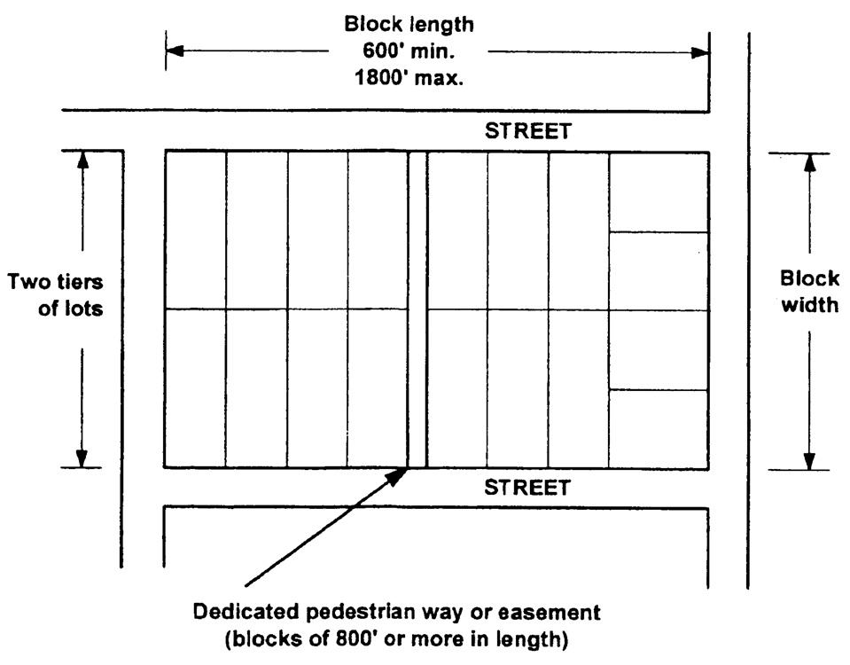
Block Length, Block Width,
and Pedestrian Way
(b)
In addition, for blocks longer than 800 feet in length, the community and economic development department director may require one or more public easements of not less than 20 feet in width to extend entirely across the block for fire protection or utilities.
(c)
The width of the block shall be sufficient to allow two tiers of lots of appropriate depth, except where reverse frontage lots on arterial streets are provided, or when prevented by topographic conditions or size of the property, or for lots along the periphery of the subdivision, in which case the community and economic development department director may approve a single row of lots. Blocks intended for business or industrial use shall be of such width as to be considered most suitable for their respective use, including adequate space for off-street parking and deliveries.
(ULDC 2005, § 9-13-3-3)
Sec. 9-13-3-4. - Width, depth, and size.
(a)
Residential lots shall have a depth not greater than three times the width of the lot at the building line, unless unusual circumstances make these limitations not practicable. Residential corner lots shall have adequate width to meet building setback requirements from both abutting streets.
(b)
Where individual septic tanks are used, the county environmental health department shall approve minimum lot sizes to conform to health standards of the state department of public health and the county.
(c)
Commercial and industrial lots shall be adequate to provide service areas and off-street parking suitable to the use intended.
(d)
Each lot shall contain an adequate building site not subject to flooding and outside the limits of any existing easements or required building setback lines.
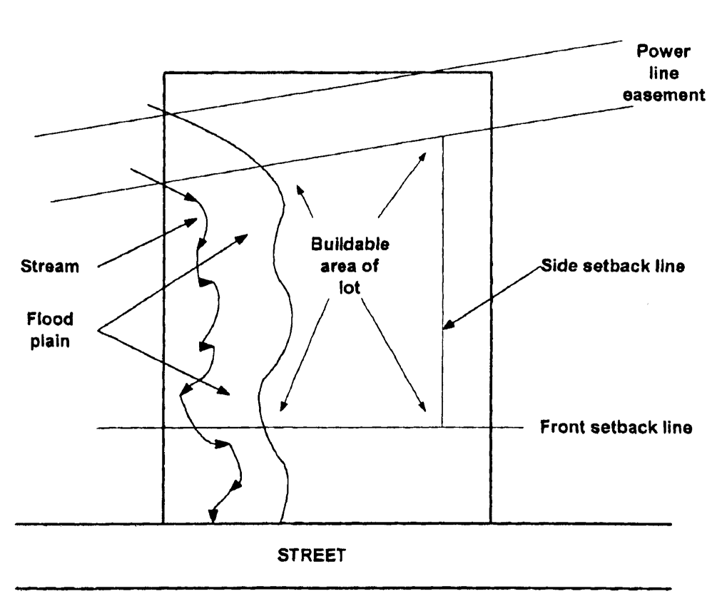
Adequate Building
Area Required
(ULDC 2005, § 9-13-3-4)
Sec. 9-13-3-5. - Lot lines.
All side lot lines shall be perpendicular to street lines, and all rear lot lines shall be parallel or radial to street lines, unless not practicable because of topographic or other features.
(ULDC 2005, § 9-13-3-5)
Sec. 9-13-3-6. - Building lines.
A building line, meeting or exceeding the front building setback requirements of the zoning district in which the lot is located, shall be established on all lots.
(ULDC 2005, § 9-13-3-6)
Sec. 9-13-3-7. - Double frontage lots.
Double frontage lots shall be avoided except where essential to provide separation of residential development from traffic arteries or overcome specific disadvantages of topography or orientation. The community and economic development department director may require a no-access, planting screen easement of at least ten feet, across which there shall be no right of access, shall along the line of lots abutting such a traffic artery or other disadvantageous use.
(ULDC 2005, § 9-13-3-7)
Sec. 9-13-3-8. - Flag lots.
Flag lots, which meet minimum lot area requirements and meet the minimum lot width at the front building setback line where the building is placed, may be allowed where conditions of hardship make standard design or frontage impossible, impractical, or inefficient with regard to land use. Where such lots are allowed, the street frontage of each panhandle portion of the lot shall not be less than 40 feet wide, and the panhandle portion of the lot shall be no less than 40 feet wide and not more than 200 feet long. Not more than two such panhandle access points shall abut each other. The community and economic development department director may require shared driveways for abutting flag lots.
(ULDC 2005, § 9-13-3-8)
Sec. 9-13-3-9. - Lot remnants not permitted.
All remnants of lots below any minimum lot size which may be required, left over after subdividing a larger tract or land-locked parcel, must be added to adjacent lots, rather than allowed to remain as unusable or noncompliant parcels. The community and economic development department director may permit a lot remnant for a specific purpose such as a detention pond, provided that access and design is appropriate and the lot remnant is restricted to specific nonresidential use.
(ULDC 2005, § 9-13-3-9)
Sec. 9-13-3-10. - Monuments.
(a)
For all subdivisions, a state-registered land surveyor shall install permanent survey monuments at all property corners, at each point at which a property line changes direction, and land lot lines, prior to final plat approval. Each monument shall be a one-half-inch-diameter steel rod or No. 4 rebar, at least 24 inches long. When rock is encountered, a hole shall be drilled four inches deep in the rock, into which shall be cemented a steel rod one-half-inch in diameter. The top of each such monument shall be approximately level with the finished grade.
(b)
Permanent survey monuments shall also be installed in accordance with the most recent edition of section 180-7-.05, Monument, of the Rules of State Board of Registration for Professional Engineers and Land Surveyors and the Georgia Plat Act (O.C.G.A. § 15-6-67).
(ULDC 2005, § 9-13-3-10)
Sec. 9-13-7-1.- Land development permit required.
(a)
A land development permit shall be required to authorize all activities associated with development activity, including, but not limited to, clearing and grubbing, grading, excavation, demolition, and the construction of such improvements as streets, surface parking areas and drives, stormwater drainage facilities, sidewalks, or other structures permanently placed on or in the property except for buildings, signs, or other structures requiring the issuance of a building permit. Any person seeking development activity on land within the city shall first submit to the community and economic development department an application for a land development permit, including all civil design and construction drawings required by this chapter.
(b)
A land development permit shall not be required for detached, fee-simple single-family dwellings and two-family dwellings (duplexes). All other forms of residential development, including, but not limited to, detached, single-family dwellings and attached dwellings in condominium ownership, townhouses, and apartments shall require a land development permit.
(ULDC 2005, § 9-13-7-1; Ord. No. 2009-47, § XXVII, 12-15-2009; Ord. No. 2020-42, § XXII, 11-3-2020)
Sec. 9-13-7-2. - Types of plans required.
(a)
Approval and permit requirements prior to commencing development activity. Persons seeking to engage in development activity on land in the city shall not commence or proceed until civil design and construction drawings are approved and a land development permit is issued by the community and economic development department.
(b)
Civil design and construction drawings and plans. The civil design and construction drawings for a project shall conform in all respects with the approved preliminary plat, if applicable, and all other requirements of this chapter. Applications for approval of civil design and construction drawings shall include each of the plans described in this chapter as appropriate to the project and summarized below (which shall not be considered limiting):
(1)
Erosion and sediment control plan. Plans must be prepared to meet the erosion and sedimentation control requirements using best management practices under article 9-14 and as required by this chapter. Conformance with the minimum requirements may be attained through the use of design criteria in the latest edition of the Manual for Erosion and Sediment Control in Georgia, published by the state soil and water conservation commission as a guide; or through the use of alternate design criteria which conform to sound conservation and engineering practices. The erosion and sediment control plan shall consider the interrelationship of the soil types, geological and hydrological characteristics, topography, watershed, vegetation, proposed permanent structures, including roadways, constructed waterways, sediment control and stormwater management facilities, local ordinances and state laws and permits.
(2)
Tree plan. A proposal for development or improvement of any tract of land shall include a tree protection plan as required by chapter 9-16-5 and this chapter. Such plan shall be submitted to the city prior to any grading, bulldozing or other removal of existing vegetation that may affect the health of existing tree coverage.
(3)
Stormwater management report. The location and size of all proposed drainage improvements shall be designed in accordance with and meet all standards relating to stormwater management as specified in chapter 9-13-12 and elsewhere in this Code, state laws and permits.
(4)
Street improvement plan. When new streets, public or private, are provided, or when an existing public or private street is modified, a street improvement plan shall be provided. Such plan must demonstrate compliance with chapter 9-13-9.
(5)
Structural buffer plan. When a structural buffer is required by this Code (see chapter 9-16-2) or provided by the applicant, a structural buffer plan shall be submitted as a part of the land development permit application. Plans shall not be required for natural buffers, but natural buffers shall be shown on the grading plan and tree plan.
(6)
Stream protection buffer plan. When a stream protection buffer is required by this Code, a stream protection site plan shall be submitted as a part of the land development permit application. The site plan must demonstrate compliance with chapter 9-16-3 and meet all standards relating to stream and water supply protection.
(7)
Floodplain permit. When a floodplain permit is required by article 9-15, a floodplain permit application shall be submitted as a part of the land development permit application and as provided in this chapter.
(8)
Sewage disposal plan. Sanitary sewerage plans shall include profiles of all mains and outfalls, lift station and force main details, typical manhole construction details, and other information as may be required by the director of department of water resources. For projects to be served by decentralized wastewater systems, such plans shall show the location of the system, extent of drainfield and attendant structures, location and results of percolation tests, and other information shall be shown as required by the county environmental health department.
(9)
Domestic water supply plan. The domestic water supply plan shall depict all water system improvements, water mains, fire hydrants, valves and other appurtenances, and other information as may be required by the director of the department of water resources.
(10)
Grading. A grading plan showing existing and proposed contours within and immediately adjacent to the proposed land development. When new streets are involved in the land development, they shall comply, as applicable, with section 9-13-9-13. Land development projects within the Limestone Parkway Overlay Zone shall meet the requirements of chapter 9-8-3, as applicable.
(11)
Site design review. Unless accomplished independently, the application for land development shall include information sufficient to meet the requirements for site design review and approval as specified in article 9-9.
(ULDC 2005, § 9-13-7-2; Ord. No. 2009-47, § XXVII, 12-15-2009; Ord. No. 2020-42, § XXII, 11-3-2020)
Sec. 9-13-7-3. - Preparation by professional.
All civil design and construction plans and supporting studies shall be prepared by or under the supervision of a registered professional engineer and stamped by said registered professional engineer. All other maps, drawings and supportive computations required to be submitted by this article shall bear the signature/seal of a registered or certified professional in engineering, architecture, landscape architecture, land surveying or erosion and sediment control, as applicable to the type of plan submitted.
(ULDC 2005, § 9-13-7-3; Ord. No. 2009-47, § XXVII, 12-15-2009; Ord. No. 2020-42, § XXII, 11-3-2020)
Sec. 9-13-7-4. - Separate requirements for phased applications.
If the tract is to be developed in phases, then a separate land development permit or grading permit, or both if applicable, shall be required for each phase.
(ULDC 2005, § 9-13-7-4; Ord. No. 2009-47, § XXVII, 12-15-2009; Ord. No. 2020-42, § XXII, 11-3-2020)
Sec. 9-13-7-5. - Relationship of permit to plat approval.
An application for preliminary plat approval may be processed independently or in conjunction with an application for issuance of a land development permit. Applicants are cautioned, however, that the preliminary plat approval is discretionary with regard to compliance with the comprehensive plan and design requirements of this article, and therefore, proceeding simultaneously with preliminary plat and land development permit applications may result in the revision of engineering plans if the layout of the preliminary plat of the proposed subdivision must be modified.
(ULDC 2005, § 9-13-7-5; Ord. No. 2009-47, § XXVII, 12-15-2009; Ord. No. 2020-42, § XXII, 11-3-2020)
Sec. 9-13-7-6. - General application requirements for land development permits.
(a)
Land development permit required to perform land-disturbing activities; application contents. No person shall conduct any land-disturbing activity within the city without first applying for and obtaining a land development permit from the community and economic development department to perform such activity. The application for a land development permit shall be submitted to the community and economic development department and must include the following:
(1)
Application form. Application shall be on the form completed by the community and economic development department. The community and economic development department may choose to complete this form for the applicant.
(2)
Civil design drawings and construction plans. A set number, as fixed from time to time by the community and economic development department director, of copies of the applicable civil design and construction drawings, including the appropriate number of copies of an erosion and sediment control plan with supporting data, as appropriate to the proposed project, and any other plans specified by this article and applicable to the proposed development. Said plans shall include, as a minimum, the data and conform to the specifications and standards specified in this chapter.
(3)
Statement of taxes paid. A statement by the county tax commissioner certifying that all ad valorem taxes levied against the property and due and owing have been paid. No land development permit shall be issued unless the applicant provides such a statement.
(4)
Fee. Payment of any land development permit fee, as established from time to time by the governing body.
(5)
Plat or plan prior approvals or applications. A copy of the approved preliminary plat, if subdivision is required and preliminary plat approval has been obtained, or an application for preliminary plat approval.
(b)
Submission and processing of application. The application shall be checked for completeness at the time of submission. Incomplete applications will not be processed and will be returned to the applicant.
(ULDC 2005, § 9-13-7-6; Ord. No. 2009-47, § XXVII, 12-15-2009; Ord. No. 2020-42, § XXII, 11-3-2020)
Sec. 9-13-7-7. - General specifications for drawings and plans.
Unless otherwise specifically provided, each certified civil design plan and construction drawing required to be submitted by this chapter shall, at a minimum, conform to the following specifications:
(1)
Graphic scale and north point or arrow indicating magnetic north.
(2)
Vicinity map showing location of project and existing streets.
(3)
Boundary line survey.
(4)
Delineation of disturbed areas within the project boundary. Plans and drawings shall show existing and planned contours for the property and all land within 50 feet of the proposed project boundaries, at a map scale of one inch equals 100 feet or larger scale, with contour lines drawn with an interval in accordance with the following minimum contour intervals. The procedure or method used at arriving at the contour interval shall be indicated on the plans.
(5)
Adjacent areas and features such as streams, lakes, residential areas, etc., which might be affected should be indicated on the plan.
(6)
Proposed structures or additions to existing structures and paved areas.
(7)
Delineate the required stream protection buffer width adjacent to state waters.
(8)
Delineate the required horizontal greenway (buffer width) along designated trout streams, where applicable.
(9)
A site location drawing of the proposed project indicating its location in relation to roadways, jurisdictional boundaries, overlay zones, streams and rivers, as well as the delineation of the 100-year floodplain and administrative floodplain (see article 9-15), if existing, and the reference data used in making the 100-year or administrative floodplain determination.
(10)
Computations, timing schedule and other supportive data required for review of the applicant's plan.
(ULDC 2005, § 9-13-7-7; Ord. No. 2009-47, § XXVII, 12-15-2009; Ord. No. 2020-42, § XXII, 11-3-2020)
Sec. 9-13-7-8. - Specifications for erosion and sediment control plans.
Erosion and sediment control plans shall meet the following minimum specifications, and also as provided in article 9-14:
(1)
Narrative or notes, and other information. Notes or narrative to be located on the site plan in general notes or in erosion and sediment control notes.
(2)
Description of existing land use at project site and description of proposed project.
(3)
Name, address, and telephone number of the property owner.
(4)
Name and telephone number of 24-hour local contact that is responsible for erosion and sedimentation controls.
(5)
Size of project, or phase under construction, in acres.
(6)
Activity schedule showing anticipated starting and completion dates for the project. Include the statement in bold letters, that "the installation of erosion and sediment control measures and practices shall occur prior to or concurrent with land-disturbing activities."
(7)
Stormwater and sedimentation management systems storage capacity, hydrologic study, calculations, including off-site drainage areas and other information as may be needed to satisfy the requirements of articles 9-13 and 9-14.
(8)
Location of erosion and sediment control measures and practices using coding symbols from the latest version of the Manual for Erosion and Sediment Control in Georgia, chapter 6, and meeting the requirements of article 9-14. Practices may include, but are not limited to:
a.
Construction exit.
b.
Sediment barrier.
c.
Sediment basin.
d.
Grassed waterway (open swale).
e.
Storm drain outlet protection.
f.
A plan for temporary and permanent vegetative and structural erosion and sediment control measures.
(9)
Vegetative plan for all temporary and permanent vegetative practices, including species, planting dates, and seeding, fertilizer, lime and mulching rates. The vegetative plan should show options for year-round seeding.
(10)
Detail drawings for all structural practices. Specifications may follow guidelines set forth in the Manual for Erosion and Sediment Control in Georgia.
(11)
Maintenance statement. "Erosion and sediment control measures will be maintained at all times. Additional erosion and sediment control measures and practices will be installed if deemed necessary by on-site inspection."
(12)
A description of the sediment control program and sediment control practices.
(13)
An adequate description of general topographic and soil conditions of the tract as available from the county soil and water conservation district.
(14)
A description of the maintenance program for sediment control facilities, including inspection programs, vegetative establishment of exposed soils, method and frequency of removal and disposal of solid waste material removed from control facilities and disposition of temporary structural measures.
(ULDC 2005, § 9-13-7-8; Ord. No. 2009-47, § XXVII, 12-15-2009; Ord. No. 2020-42, § XXII, 11-3-2020)
Sec. 9-13-7-9. - Specifications for tree plans.
Tree plans shall be required, which shall show the information specified in this section (for more detailed requirements please see article 9-16). Tree plans involving development of five acres or more shall be prepared by a registered landscape architect or registered arborist.
(1)
The extent of the development site.
(2)
All significant trees and all other trees ten inches DBH or larger which will remain on the development site and be protected during construction; and trees less than ten inches DBH that are submitted for credit as part of the required minimum tree units per acre of development site (not including land area covered by buildings).
(3)
In heavily wooded areas that will not be disturbed, the plan may show only the boundaries of each stand of trees and a list of the number, size, and type (e.g., hardwood, softwood; deciduous, evergreen) of trees in each stand which are submitted for credit. An averaging method may be used for large tracts of tree save areas.
(4)
Areas subject to other provisions of this Code regarding retention of undisturbed natural vegetative buffers shall also be shown.
(5)
Locations of proposed and existing on-site utility lines and easements. Indicate areas where trees cannot be planted because of interference with:
a.
Existing or proposed utilities on public rights-of-way or on utility rights-of-way or easements; and
b.
Existing utilities on adjoining properties.
(6)
Limits of land disturbance, clearing, grading, and trenching.
(7)
Limits of tree conservation areas, showing trees to be maintained and planted, specifying type and size. Tree protective fencing shall be delineated and labeled on all sheets of plans/plats.
(8)
Grade changes or other work adjacent to a significant tree or any other tree ten inches DBH or larger which would affect it adversely, with drawings or descriptions as to how the grade, drainage, and aeration will be maintained around the tree.
(9)
Tree protective fencing diagram or illustration.
(10)
Planting schedule, if applicable.
(11)
Requirements for landscaping, as specified in article 9-16.
(ULDC 2005, § 9-13-7-9; Ord. No. 2009-47, § XXVII, 12-15-2009; Ord. No. 2020-42, § XXII, 11-3-2020)
Sec. 9-13-7-10. - Specifications for stormwater management report and plans.
Stormwater management reports and plans shall be submitted and shall include all specifications of article 9-13-12.
(ULDC 2005, § 9-13-7-10; Ord. No. 2009-47, § XXVII, 12-15-2009; Ord. No. 2020-42, § XXII, 11-3-2020)
Sec. 9-13-7-11. - Specifications for street improvement plans.
Street improvement plans shall demonstrate compliance with article 9-13-9, and where private streets are involved, compliance with article 9-13-10. Such plans shall include the following:
(1)
Centerline profiles and typical street sections at 50-foot intervals of all proposed streets. Profiles shall be drawn on standard plan and profile sheet with plan section showing street layout, pavement and right-of-way width, curvature, and required drainage facilities. Typical street sections shall be provided for street widenings.
(2)
Where sanitary sewer or stormwater sewers are to be installed within a street, the grade, size, location and bedding class of pipe, and the location and invert elevation of manholes shall be indicated on the road profile.
(3)
Centerline profiles covering streets that are extensions of existing streets shall include elevations at 50-foot intervals for such distance as may be adequate to provide continuity consistent with the standards required by this Code for street improvements, but no less than 200 feet.
(4)
All plan elevations shall be coordinated and sited into U.S. Coast and Geodetic Survey or state department of transportation benchmarks where feasible or into reference monuments established by the Federal Emergency Management Agency.
(5)
A street striping and signage plan, showing improvements in accordance with the Manual on Uniform Traffic Control Devices, latest edition as published by the Federal Highway Administration, shall be prepared for any street newly constructed or widened to four or more lanes.
(ULDC 2005, § 9-13-7-11; Ord. No. 2009-47, § XXVII, 12-15-2009; Ord. No. 2020-42, § XXII, 11-3-2020)
Sec. 9-13-7-12. - Specifications for structural buffer plans.
(a)
When required to be submitted (see chapter 9-16-2), structural buffer plans shall provide the following:
(1)
All grading and construction details for earthen berms, walls and fences that are proposed as part of the visual screen.
(2)
A planting plan showing the location and type of proposed plant materials.
(3)
Typical cross-sections of the buffer illustrating the improvements proposed and typical location of vegetation. At least one cross-section shall be provided for each structural buffer.
(b)
Requirements for landscaping, as specified in article 9-16, unless compliance is demonstrated on a separate landscape plan or through prior project site plan approval.
(ULDC 2005, § 9-13-7-12; Ord. No. 2009-47, § XXVII, 12-15-2009; Ord. No. 2020-42, § XXII, 11-3-2020)
Sec. 9-13-7-13. - Stream protection buffer plans.
A stream protection buffer plan shall be submitted and shall include all specifications required by chapter 9-16-3.
(ULDC 2005, § 9-13-7-13; Ord. No. 2009-47, § XXVII, 12-15-2009; Ord. No. 2020-42, § XXII, 11-3-2020)
Sec. 9-13-7-14. - Floodplain permit.
If development or construction is proposed within or affecting an area of special flood hazard (see article 9-15), a flood area permit application shall be included with and reviewed along with a land development permit application. If a floodplain permit is required, the application shall also include the following:
(1)
Elevation in relation to mean sea level of the proposed lowest floor, including basement, of all buildings;
(2)
Elevation in relation to mean sea level to which any nonresidential building will be floodproofed;
(3)
Certificate from a registered professional engineer or architect that the nonresidential floodproofed building will meet the floodproofing criteria in article 9-15; and
(4)
Description of the extent to which any watercourse will be altered or relocated as a result of proposed development.
(ULDC 2005, § 9-13-7-14; Ord. No. 2009-47, § XXVII, 12-15-2009; Ord. No. 2020-42, § XXII, 11-3-2020)
Sec. 9-13-7-15. - Administration.
The community and economic development department is responsible for administering the review and approval process for issuance of land development permits.
(ULDC 2005, § 9-13-7-15; Ord. No. 2009-47, § XXVII, 12-15-2009; Ord. No. 2020-42, § XXII, 11-3-2020)
Sec. 9-13-7-16. - Review of permit applications.
(a)
The community and economic development department shall forward a copy of the permit application, including the civil design and constructions drawings for the project, to other city departments and government agencies or others as appropriate, for their review and comment. The applicant may be required by the community and economic development department to secure development approval from other agencies if they are affected by (or have jurisdiction over) the development. Development approval may be required from, but not limited to, the following:
(1)
City department of water resources.
(2)
City public works department.
(3)
County public works department.
(4)
County soil and water conservation district.
(5)
City fire department.
(6)
County environmental health department.
(7)
State Department of Transportation (GDOT).
(8)
State Department of Natural Resources (DNR).
(9)
U.S. Army Corps of Engineers.
(10)
U.S. Environmental Protection Agency.
(11)
State Environmental Protection Division (EPD).
(12)
Federal Emergency Management Agency (FEMA).
(b)
Upon receipt of comments from other city departments and external agencies, as appropriate, the community and economic development department shall provide all comments to the applicant for resolution and as appropriate shall indicate on a copy of the civil design and construction drawings or in writing all comments related to compliance with this article or Code, conditions of zoning approval, and other city regulations, as appropriate.
(ULDC 2005, § 9-13-7-16; Ord. No. 2009-47, § XXVII, 12-15-2009; Ord. No. 2020-42, § XXII, 11-3-2020)
Sec. 9-13-7-17. - Review of soil erosion plans.
Upon receipt of a land development permit application, the community and economic development department shall refer the soil erosion and sediment control plan to the county soil and water conservation district and city department of water resources for review and approval or disapproval concerning the adequacy of the erosion and sediment control plan. The results of the soil and water conservation district and department of water resources reviews shall be forwarded to the community and economic development department. No land development permit shall be issued unless the plan has been approved by the soil and water conservation district and the department of water resources, and any variances and bonding, if required, have been obtained.
(ULDC 2005, § 9-13-7-17; Ord. No. 2009-47, § XXVII, 12-15-2009; Ord. No. 2020-42, § XXII, 11-3-2020)
Sec. 9-13-7-18. - Action on permit applications.
(a)
The applicant shall be responsible for compliance with all codes, regulations, and zoning requirements and for the satisfaction of all of the comments of reviewing city departments, external agencies, and the community and economic development department. Although review may have been achieved, if another city department or external agency requires approval or permit, the owner shall also be responsible for obtaining approval from all other agencies affected by the project prior to issuance of the land development permit by the community and economic development department.
(b)
No land development permit shall be issued unless the erosion and sediment control plan has been approved by the soil and water conservation district and the department of water resources, and that the community and economic development department has affirmatively determined that the plans required are in compliance with all requirements of this article and Code.
(c)
If the land development permit is denied, the reason for denial shall be furnished to the applicant. Following satisfaction of all comments from the city and external agencies and receipt of approvals from all affected agencies, the community and economic development department shall issue a land development when all requirements of this article and Code are met. Such approval authorizes land-disturbing activities to begin based on the approved civil design and construction drawings.
(ULDC 2005, § 9-13-7-18; Ord. No. 2009-47, § XXVII, 12-15-2009; Ord. No. 2020-42, § XXII, 11-3-2020)
Sec. 9-13-7-19. - Permits for annexed lands.
If the tract, for which a land development permit is sought, is being annexed into the city, then a land development may not be issued until the date the annexation becomes effective pursuant to state law under O.C.G.A. § 36-36-2. No application for a land development or building permit shall be filed on newly annexed property until the first of the month following the annexation approval date.
(ULDC 2005, § 9-13-7-19; Ord. No. 2009-47, § XXVII, 12-15-2009; Ord. No. 2020-42, § XXII, 11-3-2020)
Sec. 9-13-7-20. - Responsibilities limited.
(a)
Approval of plans by the community and economic development department shall not imply or transfer acceptance of responsibility for the application of the principles of engineering, architecture, landscape architecture, or any other profession, from the professional, corporation, or individual under whose hand or supervision the plans were prepared.
(b)
The completion of inspections by the city and authorization for work continuation shall not transfer responsibility for the quality of the work performed or materials used from the owner, nor imply or transfer acceptance of responsibility for project design or engineering from the professional, corporation, or individual under whose hand or supervision the plans were prepared.
(c)
The approval of an erosion and sediment control plan or other plans under the provisions of this article and Code, the issuance of a land development permit, or the compliance with the provisions of this article and Code shall not relieve any person from the responsibility for damage to any person or property otherwise imposed by law nor impose any liability upon the city or the soil and water conservation commission district for damage to any person or property.
(d)
The fact that any activity for which a land development permit has been issued results in injury to the property of another shall neither constitute proof of nor create a presumption of a violation of the standards provided for in this article and Code or the terms of the permit.
(ULDC 2005, § 9-13-7-20; Ord. No. 2009-47, § XXVII, 12-15-2009; Ord. No. 2020-42, § XXII, 11-3-2020)
Sec. 9-13-7-21. - Bond requirements for violators of soil erosion and sedimentation regulations.
If the applicant has had two or more violations in the city of previous land development, this article, article 9-14, and this Code as it pertains to soil erosion and sediment control, or the Georgia Erosion and Sedimentation Act of 1975 (O.C.G.A. § 12-7-1 et seq.), as amended, within three years prior to the date of filing of the application under consideration, the director of community and economic development may deny the land development permit application, or may require the applicant to post a performance bond prior to issuing the land development. If the applicant does not comply with this article and Code, or with the conditions of the permit after issuance, the community and economic development department may call the performance bond or cause any part thereof to be forfeited and may use the proceeds to hire a contractor to stabilize the site of the land-disturbing activity and bring it into compliance.
(ULDC 2005, § 9-13-7-21; Ord. No. 2009-47, § XXVII, 12-15-2009; Ord. No. 2020-42, § XXII, 11-3-2020)
Sec. 9-13-7-22. - Suspension, revocation, or modification.
The land development permit may be suspended, revoked, or modified by the city, as to all or any portion of the land affected by the plan, upon finding that the holder or his successor in title is not in compliance with the approved erosion and sediment control plan or that the holder or his successor in title is in violation of this Code. A holder of a land development permit shall notify any successor in title to him as to all or any portion of the land affected by the approved plan of the conditions contained in the land development permit.
(ULDC 2005, § 9-13-7-22; Ord. No. 2009-47, § XXVII, 12-15-2009; Ord. No. 2020-42, § XXII, 11-3-2020)
Sec. 9-13-7-23. - Expiration of permit approval.
A land development permit shall expire within one year from the date of issuance. The applicant may request a permit extension, subject to the requirements of chapter 9-1-2 and all other requirements contained in this Code.
(Ord. No. 2020-42, § XXII, 11-3-2020)
Sec. 9-13-7-24. - Falsifying information.
Any person who knowingly makes any false statements, representations or certifications in any application, permit, record, report, plan, drawing, plat, or other document filed or required to be maintained pursuant to this chapter, or who falsifies, tampers with or knowingly renders inaccurate any monitoring device or inspection method required under this chapter shall be in violation of this code and subject to the fines, penalties and punishment provided for in section 1-1-8 of the Code of Ordinances, and other penalties as provided for in this chapter.
(Ord. No. 2020-42, § XXII, 11-3-2020)
Sec. 9-13-8-1.- Applicability.
The improvements specified in this chapter shall be provided by the subdivider or developer or at the subdivider's or developer's expense in every subdivision or land development in accordance with the standards contained in this article and Code.
(ULDC 2005, § 9-13-8-1; Ord. No. 2020-42, § XXIII, 11-3-2020)
Sec. 9-13-8-2. - Survey monumentation.
Survey monumentation of the public streets and lot lines in a subdivision shall be provided, where applicable. See also section 9-13-3-10.
(ULDC 2005, § 9-13-8-2; Ord. No. 2020-42, § XXIII, 11-3-2020)
Sec. 9-13-8-3. - Streets.
Streets, whether public or private, shall provide access to a development and to all lots in a subdivision, including the extension of streets required to provide access to adjoining properties.
(1)
Streets contained wholly within a subdivision shall be improved to the full standards contained in chapter 9-13-9. Streets that adjoin a development shall be improved to the minimum standards of a local street from the centerline of the street along the development's frontage.
(2)
Streets in nonresidential areas or serving a multifamily development shall be improved to collector street standards. In residential subdivisions, streets that serve 100 dwelling units or more shall be improved to collector street standards, while those serving fewer than 100 dwelling units shall be improved to local street standards.
(3)
The city may participate in sharing the costs of construction and installation to the extent that improvements are needed to bring an existing public street to a higher level of classification than required to exclusively serve the subdivision or development.
(4)
Curb and gutter shall be required along all streets and internal roadways, unless stormwater is directed to a stormwater best management practice via a curb cut or other means, and approval has been given by the department of water resources. See also section 9-13-9-23.
(ULDC 2005, § 9-13-8-3; Ord. No. 2020-42, § XXIII, 11-3-2020)
Sec. 9-13-8-4. - Stormwater facilities.
Stormwater drainage and detention facilities shall be provided as required by the public works director and in accordance with chapter 9-13-12 and other provisions contained in this Code.
(ULDC 2005, § 9-13-8-4; Ord. No. 2020-42, § XXIII, 11-3-2020)
Sec. 9-13-8-5. - Sidewalks.
Minimum five-foot-wide sidewalks shall be provided along each side of any street within or adjacent to the development, in accordance with section 9-13-9-26.
(ULDC 2005, § 9-13-8-5; Ord. No. 2020-42, § XXIII, 11-3-2020)
Sec. 9-13-8-6. - Traffic control devices.
Street name signs, stop bars and traffic control signs shall be installed by the city at the developer's expense. (See also section 9-13-9-25.)
(ULDC 2005, § 9-13-8-6; Ord. No. 2020-42, § XXIII, 11-3-2020)
Sec. 9-13-8-7. - Water service.
(a)
Water service shall be provided to every lot in a subdivision and to every development for both domestic use and fire protection, as more specifically provided in chapter 9-13-11.
(b)
Water mains shall be connected to the existing city water system and extended past each lot. A contractor approved by the city shall install all elements of the water system, including mains, valves and hydrants at the developer's expense. The governing body may elect to participate in sharing the costs of construction and installation to the extent that pipe sizes are needed in excess of that size required to exclusively serve the subdivision or development.
(ULDC 2005, § 9-13-8-7; Ord. No. 2020-42, § XXIII, 11-3-2020)
Sec. 9-13-8-8. - Fire hydrants.
Fire hydrants shall be located along the streets in every subdivision and within every development project, as approved by the city fire department and the department of water resources.
(ULDC 2005, § 9-13-8-8; Ord. No. 2020-42, § XXIII, 11-3-2020)
Sec. 9-13-8-9. - Sanitary sewerage.
(a)
Every lot in a subdivision and every development shall be connected to the city's public sanitary sewerage system unless on-site disposal is approved by the department of water resources and the county environmental health department. Sewer lines shall be connected to the existing sanitary sewerage system and extended past each lot, as more specifically provided in chapter 9-13-11.
(b)
Every element of the sanitary sewer system, including mains, lift stations, outfalls, and laterals, shall be installed at the developer's expense by a contractor approved by the city. The governing body may elect to participate in sharing the costs of construction and installation to the extent that sewer mains or related improvements are needed in excess of the facilities required to exclusively serve the subdivision or development.
(ULDC 2005, § 9-13-8-9; Ord. No. 2020-42, § XXIII, 11-3-2020)
Sec. 9-13-8-10. - Design variance.
The director of community and economic development, director of public works, director of water resources and other department directors as appropriate are authorized to, upon application, approve variances to the design requirements of this article, for design elements under each department's purview, and for good cause shown. Such application for variance shall be processed in conjunction with a preliminary plat application or land development permit application as appropriate. The applicant may be required to secure approval of variance from other agencies if they are affected by (or have jurisdiction over) the improvements. Possible agencies are listed in chapter 9-13-7-16.
(ULDC 2005, § 9-13-8-10; Ord. No. 2020-42, § XXIII, 11-3-2020)
Sec. 9-13-9-1.- Access.
(a)
Every development and every lot within a subdivision shall be served by a public street meeting the requirements of this chapter or an approved private street meeting the requirements of this chapter and chapter 9-13-10.
(b)
Every development and every subdivision shall have access to the public street system via a paved roadway.
(c)
When land is subdivided into larger parcels than ordinary building lots, such parcels shall be arranged and designed so as to allow for the opening of future streets and to provide access to those areas not presently served by streets.
(d)
No subdivision or development shall be designed in a way that would completely eliminate street access to adjoining parcels of land.
(e)
Reserve strips, as defined in chapter 9-13-2, shall be prohibited.
(ULDC 2005, § 9-13-9-1; Ord. No. 2020-42, § XXIV, 11-3-2020)
Sec. 9-13-9-2. - Conformance to adopted major thoroughfare and other plans.
All streets and other features of the adopted comprehensive plan shall be platted by the subdivider or installed by the land developer in the location and if any, to the dimensions indicated on the major thoroughfare plan or transportation element of the comprehensive plan adopted by the governing body, as well as the transportation plan of the metropolitan planning organization (MPO).
(ULDC 2005, § 9-13-9-2; Ord. No. 2020-42, § XXIV, 11-3-2020)
Sec. 9-13-9-3. - Continuation of existing streets.
(a)
Streets existing at the property line of a subdivision or land development, or which terminate within the boundaries of a subdivision or land development, shall be continued at the same or greater width, but in no case less than the required width. The community and economic development department director may waive this requirement in instances where in his opinion such continuation or extension would be undesirable or incompatible with surroundings.
(a)
Where, in the opinion of the community and economic development department director, it is necessary to provide for street access to adjoining property, proposed streets shall be extended by dedication of right-of-way to the boundary of such property through the subdivision or land development.
(ULDC 2005, § 9-13-9-3; Ord. No. 2020-42, § XXIV, 11-3-2020)
Sec. 9-13-9-4. - Street plans for future phases of the tract.
Where land proposed to be subdivided or developed includes only part of the tract owned by the subdivider or land developer, a tentative plan of a future street system for the portion not slated for immediate subdivision or land development consideration shall be required by the community and economic development department director. When such tentative plan is required, it shall be prepared and submitted by the subdivider or land developer at the time of submission of an application for preliminary plat, if required, or land development plan permit.
(ULDC 2005, § 9-13-9-4; Ord. No. 2020-42, § XXIV, 11-3-2020)
Sec. 9-13-9-5. - Development along arterial street or limited access highway.
Where a subdivision or land development abuts or contains an arterial street or a limited access highway, the community and economic development department director may require a street to be constructed approximately parallel to and on each side of such right-of-way, from which the lots or land development shall be accessed instead of the arterial street or limited access highway. In such cases, the community and economic development department director shall require a ten-foot-wide no-access easement planted to prohibit travel across it.
(ULDC 2005, § 9-13-9-5; Ord. No. 2020-42, § XXIV, 11-3-2020)
Sec. 9-13-9-6. - Separation of new streets along arterial street.
Subdivision streets that intersect an arterial street shall do so at intervals of not less than 800 feet, or as required by the state department of transportation, whichever is greater.
(ULDC 2005, § 9-13-9-6; Ord. No. 2020-42, § XXIV, 11-3-2020)
Sec. 9-13-9-7. - Street names.
Street names shall be reviewed for correct usage and reasonable meanings consistent with the language used and are subject to the approval of the community and economic development department director or designee. For instance, the term "parkway" shall not be appropriate for an undivided, two-lane road. Streets that are a continuation of or in alignment with existing named streets shall be given the name of the existing street. Names of new streets shall not duplicate or closely approximate those of existing streets in the city or county, regardless of the use of any suffix such as "street," "avenue," "boulevard," "drive," "place," "way," "court," or other designation.
(ULDC 2005, § 9-13-9-7; Ord. No. 2020-42, § XXIV, 11-3-2020)
Sec. 9-13-9-8. - Street alignment, intersections, and jogs.
Streets shall be aligned to join with planned or existing streets. Streets shall be laid out so as to intersect as nearly as possible at right angles (90 degrees), but in no case shall such a street intersection be less than 80 degrees. Where street offsets or jogs cannot be avoided, offset "T" intersections shall be separated by a minimum centerline offset of 200 feet.
(ULDC 2005, § 9-13-9-8; Ord. No. 2020-42, § XXIV, 11-3-2020)
Sec. 9-13-9-9. - Right-of-way widths.
All state or U.S. numbered highways shall meet all design requirements of and be approved by the state department of transportation. The right-of-way width shall be the distance across a street from lot line to lot line. Minimum right-of-way widths shall be as required in table 9-13-9-1.
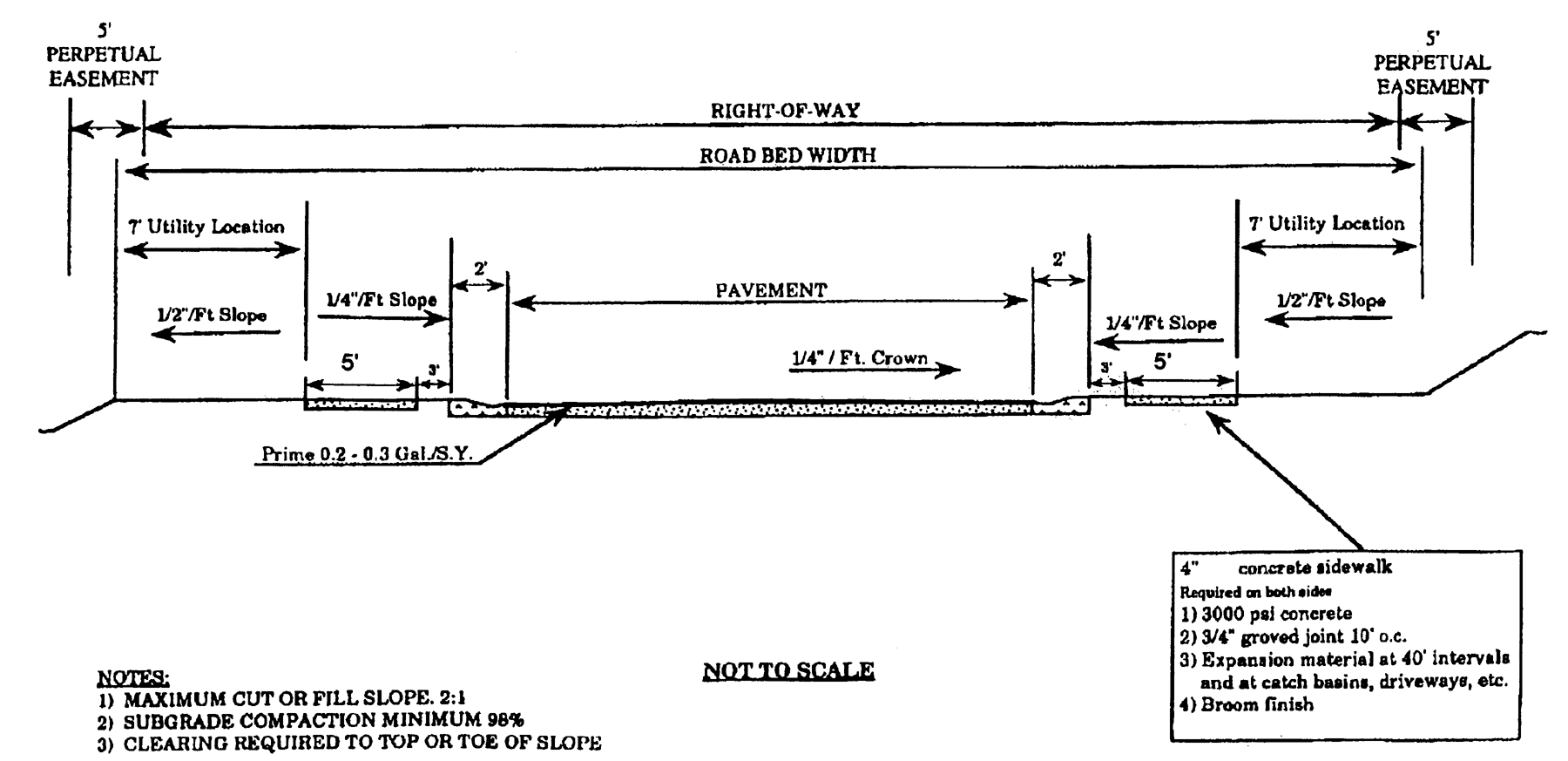
Right-of-Way Widths;
Typical Street Section A
Table 9-13-9-1. Street Improvement Requirements
(ULDC 2005, § 9-13-9-9; Ord. No. 2020-42, § XXIV, 11-3-2020)
Sec. 9-13-9-10. - Perpetual easement.
A five-foot-wide perpetual easement shall be provided outside of the right-of-way line along both sides of all collector and local streets. See typical street section A.
(ULDC 2005, § 9-13-9-10; Ord. No. 2020-42, § XXIV, 11-3-2020)
Sec. 9-13-9-11. - Pavement widths.
Street pavement widths, as measured from back-of-curb to back-of-curb, shall be provided as required in table 9-13-9-1. All roadways shall be constructed according to methods as contained in the most recent version of the state department of transportation Standard Specifications for Roadway Construction, unless otherwise approved by the director of public works.
(ULDC 2005, § 9-13-9-11; Ord. No. 2020-42, § XXIV, 11-3-2020)
Sec. 9-13-9-12. - Street grades.
Maximum and minimum street grades shall be as specified in table 9-13-9-1. In addition, the grade across a cul-de-sac in all directions may not exceed five percent. All changes in grade shall be connected by a vertical curve so constructed as to afford a minimum sight distance, said sight distance being measured from the driver's eyes, which are assumed to be 45 inches above the pavement surface, to an object six inches high on the pavement.
(ULDC 2005, § 9-13-9-12; Ord. No. 2020-42, § XXIV, 11-3-2020)
Sec. 9-13-9-13. - Grading.
(a)
Grading of full width. All streets, roads and alleys shall be graded to their full width by the developer so that pavement extensions or sidewalks, where required or if installed in the future, can be constructed on the same level plane.
(b)
Clearing. Before grading is started, the entire area to be paved shall be first cleared of all stumps, roots, brush and other objectionable materials. In all areas to be graded or filled, the developer shall stockpile the topsoil later to be spread in all disturbed areas not paved.
(c)
Slopes and shoulder improvements. The maximum slope for all fill or cut slopes shall be two feet of run for each one foot of rise or fall. The minimum width for all shoulders on local or collector streets from back edge of the curb shall be eleven feet. All shoulders shall slope one-fourth inch to the foot toward the roadway. When all construction is completed, all slopes and shoulders shall be cleared of all rubbish and shall have a stand of grass to prevent undue erosion, either by sprigging or seeding. Abutting property shall be suitably sloped to the right-of-way line.
(d)
Protection of graded areas. Immediately after grading and filling and re-spreading of topsoil, all areas of disturbed soil shall be fertilized and seeded (or in steep areas sodded or otherwise appropriately treated) with suitable vegetative cover to prevent erosion.
(e)
Installation of utilities. After grading is completed and approved, the curblines shall be staked by the developer's registered land surveyor. Before any base is applied, all of the underground utilities that are to be located under the roadway are to be installed completely or otherwise provided in accordance with public works requirements. For proper location of utilities, see section 9-13-9-27.
(f)
Authorization. No private improvements, such as private lawn sprinkler systems, yard lighting, and the like, shall be installed within a public right-of-way except by authorization of the director of public works. Such authorization, if issued, shall require the owner to assume all repair costs of the owner's and the city's facilities should they become damaged.
(g)
Preparation of subgrade. Prior to placement of the street base, the subgrade shall be compacted to 95 percent density.
(h)
Street base, curbing and paving. Street base, curbing and paving shall be installed by the developer in accordance with the requirements and standards of this article.
(ULDC 2005, § 9-13-9-13; Ord. No. 2020-42, § XXIV, 11-3-2020)
Sec. 9-13-9-14. - Sight distance.
The minimum sight distance shall be as specified in table 9-13-9-1.
(ULDC 2005, § 9-13-9-14; Ord. No. 2020-42, § XXIV, 11-3-2020)
Sec. 9-13-9-15. - Horizontal alignment.
Where a deflection angle of more than ten degrees in the alignment of a street occurs, the radius of curvature of the centerline of said street shall be not less than as specified in table 9-13-9-1. Tangents shall be as specified in table 9-13-9-1.
(ULDC 2005, § 9-13-9-15; Ord. No. 2020-42, § XXIV, 11-3-2020)
Sec. 9-13-9-16. - Curbline radii.
Curblines at street intersections shall have a radius of curvature of not less than 25 feet. Intersecting street right-of-way lines shall be rounded with a radius of no less than 25 feet.
(ULDC 2005, § 9-13-9-16; Ord. No. 2020-42, § XXIV, 11-3-2020)
Sec. 9-13-9-17. - Design speed.
Horizontal curves and superelevation shall be designed in accordance with the requirements specified in table 9-13-9-1.
(ULDC 2005, § 9-13-9-17; Ord. No. 2020-42, § XXIV, 11-3-2020)
Sec. 9-13-9-18. - Alleys.
Where an alley has been specifically authorized by the director of public works, it shall comply with the standards specified in table 9-13-9-1. In addition, dead-end alleys shall be provided with a turnaround having a radius of at least 40 feet.
(ULDC 2005, § 9-13-9-18; Ord. No. 2020-42, § XXIV, 11-3-2020)
Sec. 9-13-9-19. - Dead-end streets.
(a)
Only local streets and alleys may be dead-end streets.
(b)
A cul-de-sac shall be no more than 600 feet long unless necessitated by topographic or other conditions and approved by the community and economic development department director. Such a street shall be provided at the closed end with a turnaround having a right-of-way radius of 53 feet and pavement radius of 40 feet (42 feet radius to back of curb).
(c)
A reverse curve joining a cul-de-sac turnaround to a street section shall have a right-of-way radius of 29 feet and a radius to the back of curb of 40 feet (42 feet to edge of pavement).
(d)
A permanent dead-end street other than a cul-de-sac shall not be allowed, except as a temporary stage of construction of a street that is intended to be extended in a later stage of construction. Such a temporary dead-end street shall be provided with a temporary turnaround within the right-of-way if one or more lots front exclusively on the street; and, extension of the street is not under construction when the final plat is submitted for recording.
(e)
Temporary turnarounds shall consist of a tack coat and one inch of asphalt and have a radius of at least 40 feet.
(ULDC 2005, § 9-13-9-19; Ord. No. 2020-42, § XXIV, 11-3-2020)
Sec. 9-13-9-20. - Street base.
(a)
Street base material shall conform to the requirements of table 9-13-9-1.
(b)
Soil cement base shall contain a minimum ten percent Portland cement by volume. Soil cement base may be allowed only under the following conditions:
(1)
None of the streets exceed eight percent grade.
(2)
Tests taken every 1,000 feet of roadway shall show that the soil meets class "B" standards of the state department of transportation. The tests shall be conducted by a qualified geotechnical laboratory and the results filed with the city in order to obtain authorization to proceed.
(3)
The street base shall extend fully under combination curb and gutter (as illustrated below).
Street Base
(ULDC 2005, § 9-13-9-20; Ord. No. 2020-42, § XXIV, 11-3-2020)
Sec. 9-13-9-21. - Pavement binder and topping.
(a)
Streets shall be paved with a top course meeting the standards specified in table 9-13-9-1. If two-stage paving is approved by the director of public works, the developer shall place a binder course on the street and delay final paving until the end of the one-year maintenance period.
(b)
All pavement sections shall be designed by a qualified professional engineer with registration in the state based on 20-year projected traffic loads for that section and the existing subgrade conditions. The minimum acceptable pavement sections shall meet the specification contained within this chapter.
(ULDC 2005, § 9-13-9-21; Ord. No. 2020-42, § XXIV, 11-3-2020)
Sec. 9-13-9-22. - Testing requirements.
It is the responsibility of the developer to ensure that all required tests are made and reported to the public works department. The cost of all testing and quality control shall be performed at the expense of the developer by qualified testing laboratories.
(ULDC 2005, § 9-13-9-22; Ord. No. 2020-42, § XXIV, 11-3-2020)
Sec. 9-13-9-23. - Curb and gutter.
(a)
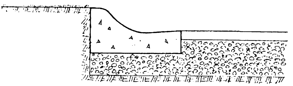
All streets shall be provided with a combination curb and gutter, unless stormwater is directed to a stormwater best management practice via a curb cut or other means, and approval has been given by the department of water resources. Curb and gutter shall be constructed of 3,000 psi Portland cement concrete, or with a header curb of the same material at median or cul-de-sac islands. Curbing along streets shall meet one of the following standards: Along the outer edge of all roadways, six-inch by 24-inch combination (full face) curb:
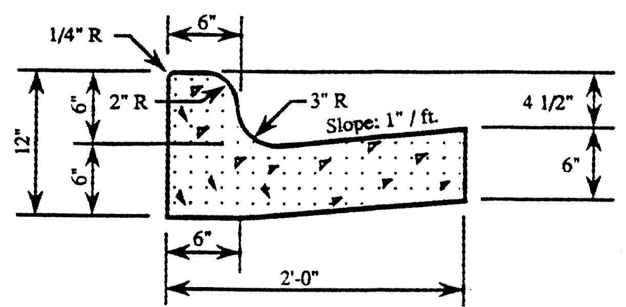
Curb and Gutter
(b)
For use along medians only, six-inch header curb is required.
(1)
Adequate storm drainage structures shall be provided. The combination curb and gutter or header curb shall be constructed so as to present a smooth, even line both horizontally and vertically. Preshaped joints shall be placed every 50 feet along the curbline.
(2)
Valley gutters shall not be allowed across local streets at street intersections.
(3)
If a development is proposed on a parcel where multiple driveways exist, the owner/developer shall be responsible for removing all existing driveway curb cuts and aprons and replacing them with standard curb and gutter. Only new driveways constructed to current standards shall be allowed.
(ULDC 2005, § 9-13-9-23; Ord. No. 2020-42, § XXIV, 11-3-2020)
Sec. 9-13-9-24. - Turning lanes.
Turning lanes may be required at all entrances to subdivisions and industrial and commercial developments that front on arterial and collector streets. Turning lanes shall be 12 feet in width, plus curb and gutter for a minimum distance of 200 feet measured from the intersection of the right-of-way lines.
(ULDC 2005, § 9-13-9-24; Ord. No. 2020-42, § XXIV, 11-3-2020)
Sec. 9-13-9-25. - Street name signs and traffic control signs.
Street name signs of a type approved by the city shall appear at all intersections. Traffic control signs shall be placed by the city and conform to the U.S. Manual on Uniform Traffic Control Devices, latest edition.
(ULDC 2005, § 9-13-9-25; Ord. No. 2020-42, § XXIV, 11-3-2020)
Sec. 9-13-9-26. - Sidewalks.
(a)
Minimum five-foot-wide sidewalks shall be installed along all new streets. In addition, the director of public works shall require the subdivider or land developer to install, along the entire property frontage, minimum five-foot-wide sidewalks on streets leading to or going through commercial areas, school sites, places of public assembly, and other congested areas, and along existing streets abutting the subdivision or land development, or as may be otherwise specified in the city's comprehensive plan.
(b)
Where required or provided, sidewalks shall be located not less than one foot from the property line to prevent interference or encroachment by fencing, walls, hedges or other plantings or structures placed on the property line at a later date. Sidewalks shall be constructed of concrete no less than four inches in depth, and located no less than three feet from the back of the curb. All sidewalks shall be constructed to conform to requirements of the Americans with Disabilities Act. The director of public works, in accordance with section 9-13-8-5, may administratively vary the width and location of the sidewalk based on existing and surrounding site conditions.
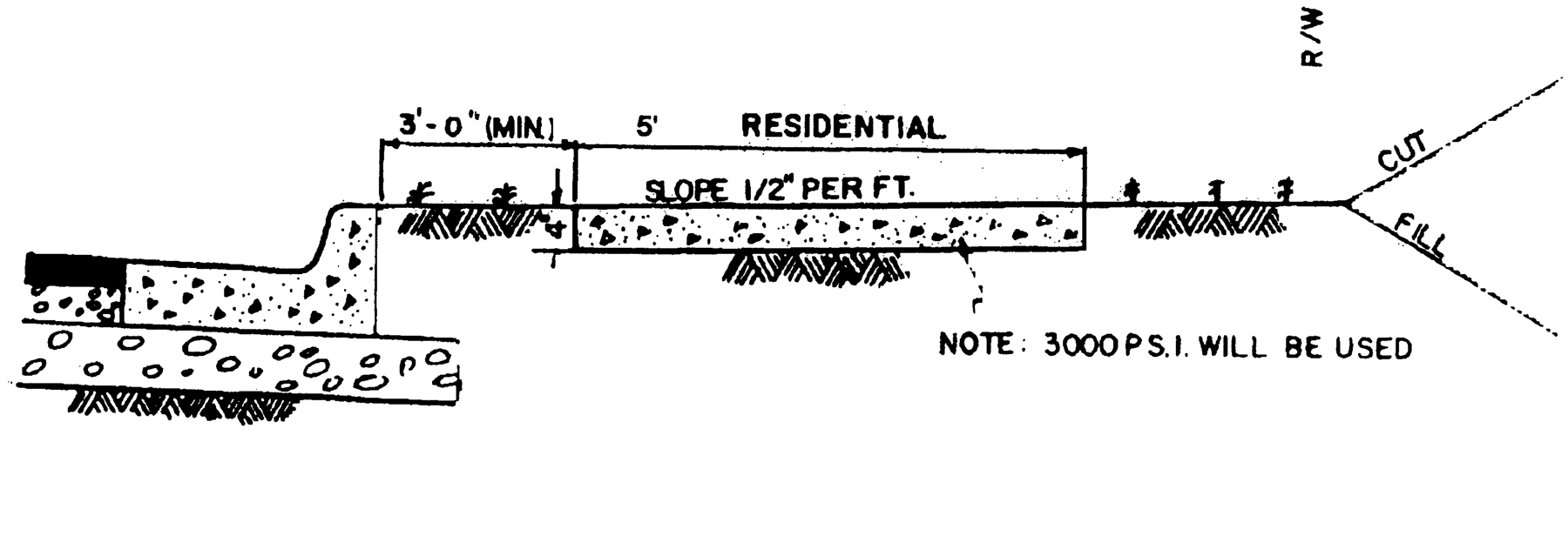
Typical Section of Sidewalk
N.T.S.
(ULDC 2005, § 9-13-9-26; Ord. No. 2020-42, § XXIV, 11-3-2020)
Sec. 9-13-9-27. - Location of utilities in streets.
(a)
Aboveground utilities. Telephone poles, streetlight poles, telephone junction boxes and other public or private utility structures placed aboveground within a street right-of-way must be at least eight feet back from the back of the street curb and one foot back from the edge of the sidewalk, whichever is farthermost from the roadway.
(b)
Underground utilities. Utilities placed underground shall be placed within the right-of-way as follows (see typical street section B).
(c)
Sanitary sewer. Sanitary sewer when placed within a street right-of-way, shall have a minimum of four feet of cover and provide a minimum slope of laterals to abutting properties of one percent.
(d)
Stormwater. Stormwater conveyance pipes, when placed within a street right-of-way, shall have a minimum of 18 inches of cover and shall have a minimum slope of at least one percent.
(e)
Location of utilities. Other utilities, when placed underground along the roadway, shall be located in the shoulder of the road and shall be placed at the following distances measured from the back of curb or edge of pavement, and placed at or below the depths indicated as follows:
Water and gas mains must be placed on opposite sides of the street. All utilities that will cross under pavement shall be installed completely throughout the subdivision prior to any roadway base being applied. Installation of approved utility sleeves shall be considered as an alternate.
Typical Street Section B
Location of Utilities
(ULDC 2005, § 9-13-9-27; Ord. No. 2020-42, § XXIV, 11-3-2020)
Sec. 9-13-9-28. - Pavement cuts.
Pavement cuts across local streets shall conform to the following:
(1)
Pavement cuts for the installation of utilities shall be avoided whenever possible. Utility crossings shall be bored across any arterial, subject to the approval of the state DOT, and across any collector unless a pavement cut is approved by the director of public works.
(2)
Pavement cuts across local streets shall be permitted, provided the road is repaired with at least six inches of 3,000 psi Portland cement and topped with at least 2½ inches of E or F hot plant mix asphaltic cement. The top of the concrete pad shall not exceed the elevation of the aggregate base course of the original road construction.
(ULDC 2005, § 9-13-9-28)
Sec. 9-13-9-29. - Street lighting.
(a)
Roadway illumination standards. In order to ensure adequate illumination of public rights-of-way and promote safety and security, the American National Standard Practice for Roadway Lighting of the Illuminating Engineering Society, as approved by the American National Standards Institute (1993), as amended, is hereby adopted as the standard for the installation and operation of lighting in the city with the following exception:
(1)
Lighting fixtures installed within the public rights-of-way to be operated for the purpose of street illumination shall comply with these standards. The minimum average horizontal footcandle illumination level by roadway classification shall be as provided in the table below:
(2)
The uniformity of illumination shall be such that the point of lowest illumination shall have at least one-third of the average horizontal footcandle required illumination level, except that on local or residential streets it may not be less than one-sixth of this average. Unless extenuating circumstances exist, fixtures for residential street lighting shall not be required to be closer than 200 feet, nor fixtures for all other roadways be closer than 100-foot spacing. If pole top fixtures are used, spacing should range between 125 feet to 150 feet.
(b)
Plans, approval, and appeal. Any party requesting permission to install or operate lighting fixtures within public and private rights-of-way shall furnish plans and specifications to the director of public works for approval showing how the proposed lighting meets the standards of this section. No lighting shall be installed or operated without the approval of the director of public works. Should the director of public works disapprove a request to install lighting fixtures within any public right-of-way, he shall communicate disapproval in writing to the party requesting approval. The written communication shall include specific reasons for disapproval. Any disapproval of a light or lighting system may be appealed to the planning and appeals board. If any party desires to appeal an adverse decision by the city engineer within ten days from the date following the written notice of disapproval, it shall be the responsibility of the director of public works to transmit forthwith to the planning and appeals board all papers and allied documents constituting the record upon which the action appealed was taken, and to ensure that the appeals promptly placed upon the agenda of the planning and appeals board for its determination. The planning and appeals board may reserve or affirm, wholly or partly, or may modify, the order, requirement, and decision of determination appealed.
(c)
Security and other lights. Roadway or street lighting luminaries or fixtures installed within the public or private rights-of-way as security lights, or for the purpose of lighting areas other than the public streets, shall be mounted on the side of the pole opposite from the street, and shall be oriented in such a manner to ensure that the lateral light distribution pattern is parallel to the street and the vertical light distribution, at the initial source, is perpendicular to the street, so as to protect the users of the street from objectionable glare. The approval of the director of public works shall be obtained prior to installation of such lights. Other lighting fixtures to be installed within or outside of public or private rights-of-way, for whatever purpose, shall be installed and operated in such a manner so as to prevent glare from being a hazard to or interfering with the normal use of the public or private rights-of-way.
(d)
Procedures for approval in subdivisions. Streetlights shall be required to be provided by the developers of all new subdivisions involving new streets, unless waived by the governing body on recommendation from the planning and appeals board. Unless so waived, the developer, at the time of submission of the preliminary plat of the subdivision shall present a streetlight layout approved by the utility company which will provide the streetlight service in the subdivisions. At the time of and as a requirement of the submission of a final plat, unless waived by the governing body on recommendation of the planning and appeals board, as herein provided, the developer shall:
(1)
Submit a final streetlight layout approved by the utility company which will provide the lighting service showing exact location of streetlights within the subdivision. This drawing (lighting layout) must be approved by the director of public works prior to obtaining any building permit within that subdivision. Fixtures and standards/poles installed or used shall be approved by the utility company which will be responsible for the maintenance of the facilities in the city. The fixtures shall be mounted a minimum of 13 to 16 feet above the ground, and shall have appropriate design to place the majority of the light output over the street. One light shall be located in each cul-de-sac within the subdivision, as well as each intersection.
(2)
Pay all costs for standards/poles, fixtures, and any other related items or materials necessary for the installation thereof.
(3)
Submit proof of payment for complete installation to the director of public works.
The above requirements must be met prior to obtaining any building permits for that subdivision and must be shown as a general note on the final plans.
(ULDC 2005, § 9-13-9-29)
Sec. 9-13-9-30. - Street trees.
(a)
Optional. Street tree planting may be permitted within the rights-of-way of new public streets and private streets within commercial, industrial, or residential subdivisions, subject to the approval of the director of public works. See chapter 9-8-7 for street tree planting requirements in the Midtown overlay zone.
(b)
Plan submittal and approval. When street trees are to be provided, the subdivider, owner of land to be dedicated as a public street, or the developer of a private street shall at the time of preliminary plat approval submit a plan for the provision of street trees along all said roads which shall be subject to the approval of the director of public works.
(c)
Installation. It is the intent of this section that where street trees are provided the subdivider or developer should carefully position street trees on the plan while taking into account sidewalk locations, utility locations, and, if not constructed simultaneously with the construction of the public or private street, future driveways. When street trees are provided, the subdivider or developer shall install said street trees, according to a plan approved by the director of public works as a part of preliminary plat approval or land development permit approval, and prior to dedication or opening of said street. The director of public works may accept an agreement by the subdivider where the responsibility for street tree planting is shifted to the owners or individual builders of the lots to be subdivided, upon their development. Any such responsibility shall be legally transferred in a form acceptable to the city attorney.
(d)
Location. Street trees must be planted within the public or private right-of-way or, if right-of-way width is insufficient to accommodate said street trees, then on private property within a street tree easement dedicated to the city.
(e)
Guidelines. The guidelines below are intended to avoid conflicts with improvements; they are recommendations only and are subject to the approval of the community and economic development department director.
*Refer to table 9-16-5-4
(ULDC 2005, § 9-13-9-30; Ord. No. 2020-42, § XXIV, 11-3-2020)
Sec. 9-13-10-1.- Private streets permitted.
Private streets may, upon application, be permitted by the community and economic development department director, subject to the requirements of this article. The community and economic development department director may impose conditions on the approval of private streets to ensure various public purposes and to mitigate potential problems with private streets. No final plat involving a private street shall be approved unless said final plat conforms to the requirements of this article.
(ULDC 2005, § 9-13-10-1)
Sec. 9-13-10-2. - Engineering plans required.
It shall be unlawful for any person, firm, or corporation to construct a new private street or alter an existing private street or to cause the same to be done without first obtaining approval of civil design drawings and construction plans and securing a land development permit from the community and economic development department director in accordance with the requirements of this article, the same as for a public street.
(ULDC 2005, § 9-13-10-2)
Sec. 9-13-10-3. - Standards for private streets.
All private streets shall be constructed to all standards for public streets as specified in chapter 9-13-9, unless otherwise specifically approved as part of a planned unit development by the governing body.
(ULDC 2005, § 9-13-10-3)
Sec. 9-13-10-4. - Street names and signs.
Private streets shall be named, subject to the approval of the community and economic development department director. The subdivider or developer of land involving a private street shall install street signs with content containing the street name and the designation "private," or as approved by the director of public works. Alternatively, the director of public works may require the subdivider or developer to pay for such signs to be installed by or under the direction of the city. Signs signifying private streets may be required by the director of public works to be a different color than that of street signs provided for public streets, in order to distinguish maintenance responsibilities in the field.
(ULDC 2005, § 9-13-10-4)
Sec. 9-13-10-5. - Easements.
Easements for private streets shall be designated on final plats as general purpose public access and utility easements, along with the name of said private street which shall require approval by the community and economic development department director. Said easement shall at minimum be of the same width as that required for the right-of-way of a public street for the type of public street (local, collector, etc.) most closely resembling the proposed private street. Easements for private streets shall not be included in any calculation of minimum lot size or density maximums established by zoning regulations of this Code. In the cases of private streets, the general purpose public access and utility easement shall be shown in a manner on the final plat such that the private street right-of-way is drawn as its own discrete parcel to be dedicated to a private homeowner's association (i.e., not shown to be a part of any lot) or other approved entity.
(ULDC 2005, § 9-13-10-5)
Sec. 9-13-10-6. - Maintenance.
The city shall not maintain, repair, resurface, rebuild, or otherwise improve streets, signs, drainage improvements or any other appurtenances within general purpose public access and utility easements established for private streets. A private maintenance covenant recorded with the county clerk of the superior court shall be required for any private street and other improvements within general purpose public access and utility easements established for private streets. The covenant shall set out the distribution of expenses, remedies for noncompliance with the terms of the agreement, rights to the use of easements, and other pertinent considerations. The covenant shall specifically include the following terms:
(1)
The covenant shall establish minimum annual assessments in an amount adequate to defray costs of ordinary maintenance and procedures for approval of additional needed assessments. The covenant shall also specify that the funds from such assessments will be held by a homeowner's or property owner's association.
(2)
The covenant shall include a periodic maintenance schedule.
(3)
The covenant for maintenance shall be enforceable by any property owner served by the private street.
(4)
The covenant shall establish a formula for assessing maintenance and repair costs equitably to property owners served by the private street.
(5)
The covenant shall run with the land.
(6)
The city, as a condition of approving private streets, shall require that a performance bond and/or maintenance bond by the subdivider, as described in sections 9-13-13-9 and 9-13-13-10, be submitted by the subdivider.
(ULDC 2005, § 9-13-10-6; Ord. No. 2009-38, § I, 10-20-2009)
Sec. 9-13-10-7. - Specifications for final plats involving private streets.
No final plat involving a private street shall be approved by the community and economic development department director for recording unless and until it shall contain the following on the face of the plat:
(1)
Covenants, or reference to the deed book and page of the recorded covenants.
(2)
"The city has no responsibility to build, improve, maintain, or otherwise service the private streets, drainage improvements, and other appurtenances contained within the general public purpose access and utility easement or easements for private streets shown on this plat."
(3)
"Grant of easement. The general purpose access and utility easements shown on this plat for private streets is (are) hereby granted and said grant of rights shall be liberally construed to provide all necessary authority to the city, and to public or private utility companies serving the subdivision, for the installation and maintenance of utilities, including, but not limited to, electric lines, gas lines, telephone lines, water lines, sewer lines, cable television lines, and fiber optic cables, together with the right to trim interfering trees and brush, together with a perpetual right of ingress and egress for installation, maintenance, and replacement of such lines.
(ULDC 2005, § 9-13-10-7)
Sec. 9-13-10-8. - Purchaser's acknowledgement.
Prior to the sale or as a condition of the closing of a real estate transaction involving any lot served by a private street in the city, the subdivider or seller of said lot shall execute a notarized purchaser's acknowledgement of private street construction and drainage maintenance responsibilities as set forth below. A copy of the purchaser's acknowledgement shall be retained by the purchaser and shall be required to be submitted as a condition of a building permit for a principal building on said lot:
Purchaser's Acknowledgement of Private Street and Drainage Maintenance Responsibility.
(I) (We) have read the Declaration of Covenant which pertains to the lot that is the subject of this real estate transaction ___________ (insert address and attach legal description). (I) (We) understand that the Declaration of Covenant applies to the lot that (I am) (we are) purchasing and requires (me) (us) to provide a specified percentage or amount of the financing for the construction and maintenance of any private street and drainage facilities serving the lot which (I am) (we are) purchasing, and that owners of other lots in this plat may sue for and recover those costs which this covenant requires (me) (us) to pay, plus their damages resulting from (my) (our) refusal to contribute, plus reasonable attorney's fees. (I) (we) further understand that the city has no obligation to assist with the maintenance and improvement of the private street, drainage facilities, and other appurtenances within the general purpose public access and utility easement for the private road serving the lot in question. I (we) understand that a copy of this purchaser's acknowledgement shall be required as a condition of the issuance of a building permit for a principal building on the lot (I am) (we are) purchasing.
(ULDC 2005, § 9-13-10-8)
Sec. 9-13-10-9. - Gated communities.
(a)
Gates must be set back a minimum of 50 feet from a public right-of-way. The minimum gate width must equal the required road width, plus the width of any utility easements present, but in no case shall the width be less than 30 feet. Gate width and placement must be reviewed by, and are subject to approval by, the fire department.
(b)
Arrangements for access through the gate for emergency service vehicles must be reviewed by, and are subject to the approval of, the police and fire departments. Such arrangements may include: keypad code entry; occupant telephone authorized entry; personal service attendant 24 hours a day, seven days a week; and/or automatic gate opening upon power disconnect.
(ULDC 2005, § 9-13-10-9)
Sec. 9-13-11-1.- Sanitary sewerage.
(a)
Connection required. Except as otherwise required in this section, each subdivider and land developer shall be required to pay for the installation of a sanitary sewerage collection system connected to the city's system serving his subdivision or land development. The layout and specifications of the system shall be in accordance with city specifications, as approved by the director of water resources, and shall be installed by a contractor approved by the city.
(b)
Connection to decentralized wastewater system. Where connection to the sanitary sewerage system is not feasible in the view of the director of water resources, the lot shall contain adequate area for the installation and safe operation of the decentralized wastewater system, as approved by the county environmental health department.
(ULDC 2005, § 9-13-11-1; Ord. No. 2020-42, § XXV, 11-3-2020)
Sec. 9-13-11-2. - Water service.
(a)
Connection required. Each subdivision or development shall connect to the city's water system and shall provide service to each lot or the development as a whole, as appropriate, at the expense of the subdivider or land developer.
(b)
Specifications. The layout and specifications of the system shall be in accordance with city specifications, as approved by the director of water resources, and shall be installed by a contractor approved by the city.
(c)
Fire hydrants. Fire hydrants shall be installed in subdivisions and developments and shall meet the requirements of the fire department.
(ULDC 2005, § 9-13-11-2; Ord. No. 2020-42, § XXV, 11-3-2020)
Sec. 9-13-12-1.- Purposes.
(a)
This chapter defines requirements for stormwater management and outlines the water quantity and quality performance criteria for managing stormwater runoff. The majority of technical stormwater criteria and standards are adopted by reference through the use of the latest revision of the GSMM.
(b)
The purposes of this chapter are also to protect, maintain and enhance the public health, safety, environment and general welfare by establishing minimum requirements and procedures to control the adverse effects of increased post-development stormwater runoff and nonpoint source pollution associated with new development and redevelopment.
(ULDC 2005, § 9-13-12-1; Ord. No. 2020-42, § XXVI, 11-3-2020)
Sec. 9-13-12-2. - Objectives.
This chapter seeks to meet its purposes through the following objectives:
(1)
Require that new development and redevelopment maintain the pre-development hydrologic response in their post-development state as nearly as practicable in order to reduce flooding, stream bank erosion, nonpoint source pollution and increases in stream temperature, and maintain the integrity of stream channels and aquatic habitats;
(2)
Establish minimum post-development stormwater management standards and design criteria for the regulation and control of stormwater runoff quantity and quality;
(3)
Establish design and application criteria for the construction and use of structural stormwater control facilities that can be used to meet the minimum post-development stormwater management standards;
(4)
Encourage the use of nonstructural stormwater management and stormwater better site design practices, such as the preservation of greenspace and other conservation areas, to the maximum extent practicable;
(5)
Establish provisions for the long-term responsibility for and maintenance of structural stormwater control facilities and nonstructural stormwater management practices to ensure that they continue to function as designed, are maintained, and pose no threat to public safety; and
(6)
Establish administrative procedures for the submission, review, approval and disapproval of stormwater management plans, and for the inspection of approved active projects, and long-term follow up.
(ULDC 2005, § 9-13-12-2; Ord. No. 2020-42, § XXVI, 11-3-2020)
Sec. 9-13-12-3. - Definitions.
(a)
The following words, terms and phrases, when used in this section, shall have the meanings ascribed to them in this subsection, except where the context clearly indicates a different meaning:
Administrative floodplain means any land area susceptible to flooding, which would have at least a one-percent probability of flooding occurrence in any calendar year based on the basin being fully developed as shown on the projected future land use map.
Administrator means the person appointed to administer and implement this chapter. The director of the department of water resources, or his designee, will serve as administrator for the purposes of this chapter.
Applicant means a person submitting a land development application for approval.
BMP or best management practice means both structural devices to store or treat stormwater runoff and nonstructural programs or practices which are designed to prevent or reduce the pollution of the waters of the state.
BMP landscaping plan means a design for vegetation and landscaping that is critical to the performance and function of the BMP, including how the BMP will be stabilized and established with vegetation. The term "BMP landscaping plan" includes a layout of plants and plant names (local and scientific).
Channel means a natural or artificial watercourse with a definite bed and banks that conducts continuously or periodically flowing water.
Conservation easement means an agreement between a landowner and the city or other government agency or land trust that permanently protects open space or greenspace on the owner's land by limiting the amount and type of development that can take place, but continues to leave the remainder of the fee interest in private ownership.
Construction sequencing plan means a document noting the sequence of construction and identification of infiltration zones for protection during staged installation of permanent post-construction BMPs to ensure suitable site conditions such as avoiding soil compaction by heavy equipment in areas designated for infiltration BMPs.
Decentralized wastewater system means a closed-loop system designed or used to receive sewage from a building sewer and to affect separation and organic decomposition of sewerage solids, and discharging sewage effluent to an absorption field or other management system. The term "decentralized wastewater system" also means an on-site wastewater disposal system or septic tank.
Department of water resources means a public agency with authority over the water systems of the city.
Department of water resources director means the director of the department of water resources of the city, or his designee, whose duties include the review and approval of construction plans for water resources for the city.
Design professional means a professional licensed by the state in the field of: engineering, architecture, landscape architecture, forestry, geology, or land surveying, or a person that is a certified professional in erosion and sediment control (CPESC) with a current certification by EnviroCert, Inc. The design professional shall practice in a manner that complies with applicable state law governing professional licensure.
Detention means the temporary storage of stormwater runoff in a stormwater management facility for the purpose of controlling the peak discharge.
Detention facility means a detention basin or structure designed for the detention of stormwater runoff and gradual release of stored water at controlled rates.
Development means new development or redevelopment.
Drainage easement means an easement appurtenant or attached to a tract or parcel of land allowing the owner of adjacent tracts or other persons to discharge stormwater runoff onto the tract or parcel of land subject to the drainage easement. Both streams and storm drainage channels are required to have easements for maintenance purposes as specified in this chapter.
Erosion and sedimentation control plan means a plan that is designed to minimize the accelerated erosion and sediment runoff at a site during land-disturbance activities.
Extended detention means the detention of stormwater runoff for an extended period, typically 24 hours or greater.
Extreme flood protection means measures taken to prevent adverse impacts from large low-frequency storm events with a return frequency of 100 years or more.
Flooding means a volume of surface water that is too great to be confined within the banks or walls of a conveyance or stream channel and that overflows onto adjacent lands.
Greenspace or open space means permanently protected areas of the site that are preserved in a natural state.
GSMM means the latest edition of the Georgia Stormwater Management Manual, Volume 2: Technical Handbook, and its appendices.
Hotspot means a land use or activity on a site that produces higher concentrations of trace metals, hydrocarbons, or other priority pollutants that are normally found in urban stormwater runoff. Examples of hotspots include, but are not limited to, gas stations, vehicle service and maintenance areas, industrial facilities such as salvage yards, material storage sites, garbage transfer facilities, and commercial parking lots with high-intensity use.
Hydrologic soil group (HSG) means a natural resource conservation service classification system in which soils are categorized into four runoff potential groups. The groups range from group A soils, with high permeability and little runoff produced, to group D soils, which have low permeability rates and produce much more runoff.
Impervious surface means a surface composed of any material that significantly impedes or prevents the natural infiltration of water into soil. Impervious surfaces include, but are not limited to, rooftops, buildings, streets and roads, sidewalks, driveways, parking lots, and any other concrete or asphalt surface. The term "impervious surface" is also called impervious cover.
Improvements means the physical addition and changes to land that may be necessary to produce usable, desirable and acceptable lots or building sites.
Industrial stormwater general permit means the National Pollutant Discharge Elimination System (NPDES) permit issued by the state environmental protection division to an industry for stormwater discharges associated with industrial activity. The permit regulates pollutant levels associated with industrial stormwater discharges or specifies on-site pollution control strategies based on the standard industrial classification (SIC) code.
Infiltration means the process of percolating stormwater runoff into the subsoil.
Inspection and maintenance agreement means a written agreement providing for the long-term inspection, operation, and maintenance of the stormwater management system and its components on a site.
Jurisdictional wetland means an area that is inundated or saturated by surface water or groundwater at a frequency and duration sufficient to support a prevalence of vegetation typically adapted for life in saturated soil conditions, commonly known as hydrophytic vegetation.
Land development means any land change, including, but not limited to, clearing, digging, grubbing, stripping, removal of vegetation, dredging, grading, excavating, transporting and filling of land, construction, paving, and any other installation of impervious cover.
Land development application means the application for a land development permit on a form provided by the city along with the supporting documentation required by this chapter.
Land development permit means the authorization necessary to begin construction-related, land-disturbing activity.
Land-disturbing activities means any activity which may result in soil erosion from water or wind and the movement of sediments into state waters or onto lands within the state, including, but not limited to, clearing, dredging, grading, excavating, and filling of land. The term "land-disturbing activity" does not include agricultural operations as described in O.C.G.A. § 12-7-17(5) or forestry land management practices as described in O.C.G.A. § 12-7-17(6) within areas zoned for such activities.
Linear feasibility program means a feasibility program developed by the department of water resources and submitted to the state environmental protection division, which sets reasonable criteria for determining when implementation of stormwater management standards for linear transportation projects being constructed by the city is infeasible.
Linear transportation projects means construction projects on traveled ways, including, but not limited to, roads, sidewalks, multi-use paths and trains, and airport runways and taxiways.
MS4 permit means the NPDES permit issued by the state environmental protection division for discharges from the city's municipal separate storm sewer system.
Municipal utility means a utility owned and operated by a local government and providing drinking water, wastewater and stormwater management facilities and services.
Sewer system means a sanitary sewerage system for the collection of water-borne wastes complete with a sewage treatment plant that is owned and operated by the city department of water resources.
Stormwater system means a system of structural and nonstructural stormwater management facilities and practices that are used to capture, convey and control the quantity and quality of the stormwater runoff.
Water system means a system for the intake, treatment and distribution of potable water that is owned and operated the city department of water resources.
New development means a land development activity on a previously undeveloped site.
Nonpoint source pollution means a form of water pollution that does not originate from a discrete point such as a sewage treatment plant or industrial discharge, but involves the transport of pollutants such as sediment, fertilizers, pesticides, heavy metals, oil, grease, bacteria, organic materials and other contaminants from land to surface water or groundwater via mechanisms such as precipitation, stormwater runoff, and leaching. Nonpoint source pollution is a by-product of land use practices such as agricultural, silvicultural, mining, construction, subsurface disposal and urban runoff sources.
Nonstructural stormwater management practice or nonstructural practice means any natural or planted vegetation or other nonstructural component of the stormwater management plan that provides for or enhances stormwater quantity and/or quality control or other stormwater management benefits, and includes, but is not limited to, stream buffers, open and greenspace areas, overland flow filtration areas, natural depressions, and vegetated channels.
Off-site facility means a stormwater management facility located outside the boundaries of the site.
On-site facility means a stormwater management facility located within the boundaries of the site.
Overbank flood protection means the measures taken to prevent an increase in the frequency and magnitude of out-of-bank flooding (i.e., flow events that exceed the capacity of the channel and enter the floodplain), and that are intended to protect downstream properties from flooding for the two-year through 25-year frequency storm events.
Owner means the legal or beneficial owner of a site, including, but not limited to, a mortgagee or vendee in possession, receiver, executor, trustee, lessee or other person, firm or corporation in control of the site.
Permit means the permit issued by the city to the applicant which is required for undertaking any land development activity.
Person means any individual, partnership, firm, association, joint venture, public or private corporation, trust, estate, commission, board, public or private institution, utility, cooperative, city, county or other political subdivision of the state, any interstate body or any other legal entity, except to the extent exempted from this Code.
Post-construction stormwater management means stormwater best management practices that are used on a permanent basis to control and treat runoff once construction has been completed in accordance with a stormwater management plan.
Post-development means the time period, or the conditions that may reasonably be expected or anticipated to exist, immediately after completion of the land development activity on a site as the context may require.
Practicability policy means the latest edition of the Metropolitan North Georgia Water Planning District's policy on practicability analysis for runoff reduction.
Pre-development means the time period, or the conditions that exist, on a site immediately before the implementation of the proposed development. Where phased development or plan approval occurs (preliminary grading, roads and utilities, etc.), the existing conditions at the time prior to the first item being approved or permitted shall establish pre-development conditions.
Previously developed site means a site that has been altered by paving, construction, and/or land-disturbing activity.
Professional engineer means an engineer licensed and registered to perform the duties of a professional engineer (PE) by the state.
Project means a land development project.
Redevelopment means structural development (construction, installation, or expansion of a building or other structure), creation or addition of impervious surfaces, replacement of impervious surfaces not as part of routine maintenance, and land-disturbing activities associated with structural or impervious development on a previously developed site. The term "redevelopment" does not include such activities as exterior remodeling.
Regional stormwater management facility or regional facility means stormwater management facilities designed to control stormwater runoff from multiple properties, where the owners or developers of the individual properties may assist in the financing of the facility, and the requirement for on-site controls is either eliminated or reduced.
Routine maintenance means activities to keep an impervious surface as near as possible to its currently constructed condition. The term "routine maintenance" includes ordinary maintenance activities, resurfacing paved areas, and exterior building changes or improvements which do not materially increase or concentrate stormwater runoff, or cause additional nonpoint source pollution.
Runoff means stormwater runoff.
Site means an area of land where development is planned, which may include all or portions of one or more parcels of land. For subdivisions and other common plans of development, the term "site" includes all areas of land covered under an applicable land development permit.
Stormwater better site design means nonstructural site design approaches and techniques that can reduce a site's impact on the watershed and can provide for nonstructural stormwater management. The term "stormwater better site design" includes conserving and protecting natural areas and greenspace, reducing impervious cover, implementing lower impact site design techniques, and using natural features for stormwater management.
Stormwater concept plan means an initial plan for post-construction stormwater management at the site that provides the groundwork for the stormwater management plan, including the natural resources inventory, site layout concept, initial runoff characterization, and first round stormwater management system design.
Stormwater management means the collection, conveyance, storage, treatment and disposal of stormwater runoff in a manner intended to prevent increased flood damage, streambank channel erosion, habitat degradation and water quality degradation, and to enhance and promote the public health, safety and general welfare.
Stormwater management facility means any infrastructure that controls or conveys stormwater runoff.
Stormwater management measure means any stormwater management facility or nonstructural stormwater practice.
Stormwater management plan means a document describing how existing runoff characteristics will be affected by a land development project and containing measures for complying with the provisions of this Code.
Stormwater management system means the entire set of structural and nonstructural site design features and structural BMPs for collection, conveyance, storage, infiltration, treatment, and disposal of stormwater runoff in a manner designed to prevent increased flood damage, streambank channel erosion, habitat degradation and water quality degradation, and to enhance and promote the public health, safety and general welfare.
Stormwater retrofit means a stormwater management practice designed for a currently developed site that previously had either no stormwater management practice in place or a practice inadequate to meet the stormwater management requirements of the site.
Stormwater runoff means flow on the surface of the ground, resulting from precipitation.
Subdivision means the division of a tract or parcel of land resulting in one or more new lots or building sites for the purpose, whether immediately or in the future, of sale, other transfer of ownership or land development, and includes divisions of land resulting from or made in connection with the layout or development of a new street or roadway or a change in an existing street or roadway.
Watercourse means any natural or artificial surface water conveyance, stream, river, creek, channel, ditch, canal, conduit, culvert, drain, waterway, gully, ravine, or wash in which water flows either continuously or intermittently; a natural watercourse has a definite bed and banks, and includes any area adjacent thereto subject to inundation by reason of overflow or floodwater.
(b)
Other terms used but not defined in this chapter shall be interpreted based on how such terms are defined and used in the GSMM and the city's MS4 permit.
(ULDC 2005, § 9-13-12-3; Ord. No. 2020-42, § XXVI, 11-3-2020)
Sec. 9-13-12-4. - Stormwater management report required.
(a)
All persons proposing development or construction in the city that meets the applicability requirements of this chapter shall prepare a stormwater management report, unless specifically exempted from the requirements of this chapter. No final subdivision plat shall be approved and no development or building permit shall be issued until and unless the stormwater management report has been reviewed and approved by the administrator, except as exempted below.
(b)
This report must be submitted with the stamp and signature of a professional engineer (PE) licensed in the state, who must verify that the design of all stormwater management facilities and practices meet submittal and permitting requirements. The engineer sealing the stormwater management report is responsible for ensuring that all permit requirements related to section 404 of the Clean Water Act are met.
(c)
Stormwater management reports shall not be required for activities that are exempted by section 9-13-12-6 from the provisions of this chapter.
(ULDC 2005, § 9-13-12-4; Ord. No. 2020-42, § XXVI, 11-3-2020)
Sec. 9-13-12-5. - Applicability.
The provisions of this chapter apply to any new development or redevelopment site that meets one or more of the following criteria:
(1)
New development that creates or adds 5,000 square feet or more of new impervious surface or that involves land-disturbing activity of one acre of land or more;
(2)
Redevelopment (excluding routine maintenance and exterior remodeling) that creates, adds or replaces 5,000 square feet or more of new impervious surface area or that involves land-disturbing activity of one acre of land or more;
(3)
New development and redevelopment if:
a.
Such new development or redevelopment is part of a subdivision or other common plan of development, and
b.
The sum of all associated impervious surface area or land-disturbing activities that are being developed as part of such subdivision or other common plan of development meets or exceeds the threshold in subsections (1) and (2) of this section;
(4)
Any commercial or industrial new development or redevelopment, regardless of size, that is a hotspot land use as defined in this chapter; and
(5)
Linear transportation projects that exceed the threshold set forth in subsection (1) or (2) of this section.
(ULDC 2005, § 9-13-12-5; Ord. No. 2020-42, § XXVI, 11-3-2020)
Sec. 9-13-12-6. - Exemptions.
The following activities are exempt from the requirements this chapter:
(1)
Land-disturbing activity conducted by local, state, authority, or federal agencies, solely to respond to an emergency need to protect life, limb, or property or to conduct emergency repairs;
(2)
Land-disturbing activity that consists solely of cutting a trench for utility work and related pavement replacement;
(3)
Land-disturbing activity conducted by local, state, authority, or federal agencies, whose sole purpose is to implement stormwater management or environmental restoration;
(4)
Repairs to any stormwater management system deemed necessary by the department of water resources or department of community and economic development;
(5)
Agricultural operations or forestry land management activities or practices as described in O.C.G.A. § 12-7-17(5) and (6) within areas zoned for such activities;
(6)
Additions or modifications to existing single-family, detached, or duplex residential structures;
(7)
Individual single-family residential lots that are not part of a subdivision or phased development project;
(8)
Installations or modifications to existing structures solely to implement Americans with Disabilities Act (ADA) requirements, including, but not limited to, elevator shafts, handicapped access ramps and parking, and enlarged entrances or exits; and
(9)
Linear transportation projects being constructed by the city to the extent the administrator determines that the stormwater management standards may be infeasible to apply, all or in part, for any portion of the linear transportation project. For this exemption to apply, any infeasibility report that is compliant with the city's linear feasibility program shall first be submitted to the administrator and shall contain adequate documentation to support the evaluation for the applicable portion and any resulting infeasibility determination, if any, by the administrator.
(ULDC 2005, § 9-13-12-6; Ord. No. 2020-42, § XXVI, 11-3-2020)
Sec. 9-13-12-7. - Variances.
The director of water resources may grant a variance from the requirements of this chapter if the proposed development activity will not:
(1)
Change the rate or volume of runoff significantly, as specified in the GSMM;
(2)
Have a significant, negative impact on any wetland, watercourse, or water body as specified in the GSMM;
(3)
Contribute to degradation of water quality; and
(4)
The application of the stormwater design sizing criteria is determined to be infeasible to implement based on a feasibility study.
(ULDC 2005, § 9-13-12-7; Ord. No. 2020-42, § XXVI, 11-3-2020)
Sec. 9-13-12-8. - Adoption and implementation of the GSMM, conflicts and inconsistencies.
(a)
The latest version of the Georgia Stormwater Management Manual (GSMM), including all related appendices, will provide the primary guidance for the design and evaluation of stormwater management facilities in the city. A copy of the GSMM may be viewed in the department of water resources or may be accessed online.
(b)
This chapter is not intended to modify or repeal any other chapter, ordinance, rule, regulation or other provision of law, including, but not limited to, any applicable stream buffers under state and local laws, and the Georgia Safe Dams Act and Rules for Dam Safety. In the event of any conflict or inconsistency between any provision in the city's MS4 permit and this chapter, the provision from the MS4 permit shall control. In the event of any conflict or inconsistency between any provision of this chapter and the GSMM, the provision from this chapter shall control. In the event of any other conflict or inconsistency between any provision of this chapter and any other ordinance, rule, regulation or other provision of law, the provision that is more restrictive or imposes higher protective standards for human health or the environment shall control.
(c)
If any provision of this chapter is invalidated by a court of competent jurisdiction, such judgement shall not affect or invalidate the remainder of this chapter.
(ULDC 2005, § 9-13-12-8; Ord. No. 2020-42, § XXVI, 11-3-2020)
Sec. 9-13-12-9. - Designation of administrator.
The director of the department of water resources may from time to time appoint a designee to administer and implement this chapter.
(ULDC 2005, § 9-13-12-9; Ord. No. 2020-42, § XXVI, 11-3-2020)
Sec. 9-13-12-10. - Stormwater management standards.
Subject to the applicability criteria in section 9-13-12-5, exemptions in section 9-13-12-6, and variances in section 9-13-12-7, the following stormwater management standards apply. Additional details for each standard can be found in the GSMM:
(1)
Design of storm management system. The design of the stormwater management system shall be in accordance with the applicable sections of the GSMM as directed by the administrator. Any design which proposes a dam shall comply with the Georgia Safe Dams Act and Rules for Dam Safety, as applicable.
(2)
Natural resources inventory. Site reconnaissance and surveying techniques shall be used to complete a thorough assessment of existing natural resources, both terrestrial and aquatic, found on the site. Resources to be identified, mapped, and shown on the stormwater management plan, shall include, at a minimum (as applicable):
a.
Topography (minimum of two-foot contours) and steep slopes (i.e., areas with slopes greater than 15 percent);
b.
Natural drainage divides and patterns;
c.
Natural drainage features (e.g., swales, basins, depressional areas);
d.
Natural feature protection and conservation areas such as wetlands, lakes, ponds, floodplains, stream buffers, drinking water wellhead protection areas and river corridors;
e.
Predominant soils (including erodible soils and karst areas); and
f.
Existing predominant vegetation, including trees, high quality habitat and other existing vegetation.
(3)
Better site design practices for stormwater management. Stormwater management plans shall preserve the natural drainage and natural treatment systems and reduce the generation of additional stormwater runoff and pollutants to the maximum extent practicable. Additional details can be found in the GSMM section 2.3.
(4)
Stormwater runoff quality/reduction. Stormwater runoff quality/reduction shall be provided by using the following:
a.
For development with a stormwater management plan submitted before December 6, 2020, the applicant may choose either subsection (4)b.1 or (4)b.2 of this section or subsection (4)b.2 of this section.
b.
For development with a stormwater management plan on or after December 6, 2020, the applicant shall choose subsection (4)b.1 of this section and additional water quality shall not be required. To the extent subsection (4)b.1 of this section has been determined to be infeasible for all or a portion of the site using the practicability policy, then subsection (4)b.2 of this section shall apply for the remaining runoff from a 1.2-inch rainfall event and must be treated to remove at least 80 percent of the calculated average annual post-development total suspended solids (TSS) load or equivalent as defined in the GSMM.
1.
Runoff reduction: The stormwater management system shall be designed to retain the first one inch of rainfall on the site using runoff reduction methods, to the maximum extent practicable.
2.
Water quality: The stormwater management system shall be designed to remove at least 80 percent of the calculated average annual post-development total suspended solids (TSS) load or equivalent as defined in the GSMM for runoff from a 1.2-inch rainfall event.
c.
If a site is determined to be a hotspot, the department of water resources may require the use of specific or additional components for the stormwater management system to address pollutants of concern generated by that site.
(5)
Stream channel protection. Protection of stream channels from bank and bed erosion and degradation shall be provided by using all of the following three approaches:
a.
24-hour extended detention storage of the one-year, 24-hour return frequency storm event;
b.
Erosion prevention measures such as energy dissipation and velocity control; and
c.
Preservation of any applicable stream buffer.
(6)
Overbank flooding protection. Downstream overbank flood protection shall be provided by controlling (attenuating) the post-development peak discharge rate to the pre-development rate for the 25-year, 24-hour storm event.
(7)
Extreme flooding protection. Extreme flood protection shall be provided by controlling the 100-year, 24-hour storm event such that flooding is not exacerbated.
(8)
Downstream analysis. Due to peak flow timing and runoff volume effects, some structural components of the stormwater management system fail to reduce discharge peaks to pre-development levels downstream from the site. A downstream peak flow analysis shall be provided to the point in the watershed downstream of the site or the stormwater management system where the area of the site comprises ten percent of the total drainage area in accordance with section 3.1.9 of the GSMM. This is to help ensure that there are minimal downstream impacts from development on the site. The downstream analysis may result in the need to resize structural components of the stormwater management system.
(9)
Stormwater management system inspection and maintenance. The components of the stormwater management system that will not be dedicated to and accepted by the city, including all drainage facilities, best management practices, credited conservation spaces, and conveyance systems, shall have an inspection and maintenance agreement to ensure that they continue to function as designed. All new development and redevelopment sites are to prepare a comprehensive inspection and maintenance agreement for the on-site stormwater management system. This plan shall be written in accordance with the requirements in section 9-13-12-21.
(ULDC 2005, § 9-13-12-10; Ord. No. 2020-42, § XXVI, 11-3-2020)
Sec. 9-13-12-11. - Pre-submittal meeting, stormwater concept plan, and stormwater management plan requirements.
(a)
Before a land development permit application is submitted, an applicant may request a pre-submittal meeting with the department of water resources. The pre-submittal meeting should take place based on an early step in the development process such as before site analysis and inventory (GSMM section 2.4.2.4) or the stormwater concept plan (GSMM section 2.4.2.5). The purpose of the pre-submittal meeting is to discuss opportunities, constraints, and ideas for the stormwater management system before formal site design engineering. To the extent applicable, local and regional watershed plans, greenspace plans, trails and greenway plans, and other resource protection plans should be consulted in the pre-submittal meeting. Applicants must request a pre-submittal meeting with the department of water resources when applying for a determination of infeasibility through the practicability policy set forth by the department of water resources.
(b)
The stormwater concept plan shall be prepared using the minimum following steps:
(1)
Develop the site layout using better site design techniques, as applicable (GSMM section 2.3).
(2)
Calculate preliminary estimates of the unified stormwater sizing criteria requirements for stormwater runoff quality/reduction, channel protection, overbank flooding protection and extreme flood protection (GSMM section 2.2).
(3)
Perform screening and preliminary selection of appropriate best management practices and identification of potential siting locations (GSMM section 4.1).
(c)
The stormwater concept plan shall contain:
(1)
Common address and legal description of the site;
(2)
Vicinity map; and
(3)
Existing conditions and proposed site layout mapping and plans (recommended scale of one inch equals 50 feet), which illustrate, at a minimum:
a.
Existing and proposed topography (minimum of two-foot contours);
b.
Perennial and intermittent streams;
c.
Mapping of predominant soils from USDA soil surveys;
d.
Boundaries of existing predominant vegetation and proposed limits of clearing and grading;
e.
Location and boundaries of other natural feature protection and conservation areas such as wetlands, lakes, ponds, floodplains, stream buffers and other setbacks (e.g., drinking water well setbacks, decentralized wastewater system setbacks, etc.);
f.
Location of existing and proposed roads, buildings, parking areas and other impervious surfaces;
g.
Existing and proposed utilities (e.g., water, sewer, gas, electric) and easements;
h.
Preliminary estimates of unified stormwater sizing criteria requirements;
i.
Preliminary selection and location, size, and limits of disturbance of proposed BMPs;
j.
Location of existing and proposed conveyance systems such as grass channels, swales, and storm drains;
k.
Flow paths;
l.
Location of the boundaries of the base flood floodplain, future-conditions floodplain, and the floodway (as applicable) and relationship of site to upstream and downstream properties and drainage; and
m.
Preliminary location and dimensions of proposed channel modifications, such as bridge or culvert crossings.
(d)
The stormwater management plan shall contain the items listed in this part and be prepared under the direct supervisory control of either a registered professional engineer or a registered landscape architect licensed in the state. Subsections (d)(3), (4), (5), and (6) of this section shall be sealed and signed by a registered professional engineer licensed in the state. The overall site plan must be stamped by a design professional licensed in the state for such purpose. (GSMM section 2.4.2.7).
(1)
Natural resources inventory.
(2)
Stormwater concept plan.
(3)
Existing conditions hydrologic analysis.
(4)
Post-development hydrologic analysis.
(5)
Stormwater management system.
(6)
Downstream analysis.
(7)
Erosion and sedimentation control plan.
(8)
BMP landscaping plan.
(9)
Inspection and maintenance agreement.
(10)
Evidence of acquisition of applicable local and non-local permits.
(11)
Determination of infeasibility (if applicable).
(12)
Construction sequencing plan.
(e)
For redevelopment and to the extent existing stormwater management structures are being used to meet stormwater management standards, the following must also be included in the stormwater management plan for existing stormwater management structures:
(1)
As-built drawings.
(2)
Hydrology reports.
(3)
Current inspection of existing stormwater management structures with deficiencies noted.
(4)
BMP landscaping plans.
(ULDC 2005, § 9-13-12-11; Ord. No. 2020-42, § XXVI, 11-3-2020)
Sec. 9-13-12-12. - Application procedures.
Land development applications are handled as part of the process to obtain the land disturbance permit. Before any person begins development on a site, the owner of the site shall first obtain approval in accordance with the following procedure:
(1)
File a land development application with the department of community and economic development with the following supporting materials:
a.
The stormwater management plan prepared in accordance with section 9-13-12-11;
b.
A certification that the development will be performed in accordance with the stormwater management plan, once approved;
c.
A preliminary determination of infeasibility, as applicable, prepared in accordance with the practicability policy set forth by the department of water resources; and
d.
An acknowledgement that applicant has reviewed the department of water resources form of inspection and maintenance agreement and that applicant agrees to sign and record such inspection and maintenance agreement before the final inspection.
(2)
The administrator shall inform the applicant whether the application and supporting materials are approved or disapproved.
(3)
If the application or supporting materials are disapproved, the administrator shall notify the applicant of such fact in writing. The applicant may then revise any item not meeting the requirements hereof and resubmit the same for the administrator to again consider and either approve or disapprove.
(4)
If the application and supporting materials are approved, the department of water resources may issue the associated land disturbance permit or building permit, provided all other legal requirements for the issuance of such permits have been met. The stormwater management plan included in such applications becomes the approved stormwater management plan.
(ULDC 2005, § 9-13-12-12; Ord. No. 2020-42, § XXVI, 11-3-2020)
Sec. 9-13-12-13. - Compliance with the approved stormwater management plan.
(a)
All development shall be:
(1)
Consistent with the approved stormwater management plan and all applicable land disturbance and building permits; and
(2)
Conducted only within the area specified in the approved stormwater management plan.
(b)
No changes may be made to an approved stormwater management plan without review and advanced written approval by the administrator.
(ULDC 2005, § 9-13-12-13; Ord. No. 2020-42, § XXVI, 11-3-2020)
Sec. 9-13-12-14. - Use of stormwater quality site development review tool required.
(a)
An automated spreadsheet tool was developed to facilitate the consistent review of development projects across the 15-county Metropolitan North Georgia Water Planning District (the district), of which the city is a part. The tool was specifically designed to meet the unified sizing and water quality performance criteria outlined in the GSMM. The overall goal is to provide an effective tool for city review staff and the development community to quickly evaluate the water quality performance of stormwater management plans for development sites. It allows the developer to use a variety of BMPs and provides incentives for leaving key areas, particularly stream buffers, undisturbed.
(b)
The city requires every project, unless otherwise exempt, to use the latest stormwater quality site development review tool. A copy of the tool is available upon request from the department of water resources.
(ULDC 2005, § 9-13-12-14; Ord. No. 2020-42, § XXVI, 11-3-2020)
Sec. 9-13-12-15. - Inspections to ensure plan compliance during construction.
Periodic inspections of the stormwater management system during construction shall be conducted by the staff of the department of water resources or conducted and certified by a professional engineer who has been approved by the department of water resources. Inspections shall use the approved stormwater management plan and the construction sequencing plan for establishing compliance. All inspections shall be documented with written reports that contain the following information:
(1)
The date and location of the inspection;
(2)
Whether the stormwater management system is in compliance with the approved stormwater management plan;
(3)
Variations from the approved stormwater management plan; and
(4)
Any other variations or violations of the conditions of the approved stormwater management plan.
(ULDC 2005, § 9-13-12-15; Ord. No. 2020-42, § XXVI, 11-3-2020)
Sec. 9-13-12-16. - Final inspection; as-built drawings; delivery of inspection and maintenance agreement.
(a)
Upon completion of the development, the applicant is responsible for:
(1)
Certifying that the stormwater management system is functioning properly and was constructed in conformance with the approved stormwater management plan and associated hydrologic analysis;
(2)
Submitting as-built drawings showing the final design specifications for all components of the stormwater management system as certified by a professional engineer;
(3)
Certifying that the landscaping is established and installed in conformance with the BMP landscaping plan; and
(4)
Delivering to the department of water resources a signed inspection and maintenance agreement that has been recorded by the owner in the property record for all parcels that make up the site.
(b)
The required certification under subsection (a) of this section shall include a certification of volume, or other performance test applicable to the type of stormwater management system component, to ensure each component is functioning as designed and built according to the design specifications in the approved stormwater management plan. This certification and the required performance tests shall be performed by a design professional and submitted to the department of water resources with the request for a final inspection. The department of water resources shall perform a final inspection with applicant to confirm applicant has fulfilled these responsibilities.
(ULDC 2005, § 9-13-12-16; Ord. No. 2020-42, § XXVI, 11-3-2020)
Sec. 9-13-12-17. - Violations and enforcement.
Any violation of the approved stormwater management plan during construction, failure to submit as-built drawings, failure to submit a final BMP landscaping plan, or failure of the final inspection shall constitute and be addressed as violations of, or failures to comply with, the underlying land disturbance permit or the underlying building permit. To address a violation of this chapter, the department of water resources shall have all the powers and remedies that are available to it for other violations of building and land disturbance permits, including, without limitation, the right to issue notices and orders to ensure compliance, stop-work orders, and penalties as set forth in the applicable ordinances for such permits.
(ULDC 2005, § 9-13-12-17; Ord. No. 2020-42, § XXVI, 11-3-2020)
Sec. 9-13-12-18. - Maintenance by private parties.
On all commercial sites and on residential property where stormwater management facilities exist, the maintenance is the responsibility of the owner or operator of the property. It shall be the responsibility of the owner or operator to repair deficiencies in a timely manner.
(ULDC 2005, § 9-13-12-18; Ord. No. 2020-42, § XXVI, 11-3-2020)
Sec. 9-13-12-19. - Maintenance by property or homeowner's associations.
When a subdivision or industrial/commercial park has a legally created property or homeowner's association, the association will be responsible for maintenance of all drainage easements and all stormwater facilities within the entire development. The association may be required to apply larvicides, stock mosquito fish or take other measures, as required by the department of water resources, to protect the health, safety and welfare of the public. The association shall be formed prior to final plat approval.
(ULDC 2005, § 9-13-12-19; Ord. No. 2020-42, § XXVI, 11-3-2020)
Sec. 9-13-12-20. - Maintenance by owner of stormwater management systems predating current GSMM.
For any stormwater management systems approved and built based on requirements predating the current GSMM and that are not otherwise subject to an inspection and maintenance agreement, such stormwater management systems shall be maintained by the owner so that the stormwater management systems perform as they were originally designed.
(ULDC 2005, § 9-13-12-20; Ord. No. 2020-42, § XXVI, 11-3-2020)
Sec. 9-13-12-21. - Inspection and maintenance agreements.
(a)
The owner shall execute an inspection and maintenance agreement with the department of water resources obligating the owner to inspect, clean, maintain, and repair the stormwater management system, including vegetation in the final BMP landscaping plan. The form of the inspection and maintenance agreement shall be the form provided by the department of water resources. After the inspection and maintenance agreement has been signed by the owner and filed with the department of water resources, the city shall promptly record such agreement in the property record for all parcels that make up the site.
(b)
The inspection and maintenance agreement shall identify by name or official title the person serving as the point of contact for carrying out the owner's obligations under the inspection and maintenance agreement. The owner shall update the point of contact from time to time as needed and upon request by the department of water resources. Upon any sale or transfer of the site, the new owner shall notify the department of water resources in writing within 30 days of the name or official title of the new person serving as the point of contact for the new owner. Any failure of an owner to keep the point of contact up to date shall, following 30 days' notice, constitute a failure to maintain the stormwater management system.
(c)
The inspection and maintenance agreement shall run with the land and bind all future successors-in-title of the site. If there is a future sale or transfer of only a portion of the site, then:
(1)
The parties to such sale or transfer may enter into and record an assignment agreement designating the owner responsible for each portion of the site and associated obligations under the inspection and maintenance agreement. The parties shall record and provide written notice and a copy of such assignment agreement to the department of water resources.
(2)
In the absence of a recorded assignment agreement, all owners of the site shall be jointly and severally liable for all obligations under the inspection and maintenance agreement, regardless of what portion of the site they own.
(ULDC 2005, § 9-13-12-21; Ord. No. 2020-42, § XXVI, 11-3-2020)
Sec. 9-13-12-22. - Right of entry for maintenance inspections.
(a)
The terms of the inspection and maintenance agreement shall provide for the department of water resources or a designee right of entry for maintenance inspections and other specified purposes. If a site was developed before the requirement to have an inspection and maintenance agreement, or an inspection and maintenance agreement was for any reason not entered into, recorded, or has otherwise been invalidated or deemed insufficient, then the department of water resources shall have the right to enter and inspect property at reasonable times as often as may be necessary to determine compliance with this chapter, pursuant to the city's general provisions for property access and inspection in this Code, including, but not limited to, chapter 4-7 of the city Code of Ordinances and chapters 9-14 and 9-20 of this Unified Land Development Code.
(b)
Where it is necessary to make an inspection to enforce the provisions of this Code, or where the department of water resources has reasonable cause to believe that there exists in a structure or upon a premises a condition which is contrary to or in violation of this Code which makes the structure or premises unsafe, dangerous or hazardous, the department of water resources is authorized to enter the structure or premises at reasonable times to inspect or to perform the duties imposed by this Code, provided that if such structure or premises are occupied that credentials be presented to the occupant and entry requested. If such structure or premises are unoccupied, the department of water resources shall first make a reasonable effort to locate the owner or other person having charge or control of the structure or premises and request entry. If entry is refused, the department of water resources shall have recourse to the remedies provided by law to gain entry.
(ULDC 2005, § 9-13-12-22; Ord. No. 2020-42, § XXVI, 11-3-2020)
Sec. 9-13-12-23. - Owner's failure to maintain the stormwater management system.
The terms of the inspection and maintenance agreement shall provide for what constitutes a failure to maintain a stormwater management system and the enforcement options available to the department of water resources. If a site was developed before the requirement to have an inspection and maintenance agreement, or an inspection and maintenance agreement was for any reason not entered into, recorded, or has otherwise been invalidated or deemed insufficient, then:
(1)
An owner's failure to maintain the stormwater management system so that it performs as it was originally designed shall constitute and be addressed as a violation of, or failure to comply with, owner's property maintenance obligations in chapter 3-5 or 4-7 of the city Code of Ordinances, chapter 9-20 of this Unified Land Development Code, and this chapter.
(2)
To address such a failure to maintain the stormwater management system, the department of water resources shall have all the powers and remedies that are available to it for other violations of an owner's property maintenance obligations, including, without limitation, prosecution, penalties, abatement, and emergency measures.
(ULDC 2005, § 9-13-12-23; Ord. No. 2020-42, § XXVI, 11-3-2020)
Sec. 9-13-12-24. - Reference to unified stormwater sizing criteria.
(a)
The GSMM has developed a set of unified stormwater sizing criteria that serves as the basis of designing stormwater facilities in the city. These criteria provide an integrated approach for meeting the stormwater runoff quality and quantity management requirements for those applicable developments identified in this section.
(b)
The purpose of the unified stormwater sizing criteria is to design a stormwater management system to:
(1)
Remove stormwater runoff pollutants and improve water quality;
(2)
Prevent downstream stream bank and channel erosion;
(3)
Reduce downstream overbank flooding; and
(4)
Reduce the runoff from and safely pass extreme storm events.
(ULDC 2005, § 9-13-12-24; Ord. No. 2020-42, § XXVI, 11-3-2020)
Sec. 9-13-12-25. - Stormwater design sizing criteria.
(a)
Stormwater management typically relies on a system of natural and constructed facilities (practices) for the storage, treatment, and conveyance of runoff. This section provides an overview of the design criteria required for stormwater detention and conveyance facilities in the city.
(b)
Stormwater facilities, generally. Stormwater facilities in the city must be designed to meet the criteria in the following table using the appropriate runoff calculation methods described in this section. Additional discussion of these criteria can be found in the following subsections and in volume II, section 2.2.3 of the GSMM.
(c)
Summary of the statewide stormwater sizing criteria for stormwater control and mitigation:
(d)
Water quality.
(1)
All stormwater runoff generated from a site shall be adequately treated before discharge. It will be presumed that a stormwater management system complies with this requirement if:
a.
It is sized to treat the prescribed water quality treatment volume from the site, as defined in the GSMM;
b.
Appropriate structural stormwater controls or nonstructural practices are selected, designed, constructed or preserved, and maintained according to the specific criteria in the GSMM; and
c.
Runoff from hotspot land uses and activities identified by the department of water resources are adequately treated and addressed through the use of appropriate structural stormwater controls, nonstructural practices and pollution prevention practices.
(2)
Any site developed before December 6, 2020, may choose either Standard No. 3 or No. 4, as set forth above, to meet the water quality criteria. Any site developed on or after December 6, 2020, must use Standard No. 3—Runoff Reduction to meet the water quality criteria.
(e)
Structural stormwater controls. All structural stormwater management facilities shall be selected and designed using the appropriate criteria from the GSMM. All structural stormwater controls must be designed appropriately to meet their intended function. For other structural stormwater controls not included in the GSMM, or for which pollutant removal rates have not been provided, the effectiveness and pollutant removal of the structural control must be documented through prior studies, literature reviews, or other means and receive approval from the department of water resources before being included in the design of a stormwater management system. Proprietary devices may be authorized on a case-by-case basis only. In addition, if hydrologic or topographic conditions, or land use activities warrant greater control than that provided by the minimum control requirements, department of water resources may impose additional requirements deemed necessary to protect upstream and downstream properties and aquatic resources from damage due to increased volume, frequency, and rate of stormwater runoff or increased nonpoint source pollution loads created on the site in question. Applicants shall consult the GSMM for guidance on the factors that determine site design feasibility when selecting and locating a structural stormwater control.
(f)
Stormwater credits for nonstructural measures. The use of one or more site design measures by the applicant may allow for a reduction in the water quality treatment volume required. The applicant may, if approved by the department of water resources, take credit for the use of stormwater better site design practices and reduce the water quality volume requirement. For each potential credit, there is a minimum set of criteria and requirements which identify the conditions or circumstances under which the credit may be applied. The site design practices that qualify for this credit and the criteria and procedures for applying and calculating the credits are included in the GSMM.
(ULDC 2005, § 9-13-12-25; Ord. No. 2020-42, § XXVI, 11-3-2020)
Sec. 9-13-12-26. - Stormwater runoff computation.
Computations for rate of runoff shall be based on the rainfall intensities for any location across the state. Information related to rainfall intensities can be obtained through the National Oceanic and Atmospheric Administration (NOAA) Atlas 14 publication, or online using the Precipitation Frequency Data Server database (http://hdsc.nws.noaa.gov/hdsc/pfds). NOAA precipitation data should be used for all hydrologic analysis at the given locations. Additional information regarding how the values in this database were derived can be accessed using the link above. Computing runoff and generating hydrographs must be done by one of the methods outlined in the GSMM, volume II, section 5. The table below summarizes the hydrologic calculation methods that will be accepted by the department of water resources and the section reference from the GSMM that explains each. The table also provides guidelines for using the appropriate method based on the size of the drainage area. Additional information relating to the design of conveyance structures can be found in the GSMM. As noted, the rational formula can only be used to design conveyance systems, one of the other methods listed must be used for designing the stormwater detention facilities.
Methods for Stormwater Runoff Computation
(ULDC 2005, § 9-13-12-26; Ord. No. 2020-42, § XXVI, 11-3-2020)
Sec. 9-13-12-27. - Water quality performance criteria.
Total suspended solids (TSS) are a key pollutant associated with sediment runoff. It also serves as a carrier of other pollutants such as organics, nutrients, and metals. Thus, TSS, a measure of suspended matter, including soils and sediments, will serve as the watershed improvement guideline for managing pollutants.
(1)
If using water quality standard No. 4 from table 2.2.3-1 of the GSMM, stormwater management systems (which can include both structural stormwater controls and better site design practices) must be designed to remove 80 percent of the average annual post-development TSS load and be able to meet any other additional watershed- or site-specific water quality requirements. All stormwater detention facilities shall be designed to control the peak flow rates associated with storms having one-, 25- and 100-year storm frequencies as specified in the table above.
(2)
If using water quality standard No. 3 from table 2.2.3-1 of the GSMM, stormwater management systems (which can include both structural stormwater controls and better site design practices) must retain or reduce the runoff for the first 1.0 inch of rainfall, or to the maximum extent practicable. If the entire 1.0 inch runoff reduction cannot be achieved, the remaining runoff from the 1.2 inch rainfall must be treated as described for standard No. 4.
(3)
A combination of subsections (a) and (b) of this section can be utilized to meet the water quality standard. Any site developed on or after December 6, 2020, must use subsection (b) of this section standard No. 3 set forth in subsection (b) of this section to meet the water quality criteria.
(4)
Use of the stormwater quality site development review tool, described in this chapter, provides the developer and reviewer with a summary of the TSS reduction from each of the drainage areas and also presents the overall TSS reduction efficiency of the planned site. Please note that, if this overall efficiency is less than 80 percent, then the site will fail to meet the recommendations of the GSMM and will not be approved.
(ULDC 2005, § 9-13-12-27; Ord. No. 2020-42, § XXVI, 11-3-2020)
Sec. 9-13-12-28. - Storm drain pipe design.
Piped drainage structures shall be designed to meet the following criteria:
(1)
Street catch basins, inlets, culverts serving basins of 20 acres or less and longitudinal piping shall be designed for the 25-year storm, shall have a minimum slope of one percent, and shall have a minimum size of 18 inches in diameter.
(2)
Inlet and outlet headwalls are required for all pipes.
(3)
The 100-year storm frequency shall be used on natural streams, culverts serving basins of 20 acres or larger and any other drainage system receiving and/or transferring off-site drainage flow.
(4)
Velocities for all pipes should be kept to a minimum of 2.5 feet per second and outlet velocities, if practical, shall not exceed four feet per second when flowing full. However, if outlet velocities exceed five feet per second then energy dissipation devices and/or channel protection must be provided.
(5)
The downstream end of all storm drain pipe shall be located at a minimum of 50 feet past the building line for pipe sizes up to, and including, 36 inches in diameter unless the storm drainage conveys stream flow.
(6)
For all pipe design, the designer shall check the 25-year hydraulic grade line to determine that no inlet structures are flooded and that the collection capacity of any structure has not been compromised by the 25-year ultimate hydraulic grade line, and that any street crossing has not been compromised by the 100-year ultimate hydraulic grade line.
(7)
Storm drain pipes shall be constructed of class III reinforced concrete or thermoplastic corrugated-smooth lined (HDPE). Aluminized type II corrugated culvert is discouraged but may be accepted on a case-by-case basis as determined by the department of water resources director. Pipe materials, related connections, and fittings shall meet the requirements and specifications noted in section 9-13-12-29.
(ULDC 2005, § 9-13-12-28; Ord. No. 2020-42, § XXVI, 11-3-2020)
Sec. 9-13-12-29. - Pipe references and requirements.
Pipe references and requirements are as follows:
(1)
Reinforced concrete. AASHTO M170, ASTM C-969, minimum eight-foot joint lengths, bell and spigot with rubber O-ring gasket conforming to ASTM C-361, class of pipe and wall thickness shall be in accordance with 1030D, GDOT specifications, table 1.
(2)
Aluminized type II corrugated culvert. AASHTO M36, AASHTO M274, AASHTO M196, ASTM C-969, ASTM B74512 gauge minimum.
(3)
High density polyethylene. AASHTO M294 Type "S," AASHTO MP7 and type "S," ASTM D-3212, ASTM F-1417, ASTM F-477, ASTM C-969, and shall be certified through the Plastic Pipe Institute Third Party Certification.
(4)
Polyvinyl chloride (PVC). AASHTO M304, ASTM D-3212, ASTM F-1417, ASTM F-477, ASTM C-969, ASTM F949, ASTM F794 and F949, and shall be certified through the Plastic Pipe Institute Third Party Certification.
(5)
Thermoplastic pipes. All thermoplastic pipes shall have a full circular cross section with an outer corrugated pipe wall and smooth inner wall. Deflection under loads that contributes to local buckling shall not be decreased by more than five percent (AASHTO M294 and MP7 section 7.4) when tested in accordance with ASTM D-2412. The structural design of thermoplastic pipes shall be in accordance with AASHTO section 12 titled, Buried Structures and Tunnel Liners.
(Ord. No. 2020-42, § XXVI, 11-3-2020)
Sec. 9-13-12-30. - Pipe installation specifications.
Pipe installation specifications are as follows:
(1)
Foundation and bedding. Unsuitable or unstable foundations shall be undercut and replaced with suitable material. A four-inch to six-inch bedding of class I or II shall be placed and compacted to a minimum of 90 percent standard proctor density and as per AASHTO T99, AASHTO M145. Haunching materials shall be class I, II, or III and shall be worked under the haunches by hand compaction in eight-inch maximum lifts to 90 percent standard proctor density. All materials and installation (compaction and bedding) shall meet AASHTO section 30, AASHTO section 12, ASTM 2321 and manufacturer's latest specifications. Pipes shall be installed in a dry trench.
(2)
Initial backfill. Initial backfill shall meet the requirements of AASHTO M145, AASHTO section 12 and shall be one and twenty-four one-hundredths inches maximum granular size and minimum compaction of 90 percent standard proctor density as per AASHTO T99.
(3)
Watertight. All joints and connections to drainage structures shall be watertight per ASTM F-1417, inspected and approved by the department of water resources before backfilling.
(4)
Street crossings. Thermoplastic corrugated-smooth lined pipe may only be installed in street culverts where the street is classified as a local road, serves 25 or fewer lots, and shall be approved by the department of water resources.
(5)
Streams. Stormwater pipes carrying stream flow shall be reinforced concrete or thermoplastic pipe and shall be approved by the department of water resources director.
(6)
Construction. Any storm drainage pipe dedicated to the city shall be constructed using reinforced concrete pipe or thermoplastic pipe.
(7)
Easement. Any storm drainage pipe dedicated to the city that extends outside of the street right-of-way shall be located within a 30-foot-wide easement.
(8)
Depth. All storm drainage pipes shall be at least 18 inches below the surface and shall have a slope of at least one percent.
(9)
Connection to public system. Development storm drain outlet systems shall connect to a public stormwater conveyance system or to a free-flowing stream, assuming that the post-development stormwater requirements in this chapter are met. The developer shall be required to provide evidence of acceptable capacity to receive additional flow.
(10)
Structures. Under no circumstances shall structures be constructed over an existing or proposed storm drain, whether public or private.
(11)
Location. All pipes shall be laid in a straight line between structures and longitudinal outside street pavement within the right-of-way or outside right-of-way in dedicated easements. No pipes shall be laid within four feet on each side of the centerline of any water main or sanitary sewer, unless with the permission of the city engineer. Pipes and fittings will be installed in strict accordance with AASHTO section 30 and AASHTO section 12.
(12)
Junction boxes. Junction boxes shall be installed where the storm drain changes direction and where one pipe or more intersect. Minimum cover will be 18 inches from finished street elevation to top of pipe.
(Ord. No. 2020-42, § XXVI, 11-3-2020)
Sec. 9-13-12-31. - Headwalls.
(a)
Headwalls or flared end sections with concrete collars are required at the inlet and outlet on all street culverts and storm drain pipes.
(b)
Headwalls are to be precast concrete, stone masonry with reinforced concrete footings, or poured-in-place, reinforced concrete with reinforced concrete footings.
(c)
Flared end sections shall be constructed of the same material as the drainage pipe to which they are being connected.
(d)
High water elevation contour is to be based on a 25-year storm at the entrance of each head wall.
(e)
Energy dissipation devices, such as splash pads, riprap, stilling basins, etc., shall be provided at the outlet of every street culvert and storm drain pipe.
(Ord. No. 2020-42, § XXVI, 11-3-2020)
Sec. 9-13-12-32. - Open channels.
(a)
All stormwater channels shall be designed to carry at least the 25-year frequency storm with one foot of freeboard.
(b)
Velocity at design flow shall be not less than six inches per second but not greater than four feet per second. A higher velocity may be allowed if actions are taken that would avoid erosion or scouring of the channel.
(c)
All stormwater channels must be designed to convey flows that prevent dwelling flooding, property damage, or public access and/or utility interruption.
(d)
The department of water resources may determine that the expected long-term maintenance of a surface drainage system could prove impractical, and a stormwater pipe collection system may be required.
(e)
Any storm drainage channel that extends outside of the street right-of-way shall be located within a 30-foot-wide easement.
(f)
In cases in which a subdivision or development is traversed by a stream, there shall be provided an easement extending 15 feet from the top of each side of the stream bank. A stream protection buffer may be required according to chapter 9-16-3.
(g)
All drainage easements, ditches, and drainage areas shall be grassed and/or rip-rapped as necessary to control erosion.
(h)
Culverts under driveways shall meet the standards for street culverts.
(Ord. No. 2020-42, § XXVI, 11-3-2020)
Sec. 9-13-12-33. - General stormwater design criteria.
(a)
The department of water resources may permit several developers to construct joint facilities. The department of water resources shall approve or disapprove the waiver of on-site drainage or detention facilities on the basis of the engineering feasibility of a combined facility.
(b)
The department of water resources shall be authorized to approve of alternative methods of stormwater detention based on appropriate engineering studies that do demonstrate equal or better performance in accordance with city stormwater management practices. Approved alternatives may include well-maintained and landscaped lakes that may be provided to act jointly as detention reservoirs and recreation facilities or aesthetic focal points within forest preserve areas, city or private parks, housing developments, shopping centers, and industrial parks. Other control methods to regulate the rate of stormwater discharge which may be acceptable include, but are not limited to, detention on flat roofs, parking lots, streets, lawns, underground detention, and oversized storm drains with restricted outlets.
(c)
Detention facilities and drainage structures shall, where possible, use natural topography and natural vegetation. In lieu thereof these shall have planted vegetation and permanent ground cover on their borders. All on-site facilities shall be properly maintained by the owner in such a way that they do not become nuisances. Nuisance conditions shall include: improper storage resulting in uncontrolled runoff and overflow; stagnant water with algae growth, insect breeding, and odors; discarded debris; and safety hazards created by the facility's operation. Private facilities are the perpetual responsibility of the landowner.
(d)
No portion of any detention facility shall be located in any required buffer, street right-of-way or within a flood hazard area.
(e)
The 100-year ponding limits of a detention facility shall not encroach upon a public street.
(f)
An easement at least 25 feet in width shall be required to provide access to the detention facility or other stormwater facility from a street.
(g)
Every detention facility or surface impoundment shall be completely enclosed within a drainage easement. The drainage easement shall extend at least ten feet beyond the ponding limits of the 100-year storm for surface impoundments.
(h)
Aboveground detention facilities and surface impoundments shall be enclosed with a minimum four-foot-high chainlink fence and shall be equipped with a minimum four-foot-wide access as necessary for maintenance.
(i)
All graded slopes on aboveground detention facilities or surface impoundments must contain a five-foot wide bench for every 20 feet in height.
(Ord. No. 2020-42, § XXVI, 11-3-2020)
Sec. 9-13-12-34. - Timing of installation.
Construction of the stormwater system shall be initiated as part of the grading of the site. Stormwater detention facilities shall be constructed prior to the installation of any other site improvements, and may be utilized under proper design as sedimentation basins during development. Installation of all other storm drainage pipes, culverts, headwalls, and ditches shall be coordinated with the construction of streets and other site improvements, as appropriate.
(Ord. No. 2020-42, § XXVI, 11-3-2020)
Sec. 9-13-13-1.- Applicability.
This chapter shall apply to inspections processes during the land development permitting process as specified in chapter 9-13-7. It shall be unlawful for any person, owner, or contractor to proceed with land development activities except as inspected for compliance in accordance with this chapter.
(ULDC 2005, § 9-13-13-1; Ord. No. 2009-38, § IV, 10-20-2009; Ord. No. 2020-42, § XXVI, 11-3-2020)
Sec. 9-13-13-2. - Owner's responsibilities.
The owner shall be responsible for correcting any deficiencies identified by land development inspections prior to approval of a final subdivision plat or issuance of a certificate of occupancy.
(ULDC 2005, § 9-13-13-2; Ord. No. 2009-38, § IV, 10-20-2009; Ord. No. 2020-42, § XXVI, 11-3-2020)
Sec. 9-13-13-3. - Request for inspection.
Requests for land development inspections shall be made by the owner or contractor to the applicable department at least 24 hours prior to when the inspection is needed. Inspections shall be made and passed prior to continuation of further activity or proceeding into new phases.
(ULDC 2005, § 9-13-13-3; Ord. No. 2009-38, § IV, 10-20-2009; Ord. No. 2020-42, § XXVI, 11-3-2020)
Sec. 9-13-13-4. - Inspections required.
Inspections are required of each of the following phases of the land development process, as applicable to the actual work to be performed under the development permit:
(1)
Land disturbance/soil erosion inspection. Prior to clearing, grubbing and/or land disturbance of the property or any activity undertaken pursuant to an approved land development permit, erosion and sedimentation control measures and devices for protection of trees and undisturbed areas shall be inspected and approved.
(2)
Street grade and sub-grade preparation. After completing street grading but prior to trenching or continuation with sub-grade preparation, inspection and approval shall be required.
(3)
Storm drainage. Installation of storm drainage pipe, detention, or other stormwater facilities shall be inspected and approved.
(4)
Sub-grade of streets. After compaction and receipt of test reports, the sub-grade may be roll-tested with an 18-ton tandem dump truck and shall pass to the satisfaction of the director of public works.
(5)
Street curbing and gutter. Inspection shall be requested after the forms or string lines have been set. Street width and vertical and horizontal alignment may be spot checked.
(6)
Street base. After receipt of test reports, the base may be string-lined for depth and crown. The street base may be roll-tested with an 18-ton tandem dump truck and shall pass to the satisfaction of the director of public works.
(7)
Paving. A public works inspector shall be on-site during the paving process to check consistency, depth, and workmanship, as applicable. For asphalt paving, the temperature of the material will be monitored and the street will be cored after completion to check thickness and density. Satisfactory test results of the cores shall be delivered to public works department prior to approval of a final subdivision plat or certificate of occupancy.
(8)
Final. A final inspection of land development activity and improvements installed shall be required and approved by the applicable department, following submission and review of the as-built surveys required by this chapter.
(ULDC 2005, § 9-13-13-4; Ord. No. 2009-38, § IV, 10-20-2009; Ord. No. 2020-42, § XXVI, 11-3-2020)
Sec. 9-13-13-5. - As-built surveys required.
Upon completion of land development activity or the installation of improvements, as authorized by the land development permit and prior to final development inspection of public and private improvements, the owner shall submit record survey drawings showing as-built conditions of all public infrastructure improvements. The as-built survey drawings shall be certified and sealed by a registered land surveyor, subject to the tolerances of accuracy indicated in the survey certification.
(ULDC 2005, § 9-13-13-5; Ord. No. 2009-38, § IV, 10-20-2009; Ord. No. 2020-42, § XXVI, 11-3-2020)
Sec. 9-13-13-6. - Specifications for as-built surveys.
The as-built survey drawings shall show the location, vertical and horizontal alignment, and finished elevations of the following:
(1)
Stormwater system.
(2)
Sanitary sewer system.
(3)
Water system.
(4)
Public streets, including street centerlines showing angles of deflection and standard curve data of intersection, radii, length of tangents and arcs, and degree of curvature with basis of curve data.
(ULDC 2005, § 9-13-13-6; Ord. No. 2009-38, § IV, 10-20-2009; Ord. No. 2020-42, § XXVI, 11-3-2020)
Sec. 9-13-13-7. - Process for approving as-built surveys.
As-built survey drawings required by this chapter shall be submitted to the public works department in a number of sets as the department may require. The public works department will coordinate review and approval with the department of water resources.
(ULDC 2005, § 9-13-13-7; Ord. No. 2009-38, § IV, 10-20-2009; Ord. No. 2020-42, § XXVI, 11-3-2020)
Sec. 9-13-13-8. - Final land development inspection.
Following submission and review of the as-built surveys, the public works department shall conduct a final land development inspection of the project. The owner shall be responsible for correcting any deficiencies identified in the final development inspection prior to approval of a final subdivision plat or issuance of a certificate of occupancy.
(ULDC 2005, § 9-13-13-8; Ord. No. 2009-38, § IV, 10-20-2009; Ord. No. 2020-42, § XXVI, 11-3-2020)
Sec. 9-13-13-9. - Maintenance bond required.
Prior to approval of a final subdivision plat or issuance of a certificate of occupancy, a maintenance bond in a form acceptable to the public works department shall be required for all public improvements shown on the as-built surveys required by this chapter. The bond will include maintenance of streets and stormwater facilities. The owner and subdivider shall be responsible for maintenance of all such public improvements for 24 months from the date of issuance of the certificate of occupancy or final subdivision plat approval, as applicable.
(ULDC 2005, § 9-13-13-9; Ord. No. 2009-38, § IV, 10-20-2009; Ord. No. 2020-42, § XXVI, 11-3-2020)
Sec. 9-13-13-10. - Amount of maintenance bond.
The value of the maintenance bond shall be equal to 30 percent of the actual cost of construction of the public improvements shown on the as-built surveys or final plat if they are 100 percent complete. For those subdividers who choose to delay the wearing course of pavement and/or the sidewalk improvements, the value of the maintenance bond shall be equal to 30 percent of the completed work and, in addition, the subdivider shall provide a performance bond as described in section 9-13-13-11. The cost of construction shall be evidenced by copies of contractor agreements or actual invoices paid, or as otherwise determined by the director of public works.
(ULDC 2005, § 9-13-13-10; Ord. No. 2009-38, § IV, 10-20-2009; Ord. No. 2020-42, § XXVI, 11-3-2020)
Sec. 9-13-13-11. - Amount of performance bond.
For those subdividers who choose to delay the wearing course of pavement and/or the sidewalk improvements, the value of the performance bond shall be equal to 100 percent of the value of the wearing course and/or the sidewalks, and any other incomplete work as allowed by the director of public works. The cost of construction shall be evidenced by copies of contractor agreements or actual invoices paid, or as otherwise determined by the director of public works.
(ULDC 2005, § 9-13-13-11; Ord. No. 2009-38, § IV, 10-20-2009; Ord. No. 2020-42, § XXVI, 11-3-2020)
Sec. 9-13-14-1.- Final plat approval required.
The purpose of this chapter is to ensure compliance with the legal recording requirements of subdivisions and the proper installation of all required public or private improvements through the submittal of a final plat.
(ULDC 2005, § 9-13-14-1; Ord. No. 2009-38, § VII, 10-20-2009; Ord. No. 2020-42, § XXVII, 11-3-2020)
Sec. 9-13-14-2. - Conformance with preliminary plat.
The final subdivision plat shall conform substantially to the preliminary subdivision plat and may constitute only that portion of the approved preliminary subdivision plat that the owner proposes to record at any one time, provided that such portion conforms to the requirements of this article and Code.
(ULDC 2005, § 9-13-14-2; Ord. No. 2009-38, § VII, 10-20-2009; Ord. No. 2020-42, § XXVII, 11-3-2020)
Sec. 9-13-14-3. - Responsibilities.
The property owner is responsible for compliance with all requirements of this article and Code. Approval of a final subdivision plat and acceptance of the public improvements and dedications therein shall not relieve the owner of that responsibility.
(ULDC 2005, § 9-13-14-3; Ord. No. 2009-38, § VII, 10-20-2009; Ord. No. 2020-42, § XXVII, 11-3-2020)
Sec. 9-13-14-4. - Installation of improvements.
Prior to submission of an application for final subdivision plat approval, all public and private improvements shall have been properly installed and completed in accordance with all requirements and standards of this article and Code (except traffic signs, street name signs, street striping, and signalization, the responsibility for which is with the city).
(ULDC 2005, § 9-13-14-4; Ord. No. 2009-38, § VII, 10-20-2009; Ord. No. 2020-42, § XXVII, 11-3-2020)
Sec. 9-13-14-5. - Final plat specifications.
(a)
A final plat shall be prepared by a registered land surveyor. In addition, if the subdivision involves public dedications of improvements, the final plat shall be approved and stamped by a professional engineer.
(b)
The final subdivision plat shall be drawn on an appropriate material and sheet size, and using minimum line weights and letter heights as required by state law for the recordation of maps and plats (O.C.G.A. § 15-6-67, as amended), and as acceptable to the clerk of the superior court.
(c)
The final plat shall meet the following specifications:
(1)
All data required by state law pertaining to the recordation of maps and plats (O.C.G.A. § 15-6-67, as amended).
(2)
Name of the subdivision and street names.
(3)
Name of the former subdivision if any or all of the property has been previously subdivided.
(4)
Location map.
(5)
Reference to north point (magnetic, true north, or grid north).
(6)
Graphic scale.
(7)
Total acreage of the property being subdivided.
(8)
Names of owners of record of all abutting land and deed/plat book references.
(9)
Lot lines with dimensions to the 1/10 -foot, necessary internal angles, arcs, and chords and tangent or radii of rounded corner.
(10)
Building setback lines (front, side, rear, and build-to lines) with dimensions as to length across each lot and distance from the street right-of-way.
(11)
Lots or sites numbered in numerical order and blocks lettered alphabetically.
(12)
Location, dimensions and purpose of all easements, including slope easements, if required, and any areas to be reserved, donated, or dedicated to public use.
a.
Utility easements. Whenever it is necessary or desirable to locate a utility line outside of the street right-of-way, the line shall be located in an easement dedicated to the city for such purpose. The easement shall be no less than 20 feet wide for water and 30 feet wide for sewer, or as otherwise acceptable to the department of water resources.
b.
Watercourse and drainage easements. A publicly dedicated stormwater easement or drainage easement is to be provided along any drainage channel, stream, stormwater conveyance, detention facility or surface water impoundment within a development. The easement is to be substantially centered on the stream, stormwater channel or conveyance, or belowground stormwater facility. The drainage easement should surround the detention facility or surface water impoundment. All easements shall be as described in this article or as otherwise acceptable to the city.
(13)
The location and size of all utility lines.
(14)
Designated tree save areas.
(15)
A listing of the private covenants recorded with each lot or a statement of the location of such covenants, if applicable.
(16)
The extent of any area of special flood hazard, as defined in this Code, and any wetlands protection overlay zones/buffers and required stream buffers shall be delineated and labeled.
(17)
Conditions of zoning, special use, or other approval by the city.
(18)
Acreage to be dedicated to the public, or as privately maintained (common area, roads, etc.).
(19)
A surveyor's certificate and owner's certificate, as provided in this subsection. In addition, the original final subdivision plat drawing shall bear the original signature, in black ink, of the registered land surveyor placed across the surveyor's seal in order to be valid and recordable.
SURVEYOR'S CERTIFICATE
It is hereby certified that this plat is true and correct and was prepared from an actual survey of the property by me or under my supervision; that all monuments shown thereon actually exist.
The field data upon which this plat is based has a closure precision of one foot in _____ feet, and an angular error of _____ per angle point, and was adjusted using _______ rule.
This plat has been calculated for closure and is found to be accurate within one foot in _____ feet.
By (name): ___________
Registered Georgia Land Surveyor No. _____
Address: ___________
Telephone Number: ___________
Date: ________
OWNER'S CERTIFICATE
State of Georgia
County of Hall
The undersigned certifies that he is the owner and subdivider of the land shown on this plat and that the plat and the public and private improvements contained therein or associated therewith meet all applicable requirements and standards of the Gainesville Unified Land Development Code. The owner further acknowledges this plat and allotment to be his free act and deed, and dedicates to the Public forever all areas shown or indicated on this plat as public streets, easements or other public use areas, and all water system, sewerage and other public improvements (hereinafter "facilities"). However, the City of Gainesville will not take ownership and maintenance of these facilities until such time as the undersigned petitions for and the governing body of the City of Gainesville accepts the dedication and acceptance of the facilities as provided in section 9-13-14-12 of the Gainesville Unified Land Development Code and provided a maintenance bond as required in sections 9-13-13-9 and 9-13-13-10 of this Code.
Owner's name: ___________
Owner's address: ___________
(20)
Plat recording and signature block for the clerk of superior court.
(ULDC 2005, § 9-13-14-5; Ord. No. 2009-38, § VII, 10-20-2009; Ord. No. 2020-42, § XXVII, 11-3-2020)
Sec. 9-13-14-6. - Final plat application requirements.
Applications for final plat approval shall include the following:
(1)
Application form. A properly completed application form, as completed by the community and economic development department, requesting review for project approval. The community and economic development department may complete the application form for the applicant.
(2)
Copies of plats. A set number, as fixed from time to time by the community and economic development department director, of copies of the final subdivision plat meeting final plat specifications of this chapter.
(3)
Fees. Payment of all applicable application and review fees, as established by the governing body from time to time.
(4)
Payment for materials and installations. Payment to the city for materials and installation of traffic signs and street name signs. Payment of the cost of street striping or signalization, if required and not completed by the owner, shall also be included in the application.
(5)
Financial guarantee of improvements. A maintenance bond, providing for the maintenance of all facilities required by this article and Code in the subdivision, shall be submitted which shall be valid for a period of 24 months following the date of approval of the final plat. If approved by the director of public works, an alternative financial guarantee of improvements may be accepted, such as one of the following:
a.
An escrow of funds with the city.
b.
An escrow upon which the city can draw with a bank or financial institution in good standing authorized to do business in the state.
c.
An irrevocable letter of commitment or credit, from a bank in good standing authorized to do business in the state, upon which the city can draw.
d.
A performance bond for the benefit of the city upon which the city can collect.
e.
A certificate of deposit with assignment letter from the subdivider and a bank in good standing authorized to do business in the state.
(ULDC 2005, § 9-13-14-6; Ord. No. 2009-38, § VII, 10-20-2009; Ord. No. 2020-42, § XXVII, 11-3-2020)
Sec. 9-13-14-7. - Review and approval process.
The community and economic development department director is responsible for administering the review and approval process for final subdivision plats, which shall not be inconsistent with the provisions of this chapter. The procedures of this section may be supplemented by the community and economic development department director where additional specification is required.
(1)
Review for completeness and application acceptance. The community and economic development department shall review the application for completeness at the time of submission. Incomplete applications will be returned to the applicant.
(2)
Distribution and agency review of final plat. The community and economic development department shall forward a copy of the final plat application to other city departments as may be appropriate, the state department of transportation if the proposed subdivision has frontage on or access to a state or federal road, or others as appropriate, for their review and comment. Agency review shall specifically include the approval from the county environmental health department if a decentralized wastewater system is proposed and the city department of water resources in cases where connection to city water supply, sanitary sewer or stormwater systems is proposed or required.
(3)
Time period for completion of review. Within two to three weeks following receipt of the application, during which agency review shall be completed, the community and economic development department shall collect all written comments or comments marked on plats related to compliance with this article and Code, and shall submit them to the applicant (not necessarily in consolidated form). The community and economic development department director shall have sole authority to determine the applicability of any provisions of this Code to the final plat.
(4)
Action. When the community and economic development department has determined that the final subdivision plat is in compliance with the requirements, purpose and intent of this article and Code, it shall be approved. The owner shall be responsible for compliance with all codes, regulations, and zoning requirements and for the satisfaction of all the noted and written comments. If revisions to a final plat are required, the applicant shall resubmit all revised drawings to the director of planning development or designee.
(ULDC 2005, § 9-13-14-7; Ord. No. 2009-38, § VII, 10-20-2009; Ord. No. 2020-42, § XXVII, 11-3-2020)
Sec. 9-13-14-8. - Certificate of final plat approval.
When all of the requirements of this article and Code, and any conditions of zoning or historic preservation approval have been met, the community and economic development department director or designee shall sign and date the certificate of final plat approval stamped or printed on a reproducible copy of the final subdivision plat. The executed original of the approved drawing shall be transmitted to the applicant and the community and economic development department shall retain the reproducible copy.
(ULDC 2005, § 9-13-14-8; Ord. No. 2009-38, § VII, 10-20-2009; Ord. No. 2020-42, § XXVII, 11-3-2020)
Sec. 9-13-14-9. - Recording of final plat.
Once the final subdivision plat has received approval, as evidenced by the certificate of final plat approval, it shall be recorded by the applicant with the clerk of the superior court. The applicant shall provide the community and economic development department with one reproducible of said recorded final subdivision plat. Recordation of a final plat constitutes approval to begin the sale or transfer of subdivision lots. After recording, the reproducible copy may omit the stamp and seal of the registered land surveyor or the professional engineer, or both, upon request.
(ULDC 2005, § 9-13-14-9; Ord. No. 2009-38, § VII, 10-20-2009; Ord. No. 2020-42, § XXVII, 11-3-2020)
Sec. 9-13-14-10. - Distribution of recorded final plat.
(a)
The final plat is a source of essential information to tax officials, public safety officials, and utility officials, among others. The community and economic development department director or designee shall be responsible for ensuring that each applicable agency listed in this section receives a copy of the final recorded plat with addresses assigned by the addressing department, unless that function is done by another city department:
(1)
The county tax commissioner.
(2)
The county tax assessor.
(3)
The county environmental health department.
(4)
The city police department.
(5)
The city fire department.
(6)
The city building inspector.
(7)
The city public works director.
(8)
The city water resources director.
(9)
The Unites States Postal Service (local postmaster).
(b)
At the discretion of the community and economic development department director, additional agencies or persons may be added to the above list.
(ULDC 2005, § 9-13-14-10; Ord. No. 2009-38, § VII, 10-20-2009; Ord. No. 2020-42, § XXVII, 11-3-2020)
Sec. 9-13-14-11. - Amendments to final plat approval.
The application requirements and procedures for amending final plats shall be the same as for preliminary plat applications.
(ULDC 2005, § 9-13-14-11; Ord. No. 2009-38, § VII, 10-20-2009; Ord. No. 2020-42, § XXVII, 11-3-2020)
Sec. 9-13-14-12. - Dedication of public streets and acceptance of public improvements.
(a)
Petition for public acceptance. At any date after 12 months has passed since the date of final plat approval, the subdivider may petition, in writing, to the director of public works for the governing body to accept public streets and other dedications, in whole or in part, within the subdivision. Said improvements shall not be accepted for maintenance until approved by the governing body.
(b)
Completion of improvements. If construction of any required public improvements was authorized by the director of public works to be deferred at the time of final plat approval, said work shall have been completed during the one-year maintenance period for the subdivision.
(c)
Final inspection. The public works department shall conduct a final acceptance inspection of the public improvements and facilities within 30 days of receipt of the letter requesting acceptance.
(d)
Correction of deficiencies. The owner shall correct all defects or deficiencies in materials or workmanship and make such repairs as necessary to approximate the as-built condition of the improvements.
(e)
Public acceptance. Upon certification by the public works director that the public improvements and facilities depicted on the as-built surveys are in conformance with the specifications of this article and the Code and are in good repair, the governing body shall determine whether to accept the public improvements and facilities into perpetual maintenance by the city.
(f)
Warranty deed. Subdivision streets and rights-of-way and other lands and facilities to be dedicated to the public shall be accepted by the city only upon the delivery to the governing body of a general warranty deed conveying fee-simple title of such rights-of-way and lands. The warranty deed shall be accompanied by a certificate of title and a tax transfer form addressed to the governing body, certifying that the grantor in such deed is vested with marketable fee-simple title to the property conveyed thereby, free and clear of all liens and encumbrances, and, further, that the individual executing such deed has full authority to do so.
(g)
Release of bond. Upon certification by the public works director that the public improvements and facilities depicted on the final plat are in conformance with the specifications of this article and the Code and are in good repair, and at any date after 24 months has passed since the date of final plat approval, the governing body may release the maintenance bond.
(ULDC 2005, § 9-13-14-12; Ord. No. 2009-38, § VII, 10-20-2009; Ord. No. 2020-42, § XXVII, 11-3-2020)
Sec. 9-13-15-1.- Purpose.
The purpose of conservation subdivisions is to provide flexibility of design in order to promote sustainable development of land in portions of the city already zoned for residential use. It permits the clustering of houses and structures on less environmentally sensitive lands which will reduce the amount of infrastructure, including paved surfaces and utility easements, necessary for residential development. Appropriate use of conservation subdivisions can also:
(1)
Provide for the preservation of greenspace as a nonstructural stormwater runoff and watershed protection measure;
(2)
Preserve in perpetuity unique or sensitive natural resources such as groundwater, floodplains, wetlands, streams, steep slopes, woodlands and wildlife habitat; and
(3)
Reduce erosion and sedimentation by minimizing land disturbance and removal of vegetation in residential development.
(ULDC 2005, § 9-13-15-1)
Sec. 9-13-15-2. - Applicability.
This conservation subdivision option is available in the residential zoning districts as a use by right. The applicant shall comply with all other provisions of this Code and all other applicable laws, except those that are incompatible with the provisions contained herein.
(ULDC 2005, § 9-13-15-2)
Sec. 9-13-15-3. - Housing density determination.
The maximum number of lots in the conservation subdivision shall be determined by either of the following two methods, at the discretion of the community and economic development department director:
(1)
Calculation. The maximum number of lots is determined by dividing the area of the tract of land by the minimum lot size specified in the underlying zoning. In making this calculation, the following shall not be included in the total area of the parcel:
a.
Slopes over 25 percent of at least 5,000 square feet contiguous area;
b.
The 100-year administrative floodplain;
c.
Bodies of open water over 5,000 square feet contiguous area;
d.
Wetlands that meet the definition of the U.S. Army Corps of Engineers pursuant to the Clean Water Act; or
e.
Anticipated right-of-way needs for roads and utilities.
(2)
Yield plan. The maximum number of lots is based on a conventional subdivision design plan, prepared by the applicant, in which the tract of land is subdivided in a manner intended to yield the highest number of lots possible. The plan does not have to meet formal requirements for a site design plan, but the design must be capable of being constructed given site features and all applicable regulations.
(ULDC 2005, § 9-13-15-3)
Sec. 9-13-15-4. - Standards to determine open space.
(a)
The minimum restricted open space shall comprise at least 40 percent of the gross tract area.
(b)
The following are considered primary conservation areas and are required to be included within the open space, unless the applicant demonstrates that this provision would constitute an unusual hardship and be counter to the purposes of this chapter:
(1)
The administrative 100-year floodplain;
(2)
A total stream buffer protection zone of at least 75 feet in width along all streams which includes a 50-foot stream protection buffer and a 25-foot stream buffer setback;
(3)
Slopes above 25 percent of at least 5,000 square feet contiguous area; wetlands that meet the definition used by the U.S. Army Corps of Engineers pursuant to the Clean Water Act;
(4)
Populations of endangered or threatened species, or habitat for such species; and
(5)
Archaeological sites, cemeteries and burial grounds.
(c)
The following are considered secondary conservation areas and should be included within the open space to the maximum extent feasible:
(1)
Important historic sites;
(2)
Existing healthy, native forests of at least one acre contiguous area;
(3)
Individual existing healthy trees greater than eight-inches caliper, as measured from their outermost drip line;
(4)
Other significant natural features and scenic viewsheds such as ridgelines, peaks and rock outcroppings, particularly those that can be seen from public roads;
(5)
Prime agricultural lands of at least five acres contiguous area; and
(6)
Existing trails that connect the tract to neighboring areas.
(d)
Aboveground utility rights-of-way and small areas of impervious surface may be included within the protected open space but cannot be counted towards the 40 percent minimum area requirement (exception: historic structures and existing trails may be counted). Large areas of impervious surface shall be excluded from the open space.
(e)
At least 75 percent of the open space shall be in a contiguous tract. The open space should adjoin any neighboring areas of open space, other protected areas, and non-protected natural areas that would be candidates for inclusion as part of a future area of protected open space.
(f)
The open space shall be directly accessible to the largest practicable number of lots within the subdivision. Non-adjoining lots shall be provided with safe, convenient access to the open space.
(ULDC 2005, § 9-13-15-4; Ord. No. 2020-42, § XXVIII, 11-3-2020)
Sec. 9-13-15-5. - Permitted uses of open space.
Uses of open space may include the following:
(1)
Conservation of natural, archeological or historical resources;
(2)
Meadows, woodlands, wetlands, wildlife corridors, game preserves, or similar conservation-oriented areas;
(3)
Walking or bicycle trails, provided they are constructed of porous paving materials;
(4)
Passive recreation areas;
(5)
Active recreation areas, provided that they are limited to no more than ten percent of the total open space and are not located within primary conservation areas. Active recreation areas may include impervious surfaces. Active recreation areas in excess of this limit must be located outside of the protected open space;
(6)
Agriculture, horticulture, silviculture or pasture uses, provided that all applicable best management practices are used to minimize environmental impacts, and such activities are not conducted within primary conservation areas;
(7)
Nonstructural stormwater management practices;
(8)
Easements for drainage, access, and underground utility lines; or
(9)
Other conservation-oriented uses compatible with the purposes of this Code.
(ULDC 2005, § 9-13-15-5)
Sec. 9-13-15-6. - Prohibited uses of open space.
Uses of open space shall not include the following:
(1)
Golf courses;
(2)
Roads, parking lots and impervious surfaces, except as specifically authorized in the previous sections;
(3)
Agricultural and forestry activities not conducted according to accepted best management practices; and
(4)
Other activities as determined by the applicant and recorded on the legal instrument providing for permanent protection.
(ULDC 2005, § 9-13-15-6)
Sec. 9-13-15-7. - Ownership and management of open space.
(a)
Ownership of open space. The applicant must identify the owner of the open space who is responsible for maintaining the open space and facilities located thereon. If a homeowner's association is the owner, membership in the association shall be mandatory and automatic for all homeowners of the subdivision and their successors. If a homeowner's association is the owner, the homeowner's association shall have lien authority to ensure the collection of dues from all members. The responsibility for maintaining the open space and any facilities located thereon shall be borne by the owner.
(b)
Maintenance of open space. In the event the party responsible for maintenance of the open space fails to maintain all or any portion in reasonable order and condition, the city may assume responsibility for its maintenance and may enter the premises and take corrective action, including the provision of extended maintenance. The costs of such maintenance may be charged to the owner, homeowner's association, or to the individual property owners that make up the homeowner's association, and may include administrative costs and penalties. Such costs shall become a lien on all subdivision properties. Should the homeowner's association go defunct, responsibility falls to the actual homeowners.
(ULDC 2005, § 9-13-15-7)
Sec. 9-13-15-8. - Legal instrument for permanent protection.
(a)
The open space shall be protected in perpetuity by a binding legal instrument that is recorded with the deed. The instrument shall be one of the following:
(1)
A permanent conservation easement in favor of either a land trust or similar conservation-oriented nonprofit organization with legal authority to accept such easements. The organization shall be bona fide and in perpetual existence and the conveyance instruments shall contain an appropriate provision for retransfer in the event the organization becomes unable to carry out its functions; or a governmental entity with an interest in pursuing goals compatible with the purposes of this chapter. If the entity accepting the easement is not the city, then a third right of enforcement favoring the city shall be included in the easement;
(2)
A permanent restrictive covenant for conservation purposes in favor of a governmental entity; or
(3)
An equivalent legal tool that provides permanent protection, if approved by the city.
(b)
The instrument for permanent protection shall include clear restrictions on the use of the open space. These restrictions shall include all restrictions contained in this chapter, as well as any further restrictions the applicant chooses to place on the use of the open space.
(ULDC 2005, § 9-13-15-8)
Sec. 9-13-15-9. - Conservation subdivision application requirements.
(a)
Site analysis map required. Concurrent with the submission of a site concept plan, the applicant shall prepare and submit a site analysis map. The purpose of the site analysis map is to ensure that the important site features have been adequately identified prior to the creation of the site design, and that the proposed open space will meet the requirements of this article. The preliminary site plan shall include the following features:
(1)
Property boundaries;
(2)
All streams, rivers, lakes, wetlands and other hydrologic features;
(3)
Topographic contours of no less than ten-foot intervals;
(4)
All primary and secondary conservation areas labeled by type, as described in this chapter;
(5)
General vegetation characteristics;
(6)
General soil types;
(7)
The planned location of protected open space;
(8)
Existing roads and structures; and
(9)
Potential connections with existing greenspace and trails.
(b)
Open space management plan required. An open space management plan, as described in this chapter, shall be prepared and submitted prior to the issuance of a land development permit. An open space management plan shall:
(1)
Allocate responsibility and guidelines for the maintenance and operation of the open space and any facilities located thereon, including provisions for ongoing maintenance and for long-term capital improvements;
(2)
Estimate the costs and staffing requirements needed for maintenance and operation of, and insurance for, the open space and outline the means by which such funding will be obtained or provided;
(3)
Provide that any changes to the plan be approved by the city council; and
(4)
Provide for enforcement of the plan.
(c)
Instrument of permanent protection required. An instrument of permanent protection, as described by this chapter, shall be placed on the open space concurrent with the issuance of a land disturbance permit.
(d)
Other requirements. The applicant shall adhere to all other applicable requirements of the underlying zoning.
(ULDC 2005, § 9-13-15-9; Ord. No. 2006-39, § I, 8-15-2006)
Sec. 9-13-16-1.- Purpose and intent.
The purposes of a corridor map are to implement the city's comprehensive plan, especially transportation and thoroughfare plans, by reserving land needed for future transportation facilities designated by a plan. The corridor map is intended to provide a basis for coordinating the provision of transportation facilities with new development by designating corridors where the construction and improvement of transportation facilities is expected, to restrict the construction or expansion of permanent structures in the intended right-of-way of planned transportation facilities, as indicated on a corridor map, and to protect the rights of landowners whose land is reserved on a corridor map.
(ULDC 2005, § 9-13-16-1)
Sec. 9-13-16-2. - Definitions.
The following words, terms and phrases, when used in this article, shall have the meanings ascribed to them in this section, except where the context clearly indicates a different meaning:
Corridor map means a map adopted by a governing body which designates land to be reserved for the construction of future or improvement of existing transportation or linear park and recreation facilities (e.g., greenways). The corridor map establishes the width and termini of corridors as necessary to allow flexibility in planning the design of a transportation facility or linear park and recreation facility.
Reserved land means land shown on the corridor map as reserved for future public use.
Transportation facilities means streets, highways, bikeways, sidewalks, and trails.
(ULDC 2005, § 9-13-16-2)
Sec. 9-13-16-3. - Findings and corridor map adoption.
The governing body reserves the right to adopt, after public hearing, a corridor map that is consistent in all respects with the comprehensive plan of participating municipalities. Prior to adoption of a corridor map, the following actions shall be taken to ensure procedural due process:
(1)
Prior to public hearing, if the proposed corridor map includes land intended for transportation facilities to be constructed or improved by the city, a copy of the proposed corridor map shall be submitted to the chief executive officer of the city who shall be allowed 30 days to indicate in writing any reserved land for transportation facilities for which they are responsible that they want removed from the corridor map, in which case such reserved land shall be removed from the corridor map.
(2)
At least 15 days before the public hearing, the community and economic development department director shall notify the public of the date, time, place, and nature of the public hearing by publication in a newspaper of general circulation in the territory of the city.
(3)
The community and economic development department director shall notify all owners of parcels of land that include proposed reserved land of the date, time, place, and nature of the public hearing by mail at least 15 days before the public hearing.
(4)
The governing body shall hold a public hearing at the date, time, and place advertised, and afford all interested individuals the opportunity to be heard concerning the proposed corridor map.
(ULDC 2005, § 9-13-16-3)
Sec. 9-13-16-4. - General provisions.
The community and economic development department director shall not issue any permit pertaining to zoning or land development on land regulated by this chapter except pursuant to the procedures and in compliance with this chapter. This chapter does not forbid or restrict the use of any reserved land that does not constitute the development of that land, nor does this chapter forbid or restrict development on the unreserved portion of any reserved land.
(ULDC 2005, § 9-13-16-4)
Sec. 9-13-16-5. - Land development permit required to develop reserved land.
An owner of reserved land who proposes to develop reserved land shall apply to community and economic development department for a land development permit. It shall be unlawful to carry out development upon land shown as reserved on the corridor map without securing a development permit as required by this Code.
(ULDC 2005, § 9-13-16-5; Ord. No. 2020-42, § XXIX, 11-3-2020)
Sec. 9-13-16-6. - Public hearing and notice on development permit.
Upon receiving an application for a land development permit involving reserved land, as shown on an adopted corridor map, the community and economic development department director shall arrange for the application to be scheduled for public hearing before the governing body. The applicant (and the governmental unit, if land is reserved for a public use by a governmental unit other than the local government) shall be notified in writing of the date, time, and place of the hearing, by written mail, personal service, or facsimile, at least 15 days prior to the public hearing. The public shall be given notice of the date, time, place, and nature of the hearing by publication in a newspaper of general circulation in the city at least 15 days prior to the public hearing. The applicant shall, at the hearing, have an opportunity, personally or through counsel, to present evidence and argument in support of his application, as shall any governmental unit or interested individual that has an interest in the application.
(ULDC 2005, § 9-13-16-6)
Sec. 9-13-16-7. - Action of governing body.
Following the public hearing, the governing body may take one of the following actions:
(1)
Approve the land development permit as proposed, with or without conditions, modify the mapped corridor to remove all or part of the reserved land from the mapped corridor, and issue with or without conditions the land development permit authorizing development on the land removed from the mapped corridor.
(2)
Modify the proposed land development permit application and issue it for development as modified, with or without conditions, if the development can reasonably be accomplished on the subject parcel without encroaching on the reserved land.
(3)
Delay action on the development permit for a defined period of time not to exceed three months for the purpose of any of the following: negotiating with the property owner for the purchase of all or a part of the reserved land by the governmental agency responsible for the transportation facilities; acquiring the reserved land voluntarily; acquiring an easement over the reserved land that prevents the property owner from building on the reserved land; taking the reserved land through eminent domain and the payment of just compensation.
(ULDC 2005, § 9-13-16-7)
Sec. 9-13-16-8. - Authority to acquire reserved land for public use.
After consideration of the development permit by the governing body, the governing body or other governmental unit responsible for the transportation facilities may, but shall not be obligated to, negotiate for the voluntary dedication of the land, enter into option to purchase, or it may initiate condemnation proceedings subject to applicable state laws and use its powers of eminent domain.
(ULDC 2005, § 9-13-16-8)
Sec. 9-13-16-9. - Final action on the land development permit.
If the governing body delays action on the development permit, as provided by this chapter, and the governmental agency responsible for transportation facilities on the reserved land fails to arrange for the legal acquisition of all or a part of the reserved land within the specified time period which shall not exceed three months, then the governing body shall approve the land development permit, with or without conditions, or in the absence of such approval, the land development permit shall be deemed approved as submitted.
(ULDC 2005, § 9-13-16-9)
Sec. 9-10-12-1.- Purpose and intent.
(a)
The comprehensive plan for the city finds that many residential neighborhoods are experiencing pressures for new development, either in the form of infill development on formerly vacant or underutilized lots, or the redevelopment of low-density residential uses into higher-density residential developments. The comprehensive plan calls for land use regulations to prevent incompatible residential infill development, protect the integrity of neighborhoods, and balance the desire to preserve neighborhood character with the importance of good, quality reinvestment.
(b)
Prior to adoption of this revised Code, the R-I and N-C zoning districts permitted lot sizes of 10,000 square feet, which raised concerns during the comprehensive planning process since many of the city's neighborhoods zoned R-I contain lots that are approximately twice the minimum lot size. It was determined during the comprehensive planning process that residential infill development without restriction on such smaller lots would be incompatible with existing neighborhood character. Accordingly, the comprehensive plan calls for suburban residential development at a medium density (not to exceed two dwelling units per acre).
(c)
It was determined that, notwithstanding the overall density limitation of two dwelling units per acre, subdividers in R-I and N-C zoning districts should be permitted to subdivide with 10,000 square foot minimum lots, if quality and compatibility can be ensured. Accordingly, this chapter provides for by-right development of infill residential development projects that have higher densities than otherwise permitted in R-I and N-C zoning districts (i.e., the prior rights to subdivided 10,000 square foot minimum lots in these residential zoning districts are maintained), in exchange for assurances that residential infill and redevelopment will be of high quality and compatibility.
(d)
The process for acting on infill residential development projects is accomplished by filing additional requirements along with an application for preliminary plat approval, as more fully specified in this chapter.
(ULDC 2005, § 9-10-12-1)
Sec. 9-10-12-2. - Definitions.
The following words, terms and phrases, when used in this article, shall have the meanings ascribed to them in this section, except where the context clearly indicates a different meaning:
Build-to line means a front building setback line established as a benchmark for a principal building on a particular property so that a more-or-less continuous and consistent building setback will be achieved considering the front building setbacks of dwellings on abutting lots on the same side of the street or right-of-way. When a build-to line applies pursuant to this article, it supersedes the front building setback requirement for the zoning district in which the property is located.
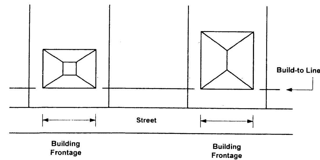
Building Frontage
and Build-To Line
Established residential area means that portion of a block facing the same street as the land proposed for infill residential development, and that portion of the block of land across the street from the proposed development facing the same street as the land proposed for infill residential development.
Infill Site and
Established Residential Area
(ULDC 2005, § 9-10-12-2)
Sec. 9-10-12-3. - Applicability.
This chapter shall apply to the subdivision of property within R-I and N-C zoning districts as specified in chapters 9-5-2 and 9-5-3. Notwithstanding the density limitations or lot size minimums established in table 9-5-2, Dimensional requirements for residential zoning districts, pertaining to the R-I and N-C zoning districts, each property owner shall have the right to subdivide property in a manner that does not meet such dimensional requirements, subject to the development requirements and procedures of this chapter. Where this chapter establishes different dimensional requirements than for the district in which the infill residential development project is located, as provided in table 9-5-2, the permissions of this chapter shall supersede such zoning district dimensional requirements but only for an infill residential development pursuant to this chapter.
(ULDC 2005, § 9-10-12-3)
Sec. 9-10-12-4. - Permitted uses.
Detached, single-family residences, fee-simple, shall be the only dwelling type permitted in a residential infill development project. This section shall not be construed to prevent structures and uses accessory to such residences as permitted in the zoning district in which the project is located.
(ULDC 2005, § 9-10-12-4)
Sec. 9-10-12-5. - Minimum lot size.
The minimum lot size of lots within a residential infill development project shall be 10,000 square feet.
(ULDC 2005, § 9-10-12-5)
Sec. 9-10-12-6. - Minimum lot width.
When the average width of lots in the established residential area is 100 feet or more, the lots within the infill residential development project shall be no less than 85 feet wide at the regulatory front building setback line when fronting on an existing street. This section helps to ensure that the widths of lots in the infill residential development project are reasonably similar to the established residential area.
(ULDC 2005, § 9-10-12-6)
Sec. 9-10-12-7. - Floor area per dwelling.
The minimum gross heated floor area of each dwelling in an infill residential development project shall be 1,800 square feet.
(ULDC 2005, § 9-10-12-7)
Sec. 9-10-12-8. - Height of dwelling.
When the heights of dwellings in the established residential area are predominantly two stories, the height of dwellings constructed in the infill residential development project shall be no more than two stories excluding basement or daylight basement.
(ULDC 2005, § 9-10-12-8)
Sec. 9-10-12-9. - Build-to lines.
(a)
This section shall apply to the erection of dwellings on lots within an infill residential development project that front on an existing street. The intent of this section is to ensure that dwellings are placed on the lot in a manner compatible with dwellings abutting to the side of the lot within the infill residential development project. Substantial deviations from the repetitive or prevailing pattern of building placement on the same existing street can result in an incompatible condition.
Infill Development
with Build-To Line
(b)
Dwellings within an infill residential development project on lots that front on an existing street shall not deviate from the average build-to line for those properties located within the established residential area (as defined in this chapter) by more than 15 feet. Where the established residential area may be difficult to determine, the community and economic development department director shall have the authority to determine the average build-to line for the infill residential development project.
(c)
When a build-to line applies pursuant to this section, it supersedes the front building setback requirement for the zoning district in which the property is located.
(ULDC 2005, § 9-10-12-9; Ord. No. 2009-47, § XXI, 12-15-2009)
Sec. 9-10-12-10. - Building orientation.
Any lot located adjacent to an existing street shall require the front of the proposed dwelling to be orientated toward the existing street. The community and economic development department director shall have the authority to wave this requirement when entrance landscaping and entrance monuments are provided as described in this chapter.
(ULDC 2005, § 9-10-12-10; Ord. No. 2009-47, § XXI, 12-15-2009)
Sec. 9-10-12-11. - Garages.
Each lot, upon its development for a single-family dwelling, shall have a garage, either attached to the dwelling or detached but placed to the rear of the principal dwelling, for the storage of two vehicles. Garage space capable of storing more than four vehicles shall not be permitted. Where detached, the height of the detached garage shall not exceed a height of 20 feet. Where lots abut an existing street, garages shall not be allowed to dominate the architecture of the dwellings in the infill residential development project.
(ULDC 2005, § 9-10-12-11; Ord. No. 2009-47, § XXI, 12-15-2009)
Sec. 9-10-12-12. - Screening of rear yards of lots fronting an interior street.
When a new subdivision street is proposed, the project often will result in the orientation of dwellings such that they form a line of rear yards abutting the side yard of a lot in the established residential area. To protect existing dwellings in the established residential area for exposure to multiple residences, rear yards of the lots in the new subdivision shall be separated and screened along common lot lines of the established residential area with a solid wooden fence or masonry wall of six feet in height and a minimum ten-foot-wide vegetative buffer, or comparable screening approved by the community and economic development department director.
(ULDC 2005, § 9-10-12-12; Ord. No. 2009-47, § XXI, 12-15-2009)
Sec. 9-10-12-13. - Entrance landscaping.
When a new subdivision street is proposed and the infill residential development project contains six or more lots, the entrance to the project (where the new road intersects with the existing street) shall be landscaped with a minimum 20-foot-wide landscape strip along the property frontage. If the landscape strip is platted as a part of a lot within the infill residential development project, a landscaping easement shall be provided over such lot, and a landscape maintenance bond shall be required for a period of two years. The landscape strip shall provide street trees approved by the community and economic development department director that are indigenous to or compatible with trees in the established residential area.
(ULDC 2005, § 9-10-12-13; Ord. No. 2009-47, § XXI, 12-15-2009)
Sec. 9-10-12-14. - Entrance monuments.
When a new subdivision street is proposed, the entrance to the infill residential development project (where the new road intersects with the existing street) may include erection of a subdivision entrance monument. If provided, it shall be composed of stacked stone or brick and shall be located to the rear of the required front landscape strip required for the entrance per this chapter.
(ULDC 2005, § 9-10-12-14; Ord. No. 2009-47, § XXI, 12-15-2009)
Sec. 9-10-12-15. - Architectural building materials.
At least 50 percent of the front facade of each dwelling within an infill residential development project shall be brick masonry, stone masonry, or split-face block masonry. All other exterior wall materials of dwellings within infill residential development projects shall consist of brick masonry, stone masonry, or split-face block masonry; or wood clapboards or weather boarding, and appropriate architectural accents. Standing-seam or corrugated metal walls or vinyl siding shall not be permitted unless specifically approved as a secondary or accent material by the community and economic development department director. Architectural treatments on all sides of the building other than the front facade shall be consistent. Roof materials shall be asphalt composition, wood shake, tile, or standing seam metal.
(ULDC 2005, § 9-10-12-15; Ord. No. 2009-47, § XXI, 12-15-2009)
Sec. 9-10-12-16. - Front yards.
Front yards of all lots within infill residential development projects shall be sodded.
(ULDC 2005, § 9-10-12-16; Ord. No. 2009-47, § XXI, 12-15-2009)
Sec. 9-10-12-17. - Detention ponds.
When a detention pond is required by the director of public works to serve the infill residential development project, it shall be sited underground; provided, however, that if not installed underground the detention pond shall meet the following requirements:
(1)
It shall be located no closer than 15 feet to an exterior property line (i.e., abutting the established residential area).
(2)
It shall be sloped so that fencing is not required.
(3)
It shall be landscaped subject to the approval of the community and economic development department director.
(ULDC 2005, § 9-10-12-17; Ord. No. 2009-47, § XXI, 12-15-2009)
Sec. 9-10-12-18. - Process for review and approval.
This chapter shall be administered at the time the applicant files a preliminary plat application. No action shall be taken on the final plat for an infill residential development project unless compliance with this chapter is met. The applicant shall be required to submit maps and data for the established residential area for approval by the community and economic development department director to ensure the provisions of this chapter are met. The director may require that the final plat for an infill residential development project contain restrictions on one or more lots as may be required to be imposed on dwellings or lot activities within the project. No final plat shall be approved unless it contains the plat notes and restrictions imposed by the director for the project.
(ULDC 2005, § 9-10-12-18; Ord. No. 2009-47, § XXI, 12-15-2009)
Sec. 9-10-12-19. - Administrative variances.
Administrative variances may be granted to the building site and yard requirements after an application has been submitted by the property owner and reviewed and approved by the community and economic development department director. No administrative variance shall be granted that reduces a building setback dimension pertaining to property bordering the boundaries of the infill residential development project.
(ULDC 2005, § 9-10-12-19; Ord. No. 2009-47, § XXI, 12-15-2009)
Sec. 9-13-2-1.- Terms related to streets.
The following words, terms and phrases, when used in this article, shall have the meanings ascribed to them in this section, except where the context clearly indicates a different meaning:
Access means a way or means of approach to provide physical entrance to a property.
Arterial street. See Street classifications.
Centerline means that line connecting the succession of midpoints between the identifiable limits of any improvements on the ground or of any easement.
Collector street. See Street classifications.
Cul-de-sac means a dead-end street of limited length having a primary function of serving adjoining land, and constructed with a turnaround at its end.
Cul-de-sac, temporary, means a nonpermanent vehicular turnaround located at the termination of a street or alley, created for construction and not accepted as a public improvement.
Curb cut means any interruption or break in the line of a street curb for the purpose of connecting a driveway to a street, or otherwise to provide vehicular access to abutting property. The term "cub cut" may also refer to an opening in the curb that allows stormwater to flow into a landscaped area or best management practice.
Dead-end street means a street connected to another street at only one end.
Deceleration lane means an added roadway lane, of a specified distance and width and which may include a taper, as approved by the city engineer, which permits vehicles to slow down and leave the main vehicle stream.
Decentralized wastewater system means a closed-loop system designed or used to receive sewage from a building sewer and to affect separation and organic decomposition of sewerage solids, and discharging sewage effluent to an absorption field or other management system. The term "decentralized wastewater system" is also referred to as an on-site wastewater disposal system or septic tank.
Deflection angle means the angle between a deviation in the direction of the centerline of a street and the extension of the centerline along a straight course from the point from which the centerline changed direction.
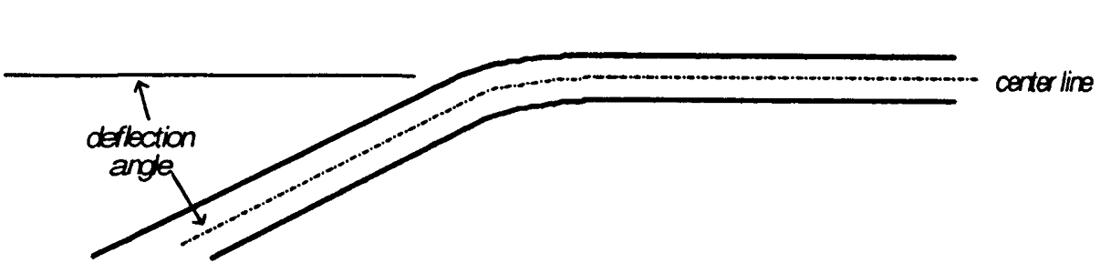
Deflection Angle
Design variance means an alteration or relaxation of the terms of this article where such alteration will not be contrary to the public interest, convenience and welfare, and where, owing to conditions peculiar to the property over which the applicant for a variance has no control, a literal enforcement of these regulations would create unnecessary and undue hardship on the applicant in the use of the property.
Development means:
(1)
A land development project involving the construction of streets, utilities, buildings, or other improvements required for the habitation or use of property, such as a residential neighborhood, an apartment complex, a store, or a shopping center;
(2)
Any manmade change to improved or unimproved real estate, including, but not limited to, buildings or other structures, mining, dredging, filling, grading, paving, excavating, drilling operations, or permanent storage of materials;
(3)
The act of constructing or carrying out a land development project, including the alteration of land or vegetation in preparation for construction activity.
Development site means any and all areas within which development takes place.
Driveway means a constructed vehicular access serving one or more properties and connecting to a public or private street, as distinguished from a platted, public or private street.
Half street means a portion of the ultimate width of a road or street where the remaining portion of the road or street shall be provided at a future date.
Major street or major thoroughfare means an arterial or collector street (see Street classifications).
Pedestrian way means a public right-of-way or private easement across a block or within a block to provide access for pedestrians and which, in addition to providing pedestrian access, may be used for the installation of utility lines.
Reserve strip means a strip or tract of land reserved for the purpose of controlling or limiting access from properties to abutting streets.
Right-of-way means land reserved for and immediately available for public use as a street or other purpose.
Roadbed means that portion of a street improved for vehicular travel, including the curbs and shoulders.
Roadway means the paved portion of a street improved for vehicular travel, measured from back of curb to back of curb.
Sidewalk means a hard-surfaced pedestrian access area adjacent to or within the right-of-way of a street.
Street means an improved way for the conveyance of motor driven, rubber-tired vehicles, such as automobiles and trucks.
Street, private, means a road or street that has not been accepted for maintenance by the governing body and that is not owned and maintained by a state, county, city, or another public entity.
Street classifications means streets are classified according to the function that they are to serve, the type, speed, and volume of traffic they will carry and the required standards of design. The classifications and locations of major thoroughfares are shown in the comprehensive plan. The classifications of streets and roads are generally as follows:
Alleys means public or private ways, whether unopened or opened for use, which afford only a secondary means of access to abutting property.
Arterial streets means state and U.S. numbered highways.
Collector streets means major streets that carry traffic between neighborhoods and arterial streets, serve nonresidential or multifamily areas or developments, and streets within a residential subdivision that collect traffic from 100 dwelling units or more.
Expressways means limited access interstate highways.
Local streets means streets in residential subdivisions and some nonresidential areas that primarily provide access to individual lots, do not carry through traffic, and serve fewer than 100 dwelling units.
Marginal-access streets means streets that are placed parallel and adjacent to expressways or arterials to provide direct access to abutting properties.
Street jog means the incidence where two streets or two portions of a single street are separated by a relatively short distance, usually at their intersection with another street.
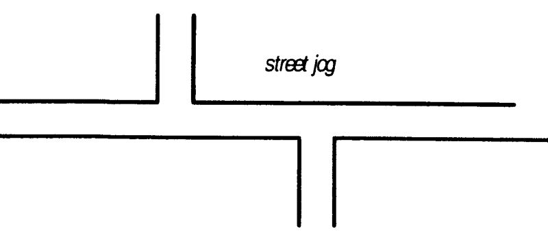
Street Jog
Tangent means the straight-line distance between the ending of one curve of a line (centerline of a street) and the beginning of another curve of the same line (centerline).
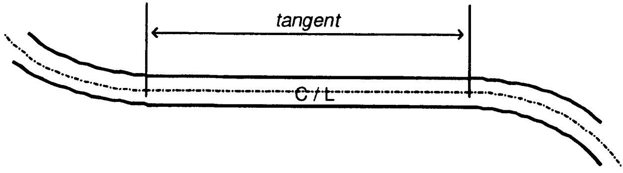
Tangent
(ULDC 2005, § 9-13-2-1; Ord. No. 2020-42, § XIX, 11-3-2020)
Sec. 9-13-2-2. - Terms related to subdivisions.
The following words, terms and phrases, when used in this article, shall have the meanings ascribed to them in this section, except where the context clearly indicates a different meaning:
Block means an area of land that is entirely surrounded by streets, public lands, railroad rights-of-way, watercourses, or other well-defined and fixed boundaries.
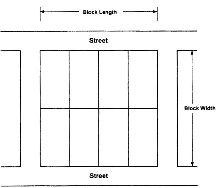
Block, Block Length,
and Block Width
Conservation subdivision means a subdivision, where open space is the central organizing element of the subdivision design, that identifies and permanently protects all primary and all or some of the secondary conservation areas within the boundaries of the subdivision, and that clusters housing together on smaller lots than in conventional subdivisions.
Dedication means the deliberate appropriation of land by an owner for any general and public use or purpose, reserving to himself no other rights than such as are compatible with the full exercise and enjoyment of the public uses to which the property has been devoted.
Dedication plat means a plat that indicates property to be dedicated for public right-of-way or land for public use, drawn to final plat specifications and following procedures for final plat approval.
Easement means a grant of one or more of the property rights by the property owner to and/or for use by the public, a corporation, or another person or entity.
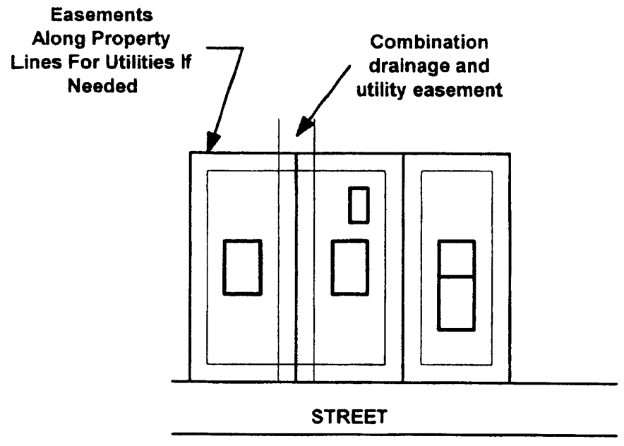
Easements
Easement, perpetual, means an easement held in perpetuity.
Escrow account means a type of subdivision improvement guarantee where the subdivider deposits either cash, a note, a bond, or some other instrument readily convertible to cash for specific face value specified by the director of public works or designated official of the city to cover the costs of required improvements.
Final plat means the final drawing of a subdivision and, as applicable, dedication, prepared for filing for record with the clerk of the county superior court, and containing all elements and requirements set forth in this article.
Homeowner's association means an organization formed for the maintenance and operation of the common areas of a development, where membership in the association is automatic with the purchase of a dwelling unit or lot within the development, with the ability to legally assess each owner of a dwelling unit or lot and which has authority to place a lien against all dwelling units and lots within the development.
Letter of credit means a type of subdivision improvement guarantee whereby a subdivider secures an instrument from a bank or other institution or from a person with resources sufficient to cover the cost of improvements required by the governing body. The instrument pledges the creditor to pay the cost of improvements in case of default by the subdivider.
Lot means a parcel of land held in single ownership. Types of lots include the following:
Corner lot means a lot abutting upon two or more streets at their intersection.
Double frontage lot means any lot, other than a corner lot, which has frontage on two streets.
Flag lot means a tract or lot of land of uneven dimensions in which the portion fronting on a street is less than the required minimum width required for construction of a building or structure on that lot. The term "flag lot" is also called a panhandle lot.
Interior lot means a lot having frontage on only one street.
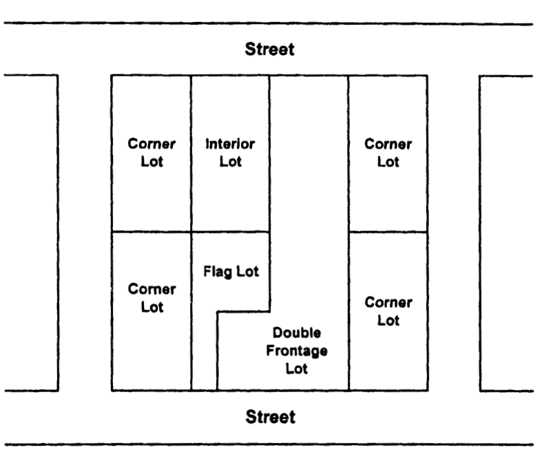
Types of Lots
Lot area means the total horizontal area included within lot lines.
Lot area, minimum, means the smallest permitted total horizontal area within the lot lines of a lot, exclusive of street rights-of-way but inclusive of easements.
Lot depth means the mean horizontal distance between front and rear lot lines.
Lot frontage means the width in linear feet of a lot where it abuts the right-of-way of any street.
Lot of record means a lot which is part of a subdivision, a plat of which has been lawfully recorded in the records of the clerk of superior court of the county; or a lot described by metes and bounds, the description of which has been lawfully recorded in the same office prior to the adoption of zoning in the city (June 20, 1955).
Lot width means the distance between side lot lines measured along the front principal building setback line.
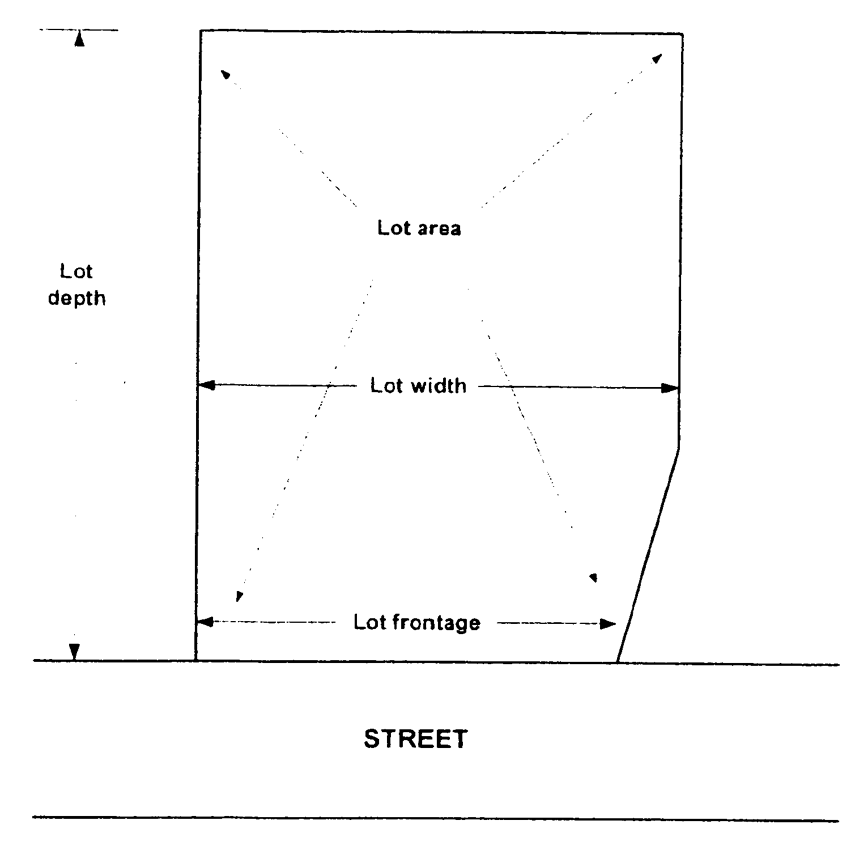
Lot Definitions
Metes and bounds means a system of describing and identifying land by a series of lines around the perimeter of an area; the term "metes" means bearings and distances and the term "bounds" refers to physical monuments.
Municipal utility means a utility owned and operated by a local government and providing drinking water, wastewater and stormwater management facilities and services. Municipal utilities include the following:
Sewer system means a sanitary sewerage system for the collection of water-borne wastes complete with a sewage treatment plant that is owned and operated by the city department of water resources.
Stormwater system means a system of structural and nonstructural stormwater management facilities and practices that are used to capture, convey and control the quantity and quality of the stormwater runoff, that is owned and operated by the city department of water resources.
Water system means a system for the intake, treatment and distribution of potable water that is owned and operated by the city department of water resources.
Performance bond means a type of improvement guarantee in the form of a bond, secured by the subdivider or land developer from a bonding company, in an amount specified by the director of public works or designated official of the city to cover the costs of required improvements, and payable to the governing body. The governing body may call in the performance bond in the event the subdivider or land developer defaults on required improvements.
Preliminary plat means a drawing which shows the proposed layout of a subdivision in sufficient detail to indicate its general design.
Private utility means a utility owned and operated by a private service company providing cable television and Internet services.
Protective covenants means contracts made between private parties as to the manner in which land may be used, with the view toward protecting and preserving the physical and economic integrity of any given area.
Public improvement means the acquisition, construction, building, operation, and maintenance of public ways, transportation facilities, parks and playgrounds, recreational facilities, cemeteries, mausoleums, markets and market houses, public buildings, libraries, public housing, airports, hospitals, terminals, docks, parking facilities, or charitable, cultural, educational, recreational, conservation, sport, curative, and corrective agencies and facilities.
Professional engineer means an engineer licensed and registered to perform the duties of a professional engineer (PE) by the state.
Public utility means a utility owned and operated by a public service company providing telecommunications, electric or natural gas services under the regulations of the state public service commission.
Publicly dedicated means land or improvements that has or have been transferred by plat or deeded to and accepted by the city for public use and maintenance.
Registered land surveyor means a land surveyor licensed and registered to perform the duties of a registered land surveyor (RLS) by the state.
Reservation means a method of holding land for future public use or dedication to the public by showing proposed public areas on a subdivision plat or a corridor map.
Septic tank means an approved watertight tank designed or used to receive sewage from a building sewer and to affect separation and organic decomposition of sewerage solids, and discharging sewage effluent to an absorption field or other management system. The term "septic tank" is also referred to as decentralized wastewater system, or on-site wastewater disposal system.
Subdivider means any person, as defined by this Code, who undertakes the subdivision of land, and any person having such a proprietary interest in land to be subdivided as will authorize the maintenance of proceedings to subdivide such land under this Code, or the authorized agent of such person.
Subdivision means the division of a property or tract of land into two or more tracts or lots; or a land development project in which two or more lots are created, along with the streets and utilities needed to support construction of buildings on the lots. The term "subdivision" includes re-subdivision and, when appropriate to the context, relates either to the process of subdividing or to the actual land or area which is subdivided. Types of subdivisions include the following:
Minor subdivision means the division of land into two or more lots, each of which will be adequately served by existing public streets, water and sanitary sewerage and that does not involve a public dedication.
Subdivision with public improvements means the division of land into two or more lots that will require the construction or extension of public streets, water or sanitary sewerage (other than the direct connection of buildings to existing facilities).
Utilities means all public, private, and municipal, above or below ground, infrastructure systems providing water, stormwater, sanitary sewer, natural gas, electricity, telecommunications, cable television or Internet services; or any other service controlled by the state public services commission.
Utility lines means linear features of utilities, such as pipes, conduit or cables, as well as junctions and ancillary facilities.
(ULDC 2005, § 9-13-2-2; Ord. No. 2020-42, § XIX, 11-3-2020)
Sec. 9-13-4-1.- Preliminary plat approval required.
The purpose of this chapter is to ensure compliance with the basic design concepts and improvement requirements of subdivisions through the submittal of a preliminary plat. Any subdivision involving the dedication of a public street or public land, and any subdivision involving a new private street, shall require the submission of a preliminary plat.
(ULDC 2005, § 9-13-4-1; Ord. No. 2020-42, § XX, 11-3-2020)
Sec. 9-13-4-2. - Relationship of preliminary plat to land development permit.
The community and economic development department director or designee must first approve a preliminary plat for subdivision activity prior to the issuance of a land development permit or initiation of any land-disturbing or construction activities. An application for preliminary plat approval may be processed independently or in conjunction with an application for issuance of a land development permit. Applicants are cautioned, however, that the preliminary plat approval is discretionary with regard to consistency with the comprehensive plan and design requirements of this article, and therefor, proceeding simultaneously with preliminary plat and land development permit applications may result in the revision of civil engineering drawings and construction plans if the layout of the preliminary plat of the proposed subdivision must be significantly modified.
(ULDC 2005, § 9-13-4-2; Ord. No. 2020-42, § XX, 11-3-2020)
Sec. 9-13-4-3. - Preliminary plat specifications.
A preliminary plat shall be prepared by a professional engineer, a registered land surveyor, a landscape architect, a land planner, or any other person professionally familiar with land subdivision and land development activities. The preliminary plat shall meet the following specifications:
(1)
Proposed name of subdivision. The proposed name of the subdivision shall not duplicate or too closely approximate, phonetically, the name of any other subdivision in the city or county. If shown to the contrary, the community and economic development department may refuse to accept such subdivision name.
(2)
Plat scale and sheet size. The preliminary subdivision plat shall be clearly and legibly drawn at a scale of 100 feet or less to one inch. The recommended maximum dimensions of the sheet size is 36 inches by 48 inches and the minimum dimensions of 17 inches by 22 inches; however, the community and economic development department director may approve other sheet sizes and scales as appropriate. For property of over 100 acres, a smaller scale may be used where, in the judgment of the community and economic development department director, presentation of detailed data is not necessary to evaluate the entire project. It is the intent of this provision that in all cases sufficient information shall be provided for an adequate evaluation of the public and private improvements.
(3)
Owner contact information. Name, address and telephone number of the property owner.
(4)
Applicant contact information. Name, mailing address, telephone and fax numbers and e-mail address of the applicant.
(5)
Miscellaneous. Tax parcel number, date of survey, north point and graphic scale, source of datum, date of plan drawing, and revision dates, as appropriate.
(6)
Use. Proposed use of the property.
(7)
Location and tract boundaries. Location (land district and land lot) and size of the property in acres (or in square feet if less than an acre), and the approximate boundaries of the tract to be subdivided or developed by bearings and distances. The preliminary plat must reference and be based on a boundary survey of the exterior boundaries of the proposed subdivision, prepared by a registered land surveyor.
(8)
Location map. A location map of the property in relation to the surrounding area with regard to well-known landmarks such as arterial streets or railroads. Location maps must be drawn at a scale sufficient to show clearly the information required, but not less than one inch equal to 2,000 feet. U.S. Geological Survey maps may be used as a reference guide or as the required location map.
(9)
Prior subdivision. Name of former approved subdivision, if any, for all of the land in the preliminary subdivision plat that has been previously subdivided, showing boundaries of same.
(10)
Zoning. Zoning district designation of the subject property and all adjacent properties, and zoning district boundaries and overlay zone boundaries as appropriate.
(11)
Conditions of approval. A copy of zoning, special use and variance conditions, if applicable.
(12)
Natural features and floodplains. Natural features within the property, including drainage channels, bodies of water, wooded areas and other significant natural features such as rock outcroppings. On all watercourses entering or leaving the property, the direction of flow shall be indicated. The 100-year floodplain, if any, shall be outlined.
(13)
Streets, easements, political boundaries and built features. Manmade features within and adjacent to the property, including street right-of-way and pavement widths, names of existing streets, all easements, city and county political boundary lines, and other significant information such as location and dimensions of bridges, utility lines, existing buildings to remain, and other features.
(14)
Subdivision layout. The proposed subdivision layout, including lot lines and street right-of-way lines, with proposed street names or letter designations and right-of-way widths, along with the front building setback line and the approximate dimensions of the length and width of each lot.
(15)
Phasing. The proposed phasing of the development if it is proposed to be platted in phases.
(16)
Water supply and sewage disposal. A statement as to the source of the domestic water supply and provisions for sanitary sewage disposal. For those properties that will not be served by a public sanitary sewerage system, but will instead install a decentralized wastewater system, location and results of percolation tests as required and approved by the county environmental health department.
(17)
Stormwater management. The approximate location of proposed stormwater facilities. Compliance with chapter 9-13-12 shall not be required at the time of preliminary plat approval but will be required for the issuance of a land development permit or grading permit.
(18)
Additional information. Additional information as may be required to ensure compliance with this article and Code.
(19)
Certificate of project approval. A certificate of project approval, as follows or as may be modified from time to time, shall be shown on the preliminary plat.
Approved for
Land Disturbance
(ULDC 2005, § 9-13-4-3; Ord. No. 2020-42, § XX, 11-3-2020)
Sec. 9-13-4-4. - Preliminary plat application requirements.
Applications for preliminary plat approval shall include the following:
(1)
Application form. A properly completed application form, as furnished by the community and economic development department, requesting review for project approval. The community and economic development department may choose to complete this form for the applicant.
(2)
Copies of plats. A set number, as fixed from time to time by the community and economic development department director, of copies of the preliminary subdivision plat meeting preliminary plat specifications of this chapter and showing the entire ownership.
(3)
Fees. Payment of all applicable application and review fees, as established by the governing body from time to time.
(ULDC 2005, § 9-13-4-4; Ord. No. 2020-42, § XX, 11-3-2020)
Sec. 9-13-4-5. - Review and approval process.
The community and economic development department director is responsible for administering the review and approval process for preliminary subdivision plats, which shall not be inconsistent with the provisions of this chapter. The procedures of this section may be supplemented by the community and economic development department director where additional specification is required.
(1)
Review for completeness and application acceptance. The community and economic development department shall review the application for completeness at the time of submission. Incomplete applications will not be processed and will be returned to the applicant.
(2)
Distribution and agency review of preliminary plat. The community and economic development department shall forward a copy of the preliminary plat application to other city departments, as may be appropriate, the state department of transportation if the proposed subdivision has frontage on or proposes access to a state or federal road, or others as appropriate, for their review and comment. Agency review shall specifically include the approval from the county environmental health department if a decentralized wastewater system is proposed. The city department of water resources will review preliminary plats in cases where connection to city water supply, sanitary sewer and/or stormwater systems is proposed or required.
(3)
Time period for completion of review. Within two to three weeks following receipt of the application, during which agency review shall be completed, the community and economic development department shall indicate on the preliminary plat or in writing all comments related to compliance with this article and Code. The community and economic development department shall provide all comments to the applicant for resolution, who shall work with each department as necessary to resolve all issues.
(4)
Action. When the community and economic development department has determined that the preliminary subdivision plat is in compliance with the requirements, purpose and intent of this article and Code, it shall be approved. The owner shall be responsible for compliance with all codes, regulations, and zoning requirements and for the satisfaction of all the noted and written comments.
(5)
Variances. The community and economic development department shall not approve any preliminary plat that would result in a lot or situation that would clearly require a variance, until or unless such variance is lawfully obtained.
(6)
Certificate of project approval. Upon approval of the preliminary plat, the community and economic development department director or his designee shall sign and date the certificate of project approval stamped on a reproducible copy of the preliminary subdivision plat. One copy of the approved drawing shall be transmitted to the applicant and the community and economic development department shall retain the additional copies for distribution and recordkeeping purposes.
(7)
Duration of approval. The certificate of project approval shall remain in effect for a period of one consecutive year after which time it shall become null and void and a new certificate may be required if no permit has been issued or no development activity has begun.
(ULDC 2005, § 9-13-4-5; Ord. No. 2020-42, § XX, 11-3-2020)
Sec. 9-13-4-6. - Amendments to preliminary plat approval.
The director of community and economic development, in consultation with the director of public works and/or the director of water resources when engineering or water supply, sanitary sewer or stormwater systems are involved, is authorized to approve minor amendments to preliminary plats (i.e., those that do not affect the public or private street configuration or that reconfigure lots and which do not increase the number of lots), without the need to reapply for preliminary plat approval. The application requirements and procedures for amending preliminary plats, unless minor in nature, shall be the same as for preliminary plat applications.
(ULDC 2005, § 9-13-4-6; Ord. No. 2020-42, § XX, 11-3-2020)
Sec. 9-13-6-1.- Minor land development permit required.
A minor land development permit may be required for small projects that would otherwise not require a land development permit or preliminary plat as identified in this article. For multifamily and nonresidential properties, this may include, but is not limited to, items such as minor tree removal, clearing and grubbing, grading, landscaping, small driveway/parking installations and small building additions located on existing impervious surface areas as determined by the community and economic development director. For single-family residential properties, this may include, but is not limited to, parking, patio, walkway and retaining wall additions as determined by the community and economic development director. Regular maintenance of property, including landscaping and gardening shall be exempt from these requirements. This chapter does not exempt the requirement of a separate building permit.
(ULDC 2005, § 9-13-6-1; Ord. No. 2009-47, § XXV, 12-15-2009; Ord. No. 2020-42, § XXI, 11-3-2020)
Sec. 9-13-6-2. - General application requirements.
The application for a minor land development permit shall be submitted to the community and economic development department and may include the following items below as approved by the community and economic development director:
(1)
Application form. Application on the form completed by the community and economic development department. The community and economic development department may choose to complete this form for the applicant.
(2)
Fee. Payment of any land development permit fee, as established from time to time by the governing body.
(3)
Plat. A copy of the approved recorded plat of the subject property.
(4)
Site plan. A site plan shall be prepared by a person familiar with land development activities. The site plan shall include, at a minimum, the project location, total project area and all erosion and sedimentation control measures.
(5)
Completeness. The application shall be checked for completeness at the time of submission. Incomplete applications will not be processed and will be returned to the applicant.
(ULDC 2005, § 9-13-6-2; Ord. No. 2009-47, § XXV, 12-15-2009; Ord. No. 2020-42, § XXI, 11-3-2020)
Sec. 9-13-6-3. - Review of permit applications.
The community and economic development department shall forward a copy of the permit application and all supporting documents to other city departments and government agencies or others as appropriate, for their approval. The applicant may be required by the community and economic development department to secure development approval from other agencies if they are affected by (or have jurisdiction over) the development. Development approval may be required from, but not limited to:
(1)
The city department of water resources.
(2)
The city public works department.
(3)
The county public works department.
(ULDC 2005, § 9-13-6-3; Ord. No. 2009-47, § XXV, 12-15-2009; Ord. No. 2020-42, § XXI, 11-3-2020)
Sec. 9-13-6-4. - Expiration of permit approval.
A minor land development permit shall expire within one year from the date of issuance.
(Ord. No. 2020-42, § XXI, 11-3-2020)