
Gaithersburg City Zoning Code
ARTICLE 2
- INTERPRETATION AND MEASUREMENTS
Sec. 24-2.1.- Language.
(A)
Terms used. All words and terms used have their commonly accepted and ordinary meaning unless they are specifically defined in this chapter or the context in which they are used clearly indicates otherwise. Technical words and phrases that may have acquired a specialized and appropriate meaning in law shall be construed and understood according to such meaning.
(B)
Terms not defined. Words and phrases not specifically defined or interpreted in the article 16, Definitions shall be construed according to the common and generally recognized usage of the language. Technical words and phrases, and others that have acquired a specialized and appropriate meaning in the law, shall be construed according to that meaning.
(C)
Mandatory and discretionary terms. The words "shall," "must," "may only," "shall not," and "will" are mandatory in nature, establishing an obligation or duty to comply with the particular provision. The words "may" and "should" are permissive in nature.
(D)
Conjunctions. Unless the context clearly suggests the contrary, conjunctions shall be interpreted as follows:
(1)
"And" indicates that all connected items, conditions, provisions or events apply or are required;
(2)
"Or" indicates that only one of the connected items, conditions, provisions, or events applies or is required; and
(3)
"And/or" indicates that one or more of the connected items, conditions, provisions, or events apply or are required.
(E)
Plural terms and verb tenses. Words used in the present tense include the future tense. Words used in the singular number include the plural number and the plural number includes the singular number, unless the context of the particular usage clearly indicates otherwise.
(F)
Usage of term person. The word "person" shall include any individual, firm, co-partnership, corporation, company, association, club, joint venture, estate, trust, or any other group or combination acting as a unit, and the individuals constituting such group or unit and the plural as well as the singular number.
(G)
Other term interpretations. The following listed terms shall also be defined as specified below:
(1)
Unless otherwise specified, an "area" of land means a "contiguous area."
(2)
The word, "approve," as used herein, necessarily includes the phrases, "approve with conditions, modifications, or amendments" as to the respective final decision of the respective decision-making official and/or body.
(3)
A "building," "structure," "land," or "property" includes the words, "or part thereof," unless the obvious construction of the wording indicates the contrary.
(4)
The terms "land use" and "use of land" shall necessarily include "building use," "use of a building," "structure use," and "use of a structure."
(Ord. No. O-5-24, 7-15-24)
Sec. 24-2.2. - Rules of interpretation.
(A)
Minimum requirements. In their interpretation and application, the provisions of this chapter shall be held to be minimum requirements, adopted for the promotion of the public health, safety, or general welfare.
(B)
Code conflicts. Wherever the requirements of this chapter are in conflict with the requirements of any other lawfully adopted rules, regulations, or ordinances, the most restrictive or that imposing the higher standards shall govern. Where a conflict arises within or among the Articles of this chapter, the more restrictive language applies.
(C)
Rules of interpretation of zoning district boundaries. Where uncertainty exists regarding the location of the boundaries of zones as shown on the official zoning map, the following rules shall apply:
(1)
Boundaries indicated as approximately following the centerlines of streets, highways or alleys shall be construed to follow such centerlines.
(2)
Boundaries indicated as approximately following platted lot lines shall be construed as following such lot lines.
(3)
Boundaries indicated as approximately following city or county limits shall be construed as following city or county limits.
(4)
Boundaries indicated as following railroad lines shall be construed to be midway between the main tracks.
(5)
Boundaries indicated as approximately following the centerlines of streams, lakes or other bodies of water shall be construed to follow such centerlines.
(6)
Boundaries indicated as parallel to or extensions of features indicated in subsections (1) through (5) of this section shall be so construed. Distances not specifically indicated on the official zoning map shall be determined by the scale of the map.
(7)
Where physical or cultural features existing on the ground are in conflict with those shown on the official zoning map, or in other circumstances not covered by subsections (1) through (6) of this section, the planning commission shall interpret the zone boundaries.
(D)
Illustrations and text. In the event of a conflict or inconsistency between the text of these regulations and any heading, caption, figure, illustration, table, or map, the text shall control. Graphics and other illustrations are provided for informational purposes only and should not be relied on as a complete and accurate description of all applicable regulations or requirements. Where regulations may only be incorporated in a table (and are not otherwise specified in the text), that table shall have equal weight as the text of this chapter.
(E)
Interpretation of defined or undefined uses. The following provisions shall apply to the interpretation of uses:
(1)
Each use type is included in:
(a)
Table 24-3.1-1, Residential Zoning Districts Comprehensive Principal Use Permissions Table;
(b)
Table 24-3.10-1, Non-Residential Zoning Districts Comprehensive Principal Use Permissions Table; and
(c)
Table 24-4.1-1, Floating Zoning Districts Comprehensive Principal Use Permissions Table;
(d)
Uses are defined in article 16, Definitions. Defined uses which are not shown in tables (a), (b) or (c) above are determined to be prohibited.
(2)
A proposed use that is not defined elsewhere in this chapter may be classified by the city manager or designee as an allowed by-right use, a conditional use, a special exception use, an allowed accessory use, or an allowed temporary use if the city manager or designee determines that the proposed use is functionally the same as a defined use that is allowed in the same zoning district as the subject property.
(3)
If the city manager or designee determines that an undefined proposed use is not functionally the same as a defined use that is allowed in the same zoning district as the subject property, then the proposed use is a prohibited use.
(F)
Classification of uses. In determining the classification of a proposed use that is undefined, or in determining if a proposed use qualifies as a principal, accessory, or temporary use, the city manager or designee may consider, but shall not be limited to, the following information provided by the property owner or applicant, which may include the contents of a use and occupancy permit per section 24-12.14:
(1)
Actual or projected characteristics of the use, their common association with established uses on a given lot, and their effects on permitted uses within the zoning district of the subject property;
(2)
Amount of floor space and/or equipment that would be provided for the use;
(3)
Amount of pedestrian, bicycle, and/or vehicular traffic typically associated with the use;
(4)
Size (including footprint area and height) of the building(s) and/or feature(s) proposed for the use;
(5)
Location of the building, feature, or use in relation to the location of other buildings and uses on the same lot;
(6)
Noise, lighting, dust, and/or odors typically associated with the use;
(7)
Number of employees on a typical shift;
(8)
Use and/or storage of hazardous materials; and/or
(9)
Hours of operation for the use.
(Ord. No. O-5-24, 7-15-24)
Sec. 24-2.3. - Rules of measurement and calculation.
(A)
Computation of days. In computing any period of time in which an act is to be done or a default occurs, the day of the act, event, or default, after which the designated period of time begins to run is not included. The last day of the period so computed is included unless:
(1)
Specifically defined as business days, time periods are calendar days.
(2)
It is a Saturday, Sunday or a legal holiday, in which event the period so computed includes the next business day, which is neither a Saturday, Sunday nor a legal holiday; or,
(3)
The act to be done is the filing of some paper with the city or a court, and the city offices or the court on such last day of the period is not open, or is closed for a part of a day, in which event the period runs until the end of the next day which is neither a Saturday, Sunday, legal holiday, or a day on which such office is not open the entire day during ordinary business hours.
(4)
When the period of time allowed is more than seven (7) days, intermediate Saturdays, Sundays and legal holidays are included; but if the period of time allowed is seven (7) days or less, intermediate Saturdays, Sundays, and legal holidays shall not be counted in computing the period of time.
(B)
Rounding. Unless otherwise provided for in this chapter, for all calculations required by this chapter, the fractional/decimal results of calculations shall be rounded to the next highest whole number.
Figure 24-1. Lot Measurement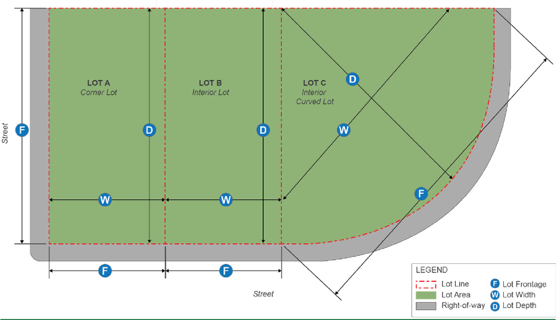
Note: The rear yard measurements of "Lot C" shall be determined per the methods of (G)(2) below.
(C)
Lot frontage. For non-floating zoned properties or when required by city council, lot frontage shall be measured by the linear distance measurement between where the side property lines of a lot intersect with the street line or drive aisle.
(D)
Lot width. The lot width shall be the average horizontal distance between the side property lines of a lot.
(E)
Lot depth. The lot depth shall be the mean horizontal distance between the front lot line and the rear lot line of a lot, measured within the lot boundaries.
(F)
Front of building.
(1)
Interior lots. For interior lots with only one frontage on a street, the front of the building is the façade of the building primarily oriented toward the street.
(2)
Corner lots. For corner lots, the front of the building shall be determined based on the proportions of the lot. The façade of the building, typical having the primary entrance of the building facing the shorter of the street frontages may be considered the front of the building and shall be used to determine the lot width and any applicable regulations pertaining to the front yard; or the applicant at the time of any plan submission can determine and identify the front(s) of the building for approval by the planning director or designee.
(3)
Through lots. For through lots, the front of the building shall be chosen by the applicant at the time of filing any plan submission, for approval by the planning director or designee. After determining the front façade of the building, the lot line facing the front of the building shall be considered the front lot line. All other front lot lines shall be considered side and/or rear yard lines for the purposes of applying building setbacks.
(G)
Setback. A setback is the measured distance from any lot line that bounds a property. The setback is measured along a horizontal plane by the distance specified for a particular zone or structure perpendicular to any lot line. Unless otherwise allowed or defined in section 24-2.4 in this chapter, a setback may not contain any building or structure.
(1)
Front setback on multiple streets for single-family residential lots. The placement of all buildings on lots having frontage on two or more streets, including corner lots, shall observe the required front yard as defined above pursuant to section 24-2.3(F). Excluding the established front yard, all other lot frontages shall apply side yard setbacks requirements.
Figure 24-2. Front Setbacks for Single-Family Corner Lots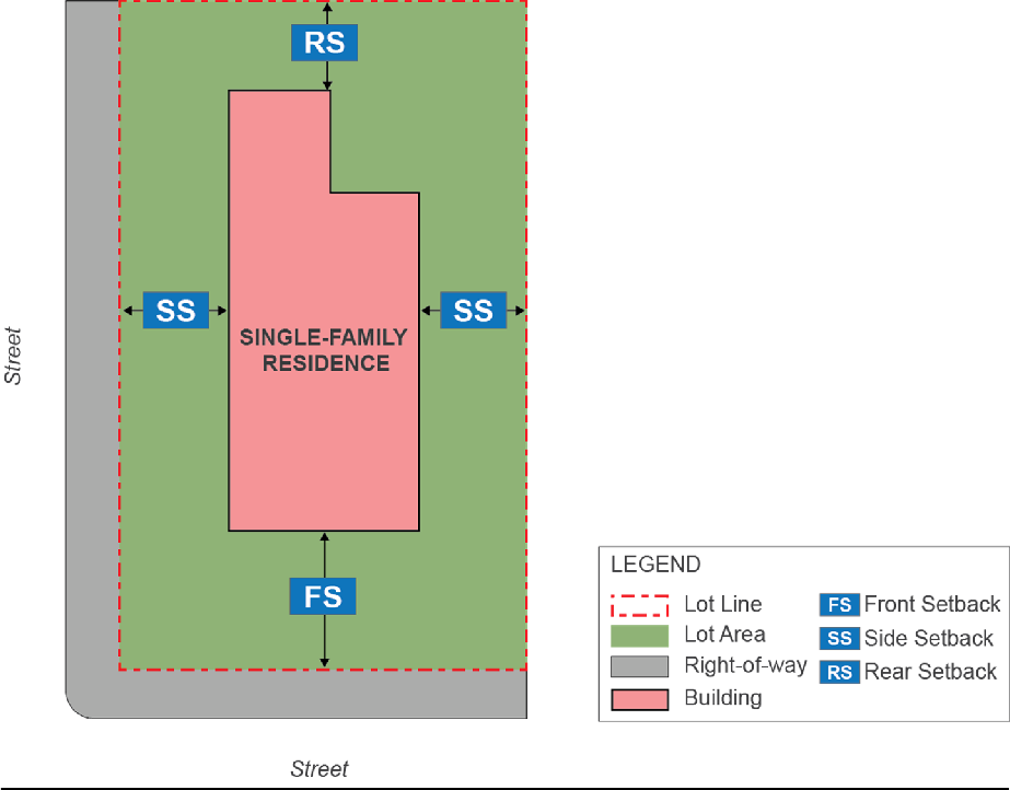
(2)
Rear setback for triangular shaped lots. Where side lot lines meet at a point to the rear of the property and the standard method for determining the required rear setback as a perpendicular measurement from a rear lot line cannot be applied, the rear setback requirement shall be established as a line drawn from the point where side lot lines meet to the center point of the front lot line. The required rear setback is measured along this line and is drawn perpendicular to it.
Figure 24-3. Rear Setback for Triangular Shaped Lots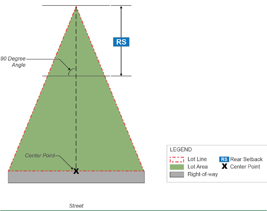
(3)
Setback required when facing on planned streets. Where a street or highway shown on an adopted plan has a proposed right-of-way greater than the existing right-of-way, the front or side setback requirement shall be measured from the proposed right-of-way line.
(H)
Yards. A front, side or rear yard shall be the entire area located between any applicable lot line and the face of the principal structure primarily facing the applicable lot line. A yard may be greater than the applicable required setback distance as specified by any provisions of this chapter.
Figure 24-4. Measurement of Yards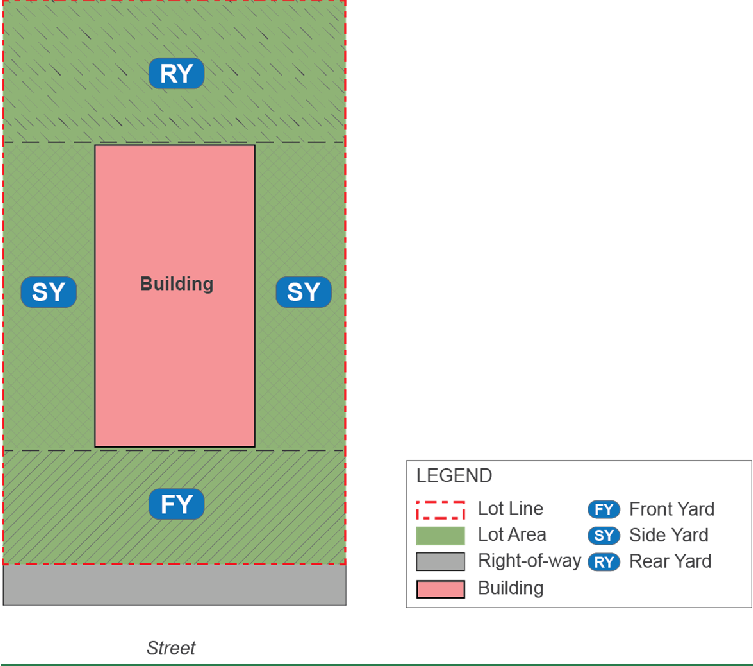
(1)
Front yard. A front yard is the area of a lot located between the entirety of the front lot line and a line drawn at the principal building foundation wall as it extends to the adjacent side lot line.
(2)
Side yard. A side yard is the entire area located between a side lot line and the adjacent principal building foundation wall, not including the front or rear yard as defined, except for corner lots where the side yard extends the length of the road frontage from the front yard to rear lot line.
(3)
Rear yard. A rear yard is the area of a lot located between the entirety of the rear lot line and a line drawn at the rear principal building foundation wall as it extends to the adjacent side lot line.
(I)
Lot area. Lot area is the total surface area of the land included within a single lot, parcel, outlot, outparcel, lot of record, or other land conveyance that has been recorded among the land records of Montgomery County.
(J)
Lot area, net. The total area included within lot lines, excluding publicly dedicated land and rights-of-way.
(K)
Impervious lot coverage. Expressed as a percentage, the area(s) of a lot that is covered by buildings, pavement, nonporous fill, or other cover as defined in chapter 8 of the city Code through which water cannot penetrate, divided by the lot area, multiplied by one hundred (100) in order to express as a percentage. The areas beneath elevated structures shall not be considered impervious, so long as those areas beneath the elevated structures are maintained as fully permeable surfaces. Wooden decks, or a similar planked material, which have spaces between planks for water to drain shall not be considered impervious surface unless the ground cover below is impervious.
(L)
Front yard impervious coverage. Expressed as a percentage, the area of the lot which is covered by buildings, pavement, nonporous fill, or other cover through which water cannot penetrate, divided by the portion of the lot defined as the front yard pursuant to (H) above, multiplied by one hundred (100) in order to express as a percentage.
(M)
Building lot coverage. Expressed as a percentage, the area(s) of the lot that is covered by any structure with a roof, divided by the lot area, multiplied by one hundred (100), in order to express as a percentage.
(1)
Exemption. The building footprint of detached accessory dwelling units shall not be counted against building lot coverage standards.
(N)
Gross floor area. The sum of the gross horizontal areas of all floors of all buildings on the lot, measured from the exterior faces of exterior walls and from the centerline of walls separating two (2) buildings. The term "gross floor area" shall also include:
(1)
Basements,
(2)
Elevator shafts and stairwells at each story,
(3)
Floor space used for mechanical equipment (with structural headroom of six (6) feet, six (6) inches or more),
(4)
Penthouses, attic space (providing structural headroom of six (6) feet, six (6) inches or more),
(5)
Interior balconies and mezzanines.
However, gross floor area shall not include:
(1)
Cellars,
(2)
Exterior balconies,
(3)
Structured or covered parking,
(4)
Rooftop mechanical structures.
(O)
Floor area ratio. Floor area ratio ("FAR") is determined by summing the gross floor area (in square feet) on all floors of all buildings located or proposed on a lot and dividing that sum by the lot area (in square feet).
Figure 24-5. Floor Area Ratio Diagram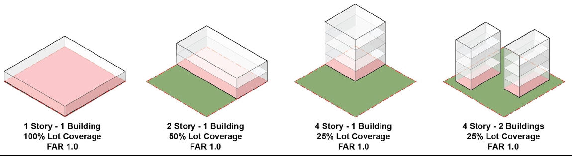
(1)
Where the FAR calculation result is a decimal. The decimal results of calculations of the floor area ratio on a parcel shall be rounded to the nearest hundredth.
(P)
Building and structure height measurement.
(1)
Building height is measured from the average elevation of the finished grade along the front of the building to the highest point of a roof surface for a flat roof, to the deck line of a mansard roof, and to the mean height level between eaves and ridge of a gable, hip or gambrel roof.
Figure 24-6. Building and Structure Height Measurement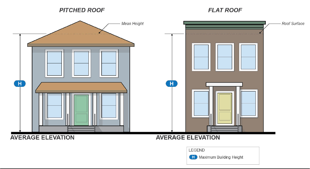
(a)
For lots with multiple street frontages, including corner lots, the building height as measured in subsection (1) above shall apply to portions of a building within one hundred (100) feet of the lot line opposing the front of the building, as defined in (F) above. Beyond this distance the building height may be measured from the average elevation of the finished grade along the building façade in increments of one hundred (100) feet.
Figure 24-7. Height Measurement for Corner Lots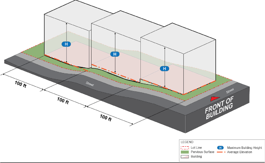
(2)
The average elevation of the finished grade is determined by calculating the average of the highest and lowest elevation along the natural or improved grade along the front of the building.
Figure 24-8. Determining Average Elevation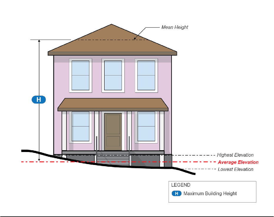
(3)
When a property slopes downward from the front property line, one story that is additional to the specified maximum number of stories, if applicable in a particular zone, may be built on the lower, rear portion of the lot.
Figure 24-9. Measurement for Downward Sloping Sites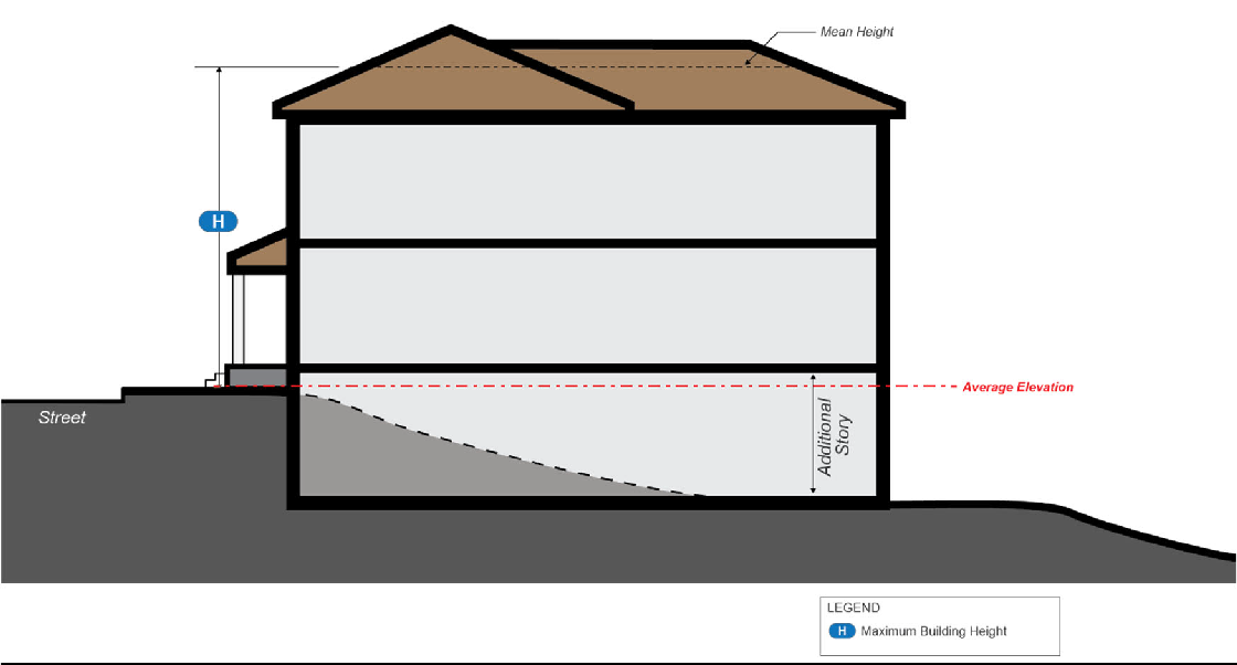
(Q)
Stories. The measurement of a story is the height from the top of the finished floor of one level of a building to the next level. Where there is no finished floor on the above level, the story is measured as the top of the finished floor to the ceiling. A basement shall not be considered a story of a building.
(R)
Fences and walls: measurement of height. The measurement of height must be made from the surface of the ground next to the fence or wall to the topmost point of the fence, post, supporting column, or wall. Where the ground on either side of the same fence or wall differs in level, the measurements must be made from the surface of the higher ground.
(Ord. No. O-5-24, 7-15-24)
Sec. 24-2.4. - Exclusions from measurements.
(A)
Fences and walls. The setback or building restriction line requirements of this chapter do not apply to fences or walls.
(B)
Structures excluded from height standards. The building and structure height limits set forth in this chapter do not apply to belfries, chimneys, cupolas, domes, flagpoles, flues, monuments, spires, tanks, water towers, water tanks, air-conditioning units or similar roof structures and mechanical appurtenances and mechanical penthouses.
(C)
Structures and projections exempt from setbacks. The following items are exempt from setback standards contained within this chapter:
(1)
The following building and site elements shall be subject to the specified setback requirements from the specified yard:
1 Steps, terraces, decks, stoops and outside open stairways which extend into any minimum required setback area may be roofed but not enclosed; provided, that such roofing may not extend one foot beyond any projection permitted by this subsection.
2 Chimneys flush with the vertical plane of any wall shall not be allowed to project into any required setback.
3 Any air conditioner or heat pump existing within any required setback prior to effective date of this chapter, shall not be considered a nonconforming use, and may be continued and replaced.
4 These features must comply with any applicable side setbacks when the side yard fronts a street or road. Freestanding solar facilities are prohibited from side yards, regardless of setback, when fronting a street or road.
(2)
Other installations. Fences, flagpoles, basketball hoops, lampposts, or similar structures, including, but not limited to, play equipment, lawn ornaments and arbors, may be located within any rear or side setback and also within a building restriction line so long as the location of the structure does not interfere with the use of any abutting or confronting property nor obstruct visibility along any public right-of-way.
(Ord. No. O-5-24, 7-15-24)

