
Gaithersburg City Zoning Code
ARTICLE 4
- FLOATING, OVERLAY, AND SPECIAL ZONING DISTRICTS
Sec. 24-4.1.- Use table: Floating zones.
Table 24-4.1-1. Floating Zoning Districts Comprehensive Principal Use Permissions Table
(Ord. No. O-5-24, 7-15-24)
Sec. 24-4.2. - Floating zones.
(A)
Floating zones identified. The following zoning districts are hereby designated and established as floating zones in the city:
(1)
CBD zone, central business district.
(2)
CD zone, corridor development.
(3)
MCD zone, mixed-commercial development.
(4)
MXD zone, mixed-use development.
(B)
Affixing floating zones.
(1)
Floating zones may be affixed to property by local map amendment or by comprehensive zoning. In the case of comprehensive zoning, such zones may be affixed to property only where the location and placement of such zoning district has been recommended in a duly adopted land use master plan for the area in which the property is located. In addition, in the case of comprehensive zoning, such zones and their location and placement where recommended in a duly adopted master plan shall be conclusively presumed to have satisfied the standards set forth in this section.
(2)
In the case of comprehensive zoning, the existing vested final site plan(s) of record for a property comprehensively rezoned will count as sketch plan or schematic development plan as applicable for the new floating zone classification.
(3)
The approval and placement of floating zones, through a zoning map amendment application, may only occur upon findings by the city council defined under the specific floating zone or if no specific findings are defined: (a) Complies with the purposes and intent of the zone as stated in this chapter; and (b) As applied will be compatible and harmonious with existing and planned land uses in the surrounding area.
(a)
Notwithstanding the provisions above, zoning map amendment or sketch plan shall only be approved upon satisfaction of the respective finding required for approval of such plans with or without conditions.
(4)
Decision criteria for establishment of a floating zone by map amendment. The city council may approve the mapping of a CBD, CD, MCD, or MXD zone by map amendment only upon finding that:
(a)
The rezoning application meets or accomplishes the purposes, objectives, and minimum standards and requirements of the zone; and
(b)
The rezoning application is in accord with recommendations in the applicable land use master plan for the property and is consistent with any special conditions or requirements contained in said land use master plan; and
(c)
The rezoning application will be internally and externally compatible and harmonious with existing and planned land uses in the areas within the proposed rezoning and adjacent areas; and
(d)
That the rezoning, if approved, would reflect the goals and intent of the city's strategic plan.
(C)
Application process for schematic development or sketch plan approval in floating zones not associated with zoning map amendments.
(1)
A sketch or schematic development plan approval request not associated with a zoning map amendment, in instances where the subject property has an applicable floating zone classification, shall be filed for approval by the city council together with the required filing fee.
(2)
The city council and city planning commission shall conduct a joint public hearing(s) on the application subject to the notification procedures defined below. The planning commission shall deliver its recommendation to the city council within thirty (30) days of the close of the commission's hearing record. The city council shall take action on the application within ninety (90) days after the close of the city council's hearing record. If the city council shall fail to do so, the application shall be deemed denied.
(3)
During the planning commission recommendation, the commission may make a finding in accordance with chapter 20, Subdivision, of the city Code that events have occurred to render the current applicable master plan recommendation no longer relevant and therefore any required findings for master plan conformance be relaxed.
(4)
The approval of a schematic development plan shall substitute for preliminary site plan approval and serve as preliminary subdivision approval.
(D)
Notification requirements for schematic development or sketch plan applications in floating zones not associated with zoning map amendments.
(1)
Posting of notice. The applicant shall erect signage indicating a "Mayor and Council and Planning Commission Hearing" for the pending application pursuant to requirements of section 24-12.15, Posting of notice.
(2)
Published notice required. For applications that do not include a zoning map amendment, the city manager shall cause to be published notice of the time, date and place of the public hearing, together with a summary of the application on the city's website at least fourteen (14) calendar days prior to the hearing date.
(3)
Mailed notice required. A notice shall be mailed to all persons or entities within two hundred (200) feet of the subject property that is the subject of a sketch or schematic development plan application. Mailed notices shall be received at least seven (7) calendar days prior to the hearing, and include the application number, date, time, and location of the public hearing. The following persons or entities with interest, ownership, or occupancy of a property within two hundred (200) feet shall be notified:
(a)
Property owners;
(b)
Occupants, including all residents and/or commercial tenants;
(c)
Condominium associations;
(d)
Homeowners' associations; and
(e)
Resident managers or management company of a rental project.
(4)
Failure of any person or entity to receive such notice required by this section shall not be a basis for denial of the application.
(5)
Schematic development or sketch plan applications in floating zones associated with zoning map amendments are to refer to and follow the notification requirements under section 24-12.3 for zoning map amendments.
(Ord. No. O-5-24, 7-15-24; Ord. No. O-06-26, 5-4-26)
Sec. 24-4.3. - CBD zone, central business district.
(A)
Purpose. The CBD zone is intended to foster revitalization by promoting a desirable mix of commercial, office and residential uses, and providing public amenities, for attracting a variety of leisure uses and activities to meet the needs and requirements of residents, workers, shoppers and visitors to Olde Towne, as well as to accomplish the following purposes:
(1)
To encourage development in accordance with the adopted master plan by permitting an increase in density and intensity of use, flexibility in use, and layout where development is in substantial conformity with the master plan and the site plan is approved by the city planning commission.
(2)
To permit a flexible response of development to the market, as well as to provide incentives for the development of a variety of land uses and activities in the central business district to meet the needs and requirements of residents, workers and shoppers.
(3)
To encourage designs which are in conformity with the architectural guidelines as adopted by the mayor and city council.
(4)
To promote the effective use of transit facilities in the central business district and pedestrian access thereto.
(5)
To promote improved pedestrian and vehicular circulation and consolidated parking facilities.
(6)
To assist in the development and redevelopment of adequate residential areas for people with a range of different incomes.
(7)
To encourage the provision of public amenities as part of development proposals.
(8)
To encourage land assembly and the most desirable use of land in accordance with the master plan.
(9)
Promote equitable revitalization of the central business district.
(B)
Minimum locational requirements. No land shall be classified in the CBD zone, outside of annexations and comprehensive rezonings, unless the land is identified for such zoning in an approved and adopted city master plan.
(C)
Development standards.
(1)
Height of buildings. No building or structure in this zone may exceed the total height as defined in the master plan or when not defined a total of four (4) stories in height, exclusive of mechanical or other equipment placed on the roof, except as may be provided though a waiver granted by the city council.
(2)
Setbacks of buildings. No setbacks are required, except as provided in the master plan or as required by the planning commission and established by site plan.
(3)
No part of any building or structure shall be located on land which is currently a public right-of-way or is indicated on an approved and adopted master plan or other approved planning document for the central business district as a right-of-way, walkway, sidewalk or bikeway.
(D)
Waiver of development standards.
(1)
The planning commission may waive the setback requirements in the CBD zone upon a finding that:
(a)
The waiver is necessary to implement the master plan or attract an appropriate and compatible type or caliber of user; and
(b)
The waiver will not detrimentally impact adjacent uses.
(2)
The mayor and city council may waive the height requirements in the CBD zone upon a finding that:
(a)
The waiver is necessary to implement the master plan or attract an appropriate and compatible type or caliber of user; and
(b)
The waiver will not detrimentally impact adjacent uses.
(E)
Special regulations and requirements.
(1)
The city council may adopt, by resolution, special regulations and requirements not inconsistent with the provisions of this section 24-4.3, relating to design and construction of buildings, structures, canopies, signs, lighting, parking areas and structures, amenities and amenity areas, and landscaping within the CBD zone. Such regulations and requirements shall be applied by the city council, city planning commission or city planning and code administration for matters within their respective jurisdictions to ensure compliance with the master plan and the revitalization and renewal of the current business district.
(2)
Notwithstanding any other provisions contained within this chapter, all building or structural construction or modifications, and the erection and placement of signs and canopies visible to a public street or thoroughfare, within the CBD zone, as defined in section 24-4.3(B), shall comply with the following additional requirements:
(a)
No building permit or sign or canopy permit shall be issued within the CBD zone in connection with the construction, modification or alteration of any existing building or structure or in connection with the erection or modification of any sign or canopy unless in compliance with the regulations and requirements adopted by the city council pursuant to subsection (1) of this section, or as may be defined in the master plan.
(b)
New construction upon unimproved property or where complete demolition of existing improvement occurs shall conform to the regulations and requirements adopted by the city council pursuant to subsection (1) of this section, or as may be defined in the master plan.
(F)
Parking requirements.
(1)
Parking within the CBD zone, except for the Olde Towne Special District, shall be determined in accordance with the general requirements and special computation schedule for uses within article 7. The requirements may be waived in whole or part by the city planning commission based upon the criteria and findings applicable in section 24-7.6 of this chapter.
(2)
The construction of either on-site or off-site parking for use by the general public which is at least twenty (20) percent in excess of the minimum requirements applicable to the new use or reuse may be considered a public amenity in seeking waivers of development standards under section 24-4.3(D) above.
(G)
Existing buildings. Any building or structure for which a building permit was issued, and any lawful use was instituted prior to the effective date of this chapter shall not be regarded as a nonconforming use, and may be structurally altered, restored, repaired or enlarged, either:
(1)
In conformance with the requirements of the CBD zone; or
(2)
To a size and intensity existing on the property or by approved building permit preceding the adoption of this chapter.
(Ord. No. O-5-24, 7-15-24)
Sec. 24-4.4. - CD zone, corridor development.
(A)
Purpose. It is the purpose of the corridor development (CD) zone to:
(1)
Encourage development, redevelopment and renovation of declining or underutilized properties along the corridor.
(2)
Create a more sustainable development pattern and enhance the city's sense of place.
(3)
Promote revitalization within the corridor by encouraging new private investment that also fosters equity and livability.
(4)
Create clearly defined regulations that provide more certainty of what is feasible on a property and create opportunities to add value through density and mix of uses.
(5)
Promote quality development through flexible development standards and a proactive design approach.
(B)
Minimum locational requirements.
(1)
No land shall be classified in the corridor development zone, outside of annexations and comprehensive rezonings, unless the land is located within an area so designated on an approved and adopted land use master plan.
(2)
When undertaking new development or redevelopment in the CD zone, all uses identified for specific areas or properties within an approved and adopted master plan shall be applied in those areas specified, unless otherwise approved by the mayor and city council within the context of a schematic development plan.
(C)
Development standards. Except as otherwise provided in the master plan or other elements of an applicable corridor development area planning document, or as set forth in design guidelines that may be adopted by resolution of the city council, the following standards shall apply:
(1)
FAR bases. Floor area ratio (FAR) shall be as provided in table 24-4.4-1. FAR is calculated and applied at the project application scale, which may include multiple parcels. These subject parcels do not have to reflect the FAR base uniformly.
Table 24-4.4-1. CD Zone Floor Area Ratio Standards
(2)
FAR bonuses. A project may receive additional FAR development density above the standards defined in table 24-4.4-1 to be calculated and reflected at schematic development plan application and review.
(a)
For those projects having received schematic development, CD zone concept, or final site plan approval prior to the effective date of this chapter, at the time of a new final site plan application and review, including amendments thereto that would not otherwise require a new or amended schematic development plan pursuant to section 24-12.5, Schematic development plans (1), any FAR bonus will be calculated and reflected on said site plan submission to be reviewed by the planning commission.
(b)
At the time of schematic development plan application, or final site plan as applicable, an applicant shall include a statement defining the amount of bonus density sought and the bonus method(s) used to achieve said bonus density. An applicant may pursue multiple bonuses.
(c)
The following FAR bonuses may be applied as a percentage increase to the base FAR as established in table 24-4.4-1. Where multiple FAR bonuses are applied, each bonus shall be applied individually to the base FAR and added to the base FAR prior to rounding. FAR bonuses are applied as a percentage increase to the base FAR permitted, not to the development square footage or units permitted.
Example: Calculating multiple FAR bonuses. Each bonus is calculated as a percentage of the base FAR. The base FAR is then added to the product of each FAR bonus to find the total maximum FAR. The total FAR is then rounded to the nearest hundredth.
i)
For multifamily developments, will receive up to a thirty (30) percent increase in FAR bonus for the project, applied to the multifamily development if one-half (½) of the required MPDUs as defined in article 13, calculated pre-bonus, are set aside for residents earning forty (40) percent AMI and below. The thirty (30) percent increase FAR bonus may also be applied to other non-residential uses in a mixed-use project that includes the multifamily component with city council approval (or planning commission for final site plans), but overall the FAR cannot exceed the thirty (30) percent bonus.
ii)
For multifamily developments, will receive up to a thirty (30) percent increase in FAR bonus for the project, applied to the multifamily development if twenty-five (25) percent of the units calculated pre-bonus contain three (3) or more bedrooms within the development. The thirty (30) percent increase FAR bonus may also be applied to other non-residential uses in a mixed-use project that includes the multifamily component with city council approval (or planning commission for final site plans), but the overall FAR cannot exceed the thirty (30) percent bonus.
iii)
The undergrounding of overhead utility lines along MD 355 and along the minimum of the project frontage will receive a fifty (50) percent increase in FAR bonus.
iv)
A dollar amount per square foot calculated for each square foot above base FAR density. The payment will equate to no more than a thirty (30) percent increase in FAR bonus. The monies collected will be allocated to city funds that further city housing goals or for improvements within the MD 355 corridor. The cost per square foot and the percent allocation between funds will be established in the fee schedule adopted each year by the mayor and city council. The dollar amount for additional FAR density above base will be established at schematic development plan with the actual dollar amount finalized based upon final site plan development square footage. The payment will be required at building permit application.
(3)
Height. Height shall be as specified in an applicable land use master plan. Where no heights are specified in the master plan, the heights shall be established by the city council at the time of schematic development plan, but may not exceed a maximum of ten (10) stories or one hundred twenty (120) feet for residential buildings or a maximum of one hundred fifty (150) feet for non-residential buildings.
(4)
Building and/or structure setbacks. Setbacks shall be as specified in the applicable master plan. Where no setbacks are specified in the master plan, the setbacks shall be established by the city council at the time of schematic development plan approval. The following shall also be imposed:
(a)
No part of any building or structure shall be located on land which is currently a public right-of-way or which is indicated on an approved and adopted master plan or other approved planning document for the corridor development area as a right-of-way, including walkways, sidewalks, or bikeways.
(b)
If the adjoining lot or parcel is in a residential zone and is not recommended for commercial, industrial, or buffer zoning on an adopted master plan, the setback shall be at least fifteen (15) feet for any building, regardless of use up to sixty (60) feet tall. For buildings greater than sixty (60) feet tall, the minimum required setback is twenty-five (25) feet.
(c)
A setback may be required along residential side streets, to be determined by the mayor and city council or planning commission at the time of schematic development plan or final site plan approval as applicable.
(D)
Special regulations and requirements. The city council may adopt, by resolution, special regulations and requirements, including design guidelines, not inconsistent with provisions of this section. Such regulations and requirements shall be applied by the city council, city planning commission or city planning and code administration for matters within their respective application purview to ensure compliance with the goals and provisions of any applicable city master plans.
(E)
Design guidelines. The city council may request and adopt design guidelines as part of a schematic development plan and approval resolution for a project in the CD zone that include, at a minimum, architectural standards, but may include other requirements or standards such as:
(1)
Building/structure setbacks and lot coverage;
(2)
Signage;
(3)
Amenity programming;
(4)
Public art;
(5)
Landscaping, streetscaping, and open areas; and
(6)
Pedestrian realm design.
(F)
Parking and access. Off-street parking shall be provided in accordance with article 7 of this chapter, except as may be otherwise authorized.
(1)
The city council, at the time of schematic development plan review, shall determine the appropriate approximate number of spaces or parking ratios for specific uses. At the time of final site plan approval, the planning commission shall determine the final number of spaces.
(2)
The planning commission may reduce the number of spaces required for any use in accordance with section 24-7.6, Parking waivers, by the planning commission where such reductions will meet the purposes of the CD zone.
(G)
Buffers and screening. Buffers or screening methods may be required at schematic development or final site plans between existing and proposed uses. These buffers shall be in the form of fences, landscaping, or walls that buffer views and noise.
(H)
Application for CD zone and schematic development plan approval.
(1)
An applicant shall file, together with the prescribed application fee, an application for the establishment of the CD zone, to be processed pursuant to the provisions of section 24-12.3, Zoning map amendments, and as part of this application for separate approval, a schematic development plan pursuant to the provisions of section 24-4.2, Floating zones, and section 24-12.5, Schematic development plans.
(2)
An application to establish CD zoning must receive approval of both the rezoning and schematic development plan. The city council cannot approve such application without approving both the rezoning and schematic development plan.
(I)
Applications for schematic development plan approval only. Applicants seeking to develop, redevelop, or improve property zoned CD without an approved concept plan, without an approved schematic development plan, not reflecting section 24-4.2(B)(2), or as an amendment to an approved schematic development plan shall file for the approval of a schematic development plan pursuant to the procedures established in section 24-4.2, Floating zones, and section 24-12.5, Schematic development plans.
(J)
Existing buildings and uses. Any building or structure for which a building permit was issued and any lawful use which was instituted prior to the effective date of this chapter shall not be regarded as a nonconforming building or use, and may be structurally altered, restored, or repaired in conformance with the standards and requirements of the CD zone.
(Ord. No. O-5-24, 7-15-24)
Sec. 24-4.5. - MCD zone, mixed-commercial development.
(A)
Purpose. The mixed-commercial development (MCD) zone exists to promote and provide design flexibility for new development and redevelopment of non-residential lands that support a concentration of employment uses, by permitting a wide range of commercial, industrial, supportive retail, service, and office land uses that typically require convenient access to an interstate and regional transportation system and that reflect the sectors and salaries ranges desired by the city. Residential developments should leverage and may be proximate to these zoned properties, but not incorporated in them. This zone is not intended to create or incorporate shopping centers, large format (big box) retail uses or centers, or entertainment centers.
(B)
Minimum locational requirements.
(1)
No land shall be classified in the mixed-commercial development (MCD) zone, outside of annexations and comprehensive rezonings, unless the land is located within an "employment node" as designated in the adopted city housing element or in an area so designated on an approved and adopted land use master plan.
(2)
When undertaking new development or redevelopment in the MCD zone, all uses identified for specific areas or properties within an applicable land use element shall be applied in those areas specified, unless otherwise approved by the mayor and city council within the context of a schematic development plan.
(C)
Development standards. Except as otherwise provided in the land use element or as set forth in design guidelines as adopted by resolution of the city council, the following standards shall apply:
(1)
Design guidelines. The city council may request and adopt design guidelines as part of a schematic development plan and approval resolution for a project in the MCD zone that include, at a minimum, architectural standards, but may include other requirements or standards such as:
(a)
Building/structure setbacks and lot coverage;
(b)
Signage;
(c)
Amenity programming;
(d)
Public art;
(e)
Landscaping and open areas; and
(f)
Pedestrian realm design.
(2)
Height. Building height shall be as specified in the applicable land use master plan. Where no heights are specified in the master plan, the heights shall be established by the city council at the time of schematic development plan but may not exceed a maximum of one hundred fifty (150) feet.
(3)
Setbacks. Setbacks shall be as specified in an applicable land use master plan. Where no setbacks are specified in the land use master plan, the setbacks shall be established by the city council at the time of schematic development plan, but for those MCD zoned properties adjoining or abutting residentially zoned properties, the minimum setback will be sixty (60) feet.
(D)
Existing buildings and uses.
(1)
Any existing building or structure on a parcel zoned or seeking to establish the MCD zone for which a building permit was issued and any lawful use was instituted through an approved final site plan prior to the effective date of this article that does not meet the standards of the MCD zone shall be regarded as a legally nonconforming building or use, and may be structurally altered, restored or repaired in accordance with the chapter requirements for nonconformities. This legal nonconformity may be reflected on a schematic development plan submitted as part of a zoning map amendment application to establish the MCD zone or a site plan amendment.
(2)
For any existing building or structure on a parcel zoned or seeking to establish the MCD zone for which a building permit was issued and any lawful use was instituted through an approved final site plan prior to the effective date of this article that does meet the standards and requirements of the MCD zone, the most recent approved vested final site plan shall count as schematic development plan under the MCD zone for map amendment applications and as both schematic development and final site plan for properties zoned MCD for site plan amendments.
(E)
Application for MCD zone and schematic development plan approval.
(1)
An applicant shall file, together with the prescribed application fee, an application for the establishment of the MCD zone, to be processed pursuant to the provisions of section 24-12.3, Zoning map amendments, and as part of this application for separate approval, a schematic development plan pursuant to the provisions of section 24-4.2, Floating zones and section 24-12.5, Schematic development plans.
(2)
An application to establish MCD zoning must receive approval of both the rezoning and schematic development plan. The city council cannot approve such application without approving both the rezoning and schematic development plan.
(F)
Applications for schematic development plan approval only. Applicants seeking to develop, redevelop, or improve property zoned MCD without an approved schematic development plan, except for subsection (D)(2) above, shall file for approval a new schematic development plan pursuant to the procedures established in section 24-4.2, Floating zones, and section 24-12.5, Schematic development plans.
(G)
General maintenance. The requirements and procedures for filing a schematic development plan shall not apply to the repair and maintenance of buildings and structures located with the MCD zone.
(Ord. No. O-5-24, 7-15-24)
Sec. 24-4.6. - MXD zone, mixed use development.
(A)
Purpose. It is the objective of this zone to provide a more flexible approach to the comprehensive design and development of multi-use projects more so than the procedures and regulations applicable under the various conventional zoning categories. The specified purposes of this zone are:
(1)
To encourage orderly, staged development of large-scale comprehensively planned multi-use developments by providing procedures for various zoning and plan approvals, including development phasing;
(2)
To encourage design flexibility and coordination of architectural style of buildings and uses;
(3)
To ensure the integration and internal and external compatibility of applicable residential and nonresidential uses by providing a suitable environment that is enhanced and complemented by uses such as commercial, recreational, open space, employment, and institutional uses and amenities within a multi-use development; and
(4)
To encourage the efficient use of land by:
(a)
Locating employment and commercial uses convenient to residential areas;
(b)
Reducing reliance upon automobile use and encouraging pedestrian and other nonvehicular circulation systems;
(c)
Retaining and providing useable open space and active recreation areas close to employment and residential populations; and
(d)
Providing a multi-modal connectivity system among various uses.
(B)
Minimum locational requirements.
(1)
No land shall be classified in the mixed use development (MXD) zone, outside of annexations and comprehensive rezonings, unless the land is within an area for which there is an approved and adopted land use master plan which recommends mixed use development zoning for the land.
(2)
Approval of the MXD zone for land that is not recommended for this zone in an approved master plan may be rezoned to MXD but shall require the affirmative vote of four members of the city council upon a finding that the subject land and associated proposed development meets the purposes and objectives of the zone.
(C)
Development standards.
(1)
Minimum area. No land shall be classified in the MXD zone unless it contains a minimum of ten (10) acres. Parcels or tracts less than the minimum acreage may be permitted if they are contiguous to an existing MXD zoned area and can be harmoniously integrated into the MXD area, consistent with the objectives and purposes of this zone. Such parcels are not required to contain multiple uses but should contribute to a multi-use development and are subject to the provisions of section 24-12.4(D).
(2)
Frontage on public streets. Notwithstanding anything to the contrary contained in this chapter, lots in this zone shall not be required to have direct access to a public street provided that they are designed in such a way as to foster the purposes and objectives of this zone and that access to a public street is provided over private rights-of-way.
(3)
Residential density. The residential density in the MXD zone shall not exceed the residential density or total number of dwelling units stated in the applicable master plan, if any. The total number of dwelling units and the corresponding overall maximum density, as well as the approximate location of such units, shall be established at the time of sketch plan approval.
(4)
Commercial, employment, and industrial density. The commercial/employment/industrial density in the MXD zone shall be compatible with any gross floor area or floor area ratio recommended in the applicable area master plan or special conditions or requirements, if any are stated therein. The maximum density and uses of commercial/employment/industrial development shall be established at the time of sketch plan approval.
(5)
Dimensional standards (where recommended). All right-of-way requirements, setbacks, height limits, open space, or buffer areas recommended in an applicable master plan or special conditions or requirements stated therein to, in part, protect properties adjacent to the MXD-zoned areas shall be incorporated into all plans subject to approval under the zone.
(6)
Dimensional standards (where not recommended). Where setback, height limits, open space, or buffer areas are not recommended in an applicable master plan or special conditions or requirements stated therein to in part, protect properties adjacent to the MXD-zoned areas, such standards shall be established at schematic development plan approval. The following requirement shall be incorporated into all plans subject to approval under this zone: No building proposed for commercial/employment/industrial use shall be constructed less than sixty (60) feet from any adjoining property not zoned MXD that is recommended for residential zoning and land use in an applicable master plan.
(D)
Minimum open area, landscaping, and amenity requirements.
(1)
The amount of open area as defined in article 16, including designated parks, public and private open space, and active and passive recreational areas, required for the residential portion of a mixed-use development shall be not less than forty (40) percent of the total area shown for solely residential uses.
(2)
The minimum open area requirement, including designated parks, public and private open space, and active and passive recreational areas, for the commercial/employment/industrial portion of a mixed-use development shall be not less than twenty-five (25) percent of the total area devoted solely to commercial/employment/industrial uses.
(3)
The minimum open area requirement for mixed-use areas, combining residential and non-residential uses in a vertical or horizontal configuration on or in the same lot, parcel, block, or building, shall be not less than thirty-five (35) percent.
(4)
The city council may reduce the open area requirements upon a finding that comparable amenities and/or facilities may be provided in lieu of open area and that such amenities or facilities are sufficient to accomplish the purposes of the zone, and would be more beneficial to the proposed development than strict adherence to the specific open area requirement.
(E)
Public facilities and utilities.
(1)
A development in the MXD zone shall conform to any public facilities recommended for the site in an approved and adopted master plan, including granting such easements or making such dedications to the public as may be shown thereon or as shall be deemed necessary by the city to ensure the compatibility of the development with the surrounding area and to assure the ability of the area to accommodate the uses proposed by the application.
(2)
All utility lines in the MXD zone shall be placed underground. The developer or subdivider shall ensure final and proper completion and installation of utility lines. Poles and lamps for street lighting shall be provided by the developer in accordance with the approved site plan.
(3)
All streets, both public and private streets, including alleys, shall be shown on the schematic development plan and the final site plan, respectively.
(F)
Parking requirements.
(1)
Off-street parking shall be provided in accordance with Article 7 of this chapter, except as may be otherwise authorized.
(2)
The city council, at the time of schematic development plan review, shall determine the appropriate approximate number of spaces or parking ratios for specific uses. At the time of final site plan approval, the planning commission shall determine the final number of spaces.
(3)
The planning commission may reduce the number of spaces required for any use in accordance with section 24-7.6 of this chapter where such reduction will meet the purposes of the MXD zone.
(G)
Application for MXD zone and sketch plan approval. An applicant shall file together, with the prescribed application fee, an application for the establishment of the MXD zone pursuant to the provisions of section 24-12.3, Zoning map amendments and zoning text amendments to chapter 24, and as part of this application for separate approval, a sketch plan pursuant to the provisions of section 24-4.2, Floating zones, and section 24-12.4, MXD zone and sketch plans.
(H)
Application for sketch plan only. For applications seeking approval of a sketch plan not in conjunction with a zoning map amendment, an applicant shall file an application for a sketch plan pursuant to the provisions of section 24-4.2, Floating zones, and section 24-12.4, MXD zone and sketch plans.
Decision criteria for sketch plan approval when not part of a map amendment. The city council may approve a sketch plan only upon finding that:
(1)
The application meets or accomplishes the purposes, objectives, and minimum standards and requirements of the zone; and
(2)
The application is in accord with recommendations in the applicable land use master plan for the property and is consistent with any special conditions or requirements contained in said land use master plan; and
(3)
The application will be internally and externally compatible and harmonious with existing and planned land uses in the areas within the proposed rezoning and adjacent areas; and
(4)
The application, if approved, would reflect the goals and intent of the city's strategic plan.
(I)
Application for schematic development plan approval. Following the approval by the planning commission and city council of the sketch plan, an application for a schematic development plan shall be filed for approval by the city council pursuant to the provisions of section 24-12.5, Schematic development plans.
(J)
Regulations or design guidelines adopted as part of schematic development plans.
(1)
The city council shall adopt design guidelines as part of a schematic development plan and approval resolution for a project in the MXD zone that include, at a minimum, architectural standards, but may include other requirements or standards such as:
(a)
Building/structure setbacks and lot coverage;
(b)
Signage;
(c)
Amenity programming;
(d)
Public art;
(e)
Landscaping and open areas.
(2)
The provisions of this section shall apply to any existing sketch or schematic development plan previously approved by the city council for the MXD zone which contains such rules, regulations, and standards.
(3)
No person, firm, or corporation may violate any such rules, regulations, or standards and any such violation shall be enforceable by the city and subject to such enforcement and penalties provided by chapter 1, sections 1-9 through 1-11, inclusive, of this Gaithersburg City Code.
(Ord. No. O-5-24, 7-15-24)
Sec. 24-4.7. - Overlay zones and special districts.
(A)
General purpose of overlay zones and special districts. These areas are applied over portions of one or more underlying base zones with the intent of supplementing generally applicable development regulations with additional development regulations that address special area-specific conditions, features, or plans while maintaining the character and purposes of the underlying zones. Overlay zones or special districts may include standards that modify or supersede standards applied by the underlying base zone; otherwise, the uses allowed or prohibited in overlay zones are the same as allowed or prohibited in the underlying zone.
(B)
Classification of overlay zones. Land shall be classified or reclassified into an overlay zone only in accordance with the procedures and requirements set forth in zoning map amendments of article 12 and in accordance with state law.
(C)
Classification of special districts. Land shall be designated as a special district when the mayor and city council or city through annexation agreements or other adopted federal, state, county, or city policy documents not related to zoning map amendments have established regulations or standards that differ or are in addition to the underlying zoning district and whose applications are limited to a specific geographic area. Special historic districts and individual resources are designated as defined in article 9, Historic Preservation, and may be reviewed on the city's website.
(D)
Olde Towne Special District.
(1)
Purpose. The purpose of the Olde Towne Special District, first established in 1982, is to create and maintain an economically viable downtown business district that will contribute to the vitality and economic success of the historic downtown area of Olde Towne in the CBD zone.
(2)
District defined. The Olde Towne Special District shall consist of all land of the city within the area described as follows or as amended by the city council: Beginning at a point on the east right-of-way line of North Summit Avenue, said point being determined by projecting the north property line of Parcel P794 in an easterly direction to intersect with said east line of North Summit Avenue; thence running in a westerly direction with the property line of P794, extended, to intersect the west property line of P794; thence running in a southeasterly direction with said west property lines of Parcels P794 and P795 to intersect the north right-of-way line of Brookes Avenue; thence running in a westerly direction with the north right-of-way line of Brookes Avenue, extended, to intersect the west right-of-way line of Park Avenue; thence running in a southeasterly direction with said west right-of-way line of Park Avenue to intersect the north line of a fifteen-foot alley, said alley being shown on a plat titled as "Russell and Brookes" Addition to Gaithersburg, Plat B-40; thence running in a westerly direction with the north right-of-way of said alley to intersect the east right-of-way line of Russell Avenue; thence continuing across Russell Avenue to intersect the west right-of-way line of Russell Avenue and the north right-of-way line of a fifteen-foot alley; thence continuing in a westerly direction with said north right-of-way line of the fifteen-foot alley to a point, being the intersection of the north right-of-way line of a fifteen-foot alley with the west right-of-way line of a fifteen-foot alley abutting the C&P Telephone Company property; thence in a southeasterly direction with said common line of C&P property and the west right-of-way of a fifteen-foot alley to the easternmost property corner of the C&P property; thence in a westerly direction with the C&P property line to its intersection with the east right-of-way line of East Diamond Avenue; thence projecting the C&P property line to intersect the face of the existing retaining wall on the east side of Maryland Route No. 355; thence running in a southeasterly direction with the line of the retaining wall projected to intersect the north right-of-way line of the B&O Railroad right-of-way; thence running in an easterly direction with said north line of the B&O right-of-way to a point, being further described as a northward extension across the B&O right-of-way of the west property line of Parcel N-96 as shown on Map FT 561 of the State Department of Assessments and Taxation, dated February 1, 1982, currently owned by Southern States Cooperative; thence reversing and running in a southerly direction with said west property line; thence in an easterly direction with the south line of N-96 to the point where it intersects the north right-of-way line of Cedar Avenue; thence running in a southwesterly direction with the west line of Cedar Avenue to a point, said point being opposite the common corner of the east right-of-way line of Cedar Avenue; and lands owned by the City of Gaithersburg and Edward W. Schultze; thence leaving said point and crossing Cedar Avenue in a southeasterly direction to the described common corner; thence running with the common lines of the City of Gaithersburg property and the Schultze property to a concrete monument, said monument on the common line between the City of Gaithersburg property, running with the south property line in an easterly direction to intersect the west right-of-way line of Summit Avenue; thence continuing in an easterly direction to intersect the east right-of-way of Summit Avenue; thence leaving said Summit Avenue and continuing in an easterly direction running with the south property line of the Gaithersburg City Hall property; thence running in a northerly direction with the east property line of the Gaithersburg City Hall property and the Lynpark Subdivision; thence continuing in a northerly direction with the Lynpark Subdivision limits to intersect Railroad Avenue; thence continuing in the same northerly direction across Railroad Avenue and the B&O Railroad right-of-way to intersect the north right-of-way line of the B&O Railroad; thence running in an easterly direction with the north line of the B&O Railroad right-of-way to a point being the southeast corner of Parcel P 31; thence running in a northerly direction with the east line of Parcel P 31 to its northeast corner located on the south right-of-way line of East Diamond Avenue; thence continuing in a northerly direction to a point on the north right-of-way line of East Diamond Avenue, said point being the intersection of the west right-of-way line of a twenty-foot alley abutting the east property line of Parcel P 950, also known as the Ty Gwyn Apartments; thence beginning at a point described as the intersection of the south end of the west line of a twenty-foot alley and the north right-of-way line of East Diamond Avenue; thence running in an easterly direction with said north line of East Diamond Avenue to a point described as the common front corner of Parcel 47 and Parcel 48 and East Diamond Avenue; thence in a southeasterly direction along the frontage of said Parcel 47 to a point described as the southeast corner of Parcel 47, the west side of the former entrance to the board of education property and the north right-of-way line of East Diamond Avenue; thence with the east common property line of Parcel 47 and the board of education property to a point; thence in a northwesterly direction along the common boundary of Parcel 47 and the board of education property to a point; thence running with the common line between the board of education property and Parcels 47, 48, 7, 6, 5, 976, 969, 975, 970 and 972 to a point described as the common corner of the north line of a twenty-foot alley and the board of education property; thence running in a westerly direction along the north side of said twenty-foot alley and the south line of the board of education property to a point, said point being the intersection of the west line of a twenty-foot alleyway and the north line of a twenty-foot alleyway; thence with said north right-of-way line of the twenty-foot alley, extended, to intersect the east right-of-way line of North Summit Avenue; thence with said east right-of-way line of North Summit Avenue to the point of beginning; containing approximately 63.86 + acres.
Figure 24-24. Map of Olde Towne Special District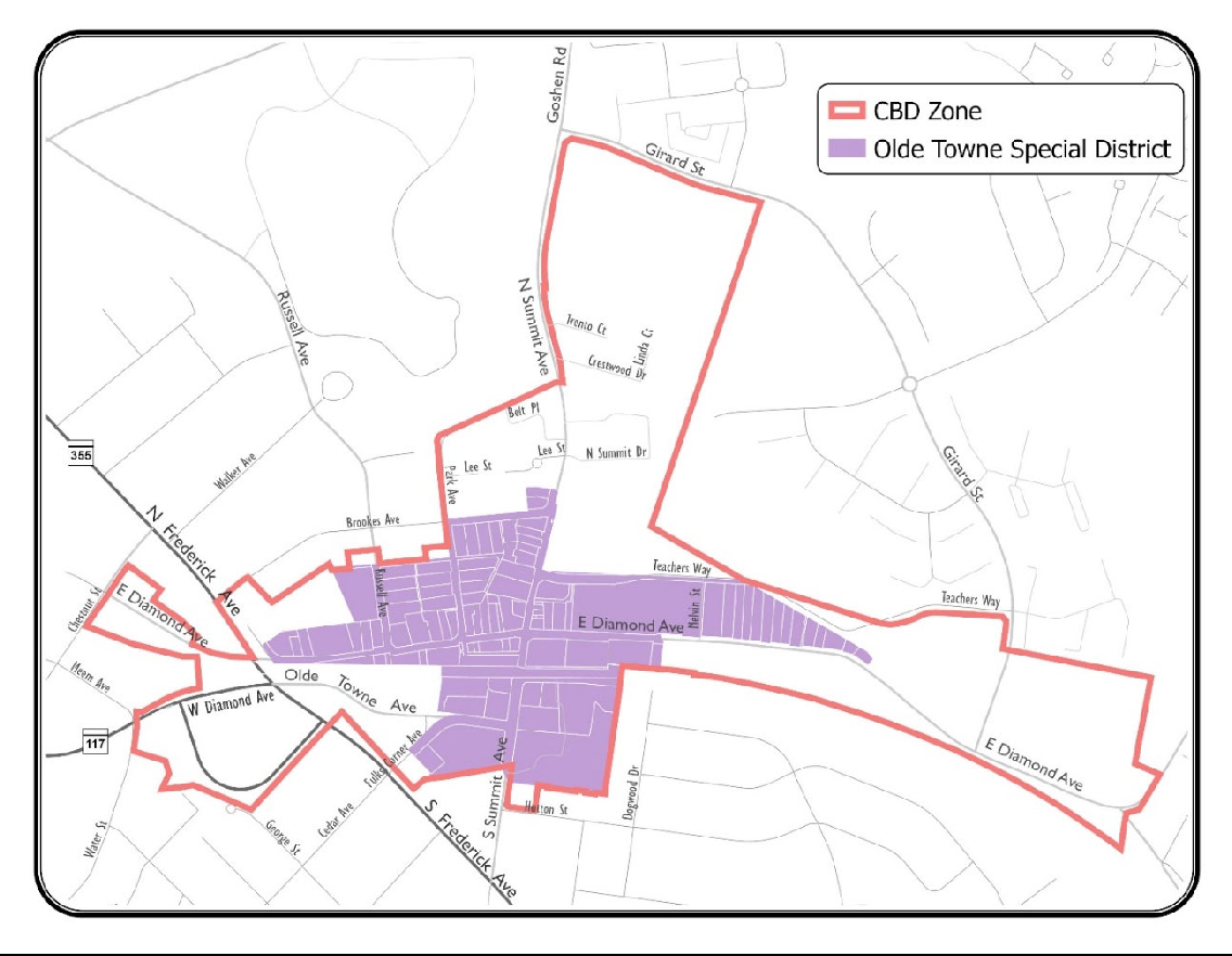
(3)
Special regulations, requirements and waivers. The city council may prescribe by ordinance or resolution, special regulations, requirements and waivers of existing regulations and requirements of this chapter relating to construction, use and occupancy of buildings and structures, on-street and off-street parking, signs and canopies and nonconforming uses and structures within the Olde Towne Special District described in subsection (B) of this section; provided, that any such regulations, requirements and waivers shall be uniform throughout such district.
(4)
Special regulations for Olde Towne Special District. Notwithstanding any other provisions contained within this chapter, all building or structural construction or modifications, the erection and placement of signs and canopies visible to a public street or thoroughfare, and the use and occupancy of buildings and premises within the Olde Towne Special District, as defined in subsection (B) above, shall comply with the following additional requirements:
(a)
New construction upon unimproved property shall also conform to the requirements and standards set forth in the resolution of the city council referred to in subsection (3) of this section.
(5)
Prohibited uses. The following uses are prohibited in the Olde Towne Special District.
(a)
Automobile repair and service establishments.
(b)
Self-storage facilities.
(c)
Equipment and machinery sales and rental establishment.
(d)
Retail store with gas.
(e)
Automobile filling station.
(f)
Carwash.
(g)
Mobile food vendors except as allowed in section 24-5.6.
(h)
In the Olde Towne Special District, as defined in subsection (B) of this section, no on-site parking shall be required for either change in use or the redevelopment of improved or unimproved property effective for five (5) years until February 23, 2025, or as amended by the city council.
(E)
Asbury Special District.
(1)
Purpose. The Asbury Special District includes the entire Asbury campus defined in 1991, at the time of the Annexation X-157 approval and associated annexation agreement. The annexation agreement includes several drawings of a conceptual plan that show the entire one hundred thirty (130) acre Asbury campus, not just the one hundred one (101) acres annexed. These drawings are referenced several times in the agreement and allowed specific uses in the R-90 zone to be "by-right" rather than a special exception, including dimensional standards.
(2)
Area defined. The area defined as the Asbury Special District shall be indicated by the figure below or as amended by the city council:
Figure 24-25. Map of Asbury Special District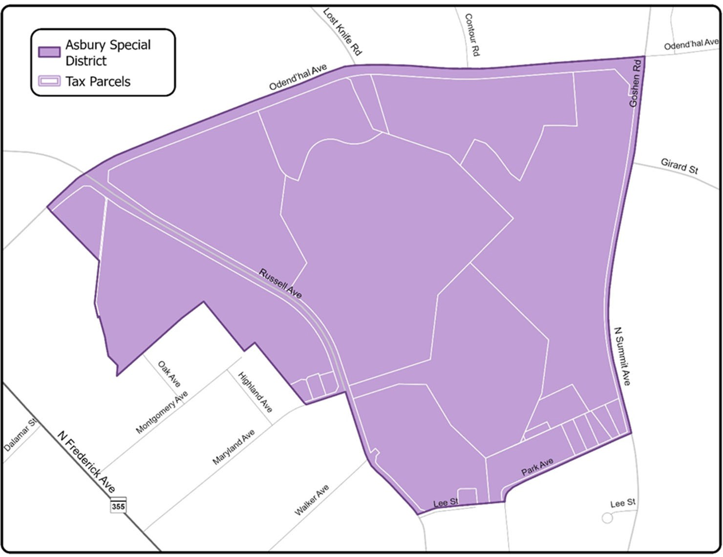
(3)
Uses. The following uses shall be permitted within the Asbury Special District:
(a)
Housing for the elderly, subject to the following conditions:
1.
The term "elderly" as applied herein shall mean persons who are sixty-two (62) years of age or older or families where either the husband or wife is sixty-two (62) years of age or older.
2.
The minimum area of the parcel or tract shall be one and one-half (1½) acres.
3.
Off-street parking shall be provided as specified in section 24-7.2.
(b)
The following uses shall be considered permitted uses, ancillary to a housing for the elderly project:
1.
Adult day care facilities and senior citizens center.
(c)
Bank, barber and beauty shops, convenience shops, gift shop, pharmacy, restaurants, general offices, storage facilities and cable communications system, primarily serving the residents and employees of the project. Such facilities shall be located in a structure used primarily as a residence or a support building for the elderly and shall not be located or operated in such a way that they will attract nonresidents of the project.
(d)
Child day care centers.
(e)
Guest quarters intended for temporary use by the guests of permanent residents, provided that the land area devoted to the guest quarters shall not exceed five (5) acres.
(f)
Care homes, medical clinic and professional offices for medical practitioners primarily to serve the residents of the elderly project.
(g)
Public utility buildings and structures.
(h)
Recreational, educational and cultural facilities not inconsistent with the purposes of this zone.
(i)
Bed and breakfast.
(4)
Development standards. The following development standards shall apply:
(a)
The maximum height of any buildings shall not exceed fifty (50) feet, unless an additional setback, from the perimeter of the housing for the elderly tract, of one foot is provided for each additional foot of height above fifty (50) feet. Where the tract abuts or confronts existing detached single-family residential development, the maximum height of any buildings shall not exceed thirty-five (35) feet, unless an additional setback of three (3) feet from the perimeter of the tract is provided for each additional foot of height.
(b)
The minimum setback for any main building shall be thirty (30) feet from a street, twelve (12) feet from any side lot line, and twenty (20) feet from any rear lot line.
1.
Notwithstanding the setbacks described above, structures which provide only pedestrian passage in an enclosed climate-controlled corridor connecting buildings in a multi-structure, multi-parcel housing for the elderly project are exempt from such yard requirements, and that structural elements of said corridors may extend over lot lines, except that such yard requirements must be satisfied from the boundaries of the master planned community.
(c)
The maximum percentage of tract area devoted to housing for the elderly that may be covered by buildings is thirty-five (35) percent.
(d)
The maximum density shall not exceed fifty-four (54) dwelling units per acre.
(e)
Existing parking spaces which do not comply with the provisions or Article 7, Off-Street Parking and Loading shall be permitted to remain and not be modified to meet the current requirements of such article.
(5)
Review procedure. Housing for the elderly projects are subject to the site plan review provisions of section 24-12.6, Site development plans, commencing with preliminary site plan review.
(6)
Conformance and continuance. Where an otherwise lawful structure or development existed at the time of annexation, such structure or development is not a nonconforming use or structure, and may be continued, modified and expanded, provided that at all times it meets the standards set forth herein. If damaged, the structure may be rebuilt, repaired and/or reconstructed.
(7)
Additional restrictions.
(a)
The city shall be prohibited from designating any properties located within the Asbury Development as historic.
(b)
The city shall be prohibited from requiring affordable housing (such as MPDUs) on the Asbury Development campus, for its existing and planned/future development.
(Ord. No. O-5-24, 7-15-24; Ord. No. O-06-26, 5-4-26)

