
Greeley City Zoning Code
CHAPTER 3
- SUBDIVISION STANDARDS
Sec. 24-301.- Streets.
a.
Intent. The intent of the street design standards is to:
1.
Plan street networks to connect to adjacent projects, correspond with the topography, and to ensure the proper arrangement of blocks and lots for coordinated long-range growth and development.
2.
Emphasize street design as a key determinant of Greeley's community image and unique identity.
3.
Integrate street networks and street designs with open spaces to establish a valuable public realm.
4.
Build complete and multi-modal networks of well-connected streets, trails, and paths to improve the access, capacity, safety, and efficiency of transportation systems.
5.
Plan frequent collector or neighborhood connector streets to link multiple projects or neighborhoods together, and avoid major streets becoming barriers.
6.
Use street design to call attention to differing contexts within the city, and to better support development patterns and uses abutting the streets.
7.
Design streets to account for all potential users of the streets, including pedestrians, bicycles, automobiles, trucks, and transit.
8.
Implement the comprehensive plan and transportation master plan as development occurs, and in particular, the complete street policies and the connectivity policies of those plans.
b.
Street network. Arterial, collector, neighborhood connector, and local streets shall generally be laid out according to the policies of the comprehensive plan, transportation master plan, and other major street, parks, trail and open space plans. In the absence of more specific guidance in these plans, the following standards shall apply to street networks:
1.
Blocks and connectivity. Streets shall be laid out to provide a network of streets and blocks based on the planning context and development pattern as identified in table 24-3-1:
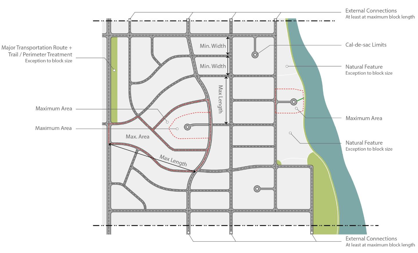
Figure 24-3-1: Connectivity and Block Sizes. Street networks shall be based on maximum block sizes (length between centerlines
of perimeter streets and area) and stub to adjacent property at a frequency sufficient
to create connected networks, unless exceptions justify not connecting.
_____
2.
Exceptions. The following are exceptions to the block and connectivity standards in table 24-3-1:
(a)
Natural features, parks, trails or other civic spaces. Blocks or parcels abutting or containing important natural features, topographical constraints or otherwise creating parts of the public parks or common space system, may be larger provided the proposed street layout preserves these features and integrates them into public realm design for the area.
(b)
Regional transportation routes. Blocks or parcels abutting significant regional transportation routes that impede local network connectivity, such as highways or rail rights-of-way, may be larger provided the street networks and development patterns achieve local connectivity in all other ways possible.
(c)
Rural lots or future development tracts. Property divided into lots of at least five acres for rural or very low-intensity development, or tracts reserved for future development, may exceed block limits provided development is arranged to allow future streets in compliance with these regulations and a logical pattern of re-subdivision can occur with minimal disruption of buildings, utilities, and other structures.
(d)
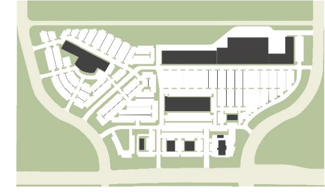
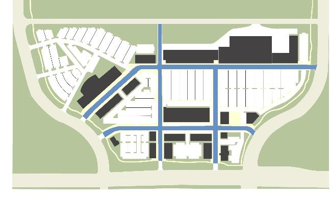
Oversized parcels. Where oversized parcels are platted for special land uses or projects that involve large-scale buildings and development patterns, such as campuses, large-scale employment complexes, or regional commercial areas, blocks may be larger than specified in table 24-3-1. Internal access streets shall mimic the block structure in table 24-3-1, include the urban design amenity of streets in table 24-3-2, and create logical extensions and connectivity to the public streetscape beyond the project.
(e)
In any case where streets are not required to connect by table 24-3-1 through exceptions to this section, alternative designs such as loops, eyebrows, closes, or courtyard layouts are preferred over dead ends and culs-de-sac.
 |  |
| Not this | This |
| Figure 24-3-2 Internal Access Streets. Internal access streets used to mimic public street networks and streetscapes for over-sized parcels and large scape development. (Section 24-301.b.2(d).) | |
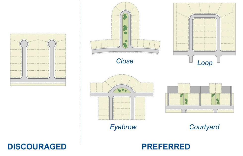
Figure 24-3-3: Disconnected Street Options. Where streets will not connect, blocks and lots should be laid out to limit the need
for culs-de-sac and maximize other options such as loops, closes, eyebrows and courtyard
patterns. (Section 24-301.b.2(e).)
3.
Walkways and bicycle routes. In any case where exceptions for larger blocks apply, or any other area where pedestrian and bicycle connections are important, such as adjacent to schools, parks, trail systems or community centers, the city may require pedestrian walkways or bicycle routes through blocks or at the end of any cul-de-sac. Connections shall be dedicated to the city and meet the city's trail standards or be common areas and meet the trail or pedestrian passage design standards in section 24-504.
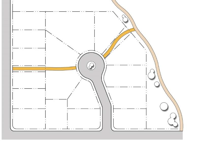
Figure 24-3-4: Walkways and Bicycle Routes. Where streets will not connect or where larger blocks are platted, connections for
pedestrians or bikes may be required through blocks or at the ends of disconnected
streets. (Section 24-301.b.3.)
4.
External connections. Streets shall be planned to provide continuation to adjacent undeveloped and future growth areas at intervals of at least the maximum block length in table 24-3-1, unless justified by an exception in section 24-301.b.2. The city may require dedication of right-of-way and construction of streets extended to the boundary line of the property to be subdivided, or approve alternative arrangements for location and timing of construction that equally or better coordinate with anticipated future development of adjacent areas.
5.
Half streets. Street systems shall be laid out to eliminate or avoid new perimeter half streets between adjacent property owners. The full right-of-way width of streets shall be dedicated and half-streets shall only be accepted by the city when it conforms to the transportation master plan.
6.
Intersections and offsets. Streets shall be laid out to intersect subject to the following:
(a)
Intersection angles should be as near as possible to right angles, and intersections less than 75 degrees are generally not acceptable.
(b)
Oblique streets should be curved approaching an intersection and should be approximately at right angles for at least 100 feet prior to the intersection.
(c)
Intersections should be generally aligned with existing intersections on the opposite side of the street, and offsets of the centerlines between 25 feet and 125 feet are generally not acceptable.
(d)
Intersections of more than two streets at one point are generally not acceptable.
7.
Alternative compliance. Alternative compliance to the street network standards established in this section may be authorized according to the process and criteria in section 24-208, and where the proposed network meets any of the following additional applicable criteria:
(a)
Better coordinate streets and trail connections with adjacent development, and particularly considering a greater frequency of bicycle and pedestrian connections.
(b)
Implement any officially approved transportation plan for a specific area.
(c)
Emphasize unique natural features or better correspond to topography.
(d)
Implement traffic calming in a manner that improves pedestrian and bicycle connections.
(e)
Create gateways and focal points within the street network by unique arrangements of streets and blocks.
(f)
Average block sizes for the project as a whole implement a comparable or greater degree of connectivity, particularly considering the frequency of collector and neighborhood connector streets that can extend beyond the project.
c.
Street types and design. The street types in this section provide typical cross sections to implement context-based street design, design "complete" streets, and result in multi-modal networks for the various contexts in Greeley, based on the policies of the comprehensive plan and transportation master plan.
1.
Context and type. The street designs are grouped with the following design types for application to specific contexts:
(a)
Neighborhood streets. A neighborhood-oriented residential street type, appropriate where a higher level of neighborhood design amenity and neighborhood walkability is desired. It is characterized by large street trees, wide sidewalks, slow speeds, and occasional on-street parking. Neighborhood streets require a well-connected network to disperse traffic and slow speeds, so that no single street is burdened with high volumes and speeds.
(b)
Pedestrian streets. A pedestrian-oriented commercial or mixed-use street type, appropriate for all areas where walkability is a goal. It is characterized by narrow lanes, slow speeds, on-street parking, wide sidewalks, and large, well-designed pedestrian amenity zones that support social and economic activity along these streets. Pedestrian streets require a highly connected network so that a variety of street design types can better support abutting uses and urban design characteristics, and ensure that vehicles and pedestrians have multiple alternative and direct routes to destinations.
(c)
Standard streets. A basic street type, appropriate generally where no particular development characteristics or urban design context warrant application of other street types. These streets accommodate peak anticipated vehicle traffic, but seek to balance and integrate other modes of transportation.
2.
Alternative compliance. The design standards shown for each street type in table 24-3-2: street types and cross sections, are typical. They may be modified based on context and according to the process and criteria in section 24-208, and any of the following additional applicable criteria:
(a)
The director shall consult with the public works director to reconcile any planning, urban design, traffic, and engineering issues.
(b)
In contexts where there is constrained rights-of-way, unusual topographic conditions, or unanticipated development pattern and traffic issues, specific elements of the cross section may be modified to best reflect the priorities for the street type expressed in subsection c.1.
(c)
Any official plan approved by the planning commission for streets, or applying specific street types or street sections to a particular area, shall be used by the director and public works director.
(d)
The director and public works director may consult the guidance provided by the transportation master plan, or any other street specification and design guides officially authorized by the city that meet the intent of this section.
| Neighborhood Street | |||
| ① | ROW width | 54' | 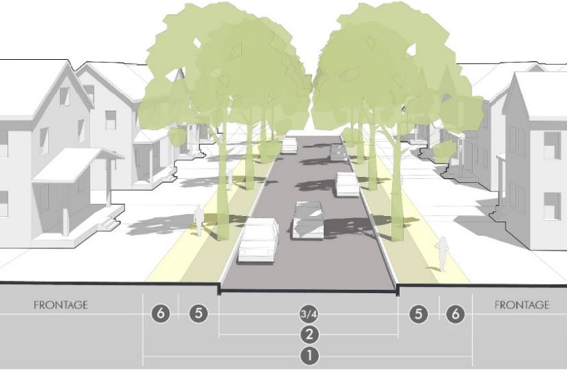 |
| ② | Street width | 30'* | |
| ③ | Travel lanes | 16'—18' yield flow | |
| ④ | Edge condition | 7' parking both sides | |
| ⑤ | Landscape amenity | 7'+ parkway | |
| ⑥ | Sidewalk | 5' | |
| ⑦ | Bicycles | N/A | |
| Applicability |
• Local — Low volume
• Local residential | ||
| Neighborhood Connector | |||
| ① | ROW width | 60' |  |
| ② | Street width | 32'—34' | |
| ③ | Travel lanes | 2 @ 9'—10' | |
| ④ | Edge condition | 7' parking both sides | |
| ⑤ | Landscape amenity | 8'+ parkway | |
| ⑥ | Sidewalk | 6'—8' | |
| ⑦ | Bicycles | 6' bike lane (optional) | |
| Applicability |
• Local
• Minor collector | ||
| Neighborhood Parkway | |||
| ① | ROW width | 90' | 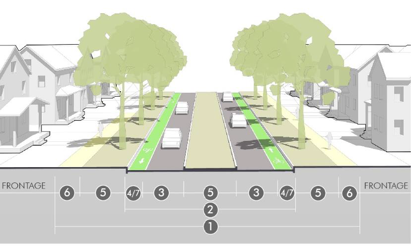 |
| ② | Street width (curb-to-curb) | 34' (+ median width) | |
| ③ | Travel lanes | 2 @ 10' | |
| ④ | Edge condition | bike lane | |
| ⑤ | Landscape amenity |
10'+ parkway
12' 20' median (optional) | |
| ⑥ | Sidewalk | 8'—10' | |
| ⑦ | Bicycles | 6'—7' bike lane | |
| Applicability |
• Minor collector
• Major collector • Minor arterial | ||
| Access Alley (Residential) | |||
| ① | ROW/Easement width | 20' | 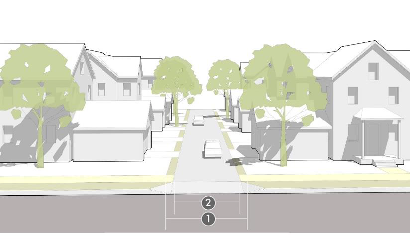 |
| ② | Street width |
14—16'' (< 40 units)
16' 18' (41+ units) | |
| ③ | Travel lanes | N/A | |
| ④ | Edge condition | shoulder | |
| ⑤ | Landscape amenity | N/A | |
| ⑥ | Sidewalk | N/A | |
| ⑦ | Bicycles | N/A | |
| Applicability | N/A — internal to block | ||
| Pedestrian Street | |||
| ① | ROW width | 60''--80' |  |
| ② | Street width | 36' | |
| ③ | Travel lanes | 2 @ 10' | |
| ④ | Edge condition | 8' parallel parking (angled optional) | |
| ⑤ | Landscape amenity | 4'—8' amenity zone | |
| ⑥ | Sidewalk | 8'—12' min. | |
| ⑦ | Bicycles | N/A | |
| Applicability |
• Local
• Minor collector | ||
| Avenue | |||
| ① | ROW width | 90'--100' | 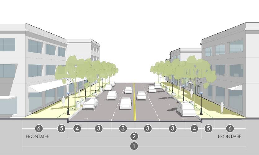 |
| ② | Street width | 58' | |
| ③ | Travel lanes | 4 @ 10' | |
| ④ | Edge condition | 8' parallel parking both sides (angled optional) | |
| ⑤ | Landscape amenity |
4'—8' amenity zone
12'—20' median (optional) | |
| ⑥ | Sidewalk | 12'—16' min. | |
| ⑦ | Bicycles | 6' bike lane (optional) | |
| Applicability |
• Minor collector
• Major collector • Minor arterial | ||
| Access Alley (Commercial/Industrial) | |||
| ① | ROW /Easement width | 20' |  |
| ② | Street width | 18'—20' | |
| ③ | Travel lanes | N/A | |
| ④ | Edge condition | shoulder | |
| ⑤ | Landscape amenity | N/A | |
| ⑥ | Sidewalk | N/A | |
| ⑦ | Bicycles | N/A | |
| Applicability | N/A — internal to block | ||
| Standard Local | |||
| ① | ROW width | 60' | 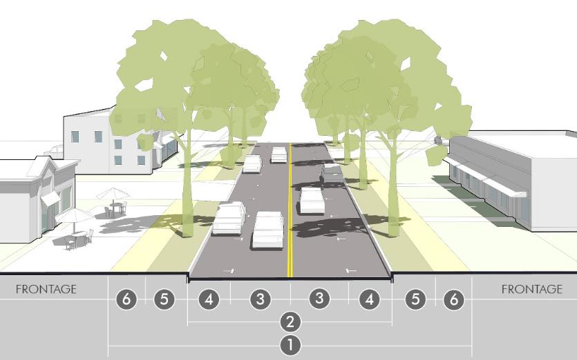 |
| ② | Street width | 36' | |
| ③ | Travel lanes | 2 @ 11' | |
| ④ | Edge condition | Parking and/or bike lanes | |
| ⑤ | Landscape amenity | 7'+ parkway | |
| ⑥ | Sidewalk | 5'—8' | |
| ⑦ | Bicycles | 6' bike lane (optional) | |
| Applicability | • Local | ||
| Standard Collector (Minor) | |||
| ① | ROW width | 70' | 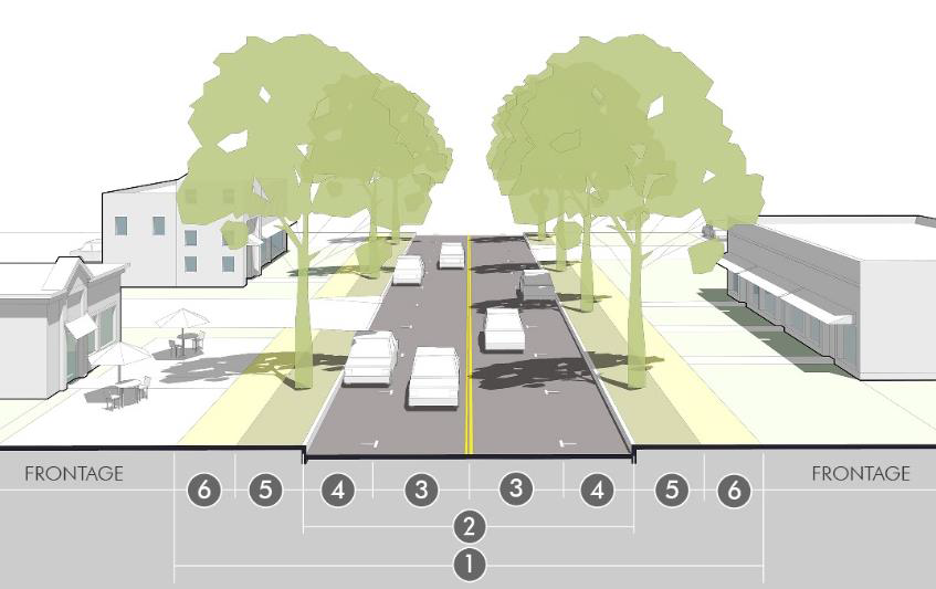 |
| ② | Street width | 36' | |
| ③ | Travel lanes | 2 @ 11' | |
| ④ | Edge condition | Parking and/or bike lanes | |
| ⑤ | Landscape amenity | 8'+ parkway | |
| ⑥ | Sidewalk | 6'—10' | |
| ⑦ | Bicycles | 6' bike lane (optional) | |
| Applicability | • Minor collector | ||
| Standard Collector (Major) | |||
| ① | ROW width | 90'--100' | 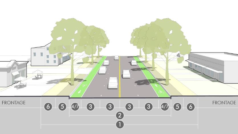 |
| ② | Street width | 58' | |
| ③ | Travel lanes | 4 @ 11' | |
| ④ | Edge condition | bike lane | |
| ⑤ | Landscape amenity | 8'+ parkway | |
| ⑥ | Sidewalk | 8'—12' | |
| ⑦ | Bicycles | 6'—7' bike lane | |
| Applicability | • Major collector | ||
| Standard Arterial (Minor) | |||
| ① | ROW width | 120'+ | 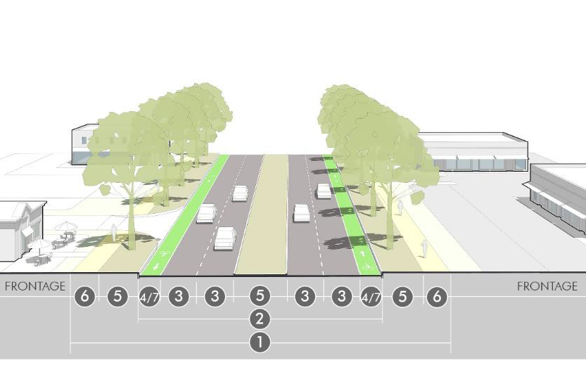 |
| ② | Street width | 72' (w/median) | |
| ③ | Travel lanes | 4 @ 11' | |
| ④ | Edge condition | bike lanes | |
| ⑤ | Landscape amenity |
12'+ parkway
16' center median | |
| ⑥ | Sidewalk | 8'—12' | |
| ⑦ | Bicycles | 6'—7' bike lane OR 12' multi-use trail (off-street) | |
| Applicability | • Minor arterial | ||
| Standard Arterial (Major) | |||
| ① | ROW width | 130'+ | 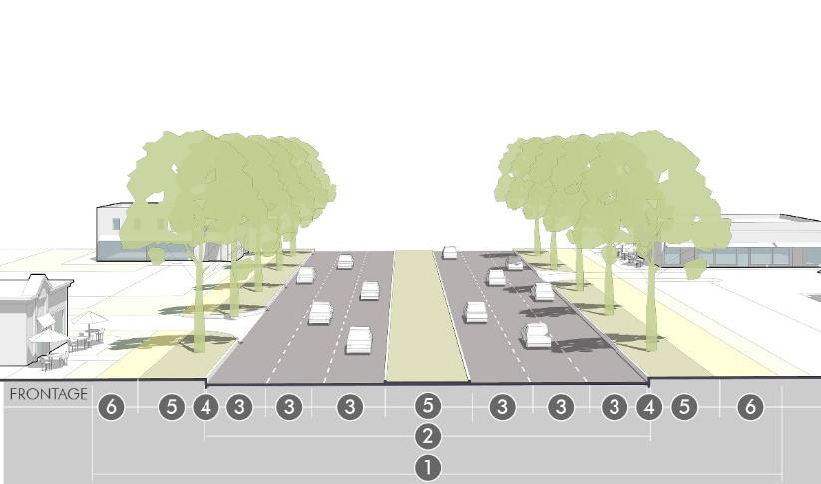 |
| ② | Street width | 82' (w/median) | |
| ③ | Travel lanes | 6 @ 11' | |
| ④ | Edge condition | Curb & gutter | |
| ⑤ | Landscape amenity |
12'+ parkway
16' center median | |
| ⑥ | Sidewalk | 12' multi-use trail | |
| ⑦ | Bicycles | 12' multi-use trail (off-street) | |
| Applicability | • Major arterial | ||
d.
Intersection design. Intersections shall generally be designed according to the Greeley Design Criteria and Construction Specifications for streets. The subsections below provide specific and additional considerations to align intersection design with the development patterns and public realm design of a particular area.
1.
Corner radii. In order to balance the competing interest of vehicle turning movements and the safety and distance of pedestrians crossing the street, the director and public works director may approve decreases from the corner radii specified in the design criteria and construction specifications based on the following considerations:
(a)
The context of a particular development, and in particular, whether walkable development patterns are a priority.
(b)
The impact that the specified radii has on increasing the distance that pedestrians must cross.
(c)
The desired speeds of vehicles in the roadway and the desired speeds and volume of turning vehicles.
(d)
The connectivity of the street network and whether vehicles have multiple alternative routes that minimize frequent turning movements at one particular location.
(e)
The effective turning radius of vehicles considering other features of the specific cross section, including bicycle lanes, on-street parking or other configurations that impact the actual path of turning movements.
(f)
The likelihood that large vehicles will make frequent turning movements at a particular location, compared with the ability of over-sized vehicles or unusual turning movements to safely encroach into other areas of the street.
(g)
Other design guides or industry manuals officially authorized by the city that meet the intent of this section.
2.
Sight distance. Proper lines of sight shall be maintained at all intersections and all vehicle connections to the street. The proper line of sight shall be an unobstructed view from the stopping point on the approaching street, or 15 feet back from the flow line where no specific point is evident, to all points two and one-half feet above the roadway along the centerline of the intersecting street. The distance of the unobstructed view shall be based upon the design speed of the intersecting street specified in table 24-3-4, Clear sight distance.
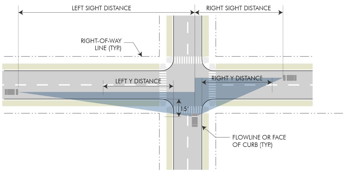
Figure 24-3-5: Clear Sight Distance
(a)
Theses distances are typical to be used under normal conditions and may be modified by the traffic engineer to protect the public safety and welfare under exceptional conditions.
(b)
No building, structure, vegetation or other type of visual obstruction shall be placed or maintained within the triangle created by the centerline of the street intersection, the stopping point on the approaching street, and the sight distance specified in table 24-3-6 to the centerline of the intersecting street.
(c)
Street trees, light poles or other limited narrow obstructions are allowed within the sight triangle provided they do not have any foliage, limbs, or other broad obstructions between 2½ and eight feet and are no closer than 20 feet to the intersecting right-of-way line.
(d)
Fully controlled intersections where signalization establishes and prioritizes safe turning movements may deviate from the above sight triangle standards if site conditions warrant and based upon a recommendation of the director and public works director.
3.
Crosswalks. All intersections and crosswalks shall be designed to address conditions at each specific location, based on the guidance in the transportation master plan and applicable standards in the design criteria and construction specifications. In general or where this guidance does not provide more specificity, sidewalks or trails intersecting with public streets or other vehicle access shall have crossings meeting the following standards:
(a)
Curb ramps meeting Americans with Disabilities Act (ADA) accessibility standards and guidelines shall provide a direct, non-diverted approach from the sidewalk along the block into the designated or protected crossing area.
(b)
Crossings on collector streets or higher classification shall be considered for enhanced crosswalks including pavement markings, bulb outs, signalization, refuge islands or other traffic-calming measures that are appropriate to the context of the intersection.
(c)
Where blocks exceed more than 700 feet between intersections or at other locations of high pedestrian activity, mid-block crossings shall be considered. Mid-block crossing designs and locations are subject to a specific recommendation and approval of the director and public works director.
(d)
Any crosswalk over 80 feet, or any other significant pedestrian crossing, may require a pedestrian refuge in the median at the discretion of the director and public works director.
4.
Turn lanes. Turn lanes for left or right turn movements may be required for specific intersections, based on an approved traffic study and with consideration by the director and public works director. Requirements for turn lanes should be based on careful consideration of the context balancing the impact of crossing distances for pedestrians, vehicle turning speeds, and prioritization of other planning, urban design, and traffic engineering issues. In general, this space should come from reconfiguration of the space within the roadway width near the intersection (i.e., within median space, narrowing lanes, or limiting on-street parking) rather than claiming space from the pedestrian area or streetscape, or rather than widening the road and right-of-way.
e.
Traffic calming. In order to meet the desired speeds throughout the street network, to manage volumes in association with the street network, and to meet the city's complete streets policies and intent of this section, traffic-calming strategies may be required in street plans. Traffic calming may include bulb outs and curb extensions, medians and islands, neck downs, vertical diverters, enhanced or raised crossings, and other speed management techniques approved by the director and public works director. (See National Association of City Transportation Officials Guidelines.)
f.
Engineering and construction specifications. All other engineering specifications, horizontal and vertical alignment, design details, and technical or construction specifications for constructing streets shall be covered by the City of Greeley's Design Criteria and Construction Specifications for streets, and administered by the public works director.
(Ord. No. 35, 2021, § 2(app. A, § 2), 9-21-2021)
Sec. 24-302. - Parks and trails.
a.
Intent. The intent of this section is to:
1.
Emphasize open and civic space design as a key determinant of Greeley's community image and unique identity.
2.
Integrate parks and trail systems, and other common areas into the patterns of streets and blocks to create a coordinated public realm.
3.
Value the design, function and appropriate location of different types of open space, rather than solely the quantity of space.
4.
Consider the context and multiple functions that open spaces can serve to support development including ecological, recreation, aesthetic and urban design functions.
5.
Promote good civic design and create focal points for the community, district, neighborhood or development site.
6.
Integrate natural systems into the design of public or common open spaces to improve stormwater management, protect water resources, preserve ecosystems, and improve sustainability efforts.
7.
Implement the city's parks, trails, and open lands master plan, other plans for natural areas and trails, and coordinate the design and location of other open and civic spaces with these plans.
b.
Required park dedication. All residential subdivision applications shall dedicate land suitable for the development of parks according to the formula in table 24-3-5: park land dedication. Where no suitable land is available in the proposed development, the city may accept the cash-in-lieu equivalent of the land value. This requirement shall also apply to any rezoning or use by special review for residential uses that is not associated with a plat application, and where a previous plat application was not required to dedicate land or pay a cash-in-lieu equivalent.
1.
The city reserves the right to adjust the acreage requirement between the four park categories as deemed necessary to meet specific needs and to determine the amount of developed park acreage required based upon recommendations by the cultural, parks and recreation department.
2.
Existing dwelling units within a subdivision shall be excluded from the calculation of the park dedication requirement.
3.
Where a final unit count cannot be determined until subsequent stages of a project, land dedication shall be based on an assumed average density. Multifamily density shall be assumed at 20 dwelling units per acre but may be adjusted by the city where more specific information on the site, developable area or anticipated building types exist.
4.
Land proposed for park dedication shall be clearly identified on any submitted plat including the number of acres for each site and the total acreage proposed for city park dedication within the project.
5.
The dedication shall be by warranty deed, and the title shall be free and clear of all liens and encumbrances, including real property taxes prorated to the time of dedication. The applicant shall provide the city with a title insurance policy in the city's name and a certified survey at the time of conveyance.
6.
Land dedicated for parks shall include adequate site access, installation of curb, sidewalks, and storm drainage systems, and the necessary water rights or other available water service to provide for irrigation and drinking water.
7.
Community park and/or sports complex park land shall be dedicated to the city prior to recordation of the first final plat for the subdivision as defined by the preliminary plat. Neighborhood park land shall be dedicated at the time of the final plat for the area to be served by the neighborhood park.
c.
Cash-in-lieu of dedication. Cash-in-lieu of land dedication may be used when the city determines the cash value of land to be more appropriate in satisfying the needs of the proposed subdivision than land within the proposed subdivision. Typical cases include small developments, locations with disadvantageous topography or access, or developments that already have adjacent facilities that could be expanded to satisfy the need created by the proposed development.
1.
The city will adopt a pre-determined per-acre cash-in-lieu of land for parks amount, that may be administratively adjusted periodically and will be available on file with the community development department. The pre-determined amount will be based on a mass appraisal performed by an independent qualified appraiser using generally accepted appraisal practices. As an alternative to the city's predetermined cash-in-lieu amount, the applicant may submit a proposal for determination of the cash-in-lieu amount. The proposal shall supply supporting information, including at least one report by an independent, qualified appraiser using generally accepted appraisal practices. The supporting information supplied must be adequate to allow the city to evaluate the proposed amount. If the city determines that the alternate proposal is not adequately supported, the city's predetermined cash-in-lieu amount will be applied.
2.
The cash-in-lieu amount will be paid at the time the plat is recorded, unless otherwise determined by the city and agreed to in a subdivision improvement agreement.
3.
The city may adjust the cash-in-lieu requirement between the types of open and civic space in this code, or based on any policies of the parks, trails, and open lands master plan.
4.
The city may accept combinations of cash and dedication where only a portion of the required dedication can be met by acceptable park sites within the project. The required cash value shall be prorated to the amount of required land not dedicated and accepted.
d.
Trails and natural areas. The city may require or the applicant may offer trails and natural areas for public dedication in addition to the land for parks and rights-of-way. Based on the recommendations of the parks, trails, and open lands master plan, and other plans of the culture, recreation and parks department, the city may accept the dedication, and may credit this dedication to the parks requirement where it equally or better meets the intent of this section.
e.
Neighborhood features and common area systems. Land dedication, or cash-in-lieu of dedication parks is not intended to replace, discourage, or prohibit the creation of pocket parks, civic spaces, or other open lands features operated and owned by a homeowners' association or other governing entities for any other public, common, or private purpose. Section 24-504 includes requirements for neighborhood features and common areas. These areas shall be coordinated with the design and location of street networks, parks and trails to better leverage a system of parks, trails, open lands, and civic spaces throughout the area.
(Ord. No. 35, 2021, § 2(app. A, § 2), 9-21-2021; Ord. No. 7, 2023, app. A(24-3-5), 2-21-2023)
Sec. 24-303. - Blocks and lots.
a.
Intent. The intent of the blocks and lots standards is to:
1.
Ensure the proper arrangement of blocks and lots to complement the street network, parks and trail system, and neighborhood features and common areas.
2.
Arrange blocks, lots and development in a manner that is least disruptive to existing topography and capitalizes on inherent natural characteristics of the land as defining features.
3.
Coordinate access and utilities for each lot in association with larger systems of streets and infrastructure.
4.
Promote appropriate site, building and frontage designs in relation to streetscapes and open spaces.
5.
Ensure that all lots are buildable according to this code, that all sensitive, hazardous or other non-buildable areas are preserved from development, and that all non-developed outlots or other parcels serve an urban design or planning function in relation to the overall development pattern.
b.
Block and lot arrangement.
1.
General layout. All blocks shall be laid out to have two tiers of lots unless dictated by existing development patterns outside of the control of the project or by access management on major arterial streets or railroad rights-of-way. In these cases, streetscape standards, trails, or common areas should be used to create buffers and transitions where the rear of lots would abut these areas.
2.
Hazards and unbuildable areas. Blocks and lots shall be arranged to avoid hazards and unbuildable areas including steep grades, unstable or expansive soils, lands with inadequate drainage or subject to flooding, and natural drainage areas. These areas shall be incorporated into open and civic space systems, restricted tracts or outlots, or otherwise mitigated to eliminate hazards.
3.
Block size and patterns. The maximum block length and size shall be based on the street connectivity standards in section 24-301.b.
4.
Lot patterns. All lots shall front on a public street, or on an internal access street or common area open space where specifically allowed by these regulations. Lots shall meet the standards for the zoning district, or where applicable for the specific permitted building types. All side lot lines shall generally be perpendicular to front lot lines, or radial to any curves along the front lot lines. Other irregular lot patterns shall only be permitted where they are used to integrate patterns of buildable lots into the overall block structure and to provide consistent relationships of buildings and lots to the streetscape.
5.
Addressing. All lots and other parcels shall require an address following city address policies and guidelines, including streets and street names.
6.
Easements. All blocks shall include easements for all utilities, required improvements, and access necessary to serve each lot.
(a)
Easements shall be granted by the owner to the appropriate entity, according to the needs and specifications of that entity.
(b)
Easements shall be coordinated with each entity early in the platting process to ensure proper arrangement of blocks, lots and building sites.
(c)
In general, easements and any associated structures or facilities shall be located on the most remote and least visible portions of sites. Where available, alleys shall be used for easements and services. Otherwise, easements and associated facilities shall be located along rear lot lines, remote corners, and other low-visibility joint lot lines.
(d)
In cases where block, lot and building patterns necessitate easements and facilities along the side or front lot lines, additional design and screening may be required to ensure appropriate relationships to frontages and streetscapes.
7.
Drainage. Where a subdivision is traversed by a watercourse, drainage way or stream, blocks shall be laid out in coordination with these features.
(a)
A pedestrian or bikeway easement may be required where drainage areas interrupt the block structure more than permitted in section 24-301.b, or where the city determines the area is appropriate for active recreation or transportation uses.
(b)
All necessary rights-of-way and easements shall be dedicated to the city or other public entity to preserve the hydrologic, environmental, or stormwater function of the watercourse, drainage way or stream.
(c)
Access for service vehicles shall be incorporated into the design of any drainage areas or easements internal to the block structure or common areas.
(Ord. No. 35, 2021, § 2(app. A, § 2), 9-21-2021)
Sec. 24-304. - Required improvements.
a.
Intent. The intent of this section is to:
1.
Ensure that all improvements necessary to serve lots within a subdivision are constructed, inspected or otherwise assured of completion prior to the issuance of permits and final approvals.
2.
Prevent the location or design of a subdivision from placing an undue burden on public utility systems and community facilities serving other areas.
3.
Provide appropriate apportionment of costs, and offset higher net costs or premature costs to the public resulting from subdivisions.
4.
Protect against subdivisions where soil, subsoil or flooding conditions would create potential dangers to public health or safety.
5.
Coordinate subdivisions and construction of required improvements with other anticipated improvements or with future growth.
b.
Timing of improvements. All required improvements shall be provided in one of the following ways:
1.
Construction prior to building permit. Improvements may be constructed and certified record drawings of as-built shall be submitted to the city and certified that it was built as shown and to city specifications by:
(a)
The contractor;
(b)
The project surveyor; and
(c)
The project engineer.
2.
Financial guarantee. The applicant may defer any improvements by submitting a financial guarantee for 125 percent of the total cost of improvements based on approved design or construction plans.
(a)
The guarantee shall be in a form and for an amount acceptable by the city.
(b)
Any deferral of streets shall require all weather surfaces of concrete, asphalt or road base placed on the lip of the curb and gutter for interim access of construction and emergency vehicles.
(c)
All improvements for the particular phase of the plat shall be installed prior to a certificate of occupancy for any part of the phase.
(d)
Upon submittal and acceptance of as-built drawings for the improvements, the city may release the financial guarantee, but retain 20 percent for the two-year warranty period.
3.
Subdivision improvement agreement. The city and the applicant may enter into a subdivision improvement agreement recorded in association with an approved plan that more specifically defines the type, timing, and guarantees for required improvements.
c.
Required improvements. The following improvements and plans are required for all subdivisions. All improvements are subject to the city or other responsible entities' standards, plans, and specifications for improvements.
1.
Survey monuments;
2.
Sanitary sewer main lines and service lines to each lot;
3.
Water main lines and service lines to each lot;
4.
All non-potable mains and services to required lots;
5.
Fire hydrants;
6.
Storm sewers, culverts, detention facilities, bridges and any other approved storm drainage components, or elements required by a stormwater management plan;
7.
Dust abatement and erosion control plan; and
8.
Perimeter treatment landscape plan.
9.
Utilities (telephone, electrical service, gas lines and cable television). All utilities shall be installed underground and be in place prior to any postponed street or alley surfacing. Above-ground facilities necessarily appurtenant to underground facilities or other installation of peripheral overhead electrical transmission and distribution feeder lines or other installation of either temporary or peripheral overhead communications, distance, trunk or feeder lines may be above ground. No curb, gutter or sidewalk shall be installed until all utilities are provided.
10.
Streets, alleys and sidewalks. All streets shall be paved and all other improvements such as sidewalk, bike paths, curb and gutter shall be installed as required. In cases where an existing street has not been brought up to city specifications the street shall be paved and all other improvements such as sidewalk, bike paths, curb and gutter shall be installed in order to meet city specifications. If any subdivision is located adjacent to any existing street right-of-way, the applicant shall improve at least the adjacent half of the street according to city specification.
11.
Street signs (on residential projects only);
12.
Street lights;
13.
All other improvements required as a condition of approval of the plat or contained within the subdivision improvement agreement shall be completed.
d.
Procedures for improvements. To ensure that all required improvements are built according to city specifications, the construction process shall generally take the following steps:
e.
Warranty. All public improvement infrastructure, perimeter landscaping treatment improvements and common area improvements shall provide a two-year warranty period covering design and construction defects.
1.
Warranty shall be one of the following, at the option of the permittee and subject to approval of the form by the city:
(a)
Warranty bond for 20 percent of total construction cost of required improvements.
(b)
Letter of credit for 20 percent of total construction cost of required improvements.
(c)
Cash deposit for one percent of total construction cost of required improvements that is nonrefundable. A cash deposit is an administration fee and shall not be construed as creating any type of insurer/insured relationship or subject the city to the provisions of C.R.S. title 10.
2.
The warranty amount shall be based on an estimate provided by the applicant, or the director may determine an alternate amount based on relevant similar projects and comparable improvements.
3.
The city may approve the construction permit in clearly defined, logical phases of construction, and may accept the apportioned warranty prior to the beginning of each phase.
4.
The use of the warranty shall be restricted for the repair, replacement, completion and maintenance of all improvements subject to the construction permit, including detention facilities, perimeter landscaping and open space.
5.
If the city uses any of the warranty, the permittee shall replace that amount used prior to being issued any new construction permits, either for the affected specific project or any other projects in which the permittee has an interest.
6.
The city may extend the two-year warranty for all or a portion of the amount if major items have not been repaired/replaced to the city's satisfaction.
7.
At least once each year, the city engineer shall review the use of all cash payment funds received by the city pursuant to this section. After review, the city engineer shall report to the city manager and city council, and make recommendations regarding the cash payment fund including transfers of fund balances to the General Fund.
8.
After final inspection and final acceptance, and at the end of the two-year warranty period, the city shall release the permittee from any warranty bond or letter of credit. If the warranty is by cash deposit, this amount is not refundable.
(Ord. No. 35, 2021, § 2(app. A, § 2), 9-21-2021)
Sec. 24-305. - Adequate public facilities.
a.
Intent. The intent of the adequate public facilities standards is to:
1.
Anticipate and evaluate the incremental and long-term impact of development on broader public and community facility needs.
2.
Identify opportunities to integrate plans for public and community facilities into the planning and design of proposed land divisions.
3.
Consider the location of public and community facilities in coordination with the initial planning considerations for streets, open spaces, blocks, and lots, so that needed facilities are appropriately located prior to the premature commitment of these areas to conflicting development patterns.
4.
Ensure that public facilities needed to serve new development are available concurrent with development, and maintain service levels in existing areas as new development occurs.
5.
Apportion appropriate costs for the impact of new development on existing and planned public facilities.
6.
Provide the opportunity to negotiate implementation of public or community facilities beyond the impact of the particular project, where the lack of facilities may otherwise constrain potential future development.
7.
Promote fiscal responsibility for all public entities by coordinating the planning, design and financing of public facilities with the impact generated from proposed development.
b.
General requirements.
1.
Public facility plans. Public facilities shall be provided consistent with the following adopted city documents:
(a)
Comprehensive plan;
(b)
Water, sewer, and non-potable water master plans;
(c)
Comprehensive stormwater master plans;
(d)
Transportation master plan;
(e)
Development fee study;
(f)
Parks, trails, and open space master plan; and
(g)
Other adopted documents related to city capital improvements.
2.
Service area map. Available services shall generally mean existing services of standard sizes of public water and sewer mains. The city updates the existing service area map regularly.
3.
Project impacts. Individual projects will be evaluated for adequacy based on specific studies provided by the applicant and accepted by the city that demonstrate:
(a)
The location of the proposed development relative to existing facilities and service;
(b)
The ability of the project to access those facilities and services; and
(c)
The capacity of existing facilities and services to serve the new project while maintaining acceptable levels of service for existing development.
4.
Other provisions.
(a)
Finding of adequate facilities does not exempt the applicant from paying impact fees provided in section 24-305.d.
(b)
Nothing in this section shall limit the city from denying an application where it otherwise determines that adequate public facilities will not be in place concurrent with the application, despite the effect of any of the requirements or options provided in this section.
(c)
Nothing in this section shall prohibit any other public entity from establishing fees that apportion the appropriate contribution for the impacts on planning, design and land acquisition for facilities needed due to the development.
c.
Specific adequacy standards. In addition to being consistent with the public facility plans in section 24-305.b.1, adequacy of specific public facilities shall be evaluated as follows. City analysis and project-specific studies of the impact, demand and capacity of existing facilities will be required to make a final adequacy determination.
1.
Fire. Fire service is considered adequate if the proposed development is located within a 1.38 mile radius of an existing, operational fire station. This requirement is based on the analysis that one fire station is needed for every 30,000 people generally living in a six-square-mile area, as applied in the comprehensive plan. Proposed developments including land uses that pose a high risk of fire may be subject to more stringent requirements.
2.
Parks. Park facilities are considered adequate if the proposed development is located within a half-mile radius of a neighborhood park and within a one-mile radius of a community park, where the park is not separated from the proposed development by an expressway, facility or natural feature. Regional parks, trails, natural areas, or sports facilities are not included in the analysis unless they contain facilities equivalent to those available in neighborhood parks.
3.
Police. Police service extends to the city limits and adequacy shall be determined according to call response times relevant to the proposed development location.
4.
Sanitary sewer. Sewer facilities are considered adequate if the proposed development is connected to a sewer line that is eight inches or larger in diameter with sufficient system capacity as defined by the city.
5.
Water. Water facilities are considered adequate if the proposed development has sufficient connection to existing water lines that are eight inches or larger in diameter with sufficient system capacity.
6.
Stormwater. Stormwater facilities are generally considered adequate if the site can safely convey stormwater runoff to a regional stormwater detention facility with sufficient capacity as defined by the city. If the city determines that the proposed development cannot safely convey runoff to an adequate stormwater system, adequacy requirements shall be met with detention facilities constructed on site.
7.
Transportation. Transportation facilities to support new development are generally considered adequate if the proposed development is connected to a collector or arterial road or expressway (or will be connected at the time the improved arterial or collector is constructed within the two-year budget cycle) constructed to an acceptable cross section with sufficient capacity to serve the development as defined by the city.
d.
Impact fees. To mitigate project impacts on city service systems beyond the improvements required in section 24-304, developers shall pay standard impact fees established by title 6, chapter 15 of this Code.
1.
If the facility is currently inadequate, sub-standard, or not existing, the impact fee shall be paid at the time of final plat. For purposes of economic development, the city may defer the impact fees for commercial and industrial development until the time of a building permit.
2.
Impact fees where adequate facilities are existing shall be paid at the time of building permit.
3.
As an alternative to the fee, the city may accept the applicant constructing or upgrading of any facility to the standards of this section.
4.
Exceptions. The city council may waive some or all requirements that the developer absorb the development costs identified through the adequacy analyses outlined above pursuant to chapter 12 of title 6 of this Code.
e.
Reimbursement agreements. Applicants constructing required improvements for the applicants' property, or other adequate public facilities to serve the applicants' project, may be required to oversize the facilities to serve areas larger than such applicants' project based on planned future facility for the city. The city may require the applicant to enter into reimbursement agreements established elsewhere in this Code and according to the policies and procedures of the department responsible for the facility.
f.
Dedication of land. The city may require the dedication of land to the city or other government entity with jurisdiction over public and community facilities, for parks, open space, public safety facilities, or other public or community facilities.
1.
The requirement shall be based on an official master plan of the entity having jurisdiction over the facility identifying the general location and extent of the facility, or some other documented need for the facility that is available for public review.
2.
The dedication must be included on the preliminary plat or a condition of approval of the preliminary plat.
3.
Acceptance of the dedication shall be agreed to in writing by the entity having jurisdiction over the site or facility prior to approval of the final plat or through approval of the final plat if dedication is to the city.
4.
Dedication of land for community facilities beyond the impact of the application may be credited to the required impact fees based on a detailed analysis and documentation showing costs of land.
(Ord. No. 35, 2021, § 2(app. A, § 2), 9-21-2021; Ord. No. 18, 2025, § 3, 6-3-2025)