
Herndon City Zoning Code
ARTICLE II
ZONING DISTRICTS
Sec. 78-20.- Zoning districts.
The following sections provide general provisions for zoning districts and the zoning map.
(Ord. No. 17-O-13, 8-8-2017)
Sec. 78-20.1. - Establishment of base zoning districts.
The base zoning districts established in this chapter are shown in Table 78-20.1: Base Zoning Districts.
(Ord. No. 17-O-13, 8-8-2017; Ord. No. 25-O-13, § 1, 8-12-2025)
Sec. 78-20.2. - Establishment of overlay zoning districts.
The overlay zoning districts established in this chapter are shown in Table 78-20.2: Overlay Zoning Districts.
(Ord. No. 17-O-13, 8-8-2017; Ord. No. 20-O-61, § 1, 11-17-2020)
Sec. 78-20.3. - Relationship of base districts to overlay zoning districts.
Three overlay districts are established in addition to the base zoning districts: The Floodplain Overlay (FPO), the Historic District Overlay (HDO), and the Chesapeake Bay Preservation Area Overlay (CBPAO). Where land is classified into an overlay district as well as a base zoning district, the regulations governing development in the overlay district shall apply in addition to the regulations governing development in the underlying base zoning district. In the event of an express conflict, as determined by the zoning administrator, between the standards governing an underlying base zoning district and those governing an overlay district, the standards governing the overlay district shall control.
(Ord. No. 17-O-13, 8-8-2017; Ord. No. 20-O-61, § 1, 11-17-2020)
Sec. 78-20.4. - Official zoning map.
(a)
District boundaries. The official zoning map designates the location and boundaries of the various zoning districts established in this chapter within the town. The official zoning map shall be kept on file in the zoning administrator's office and shall be available for public inspection during normal business hours.
(b)
Incorporated by reference. The official zoning map and all the notations on it are, by this provision, incorporated by reference and made part of this chapter.
(c)
Boundary lines. Unless otherwise specified, zoning district boundary lines are lot lines or the centerlines of streets, alleys, or such lines extended, fixed by dimensions, or otherwise clearly shown or described. The zoning administrator shall interpret zoning district boundaries pursuant to section 78-155.6(e), determination requests. In any case in which a street serves as the boundary between an area zoned for residential use and an area zoned for another use, then the centerline of that street shall be considered as the boundary between the area zoned for residential use and the area zoned for another use.
(d)
Changes to boundaries. Changes made in zoning district boundaries or other matters portrayed on the official zoning map shall be made in accordance with the provisions of this chapter, including section 78-155.1, zoning map amendment. The zoning administrator shall enter changes approved by the town council on the official zoning map at least annually.
(Ord. No. 17-O-13, 8-8-2017)
Sec. 78-20.5. - Transition to new zoning districts.
Upon adoption of this chapter, land that was zoned within a zoning district classification existing prior to July 1, 2006, shall be classified within one of the zoning district classifications set forth in Article II, Zoning Districts, and as shown in Table 78-20.5, Transition to New Zoning Districts. The following table summarizes the transition from former zoning ordinance districts to new districts set forth in this chapter.
(Ord. No. 17-O-13, 8-8-2017; Ord. No. 20-O-61, § 1, 11-17-2020)
Sec. 78-20.6. - Annexed land.
Any area annexed by the town after the effective date of this chapter shall immediately upon the effective date of such annexation be, and remain until further legislative act of the town council under authority of this section and of this chapter, classified as its former county zoning district including any proffered conditions, special exceptions, variances, or other zoning attributes or zoning elements. The planning commission shall prepare and present to the town council a zoning plan of the annexed area within one year after the effective date of the annexation.
(Ord. No. 17-O-13, 8-8-2017)
Sec. 78-21. - General provisions for all zoning districts.
(a)
Uses. Principal permitted and allowed uses for all parcels are listed in individual zoning district regulations in Article III, Residential Districts, Article IV, Business Districts, and Article V, Planned Development Districts, and summarized in section 78-70.2(d): Table of Principal Permitted and Allowed Uses.
(b)
Dimensional standards. Any land that is developed, used, or occupied shall meet the minimum lot area, width, coverage, setback, yard, structure height and other requirements set forth in Article III, Residential Districts, Article IV, Business Districts, and Article V, Planned Development Districts, for the zoning district in which it is located, except as otherwise established in this chapter for particular uses.
(c)
Lot requirements. The following provisions apply in all lots in all zoning districts:
(1)
Number of principal structures. There shall be no more than one primary or principal structure, plus permitted accessory structures, per lot or tract of land, except in the multi-family, planned development or business districts subject to the provisions of this chapter. To qualify as part of a single primary structure, a structure must be structurally linked to the rest of the primary structure.
(2)
Double frontage lots. On double frontage lots, the front setback requirement shall be met on all street frontages of the property.
(3)
Corner lots. On corner lots, the front setback requirement shall be met on all street frontages. Side and rear yard requirements shall be determined by the zoning administrator based upon both the orientation of the lot and upon the orientation of structures built or to be built on the lot. On any corner lot planting, structures, fences, retaining walls, or other features more than three feet higher than the curb level are subject to the provisions of section 78-21(e), visibility clearance.
(d)
Common areas. Common areas shall be established and maintained as described in Article XI, Development Standards. Common area not contained in lots and streets shall not be denuded, defaced or otherwise disturbed in any manner other than for maintenance except in accordance with the approved site plan or subdivision plan for the site.
(e)
Visibility clearance. The following visibility standards apply in all districts.
(1)
Fences, walls and shrubs of three feet or more. Fences, walls, trees, shrubs, or other visual barriers over three feet in height above grade shall be placed in such a manner as to enable and ensure the ongoing the view of pedestrians on the sidewalk and traffic vision at intersections.
(2)
Intersecting streets. For intersecting streets, the public works director shall determine the visibility clearance requirement based upon accepted engineering standards for requiring adequate sight distance.
(3)
Driveways or alleys. For a driveway or alley intersecting a street, no visual obstruction over three feet in height above grade shall be permitted within the 25 feet sight distance triangle created at the intersection of an alley and street. The triangle is measured from a point where the curb line and the center line of the alley meet. The distance from this point shall be 25 feet along the street curb line ("B") and 25 feet along the alley center line ("A"). The third side of the triangle ("C") connects these two sides, creating the sight distance triangle. Similarly, no visual obstruction over three feet in height above grade shall be permitted within the six feet sight distance triangle created at the intersection of a garage entrance and alley. The following diagram illustrates the site distance triangle.
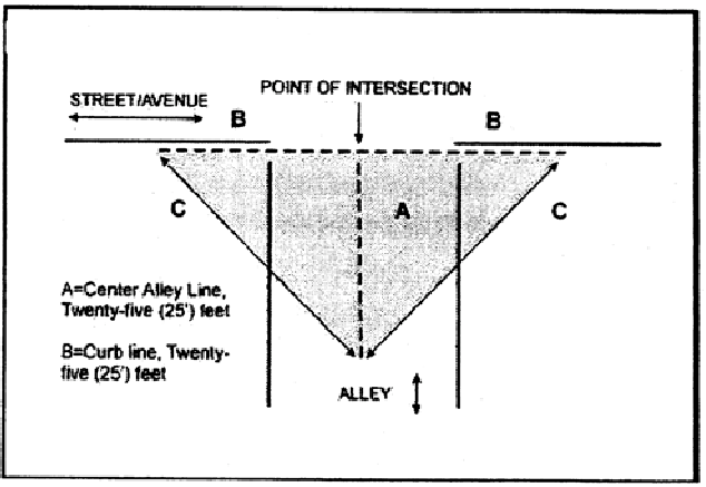
Site Distance Triangle Illustration
(f)
Accessory features and structures allowed within required setbacks and yards in all districts. The buildings or structures on a lot shall not be located in whole or in part within a required setback or yard in any zoning district, except in the case of certain features appurtenant to a principal structure or use. Table 78-21(f): Features Allowed within Required Setbacks and Yards, lists features that may be located within any required setbacks or yards, subject to specific limitations, which may include zoning district specific provisions, noted within the table and the following:
(1)
Public safety and circulation. Any features allowed within required setbacks and yards shall not interfere with safe use of the public street or sidewalk or otherwise interfere with public safety and circulation.
(2)
Landscaping. Landscape features (such as trees, walls, shrubs, fences, flowers, or other plants) shall not produce a hedge effect higher than four feet in any front setback or higher than seven feet in a required rear or side yard.
(3)
Table. Table 78-21(f): Features Allowed within Required Setbacks and Yards, lists features that may be located within any required setbacks or yards, subject to specific limitations, which may include zoning district specific provisions. [Formerly section 78-300.4(b)(3)]
(Ord. No. 17-O-13, 8-8-2017)