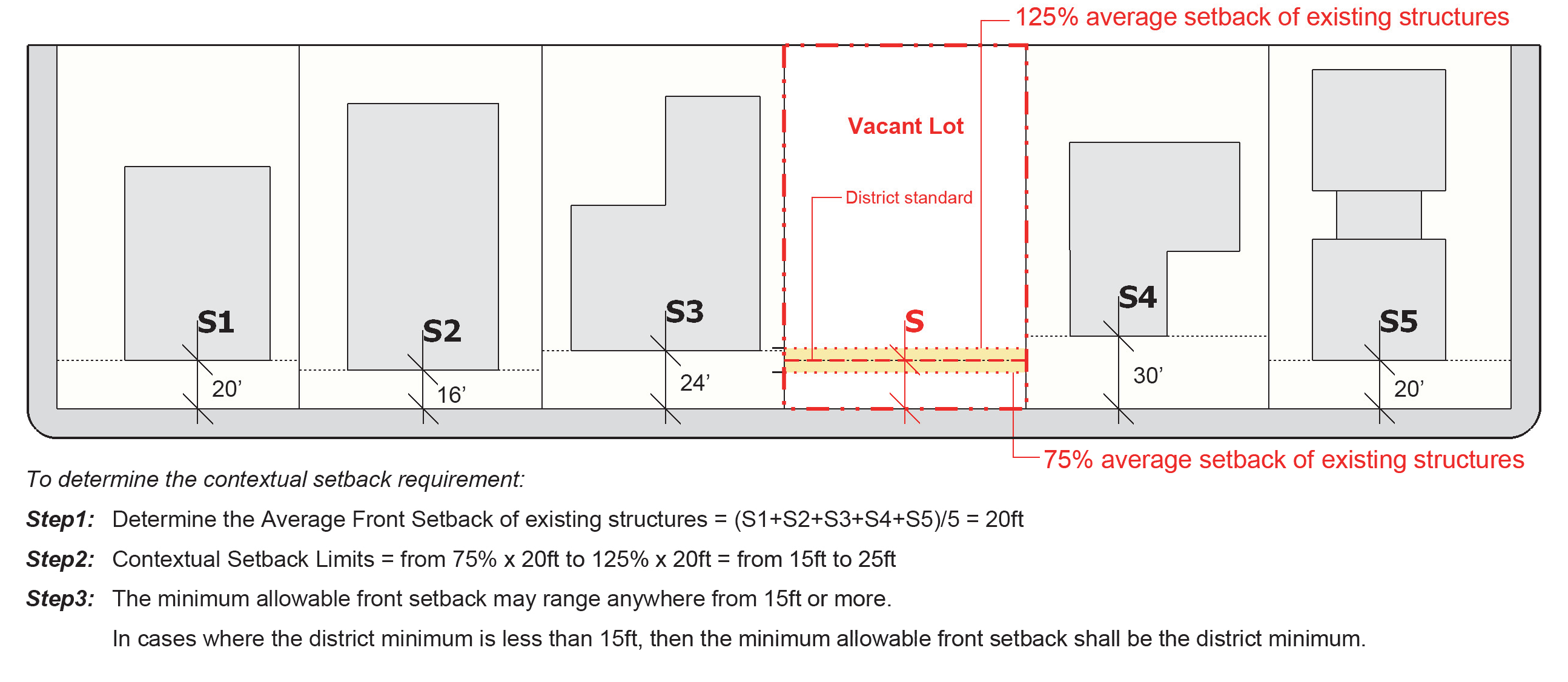
ABUTTING
|
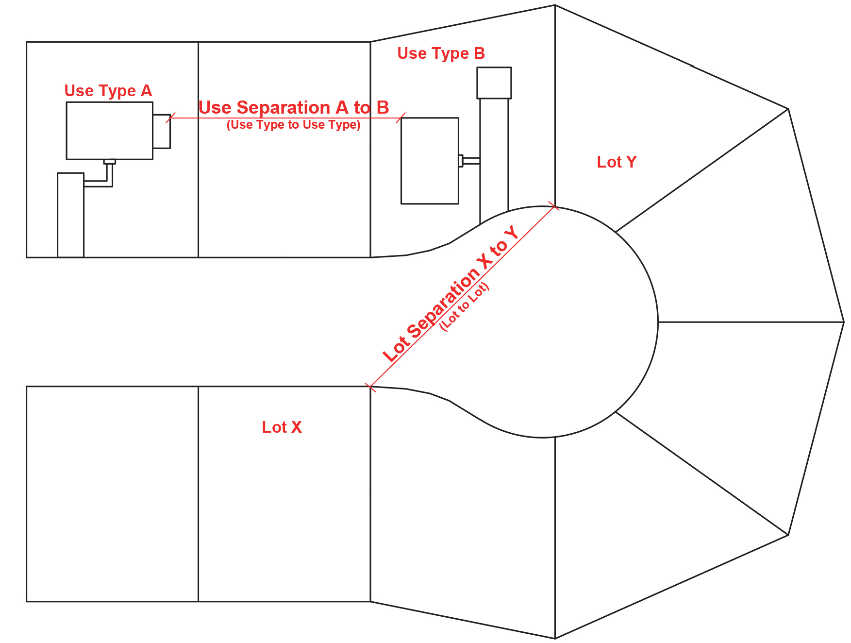
The condition of 2 parcels of land having a common property line or boundary, including
cases where 2 or more parcels of land adjoin at a corner, but not including cases
where parcels of land are separated by a street or alley.
|
ACCELERATED EROSION
|
Any increase over the rate of natural erosion as a result of land-disturbing activities.
|
ACCESS
|
The right or ability of pedestrians, vehicles, and boats to enter and leave property.
|
ACCESS EASEMENT
|
An easement which grants the right to cross land.
|
ACCESSORY BUILDING
|
A detached building, the use of which is incidental to that of the principal building
and which is located on the same lot as the principal building.
|
ACCESSORY DWELLING UNIT
|
A secondary dwelling unit established in conjunction with and clearly subordinate
to a principal dwelling unit, whether part of the same structure as the principal
dwelling unit, or as a detached structure on the same lot.
|
ACCESSORY STRUCTURE
|
A detached subordinate or incidental structure, the use of which is incidental to
the principal structure and which is located on the same lot as the principal structure.
|
ACCESSORY USE
|
A use that is incidental, appropriate, and subordinate to the principal use of land
or buildings and located on the same lot.
|
ACTIVE RECREATION AREA
|
Uses or structures intended for specific active recreational uses such as athletic
fields, playgrounds, swimming pools, courts, tracks walking trails, paths, porches,
and other similar uses typically located in open space areas or parks and served by
parking facilities, spectator areas, restroom facilities, and exterior lighting, where
appropriate.
|
ADDITION
|
An extension or increase in the floor area or height of a building or structure.
|
ADJACENT
|
A parcel of land or development that shares all or part of a common lot line or boundary
with another parcel of land, or a parcel of land that would abut another parcel of
land, but for the fact a street or right-of-way divides the parcels.
|
ADOPTED POLICY GUIDANCE
|
The combined future land-use policy guidance provided by the adopted comprehensive
plan and area plans prepared for specific parts of the City, and system plans related
to the City's infrastructure systems.
|
ADULT ENTERTAINMENT
|
The following definitions relate to adult entertainment uses:
|
|
a) Adult arcade (also known as "peep show")
|
A place to which the public is permitted or invited wherein coin-operated or slug-operated
or electronically, electrically, or mechanically controlled still or motion picture
machines, projectors, or other image-producing devices are maintained to show images
to persons in booths or viewing rooms where the images so displayed depict or describe
"specified sexual activities" or "specified anatomical areas.
|
|
b) Adult bookstore or adult video store
|
A commercial establishment which as 1 of its principal business purposes offers for
sale or rental for any form of consideration any one or more of the following:
1) books, magazines, periodicals or other printed matter, or photographs, films,
motion pictures, video cassettes or video reproductions, slides, or other visual representations
that depict or describe "specified sexual activities" or "specified anatomical areas";
or
2) instruments, devices, or paraphernalia that are designed for use in connection
with "specified sexual activities."
|
|
c) Adult cabaret
|
A nightclub, bar, restaurant, or other commercial establishment that regularly features,
exhibits or displays as one of its principal business purposes:
1) persons who appear nude or semi-nude; or
2) live performances which are characterized by the exposure of "specified anatomical
areas" or by "specified sexual activities"; or
3) films, motion pictures, videos, slides, or other photographic reproductions which
depict or describe "specified sexual activities "or" specified anatomical areas."
|
|
d) Adult motel
|
A hotel, motel or similar commercial establishment that:
1) offers accommodations to the public for any form of consideration; provides patrons
with closed-circuit television transmissions, films, motion pictures, videos, slides,
or other photographic reproductions that depict or describe "specified sexual activities"
or "specified anatomical areas" as one of its principal business purposes; or
2) offers a sleeping room for rent for a period of time that is less than 10 hours;
or
3) allows a tenant or occupant of a sleeping room to sub-rent the room for a period
of time that is less than 10 hours.
|
|
e) Adult motion picture theater
|
A commercial establishment where, for any form of consideration, films, motion pictures,
videos, slides, or similar photographic reproductions are regularly shown as one of
its principal business purposes that depict or describe "specified sexual activities
"or" specified anatomical areas."
|
|
f) Adult theater
|
A theater, concert hall, auditorium, or similar commercial establishment which regularly
features, exhibits or displays, as one of its principal business purposes, persons
who appear in a State of nudity or semi-nude, or live performances that expose or
depict "specified anatomical areas "or" specified sexual activities."
|
|
g) Escort
|
A person who, for tips or any other form of consideration, agrees or offers to act
as a date for another person, or who agrees or offers to privately model lingerie
or to privately perform a striptease for another person.
|
|
h) Escort agency
|
A person or business that furnishes, offers to furnish, or advertises to furnish escorts
as one of its principal business purposes, for a fee, tip, or other consideration.
|
|
i) Nude model studio
|
A place where a person who appears nude or semi-nude, or who displays "specified anatomical
areas" is provided to be observed, sketched, drawn, painted, sculptured, photographed,
or similarly depicted by other persons who pay money or any form of consideration
for such right. Nude Model Studio shall not include a proprietary school licensed
by the State of North Carolina or a college, junior college, or university supported
entirely or in part by public taxation; a private college or university which maintains
and operates educational programs in which credits are transferable to a college,
junior college, or university supported entirely or partly by taxation; or in a structure:
1) that has no sign visible from the exterior of the structure and no other advertising
that indicates a nude or semi-nude person is available for viewing; and
2) where in order to participate in a class a student must enroll at least 3 days
in advance of the class; and
3) where no more than 1 nude or semi-nude model is on the premises at any one time.
|
|
j) Nude or a State of nudity
|
1) the appearance of a human anus, male genitals, or female genitals; or
2) a State of dress which fails to opaquely cover a human anus, male genitals, or
female genitals.
|
|
k) Semi-nude
|
A State of dress in which clothing covers no more than the genitals, pubic region,
and areola of the female breast, as well as portions of the body covered by supporting
straps or devices.
|
|
l) Sexual encounter center
|
A business or commercial enterprise that, as one of its principal business purposes,
offers for any form of consideration physical contact in the form of wrestling or
tumbling between persons of the opposite sex, or activities between male and female
persons and/or persons of the same sex when one or more of the persons is in a State
of nudity or semi-nude.
|
|
m) Specified anatomical areas
|
Human genitals in a State of sexual arousal.
|
|
n) Specified sexual activities
|
Any of the following:
1) the fondling or other erotic touching of human genitals, pubic region, buttocks,
anus, or female breasts; or
2) sex acts, normal or perverted, actual or simulated, including intercourse, oral
copulation, or sodomy; or
3) masturbation, actual or simulated; or
4) excretory functions as part of or in connection with any of the activities set
forth in 1. through 3. above.
|
AFFECTED PARTY
|
Owners of land adjoining the land subject to an application and any other person who
could suffer an adverse effect to a property interest from a proposed development.
|
AGGRIEVED PARTY
|
A person, with a legally recognized interest (i.e., fee simple ownership) and standing
to appeal, that is injuriously affected by a decision from any decision-making body
of the City, including any officer or agent of the City.
|
ALLEY
|
A roadway set aside primarily for vehicular service access to the back or side of
lands otherwise abutting a street or open space.
|
ALTERNATIVE LANDSCAPE PLAN
|
A plan or other proposal to deviate from the basic landscaping or tree planting standards
in this Ordinance.
|
ALTERNATIVE PARKING PLAN
|
A plan or other proposal to utilize one or more of the alternative parking provisions
as a means of providing more off-street parking spaces than typically allowed, fewer
spaces than required, or alternative surfacing materials.
|
APPLICANT
|
A person who has submitted a development application for review under applicable provisions
of this Ordinance.
|
APPLICATION
|
The completed form or forms and all accompanying documents, exhibits, and fees required
of an applicant by the appropriate City department or board as part of the development
review processes.
|
ARBOR
|
A structure with an open roof system providing partial shading and which may also
have non-opaque fencing on the outside perimeter.
|
ARCADE
|
A series of arches supported by piers or columns.
|
ARCH
|
A curved, semicircular opening in a wall.
|
AREA OF SHALLOW FLOODING
|
A designated AO zone on the Flood Insurance Rate Map (FIRM) with base flood depths
from 1 to 3 feet where a clearly defined channel does not exist, the path of flooding
is unpredictable and indeterminate, and velocity flow may be evident.
|
AS-BUILT PLANS
|
A set of engineering or site drawings that delineate the specific permitted development
as actually constructed.
|
ASSESSED VALUE
|
The monetary price that a parcel of land, portion of land, improvement on land, or
other commodity assigned by property appraiser's office for the purposes of taxation.
|
AUTHORIZED AGENT
|
A person with express written consent to act upon another's behalf.
|
AWNING
|
An attached, framed structure typically covered by plastic, canvas, metal or other
material that projects from a building to provide protection from the weather. This
definition does not include a "canopy" which is defined elsewhere.
|
BASE FLOOD
|
The flood having a 1 percent chance of being equaled or exceeded in any given year.
|
BASE FLOOD ELEVATION
|
A determination of the water surface elevations of the base flood as published in
the flood insurance study. The base flood elevation, when combined with the "freeboard",
establishes the "regulatory flood protection elevation".
|
BASEMENT
|
An area of a building with a floor located below ground level on all sides.
|
BATTERY-CHARGED SECURITY FENCE
|
An alarm system and ancillary components, or equipment attached to that system, including
a fence, a battery-operated energizer that is intended to periodically deliver voltage
impulses to the fence, and a battery charging device used exclusively to charge the
battery.
|
BERM
|
An elongated earthen mound typically designed or constructed on a site to separate,
screen, or buffer adjacent uses.
|
BIO-RETENTION DEVICE
|
A stormwater infiltration device consisting of an excavated basin that is refilled
with engineered soil and mulch that allows stormwater run-off to collect and percolate
through the engineered soil where it is treated prior to infiltrating into the surrounding
undisturbed soil. Also known as a rain garden or bio-cell.
|
BLOCK
|
The land lying within an area bounded on all sides by streets.
|
BLOCK FACE
|
A specific side of a block referenced in relationship to the setback, bulk, height,
or uses on the block.
|
BLOCK LENGTH
|
The distance, measured along the right-of-way of each side of a street, between one
intersecting through street (not a cul-de-sac or loop street) and the next intersecting
through street.
|
BREAKAWAY WALL
|
A wall not part of the structural support of a building and intended to collapse under
specific lateral loading forces without causing damage to the elevated portion of
the building or the supporting foundation system.
|
BREWPUB
|
An eating and drinking establishment that produces less than 15,000 barrels of malt
beverage per year.
|
BORROW
|
Fill material which is required for on-site construction and is obtained from other
locations.
|
BUFFER
|
An area of natural or planted vegetation adjoining or surrounding a use and unoccupied
in its entirety by any building, structure, paving or portion of such use, for the
purposes of screening and softening the effects of the use, no part of which buffer
is used for recreation or parking.
|
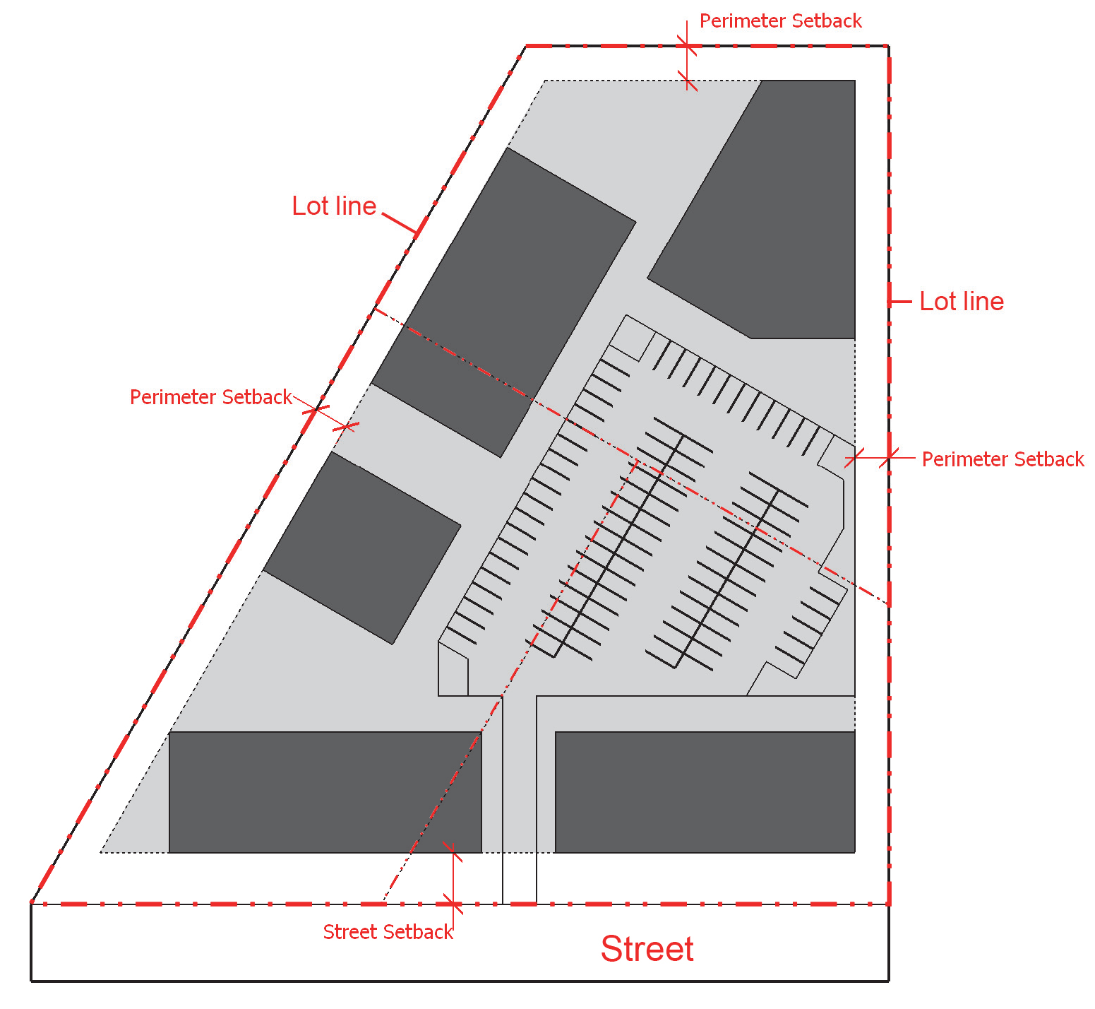
BUFFER, PERIMETER LANDSCAPING
|
Vegetative material and structures (i.e., walls, fences) that are used to separate
uses from each other as required by this Ordinance, including but not limited to the
Type A Opaque, Type B Semi-Opaque, Type C intermittent, and Type D Basic.
|
BUILDING
|
A structure having a roof supported by walls or columns constructed or used for residence,
business, industry, or other public or private purposes.
|
BUILDING ELEVATION
|
A fully dimensioned drawing of the exterior front, side or rear of a building showing
architectural features such as windows, doors and rooflines, and which may also contain
information regarding exterior materials, colors, and fixtures.
|
BUILDING MARKER
|
A sign indicating the name of a building and date and incidental information about
its construction, which sign is cut into a masonry surface or made of bronze or other
permanent material.
|
BUILDING MASS
|
The visual form of a building that includes the exterior walls, projections, recesses,
roof features, and any attachments.
|
BUILT-UPON AREA (BUA)
|
Impervious surface and partially impervious surface to the extent that the partially
impervious surface does not allow water to infiltrate through the surface and into
the subsoil. None of the following surfaces shall be considered BUA or an impervious
or partially impervious surface:
1) A slatted deck;
2) The water area of a swimming pool;
3) A surface of number 57 stone, as designated by the American Society for Testing
and Materials, laid at least four inches thick over a geotextile fabric;
4) A trail as defined in G.S. 113A-85 that is either unpaved or paved as long as
the pavement is porous with a hydraulic conductivity greater than 0.001 centimeters
per second (1.41 inches per hour);
5) Landscaping material, including, but not limited to, gravel, mulch, sand, and
vegetation, placed on areas that receive pedestrian or bicycle traffic or on portions
of driveways and parking areas that will not be compacted by the weight of a vehicle,
such as the area between sections of pavement that support the weight of a vehicle;
or
6) Artificial turf, manufactured to allow water to drain through the backing of
the turf, and installed according to the manufacturer's specifications over a pervious
surface.
|
BY RIGHT
|
Land uses that are permitted in a zoning district without requiring special use review.
|
CALIPER
|
Measurement for determining the size of trees at time of planting. Caliper is the
quantity in inches of the diameter of trees measured at 6 inches above the ground.
|
CANDELA
|
The candela is the base unit of luminous intensity in the International System of
Units; it is luminous power per unit solid angle emitted by a point light source in
a particular direction.
|
CANOPY
|
A rigid permanent structure attached to a building (building canopy) or freestanding
(freestanding canopy) for the purpose of providing shelter or as a decorative feature
on a building wall. A canopy is not an enclosed structure and the definition does
not include an "awning" which is defined elsewhere.
|
CANOPY TREE
|
A species of tree which normally grows to a mature height of 40 feet or more with
a minimum mature crown width of 30 feet.
|
CESSATION
|
Ending of the use of land, structure, operation, or activity, permanently or for a
period of time, as defined by this Ordinance.
|
CHANGE OF USE
|
The change in the use of a structure or land. Change of use includes a change from
one use type to another use type.
|
CHANNEL
|
A natural water-carrying trough cut vertically into low areas of the land surface
by erosive action of concentrated flowing water or a ditch or canal excavated for
the flow of water.
|
CHANNELIZATION
|
Any improvements or other construction activity which occurs within or in the vicinity
of an existing natural drainageway or perennial stream which directs or relocates
said waterway along some desired course, by increasing its depth or by the use of
piping or any other manmade storm drainage structures.
|
CITIZEN INFORMATION MEETING
|
A meeting conducted by an applicant on a proposed development before an application
for the development permit or approval is reviewed by the P & Z Commission.
|
CITY
|
The City of High Point, North Carolina.
|
CONDOMINIUM
|
A development containing individually owned dwelling units and jointly owned and shared
areas and facilities that is subject to the North Carolina Unit Ownership Act (North
Carolina General Statutes Section Ch. 47A) and/or the North Carolina Condominium Act
(North Carolina General Statutes Section Ch. 47C).
|
CONSERVATION SUBDIVISION
|
The division of a tract of land into 2 or more lots, building sites, or other divisions
along with additional land area set aside as open space for conservation and/or recreation
purposes.
|
CONSTRUCTION
|
The erection of any building or structure or any preparations (including land disturbing
activities) for the same.
|
CONTIGUOUS
|
Abutting directly or immediately adjacent to a boundary or separated only by a street,
railroad, or public utility right-of-way.
|
CORE CITY
|
The area subject to the Core City Plan provisions and delineated on the Official Zoning
Map.
|
CORNICE
|
Any horizontal member, structural or nonstructural, of any building, projecting outward
from the exterior walls at the roofline, including eaves and other roof overhang.
|
CROSS-ACCESS
|
Vehicular access provided between the vehicular use areas of 2 or more development
sites or parcels of land intended to allow travel between the sites without the use
of a public or private street.
|
CROSSWALK
|
A right-of-way dedicated to public use which cuts across a block to facilitate pedestrian
access to adjacent streets and properties.
|
CUL-DE-SAC STREET
|
A short local street having one end open to traffic and the other end permanently
terminated by a vehicular turnaround.
|
CUPOLA
|
A domelike structure on top of a roof or dome, often used as a lookout or to admit
light and air.
|
CUT-OUT LETTER LIGHTING
|
Lighting so arranged that only the outlines of letters, numerals, or symbols are illuminated
from an internal lighting source while the remainder of the sign is covered with nontransparent
materials that prevent illumination.
|
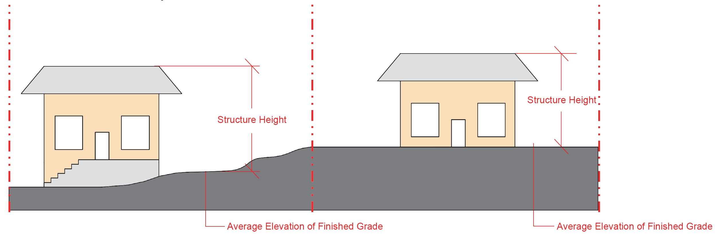
DECK
|
A structure, without a roof, directly adjacent to a principal building which has an
average elevation above finished grade.
|
DENSITY CREDIT
|
The potential for a portion of a development or subdivision, expressed in dwelling
units or other measures of intensity, that may be transferred to other portions of
the same lot, tract, or site that is part of a common development plan.
|
DETERMINATION
|
A final decision by a local jurisdiction's officer with the highest level of authority
to make the determination, including those with authority to hear appeals.
|
DEVELOPER
|
A person engaging in land, site, or building development.
|
DEVELOPMENT
|
Any manmade change to improved or unimproved real estate, including but not limited
to: buildings or other structures; mining; dredging; filling; grading; paving; excavation;
drilling operations; or storage of equipment or materials.
|
DEVELOPMENT PERMIT
|
The following administrative and quasi-judicial permits and approvals are defined
as development permits pursuant to State law: alternate design, certificate of appropriateness,
reasonable accommodation, special use, variance, building permit, final plat, floodplain
development permit, group development, land disturbance permit, preliminary plan,
public tree certificate, sign permit, site plan, wireless telecommunications permit,
and zoning compliance permit.
|
DIAMETER AT BREAST HEIGHT (DBH)
|
Measurement for determining the size of existing trees to be credited towards landscaping
requirements or for violations of this Ordinance. DBH is the measurement of the diameter
of an existing tree trunk taken at a height of 4 ½ feet above the ground. Trees with
multiple trunks should be treated as multiple trees and the DBH for each trunk added
to aggregate diameter measurement.
|
DISABLED MOTOR VEHICLE
|
A motor vehicle that meets one of more of the following criteria:
- It does not display a current license plate;
- It is partially dismantled or wrecked;
- It cannot be self-propelled or moved in the manner originally intended; or
- It is more than 4 years old and appears to be worth less than $500.00.
Nothing in this definition shall be construed to apply to any vehicle in an enclosed
building or vehicle on the premises of a business enterprise being operated in a lawful
place and manner and the vehicle being necessary to the operation of the business
enterprise, or to a vehicle in an appropriate storage place or depository maintained
in a lawful place and manner by the City.
|
DISCHARGE POINT
|
The point at which stormwater runoff leaves a tract of land.
|
DISPERSED FLOW
|
Uniform shallow water flow that is conveyed to a vegetated filter strip meeting the
State's device specific Minimum Design Criteria (MDC), another vegetated area, or
stormwater control measure. The purpose of dispersed flow is to remove pollutants
through infiltration and settling, as well as to reduce erosion prior to stormwater
reaching surface waters.
|
DITCH
|
A manmade, open drainageway into which surface water or groundwater from land, stormwater
runoff, or floodwaters flows either continuously or intermittently.
|
DRAINAGEWAY
|
A natural or manmade channel that carries surface runoff from precipitation.
|
DRAINAGE EASEMENT
|
An easement which grants the right to maintain, relocate, or, utilize land within
the easement for the improvement of drainage and stormwater flow.
|
DRIPLINE
|
A vertical line extending from the outermost portion of a tree's canopy to the ground.
|
DRIVEWAY
|
A private road or vehicular accessway providing access to parking areas, garages,
dwellings, drive-up windows, or other similar features.
|
DRIVE-THROUGH
|
A facility designed to enable a person to transact business while remaining in a motor
vehicle.
|
DWELLING
|
A structure or portion thereof that is used exclusively for human habitation.
|
DWELLING UNIT
|
One or more rooms, designed, occupied, or intended for occupancy as separate living
quarters, with cooking, sleeping, and sanitary facilities provided therein.
|
EASEMENT
|
A grant of 1 or more property rights by the property landowner to, or for use by,
the public, a corporation, or other entity.
|
EAVE
|
The projecting lower edges of a roof that overhangs the wall of a building.
|
EGRESS
|
An exit from a building or site.
|
ELEVATION
|
The front, side, or rear of a structure.
|
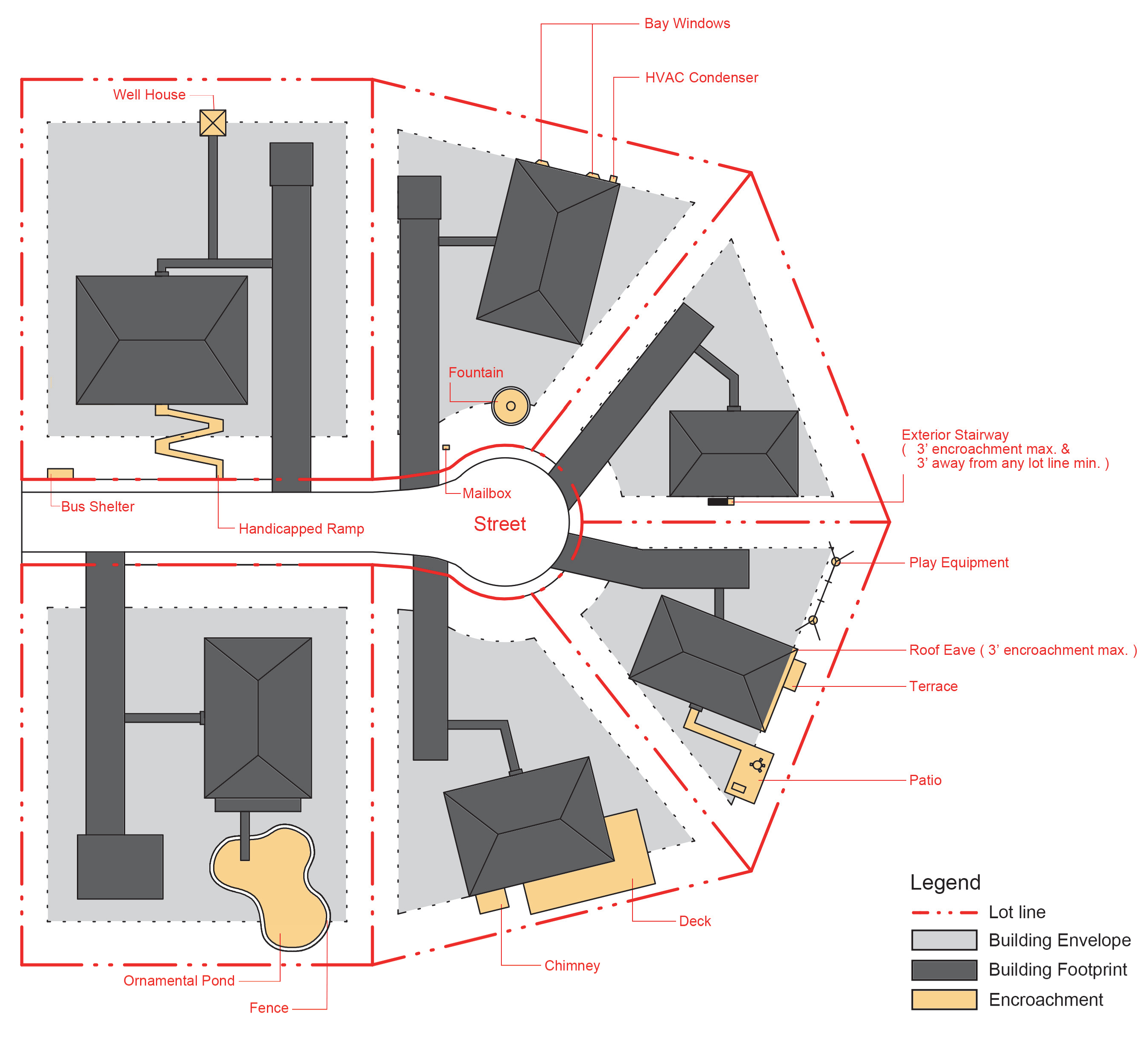
ENCROACHMENT
|
As used in the flood damage prevention standards, the advance or infringement of uses,
fill, excavation, buildings, structures or development into a special flood hazard
area, which may impede or alter the area's flooding flow capacity.
|
EPHEMERAL STREAM
|
A feature that carries only stormwater in direct response to precipitation with water
flowing only during and shortly after large precipitation events. An ephemeral stream
may or may not have a well-defined channel, the aquatic bed is always above the water
table and stormwater runoff is the primary source of water. An ephemeral stream typically
lacks the biological, hydrological and physical characteristics commonly associated
with the continuous or intermittent conveyance of water.
|
EROSION
|
The wearing away of land surface by the action of wind, water, gravity, or any combination
thereof.
|
EROSION CONTROL MEASURE
|
A device which controls the soil material within the land area under responsible control
of the person conducting a land-disturbing activity.
|
EXISTING DEVELOPMENT
|
Those projects that are built or those projects that have established a vested right
under North Carolina law or this Ordinance.
|
EXPANSION
|
An increase in the floor area of an existing structure or building, or the increase
of area of a use.
|
EXTENSIVE EROSION CONTROL MEASURE
|
Erosion control devices that are designed by a registered professional engineer, architect,
landscape architect, certified professional in erosion and sedimentation control (CPESC),
or a registered surveyor to the extent permitted by North Carolina laws.
|
FACADE
|
The entire exterior wall of a building facing a lot line measured from the grade to
the eave or highest point of a flat or mansard roof. Facades may be on the front,
side, or rear elevation of the building.
|
FAMILY
|
One or more persons occupying a dwelling unit and living as a single household unit.
|
FENCE
|
A physical barrier or enclosure consisting of wood, stone, brick, block, wire, metal,
or similar material used as a boundary or means of protection or confinement, but
not including a hedge or vegetation.
|
FINANCIAL GUARANTEE
|
Cash or other guarantee provided by an applicant in-lieu of completion of public infrastructure
or installation of required private site features prior to issuance of a building
permit or other development approval.
|
FLAG
|
A sign mounted to a pole made of non-rigid cloth or canvas or other material with
no enclosing or supporting framework.
|
FLOOD OR FLOODING
|
A general and temporary condition of partial or complete inundation of normally dry
land areas from the overflow of inland waters or the unusual and rapid accumulation
of runoff of surface waters from any source.
|
FLOOD INSURANCE
|
The insurance coverage provided under the National Flood Insurance Program.
|
FLOOD INSURANCE RATE MAP (FIRM)
|
The official map issued by the Federal Emergency Management Agency (FEMA) that depicts
special flood hazard areas and risk premium zones applicable in the City.
|
FLOOD INSURANCE STUDY (FIS)
|
An examination, evaluation, and determination of flood hazards, corresponding water
surface elevations (if appropriate), flood hazard risk zones, and other flood data
in a community issued by the Federal Emergency Management Agency (FEMA). The flood
insurance study report includes flood insurance rate maps (FIRMs) and flood boundary
and floodway maps (FBFMs), if published.
|
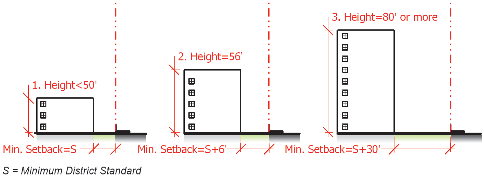
FLOOD PROTECTION ELEVATION
|
The elevation to which structures and uses regulated by Section 6.4, Flood Damage Prevention, are required to be elevated or flood proofed.
|
FLOODPROOFING
|
Any combination of structural and nonstructural additions, changes or adjustments
to structures which reduce or eliminate flood damage to land or development.
|
FLOODWAY
|
The channel of a river or other watercourse and the adjacent land areas that must
be reserved in order to discharge the base flood without cumulatively increasing the
water surface elevation more than 1 foot.
|
FLOODWAY FRINGE
|
The land located between the floodway and maximum elevation subject to inundation
by the base flood.
|
FLOOD ZONE
|
A geographical area on the Flood Hazard Boundary Map or Flood Insurance Rate Map that
reflects the severity or type of flooding in the area.
|
FLOOR
|
As used in the flood damage prevention standards, the top surface of an enclosed area
in a building (including the basement), such as the top of the slab in concrete slab
construction or the top of the wood flooring in wood frame construction.
|
FOOTCANDLE
|
A unit of measure of the intensity of light falling on a surface. It is often defined
as the amount of illumination the inside surface of a 1-foot-radius sphere would be
receiving if there were a uniform point source of 1 candela in the exact center of
the sphere. 1 footcandle is equal to 1 lumen per square foot.
|
FREEBOARD
|
The height added to the BFE to account for unknown factors that could contribute to
flood heights greater than the height calculated for a selected size flood and floodway
conditions, such as wave action, blockage of bridge openings, and the hydrological
effect of urbanization of the watershed.
|
FRONT FACADE
|
The side or elevation of a structure that contains the structure's architectural front,
or the portion of the structure facing the street from which the structure derives
its street address.
|
GABLE
|
A triangular area of an exterior wall formed by 2 sloping roofs.
|
GLARE
|
The effect produced within the visual field by a high intensity or insufficiently
shielded light source that is significantly brighter than the level to which the eyes
are adapted, causing annoyance, discomfort, or loss of visual performance or visibility
of objects.
|
GLAZING
|
The portion of an exterior building surface occupied by glass or windows.
|
GOVERNING BODY
|
The City Council for the City of High Point.
|
GRADING
|
Excavating, filling (including hydraulic fill) or stockpiling of earth material, or
any combination thereof, including the land in its excavated or filled condition.
|
GREEN ROOF
|
The roof of a building that is partially or completely covered with vegetation and
a growing medium, planted over a waterproofing membrane. It may also include additional
layers such as a root barrier and drainage and irrigation systems.
|
GREENWAY
|
Public open space under the control and maintenance of the City which has been designated
on an officially adopted greenway or open space plan and developed in accordance with
the adopted greenway or open space plan.
|
GROUND COVER
|
Any vegetation, masonry, paving, rip-rap, or other material or materials which render
the soil surface stable against accelerated erosion.
|
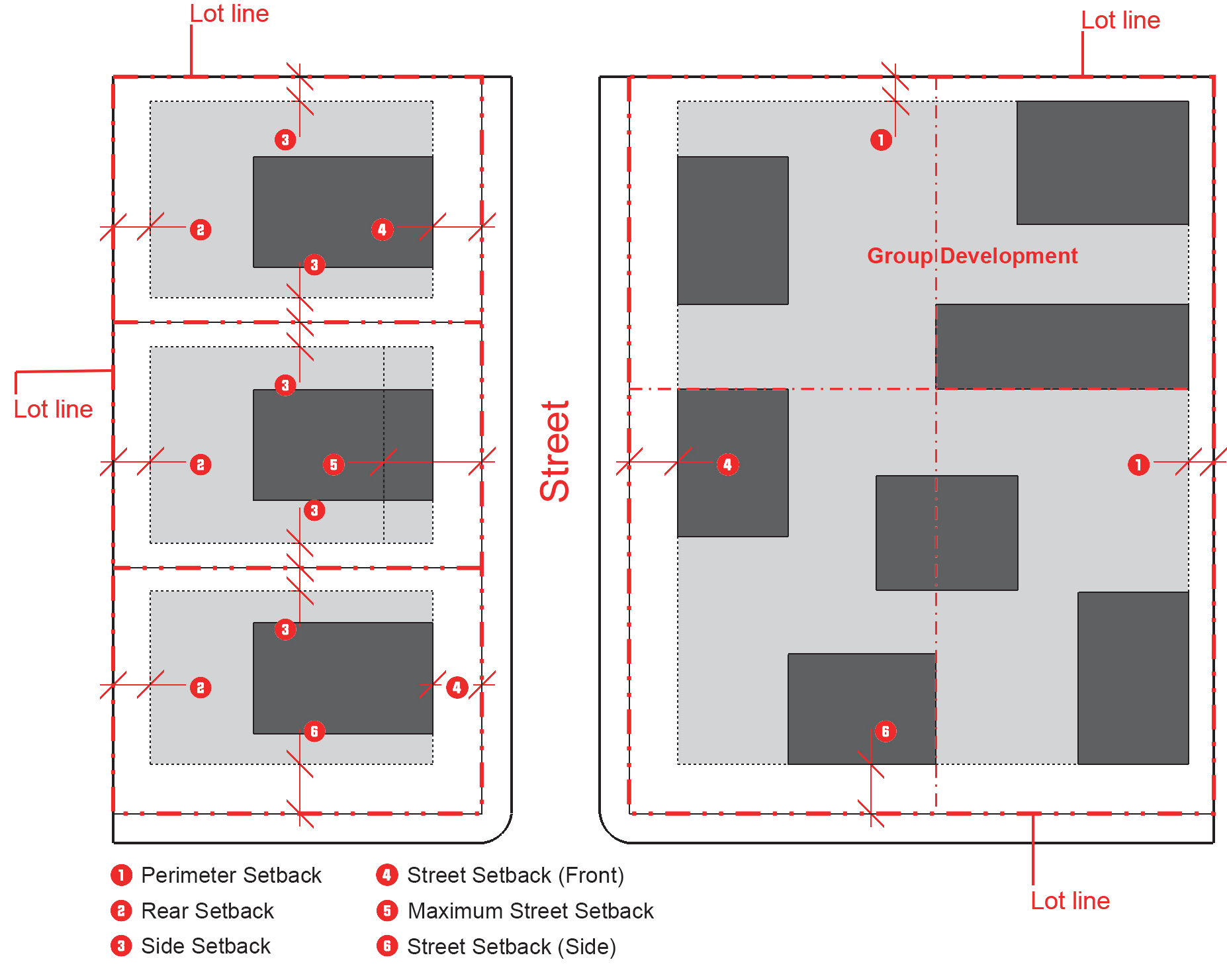
GROUP DEVELOPMENT
|
A development in which, in-lieu of the division of a tract of land into separate lots
for separate principal buildings, a tract of land is divided into 2 or more principal
building sites for the purpose of building development (whether immediate or future)
and occupancy by separate families, firms, businesses, or other enterprises.
|
HEARING, QUASI-JUDICIAL
|
A formal hearing involving the legal rights of specific parties conducted by the City
Council, the Board of Adjustment or the Historic Preservation Commission based on
evidence and sworn testimony presented during the public hearing. Decisions made during
such hearings are based upon and supported by the record developed at the hearing,
and typically involve findings of fact made by the decision-making body.
|
HISTORIC STRUCTURE
|
Any structure that is: 1) listed individually in the National Register of Historic
Places (a listing maintained by the US Department of Interior) or preliminarily determined
by the Secretary of Interior as meeting the requirements for individual listing on
the National Register; 2) certified or preliminarily determined by the Secretary of
Interior as contributing to the historical significance of a registered historic district
or a district preliminarily determined by the Secretary to qualify as a registered
historic district; 3) individually listed on a state inventory of historic places;
4) individually listed on a local inventory of historic places in communities with
a Certified Local Government (CLG) Program; or 5) certified as contributing to the
historic significance of a historic district designated by a community with a Certified
Local Government (CLG) Program. Certified Local Government Programs are approved by
the US Department of the Interior in cooperation with the North Carolina Department
of Cultural Resources through the State Historic Preservation Officer as having met
the requirements of the National Historic Preservation Act of 1966, as amended.
|
HOME OCCUPATION
|
Any activity carried out for gain by a resident and conducted in the resident's dwelling
unit.
|
HUMAN SCALE
|
Features of a building or built environment that are sized and configured in accordance
with the typical human frame. Human-scale details and features are most often configured
for observation and recognition by people who are walking.
|
ILLUMINATION, DIRECT
|
Illumination from a light source that is contained within the sign, where the light
source is internal to the sign.
|
ILLUMINATION, INDIRECT
|
Illumination from a light source that is not contained within the sign, where the
light source is external and projected onto the sign.
|
IMPROVED WALKWAY
|
An improved walkway is a walkway dedicated to pedestrian access that has a width of
at least four feet and includes a paved, all-weather surface (excluding gravel or
cinders) that is graded and configured to ensure safe pedestrian movement.
|
IMPROVEMENT
|
The construction of buildings and the establishment of basic services and amenities
associated with development, including, but not limited to streets and sidewalks,
parking areas, water and sewer systems, drainage system, property markers and monuments,
recreation facilities (i.e., lakes, swimming pools, tennis courts, golf courses, riding
stables, club houses, cabanas, marinas, docks and the like) and other similar construction
or establishment.
|
INFILL
|
Development, redevelopment, and re-use of existing sites and buildings in the City's
existing neighborhoods and commercial corridors.
|
INGRESS
|
Access or entry to a building or site.
|
INTERMITTENT STREAM
|
A well-defined channel that contains water for only part of the year, typically during
winter and spring when the aquatic bed is below the water table. The flow may be heavily
supplemented by storm water runoff. An intermittent stream often lacks the biological
and hydrological characteristics commonly associated with the continuous conveyance
of water.
|
JUST CAUSE
|
Legitimate cause; legal or lawful ground for action.
|
LAND, UNDEVELOPED
|
Land is considered to be undeveloped when it is in its natural state, or when prior
evidence of development such as buildings, other structures and vehicular use areas
have been removed or substantially removed.
|
LAND, VACANT
|
Land is considered to be vacant when evidence of development exists such as buildings,
other structures and vehicular use areas, but no occupancy or active use of the land
exists.
|
LAND CLEARING AND INERT DEBRIS (LCID) LANDFILL
|
A landfill limited to concrete, brick, concrete block, uncontaminated soil, rock,
gravel, untreated wood, limbs, leaves and stumps. LCID does not include materials
that have been painted or coated with sealants or finishes.
|
LAND DISTURBING ACTIVITY
|
Any use of the land, manually or mechanically, that results in a change in the natural
cover or topography and that may cause or contribute to sedimentation, including but
not limited to any modification of existing grade by dredging, demolition, excavation
or fill, grading, scraping, vegetation removal, landscaping, coring, well drilling,
pile driving, undergrounding utility lines, trenching, bulldozing, sheeting, shoring
and excavation for laying or removing foundations, pilings or other purposes.
|
LAND USE INTENSITY
|
A numeric value denoting the intensity of an individual use type for the purposes
of determining applicable perimeter landscape yard requirements.
|
LANDOWNER
|
As applied to the standards related to vested rights, an owner of a legal or equitable
interest in real property, including the heirs, devisees, successors, assigns, and
personal representative of the owner.
|
LANDSCAPING
|
The improvement of a lot, parcel or tract of land with grass, shrubs, and trees. Landscaping
may include pedestrian walks, flower beds, ornamental objects such as fountains, statuary,
and objects designed and arranged to produce an aesthetically pleasing effect.
|
LANDSCAPING STRIP, PERIMETER
|
Vegetative material associated with the perimeter landscaping required for a vehicular
use area.
|
LARGE VEHICLE
|
A vehicle with a gross vehicle weight of 14,000 or more pounds, a recreational vehicle,
or a school or church bus.
|
LIGHTING, FULL CUT-OFF FIXTURE OR LENS
|
A light fixture or lens constructed and installed that projects all of its light in
a downward direction.
|
LIGHTING, SEMI-CUT-OFF FIXTURE
|
A light fixture constructed and installed that emits none of its light above the horizontal
plane of the fixture (90 degrees) and no more than 10 percent of its emitted light
between 80 degrees and 90 degrees. Often referred to as a shielded fixture.
|
LOADING SPACE
|
Space logically and conveniently located for bulk pickups and deliveries, scaled to
delivery vehicles, and not considered as part of the minimum required off-street surface
parking.
|
LOCAL GOVERNMENT
|
Any county, incorporated municipality, or any combination of counties and/or incorporated
municipalities acting through a joint program pursuant to the provisions of this Ordinance.
|
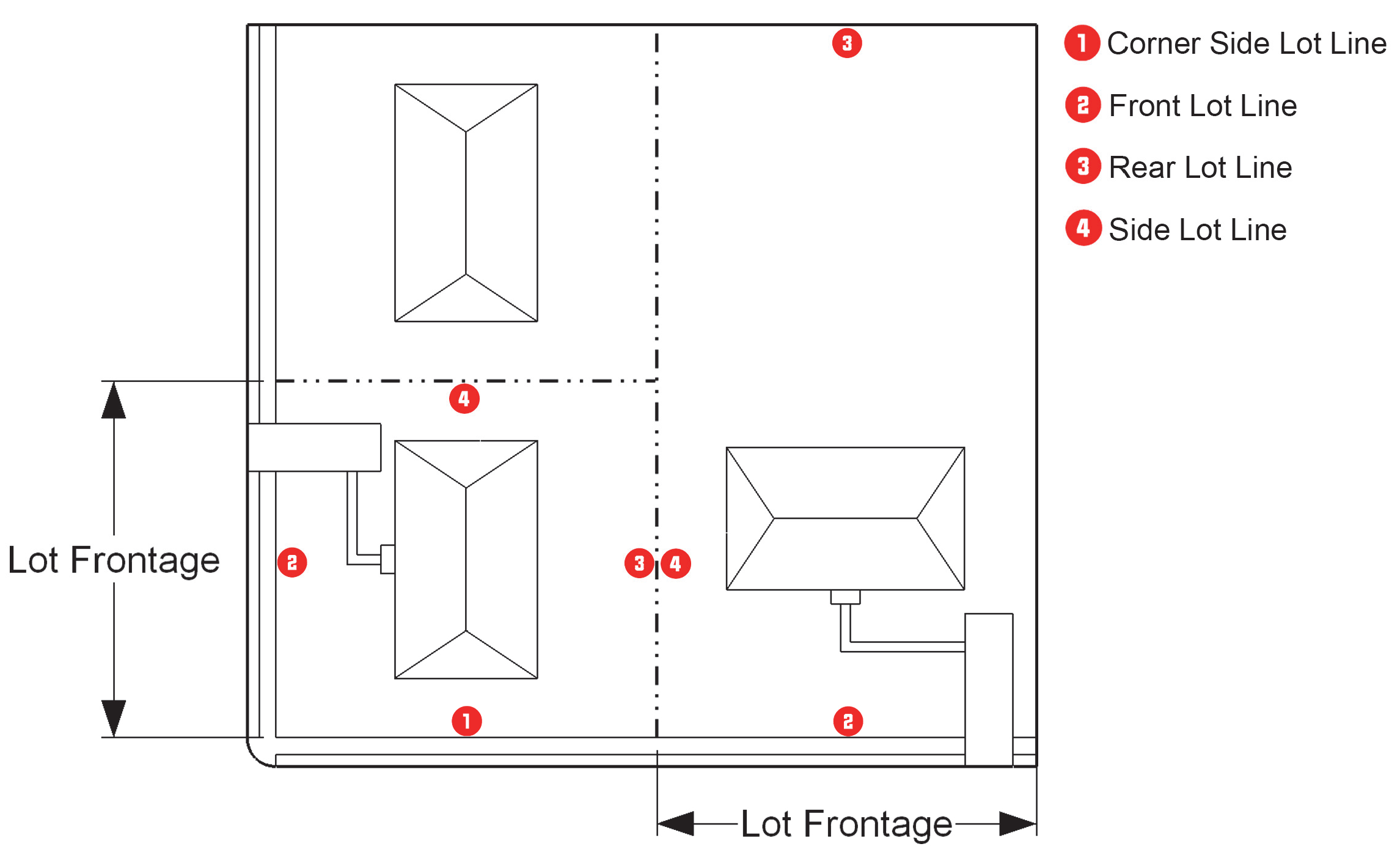
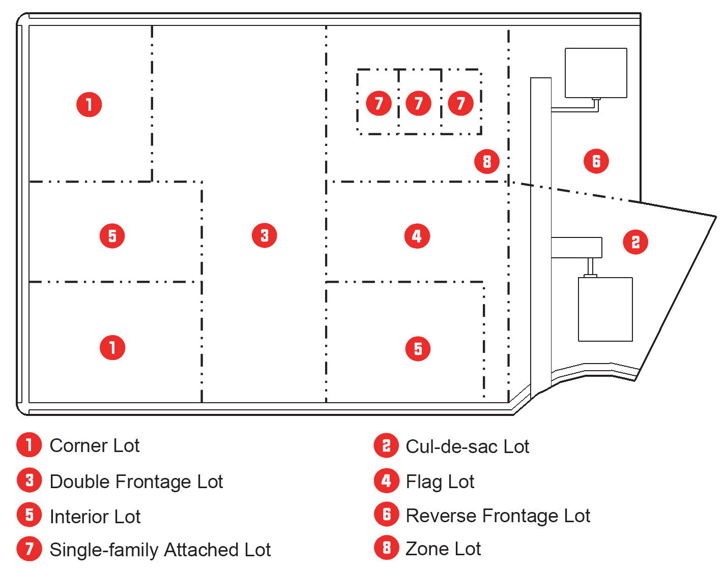
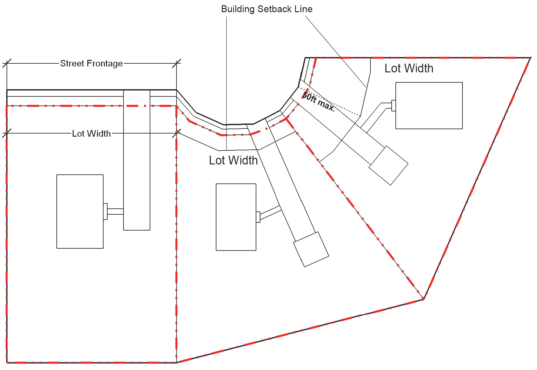
LOT
|
A legally described piece of contiguous land that has been or may be developed as
a unit. This term is synonymous with "parcel."
|
LOT OF RECORD
|
A lot that has been recorded in the office of the County Register of Deeds and which
was in conformance with the Development Ordinance in effect at the time of recording.
|
LOWEST FLOOR
|
As used in the flood damage prevention standards, the lowest floor of the lowest enclosed
area (including basement) that is typically an unfinished or flood resistant enclosure
that does not include habitable space.
|
LUMEN
|
A quantitative unit measuring the amount of light emitted by a light source.
|
MAINTENANCE GUARANTEE
|
Cash or other guarantee provided by an applicant to ensure public infrastructure functions
as intended following acceptance by the City.
|
MAJOR WATERSHED VARIANCE
|
A variance from the minimum statewide watershed protection rules that results in the
relaxation of any buffer, density, built-upon area or minimum lot size requirement
by a factor greater than 5 percent under the high density option; the relaxation of
any buffer, density, built-upon area or minimum lot size requirement by a factor greater
than 10 percent under the low density option; any variance that pertains to activities
proposed to impact greater than one-third of an acre of a surface water buffer; or
any variation in the design, maintenance or operation requirements of an approved
stormwater control measure.
|
MANSARD ROOF
|
A sloped roof or roof-like facade architecturally comparable to a building wall.
|
MARQUEE
|
A permanent roof-like structure projecting beyond the facade of a building, such as
a theater, generally located at the building's primary entrance designed to provide
protection from the weather upon which messages are placed.
|
MAXIMUM EXTENT PRACTICABLE
|
No feasible or practical alternative exists, as determined by the City, and all possible
efforts to comply with the standards or regulation to minimize potential harmful or
adverse impacts have been undertaken by an applicant. Economic considerations may
be taken into account but shall not be the overriding factor determining "maximum
extent practicable."
|
MEAN SEA LEVEL
|
The National Geodetic Vertical Datum (NGVD) as corrected in 1929, the North American
Vertical Datum (NAVD) as corrected in 1988, or other vertical control datum used as
a reference for establishing varying elevations within the floodplain, to which base
flood elevations on the FIRM are referenced.
|
MEMBRANE STRUCTURE
|
A structure, building, or tent composed of a membrane material, such as canvas, plastic,
or other fabrics, that is supported by a rigid framework of metal, plastic, or other
material.
|
MINOR WATERSHED VARIANCE
|
A variance from the minimum statewide watershed protection rules that results in the
relaxation of any buffer, density, built-upon area or minimum lot size requirement
by a factor of up to 5 percent under the high density option; or relaxation of any
buffer, density, built-upon area or minimum lot size requirement by a factor up to
10 percent under the low density option; or any variance that pertains to activities
proposed to impact less than one-third of an acre of a surface water buffer.
|
MIXED-USE DEVELOPMENT
|
A tract of land or structure developed for 2 or more different uses, such as, but
not limited to, residential, office, retail, institutional, public, or entertainment.
Such uses are functionally integrated and share vehicular use areas, ingress/egress,
and pedestrian access.
|
MOTOR VEHICLE
|
A vehicle required by the North Carolina Department of Motor Vehicles to be registered
under North Carolina State Law.
|
MULTIPLE LOT DEVELOPMENT
|
A development containing 2 or more lots, and 2 or more businesses that is planned,
organized, and managed to function as a single development or single zone lot for
the purposes of development standards.
|
MULTI-TENANT BUILDING
|
A building that is used for two or more occupancies provided each occupancy is separated
by construction having fire-resistive ratings in compliance with the NC State Building
Code.
|
NATURAL INFILTRATION AREAS
|
A type of stormwater management device that relies on vegetation, soil, or other natural
matrix configured to allow stormwater runoff to enter, filter, and be re-released
with fewer pollutants.
|
NEW CONSTRUCTION
|
As used in the flood damage prevention standards, structures for which the start of
construction commenced on or after the effective date of the flood damage prevention
standards.
|
NIT
|
A unit of luminance equal to 1 candela per square meter (cd/m2), measured perpendicular
to the rays of the source.
|
NON-ENCROACH-
MENT AREA
|
The channel of a river or other watercourse and the adjacent land areas that must
be reserved in order to discharge the base flood without cumulatively increasing the
water surface elevation more than 1 foot as designated in the Flood Insurance Study
report.
|
NONCONFORMING LOT
|
A lot of record that that was lawful at the date on which it was established, but
does not conform to the current dimensional standards of the zoning district in which
it is located.
|
NONCONFORMING SIGN
|
Any sign that was lawful at the date on which it was established, but does not meet
the standards of this Ordinance.
|
NONCONFORMING STRUCTURE
|
A structure that was lawful at the date on which it was established, but does not
conform to current dimensional standards, elevation, location, or other requirements
of this Ordinance.
|
NONCONFORMING USE
|
A use which was lawful at the date on which it was established, but is now not a permitted
use of that parcel or structure under this Ordinance.
|
NONCONFORMITY
|
Any land use, development, structure, or site, including any lot of record, that was
legally established, but that is not presently in full compliance with the provisions
of this Ordinance.
|
NON-OCCUPIABLE SPACE
|
A room or enclosed space, that is not used for living, sleeping, eating or cooking,
and that is not designed for human occupancy or used for such activities as rest,
amusement, treatment, education, dining, shopping, employment, labor, assembly or
other similar purposes. Examples of non-occupiable space are closets, toilet rooms,
mechanical equipment rooms and storage rooms.
|
NORTH CAROLINA SEDIMENTATION POLLUTION CONTROL ACT
|
North Carolina General Statutes Section 113A-50 et seq., and all rules and orders
adopted pursuant to it.
|
NOTICE OF VIOLATION
|
A notice indicating a violation of this Ordinance not associated with a fine.
|
OFFICIAL ZONING MAP
|
The Official Zoning Map upon which the boundaries of various zoning districts are
drawn and which is an integral part of this Ordinance.
|
OPACITY
|
A measurement indicating the degree of obscuration of light or visibility.
|
OPEN SPACE
|
An area of land or water intended to provide light, air, amenity, recreation and/or
resource protection set aside in some permanent manner for public or private use and
enjoyment. Open space includes, but is not limited to, preserves, parks, passive and
active recreation areas, floodplains, plazas, squares, greenways, and waterbodies.
|
ORDINANCE
|
A legislative enactment of the City of High Point, North Carolina.
|
OUTDOOR DISPLAY
|
The placement of any goods, merchandise or vehicles outside an enclosed building for
exhibition, sale or rent, typically in an area accessible by the public.
|
OUTDOOR STORAGE
|
The keeping of any goods, material, merchandise or vehicles outside an enclosed building
for a period of time exceeding 24 hours, typically in an area inaccessible by the
public.
|
OUTPARCEL
|
A subdivided or leased parcel within a group development, multiple-lot development,
or shopping center.
|
OWNERS' ASSOCIATION
|
An organization of homeowners or property owners of lots or land in a particular subdivision,
condominium, or planned development. The owners association is responsible for maintaining
and enhancing the shared private infrastructure (e.g., stormwater, streets, and sidewalks)
and common elements recreation.
|
PARAPET
|
A building facade that rises above the roof level, typically obscuring a gable or
flat roof as well as any roof-mounted equipment.
|
PARCEL
|
See "Lot."
|
PARKING LOT DRIVE AISLE
|
A vehicular accessway located within an off-street parking or vehicular use area which
serves individual parking stalls and driveways.
|
PARKING SPACE, OFF-STREET
|
A space that is designated for the parking or temporary storage of 1 motor vehicle
located outside of a dedicated street right-of-way, vehicular travel way, or parking
aisle.
|
PARKING, OFF-SITE
|
An off-street parking area provided on a different parcel than the use it is intended
to serve.
|
PARKING, ON-STREET
|
A location or area within the right-of-way of a public or private street that is reserved
for the parking of vehicles. Such areas may or may not be formally designated with
signage, striping, or parking meters.
|
PARKING, SHARED
|
Off-street parking facilities shared by 2 or more uses that are in close proximity
to one another and the parking area, and that have different operational characteristics
such that use of the parking facilities by one use will not generally overlap with
the use of the parking area by the other use(s).
|
PASSIVE RECREATION AREA
|
Open space areas designated for passive recreation uses including walking trails,
pathways, gazebos, picnic areas, fountains, plazas, and similar areas. Such areas
may also include undisturbed natural vegetation.
|
PATIO
|
An area, usually paved, adjoining a building - used as an area for outdoor lounging,
dining, or gathering.
|
PEDESTRIAN AMENITY
|
Seating, outdoor play areas, bicycle racks, kiosks, water features, public art, freestanding
structures such as a clock tower or similar amenities, intended primarily for use
by pedestrians.
|
PEDESTRIAN CONNECTION
|
Interconnected paved walkway that provides a pedestrian passage through blocks running
from street to street, vehicular use areas, or other locations.
|
PEDESTRIAN-
ORIENTATION
|
Development elements, such as density, building placement, street and path connections,
and mixture of uses designed with pedestrians in mind and intended to encourage and
promote pedestrian activity.
|
PENNANT
|
A lightweight plastic, fabric, or other material, whether or not containing a message
of any kind, suspended from a rope, wire, or string, usually in series, designed to
move in the wind.
|
PERENNIAL STREAM
|
A well-defined channel that contains water year-round during a year of normal rainfall
with the aquatic bed located below the water table for most of the year. Groundwater
is the primary source of water for a perennial stream, but it also carries stormwater
runoff. A perennial stream exhibits the typical biological, hydrological and physical
characteristics commonly associated with the continuous conveyance of water.
|
PERSON
|
Any individual, partnership, firm, association, joint venture, public or private corporation,
trust, estate, commission, board, or public or private institution, utility, cooperative,
interstate body, or other legal entity.
|
PILASTER
|
A rectangular column with a capital and base that is attached or affixed to a wall
as an ornamental design feature.
|
PLANNED DEVELOPMENT
|
An area of land under unified ownership or control to be developed and improved as
a single entity under a Planned Development Master Plan in accordance with this Ordinance.
|
PLANTING SEASON
|
The dormant time of the year for trees beginning with leaf drop and ending with bud
break; generally late fall to early spring.
|
PLANTING STRIP
|
An area usually within or adjacent to a right-of-way or lot line that contains required
vegetation.
|
PLAT
|
A surveyed map or plan for a parcel of land which is to be, or has been, subdivided.
|
PLAZA
|
An open space at the intersection of important streets or adjacent to important structures,
set aside for civic purposes and commercial activity, which may include parking, consisting
of durable pavement, and formal landscaping or tree plantings.
|
PORCH
|
A covered projection (can be glazed or screened) from the main wall of a building,
with a separate roof, that is not used for livable space.
|
PORTICO
|
A large porch usually with a pediment usually associated with an entrance, supported
by columns.
|
POST-FIRM
|
Construction or other development for which the "start of construction" occurred on
or after the effective date of the initial Flood Insurance Rate Map.
|
PRE-FIRM
|
Construction or other development for which the "start of construction" occurred before
the effective date of the initial Flood Insurance Rate Map.
|
PRIMARY DRIVE AISLE
|
The main aisle(s) that extends from the street right-of-way, or from the driveway
entrance(s) serving a development along the front of the building it serves.
|
PRIMARY ENTRANCE
|
The place of ingress and egress to a building, parcel, or development used most frequently
by the public.
|
PRIMARY STORMWATER CONTROL MEASURE
|
Means a wet pond, stormwater wetland, infiltration system, sand filter, bioretention
cell, permeable pavement, green roof, rainwater harvesting, or an approved new stormwater
technology that is designed, constructed and maintained in accordance with the State's
Minimum Design Criteria (MDC).
|
PRINCIPAL BUILDING
|
A building in which is conducted the principal use(s) of the lot on which it is located
or, in a group development, of the building site on which it is located. Any dwelling
is considered a principal building unless it is an accessory dwelling.
|
PRINCIPAL BUILDING FACADE
|
The entire exterior wall of a building facing a lot line measured from the grade to
the eave or the highest point of a flat or mansard roof. The principal building facade
is the front of the building, or the side that contains the primary building entrance.
|
PRINCIPAL BUILDING LINE
|
A line or horizontal plane that is measured from the portion of the building closest
to the lot line laterally along the lot line.
|
PRINCIPAL DWELLING
|
Any principal building or structure which is used and designed for human habitation
including living, sleeping, cooking, and eating activities, excluding dormitories,
hotels, motels, shelters for the homeless, or other structures designed for transient
residents.
|
PRINCIPAL USE
|
A primary or predominate use of a lot or parcel.
|
PRINCIPAL STRUCTURE
|
A structure in which is conducted the principal use(s) of the lot on which it is located.
|
PRIVATE DRIVE
|
A vehicular travelway that is not a public street or a private street that provides
access to a parking lot(s) or a principal building(s).
|
PRIVATE STREET
|
A vehicular travelway not dedicated or offered for dedication as a public street but
resembling a local street by carrying traffic from a series of driveways to the public
street system.
|
PROJECTING BAY
|
A space projecting outward from the main walls of a building and forming a bay in
a room, often incorporating a window.
|
PROPERTY OWNER
|
See "Landowner."
|
PUBLIC INFRASTRUCTURE
|
Aspects of the public realm owned and maintained by the City or the State that serve
the public at large, including streets, highways, sidewalks, curb and gutter, potable
water distribution systems, sanitary sewer systems, stormwater drainage retention
and conveyance features, street lights, on-street parking spaces, and similar aspects
located within a public right-of-way or public easement.
|
PUBLIC STREET
|
A dedicated and accepted public right-of-way for vehicular traffic and street rights-of-way
offered for dedication, but not yet accepted, in which the roadway design and construction
have been approved under public standards for vehicular traffic.
|
PUBLIC TREE
|
A tree in the public street right-of-way, in a park, or other areas owned or controlled
by the City.
|
QUORUM
|
The minimum number of board or commission members that must be present in order to
conduct official business or take official action.
|
RAIN GARDEN
|
A planted depression that allows rainwater runoff from impervious urban areas like
roofs, driveways, walkways, parking lots, and compacted lawn areas the opportunity
to be collected in a single location and absorbed.
|
RECREATIONAL VEHICLE
|
A vehicular type unit primarily designed as temporary living quarters for recreational,
camping or travel use that either has its own motive power or is mounted on, or towed
by, another vehicle. The basic entities are camping trailer, fifth-wheel travel trailer,
motor home, travel trailer, and truck camper. This term does not include a manufactured
dwelling.
|
REFERENCE LEVEL
|
The top of the lowest floor for structures within special flood hazard areas designated
as zone A1-A30, AE, A, A99 or AO.
|
REGULATORY FLOODPLAIN ELEVATION
|
The base flood elevation plus the freeboard. In special flood hazard areas where BFEs
have been determined, this elevation is the BFE plus 2 feet of freeboard. In special
flood hazard areas where no BFE has been established, this elevation is at least 2
feet above the highest adjacent grade.
|
RESERVATION
|
An obligation, shown on a subdivision or site plan, to keep land free from development
and available for public acquisition for a stated period of time.
|
RETAINING WALL
|
A structure, either masonry, metal, or treated wood, designed to prevent the lateral
displacement of soil, rock, fill, or other similar material.
|
RIGHT-OF-WAY
|
An area dedicated to public or private use for pedestrian and vehicular movement,
which may also accommodate public utilities.
|
ROOFLINE
|
The top edge of the roof or the top of the parapet, whichever forms the top line of
a building.
|
RURAL CHARACTER
|
Patterns of land use and development in which open space, the natural landscape, and
vegetation predominate over the built environment.
|
SEDIMENT
|
Solid particulate matter, both mineral and organic, that is transported by water,
air, gravity, or ice from its site of origin.
|
SEDIMENTATION
|
The process by which sediment resulting from accelerated erosion is transported off-site
by land-disturbing activity.
|
SEVERE PRUNING
|
The pruning, cutting, or otherwise damaging of the natural form of a tree or shrub,
whether existing or planted, such that a significant or noticeable portion of the
crown system is removed (e.g., 25 percent of the crown removed from a tree, or the
continued cutting/trimming of trees previously pruned illegally, or pruning of trees
that must grow naturally to meet the landscaping requirements), and/or if more than
1/3 of the overall circumference of a tree is exposed by pruning cuts.
|
SHIELDED SILHOUETTE LIGHTING
|
Lighting achieved by an illumination source located behind individual letters or parts
of a sign but not visible directly through such letters or parts of the sign to the
viewer.
|
SHRUB
|
A woody plant, smaller than a tree, consisting of several small stems emerging from
the ground, or small branches near the ground. Shrubs may be deciduous or evergreen.
|
SIDEWALK
|
A paved area public right-of-way running parallel to the street for the purposes of
pedestrian travel and to facilitate pedestrian access to adjacent streets and land.
|
| SIGNS |
The following definitions relate to Signs: (See Section 5.7.16, Sign Images by Sign Type to view images of the different sign types.)
|
| a) A-Frame Sign
|
A temporary sign constructed in such a manner as to form an "A" or tent-like shape,
hinged or not hinged at the top. Also known as a "sandwich board sign."
|
| b) Air-Blown Sign/Device
|
Any sign of which all or part is set in motion by mechanically forced air such as
signs or devices referred to commercially as "air puppets" and "air dancers."
|
| c) Animated Sign
|
Any type of sign where all or part of the sign copy visibly moves in any fashion whatsoever
using illumination of any type to show movement, motion, action, special effects,
scenery, or change.
|
| d) Announcement Sign
|
A sign that meets the area and height requirements for an announcement sign in Section
5.7.7, Signs Allowed Without a Sign Permit.
|
| e) Attached Sign
|
A sign that is affixed to, painted, or drawn on a building or structure.
|
| f) Attached Specialty Sign
|
A blade, crown, freestanding canopy, or supergraphic sign.
|
| g) Awning Sign
|
An attached sign applied to an awning.
|
| h) Blade Sign
|
An attached specialty sign located between 9 and 12 feet above grade on the building
facade and projecting from that facade.
|
| i) Building Banner Sign
|
An attached specialty sign constructed of mesh, vinyl, fabric, or similar material
attached to a building facade in a perpendicular manner.
|
| j) Building Canopy Sign
|
An attached sign structurally part of or located on a building canopy.
|
| k) Building Marker Sign
|
A sign attached to a building inscribed onto a masonry surface or metal plaque or
other permanent material.
|
| l) Cabinet Sign
|
A sign structure which contains a removable sign face panel and/or background constructed
of plastic or similar translucent materials and which has an internal light source.
|
| m) Changeable Copy Sign
|
A sign or portion thereof that displays nonelectronic messages in which the copy is
arranged or rearranged manually or mechanically.
|
| n) Commercial Message
|
Messages, emblems, or images that function to direct attention to or promote a business,
product, service, event, or activity.
|
| o) Construction Sign
|
A sign temporarily placed on the property where site work, building construction and/or
a tenant improvement is in progress.
|
| p) Crown Sign
|
An attached specialty sign located on the facade of the topmost story of a multi-story
building and not projecting above the roofline of the building.
|
| q) Cut-Out Letter/Graphic Sign
|
A sign designed in a manner that only the outlines of the letters, numerals, graphics,
or symbols are illuminated from an internal lighting source while the remainder of
the sign is covered with opaque materials that prevent illumination. Neon or tube
lighting is not considered cut-out lettering.
|
| r) Development Entrance Sign
|
A freestanding specialty sign located at a principal entrance to the development.
|
| s) Directional and Safety Sign
|
A sign that has a purpose of guiding traffic and pedestrians, or identifying hazards
on public or private property, that is secondary to the primary use of the property
on which it is located, such as "no parking," "entrance," "exit," "loading only,"
and similar signs of warning and/or directives, such as "high voltage" or "no trespassing."
|
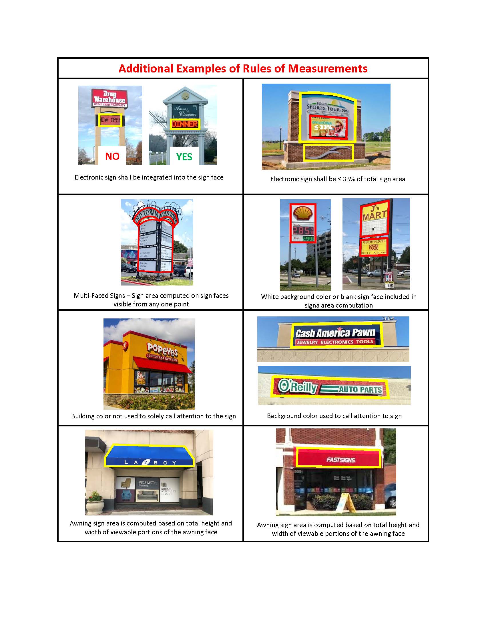
| t) Electronic Changeable Copy Sign
|
A sign or portion thereof that changes sign copy electronically or displays electronic,
non-pictorial information using alphanumeric characters employing light emitting diodes,
fiber optics, light bulbs, or other illumination devices.
|
| u) Externally Illuminated Sign
|
A sign where the light source is not contained within the sign, but is external and
projected onto the sign.
|
| v) Flashing Sign
|
A sign that projects or displays (or has the illusion of) an intermittent, blinking,
scintillating, or flashing light source.
|
| w) Freestanding Sign
|
A sign that is affixed to the ground with one or more supports, or on a fence, or
other non-building wall, but not on any portion of a building.
|
| x) Freestanding Canopy Sign
|
An attached specialty sign structurally part of or located on a freestanding canopy.
|
| y) Freestanding Multi-Tenant Development Sign
|
A sign located on a lot with a multi-tenant building with 3 or more tenants, a group
development, or a multiple lot development.
|
| z) Freestanding Specialty Sign
|
A development entrance sign, institutional banner sign, or light-pole banner sign.
|
| aa) Historical or Memorial Sign
|
A freestanding sign located on property that is individually listed on the National
Register of Historic Places, designated a Guilford County Landmark property, within
a Local Historic Overlay district, or on similar historic properties.
|
| bb) Inflatable Sign
|
A limited duration sign which is multi-dimensional and filled with air or gas. This
definition does not include balloons without messages.
|
| cc) Institutional Banner Sign
|
A specialty freestanding sign constructed of mesh, vinyl, fabric, or similar material
attached on opposite ends to permanent ground-mounted posts.
|
| dd) Institutional Directional Sign
|
A sign that has a purpose of guiding traffic and pedestrians within the Institutional
District and meets the standards of Section 5.7.11, Signs in Institutional Districts.
|
| ee) Internally Illuminated Sign
|
A sign where the light source is concealed or contained within the sign itself and
becomes visible by shining through a translucent surface or is shielded silhouette
lighting that illuminates or backlights an image or lettering.
|
| ff) Item of Information
|
A word, single number, logo or other image. The following shall also be considered
single items of information: a telephone number; an address number; a street name,
including a designation as "street," "avenue" or other street type.
|
| gg) Legible
|
A message that is clear enough to read or view from a particular location (such as
a street) if a person, who is between five feet and six feet tall and has eyesight
(corrected or natural) adequate to pass the North Carolina driver's license criteria,
can discern the meaning of the message. A message or image viewable from any street
or residential use other than the lot on which the sign is located is presumed to
be legible if the letter height exceeds eight inches.
|
| hh) Light-Pole Banner Sign
|
A specialty freestanding sign constructed of mesh, vinyl, fabric, or similar material
attached to a light-pole that is not located within the public right-of-way.
|
| ii) Limited Duration Sign
|
A sign that meets the standards of Section 5.7.12, Limited Duration Signs, and is displayed for a limited period of time that is not
permanently mounted to the ground, on a building, or structure. Limited duration signs
shall only include inflatable signs, pennants, and temporary banner signs.
|
| jj) Marquee Sign
|
A sign attached to, in any manner, or made a part of a marquee.
|
| kk) Mechanically Moving Sign |
A sign that revolves, rotates, spins, oscillates, or swings.
|
| ll) Menu Board Sign
|
A sign located in proximity to a drive-through or drive-up speaker or service window
from which an order is placed.
|
| mm) Monument Sign
|
A freestanding ground-mounted sign in which the base is a solid structure flush or
nearly flush with the ground.
|
| nn) Mural
|
A sign displaying only a noncommercial message that is painted or drawn on a building
wall.
|
| oo) Noncommercial Message
|
Messages, emblems, or images that do not function to direct attention to or promote
a business, product, service, event, or activity.
|
| pp) Nonconforming Sign
|
A sign that was lawfully erected, constructed, or placed that does not conform to
current size, height, location, design, construction, or other requirements of this
Ordinance. (See Section 8.5, Nonconforming Signs)
|
| qq) Pennant
|
A limited duration sign, which is a windblown device, made of lightweight plastic,
fabric, or other material, whether or not containing a message of any kind, suspended
from a rope, wire, or string, usually in series, designed to move in the wind.
|
| rr) Projecting Sign
|
An attached sign that extends from the building facade over 12 feet above grade. This
term does not include an awning, blade, or canopy sign.
|
| ss) Real Estate Sign
|
A sign temporarily placed on the premises where the land, building spaces, or other
appurtenances are for sale or rent.
|
| tt) Roof Sign
|
An attached sign located on a building roof or on a wall that extends above any portion
of the roof line or parapet.
|
| uu) Sign
|
Any temporary or permanent device, form, graphic, illumination, illustration, symbol,
design, pattern, wording, logo, representation, trademark, trademark color, changeable
image or message that is legible and intended or designed to call attention to something
or someone, or communicate information or a message to the public. This definition
shall not apply to any architectural building feature directly integrated into or
supporting a building, nor shall it apply to any displays located inside buildings,
courts, lobbies, stadiums, or other structures that are not positioned in such a manner
so as to be intended to be seen from the exterior of the building or structure.
|
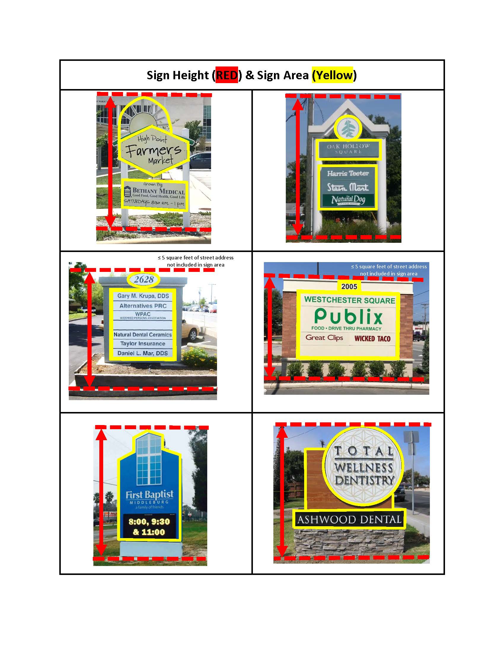
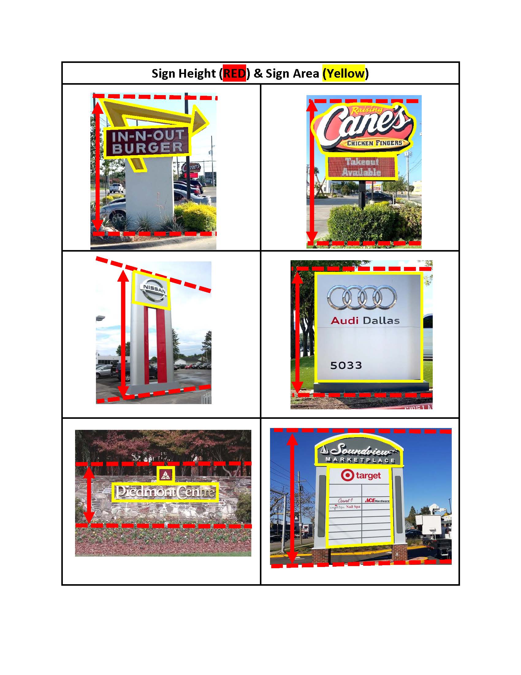
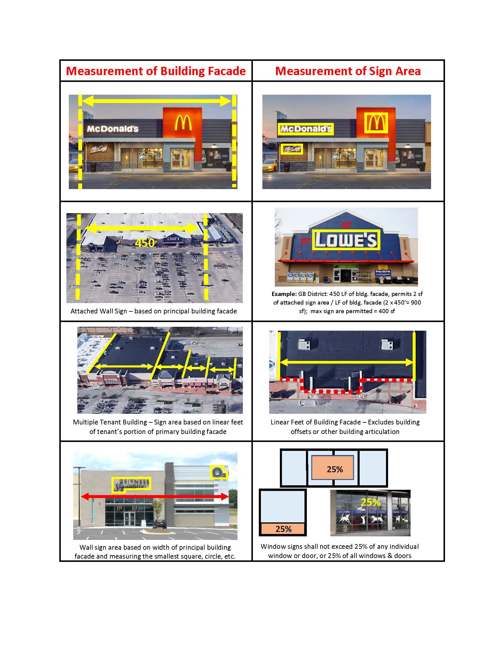
| vv) Sign Area
|
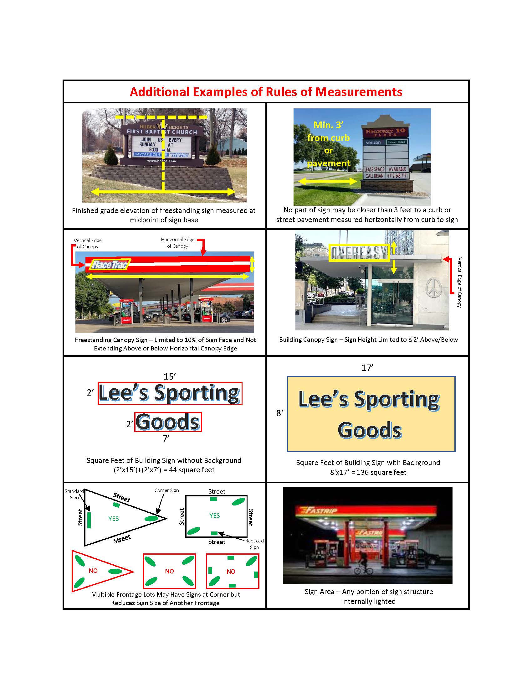
Area of the sign structure upon which the limits of the sign square footage is computed.
(See Section 10.2.10, Signs for rules of measurement)
|
| ww) Sign Copy
|
Wording or graphics on a sign surface either in permanent or removable form. (See
Section 10.2.10, Signs for rules of measurement)
|
| xx) Sign Face
|
That portion of a sign on which the message of the sign is displayed, and includes
all those areas within a continuous perimeter enclosing the extreme limits of all
the writing, display, or presentation together with any other display material forming
an integral part of such sign or used to differentiate the background against which
such sign is placed, but does not include any structural element used solely for supporting
the said sign.
(See Section 10.2.10, Signs for rules of measurement)
|
| yy) Sign Structure
|
The structure surrounding and or supporting the sign face. (See Section 10.2.10, Signs for rules of measurement)
|
| zz) Silhouette Lighted Sign
|
A sign where light is directed against and reflected off the surface behind the letters
or image thereby producing a glowing effect around the letters or image. Commonly
referred to as back-lit lighting.
|
| aaa) Supergraphic Sign
|
An attached specialty sign, generally oversized, constructed of a mesh, vinyl, fabric,
or similar material with a temporary message that meets the standards of Section 5.7.9., Attached Signs Requiring a Permit.
|
| bbb) Temporary Banner Sign
|
A limited duration sign constructed of mesh, vinyl, fabric, or similar material attached
on opposite ends to ground-mounted posts or secured to a building facade. A flag shall
not be considered a temporary banner sign.
|
| ccc) Trailer Sign
|
A sign, with or without wheels, on a supporting frame that is not permanently attached
to the ground or other permanent structure, and is designed to be transported.
|
| ddd) Vehicle Sign
|
A sign attached to, painted onto, or otherwise positioned in or on a vehicle or trailer
that is parked for a period of time or driven in a manner that indicates that a principal
use of the vehicle or trailer is for displaying the sign.
|
| eee) Vending Sign
|
A sign on a machine that dispenses or provides access to products for public consumption
or use. This term does not include drive-up accessory structures which are covered
in Section 4.4.4 Standards for Accessory Structures.
|
| fff) Video Sign
|
An electronic sign or a portion thereof that displays moving images (animated) in
monochrome or in color.
|
| ggg) Vintage Sign
|
A sign that is located on grounds or structures that are historically relevant or
individually listed on the National Register of Historic Places or designated as a
Guilford County Landmark property.
|
| hhh) Wall Sign
|
An attached sign that is located on a building or structure wall. This definition
excludes murals.
|
| iii) Weekend Sign
|
A temporary sign displayed on a weekend that meets the standards of Section 5.7.7, Signs Allowed Without a Sign Permit.
|
| jjj) Windblown Sign
|
A sign, or any part of a sign, all or part of which is set in motion by wind. Such
signs or devices include, feather flags, pennants, streamers, ribbons, balloons, or
long narrow strips of fabric, plastic, or other material designed to move in the wind.
This definition does not include "flag" as defined within this Ordinance. See also
"Air-blown sign/device," which is defined separately.
|
| kkk) Window Sign
|
A sign which is placed or painted on a window, or designed to be legible through a
window, excluding displays of actual merchandise.
|
SILTATION
|
Sediment transported from its point of origin within the site of a land-disturbing
activity that is deposited on land or is in suspension in water.
|
SMALL WIND ENERGY CONVERSION SYSTEM
|
A wind energy facility, constructed as an accessory use, consisting of a wind turbine,
a tower, and associated control or conversion electronics, which has a rated capacity
of not more than 100 kW per year and a maximum tower height of 120 feet or less.
|
SOIL AND WATER CONSERVATION DISTRICT
|
The Guilford Soil and Water Conservation District created pursuant to Chapter 139
of the North Carolina General Statutes.
|
SOIL EROSION AND SEDIMENTATION CONTROL PLAN
|
The graphic plan and narrative required as a prerequisite for a land disturbance permit
that explains existing conditions, proposed grading, and measures undertaken to control
accelerated soil erosion and sedimentation.
|
SOLID WASTE COLLECTION FACILITY
|
Containers and structures designed to collect and hold solid waste on-site until transported
to a solid waste management facility, including but not limited to, dumpsters, compactors,
bins for trash and recyclables, etc.
|
SPECIAL EVENT
|
A temporary, short-term use of land or structures, not otherwise allowed as a principal
or accessory use by this Ordinance, for concerts, carnivals, circuses, fairs, festivals,
exhibitions, religious events and similar community events.
|
SPECIAL FLOOD HAZARD AREA
|
The land in the floodplain subject to a 1 percent or greater chance of being flooded
in any given year.
|
SQUARE
|
An open space that is defined by streets or adjacent buildings that is set aside for
civic purposes, with landscaping consisting of paved walks, lawns, trees, and may
contain civic buildings.
|
STACKING LANE
|
A portion of the vehicular use area on a site that is dedicated to the temporary storage
or "standing" of vehicles engaged in drive-through use of the site or development.
Parking or storage of vehicles is not permitted within the stacking/standing area.
|
START OF CONSTRUCTION
|
As used in the flood damage prevention standards, the date the building permit was
issued, provided the actual start of construction, repair, reconstruction, rehabilitation,
addition or improvement was within 180 days of the permit date. The actual start means
the first placement of permanent construction of a structure (including a manufactured
home) on a site, such as the pouring of slabs or footings, installation of piles,
construction of columns, or any work beyond the stage of excavation or the placement
of a manufactured home on a foundation. For a substantial improvement, the actual
start of construction means the first alteration of any wall, ceiling, floor, or other
structural part of the building, whether or not that alteration affects the external
dimensions of the building.
|
STORM, 100 YEAR
|
The surface runoff resulting from a rainfall of an intensity expected to be equaled
or exceeded, on average, once in 100 years.
|
STORM, 10 YEAR
|
The surface runoff resulting from a rainfall of an intensity expected to be equaled
or exceeded, on average, once in 10 years.
|
STORM, 25 YEAR
|
The surface runoff resulting from a rainfall of an intensity expected to be equaled
or exceeded, on average, once in 25 years.
|
STORMWATER OR STORMWATER RUNOFF
|
The direct runoff of water resulting from precipitation in any form.
|
STORMWATER CONTROL MEASURE
|
A permanent structural device that is designed, constructed, and maintained to remove
pollutants from stormwater runoff by promoting settling or filtration; or to mimic
the natural hydrologic cycle by promoting infiltration, evapo-transpiration, post-filtration
discharge, reuse of stormwater, or a combination thereof.
|
STREAM
|
A watercourse that collects surface runoff.
|
STREET FRONTAGE
|
The length of lot abutting a public right-of-way or private street.
|
STREET, COLLECTOR
|
A street whose principal function is to carry traffic between cul-de-sac, local streets
and streets of higher classification but which may also provide direct access to abutting
lands.
|
STREET, INDUSTRIAL
|
An existing public or private street that serves as access to industrially zoned properties
exclusively, or serves as access to properties that are developed with, or are planned
to be developed with, wholesale, transportation, warehousing, utility, manufacturing
or other industrial land uses.
|
STREET, LOCAL
|
A street whose primary function is to provide access to abutting lands. This term
includes both residential and industrial streets.
|
STREET, THOROUGHFARE
|
An interstate, other freeway, expressway, or parkway links, or other major street
that provides for the expeditious movement of high volumes of traffic within and through
urban areas. Term includes both major and minor thoroughfare streets.
|
STREET NAME AND ADDRESS ASSIGNMENT GUIDELINES AND POLICIES
|
A set of guidelines and policies to provide the Planning and Zoning Commission with
direction when naming and assign street names and addresses.
|
STREET RIGHT-OF-WAY
|
A strip of land whose legal title rests with the City or State and is occupied or
intended to be occupied by a travelway for vehicles and is also available, with the
consent of the appropriate governmental agency, for installation and maintenance of
traffic control devices, traffic signs, street name signs, historical marker signs,
water lines, sanitary sewer lines, storm sewer lines, gas lines, power lines, and
communication lines.
|
STREET STUB
|
A nonpermanent dead end street intended to be extended in conjunction with development
on adjacent lots or sites.
|
STREET TREE
|
A canopy tree planted or existing within or along either side of a street right-of-way.
|
STREETSCAPE
|
An area within a public or private street right-of-way that may contain sidewalks,
street furniture, landscaping, street trees, bus shelters, street lighting, building
projections, and other features that create interest and interaction at the street
level.
|
STRUCTURE
|
Any material constructed, erected or placed in or upon the ground, including buildings.
|
SUBDIVIDER
|
A person who subdivides land.
|
SUBDIVISION
|
All divisions of a tract or parcel of land into 2 or more lots, building sites, or
other divisions when any one or more of those divisions is created for the purpose
of sale or building development (whether immediate or future) and includes all divisions
of land involving the dedication of a new street or a change in existing streets.
The following are not included within this definition and are not subject to any subdivision
regulations in this Ordinance:
a. The combination or recombination of portions of previously subdivided and recorded
lots if the total number of lots is not increased and the resultant lots are equal
to or exceed the standards of this Ordinance.
b. The division of land into parcels greater than 10 acres if no street right-of-way
dedication is involved.
c. The public acquisition by purchase of strips of land for the widening or opening
of streets, or for public transportation system corridors.
d. The division of a tract in single ownership, the entire area of which is not
greater than 2 acres, into not more than 3 lots, where no street right-of-way dedication
is involved and where the resultant lots are equal to or exceed the standards of this
Ordinance.
e. The division of a tract into parcels in accordance with the terms of a probated
will or in accordance with intestate succession under Chapter 29 of the North Carolina
General Statutes.
|
SUBDIVISION, MINOR
|
A subdivision of land meeting either of the following, that is reviewed and approved
as a final plat with no preliminary plan approval required:
a. Consisting of not more than four (4) lots, fronting on an existing street, not
requiring any new street(s) for access to interior property, and not requiring extension
of public water or sewer lines, OR
b. The entire area of the tract or parcel to be divided is greater than five (5)
acres, no more than three (3) lots result from the division, and no part of the tract
or parcel to be divided has been subdivided in the ten (10) years prior to this division.
|
SUBORDINATE
|
A staff member designated to fulfill the function of the Planning and Development
Director, Engineering Services Director, Transportation Director, or Public Service
Director, as appropriate.
|
SUBSTANTIAL IMPROVEMENT
|
Any repair, reconstruction, expansion, or improvement of a structure, the cost of
which exceeds 50 percent of the assessed value of a structure (derived by tax records)
as determined either before the expansion or improvement begins or before the damage
occurred giving rise to the repair or reconstruction. Substantial improvement does
not include, however, any repair or improvement required to bring the structure into
compliance with existing State or county health, sanitary, safety, or building ordinance
specifications necessary to ensure safe habitation of the structure.
|
SURFACE WATER BUFFER
|
A natural, vegetated, or revegetated area through which stormwater runoff flows in
a diffuse manner so that the runoff does not become channelized and which provides
for infiltration of the runoff and filtering of pollutants.
|
SURFACE WATERS
|
All waters of the state as defined in G.S. 143-212 except underground waters and wetlands.
|
SUSTAINABLE DEVELOPMENT FEATURES
|
One or more development features voluntarily provided by an applicant or developer
as a means of promoting sustainable development and/or taking advantage of available
sustainable development practice incentives.
|
TENANT
|
A person who alone or jointly or severally with others occupies a building under a
lease or holds a legal tenancy.
|
TRAFFIC CALMING DEVICE
|
A natural or constructed feature located within or adjacent to a street that is designed
to reduce motorist speed or vehicle volumes, while at the same time increasing safety
for pedestrians and non-motorized vehicles.
|
TRAFFIC IMPACT ANALYSIS
|
A study conducted to evaluate the capacity and safety impacts on the transportation
system from a proposed development and identify necessary improvements or management
strategies to mitigate negative impacts. Such studies shall be performed by a licensed
professional engineer in accordance with the Traffic Impact Analysis Policy adopted
by the City of High Point in this ordinance.
|
UNDERSTORY TREE
|
A species of tree which normally grows to a mature height of 15 to 35 feet.
|
USE
|
The purpose or activity for which land or structures are designed, arranged or intended,
or for which land or structures are occupied or maintained.
|
UTILITY EASEMENT
|
An easement which grants the right to install and maintain utilities including, but
not limited to, water lines, sewer lines, storm sewer lines, electrical power lines,
telephone lines, natural gas lines, and community antenna television systems.
|
VEGETATION, NATIVE
|
Any indigenous tree, shrub, ground cover or other plant adapted to the soil, climatic,
and hydrographic conditions occurring on the site.
|
VEHICULAR USE AREA
|
Areas used for the parking and circulation of automobiles, trucks, and motorcycles.
Vehicular use areas do not include individual driveways serving single-family detached
residential development.
|
VEHICULAR USE AREA LANDSCAPING
|
Vegetative material, structures (walls or fences), berms, and associated ground cover
located around the perimeter of a parking lot, or other vehicular use area.
|
VELOCITY
|
The average velocity of flow through the cross section of the main channel at the
peak flow of the storm of interest. For the purposes of this definition, the cross
section of the main channel is the area defined by the geometry of the channel plus
the area of flow below the flood height defined by vertical lines at the main channel
banks.
|
VESTED RIGHT
|
A development right that cannot be changed or altered by changes in regulation.
|
WALL
|
For purposes of signage, the vertical exterior surface of a building. The area of
all parallel vertical surfaces along a single building elevation regardless of offsets
shall be counted as one wall. The front of each unit of a multiple tenant commercial
building shall be counted as a separate wall. The area of an angled wall surface shall
be counted as part of whichever adjoining wall surface it is most parallel with. A
45 degree angled wall may be counted as part of the area of either adjoining wall,
but not as a part of both.
|
WALL PACK
|
An exterior lighting device that is flush-mounted on a vertical wall surface.
|
WALL, PARAPET
|
A low protective or decorative wall or railing along the edge of a raised structure
such as a roof or balcony.
|
WATER DEPENDANT STRUCTURE
|
Structure which requires access or proximity to surface waters to fulfill its basic
purpose, such as boat ramps, boat houses, docks, and bulkheads.
|
WATER QUALITY CONSERVATION EASEMENT
|
A permanent easement conveyed to the City for the protection of water quality in which
no structures or land-disturbing activities are allowed.
|
WATER SUPPLY WATERSHED
|
The entire land area contributing surface drainage to a designated water supply reservoir.
|
WATER SURFACE ELEVATION
|
The height, in relation to mean sea level, of floods of various magnitudes and frequencies
in the floodplains of riverine areas.
|
WATERSHED CRITICAL AREA
|
The area adjacent to a water supply intake or reservoir where risk associated with
pollution is greater than from the remaining portions of the watershed. The critical
area is defined as extending either ½ mile from the normal pool elevation of the reservoir
in which the intake is located or to the ridge line of the watershed (whichever comes
first); or ½ mile upstream from the intake located directly in the stream or river
(run-of-the-river), or the ridge line of the watershed (whichever comes first).
|
WETLANDS
|
Those areas that are inundated or saturated by an accumulation of surface or ground
water at a frequency and duration sufficient to support, and that under normal conditions
do support, a prevalence of vegetation typically adapted for life in saturated soil
conditions.
|
WIRELESS TELECOMMUN-
ICATIONS FACILITY
|
The following definitions relate to wireless telecommunications facilities:
|
|
(a) Abandonment
|
Cessation of use of a wireless support structure for wireless telecommunication activity.
|
|
(b) Accessory equipment
|
Equipment serving or being used in conjunction with a wireless facility or wireless
support structure. The term includes utility or transmission equipment, power supplies,
generators, batteries, cables, equipment buildings, cabinets and storage sheds, shelters
or similar structures.
|
|
(c) Antenna
|
Communications equipment that transmits, receives, or transmits and receives electromagnetic
radio signals used in the provision of all types of wireless services.
|
|
(d) Applicable codes
|
The North Carolina State Building Code and any other uniform building, fire, electrical,
plumbing, or mechanical codes adopted by a recognized national code organization together
with State or local amendments to those codes enacted solely to address imminent threats
of destruction of property or injury to persons.
|
|
(e) Base station
|
A station at a specific site authorized to communicate with mobile stations, generally
consisting of radio transceivers, antennae, coaxial cables, power supplies and other
associated electronics.
|
|
(f) Breakpoint technology
|
The engineering design of a monopole wherein a specified point on the monopole is
designed to have stresses concentrated so that the point is at least five percent
(5%) more susceptible to failure than any other point along the monopole so that in
the event of a structural failure of the monopole, the failure will occur at the breakpoint
rather than at the base plate, anchor bolts, or any other point on the monopole.
|
|
(g) Collocation
|
The placement, installation, maintenance, modification, operation, or replacement
of wireless facilities on, under, within, or on the surface of the earth adjacent
to existing wireless support structures, including utility poles, City utility poles,
water towers, buildings and other structures capable of structurally supporting the
attachment of wireless facilities in compliance with applicable codes . The term 'collocation"
does not include the installation of new utility poles, City utility poles, or wireless
support structures.
|
|
(h) Commun-
ications facility
|
The set of equipment and network components, including wires and cables and associated
facilities used by a communications service provider to provide communications service.
|
|
(i) Commun-
ications service
|
Cable service as defined in 47 U.S.C. § 522(6), information service as defined in
47 U.S.C. § 153(24), telecommunications service as defined in 47 U.S.C. § 153(53),
or wireless services.
|
|
(j) Commun-
ications service provider
|
A cable operator as defined in 47 U.S.C. § 522(5); a provider of information service,
as defined in 47 U.S.C. § 153(24); a telecommunications carrier, as defined in 47
U.S.C. § 153(51); or a wireless provider.
|
|
(k) Concealed wireless facility
|
A type of wireless support structure that is not readily identifiable as a wireless
support structure and that is integrated as an architectural feature of an existing
structure or existing buildings in the area so that it is not readily apparent to
a casual observer.
|
|
(l) Electrical transmission tower
|
An electrical transmission structure used to support high voltage overhead power lines.
The term shall not include any utility pole.
|
|
(m) Eligible facilities request
|
A request for modification of an existing wireless facility that does not include
a substantial modification.
|
|
(n) Equipment compound
|
An area surrounding or near the base of a wireless support structure within which
are located wireless facilities.
|
|
(o) Existing wireless support structure
|
A wireless support structure, erected prior to the application for collocation or
substantial modification under the wireless telecommunication facility provisions,
that is capable of supporting the attachment of wireless facilities, including but
not limited to electrical transmission towers, buildings and water towers. The term
shall not include any utility pole.
|
|
(p) Fall zone
|
The area in which a wireless support structure may be expected to fall in the event
of a structural failure, as measured by engineering standards.
|
|
(q) Master small wireless facility license agreement
|
A written agreement between the City and an applicant which sets forth specific negotiated
terms and conditions applicable to applicant's use of City street rights-of-way, City-owned
land, City-owned structures or City-owned infrastructure.
|
|
(r) Micro wireless facility
|
A small wireless facility that is no larger in dimension than 24 inches in length,
15 inches in width, and 12 inches in height and that has an exterior antenna, if any,
no longer than 11 inches.
|
|
(s) Monopole
|
A single, freestanding pole type structure supporting one or more wireless facilities.
The term shall not include any utility pole.
|
|
(t) Ordinary maintenance
|
Ensuring that wireless facilities and wireless support structures are kept in good
operating condition. Ordinary maintenance includes inspections, testing and modifications
that maintain functional capacity and structural integrity. Examples are: strengthening
a wireless support structure's foundation or the structure itself; replacing antennae
of similar size, weight, shape and color; replacing equipment within an existing equipment
compound; and relocating antennae to different height levels on an existing monopole
or tower upon which it is currently located.
|
|
(u) Replacement pole
|
A pole of equal proportions and of equal height - or such other height that would
not constitute a substantial modification to an existing structure - in order to support
wireless facilities or to accommodate collocation. A replacement pole requires the
removal of the wireless support structure it replaces.
|
|
(v) Search ring
|
The area within which a wireless support structure must be located in order to meet
service objectives of the wireless service provider.
|
|
(w) Small wireless facility
|
A wireless facility that meets both of the following qualifications:
(i) Each antenna is located inside an enclosure of no more than 6 cubic feet in volume
or, in the case of an antenna that has exposed elements, the antenna and all of its
exposed elements, if enclosed, could fit within an enclosure of no more than 6 cubic
feet.
(ii) All other wireless equipment associated with the facility has a cumulative volume
of no more than 28 cubic feet. For purposes of this sub-subdivision, the following
types of ancillary equipment are not included in the calculation of equipment volume:
electric meters, concealment elements, telecommunications demarcation boxes, ground-based
enclosures, grounding equipment, power transfer switches, cut-off switches, vertical
cable runs for the connection of power and other services, or other support structures.
|
|
(x) Substantial modification
|
The mounting of a proposed wireless facility on a wireless support structure which
substantially changes the physical dimensions of the support structure. A mounting
is presumed to be a substantial modification if it meets any one or more of the following
criteria:
(i) Increases the existing vertical height of the wireless support structure by the
greater of;
(a) more than 10 percent, or
(b) the height of 1 additional antenna array with separation from the nearest existing
antenna not to exceed 20 feet, or
(ii) Except where necessary to shelter the antenna from inclement weather or to connect
the antenna to the tower via cable, adding an appurtenance to the body of a wireless
support structure that protrudes horizontally from the edge of the support structure
the greater of more than 20 feet, or more than the width of the support structure
at the level of the appurtenance, or
(iii) Increases the square footage of the existing equipment compound by more than
2,500 square feet.
|
|
(y) Temporary WSS facilities
|
A portable, self-contained wireless facility that can be moved to a location and set
up to provide wireless services on a temporary or emergency basis. A temporary WSS
facility is normally vehicle mounted and contains a telescoping boom as the antenna
support structure.
|
|
(z) Tower
|
A general term used to describe wireless support structures other than base stations
and concealed wireless facilities. Includes lattice-type structures (guyed or freestanding)
and monopoles that support one or more antenna.
|
|
(aa) Utility pole
|
A structure that is designed for and used to carry lines, cables, wires, lighting
facilities, or small wireless facilities for telephone, cable television, electricity,
lighting, or wireless services.
|
|
(bb) Water tower or tank
|
A water storage tank, standpipe or elevated tank situated on a support structure,
constructed for use as a reservoir or facility to store or deliver water.
|
|
(cc) Wireless telecommun-
ications facility
|
Equipment at a fixed location that enables wireless communications between user equipment
and a communications network, including (i) equipment associated with wireless communications
and (ii) radio transceivers, antennas, wires, coaxial or fiber-optic cable, regular
and backup power supplies, and comparable equipment, regardless of technological configuration.
The term includes small wireless facilities. The term shall not include any of the
following:
(i) The structure or improvements on, under, within, or adjacent to which the equipment
is collocated.
(ii) Wireline backhaul facilities.
(iii) Coaxial or fiber-optic cable that is between wireless structures or utility
poles or city utility poles or that is otherwise not immediately adjacent to or directly
associated with a particular antenna.
|
|
(dd) Wireless infrastructure provider
|
Any person with a certificate to provide telecommunication services in the State who
builds or installs wireless communication transmission equipment, wireless facilities,
or wireless supports structures for small wireless facilities but that does not provide
wireless services.
|
|
(ee) Wireless provider
|
A wireless infrastructure provider or a wireless services provider.
|
|
(ff) Wireless services
|
Any services, using licensed or unlicensed wireless spectrum, including the use of
Wi-Fi, whether at a fixed location or mobile, provide to the public using wireless
facilities.
|
|
(gg) Wireless services provider
|
A person who provides wireless services.
|
|
(hh) Wireless support structure
|
A tower or base station that supports any type of wireless facility; a utility pole
or a City utility pole is not a wireless support structure.
|
ZONE LOT
|
One or more lots of record in 1 undivided ownership with sufficient total area, area
exclusive of easements and flood hazards, total dimensions, street access, and frontage
to permit construction thereon of a principal building together with its required
parking and landscape yards. In multi-family or single-family attached developments,
the zone lot shall be considered to be the entire development.
|
ZONING MAP, OFFICIAL
|
See "Official Zoning Map".
|