
High Point City Zoning Code
CHAPTER 1
- GENERAL PROVISIONS
1.1.- Title
This Ordinance shall be officially known as the "Development Ordinance of the City of High Point" and may be referred to as "the Development Ordinance," "this Ordinance," and several abbreviated references ("the DO," "this DO," or "DO.")
1.3.- General Purpose and Intent
The purpose of this Ordinance is to protect the public health, safety, morals, and general welfare of the citizens and landowners of the City of High Point, and to implement the policies and objectives of City-adopted plans addressing the City's growth and development. More specifically, the intent of this Ordinance is to:
A.
Foster convenient, compatible, and efficient relationships among land uses;
B.
Support and encourage a strong and diverse economy;
C.
Better manage and lessen congestion in the streets;
D.
Improve and revitalize the city's central core area, as identified in the Core City Plan;
E.
Ensure the provision of adequate open space between uses for light, air, and fire safety;
F.
Secure the safety of landowners and residents from flooding, fire, seismic activity, and dangers presented from extreme weather events, to the extent possible;
G.
Encourage urban densities in appropriate locations such as the Core City area;
H.
Facilitate the adequate and economic provision of transportation, water, sewage, schools, parks, and other public services;
I.
Improve development quality and the quality of life for city residents and visitors;
J.
Protect water quality within the Watershed Critical Areas and the General Watershed Areas of designated water supply watersheds;
K.
Preserve and enhance visual attractiveness and economic vitality;
L.
Preserve the neighborhood character and quality of residential communities while providing increased housing choices indicated in adopted policy guidance, as appropriate;
M.
Establish new compact, mixed-use centers in appropriate locations, as identified in adopted policy guidance;
N.
Maintain and enhance the character of distinct areas in the city through an emphasis on design and form standards;
O.
Require appropriate setbacks for buildings and other structures to facilitate the safe movement of vehicular and pedestrian traffic, provide adequate fire lanes, and ensure adequate distance from dust, noise, and fumes created by vehicular traffic;
P.
Protect and revitalize the city's neighborhoods and gateways;
Q.
Add flexibility and provide incentives for beneficial redevelopment, development that incorporates sustainable features, and increased pedestrian-orientation;
R.
Protect existing established development and neighborhoods from incompatible infill and redevelopment; and
S.
Protect open space, natural resources, and rural character, where appropriate.
1.6.- Development Guide
The purpose of the Development Guide is to supplement and assist the use of this Ordinance. The Planning and Development Director is authorized to establish the content and form for each type of development application reviewed under this Ordinance. The Planning and Development Director shall prepare and maintain a Development Guide that sets forth the procedures, specifications, and practices necessary for the effective and efficient administration of this Ordinance.
1.10.- Vested Rights
Vested rights under this Ordinance shall be established and maintained only in accordance with the following.
(Ord. No. 7622/20-38, § 4.A, 8-5-2020)
1.11.- Severability
The legislative intent of the City Council in adopting this Ordinance is that all provisions shall regulate development in accordance with the existing and future needs of the City as established in this Ordinance, and promote the public health, safety, and general welfare of the landowners and residents of High Point. If any section, subsection, sentence, boundary, or clause of this Ordinance is for any reason held by a court of competent jurisdiction to be invalid, such decision shall not affect the validity of the remaining portions of the Ordinance. The City Council hereby declares that it would have passed this Ordinance and any section, subsection, sentence, boundary, clause, and phrase thereof, irrespective of the fact that any one or more sections, subsections, sentences, boundaries, clauses, or phrases are declared invalid.
1.2.1.- General Authority
This Ordinance consolidates the City's zoning, subdivision, and flood damage prevention regulations, as authorized by the North Carolina General Statutes. It is adopted in accordance with:
A.
The General Assembly The authority granted to the City of High Point by the General Assembly of the State of North Carolina;
B.
The North Carolina Statutes The North Carolina General Statutes, including:
1.
Chapter 160A, Article 8 (Police Powers);
2.
Chapter 160D, Local Planning and Development Regulation;
3.
Chapter 143, Article 21 (Water and Air Resources);
4.
Chapter 113A, Article 4 (Sedimentation and Pollution Control);
C.
The City Charter The High Point City Charter;
D.
Other Relevant Laws
1.
All other relevant laws of the State of North Carolina; and
2.
Any special legislation enacted by the General Assembly.
(Ord. No. 7712/21-29, § 1.A, 5-19-2021)
1.2.2. - References to North Carolina General Statutes
Whenever any provision of this Ordinance refers to or cites a section of the North Carolina General Statutes and that section is later amended or superseded, this Ordinance shall be deemed amended to refer to the amended section or the section that most nearly corresponds to the superseded section.
1.4.1.- Effective Date
This Ordinance shall be in full force and effect on January 1, 2017, and repeals and replaces the High Point Development Ordinance, as originally adopted on January 7, 1992, and subsequently amended.
1.4.2. - General Applicability
The provisions of this Ordinance shall apply to the development of all land within the corporate limits and the Extraterritorial Jurisdiction (ETJ) of the City of High Point unless it is expressly exempted by a specific section or subsection of this Ordinance.
1.4.3. - Application to Governmental Units
Except as stated elsewhere, this Ordinance shall apply to:
A.
The City of High Point Development by the City or its agencies or departments;
B.
Local and State Government Development of buildings by state or city agencies or departments, public colleges or universities, or other political subdivisions of the State, in accordance with the standards in Section 160D-913 of the North Carolina General Statutes; and
C.
The Federal Government Development owned or held in tenancy by the government of the United States, its agencies, departments, or corporate services, to the full extent permitted by federal law.
(Ord. No. 7712/21-29, § 1.B, 5-19-2021)
1.4.4. - No Development Until Compliance With All Applicable Law
A.
No Land Developed Unless exempted, no land shall be developed without compliance with this Ordinance and all other applicable City, State, and federal regulations.
B.
No Use or Occupancy No person shall use, occupy, or divide any land or a building or authorize or permit the use, occupancy, or division of land or a building under their control, except in accordance with this Ordinance.
C.
No Building Constructed No building, or portion thereof, shall be erected, used, occupied, maintained, moved, or altered except in conformity with the applicable regulations in this Ordinance.
1.4.5. - Annexation
A.
County Regulations Prevail If any portion of the territory subject to county jurisdiction is annexed by the City or taken into the City's ETJ, county regulations and powers of enforcement shall remain in effect until one of the following occurs:
1.
The City has adopted regulations for the area; or
2.
A period of 60 days has elapsed following the effective date of annexation or extension of the ETJ.
B.
Utility Connection Required The City shall require annexed land to connect to or use public utilities (potable water, sanitary sewer, stormwater, etc.), as appropriate.
1.4.6. - Bona Fide Farms Exempt in ETJ
In accordance with 160D-903, property that is located within the City's ETJ and used for bona fide farm purposes is exempt from the zoning regulations of this Ordinance.
(Ord. No. 7712/21-29, § 2, 5-19-2021)
1.5.1.- Adopted Policy Guidance
The administration, enforcement, and amendment of this Ordinance shall be accomplished in accordance with the City's adopted planning policy framework. The Comprehensive Plan provides overarching policy guidance and sets out general goals for desired uses of land and resource protection strategies. Area plans provide strategic planning policy guidance for specific parts of the City, and system plans address planning issues related to the City's infrastructure systems. Figure 1.5.1, Planning Policy Framework, illustrates the relationship of these planning documents to one another.
FIGURE 1.5.1, PLANNING POLICY FRAMEWORK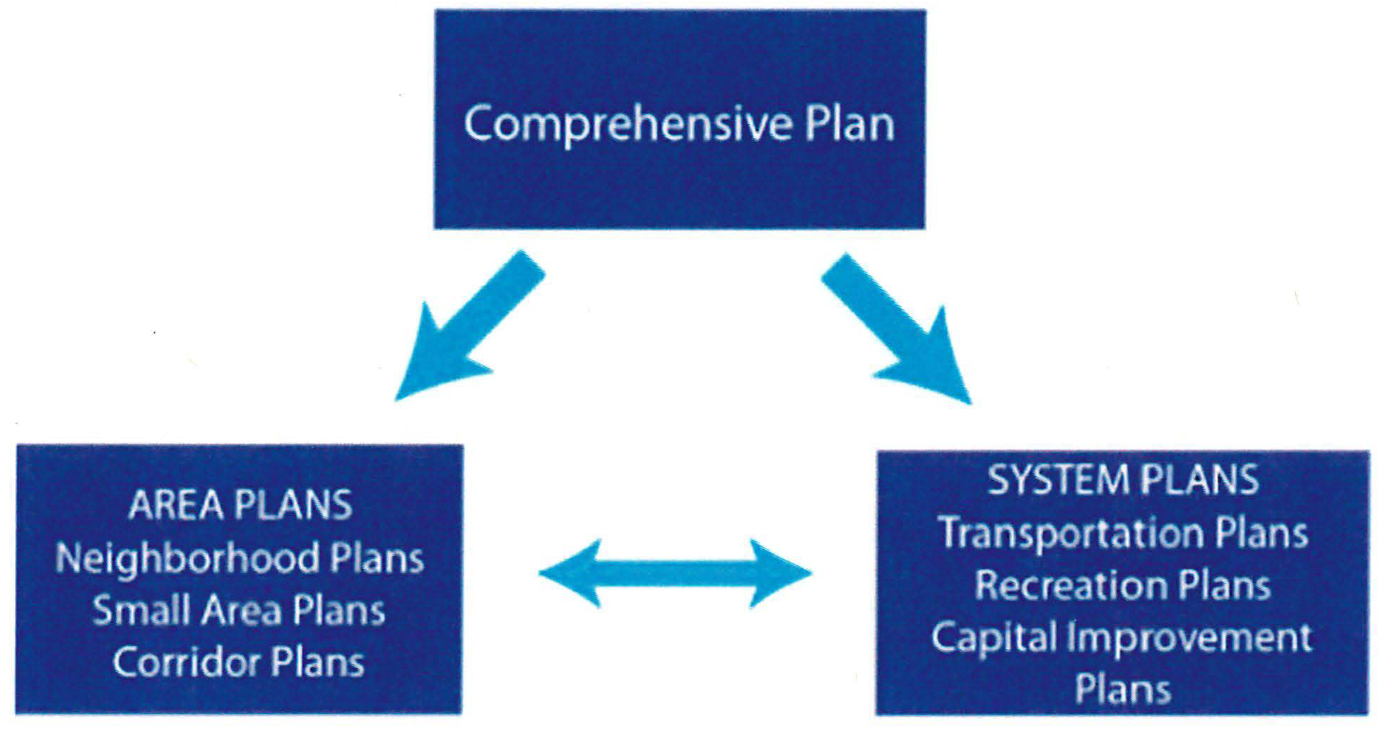
(Ord. No. 7365/17-108, § 1, 11-20-2017; Ord. No. 8016/24-33, § 1(Pts. A, B), 7-15-2024)
1.5.2. - Conformance
A.
Consistency This Ordinance is intended to ensure that all development within the City is consistent with the goals, objectives, policies, strategies, and actions contained in the City's adopted policy guidance.
B.
Amendment Upon Inconsistency To the extent this Ordinance is or becomes inconsistent with the adopted policy guidance, it should be amended to remain consistent. All amendments to this Ordinance's text or to the Official Zoning Map should maintain and enhance consistency between this Ordinance and adopted policy guidance.
1.7.1.- Minimum Requirements
In the application of this Ordinance, all provisions shall be considered as minimum requirements and shall not be deemed to limit or repeal any other powers or authority granted under the North Carolina General Statutes.
1.7.2. - Conflicts with Other City Codes or Laws
If a provision of this Ordinance is inconsistent with another provision of this Ordinance, or with a provision found in other adopted ordinances of the City, the more restrictive provision shall govern unless the terms of the more restrictive provision specifies otherwise. The more restrictive provision is the one that imposes greater restrictions or burdens, or more stringent controls.
1.7.3. - Review of Private Agreements
The City may review private agreements, such as those related to maintenance of private common open space, shared parking, or cross access easements, but the City is not responsible for monitoring or enforcing private covenants and restrictions.
1.7.4. - Conflicts with State or Federal Law
If a provision of this Ordinance is inconsistent with state or federal law, the more restrictive provision controls, to the extent permitted by law.
1.7.5. - Existing Agreements or Vested Rights
Nothing in this Ordinance is intended to repeal, supersede, annul, impair, or interfere with any existing private agreements or vested rights, provided such agreements or vested rights are lawfully established and remain in effect.
1.8.1.- Prior Violations Continue
Any prior violation of the previous ordinance shall continue to be a violation under this Ordinance, unless the development complies with this Ordinance. Violations of this Ordinance shall be subject to Chapter 9: Enforcement.
1.8.2. - Existing Nonconformities
If any use, structure, lot or sign, legally existed on the effective date of this Ordinance, but does not fully comply with the standards of this Ordinance, the use, structure, lot or sign, is considered nonconforming under this Ordinance and shall comply with the requirements in Chapter 8: Nonconformities.
1.8.3. - Pending Complete Applications
A.
Final Action Pending Except for applications for subdivision, any development application accepted as complete before January 1, 2017, but still pending final action as of that date, shall be reviewed and decided in accordance with the regulations in effect when the application was accepted as complete. To the extent such an application is approved and proposes development that does not comply with this Ordinance, the subsequent development, although permitted, shall be nonconforming and subject to the provisions of Chapter 8: Nonconformities.
B.
Complete Applications Completed applications shall be processed in good faith and shall comply with any time frames for review, approval, and completion as established in the regulations in effect at the time of the application is deemed by the Planning and Development Director to be complete. If the application fails to comply with the required time frames, it shall expire and future development shall be subject to the requirements of this Ordinance.
C.
Review Under this Ordinance An applicant with a pending application accepted before January 1, 2017 may opt to have the proposed development reviewed under this Ordinance by submitting a written request to the Planning and Development Director.
D.
Subdivision Applications Applications for subdivision approval still pending final action as of January 1, 2017 shall be reviewed under either the rules in place at the time the application was deemed by the Planning and Development Director to be complete or this Ordinance, at the choice of the applicant. To the extent such an application is approved and proposes development that does not comply with this Ordinance, the development, although permitted, shall be nonconforming and subject to the provisions of Chapter 8: Nonconformities.
1.8.4. - Approved Applications
A.
Valid Until Expiration Any development approvals or permits granted before January 1, 2017 shall remain valid until their expiration date. Developments with valid approvals or permits shall be carried out in accordance with the terms and conditions of their approval and the development standards in effect at the time of approval, provided the approval or permit is valid and has not expired.
B.
Expiration If the prior approval expires or is revoked (e.g., for failure to comply with the terms and conditions of approval), any subsequent development of the site shall comply with this Ordinance.
C.
Nonconforming Development To the extent a prior-approved application proposes development that does not comply with this Ordinance, the subsequent development, although permitted, shall be nonconforming and subject to the provisions of Chapter 8: Nonconformities.
1.8.5. - Prior-Approved Conditional Use Zoning
A.
Subject to Existing Conditions A conditional use zoning approval (and associated conditional use permit) approved before January 1, 2011 shall be translated to the corresponding new zoning district classification. It shall continue to be subject to all conditions in the conditional use permit.
B.
Amendment A conditional use zoning (and associated conditional use permit) approved before January 1, 2011 must be amended through an amendment to the Official Zoning Map in accordance with Section 2.4.20, Zoning Map Amendment.
1.8.6. - Prior-Approved Conditional Zoning
A.
Subject to Existing Conditions A conditional zoning approved before January 1, 2017 shall be translated to the corresponding new zoning district classification. It shall continue to be subject to all conditions of approval.
B.
Minor Changes Unless prohibited by City Council as part of the original approval, a conditional rezoning approved before January 1, 2017 may include minor changes from the approved conditions in accordance with the standards in Section 2.4.6 F.1, Minor Changes.
C.
Amendment To the extent a landowner proposes development that is not allowed by a conditional zoning approved before January 1, 2017, it must be amended in accordance with Section 2.4.6 F.2, Material Changes are Amendments.
1.8.7. - Prior Approved Planned Unit Development and Traditional Neighborhood District
A.
Classification Retained A PDR, PDM, PDL, or TN district subject to a master or general development plan approved before January 1, 2017 shall retain the PDR, PDM, PDL, or TN classification and continue to be subject to the master plan or general development plan and all associated conditions of approval.
B.
Amendment of Conditional Use Zoning Amendments to a PDR, PDM, or PDL district established through a conditional use zoning classification (and a conditional use permit) approved before January 1, 2011 shall be subject to the standards in Section 1.8.5, Prior-Approved Conditional Use Zoning.
C.
Amendment of Conditional Zoning Amendments to a PDR, PDM, or PDL district established through a conditional zoning classification approved before January 1, 2017 shall be subject to the standards in Section 1.8.6, Prior-Approved Conditional Zoning.
D.
Amendment of TN District Amendments to a TN district approved before January 1, 2017 shall be reviewed and decided in accordance with Section 2.4.20, Zoning Map Amendment.
1.8.8. - Existing Uses
If a use was a lawfully established permitted use before January 1, 2017 and is subsequently made a special use in Table 4.1.9, Principal Use Table, the use shall be considered a lawfully-established special use.
1.9.1.- District Translation Table
On January 1, 2017, land zoned with a zoning district classification from the previous ordinance shall be translated or reclassified to one of the zoning district classifications in this Ordinance as set forth in Chapter 3: Zoning Districts. Table 1.9.1, Zoning District Translation, summarizes the translation or reclassification of the zoning districts used in the previous ordinance to the zoning districts used in this Ordinance. (For example, Table 1.9.1 shows that all lands classified as Agricultural (AG) in the previous ordinance (under the column titled "Former Zoning District") are now classified Agricultural/Rural (AGR) in this Ordinance (under the column titled "Current Zoning District").
(Ord. No. 7365/17-108, § 1, 11-20-2017)
1.10.1.- Development Permit
The issuance of a development permit, as defined by this Ordinance, establishes a vested right to development in accordance with Sections 160D-108 of the North Carolina General Statutes, as long as the development complies with the terms and conditions of approval of that permit and the permit remains valid pursuant to law.
(Ord. No. 7266/17-08, § 1, 1-17-2017; Ord. No. 7622/20-38, § 4.A, 8-5-2020; Ord. No. 7712/21-29, § 1.C, 5-19-2021)
1.10.2. - Vested Rights Certificate
A vested right for a site plan, preliminary plan, or group development plan may be established in accordance with Section 2.4.17, Vested Rights Certificate.
(Ord. No. 7622/20-38, § 22, 8-5-2020)
1.10.3. - Development Agreement
A vested right for a development may be established in accordance with Section 2.4.7, Development Agreement.
(Ord. No. 7622/20-38, § 4.A, 8-5-2020)
Editor's note— Ord. No. 7622/20-38, § 4.A, adopted August 5, 2020, added new provisions as § 1.10.3 and further amended the Code by renumbering existing §§ 1.10.3 and 1.10.4 accordingly.
1.10.4. - Common Law Vesting
A common law vested right is established only when the following can be demonstrated by the landowner:
A.
There is an affirmative governmental act by the City in the form of an approval of a permit or development approval under this Ordinance; and
B.
The landowner relies on this affirmative governmental act in good faith and makes substantial expenditures to develop the land; and
C.
It would be inequitable to prevent the landowner from proceeding to develop the land consistent with the terms and conditions of the permit or development approval relied upon.
(Ord. No. 7622/20-38, § 4.A, 8-5-2020)
1.10.5. - Prior Vesting
Where a vested right is established by a valid and unexpired development permit, vested rights certificate or development agreement, any amendments to the regulations of this Ordinance, including zoning district boundaries, shall not be applicable or enforceable without the written consent of the landowner, except where a change in State or federal law mandates such action.
(Ord. No. 7622/20-38, § 4.A, 8-5-2020)
1.10.6. - Expiration
As provided in State law, a vested right established through an approved development permit, vested rights certificate or development agreement shall terminate at the end of the applicable vesting period. Furthermore, such vesting shall expire for an uncompleted project if development is intentionally and voluntarily discontinued for a period of not less than 24 consecutive months, except where a longer vesting period is provided in this Ordinance.
(Ord. No. 7622/20-38, § 4.A, 8-5-2020)