
Hollister City Zoning Code
CHAPTER 17
04 - RESIDENTIAL ZONING DISTRICTS
17.04.010 - Purpose.
This article provides regulations applicable to development and new land uses in the residential zoning districts established by Section 17.02.030 (Zoning Districts Established). The purposes of the individual residential zoning districts are as follows:
A.
RE (Residential Estate) District. The Residential Estate (RE) Zoning District provides for residential development at densities up to one dwelling unit per five acres; it is intended to provide for very low intensity residential development. The RE District is intended to provide sites for larger, distinctive residences. The RE Zoning District is consistent with the Residential Estate (RE) land use category of the General Plan.
B.
R1 (Low Density Residential) District. The Low Density Residential (R1) Zoning District includes areas substantially developed with existing single-family residential residences prior to 2005 with densities of four to six dwelling units per acres. The R1 Zoning District is consistent with the Low Density Residential (LDR) land use category of the General Plan which now allows one to eight units per acre.
C.
R2 (Two-Family Residential) District. The Two-Family Residential (R2) Zoning District provides for duplexes or two-family dwellings. Areas designated R2 were substantially developed prior to 2005 with two single-family residential units on a lot or duplexes. The R2 Zoning District is consistent with the Medium Density Residential (MDR) land use category of the General Plan.
D.
R3 (Medium Density Residential) District. The Medium Density Residential (R3) Zoning District provides for medium and medium-to high-density residential development at densities from eight to 12 dwelling units per acre.
Areas designated R3 were substantially developed prior to 2005 and are generally characterized by apartments and other high-density residential development, and planned residential development at a density of 12 dwelling units per acre. The R3 Zoning District is consistent with the Medium Density Residential (MDR) and High Density Residential (HDR) land use categories of the General Plan.
E.
R4 (High Density Residential) District. The High Density Residential (R4) Zoning District provides for high-density residential development at densities from 12 to 35 dwelling units per acre. Areas designated R4 were substantially developed prior to 2005 and are generally characterized by apartments and other high density residential development, and planned residential development at a density of 16 or more dwelling units per acre. The R4 Zoning District is consistent with the High Density Residential (HDR) land use category of the General Plan.
F.
R4-20 (High Density Multifamily Residential) District. The High Density Multifamily Residential R4-20 Zoning District provides for multifamily residential development at densities from 20 to 35 dwelling units per acre. Areas designated R4-20 are intended to be developed solely for high density residential multifamily housing. The R4 Zoning District is consistent with the High Density Residential (HDR) land use category of the General Plan. The planning Commission may waive the minimum density requirement for a development proposal with 100 percent multifamily affordable housing in the R4, R4-20, and OT-H Zoning Districts where it is demonstrated that the minimum density standard poses a constraint to the viability of the development. The manager's unit may be excluded from the affordability requirement. A Conditional Use Permit shall be required for approval of the waiver.
G.
Residential Performance Overlay Zone District (R1 L/PZ, R3 M/PZ and R4 H/PZ). This overlay District (see Chapter 17.14 Overlay Zoning District) applies to vacant land within the city of Hollister. The intent of the overlay District is to foster development that meets the range of densities for the General Plan land use designation with the option for flexible standards to implement policies and programs in the General Plan that call for the following:
1.
A variety of lot sizes and choices for housing types in all zoning Districts;
2.
New development with interesting street patterns, site planning and neighborhood design;
3.
Connections of the new development with the rest of the city for pedestrians and bicyclists;
4.
Incorporation of on-site recreation, pedestrian links between adjoining properties, trails or easements in the vicinity of drainages and water courses in new development;
5.
Clustered development that meets the average General Plan density for the property while avoiding development in areas with environmental constraints such as flood, seismic, and liquefaction problems, or a special habitat area;
6.
Lot design and building orientation to provide solar access;
7.
Sensitive integration of the scale and mass of new development preserves the character and scale of existing residential neighborhoods.
Lands with the R1 L/PZ overlay zone predominantly include vacant land within the city of Hollister in the Low Density Residential (one to eight units per acre) land use category of the General Plan. An average development density of one to eight units per acre is now required in this overlay zone with a targeted density of at least six units per acre. Please refer to Section 17.14.020 for Performance Overlay densities performance standards and development requirements.
H.
OT (Old Town) District. The Old Town (OT) Zoning District applies to the residential neighborhoods that include the original town of Hollister, as laid out by the San Justo Homestead Association, its early subdivisions, and adjacent older residential areas. Within this District are numerous lots of unusual size and shape, many of which were originally designed to accommodate stables, barns and other outbuildings. In addition, many areas of this District are occupied by a varied mix of residential types and densities. The majority of the housing stock was constructed prior to World War II. Some of the homes in this District are listed in the National Monterey Street Historic District. South of Fourth Street, the Old Town (OT-M) Zoning District is consistent with the Medium Density Residential land use category of the General Plan with residential development densities from eight to 12 dwelling units per acre. Areas within the OT-M District could have single-family homes, duplexes, fourplex, cottages and housing on small lots. This District also encompasses the General Plan Old Town Special Planning Area. North of Fourth Street, the Old Town (OT-H) District is consistent with the High-Density Residential category of the General Plan with residential development densities from 12 to 35 dwelling units per acre. The Old Town-H District provides for infill development of small lots, apartments and other high density residential development.
The additional purpose of the OT-M District is to provide for the infill of detached single-family dwellings on small lots and small-scale medium-density dwellings where the minimum density is not less than eight units per acre and the maximum density is not more than 12 units per acre without density bonus. The additional purpose of the OT-H District is to provide for the infill of detached, attached, medium-density and multifamily dwellings where the minimum density is not less than 16 units per acre and the maximum density is not more 35 units per acre without density bonus.
I.
RWF (Residential, West Fairview Road) District. The RWF (West Fairview Road District) establishes zoning regulations for the area defined by the West Fairview Road Specific Plan. The West Fairview Road Specific Plan provides for comprehensive land use, circulation and infrastructure plans, development and design policies, housing strategies and implementation programs for guiding and ensuring the orderly development of the plan area.
(Ord. 1038, § 2, 2008; Ord. 1056, § 3, 2009; Ord. 1061, § 1, 2010; Ord. 1220, § 1, 2022)
17.04.020 - Residential zone land uses and permit requirements.
The following Table 17.04-1 identifies the uses of land allowed by this Zoning Ordinance in each residential zone, and the land use permit required to establish each use, in compliance with this chapter. For properties with an overlay, please refer to the zoning designation (not the overlay) for allowable uses.
Table 17.04-1 Residential Land Uses and Permit Requirements
Notes:
(1) See Chapter 16.17 "Conversion of multifamily rental units" for information on condominium conversion requirements.
(2) Manufactured and mobile homes are required to be on a permanent foundation where the development and must comply with the development standards of the zoning District in which the property is located and the minimum development density identified in the General Plan.
(3) On corner lots, an entrance shall be oriented to each street frontage. On interior lots, the unit shall be designed to maintain a single-family residential appearance from the street frontage with access to the second unit, parking and utilities concealed from the street.
(4) An existing single-family home that is the only dwelling on a parcel that was lawfully constructed and involuntarily damaged or destroyed by fire or other calamity may be rebuilt.
(Ord. 1038, § 2, 2008; Ord. 1056, § 4, 2009; Ord. 1071, § 3, 2011; Ord. 1138, § 4, 2017; Ord. 1177, § 2, 2019; Ord. 1220, § 1, 2022; Ord. 1235, § 1(1.2), 2023; Ord. 1262, § 1, 2025; Ord. 1267, § 4, 2025)
17.04.030 - Residential general development standards.
New land uses and structures, and alterations to existing uses or structures shall be designed and constructed in compliance with the following requirements in Table 17.04-2 Residential Lot Size, Lot Area, and Density Requirements by District, Table 17.04-3 Residential Standards for Lot Width, Depth, Coverage and Building Height, Table 17.04-4 Residential Standards for Yards, and standards in Section 17.04.060(C) (West Fairview Road Standards) of this chapter.
A.
General Site Planning and Development Standards for Existing Developed Areas and New Residential Development. Infill, new land uses and structures, and alterations to existing land uses and structures, shall be designed and constructed in compliance with the following requirements.
Sense of Place. New residential development shall reinforce the small town-character of Hollister and reinforce a sense of place with the following strategies:
1.
The majority of the architectural entry features shall face the street. Front porches are encouraged to promote natural surveillance.
2.
Developments shall incorporate varied lot widths, size and floor plans on a street block.
3.
Encourage the Performance Overlay Zoning District as an alternative development pattern to integrate a variety of housing types and densities within a block.
4.
Encourage residences with attached porches and garages placed back from the street or accessed from rear alleys to promote visual interest, neighborhood interaction, and facilitate natural surveillance.
5.
Require variation of design of residences in tract developments to reduce monotony and create variety and interest. A reasonable difference in the massing and composition (not just finish) of each adjacent dwelling unit shall be accomplished. One design should not be repeated more frequently than each fourth dwelling unit. Each street block shall also include a variety of model elevations.
6.
Neck down or bulbed intersections with decorative paving at crosswalks are encouraged at primary intersections, parks or tot lots.
7.
Allow with a Conditional Use Permit the establishment of small-scale neighborhood markets to promote a sense of community and a pedestrian friendly walkable community.
8.
The height and mass of new structures shall be consistent with those of the adjacent properties in the neighborhood.
B.
Parking/Garages.
1.
Garage doors shall be adequately set back to keep the sidewalk clear of vehicles at all times.
2.
Front entry garages shall be recessed behind the street façade of the principal residential structure except for side-entry garages.
3.
Variation of garage placement on a lot shall be incorporated into major subdivision designs. Garages that are located behind the principal residential structure or are rear-entry accessible from alleys are strongly encouraged to reduce the visual prominence of the garage on the streetscape.
a.
Tandem garages should be encouraged as an alternative to three-car garages.
b.
Three-car garages shall not be allowed on lots with widths of less than 60 feet unless the garage is detached and recessed behind the residence.
c.
A perpendicular deviation of no more that five feet between the driveway lip and the main garage entry shall be required to avoid egress back-up hazards.
4.
Multifamily developments shall be oriented to the street, with covered architectural entry features or front porches that provide direct access to the street. Parking areas should be located to the rear of the dwelling units wherever possible in order to promote neighborhood interaction, provide "eyes on the street", and ensure a more pedestrian-friendly streetscape.
C.
Connection shall be incorporated into residential development to collector/arterial streets, public facilities, shopping or residential neighborhoods to provide connectivity between neighborhoods, safe routes to schools and a healthy community in compliance with Section 17.18.030, General Pedestrian, Bicycle and Parking Regulations.
1.
A grid or loop street network shall be required instead of cul-de-sacs. Where cul-de-sac streets are located due to existing development patterns, terrain or traffic safety, the length shall be limited to 400 feet.
2.
A 20-foot wide pedestrian/bicycle/transit connection shall be integrated into cul-de-sacs and subdivision designs where loop streets or cul-de-sacs impede direct access to surrounding properties.
D.
Accessible Construction.
1.
At least ten percent of the residences in a major subdivision shall include provisions for one accessible entry, bedroom and bathroom.
2.
At least ten percent of the dwelling units in a multifamily housing development shall incorporate at least one accessible entry, bedroom and bathroom.
E.
Energy Efficiency. Solar access to surrounding properties shall be maintained through the siting and orientation of buildings and two- and/or three-story residences.
F.
Front Yard Paving. The use of pervious paving is preferred in the front yard. Impervious solid surfaces such as poured concrete, asphalt and mortared paving (e.g., brick or tile) shall be limited to the driveways not to exceed 20 feet in width for a single-family residence and six-foot wide walkways to the front door and side yards. Paving materials that allow water to penetrate to the subsurface may be allowed in other parts of the front yard. Increases in the amount of allowable solid surface paving may be approved with an Administrative Permit from the Engineering Department if necessary to provide safe ingress and egress to the site or for health and safety.
G. Consolidation of Parcels. Prior to the approval for a development of any multi-unit development project that includes more than one parcel, the parcels shall be merged, or otherwise consolidated, in a manner consistent with the city of Hollister subdivision ordinance and Subdivision Map Act. The intent of this requirement is to provide a guarantee of common ownership, maintenance and management of multi-unit projects.
Table 17.04-2 Residential Lot Size, Lot Area, and Density Requirements by District
Notes:
(1) Residential density does not include a density bonus.
(2) Lots in the Monica Estates subdivision Tract 180 shall be considered conforming for minimum lot size.
(3) Minimum lot size may be reduced when the exclusive use of such lots is intended for utility substations, pumping stations, and other similar facilities.
(4) Minimum area for lots proposed in new subdivisions, and the minimum area required for an existing lot of record to be eligible for development may be altered with performance agreement provided the average development density before a density bonus complies the applicable General Plan land use designation.
(5) Partially developed parcels with potential for infill development may be subdivided without a growth management allocation if the Planning Commission can make the following findings: (a) the minimum lot size of an existing residential use shall be at least 5,000 square feet and the setback requirements for the R1 District can be met; (b) the orientation of the single-family home will help support the existing residential character and scale of the area; (c) there is adequate access to the new lot; (d) the standards for the applicable zoning District can be met with the proposed lot design and location of the infill parcel.
(6) An exception to the minimum lot size in the Old Town District may be allowed if the Planning Commission can make the following findings: (a) the subdivision includes at least one or two existing residences that have been included on a list of historic structures approved by the Hollister City Council or include defining characteristics to qualify for a list; (b) the location of the existing residences will comply with side yard setback requirements after the subdivision; (c) A deed restriction is recorded on the property that prohibits the demolition of the historic structure for at least ten years.
(7) The Planning Commission may waive the minimum density requirement for a development proposal with 100 percent multifamily affordable housing in the R4, R4-20, and OT-H Zoning Districts where it is demonstrated that the minimum density standard poses a constraint to the viability of the development. The manager's unit may be excluded from the affordability requirement. A Conditional Use Permit shall be required for approval of the waiver.
(8) An existing single-family home that is the only dwelling on a parcel that was lawfully constructed and involuntarily damaged or destroyed by fire or other calamity may be rebuilt.
(9) For lot sizes under one-half acre, that have been lawfully established prior to the effective date of the ordinance codified in this chapter, and the number of dwelling units in a multiple dwelling or dwelling group do not exceed the number obtained by dividing the area of the building site by 2,000, adjusting any fractional result where the fraction is equal to or less than one-half to the next lower whole number, may be rebuilt if involuntarily damaged or partially damaged by a fire or other calamity.
(10) For lot sizes over one-half acre, that have been lawfully established prior to the effective date of the ordinance codified in this chapter, and the number of dwelling units in a multiple dwelling or dwelling group do not exceed the range expressed by the total acreage multiplied by 16, adjusting any fractional result where the fraction is equal to or less than one-half to the next lower whole number, may be rebuilt if involuntarily damaged or partially damaged by a fire or other calamity.
(11) For lot sizes under the minimum lot size, but not under the "Lot area per dwelling unit (minimum)" that have been lawfully established prior to the effective date of the ordinance codified in this chapter, and the existing single-family home that is the only dwelling on the parcel is damaged or destroyed by any means, it may be restored and used in conformity with the provisions of the District in which it is located.
(12) Where the minimum lot size conflicts with the density established under the General Plan, the density of the General Plan shall take precedence.
Table 17.04-3 Residential Standards for Lot Width, Depth, Coverage and Building Height
Notes:
(1) On corner lots, an entrance shall be oriented to each street frontage. On interior lots, the unit shall be designed to maintain a single-family residential appearance from the street frontage with access to the second unit, parking and utilities concealed from the street.
(2) Transition in building height and other design elements shall be incorporated into development near existing residential neighborhoods to assure that the new development is not out of scale with the character of the surrounding uses.
(3) The half story shall be directed to the rear of the structure where the predominant development pattern surrounding the lot is single story and shall not overwhelm the historic character of the neighborhood.
(4) See building height exceptions in Chapter 17.16.
(5) Planning Commission approval is required for accessory structures higher than 15 feet.
Table 17.04-4 Residential Standards for Yards
Notes:
(1) A single-family residence on a corner lot that has been lawfully established prior to the effective date of the ordinance codified in this chapter may be reconstructed with administrative Planning and Engineering approval of a similar nonconforming setback that complies with Building and Fire Codes if it has been involuntarily damaged or partially damaged by a fire or other calamity.
(2) An alternative to the setbacks may be allowed with administrative approvals from the Planning and Engineering Departments for placement of a residence on a corner lot to assure adequate separation of a driveway from an intersection provided there is at least 1,000 square feet of useable open space in the rear or side yard and a minimum setback of six feet from any adjoining property line and there is no conflict with easements or rights-of-way.
(Ord. 1038, § 2, 2008; Ord. 1056, §§ 6—8, 2009; Ord. 1057, § 2, 2010; Ord. 1061, § 2, 2010; Ord. 1071, §§ 4, 5, 2011; Ord. 1083, §§ 4, 5, 2012; Ord. 1100, § 4, 2014; Ord. 1121, §§ 1—6, 2015; Ord. 1177, §§ 9—11, 2019; Ord. 1220, § 1, 2022)
17.04.040 - Residential open space requirements.
A.
For the purposes of this chapter, private open space shall refer to area which is accessible only to the residents of a single unit. Private open space can include decks, balconies, porch areas, and roof gardens in addition to private rear yards at ground level.
1.
Private open space at ground level shall have no dimension of less than ten feet.
2.
Private open space in the form of a balcony or roof garden shall have no dimension of less than six feet.
3.
Private open space shall not include enclosed side yards with dimensions of less than ten feet, unenclosed side yards, or front yards.
B.
Open Space Requirements for Residential Estate (RE) and Low Density Residential (R1) Development:
1.
Private Open Space: 1,000 sq. ft. at ground level at the same grade (excluding retaining walls).
2.
All requirements of Chapter 16.55 Park and Recreation Area Dedication and Fees must be met.
C.
Open Space Requirements for Two-Family Residential (R2) Development:
1.
Private Open Space: Ten percent of lot area per unit (total 20 percent of lot area) at ground level at the same grade (excluding retaining walls).
2.
All requirements of Chapter 16.55 Park and Recreation Area Dedication and Fees must be met.
D.
Open Space Requirements for Medium Density Residential (R3, R3-M/PZ, OT-M), High Density Residential (R4, R4-H/PZ, R4-20, OT-H), Low Density Performance Overlay (R1-L/PZ), and Mixed Use (DMU, WG, NMU) Residential Development:
1.
Single-Family Detached: 500 sq. ft. of private open space at ground level at the same grade (excluding retaining walls).
2.
Single-Family Attached and Duets: 500 sq. ft. of private open space in any combination of ground level, balcony, or rooftop area.
3.
Multi-Family: 500 sq. ft. combined total private and common open space per unit.
a.
Private Open Space: 250 sq. ft. minimum if provided at ground level; 64 sq. ft. minimum if provided in the form of a balcony.
b.
Common Open Space: Each unit shall be provided 500 total sq. ft. of open space. The common open space for each unit shall be calculated as the remainder of 500 sq. ft. minus the provided private open space area. The common open space area shall be equal to or greater than the sum total of the common open space requirement of all units in the development.
i.
For the purposes of this chapter, common open space shall refer to centralized, contiguous area that is improved for passive or active open space with a plan for encouraging community interaction. Common open space may include indoor recreation facilities, such as a gym or indoor pool, or rooftop gardens.
ii.
Common open space shall be privately maintained.
If multifamily units are mixed throughout a single-family development, any required common open space may be provided as space in a dedicated park land area pursuant to Chapter 16.55 and dedicated to the city for maintenance purposes as deemed appropriate by the city. An amenity appropriate to the number of multifamily units shall be required, and any construction costs which exceed the in-lieu fees shall be the responsibility of the developer.
iii.
Common open space shall be accessible to all multi-family residents in a development.
iv.
Landscaping and walkways between buildings and parking areas shall not be included as open space.
v.
Where practical, common open space shall not be screened from public view.
c.
Minor Amenities for Developments of Two to 25 Multi-Family Units in a Development. Children's play areas, picnic and barbeque areas, multi-use play areas, a spa or sauna, and other such amenities that would be appropriate to serve the residents of the project and foster a development with a sense of place and community.
i.
For developments with two to four multifamily units, if the open space requirement is met entirely through private open space, no common open space or minor amenity is required. If, however, the open space requirement is not satisfied by private open space alone, a minimum of 400 sq. ft. of common open space with a minor amenity shall be required. The minimum dimension of common open space shall be 15 feet.
ii.
For developments with five to 25 multifamily units, a minimum of 400 sq. ft. of common open space with a minor amenity shall be required. The minimum dimension of common open space shall be 15 feet.
d.
Major Amenities for Developments with 25 or More Multi-Family Units. Facilities to provide community gathering areas, including recreation buildings, swimming pools with eating areas, tennis, baseball and handball courts, child care facilities and other amenities appropriate to serve the residents as determined by the city to foster a sense of place and community. Two major amenities shall be provided for projects with 200 or more units.
e.
On-Site Management. An on-site resident property manager shall be provided for any multifamily development consisting of 16 or more apartment units.
i.
All requirements of Chapter 16.55 Park and Recreation Area Dedication and Fees must be met.
(Ord. 1177, § 8, 2019)
Editor's note— Ord. 1177, § 8, adopted June 17, 2019, repealed § 17.04.040, and enacted a new § 17.04.040 as set out herein. The former § 17.04.040 pertained to multifamily residential general development standards and derived from Ord. 1038, § 2, adopted in 2008; and Ord. 1056, § 9, adopted in 2009.
17.04.050 - Old Town Zoning District supplemental design standards.
A.
Architecture and Site Design. The Old Town Zoning District encompasses an area that is characterized primarily by buildings constructed before the founding of Hollister in 1876 to just before World War II. The buildings in the area include a variety of architectural styles and range of sizes. They also reflect an integration of income levels and social classes within the neighborhoods. Some of the homes interspersed in the area were constructed after World War II and have a contemporary style. Although these are established neighborhoods, there remain opportunities for infill development within the Old Town zone District. Infill development must compliment the scale and architecture of the area.
The purpose of these design standards is to promote infill development that reflects the architectural styles and site development patterns that were used prior to World War II. These standards are intended to promote structures with a style and massing that are complimentary and compatible with earlier architectural styles of the area. Structures shall be sited to be compatible with predominate pattern in a block as observed from the street frontage of the block.
1.
Single-Family Dwellings. New single-family dwellings in the OT zone District shall be in keeping and compatible with one of the following representative architectural styles of the area: American Foursquare, Craftsman, Gothic Revival, Italianate, Mediterranean Revival, Mission Revival, Neo-Classical Revival, Prairie Style, Queen Anne, Shingle Style, Tudor Revival.
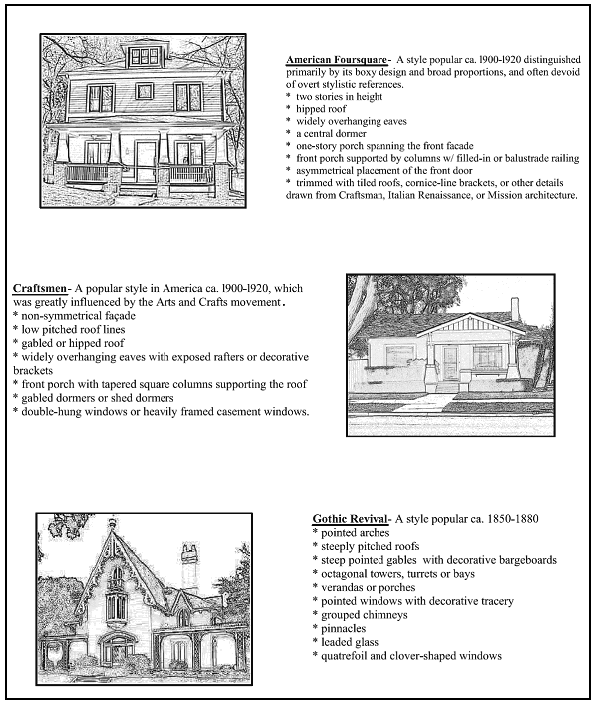
Fig. 17.04-01 Architectural Styles
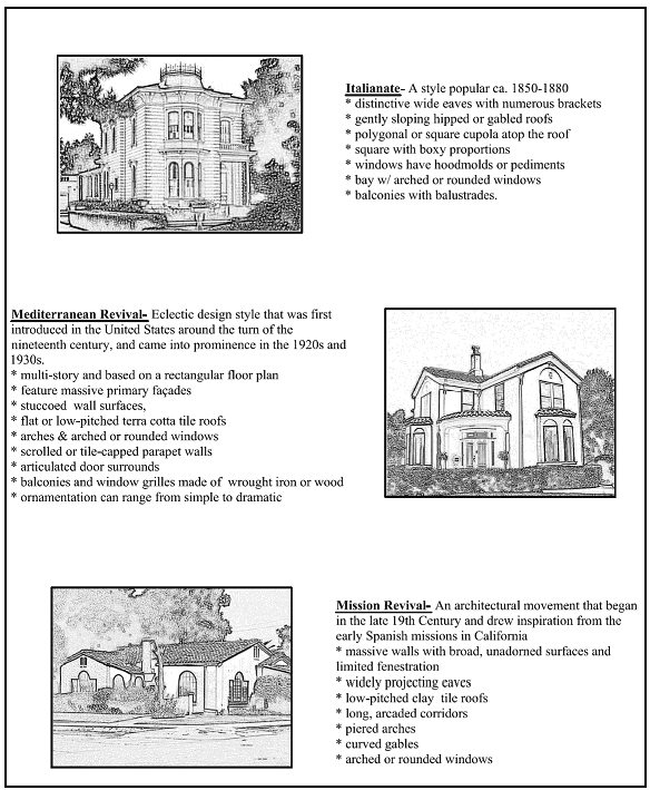
Fig. 17.04-02 Architectural Styles
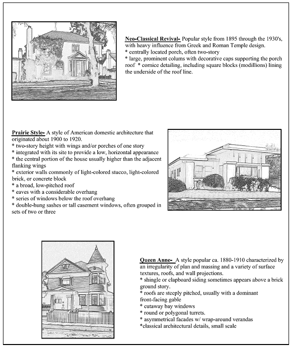
Fig. 17.04-03 Architectural Styles
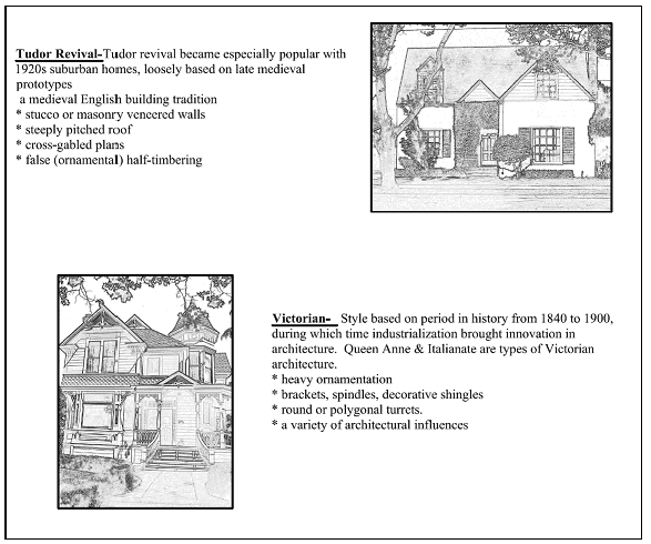
Fig. 17.04-04 Architectural Styles
a.
Design Standards.
i.
Raised foundations;
ii.
Articulated or modulated fronts with porches or entrance stoops;
iii.
Steps leading to a front porch or stoop;
iv.
Distinctive front entrances facing the street;
v.
Mixture of siding materials that terminate or transition at appropriate locations;
vi.
Distinctive ornamentation;
vii.
Variety of roof forms; and
viii.
Garages or carports shall be set back behind the front of the house or accessed from an alley.
b.
Additions to existing structures shall be designed to integrate with the existing building and incorporate its defining architectural characteristics and details. It is preferred that materials match those used when the building was originally constructed; however, suitable alternatives will be considered on a case-by-case basis with material, appearance, application, and location all given consideration.
2.
Medium Density Dwellings. Medium density residential infill projects shall be designed to integrate with adjoining properties and the neighborhood. Multifamily residential buildings shall incorporate the characteristics of the early architectural styles of the Old Town area. In the Old Town M District (eight to 12 units per acre), permitted building types include single-family dwellings, cottage homes, small lot developments and duplexes. Additional building types allowed in the Old Town H District (12 to 35 units per acre) also include multiple dwellings. Townhouse, row house and condominium projects have the potential to conflict with the historic character of the District and are discouraged but may be allowed with approval by the planning Commission of a Site and Architectural Review if the site organization, architecture and massing of buildings is harmonious with the defining characteristics of the Old Town District and standards and guidelines in this section.
a.
Design Standards.
i.
Front façades shall be similar in scale to single-family residential structures;
ii.
Individual units shall be distinguishable from others in the development;
iii.
Front entrances to units shall be distinguished and include porches or stoops;
iv.
Street-facing façades shall relate to the streetscape by including front entrances, windows and elements that mitigate the mass of a structure. Large walls with no opening or articulation shall not be allowed;
v.
Parking areas and structures shall not be located at the street side of site;
vi.
Large (in excess of 25 feet) unbroken wall planes shall not be permitted;
vii.
Roofs shall incorporate a variety of forms that relate to the building's footprint and entrance locations;
viii.
A variety of materials shall be employed to differentiate units and mitigate massing or unbroken wall segments;
ix.
Utility meters, trash enclosures, and storage areas shall be located at the rear of a building or screened from view;
x.
Detached units are encouraged to mitigate the massing of a project; and
xi.
Courtyard access to allow connections to the street, other units, parking and service areas are encouraged.
b.
Key design elements that will be considered when reviewing a residential infill development project will include:
i.
Does the architecture of the proposal relate to the architectural style of structures on adjoining properties and other structures in the block it is located?
ii.
Have neighboring structures been sited in a pattern or rhythm and does the proposal follow or compliment that pattern?
iii.
Is the height of the proposed structure in keeping with established building heights in the area?
iv.
Is the project a significant change for the neighborhood? Will the change set an example for future projects to follow?
B.
Parking Structures and Access. Wherever possible, access should be directed to an alley. On parcels without alley access, driveways shall be on the side yard the garage recessed behind the main house. Driveways should not exceed 16 feet in width.
1.
Interior Lots. Garages in multifamily developments shall be accessible from alleys or the interior of the development and shall be oriented way from public streets.
2.
Parking. Parking shall be directed to rear alleys, the side, and interior or rear yard of lots to maintain the predominant street pattern in the Old Town area. Parking courts shall be screened from view with landscaping or interesting architectural elements that provide visual interest for pedestrians. The use of permeable paving is encouraged.
C.
Landscaping and Street Trees.
1.
Existing Trees. Existing trees greater than four inches in diameter at a distance of four feet above grade shall be retained and incorporated into site development.
a.
Front Yard. All front yards shall be landscaped and include at least one tree.
b.
Street Trees. Each street frontage of a site shall be planted with one tree from the Old Town street tree list as approved and updated from time to time by the city of Hollister. Location of trees shall be subject to the approval by appropriate city staff, taking that shall take into consideration such things as and utility locations, driveway placement, and other circumstances that may affect improvements in the area as well as the health and condition of the trees and improvements in the area.
c.
Planter Strips. Planter strips adjacent to the street shall be landscaped. Paving coverage in planter strips shall not 20 percent of the aggregate planter strip area.
(Ord. 1038, § 2, 2008; Ord. 1220, § 1, 2022)
17.04.060 - Residential, West Fairview Road (RWF ) standards.
Proposed development and new land uses within the RWF (Residential, West Fairview Road) Zoning District shall comply with the requirements of this section.
A.
Applicability of Standards. It is the intent of the West Fairview Road Specific Plan to provide for a residential community utilizing a variety of housing types and densities. There are three basic land use densities that are authorized in the Plan area: The large lot single-family area; the basic density area; and the medium density area. As stipulated in Section 6.0 of the Plan, the large lot single-family area is restricted to the development standards outlined in this section. The medium density area is encouraged to be located adjacent to the proposed recreation/open space system and major roadways, and is the area that is particularly suited for small single-family lots, zero lot line single-family lots, duette lots and senior and multiple-family housing. The base density allows for standard single-family lots and may also include any of the housing types identified in subsections C through E of this section, as long as the average density does not exceed that authorized for the base density.
B.
Residential Densities. The following areas as shown on Figure 2.1 of the West Fairview Road Specific Plan are restricted to the densities noted in Table 17.04-5
Table 17.04-5 West Fairview Specific Plan Densities
C.
Development Standards. Proposed development and new land uses within the RWF Zoning District shall comply with the following standards:
1.
Modification of Residential Development Standards. To allow for land use and design continuity within the Plan area and with adjacent residential areas, the height of the residential units may be restricted to one story through the required design review process, where the adjacent land use is predominantly single-story.
2.
Site Layout, Height Limits, and Parking.
Table 17.04-6 West Fairview Road Requirements by Zoning District
Notes:
1. Lots with a minimum of 20,000 sq. ft. See Figure 6.12, West Fairview Road Specific Plan.
2. Lots with a minimum of 6,000 sq. ft. See Figure 6.13, West Fairview Road Specific Plan.
3. Lots with a minimum of 5,000 sq. ft. See Figure 6.14, West Fairview Road Specific Plan.
4. Lots with a minimum of 8,000 sq. ft. See Figure 6.16, West Fairview Road Specific Plan.
5. For corner lots, the side setback with roadway frontage shall be a minimum of 15 ft.
6. Building height may be restricted in compliance with Subsection (C)(4).
3.
Senior and Multifamily Housing. Senior or multifamily housing projects shall comply with the regulations in the R3 and R4 Zoning Districts. Multi-family housing units, with the exception of duette lots, are only authorized on the area designated as Lot 578 on the approved Tentative Map 2005-1.
4.
Intent of Development Standards. It is the intent of these regulations to provide for mixed densities of residential units for the full area and for individual projects or phases. For the base density area, a minimum of 65 percent of lots created shall be single-family lots at a minimum of 6,000 square feet. The remaining 35 percent of the lots may include lots between 5,000 square feet and 6,000 square feet, as well as duette lots of 8,000 square feet. No more than half of the lots within the 35 percent smaller shall be less than 5,500 square feet. The lots within the 35 percent may include standard detached single-family lots.
D.
Design Standards and Review Requirements. The West Fairview Road Specific Plan (Plan) modifies the existing City Development Review and permitting procedures by providing policies, implementation actions and development standards for projects within the Plan area. These projects will be subject to review and approval by the appropriate city development review body, and must be found consistent with the Plan to obtain approval. For development proposals within the RWF District, the following special design and review standards, in addition to other regulations in this title, shall be considered when reviewing individual project proposals. The West Fairview Road Specific Plan is consistent with and implements the all of the land use designations of the General Plan.
1.
Architectural Design. All dwelling units and fences constructed in the RWF District shall be of quality design and shall utilize quality materials, and shall be designed in compliance with the policies and actions set forth in Section 6.0, Community Design, West Fairview Road Specific Plan. Of specific importance are the design features set forth in Policies 6.2.1 through 6.2.4 of the Plan.
2.
Open Space Design. A linear and neighborhood park system shall be provided within the District area, and shall be designed in compliance with the policies and actions set forth in Section 6.0, Community Design, and West Fairview Road Specific Plan. Street trees shall be planted throughout the District area as set forth by Policy 6.3.1 of the Plan.
3.
Circulation Design. Roadways and pedestrian paths shall be designed in compliance with the policies and actions set forth in Section 4.0, Circulation, West Fairview Road Specific Plan. Internal circulation shall be organized in a logical pattern to unify and strengthen neighborhood character, as outlined by the actions specified in Policy 6.1.5 of the Plan.
4.
Review Procedures. All projects proposed for standard single-family lots as defined by Section 6.3 of the West Fairview Road Specific Plan shall be subject to development review by the Department prior to acceptance of building permit applications. Any staff design review action or decision is subject to appeal to the Commission. In addition, where there is a question by staff, the public, or the developer as to whether the housing designs meet the requirements of the Specific Plan, the designs may be referred to the Commission. All other residential development types shall be, for the purposes of this District, considered to be in a "S" Special Zoning Area, and shall be subject to Site and Architectural Review approval by the Commission or its designee, prior to acceptance of building permit applications.
(Ord. 1038, § 2, 2008)