
Horry County Unincorporated
City Zoning Code
City Zoning Code
ARTICLE V
- LANDSCAPE, BUFFER AND TREE PRESERVATION STANDARDS
Sec. 500.- Intent.
The landscaping and preservation standards of this section are intended to accomplish the following:
1.
To protect and preserve the character and aesthetics of the natural environment within Horry County;
2.
To enhance property values by ensuring proper transition between land uses;
3.
To reduce noise, air and visual pollution, heat island effects, and stormwater runoff; and
4.
Improve appearance of parking areas and reduce glare from vehicle lighting.
Sec. 501. - Applicability.
A.
Landscape Design Standards set by § 504, below, apply to any non-residential, quadraplex, townhome, and in-common residential projects within unincorporated Horry County that are being developed or redeveloped. Major residential subdivisions, including single-family and duplexes, must comply with perimeter buffer requirements if located along a road found within Table 1: Applicable Roads. Major residential developments that are not on Table 1 roads must only comply with the Type C streetscape buffer requirements as described in § 504B, Table 4.
1.
Properties where renovations modify or expand a structure or business wherein the percent of value, calculated as the cost of modification divided by the existing structure improvement value multiplied by 100, is greater than 50% shall trigger full compliance to the landscaping requirements set forth. General maintenance and repairs including interior work, are exempt from the standards.
2.
If an existing business is damaged or destroyed due to an act of nature (flood, hurricane, tornado, etc.), or catastrophic event and is reconstructed within twelve (12) months of such damage or destruction, the standards contained herein shall not apply. This exemption, however, shall not relieve the property owner of having to meet applicable building or zoning regulations that are in place during time of reconstruction.
3.
Additional design requirements may be set by an overlay district found in Article VIII.
4.
The Zoning Administrator or authorized designee has the authority to allow variation of design standards (§ 504) and tree preservation (§ 505) requirements for unique and challenging projects.
B.
Non-residential, multifamily, quadraplex, townhome, and in-common residential projects that are located along Table 1: Applicable Roads must meet the Tree Preservation Standards set in § 505 in addition to the required landscape plantings set by § 504.
C.
Live Oak Standards set by § 505C apply to any property within Horry County including single family residential.
Sec. 502. - Business licensing.
If a Horry County business license is required for any ditching, clearing, excavating or grading of land or planting, cutting, trimming, pruning, removing, or otherwise modifying trees, applicants must sign an affidavit stating receipt and comprehension of these standards.
Sec. 503. - Requirements.
A.
Landscaping plan. To comply with the regulations set by the Landscape Buffer and Tree Preservation Standards, preliminary and construction plans shall include a landscape plan demonstrating how existing and proposed landscaping and tree preservations comply with the requirements of the following sections prior to the issuance of a building permit or construction plan approval, whichever is applicable. Plans shall comply with Horry County plan submittal requirements and contain enough detail to illustrate that the landscape requirements of this ordinance have been met. At a minimum a landscaping plan will include:
1.
Location of any structures (existing and proposed);
2.
Any preserved tree or shrub indicating species along with diameter at breast height (DBH) of any trees and heights of shrubs. Dripline should be indicated if DBH is greater than twenty four (24) inches. A tree protection method detail will need to be supplied for those trees to be retained on-site;
3.
Any planted landscaping and non-vegetated requirements;
4.
Vehicle use and parking areas;
5.
Easements, overhead and underground utilities, and ditches; and
6.
Irrigation.
a)
Plantings must be mechanically irrigated.
b)
Required planting areas associated with vehicle use areas containing less than thirty (30) spaces are not required to be mechanically irrigated, however all supplemental plantings shall be located within one hundred (100) feet of a water hose bib on-site. Any alternative water sources will require approval from the Zoning Administrator or designee.
7.
Perimeter buffers within a major residential development shall be platted within open space/common area.
B.
Maintenance. Maintenance of landscaping shall be the responsibility of the property owner. All areas shall be properly maintained to ensure proper functioning, capacity and growth. Landscaping shall be continuously monitored and maintained for the lifetime of the use to assess the need to remove dead, dying or diseased vegetation, along with debris or litter within required areas and ensuring fencing, berms, or walls are in good condition.
1.
Any required landscaping that is removed must be replaced in a like fashion and must meet the minimum standards herein.
2.
Protected and Specimen Trees may be periodically pruned to enhance growth and prevent public endangerment. Pruning techniques must meet the most recent American National Pruning Standard ANSI A-300 publication.
3.
Undisturbed, naturally forested areas within a required perimeter buffer shall be maintained and retained in accordance to § 504C3a.
C.
Exemptions. The following land use activities are hereby exempt from the requirements of the following sections.
1.
Agriculture activities involving the continuous cultivation of field crop, livestock, and evergreen and nursery stock for profit.
2.
Aquaculture activities involving the continuous production of fish, amphibian, or crustaceans for profit.
3.
Forest management activity including but not limited to timber harvesting, forest regeneration, thinning, site preparation, forest road construction, prescribed burns, reforestation, pesticide application, vector control, wildfire control, animal damage control, and other generally accepted forestry methods and practices as defined by the Dictionary of Forestry published by the Society of American Foresters.
4.
Individual single family residential and duplex structures are exempt from all requirements except the Live Oak Protections set forth in the Tree Preservation sections. This exemption does not apply to major subdivisions for which perimeter buffers or streetscape is required.
5.
Tee, green, and fairways associated with regulation golf courses and Par 3 golf courses, except for presence of Protected and Specimen trees. Clubhouses and maintenance facilities are not exempt.
6.
Roadway, drainage maintenance, and stormwater control activities of Horry County, South Carolina Department of Transportation or any other public agency.
7.
Utility (electric, cable, telephone, etc.) and easements involved in facility construction, maintenance, repair or replacement are exempt from the tree preservation sections.
8.
Airports provided the removal is for the purpose of maintaining safe clearance for aircrafts as per federal law.
9.
Sites classified as home occupations by the Zoning Administrator.
10.
Jurisdiction and non-jurisdictional wetlands as certified by the US Army Corps of Engineers are exempt from § 504.
D.
Penalties. It shall be illegal to remove or cause the removal of any Protected or Specimen tree or any required landscaping.
1.
Removal of said trees without proper permits or permissions are in violation of this ordinance and shall require replacement of such removed trees at four (4) times the rate required for mitigation for Preserved or Specimen Trees.
2.
Failure to comply may result in a misdemeanor punishable by the maximum fine of $500.00 per removal. Each tree removed constitutes a separate offense. This fine would be in addition to the penalty stated in section D(1) above.
3.
Deviation from the approved landscape plan or failure to comply with industry standard landscape maintenance may also be subject to fines and penalties.
Sec. 504. - Landscape design standards.
A.
General. Any new required plantings shall meet the standards described in this section and referenced within the supplemental Landscape Handbook.
1.
Landscaping preservation.
a)
Preservation of existing vegetation is the preferred method to meet the buffer requirements.
b)
Preserved vegetation should be located within the site in a way that is conducive to plant survival and safety, i.e. clustered tree patches are allowable for stable root systems as long as supplemental landscaping meets the requirements herein.
c)
Credit shall be awarded for preserving existing trees on a one to one (1:1) basis for required trees (canopy and understory) as part of supplemental plantings when the existing trees meet the minimum size requirements in landscaped areas and are located within the required buffer.
i.
Preserved Protected Trees receive credit at a two to one (2:1) exchange.
ii.
Preserved Specimen Trees receive credit at a four to one (4:1) exchange.
iii.
Reductions to required planted landscaping shall apply should the DBH of preserved trees be greater than twenty-four (24) inches and the driplines create unsuitable habitat for supplemental plantings.
iv.
Credit is applied per tree, not DBH.
d)
Preservation of Protected and Specimen Trees is required. Mitigation is required for any removals of protected or specimen trees. Fines may apply for unlawful removals. See § 505 Tree Preservation Standards for requirements.
e)
In order to reduce the amount of impervious surfaces, the Zoning Administrator can grant a five (5) percent reduction in the number of off-street parking spaces required on the site if the reduction of pavement will preserve the root zones of existing healthy trees with a DBH of eight (8) inches or greater.
2.
Plant materials. A supplemental Landscape Handbook of plant species best suited for Horry County along with a list of discouraged species is included as a supplement to this ordinance.
a)
The Handbook should be used for landscape requirements where applicable.
b)
Prohibited and invasive plants will not count towards any landscape or preservation requirements.
c)
Any dead, dying or diseased planting materials must be removed by the property owner prior to development providing minimal disturbance to healthy vegetation.
d)
Removed existing vegetation must be replaced to meet the minimum requirements herein.
3.
Minimum plant sizes. All new vegetation must meet the minimum size requirements at time of planting.
a)
Canopy tree: minimum ten (10) feet in height with two (2) inches in caliper and must reach a mature height of at least thirty (30) feet.
Palms meeting this requirement may be utilized provided two (2) palms are planted per one (1) required canopy tree.
b)
Understory tree: minimum five (5) feet in height and must reach a mature height between ten (10) and thirty (30) feet.
c)
Shrub: minimum fifteen (15) inches in height and must reach a mature height of at least three (3) feet.
Palms meeting this requirement may be used.
d)
Ornamental grass: minimum twelve (12) inches in height and must reach a mature height of at least three (3) feet.
e)
Perennials: minimum twelve (12) inches in height and must reach a mature height of at least three (3) feet.
4.
Site constraints.
a)
Stormwater management devices (such as swales and ponds measured from the top of bank and drainage easements) may not encroach into the required landscape buffers by more than ten (10) percent unless an approved low impact development (LID) design. Stormwater management devices may not encroach into the required Type C Residential (Streetscape) buffer by more than twenty-five (25) percent.
b)
Where cross access easements run parallel to property lines, landscaping may be provided within the easement pending approvals from appropriate County departments.
c)
Without consent of utility provider, easement holder, or Horry County, only shrubs, ornamental grasses or perennials may be planted in easements for utility services.
i.
Overhead Utilities (power lines): only trees or shrubs that reach a maximum height of twelve (12) feet can be planted within the easement.
ii.
Underground Utilities (piped utilities): tree species whose roots are known to cause damage to utilities such as underground piped stormwater, sewer, or gas lines, shall not be planted within the easement for such utility or no closer than twelve (12) feet when no easement exists. Approved trees for planting on top of underground utilities can be found within the Landscape Handbook.
d)
Visibility Clearance/Sight Triangle. Required landscaping or optional berms shall not be planted or constructed within the sight triangle, unless it conforms to SCDOT standards. Plantings cannot be greater than thirty (30) inches in height and trees must be limbed above six (6) feet in height with no multi-stemmed trunks. For all intersections and corners there shall be 100 feet of visibility for every ten (10) miles per hour of speed limit.
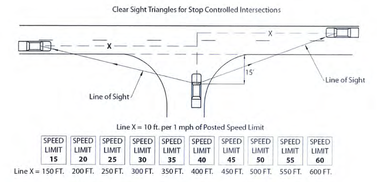
Figure 1: Sight Triangle
5.
Plant diversity. In order to maximize success of vegetation and prevent monocultures, new plantings shall comply with the following standards in Table 2: Species Diversity Standards. The standards apply to the total amount of vegetation on site, not just the vegetation within a required buffer.
6.
Ground stabilizations. Disturbed areas and required landscape planting areas shall be stabilized and maintained with groundcover, mulches, or other approved materials.
7.
Berms. Berms are discouraged as standalone landscaping. However, there are cases where berms are appropriate for screening or buffering. The use of a berm does not negate the buffer requirements described herein. Berms should comply with the following:
a)
Side slope of earthen berms not to exceed a two to one (2:1) ratio.
b)
Berms should be continuous except for drainage breaks every six (6) feet to eight (8) feet.
c)
Berms shall be stabilized with understory, shrubs, ornamental grasses, or perennials. Groundcover or lawn and turf grasses shall be used as supplemental stabilizations. Planting shelfs are required for any vegetation.
Planting shelfs must be a minimum of four (4) feet wide and be suited for maximum survival and success of selected plantings.
d)
Berms used along a rights-of-way must be designed and constructed to provide adequate sight distances at intersections and shall not impede safe operation of vehicles. Berms shall not encroach into residential lots.
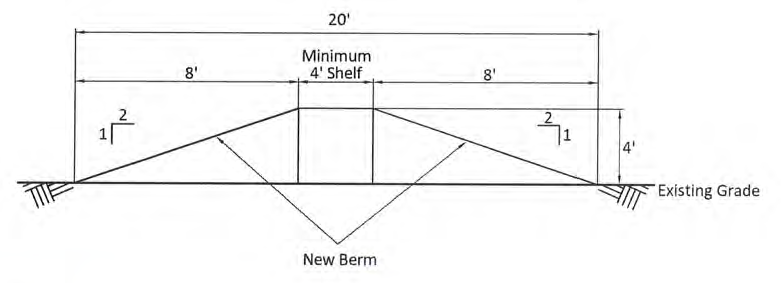
Figure 2: Berm Diagram
8.
Low impact development (LID). Low Impact Development utilizes integrated management practices in order to treat stormwater at the source. The goals of LID are to maximize existing vegetation and create small, landscaped features that encourage infiltration, lengthen the time of concentration, and retain flow to create a hydrologic landscape functionally equivalent to the pre-development conditions.
a)
These features must be constructed to meet the Department of Stormwater Management requirements and regulations set forth in the Stormwater Management Design Manual.
b)
All LID stormwater features must be planted with water tolerant vegetation in order to qualify for landscape credits and be located within the required landscaped areas. For suggested LID plants, refer to the Low Impact Development in Coastal South Carolina: A Planning and Design Guide.
c)
LID is prohibited within:
i.
Type A: Opaque Buffers.
ii.
Type C: Non-Residential Streetscape Buffers along Table 1: Applicable Roads.
d)
Examples of qualifying LID include:
i.
Bioretention.
ii.
Vegetated swales.
iii.
Constructed wetlands.
e)
Credits for Required Landscaping by using LIDS.
i.
For every one (1) linear foot of qualifying low impact development, a credit for one and a half (1.5) feet of required landscaping buffer can be claimed. LID can replace up to fifty (50) percent of the required landscaped area.
ii.
To qualify for this credit, the LID method must follow all requirements set by the Horry County Stormwater Department.
iii.
If using LID within parking islands, the requirement of every parking space being within fifty (50) feet of a tree can be waved.
B.
Buffers defined. A buffer is a specified land area used to transition between land uses or zoning.
1.
Permitted use within buffers.
a)
Bicycle and pedestrian facilities (including sidewalks);
b)
Appurtenances that require high visibility such as fire hydrants, mail boxes, and utility boxes;
c)
Ingress and egress to the proposed use and utilities may cross the buffer provided it is as perpendicular as practical;
d)
Permitted and temporary signs; and
e)
Site lighting.
2.
Prohibited use.
a)
Structures or accessory structures, including dumpsters;
b)
Any storage or outdoor display of products, unless permitted elsewhere in this ordinance; and
c)
Vehicle use areas, including parking or loading areas.
C.
Perimeter buffer requirements.
1.
Intent.
a)
Opaque. To provide screening between dissimilar uses. Opacity shall be 85% or more during peak summer season from ground to six (6) feet.
b)
Spatial. To soften the area between adjacent similar uses.
c)
Streetscape. To enhance the visual character and transition between property and street, access or public right-of-way.
2.
Applicability.
a)
Perimeter buffers are required surrounding the improved area of the subject property.
b)
Opaque (Type A) buffers are required between non-residential and residential property. Spatial (Type B) buffers are required between like use parcels. Streetscape buffers (Type C) are required between any parcel and the street frontage, access or right-of-way. See Table 3: Perimeter Buffer Type Applicable.
3.
Standards. Requirements of each buffer type are found in Table 4: Perimeter Buffer Type Requirements.
a)
Undisturbed naturally forested areas shall meet the following criteria:
i.
These areas typically include native and existing vegetation of varied ages, heights, and types (i.e. a mixture of canopy, understory, and ground cover).
ii.
A 25' wide buffer shall consist of a minimum of ten (10) existing canopy trees with a minimum 6" DBH or twenty (20) existing canopy trees with a minimum 4" DBH per 100 linear feet. The number of trees shall increase or decrease proportionately based upon the minimum buffer width requirement.
iii.
Forested jurisdictional and non-jurisdictional wetlands as certified by the US Army Corps of Engineers qualify as an undisturbed naturally forested buffer area and a tree survey for these areas shall not be necessary.
iv.
Supplemental plantings shall be required to fill in gaps in vegetation where the entire buffer is not classified as an undisturbed naturally forested area.
v.
Supplemental plantings within this area shall be native species and are not required to be irrigated or provide ground cover (i.e. mulch).
vi.
Maintenance of the understory is permitted within the buffer. Maintenance includes, but is not limited to, clearance of dead vegetation, invasive species, and Firewise management practices (where applicable).
vii.
A tree survey shall be submitted with the landscape plan to document the buffer area meets the minimum requirements to qualify as an undisturbed, naturally forested buffer.
b)
The Type C Residential Streetscape buffer may be educed down to a Type C 10' buffer under the following conditions:
i.
Where the development has frontage along an existing Private R/W;
ii.
Where there is less than 300 lf. of frontage along an existing R/W (regardless of width or ownership of that existing R/W) and there are no more than fifty (50) lots/units proposed;
iii.
When the proposed development/phase is a continuation of an existing development, as shown on a Master Plan approved on or prior to January 4, 2022, unless said Master Plan identifies specific streetscape buffer requirements that exceed these standards.
iv.
These exemptions do not supersede any overlay landscape requirements.
Figure 3: Type A Buffer Option 1
Figure 4: Type A Buffer Option 3
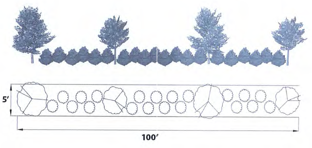
Figure 5: Type B Buffer
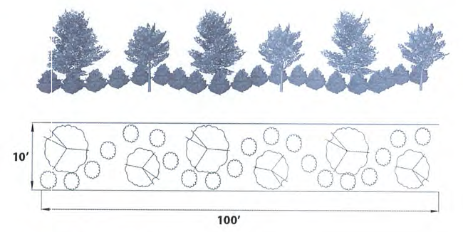
Figure 6: Type C Non-Residential Buffer
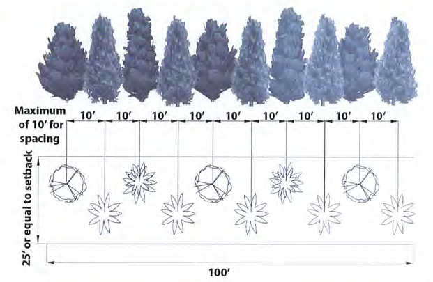
Figure 6: Type C Major Residential Buffer Option 1
D.
Vehicle use area requirements.
1.
Intent.
a)
Street frontage. To reduce the glare and impacts of headlights on road traffic.
b)
Parking islands. To provide shade, reduce heat islands and provide visual character to the parking area.
2.
Exemptions. Street Frontage plantings are only required when the vehicle use area is located adjacent to the street.
3.
Standards.
a)
All landscaping areas that abut parking shall be protected by eighteen (18) inches of clearance utilizing staked wheel stops, concrete curbing or other approved stable means. Appropriate breaks for low impact development are permissible when using curbing.
b)
Street frontage. Shrubs, perennials or ornamental grasses must meet proper spacing guidelines found in the Landscape Handbook in a continuous row. Plantings can be located within the setback or Perimeter Buffer.
c)
Parking islands shall comply with the following:
i.
Every parking space must be within fifty (50) feet from a planted tree.
ii.
For every fifteen (15) parking spaces in a row, a parking island is required and must include one (1) tree and five (5) shrubs, perennials or ornamental grasses. Twenty-five (25) percent of the total plantings must be evergreens. Fifty (50%) of all trees planted must be canopy. Parking islands containing canopy trees must be at least 200 square feet.
iii.
For parking areas of ninety (90) spaces or more, there must be an additional ten (10) foot wide parking island between modules.
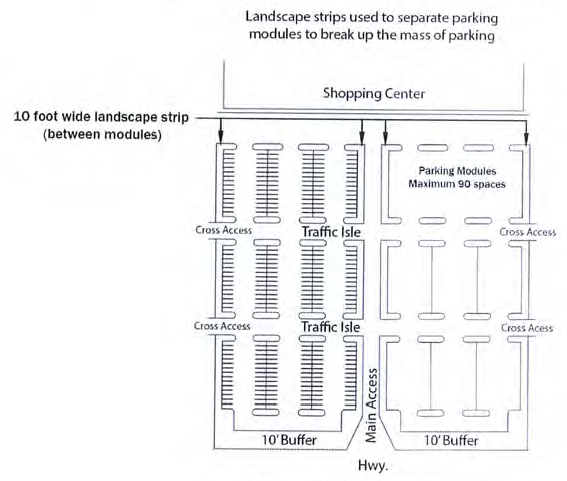
Figure 7: Parking Lot Layout
E.
Foundation buffer.
1.
Intent. To enhance architectural features, provide a visual transition from building to site, and define and enhance building entrances.
2.
Exemptions.
a)
Building entrances and exits.
b)
Areas used for pedestrian activities (sidewalks, plazas, etc.). In these instances, the landscaping must be installed between the building foundation and the back of the curb separating the pedestrian area from the vehicle use area. In no case shall the length of the planted area be less than fifty (50) percent of the length of the building facade, minus the width of the entrances or exits.
c)
Portions of buildings which have drive-up services along the side of the building (fast-food restaurants, pharmacies, banks, etc.).
d)
Areas not typically accessible by the general public (loading docks, enclosed storage areas, utility enclosures, etc.).
e)
Properties where the structure is located less than or equal to twenty-five (25) feet from the property line and no vehicle use or paving is located within this space.
3.
Standards.
a)
A landscape area of at least five (5) feet in width shall be provided adjacent to buildings along the foundation or between the foundation and the back of the curb separating the pedestrian area from the vehicle use area where applicable.
i.
Foundation buffers are required around any structure on site.
ii.
A mandatory variety of species must be used according to Table 2: Species Diversity Standards.
iii.
The required plantings must include shrubs, perennials or ornamental grasses and meet the spacing requirements set in the Landscape Handbook. Trees may be used if applicable at the discretion of the property owner and approved by the Zoning Administrator.
b)
Renovated or redeveloping properties wherein the foundation buffer area is paved may utilize planter boxes to meet the requirements of the foundation buffer.
i.
Planter boxes must be automatically irrigated and be at least two and a half (2.5) feet wide.
ii.
Use of planter boxes does not alleviate proper maintenance requirements and box size must allow for proper root spacing.
iii.
The Zoning Administrator or designee can discuss alternatives and ways to meet the foundation buffer requirements for unique situations.
Sec. 505. - Tree preservation.
A.
Tree survey.
1.
Non-residential, multi-family, quadraplex, townhome, & in-common residential projects located along Table 1: Applicable Roads must provide a tree survey documenting all trees listed in Table 5: Protected and Specimen Trees meeting or exceeding the minimum diameter at breast height (DBH). Any property, including single family residential, within Horry County containing Specimen Live Oaks must submit a tree survey. Any new major residential developments will need to identify Specimen live oak trees within the project boundaries on the preliminary plans and plats. If an undisturbed, naturally forested buffer is utilized for a non-residential or major residential development, a tree survey shall be submitted to document the buffer vegetation meets the minimum requirements.
2.
Tree surveys submitted must indicate the species and DBH of any Protected or Specimen Trees, denoting Specimen Live Oaks separately from other oak species.
3.
Trees shall not be removed until submittal of tree survey. Approval to remove said trees, with exception of Specimen Live Oaks, shall be obtained from the Zoning Administrator, or designee. If approval to remove said tree is granted, removed trees shall be mitigated.
B.
Methods to calculate tree size.
1.
Caliper. The diameter of a tree trunk measured six (6) inches above the root ball.
2.
Diameter at breast height. The diameter of a tree trunk measured four and a half (4.5) feet above the ground.
a)
Forks located less than one (1) foot from the ground are to be treated as separate trees and measured at standard DBH. The square root of each DBH (sum of the square of each) is used to derive total DBH.
a.
Total DBH =
![]()
where:
b.
"a" and "b" are the DBH of split trunks.
b)
Forks located between one (1) foot and four and half (4.5) feet from the ground are to be treated as separate trees and calculated with the formula above but measured from three and a half (3.5) feet from the pith, or at the start of the fork.
c)
Forks located at or greater than four and half (4.5) feet from the ground are measured just below the fork beneath the swelling.
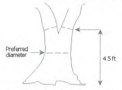
Figure 7: DBH for Forks located at or above 4.5 feet
C.
Live oak standards. It is unlawful to injure, participate in, authorize, or cause the removal of any Specimen Live Oak (DBH of twenty-four (24) inches or greater). Authorization to do so shall come from:
1.
A variance granted by the Zoning Board of Appeals finding that the tree:
a)
Presented a safety hazard to pedestrian or vehicular traffic, buildings, structures or utility structures;
b)
Removal presented the only reasonable means to comply with appropriate agency requirements including parking, ingress or egress, or other required infrastructure such as stormwater;
c)
Justification according to good urban forestry practices (i.e., to reduce competition among trees or to remove an invasive species) or presence of dead, dying, or diseased trees;
d)
A planned grade cut placing the tree protection zone four (4) feet above final grade or introduction of fill twelve (12) inches or greater elevating the parcel above the required flood protection elevation; or
e)
Reasonable use of the property will be significantly impaired.
2.
For all areas within the Garden City Overlay, the Zoning Administrator shall allow the tree to be removed upon a finding that the tree will be located within the footprint of a proposed structure and the structure cannot be reasonably adjusted to preserve the tree. This provision does not exempt the tree from the mitigation standards in § 505E.
3.
The Zoning Administrator may authorize the removal a Specimen Live Oak tree without a variance under the following conditions:
a)
The tree is diseased or dying as certified by a certified arborist and cannot be properly treated or pruned to alleviate such condition;
b)
Such assessment must be provided to the county in writing, and the diseased or dying state of the tree may be assessed by the County;
c)
Should the County confirm the tree is diseased or dying and cannot be treated for such condition, a zoning compliance may be issued for removal of the tree;
d)
Mitigation Standards in § 505E will still apply.
4.
If a Specimen Live Oak tree is unlawfully removed, building permits and further subdivision of the parcel will be prohibited for a period of two (2) years.
D.
Tree protection. Preserved trees must be protected from damages during development. Most trees can tolerate only a small percentage of root zone disturbance or loss.
a)
Root Protection Zone: the total area beneath the tree canopy, or dripline.
b)
If encroachment into the root protection zone is anticipated, preventative methods shall be employed to include:
i.
Flagging of Protected or Specimen Trees prior to land disturbance activity;
ii.
Mulching the Root Protection Zone during soil compaction;
iii.
Vertical root pruning techniques to cut rather than tear or damage root systems during site clearing; and
iv.
Installation of Protective Devices.
c)
Protective Devices shall be installed surrounding the dripline of the preserved tree and must be kept free of construction materials, vehicles or debris. Areas surrounding the preserved tree must be identified with "tree protection area" signage. Protective Devices shall be one of the following:
i.
Fencing a minimum of four (4) feet in height constructed in a post and rail configuration. Two (2) inch by four (4) inch and double one (1) inch by two (2) inch railing is recommended.
ii.
Four (4) foot high polyethylene laminar safety fencing provided it is maintained to persist until occupancy.
iii.
Continuous rope, flagging (heavy mill, minimum four (4) inches in width) or silt fencing is allowable only in areas that will not be directly impacted by land disturbance activities.
E.
Mitigation standards.
1.
Mitigation: Mitigation for removal of Protected or Specimen Trees is required. Requirements may be met by either:
a)
Replacement Trees.
i.
Total caliper of replacement trees must equal the total DBH of Protected or Specimen Trees removed.
ii.
All replacement trees must be a species listed in Table 5: Protected and Specimen Trees.
iii.
Newly planted replacement trees will follow the following formula:
D/2.5 A = RT B , where:
D = total DBH of the largest fifteen (15) removed trees per acre (inches)
2.5 = minimum caliper of each replacement tree (inches)
RT = minimum number of replacement trees
A.
If the caliper of replacement trees is greater than two and a half (2.5) inches, the total number of replacement trees can be reduced.
B.
A multiplier of one and a half (1.5) is applied when trees removed are Specimen Trees.
iv.
Trees preserved on site that do not meet the size requirements of Table 5: Protected and Specimen Trees may count as replacement trees provided each tree has a DBH of four (4) inches or greater.
b)
Fee in lieu.
i.
A fee in lieu of replacement trees collected will be equal to:
RT * 150 = F, where:
RT = minimum number of replacement trees
150 = fee per replacement tree (dollars)
F = total fee paid to Horry County
ii.
Fees collected are deposited into a special fund designated for costs associated with the installation of landscaping, associated materials and irrigation systems or the purchase of additional park or open space lands.
iii.
"F" shall be increased at 2 times the standard rate (dollars) for Protected and Specimen live oaks.
(Ord. No. 44-2023, § 1, 5-16-23)