
Huntersville City Zoning Code
ARTICLE 3
ZONING DISTRICTS
T24-03 Conditional Zoning District
TA23-06
T24-12 SUP
T24-06 Farmhouse Cluster
Draft TA25-06 Buffer Yards
Draft TA25-08 Part 1
Draft TA25-01
T24-07
TA22-02
TA22-07
TA22-16
TA22-13
Draft TA25-07 (Zoning)
3.1.1 General Districts
The General Zoning Districts are established below in a hierarchy from “lowest” to “highest”. Reclassification of property to any general zoning district is considered under the procedures of Section 11.4. The requirements of each general district are established in Section 3.2.
| District | Classification | |
| R | Rural District | Residential |
| TR | Transitional Residential District | Residential |
| NR | Neighborhood Residential District | Residential |
| GR | General Residential District | Residential |
| TND-R | Rural Traditional Neighborhood Development District | Mixed Use |
| TND-U | Urban Traditional Neighborhood Development District | Mixed Use |
| TOD-R | Transit-Oriented Development District – Residentially Led | Mixed Use |
| NC | Neighborhood Center District | Mixed Use |
| TC | Town Center District | Mixed Use |
| CI | Campus Institutional District | Mixed Use |
| TOD-E | Transit-Oriented Development District – Employment Led | Commercial |
| HC | Highway Commercial District | Commercial |
| CB | Corporate Business District | Commercial |
| VS | Passenger Vehicle Sales District | Commercial |
| SP | Special Purpose District | Commercial |
3.1.2 Conditional Zoning Districts
Conditional zoning districts correspond to general districts. Conditional zoning districts may be appropriate for situations including, but not limited to, the following:
- Thethe general district has insufficient standards to mitigate the site-specific impact on surrounding areas.
- Projects where modifications of the ordinance standards may be needed to provide flexibility for design that exceeds minimum ordinance standards.
- Projects that provide a public benefit such as a new or improved public space or transportation improvements. Examples may include, but are not limited to, public streetscape improvements, parking facilities, greenway construction, transit facilities, etc.
The Town Board in its sole discretion will determine the merit of the proposed conditional district. Uses that may be considered for a conditional zoning district are restricted to those uses permitted in the corresponding general zoning district. Conditional Zoning Districts are established on an individualized basis, at the request of all owners of the property to be included, according to the procedures of Section 11.4. Zoning of a conditional zoning district is not intended for securing early or speculative reclassification of property. It is expected that, in most cases, the standards of the General Districts appropriately regulate the site-specific impact of permitted uses and structures on surrounding areas.
| District | Classification | |
| R (CD) | Conditional Zoning Rural District | Residential |
| TR (CD) | Conditional Zoning Transitional Residential District | Residential |
| NR (CD) | Conditional Zoning Neighborhood Residential District | Residential |
| GR (CD) | Conditional Zoning General Residential District | Residential |
| TND-R (CD) | Conditional Rural Traditional Neighborhood Development District | Mixed Use |
| TND-U (CD) | Conditional Urban Traditional Neighborhood Development District | Mixed Use |
| TOD-R (CD) | Conditional Transit-Oriented Development District – Residentially | Mixed Use |
| NC (CD) | Conditional Zoning Neighborhood Center District | Mixed Use |
| TC (CD) | Conditional Zoning Town Center District | Mixed Use |
| CI (CD) | Conditional Zoning Campus Institutional District | Mixed Use |
| TOD-E (CD) | Conditional Transit-Oriented Development District – Employment | Commercial |
| HC (CD) | Conditional Zoning Highway Commercial District | Commercial |
| CB (CD) | Conditional Zoning Corporate Business District | Commercial |
| VS (CD) | Conditional Passenger Vehicle Sales District | Commercial |
| SP (CD) | Conditional Zoning Special Purpose District | Commercial |
3.1.3 Overlay Districts
An Overlay District is a zoning district that is applied only in conjunction with another zoning district. It may grant additional uses, restrict permitted uses, or impose development requirements that differ from those of the underlying district. The underlying district and the overlay district, taken together, will control development. The Overlay Districts are established below. The requirements of each Overlay District are set forth in Section 3.3.
| District | Classification | |
| MH-O | Manufactured Home Overlay District | Residential |
| MIL-O | Mountain Island Lake Watershed Overlay District | Environmental Protection |
| LN-O | Lake Norman Watershed Overlay District | Environmental Protection |
3.1.4 Zoning District Boundary Interpretation
- Where district boundaries are shown within a street or alley right-of-way, railroad or utility line right-of-way, recorded easement, or navigable or non-navigable waterway, such boundaries shall be construed to be in the center of the right-of-way, easement, or waterway.
- Where district boundaries are so indicated that they approximately follow lot lines, or town, city, or county borders, such lines shall be construed to be said district boundaries, unless otherwise indicated.
- Where district boundaries are so indicated that they are approximately parallel to the centerlines of streets, highways, or railroads, or rights-of-way of same, such district boundaries shall be construed as being parallel thereto and at such distance therefrom as indicated on the zoning map. If no distance is shown, such distance shall be determined by the use of the scale shown on the Official Zoning Maps.
- Where a district boundary line divides a single lot, each part of the lot shall be used in conformity with the standards established by these regulations for the district in which that part is located.
- Zoning district boundaries are automatically amended to remain consistent with the boundaries of the Zoning Maps incorporated herein by reference pursuant to Section 1.5. If, because of error or omission in the maps, any property within the jurisdiction of this ordinance is not shown as being in a zoning district, such property will be classified as TRANSITIONAL until changed by amendment.
- When a zoning case file contains detailed, verifiable information regarding the boundary, that information will be used as the correct boundary location.
- In instances where none of the above methods are sufficient to resolve the boundary location, the reasonable maintenance of a regular boundary will be used to establish the boundary location.
3.2.1 RURAL DISTRICT (R)
Intent: The Rural District is provided to encourage the development of neighborhoods and rural compounds that set aside natural vistas and landscape features for permanent conservation. The density of development is regulated on a sliding scale; permitted densities rise with increased open space preservation. Development typologies associated with the Rural District are farms, the single house, the conservation subdivision, the farmhouse cluster, and the residential neighborhood. The section number in parenthesis following listed use indicates the ordinance section of development conditions.
- Permitted Uses.
Uses permitted by right.
• bed and breakfast inn
• boarding or rooming houses for up to two roomers
• family care home
• residential uses
Uses permitted with conditions.
• cemeteries, (9.7)
• religious institutions, (9.8)
• commercial communication towers, (9.9)
• essential services 1 and 2, (9.14)
• government buildings up to 5,000 sq. ft. of gross floor area; fire stations are permitted in government buildings up to 15,000 sq. ft. of gross floor area
• neighborhood and outdoor recreation, (9.21)
• parks, (9.29)
• plant nurseries, (9.46)
• riding academies and/or commercial stables, (9.33)
• schools, (9.35)
• transit shelters, (9.39)
• banquet facility, (9.59)
• dormitory for a bona fide farm, (9.62)
Uses permitted with Special Use Permit.
• agricultural industry, (9.3)
• solar energy facility, major, (9.54)
• wind energy facility, major, (9.53)
• wind energy facility, minor, accessory (9.53) - Permitted Building and Lot Types.
• duplex
• civic building
• detached house - Permitted Accessory Uses.
• accessory dwelling, (9.1))
• daycare home (small), (9.11)
• home occupations, (9.19)
• marinas, (9.42)
• solar energy facility, minor residential (9.54)
• solar facility, minor non-residential (9.54)
• accessory uses permitted in all districts (8.11) - General Requirements.
- Frontage on a public street is required for all lots in the Rural District except those comprising a Farmhouse Cluster (see Special Requirements, paragraph e), this section), those comprising a Conservation Subdivision (see Special Requirements, paragraph f), or those specifically exempted in Article 8.1.
- Development in the Rural District shall meet the following standards:
- Non-residential lots outside of planned developments and lots in exempt subdivisions not approved as Farmhouse Clusters or Conservation Subdivisions require a minimum lot size of 20,000 sq. ft. and a minimum lot width of 90’; no open space requirement. Further, individual lots of less than 20,000 sq. ft. and/or 90’ width, existing prior to the effective date of this ordinance, are construed to be conforming.
- Except as provided in a. above, Farmhouse Cluster and Conservation Subdivision Standards, density in the Rural zoning district shall be as follows:
Percent Open Space 0% unless tract is within a proposed greenway, in which case the greenway shall, at a minimum, be reserved as open space per the subdivision regulations 25% 45% or more Units per Gross Acre Less than .3 units per acre .30 .90 - For every 1% additional open space over 25%, density can be increased by .03 units per gross acre to a maximum of .90 units per gross acre.
- Open space which is improved, dedicated and accepted by a public agency for public use shall be counted as 1.5 times the actual acreage as an incentive to provide improved public open space. Written proof of willingness to accept the open space by a public agency shall be presented at all stages of the approval process. Access shall at least consist of trails built to public standards meandering through the open space with public access points readily available and public access signs posted at those locations and where the trail intersects with roads shown on the Thoroughfare Plan. Other improvements, such as parks, shall be in accordance with applicable governmental standards.
- In determining density permissible on a tract of land, fractions shall be dropped.
- Lot sizes shall average at least 15,000 sq. ft., but in no case shall any lot be less than 8,000 sq. ft. The front yard setback for residential lots shall be a minimum of 25’. The side yard setback shall be 8’ and the rear yard setback shall be a minimum of 25’.
- Lot widths shall average at least 70’ feet (excluding cul-de-sac lots), but in no case shall any lot be less than 60' wide. On cul-de-sac or turn-arounds, lots shall have at least 80% of the minimum lot width required when measured to a point 50' back from the street right-of-way. Further, these lots shall have a minimum 35' of frontage along the street right-of-way.
- In residential subdivisions, lots should not have a depth greater than 4 times the width at the build-to or setback line except where physical dimensions of the tract provide no other alternative layout or where the open space is for a required buffer. Emphasis shall be on quality of design as opposed to reduction of development costs.
- In order to preserve the low intensity development character found in the Rural zoning district, along existing state-maintained roads and future thoroughfares a visually opaque landscaped buffer of native vegetation at least 80 feet in width shall be required for major subdivisions unless a more restrictive buffer is established elsewhere in these regulations. The buffer shall be in common area and shall be counted towards meeting open space requirements. See Article 7 for buffer performance standards.
- In major residential subdivisions, a landscaped median at least 20’ in width shall be required at all entrances into the subdivision.
- Open space shall not be located in private residential lots, unless specifically allowed by this ordinance.
- Duplexes are permitted in major subdivisions. The aggregate number of dwelling units contained in the duplex house type shall not exceed ten (10) percent of the total number of dwelling units in a project.
- Open Space. Designated open space includes that parcel or parcels of land, which shall be set aside in perpetuity and shall have no buildings or permanent structures constructed within its perimeters except as provided for in this section. There are four types of open space in the Rural District – agriculture, common, natural, and recreation. Open space shall meet the provisions of this section and the provisions for open space established in Article 7, Part B.
- Areas containing buildings and other impervious surfaces in excess of 100 sq. ft., shall not be counted as open space. This shall include, but not be limited to, barns, storage buildings, parking lots, clubhouses and tennis courts,
- Open Space that is dedicated and accepted by the general public shall be maintained and managed by the Town of Huntersville or Mecklenburg County. The town and county have the right to accept or deny the dedication of open space to the public.
- In Minor Subdivisions and Conservation Subdivisions, open space may also include portions of private building lots subject to a conservation or open space easement.
- Open space preservation shall be irrevocable. A metes and bounds description of the space to be preserved and limits on use shall be recorded on the subdivision plat, in homeowner covenants, and on individual deeds when open space lands are not held entirely in common. Alternative means of permanent open space preservation may include acceptance by a land conservation trust or a unit of government. Private management alternatives which ensure the open space preservation required by this section will also be permitted. Restrictive covenants shall limit uses to the continuation of certain agricultural activities (pastureland, crop cultivation) or recreation uses that preserve the view from public streets of rural heritage features to be preserved. Upon verification by the town that restriction of development has been established by a permanent and irrevocable instrument, a letter so nothing shall be simultaneously issued to the property owner(s) and to the Mecklenburg County Tax Administrator, Office of Real Estate Appraisal.
- Compatibility with Surrounding Development.
- Along existing streets, new buildings shall respect the general spacing of structures, building mass and scale, and street frontage relationships of existing buildings.
• New buildings which adhere to the scale, massing, volume, spacing, and setback of existing buildings along fronting streets exhibit demonstrable compatibility.
• New buildings which exceed the scale and volume of existing buildings may demonstrate compatibility by varying the massing of buildings to reduce perceived scale and volume. The definition of massing in Article 12 illustrates the application of design techniques to reduce the visual perception of size and integrate larger buildings with pre-existing smaller buildings.
• A single-family detached house established on a lot of one acre or more that is created according to the provisions of Article 8.1, paragraph 1, need not adhere to the spacing, massing, scale, and street frontage relationships of existing buildings along an existing street or road, but shall, at a minimum, observe a front setback of 40 feet and a lot width of 90 feet. This paragraph shall take precedence over the requirement of Article 4: Lot Types/Detached House for placement of a building on its lot.
• Nothing in this subsection shall be interpreted to conflict with the building design element provisions as found in N.C.G.S. 160D-702(b) for structures subject to the North Carolina Residential Code. - On new streets, allowable building and lot types will establish the development pattern.
- Along existing streets, new buildings shall respect the general spacing of structures, building mass and scale, and street frontage relationships of existing buildings.
- See Section 8.16, Standards for Residential Lot Widths, Alleys, Garages and Parking in Residential Districts.
- Special Requirements: Farmhouse Cluster Developments. A Farmhouse Cluster permits the subdivision of land for up to six house lots accessed by way of a shared private drive when the following conditions have been met:
- Minimum project size and frontage on public road: 10 acres with a minimum of 30 feet of frontage on a public road either by fee simple ownership or by exclusive easement.
- There shall be no more than two farmhouse cluster developments permitted per tract.
- Private drives shall be paved in accordance with the Town of Huntersville construction standards. The private street right-of-way or easement shall be sufficient width to accommodate drainage/water quality treatment associated with the private drive. Further, the recorded easement shall have at least 30’ of frontage on a public street. In the event two farmhouse clusters are established, the private drive serving those farmhouse clusters may be connected provided:
- The subdivision plat and associated deeds shall clearly state such drive shall remain private and will not be taken over by a public entity in the future unless such street complies with the construction standards of that public entity.
- Where feasible, there shall be two means of ingress and egress into the combined farmhouse cluster development. Only in the event the original tract does not have the adequate frontage on a public road to obtain two driveway permits would one private drive be allowed to serve the combined farmhouse cluster development;
- An association of all property owners shall be established for maintenance of all commonly held spaces, if any. Where there are no commonly held spaces except for a shared driveway or private street, a legally binding shared driveway and/or private street use and maintenance agreement shall be filed at the Register of Deeds of Mecklenburg County. Furthermore, the shared driveway or private road shall be shown, along with all appropriate and necessary easements, on a recorded plat and a note shall be attached thereto stipulating the use and maintenance of the driveway and referencing the recorded agreement(s).
- The location of building sites shall be determined through a site analysis which identifies features listed in Article 7 to be preserved as open space;
- No minimum lot size or width is required, so long as the project meets all other standards of the district. Detached garages in farmhouse clusters shall be placed in the side or rear yard of home lots. Farmhouse clusters must include an opaque vegetative buffer from the public street for the placement of detached garages in the side yard of home lots.
- At least 50% of the tract shall be designated as open space. Open space preservation shall be irrevocable. A metes and bounds description of the space to be preserved and limits on use shall be recorded on the subdivision plat and on individual deeds when open space lands are not held entirely in common. Open space lands may be part of a deeded lot so long as it reflects an irrevocable conservation or open space easement requiring such portions of individual lots to remain and be used as open space as provided in this section.
- Permitted uses of open space lands to be preserved shall correspond generally to physical conditions at the time of subdivision approval. Restrictive covenants shall limit uses to the continuation of certain agricultural activities (pastureland, crop cultivation) or recreation uses that preserve the view from public streets of rural heritage features to be preserved. For example, fields or pasture land preserved as required open space may continue to support cultivation or grazing; however existing woodlands may not be clear-cut. In order to ensure septic tanks are located on the most suitable soils, septic fields may be located in common open space provided a maintenance easement is established for access.
- Private building lots, or any portion thereof, shall not be used to satisfy tree save requirements or open space requirements.
- The project shall provide an 80-foot landscaped buffer along the property street frontage. The buffer shall consist of:
- Vegetated plantings consisting of five (5) trees per 1,000 sq/ft of buffer area; 75% large maturing25% small maturing and eight (8) shrubs per 1,000 sq/ft; 100% evergreen; or
- Softscape (i.e. street trees, meadow, or pastures) and hardscape elements (i.e. stone walls or split rail fencing). Residential structures must not be visible from the public road using an opaque screening (Article 7.6.2).
- Where a farmhouse cluster would eliminate a planned street connection or a street connection indicated on a plan adopted by the Town of Huntsville or the Charlotte-Mecklenburg Thoroughfare Plan, and no alternate alignment can reasonably provide the connection, the design of the farmhouse cluster shall provide for said connection by the dedication of right-of-way for streets less than 70 feet in width and by the reservation of right-of-way for streets 70 feet or wider.
- A Farmhouse Cluster requires an approved Farmhouse Cluster subdivision plan, according to the requirements of the Huntersville Subdivision Ordinance including approval by the Planning Staff and shall meet all other requirements for review and approval, which may include preliminary plan approval prior to approval of a final plat.
- Special Requirements: Conservation Subdivisions. A Conservation Subdivision permits single-family building lots to be divided from a parent tract(s) according to a streamlined subdivision approval process. The approval process, coupled with exemption from most zoning and subdivision requirements, is available to owners who voluntarily place conservation easements on their land in favor of an established lands conservancy. A land division can be approved as a Conservation Subdivision when the following conditions are met:
- An irrevocable conservation easement held by a conservation organization is placed upon the tract(s) to be subdivided, and documentation of the conservation easement, including a boundary description of the area subject to the conservation easement is submitted with the subdivision application.
- Limits on location and extent of land disturbance and building construction are set out in the conservation easement(s), which shall at a minimum preserve the rural appearance of the land when viewed from public roads and from abutting properties.
- Treatment of floodplain(s) and required water quality buffers, as described in the conservation easement(s), conform to the minimum standards of the Huntersville Zoning and Subdivision Ordinances.
- Minimum project size: 40 acres.
- Maximum gross density: 1 dwelling unit per 20 acres.
- No new public streets are to be created through the development process.
- All parcels within the conservation subdivision will have frontage on an existing public road right-of-way or will be provided access to a permanent 20-foot wide access easement that connects to the public right-of-way. Permanent access easement(s) may be either exclusive or non-exclusive, however landlocked parcel(s) may not be created. Documentation of lot access shall be submitted with the subdivision application.
- The holder of the conservation easement will be held responsible for enforcement of the terms of the conservation easement.
- Where the parent tract(s) abuts or includes a segment of a thoroughfare that is shown on the adopted Comprehensive Transportation Plan and for which an engineered alignment has been selected, any right of way reservation required by the subdivision regulations shall be made, either by the filing of a deed or the filing of a plat map.
- Documentation of the above, including a copy of the recorded conservation easement with metes and bounds description, shall be provided with the subdivision application and shall entitle the subdivider to choose to divide the property by deed, as a metes and bounds subdivision, or by final plat approval and recordation according to the requirements of Subdivision Ordinance Section 6.520 for a minor subdivision.
- A Conservation Subdivision and the lots and homes built therein are exempt from the following ordinance provisions: • Requirement that each building lot have frontage on a public street. • Requirement to provide open space. • Requirements of Article 4: Lot Types/Detached House, which section describes the placement of a building on its lot. • Requirements for the placement and size of residential garages set out in Section 8.16, paragraphs .1 and .6. All other standards of Section 8.16 shall apply. • Requirement to plant street trees along existing public road(s) where existing, mature trees are to be preserved as a condition of the conservation easement. • Requirement to construct or escrow funds for sidewalks or alternative pedestrian paths along existing public road(s).
Amended by Ord. TA23-06 on 2/19/2024
Amended by Ord. T24-12 SUP on 9/17/2024
Amended by Ord. T24-06 Farmhouse Cluster on 9/17/2024
Amended by Ord. Draft TA25-06 Buffer Yards on 8/19/2025
Amended by Ord. Draft TA25-08 Part 1 on 8/19/2025
Amended by Ord. Draft TA25-01 on 8/19/2025
3.2.2 TRANSITIONAL RESIDENTIAL DISTRICT (TR)
Intent: The Transitional Residential District serves as a bridge between rural zones and more urbanized development. It is provided to encourage the development of neighborhoods and rural compounds that set aside significant natural vistas and landscape features for permanent conservation. Density of development is regulated on a sliding scale; permitted densities rise with increased open space preservation. Development typologies associated with the Transitional District are farms, the single house, the conservation subdivision, the farmhouse cluster, and the residential neighborhood. The section number in parenthesis following listed use indicates the ordinance section of development conditions.
- Permitted Uses.
Uses permitted by right.
• bed and breakfast inns
• boarding or rooming houses for up to two roomers
• family care home
•residential uses
Uses permitted with conditions.
•cemeteries, (9.7)
•religious institutions, (9.8)
•essential services 1 and 2, (9.14)
•government buildings up to 5,000 sq. ft. of gross floor area; fire stations are permitted in government buildings up to 15,000 sq. ft. of gross floor area
•neighborhood and outdoor recreation, (9.21)
•parks, (9.29)
•plant nurseries, (9.46)
•riding academies and/or commercial stables, (9.33)
•schools, (9.35)
•transit shelters, (9.39)
Uses permitted with Special Use Permit.
•agricultural industry, (9.3)
•dormitory for a bona fide farm (9.62)
•energy facility, major, (9.54)
•wind energy facility, major, (9.53)
•wind energy facility, minor, accessory, (9.53) - Permitted Building and Lot Types.
• duplex
• civic building
• detached house - Permitted Accessory Uses.
•accessory dwelling, (9.1)
•daycare home (small), (9.11)
•home occupations, (9.19)
•marinas, (9.42)
•solar energy facility, minor residential (9.54)
•solar facility, minor non-residential (9.54)
•accessory uses permitted in all districts (8.11) - General Requirements.
- Frontage on a public street is required for all lots in the Transitional Residential District except those comprising a Farmhouse Cluster (see Special Requirements, paragraph e), this section), those comprising a Conservation Subdivision (see Special Requirements, paragraph f), or those specifically exempted in Article 8.1.
- Development in the Transitional Residential District shall meet the following standards:
- Non-residential lots outside of planned developments and lots in exempt subdivisions not approved as Farmhouse Clusters or Conservation Subdivisions require a minimum lot size of 20,000 sq. ft. and a minimum lot width of 90’; no open space requirement. Further, individual lots of less than 20,000 sq. ft. and/or 90’ width, existing prior to the effective date of this ordinance, are construed to be conforming.
- Except as provided in a. above, Farmhouse Cluster and Conservation Subdivision Standards, density in the Transitional zoning district shall be as follows:
Percent Open Space 20% 40% or more Units per Gross Acre .5 1.5 - For every 1% additional open space over 20%, density can be increased by .05 units per gross acre to a maximum of 1.5 units per gross acre.
- Open space which is improved, dedicated and accepted by a public agency for public use shall be counted as 1.5 times the actual acreage as an incentive to provide improved public open space. In order to obtain credit the open space should align with the Town and County’s future land use plans. Written proof of willingness to accept the open space by a public agency shall be presented at all stages of the approval process. Access shall at least consist of trails built to public standards meandering through the open space with public access points readily available and public access signs posted at those locations and where the trail intersects with roads shown on the Thoroughfare Plan. Other improvements, such as parks, shall be in accordance with applicable governmental standards.
- In determining density permissible on a tract of land, fractions shall be dropped. In mixed-use developments, areas used for nonresidential purposes shall be subtracted from the tract acreage to determine density permitted.
- Lot sizes shall average at least 7,500 sq. ft., but in no case shall any lot be less than 6,000 sq. ft. The front yard setback for residential lots shall be a minimum of 20’. The side yard setback shall be 6’ and the rear yard setback shall be a minimum of 25’.
- Lot widths shall average at least 60 feet (excluding cul-de-sac lots), but in no case shall any lot be less than 50’ wide. On cul-de-sac or turn-arounds, lots shall have at least 80% of the minimum lot width required when measured to a point 50' back from the street right-of-way. Further, these lots shall have a minimum 25’ of frontage along the street right-of-way. No more than 50% of the lots in a subdivision shall be one width. A 10’ differential in lot widths is required. At least 2 lot widths shall be required for subdivisions of 50 or less lots and at least 3 lot widths shall be required for subdivisions over 50 lots in size.
- In residential subdivisions, lots should not have a depth greater than four (4) times the width at the build-to or setback line except where physical dimensions of the tract provide no other alternative layout or where the open space is for a required buffer. Emphasis shall be on the quality of design as opposed to reduction of development costs.
- In order to preserve the low intensity development character found in the Transitional Residential zoning district, along existing state-maintained roads and future thoroughfares a visually opaque landscaped buffer of native vegetation at least 80 feet in width shall be required for major subdivisions unless a more restrictive buffer is established elsewhere in these regulations. The buffer shall be in common area and shall be counted towards meeting open space requirements. See Article 7 for buffer performance standards.
- In major residential subdivisions, a landscaped median at least 20’ in width shall be required at all entrances into the subdivision.
- Open space shall not be located in private residential lots, unless specifically allowed by this ordinance.
- Duplexes are permitted in major subdivisions. The aggregate number of dwelling units contained in the duplex house type shall not exceed twenty (20) percent of the total number of dwelling units in a project.
- Open Space. Designated open space includes that parcel or parcels of land, which shall be set aside in perpetuity and shall have no buildings or permanent structures constructed within its perimeters except as provided for in this section. There are five types of open space in the Transitional Residential District: urban, agricultural, common, natural, and recreational. Open space shall meet the provisions of this section and the provisions for open space established in Article 7, Part B.
- Areas containing buildings and other impervious surfaces in excess of 100 sq. ft., shall not be counted as Open Space. This shall include, but not be limited to, barns, storage buildings, parking lots, clubhouses and tennis courts,
- Open Space that is dedicated and accepted by the general public shall be maintained and managed by the Town of Huntersville or Mecklenburg County. The town and county have the right to accept or deny the dedication of open space to the public.
- In Minor Subdivisons and Conservation Subdivisions, open space may also include portions of private building lots subject to a conservation or open space easement.
- Open space preservation shall be irrevocable. A metes and bounds description of the space to be preserved and limits on use shall be recorded on the subdivision plat, in homeowner covenants, and on individual deeds when open space lands are not held entirely in common. Alternative means of permanent open space preservation may include acceptance by a land conservation trust or a unit of government. Private management alternatives which ensure the open space preservation required by this section will also be permitted. Restrictive covenants shall limit uses to the continuation of certain agricultural activities (pastureland, crop cultivation) or recreation uses that preserve the view from public streets of rural heritage features to be preserved. Upon verification by the town that restriction of development has been established by a permanent and irrevocable instrument, a letter so noting shall be simultaneously issued to the property owner(s) and to the Mecklenburg County Tax Administrator, Office of Real Estate Appraisal.
- Compatibility with Surrounding Development.
- Along existing streets, new buildings shall respect the general spacing of structures, building mass and scale, and street frontage relationships of existing buildings.
• New buildings which adhere to the scale, massing, volume, spacing, and setback of existing buildings along fronting streets exhibit demonstrable compatibility.
• New buildings which exceed the scale and volume of existing buildings may demonstrate compatibility by varying the massing of buildings to reduce perceived scale and volume. The definition of massing in Article 12 illustrates the application of design techniques to reduce the visual perception of size and integrate larger buildings with pre-existing smaller buildings.
• A single-family detached house established on a lot of one acre or more that is created according to the provisions of Article 8.1, paragraph 1, need not adhere to the spacing, massing, scale, and street frontage relationships of existing buildings along an existing street or road, but shall, at a minimum, observe a front setback of 40 feet and a lot width of 90 feet. This paragraph shall take precedence over the requirement of Article 4: Lot Types/Detached House for placement of a building on its lot.
• Nothing in this subsection shall be interpreted to conflict with the building design element provision as found in N.C.G.S. 160D-702(b) for structures subject to the North Carolina Residential Code. - On new streets, allowable building and lot types will establish the development pattern.
- Along existing streets, new buildings shall respect the general spacing of structures, building mass and scale, and street frontage relationships of existing buildings.
- See Section 8.16, Standards for Residential Lot Widths, Alleys, Garages and Parking in Residential Districts.
- Special Requirements: Farmhouse Cluster Developments. A Farmhouse Cluster permits the subdivision of land for up to six house lots accessed by way of a shared private drive when the following conditions have been met:
- Minimum project size and frontage on public road: 10 acres with a minimum of 30 feet of frontage on a public road either by fee simple ownership or by exclusive easement.
- There shall be no more than two farmhouse cluster developments permitted per tract.
- Private drives shall be paved in accordance with the Town of Huntersville construction standards. The private street right-of-way or easement shall be of sufficient width to accommodate drainage/water quality treatment associated with the private drive. Further, the recorded easement shall have at least 30’ of frontage on a public street. In the event two farmhouse clusters are established, the private drive serving those farmhouse clusters may be connected provided:
- The subdivision plat and associated deeds shall clearly state such drive shall remain private and will not be taken over by a public entity in the future unless such street complies with the construction standards of that public entity.
- Where feasible, there shall be two means of ingress and egress into the combined farmhouse cluster development. Only in the event the original tract does not have the adequate frontage on a public road to obtain two driveway permits would one private drive be allowed to serve the combined farmhouse cluster development;
- An association of all property owners shall be established for maintenance of all commonly held spaces, if any. Where there are no commonly held spaces except for a shared driveway or private street, a legally binding shared driveway and/or private street use and maintenance agreement shall be filed at the Register of Deeds of Mecklenburg County. Furthermore, the shared driveway or private road shall be shown, along with all appropriate and necessary easements, on a recorded plat and a note shall be attached thereto stipulating the use and maintenance of the driveway and referencing the recorded agreement(s).
- The location of building sites shall be determined through a site analysis which identifies features to be preserved as open space;
- No minimum lot size or width is required, so long as the project meets all other standards of the district. Detached garages in farmhouse clusters shall be placed in the side or rear yard of home lots. Farmhouse clusters must include an opaque vegetative buffer from the public street for the placement of detached garages in the side yard of home lots.
- At least 50% of the tract shall be designated as open space. Open space preservation shall be irrevocable. A metes and bounds description of the space to be preserved and limits on use shall be recorded on the subdivision plat and on individual deeds when open space lands are not held entirely in common. Open space lands may be part of a deeded lot so long as it reflects an irrevocable conservation or open space easement requiring such portions of individual lots to remain and be used as open space as provided in this section.
- Permitted uses of open space lands to be preserved shall correspond generally to physical conditions at the time of subdivision approval. Restrictive covenants shall limit uses to the continuation of certain agricultural activities (pastureland, crop cultivation) or recreation uses that preserve the view from public streets of rural heritage features to be preserved. For example, fields or pasture land preserved as required open space may continue to support cultivation or grazing; however existing woodlands may not be clear-cut. In order to ensure septic tanks are located on the most suitable soils, septic fields may be located in the common open space provided a maintenance easement is established for access.
- Private building lots, or any portion thereof, shall not be used to satisfy tree save requirements or open space requirements.
- The project shall provide an 80-foot landscaped buffer along the property street frontage. buffer shall consist of:
- Vegetated plantings consisting of five (5) trees per 1,000 sq/ft of buffer area; 75% large maturing25% small maturing and eight (8) shrubs per 1,000 sq/ft; 100% evergreen; or
- Softscape (i.e. street trees, meadow, or pastures) and hardscape elements (i.e. stone walls or split rail fencing). Residential structures must not be visible from the public road using an opaque screening (Article 7.6.2).
- Where a farmhouse cluster would eliminate a planned street connection or a street connection indicated on a plan adopted by the Town of Huntsville or the Charlotte-Mecklenburg Thoroughfare Plan, and no alternate alignment can reasonably provide the connection, the design of the farmhouse cluster shall provide for said connection by the dedication of right-of-way for streets less than 70 feet in width and by the reservation of right-of-way for streets 70 feet or wider.
- A Farmhouse Cluster requires an approved Farmhouse Cluster subdivision plan, according to the requirements of the Huntersville Subdivision Ordinance including approval by the Planning Staff and shall meet all other requirements for review and approval, which may include preliminary plan approval prior to approval of a final plat.
- Special Requirements: Conservation Subdivisions. A Conservation Subdivision permits single-family building lots to be divided from a parent tract(s) according to a streamlined subdivision approval process. The approval process, coupled with exemption from most zoning and subdivision requirements, is available to owners who voluntarily place conservation easements on their land in favor of an established lands conservancy. A land division can be approved as a Conservation Subdivision when the following conditions are met:
- An irrevocable conservation easement held by a conservation organization is placed upon the tract(s) to be subdivided, and documentation of the conservation easement, including a boundary description of the area subject to the conservation easement is submitted with the subdivision application.
- Limits on location and extent of land disturbance and building construction are set out in the conservation easement(s), which shall at a minimum preserve the rural appearance of the land when viewed from public roads and from abutting properties.
- Treatment of floodplain(s) and required water quality buffers, as described in the conservation easement(s), conform to the minimum standards of the Huntersville Zoning and Subdivision ordinances.
- Minimum project size: 40 acres.
- Maximum gross density: 1 dwelling unit per 20 acres.
- No new public streets are to be created through the development process.
- All parcels within the conservation subdivision will have frontage on an existing public road right-of-way or will be provided access to a permanent 20-foot wide access easement that connects to the public right-of-way. Permanent access easement(s) may be either exclusive or non-exclusive, however landlocked parcel(s) may not be created. Documentation of lot access shall be submitted with the subdivision application.
- The holder of the conservation easement will be held responsible for enforcement of the terms of the conservation easement.
- Where the parent tract(s) abuts or includes a segment of a thoroughfare that is shown on the adopted thoroughfare plan and for which an engineered alignment has been selected, any right of way reservation required by the subdivision regulations shall be made, either by the filing of a deed or the filing of a plat map.
- Documentation of the above, including a copy of the recorded conservation easement with metes and bounds description, shall be provided with the subdivision application and shall entitle the subdivider to choose to divide the property by deed, as a metes and bounds subdivision, or by final plat approval and recordation according to the requirements of Subdivision Ordinance Section 6.520 for a minor subdivision.
- A Conservation Subdivision and the lots and homes built therein are exempt from the following ordinance provisions: • Requirement that each building lot have frontage on a public street. • Requirement to provide open space. • Requirements of Article 4: Lot Types/Detached House, which section describes the placement of a building on its lot. • Requirements for the placement and size of residential garages set out in Section 8.16, paragraphs .1, and .6. All other standards of Section 8.16 shall apply. • Requirement to plant street trees along existing public road(s) where existing, mature trees are to be preserved as a condition of the conservation easement. • Requirement to construct or escrow funds for sidewalks or alternative pedestrian paths along existing public road(s).
Amended by Ord. TA23-06 on 2/19/2024
Amended by Ord. T24-12 SUP on 9/17/2024
Amended by Ord. T24-06 Farmhouse Cluster on 9/17/2024
Amended by Ord. Draft TA25-06 Buffer Yards on 8/19/2025
Amended by Ord. Draft TA25-08 Part 1 on 8/19/2025
Amended by Ord. Draft TA25-01 on 8/19/2025
3.2.3 GENERAL RESIDENTIAL DISTRICT (GR)
Intent: The General Residential District is coded to permit the completion and conformity of conventional residential subdivisions already existing or approved in sketch plan form prior to the effective date of these regulations. The application of the General Residential District is not intended for development projects in the Huntersville jurisdiction which are initiated after the effective date of this ordinance (November 19, 1996).
- Permitted Uses.
Uses permitted by right.
• residential uses
• family care home
Uses permitted with conditions.
• cemeteries, (9.7)
• religious institutions, (9.8)
• duplexes on corner lots, (9.13)
• essential services 1 and 2, (9.14)
• government buildings up to 5,000 sq. ft. of gross floor area
• neighborhood and outdoor recreation, (9.21)
• parks, (9.29)
• schools, (9.35)
• transit shelters, (9.39)
Uses permitted with Special Use Permit.
• wind energy facility, minor, accessory (9.53) - Permitted Building and Lot Types.
• civic building
• duplex
• detached house
• other building types previously approved by the Board of Commissioners as elements of a cluster development plan - Permitted Accessory Uses.
• accessory dwellings, (9.1)
• day care home (small), (9.11)
• home occupations, (9.19)
• marinas, (9.42)
• solar facility, minor non-residential (9.54)
• solar energy facility, minor residential (9.54)
• accessory uses permitted in all districts (8.11) - General Requirements.
- Development density, amount and location of open space, arrangement of streets and lots, yard dimensions, and access to existing roads shall be controlled by the most recently approved subdivision plan (sketch, preliminary, or plat) unless the lot size and width in question is less than 50% of the standards found in (d)(3) below. If below 50% of the lot area and width, then Section 11.5.5 of these regulations shall apply. Any modifications to an approved subdivision plan shall maintain the density of the original plan.
- Developments in the general residential district which are approved but not yet built are permitted minor modifications through the administrative process; such developments, if redesigned, must conform to all of the requirements of this ordinance for the GR District (3, below) or may petition for a district change according to Section 11.4.
- In the absence of a subdivision sketch or preliminary plan approved prior to the effective date of this ordinance, the following lot dimensions shall apply:
Minimum Lot Size Minimum Lot Width Minimum Front Yard Minimum Rear Yard Minimum Side Yards Minimum Corner
Lot Side Yard20,000 90' 40' 50' 10' 20'
3.2.4 NEIGHBORHOOD RESIDENTIAL DISTRICT (NR)
Intent: The Neighborhood Residential District provides for residential infill development around the Town Core, Activity Centers and Mixed Use Centers and their logical extensions identified in adopted long range plans. . Streets in the Neighborhood Residential District must be interconnected, according to Article 5, Streets, and Urban Open Space provided according to Article 7. A range of housing types is encouraged. Low-intensity business activity is permitted in mixed-use and commercial buildings at residential scale, according to locational criteria. The intensity to which permitted uses may be built is regulated by the building type which corresponds to the use.
- Permitted Uses.
Uses permitted by right.
• bed and breakfast inns
• boarding or rooming houses for up to four roomers
• congregate housing designed within the “civic” building type
• family care home
• residential uses
Uses permitted with conditions.
• cemeteries, (9.7)
• religious institutions, (9.8)
• commercial use in a mixed-use building¹, located on an arterial or at the intersection of a local street and a larger capacity street
• commercial use, in a detached house building type, located within 1/4 mile of a Town Center district and fronting a major or minor thoroughfare (Includes properties in which any portion falls within the 1/4 mile boundary) (9.51)
• essential services 1 and 2, (9.14)
• government buildings up to 5000 sq. ft. of gross floor area
• neighborhood and outdoor recreation, (9.21)
• parks, (9.29)
• retirement communities (9.50)
• schools, (9.35)
• transit-oriented parking lots as a principal use, (9.49)
• transit shelters, (9.39)
Uses permitted with Special Use Permit.
• wind energy facility, minor, accessory, (9.53) - Permitted Building and Lot Types.
• apartment
• townhome
• duplex
•
triplex
•
quadplex
•
civic building
• detached house (Commercial uses up to 4,500 sq. ft. of first floor area)
• mixed-use1 , up to 3,000 sq. ft. of first floor area - Permitted Accessory Uses.
• accessory dwelling, (9.1)
• day care home (small), (9.11)
• home occupation, (9.19)
• marinas, (9.42)
• solar facility, minor non-residential (9.54)
• solar energy facility, minor residential (9.54)
• accessory uses permitted in all districts (8.11) - General Requirements.
- Along existing streets, new buildings shall respect the general spacing of structures, building mass and scale, and street frontage relationships of existing buildings.
- New buildings which adhere to the scale, massing, volume, spacing, and setback of existing buildings along fronting streets exhibit demonstrable compatibility.
- New buildings which exceed the scale and volume of existing buildings may demonstrate compatibility by varying the massing of buildings to reduce perceived scale and volume. The definition of massing in Article 12 illustrates the application of design techniques to reduce the visual perception of size and integrate larger buildings with pre-existing smaller buildings.
- Subsection 3.2.4(d)(1)(a)-(b) shall not apply to development on parcels where multifamily structures are an allowable use and the development contains two or more affordable housing units for families or individuals with incomes below eighty percent (80%) of the area median income.
- A single-family detached house established on a lot of one acre or more that is created according to the provisions of Article 8.1, paragraph 1, need not adhere to the spacing, massing, scale, and street frontage relationships of existing buildings along an existing street or road, but shall, at a minimum, observe a front setback of 40 feet and a lot width of 90 feet. This paragraph shall take precedence over the requirement of Article 4: Lot Types/Detached House for placement of a building on its lot.
- Nothing in this subsection shall be interpreted to conflict with the building design element provision as found in N.C.G.S. 160D-702(b) for structures subject to the North Carolina Residential Code.
- On new streets, allowable building and lot types will establish the development pattern.
- In major subdivisions, the aggregate number of dwelling units contained in duplex, triplex, quadplex, townhome, apartment buildings, and mixed-use1 buildings shall not exceed thirty percent (30%) of the total number of dwelling units in a project.
- Every building lot shall have frontage upon a public street except as provided in Section 8.1.
- The percentage of dwelling units contained in duplex style buildings is not limited within a retirement community development.
- See Section 8.16, Standards for Residential Lot Widths, Alleys, Garages and Parking in Residential Districts.
- Along existing streets, new buildings shall respect the general spacing of structures, building mass and scale, and street frontage relationships of existing buildings.
1 The mixed-use building duplicates the shopfront building type and has at least two occupiable stories; at least 50% of the habitable area of the building shall be in residential use, the remainder shall be in commercial use. However, when an existing residential building is redeveloped to a mixed-use, at least 40% of the habitable area shall be in residential use.
Amended by Ord. TA22-02 on 4/4/2022
Amended by Ord. TA22-07 on 11/21/2022
Amended by Ord. TA22-16 on 3/20/2023
Amended by Ord. TA23-06 on 2/19/2024
Amended by Ord. Draft TA25-01 on 8/19/2025
3.2.5 NEIGHBORHOOD CENTER DISTRICT (NC)
Intent: The Neighborhood Center District is provided for the location of shops, services, small workplaces, civic and residential buildings central to a neighborhood or grouping of neighborhoods and within walking distance of dwellings. A neighborhood center shall be developed on an interconnected pattern of streets and is limited to approximately 1/4 mile in radius. Uses in the neighborhood center will have a primary market area of 1 mile and buildings compatible with surrounding residences. If a neighborhood center is the focus of a planned transit stop, it should be designed to serve the neighborhood’s residential base plus transit riders.
- Permitted Uses.
Uses permitted by right.
• bed and breakfast inns
• boarding or rooming houses for up to six roomers
• civic, fraternal, cultural, community, or club facilities
• commercial uses
• congregate housing designed within the “civic” building type
• family care home
• indoor amusement
• indoor recreation
• single family homes
Uses permitted with conditions.
• cemeteries, (9.7)
• religious institutions, (9.8)
• commercial marinas, (9.43)
• day care center, (9.11)
• essential services 1 and 2, (9.14)
• government buildings up to 6,000 sq. ft. of first floor area
• neighborhood gasoline stations, excluding major service and repair of motor vehicles (9.22)
• parking lot as principal use (9.28)
• parks, (9.29)
• schools, (9.35)
• temporary mobile food sales (9.37)
• temporary outdoor sales of seasonal agricultural products and customary accessory products (example: farmers’ markets, Christmas tree/pumpkin sales), (9.37)
• transit-oriented parking lots as a principal use, (9.49)
• transit shelters, (9.39)
Uses permitted with Special Use Permit.
• wind energy facility, minor, accessory, (9.53) - Permitted Building and Lot Types.
• apartment
• townhome
•
duplex
•
triplex
•
quadplex
• civic
• detached house
• mixed use1 up to 6,000 sq. ft. of first floor area
• shopfront up to 6,000 sq. ft. of first floor area
• workplace up to 6,000 sq. ft. of first floor area - Permitted Accessory Uses.
• accessory dwelling, (9.1)
• day care home (small), (9.11)
• drive through windows, excluding those associated with restaurants, (9.12)
• home occupation, (9.19)
• marinas accessory to residential uses, (9.42)
• solar facility, minor non-residential (9.54) • solar energy facility, minor residential (9.54)
• stalls or merchandise stands for outdoor sale of goods at street front (encroachment onto sidewalk may be permitted by agreement with town); outdoor storage expressly prohibited2.
• accessory uses permitted in all Districts (8.11) - General Requirements.
- Along existing streets, new buildings shall respect the general spacing of structures, building mass and scale, and street frontage relationships of existing buildings.
- New buildings which adhere to the scale, volume, spacing, and setback of existing buildings along fronting streets exhibit demonstrable compatibility.
- Buildings which exceed the scale and volume of existing buildings may demonstrate compatibility by varying the massing of buildings to reduce perceived scale and volume. The definition of massing in Article 12 illustrates the application of design techniques to reduce the visual perception of size and integrate larger buildings with pre-existing smaller buildings.
- Subsection 3.2.5(d)(1)(a)-(b) shall not apply to development on parcels where multifamily structures are an allowable use and the development contains two or more affordable housing units for families or individuals with incomes below eighty percent (80%) of the area median income.
- Nothing in this subsection shall be interpreted to conflict with the building design element provision as found in N.C.G.S. 160D-702(b) for structures subject to the North Carolina Residential Code.
- On new streets, allowable building and lot types will establish the development pattern.
In major subdivisions and planned developments, the aggregate number of dwelling units contained in duplex, triplex, quadplex, townhome, apartment buildings, and mixed-use1 buildings shall not exceed thirty percent (30%) of the total number of dwelling units in a project.- New Construction favors retail first floor, office or residential second floor
- Maximum radius of neighborhood center = 1/4 mile
- Incremental development of a neighborhood center is to be expected with individual sites developed in accordance with an approved, locational explicit, town plan.
- Every building lot shall have frontage upon a public street or urban open space.
- See Section 8.16, Standards for Residential Lot Widths, Alleys, Garages and Parking in Residential Districts.
- Along existing streets, new buildings shall respect the general spacing of structures, building mass and scale, and street frontage relationships of existing buildings.
1 The mixed-use building duplicates the shopfront building type and has at least two occupiable stories; at least 50% of the habitable area of the building shall be in residential use, the remainder shall be in commercial use. However, when an existing residential building is redeveloped to a mixed-use, at least 40% of the habitable area shall be in residential use.
2 Items for outdoor sales are returned to building at end of each business day; goods not brought in at close of business day are considered outdoor storage.
Amended by Ord. TA22-02 on 4/4/2022
Amended by Ord. TA22-07 on 11/21/2022
Amended by Ord. TA22-16 on 3/20/2023
Amended by Ord. TA23-06 on 2/19/2024
Amended by Ord. Draft TA25-01 on 8/19/2025
3.2.6 TOWN CENTER DISTRICT (TC)
Intent: The Town Center District provides for revitalization, reuse, and infill development in Huntersville’s traditional town center. A broad array of uses is expected in a pattern which integrates shops, restaurants, services, work places, civic, educational, and religious facilities, and higher density housing in a compact, pedestrian-oriented environment. The Town Center anchors the surrounding residential neighborhoods while also serving the broader community. The district is coded to accommodate the higher overall intensity of development required to support a rail transit station. It is to be expected that the Town Center District will be expanded over time through the zoning change process to an approximate 1/2 mile radius to meet growth in demand for downtown facilities and services.
- Permitted Uses.
Uses permitted by right.
• bed and breakfast inns
• boarding or rooming houses for up to six roomers
• civic, fraternal, cultural, community, or club facilities
• commercial uses
• congregate housing designed within the “civic” building type
• family care home
• government buildings
• hotels
• indoor amusement
• nightclubs, music clubs, bars, and similar entertainment facilities
• residential uses
Uses permitted with conditions.
• automobile and/or motorcycle sales, automobile service and repair, up to 2 acres in size, with a principal building of at least 8,000 sq. ft., all damaged vehicles and auto parts to be screened opaque (9.25)
• cemeteries, (9.7)
• religious institutions, (9.8)
• essential services 1 and 2, (9.14)
• neighborhood gasoline stations, excluding major service and repair of motor vehicles (9.22)
• parking lot as principal use (9.28)
• parks, (9.29)
• schools, (9.35)
• temporary mobile food sales (9.37)
• temporary outdoor sales of seasonal agricultural products and customary accessory products (example: farmers’ markets, Christmas tree/pumpkin sales), (9.37)
• transit-oriented parking lots as a principal use, (9.49)
• transit shelters, (9.39)
Uses permitted with Special Use Permit.
• wind energy facility, minor, accessory, (9.53) - Permitted Building and Lot Types.
• apartment
• duplex
• triplex
• quadplex
• civic
• detached house
• mixed-use1 up to 50,000 sq. ft. of first floor area; larger buildings may be permitted with a
conditional rezoning
• shopfront up to 50,000 sq. ft. of first floor area; larger buildings may be permitted with a
conditional rezoning
• workplace up to 50,000 sq. ft. of first floor area; larger buildings may be permitted with a conditional rezoning - Permitted Accessory Uses.
• accessory dwelling, (9.1)
• day care home (small), (9.11)
• drive through windows, excluding those associated with restaurants, (9.12)
• home occupation, (9.19)
• solar facility, minor non-residential (9.54) • solar energy facility, minor residential (9.54)
• stalls or merchandise stands for outdoor sale of goods at street front (encroachment onto sidewalk may be permitted by agreement with town); outdoor storage expressly prohibited2
• accessory uses permitted in all districts, (8.11) - General Requirements. Along existing streets, new buildings shall respect the general spacing of structures, building mass and scale, and street frontage relationships of existing buildings.
- buildings which adhere to the scale, massing, volume, spacing, and setback of existing buildings along fronting streets exhibit demonstrable compatibility.
- buildings which exceed the scale and volume of existing buildings may demonstrate compatibility by varying the massing of buildings to reduce perceived scale and volume. The definition of massing in Article 12 illustrates the application of design techniques to reduce the visual perception of size and integrate larger buildings with pre-existing smaller buildings.
- Subsection 3.2.6(d)(1)(a)-(b) shall not apply to development on parcels where multifamily structures are an allowable use and the development contains two or more affordable housing units for families or individuals with incomes below eighty percent (80%) of the area median income.
- Nothing in this subsection shall be interpreted to conflict with the building design element provision as found in N.C.G.S. 160D-702(b) for structures subject to the North Carolina Residential Code.
- In major subdivisions and planned developments, the aggregate number of dwelling units contained in duplex, triplex, quadplex, townhome, apartment buildings, and mixed-use1 buildings shall not exceed thirty percent (30%) of the total number of dwelling units in a project.
- New construction favors retail on first floor, office and/or residential on upper floors.
- Every building lot shall have frontage upon a public street or urban open space.
- Minimum Height. Mixed Use, Storefront and Workplace Buildings. New construction shall be a minimum of two stories for buildings fronting on the following roads:
• Gilead Road- From Sherwood Drive to Old Statesville Road (NC 115)
• Huntersville-Concord Road- From Old Statesville Road (NC 115) to Main Street
• Old Statesville Road (NC 115) - From 400 feet north of the intersection of Gilead Road/Huntersville-Concord Road to Greenway Drive
• Main Street- From Huntersville-Concord Road to Greenway Drive - See Section 8.16, Standards for Residential Lot Widths, Alleys, Garages and Parking in Residential Districts.
1 The mixed-use building duplicates the shopfront building type and has at least two occupiable stories; at least 50% of the habitable area of the building shall be in residential use, the remainder shall be in commercial use. However, when an existing residential building is redeveloped to a mixed-use, at least 40% of the habitable area shall be in residential use.
2 Items for outdoor sales are returned to building at end of each business day; goods not brought in at close of business day are considered outdoor storage.
Amended by Ord. TA22-02 on 4/4/2022
Amended by Ord. TA22-07 on 11/21/2022
Amended by Ord. TA22-16 on 3/20/2023
Amended by Ord. TA23-06 on 2/19/2024
Amended by Ord. T24-12 SUP on 9/17/2024
Amended by Ord. Draft TA25-01 on 8/19/2025
3.2.7 HIGHWAY COMMERCIAL DISTRICT (HC)
Intent: The Highway Commercial District is established to provide primarily for auto-dependent uses in areas not amenable to easy pedestrian access and a comfortable pedestrian environment. It is expected that the Highway Commercial District will serve not only the Huntersville Community, but interstate travelers as well. Because of the scale and access requirements of uses in this category, they often cannot be compatibly integrated within the Town Center or Neighborhood Center Districts. Development at district boundaries must provide a compatible transition to uses outside the district; property boundaries adjacent to freeways or expressways will require a 50-foot foliated buffer yard; and frontages on major or minor arterials will require formal street tree planting.
- Permitted Uses.
Uses permitted by right.
• amusement facilities: all indoor uses
• armories for meetings and training of military organizations
• auction sales
• boarding or rooming houses for up to six roomers
• religious institutions
• civic, fraternal, cultural, community, or club facilities
• commercial uses
• contractor offices and accessory storage yards, excluding the storage of general construction equipment and vehicles
• family care home
• government
buildings• indoor and outdoor recreation
• nightclubs, music clubs, bars, and similar entertainment facilities
• pawnshops and second-hand shops
• single family homes
• vocational and technical schools
• wholesale sales with related office, storage and warehousing entirely within an enclosed building; truck terminals not permitted
Uses permitted with conditions.
• adult establishments, (9.2)
• amusement facilities, outdoor, limited to par 3 golf courses, golf driving ranges, and archery ranges, (9.5)
• car wash, (9.6)
• commercial marinas, (9.43)
• day care center, (9.11)
• essential services 1 and 2, (9.14)
• gasoline service stations, including service and repair of motor vehicles, (9.22)
• hotels, (9.45)
• parks, (9.29)
• temporary outdoor sales of seasonal agricultural products (example: Christmas tree/pumpkin sales), (9.37)
• temporary mobile food sales, (9.37)
• transit-oriented parking lots as a principal use, (9.49)
• transit shelters, (9.39)
• vehicle and boat service, rental, cleaning, mechanical repair, and body repair, (9.25; 9.26)
Uses permitted with special use permit.
• crematoriums, accessory, (9.56)
• halfway houses (9.55)
• wind energy facility minor, accessory, (9.53) - Permitted Building Types.
• apartment
• townhome
•
duplex
•
triplex
•
quadplex
• civic
• detached house
• highway commercial; up to 65,000 sq. ft. of first floor area on major thoroughfare; up to 15,000 sq. ft. of first floor area on minor thoroughfare.1
• mixed-use2 up to 65,000 sq. ft. of first floor area on major thoroughfare; up to 15,000 sq. ft. on minor thoroughfare
• shopfront, up to 65,000 sq. ft. of first floor area on major thoroughfare; up to 15,000 sq. ft. of first floor area on minor thoroughfare; second floor apartments or offices encouraged for most uses.
• workplaces; up to 65,000 sq. ft. of first floor area on major thoroughfare; up to 15,000 sq. ft. of first floor area on minor thoroughfare; second floor apartments or offices encouraged for most uses. - Permitted Accessory Uses.
• commercial outdoor kennels, (9.10)
• drive through windows associated with any use (9.12)
• helistop, (9.18)
• home occupations, (9.19)
• outdoor storage, excluding construction equipment, (9.26)
• solar facility, minor non-residential (9.54) • solar energy facility, minor residential (9.54)
• stalls or merchandise stands for outdoor sale of goods at street front; outdoor storage must be behind building and screened from view from public spaces3
• warehousing accessory to merchandise showroom, within an enclosed building
• accessory uses permitted in all districts, (8.11) - General Requirements.
- Along existing streets, new buildings shall respect the general spacing of structures, building mass and scale, and street frontage relationships of existing buildings.
- New buildings which adhere to the scale, massing, volume, spacing, and setback of existing buildings along fronting streets exhibit demonstrable compatibility.
- New buildings which exceed the scale and volume of existing buildings may demonstrate compatibility by varying the massing of buildings to reduce perceived scale and volume. The definition of massing in Article 12 illustrates the application of design techniques to reduce the visual perception of size and integrate larger buildings with pre-existing smaller buildings.
- Subsection 3.2.7(d)(1)(a)-(b) shall not apply to development on parcels where multifamily structures are an allowable use and the development contains two or more affordable housing units for families or individuals with incomes below eighty percent (80%) of the area median income.
- Nothing in this subsection shall be interpreted to conflict with the building design element provision as found in N.C.G.S. 160D-702(b) for structures subject to the North Carolina Residential Code.
- In major subdivisions and planned developments, the aggregate number of dwelling units contained in attached houses, apartment buildings, and mixed-use2 buildings shall not exceed thirty percent (30%) of the total number of dwelling units in a project.
- Notwithstanding the limitations of 3), above,
- In a pedestrian-oriented development organized around a system of streets and blocks, and anchored with retail, restaurant, and entertainment uses, 100 percent of the dwelling units which are located in the same block with commercial uses may be contained in attached houses, apartment buildings, and mixed-use buildings. To qualify under this paragraph, at least one parking space per dwelling unit must be replaced in a parking deck which is located on the interior of the block, and at least 20% of the habitable first floor area in each block must be devoted to commercial uses. Habitable first floor area includes all first floor building area that is used for interior human activity (including storage areas of retail shops, kitchen areas and pantries for restaurants, and similar uses). Habitable first floor area does not include the first floor of a parking deck nor outdoor areas used for restaurant seating or retail display. Hotels, light manufacturing and assembly facilities, and laboratories and associated research facilities are permitted within the development, but may not be used to meet the 20% minimum first floor commercial requirement. The higher density residential environment permitted by this exception provides a full-time population which animates the streets, supports the businesses on a daily basis, and accesses goods and services without sole dependence on private vehicles.
- Within a Mixed-Use Node, the aggregate number of dwelling units contained in duplex, triplex, quadplex, apartment buildings, and mixed-use2 buildings shall not exceed 80% subject to the following requirements:
- Housing density shall decrease in intensity on streets further away from the Commercial Use(s); apartment buildings and mixed-use buildings housing density shall not exceed 18 units per acre; attached housing density shall not exceed 8 units per acre; detached housing density shall not exceed 3 units per acre.
- A minimum of 50% of the node acreage must be for residential use.
- All mixed-use buildings shall count towards the residential acreage requirements.
- An approved Mixed-Use Node that contains less than 100 acres may be expanded to include parcels that are adjacent to the approved Mixed-Use Node and its major thoroughfare. The number and type of dwelling units permitted at an expanded Mixed-Use Node shall not exceed the overall allowable density as prescribed herein.
- Where screening is required by Article 9 for activities involving any sale, use, repair, storage, or cleaning operation, the specified standard of Section 7.5 shall apply.
- Any Highway Commercial District shall be bordered on at least one side by a major or minor thoroughfare.
- Abutting Interstate 77, the specified buffer requirement of Section 7.5 applies.
- The arrangement of multiple buildings on a single lot shall establish building facades generally parallel to the frontage property lines along existing streets and proposed interior streets.
- Every building lot shall have frontage upon a public street or urban open space except as follows: in specific locations where factors beyond developer control, such as a limited access highway, an existing development, or the location of an existing intersection, prohibit completing a street connection in the Highway Commercial District, a private drive may be substituted for the interior street which cannot be connected to the public network.
- See Section 8.16, Standards for Residential Lot Widths, Alleys, Garages and Parking in Residential Districts.
- Along existing streets, new buildings shall respect the general spacing of structures, building mass and scale, and street frontage relationships of existing buildings.
1 Maximum first floor area for highway commercial buildings may be exceeded only where massing of building is varied to reduce perceived scale and volume.
2 The mixed-use building duplicates the shopfront building type and has at least two occupiable stories; at least 50% of the habitable area of the building shall be in residential use, the remainder shall be in commercial use.
3 Items for outdoor sales are returned to building at end of each business day; goods not brought in at close of business day are considered outdoor storage.
Amended by Ord. TA22-07 on 11/21/2022
Amended by Ord. TA22-16 on 3/20/2023
Amended by Ord. TA23-06 on 2/19/2024
Amended by Ord. T24-12 SUP on 9/17/2024
Amended by Ord. Draft TA25-01 on 8/19/2025
3.2.8 CAMPUS INSTITUTIONAL DISTRICT (CI)
Intent: The campus institutional district is established to provide for large institutional complexes which are already in place and for new institutional complexes on 15 acres or more which, because of the scale of the buildings or the nature of the use, cannot be fully integrated into the fabric of the community. Campus districts, unlike town districts, are buffered from neighboring properties; nonetheless, buildings in the campus district that front a town street shall relate to the street as prescribed by building type. Campus districts are intended primarily for existing institutions, as most new institutional projects can and should be designed within the fabric of the town.
- Permitted Uses.
Uses permitted by right.
• academic institutions, including elementary, middle, and high schools, technical, vocational, college, and university
• religious institutions and religious institution-related facilities
• governmental complexes, including indoor and outdoor recreation, but excluding correctional and waste management facilities
• health institutions, including hospitals and congregate care facilities with accessory shopfronts, sheltered workshops, and similar uses
• family care home, unlimited as to number of residents
• residential uses on the premises which are intended for use by employee(s) of the institution or of companies providing on-site services to the institution.
Uses permitted with conditions.
• day care centers, (9.11)
• essential services 1 and 2, (9.14)
• parks, (9.29)
• temporary outdoor sales of seasonal agricultural products (example: Christmas tree/pumpkin sales), (9.37)
• transit-oriented parking lots as a principal use, (9.49)
• transit shelters, (9.39)
Uses permitted with Special Use Permit.
• halfway houses (9.55)
• wind energy facility, minor, accessory, (9.53) - Permitted Building and Lot Types.
• apartment
• duplex
•
triplex
•
quadplex
• civic building
• detached house
• mixed-use1
• shopfront
• workplace - Permitted Accessory Uses.
• commercial uses and structures that are clearly accessory to a permitted principal use
• helistop, (9.18)
• home occupations, (9.19)
• solar energy facility, minor residential (9.54)
• solar facility, minor non-residential (9.54)
• accessory uses permitted in all districts, (8.11) - General Requirements.
- Along existing streets, new buildings shall respect the general spacing of structures, building mass and scale, and street frontage relationships of existing buildings.
- New buildings which adhere to the scale, volume, spacing, and setback of existing buildings along fronting streets exhibit demonstrable compatibility.
- New buildings which exceed the scale and volume of existing buildings may demonstrate compatibility by varying the massing of buildings to reduce perceived scale and volume. The definition of massing in Article 12 illustrates the application of design techniques to reduce the visual perception of size and integrate larger buildings with pre-existing smaller buildings.
- Subsection 3.2.8(d)(1)(a)-(b) shall not apply to development on parcels where multifamily structures are an allowable use and the development contains two or more affordable housing units for families or individuals with incomes below eighty percent (80%) of the area median income.
- Where necessary scale of building prevents design compatibility, buffer standards of Section 7.5 shall apply
- On new streets, allowable building and lot types will establish the development pattern.
- The interior of new campus developments shall be laid out along a street pattern and maintain well defined open space to give prominence to important structures and allow for assembly and pedestrian circulation; quadrangles are recommended.
- Every building lot shall have frontage upon a public street, or urban open space; buildings fronting urban open space shall provide for vehicular access from a rear alley or street.
- The arrangement of multiple buildings on a single lot shall establish building facades generally parallel to the frontage property lines along existing streets and proposed interior streets.
- Along existing streets, new buildings shall respect the general spacing of structures, building mass and scale, and street frontage relationships of existing buildings.
1 The mixed-use building duplicates the shopfront building type and has at least two occupiable stories; at least 50% of the habitable area of the building shall be in residential use, the remainder shall be in commercial use. However, when an existing residential building is redeveloped to a mixed-use, at least 40% of the habitable area shall be in residential use.
3.2.9 CORPORATE BUSINESS (CB)
Intent: The Corporate Business district is established to provide for large business or light industrial uses and parks which are already in place and for new business or light industrial uses or parks which, because of the scale of the buildings or the nature of the use, cannot be fully integrated into the fabric of the community. The predominant use is that of the workplace. Some institutional uses such as schools and religious institutions may be appropriate if they are sited properly and temporary. The corporate business district, unlike town districts, is buffered from neighboring properties; nonetheless, buildings in the corporate business district that front a town street shall relate to the street as prescribed by building type. Individual workplace buildings oriented to the street and scaled for compatibility with the surrounding environment are also permitted in the Highway Commercial district and, on a smaller scale, in the Town Center, Neighborhood Center, and TND Districts. Such workplaces should not be reclassified to the Corporate Business District. The corporate district is reserved for uses which require very large buildings and/or large parking and loading facilities such as warehouse/distribution operations.
- Permitted Uses.
Uses Permitted by Right.
• office
• distributive businesses
• inns
• laboratories and research facilities
• manufacturing and assembly, excluding heavy manufacturing
• government buildings
• warehouses, except mini-warehouse storage
• wholesale sales
• vocational and technical schools
Uses Permitted With Conditions.
• automotive country club, (9.57)
• day care center, (9.11)
• commercial communication tower, (9.9)
• essential services 1 and 2, (9.14)
• hotels and motels, (9.45)
• schools, (9.35)
• parks, (9.29)
• temporary mobile food sales, (9.37)
• transit-oriented parking lots as a principal use, (9.49)
• transit shelters, (9.39)
Uses Permitted with Special Use Permit.
• wind energy facility, minor (accessory) (9.53) - Permitted Building and Lot Types.
• apartment
• townhome
•
duplex
•
triplex
•
quadplex
• civic building
• highway commercial, up to 65,000 sq. ft. of first floor area
• mixed use, up to 6,000 sq. ft. of first floor area1
• shopfront, as accessory to workplace
• workplace - Permitted Accessory Uses.
• residential uses in a duplex, triplex, quadplex, townhome, or apartment intended for use by personnel employed for security or maintenance
• residential uses in a duplex, triplex, quadplex, townhome, or apartments in a corporate business development of 400 acres or more, with an approved, vested plan so long as (a) the gross land area of the residential use does not exceed 8 percent of the gross land area in the corporate business development; and (b) the number of residential housing developments within the corporate business development is limited to 3
• helistop, (9.18)
• home occupations, (9.19)
• outdoor storage, excluding the storage of construction equipment, (9.26)
• retail, restaurant, personal services, branch banks, conference facilities, clinics, indoor recreation and similar workplace support uses up to 10 percent of gross floor area within the business or light industrial park or 70,000 sq. ft., whichever is less
• solar energy facility, minor residential (9.54)
• solar facility, minor non-residential (9.54)
• accessory uses permitted in all districts, (8.11) - General Requirements.
- Along existing streets, new buildings shall respect the general spacing of structures, building mass and scale, and street frontage relationships of existing buildings.
- New buildings which adhere to the scale, massing, volume, spacing, and setback of existing buildings along fronting streets exhibit demonstrable compatibility.
- New buildings which exceed the scale and volume of existing buildings may demonstrate compatibility by varying the massing of buildings to reduce perceived scale and volume. The definition of massing in Article 12 illustrates the application of design techniques to reduce the visual perception of size and integrate larger buildings with pre-existing smaller buildings.
- Subsection 3.2.9(d)(1)(a)-(b) shall not apply to development on parcels where multifamily structures are an allowable use and the development contains two or more affordable housing units for families or individuals with incomes below eighty percent (80%) of the area median income.
- Buffer standards included in Article 7, Part A shall apply.
- On new streets, allowable building and lot types will establish the development pattern.
- Rezonings to the CB district shall only include one or more tracts of land or development sites that total fifteen acres or more in size except that proposals for less than fifteen acres adjoining an existing CB district may be considered.
- The interior of new business and light industrial parks shall be laid out along a street pattern and shall maintain well defined open space to give prominence to important structures and allow for assembly and pedestrian circulation; quadrangles are recommended.
- Every building lot shall have frontage upon a public street or urban open space unless an 80’ buffer as provided in Article 7 is established; buildings fronting urban open space shall provide for vehicular access from a rear alley or street.
- The arrangement of multiple buildings on a single lot shall have building facades established generally parallel to the frontage property lines along existing streets and proposed interior streets.
- Along existing streets, new buildings shall respect the general spacing of structures, building mass and scale, and street frontage relationships of existing buildings.
1 The mixed-use building duplicates the shopfront building type and has at least two occupiable stories; at least 50% of the habitable area of the building shall be in residential use, the remainder shall be in commercial use. However, when an existing residential building is redeveloped to a mixed-use, at least 40% of the habitable area shall be in residential use.
Amended by Ord. TA22-07 on 11/21/2022
Amended by Ord. T24-12 SUP on 9/17/2024
Amended by Ord. Draft TA25-01 on 8/19/2025
3.2.10 SPECIAL PURPOSE DISTRICT (SP)
Intent: The Special Purpose District is established to accommodate uses that may constitute health or safety hazards, have greater than average impacts on the environment, or diminish the use and enjoyment of nearby property by generation of noise, smoke, fumes, odors, glare, commercial vehicle traffic, or similar nuisances. Because uses permitted in the SP District vary as to their impacts on the community, they may likewise vary as to effective mitigating conditions. Therefore, the SP district exists as a General Zoning District, but will frequently benefit from application as a Parallel Conditional Zoning District.
- Permitted Uses.
Uses Permitted by Right.
• abattoirs
• agricultural industries
• amusement facilities: all indoor uses
• commercial uses including office
• contractor offices and accessory storage yards
• foundries
• Indoor Recreation
• laboratories
• lumber mills and storage yards
• heavy manufacturing
• outdoor theatres
• power generation plants
• railroad freight yards, repair shops, and marshalling yards
• repair of products of heavy manufacturing operations
• all other uses permitted by right in the CB District
• mini-warehouse storage
Uses Permitted with a Special Use Permit.
• airports, (9.4)
• correctional facilities, (9.41)
• essential services 3, (9.15)
• halfway houses (9.55)
• hazardous or infectious material incineration, handling, or storage, (9.17)
• off-site LCID and C&D landfills, (9.23)
• quarries, (9.31)
• raceways and drag strips, (9.32)
• sanitary landfill, (9.34)
• solar energy facility, major, (9.54)
• solar energy facility free-standing, minor, non-residential, (9.54)
• solar energy facility, minor non-residential (9.54)
• solar energy facility, minor residential as follows: located on the façade elevation facing public street or common access; or located on the roof slope above the façade of the structure facing public street or common access, (9.54)
• solid waste incineration, (9.36)
• transfer station for organic and inorganic waste products, (9.38)
• other environmentally sensitive uses not expressly permitted in the SP or other districts, (9.24)
• wind energy facility, major, (9.53)
• wind energy facility, minor, accessory, (9.53)
Uses Permitted with Conditions.
• amusement facilities, outdoor, (9.5)
• commercial communication towers, (9.9)
• commercial kennels, indoor and outdoor (9.10)
• essential services 1 and 2, (9.14)
• inorganic residential household waste, intake and transfer off-site, (9.16)
• internet sweepstakes, (9.58)
• residential recycling center, (9.16)
• yard waste intake and processing, (9.16)
• junk yards, (9.20)
• outdoor storage, (9.26)
• outdoor storage of construction equipment, (9.27)
• petroleum storage facilities, (9.30)
• temporary mobile food sales, (9.37)
• transit-oriented parking lots as a principal use, (9.49)
• transit shelters, (9.39)
• trucking terminals, (9.40)
• all other uses permitted with conditions in the CB District - Permitted Building and Lot Types.
• townhome
•
duplex
•
triplex
•
quadplex
•
workplace
• highway commercial - Permitted Accessory Uses.
• residential uses permitted in the Corporate Business (CB) District
• day care center, (9.11)
• helistop, (9.18)
• outdoor storage, (9.26)
• outdoor storage of construction equipment, (9.27)
• accessory uses permitted in all districts, (8.11)
• modular home display as accessory to modular home sales office
• solar energy facility, minor residential (9.54)
• solar facility, minor non-residential (9.54) - General Requirements.
- Along existing streets, new buildings shall respect the general spacing of structures, building mass and scale, and street frontage relationships of existing buildings.
• New buildings which adhere to the scale, massing, volume, spacing, and setback of existing buildings along fronting streets exhibit demonstrable compatibility.
• New buildings which exceed the scale and volume of existing buildings may demonstrate compatibility by varying the massing of buildings to reduce perceived scale and volume. The definition of massing in Article 12 illustrates the application of design techniques to reduce the visual perception of size and integrate larger buildings with pre-existing smaller buildings
• Buffer standards of Section 7.5 shall apply - On new streets, allowable building and lot types will establish the development pattern.
- The arrangement of multiple buildings on a single lot shall establish building facades generally parallel to the frontage property lines along existing streets and proposed interior streets.
- Along existing streets, new buildings shall respect the general spacing of structures, building mass and scale, and street frontage relationships of existing buildings.
3.2.11 TRADITIONAL NEIGHBORHOOD DEVELOPMENT DISTRICTS (TND-U AND TND-R)
Intent: The Traditional Neighborhood Development Districts are provided for the development of new neighborhoods and the revitalization or extension of existing neighborhoods, which are structured upon a fine network of interconnecting pedestrian-oriented streets and other public spaces. Traditional Neighborhood Developments (TND’s) offer a mixture of housing types and prices, prominently sited civic or community building(s), and stores/offices/workplaces to provide a balanced mix of activities. Religious institution and pre-school/elementary school facilities are encouraged. A Traditional Neighborhood Development (TND) has a recognizable center and clearly defined edges; optimum size is a quarter mile from center to edge. A TND-U is urban in form, is an extension of the existing developed area of the town, and complies with density measures of the Neighborhood Residential (NR) District. Minimum size of a TND-U is 40 acres. A TND-R will resemble a rural village, will usually be surrounded by a rural landscape, and must comply with the density limits and bonuses of the Rural and Transitional District. Minimum size of a TND-R is 65 acres.
- Permitted Uses.
Uses permitted by right.
• bed and breakfast inns
• boarding or rooming houses for up to six roomers
• civic, fraternal, cultural, community, or club facilities
• commercial uses
• congregate housing
• conference facilities
• family care home
• government buildings
• hotels
• residential uses
Uses permitted with conditions.
• cemeteries, (9.7)
• religious institutions, (9.8)
• commercial marinas, (9.43)
• day care centers, (9.11)
• essential services 1 and 2, (9.14)
• neighborhood gasoline stations, excluding major service and repair of motor vehicles (9.22)
• parking lot as principal use (9.28)
• schools, (9.35)
• transit-oriented parking lots as a principal use, (9.49)
• transit shelters, (9.39)
• stalls or merchandise stands for outdoor sale of goods at street front (encroachment onto sidewalk may be permitted by agreement with town); outdoor storage expressly prohibited1.
Uses permitted with Special Use Permit.
• wind energy facility, minor, accessory, (9.53) - Permitted Building and Lot Types.
• apartment
• duplex
•
triplex
•
quadplex
• civic
• detached house
• mixed-use2 up to 6,000 sq. ft. of first floor area; up to 65,000 sq. ft. of first floor area within 2,000 feet of a freeway interchange or the intersection of two major thoroughfares
• shopfront up to 6,000 sq. ft. of first floor area; up to 65,000 sq. ft. of first floor area within 2,000 feet of a freeway interchange or the intersection of two major thoroughfares
• workplace up to 6,000 sq. ft. of first floor area; up to 65,000 sq. ft. of first floor area within 2,000 feet of a freeway interchange or the intersection of two major thoroughfares - Permitted Accessory Uses.
• accessory dwelling, (9.1)
• day care home (small), (9.11)
• drive through windows, excluding those associated with restaurants, (9.12)
• home occupation, (9.19)
• marinas accessory to residential uses, (9.42)
• solar energy facility, minor residential (9.54)
• solar facility, minor non-residential (9.54)
• accessory uses permitted in all districts, (8.11) - General Requirements.
- Along existing streets, new buildings shall respect the general spacing of structures, building mass and scale, and street frontage relationships of existing buildings.
- New buildings which adhere to the scale, massing, volume, spacing, and setback of existing buildings along fronting streets exhibit demonstrable compatibility.
- New buildings which exceed the scale and volume of existing buildings may demonstrate compatibility by varying the massing of buildings to reduce perceived scale and volume. The definition of massing in Article 12 illustrates the application of design techniques to reduce the visual perception of size and integrate larger buildings with pre-existing smaller buildings.
- Subsection 3.2.11(d)(1)(a)-(b) shall not apply to development on parcels where multifamily structures are an allowable use and the development contains two or more affordable housing units for families or individuals with incomes below eighty percent (80%) of the area median income.
- Nothing in this subsection shall be interpreted to conflict with the building design element provision as found in N.C.G.S. 160D-702(b) for structures subject to the North Carolina Residential Code.
- New buildings which adhere to the scale, massing, volume, spacing, and setback of existing buildings along fronting streets exhibit demonstrable compatibility.
- On new streets, allowable building and lot types will establish the development pattern.
- A master plan in compliance with Traditional Neighborhood Development standards shall be provided with the subdivision sketch plan submittal for a general district TND or with the conditional district plan for reclassification to a parallel conditional TND zoning district. The master plan shall include a topographic survey and shall show the location and hierarchy of streets and public open spaces, location of residential, commercial, and civic building lots, street sections and/or plans, a master sign program, an outline of any additional regulatory intentions, phasing, and any other information, including building elevations, which may be required to evaluate the interior pedestrian environment and conditions at project edges.
- See Section 8.16, Standards for Residential Lot Widths, Alleys, Garages and Parking in Residential Districts.
- Along existing streets, new buildings shall respect the general spacing of structures, building mass and scale, and street frontage relationships of existing buildings.
- TND Development Provisions.
- Minimum Development Size:
Generally 40 acres in the TND-U
Generally 65 acres in the TND-R
To allow for the gradual accretion of a TND, which may include the participation of several property owners over an extended period of time, a partial TND of less than the minimum number of acres may be considered for approval, so long as the project shows an integrated design for at least the minimum size and the potential to become a TND-U of at least 40 acres, or a TND-R of at least 65 acres. - Maximum Development Size: 200 acres
Tracts larger than 200 acres shall be developed as multiple Traditional Neighborhood Developments, each individually subject to all provisions. - Maximum Permitted Densities: TND-U may be developed to the density permitted in the NR district (see Section 3.2.3) TND-R may be developed to the maximum density permitted in the R & TR district (see Section 3.2.1 & 3.2.2)
- Minimum Development Size:
- TND Design Provisions.
- Neighborhood Form.
• The illustrations of Traditional Neighborhood Street Typologies in Article 5 show the general arrangement and distribution of elements in a more urban TND (designated TND-U), and in a less urban TND (designated TND-R).
• The area of the TND shall be divided into blocks, streets, lots, and open space.
• Similar land uses shall generally enfront across each street. Dissimilar categories shall generally abut at rear lot lines. Corner lots which front on streets of dissimilar use shall generally observe the setback established on each fronting street.
Traditional Neighborhood Street Typology
More Urban Conditions: Typical Characteristics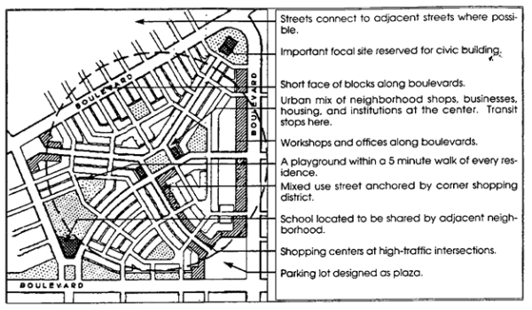 Less Urban Conditions: Typical Characteristics
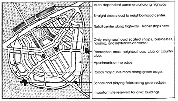
- Street.
• Public streets shall provide access to all tracts and lots.• Streets and alleys shall, wherever practicable, terminate at other streets within the neighborhood and connect to existing and projected streets outside the development. Cul-de sacs shall not exceed 250 feet in length, must be accessed from a street providing internal or external connectivity, shall be permanently terminated by a vehicular turnaround, and are permitted where topography makes a street connection impracticable. In most instances, a “close” or “eyebrow” is preferred to a cul-de-sac. Vehicular turnarounds of various configurations are acceptable so long as emergency access is adequately provided. • The average perimeter of all blocks within the TND should not exceed 1,350 feet. No block face should have a length greater than 500 feet without a dedicated alley or pathway providing through access. • A continuous network of rear alleys is recommended for all lots in a TND; rear alleys shall provide vehicular access to lots 50 feet or less in width. • Utilities may run along alleys. • TND streets shall be organized according to a hierarchy based on function, size, capacity, and design speed; streets and rights-of-way are therefore expected to differ in dimension. The proposed hierarchy of streets shall be indicated on the submitted sketch plan. Each street type in a TND shall be separately detailed. Street types illustrated in Article 5 represent the array of elements that are combined to meet the purposes of TND neighborhood streets: building placement line, optional utility allocation, sidewalk, planting strip, curb and gutter, optional parallel parking, and travel lane(s). Alternative methods of assembling the required street elements will be considered to allow neighborhood street designs that are most appropriate to setting and use. • To prevent the buildup of vehicular speed, disperse traffic flow, and create a sense of visual enclosure, long uninterrupted segments of straight streets should be avoided. Methods: (1) a street can be interrupted by intersections designed to calm the speed and disperse the flow of traffic (Article 5) and terminate vistas with a significant feature (building, park, natural feature); (2) a street can be terminated with a public monument, specifically designed building facade, or a gateway to the ensuing space; (3) perceived street length can be reduced by a noticeable street curve where the outside edge of the curve is bounded by a building or other vertical elements that hug the curve and deflect the view; (4) other traffic calming configurations are acceptable so long as emergency access is adequately provided. - Buildings and Lots.
• All lots shall share a frontage line with a street urban open space; lots fronting an urban open space shall be provided rear alley access. • Consistent build-to lines shall be established along all streets and public space frontages; build-to lines determine the width and ratio of enclosure for each public street or space. A minimum percentage build-out at the build-to line shall be established on the plan along all streets and public square frontages. • Building and lot types shall comply with Article 4. • Large-scale, single use facilities (conference spaces, theaters, athletic facilities, for example) shall generally occur behind or above smaller scale uses of pedestrian orientation. Such facilities may exceed maximum first floor area standards if so sited. - Open Space. Open space is defined as any area which is not divided into private or civic building lots, streets, rights-of-way, parking, or easements for purposes other than open space conservation. Design of urban open space shall comply with Article 7. In the TND-U, the open space requirements of the NR district shall apply. In the TND-R, the open space requirements of the R & TR districts, including rural open space, shall apply. Rural open space is site specific in its designation. Paragraphs d) 3 & 4 of Section 3.2.1 & 3.2.2, describe the site analysis required to identify qualifying rural open space.
- Parking and Landscaping. Parking and landscaping shall comply with Article 6.
- Neighborhood Form.
1 Items for outdoor sales are returned to building at end of each business day; goods not brought in at close of business day are considered outdoor storage.
2 The mixed-use building duplicates the shopfront building type and has at least two occupiable stories; at least 50% of the habitable area of the building shall be in residential use, the remainder shall be in commercial use. However, when an existing residential building is redeveloped to a mixed-use, at least 40% of the habitable area shall be in residential use.
Amended by Ord. TA22-07 on 11/21/2022
Amended by Ord. TA23-06 on 2/19/2024
Amended by Ord. Draft TA25-01 on 8/19/2025
3.2.12 PASSENGER VEHICLE SALES DISTRICT (VS)
Intent: The Passenger Vehicle Sales District is established to provide large accommodations for the sale of new and used passenger vehicles and trucks not exceeding the size, weight, and configuration of the medium duty truck standard. It is intended for use in areas not amenable to easy pedestrian access, where a comfortable pedestrian environment is unlikely to be achieved. It is expected that the Passenger Vehicle Sales District will serve the passenger and small business vehicle needs of those in the Huntersville Community and in the larger region. Because of the scale of buildings and parking, and the access requirements of uses in this category, they cannot be compatibly integrated within the Town Center, Neighborhood Center, or smaller scale Highway Commercial Districts. At district boundaries, compatible transitions must be provided by the use of landscaping and/or walls. Property boundaries adjacent to freeways or expressways will require a 50-foot foliated buffer yard and frontages on major or minor arterials will require formal street tree planting.
- Permitted Uses.
Uses Permitted with Conditions.
• essential services 1, (9.14)
• sales and leasing of vehicles not exceeding the industry standard for "medium duty trucks", (9.25)1
• sales and leasing of boats and boat accessories (9.25)
• transit shelters, (9.39)
Uses Permitted with Special Use Permit.
• wind energy facility, minor, accessory, (9.53) - Permitted Building Types.
• highway commercial; up to 65,000 sq. ft. of first floor area on major thoroughfare; up to 15,000 sq. ft. of first floor area on minor thoroughfare.2 - Permitted Accessory Uses.
• car wash
• boat wash
• service, cleaning, mechanical repair and body repair in association with vehicle sales/leasing, including drive-in vehicle drop off facilities in compliance with Section 3.2.10 d), item 4 (9.25)
• solar facility, minor non-residential (9.54)
• warehousing accessory to merchandising and repair, within an enclosed building
• accessory uses permitted in all districts, (8.11) - General requirements and district options.
- Along existing streets, new buildings shall respect the street frontage relationships of existing buildings in terms of building setback and orientation. On new streets, allowable building and lot types will establish the development pattern.
- Where screening is required by Article 9 for activities involving any sale, use, repair, storage, or cleaning operation, the specified standard of Section 7.6 shall apply.
- Any Vehicle Sales District shall be bordered on at least one side by a major or minor thoroughfare.
- Drive-in service windows and service processing, stacking and circulation lanes, and circulation are prohibited in the established front setback of the principal building and prohibited within a 75-foot setback from the right-of-way in a principal building's side yard that abuts a major or minor thoroughfare. On-site stacking lanes for drive-in service windows shall be a minimum of 200 feet in length if accessed directly from a thoroughfare or minimum of 100 feet if accessed directly from a street of lesser capacity.
- In the VS Zoning District only, the buffer requirement of Section 7.5 (yards abutting I-77 right-of-way) shall be met.
- All other signs on the site and building shall conform to the standards of Article 10, Signs, including, but not limited to the prohibition of flashing signs, portable signs and fluttering signs such as pennants and pennant swags. Non-conforming signs, if present anywhere on the site, shall be removed prior to issuance of a change of use permit, issuance of grading permit, or commencement of new construction on the site.
- Vehicles or boats for sale or lease shall not be displayed in the established front yard of the principal building on the site.
- In the Vehicle Sales district only, the established front yard shall be designed in accordance with the Highway Commercial Building / Lot Type found in Article 4 or a) or b) below:
- Vehicles for sale or lease may be displayed in the established front yard in front of the principal building in the VS district only. Such areas shall be permitted on sites where the principal building consumes at least 35% of the frontage. The Highway Commercial Building Type build to line (15’), measured to the face of the canopy (if applicable), shall be increased by no more than 10’ to accommodate one row of vehicle display. An established front yard used for display of vehicle sales or leasing must be constructed of a decorative paving material (if impervious), and must be screened in accordance with 10) of this section.
- Notwithstanding the limitations of off-street parking in front of buildings, as described by building type and parking lot specifications, vested parking and maneuvering areas in the established front yard may be constructed in accordance with an NCDOT driveway permit.
- Outdoor storage of vehicles in process of repair and vehicles-for-sale that are in the process of dealer preparation for buyer pick up is permitted.
- Such storage areas are exempt from the interior landscaping requirements for Parking Lots found in Article 6. However, the perimeter landscaping requirements of Article 6 shall apply to such storage areas.
- Such storage areas may only be located behind the principal building and/or its accessory buildings, and shall not be placed within 100 feet of any property line that abuts a thoroughfare or local public street.
- In the Vehicle Sales district only, the landscaping requirements of Article 6 shall be applied as follows:
- Vehicle display areas shall be exempt from the interior landscaping requirements for Parking Lots found in Article 6. However, a large maturing tree shall be planted within a 200 square foot pervious area that is permanently protected from parking and maneuvering areas with all vehicles on display being located within 40’ of such pervious area.
- Along the frontage, a vehicle display area is exempt from the large maturing tree 40’ on center requirement found in Landscaping of Parking Lots in Article 6.
- Uses in the VS District are exempt from the Article 6 suggestion to provide for bicycle parking.
- The arrangement of principal buildings on a single lot shall establish building facades generally parallel to the frontage property lines along existing streets and proposed interior streets.
- Every building lot shall have frontage upon a public street or urban open space except as follows: in specific locations where factors beyond developer control, such as a limited access highway, an existing development, or the location of an existing intersection, prohibit completing a street connection in the Highway Commercial District, a private drive may be substituted for the interior street which cannot be connected to the public network.
- Adjoining businesses shall provide for interconnectivity by way of internal street(s) or, if permitted, private drives; internal street(s) shall remain open at all times while private drive connections shall, at a minimum, remain open for public passage during business hours.
- Businesses in the VS district are prohibited from using amplified speaker/public address systems except within fully enclosed building(s).
- Lighting in customer parking areas shall comply with Article 6, OFF-STREET PARKING (Lighting for Parking Lots).
- Lighting in vehicle display parking areas and storage areas may comply with the standards of Article 6 (Lighting for Parking Lots) or with all of the alternative lighting standards below:
- Including the base/mounting fixture the maximum height for lighting (pole mounted and wall mounted) shall be 30 feet.
- To prevent glare from off-site locations, all lighting fixtures shall be full cut-off. The use of drop lens, vertical burn lamps, and other equipment with similar glare producing effects are prohibited. Lighting shields or hoods shall be employed to result in lighting projection of display areas only.
- Floodlights are not permitted for parking lot illumination. In all applications, lighting shall be directed downward. This prohibition does not apply to floodlights allowed elsewhere in this ordinance for external illumination of permitted signs.
- Along the front line of the display area, lighting shall not exceed an average of 30 foot-candles, measured at grade.
- Uniformity shall not exceed a 3:1 ratio.
- All lights, except those required for security as provided herein, must be extinguished at 9 PM on all days. For reasons of security, a maximum of 1.5 foot-candles at entrances, stairways and loading docks, and 1.0 foot-candle on the rest of the site is permitted.
- The spillover light level from lighting on the site onto adjacent property or property across a public road shall not exceed 0.1 foot-candle measured 10’ into the adjacent property from any orientation of the measuring device.
- The average illumination, measured at grade, across the entire property, including the frontage, shall not exceed 30-foot candles. The site area for calculating the average illumination shall exclude the building(s).
- Lighting fixtures that produce glare visible from adjacent property(s) and public right of way(s) are prohibited.
1 Expressly prohibited is the sale or lease of campers, motor homes, trailers, and similar vehicles.
2 Maximum first floor area for highway commercial buildings may be exceeded only where massing of building is varied to reduce perceived scale and volume.
3.2.13 TRANSIT-ORIENTED DEVELOPMENT - RESIDENTIAL (TOD-R)
Intent: The transit-oriented residential district is established to support higher density residential communities that include a rich mix of retail, restaurant, service, and small employment uses within a pedestrian village format. Land consuming uses, such as large lot housing and large retail outlets are excluded from this district. The TOD-R may be located on developable and redevelopable parcels generally found within the 1/2 mile catchment area of designated rapid transit station sites. Nothing in these regulations shall preclude application of the TOD-R beyond the 1/2 mile radius when site-specific development plans demonstrate efficient resident access to a rapid transit station. The district establishes a primarily residential village within a 10-minute walk of a designated rapid transit station that serves a residential population of sufficient size to constitute an origin and destination for purposes of rapid transit service.
- Permitted Uses.
Uses permitted by right.
• bed and breakfast inns
• boarding or rooming houses for up to six roomers
• civic, cultural, and neighborhood recreation facilities up to 15,000 sq. ft. of gross floor area, minimum FAR of .35
• conference centers, up to 15,000 sq. ft. of gross floor area, minimum FAR of .35
• dormitories
• family care home
• financial institutions up to 6,000 sq. ft. of gross floor area
• government buildings up to 8,000 sq. ft. of gross floor area, minimum FAR of .35
• indoor motions pictures, limited to one (1) screen
• inns
• residential uses
• offices, general, medical, professional, minimum FAR of .35
• personal, professional, and technical services up to 8,000 sq. ft. of gross area, minimum FAR of .35
• research and development services, minimum FAR of .35
• restaurants without drive-through windows, up to 8,000 sq. ft. of gross floor area, minimum FAR of .35
• retail establishments, up to 8,000 sq. ft. of gross area, minimum FAR of .35
• greenways
• squares, plazas, or other formal open spaces not exceeding 1/2 acre in area
• stalls or merchandise stands for outdoor sale of goods at street front (encroachment onto sidewalk may be permitted by agreement with town); outdoor storage expressly prohibited1
• taverns and bars, up to 6,000 sq. ft. of gross floor area, minimum FAR of .35
• transit stations
• workshops and studios or the design and manufacture of art, craft and artisan products, up to 8,000 sq. ft. of gross area, minimum FAR of .35
Uses permitted with a Special Use Permit.
• wind energy facility, minor, accessory, (9.53)
Uses permitted with conditions.
• any non-residential use permitted by right or with conditions where size of first floor area exceeds 15,000 sq. ft., (9.47)
• any permitted non-residential use or collection of non-residential uses that exceeds the maximum permitted in the district by paragraph e) 5) of this section, (9.47)
• religious institutions, (9.8)
• day care centers, (9.11)
• essential services 1 and 2, (9.14)
• parking lot or structure as principal use, (9.49)
• schools, (9.35)
• transit shelters, (9.39) - Permitted Building and Lot Types.
• apartment
• duplex
•
triplex
•
quadplex
• civic
• detached house on lot of 5,000 sq. ft. or less
• mixed-use2
• shopfront
• workplace - Permitted Accessory Uses.
• accessory dwelling, (9.1)
• day care home (small), (9.11)
• home occupation, (9.19)
• parking lot as an accessory to any permitted principal use, on the same lot or on an abutting lot, according to the standards of Article 6
• solar facility, minor non-residential (9.54)
• solar energy facility, minor residential (9.54)
• accessory uses permitted in all districts, (8.11) - General Requirements.
- To integrate the larger scale of buildings in transit-oriented developments into the existing built fabric of the community, the edge conditions of paragraph f) 6), below shall be met.
- Along existing streets, new buildings shall create a transition in spacing, mass, scale, and street frontage relationship from existing buildings to buildings in the Transit Oriented Residential district.
- New buildings are expected to exceed the scale and volume of existing buildings, but shall demonstrate compatibility by varying the massing of buildings to reduce perceived scale and volume. The definition of massing in Article 12 illustrates the application of design techniques to reduce the visual perception of size and integrate larger buildings with pre-existing smaller buildings.
- Subsection 3.2.13(d)(2)(a) shall not apply to development on parcels where multifamily structures are an allowable use and the development contains two or more affordable housing units for families or individuals with incomes below eighty percent (80%) of the area median income.
- Nothing in this subsection shall be interpreted to conflict with the building design element provisions as found in N.C.G.S. 160D-702(b) for structures subject to the North Carolina Residential Code.
- On new streets, allowable building and lot types will establish the development pattern.
- Within a TOD-R zoning district, a minimum average density of 15 dwelling units per acre shall be achieved; residential density shall be calculated by dividing the total number of housing units planned by the number of acres designated for residential use, net of streets.
- A master subdivision sketch plan shall be provided with any application for development approval. It shall comply with the standards of this district and with the most detailed development policies and/or plans adopted by the Town Board for the station’s catchment area. The master plan shall include a topographic survey and shall show the location and hierarchy of streets and public open spaces, location of residential, commercial, and civic building lots, street sections and/or plans, approximate unit count, square footage on non-residential buildings and uses, proposed building heights, an outline of any additional regulatory intentions, phasing, and any other information, including building elevations, which may be required to evaluate the interior pedestrian environment and conditions at project edges. Phasing of development to provide for future horizontal and vertical intensification to meet the standards of this section is permitted. Approval of the master sketch plan will be administrative.
- A single building on an existing lot shall comply with the standards of this district and with the most detailed development policies and/or plans adopted by the Town Board for the station’s catchment area, but shall require zoning and building permits only.
- See Section 8.16, Standards for Residential Lot Widths, Alleys, Garages and Parking in Residential Districts.
- Development Provisions.
- Minimum Development Size: None
- Maximum Development Size: None
- Residential Density: Within a TOD-R zoning district, a minimum average density of 15 dwelling units per acre (net of streets) shall be achieved; residential density shall be calculated by dividing the total number of housing units planned by the acreage of all lots that are designated for residential use. When designing the site, higher densities (18 du/a and greater) should be concentrated within approximately 1/4 mile walking distance of the station site while lower densities (6 du/a and greater) may be placed beyond the approximate 1/4 mile walking distance. The maximum density permitted on any lot in a TOD-R is 40 units per acre (net of streets).
- Special parking provisions for residential development in the TOD-R:
Minimum Maximum • Efficiency apartment 1 space/unit 2 spaces/unit • One or two bedroom apartment/attached house 1 space/unit 2 spaces/unit • Other dwelling units 1 space/unit 2 spaces/unit - Siting requirements for non-residential development: All non-residential development shall be oriented to provide direct pedestrian access from the transit station by way of the public street system, designated pedestrian paths, or any combination of the two. In addition, the locational standards below shall apply.
• Within a 1/4 mile walking distance of the station site, a master subdivision sketch plan may include up to 10,000 sq. ft. of retail/services/commercial/office development for each 250 dwelling units master planned in the 1/2 mile catchment area.
• If placed in a TOD-R district, religious institutions without shared parking, schools, and neighborhood recreation facilities, up to the maximum size permitted in the district, should be located between the 1/4 mile and 1/2 mile walk of the station site.
• Without regard to station proximity, day care centers and religious institutions with shared parking provisions that meet the size provisions of the TOD-R are permitted.
- Design Provisions.
- Neighborhood Form.
• The illustration below shall guide the general arrangement and distribution of uses in the project.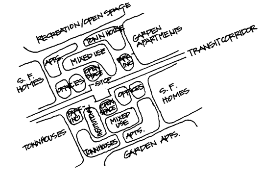 Reprinted with permission from PAS Report Number 468, copyright December, 1996 by the American Planning Association, Suite 1600, 122 S. Michigan Ave., Chicago, IL 60603-6107
• The area of the project shall be divided into blocks, streets, lots, and open space.
• Similar land uses shall generally enfront across each street. Dissimilar categories shall generally abut at rear lot lines. Corner lots which front on streets of dissimilar use shall approximate the setback established on each fronting street. - Streets.
• Public streets shall provide access to all tracts and lots.
• Streets and alleys shall, wherever practicable, terminate at other streets within the neighborhood and connect to existing and projected streets outside the development. Cul-de-sacs shall not exceed 250 feet in length, must be accessed from a street providing internal or external connectivity, shall be permanently terminated by a vehicular turnaround, and are permitted only where topography makes a street connection impracticable. In most instances, a “close” or “eyebrow” is preferred to a cul-de-sac. Vehicular turnarounds of various configurations are acceptable so long as emergency access is adequately provided.
• No block face may exceed 500 feet in length without a dedicated alley or pathway providing through access for pedestrians.
• Utilities shall run along alleys where alleys are provided.
• Streets shall be organized according to a hierarchy based on function, size, capacity, and design speed; streets and rights-of-way are therefore expected to differ in dimension. The proposed hierarchy of streets shall be indicated on the submitted master subdivision sketch plan. Each street type shall be separately detailed. Street types illustrated in Article 5 represent the array of elements that are combined to meet the purposes of neighborhood streets: building placement line, optional utility allocation, sidewalk, planting strip, curb and gutter, optional parallel parking, and travel lane(s). Alternative methods of assembling the required street elements will be considered to allow neighborhood street designs that are most appropriate to setting and use. Proposed routing for private vehicles and feeder buses entering and leaving the station area shall be shown.
• To prevent the buildup of vehicular speed, disperse traffic flow, and create a sense of visual enclosure, long uninterrupted segments of straight streets should be avoided. Methods: (1) a street can be interrupted by intersections designed to calm the speed and disperse the flow of traffic (Article 5) and terminate vistas with a significant feature (building, park, natural feature); (2) a street can be terminated with a public monument, specifically designed building facade, or a gateway to the ensuing space; (3) perceived street length can be reduced by a noticeable street curve where the outside edge of the curve is bounded by buildings or other vertical elements that hug the curve and deflect the view; (4) other traffic calming configurations are acceptable so long as emergency access is adequately provided. - Buildings and Lots.
• Every building lot shall share a frontage line with a street, or urban open space; lots fronting directly onto a formal open space (i.e., without intervening street) shall be provided rear alley access.
• Consistent build-to lines shall be established along all streets and urban open space frontages; build-to lines determine the width and ratio of enclosure for each public street or space. A minimum percentage build-out at the build-to line shall be established on the plan along all streets and urban open space frontages.
• Building and lot types shall comply with Article 4. However, notwithstanding the height restrictions of Article 4, Building and Lot Types, new buildings in the Transit Oriented Residential district are limited to thirteen (13) stories or one hundred eighty-two 182 feet in height, whichever is greater. New buildings in the Transit-Oriented Residential District within one (1) mile of the Town Center Zoning District are limited to four (4) stories or forty six (46) feet in height, whichever is greater. Minimum building height is twenty-six (26) feet, measured at the eave line.
• Large-scale, single use facilities (conference spaces, theaters, athletic facilities, for example) shall occur behind or above smaller scale uses of pedestrian orientation. Such facilities may exceed maximum first floor area standards if so sited. - Open Space. Open space is defined as any area which is not divided into private or civic building lots, streets, rights-of-way, parking, or easements that diminish the utility or aesthetic quality of the space. Design of urban open space shall comply with Article 7.
- Parking Lot Landscaping. Parking lot landscaping shall comply with Article 6.
- District Edge Conditions. Along any boundary of a TOD-R district that abuts a pre-existing subdivision of 20 or more single-family detached homes, one of the following edge conditions shall apply to abutting lot boundaries, however no buffer or wall shall be allowed to block extension of a street from existing development into a planned TOD-R development.
- A free-standing structure or the end unit of an attached structure on lots along the common boundary shall be limited to two stories or 26 feet in height, whichever is less, or
- A semi-opaque buffer shall be constructed along the common boundary, on the site of the developing use. The width of the buffer shall at a minimum equal 1/2 the height of the abutting building in the TOD-R district, or
- A 6’ masonry wall may be constructed by the developer along the common lot boundaries, in which case the width of the buffer may be reduced to the width of the wall.
- Neighborhood Form.
1 Items for outdoor sales are returned to building at end of each business day; goods not brought in at close of business day are considered outdoor storage.
2 The mixed-use building duplicates the shopfront building type and has at least two occupiable stories; at least 50% of the habitable area of the building shall be in residential use, the remainder shall be in commercial use. However, when an existing residential building is redeveloped to a mixed-use, at least 40% of the habitable area shall be in residential use.
Amended by Ord. TA22-07 on 11/21/2022
Amended by Ord. TA23-06 on 2/19/2024
Amended by Ord. T24-12 SUP on 9/17/2024
Amended by Ord. Draft TA25-01 on 8/19/2025
3.2.14 TRANSIT-ORIENTED DEVELOPMENT - EMPLOYMENT (TOD-E)
Intent: The transit-oriented employment district is established to accommodate general office uses and office support services in a highly pedestrianized setting. General office, characterized by 40 to 70 employees per acre, is the predominant use. Uses that employ relatively few workers, such as warehousing and distribution, are excluded from this district. The TOD-E may be located on developable parcels within the 1/2 mile catchment area of rapid transit stations. The district establishes an employment node within a 10-minute walk of a designated transit rapid station that serves a workforce of sufficient size to constitute a destination for purposes of rapid transit service.
- Permitted Uses.
Uses Permitted by Right.
• financial services
• commercial uses, other than those specifically permitted in this section
• conference centers, up to 15,000 sq. ft. of gross floor area
• greenways
• government offices
• inns
• light manufacturing, (9.48)
• residential uses
• offices
• professional, personal, and technical services
• squares, plazas, or other urban open spaces not exceeding 1/2 acres in area
• transit stations
• workshops and studios for the design and manufacture of art, craft, and artisan products, up to 8,000 sq. ft. of gross area
Uses Permitted with Conditions.
• day care center, (9.11)
• essential services 1 and 2, (9.14)
• hospitals, (9.48)
• light manufacturing, (9.48)
• parking lot or parking structure as a principal use, (9.48)
Uses Permitted with a Special Use Permit.
• wind energy facility, minor, accessory, (9.53) - Permitted Building and Lot Types.
• civic building
• highway commercial (for conference facilities only), minimum FAR of .35
• mixed-use1
• shopfront
• workplace, minimum FAR of .35 - Permitted Accessory Uses.
• home occupations, (9.19)
• parking lot as an accessory to any permitted principal use, on the same lot or on an abutting lot according to the standards of Article 6
• retail, restaurant, bars and taverns, personal services, clinics and similar workplace support uses up to 20 percent of first floor area of any building, or of a multi-building project taken as a whole
• solar energy facility free-standing, minor, non-residential, (9.54)
• solar energy facility,, minor non-residential (9.54)
• solar energy facility, minor residential (9.54)
• warehousing, (9.48)
• accessory uses permitted in all districts, (8.11) - General Requirements.
- Along existing streets, new buildings shall create a transition in spacing, mass, scale, and street frontage relationship from existing buildings to buildings in the Transit-Oriented Employment district.
- New buildings are expected to exceed the scale and volume of existing buildings, but shall demonstrate compatibility by varying the massing of buildings to reduce perceived scale and volume. The definition of massing in Article 12 illustrates the application of design techniques to reduce the visual perception of size and integrate larger buildings with pre-existing smaller buildings.
- Subsection 3.2.14(d)(1) shall not apply to development on parcels where multifamily structures are an allowable use and the development contains two or more affordable housing units for families or individuals with incomes below eighty percent (80%) of the area median income.
- On new streets, allowable building and lot types will establish the development pattern.
- A master subdivision sketch plan in compliance with this district shall be provided with any application for development approval. It shall comply with the standards of this district and with the most detailed development policies and/or plans adopted by the Town Board for the station’s catchment area. The master plan shall include a topographic survey and shall show the location and hierarchy of streets and public open spaces, location of residential, commercial, and civic building lots, street sections and/or plans, approximate square footage of office/commercial buildings and uses, residential unit count, proposed building heights, an outline of any additional regulatory intentions, phasing, and any other information, including building elevations, which may be required to evaluate the interior pedestrian environment and conditions at project edges. Phasing of development to provide for future horizontal and vertical intensification to meet the standards of this section is permitted. Approval of the master sketch plan will be administrative.
- A single building on an existing lot shall comply with the standards of this district and with the most detailed development policies and/or plans adopted by the Town Board for the station’s catchment area, but shall require zoning and building permits only.
- Along existing streets, new buildings shall create a transition in spacing, mass, scale, and street frontage relationship from existing buildings to buildings in the Transit-Oriented Employment district.
- Design Provisions.
- Every building shall share a frontage line with a street, or urban open space; lots fronting directly onto an urban open space (i.e., without intervening street) shall be provided rear alley access.
- New construction favors general office uses, with accessory retail, personal services, restaurant, and similar uses located at street level and residential uses permitted on third and higher floors.
- Notwithstanding the height restrictions of Article 4, Building and Lot Types, new buildings in the Transit Oriented Employment district are limited to seven stories or 80 feet in height, whichever is greater. Minimum building height is 26 feet, measured at the eave line.
- Minimum permitted Floor Area Ratio (FAR) is .35; preferred FAR will range from .5 to 1.5.
- Special parking provisions for residential development in the TOD-E:
Minimum Maximum • Office/Commercial uses 1 space/1000 sq. ft. 1 space/500 sq. ft. • Efficiency apartment 1 space/unit 2 spaces/unit • One or two bedroom apartment 1 space/unit 2 spaces/unit - District Edge Conditions. Along any boundary of a TOD-E district that abuts a pre-existing subdivision of 20 or more single-family detached homes, one of the following edge conditions shall apply to abutting lot boundaries, however no buffer or wall shall be allowed to block extension of a street from existing development into a planned TOD-E development. • A free-standing structure or the end unit of an attached structure on lots along the common boundary shall be limited to two stories or 26 feet in height, whichever is less, or • A semi-opaque buffer shall be constructed along the common boundary, on the site of the developing use. The width of the buffer shall at a minimum equal 1/2 the height of the abutting building in the TOD-E district, or • A 6’ masonry wall may be constructed by the developer along the common lot boundaries, in which case the width of the buffer may be reduced to the width of the wall.
1 The mixed-use building duplicates the shopfront building type and has at least two occupiable stories; at least 50% of the habitable area of the building shall be in residential use, the remainder shall be in commercial use. However, when an existing residential building is redeveloped to a mixed-use, at least 40% of the habitable area shall be in residential use.
Amended by Ord. TA22-07 on 11/21/2022
Amended by Ord. T24-12 SUP on 9/17/2024
Amended by Ord. Draft TA25-01 on 8/19/2025
3.3.1 MANUFACTURED HOME OVERLAY DISTRICT (MH-O)
Intent: The Manufactured Home Overlay District is established to provide for existing and proposed neighborhoods which include or are proposed to include manufactured homes. The requirements herein are intended to ensure compatibility with existing housing stock by imposing supplemental appearance standards for manufactured housing. The Manufactured Home Overlay district may be applied to tracts zoned NR, GR, TR, or R. It supplements the range of residential types permitted in the underlying district while limiting some accessory uses. For existing neighborhoods, the MH Overlay may be established by map adoption; for proposed neighborhoods, the MH Overlay district requires zoning approval accompanied by a detailed development plan and supporting materials.
- Permitted Uses.
Uses permitted by right.
• all uses permitted by right in the underlying district, according to the standards of the underlying district
• family care home
Uses permitted with conditions.
• all uses permitted with conditions in the underlying district, according to the standards and conditions associated with the underlying district.
• Manufactured Homes, provided that:- The home shall be set up in accordance with the standards set by the North Carolina Department of Insurance.
- A continuous, permanent masonry wall, having the appearance of a conventional load-bearing foundation wall, unpierced except for required ventilation and access, shall be installed under the perimeter of the manufactured home. Notwithstanding the foregoing, neither masonry walls nor masonry skirting shall be required for manufactured homes located on land leased to the owner of the manufactured home; however, non-masonry skirting shall be installed on such manufactured homes.
- The home will have all wheels, transporting lights, and towing apparatuses removed.
- The structure must be at least 14 feet in width along the majority of its length.
- The roof shall have at least a 3:12 pitch.
- Exterior wall and roofing materials and finishes shall be comparable in composition, appearance and durability to those commonly used in conventional residential construction. As examples, exterior walls would be expected to be covered in wood, stucco, brick, stone, other masonry materials, or similar conventional exterior finishes. Roofing material should consist of wood shingle, wood shake, synthetic composite shingle, ceramic tile, concrete tile, or similar conventional roofing materials.
- All entrances to a manufactured home shall be provided with permanent steps, porch or similar suitable entry.
- Permitted Building and Lot Types.
• all building and lot types permitted in the underlying zoning district
• manufactured home placed according to the standards for a detached house - Permitted Accessory Uses.
• dwelling accessory to any principal dwelling which meets the NC Housing Code, (9.1)
• day care home (small), accessory to any principal dwelling which meets the NC Housing Code, (9.11)
• home occupation accessory to any principal dwelling which meets the NC Housing Code, (9.19)
• marinas accessory to residential uses (9.42)
• accessory uses permitted in all districts, (8.11) - General Requirements.
- Along existing streets, new buildings shall respect the general spacing of structures, building mass and scale, and street frontage relationships of existing buildings.
• New buildings which adhere to the scale, massing, volume, spacing, and setback of existing buildings along fronting streets exhibit demonstrable compatibility.
• New buildings which exceed the scale and volume of existing buildings may demonstrate compatibility by varying the massing of buildings to reduce perceived scale and volume. The definition of massing in Article 12 illustrates the application of design techniques to reduce the visual perception of size and integrate larger buildings with pre-existing smaller buildings.
• Nothing in this subsection shall be interpreted to conflict with the building design element provisions as found in N.C.G.S. 160D-702(b) for structures subject to the North Carolina Residential Code. - On new streets, allowable building and lot types will establish the development pattern.
- All subdivision standards shall be met.
- In nonconforming subdivisions or manufactured home parks, any manufactured home may be replaced with another manufactured home of at least comparable width (i.e. a single-wide home may be replaced with a home of minimum 12 feet width or with a larger home, while a double-wide home can be replaced only by another double-wide home); a replacement home shall, with the exception of width, meet all design and safety conditions of Section 3.3.1 a).
- Existing manufactured home parks which are not subdivided into individual deeded lots may continue operation but may not be expanded except in conformance with this ordinance and the Subdivision Ordinance.
- For proposed neighborhoods, homes shall be a minimum of 14 feet wide.
- For proposed neighborhoods, an application to classify property to the MH-O district shall require a master plan that shows the location and hierarchy of streets and public spaces, location of residential, non-residential, and civic building lots, street sections and/or plans, phasing, and any other information which may be required to evaluate the subdivision’s adherence to the standards of this ordinance and the subdivision ordinance.
- See Section 8.16, Standards for Residential Lot Widths, Alleys, Garages and Parking in Residential Districts.
- Along existing streets, new buildings shall respect the general spacing of structures, building mass and scale, and street frontage relationships of existing buildings.
- MH-O Development Provisions.
- Minimum Development Size: 3 acres for new developments
- Maximum Development Size: 25 acres for new developments
- Maximum Permitted Densities are determined by the standards of the underlying district. Density in the RURAL AND TRANSITIONAL District correlates to amount of open space provided, as set forth in the district regulations. Density in the NR district is a function of building and lot type.
3.3.2 MOUNTAIN ISLAND LAKE WATERSHED OVERLAY DISTRICT (MIL-O)
Intent: The intent of the Mountain Island Lake Watershed Overlay District is to provide for the protection of public water supplies as required by the N.C. Water Supply Watershed Protection Act (N.C.G.S. 143-214.5) and regulations promulgated there under. The Mountain Island Lake Watershed Overlay may be applied in any zoning district. The Mountain Island Lake Watershed Overlay District supplements the regulations of the underlying zoning district within the Mountain Island Lake Watershed Protection Area to ensure protection of public drinking water supplies. All regulations for the underlying district shall continue to remain in effect for properties classified under the Mountain Island Lake Watershed Overlay District.
- Applicability. The Mountain Island Lake Watershed Protection Area is that area within Mecklenburg County which contributes surface drainage into Mountain Island Lake and which is bounded as follows: beginning at the Mountain Island Lake Dam on the Catawba River and proceeding along the ridgeline in an easterly direction to Rozzelle's Ferry Road and proceeding thence in a southeasterly direction along Rozzelle's Ferry Road to the intersection of Mt. Holly-Huntersville Road, and thence proceeding along Mt. Holly-Huntersville Road in a northeasterly direction to the intersection of Hambright Road, and thence proceeding in an easterly direction along Hambright Road to N.C. 115, and thence proceeding in a northerly direction along N.C. 115 to the intersection of N.C. 73 and thence in a westerly-southwesterly direction along N.C. 73 to the Lake Norman Dam and thence proceeding in a southerly direction along the Catawba River to the beginning point.
- Exceptions to Applicability.
- Existing development, as defined in Section 12.2.3, is not subject to the requirements of the Mountain Island Lake Watershed Overlay District. Expansions to structures classified as existing development must meet the requirements of this section, however the built-upon area of the existing development is not required to be included in the impervious area calculations.
- An existing lot, as defined in Section 12.2.3, owned prior to the effective date of this ordinance, regardless of whether or not a vested right has been established, may be developed for single family residential purposes subject only to the buffer requirements of Section 3.3.3-A, f) and g) or Section 3.3.3-B, f) and g), whichever are applicable.
- Existing public utilities may expand without being subject to the restrictions of this part provided that:
- Such expansion complies with all applicable laws of the State of North Carolina and the United States of America, and
- Discharges associated with the existing public utilities may be expanded, however the pollutant load shall not be increased beyond presently permitted levels.
- This Section 3.3.2 shall not require private property owners to install new or increased stormwater controls for (i) preexisting development or (ii) redevelopment activities that do not remove or decrease existing stormwater controls. When a preexisting development is redeveloped, either in whole or in part, increased stormwater controls shall only be required for the amount of impervious surface being created that exceeds the amount of impervious surface that existed before the redevelopment, irrespective of whether the impervious surface that existed before the redevlopment is to be demolished or relocated during the redevelopment activity. A property owner may elect to treat the stormwater resulting from the net increase in built-upon area above the preexisting development for the purpose of exceeding allowable density under the applicable water supply watershed rules as provided in G.S. 143-214.5(d3) and as further described in this Article 3.
- Watershed Subareas Established.
- Critical Areas.
CA1 - Lower Gar Creek. From normal pool elevation of Mountain Island Lake extending up Gar Creek to Beatties Ford Road and to approximately the ridge line along the north side of Gar Creek and to Mt. Holly-Huntersville Road on the south side of Gar Creek, as shown specifically on Town of Huntersville Zoning Maps.
CA2 - Upper Gar Creek. From Beatties Ford Road upstream along Gar Creek to the limits of the Gar Creek drainage basin and to approximately the ridge line along either side of Gar Creek, as shown specifically on Town of Huntersville Zoning Maps.
CA3 - McDowell Creek. From normal pool elevation of Mountain Island Lake extending one mile upstream on McDowell Creek and to approximately the ridge line along either side of McDowell Creek, as shown specifically on Town of Huntersville Zoning Maps.
CA4 - Lake Front. Extending landward one-half mile from normal pool elevation along Mountain Island Lake and the Catawba River between Cowan's Ford Dam and Mountain Island Lake Dam, as shown specifically on Town of Huntersville Zoning Maps.
- Critical Areas.
- Protected Areas.
PA1 - The area extending from the outer limits of the critical areas to five hydrologic miles from the normal pool elevation and draining to Mountain Island Lake, as shown specifically on Town of Huntersville Zoning Maps.
PA2 - The area extending from the outer limit of the PA1 area where it intersects with N.C. 73 and running in a north-northeasterly direction along N.C. 73 to the intersection of I-77 and thence proceeding in a southerly direction along I-77 to the intersection of Gilead Road and thence in an easterly direction along Gilead Road to the intersection of N.C. 115 and thence in a southerly direction along N.C. 115 to the intersection of Hambright Road and thence in a westerly direction along Hambright Road to the intersection of Mt. Holly-Huntersville Road and thence in a northwesterly direction along the outer limits of the CA2 and PA1 areas to the beginning point, as shown specifically on Town of Huntersville Zoning Maps.
PA3 - The area extending from the outer limits of the PA2 area to the limits of the Mountain Island Lake Watershed, as shown specifically on Town of Huntersville Zoning Maps.
3.3.3 LAKE NORMAN WATERSHED OVERLAY DISTRICT (LN-O)
Intent: The intent of the Lake Norman Watershed Overlay District is to provide for the protection of public water supplies as required by the N.C. Water Supply Watershed Protection Act (G.S. 143-214.5) and regulations promulgated there under. The Lake Norman Watershed Overlay may be applied in any zoning district. The Lake Norman Watershed Overlay District supplements the regulations of the underlying zoning district within the Lake Norman Watershed Protection Area to ensure protection of public drinking water supplies. All other uses and regulations for the underlying district shall continue to remain in effect for properties classified under the Lake Norman Watershed Overlay District.
- Applicability. The Lake Norman Watershed Protection Area is that area within the jurisdiction of the Town of Huntersville which contributes surface drainage into that portion of the Catawba River known as Lake Norman and its tributaries. The Lake Norman Watershed Protection area is specifically defined on the Huntersville Zoning Maps.
- Exceptions to Applicability.
- Existing development, as defined in Section 12.2.3, is not subject to the requirements of the Lake Norman Watershed Overlay District. Expansions to structures classified as existing development must meet the requirements of this section, however the built-upon area of the existing development is not required to be included in the impervious area calculations.
- An existing lot, as defined in Section 12.2.3, owned prior to the effective date of this ordinance, regardless of whether or not a vested right has been established, may be developed for single family residential purposes subject only to the buffer requirements of Section 3.3.4-A, f) and g), whichever are applicable.
- Existing public utilities may expand without being subject to the restrictions of this part provided that:
(a) Such expansion complies with all applicable laws of the State of North Carolina and the United States of America; and
(b) Discharges associated with the existing public utilities may be expanded, however the pollutant load shall not be increased beyond presently permitted levels.
d. This Section 3.3.3 shall not require private property owners to install new or increased stormwater controls for (i) preexisting development or (ii) redevelopment activities that do not remove or decrease existing stormwater controls. When a preexisting development is redeveloped, either in whole or in part, increased stormwater controls shall only be required for the amount of impervious surface being created that exceeds the amount of impervious surface that existed before the redevelopment, irrespective of whether the impervious surface that existed before the redevelopment is to be demolished or relocated during the development activity. A property owner may elect to treat the stormwater resulting from the net increase in built-upon area above the preexisting development for the purpose of exceeding allowable density under the applicable water supply watershed rules as provided in G.S. 143-214.5(d3) and as further described in this Article 3.
- Watershed Subareas Established.
- Critical Area. The Critical Area is defined as the land area which begins at the normal pool elevation of Lake Norman and extends one-half mile inland or to the ridgeline, whichever is closest, as shown more specifically on the Huntersville Zoning Maps.
- Protected Area. There is no Lake Norman Protected Area located within the jurisdiction of the Town of Huntersville.
3.3.2-A Critical Areas (CA-1, CA-2, CA-3, CA4)
Intent: The intent of these regulations is to require higher standards in the Critical Areas of the Mountain Island Lake Watershed because of the greater risk of water quality degradation from pollution. All uses permitted in the Critical Areas are subject to the standards of both the overlay district and the underlying zoning district. In every case, the more restrictive standard controls.
- Permitted Uses.
Uses permitted with conditions.
• essential services 1 and 2, provided that there shall be no new industrial process or domestic discharges into any stream or lake in the Mountain Island Lake Watershed, but existing wastewater treatment plant(s) may expand so long as the total pollutant load per parameter is not increased beyond the effluent limits permitted as of October 1, 1993, the effective date of watershed protection regulations; agriculture, subject to the provisions of the Food Security Act of 1985 and the Food, Agricultural, Conservation and Trade Act of 1990. All agricultural activities conducted after January 1, 1993 shall maintain a minimum ten-foot vegetative buffer, or equivalent control as determined by the Soil and Water Conservation Commission, along all perennial waters indicated on the most recent versions of U.S.G.S. 1:24,000 scale topographic maps or as determined by local government studies. Agricultural activities begun after October 1, 1993 shall comply with the buffer standards of Section 3.3.3 -A(f). Animal operations greater than 100 animal units shall employ Best Management Practices by July 1, 1994 recommended by the Soil and Water Conservation Commission;
• silviculture, subject to the provisions of the Forest Practices Guidelines Related to Water Quality (02 NCAC 60C.0100 to .0209);
• residential uses permitted in the underlying district, subject to density and built-upon limits of the low-density development option; cluster development allowed in the underlying district is permitted;
• non-residential uses permitted in the underlying district, subject to the built-upon limits of the low-density development option; cluster development allowed in the underlying district is permitted. - Prohibited Uses.
• all uses not permitted in the underlying zoning district
• residual applications
• landfills, sanitary
• landfills, off-site demolition
• new or expanded domestic and industrial discharges
• structural SCMs not associated with agriculture
• disposal or treatment of petroleum contaminated soils (land farming) - Permitted Building and Lot Types.
• building and lot types permitted in the underlying zoning district - Permitted Accessory Uses.
• accessory uses permitted in the underlying zoning district; uses prohibited as principle uses are also prohibited as accessory uses - Built-Upon Area (BUA) Development Standards. For individual buildings or for development projects within the Critical Areas, the following impervious area limitations are established on a building or project basis.
Notwithstanding the above, an applicant shall be allowed to exceed the allowable Built-Upon Area (density) under the water supply watershed rules if all of the following circumstances apply:
(1) The property was developed prior to October 1, 1993, the effective date of the local water supply watershed program.
(2) The property has not been combined with additional lots after January 1, 2021.
(3) The property has not been a participant in a density averaging transaction as provided in Section 3.3.2-A(h).
(4) The current use of the property is nonresidential.
(5) At the election of the property owner, the stormwater from any net increase in built-upon area on the property above the preexisting development is treated in accordance with all applicable local government, State, and federal laws and regulations.
(6) The remaining vegetated buffers on the property are preserved in accordance with Section 3.3.2-A(f).
| CA1 | 6% BUA1 |
| CA2 | 12% BUA1 |
| CA3 | 12% BUA1 |
| CA4 | 24% BUA1 |
1 Residential subdivisions shall reserve, at minimum, 1% of the lot area but in no case less than 150 sq. ft. impervious area per lot to allow for addition of future impervious areas by homeowner/occupant
- Buffer Size. Undisturbed buffers, except as specifically provided in this section, are required in the Critical Areas along the shoreline of Mountain Island Lake, measured horizontally by a licensed land surveyor from the normal pool elevation (648’ contour), and along all perennial streams, measured from the top of the bank on each side of the stream.
CA1 100 feet or 100 year flood plain boundary, whichever is greater CA2 100 feet or 100 year flood plain boundary, whichever is greater CA3 100 feet or 100 year flood plain boundary, whichever is greater CA4 (lake shore) 100 feet - Buffer Protection. No permanent structures, impervious covers, septic tank systems or any other disturbance of existing vegetation shall be allowed within the buffer except as follows:
- The surveyed buffer boundary must be clearly marked on-site with orange “tree-protection” or “high-hazard” fence prior to any land disturbing activities. Tree protection is required by Section 7.4(3) of this ordinance.
- The surveyed buffer boundary must be permanently marked with an iron pin at the intersection of the watershed buffer and each property line following the completion of land disturbing activities and prior final plat, satisfactory final inpsection, and to occupancy. Properties greater than 200’ in width shall be marked at a maximum of 100’ intervals.
- No trees larger than 2-inch caliper, measured at 6 inches above the existing grade, are to be removed except for dead or diseased trees. Undergrowth and trees less than 2-inch caliper, measured at 6 inches above the existing grade, may be removed to be replaced by an effective stabilizing and filtering ground cover based upon the most recent edition of the “Charlotte-Mecklenburg Water Quality Buffer Implementation Guidelines" and as approved by the Mecklenburg County Water Quality Program.
- Stream bank or shoreline stabilization is allowed as approved on a plan submitted to the Town Engineering Department and the Charlotte-Mecklenburg Storm Water Services.
- Water dependent structures and public projects such as road crossings and greenway paths are allowed where no practical alternatives exist. These activities should minimize built-upon area, direct runoff away from surface waters, and maximize the utilization of nonstructural SCMs and pervious materials.
- During new development or the expansion of existing development, the Town, upon the advice of the Charlotte-Mecklenburg Storm Water Services, can require enhancement of the existing vegetation in the buffer if necessary so that the buffer can effectively perform its filtering and absorption functions. Buffer enhancement requirements shall be based on the most recent edition of the “Charlotte-Mecklenburg Water Quality Buffer Implementation Guidelines”.
- Mitigation of disturbed buffers required. Should existing vegetation within the buffer be disturbed (except as allowed by this ordinance), or should vegetation added to a buffer pursuant to paragraph 6) be disturbed, the property owner shall be required to enhance the buffer in accordance with the most recent edition of the “Charlotte-Mecklenburg Water Quality Buffer Implementation Guidelines” so that the buffer can effectively perform its filtering and absorption functions.
- Non-impervious recreational development and non-impervious pedestrian trails are allowed in the required buffer in compliance with paragraph 3), above. Pathway guidelines are available in the most recent edition of the “Charlotte-Mecklenburg Water Quality Buffer Implementation Guidelines.” If in a common area, such development and trails must be located a minimum of 30 feet from the normal pool elevation of Mountain Island Lake (648’ contour), or a minimum of 30 feet from the top of the bank on each side of all perennial streams; except for waterfront access points approved by the Town, upon the advice of Charlotte-Mecklenburg Storm Water Services.
- Non-conforming structures and increasing built-upon area may permitted if the following criteria are met:
- The existing structure (to be expanded) was built prior to the enactment of the 1993 Watershed Ordinance.
- The BUA of the existing structure must cover a minimum of 10% of the 100-foot buffer on the lot.
- In Critical Area 1 (CA1), which has a 6% BUA cap, the maximum allowable increase in BUA in the buffers is 2%. In Critical Area 2 (CA2) and Critical Area 3 (CA3), which have a 12% BUA cap and Critical Area 4 (CA4), which has a 24% BUA cap, the maximum allowable increase in BUA is the buffer is 4%.
- Existing BUA shall not be increased within the State minimum 50-foot buffer.
- Stormwater Control Measures (SCMs) (including rain gardens and plantings) must be installed to achieve the following removal efficiencies for all BUA on the lot (not just the BUA in the buffer):
- 85% removal of Total Suspended Solids (TSS)
- 60% removal of Total Phosphorus (TP)
- All SCMs shall be installed or planted in accordance with the Charlotte-Mecklenburg Stormwater Control Measure SCM Design Manual and in accordance with Huntersville’s Water Quality Ordinance.
- Maintenance Agreements and Maintenance Plans must be recorded for all SCMs installed and/or planted and the location of the SCM and corresponding notes must be recorded on the deed in compliance with Huntersville’s Water Quality Ordinance.
- Mitigation measures, including all SCMs, must be installed, inspected and approved and the provisions described in item g (above) satisfied prior to final plat, satisfactory final inspection, and the release of any certificates of occupancy for the structural expansion.
- All structural SCMs must be inspected and certified annually for compliance with design criteria by a qualified professional in accordance with the Huntersville Water Quality Ordinance. Inspection reports must be submitted to Mecklenburg County for approval.
- Any deficiencies detected to the SCM or any other mitigation measure must be resolved in a timely manner at the sole expense of the property owner after detection and notification of the deficiencies by the Town of Huntersville. Failure to remedy the deficiencies in a timely manner of detection will be in violation of the Huntersville Water Quality Ordinance and could result in the assessment of penalties.
- Paired-Parcel Averaged-Density Development. Paired-parcel averaged density development involves the transfer of impervious development rights between two (2) parcels not within the boundaries of the same subdivision by way of designated undisturbed natural areas. A metes and bounds description of the space to be undisturbed and limits on use shall be recorded on the subdivision plat, in homeowner covenants, and on individual deed and shall be irrevocable. The resultant impervious area/amount for the two lots combined shall not exceed the original allowable impervious amount for each individual lot if they were developed separately.
- A density averaging certificate shall be considered one development request.
- Overall impervious area/amount of the paired parcel averaged-density development, calculated by built-upon area, shall not exceed the impervious that would be allowed if the parcels were developed separately. The parcel pair shall be located in the same water supply watershed and preferably in the same drainage area of the watershed. Parcel pairs may be located in the Critical Area and in the Protected Area. However, if one of the parcels is located in the Critical Area and one is located in the Protected Area, the Critical Area parcel shall not be developed beyond those impervious amounts allowed in the critical area provisions of the Huntersville Zoning Ordinance. A property in a more restricted watershed area shall not acquire impervious rights from a property in a less restricted area of the watershed. The purpose of this provision is to preserve open space in the more sensitive areas of the watershed.
- The paired parcels may include or be developed for residential or non-residential purposes.
- Buffers shall at least meet the appropriate minimum Huntersville Zoning Ordinance water supply watershed protection requirements on both parcels in the parcel pair.
- The portion of the parcel(s) which is not developed as part of the paired parcel, but that is being averaged in the land area being evaluated to meet the built-upon surface area, shall remain in an undisturbed vegetated or natural state. A metes and bounds description of the space to be undisturbed and limits on use shall be recorded on the subdivision plat, in homeowner covenants, and on individual deed and shall be irrevocable. The resultant impervious area/amount for the two lots combined shall not exceed the original allowable impervious amount for each individual lot if they were developed separately. It shall be noted on the plat that the Zoning Administrator shall reserve the right to make periodic inspections to ensure compliance.
- A Density Averaging Certificate shall be obtained from the Watershed Review Board (Planning Board) to ensure that both parcels considered together meet the standards of the ordinance and that potential owners have record of how the watershed regulations were applied to the parcel pair. Only the owner(s) of both of the paired parcels may submit the application for the Density Averaging Certificate. A site plan for both of the parcels must be submitted and approved as part of the Density Averaging Certificate. If such a certificate is granted, no change in the development proposal authorized for either parcel shall be made unless the certificate is amended. Upon issuance of such certificate, one copy will be forwarded to the North Carolina Division of Water Quality (DWQ). Included with the Density Averaging Certificate will be a site plan, registered plats for both properties, a description of both properties, and documentation reflecting the development restrictions to the parcel pair that will remain undeveloped.
- The Watershed Review Board shall make written findings supported by appropriate calculations and documentation that the paired parcel averaged-density development plan as a whole conforms to the intent and requirements of this Article and Section, and that the proposed agreement assures protection of the public interest.
- The undisturbed land area shall be recorded in the deed for the parcel to which it applies. The Density Averaging Certificate shall be recorded in the deed for each of the parcels in the parcel pair. Both the designated undisturbed land area and the certificate shall be noted on the subdivision plat that applies to each of the parcels.
- Stormwater runoff from paired parcel averaged density-averaged development which meets the low-density option development requirements shall be controlled by vegetative conveyances to the maximum extent practicable and shall be approved by Charlotte-Mecklenburg Storm Water Services.
- Stormwater runoff from paired parcel averaged density development which meets the high-density option development requirements shall be controlled on the parcel(s) where the high-density development is occurring in accordance with the criteria specified in the Huntersville Water Quality Design Manual and the Huntersville Zoning Ordinance for high-density development.
- No parcel for which a watershed variance has been granted, or would be required, may be included as part of a parcel pair.
- Compliance with criteria 1-12 shall be evidence that the parcel pair is consistent with the orderly and planned distribution of development throughout the watershed.
Amended by Ord. Draft TA25-07 (Zoning) on 7/15/2025
Amended by Ord. Draft TA25-08 Part 1 on 8/19/2025
3.3.2-B Protected Areas (PA-1, PA-2)
Intent: The intent of these regulations is to allow development with fewer restrictions in protected areas 1 and 2 than in the critical areas because the risk of water quality degradation from pollution is less in the protected areas than in the critical areas. All uses permitted in the Protected Areas are subject to the standards of both the overlay district and the underlying zoning district. In every case, the more restrictive standard controls. Note: Protected area 3 defines the remainder of watershed and is not subject to watershed regulation.
- Permitted Uses.
Uses permitted with conditions.
• Essential services 1 and 2, provided that there shall be no new industrial process or domestic discharges into any stream or lake in the Mountain Island Lake Watershed, but existing wastewater treatment plant(s) may expand so long as the total pollutant load per parameter is not increased beyond the effluent limits permitted as of October 1, 1993, the effective date of watershed protection regulations;
• Agriculture, subject to the provisions of the Food Security Act of 1985 and the Food, Agricultural, Conservation and Trade Act of 1990. All agricultural activities conducted after January 1, 1993 shall maintain a minimum ten-foot vegetative buffer, or equivalent control as determined by the Soil and Water Conservation Commission, along all perennial waters indicated on the most recent versions of U.S.G.S. 1:24,000 scale topographic maps or as determined by local government studies. Agricultural activities begun after October 1, 1993 shall comply with the buffer standards of Section 3.3.3-B(f). Animal operations greater than 100 animal units shall employ Stormwater Control Measures by July 1, 1994 recommended by the Soil and Water Conservation Commission;
• Silviculture, subject to the provisions of the Forest Practices Guidelines Related to Water Quality (02 NCAC 60C.0100 to .0209);
• Storage of hazardous materials, subject to the filing of a spill/failure containment plan with Mecklenburg County Fire Marshall and the fire department(s) with jurisdiction in the Huntersville Mountain Island Lake Watershed Overlay District;
• Residential uses permitted in the underlying district, subject to either the low density or the high- density option; cluster development allowed in the underlying district is permitted;
• Non-residential uses permitted in the underlying district, subject to either the low density or the high-density option; cluster development allowed in the underlying district is permitted. - Prohibited Uses.
• All uses not permitted in the underlying zoning district
• In PA 1, off-site demolition landfills
• In PA 1, sanitary landfills
• In PA 1, wastewater treatment facilities - Permitted Building and Lot Types.
• Building and lot types permitted in the underlying zoning district - Permitted Accessory Uses.
• Accessory uses permitted in the underlying zoning district; uses prohibited as principal uses are also prohibited as accessory uses - Built-Upon Area (BUA) Development Standards. For individual buildings or for development projects within Protected Areas 1 and 2, the following impervious area limitations are established on a building or project basis.
Notwithstanding the above, an applicant shall be allowed to exceed the allowable Built-Upon Area (density) under the water supply watershed rules if all of the following circumstances apply:
(1) The property was developed prior to October 1, 1993, the effective date of the local water supply watershed program.
(2) The property has not been combined with additional lots after January 1, 2021.
(3) The property has not been a participant in a density averaging transaction as provided in Section 3.3.2-B(i).
(4) The current use of the property is nonresidential.
(5) At the election of the property owner, the stormwater from any net increase in built-upon area on the property above the preexisting development is treated in accordance with all applicable local government, State, and federal laws and regulations.
(6) The remaining vegetated buffers on the property are preserved in accordance with Section 3.3.2-B(f).
| PA1 and PA2, low density option | 24% BUA with curb and gutter streets1 36% BUA without curb and gutter streets1 |
| PA1and PA2, high density option, where permitted | 70% BUA with SCM1 |
1 Residential subdivisions shall reserve, at minimum, 1% of the lot area but not less than 150 sq. ft. impervious area per lot to allow for addition of future impervious areas by homeowner/occupant.
(f) Buffer Size. Undisturbed buffers, except as specifically provided in this section, are required in the Protected Areas along all perennial streams, measured horizontally by a licensed land surveyor from the top of the bank on each side of the stream.
| PA1, low density option | 50 feet |
| PA2, low density option | 30 feet; 50 feet for agricultural uses |
| PA1, high density option | 100 feet |
| PA2, high density option | 100 feet |
(g) Buffer Protection. No permanent structures, impervious covers, septic tank systems or any other disturbance of existing vegetation shall be allowed within the buffer except as follows:
- The surveyed buffer boundary must be clearly marked on-site with orange “tree-protection” or “high-hazard” fence prior to any land disturbing activities. Tree protection is required by Section 7.4(3) of this ordinance.
- The surveyed buffer boundary must be permanently marked with an iron pin at the intersection of the watershed buffer and each property line following the completion of land disturbing activities and prior to final plat, satisfactory final inspection, and occupancy. Properties greater than 200’ in width shall be marked at a maximum of 100’ intervals.
- No trees larger than 2-inch caliper, measured at 6 inches above the existing grade, are to be removed except for dead or diseased trees. Undergrowth and trees less than 2-inch caliper, measured at 6 inches above existing grade, may be removed to be replaced by an effective stabilizing and filtering ground cover based upon the most recent edition of the “Charlotte-Mecklenburg Water Quality Buffer Implementation Guidelines” and as approved by the Mecklenburg County Water Quality Program.
- Stream bank or shoreline stabilization is allowed as approved on a plan submitted to the Town Engineering Department and the Charlotte-Mecklenburg Storm Water Services.
- Water dependent structures and public projects such as road crossings and greenway paths are allowed where no practical alternatives exist. These activities should minimize built-upon area, direct runoff away from surface waters, and maximize the utilization of nonstructural SCMs and pervious materials.
- During new development or the expansion of existing development, the Town, upon the advice of the Charlotte-Mecklenburg Storm Water Services, can require enhancement of the existing vegetation in the buffer if necessary so that the buffer can effectively perform its filtering and absorption functions. Buffer enhancement requirements shall be based on the most recent edition of the “Charlotte-Mecklenburg Water Quality Buffer Implementation Guidelines”.
- Mitigation of disturbed buffers required. Should existing vegetation within the buffer be disturbed (except as allowed by this ordinance) or should vegetation added to a buffer pursuant to paragraph 6) be disturbed, the property owner shall be required to enhance the buffer in accordance with the most recent edition of the “Charlotte-Mecklenburg Water Quality Buffer Implementation Guidelines” so that the buffer can effectively perform its filtering and absorption functions.
- Non-impervious recreational development and non-impervious pedestrian trails are allowed in the required buffer in compliance with paragraph 3), above. Pathway guidelines are available in the most recent edition of the “Charlotte-Mecklenburg Water Quality Buffer Implementation Guidelines.” If in a common area, such development and trails must be located a minimum of 30 feet from the top of the bank on each side of all perennial streams; except for waterfront access points approved by the Town, upon the advice of the Mecklenburg County Water Quality Program.
- Non-conforming structures and increasing built-upon area may permitted if the following criteria are met:
- The existing structure (to be expanded) was built prior to the enactment of the 1993 Watershed Ordinance.
- BUA of the existing structure must cover a minimum of 10% of the 100-foot buffer on the lot.
- In Critical Area 1 (CA1), which has a 6% BUA cap, the maximum allowable increase in BUA in the buffers is 2%. In Critical Area 2 (CA2) and Critical Area 3 (CA3), which have a 12% BUA cap and Critical Area 4 (CA4), which has a 24% BUA cap, the maximum allowable increase in BUA is the buffer is 4%.
- Existing BUA shall not be increased within the State minimum 50-foot buffer.
- Stormwater Control Measures (SCMs) (including rain gardens and plantings) must be installed to achieve the following removal efficiencies for all BUA on the lot (not just the BUA in the buffer):
- 85% removal of Total Suspended Solids (TSS)
- 60% removal of Total Phosphorus (TP)
- All SCMs shall be installed or planted in accordance with the Charlotte-Mecklenburg SCM Design Manual and in accordance with Huntersville’s Water Quality Ordinance.
- Maintenance Agreements and Maintenance Plans must be recorded for all SCMs installed and/or planted and the location of the SCM and corresponding notes must be recorded on the deed in compliance with Huntersville’s Water Quality Ordinance.
- Mitigation measures, including all SCMs, must be installed, inspected and approved and the provisions described in item g (above) satisfied prior to final plat, satisfactory final inspection, and the release of any certificates of occupancy for the structural expansion.
- All structural SCMs must be inspected and certified annually for compliance with design criteria by a licensed N.C. engineer in accordance with the Huntersville Water Quality Ordinance. Inspection reports must be submitted to Mecklenburg County for approval.
- Any deficiencies detected to the SCM or any other mitigation measure must be corrected within 30 days of detection at the sole expense of the property owner. Failure to do so will be in violation of the Huntersville Water Quality Ordinance and could result in the assessment of penalties.
- Property in the Mountain Island Lake Overlay District Protected Area (PA2), which is also part of an approved conditional zoning in the Corporate Business Zoning District, may request the Board of Commissioners to approve a modification to a perennial stream buffer draining under 50 acres without a variance subject to implementing one of the nine mitigation techniques in Section 8.25. 11(b). This provision is applicable only to those streams not indicated on the most recent version of the United States Geological Survey (USGS) 1:24,000 scale (7.5 minute) quadrangle topographic maps and therefore do not meet the criteria for a State water supply watershed buffer.
(h) High Density Option Requirements in Protected Areas of the MIL Watershed.
- The High-Density Option allows for greater development density provided engineered controls (structural SCMs) are used to manage storm water runoff. Structural SCMs are required under the High-Density Option. The High-Density Option is permitted in the PA1 and PA2 subareas. In addition to meeting basic zoning and subdivision standards of the Town of Huntersville, high density development shall meet the requirements of this section, the Land Development Standards Manual, and other published standards of the Town Engineering Department.
- High-Density Permit Application.
- A High-Density Development Permit shall be required for new development exceeding the requirements of the low-density option.
- Application for a High-Density Development Permit shall be submitted as follows:
- Development plans subject to the Huntersville Subdivision Ordinance and the Sediment and Erosion Control Ordinance will submit the High-Density Development Permit to the Town Engineering Department and the Huntersville Planning Director, or designee, as part of the subdivision review application process.
- Development plans exempt from Subdivision Ordinance regulations will submit the High- Density Development Permit to the Town Engineer or their designee as part of the Sediment and Erosion Control requirements of the building permit application process.
- Applications for the High-Density Option shall be made on the proper form and shall include the following information:
• A completed High-Density Development Permit Application signed by the owner of the property. The signature of the consulting engineer or other agent will be accepted on the application only if accompanied by a letter of authorization.
• Required number of development plans and specifications of the storm water control structure.
• Submittal of a sediment and erosion control plan to the appropriate agency.
• Permit application fees.
- Structural SCMs.
- All structural SCMs shall be designed, and the plans sealed, by a North Carolina registered professional with qualifications appropriate for the type of system required as provided for in the North Carolina General Statutes.
- Structural SCMs shall be designed for specific pollutant removal according to modeling techniques approved by the North Carolina Division of Water Quality. Specific requirements for these systems shall be in accordance with the design criteria and standards contained in the Land Development Standards Manual.
- Qualifying areas of the structural SCM may be considered pervious when computing total built-upon area. However, if the structure is used to compute the percentage built-upon area for one site, it shall not be used to compute the built-upon area for any other site or area.
- The design of the structural SCM shall include the appropriate easements for ingress and egress necessary to perform inspections, maintenance, repairs and reconstruction.
- Posting of Financial Security Required.
- When Structural SCMs are required under the High-Density Option, the approval of the High- Density Development Permit will be subject to developer compliance with Section 8.400 of the Huntersville Subdivision Ordinance.
- Additional Requirements.
- Certificates of occupancy shall be issued until the following have occurred; approval of the stormwater control structure by the Town Engineering Department, satisfactory field inspection, approval of the project, and passing final inspection.
- Appeals of any order, requirement, decision or determination shall be made to and decided by the Planning Board of the Town of Huntersville.
(i) Paired-Parcel Averaged-Density Development. Paired-parcel averaged density development involves the transfer of impervious development rights between two (2) parcels not within the boundaries of the same subdivision by way of designated undisturbed natural areas. A metes and bounds description of the space to be undisturbed and limits on use shall be recorded on the subdivision plat, in homeowner covenants, and on individual deed and shall be irrevocable. The resultant impervious area/amount for the two lots combined shall not exceed the original allowable impervious amount for each individual lot if they were developed separately.
- A density averaging certificate shall be considered one development request.
- Overall impervious area/amount of the paired parcel averaged-density development, calculated by built-upon area, shall not exceed the impervious that would be allowed if the parcels were developed separately. The parcel pair shall be located in the same water supply watershed and preferably in the same drainage area of the watershed. Parcel pairs may be located in the Critical Area and in the Protected Area. However, if one of the parcels is located in the Critical Area and one is located in the Protected Area, the Critical Area parcel shall not be developed beyond those impervious amounts allowed in the critical area provisions of the Huntersville Zoning Ordinance. A property in a more restricted watershed area shall not acquire impervious rights from a property in a less restricted area of the watershed. The purpose of this provision is to preserve open space in the more sensitive areas of the watershed.
- The paired parcels may include or be developed for residential or non-residential purposes.
- Buffers shall at least meet the appropriate minimum Huntersville Zoning Ordinance water supply watershed protection requirements on both parcels in the parcel pair.
- The portion of the parcel(s) which is not developed as part of the paired parcel, but that is being averaged in the land area being evaluated to meet the built-upon surface area, shall remain in an undisturbed vegetated or natural state. A metes and bounds description of the space to be undisturbed and limits on use shall be recorded on the subdivision plat, in homeowner covenants, and on individual deed and shall be irrevocable. The resultant impervious area/amount for the two lots combined shall not exceed the original allowable impervious amount for each individual lot if they were developed separately. It shall be noted on the plat that the Zoning Administrator shall reserve the right to make periodic inspections to ensure compliance.
- A Density Averaging Certificate shall be obtained from the Watershed Review Board (Planning Board) to ensure that both parcels considered together meet the standards of the ordinance and that potential owners have record of how the watershed regulations were applied to the parcel pair. Only the owner(s) of both of the paired parcels may submit the application for the Density Averaging Certificate. A site plan for both of the parcels must be submitted and approved as part of the Density Averaging Certificate. If such a certificate is granted, no change in the development proposal authorized for either parcel shall be made unless the certificate is amended. Upon issuance of such certificate, one copy will be forwarded to the North Carolina Division of Water Quality (DWQ). Included with the Density Averaging Certificate will be a site plan, registered plats for both properties, a description of both properties, and documentation reflecting the development restrictions to the parcel pair that will remain undeveloped.
- The Watershed Review Board shall make written findings supported by appropriate calculations and documentation that the paired parcel averaged-density development plan as a whole conforms to the intent and requirements of this Article and Section, and that the proposed agreement assures protection of the public interest.
- The undisturbed land area shall be recorded in the deed for the parcel to which it applies. The Density Averaging Certificate shall be recorded in the deed for each of the parcels in the parcel pair. Both the designated undisturbed land area and the certificate shall be noted on the subdivision plat that applies to each of the parcels.
- Stormwater runoff from paired parcel averaged density-averaged development which meets the low-density option development requirements shall be controlled by vegetative conveyances to the maximum extent practicable and shall be approved by the Town of Huntersville.
- Stormwater runoff from paired parcel averaged density development which meets the high-density option development requirements shall be controlled on the parcel(s) where the high-density development is occurring in accordance with the criteria specified in the Huntersville Water Quality Design Manual and the Huntersville Zoning Ordinance for high-density development.
- No parcel for which a watershed variance has been granted, or would be required, may be included as part of a parcel pair.
- Compliance with criteria 1-12 shall be evidence that the parcel pair is consistent with the orderly and planned distribution of development throughout the watershed.
Amended by Ord. Draft TA25-07 (Zoning) on 7/15/2025
Amended by Ord. Draft TA25-08 Part 1 on 8/19/2025
3.3.2-C Appeals And Variances In MIL-O District
- The Planning Board is hereby designated the Watershed Review Board.
- An appeal to reverse or modify the order, decision, determination, or interpretation of the Zoning Administrator (herein designated the Watershed Administrator), shall comply with the procedures and standards of Section 11.3 of these regulations.
- A petition for variance to the standards of the Mountain Island Lake Watershed Overlay District shall comply with the procedures and standards of Section 11.3 of these regulations, with the following exceptions.
- In addition to the notification requirements of Section 11.3, the Watershed Administrator shall also notify in writing each local government having jurisdiction in the watershed and the entity using the water supply for consumption. Such notice shall include a description of the variance being requested. Local governments receiving notice of the variance request may submit comments to the Watershed Administrator prior to a decision by the Watershed Review Board. Such comments shall become a part of the record of proceedings of the Watershed Review Board.
- Major and Minor Variances are differentiated by definition.
Minor variances shall include a variance from the minimum statewide watershed protection rules that results in the relaxation of up to 10 percent of any vegetated setback, density, or minimum lot size requirement applicable to low density development, or the relaxation of up to five percent of any vegetated setback, density, or minimum lot size requirement applicable to high density development. For variances to a vegetated setback requirement, the percent variation shall be calculated using the foot print of built-upon area proposed to encroach within the vegetated setback divided by the total area of vegetated setback within the project.
Major variances means a variance that is not a "minor variance" as that term is defined in 15A NCAC 02B .0621 of the North Carolina Administrative Code. - Major and Minor Variances are differentiated as to procedures and standards.
Per 15A NCAC 02B.0623(5) of the North Carolina Administrative Code the Watershed Review Board shall make the below findings of fact for granting minor and major variance petitions: a) there are difficulties or hardships that prevent compliance with the ordinance; (b) the variance is in accordance with the general purpose and intent of the local watershed protection ordinance; and (c) granting the variance, the project will ensure equal or better protection of waters of the State than the requirements of Rules .0621-.0624 of 15A NCAC 02B.0623(5) of the North Carolina Administrative Code and that the stormwater controls will function in perpetuity.
Minor variances shall comply with the procedures and standards of Section 11.3 of these regulations. An annual report of minor variances granted shall be submitted by the Watershed Administrator for each calendar year to the Division of Water Quality on or before January 1st of the following year and provide a description of each project receiving a variance and the reasons for granting the variance.
Major variances shall comply with the procedures and standards of Section 11.3 except that:
A decision by the Watershed Review Board to deny a major variance shall be final. Appeal shall be to a court of competent jurisdiction as provided in Section 11.3.
A decision by the Watershed Review Board to approve a major variance shall be advisory only. The Watershed Administrator shall within 30 days forward a record of the Planning Board hearing, findings, and conclusions to the North Carolina Environmental Management Commission for final decision.
3.3.3-A Critical Area (CA)
Intent: The intent of these regulations is to require higher standards in the Critical Area of the Lake Norman Watershed because of the greater risk of water quality degradation from pollution. All uses permitted in the Critical Area for which erosion/sedimentation control plans are required under Town of Huntersville regulations are subject to the standards of both the overlay district and the underlying zoning district. In every case the more restrictive standard controls.
- Permitted Uses.
Uses permitted with conditions.
• Essential services 1 and 2, provided that there shall be no new industrial process or domestic discharges into any stream or lake in the Lake Norman Watershed, but existing wastewater treatment plant(s) may expand so long as the total pollutant load per parameter will not be increased beyond the effluent limits permitted as of October 1, 1993, the effective date of watershed protection regulations;
• Agriculture, subject to the provisions of the Food Security Act of 1985 and the Food, Agricultural, Conservation and Trade Act of 1990. All agricultural activities conducted after January 1, 1993 shall maintain a minimum ten-foot vegetative buffer, or equivalent control as determined by the Soil and Water Conservation Commission, along all perennial waters indicated on the most recent versions of U.S.G.S. 1:24,000 scale topographic maps or as determined by local government studies. Agricultural activities begun after October 1, 1993 shall comply with the buffer standards of Section 3.3.3-A(f). Animal operations greater than 100 animal units shall employ Stormwater Control Measures Practices by July 1, 1994 recommended by the Soil and Water Conservation Commission;
• Silviculture, subject to the provisions of the Forest Practices Guidelines Related to Water Quality (02 NCAC 60C.0100 to .0209);
• Residential uses permitted in the underlying district, subject to either the low or high density option; cluster development allowed in the underlying district is permitted;
• Non-residential uses permitted in the underlying district, subject to either the low or high-density development option; cluster development allowed in the underlying district is permitted. - Prohibited Uses.
• All uses not permitted in the underlying zoning district
• Residual applications
• Landfills, sanitary
• Landfills, off-site demolition
• New or expanded domestic and industrial discharges
• Disposal or treatment of petroleum contaminated soils (land farming)
• Petroleum storage tanks as a principal use - Permitted Building and Lot Types.
• Building and lot types permitted in the underlying zoning district - Permitted Accessory Uses.
• Accessory uses permitted in the underlying zoning district; uses prohibited as principal uses are also prohibited as accessory uses - Built-Upon Area (BUA) Development Standards. For individual buildings or for development projects within the Lake Norman Critical Area, the following impervious area limitations are established on a building or project basis.
Notwithstanding the above, an applicant shall be allowed to exceed the allowable Built-Upon Area (density) under the water supply watershed rules if all of the following circumstances apply:
(1) The property was developed prior to October 1, 1993, the effective date of the local water supply watershed program.
(2) The property has not been combined with additional lots after January 1, 2021.
(3) The property has not been a participant in a density averaging transaction as provided in Section 3.3.3-A(i).
(4) The current use of the property is nonresidential.
(5) At the election of the property owner, the stormwater from any net increase in built-upon area on the property above the preexisting development is treated in accordance with all applicable local government, State, and federal laws and regulations.
(6) The remaining vegetated buffers on the property are preserved in accordance with Section 3.3.3-A(f).
| CA, low density option | 24% BUA1 |
| CA, high density option | 50% BUA with Structural SCM1 |
1 Residential subdivisions shall reserve, at minimum, 1% of the lot area but not less than 150 sq. ft. impervious area per lot to allow for addition of future impervious areas by homeowner/occupant.
- Buffer Size. Undisturbed buffers, except as specifically provided in this section, are required along the shoreline of Lake Norman measured horizontally by a licensed land surveyor from the normal pool elevation (760’ contour) and along each side of all perennial streams measured from the top of the bank on each side on the stream. Minimum buffer widths are:
CA, low density option 50 feet CA, high density option 100 feet - Buffer Protection. No permanent structures, impervious covers, septic tank systems or any other disturbance of existing vegetation shall be allowed within the buffer except as follows:
- The surveyed buffer boundary must be clearly marked on-site with orange “tree-protection” or “high-hazard” fence prior to any land disturbing activities. Tree protection is required by Section 7.4(3) of this Ordinance.
- The surveyed buffer boundary must be permanently marked with an iron pin at the intersection of the watershed buffer and each property line following the completion of land disturbing activities and prior to final plat, satisfactory final inspection, and occupancy. Properties greater than 200’ in width shall be marked at a maximum of 100’ intervals.
- No trees larger than 2-inch caliper, measured at 6 inches above the existing grade, are to be removed except for dead or diseased trees. Undergrowth and trees less than 2-inch caliper, measured at 6 inches above the existing grade, may be removed to be replaced by an effective stabilization and filtering ground cover based upon the most recent edition of the “Charlotte-Mecklenburg Water Quality Buffer Implementation Guidelines” and as approved by Charlotte-Mecklenburg Storm Water Services.
- Stream bank or shoreline stabilization is allowed as approved on a plan submitted to the Town Engineering Department and the Charlotte-Mecklenburg Storm Water Services.
- Water dependent structures and public projects such as road crossings and greenway paths are allowed where no practical alternatives exist. These activities should minimize built-upon area, direct runoff away from surface waters, and maximize the utilization of nonstructural SCMs and pervious materials.
- During new development or the expansion of existing development, the Town, upon the advice of the Charlotte-Mecklenburg Storm Water Services, can require enhancement of the existing vegetation in the buffer if necessary so that the buffer can effectively perform its filtering and absorption functions. Buffer enhancement requirements shall be based on the most recent edition of the “Charlotte-Mecklenburg Water Quality Buffer Implementation Guidelines”.
- Mitigation of disturbed buffers required. Should existing vegetation within the buffer be disturbed (except as allowed by this Ordinance) or should vegetation added to a buffer pursuant to paragraph 6) be disturbed, the property owner shall be required to enhance the buffer in accordance with the most recent edition of the “Charlotte-Mecklenburg Water Quality Buffer Implementation Guidelines” so that the buffer can effectively perform its filtering and absorption functions.
- Non-impervious recreational development and non-impervious pedestrian trails are allowed in the required buffer in compliance with paragraph 3), above. Pathway guidelines are available in the most recent edition of the “Charlotte-Mecklenburg Water Quality Buffer Implementation Guidelines.” If in a common area, such development and trails must be located a minimum of 30 feet from the normal pool elevation of Lake Norman (760’ contour), or a minimum of 30 feet from the top of the bank on each side of all perennial streams; except for waterfront access points approved by the Town, upon the advice of the Charlotte-Mecklenburg Storm Water Services.
- High-Density Option Requirements in the Critical Area of the LN Watershed.
- The High-Density Option allows for greater development density provided engineered controls (structural SCMs) are used to manage storm water runoff. Structural SCMs are required under the High-Density Option. The High-Density Option is permitted in the CA subarea. In addition to meeting basic zoning and subdivision standards of the Town of Huntersville, high-density development shall meet the requirements of this section, the Land Development Standards Manual, other published standards of the Town Engineering Department.
- High Density Permit Application.
- A High-Density Development Permit shall be required for new development exceeding the requirements of the low-density option.
- Application for a High-Density Development Permit shall be submitted as follows:
- Development plans subject to the Huntersville Subdivision Ordinance and the Sediment and Erosion Control Ordinance will submit the High-Density Development Permit to the Town Engineering Department and the Huntersville Planning Director, or designee, as part of the subdivision review application process.
- Development plans exempt from subdivision ordinance regulations will submit the High-Density Development Permit to the Town Engineer or their designee as part of the Sediment and Erosion Control requirements of the building permit application process.
- Applications for the High-Density Option shall be made on the proper form and shall include the following information:
• A completed High-Density Development Permit Application signed by the owner of the property. The signature of the consulting engineer or other agent will be accepted on the application only if accompanied by a letter of authorization.
• Required number of development plans and specifications of the storm water control structure.
• Submittal of a sediment and erosion control plan to the appropriate agency.
• Permit application fees.
- Structural SCMs.
- All structural SCMs shall be designed, and the plans sealed, by a North Carolina registered professional with qualifications appropriate for the type of system required as provided for in the North Carolina General Statues.
- Structural SCMs shall be designed for specific pollutant removal according to modeling techniques approved by the North Carolina Division of Water Quality. Specific requirements for these systems shall be in accordance with the design criteria and standards contained in the Land Development Standards Manual.
- Qualifying areas of the structural SCM may be considered pervious when computing total built-upon area. However, if the structure is used to compute the percentage built-upon area for one site, it shall not be used to compute the built-upon area for any other site or area.
- The design of the structural SCM shall include the appropriate easements for ingress and egress necessary to perform inspections, maintenance, repairs and reconstruction.
- Posting of Financial Security Required.
- When Structural SCMs are required under the High-Density Option, the approval of the High- Density Development Permit will be subject to developer compliance with Section 8.400 of the Huntersville Subdivision Ordinance.
- Additional Requirements.
- Certificates of occupancy shall not be issued until the following have occurred: approval of the stormwater control structure by the Town Engineering Department, satisfactory field inspection, and approval of the project, and passing final inspection..
- Appeals of any order, requirement, decision or determination shall be made to and decided by the Planning Board of the Town of Huntersville.
- Paired-Parcel Averaged-Density Development. Paired-parcel averaged density development involves the transfer of impervious development rights between two (2) parcels not within the boundaries of the same subdivision by way of designated undisturbed natural areas. A metes and bounds description of the space to be undisturbed and limits on use shall be recorded on the subdivision plat, in homeowner covenants, and on individual deed and shall be irrevocable. The resultant impervious area/amount for the two lots combined shall not exceed the original allowable impervious amount for each individual lot if they were developed separately.
- A density averaging certificate shall be considered one development request.
- Overall impervious area/amount of the paired parcel averaged-density development, calculated by built-upon area, shall not exceed the impervious that would be allowed if the parcels were developed separately. The parcel pair shall be located in the same water supply watershed and preferably in the same drainage area of the watershed. Parcel pairs may be located in the Critical Area and in the Protected Area. However, if one of the parcels is located in the Critical Area and one is located in the Protected Area, the Critical Area parcel shall not be developed beyond those impervious amounts allowed in the critical area provisions of the Huntersville Zoning Ordinance. A property in a more restricted watershed area shall not acquire impervious rights from a property in a less restricted area of the watershed. The purpose of this provision is to preserve open space in the more sensitive areas of the watershed.
- The paired parcels may include or be developed for residential or non-residential purposes.
- Buffers shall at least meet the appropriate minimum Huntersville Zoning Ordinance water supply watershed protection requirements on both parcels in the parcel pair.
- The portion of the parcel(s) which is not developed as part of the paired parcel, but that is being averaged in the land area being evaluated to meet the built-upon surface area, shall remain in an undisturbed vegetated or natural state. A metes and bounds description of the space to be undisturbed and limits on use shall be recorded on the subdivision plat, in homeowner covenants, and on individual deed and shall be irrevocable. The resultant impervious area/amount for the two lots combined shall not exceed the original allowable impervious amount for each individual lot if they were developed separately. It shall be noted on the plat that the Zoning Administrator shall reserve the right to make periodic inspections to ensure compliance.
- A Density Averaging Certificate shall be obtained from the Watershed Review Board (Planning Board) to ensure that both parcels considered together meet the standards of the ordinance and that potential owners have record of how the watershed regulations were applied to the parcel pair. Only the owner(s) of both of the paired parcels may submit the application for the Density Averaging Certificate. A site plan for both of the parcels must be submitted and approved as part of the Density Averaging Certificate. If such a certificate is granted, no change in the development proposal authorized for either parcel shall be made unless the certificate is amended. Upon issuance of such certificate, one copy will be forwarded to the North Carolina Division of Water Quality (DWQ). Included with the Density Averaging Certificate will be a site plan, registered plats for both properties, a description of both properties, and documentation reflecting the development restrictions to the parcel pair that will remain undeveloped.
- The Watershed Review Board shall make written findings supported by appropriate calculations and documentation that the paired parcel averaged-density development plan as a whole conforms to the intent and requirements of this Article and Section, and that the proposed agreement assures protection of the public interest.
- The undisturbed land area shall be recorded in the deed for the parcel to which it applies. The Density Averaging Certificate shall be recorded in the deed for each of the parcels in the parcel pair. Both the designated undisturbed land area and the certificate shall be noted on the subdivision plat that applies to each of the parcels.
- Stormwater runoff from paired parcel averaged density-averaged development which meets the low-density option development requirements shall be controlled by vegetative conveyances to the maximum extent practicable and shall be approved by Charlotte-Mecklenburg Storm Water Services.
- Stormwater runoff from paired parcel averaged density development which meets the high-density option development requirements shall be controlled on the parcel(s) where the high-density development is occurring in accordance with the criteria specified in the Huntersville Water Quality Design Manual and the Huntersville Zoning Ordinance for high-density development.
- No parcel for which a watershed variance has been granted, or would be required, may be included as part of a parcel pair.
- Compliance with criteria 1-12 shall be evidence that the parcel pair is consistent with the orderly and planned distribution of development throughout the watershed.
Amended by Ord. Draft TA25-07 (Zoning) on 7/15/2025
Amended by Ord. Draft TA25-08 Part 1 on 8/19/2025
3.3.3-B Appeals And Variances In LN-O District
- The Planning Board is hereby designated the Watershed Review Board.
- An appeal to reverse or modify the order, decision, determination, or interpretation of the Zoning Administrator (herein designated the Watershed Administrator), shall comply with the procedures and standards of Section 11.3 of these regulations.
- A petition for variance to the standards of the Lake Norman Watershed Overlay District shall comply with the procedures and standards of Section 11.3 of these regulations, with the following exceptions.
- In addition to the notification requirements of Section 11.3, the Watershed Administrator shall also notify in writing each local government having jurisdiction in the watershed and the entity using the water supply for consumption. Such notice shall include a description of the variance being requested. Local governments receiving notice of the variance request may submit comments to the Watershed Administrator prior to a decision by the Watershed Review Board. Such comments shall become a part of the record of proceedings of the Watershed Review Board.
- Major and Minor Variances are differentiated by definition.
Minor variances shall include a variance from the minimum statewide watershed protection rules that results in the relaxation of up to 10 percent of any vegetated setback, density, or minimum lot size requirement applicable to low density development, or the relaxation of up to five percent of any vegetated setback, density, or minimum lot size requirement applicable to high density development. For variances to a vegetated setback requirement, the percent variation shall be calculated using the foot print of built-upon area proposed to encroach within the vegetated setback divided by the total area of vegetated setback within the project.
Major variances means a variance that is not a "minor variance" as that term is defined in 15A NCAC 02B .0621 of the North Carolina Administrative Code. - Major and Minor Variances are differentiated as to procedures and standards.
Per 15A NCAC 02B.0623(5) of the North Carolina Administrative Code the Watershed Review Board shall make the below findings of fact for granting minor and major variance petitions: a) there are difficulties or hardships that prevent compliance with the ordinance; (b) the variance is in accordance with the general purpose and intent of the local watershed protection ordinance; and (c) granting the variance, the project will ensure equal or better protection of waters of the State than the requirements of Rules .0621-.0624 of 15A NCAC 02B.0623(5) of the North Carolina Administrative Code and that the stormwater controls will function in perpetuity.
Minor variances shall comply with the procedures and standards of Section 11.3 of these regulations. An annual report of minor variances granted shall be submitted by the Watershed Administrator for each calendar year to the Division of Water Quality on or before January 1st of the following year and provide a description of each project receiving a variance and the reasons for granting the variance.
Major variances shall comply with the procedures and standards of Section 11.3 except that:
A decision by the Watershed Review Board to deny a major variance shall be final. Appeal shall be to a court of competent jurisdiction as provided in Section 11.3.
A decision by the Watershed Review Board to approve a major variance shall be advisory only. The Watershed Administrator shall within 30 days forward a record of the Planning Board hearing, findings, and conclusions to the North Carolina Environmental Management Commission for final decision.