
Huntersville City Zoning Code
ARTICLE 5
STREETS
5.1 Summary
Streets are an integral component of community design and represent the largest percentage of public open space in town. In Huntersville, public streets are designed with the land uses adjacent to the street to safely accommodate mobility, access, and travel for all users. All streets should connect to help create a comprehensive network of public areas to allow movement of automobiles, transit vehicles, bicyclists, and pedestrians. All elements of community design must be incorporated with the design of the street network to promote motorized speeds that are appropriate to their context.
The processes described in this Article in conjunction with the Town’s Engineering Standards and Procedures Manual shall be used for the design of all public streets in the Town’s jurisdiction, which includes both the Town corporate limits and the Extraterritorial Zoning Jurisdiction (ETJ).
Streets shall:
- Incorporate appropriate accommodations for all modes of transportation including, vehicles, pedestrians, bicyclists, and transit users, and may include user amenities such as shelters, benches, and bike racks.
- Interconnect within a development and with adjoining development. Cul-de-sac streets may be allowed only where topographical and/or adjacent development offer no practical alternatives for connections or through traffic. Street stubs shall be provided within developments adjacent to vacant land or land suitable for redevelopment, wherever possible, to provide for future connections. The Land Development Map, Huntersville Community Plan and any applicable Small Area Plans should be reviewed to locate potential connections in new neighborhoods.
- Be bordered by sidewalks on both sides, with the exception of ditch-type local streets, alleys, and the undeveloped edge of parkways (see Article 7.11). Sidewalks on one side of the road may be permitted in the Rural zone as an incentive to protect water quality.
- Be lined with street trees on both sides, with the exception of ditch-type local streets, alleys, and the undeveloped edge of parkways (see Article 7.11).
- Be public. Private streets are not permitted within any new development. Alleys will be classified as public or private depending on function. Private drives are permitted only as specifically provided for in these regulations.
- Generally, all buildings will front on public streets.
5.2 Blocks, Intersections, And Traffic Calming
- Blocks. Street blocks defined by public streets are the foundation of traditional neighborhoods. Block dimensions are as follows: The block pattern should continue to establish the development pattern at the project edge. Where a longer block will reduce the number of railroad grade crossings, major stream crossings, or where longer blocks will result in an arrangement of street connections, lots and public space that comply with this Article and Article 7 of these regulations, the Planning Staff may authorize up to 30% greater block lengths at the time of subdivision sketch plan review and approval. Any block length extension beyond 30% shall be processed as a subdivision variance in accordance with 4.000 of the Subdivision Ordinance.
New Development Type Linear feet as measured between cross streets Urban Conditions 250 to 500 feet Major Residential Subdivisions Not to exceed 800 feet Large Lot Subdivisions/Industrial Areas Not to exceed 1500 feet - Intersections. Segments of straight streets should be interrupted by intersections designed to:
- Disperse traffic flow and reduce speeds, thereby eliminating the creation of de facto collector streets with high speed, high volume traffic; and
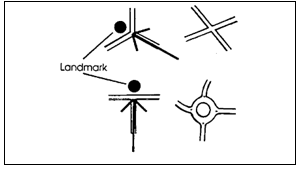
- Terminate vistas with a significant natural feature, a building, a small park, or other public space.
- Traffic Calming. Other traffic calming measures such as mini traffic-circles, neck-downs, chicanes, mid-block diverters, intersection diverters, curb bulbs, serial hill crests, and related devices will be considered on a case-by-case basis, based on safety and appropriateness in the proposed location.
5.3 Acceptance Of Streets For Town Maintenance
Streets shall be accepted in accordance with the Street Acceptance Policy adopted by the Board of Commissioners and as explained in Section I.J of the Engineering Standards and Procedures Manual.
5.4 Defining The Public Space Of The Street
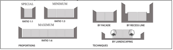
As the most prevalent public spaces in Huntersville, streets should be spatially defined by buildings. Proper alignment and delineation of the public street space occurs when the facades of adjacent buildings are aligned much like the walls forming a room. Buildings that make up the street edges are aligned in a disciplined manner. The defined space observes a certain ratio of height to width.
Building articulation must take place primarily in the vertical plane of the façade. Appendages such as porches, balconies, and bay windows are encouraged to promote the transition between the public street and the private dwelling.
For good definition, the ratio of one increment of height to six of width is the absolute maximum, with one to three being a good effective minimum. As a general rule, the tighter the ratio, the stronger the sense of place. Very tight relationships of one to one can create special pedestrian places.
In the absence of spatial definition by facades, disciplined tree planting is an alternative. Trees aligned for spatial enclosure are necessary on streets with deep building setbacks.
5.5 Street Design Specifications
Design should permit comfortable use of the street by motorists, pedestrians, bicyclists, and transit users. Pavement widths, posted speeds, and the number of travel lanes shall be appropriate for a multi-modal transportation network for which it will serve. The specific design of any given street must consider the context of the building-types which have frontage and the relationship of the street to the overall Town street network.
Decision Making Process.
Street design is to be tailored to the context of the area in which the street is located and shall balance the needs of those living, working, and traveling on that street. All new streets and improvements to existing streets within the Town’s jurisdiction (excluding projects where multi-modal transportation is not allowed) will use the collaborative decision-making process described below:
Step 1: Define Land Use Context. What is the intensity and type of land use at present? What building type(s), massing and exterior features are common between the existing developments? Is there a Small Area Plan for the district? What does it involve and advise? Are there other adopted plans that are applicable?
Step 2: Define the Transportation Context. Identify the transportation network that will influence the street design. What is the nature of the surrounding street network? Does the street cater to the multi-modal design philosophy? What are the incorporated street elements (lanes, sidewalks, bicycle lanes, traffic-calming devices, landscaping)? Are transportation improvements expected for the area?
Step 3: Establish Goals and Objectives. Consider the issues and opportunities of the context (land use and transportation) and their impact on the design of the street network in order to develop goal sets for all users.
Step 4: Prioritize Goals. What components are acceptable and what should be modified? Do the stakeholders and larger community prefer the street network and neighborhood to change or remain the same? How would the stakeholders and larger community prefer the street network and neighborhood to change?
Step 5: Develop Alternatives. Research and test the most suitable street type and its elements using this Article. Identify the site-specific constraints (right-of-way, existing features, environmental features, topography, etc.).
Step 6: Recommend Alternatives. Apply the appropriate street cross-section in the Town of Huntersville Engineering and Standards and Procedure Manual. Reconfigure the cross-section according to the context-based analysis in Steps 1 and 2 to meet goals established in Step 4 and accommodate the site-specific constraints listed in Step 5.
Elements of Street Design. Below are cross-sections to be used for ILLUSTRATIVE PURPOSES to explain each design element discussed in this section.
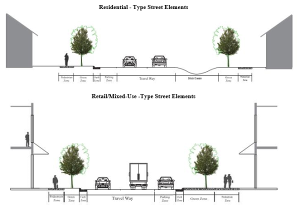
NOTE: On-street parking typically provided on both side of street.
- Pedestrian Zone is the area intended for pedestrian travel. The walkway section of the pedestrian zone shall be free of all obstacles (temporary and permanent) and should be of sufficient width to allow pedestrians to walk safely and comfortably for current and future pedestrian activity. At a minimum, 5 feet “free and clear” (per ADA standards) shall be provided.
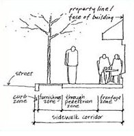
- A sidewalk is required on both sides of public streets excluding residential-type streets in the Rural district, and the undeveloped side of residential-type streets adjacent to open space. Sidewalks are not required for alleys. On residential streets, the minimum sidewalk width shall be 5 feet. In commercial and mixed-use areas, the minimum sidewalk width is 7 feet free and clear of obstacles. When the Green Zone includes hardscaped materials (tree grates and cutouts), the minimum sidewalk width is 10 feet with 5 feet “free and clear” (per ADA standards).
- Sidewalk widths along thoroughfares (or higher-order streets) are established on a case-by-case basis but shall not be less than 6 feet.
- Tree-grates may be utilized for street trees; however, the grate-area may only count toward 1 foot of the “free and clear” (per ADA standards) sidewalk area. All other material placed at the base of street trees, other than concrete or asphalt, shall not count toward the minimum sidewalk width.
- Street trees are required on both sides of all public streets except along the undeveloped side of residential-type streets adjacent to open space. Street Trees shall be located within a Green Zone, which is the space between the sidewalk and the back of curb or back of swale where no curb and gutter is present. Typically, Green Zones are a planting strip or hardscaped amenity zone, which serves as a buffer between pedestrians and vehicles. The Green Zone may include street trees and landscaping and often includes street furnishings and utilities. To encourage tree health, Green Zones shall be provided as follows:
- Curb and gutter section – 7 feet in width (minimum for small-maturing street trees), 9 feet in width (minimum for large maturing street trees) per Article 7;
- Ditch section – 6 feet minimum outside the swale;
- Industrial Streets – 10 feet in width;
- Alleys – not required.
- Generally, street trees shall be planted at a spacing not to exceed 40 feet on center. Where overhead utility lines preclude the use of large-maturing street trees, small-maturing street trees may be substituted, planted 30 feet on center. Street tree spacing may be “field-adjusted” for driveways or utilities, and to comply with the Town of Huntersville Engineering Standards and Procedures Manual, but should generally maintain uniform spacing. Street trees should not be planted within 40 feet of the radius return of an intersection.
- Parking Zone is an area to accommodate on-street parking adjacent to uses where on-street parking provides convenience. Parking widths and layout may vary. Refer to the Town’s Engineering Standards and Procedures Manual for specifics on parking space widths and lengths. This area may also include transit stops and provisions for transit pullouts.
On-street parking is recommended where building type and use will generate regular parking need. Occasional on-street parking can be accommodated without additional pavement width. For streets which serve workplace and storefront buildings, on-street parking lane(s) are required and shall be marked as such. An on-street parking lane on at least one side of the street is required on streets serving apartments, duplex, triplex, quadplex, townhomes, and detached houses with lots 60’ or less in width that are a part of a major subdivision. This parking should be on the side of the street that the use is located (if applicable). In some conditions, parking should be adjacent to urban open space. Standard curb and gutter is required where there is marked parking.
Generally, on-street parking should be parallel, and 7 to 8 feet in width; Angled parking or reverse-angle parking is only permitted as an intentional design element where appropriate. - Medians. Medians that are greater than 10 feet in width should be planted. Refer to the Engineering Standards and Procedures Manual for additional planting requirements. Pedestrian refuges may be located in the medians.
- Traffic Control Plans depicting all regulatory, warning and street name signage as well as pavement markings shall be prepared in accordance with the guidance of the Manual on Uniform Traffic Control Devices and the Engineering Standards and Procedures Manual for all public streets. The developer is responsible for the initial installation of the signs and/or markings and the maintenance thereof until the public accepts the street for maintenance. Conflicts between street signs and tree plantings shall be avoided.
These elements may be varied only in accordance with the design principles detailed above and as approved by the Planning Director in consultation with the Town’s Engineer.
- Street trees are required on both sides of all public streets except along the undeveloped side of residential-type streets adjacent to open space. Street Trees shall be located within a Green Zone, which is the space between the sidewalk and the back of curb or back of swale where no curb and gutter is present. Typically, Green Zones are a planting strip or hardscaped amenity zone, which serves as a buffer between pedestrians and vehicles. The Green Zone may include street trees and landscaping and often includes street furnishings and utilities. To encourage tree health, Green Zones shall be provided as follows: