
Huntington City Zoning Code
CHAPTER FIVE
ZONING DISTRICTS AND REGULATIONS
ARTICLE 1317 - ESTABLISHMENT OF DISTRICTS AND ZONE MAP[6]
State Law reference— Zoning districts generally, W. Va. Code, § 8-24-40.
ARTICLE 1319 - APPLICATION OF REGULATIONS[7]
Cross reference— Remedies and penalties, Art. 1367.
State Law reference— Zoning districts generally, W. Va. Code, § 8-24-40.
ARTICLE 1321 - R-1 RESIDENCE AND R-2 RESIDENCE DISTRICTS[8]
Cross reference— Districts established, § 1317.01; height, yard and lot modifications, § 1341.01 et seq.; accessory uses, § 1341.06; swimming pools, § 1341.16; fences and walls, § 1341.19; garage sales, § 1341.21; home occupations, § 1341.22; satellite dish antennas, § 1341.24.
ARTICLE 1323 - R-4 RESIDENCE DISTRICT[9]
Cross reference— Districts established, § 1317.01; height, yard and lot modifications, § 1341.01 et seq.; accessory uses, § 1341.06; swimming pools, § 1341.16; fences and walls, § 1341.19; garage sales, § 1341.21; home occupations, § 1341.22; satellite dish antennas, § 1341.24.
ARTICLE 1325 - R-5 RESIDENCE DISTRICT[10]
Cross reference— Districts established, § 1317.01; height, yard and lot modifications, § 1341.01 et seq.; accessory uses, § 1341.06; swimming pools, § 1341.16; fences and walls, § 1341.19; garage sales, § 1341.21; home occupations, § 1341.22; satellite dish antennas, § 1341.24.
ARTICLE 1327 - C-1 NEIGHBORHOOD COMMERCIAL DISTRICT[11]
Cross reference— District established, § 1317.01; height, yard and lot modifications, § 1341.01 et seq.; accessory uses, § 1341.06; adult day care, § 1341.09; religious uses, § 1341.14.
ARTICLE 1329 - C-2 HIGHWAY COMMERCIAL DISTRICT[12]
Cross reference— District established, § 1317.01; height, yard and lot modifications, § 1341.01 et seq.; accessory uses, § 1341.06; adult day care, § 1341.09; religious uses, § 1341.14; drive-thru restaurant, § 1341.08; auto service station, § 1341.11.
ARTICLE 1331 - C-3 CENTRAL BUSINESS DISTRICT[13]
Cross reference— District established, § 1317.01; height, yard and lot modifications, § 1341.01 et seq.; accessory uses, § 1341.06; adult day care, § 1341.09; religious uses, § 1341.14.
ARTICLE 1333 - I-1 LIGHT INDUSTRIAL AND COMMERCIAL DISTRICT[14]
Editor's note—Ord. No. 2020-O-41, adopted December 28, 2020, amended article 1333 in its entirety to read as herein set out. Former article 1333, §§ 1333.01—1333.06, pertained to similar subject matter, and derived from Ord. No. 2019-O-24, 9-14-20.
ARTICLE 1334 - I-2 HEAVY INDUSTRIAL DISTRICT[15]
Editor's note—Ord. No. 2020-O-41, adopted December 28, 2020, amended article 1334 in its entirety to read as herein set out. Former article 1334, §§ 1333.01—1333.05, pertained to similar subject matter, and derived from Ord. No. 2019-O-24, 9-14-20.
ARTICLE 1335 - PLANNED UNIT DEVELOPMENT[16]
Cross reference— Planned unit development defined, § 1315.02.
ARTICLE 1337 - SPECIAL ZONING DISTRICTS[17]
Cross reference— District boundaries, § 1317.03; effect of establishment of districts, § 1319.02.
ARTICLE 1339 - H-1 HISTORIC PRESERVATION DISTRICT OVERLAY[18]
Cross reference— District boundaries, § 1317.03; effect of establishment of districts, § 1319.02.
1317.01 - ESTABLISHMENT OF ZONING DISTRICTS.
The following Zoning Districts are hereby established in the City of Huntington:
Residential Districts
R-1 Single-family Residence District
R-2 Single-family Residence District
R-4 Two-family Residence District
R-5 Multi-family Residence District
Commercial Districts
C-1 Neighborhood Commercial District
C-2 Highway Commercial District
C-3 Central Business District
Industrial Districts
I-1 Light Industrial and Commercial District
I-2 Heavy Industrial District
Overlay Districts
H-1 Historic Preservation District Overlay
(Ord. No. 2020-O-41, 12-28-20)
1317.02 - OFFICIAL ZONING MAP.
The boundaries of the zoning districts hereby established are shown on the official zoning map bearing the date of adoption of this ordinance. The official zoning map is hereby declared to be a part of this ordinance, shows the boundaries of and the area covered by the districts, notations, reference, indications and other matters shown on the official zoning map are as much a part of this ordinance as if they were fully described herein.
1317.03 - DISTRICT BOUNDARIES.
Where uncertainty exists as to the boundaries of any district as shown on the official zoning map, the following rules shall apply:
A.
District boundary lines, unless otherwise indicated on the map, follow or are parallel to the centerline of streets and streams; and to lot or property lines as they exist on a recorded deed or plan of record in the clerk of the county court of either Cabell County or Wayne County at the time of the adoption of this ordinance.
B.
Where streets, streams, property lines, or other physical boundaries and delineation are not applicable, boundaries shall be determined by the scale shown on the official zoning map.
C.
Where a district boundary is not fixed by dimensions and where it approximately follows lot lines, and where it does not scale more than ten feet therefrom, such lot lines shall be construed to be such boundaries unless specifically shown otherwise.
D.
In unsubdivided land or where a district boundary divides a lot, the location of such boundary, unless the same is indicated by dimensions, shall be determined by the use of the scale appearing on the maps.
1317.04 - INTERPRETATION OF DISTRICT BOUNDARIES.
In circumstances not covered by section 1317.03, district boundaries, the board of zoning appeals shall interpret the intent of the official zoning map as to location of district boundaries.
1317.05 - PROCEDURE RELATING TO ANNEXED OR VACATED AREAS.
A.
When the city initiates an ordinance for the annexation of property to the city, the planning commission shall prepare an ordinance to amend this zoning ordinance embracing the proposed zoning provisions to be established for such area proposed to be annexed. Procedure on the proposed ordinance to amend this ordinance shall progress concurrently with the procedure on the annexation ordinance in order that the zoning amendment may be adopted by the city council at the same time as the annexation ordinance.
B.
Whenever any street, place, alley, public way, railroad right-of-way, waterway, or other similar area is vacated by proper authority, the districts adjoining each side of such street, alley, public way, railroad right-of-way, or similar area shall be extended automatically to the center of such vacation and all area included in the vacation shall then and thenceforth be subject to all appropriate provisions of the extended districts. In the event of a partial vacation, the adjoining district, or district nearest the portion vacated, shall be extended automatically to include all of the vacated area.
1319.01 - USE OF PROPERTY.
A.
No building or land shall be used and no building shall be erected, reconstructed or structurally altered, which is arranged, intended or designed to be used for any purpose other than a use which is permitted and specified in a district in which such building or land is located.
B.
Environmentally Sensitive Lands Regulations. In order to prevent inappropriate development from taking place and to protect persons and property from hazards resulting from the inappropriate development of lands containing environmentally sensitive areas, the environmentally sensitive lands requirements impose a set of regulations in addition to those of the zoning district. The environmentally sensitive lands areas regulations apply to all applications for a zoning permit, a building permit or a land development permit. Any use classified as a permitted use, or special exception in an underlying zoning district may be allowed within the designated zoning district provided that no more than the stated percent of the following types of areas may be altered, regraded, cleared, or built on:
1.
Floodplain - subject to Article 1349 of this Zoning Ordinance.
2.
Naturally occurring or manmade lakes; ponds; watercourses; and perennial streams in which water has a definite channel, bed, and banks, and includes any area adjacent thereto subject to inundation by reason of overflow or flood water - 0 percent.
3.
Wetland margins consisting of the area for 50 feet from a wetlands to an uplands integral to the wetlands providing temporary refuge for wetlands fauna during high water episodes, critical habitat for animals dependent upon, but not resident in wetlands, and slight variations of wetland boundaries over time due to hydrologic or climatologic effects - no more than 20 percent.
4.
Steep slopes where the inclination (vertical distance over horizontal distance) is 25 percent or more - no more than 20 percent.
5.
Steep slopes of 15 percent to 25 percent - no more than 30 percent.
6.
Wetlands consisting of those lands in the city subject to inundation of soils which are characteristic and categorized as being alluvial or high water table soils by the Soil Survey of Cabell County or Wayne County West Virginia prepared by the United States Department of Agriculture (Soil Conservation Service) - 0 percent.
7.
Ponding basins as designated by the Huntington Flood Wall Advisory Board and subject to article 1349 of this Zoning Ordinance.
C.
Application procedure. All applications for a zoning permit, a building permit or a land development permit shall include an inventory and analysis of the site. The inventory shall include the total acreage of the tract, to the nearest tenth of an acre, consisting of the environmentally sensitive lands listed in part B of this section. The following site features shall be inventoried and mapped in sufficient detail to allow evaluation of the inventory by the city relative to the intent of the overlay district.
1.
Topographic contours at 20-foot intervals, showing slopes of between 15 percent and 25 percent and slopes of more than 25 percent.
2.
Location of wetlands and areas subject to inundation of soils which are characteristic and categorized as being Alluvial or High Water Table Soils by the Soil Survey of Cabell County or Wayne County West Virginia prepared by the United States Department of Agriculture (Soil Conservation Service).
3.
Hydrologic characteristics of the site, including surface water bodies, floodplain, and hydric soils as per the Cabell County Soil Survey and the Wayne County Soil Survey.
4.
Vegetation of the site, defining locations and boundaries of woodland area and vegetation associations in terms of species and size.
5.
Areas designated as ponding basins by the Huntington Flood Wall Board.
1319.02 - EFFECT OF ESTABLISHMENT OF DISTRICTS.
Following the effect date of this zoning ordinance:
A.
Any use not permitted by this zoning ordinance shall be deemed to be prohibited, unless such use is deemed by the planning commission to not be contrary to the spirit of this ordinance.
B.
Where the provisions of this zoning ordinance impose greater restrictions than those of any statute, other ordinance, or regulation, the provisions of this zoning ordinance shall be controlling. Where the provisions of any statute, other ordinance or regulation impose greater restrictions than this zoning ordinance, the provisions of such statute, other ordinance or regulation shall be controlling.
1320.01 - GENERAL PROVISIONS.
Table 1320.A lists the principal uses allowed within all zoning districts with the exception of uses permitted within a planned unit development.
(Ord. No. 2020-O-15, 6-22-20)
1320.02 - TABLE OF PERMITTED USES.
A.
Permitted uses.
1.
A "●" in a cell indicates that a use type is allowed by-right in the respective zoning district. Permitted uses are subject to all other applicable standards of this zoning ordinance.
2.
Permitted uses are approved administratively by the planner through the site plan review unless subject to additional review (e.g., certificate of appropriateness, alternative equivalent compliance, variance, etc.) and any applicable standards identified in Table 1320.A.
B.
Conditionally permitted uses.
1.
A "○" in a cell indicates that a use may be permitted if approved by the BZA through the conditional use review procedure (See article 1359). Conditional uses may be subject to use-specific standards as identified in the last column of Table 1320.A. Conditional uses are subject to all other applicable standards of this zoning ordinance.
2.
The existence or lack of additional use-specific standards in this zoning ordinance shall not be implied to be the only standards the use is required to meet. Any conditional use listed in the table shall be subject to the general review standards for all conditional uses established in article 1359.
3.
Conditionally permitted uses are synonymous with special permitted uses in previous versions of the zoning ordinance.
C.
Prohibited uses.
1.
A blank cell indicated that a use is prohibited in the respective zoning district.
D.
Use-specific standards. The numbers contained in the "Use-Specific Standards" column are references to additional standards and requirements that apply to the use type listed. Standards referenced in the "Use-Specific Standards" column apply in all zoning districts unless otherwise expressly stated.
1.
The use-specific standards include site planning, development, and/or operating standards for certain land uses that are permitted or conditionally permitted in Table 1320.A.
2.
The land uses and activities covered by this section shall comply with the applicable standards for the specific use in all districts unless otherwise specified, in addition to all other applicable provisions of this zoning ordinance.
(Ord. No. 2020-O-15, 6-22-20)
1320.03 - USE DETERMINATION AND UNLISTED USES.
A.
The planner shall make the determination if a proposed use is permitted, a conditional use, or a prohibited use under the provisions of this section.
B.
The planner may determine that a proposed use is substantially similar to a use that is permitted or a conditional use established in Table 1320.A based on the proposed use activities, character of the business, similarity to existing uses within the city, or information on the use as may be available from third-party land use resources such as documentation from the American Planning Association, Urban Land Institute, or similar organizations. If the planner finds that the proposed use is substantially similar to a use established in Table 1320.A, the application shall be processed in the same manner as the similar use.
C.
In finding that a proposed use is similar to a use established in Table 1320.A, the planner shall make a note of the similar use in the approved application form.
D.
If the planner makes the determination that a use is prohibited, the application shall not be processed.
E.
If the applicant disagrees with the planner's determination regarding the proposed use, the applicant may choose to take one of the following actions:
1.
The applicant may appeal the determination of the planner to the BZA; or
2.
The applicant may present their case to the planning commission and/or city council to request that the city initiate a text amendment to address the proposed use and applicable standards.
F.
Multiple permitted uses in a principal structure.
1.
Any principal building may contain more than one use and organization. Each use must be permitted or an approved conditional use within the zoning district where it is located.
(Ord. No. 2020-O-15, 6-22-20)
1320.04 - PERMITTED USES.
The chart in this section lists all permitted uses, conditional uses, and use-specific standards.
(Ord. No. 2020-O-15, 6-22-20; Ord. No. 2020-O-41, 12-28-20; Ord. No. 2022-O-09, 6-13-22; Ord. No. 2023-O-11, 6-12-23)
1321.01 - PURPOSE.
The purpose of the R-1 and R-2 districts is to establish and maintain areas where the use consists of largely single-family residential use at low densities generally in a range of five to nine units per acre. These areas are to be developed compatible and respectful of the scale, texture and quality of existing housing and related uses.
1321.02 - DEVELOPMENT REQUIREMENTS.
(Ord. No. 2020-O-15, 6-22-20)
Editor's note— Ord. No. 2020-O-15, adopted June 22, 2020, repealed the former § 1321.02, and enacted a new § 1321.02 as set out herein. The former § 1321.02 pertained to permitted uses.
1321.03 - SUPPLEMENTARY REGULATIONS.
A.
Parking. See article 1343.
1.
Location. Off-street parking areas shall only be permitted in the side or rear yards with the following exceptions:
i.
Prevailing pattern of development. If the prevailing pattern of development along a block face, within a distance of no more than 500 feet in both directions from the property and located in the same zone, is that there is parking in the majority of front yards, then front yard parking may be permitted.
ii.
No improved alley or secondary street access. If the property has no improved alley access or secondary street access, then front yard parking may be permitted.
iii.
Front yard parking spaces. Parking spaces in the front yard shall only be located within the driveway and the garage apron.
iv.
Additional regulations. The front yard parking must meet all other applicable requirements from article 1343 and the district regulations.
2.
Access. Vehicle access to parking off-street parking areas on lots with alley access shall be from such alley to the maximum extent practicable.
(Ord. No. 2020-O-15, 6-22-20; Ord. No. 2020-O-42, 12-28-20)
Editor's note— Ord. No. 2020-O-15, adopted June 22, 2020, repealed the former § 1321.03, and enacted a new § 1321.03 as set out herein. The former § 1321.03 pertained to bulk and area regulations.
1321.04 - RESERVED.
Editor's note— Ord. No. 2020-O-15, adopted June 22, 2020, repealed § 1321.04, which pertained to special permit and derived from Ord. of 11-23-15.
1323.01 - PURPOSE.
The purpose of the R-4 district is to establish and provide areas for primarily single-family residential land use at moderate densities of no more than two units per lot. These areas are to be developed compatible and respectful of the scale, texture and quality of existing housing and related uses.
1323.02 - DEVELOPMENT REQUIREMENTS.
(Ord. No. 2020-O-15, 6-22-20)
Editor's note— Ord. No. 2020-O-15, adopted June 22, 2020, repealed the former Sections 1323.02, 1323.03 and enacted a new Section 1323.02 as set out herein. The former Sections 1323.02, 1323.03 pertained to permitted uses and bulk and area regulations.
1323.03 - SUPPLEMENTARY REGULATIONS.
A.
Residential Conversion of Single-Family Detached Dwellings.
1.
The maximum number of dwelling units after conversion is limited to two.
2.
Each dwelling unit shall contain within the unit a complete kitchen, toilet and bathing facility; shared facilities shall not be permitted.
3.
The appearance of a single-family dwelling unit shall be maintained. For the converted structure necessary changes in the number or placement of windows to provide adequate light and air will be allowed, but shall be minimized; any changes which occur shall be of one manner consistent with the architectural character of the dwelling. No stair cases shall be allowed in the front of buildings to access upper floors.
4.
Garbage and refuse pickup and other utility areas shall be provided and shall be located so as not to detract from the aesthetic character of the neighborhood and shall be enclosed and shielded from view by fencing, walls, or shrubbery. Planted material or fences shall meet the standards for buffering of parking areas specified above.
5.
Certification of adequate sewer and water services shall be provided by the applicant.
6.
Basement or cellar dwelling units shall be permitted only if all exterior walls of the dwelling unit are at least four (4) feet above the average finished grade level of the adjoining ground.
B.
Parking. See article 1343.
1.
Location. Off-street parking areas shall only be permitted in the side or rear yards.
2.
Access. Vehicle access to off-street parking areas on lots with alley access shall be from such alley to the maximum extent practicable.
C.
Signs. See article 1345.
(Ord. No. 2020-O-15, 6-22-20; Ord. No. 2020-O-42, 12-28-20; Ord. No. 2021-O-09, 6-28-21)
Note— Formerly, § 1323.04.
1323.04, 1323.05 - RESERVED.
Editor's note— Ord. No. 2020-O-15, adopted June 22, 2020, repealed § 1323.05, which pertained to special permit and derived from Ord. of 11-23-15.
1325.01 - PURPOSE.
The purpose of the R-5 district is to accommodate, in central locations convenient to services and city institutions, higher density multi-family housing consisting of three or more units.
1325.02 - DEVELOPMENT REQUIREMENTS.
(Ord. No. 2020-O-15, 6-22-20)
Editor's note— Ord. No. 2020-O-15, adopted June 22, 2020, repealed the former Section 1325.02, and enacted a new Section 1325.02 as set out herein. The former Section 1325.02 pertained to permitted uses and derived from Ord. of 1-24-11.
1325.03 - SUPPLEMENTARY REGULATIONS.
A.
A site plan shall meet the following requirements, in addition to the requirements set forth in this section:
1.
In the event that more than one building is proposed, they shall be designed to be located so that not more than two buildings are in a straight, unbroken line. Each multi-family use building shall be designed with setbacks or breaks of not less than six feet to all exterior walls for every two building units. Each apartment complex of dwelling units shall have a compatible architectural theme with variations in design to provide attractiveness to the development, which shall include consideration of landscaping techniques, building orientation to the site and to other structures, topography, natural features and individual dwelling unit design, such as varying unit widths, staggering unit setbacks, providing different exterior materials, changing roof lines and roof designs, altering building heights, and changing types of windows, shutters, doors, porches, colors, and vertical or horizontal orientation of the facades, singularly or in combination of each dwelling unit.
B.
Single-family conversions. Regulations found in section 1323.03 shall apply for residential conversions of single-family detached dwellings.
C.
Parking. See article 1343.
1.
Location. Off-street parking areas shall only be permitted in the side or rear yards.
2.
Access. Vehicle access to off-street parking areas on lots with alley access shall be from such alley to the maximum extent practicable.
D.
Signs. See article 1345.
(Ord. No. 2020-O-15, 6-22-20; Ord. No. 2020-O-42, 12-28-20)
Editor's note— Ord. No. 2020-O-15, adopted June 22, 2020, repealed the former Section 1325.03, and enacted a new Section 1325.03 as set out herein. The former Section 1325.03 pertained to bulk and area regulations and derived from Ord. of 1-24-11.
1325.04 - RESERVED.
Editor's note— Ord. No. 2020-O-15, adopted June 22, 2020, repealed Section 1325.04, which pertained to special permit and derived from Ord. of 12-14-98; Ord. of 3-13-00; Ord. of 11-23-15.
1327.01 - PURPOSE.
The purpose of the C-1 district is to conveniently provide goods and services to the residents of the neighborhoods while maintaining and promoting the sense of community provided by the commercial hub located in the neighborhood.
1327.02 - DEVELOPMENT REQUIREMENTS.
(Ord. No. 2020-O-15, 6-22-20)
Editor's note— Ord. No. 2020-O-15, adopted June 22, 2020, repealed the former Sections 1327.02—1327.04, and enacted new Sections 1327.02, 1327.03 as set out herein. The former Sections 1327.02—1327.05 pertained to permitted uses, bulk and area regulations, supplementary regulations and derived from Ord. No. 2019-O-4, 2-11-19; Ord. No. 2019-O-10, 4-8-19.
1327.03 - SUPPLEMENTARY REGULATIONS.
A.
Multiple principal structures. Any lot may contain more than one principal structure, provided that each principal structure is located in a manner which will allow the possibility of subdividing the lot in a manner that each structure and resulting lot would conform to the zoning requirements, including frontage on a public street. Where any lot contains more than one principal building, all buildings shall be compatibly designed, whether constructed all at one time or in stages over a period of time.
B.
Parking. See article 1343.
1.
Requirement reduction.
i.
The off-street parking requirements related to non-residential uses shall be reduced by 50% in the C-1 district for the conversion of existing buildings and new construction provided there is curbside parking along at least 75% of the front yard(s). If there is less than 75% of the front yard(s) available for curbside parking, then the off-street parking requirements related to non-residential use shall be reduced by 25%.
ii.
The off-street parking requirements related to non-residential use shall be reduced by two spaces if there is no curb-cut or driveway in the front yard(s) of the property.
iii.
The off-street parking requirements related to residential use in a mixed-use building shall be reduced by 20% in the C-1 district for the conversion of existing buildings and new construction provided there is curbside parking along at least 75% of the front yard(s).
iv.
The off-street parking requirements related to non-residential use shall be waived in the C-1 district if there is a public parking lot within 660 feet of the primary entrances for the structure. The distance from primary entrance measured to the parking lot shall be measured along the sidewalk, crosswalks, or other non-vehicular pathways from the center of the entrance to the nearest edge of the parcel in which the public parking lot is located.
2.
Parking location.
i.
Vehicle access to off-street parking areas on lots with alley access shall be from such alley to the maximum extent practicable.
ii.
A curb cut for off-street parking shall be no more than 36 linear feet.
iii.
Off-street parking areas shall only be permitted in the side or rear yards.
C.
Signs. See article 1345.
D.
Landscaping. See article 1347.
E.
Façade materials.
1.
All building walls facing a street, residential district line, or significantly visible from the public right of way shall be suitably finished for aesthetic purposes.
2.
Preferred building materials include:
i.
Brick.
ii.
Decorative concrete block.
iii.
Wood.
iv.
Stone.
v.
Architectural metal panels.
vi.
Other natural materials.
3.
Prohibited materials on street facing walls include:
i.
Vinyl siding.
ii.
Unpainted or painted smooth, gray, non-decorative block.
iii.
Metal sheeting on the ground floor facade.
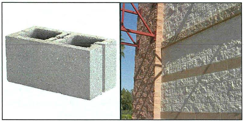
Figure 1327.A: On the left, an unpainted, non-decorative gray concrete block. On the
right, multiple types of decorative concrete blocks.
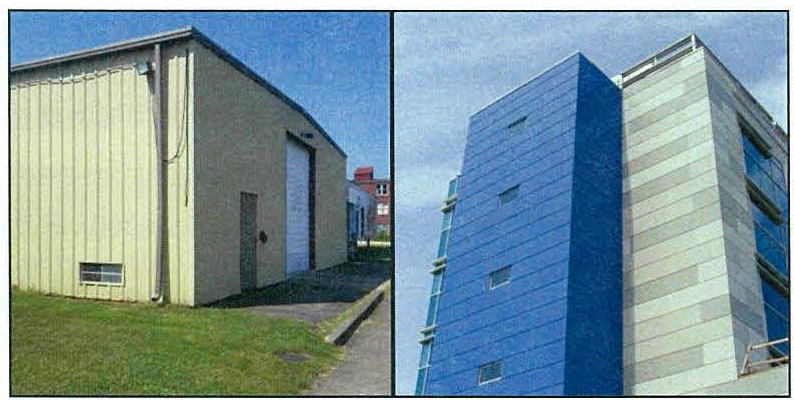
Figure 1327.B: On the left, metal sheeting which is prohibited. On the right, architectural
metal panels.
F.
Outdoor merchandise. No merchandise, products, waste equipment or similar material or objects shall be displayed or stored outside except for the display of fresh produce or except for merchandise and products displayed in a forecourt during business hours. Temporary displays of merchandise for special promotions or events may be permitted by the mayor's office.
1.
Forecourts: Forecourts may be used in residential buildings to provide entry yards and/or shared garden space. Forecourts may be used in non-residential and mixed-use buildings to provide areas for outdoor dining, display of merchandise while the business is actively open to the public, or entries to individual tenants. Where provided, forecourts shall be a minimum of 12 feet in depth measured from the front of the building but no more than 50% of the depth of the structure and 12 feet in width but no more than 60% of the total front facade.
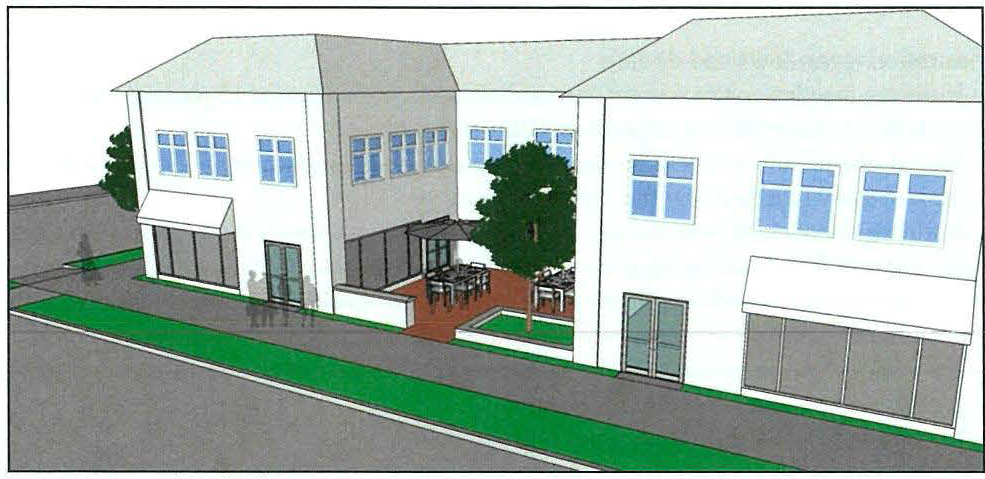
Figure 1327.C: An example of a forecourt used as dining space for a ground floor restaurant.
Note that the forecourt is mostly enclosed except for on one side by the building.
2.
Arcades: Arcades may occur in the front yard(s) of non-residential and mixed-use buildings for structures in which the second story is built parallel within one foot of the front yard property line. Where provided, arcades shall be a maximum of 12 feet in depth measured from the front yard property line. Arcades may be used for outdoor dining, display of merchandise while the business is actively open to the public, or entry to individual units.
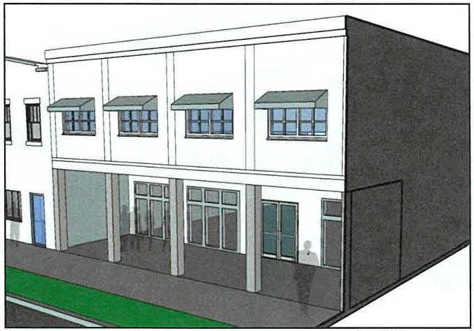
Figure 1327.D: An example of an arcade on a two-story building that is 12 feet deep.
3.
Story separation: Buildings over two stories in height must have an architectural distinction between the ground floor and the upper stories of the buildings, such as change of brick color or material with a horizontal band such as a cornice or soldier course separating the change so that the ground floor is distinguished from the other stories above it.
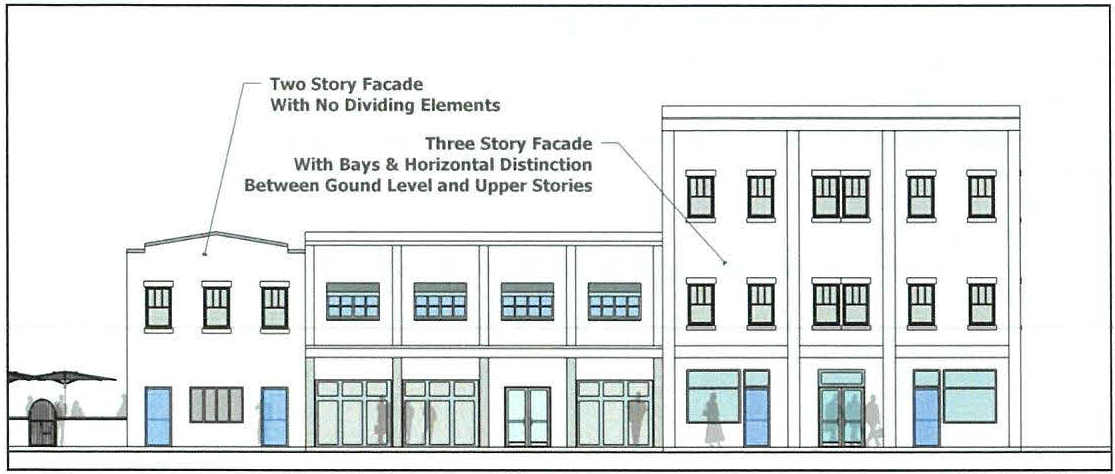
Figure 1327.E: An example of facades of different heights. The two-story facade on
the left requires no horizontal separation. The three-story facade on the right has
a horizontal band creating distinction between the ground level and upper floors.
(Ord. No. 2020-O-15, 6-22-20)
1327.04—1327.06 - RESERVED.
Editor's note— Ord. No. 2020-O-15, adopted June 22, 2020, repealed § 1327.06, which pertained to special permit and derived from Ord. 12-14-98; Ord. 3-8-04; Ord. of 11-28-11(2); Ord. of 6-25-12(4); Ord. of 9-28-15(3); Ord. of 12-28-15(1); Ord. No. 2019-O-10, 4-8-19; Ord. No. 2020-O-5, 3-23-20.
1329.01 - PURPOSE.
The purpose of the C-2 district is to provide varied professional, personal, and retail services convenient to the neighborhoods in an attractive setting and considerate of traffic safety concerns resulting from location along the major corridors of the city.
1329.02 - DEVELOPMENT REQUIREMENTS.
(Ord. No. 2020-O-15, 6-22-20)
Editor's note— Ord. No. 2020-O-15, adopted June 22, 2020, repealed the former Sections 1329.02, 1329.03 and enacted a new Section 1329.02, as set out herein. The former Sections 1329.02, 1329.03 pertained to permitted uses and bulk and area regulations and derived from Ord. of 5-26-15(1); Ord. of 9-28-15(3); Ord. No. 2019-O-4, 2-11-19; Ord. No. 2020-O-5, 3-23-20.
1329.03 - SUPPLEMENTARY REGULATIONS
A.
Multiple principal structures.
1.
Any lot may contain more than one principal structure so long as all requirements of this section are met. Where any lot contains more than one principal building, all buildings shall be compatibly designed, whether constructed all at one time or in stages over a period of time.
B.
Parking. See article 1343.
C.
Signs. See article 1345.
D.
Landscaping. See article 1347.
1.
All portions of the property not utilized by buildings or paved surfaces shall be landscaped, utilizing combinations such as landscaped fencing, shrubbery, lawn area, ground cover, rock formations, contours, existing foliage and the planting of conifers and/or deciduous trees native to the area in order to either maintain or re-establish the tone of the vegetation in the area and lessen the visual impact of the structures and paved areas. The established grades on any site shall be planned for both aesthetic and drainage purposes. The grading plan, drainage facilities and landscaping shall be coordinated to prevent erosion and silting, as well as assuring that the capacity of natural or man-made drainage system is sufficient to handle the water generated and anticipated both from the site and contributing upstream areas.
E.
Façade materials.
1.
All building walls facing a street, residential district line, or significantly visible from the public right of way shall be suitably finished for aesthetic purposes. Preferred building materials include:
a.
Brick.
b.
Decorative concrete block.
c.
Wood.
d.
Stone.
e.
Architectural metal panels.
f.
Other natural materials.
2.
Prohibited materials on street and residential district line facing walls include:
a.
Vinyl siding.
b.
Unpainted or painted smooth, gray, non-decorative block.
c.
Metal sheeting on ground floor façade; this shall include gable ends of one story structures.
(Ord. No. 2020-O-15, 6-22-20)
Note— Formerly, section 1329.04.
1329.04 - GENERAL CIRCULATION DESIGN STANDARDS.
All applications for a zoning permit, a building permit in an area of the city in the C-2 districts shall provide a traffic circulation plan. The plan shall indicate how the traffic and circulation plan for the land development relates to existing and proposed development adjoining the land development, to the site's terrain, the overall design of the land development and the road network of the city.
(Ord. No. 2020-O-15, 6-22-20)
Note— Formerly, section 1329.05.
1329.05, 1329.06 - RESERVED.
Editor's note— Ord. No. 2020-O-15, adopted June 22, 2020, repealed § 1329.06, which pertained to special permit and derived from Ord. 12-14-98; Ord. 2-9-04; Ord. of 4-27-15(1); Ord. of 9-28-15(3); Ord. of 2-22-16(1); Ord. No. 2020-O-5, 3-23-20.
1331.01 - PURPOSE.
The purpose of the C-3 district is to ensure continuation of the highly diverse and integrated land uses serving a variety of missions to an assortment of persons. It also serves to provide a cohesive and viable central business district for the City of Huntington, while preventing the intrusion of certain incompatible commercial or industrial uses.
1331.02 - DEVELOPMENT REQUIREMENTS.
(Ord. No. 2020-O-15, 6-22-20)
Editor's note— Ord. No. 2020-O-15, adopted June 22, 2020, repealed the former Sections 1331.02—1331.04, and enacted a new Section 1331.02 as set out herein. The former Sections 1331.02—1331.04 pertained to permitted uses, bulk and area regulations, and parking waiver in the CBD and derived from Ord. of 9-28-15(3); Ord. No. 2019-O-4, 2-11-19.
1331.03 - SUPPLEMENTARY REGULATIONS.
A.
Multiple principal structures.
1.
Any lot may contain more than one principal structure so long as all requirements of this section are met. Where any lot contains more than one principal building, all buildings shall be compatibly designed, whether constructed all at one time or in stages over a period of time.
B.
Parking. See article 1343.
1.
Off-street parking waiver. Off-street parking space requirements shall be waived in the C-3 District for the conversion of existing buildings and new construction. However, the standards for building off-street parking greater than the requirements shall still apply.
C.
Signs. See article 1345.
D.
Landscaping. See article 1347.
E.
Façade materials.
1.
All building walls facing a street, residential district line, or significantly visible from the public right-of-way shall be suitably finished for aesthetic purposes. Preferred building materials include:
a.
Brick.
b.
Decorative concrete block.
c.
Wood.
d.
Stone.
e.
Architectural metal panels.
f.
Other natural materials.
2.
Prohibited materials on street facing walls include:
a.
Vinyl siding.
b.
Unpainted or painted smooth, gray, non-decorative block.
c.
Metal sheeting.
(Ord. No. 2020-O-15, 6-22-20)
Note— Formerly, section 1331.05.
1331.04—1331.06 - RESERVED.
Editor's note— Ord. No. 2020-O-15, adopted June 22, 2020, repealed § 1331.06, which pertained to special permit and derived from Ord. 12-14-98; Ord. 2-9-04; Ord. of 4-27-15(1); Ord. of 5-26-15(1); Ord. of 9-28-15(3).
1333.01 - PURPOSE.
The purpose of the I-1 district is to provide an area where various light industrial activities can be accommodated without creating undesirable or incompatible situations with surrounding land uses.
(Ord. No. 2020-O-41, 12-28-20)
1333.02 - DEVELOPMENT REQUIREMENTS.
1333.03 - SUPPLEMENTARY REGULATIONS
A.
Parking. See article 1343.
1.
Access. Vehicle access to parking off-street parking areas on lots with alley access shall be from such alley to the maximum extent practicable.
2.
Location. Off-street parking areas shall only be permitted in the side or rear yards.
Figure 1333.A: An example of side yard and rear yard parking.
B.
Front yard and front façade requirements.
1.
The principal building shall be set back from any street within the range established in this section.
2.
Façade materials: All building walls facing a non-industrial district line, excluding walls facing an alley, shall be suitably finished for aesthetic purposes.
A.
Preferred building materials include:
i)
Brick.
ii)
Decorative concrete block.
iii)
Wood.
iv)
Stone.
v)
Architectural metal panels.
vi)
Other natural materials.
B.
Prohibited materials on street facing walls include:
i)
Vinyl siding.
ii)
Unpainted or painted smooth, gray, non-decorative block.
iii)
Metal sheeting.
C.
Signs. See article 1345.
D.
Landscaping. See article 1347.
(Ord. No. 2020-O-41, 12-28-20)
1333.04 - PERFORMANCE STANDARDS.
The requirements herein are intended to provide a basis for determining the compatibility of land uses that may produce measurable adverse environmental effects on their surroundings.
1.
Noise. At no point along the property line shall the noise level of continuous sound exceed 80 decibels. Impulsive sound shall not exceed 90 decibels. Additionally at no point in a non-industrial district shall the noise level of any operation or plant (except as otherwise noted herein) be high enough as to be detectable by a person with average hearing ability, unaided by any mechanical or electronic device, at a distance of 100 feet from the building between 9:00 p.m. and 7:00 a.m.
a.
Exemptions. The following shall be exempt from noise performance standards:
1)
Noises of construction or maintenance activities from 7:00 a.m. to 9:00 p.m.
2)
Noises of safety signals, warning devices, and emergency pressure relief valves.
3)
Transient noises of moving sources such as transportation vehicles.
4)
Other noises not under the direct control of the property user.
2.
Vibration. No perceptible vibrations shall be permitted at the property line.
3.
Smoke, particulate matter and gases. The emission of smoke, dust, fumes, gases, and similar matter which can cause any damage to human or animal health or vegetation, or to other forms of property, or which can cause any soiling or staining of persons or property at the point beyond the lot line of the use creating the emission is prohibited. Standards concerning such emission shall be in accord with the rules and regulations of the West Virginia Division of Environmental Protection.
4.
Odor. No activity or operation shall cause at any time the discharge of toxic or noxious odor beyond the lot line of the lot on which it is located.
5.
Glare and heat. Glare, whether direct or reflected, such as from spot lights or high temperature processes, and as differentiated from general illumination, shall be not visible beyond the lot line of the lot on which the use is located.
6.
Fire hazards. No activity or operation shall be established which fails to meet requirements of Life Safety 101, Fire Code.
(Ord. No. 2020-O-41, 12-28-20)
1334.01 - PURPOSE.
The purpose of the I-2 district is to provide an area where various industrial activities can be accommodated without creating undesirable or incompatible situations with surrounding land uses.
(Ord. No. 2020-O-41, 12-28-20)
1334.02 - DEVELOPMENT REQUIREMENTS.
1334.03 - SUPPLEMENTARY REGULATIONS.
A.
Parking. See article 1343.
B.
Signs. See article 1345.
C.
Landscaping. See article 1347.
(Ord. No. 2020-O-41, 12-28-20)
1334.04 - PERFORMANCE STANDARDS.
The requirements herein are intended to provide a basis for determining the compatibility of land uses that may produce measurable adverse environmental effects on their surroundings.
1.
Noise. At no point along the property line from which the noise emanates from shall the noise level of continuous sound exceed 80 decibels. Impulsive sounds shall not exceed 105 decibels.
a.
Exemptions. The following shall be exempt from noise performance standards:
1)
Noises of construction or maintenance activities from 7:00 a.m. to 9:00 p.m.
2)
Noises of safety signals, warning devices, and emergency pressure relief valves.
3)
Transient noises of moving sources such as transportation vehicles.
4)
Other noises not under the direct control of the property user.
2.
Vibration. No perceptible vibrations shall be permitted at the property line.
3.
Smoke, particulate matter and gases. The emission of smoke, dust, fumes, gases, and similar matter which can cause any damage to human or animal health or vegetation, or to other forms of property, or which can cause any soiling or staining of persons or property at the point beyond the lot line of the use creating the emission is prohibited. Standards concerning such emission shall be in accord with the rules and regulations of the West Virginia Division of Environmental Protection.
4.
Odor. No activity or operation shall cause at any time the discharge of toxic or noxious odor beyond the lot line of the lot on which it is located.
a.
Exemptions. The following shall be exempt from odor performance standards:
1)
Odors from regular or required maintenance of the facility or site between 7:00 a.m. and 6:00 p.m.
5.
Glare and heat. Glare, whether direct or reflected, such as from spot lights or high temperature processes, and as differentiated from general illumination, shall be not visible beyond the lot line of the lot on which the use is located.
6.
Fire hazards. No activity or operation shall be established which fails to meet requirements of Life Safety 101, Fire Code.
(Ord. No. 2020-O-41, 12-28-20)
1335.01 - PURPOSE.
The provisions of this section are intended for special situations in which:
a.
Adequate space, light, air, and other objectives of this Code relating to the public health, safety, and welfare can be achieved without the literal application of the detailed zoning and subdivision requirements otherwise applicable, and
b.
Special amenities and benefits to the community beyond those required by this and other city ordinances can be achieved by allowing more flexible design than is otherwise permitted by such requirements.
These objectives can be achieved where an area of land is planned for development as an integrated unit and where its design is subject to more detailed review and approval by the city than is normally required. The objective of planned unit development (PUD) is therefore not simply to allow exceptions to otherwise applicable regulations. It is instead to encourage a higher level of design and amenity than it is possible to achieve under the usual land development requirements.
It is accordingly the intent of the city to suspend the application of detailed zoning and subdivision standards as provided herein only where such special amenity is achieved. In this way the city may grant the creative developer a desirable flexibility and at the same time not only protect but enhance the welfare of the residents and other users of a development as well as the rest of the community.
1335.02 - QUALIFICATION FOR FILING AS A PUD.
A planned unit development may be developed in any district subject to the following requirements:
a.
Is at least two acres in size, and
b.
Contains more than two detached buildings accommodating principal uses, and
c.
Is initially under the same ownership or control.
A planned unit development may be residential, commercial, office, industrial, or a combination thereof. Flexibility to suspend requirements imposed elsewhere is not conferred upon the PUD applicant as a matter of right but is in all cases subject to a finding by the city that the objectives of these provisions will be served thereby.
1335.03 - INCENTIVES FOR PLANNED UNIT DEVELOPMENTS.
To further a superior level of design and amenity in new development, the following incentives are offered in planned unit developments:
1)
Variable density and dimensional zoning standards. Standards for minimum lot area, minimum lot area per dwelling unit, lot width, building height, floor area ratio, yard dimensions, off-street parking and loading, landscaping and screening, fences, and signs may vary from those established elsewhere in this ordinance.
2)
More than one principal building per lot. In a planned unit development more than one principal building may be located on a lot.
3)
Variable subdivision design standards. Dimensional and design standards for subdivisions and subdivision improvements such as streets, blocks, sidewalks and parkways, but not improvement construction standards, may vary from those established in the city subdivision regulations.
4)
Mixed land uses. Land uses other than those allowed as permitted or special exceptions in the applicable zoning districts may be permitted on up to 30 percent of the net site area of a planned unit development.
1335.04 - REQUIREMENTS FOR PLANNED UNIT DEVELOPMENTS.
1)
Site plan review. Whether or not a land subdivision is involved, preliminary and final plans for the development shall be filed and approved by the city in conformance with the provisions of article 1351 of this ordinance.
2)
Required common open space. A minimum of 20 percent of the net site area in residential use in each phase shall be set aside for permanent common open space as defined herein.
3)
Quality of Design. To be granted the flexibility permitted hereunder, a planned unit development must evidence a level of design and amenity exceeding that typical of conventional development. Among the features that may evidence such amenity are:
a)
Amount and quality of landscaping;
b)
Amount, quality, and interconnectedness of common open space;
c)
Provision of pedestrian or bicycle paths separated from streets;
d)
Preservation of drainage ways and other natural features;
e)
Provision of common recreational facilities;
f)
Enclosed, underground, depressed, or outstandingly landscaped parking areas;
g)
Varied building setbacks or other measures to reduce monotony in design; and
h)
Other features as determined by the planning commission or city council.
4)
Maintenance of land intended for future phases. Land designated for future construction phases and other land not intended for immediate improvement shall be landscaped or otherwise maintained with a neat and orderly appearance as specified by the planning director.
1335.05 - APPROVAL PROCESS.
Preliminary plans and final plans for planned unit developments shall be approved only in conformance with W. Va. Code, Ch. 8, Art. 5, § 18 and the approval criteria provided in Section G of this article. No permit for a PUD or phase thereof shall be issued before approval by the city council of a final plan as provided herein.
1335.06 - PUD REVIEW COMMITTEE.
A PUD review committee is hereby authorized to review planned unit development filings.
The membership of the committee shall include the mayor, the chairperson of city council, the director of development and planning, the planning director, the director of public works, the fire chief, the chairman of the board of zoning appeals, the chairman of the planning commission, and may include any others appointed thereto by the mayor. The committee may seek technical assistance from such other sources as it deems necessary.
The committee may advise and assist applicants in meeting city objectives but shall have no power to approve or disapprove any filing or in any way restrict the applicant's right to seek formal approval thereof from the planning commission and city council.
The committee shall, within 30 days after completing its review of any filing, submit to the planning commission the complete filing together with a written report noting any deficiencies in compliance with the requirements herein and any recommendations for improvement of the planned unit development to better reflect the objectives of these provisions. A copy of the committee's report shall also be sent to the applicant.
1335.07 - FINAL PLAN.
1)
Filing of final plan. The city council may approve, conditionally approve, or deny a final plan of a planned unit development, or any phase thereof, for which it has approved a preliminary plan. The final plan may be filed, and may be approved, simultaneously with the preliminary plan.
The general terms, conditions, and requirements set forth in a preliminary plan, or any phase thereof, approved by the city council shall not be modified, revoked, or otherwise impaired by action of the city. Except that the city council may rescind approval of a preliminary plan, or any phase thereof, and thereby revoke such terms and conditions, if the applicant has failed to file within three years of the date of approval of the preliminary plan either a final plan in conformance therewith or a revised plan together with an application for an amendment. The city council may grant an extension of this time period.
A financial surety shall be submitted with the final plan and shall provide for the phasing of the installation and improvement of public or common areas and improvements, open spaces, and amenities in a manner generally proportionate to the number of dwelling units or the amount of non-residential floor space, as applicable, to be built in each phase together with the phases that preceded it.
2)
Recording of final plan. The final plan as approved by the city council shall be filed with the county recorder as the final plat for the PUD under provisions of the city subdivision regulations whether or not the PUD involves any subdivision of land. No building permit shall be issued before the approved final plan is recorded. The applicant shall pay all recording costs.
3)
Amendments to approved plan. Approval of an amendment shall be required for:
a.
Any material change, deletion, or addition made to:
1.
An approved preliminary plan, or
2.
An approved final plan, or for:
b.
A final plan that does not conform to the preliminary plan approved by the city council.
An applicant seeking approval of an amendment shall file an application therefor with the planning director. The application shall describe the amendment sought and provide such other information as the planning commission or city council may require. It shall be accompanied by ten copies of the proposed amendment and a filing fee.
If the planning director determines that the amendment sought is a minor amendment as defined herein, he or she shall refer it to the planning commission for final action. No public hearing shall be required for a minor amendment. An applicant may appeal a decision of the planning commission on a minor amendment to the city council.
For amendments other than minor amendments, the full approval process set forth herein for preliminary plans and final plans shall be followed.
A minor amendment to a planned unit development shall be any change from the previously approved Plan that involves:
1.
No change in land use type or housing type; and
2.
No change in the location of any structure, off-street parking or loading area, common open space area, or any area or right-of-way to be conveyed to or reserved for a public body, by more than ten feet in any direction, nor a change in the spacing between any two structures by more than 10%; and
3.
No change of more than 10% in any non-locational quantitative specification of the previously approved plan, including:
a.
Any dimension of any lot, yard, structure, or pedestrian or vehicular thoroughfare;
b.
Any residential density;
c.
Amount of common open space acreage;
d.
Utility line capacity;
e.
Amount of floor area of non-residential development;
f.
Amount of land to be conveyed to or reserved for any public body;
g.
Size or capacity of any off-street parking or loading area;
h.
Amount or dimensions of proposed tree or ground cover, landscaping, or screening; and
4.
No other change that causes the development to fall short of meeting the requirements of any applicable zoning district to any greater degree than already provided on the previously approved plan.
The planning commission may disallow minor amendment status if a proposed amendment fails to meet the foregoing criteria when it is considered together with one or more minor amendments previously approved for the same development.
The planning commission or city council shall approved, conditionally approve, or disapprove an amendment. An amended final plan shall be recorded in accordance with the provisions herein governing recording of a final plan.
1335.08 - APPROVAL CRITERIA FOR PLANNED UNIT DEVELOPMENTS.
In recommending approval or conditional approval of a preliminary or final plan for a planned unit development (PUD), the planning commission shall transmit to the city council written findings of fact that the application meets all of the criteria below, or will meet them when the commission's conditions are complied with. The city council shall not be bound by the recommendation of the planning commission, but in granting approval or conditional approval, the council shall also find that all of the following criteria are met or will be met when any conditions to which the approval is made subject are complied with:
1)
Superior design. The PUD represents a more creative approach to the unified planning of development and incorporates a higher standard of integrated design and amenity than could be achieved under otherwise applicable zoning district and subdivision regulations, and solely on this basis modifications to the use and design standards established by such regulations are warranted.
2)
Meets PUD requirements. The PUD meets the requirements for planned unit developments set forth in this Code, and no modifications to the use and design standards otherwise applicable are allowed other than those permitted herein.
3)
Consistent with city plan. The PUD is generally consistent with the objectives of the city Comprehensive Plan as viewed in light of any changed conditions since its adoption.
4)
Public welfare. The PUD will not be detrimental to the public health, safety, morals, or general welfare.
5)
Compatible with environs. Neither the PUD nor any portion thereof will be injurious to the use and enjoyment of other properties in its vicinity, seriously impair property values or environmental quality in the neighborhood, nor impede the orderly development of surrounding property.
6)
Natural features. The design of the PUD is as consistent as practical with the preservation of natural features of the site such as flood plains, wooded areas, steep slopes, natural drainage ways, or other areas of sensitive or valuable environmental character.
7)
Circulation. Streets, sidewalks, pedestrian ways, bicycle paths, off-street parking, and off-street loading as appropriate to the planned land uses are provided. They are adequate in location, size, capacity, and design to ensure safe and efficient circulation of automobiles, trucks, bicycles, pedestrians, fire trucks, garbage trucks, and snow plows as appropriate without blocking traffic within the PUD, or unduly interfering with the safety or capacity of adjacent streets.
8)
Open spaces and landscaping. The quality and quantity of common open spaces and landscaping provided are consistent with the higher standards of design and amenity required of a PUD. The size, shape, and location of a substantial portion of total common open space provided in residential areas render it useable for recreation purposes.
Open space between all buildings is adequate to allow for light and air, access by fire fighting equipment, and for privacy where walls have windows, terraces, or adjacent patios. Open space along the perimeter of the development is sufficient to protect existing and permitted future uses of adjacent property from adverse effects from the development.
9)
Covenants. Where individual parcels are to be later sold, adequate provision has been made in the form of deed restrictions, homeowners or condominium associations, or the like for:
a.
The preservation and maintenance of any open spaces, thoroughfares, utilities, water retention or detention areas, and other common elements not to be dedicated to the city or another public body.
b.
Such control of the use and exterior design of individual structures, if any, as is necessary for continuing conformance to the PUD Plan, such provision to be binding on all future ownership.
10.
Public services. The land uses, intensities, and phasing of the PUD are consistent with the anticipated ability of the city, the school system, and other public bodies to provide and economically support police and fire protection, water supply, sewage disposal, schools, and other public facilities and services without placing undue burden on existing residents and businesses.
11.
Phasing. Each development phase of the PUD can, together with any phases that preceded it, exist as an independent unit that meets all of the foregoing criteria and all other applicable regulations herein even if no subsequent phase should ever be completed. The provision and improvement of public or common area improvements, open spaces, and amenities — or the provision of financial sureties guaranteeing their improvement — is phased generally proportionate to the phasing of the numbering of dwelling units or amount of non-residential floor area.
1337.01 - PURPOSE.
The purpose of this section is to provide special regulations where, due to specific local conditions, the normal district requirements of this ordinance do not adequately provide the most appropriate development options.
1337.02 - B&O RIGHT-OF-WAY SPECIAL ZONING DISTRICT.
A.
Statement of intent. The intent of the B&O right-of-way special zoning district is to recognize the unique development issues related to building construction and land use along the former B&O right-of-way in the Westmoreland area of the City of Huntington and to promulgate zoning restrictions which will allow property owners the maximum use of their property while protecting the interests of other property owners in the vicinity.
B.
District boundaries. The boundaries of the B&O right-of-way special zoning district are Bradley Road to the south, Waverly Road to the north, Huntington floodwall to the west, and Camden Road to the east.
C.
Primary permitted uses.
D.
Permitted accessory building uses.
1.
Accessory uses, such as walks, driveways, curbs, retaining walls, mail boxes, lamp posts, and structures of like nature and trees, shrubs, or plants are permitted in any required yard. Vision clearance shall be maintained on corner lots.
2.
Fences not more than seven feet in height shall be allowed in any side or rear yard. No fence shall be allowed in the front yard.
3.
Accessory buildings, not to 150 square feet, are permitted in any side yard. Such buildings shall not occupy more than 20% of the side yard.
4.
An attached carport may extend ten feet into the required side yard.
5.
Swimming pools may be located in any side yard. A pool with a depth exceeding 24 inches must be surrounded by a fence at least four feet in height.
6.
An open porch or deck may be located in may required yard, however, such structure shall not extend more than four feet into a required front or rear yard or ten feet into a side yard.
E.
Minimum lot size. The minimum lot size within the district shall be 4,800 square feet, with no less than 120 feet lot frontage.
F.
Height. No structure shall exceed one story in height.
G.
Setbacks. The following minimum setback shall be required. The front yard shall abut Bradley Road, while the Waverly Road frontage shall be considered the rear yard.
1.
Front yard setback - 20% of lot depth.
2.
Rear setback - 20% of lot depth.
3.
Side setback - 20 feet, each side.
H.
Parking. There shall be two off-street spaces per dwelling. Driveway access shall only be permitted from Bradley Road.
(Ord. No. 2020-O-15, 6-22-20)
1337.03 - RESERVED.
Editor's note— Ord. No. 2020-O-15, adopted June 22, 2020, repealed § 1337.03, which pertained to special permit and derived from Ord. of 4-26-04.
1339.01 - PURPOSE.
The purpose of the H-1 district overlay is to acknowledge the special and unique character of the City of Huntington's historic districts. These districts include the residential and non-residential land uses representing the community's growth and change during the nineteenth and twentieth centuries. The H-1 district overlay is also established to provide special provisions designed to preserve and protect the historical nature of the community, while at the same time encouraging renovation, rehabilitation and new construction compatible with existing aesthetic patterns to promote and continue the revitalization of the city's historic areas. The intent of all standards and guidelines in the H-1 district overlay is to safeguard the heritage of the city by preserving that part of the city which reflects elements of its cultural, social, economic and architectural history and to promote the use of the historic areas for the education, pleasure and welfare of the city and its visitors. Finally, the H-1 district overlay serves to implement Part One, Chapter Five of the Codified Ordinances of Huntington allowing for the preservation and long-term protection of historic structures in the city.
1339.02 - SCOPE.
All owners, occupants, tenants and other persons or entities in control or possession of structures must apply for review by the historic preservation commission and issuance of a "Certificate of Appropriateness" prior to any building permit being issued; or in the event no such permit is required, then prior to any work or activity being commenced. This includes the following activities within the H-1 district overlay or on any historic property (including structure and archaeological resource) or for any structure surveyed or identified in the City of Huntington as listed on the National Register. Activities to be regulated by a "Certificate of Appropriateness" include: demolition, relocation, repair, changes in exterior appearance by means of repainting (whether in the same or in a different color), or addition or new signage or exterior lighting; or excavation or ground disturbance. The "Certificate of Appropriateness" is in addition to any other approvals necessitated by the development proposal and as approved by the planning director, planning commission, or board of zoning appeals.
Application procedures. The procedure for application for a certificate of appropriateness for development and redevelopment in the City of Huntington H-1 district overlay including demolition, relocation, repair, changes in exterior appearance by means of repainting (whether in the same or in a different color), or addition or new signage or exterior lighting; or excavation or ground disturbance are outlined in article 1353 of this chapter.
1339.03 - PERMITTED USES AND BULK AND AREA REGULATIONS.
The H-1 district overlay imposes a set of requirements in addition to those of the underlying zoning district within those areas determined to be historic resources designated by the historic preservation commission. All applicable use and bulk and area regulations of the underlying zoning district shall apply in addition to the regulations outlined in the additional sections of this article. Only land which is identified on the zoning map which is in the H-1 Historic Preservation District Overlay is regulated by this section.
1339.04 - DESIGN STANDARDS FOR NEW CONSTRUCTION.
A new building in the H-1 districts overlay should be visually compatible with its neighbors in spacing, setback, massing, materials, roof shape, window divisions and siding emphasis. A new building must not be identical with its neighbors in these respects, but attention shall be given to the immediate architectural environment of the new building. Any new building shall support and enhance a block's design unity and sense of character through consideration of silhouette, spacing, setbacks, proportions, volume/mass, entryway, material/surface, shadow/texture, and style/image. In addition, these guidelines apply only to the parts of the building visible from a public way. Within the city's requirements and the requirements of the Building Code, the designer should have free rein.
A.
Where the underlying zoning is residential the use shall present a residential atmosphere. To accomplish this, new buildings should be compatible in size, scale, and mass with existing buildings.
B.
Rhythms of building spacing should be maintained. In the historic district where there is a pattern of buildings the pattern shall continue.
C.
Front of buildings facing the street. The buildings in Huntington are characterized by their linear appearance. The front of nearly every building faces the street. Although this may not be achievable on every site due to other constraints, architectural treatments can achieve the same effect. Parking should be located at the rear and side of buildings.
D.
Entrances and porches are often the focus of buildings, particularly when they occur on primary elevations. Together with their functional and decorative features such as doors, steps, balustrades, pilasters and entablatures, they can be extremely important in defining the overall character of a building. The porch treatment of new structures shall relate to the porch treatment of existing adjacent structures. Open porches are strongly encouraged, but screened in porches may be acceptable if well-detailed.
E.
The roof, with its shape; features such as cresting, dormers and chimneys; and the size, color and patterning of the roofing material, can be extremely important in defining the building's overall character.
Roof profiles contribute strongly to the character of a street, and new construction shall relate to the predominant roof shape and pitch of existing adjacent buildings. Where flat roofs appear historically, they almost always project beyond the facade line and are frequently supported by brackets. New roofs should follow the traditional types: gabled, gambrel, hipped and mansard. Roofing material shall be unobtrusive and not call attention to itself, except on buildings where pattern is a part of the overall design.
Asphalt shingle is acceptable, provided it is a relatively dark shade. Random mingling of shingle shapes and colors should not be permitted, and consideration should be given to whether there is stylistic justification for the use of shaped shingles at all.
F.
The proportion, size and detailing of windows in new construction should relate to that of existing adjacent buildings. Most windows in the city's historic districts have a vertical orientation. Also, wooden double-hung windows are traditional in the city's historic districts.
The use of large picture windows shall not be permitted in domestic structures, nor should any window which is basically horizontal in orientation. Reflective glass is not allowed.
Projecting bay windows with a polygonal plan are appropriate. If a bay window is added, a projecting bay window is preferable to a curving bow window.
G.
Window type and materials are to be compatible with the front facade and the historic and architectural character of the buildings. Exterior storm windows and doors should be visually unobtrusive. Aluminum shall be painted in an appropriate manner.
H.
Stylistic trim using cornices, scroll work, and the like is encouraged. Shutters are appropriate for new structures. Shutters should be paneled or louvered. Plank or board and batten shutters shall not be permitted. Shutters shall not be pierced with sawn initials or other motifs.
Shutters shall be dimensioned to cover the window opening. The height of shutters shall be equal to the distance from the sill to the lintel, and the width of each unit shall be half the width of the frame, all measured on the exterior. Attachment of shutters to the building with hinges is preferable to an immovable mounting.
I.
Exterior materials are to be natural in appearance. For siding of new structures, diagonal and vertical siding are generally unacceptable. Siding of new structures shall have the same directional emphasis as the siding on original structures. Clapboard is the preferred siding material of new buildings. Materials which imitate natural materials may be acceptable. Imitative materials such as asphalt siding, wood-textured metal siding or artificial siding stone or brick should not be used. Four-inch metal siding, when installed and carefully detailed, may be acceptable.
J.
Paint color for a privately-owned building is essentially a personal choice. Several very good books have been published regarding historic paint colors at various periods in American architectural history (including Century of Color, published by the American Life Foundation in 1981); it would be desirable if these were consulted prior to choosing a color. Colors should be compatible with the historic district's atmosphere and typical of the period from which the architectural style was developed.
1339.05 - DESIGN GUIDELINES FOR ARCHITECTURAL RESTORATION.
Restoration of buildings should comply with accepted historic preservation guidelines such as the Secretary of Interior's Standards for Rehabilitation and Guidelines for Rehabilitating Historic Buildings and Preservation Briefs published by the National Park Service
A.
Windows and doors. Existing windows and doors, including the window sash, glass, lintels, frames, molding, shutters, and steps, should be retained and repaired whenever possible. If a new window or door must be used, it should be of a material compatible with the front facade. Changing the size or arrangement of windowpanes, muntins, and rails where they contribute to the historic and architectural character of the building is discouraged. Inappropriate window or door features on significant facades are discouraged. Replacement windows in restored and rehabilitated structures should retain the dimensions and pane divisions of the window being replaced. Paired casement windows, although not historically common, are generally acceptable because of their vertical orientation. The use of single-pane windows should not be permitted unless equipped with snap-in muntins.
B.
Storm windows. Exterior storm windows and doors may be installed if they are visually unobtrusive, do not cause damage to existing frames, and can be removed in the future. Storm windows should match the trim color. Mill-finished aluminum can be painted to match.
C.
Porches and steps. Porches and steps that are appropriate to the building and the site should be retained. The original material and architectural features of porches and steps should be retained whenever possible.
D.
Roofs. The original roof shape should be preserved. All architectural features that give the roof its essential character should be preserved or replaced in a compatible manner.
E.
Architectural metals. Architectural metals should be cleaned when necessary with an appropriate method that does not erode the surface.
F.
Masonry surface and repointing. Original masonry should be retained whenever possible, without applying any surface treatment, including paint. When repointing of mortar joints is absolutely necessary, old mortar should be duplicated in composition, color, texture, method of application, and joint profile. The surface cleaning of structures shall be undertaken with the gentlest means possible.
G.
Wood frame buildings. Architectural features, such as cornices, brackets, window and door molding and details, clapboard, weatherboard, shingles, and other wood siding, are essential and parts of the character and appearance of frame buildings. They should be retained and preserved whenever possible. Frame buildings should not be resurfaced with new materials that are inappropriate for the building or that will cause deterioration of the original structure.
H.
Structural systems. Existing foundations should not be disturbed with new excavations that could undermine the structural integrity of the building.
I.
Mechanical systems. Exterior cables (e.g., electrical, telephone, and cable TV) should be installed in places where they will be visually unobtrusive. Audio/video antenna and mechanical equipment (e.g., air conditioning and solar panels) should be placed in as inconspicuous a location as possible.
J.
Garages. If an ally is adjacent to the dwelling, a new garage should be located off the alley. Where alleys do not exist, garage facing the street or driveway curb cuts may be acceptable. Garage doors should not face the street. If this is found necessary, single garage doors should be used to avoid the horizontal orientation of two-car garage doors.
Parking spaces should be screened from the street and sidewalk by landscaping.
K.
Walls, fences, and railings. Removal or replacement with inappropriate material or design is discouraged where these are historically or architecturally important elements of the design and character of the structure and district.
1339.06 - DESIGN GUIDELINES FOR STOREFRONTS.
A.
The storefront opening. The storefront opening, where possible, shall be recessed six to 12 inches into the facade's storefront opening rather than applied to the face of the facade.
B.
The storefront frame. The storefront design shall generally be composed of a hierarchical frame made up of vertical and horizontal elements.
C.
The recessed entry. The storefront should have a recessed entry off the sidewalk to create a more intimate sense of entry at the door. The recessed entry should be three feet to six feet deep.
D.
The windows. The storefront should be as transparent as possible. Large window areas emphasize display, maximize natural light and allow for visibility into and out of the store.
E.
The storefront cornice. The storefront should have a strong horizontal form at its top to separate it from the upper facade and to help certain signage.
F.
Materials, color and texture. These characteristics of the storefront design should flatter that of the upper facade and adjacent facades.
G.
Proposed changes should be supported by historic photos, blueprints, etc. of the structure.