
Huntington City Zoning Code
ARTICLE 1345
SIGN REGULATIONS AND SITE LIGHTING21
Editor's note—Ord. No. 2022-O-11, adopted July 11, 2022, amended article 1345 in its entirety to read as herein set out. Former article 1345, §§ 1345.01—1345.13, pertained to similar subject matter, and derived from 1964 Code Secs. 30-15, 30-23, 30-27; Ord. of 10-22-07; Ord. No. 2020-O-32, 9-14-20.
Cross reference— Unauthorized traffic signs, § 313.06; sign definitions, § 1315.02; signs in I-1 General Industrial District, § 1333.09.
1345.01 - PURPOSE.
This sign ordinance is not intended to regulate speech. Instead the intent is to:
A.
To preserve and protect the public safety, comfort and welfare of users of streets and sidewalks in the City of Huntington by regulating signs of all types.
B.
To enhance community appearance, reduce visual clutter and blight, protect property values, promote recreational value of public travel and the economic development of the City of Huntington.
C.
To limit the size, number and location of signs which may obstruct the vision of motorists, create distractions and increase traffic accidents.
D.
To acknowledge the appropriate display of signs as necessary to public service and to the conduct of competitive commerce.
E.
To establish size and design standards.
F.
To maintain signs in a safe manner.
(Ord. No. 2022-O-11, 7-11-22)
1345.02 - GENERAL SIGN REGULATIONS.
A.
Applicability. All new, reconstructed, altered, or relocated signs must comply with the standards of this section. For the purpose of this ordinance, "to alter" means to change in appearance, material, size, or structure.
B.
Sign permit.
1.
All sign types, unless exempted in this article, require a sign permit before they may be constructed, reconstructed, altered, or relocated. Signs that are exempted from requiring a permit within this article must still comply with the regulations for this article.
2.
Any sign that encroaches upon or over a public right-of-way requires review and approval from public works must be included in a liability insurance policy holding the city free of all responsibility.
3.
No person shall construct, reconstruct, alter, or relocate any sign upon any property or structure without the prior written consent from the property owner or their authorized representative. The written consent must accompany the sign permit application.
4.
A sign permit shall become null and void if work authorized under the permit has not been completed within one year of the date of issuance. The planning officer may approve an extension of up to three months based on a written request from the applicant.
C.
Location.
1.
Each sign, with the exception of off-premise signs as defined in article 1315 erected in conformance with this article, must be located on the same site as the subject of the sign.
2.
No sign may be installed in a way that obstructs free and clear vision, or free use, of any public right-of-way, intersection, ingress or egress point, transit stop, parking space, drive aisle, driveway, building entrance, fire escape, or accessibility ramp.
3.
No sign may be placed so as to obstruct any window or door, with the exception of window signs in compliance with this article.
4.
Lots fronting on two or more streets are allowed the permitted sign area for each street frontage. However, the total sign area that is oriented toward a particular street may not exceed the portion of the lot's total sign area allocation that is derived from the lot, building, or wall area frontage on that street. In the C-3 zone, any improved alley abutting a property shall be considered a street frontage when determining number of permitted signs.
D.
Design, construction, and maintenance.
1.
All signs shall be designed, constructed, and maintained in accordance with the appropriate Building Code and Electrical Code as adopted by the City of Huntington. Except for banners, flags, temporary signs, and window signs, conforming in all respects with the requirements of the ordinance, all signs shall be constructed of permanent materials and shall be permanently attached to the ground, a building, or another structure by direct attachment to a rigid wall, frame, or structure.
2.
All signs shall be maintained in good structural condition, in compliance with all building and electrical codes, and in conformance with this code, at all times.
3.
When an existing sign is removed, replaced, or repaired, all brackets, poles, wiring, and other supporting hardware that are no longer required must be removed, and any surfaces to which the sign may have been attached must be repaired or painted.
E.
Illumination. Each type of sign illumination must comply with the following standards:
1.
External illumination. An externally illuminated sign is characterized by the use of artificial light reflect off its surface.
a.
External light sources intended to illuminate the sign face must be fully shielded and placed close to, and directed upon, the sign face.
b.
Any light sources intended to illuminate surfaces behind a sign to produce a halo effect must be fully concealed from view.
2.
Internal illumination. An internally illuminated sign is characterized by the use of artificial light projecting through its surface.
a.
All lamps intended for internal illumination must be fully concealed.
3.
Direct illumination. A directly illuminated sign is characterized by the use of exposed lamps, such as neon tubes, incandescent bulbs, or LED lights that have no shielding and are visible to the eye.
a.
Direct illumination is limited to letters, numbers, symbols, and accents.
4.
Public safety.
a.
No direct or reflected light from the primary light source of a sign may create hazards for pedestrians, cyclists, or operators of motor vehicles.
b.
Colored light must not be used at a location or in a manner so as to be confused with or construed as traffic control devices.
c.
Blinking, flashing, fluttering, strobe-light effects, and streaming video are prohibited.
(Ord. No. 2022-O-11, 7-11-22)
1345.03 - PROHIBITED SIGNS.
Unless specifically excepted in this section, the following signs shall be prohibited in all zoning districts:
A.
Portable signs or attention-getting devices, flags, pennants, and banners except in compliance with the temporary sign regulations in section 1345.04(F) and Table 1345 of this article;
B.
Signs painted, attached, or in any other manner affixed to trees, rock, or similar natural surfaces, public utility poles, equipment, bridges, towers, or other similar public structures;
C.
Roof signs;
D.
Signs with moving, rotating, or oscillating parts, excluding tri-vision signs per section 1345.15;
E.
Signs which by reason of their size, location, movement, content, coloring or manner of illumination may be confused with or construed to be a traffic-control sign or railroad sign or signal, or emergency vehicle signal, or which attempts to direct the movement of traffic or which hides from view or interferes with the effectiveness of any official traffic-control device or any railroad sign or signal.
No sign of any description shall be installed, erected, or maintained so as to obstruct any fire escape or any door or window leading to any fire escape, nor shall any sign of any kind be attached or affixed in any form or manner to a fire escape.
(Ord. No. 2022-O-11, 7-11-22)
1345.04 - EXEMPTIONS.
The following signs shall be exempt from the permit requirements of this article, except as they may interfere with traffic safety or in any other way become a public safety hazard, but must still follow applicable requirements:
A.
Maintenance and Non-structural Alterations: The following alterations and maintenance activities do not require a sign permit:
1.
Painting, cleaning, or other normal maintenance and repair of a sign, provided no change is made to any structural or electronic component of the sign.
2.
Changing displayed information, the message of an existing changeable or electronic message component of a sign, or the sign face within an existing sign structure, provided that no change is made to any structural or electronic component of the sign.
B.
Decorations displayed for recognized holidays recognized by Federal, State, or local government or generally recognized by the community.
C.
Signs engraved or are otherwise a permanent component of a building, monument, tombstone, or other similar structure or are integrated into public-use equipment such as automatic teller machines, coin-operated machines, or vending machines.
D.
Signs erected by a public entity for a public purpose.
E.
Window signs that do not exceed 50% of the total area of the window in which they are located (see section 1345.13).
F.
Temporary signs that are less than 12 square feet or sidewalk signs, subject to the limitations in section 1345.14
G.
Signs promoting or assisting in the health and safety of persons or their personal property. Some examples might include, but are not limited to, trespassing signs, notification signs for emergency personnel, directional signs to promote orderly traffic flow and inform pedestrians of expected vehicular traffic on private property, provided that the sign does not exceed two square feet in sign surface area.
(Ord. No. 2022-O-11, 7-11-22)
1345.05 - NONCONFORMING SIGNS.
Any nonconforming sign may be continued only as provided in this section.
A.
A nonconforming sign that was lawfully established and maintained in compliance with the provisions of all applicable laws in effect at the time of original installation, but that does not now comply with the provisions of this ordinance, may be repaired, altered, or relocated on-site in accordance with section 1345.02.D.
B.
Normal maintenance of a nonconforming sign may occur, including any necessary repairs and alterations which do not enlarge, extend, or intensify the nonconformity.
C.
No structural alteration, enlargement, or extension shall be made of a nonconforming sign, except when the alteration is required by law or will eliminate the nonconforming condition.
D.
Any sign that was not previously approved by the City of Huntington and that does not conform to these regulations (illegal signs) shall be removed at the expense of the owner.
E.
Should a nonconforming sign or sign structure be damaged, whether intentionally or unintentionally (including actions by an outside party or "acts of God"), to an extent greater than 50% of its physical structure or its market value, or temporarily or permanently removed by any means, it shall not be reconstructed or used except in conformity with the provisions of this article; unless all required permits for its reconstruction have been applied for within 180 days of when the sign or sign structure was damaged.
(Ord. No. 2022-O-11, 7-11-22)
1345.06 - SIGN MEASUREMENT.
A.
Computation of area of individual signs.
1.
The area of a sign face (which is also the sign area of a wall sign or other sign with only one face) shall be computed by means of the smallest square, circle, rectangle, triangle, or combination thereof that will encompass the extreme limits of the writing, representation, emblem or other display, together with any material or color forming an integral part of the background of the display or used to differentiate the sign from the backdrop or structure against which it is placed, but not including any supporting framework, bracing, or decorative fence or wall when such fence or wall otherwise meets zoning ordinance regulations and is clearly incidental to the display itself.
2.
Window signs printed on a transparent film and affixed to the interior or exterior of a windowpane are calculated as individual letters or features, provided that the portion of the film around the individual letters or features is fully transparent.
3.
If a sign has two or more faces, the area of all faces is included in determining the area of the sign, unless the two sign faces are placed back to back and are no more than two feet apart. In such case, the sign area is calculated as the area of one face. If the two faces are unequal in area, the area of the larger face is used to calculate sign area.
B.
Sign height. Sign height is measured as the vertical distance from the base of a sign or sign structure, to the highest point of the sign or sign structure.
Vertical clearance. For signs attached to a structure, vertical clearance is measured as the vertical distance from the sidewalk level to the lowest point of the sign.
(Ord. No. 2022-O-11, 7-11-22)
1345.07 - SIGNS PERMITTED IN INDIVIDUAL ZONING DISTRICTS.
The signs listed in Table 1345 shall be permitted in individual zoning districts, subject to any requirements listed in the table and in each Subsection.
(Ord. No. 2022-O-11, 7-11-22)
1345.08 - ADDITIONAL STANDARDS FOR CHANGEABLE COPY SIGNS.
Changeable copy signs are signs with characters, letters or illustrations that can be changed or rearranged manually without altering the face or surface of the sign; are exempt from permitting; and shall be allowed as follows:
A.
In residential districts, changeable copy may be used on authorized freestanding or wall signs for permitted civic and community uses only as listed in article 1320. Signs utilizing changeable copy shall comply with sign size and illumination regulations for residential districts.
B.
In commercial and manufacturing districts, changeable copy may be used on authorized freestanding or wall signs. Signs containing changeable copy shall comply with sign size and illumination regulations for commercial and manufacturing districts.
C.
In addition to other signs permitted under this article, gasoline service stations may erect changeable copy signs advertising the prices of gasoline or other fuels, provided that the total of area of permitted signage is not exceeded.
(Ord. No. 2022-O-11, 7-11-22)
1345.09 - ADDITIONAL STANDARDS FOR ELECTRONIC MESSAGE CENTERS.
An electronic message center (EMC) is an electrically activated display whose variable message and/or graphic presentation can be electronically programmed. These signs include displays using incandescent lamps, LEDs, LCDs or a flipper matrix, and shall comply with the following limitations:
A.
Display requirements. Each electronic message that is displayed must be static and depicted for a minimum of eight seconds before changing. Any change in an electronic message must be instantaneous, without scrolling, fading in, dropping in, or similar moving copy changes.
B.
All permitted EMCs shall be equipped with a sensor or other device that automatically determines the ambient illumination and programmed to automatically dim according to ambient light conditions, or that can be adjusted to not exceed 0.3 foot candles at night.
C.
Any commercial messages on an electronic display sign in the C-1, C-2, C-3, and I-1 zones shall be limited to on premise products and services, otherwise said electronic display must conform to the regulations regarding off-premise signs (billboards) as outlined in section 1345.15, below.
D.
In commercial, and manufacturing districts, electronic message centers may be used on authorized freestanding or wall signs. Signs containing electronic message centers shall comply with sign size and illumination regulations for residential, commercial, and manufacturing districts.
An electronic display sign is conditionally permitted in the C-1 zone.
(Ord. No. 2022-O-11, 7-11-22)
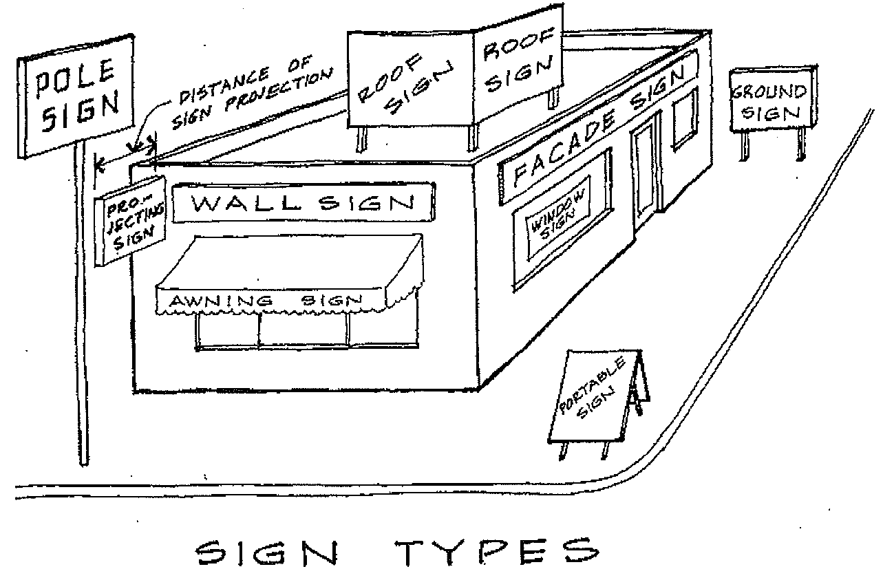
1345.10 - ADDITIONAL STANDARDS FOR FREESTANDING SIGNS.
The following sign types are considered freestanding signs:
- Monument sign - A freestanding sign attached to a pedestal or perimeter wall
- Pole sign - A freestanding sign constructed on a structure of one or more poles.
In addition to the regulations in Table 1345, all freestanding signs, except for temporary signs, shall comply with the following limitations and requirements:
A.
A freestanding sign shall have no more than two sign faces and a maximum of one freestanding sign is permitted per site;
B.
The area immediately surrounding the base and support structure of the sign shall be landscaped with evergreen vegetation;
C.
No part of a pole sign may encroach upon a public right-of-way or overhang a drive aisle, parking space, or walkway; and
D.
Connector/Freeway-Oriented Signs are signs oriented towards Interstate 64:
1.
Area of sign - Shall not exceed 200 square feet in area and shall have no more than two sign faces.
2.
Height - Signs shall not exceed 35 feet in height.
3.
Lighting - Signs may be internally or externally lighted. No exposed incandescent lamp shall be utilized.
Connector for this purpose shall be defined as State Route 10, State Route 152 (5 th Street Road), US Route 52 (Rahall Bridge approach), and the sign shall be limited to C-1, C-2, and I-1 zoned properties.
(Ord. No. 2022-O-11, 7-11-22)
1345.11 - ADDITIONAL STANDARDS FOR SUSPENDED OR PROJECTING SIGNS.
A suspended or projection sign is a two-sided sign that projects outward from the exterior wall of a structure. In addition to the regulations in Table 1345, all suspended and projecting signs shall comply with the following limitations and requirements:
A.
The sign shall be located in front of the establishment it serves and shall be of similar size, color and design as other suspended signs;
B.
There shall be no more than one such sign per establishment fronting on the marquee, overhang, or other building feature from which the sign is suspended; and
C.
A projection sign which is suspended to allow the sign to swing due to wind action may not exceed six square feet in area.
(Ord. No. 2022-O-11, 7-11-22)
1345.12 - ADDITIONAL STANDARDS FOR WALL SIGNS.
A wall sign is a sign that is painted to, attached flat to, or mounted away from, but parallel to, any exterior wall of a structure. In addition to the regulations in Table 1345, all wall signs shall comply with the following limitations and requirements:
A.
The sign shall extend no further than 12 inches from the wall to which it is attached;
B.
The sign shall be attached, painted, or adhered to the wall so that the face of the sign is substantially parallel to the wall;
C.
Commercial and Industrial Zones.
1.
In C-1 and C-3 commercial zones, the maximum sign area shall be one and one-half square feet per linear foot of building facade within the built-to zone or on the build-to line, to include linear footage of exempted elements of the built-to requirements such as a forecourt or arcade. In the C-3 zone, any improved alley abutting a property shall be considered a street frontage when determining number of permitted signs.
2.
In C-2 and I-1 zones, maximum sign area shall be 1.75 square feet per linear foot of building facade within the built-to zone or on the build-to line, to include linear footage of exempted elements of the built-to requirements such as a forecourt or arcade, but not to exceed 100 square feet per establishment per right-of-way.
3.
If no part of the building facade is in the built-to zone or on the build-to line, the planner shall make a determination of the linear footage based on the building facade parallel and closest to the build-to zone or build-to line.
4.
In the case of multi-occupant buildings, each tenant or owner may have a sign area not to exceed its proportionate share of the total allowable sign area for the building.
D.
In residential districts, multi-family apartment buildings and authorized non-residential buildings may have wall signs that shall not exceed two feet in height or 12 square feet in total area, and shall not obscure or cover any window, door, or architectural feature.
E.
In commercial and industrial districts, wall signs shall be placed no higher than the height of the building and, if the sign projects further than three inches from the wall, no lower than ten feet above the ground level.
F.
No wall sign or wall bulletin shall be erected or maintained in such a manner as to permit the accumulation of paper, leaves, or trash behind the same.
G.
No wall sign or wall bulletin shall be erected and maintained so as to cover the doors or windows of any building, except by special permit authorized by the chiefs of the police and fire departments, or so as to prevent free ingress or egress from any window, door, fire escape of the building upon which it is erected (1964 Code Sec. 30-15).
H.
Awnings: An awning sign is defined as a wall sign printed on any surface of an awning.
1.
The content on the awning sign is calculated using the same measurements as wall signs according to the district in which it is located.
Awnings may project out from the building and minimum clearance above the sidewalk with the same requirements as projection signs.
(Ord. No. 2022-O-11, 7-11-22)
1345.13 - ADDITIONAL STANDARDS FOR WINDOW SIGNS.
In addition to the regulations in Table 1345, all window signs shall comply with the following limitations and requirements:
A.
The total area of all window signs on display at any one time, including temporary window promotional signs, shall not exceed 50% of the total area of the window in which they are located. A series of windows which are separated by frames less than six inches in width shall be considered as a single window for the purposes of this computation.
B.
Window signs that do not exceed 50% of the total area of the window in which they are located are exempt from permits.
(Ord. No. 2022-O-11, 7-11-22)
1345.14 - TEMPORARY SIGNS.
A.
No temporary sign shall encroach into any public right-of-way or obstruct the view of motorists in any required clear sight triangle.
B.
No temporary sign is erected for more than 90 consecutive days, up to two times per calendar year.
C.
All signs shall be maintained in good structural condition, with no rips, tears, or other types of damage, at all times.
D.
All temporary signs are subject to the size requirements in Table 1345.14.E below.
(Ord. No. 2022-O-11, 7-11-22)
1345.15 - OFF-PREMISE SIGNS (BILLBOARDS).
A.
Off premise signs shall be permitted in the following zones:
C-1 - Conditional Use.
C-2 - Permitted.
C-3 - Conditional Use.
I-1 - Permitted.
B.
Legal nonconforming off-premise signs. Any off-premise sign lawfully erected and in existence on the effective date of this ordinance which does not meet the requirements of this ordinance may be maintained as a matter of right as a legal nonconforming sign and may be rebuilt 100% or relocated on the same property, provided that the sign's degree of nonconformity is not increased. This includes loss of signs due to acts of God.
C.
Size of signs.
1.
The maximum size area for any one face of an off-premise sign located on interstate roads shall not exceed 672 square feet excluded the base of apron, trim supports, and other structural elements. Temporary embellishments shall not exceed 20% of the maximum sign area allowed.
2.
The maximum sign area of any one face of an off-premise sign located on non-interstate roads shall not exceed 400 square feet excluding the base, or apron, trim supports, and other structural elements. Temporary embellishments shall not exceed 20% of the maximum sign area allowed.
3.
Sign may be back-to-back, V-type, and tri-vision with not more than one face to each facing and such structure shall be considered as one off-premise sign.
D.
Height of an off-premise sign.
1.
An off-premise sign shall maintain a minimum clearance often feet measured from the ground level at the base of the sign to the bottom of the sign face.
2.
An off-premise sign shall have a maximum height not to exceed 50 feet above grade level of interstate roadways to the bottom of the sign face and 35 feet above grade level of non-interstate roadways to the bottom of the sign face, as measured from the centerline of the roadway to which the sign is oriented. In no case, shall the height of a sign exceed the maximum height limitation of the zoning district in which it is located.
E.
Spacing for off-premise signs.
1.
No off-premise sign may be established within 750 feet of any other off-premise sign, measured along the same side of the street or highway to which the sign is oriented.
2.
The spacing between signs does not apply to structures separated by buildings or other obstructions in such a manner that only one sign located within the spacing distances is visible from the street at any one time.
3.
Spacing from Directional and Official signs. On-premise signs, or any other signs which does not constitute an off-premise sign shall not be counted nor shall measurements be made from such signs for the purpose of determining compliance with these spacing requirements.
4.
No off-premise sign shall be constructed within 500 feet, measured linearly, along the same side of the street from a church, school, playground, park, recreation center, or community center.
5.
No billboard shall be constructed within 200 feet, measured linearly, along the same side of the street from a residential district.
6.
The minimum distance between off-premise signs shall be measured along the nearest edge of the pavement between points directly opposite the center of the signs along each side of the highway and shall apply to structures located on the same side of the same street or highway.
F.
Setback requirements.
1.
Front - 10 feet.
2.
Side - 5 feet.
3.
Rear - 5 feet.
4.
In no case shall any portion of an off-premise sign overhang into or be placed in the public right-of-way unless allowed by the director of public works.
5.
In no case shall any portion of an off-premise sign extend into the required buffer area as designed in section 1347.05.
G.
Illumination (see section 1345.02.E).
H.
Construction standards. All off-premise signs shall be constructed in accordance with the building code of the city. The structural elements of all off-premise signs shall be of steel unipole construction.
(Ord. No. 2022-O-11, 7-11-22)
1345.16 - LIGHTING.
In connection with every site plan, the applicant shall submit plans for all proposed exterior lighting. These plans shall include the location, type of light, radius of light, manufacturer's specification sheet and intensity in foot-candles. The following designs standards shall be followed:
A.
The style of the light and light standard shall be consistent with the architectural style of the principal building.
B.
The maximum height of freestanding lights shall be the same as the principal building, but not exceeding 25 feet.
C.
All lights shall be shielded to restrict the maximum open angle of the cone of illumination to 150 degrees.
D.
Where lights along property lines would be visible to adjacent residents, the lights shall be appropriately shielded.
E.
Spotlight-type fixtures attached to buildings and visible to the public shall be avoided.
F.
Freestanding lights shall be so located and protected to avoid being easily damaged by vehicles.
G.
Lighting shall be located along streets, parking areas, at intersections, and where various types of circulation systems merge, intersect, or split.
H.
Pathways, sidewalks and trails shall be lighted with low or mushroom type standards.
I.
Stairways, and sloping or rising paths, building entrances and exits require illumination.
J.
Lighting shall be provided where buildings are setback or off-set if access is provided at such points.
K.
The following intensity in foot-candles shall be provided:
1.
Parking lots - average of 0.5 foot-candles throughout.
2.
Intersections - 3 foot-candles.
3.
Maximum at property lines - 1.0 foot-candle.
4.
In residential areas - average of 0.6 foot-candles.
(Ord. No. 2022-O-11, 7-11-22)
1345.17 - SEVERABILITY.
If any sections, subsection, sentence, clause, or phrase of this ordinance is for any reason held to be invalid, such decision shall not affect the validity of the remaining portions of this ordinance. The city council declares that it would have adopted this sign ordinance in each section, subsection, sentence, or phrase thereof, irrespective of the fact that any one or more sections, subsections, sentences, clauses, or phrases be declared invalid.
(Ord. No. 2022-O-11, 7-11-22)
ARTICLE 1347 - LANDSCAPING[22]
Cross reference— Landscape plan in I-1 General Industrial District, § 1333.11.
ARTICLE 1349 - REGULATION OF THE FLOODPLAIN AREA AND PONDING BASINS[23]
Editor's note—An ordinance adopted April 13, 2015, amended article 1349 in its entirety to read as herein set out. Former article 1349, §§ 1349A—1349J, pertained to similar subject matter. See Code Comparative Table for complete derivation.
1347.01 - PURPOSE.
A.
Unless specified elsewhere in this ordinance, landscaping shall be provided as part of all non-residential land developments, residential subdivisions, and open space cluster developments for which a site plan is required by article 1351 and in accordance with the following standards. It shall be conceived in a total pattern throughout the site, integrating the various elements of the site design, preserving and enhancing the particular identity of the site and creating a pleasing site character.
B.
Landscaping may include plant materials such as trees, shrubs, ground cover, perennials, and annuals and other materials such as rocks, water, sculpture, art, walls, fences, and building and paving material.
1347.02 - LANDSCAPE PLAN.
A landscape plan shall be submitted with each non-residential land development, planned unit development, manufactured home park, residential subdivision, and open space cluster developments site application. The plan shall identify existing and proposed trees, shrubs, ground cover, natural features such as rock outcroppings, and other landscaping elements. The plan should show where there are or will be located and planting and/or construction details. When existing natural growth is proposed to remain, the applicant shall include in the plans proposed methods to protect existing trees and growth during and after construction.
1347.03 - SITE PROTECTION AND GENERAL PLANTING REQUIREMENTS.
A.
Topsoil preservation. Topsoil moved during the course of construction shall be redistributed on all regraded surfaces so as to provide at least four inches of even cover to all disturbed areas of the development and shall be stabilized by seeding or planting.
B.
Removal of debris. All stumps and other tree parts, litter, brush, weeds, excess or scrap building materials, or other debris shall be removed from the site and disposed of in accordance with the law. No tree stumps, portions of tree trunks or limbs shall be buried anywhere in the development. All dead or dying trees, standing or fallen, shall be removed from the site. If trees and limbs are reduced to chips, they may, subject to approval of the city engineer, be used as mulch in landscaped areas.
C.
Protection of existing plantings. Maximum effort should be made to save fine specimens (because of size or relative rarity). No material or temporary soil deposits shall be placed within four feet of shrubs or ten feet of trees designated to be retained on development site. Protective barriers or tree wells shall be installed around each plant and/or group of plants that are to remain on the site. Barriers shall not be supported by the plants they are protecting, but shall be self-supporting. They shall be a minimum of four feet high and constructed of a durable material that will last until construction is completed. Snow fences and silt fences are examples of acceptable barriers.
D.
Slope plantings. Landscaping of the area of all cuts and fills and/or terraces shall be sufficient to prevent erosion, and all roadway slopes steeper than one foot vertically to three feet horizontally shall be planted with ground covers appropriate for the purpose and soil conditions, water availability, and environment.
E.
Additional landscaping. In residential developments, besides the screening and street trees required, additional plantings or landscaping elements shall be required throughout the subdivision where necessary for climate control, privacy, or for aesthetic reasons in accordance with a planting plan approved by the planning director and taking into consideration cost constraints. In nonresidential developments, all areas of the site not occupied by buildings and required improvements shall be landscaped by the planting of grass or other ground cover, shrubs, and trees as part of a site plan approved by the planning director or reviewing body.
F.
Planting specifications. Deciduous trees shall have at least a two-inch caliper measured 12 inches above the ground at planting. Size of evergreens and shrubs shall be allowed to vary depending on setting and type of shrub. Only nursery-grown plant materials shall be acceptable; and all trees, shrubs, and ground covers shall be planted according to accepted horticultural standards. Dead or dying plants shall be replaced by the developer during the following planting season.
1347.04 - STREET TREES.
A.
Location. Street trees shall be installed on both sides of all streets in accordance with the approved landscape plan. Trees shall either be massed at critical points or spaced evenly along the street, or both. A permit for installation of trees within the city right-of-way or easements will be required.
When trees are planted at predetermined intervals along streets, spacing shall depend on tree size, as follows:
When the spacing interval exceeds 40 feet, small ornamental trees can be spaced between the larger trees. If a street canopy effect is desired, trees may be planted closer together, following the recommendations of a certified landscape architect. The trees shall be planted so as not to interfere with utilities, roadways, sidewalks, sight easements, or street lights. Tree location, landscaping design, and spacing plan shall be approved by the director of public works as part of the landscape plan.
B.
Tree type. Tree type may vary depending on overall effect desired, but as a general rule, all trees shall be the same kind on a street except to achieve special effects. Selection of tree type shall be approved by the planning director or reviewing body.
1347.05 - BUFFERING.
A.
Function and materials. Buffering shall provide a year round visual screen in order to minimize adverse impacts from a site on an adjacent property or from adjacent areas. It may consist of fencing, evergreens, berms, rocks, boulders, mounds, or combinations to achieve the stated objectives.
B.
When required. Buffering shall be required when topographical or other barriers do not provide reasonable screening or when the planning commission determines that there is a need to shield the site from adjacent properties and to minimize adverse impacts such as incompatible land uses, noise, glaring light, and traffic. In small-lot developments, when building design and sitting do not provide privacy, the planning commission may require landscaping, fences, or walls to ensure privacy and screen dwelling units.
Buffers shall be measured from side and rear property lines, excluding access driveways.
1.
Where nonresidential, multi-family, or a manufactured home park use (including related parking areas) are adjacent to any R-1, R-2, or R-4 residential district or any lot with a single-family residence, a buffer yard 25 feet, but not to exceed 10% of the lot area width, shall be required.
2.
Parking areas, garbage collection and utility areas, and loading and unloading areas should be screened around their perimeter by a buffer strip a minimum of five feet wide.
3.
Where residential subdivisions abut higher-order streets (collectors or arterioles), adjacent lots should front on lower-order streets, and a landscaped buffer area provided along the property line abutting the road. The buffer strip shall be a minimum of 25 to 35 feet, but not to exceed 10% of the lot area wide or wider where necessary for the health and safety of the residents, and include both trees and shrubs.
C.
Design. Arrangement of plantings in buffers shall provide maximum protection to adjacent properties and avoid damage to existing plant material. Possible arrangements include planting in parallel, serpentine, or broken rows. If planted berms are used, the minimum top width shall be four feet, and the maximum side slope shall be 2:1.
D.
Planting specifications. Plant materials shall be sufficiently large and planted in such a fashion that a screen at least eight feet in height shall be produced within three growing seasons. All plantings shall be installed according to accepted horticultural standards.
E.
Maintenance. Plantings shall be watered regularly and in a manner appropriate for the specific plant species through the first growing season, and dead or dying plants shall be replaced by the applicant during the next planting season. No buildings, structures, storage of materials, or parking shall be permitted within the buffer area; buffer areas shall be maintained and kept free of all debris, rubbish, weeds, and tall grass.
1347.06 - PARKING LOT LANDSCAPING.
A.
Amount required. In parking lots, at least 5% of the interior parking area shall be landscaped with plantings. Parking lot street frontage screening and perimeter screening shall be a minimum of five feet wide. If buffering is required, per section 1347.05(B)(1), the more restrictive screening distance shall apply. Planting required within the parking lot is exclusive of other planting requirements, such as for street trees.
B.
Location. The landscaping should be located in protected areas, such as along walkways, in center islands, at the end of bays, or in diamonds between parking stalls. All landscaping in parking areas and the street frontage shall be placed so that it will not obstruct sight distance.
C.
Plant type. A mixture of hardy flowering and/or decorative evergreen and deciduous trees may be planted; the area between trees shall be planted with shrubs or ground cover or covered with mulch.
1349A.01 - AUTHORITY.
A.
The provisions of this ordinance have been prepared with the intention of meeting the requirements of the National Flood Insurance Act of 1968 (42 U.S.C. 4001 et seq.) amended by the Congress of the United States through the 15th of February, 1975 (Public Law 91-152).
B.
Authority to adopt, administer and enforce this ordinance is vested in City of Huntington pursuant to W. Va. Code §§ 8-12-14, 7-1-3n, 7-1-3v and 7-1-3kk and/or W. Va. Code §§ 8A-4-2, 8A-5-7, 8A-7-2.
1349A.02 - INTENT.
The intent of this ordinance is to:
A.
Promote the general health, welfare, and safety of the community.
B.
Encourage the utilization of appropriate construction practices in order to prevent or minimize flood damage in the future and protect natural drainage.
C.
Minimize danger to public health and safety by protecting water supply and sanitary sewage disposal in cooperation with the county sanitarian.
D.
Assure the county assessor obtains information concerning improvement of real property as required by W. Va. Code § 11-3-3A.
E.
Assure County E-911 addresses are obtained to maintain the currency of established emergency response dispatch systems.
F.
Reduce financial burdens imposed on City of Huntington, its governmental units, and its residents, by preventing the unwise design and construction of development in areas subject to flooding.
1349A.03 - ABROGATION AND GREATER RESTRICTIONS.
This ordinance supersedes any ordinance currently in effect in flood prone areas. Any ordinance, however, shall remain in full force and effect to the extent that its provisions are more restrictive.
1349A.04 - APPLICABILITY.
It shall be unlawful for any contractor, person, partnership, business, or corporation to undertake or cause to be undertaken, any development, new construction, substantial improvement, repair of substantial damage, or the placement or relocation of any structure (including manufactured homes) within City of Huntington, unless a permit application has been completed and a permit or certificate of occupancy has been obtained from the floodplain administrator. In addition, where land partially or fully in the special flood hazard area is to be subdivided, utilized for a manufactured home park or subdivision or otherwise developed as defined in this ordinance, a site plan with elevation data shall be submitted to, and approved by, the floodplain administrator prior to any development.
Provision of all other codes, ordinances, and regulations shall be applicable insofar as they are consistent with the provisions of this ordinance and the community's need to minimize the hazards and damage resulting from flooding.
1349A.05 - MATTERS NOT PROVIDED FOR SPECIFICALLY.
Where conditions are encountered that are not specifically provided for herein, the Floodplain Administrator shall determine the applicability of the provisions of this ordinance in accordance with its intent, and shall require the applicant to take appropriate measures pursuant to such determination.
1349B.01 - INTERPRETATIONS.
A.
For the purpose of this ordinance, the following interpretations shall apply:
1.
Words used in the present tense include the future tense.
2.
The singular includes the plural.
3.
The plural includes the singular.
4.
The word "person" includes a corporation, unincorporated association or partnership as well as an individual.
5.
The term "shall" or "will" is always mandatory.
6.
The word "building" or "structure" shall be construed as if followed by the phrase "or part thereof'.
7.
The word "ordinance" shall refer to the floodplain ordinance.
1349B.02 - DEFINITIONS.
Unless specifically defined below, words and phrases used in this ordinance shall be interpreted so as to give this ordinance it's most reasonable application.
Accessory structure. A structure on the same parcel of property as the principal structure and the use of which is incidental to the use of the principal structure. This does not include a gas or liquid storage tank.
Base flood. Means the flood having a one percent chance of being equaled or exceeded in any given year.
Base flood elevation (BFE). The water surface elevation of the base flood in relation to the datum specified on City of Huntington's Flood Insurance Rate Map. For the purposes of this ordinance, the 100-year flood or 1% annual chance flood.
Basement. Any area of the building having its floor sub grade (below ground level) on all sides.
Certificate of occupancy. A certification that all development is in occupancy with the provisions of this ordinance.
Compensatory storage. An artificially excavated, hydraulically equivalent volume of storage within the special flood hazard area used to balance the loss of natural flood storage capacity when artificial fill or structures are placed within the special flood hazard area.
Contractor - W. Va. Code § 21-11-3(c). A person who in any capacity for compensation, other than as an employee of another, undertakes, offers to undertake, purports to have the capacity to undertake, or submits a bid to construct, alter, repair, add to, subtract from, improve, move, wreck or demolish any building, highway, road, railroad, structure or excavation associated with a project, development or improvement, or to do any part thereof, including the erection of scaffolding or other structures or works in connection therewith, where the cost of the undertaking is one thousand dollars or more. Contractor includes a construction manager who performs management and counseling services on a construction project for a professional fee.
Contractor does not include:
1.
One who merely furnishes materials or supplies without fabricating or consuming them in the construction project;
2.
A person who personally performs construction work on the site of real property which the person owns or leases whether for commercial or residential purposes;
3.
A person who is licensed or registered as a professional and who functions under the control of any other licensing or regulatory board, whose primary business is real estate sales, appraisal, development, management and maintenance, who acting in his or her respective professional capacity and any employee of such professional, acting in the course of his or her employment, performs any work which may be considered to be performing contracting work;
4.
A pest control operator licensed under the provisions of section seven, article sixteen-a, chapter nineteen of this code to engage in the application of pesticides for hire, unless the operator also performs structural repairs exceeding one thousand dollars on property treated for insect pests; or
5.
A corporation, partnership or sole proprietorship whose primary purpose is to prepare construction plans and specifications used by the contractors defined in this section and who employs full time a registered architect licensed to practice in this state or a Registered Professional Engineer licensed to practice in this state. Contractor also does not include employees of such corporation, partnership or sole proprietorship.
Critical facility. Any facility in which, even a slight chance of flooding is too great a threat. Typical critical facilities include hospitals, fire stations, police stations, storage of critical records, and similar facilities. These should be given special consideration when formulating regulatory alternatives and floodplain management plans. A critical facility should not be located in a special flood hazard area if at all possible. If a critical facility must be located in a special flood hazard area it should be provided a higher level of protection so that it can continue to function and provide services during a flood.
Development. Any man-made change to improved or unimproved real estate, including but not limited to buildings or other structures, mining, dredging, filling, grading, paving, excavation or drilling operations or storage of equipment or materials.
Flood. A general and temporary inundation of normally dry land areas.
Flood insurance rate map (FIRM). The official map on which the Federal Emergency Management Agency has delineated both the special flood hazard areas and the risk premium zones applicable to City of Huntington. A FIRM that has been made available digitally is called a digital flood insurance rate map (DFIRM).
Flood insurance study. The official report in which the Federal Emergency Management Agency has provided flood profiles, floodway information, and water surface elevations.
Floodplain.
1.
A relatively flat or low land area adjoining a river, stream, or watercourse which is subject to partial or complete inundation;
2.
An area subject to the unusual and rapid accumulation or runoff of surface waters from any source.
Floodway. The channel of a river or other watercourse and the adjacent land area that must be reserved to discharge the base flood without increasing the water surface elevation of that flood more than one foot at any point.
Flood proofing. Any combination of structural and non-structural additions, changes or adjustments to structures which reduce or eliminate flood damage to real estate or improved real property, water and sanitary facilities, structures and their contents.
Freeboard. A factor of safety usually expressed in feet above a flood level for purposes of floodplain management. Freeboard tends to compensate for unknown factors that may contribute uncertainty to flood heights of any given flood and floodway condition, such as wave action, blockage at stream crossings, and increased runoff from urbanization of the watershed. Freeboard also tends to lower the cost of flood insurance.
Highest adjacent grade (HAG). The highest natural elevation of the ground surface immediately adjacent to the development or structure foundation. This is primarily used during insurance rating in approximated floodplains.
Historic structure. Any structure that is:
A.
Listed individually in the National Register of Historic Places (a listing maintained by the Department of Interior) or preliminarily determined by the Secretary of the Interior as meeting the requirements for individual listing on the National Register;
B.
Certified or preliminarily determined by the Secretary of the Interior as contributing to the historical significance of a registered historic district or a district preliminarily determined by the Secretary to qualify as a registered historic district;
C.
Individually listed on a state inventory of historic places in states with historic preservation programs which have been approved by the Secretary of the Interior; or,
D.
Individually listed on a local inventory of historic places in communities with historic preservation programs that have been certified either:
1.
By an approved state program as determined by the Secretary of the Interior; or,
2.
Directly by the Secretary of Interior in states without approved programs.
Licensed manufactured home retailer. A business licensed to sell manufactured homes in the State of West Virginia as set forth in the West Virginia State Code.
Licensed manufactured home installer. A contractor licensed to install manufactured homes in West Virginia as set forth in the West Virginia State Code.
Licensed professional surveyor. Any person licensed by the West Virginia State Board of Examiners of Land Surveyors to engage in the practice of land surveying as defined in West Virginia State Code.
Lowest adjacent grade (LAG). The lowest natural elevation of the ground surface immediately adjacent to the proposed development or structure foundation. The primary use of the LAG is to determine whether the structure is located within a special flood hazard area by comparing it to the base flood elevation.
Lowest floor. The lowest floor of the lowest enclosed area (including basement). An unfinished enclosure constructed with flood resistant materials as defined in FEMA Technical Bulletin 2 and usable solely for parking of vehicles, building access or storage in an area other than a basement area is not considered a building's lowest floor; provided, that such enclosure has proper flood openings and is not built so as to render the structure in violation of the applicable non-elevation design requirements of this ordinance.
Manufactured home. A structure, transportable in one or more sections, which is built on a permanent chassis and is designed for use with or without a permanent foundation when connected to the required utilities. The term "manufactured home" does not include a "recreational vehicle".
New construction. Structures for which the start of construction as herein defined commenced on or after January 17, 1990 and including any subsequent improvements to such structures. Any construction started after effective date of City of Huntington's first floodplain ordinance adopted by City of Huntington and before the effective start date of this floodplain management ordinance is subject to the ordinance in effect at the time the ordinance was issued, provided the start of construction was within 180 days of permit issuance.
100-year flood. A flood that has one chance in 100 or a 1% chance of being equaled or exceeded in any given year.
Person. Any individual or group of individuals, corporation, partnership, association or other entity, including state and local governments and agencies.
Post firm non-compliant structures—Violations. The failure of any structure or development to be fully compliant with all requirements of this ordinance. A structure or other development without the elevation certificate, other certifications, or other evidence of compliance required by this ordinance is presumed to be in violation until such time as the documentation is provided. No future improvements or developments can be made to structures found to be in violation unless the development is to bring the structure into compliance with the current ordinance.
Practice of engineering. Any service or creative work, as described in West Virginia State Code Article 13, the adequate performance of which requires engineering education, training and experience in the application of special knowledge of the mathematical, physical and engineering sciences to such services or creative work as consultation, investigation, evaluation, planning and design of engineering works and systems; planning the use of land and water; teaching of advanced engineering subjects, engineering surveys and studies; and the review of construction for the purpose of assuring compliance with drawings and specifications any of which embraces such services or work, either public or private, in connection with any utilities, structures, buildings, machines, equipment, processes, work systems, projects and industrial or consumer products or equipment of a mechanical, electrical, hydraulic, pneumatic or thermal nature, insofar as they involve safeguarding life, health or property, and including such other professional services as may be necessary to the planning, progress and completion of any engineering services. Engineering surveys include all survey activities required to support the sound conception, planning, design, construction, maintenance and operation of engineered projects.
Any person who practices any branch of the profession of engineering or who, by verbal claim, sign, advertisement, letterhead, card or in any other way represents himself or herself to be a registered professional engineer, or by using another title implies that he or she is a registered professional engineer or that he or she is registered under West Virginia State Code, Article 13 or who holds himself or herself out as able to perform, or who performs any engineering service or work or any other service designated by the practitioner which is recognized as engineering, is considered to practice or offer to practice engineering within the meaning and intent of West Virginia State Code, Article 13.
Principally above ground. Where at least 51% of the actual cash value of a structure, less land value, is above ground.
Recreational vehicle. A vehicle which is:
A.
Built on a single chassis;
B.
400 square feet or less when measured at the largest horizontal projection;
C.
Designed to be self-propelled or permanently towable by a light duty truck; and
D.
Designed primarily not for use as a permanent dwelling but as temporary living quarters for recreational, camping, travel, or seasonal use.
Registered professional engineer. A person who has been duly registered or licensed as a registered professional engineer by the West Virginia State Board of Registration for Professional Engineers as required under West Virginia State Code, Article 13 et seq.
Remedy a violation. To bring a structure or other development into compliance with the requirements of this ordinance, or, if full compliance is not possible, to reduce the adverse impacts of the non-compliance to the greatest extent feasible.
Reasonably safe from flooding. Means that during the base flood, water should not damage structures and any subsurface waters related to the base flood should not damage existing or proposed structures.
Special flood hazard area. The land in the floodplain subject to a one percent or greater chance of flooding in any given year. Special flood hazard areas are designated by the Federal Emergency Management Agency in flood insurance studies and on flood insurance rate maps as zones A, AE, AO, A1-30, and A99. This term shall also include areas shown on other flood hazard maps that are specifically listed or otherwise described in this ordinance.
Start of construction. The date the permit was issued, provided the actual start of construction, repair, reconstruction, rehabilitation, addition, placement, or other improvement was within 180 days of the permit date. The actual start means either the first placement of permanent construction on a site, such as the pouring of slab or footings, the installation of piles, the construction of columns, or any work beyond initial excavation, or the placement of a manufactured home on a foundation. Although a permit must be obtained prior to beginning, permanent construction does not include land preparation, such as clearing, grading and filling, nor does it include the installation of streets and/or walkways, nor does it include excavation for a basement, footings, piers or foundations or the erection of temporary forms, nor does it include the installation on the property of accessory buildings, such as garages or sheds not occupied as dwelling units or not part of the main structure. For an alteration, the actual start of construction means the first alteration of any wall, ceiling, floor or other structural part of a building, whether or not that alteration affects the external dimensions of the building.
State coordinating office. The West Virginia Division of Homeland Security and Emergency Management.
Stream. As defined in West Virginia State Code 7-1-3U, any watercourse, whether natural or man-made, distinguishable by banks and a bed, regardless of their size, through which water flows continually or intermittently, regardless of its volume.
Structure. A walled and roofed building, including a gas or liquid storage tank that is principally above ground, as well as a manufactured home.
Substantial damage. Damage of any origin sustained by a structure whereby the cost of restoring the structure to it's before damage condition would equal or exceed 50 percent of the market value of the structure before the damage occurred. Substantial damage also means cumulative flood-related damages sustained by a structure on two separate occasions during a ten-year period for which the cost of repairs at the time of each flood event, on the average, equals or exceeds 25 percent of the market value of the structure before the damage occurred. See "substantial improvement."
Substantial improvement. Any repair, reconstruction, rehabilitation, addition, or other improvement of a structure, the cost of which equals or exceeds 50 percent of the market value of the structure before the start of construction of the improvement.
This term includes structures, which have incurred "substantial damage", as defined herein regardless of the actual repair work performed. The term does not, however, include any project for improvement of a structure to correct existing violation of state or local health, sanitary or safety code specifications which have been identified by the local code enforcement official and which are the minimum necessary to assure safe living conditions.
Historic structures undergoing repair or rehabilitation that would constitute a substantial improvement as defined above, must comply with all ordinance requirements that do not preclude the structure's continued designation as a historic structure. Documentation that a specific ordinance requirement will cause removal of the structure from the National Register of Historic Places or the state inventory of historic places must be obtained from the Secretary of the Interior or the State Historic Preservation Officer. Any exemption from ordinance requirements will be the minimum necessary to preserve the historic character and design of the structure.
For the purpose of this definition improvement is considered to occur when the first alteration of any wall, ceiling, floor or other structural part of the building commences whether or not that alteration affects the external dimensions of the structure.
Top of bank. The lines depicted on the FIRM maps delineating each side of a stream indicate the top of bank. In the field a professional familiar with fluvial geomorphology should document the top of bank. When a professional is not employed the top of the bank may be considered to be the top of the first significant slope landward of the waters edge when it is followed by at least 50 feet of relatively flat land.
Violation. The failure of any structure or development to be fully compliant with all the requirements of this ordinance. Any structure or other development lacking the certifications, finished construction elevation certificate or other evidence of compliance required by this ordinance is presumed to be in violation until such time as that documentation is provided.
1349C.01 - IDENTIFICATION.
A.
The identified special flood hazard area shall be those areas of the City of Huntington which are subject to the 100-year flood, as shown on the flood insurance rate map (FIRM) and described in the flood insurance study (FIS) prepared for City of Huntington by the Federal Emergency Management Agency (FEMA) dated February 19, 2014 or the most recent revision thereof including all digital data developed as part of the FIS.
B.
The identified special flood hazard area shall also be those special flood hazard areas identified by City of Huntington by use of historic or other technical data and shown on an officially recognized "local flood hazards map". These areas shall be designated as appropriate with the level of technical data described below and shall be managed accordingly.
1349C.02 - DESCRIPTIONS OF SPECIAL FLOOD HAZARD AREAS.
A.
The identified special flood hazard area shall consist of the following four specific areas:
1.
The floodway shall be those areas of AE zone identified as floodways in the FIS and as shown on the FIRM. The term shall also include any floodway areas delineated by developers in the approximated floodplain and designated as such by the community.
2.
The floodway fringe shall be those areas of AE zone for which specific 100-year flood elevations have been provided in the FIS but which lie beyond the floodway area.
3.
The AE area without floodway shall be those areas identified as an AE zone on the FIRM included in the FIS prepared by FEMA for which 100-year flood elevations have been provided but no floodway has been delineated.
4.
The approximated floodplain shall be those areas identified as an A zone on the FIRM included in the FIS prepared by FEMA and for which no 100-year flood elevations have been provided.
1349C.03 - CHANGES IN DESIGNATION OF AREA.
A.
The delineation of the identified special flood hazard area may be revised by City of Huntington where natural or man-made changes have occurred and/or more detailed studies conducted or undertaken by the U.S. Army Corps of Engineers, a River Basin Commission or other qualified agency or individual document the necessity for such changes. However, prior to any such change, approval must be obtained from the Federal Emergency Management Agency (FEMA).
B.
City of Huntington's base flood elevations may increase or decrease resulting from physical changes affecting flooding conditions. As soon as practicable but, not later than six months after the date such information becomes available, City of Huntington shall notify the NFIP Administrator of the changes by submitting technical or scientific data.
C.
City of Huntington may identify and regulate new local flood hazard or ponding areas. These areas may be delineated on a "local flood hazard map" using best available topographic data and locally derived information such as flood of record, historic high water marks or approximate study methodologies.
1349C.04 - BOUNDARY DISPUTES.
Should a dispute concerning the location of proposed development relative to a special flood hazard area arise, an initial determination shall be made by the Floodplain Administrator and any party aggrieved by this decision may appeal to City of Huntington. The burden of proof shall be on the appellant/applicant.
1349C.05 - ELEVATIONS PREVAIL.
Elevation data certified by a licensed professional surveyor or registered professional engineer shall be submitted in sufficient detail to allow a thorough review by the floodplain administrator.
If the structure location appears to be inside the SFHA on the FEMA FIRM's and if the lowest natural grade adjacent to proposed development within an identified flood hazard area is at or above the base flood elevation specified in the flood insurance study (FIS), the structure shall not be required to conform to the flood prevention design and construction standards or flood-related development codes in article VI. Topographic data certified by a registered professional engineer or licensed professional surveyor shall be submitted in sufficient detail to allow a thorough review by the floodplain administrator. The applicant shall apply for a letter of map amendment (LOMA) from FEMA and the determination given to the floodplain administrator within 90 days of issuance of the permit having the special flood hazard area designation removed from the parcel or structure prior to certificate of occupancy/compliance.
The proposed development shall be considered to be within the special flood hazard area if the natural LAG to the proposed development is below either: 1. The closest applicable BFE specified in the flood insurance study, or 2. The reasonably safe from flooding elevation determined by City of Huntington in approximate floodplains. The proposed development shall then be required to conform to all appropriate flood damage reduction provisions of this ordinance.
1349D.01 - FLOODWAY.
Within any floodway area, no encroachments, including fill, new construction, substantial improvements, or other development shall be permitted unless it has been demonstrated through hydrologic and hydraulic analysis performed in accordance with standard engineering practice that the proposed encroachment would not result in any increase in flood levels within the City of Huntington during the occurrence of the base flood discharge. The resultant engineering study shall include a cover letter, signed and sealed by the responsible professional, providing a statement of findings in basic terms. In addition, studies, analyses, computations, etc., shall be submitted in sufficient detail to allow a thorough technical review by the floodplain administrator.
A.
Because floodways present increased risk to human life and property due to their relatively faster and deeper flowing waters the floodway shall be preserved to the greatest extent possible.
1.
New development shall not be permitted in the floodway where reasonable alternatives exist elsewhere. In addition to the requirements below the applicant shall demonstrate that there are no reasonable alternatives other than the floodway encroachment before a permit is issued.
2.
When the floodway is the only reasonable alternative the applicant shall demonstrate that the floodway encroachment is the minimum necessary to accomplish the project.
3.
All permitted uses, activities, and development shall be undertaken in strict compliance with the flood proofing and related provisions contained herein, and in all other applicable codes, ordinances and regulations.
4.
In special flood hazard areas for which no regulatory floodway has been designated, the regulatory floodway for small, single lot development not incorporating significant amounts of fill can, at the discretion of City of Huntington, be determined to be the channel of the stream and the adjacent land areas to a distance of one-half the width of the special flood hazard area as measured from the top of the bank nearest the site to the upland limit of the 1% annual chance special flood hazard area boundary.
1349D.02 - FLOODWAY FRINGE.
Within any floodway fringe area any development and/or use of land shall be permitted provided that all such uses, activities and/or development shall be undertaken in strict compliance with the floodproofing and related provisions contained herein and in all other applicable codes, ordinances and regulations.
1349D.03 - AE WITHOUT FLOODWAY.
Within any AE without floodway area, no new construction or development shall be allowed unless it is demonstrated that the cumulative effect of the proposed development, when combined with all other existing and anticipated development, will not increase the elevation of the 100-year flood more than one foot at any point. This requirement can be satisfied by utilization of the floodway where determined.
1349D.04 - Approximated floodplain (zone A).
A.
Within any approximated floodplain.
1.
The floodplain administrator shall use elevation and floodway information from federal, state, or other acceptable sources when available to determine the elevation above which development will be reasonably safe from flooding.
2.
When data from an acceptable source is not available, the floodplain administrator shall review, or shall cause to be reviewed; all proposed development to determine: 1. The amount being invested, and 2. The specific flood risk at the site. The floodplain administrator shall then require the applicant to determine the elevation above which the development will be reasonably safe from flooding using elevation data, hydrologic and hydraulic analyses or other techniques. When hydrologic and hydraulic analyses are required, they shall only be undertaken by a registered professional engineer who shall certify that the methods used correctly reflect currently accepted technical concepts. The resultant study shall include a cover letter, signed by the responsible professional, providing a statement of findings in basic terms. In addition, studies, analyses, computations, etc. shall be submitted in sufficient detail to allow a thorough technical review by the floodplain administrator.
3.
Any development and/or use of land shall be permitted provided that all such uses, activities and/or development shall be undertaken in strict compliance with the flood-proofing and related provisions contained herein and in all other applicable codes, ordinances and regulations.
See appendix 4.4 for sample "approximated floodplain (zone A) techniques".
1349D.05 - ALTERATION OR RELOCATION OF A STREAM.
A.
Whenever a developer intends to alter or relocate a stream within the special flood hazard area the developer shall notify in writing, by certified mail, to City of Huntington, the floodplain administrator, the state coordinating office, any adjacent communities and any adjacent property owners of all such intended activities prior to the alteration or relocation of the stream. Copies of all required notifications must be submitted to the Federal Emergency Management Agency (FEMA). In addition prior to issuing the local permit the floodplain administrator shall require copies of all necessary permits from those governmental agencies from which federal or state law requires approval.
See appendix 4.5 for sample "stream alteration process and contact sheet".
B.
The developer shall also assure City of Huntington in writing that the flood carrying capacity within the altered or relocated portion of the stream will be maintained. The floodplain administrator may require the applicant to demonstrate that the altered or relocated portion of stream will provide equal or greater conveyance than the original stream segment. If hydrologic and hydraulic analyses are required, they shall only be undertaken by a registered professional engineer, who shall certify that the methods used correctly reflect currently accepted technical concepts. The resultant study shall include a cover letter, signed by the responsible professional, providing a statement of findings in basic terms. In addition, studies, analyses, computations, etc. shall be submitted in sufficient detail to allow a thorough technical review by the floodplain administrator.
C.
Alteration of a stream includes placement of culverts, bridges or other stream crossings. The floodplain administrator may require the use of certain "best practice" techniques in the construction of bridges, culverts or stream crossings to prevent damage, loss of stream crossings and localized flooding caused by blockage. These techniques may include, but are not limited to, wing walls, trash grates or requiring openings to be of sufficient size to pass debris and/or anticipated future increases in flood heights.
D.
All new and replacement bridges, culverts and other stream crossings shall adhere to the relevant anchoring requirements contained in this ordinance.
E.
The developer is required to provide City of Huntington a legal agreement detailing all scheduled inspections and maintenance to be performed on altered or relocated watercourses including culverts, bridges and other stream crossings. It shall be the responsibility of the applicant to transfer this agreement to the new owner when the land associated with the watercourse alteration is transferred. A copy of all new agreements shall be provided to the floodplain administrator. Failure to transfer the agreement and provide a signed copy to the floodplain administrator shall subject the violator to the penalties set forth in section 1349H.03 of this ordinance.
F.
The applicant shall submit any maps, computations or other material required by the Federal Emergency Management Agency (FEMA) to revise the flood insurance study and/or flood insurance rate maps, when notified by the floodplain administrator, and shall pay any fees or other costs assessed by FEMA for this purpose.
1349E.01 - GENERAL.
Permits are required in order to determine whether all new construction or substantial improvements are:
1.
Located in an identified floodplain, floodway or other special flood hazard area.
2.
Designed (or modified) and adequately anchored to prevent flotation, collapse, or lateral movement of the structure resulting from hydrodynamic and hydrostatic loads, including the effects of buoyancy.
3.
Constructed with material and utility equipment resistant to flood damage as outlined in FEMA Technical Bulletin 2 or the most recent revision thereof.
4.
Constructed by methods and practices that minimize flood damage.
5.
Constructed with electrical, heating, ventilation, plumbing and air conditioning equipment and other service facilities that are designed and/or located so as to prevent water from entering or accumulating within the components during conditions of flooding.
6.
To comply with West Virginia State Code § 11-3-3a. concerning County Assessor "Building or real property improvement notice".
7.
Approved by county health department for water and sewer to assure facilities are designed or located in compliance with the flood damage reduction requirements of this ordinance.
1349E.02 - BASIC FORMAT.
The basic format of the permit shall include the following:
1.
Name and address of applicant.
2.
Name and address of owner of land on which proposed development is to occur.
3.
Names, addresses, and valid West Virginia license numbers of all contractors working at the building site, or affidavits stating that work is being performed by individuals exempt from contractor licensing as set forth in Title 28, Series 2, section 3.9 (b) of the West Virginia Code of state regulations or the most recent revision thereof.
4.
A description of site location sufficient to locate the project including tax map and parcel number and most recent deed book and page number.
5.
A standard site plan showing size and location of the proposed development as well as any existing buildings or structures. The site plan shall also show all adjacent roads and watercourses with direction of flow, the lowest adjacent grade to the proposed foundation and/or toe of fill, the base flood elevation and the location of the floodway boundary when applicable.
6.
An acknowledgment that the applicant agrees to pay any and all fees associated with the permitting process as set forth in section 1349G.09 hereof.
7.
An acknowledgment that the applicant agrees to allow authorized representatives of floodplain management programs access to the development to inspect for compliance.
8.
The contract required by West Virginia Code of State Regulations, Title 28, Series 4, and all addendums to the contract(s) shall be presented to the Floodplain Administrator for review within five (5) business days of contract signing. City of Huntington does not require and will not keep copies of the contracts or addendums. Failure to present contract or addendums for review shall void the permit. If a licensed contractor is not involved, or the work is of an aggregate value of less than ten thousand dollars including materials and labor, a brief written description of proposed work and the estimated value will suffice.
1349E.03 - ELEVATION AND FLOOD PROOFING INFORMATION.
All applicants are encouraged to exceed the minimum elevation requirements contained herein. Flood insurance rates can be lowered significantly by increasing the elevation of the lowest floor above the freeboard height required by this ordinance.
Depending on the type of structure involved, the following information shall also be included in the application for work within the special flood hazard area:
A.
For structures to be elevated two feet above the base flood elevation:
1.
A plan showing the size of the proposed structure and its relation to the lot where it is to be constructed.
2.
A determination of elevations of the base flood, existing ground, proposed finished ground and lowest floor, certified by a registered professional engineer or licensed professional surveyor.
3.
Plans showing the method of elevating the proposed structure including details of proposed fills, pile structures, retaining walls, foundations, erosion protection measures, etc. When required by the floodplain administrator, a registered professional engineer or architect shall prepare these plans.
4.
Plans showing the methods used to protect utilities (including sewer, water, telephone, electric, gas, etc.) from flooding to two feet above the base flood elevation at the building site.
5.
During the course of construction, as soon as the basic elements of the lowest floor are in place and before further vertical construction, it is highly recommended that the applicant check for error by obtaining elevation data completed by a registered professional engineer or licensed professional surveyor certifying the height of the lowest floor. If a mistake in elevation has been made this is the best time to correct the error.
6.
A finished construction elevation certificate shall be prepared by a licensed professional surveyor or others of demonstrated qualifications. The elevation certificate shall confirm that the structure in question, together with attendant utilities is elevated in compliance with permit conditions.
7.
A non-conversion agreement shall be signed by the applicant whenever City of Huntington determines that the area below the first floor could be converted to a non-conforming use (generally applies to enclosed areas below base flood elevation that are five feet high or more). This agreement shall state:
(i)
The area below base flood elevation shall not be converted for use other than for parking, building access or for allowable storage as detailed in this ordinance.
(ii)
The applicant agrees to notify prospective buyers of the existence of the non-conversion agreement. It shall be the responsibility of the applicant to transfer the agreement at closing to the new owner via notarized signature, a copy of all new agreements shall be provided to the floodplain administrator. Failure to transfer the agreement and provide a signed copy to the floodplain administrator shall subject the violator to the penalties set forth in section 1349H.03 of this ordinance.
B.
For structures to be flood proofed to two feet above the base flood elevation (nonresidential structures only):
All applicants are encouraged to exceed the minimum flood proofing requirements contained herein. Flood insurance rates can be lowered significantly by increasing the level of flood proofing above the height required by this ordinance. In order to obtain an "elevation credited" flood insurance rate on dry flood proofed buildings, flood proofing must extend at least one foot above the base flood elevation.
1.
Plans showing details of all flood proofing measures, prepared by a registered professional engineer, showing the size of the proposed structure and its relation to the lot where it is to be constructed.
2.
A determination of elevations of the base flood, existing ground, proposed finished ground, lowest floor, and flood proofing limits; certified by a registered professional engineer or licensed professional surveyor.
3.
A flood proofing certificate, FEMA 81-65, as revised by FEMA, shall be prepared by the registered professional engineer who prepared the plans in 1. above, stating that the finished structure, together with attendant utility and sanitary facilities is designed so that:
(i)
The structure is water tight with walls substantially impermeable to the passage of water from the lowest structural element to two feet above the base flood elevation.
(ii)
The structure will withstand the hydrostatic, hydrodynamic, buoyant, impact, and other forces resulting from the flood depths, velocities, pressures, and other factors associated with the base flood.
C.
For accessory structures constructed of flood resistant materials used solely for parking of vehicles or limited storage, (accessory structures only).
1.
A site plan prepared by a licensed professional surveyor or others of demonstrated qualifications showing elevation of existing ground, proposed finished ground and lowest floor. The plan shall also show details of proposed flood resistant materials usage and the size of the proposed structure and its relation to the lot where it is to be constructed. The location of the floodway boundary shall be represented on the plan when a floodway is present on the site.
2.
An elevation certificate, based on finished construction, must be prepared by a licensed professional surveyor or others of demonstrated qualifications. The elevation certificate confirm that the structure in question, together with attendant utilities is designed so that:
(i)
Flood resistant materials as detailed in FEMA Technical Bulletin 2 are used in the construction of the structure from the lowest structural element to two feet above the base flood elevation and that all utilities are located at least two feet above the base flood elevation.
(ii)
Hydrostatic flood forces on exterior walls are equalized by allowing for automatic entry and exit of floodwaters. Designs for meeting this requirement shall either be certified by a registered professional engineer or architect or meet or exceed the following minimum criteria:
a)
A minimum of two openings having a total net area of not less than one square inch for every square foot of enclosed area subject to flooding shall be provided.
b)
The bottom of all openings shall be no higher than one foot above grade.
c)
Openings may be equipped with screens, louvers, valves or other coverings or devices provided that they permit the automatic entry and exit of floodwaters.
3.
In addition, the applicant shall sign a non-conversion agreement and notify prospective buyers of the existence of the agreement. It shall be the responsibility of the applicant to transfer the non-conversion agreement to any new owner at closing via notarized signature. A signed copy of the transferred non-conversion agreement shall be provided to the floodplain administrator. Failure to transfer the agreement and provide a signed copy to the floodplain administrator shall subject the violator to the penalties set forth in section 1349H.03 of this ordinance.
1349E.04 - SITE PLAN CRITERIA.
Site plans are required for all development, new construction and substantial improvements determined to be located in a special flood hazard area and all proposed subdivisions and manufactured home parks. These proposals shall be reviewed by the floodplain administrator to assure that they are consistent with the need to minimize flood damage.
The owner or developer shall submit a preliminary site plan to the floodplain administrator that includes the following information:
1.
A map showing the location of the proposed subdivision and/or development with respect to special flood hazard areas, proposed lot sites, and fills.
2.
Name of registered professional engineer, licensed professional surveyor or other qualified person responsible for providing the information required in this section.
3.
Where the subdivision or manufactured home park lie partially or completely in the special flood hazard areas, the plan map shall include detailed information giving the location and elevation of proposed roads, public utilities and building sites. All such maps shall also show contours at intervals of two or five feet depending upon the slope of the land and identify accurately the boundaries of the special flood hazard areas. A registered professional engineer or licensed professional surveyor shall certify the site plan.
4.
All subdivision proposals and other proposed new developments which are proposed to take place either fully or partially within the approximated floodplain and which are greater than ten lots or two acres, whichever is the lesser, shall include base flood elevation data and shall delineate a floodway when directed to do so by the floodplain administrator.
1.
When a flood insurance study (FIS) is available from FEMA, the data contained in that study shall be used to substantiate the base flood.
2.
If a FEMA Flood Insurance Study is not available the required data may be available from an authoritative source, such as the U.S. Army Corps of Engineers, U.S. Geological Survey, Natural Resource Conservation Service or state and local water resource department.
3.
If the required data is not available from other sources the applicant shall develop the technical data using detailed methodologies comparable to those contained in a flood insurance study. This data shall be prepared and certified by a registered professional engineer, who shall certify that the methods used correctly reflect currently accepted technical concepts.
5.
Where the subdivision or other development site lies partially in the special flood hazard area and all proposed development including fill will take place on natural grade a significant vertical distance above the approximated floodplain area (zone "A") boundary depicted on the map, development of detailed base flood elevation data may not be necessary. In these cases the site plan for the proposed development must show contours at intervals of two or five feet, depending on the slope, and clearly delineate the area to be developed and the location of the special flood hazard boundary area as scaled from the FEMA map. A registered professional engineer or licensed professional surveyor shall certify the site plan.
1349E.05 - RESTRICTIONS TO SUBDIVISION OF LAND IN SPECIAL FLOOD HAZARD AREAS.
Subdivision of land in the special flood hazard area shall result in lots that include a buildable portion outside of the special flood hazard area and be served by streets within the proposed subdivision having surfaces not lower than one foot below the elevation of the line defining the special flood hazard area limits. All new structures shall be sited on the portion of the subdivided lot that is located outside of the special flood hazard area.
1349F.01 - DESIGN AND CONSTRUCTION STANDARDS.
In order to prevent excessive damage to buildings, structures, and related utilities and facilities, the following restrictions apply to all development, subdivision proposals, manufactured home parks, new construction and to construction of substantial improvements, and the repair of substantial damage, to existing structures occurring in the Special flood hazard area.
A.
Basements and lowest floors.
1.
Residential structures - All new construction, relocation, substantial improvements including repair of substantial damage, of residential structures shall have the lowest floor, including basement, ductwork and utilities, elevated to two feet above the base flood elevation.
2.
Non-residential Structures - All new construction, relocation, substantial improvements, including repair of substantial damage, of nonresidential structures shall have the lowest floor, including basement, ductwork and utilities, elevated to two feet above the Base Flood Elevation; or, together with attendant utility and sanitary facilities, be designed so that the structure is water tight with walls substantially impermeable to the passage of water from the lowest structural element to two feet above the base flood elevation.
3.
Openings - For all new construction, relocation, substantial improvements, and repair of substantial damage, those fully enclosed areas below the lowest floor that are usable solely for parking of vehicles, building access or storage in an area other than a basement and which are subject to flooding shall be designed to automatically equalize hydrostatic flood forces on exterior walls by allowing for entry and exit of floodwaters. Designs for meeting this requirement shall either be certified by a Registered Professional Engineer or meet or exceed the following minimum criteria:
a)
A minimum of two openings having a total net area of not less than one square inch for every square foot of enclosed area subject to flooding shall be provided.
b)
The bottom of all openings shall be no higher than one foot above grade.
c)
Openings may be equipped with screens, louvers, valves, or other coverings or devices provided that they permit the automatic entry and exit of floodwaters.
4.
A non-conversion agreement shall be signed by the applicant on all flood-proofed structures and any elevated structures when the City of Huntington determines that the area below the first floor could be converted to a non-conforming use (generally applies to enclosed areas below base flood elevation that are five feet high or more). This agreement shall state:
The area below base flood elevation shall not be converted for use other than for parking, building access or for allowable storage as detailed in this ordinance.
The applicant agrees to notify prospective buyers of the existence of the non-conversion agreement. It shall be the responsibility of the applicant to transfer the agreement at closing to the new owner via notarized signature, a copy of all new agreements shall be provided to the floodplain administrator. Failure to transfer the agreement and provide a signed copy to the floodplain administrator shall subject the violator to the penalties set forth in section 1349H.03 of this ordinance.
B.
Manufactured home placement. Certain unique characteristics of manufactured homes installed in special flood hazard areas pose an elevated risk to safety and substantial damage to property. Therefore:
1.
All manufactured homes to be sited within the special flood hazard areas of City of Huntington shall be installed by a contractor possessing a valid West Virginia Manufactured Home Installer's license. The licensed manufactured home installer shall use an installation design engineered to withstand flood hazards specific to the particular home site. Manufactured homes to be placed or substantially improved within the special flood hazard areas shall be installed in accordance with the following standards:
a.
The lowest floor, ductwork and utilities including HVAC/heat pump shall be elevated two feet above the base flood elevation.
b.
Elevation shall be on reinforced piers on a permanent foundation, or shall use foundation elements of at least equivalent strength engineered for use in a flood hazard area. Installation designs incorporating dry stacked block piers shall not be used in special flood hazard areas.
c.
All manufactured homes shall be securely anchored to an adequately anchored foundation system in compliance with the requirements of 42 West Virginia Code of State Regulations, Series 19, 1349s 10.1, 10.2, and 10b as authorized by W. Va. Code § 21-9-4 or the most recent revisions thereof. The anchoring shall be adequate to resist flotation, collapse, or lateral movement. Methods of anchoring may include but are not limited to the over-the-top and frame ties, attached to permanent foundation elements. Ground anchors may not be adequate to satisfy flood specific anchoring requirements. This requirement is in addition to applicable state and local anchoring requirements for resisting wind forces.
d.
Permanently attached rigid skirts and/or perimeter wall skirts of brick or block shall have openings to prevent collapse and damage to supporting piers. The openings shall be designed to automatically equalize hydrostatic flood forces by allowing for entry and exit of floodwaters. Designs for meeting this requirement shall either be certified by a registered professional engineer or meet or exceed the following minimum criteria:
(i)
A minimum of two openings having a total net area of not less than one square inch for every square foot of enclosed area subject to flooding shall be provided.
(ii)
The bottom of all openings shall be no higher than one foot above grade.
(iii)
Openings may be equipped with screens, louvers, valves, or other coverings or devices provided that they permit the automatic entry and exit of floodwaters.
e.
Any additions to a manufactured home shall be similarly anchored and vented.
2.
The licensed West Virginia Manufactured Home Installer placing the unit shall perform a site inspection and certify in writing that the manufactured home has been installed to the standards set forth in this ordinance.
C.
Accessory structures.
1.
Except as provided in subsection 2. below, accessory structures shall be located out of the special flood hazard area or elevated to two feet above the base flood elevation.
2.
Where accessory structures not connected to the principal structure are to be located on sites below the base flood elevation, the following flood damage reduction provisions apply:
a.
Use of the structure shall be restricted to parking or limited storage.
b.
Structures shall be no more than 200 square feet in size and valued at less than $5,000.
c.
Floors shall be at or above grade on at least one side.
d.
Structures shall be located, oriented and constructed to minimize flood damage.
e.
Structures shall be designed (or modified) and adequately anchored to prevent flotation, collapse, or lateral movement of the structure resulting from hydrodynamic and hydrostatic loads, including the effects of buoyancy.
f.
Flood resistant materials as detailed in FEMA Technical Bulletin 2 shall be used in the portions of the structure below BFE.
g.
Machinery, electric devices or appliances, and all utilities shall be located at least two feet above the base flood elevation.
h.
The venting requirements contained in section 1349F.01 A. are applicable and shall be strictly adhered to.
3.
A non-conversion agreement shall be signed by the applicant stating that the use of the accessory structure or detached or attached garage shall not be changed from the use permitted, acknowledging that the structure may be subject to greater flood risk and that higher flood insurance premiums may be possible, and that a change in use may require full compliance with this ordinance. The applicant agrees to notify prospective buyers of the existence of this agreement. It shall be the responsibility of the applicant to transfer the agreement at closing to the new owner via notarized signature, a copy of all new agreements shall be provided to the floodplain administrator. Failure to transfer the agreement and provide a signed copy to the floodplain administrator shall subject the violator to the penalties set forth in section 1349H.03 of this ordinance.
D.
Recreational vehicle placement.
1.
Recreational vehicles to be placed within any special flood hazard area shall either:
a.
Be on site for fewer than 180 consecutive days, or
b.
Be fully licensed and ready for highway use. A recreational vehicle is ready for highway use if it is on its wheels or jacking system, is attached to the site only by quick disconnect utilities and security devices, and has no permanently attached additions, or
c.
Be installed in accordance with the Manufactured Home Placement requirements and all other flood reduction requirements contained in this ordinance.
E.
Fill. City of Huntington officially recognizes the beneficial functions the floodplain serves in storage and transportation of water during floods. Therefore:
1.
Placement of fill in the special flood hazard area is discouraged and should be minimized.
2.
No fill shall be permitted in the floodway.
3.
Placement of fill in other areas of the special flood hazard area shall be restricted to functional purposes such as elevating a structure. Fill shall only be permitted in the same permit with the related structure or other functional purpose. Placement of fill to dispose of spoil from excavation or to elevate yards, parking lots, or fields will not generally be considered a functional purpose. The floodplain administrator may require the developer to provide compensatory storage before permitting fill.
4.
No fill shall be permitted unless it meets the requirements of section 1349D.01 of this ordinance. All fill placed in the special flood hazard area shall meet or exceed the following standards:
a.
Fill shall be used only to the extent to which it does not adversely affect adjacent properties. City of Huntington may require the applicant to demonstrate through engineering reports that proposed fill would not adversely affect adjacent properties. When required, hydrologic and hydraulic analyses shall be undertaken only by registered professional engineers who shall certify that the technical methods used correctly reflect currently accepted technical concepts. The resultant study shall include a cover letter, signed and sealed by the responsible professional, providing a statement of findings in basic terms. In addition, studies, analyses, computations, etc., shall be submitted in sufficient detail to allow a thorough technical review by City of Huntington during permit review City of Huntington shall consider the following issues that have the potential to cause adverse impact to adjacent properties:
i.
Unacceptable increases in flood heights.
ii.
Blocking drainage from adjacent property.
iii.
Deflection of floodwaters onto adjacent existing structures.
iv.
Increases to stream velocity initiating or exacerbating erosion problems.
v.
Other unique site conditions may be considered when determining whether fill will cause adverse impact to adjacent property including, but not limited to, subsidence areas, Karst topography, stream blockages, and steep topography adjacent to the channel.
b.
Fill shall be used only to the extent to which it does not adversely affect the capacity of channels or floodways of any tributary to the main stream, drainage ditch, or any other drainage facility or system.
c.
Filled site shall be contoured to drain properly (avoid ponding).
d.
Fill shall extend beyond a structure for a sufficient distance to provide acceptable access. For residential structures, fill shall extend laterally 15 feet beyond the building line from all points before the start of sloping required in following subsection. For nonresidential structures, fill shall be placed to provide access acceptable for intended use. At grade access, with fill extending laterally 15 feet beyond the building line shall be provided to a minimum of 25% of the perimeter of a nonresidential structure.
e.
Fill shall consist of soil or rock material only. Sanitary landfills shall not be permitted; no trash or woody debris shall be buried on site.
f.
Fill material shall be compacted to provide the necessary stability and resistance to erosion, scouring or settling. Fill compaction standards shall be appropriate to proposed post fill use, particular attention is necessary when fill is being used to elevate a structure.
g.
Fill slopes shall be no steeper than one vertical on two horizontal, unless substantiating data justifying steeper slopes are submitted to and approved by the floodplain administrator.
h.
Fill site and fill shall be protected from erosion.
i.
Fill slopes exposed to flood waters with expected velocities during the occurrence of the base flood of five feet per second or less will be protected from erosion by covering them with grass, vines, weeds, or similar vegetative undergrowth.
ii.
Fill slopes exposed to flood waters with expected velocities during the occurrence of the base flood of greater than five feet per second will be protected from erosion by armoring them with stone or rock slope protection.
i.
All applicants placing fill in a special flood hazard area shall obtain a conditional letter of map revision (CLOMR) from FEMA when directed to do so by the floodplain administrator before a permit can be issued. After fill is finished the applicant shall convert the CLOMR to a letter of map revision based on fill (LOMR-F) before a certificate of occupancy can be issued.
j.
The applicant shall submit any maps, computations or other material required by the Federal Emergency Management Agency (FEMA) to revise the flood insurance study and/or flood insurance rate maps, when notified by the floodplain administrator, and shall pay any fees or other costs assessed by FEMA for this purpose.
F.
Placement of structures and other development.
1.
All structures and other development shall be constructed or placed on the lot so as to offer the minimum obstruction to the flow of water and shall be designed to have a minimum obstruction effect upon the flow and height of floodwater.
i.
Whenever possible, structures and other development shall be constructed with the longitudinal axis parallel to the direction of flood flow, and
ii.
So far as practicable, structures and other development shall be placed approximately on the same flood-flow lines as those of adjoining structures or development.
G.
Anchoring
1.
All structures and other development including stream crossings shall be firmly anchored in accordance with accepted engineering practices to prevent flotation, collapse, and lateral movement, thus reducing the threat to life and property and decreasing the possibility of the blockage of bridge openings and other restricted sections of the watercourse.
2.
All air ducts, large pipes, swimming pools and storage tanks located at or below the Base Flood Elevation shall be firmly anchored to resist flotation.
H.
Flood protection setback. A flood protection setback equal to twice the width of the watercourse channel measuring from the top of one bank to the top of the opposite bank or 50 feet, whichever is less, shall be maintained from the top of the banks of all watercourses. To reduce erosion, natural vegetation shall be maintained in this area. Where natural vegetation does not exist along the watercourse and conditions for replanting are suitable, high priority shall be given to planting vegetation in the setback area to stabilize banks, enhance flood protection and benefit aquatic resources.
1.
Necessary public works and temporary construction may be exempted from this subsection.
2.
The floodplain administrator may consider an appeal to the flood protection setback requirement if the applicant demonstrates that it is impossible to allow any development without encroachment into the flood protection setback area. The appeal conditions shall be the minimum necessary and shall be made only after due consideration is given to varying other siting standards, such as side, front and back lot line setbacks.
I.
Storage.
1.
No materials that are buoyant, flammable, explosive, or in times of flooding could be injurious to human, animal or plant life, shall be stored below base flood elevation.
2.
Storage of other material or equipment may be allowed if not subject to major damage by floods and firmly anchored to prevent flotation or readily removable from the area within the time available after flood warning.
3.
Due to the potential of masking the natural elevation and making it more difficult to enforce this ordinance, material that resembles "fill" material shall not be considered "storage" material for purposes of this subsection.
J.
Utility and facility requirements. All new or replacement water systems whether public or private, shall be designed to minimize or eliminate infiltration of floodwaters into the systems.
All new or replacement sanitary disposal systems, whether public or private, shall be designed to minimize or eliminate infiltration of floodwaters into the systems and discharges from the systems into floodwaters.
All other new or replacement public and/or private utilities and facilities shall be located and constructed to minimize or eliminate flood damage.
Onsite waste disposal systems shall be located to avoid impairment to them or contamination from them during flooding.
K.
Drainage.
1.
Adequate drainage shall be provided to reduce exposure to flood hazard.
2.
Adequate drainage paths are required around structures on slopes within zones AH and AO to guide floodwaters around and away from proposed structures.
L.
Backflow preventers. Back flow prevention valves should be used for all enclosed structures with sewage or drainage facilities located in the special flood hazard area.
1349G.01 - DESIGNATION OF FLOODPLAIN ADMINISTRATOR.
The floodplain coordinator is hereby appointed as floodplain administrator and is vested with the responsibility, authority and means to implement the commitments made in our agreement with the Federal Government to administer and implement this local law by granting or denying floodplain development permits in accordance with its provisions. The floodplain administrator shall also be responsible for submitting all required reports to FEMA concerning City of Huntington's participation in the National Flood Insurance Program.
1349G.02 - DEVELOPMENT PERMITS AND SITE PLAN APPROVALS REQUIRED.
It shall be unlawful for any contractor, person, partnership, business, or corporation to undertake or cause to be undertaken, any development or the new construction, substantial improvement, repair of substantial damage, the placement or relocation of any structure (including manufactured homes) within City of Huntington, unless a permit application and standard site plan has been completed, and a permit has been obtained from the floodplain administrator. In addition, where land that is either partially or fully in the special flood hazard area is to be subdivided, utilized for a manufactured home park or subdivision or otherwise developed, a detailed site plan shall be submitted to, and approved by, the floodplain administrator prior to any development.
1349G.03 - APPROVAL OF PERMITS AND PLANS.
A.
The floodplain administrator shall review, or shall cause to be reviewed; all permit applications and plans in order to determine whether proposed building sites are reasonably safe from flooding.
B.
All permits and plans shall be approved only after it has been determined that the proposed work to be undertaken will be in conformance with the requirements of the state and all other applicable codes and ordinances.
C.
The floodplain administrator shall not issue a permit to any person who does not possess a valid contractor's license when a contractor's license is required by W. Va. Code § 21-11-10.
D.
The floodplain administrator, before issuance of the permit, shall require the applicant to furnish satisfactory proof that such person is duly licensed as a contractor under the provisions of West Virginia State Code. If the applicant is not licensed a written affidavit that such person is not subject to licensure as a contractor or subcontractor as defined in W. Va. Code § 21-11-3 shall be provided to the floodplain administrator and placed in the permit file.
E.
The floodplain administrator shall require copies of all necessary permits from those governmental agencies from which federal or state law requires approval.
F.
The floodplain administrator shall provide a copy of all permits to the county assessor as required by W. Va. Code § 11-3-3A.
G.
The floodplain administrator shall provide a copy of all permits for new structures to the County E-911 addressing coordinator.
H.
The County E-911 addressing coordinator shall provide a copy of all requests for addresses for new structures to the county floodplain administrator.
I.
City of Huntington shall provide sufficient space to allow the floodplain administrator to keep on file in perpetuity, in a location safe from natural hazards, all information collected during the course of the administration of this ordinance.
1349G.04 - APPLICATION PROCEDURES.
Application for a permit and/or site plan approvals shall be made, in writing, on the forms supplied by City of Huntington, and shall include all information stipulated under section 1349E of this ordinance.
1349G.05 - CHANGES.
After the issuance of a permit or site plan approval by the floodplain administrator, no changes of any kind shall be made to the application, permit, or any of the plans, specification or other documents submitted with the application without the written consent or approval of the floodplain administrator.
1349G.06 - PERMIT PLACARDS.
The floodplain administrator shall issue a permit placard, which shall be prominently displayed on the premises during the time construction is in progress. This placard shall show the number of the permit, the date of its issuance and be signed by the floodplain administrator.
1349G.07 - START OF CONSTRUCTION.
Work on the proposed development shall begin within 180 days after the date of issuance of the permit or the permit shall expire unless a time extension is granted, in writing, by the floodplain administrator. All work on the proposed development shall be completed within 18 months of permit issuance, at which time the permit shall expire, unless a time extension is granted in writing by the floodplain administrator. The request for a time extension shall be in writing and shall state the reasons for the extension. When considering an extension, the floodplain administrator shall consider the following criteria:
A.
Has the developer diligently pursued the completion of the proposed development during the 18 months?
B.
Will the granting of the extension be detrimental to public safety, health, or welfare or injurious to other property?
1349G.08 - INSPECTIONS, STOP-WORK ORDERS, VIOLATION NOTICE AND REVOCATIONS.
A.
Inspections.
1.
Upon learning of a potential violation of this ordinance, the floodplain administrator or staff shall investigate to determine whether a violation has occurred.
2.
During the construction period, the floodplain administrator or other authorized official may inspect the premises to determine that the work is progressing in compliance with the information provided on the permit application and with all applicable laws and ordinances.
3.
The floodplain administrator or other authorized official may inspect any development covered by this or previous ordinance to determine whether any portion of the development has been altered to be in non-compliance with the requirements of this ordinance.
B.
Stop-work orders.
1.
The floodplain administrator shall immediately issue, or cause to be issued, a "stop-work order" for any development found ongoing without having obtained a floodplain determination or a permit. Disregard of a stop work order shall subject the violator to the penalties described in section 1349H.03 of this local law.
C.
Violation notice and revocations.
1.
When it appears after investigation that a permitted development is non-compliant with the provisions of this law and/or the conditions of the permit, the floodplain administrator shall notify the violator by means of written violation notice. The violation notice shall specify the nature of the violation and request that the violation be corrected within 15 days from the date appearing on the notice. Failure to correct the violation within this time period shall be cause for revocation of the permit and the governing body, or authorized employee or agent to:
a.
Seek an injunction in the Circuit Court of Cabell or Wayne County to restrain the violator from continuing the violation, including but not limited to requests for the removal of structures or land uses from the property involved; and
b.
Seek a misdemeanor conviction in magistrate court or circuit court.
1349G.09 - CERTIFICATE OF OCCUPANCY.
A.
In areas of flood hazard it shall be unlawful to occupy, or to permit the use or occupancy, of any building or premises, or both, or part thereof hereafter created, erected, installed, changed, converted or wholly or partly altered or enlarged in its use or structure until a certificate of occupancy has been issued by the floodplain administrator stating that the building or land conforms to the requirements of this local law. Occupying or using a building or premises in violation of this section shall subject the violator to the penalties described in section 1349H.03 of this local law.
B.
In areas of flood hazard it shall be unlawful to inspect and approve a permanent utility connection to any building or premises, or both, or part thereof hereafter created, erected, installed or rebuilt until the inspector is in possession of a copy of the certificate of occupancy issued by the local floodplain administrator stating that the particular development being inspected conforms to the requirements of this local law. Inspection and approval of utilities in violation of this section shall subject the violator to the penalties described in section 1349H.03 of this local law.
C.
In areas of flood hazard it shall be unlawful to install a permanent utility connection to any building or premises, or both, or part thereof hereafter created, erected, installed or rebuilt until a certificate of occupancy has been issued by the local floodplain administrator stating that the development conforms to the requirements of this local law. Installation of utilities in violation of this section shall subject the violator to the penalties described in section 1349H.03 of this local law.
D.
A certificate of occupancy shall be issued by the local administrator upon satisfactory completion of all development in areas of special flood hazard.
E.
Issuance of the certificate shall be based upon the inspections conducted as prescribed in this ordinance or local administrative procedures, and any finished construction elevation certificate, hydraulic data, flood proofing certificate, or encroachment analyses which may have been required as a condition of permit approval.
1349G.10 - FEES.
Application for building permit shall be accompanied by a fee, payable to the City of Huntington, based upon the estimated cost of the proposed construction as determined by the fee schedule as established by the City of Huntington Division of Inspection and Compliance.
1349H.01 - APPEALS.
1.
Whenever any person is aggrieved by a decision of the floodplain administrator with respect to the provision of this ordinance, it is the right of that person to appeal to the Board of Zoning Appeals of City of Huntington which shall be known as the appeals board. Such appeal shall be filed with the Appeals Board of City of Huntington, in writing, within 30 days after notification of the decision. Upon receipt of such appeal, the appeals board shall set a time and place not less than ten nor more than 60 days for the purpose of hearing the appeal. Notice of the time and place of the hearing shall be given to all parties at which time they may appear and be heard. The determination by the appeals board shall be final in all cases.
1349H.02 - APPEAL REVIEW CRITERIA.
A.
All appeals contesting only the permit fee, the cumulative substantial damage requirement, the flood protection setback requirement, or the freeboard requirements, may be handled at the discretion of the appeals board.
B.
All decisions on appeals to all other provisions of this ordinance shall adhere to the following criteria.
C.
Affirmative decisions shall only be issued by the appeals board upon (i) a showing of good and sufficient cause, (ii) a determination that failure to grant the appeal would result in exceptional hardship to the applicant, and (iii) a determination that the granting of an appeal will not result in increased flood heights, additional threats to public safety, extraordinary public expense, create nuisances, cause fraud on or victimization of the public or conflict with existing locals laws or ordinance.
1.
An affirmative decision shall be issued only upon determination that it is the minimum necessary, considering the flood hazard, to afford relief. Financial hardship, as a sole criterion, shall not be considered sufficient justification to grant an appeal.
2.
An affirmative decision shall be issued for the repair or rehabilitation of historic structures upon a determination that the proposed repair or rehabilitation will not preclude the structure's continued designation as a historic structure and the variance is the minimum necessary to preserve the historic character and design of the structure.
3.
The appeals board shall notify the applicant in writing over the signature of a City of Huntington official that (i) the issuance of a decision to allow construction of a structure below the base flood elevation will result in increased premium rates for flood insurance, (ii) such construction below the base flood elevation increases risk to life and property. Such notifications shall be maintained with a record of all decisions as required in paragraph 4. of this section; and
4.
The appeals board shall (i) maintain a record of all decisions including justification for their issuance, and (ii) report such decisions issued in its biannual report to the Federal Emergency Management Agency (FEMA).
5.
An affirmative decision shall not be granted for any construction, development, use or activity within any floodway area that would cause any increase in the base flood elevation.
1349H.03 - VARIANCES.
A.
If compliance with any of the requirements of this ordinance would result in an exceptional hardship to a prospective builder, developer or landowner, the City of Huntington may, upon request, grant relief from the strict application of the requirements.
B.
Considerations for the issuance of variances to this ordinance shall adhere to the following criteria:
1.
A decision granting or denying the variance request shall only be issued by the board of zoning appeals upon (i) a showing of good and sufficient cause, (ii) a determination that failure to grant the permit would result in exceptional hardship to the applicant, and (iii) a determination that granting the permit will not result in increased flood heights, additional threats to public safety, extraordinary public expense, create nuisances, cause fraud on or victimization of the public or conflict with existing laws, regulations or ordinances;
2.
An affirmative decision granting a variance shall be issued only upon determination that it is the minimum necessary, considering the special flood hazard area, to afford relief. Financial hardship, used as sole criteria, shall not be considered sufficient justification to grant a variance;
3.
An affirmative decision granting a floodplain variance shall be issued for the repair or rehabilitation of historic structures upon a determination that the proposed repair or rehabilitation will not preclude the structure's continued designation as a historic structure and the variance is the minimum necessary to preserve the historic character and design of the structure;
4.
The board of zoning appeals shall notify the applicant in writing and signed by a majority of the board of zoning appeals that (i) the issuance of a decision to allow construction of a structure below the base flood elevation will result in increased premium rates for flood insurance, and (ii) such construction below the base flood elevation increases risk to life and property. Such notification shall be maintained with a record of all decisions as required in this ordinance;
5.
The board of zoning appeals shall (i) maintain a record of all decisions including justification for the decisions, and (ii) report such decisions issued in its biannual report to the Federal Emergency Management Agency; and
6.
An affirmative decision shall not be granted for issuance of a floodplain variance for any construction, development use or activity within any floodway area that would cause any increase in the base flood elevation.
1349H.04 - PENALTIES.
Any person who fails to comply with any or all of the requirements or provisions of this ordinance or direction of the floodplain administrator, or any other authorized employee of City of Huntington, shall be unlawful and shall be referred to the prosecuting attorney who shall expeditiously prosecute all such violators. A violator shall, upon conviction, pay a fine to City of Huntington of not less than fifty dollars or more than $500 plus cost of prosecution. In default of such payment such person shall be imprisoned for a period not to exceed ten days. Each day during which any violation of this ordinance continues shall constitute a separate offense. In addition to the above penalties, all other actions are hereby reserved including an action in equity for the proper enforcement of this ordinance. The imposition of a fine or penalty for any violation of, or non-occupancy with, this ordinance shall not excuse the violation or non-compliance with the ordinance or permit it to continue; and all such persons shall be required to correct or remedy such violations or non-compliance within a reasonable time. Any structure constructed, reconstructed, enlarged, altered or relocated in non-compliance with this ordinance may be declared by the City Council of the City of Huntington to be a public nuisance and abatable as such.
1349I.01 - JURISDICTIONAL BOUNDARY CHANGES.
A.
The county floodplain ordinance in effect on the date of annexation shall remain in effect and shall be enforced by the municipality for all annexed areas until the municipality adopts and enforces an ordinance which meets or exceeds the requirements for participation in the National Flood Insurance Program.
B.
Municipalities with existing floodplain ordinances shall pass a resolution acknowledging and accepting responsibility for enforcing floodplain ordinance standards prior to annexation of any area containing identified flood hazards.
C.
All plats or maps of annexation shall show the special flood hazard area boundaries, base flood elevation and location of floodway where determined.
D.
In accordance with the Code of Federal Regulations, Title 44 Subpart (B) 1349 59.22 (a) (9) (v) all NFIP participating communities will notify the Federal Emergency Management Agency (FEMA) and the State Coordinating Office in writing whenever the boundaries of City of Huntington have been modified by annexation City of Huntington has otherwise assumed or no longer has authority to adopt and enforce floodplain management regulations for a particular area. In order that all Flood Insurance Rate Maps accurately represent City of Huntington's boundaries, a copy of a map of City of Huntington suitable for reproduction, clearly delineating the new corporate limits or new area for which City of Huntington has assumed or relinquished floodplain management regulatory authority shall be included with the notification.
1349I.02 - PERMITS FOR GOVERNMENT ENTITIES.
Unless specifically exempted by law, all public utilities and municipal, county, state and federal entities are required to comply with this ordinance and obtain all necessary permits. Any entity claiming to be exempt from the requirements of this ordinance shall provide a written statement setting forth the rationale for exemption. In addition the entity claiming exemption shall provide copies of all relevant legal documentation demonstrating the exemption.
1349J.01 - SEVERABILITY.
If any section, subsection, paragraph, sentence, clause, or phrase of this ordinance shall be declared invalid for any reason whatever, such decision shall not affect the remaining portions of this ordinance which shall remain in full force and effect and for this purpose the provisions of this ordinance are hereby declared to be severable.
1349J.02 - LIABILITY.
The granting of a permit or approval of a subdivision or development plan in an identified flood-prone area, shall not constitute a representation, guarantee, or warranty of any kind by City of Huntington, or by any official or employee thereof of the practicability or safety of the proposed use, and shall create no liability upon City of Huntington.