
Indian River County Unincorporated
City Zoning Code
City Zoning Code
CHAPTER 901
DEFINITIONS
Section 901.01.- Title.
This chapter, the terms and definitions contained herein shall be known as the "Indian River County, Definitions Chapter."
(Ord. No. 90-16, § 1, 9-11-90)
Section 901.02. - Purpose and intent.
It is the purpose of this chapter to maintain the definitions of terms for all of the land development regulations of Indian River County, Florida.
(Ord. No. 90-16, § 1, 9-11-90)
Section 901.03. - Definitions in alphabetical order.
Abandon to discontinue a use or activity for more than six (6) consecutive months.
Abandonment to cease or discontinue a use or activity without intent to resume, but excluding temporary or short term interruptions to a use or activity during periods of remodeling, maintaining, or otherwise improving or re-arranging a facility, or during normal periods of vacation or seasonal closure.
Abandonment, right-of-way an action by the board of county commissioners, closing, abandoning, vacating, surrendering, discontinuing, remissing and releasing any interest the county may have in the subject right-of-way.
Abutting having a common border with, or being separated from such a common border by a right-of-way, alley, or easement.
Abutting property property that is immediately adjacent to or contiguous to property that is subject to review or property that is located immediately across any road or public right-of-way from the property subject to review.
Acceleration lane the portion of a roadway adjoining the traveled way for the purpose of enabling a vehicle entering a roadway to increase its speed to a rate at which it can more safely merge with through traffic.
Access, point of a driveway or other opening for vehicles onto a public street.
Accessory apartment a second dwelling unit, either in or added to an existing single-family detached dwelling, or in a separate accessory structure on the same lot as the main dwelling, for use as a complete, independent living facility with provision for cooking, eating, sanitation, and sleeping. Such a dwelling is an accessory use to the main dwelling.
Accessory structure a structure which is customarily associated with, subordinate in size and incidental in use to the principal structure and located on the same site. However, accessory structures may be larger in size than a single-family dwelling, subject to the regulation of Section 912.05(3). Examples are tool sheds and garages.
Accessory use a use which:
(a)
Is clearly incidental to, customarily found in association with, and serves a principal use;
(b)
Is subordinate in purpose, area, and extent to the principal use served; and
(c)
Is located on the same lot as the principal use, or on an adjoining lot in the same ownership as that of the principal use and legally combined via a unity of title or equivalent legal instrument.
Accessway a paved area intended to provide ingress and egress of vehicular traffic from a public or private right-of-way to an off-street parking area.
Addition (to an existing building) for purposes of County Code Chapter 930 relating to flood protection, means any walled and roofed expansion to the perimeter of a building in which the addition is connected by a common load-bearing wall other than a firewall. Any walled and roofed addition which is connected by a firewall or is separated by independent perimeter load-bearing walls is new construction.
Adjacent a lot or parcel of land that is nearby and not necessarily abutting. The lots or parcels may be separated by streets, rights-of-way, power lines, or similar open areas.
Administrative permit use a use that would not be appropriate generally or without restriction throughout the zoning district but which, if controlled as to number, area, location, or relation to the neighborhood, would not be detrimental to public health, safety, or general welfare.
Administrator the Indian River County Administrator.
Adopted portion of the Indian River County Comprehensive Plan those portions of the comprehensive plan adopted by the board of county commissioners by Ordinance No. 90-3 as the adopted portion of the plan pursuant to the requirements of Chapter 163, Part II, Florida Statutes, and FAC 9J-5.005(c).
Adult arcade an establishment where, for any form of consideration, one or more motion picture projectors, slide projectors or similar machines, for viewing by five (5) or fewer persons each, are used to show films, motion pictures, video cassettes, slides, photographic reproductions, or other visual materials having as their primary or dominant theme the depiction of or description of "specified sexual activities" or "specified anatomical areas." Such use is generally not open to the public in general, but only to one or more classes of the public, excluding minors by reason of age.
Adult bookstore an establishment that sells or rents, or offers to sell or rent, for any form of consideration, adult materials and that (a) more than twenty (20) percent of the stock on view to the public, excluding minors, consists of adult materials or, (b) more than twenty (20) percent of its gross revenue is derived from the sale or rental of adult materials. "Adult materials" shall mean any one or more of the following:
(1)
Books, magazines, periodicals, or other printed matter, or photographs, films, motion pictures, video cassettes or video reproductions that have as their primary or dominant theme the depicting or describing of "specified sexual activities" or "specified anatomical areas" as defined; or
(2)
Instruments, devices, or paraphernalia which are designed for use in connection with "specified sexual activities" as defined.
Adult care facility an establishment, whether operated for profit or not, which undertakes through its ownership or management to provide basic services to three (3) or more adults, not related to the owner/operator by blood or marriage, for a period of less than twenty-four (24) hours a day on a regular basis.
Adult congregate living facility (ACLF) a home, institution, building(s) or residence(s), public or private, whether operated for profit or not, licensed by the state, which provides housing, food service, and one or more personal services for a period exceeding twenty-four (24) hours to four (4) or more adults who are not related to the operator. Such a facility may provide extended congregate care, limited nursing services and limited mental health services for on-site residents when licensed by the state.
Adult dancing establishment an establishment that permits, suffers or allows dancers, employees or other persons to display or expose "specified anatomical areas" to public view, regardless of whether the employees or other persons actually engage in dancing.
Adult entertainment business any of one or more of the following described businesses: Adult arcade, adult bookstore, adult dancing establishment, adult motion picture booth, adult mini-motion picture theater or drive-in, adult motel/hotel, adult personal service business and adult theater.
Adult mini-motion picture theater an enclosed building with a capacity of less than fifty (50) persons including, but not limited to, an adult arcade having as a principal activity the presentation of material having as the primary or dominant theme the depiction of, description of, or portrayals of "specified anatomical areas" or "specified sexual activities." Such use is generally not open to the public in general but only to one or more classes of the public, excluding any minor by reason of age.
Adult motel/hotel any hotel or motel, boardinghouse, rooming house or other lodging which includes the word "adult" in any name it uses or otherwise advertises the presenting of closed circuit television transmissions, films, video, motion pictures or other visual material having as its primary or dominant theme the depicting or describing of "specified sexual activities" or "specified anatomical areas," as defined, for observation by patrons of such establishment.
Adult motion picture booth an enclosed area designed or used for the viewing by one or more persons of motion pictures, films, video cassettes, slides or other visual materials which have as their primary or dominant theme matters depicting, illustrating or relating to "specific anatomical areas." Such use is not generally open to the public in general but only to one or more classes of the public, excluding any minor by reason of age.
Adult motion picture theater or drive-in an enclosed building or a portion or part of an enclosed building or open air establishment designed to permit viewing by patrons for any form of consideration films, video or other visual material in which the primary or dominant theme of the material presented is distinguished or characterized by emphasis on matter depicting, describing, or related to "specified sexual activities" or "specified anatomical areas," as defined. Such use is generally not open to the public in general but only to one or more classes of the public, excluding any minor by reason of age.
Adult personal service business a business having as a principal activity a person, while displaying or exposing specific anatomical areas, providing personal services for another person on an individual basis in a closed room. It includes, but is not limited to, the following activities and services: Massage parlors, erotic rubs, and modeling studios. Such services are generally not offered to the public in general but only to one or more classes of the public, excluding any minor by reason of age. It does not include activities performed by persons pursuant to, and in accordance with, licenses issued to such persons by the State of Florida, Department of Professional Regulation, Board of Massage, and by state law, Chapter 480, Florida Statutes.
Adult theater a theater, concert hall, auditorium or similar establishment which features persons who appear in a state of nudity or live performances which have as their primary or dominant theme the depicting or describing of "specified anatomical areas" or by "specified sexual activities." Such uses are not generally open to the general public, excluding minors by reason of age.
The determination as to whether an establishment constitutes an adult establishment, as herein defined, shall be based upon reasonable cause. Reasonable cause may be established through visual observation of the stock, review of financial records, consideration of the nature of the stock which does not constitute adult materials or such other means which establishes a reasonable likelihood that the establishment constitutes an adult establishment.
Advertising structure any structure, with or without any advertisement display thereon, situated upon or attached to real property, upon which any sign may be placed and:
(a)
Is used to inform, attract attention, or advertise; and
(b)
Is readily visible from any public place off the premises; and
(c)
Upon which writing, pictorial representation, decoration, emblem (except a religious emblem) flag, figure, character or other media is located.
Agricultural lands those lands in any bona fide agricultural use.
Agriculture use activities listed as "permitted agricultural uses" in accordance with Chapter 911, Zoning.
Agricultural operation land use and associated activities relating to bona fide agricultural production, including but not limited to farming, dairying, pasturage agriculture, horticulture, floriculture, viticulture, and animal and poultry husbandry, whereby said land use is the principal use of a property and said property is classified as agricultural land for purposes of ad valorem tax assessment.
Air curtain incinerator a portable or stationary combustion device that directs a plane of high velocity forced draft air through a manifold head into a pit with vertical walls in such a manner as to maintain a curtain or air over the surface of the pit and a recirculating motion of air under the curtain.
Air rights the ownership or control of all land, property, and that area of space at and above a certain horizontal plane located over the ground surface of land. The horizontal plane shall be at a height that is reasonably necessary or necessary or legally required for the full and free use of the ground surface.
Airport or airstrip any runway landing area designed, used or intended to be used either publicly or privately for the landing and taking off of aircraft, including taxiways, storage and tie down areas, hangars and other necessary structures.
Airport conical zone the area extending outward from the periphery of the horizonal zone for a distance of 4,000 feet. Height limitations for structures in the conical zone are 150 feet above airport height at the inner boundary with permitted height increasing one foot vertically for every 20 feet of horizontal distance measured outward from the inner boundary to a height of 350 feet above airport height at the outer boundary.
Airport height limitation zone:
Subzone A. The area surrounding each licensed public use airport extending outward twenty thousand (20,000) feet from the ends and each side of all active runways, and
Subzone B. That area within the unincorporated area of the county not within airport height notification Subzone a.
Airport, licensed public use an area of land or water designed and set aside for the landing and taxing off of aircraft, utilized or to be utilized in the interest of the public for such purpose and validly licensed by the state in the public airport category. Publicly licensed airports include: The Vero Beach Municipal Airport, the Sebastian Municipal Airport, and the New Hibiscus Airport.
Airport noise impact zone an area contiguous to a publicly licensed airport measuring one-half (½) the length of the longest active runway on either side of and at the end of each active runway centerline. For land use control purposes, this boundary shall be considered to be consistent with the sixty-five (65) to seventy (70) ldn zone determined by an official Part 150 Noise Study.
Airport obstruction (hazard) any structure or object of natural growth or use of land which would exceed the federal obstruction standards as contained in 14 CFR Parts 71.21, 77.23, 77.25, 77.28, and 77.29 and which obstructs the airspace required for flight of aircraft in taking off, maneuvering or landing at an airport or is otherwise hazardous to taking-off, maneuvering or landing of aircraft, and is unpermitted, or for which a variance has not been granted.
Airport primary zone an area longitudinally centered on a runway, extending two hundred (200) feet beyond each end of that runway with the width so specified for each runway for the most precise approach existing or planned for either end of the runway.
Airport runway clear zone an area at ground level which begins at the end of a primary surface (as defined in 14 CFR Part 77) and extends with the width of each approach surface (as defined in 14 CFR Part 77) to terminate directly below each approach surface slope at the point, or points, where the slope reaches a height of fifty (50) feet above the elevation of the runway or fifty (50) feet above the terrain at the outer extremity of the clear zone, whichever distance is shorter.
Airport transitional zone the area extending outward from the sides of the primary zones and approach zones connecting them to the horizontal zone. Height limits within the transitional zone are the same as the primary zone or approach zone at the boundary line where it adjoins and increases at a rate of one foot vertically for every seven (7) feet horizontally, with the horizontal distance centerline, until the height matches the height of the horizontal zone or conical zone or for a horizontal distance of five thousand (5,000) feet from the side of the part of the precision approach zone that extends beyond the conical zone.
Alarm a signal, such as a loud noise or flashing light, that warns or alerts.
Alarm (smoke) any device which is used in a building or premises for the detection of fire and smoke and which when activated emits a sound, signal, or message to alert others, whether emitted on or off the premises or to the central office of an alarm business.
Alarm user any person, business, institution or corporation using an alarm or occupying and controlling a premises or building, or a portion of a premises or building, served by an alarm.
Alley a public or private way which affords only a secondary means of access to property abutting thereon and not intended for general traffic circulation.
Alter (alteration) any work beyond maintenance of the original condition including additions to an existing system, changes of any part of an existing system to capacities or locations different from those originally constructed, or changes in the rate, volume or timing of discharges.
Alteration of a watercourse a dam, impoundment, channel relocation, change in channel alignment, channelization, or change in cross-sectional area of a channel or a channel capacity, or any other form of modification which may alter, impede, retard or change the direction and/or velocity of the riverine flow of water during conditions of the base flood.
Alteration, structural any change or rearrangement in the supporting members of an existing building, such as bearing walls, columns, beams, girders or interior partitions, as well as any change in doors or windows, or any enlargement to or diminution of a building or structure, whether horizontally or vertically, or the moving of a building or structure from one location to another.
Amusement arcade a building or part of a building in which five or more pinball machines, videogames, or other similar player-operated amusement devices are maintained.
Amusement park see commercial amusement, unenclosed.
Animal any living dumb creature capable of self-locomotion, but if the context requires, may refer to only a dog or cat, or both.
Animal control authority refers to one or more or all of those offices, departments, agencies, groups or individuals, designated by the board of county commissioners of Indian River County to provide a function or service relating to animal control or regulation under the terms of this chapter.
Animal race track see commercial amusement, unenclosed.
Antenna any system of wires, poles, rods, reflecting disc, or similar devices used for the transmission or reception of electromagnetic waves external to or attached to the exterior of any building.
Appeal for purposes of County Code Chapter 930 relating to flood protection, means a request for a review of the interpretation by the community development director of any provision of Chapter 930 floodplain regulations or a request for a variance.
Applicant any person or his duly authorized representative who submits plans through any county agency for the purpose of obtaining approval thereof.
Aquaculture any activity devoted to the hatching, raising, and breeding of fish or other aquatic plants or animals for sale or personal use.
Aquifer a geological unit in which porous and permeable conditions exist and thus are capable of yielding usable amounts of water.
Aquifer, Floridan (a geological unit) comprised of layers of limestone and dolomite of the middle Eocene through Oglicene ages, underlying the Hawthorn Formation of Miocene age. The Floridan Aquifer underlies the entire county at depths ranging from about two hundred fifty (250) feet to more than two thousand seven hundred (2,700) feet below sea level.
Aquifer recharge area an area that has soils and geological features that are conducive to allowing significant amounts of surface water to percolate into groundwater.
Aquifer, shallow see "surficial aquifer."
Aquifer, surficial a water bearing stratum which is not covered by a confining (impervious) bed and which can be replenished directly by rainfall. In Indian River County, the surficial aquifer generally extends from the top of the water table to about one hundred fifty (150) feet below land surface.
Area of shallow flooding means a designated AO or VO Zone on a community flood insurance rate map (FIRM) with base flood depths from one (1) to three (3) feet, where a clearly defined channel does not exist, where the path of flooding is unpredictable and indeterminate, and where velocity flow may be evident.
Area of special flood hazard is the land in the floodplain within a community subject to a one (1) percent or greater chance of flooding in any given year.
Artificial light any fixed source of light emanating from a manmade device, including but not limited to, incandescent mercury vapor, metal halide, or sodium lamps, spotlights, street lights, construction or security lights.
As-built plans amended construction drawings specifying the actual locations dimensions, elevations, capacities, and capabilities of structures and facilities as they have been constructed on or under the site; also known as record drawings.
ASCE 24 a standard titled Flood Resistant Design and Construction that is referenced by the Florida Building Code. ASCE 24 is developed and published by the American Society of Civil Engineers, Reston, VA.
Assessment or assessments to make an official valuation which is subject to a charge. See also "special assessments."
Atlantic Coastal Sand Ridge a prehistoric geologic formation located parallel and proximate to U.S. Highway No. 1 in Indian River County. The Sand Ridge shall be characterized by having a combination of the following attributes:
(1)
The substrate is predominately excessively drained deep sandy soils or associated moderately well drained soils, being one or more of the following: Paloa, St. Lucie, Astatula, Archbold, Pomello, Orsino, and/or Jonathan soil series (as verified by the Soil Conservation Service);
(2)
The land supports predominately sand pine (Pinus clausa) and associated scrub vegetation; and/or
(3)
The natural topographic elevation is equal to or greater than twenty-five (25) feet mean sea level (MSL).
Authorized person a person other than a public officer or county employee who is authorized by the board of county commissioners of Indian River County, Florida, to incur travel expenses in the performance of official county duties.
Automobile parking and storage includes enclosed or unenclosed parking and storage of automobiles, passenger vans, utility vans, and/or light duty trucks on a paved surface within delineated (striped) parking stalls. This definition does not include parking or storage of commercial vehicles, recreational vehicles, or boats.
Average annual daily traffic volume seasonally adjusted average number of vehicles that pass a point on a roadway segment on a daily basis.
Background traffic existing and projected traffic, including the traffic from each prior vested and current vested project that is assigned to segments on the concurrency determination network.
Backlogged segment a roadway segment on the concurrency determination network where the existing level of service is below the adopted level of service standard as specified in Chapter 952, Traffic Impact Study, Level of Service Standards.
Banktop the point where the upward slope of the land from the water surface, or the bottom of a dry excavation intersects with the existing ground elevation or crest of berm, whichever is of higher elevation.
Banner any sign having characters, letters, illustrations, or ornamentations applied to cloth, paper, balloons, or fabric of any kind with only such material for foundation. The word "banner" shall also include pennant or any animated device, with or without lettering for design, and manufactured and placed for the purpose of attracting attention.
Bar any place selling and dispensing alcoholic beverages for consumption on the premises. Also see "tavern."
Base facilities charge the charge imposed by the county for each equivalent residential unit which is not related to actual usage of either water or sewer service but represents a portion of the cost to the county of having the system available to serve that equivalent residential unit.
Base flood a flood having a one-percent chance of being equaled or exceeded in any given year [Also defined in FBC, B]. The base flood is commonly referred to as the "100-year flood" or the "one-percent-annual chance flood."
Base flood elevation the elevation of the base flood, including wave height, relative to the National Geodetic Vertical Datum (NGVD), North American Vertical Datum (NAVD) or other datum specified on the flood insurance rate map (FIRM). [Also defined in FBC, B].
Basement a story partly underground and having at least one-half (½) of its height above the average adjoining grade. A basement or cellar shall be counted as a story if the vertical distance from the average adjoining grade to the ceiling is over five (5) feet. For purposes of County Code Chapter 930 relating to flood protection, "basement" means that portion of a building having its floor subgrade (below ground level) on all sides. [Also defined in FBC, B].
Basic grid system a series of designated parallel lines one mile apart, intersecting a second set of designated parallel lines one mile apart forming approximately one square mile areas (also known as sections).
Beach that area of unconsolidated material that extends landward from the seasonal mean low water line of a waterbody to the place where there is a marked change in material or physiographic form, or to the line of permanent vegetation (usually the effective limit of storm waves).
Beach club a membership establishment, not available for use by the general public, providing for recreational and social activities related to and in close proximity to the beach.
Bed and breakfast an owner-occupied dwelling unit where guest room lodging, with or without meals, is provided for compensation.
Bedroom any room used principally for sleeping purposes, an all-purpose room, a study, or a den, provided that no room having less than one hundred (100) square feet of floor area shall be considered a bedroom.
Best management practices (bmp) a practice, or combination of practices, that is determined by a state (or designated areawide planning agency) after problem assessment, examination of alternative practices, and appropriate public participation to be the most effective, practicable (including technological, economic, and institutional considerations) means of preventing or reducing the amount of pollution generated by nonpoint sources to a level compatible with environmental quality goals.
Bicycle every vehicle propelled solely by human power upon which any person may ride, having two (2) tandem wheels, and including any vehicle generally recognized as a bicycle though equipped with two (2) front or two (2) rear wheels, except such vehicles with a seat height of no more than twenty-five (25) inches from the ground when the seat is adjusted to its highest position, and except scooters and similar devices.
Bicycle facilities a general term denoting improvements and provisions to accommodate or encourage bicycling, including parking facilities, maps, all bikeways, and shared roadways not specifically designated for bicycle use.
Bicycle lane (bike lane) a portion of a roadway which has been designated by striping, signing and/or pavement markings for the preferential or exclusive use of bicyclists.
Bicycle path (bikepath) a bikeway physically separated from motorized vehicular traffic by an open space or barrier and either within the highway right-of-way or within an independent right-of-way.
Bicycle route (bike route) a segment of a system of bikeways designated by the jurisdiction having authority with appropriate directional and informational markers, with or without a specific bicycle route number.
Bikeway any road, path, or way which in some manner is specifically designated as being open to bicycle travel, regardless of whether such facilities are designated for the exclusive use of bicycles or are to be shared with other transportation modes.
Billboard (off-premise sign) any sign or framework thereof installed for the purpose of directing the public to the location of a business, residential community, church, institution or civic organization at a place other than a location of the sign.
Bite an action whereby an animal physically breaks the skin of another animal or human with its teeth.
Block a tract of land or group of lots bounded by streets or other well-defined and fixed boundaries.
Board the Board of County Commissioners of Indian River County.
Board of adjustment a body authorized to hear and decide variances from the strict application of the land development regulations.
Boardinghouse an establishment with lodging for five or more persons where meals are regularly prepared and served for compensation and where food is placed upon the table family style, without service or ordering of individual portions from a menu.
Boat a vehicle designed for operation as a watercraft propelled by oars, sails, or one or more internal combustion engine(s). A boat shall not be considered as a recreational vehicle even though it has facilities for temporary living quarters.
Boat livery a commercial establishment providing boat hauling or launching facilities, rental of covered or uncovered boat slips or dock space or enclosed dry storage space, rental or sale of boats and boat motors, repair and maintenance of boats and boat motors, sale of marine fuel and lubricants, and as accessory service uses, on-shore restaurants, hotels, or motels, and sale of bait and fishing equipment. The term boat livery includes marinas but shall not be deemed to include boat yards.
Boat slip a space designed for the mooring of a single watercraft. Such spaces may extend from a dock or shoreline but shall not be allowed to project from a pier.
Boat yard a premise or site used as an industrial establishment for the provision of all such facilities as are customary and necessary to the construction, reconstruction, repair, or maintenance and accessory sale of boats, marine engines, or marine equipment, supplies, or services of all kinds including, but not limited to, rental of covered or uncovered boat slips, or dock space or enclosed dry storage space, lifting or launching services. The term boat yards shall include marinas and boat liveries.
Bond a surety instrument underwritten by a surety insurer authorized to transact such business in the State of Florida.
Borrow pit any place or premises where dirt, soil, sand, gravel, or other material is removed below the grade of surrounding land for any purpose other than that necessary and incidental to site grading or building construction.
Bottle club a commercial premises primarily established for the on-site consumption of alcoholic beverages and other materials normally associated with the preparation of alcoholic beverages to be consumed on-site, but not requiring an alcoholic beverage license. Bottle clubs may be public or private. Other private clubs such as golf and tennis clubs, health clubs, beach clubs, or social membership organization, where the on-site consumption of alcohol is not the primary purpose of attendance, shall not be considered to be bottle clubs.
Breakaway wall or frangible wall means a wall that is not part of the structural support of the building and is intended through its design and construction to collapse under specific lateral loading forces without causing damage to the elevated portion of the building or the supporting foundation system.
Buffer, opaque feature an additional screening requirement pertaining to landscape buffers, to provide a visual screen between adjacent land uses. An opaque buffer feature is intended to completely exclude all visual contact between uses, to a specified height (six (6) feet or three (3) feet). The opaque feature is applied in conjunction with a particular buffer type, said buffer type consisting of canopy/shade trees, understory and groundcover (reference Chapter 926, Landscape and Buffer Ordinance). The opaque feature may be composed of a wall, solid and/or slatted fence, landscaped earth berm, planted vegetation, or existing vegetation, or any combination thereof which maintains a completely opaque screen of a specified height. The opaque feature must be opaque in all seasons of the year, and shall not consist of fabric screening material.
Buffer strip land area which may contain plant material, vegetated berm, fencing, or other landscaping that is used to separate developed land from a roadway or to separate one use from another for the purpose of creating an attractive and opaque boundary to shield or block noise, light or other nuisances. (Also see "screening").
Buildable area the area of a lot remaining after the minimum yard, dedicated lands, wetlands, and open space requirements of the county land development regulations have been met.
Building an enclosed structure that is principally aboveground. The term includes mobile homes and gas or liquid storage tanks. Any structure designed or built for the support, enclosure, shelter or protection of persons, animals, chattels or property of any kind.
Building facade that portion of any exterior elevation of a building extending from grade to the roof line and the entire width of the building elevation, including window area.
Building front that area of the building which faces the public or private road by which the building was numbered.
Building, height of the vertical distance to the intersection of the highest inside finished face of the exterior vertical wall and the highest ceiling, measured from the average natural grade or the minimum flood elevation, whichever is higher. The FDEP Design Breakaway Wave Crest Elevation (DBWCE) shall constitute minimum flood elevation, where applicable. However, architectural embellishments, including but not limited to mansard, gable, hip, gambrel roofs; parapets and parapet walls, except as limited in LDR section 911.15(1)((b); mechanical equipment and enclosures for such equipment; elevator shafts and stairway enclosures; and similar structures, shall be allowed to exceed the maximum building height limitation by not more than fifteen (15) feet where the thirty-five-foot height limitation applies, and by not more than twenty (20) feet where the forty-five-foot height limitation applies, subject to the regulations of LDR section 911.15(1).
Building official the director of the building division of the community development department and all inspectors working under his/her authority and direction.
Building permit the document issued by the building division authorizing the applicant to initiate construction activity in accordance with the most recently adopted building code.
Building, principal a building occupied by the principal use of the lot on which it is located.
Building support structure any structure which supports floor, wall or column loads, and transmits them to the foundation. The term shall include beams, grade beams or joists, and includes the lowest horizontal structural member exclusive of piles, columns or footings.
Bulky items any tangible item such as furniture, appliances, bicycles, motor vehicles or similar property not having a useful purpose to the owner or abandoned by the owner and not included within the definition of garbage, garden trash, or rubbish.
Campground an area or tract of land on which accommodations for temporary occupancy are located or may be placed, including cabins, tents, and major recreational equipment and which is primarily used for recreational purposes and retains an open air or natural character.
Canopy the upper portion of a tree consisting of limbs, branches, and leaves.
Capital budget a plan of proposed capital outlay appropriations and means of financing them.
Capital improvement any physical asset constructed or purchased to provide, improve or replace a public facility and which is large scale and high in cost. The cost of a capital improvement is generally nonrecurring and may require multi-year financing.
Capital improvements element (CIE) that portion of the Indian River County Comprehensive Plan which meets the requirements in Chapter 163, F.S. Rule 9J-5. This is the plan element which guides the provision of the needed capital improvements identified in the other plan elements.
Capital improvement program (CIP) a multi-year schedule of capital improvements which not only reflects those improvements identified in the comprehensive plan but also those other capital improvements which are desired by the county.
Carwash a building or area that provides facilities for washing and cleaning motor vehicles, which may use production line methods with a conveyor, blower, or other mechanical devices, and which may employ some hand labor.
Cemetery land used or intended to be used for the burial of the dead and dedicated for cemetery purposes, including columbariums, crematories, mausoleums, and mortuaries when operated in conjunction with and within the boundaries of such cemetery. Cemetery shall also mean pet cemetery.
Centralized stormwater management plan see "stormwater management plan, centralized."
Certificate of completion that certificate issued for subdivision projects by the community development department after final inspection of a subdivision or land development activity acknowledging that improvements have been completed in conformity with the requirements of county land development regulations and with the approved land development plans and specifications.
Certificate of concurrency determination a certificate of concurrency compliance. The certificate will be issued only after review and approval of a concurrency determination application.
Certificate of ownership an opinion of title prepared by an attorney at law licensed in Florida or a certification by an abstractor or a title company showing that apparent record title to the land described and shown on the plat is in the name of the person(s) or business entity executing the dedication, if any, as it is shown on the plat, if a plat does not contain a dedication, that the developer has apparent record title to the land. The title opinion or certification shall also show all mortgages or other encumbrances of record not satisfied or released and shall be in the form set forth in Chapter 913, Subdivisions and Platting.
Chairman the chairman of the board of county commissioners.
Change of use see "use, change of."
Channel of the Intracoastal Waterway all waters within the navigable channel of the Intracoastal Waterway in the Indian River in Indian River County, Florida, and which navigable channel is a part of the inland waterways, and which said navigable channel is located by buoys or other markers placed by the U.S. Coast Guard or Florida Inland Navigation District (FIND) together with the area extending a distance of one hundred (100) feet from each side of said channel in a direction away from the center of such channel and the sides of which channel being as determined and marked by the buoys and markers placed by U.S. Coast Guard or Florida Inland Navigation District (FIND).
Charitable institutions nonprofit corporations operating physical facilities in Florida at which are provided charitable services, a reasonable percentage of which shall be without cost to those unable to pay.
Child care the care, protection and supervision of a child for a period of less than twenty-four (24) hours a day on a regular basis which supplements for the child, in accordance with his individual needs, daily care, enrichment opportunities, and health supervision and where a payment, fee or grant is made for care.
Child care facility a facility which includes any duly licensed child care center or child care arrangement that provides child care for more than five (5) children unrelated to the operator and which receives a payment, fee or grant for any of the children receiving care, wherever operated, and whether or not operated for profit. The following are not included: Public schools and nonpublic schools which are in compliance with the Compulsory School Attendance Law, Chapter 232, Florida Statutes; summer camps having children in full-time residence; summer day camps, and Bible schools normally conducted during vacation periods. The provisions of this act shall not apply to a child care facility which is an integral part of a church when such child care is only associated with child care provided during services and other church activities or parochial schools conducting regular classes or courses of study.
Chlorination chemical method of water treatment involving sterilizing, oxidizing, and bleaching procedures. The process causes ions of iron and manganese to precipitate out of the water and oxidizes hydrogen sulfides.
Church an institution that people regularly attend to participate in or hold religious services, meetings, and other activities. The term "church" shall not carry a secular connotation and shall include buildings in which the religious services of any denomination are held. (See also "places of worship").
Circuit Court the Circuit Court of the Nineteenth Judicial Circuit of the State of Florida, in and for the County of Indian River, or of the judicial circuit in which the county shall at the time be located, or any judge thereof.
Classification the method by which a business or group of businesses is identified by size or type, or both.
Clerk the clerk of the board of county commissioners of Indian River County, Florida or the clerk of the circuit court of Indian River County, Florida.
Clinic a building designed and used for the diagnosis and treatment of human patients that does not include overnight care facilities.
Closing hours that time which begins a period when a public facility is closed to the general public.
Club buildings or facilities owned or operated by a corporation, association, or persons for a social, educational, or recreational purpose; but not primarily for profit or to render a service that is customarily carried on as a business.
Coastal construction control line a line of regulatory jurisdiction as established in 1987 by the Florida Department of Natural Resources, (Section 161.053 F.S.). All activity seaward of the line must be coordinated with F.D.N.R.
Coastal barrier island a geological feature which is completely surrounded by marine waters and fronts the Atlantic Ocean.
Coastal building zone the land area of the coastal barrier island extending from the seasonal high-water line of the Atlantic Ocean to a line five thousand (5,000) feet landward from the State Coastal Construction Control Line (CCCL) as may be amended, or the entire barrier island, whichever is less.
Coastal construction control line the line established by the State of Florida pursuant to Section 161.053, F.S., and recorded in the official records of Indian River County, which defines that portion of the beach-dune system subject to severe fluctuations based on a 100-year storm surge, storm waves or other predictable weather conditions.
Coastal high hazard area a special flood hazard area extending from offshore to the inland limit of a primary frontal dune along an open coast and any other area subject to high velocity wave action from storms or seismic sources. Coastal high hazard areas are also referred to as "high hazard areas subject to high velocity wave action" or "V Zones" and are designated on flood insurance rate maps (FIRM) as Zone V1-V30, VE, or V. [Note: The FBC, B defines and uses the term "flood hazard areas subject to high velocity wave action" and the FBC, R uses the term "coastal high hazard areas."]
Code enforcement official the community development director or his representatives duly authorized by the board of county commissioners to enforce county regulations.
Co-generation facility a place where there is the combined production of two (2) or more forms of energy which usually involves the capture of waste heat for use in another process.
Column action potential elastic instability in piles or columns resulting in axial or lateral bending of the member due to compressive stress.
Commencement of land development (project) the beginning of any of the activities defined as development (project).
Commercial amusement establishments engaged primarily in providing amusement or entertainment for a fee or admission charge.
Commercial amusement, enclosed a commercial amusement establishment, the operations of which are conducted entirely within the confines of an enclosed building or structure, excluding necessary off-street parking facilities. This definition includes, but is not limited to, the following: bowling alleys, billiard and pool establishments, indoor skating rinks, video arcades, and indoor theaters.
Commercial amusement, temporary a commercial amusement which is established as a temporary use. This definition includes, but is not limited to, the following: circuses, carnivals, festivals, fairs and special exhibitions.
Commercial amusement, unenclosed a commercial amusement which is conducted in an outdoor area or in an unenclosed structure. This definition includes, but is not limited to, the following: drive-in theaters, miniature golf courses, golf driving ranges, animal or vehicular race tracks, amusement parks and stadiums.
Commercial event at residence a gathering of people for a celebration that may include but not be limited to a: birthday, anniversary, wedding, reunion or sporting event characterized by music (live or recorded), dancing, catered food, tents, outdoor tables, alcohol or use of shuttles or valet for guests.
1.
Held or occurring at single-family residence.
2.
Leased by the owner or the owner's agent for consideration in exchange for holding the event at the residence.
Commercial fishery a commercial establishment for the receiving, processing, packaging, storage, and wholesale or retail distribution and sale of products of the sea. Such an establishment may include facilities for the docking, loading, unloading, fueling, icing and provision of vessels and for the drying, maintenance and storage of equipment.
Commercial/industrial/institutional complex a land area of three (3) or more acres under unity of title which is designed to accommodate:
(1)
An office park;
(2)
A retail shopping center;
(3)
A discount or wholesale mart;
(4)
An industrial center;
(5)
A hospital; or
(6)
A park.
Commercial use all nonresidential, non-institutional and, industrial establishments, but not limited to and without regard to whether they are profit or nonprofit organizations or retail and/or wholesale establishments; including motels, hotels, stores, office buildings, restaurants, service stations, garages, laundries, cleaning establishments, for-hire services, and all other business required to obtain occupational licenses.
Commercial vehicle any motor vehicle which
(1)
Has a rack for transporting materials or equipment and items other than the personal effects of private passengers, or a boom that is visible when the vehicle is parked, including but not limited to bucket trucks, dump trucks, semi-tractors, semi-trailers, and other similar vehicles; or
(2)
Exceeds a gross vehicle weight of fifteen thousand (15,000) pounds, a length of twenty-three (23) feet (two hundred seventy-six (276) inches), or a height of nine (9) feet (one hundred eight (108) inches), except that recreational vehicles, as defined in this section, shall not be considered as commercial vehicles.
Commercial wastes wastes generated by commercial and/or institutional uses. Physical characteristics of these wastes are similar to those of residential wastes, in that they consist largely of combustible materials in the form of paper and food waste from offices, restaurants, retail establishments, schools, hospitals, motels, and churches.
Commission the board of county commissioners of Indian River County.
Communications tower a structure used for the primary purpose of supporting one or more antennas, and related attachments such as safety lighting and lightning rods. The following shall be considered not to be a "communications tower":
-a structure supporting a utility transmission line(s) only.
-a structure up to one hundred fifty (150) feet high supporting a 69 KV or higher voltage utility transmission line(s) and an antenna(s), when located in non-residential zoning districts.
Note: Notwithstanding anything in section 971.44(1) to the contrary, within residential zoning districts no telecommunications additions (such as antennas or support structures) shall be made to utility poles that would result in a increased height of the pole and its attachments.
Certain types of communications towers are defined as follows:
(a)
Amateur radio: a tower structure used by an individual or individuals licensed by the Federal Communications Commission as an amateur radio operator(s) and where such use is covered by the Federal Communications Commission PRB-1 preemption.
(b)
Commercial: a tower structure used by a telecommunications provider, other than an amateur radio operator. Examples of such providers/services include: AM/FM radio, television, microwave, telephone, cellular, personal wireless services, and related forms of electronic communication.
(c)
Commercial camouflaged: a communications tower and support facilities designed to blend into the existing surroundings and to be disguised so as not to have the appearance of a communications tower and tower support facilities. Camouflaged towers may be disguised to appear as either part of or within the structure housing the site's principal use or as an accessory structure that is normally associated with the site's principal use. Examples of such camouflaged towers include towers disguised or within or as a part of a steeple, clock tower, or light pole. Camouflaged towers may also be disguised to blend in with or be designed to complement their surroundings. Examples of such camouflaged towers include towers constructed in the form of a tree to appear to be part of a forested area or towers disguised within a monument that blends in with an entranceway feature or park.
(d)
Lattice: a self supporting tower structure other than a monopole, characteristics by a lattice structural appearance.
(e)
Monopole: a tower structure that consists of a single pole supported by a permanent foundation.
Communications tower height: tower height shall be measured vertically from the tower site's average natural grade elevation to the tower's highest point above the ground, including the highest point of the highest antenna attached to the tower. Required safety appurtenances such as air traffic lighting and lightning rods covering a vertical distance of eight (8) feet or less shall not be included in the calculation of tower height.
Community center a publically or privately owned place, structure, area, or other facility used for and providing social programs, recreational programs, and/or a meeting place generally open to the public and designed to accommodate and serve significant segments of the community.
Community development shall mean the planning and developmental services department.
Community development director shall mean the planning and development services director.
Compensatory storage floodwater storage volume created on a development site to offset the volume of floodwater storage displaced by development on the site within a floodplain.
Comprehensive plan the Indian River County Comprehensive Plan, adopted pursuant to the "Local Government Comprehensive Planning and Land Development Regulation Act of 1985," Section 163.3161 et. seq., Florida Statutes, as amended.
Conceptual development order any development order which changes the potential density and intensity of use of lands such as a comprehensive plan land use amendment or a rezoning; these development orders do not authorize any construction or physical changes to the property.
Concurrency determination network a listing of all existing and planned roadway segments within Indian River County that comprise the roadway network to be used when evaluating the traffic impacts of a proposed development.
Concurrency determination network map a map illustrating all existing and planned roadway segments within Indian River County that comprise the roadway network to be used when evaluating the traffic impacts of a proposed development.
Concurrency management system the process used to determine that public facilities and services needed to support development are available concurrent with the impacts of such development.
Concurrency review process the procedures, review timeframes, and appeals process pursuant to Chapter 910, Concurrency Management System of the Indian River County Land Development Regulations.
Condominium that form of ownership of property under which units of improvements are subject to ownership by one or more owners, and there is appurtenant to each unit as part thereof an undivided share in the common elements. Condominium property means and includes the land in a condominium whether or not contiguous, and all improvements thereon and all easements and rights appurtenant thereto intended for use in connection with the condominium.
Cone of depression a depression in the potentiometric surface of a body of ground water that has the shape of an inverted cone and develops around a pumped well.
Congregate housing a residential facility for four (4) or more elderly persons (age sixty (60) or older) within which are provided living and sleeping facilities, meal preparation, laundry services, and room cleaning. Such facilities may also provide other services, such as transportation for routine social and medical appointments, and counseling.
Conservation areas real property supporting a natural area or areas protected via the filing of a conservation easement, whereby such areas are preserved in viable condition with intact canopy, understory, and groundcover, as applicable. Conservation areas are generally established in accordance with the requirements of Chapter 928, Wetlands and Deepwater Habitat Protection, and Chapter 929, Upland Habitat Protection. Such areas include freshwater and estuarine wetlands, and upland plant communities such as coastal strand, hardwood hammocks, xericscrub, coastal/tropical hammocks, pine flatwoods, and dry prairies.
Conservation areas are allowed as credit toward other county land development regulations such as landscape, buffer, and open space requirements, and minimum yard setback requirements. Certain activities, such as passive recreation, may be allowed in conservation areas provided the activities are not detrimental to the health of the ecological system.
Conservation easement an easement granting a right or interest in real property that is appropriate to retaining land or water areas predominately in their natural, scenic, open, or wooded condition; retaining such areas as suitable habitat for fish, plants, or wildlife; or maintaining existing land uses.
Consistent with the Indian River County Comprehensive Plan a determination that the land uses, densities or intensities and other aspects of development permitted by a development order are compatible with and further the goals, objectives, policies, land uses, and densities or intensities in the Indian River County Comprehensive Plan.
Constrained facility a roadway segment on the concurrency determination network that is currently backlogged or projected to be backlogged due to the inability to expand the facility because of environmental concerns, inability to economically obtain required right-of-way, or community policies about the extent of road widening considered to be acceptable without undue degradation of neighborhood character.
Construction the building of or substantial improvement to any structure or the clearing, filling, or excavation of any land. It shall also mean any alterations in the size or use of any existing structure or the appearance of any land. When appropriate to the context, "construction" refers to the act of construction or the result of construction.
Construction (start of) any on-site activity including land clearing, earth moving, or the erection of structures. "Start of construction" includes substantial improvement, and means the date the building permit was issued, provided the actual start of constructing, repair, reconstruction, placement, or other improvement was within one hundred eighty (180) days of the permit date. The actual start means either the first placement of permanent construction of a structure on a site, such as the pouring of a slab or footings, the installation of piles, the construction of columns, or any work beyond the stage of excavation; or the placement of a manufactured home on a foundation. Permanent construction does not include land preparation, such as clearing, grading and filling; nor does it include the installation of streets and/or walkways; nor does it include excavation for a basement, footings, piers, or foundations or the erection of temporary forms; nor does it include the installation on the property of accessory buildings, such as garages or sheds not occupied as dwelling units or not part of the main structure.
Construction material sales a retail establishment which sells materials used for the construction and maintenance of structures. Such materials shall include but not be limited to lumber and related supplies, roofing supplies, plumbing fixtures supplies, and electrical materials and fixtures.
Construction plans or drawings those detailed engineered plans, specifications and calculations prepared in accordance with county and other applicable regulations, codes and standards, submitted to the county for approval of a site and development plan or final subdivision plan, which set forth the specific improvements to be made in conjunction with development as they affect the existing site, its boundary conditions, topography, drainage, access, and associated road and other right-of-way and easements.
Contiguous next to, abutting, or touching and having a boundary, or portion thereof, which is coterminous.
Control elevation an elevation determined by engineering analysis, which for a particular stormwater management system, provides the necessary volume and discharge required for flood attenuation and for water quality control. Generally the lowest elevation at which stormwater runoff can be discharged over, or through, a control structure, such as a weir, orifice, or culvert.
Convenience store any retail establishment offering for sale prepackaged food products, household items, and other goods commonly associated with the same and having a gross floor area of less than five thousand (5,000) square feet.
Country club a land area and buildings containing recreational facilities, clubhouse and the usual uses accessory thereto, open only to members and their guests for a membership fee. Country clubs shall be interpreted to include multi-purpose recreational clubs as well as golf courses, tennis clubs and similar membership recreational facilities. (also see Club).
County Indian River County, Florida.
County commission the board of county commissioners of Indian River County, Florida.
County engineer the regular engineer for the county or any qualified engineer employed by the board to perform the engineering services requested to be performed in connection with any district.
County standards the minimum specifications, design standards and construction details as compiled by the office of the county engineer and adopted by resolution of the board of county commissioners as the "Indian River County Engineering Standards."
Courtyard an open, unobstructed, unoccupied space, other than a yard, that is on the same lot with and bounded on two (2) or more sides by the walls of a building.
Critical flood zone an area characterized by the following:
a.
Lands subject to inundation by a ten-year flood;
b.
Wetlands, watercourses and waterbodies;
c.
Floodways; and
d.
Isolated topographic depressions with a history of flooding or a high potential for flooding.
Critical root zone (CRZ) an area around a tree that is regulated by the Indian River County Land Development Regulations for the purpose of protecting the roots and trunk of a protected tree or a specimen tree, both during and after construction. It is a circular area using a radius measured from the center of the tree. The radius is calculated as one (1) foot of radius for each one (1) inch of diameter at breast height (four and one-half (4.5) feet above grade). For any fraction of a foot over a whole foot, the diameter at breast height will be rounded up to the next whole number. Example: a tree has a diameter at breast height of twenty-one and one-quarter (21¼) inches; the CRZ is a circle, centered on the center of the tree, with a radius of twenty-two (22) feet.
Critical transportation location for projects generating between one hundred (100) to four hundred ninety nine (499) average daily trips, any segment where the combined traffic volume impact of the existing plus prior vested and current vested background traffic is at or above ninety (90) percent of the FDOT generalized planning capacity at the applicable service level for the segment or other calculated segment capacity as approved by the director of public works; for projects generating between five hundred (500) to one thousand (1,000) average daily trips, any segment where the combined traffic volume impact of the existing plus prior vested and current vested traffic is at or above seventy (70) percent of available capacity at level of service "E" based on the FDOT's Generalized Level of Service Tables.
Cul-de-sac a minor street intersecting another street at one end and terminating at the other end by a vehicular turnaround.
Cultural or civic facility a building or complex of buildings that houses public or private not-for-profit facilities, offices or services, and which may include civic or community centers, theaters, predominantly used for live performances, libraries, zoological or botanical gardens, historical landmarks, museums and similar facilities.
Current vested development all development projects approved after September 1, 1990 for which an initial concurrency determination or final concurrency determination has been made.
Custom installation an installation which employs outside construction methods, either aerial or underground, different from those employed in the distribution system serving the subscriber, where inside wiring involves installation of cable or wire in any attic, crawl space, or within the dead space area of any wall or other area not readily accessible or involving excessive time, care of expertise, or which requires the use of more than two hundred (200) feet of standard lead-in cable or of additional amplification equipment on the subscriber's property in order to provide proper service.
dB see "decibel."
dB(A) the standard abbreviation for A-weighted sound levels in decibels. A-weighted sound levels are a measurement of sound approximating the sensitivity of the human ear, used to note the intensity or annoyance of sounds.
Debris fragments or accumulations of pieces or cuttings of metal, rubber, plastics, cloth, paper, glass, or any other natural, manufactured or vegetative matter.
Debt an obligation resulting from the borrowing of money or from the purchase of goods and services. Debts of governments include trends, time warrants, and notes.
Debt service payments of principal, interest and other required contributions to an amortization or sinking fund resulting from debt obligations.
Deceleration lane that portion of a roadway adjoining the traveled way for the purpose of enabling an exiting vehicle to slow to the safe speed on the curve ahead after it has left the traveled way.
Decibel the unit measurement of sound level calculated by taking ten times the common logarithm of the ratio of the magnitude of the particular sound pressure to the standard reference sound pressure of twenty (20) micropascals and its derivatives. It is abbreviated as dB.
Decision-Making Authority any state or local government commission, board, agency, department or official having authority to issue a development order as defined herein.
Deck line see "roof line."
Deep aquifer see "aquifer, Floridan."
Deepwater habitats permanently flooded lands lying below the deepwater boundary of wetlands. Deepwater habitats include environments where surface water is permanent and often deep, so that water, rather than air, is the principal medium within which the dominant organisms live, whether or not they are attached to the substrate. As in wetlands, the dominant plants are hydrophytes; however, the substrates are considered nonsoil because the water is too deep to support emergent vegetation.The boundary between wetland and deepwater habitat in the marine and estuarine systems coincides with the elevation of the extreme low water of spring tide; permanently flooded areas are considered deepwater habitats in these systems. The boundary between wetland and deepwater habitat in the Riverine, Lacustrine, and Palustrine systems lies at a depth of two (2) meters (6.6 feet) below low water; however, if emergents, shrubs, or trees grow beyond this depth at any time, their deepwater edge is the boundary.
Delegation of authority the policy applicable to these land development regulations specifying that whenever a provision appears requiring the head of a department or some other county officer or employee to do some act or perform some duty, it is to be construed to authorize the head of the department or other officer to designate, delegate and authorize professional level subordinates to perform the required act or duty unless the terms of the provision or section specify otherwise.
Demolition debris site property used to handle, separate, process, or recycle construction or demolition debris generated from other properties. For purposes of this definition, "construction or demolition debris" shall include unsorted, remnant materials from construction sites and fragmented or broken material from demolition projects. The demolition debris site operation may or may not entail the selling of material derived from construction and demolition debris.
Density a measure of the intensity of residential development per unit area of land herein expressed as the number of dwelling units per acre.
Design flood the flood associated with the greater of the following two (2) areas: [Also defined in FBC, B]
1.
Area with a floodplain subject to a one-percent or greater chance of flooding in any year; or
2.
Area designated as a flood hazard area on the community's flood hazard map, or otherwise legally designated.
Design flood elevation the elevation of the "design flood," including wave height, relative to the datum specified on the community's legally designated flood hazard map. In areas designated as Zone AO, the design flood elevation shall be the elevation of the highest existing grade of the building's perimeter plus the depth number (in feet) specified on the flood hazard map. In areas designated as Zone AO where the depth number is not specified on the map, the depth number shall be taken as being equal to two (2) feet. [Also defined in FBC, B, Section 1612.2.]
Design storm the twenty-five-year return frequency, twenty-four-hour duration, Soil Conservation Service Type II modified rainfall distribution. The minimum total amount of precipitation for this twenty-four-hour duration storm shall be 8.64 inches.
Designated impoundment facility facility designated or recognized by the board of county commissioners of Indian River County for the purpose of impounding and caring for animals.
Developer any individual, firm, association, syndicate, co-partnership, corporation, trust or any other legal entity that proposes a project under the terms of these land development regulations.
Development a subdivision of land or a site and development as defined by the Indian River County Land Development Regulations, a residential mobile home park, and any other construction whether residential, commercial, industrial, office, professional, institutional, or recreational, except an individual single-family residence on an individual lot, or lots.
Development, floodplain for purposes of County Code Chapter 930 relating to flood protection, any man-made change to improved or unimproved real estate, including but not limited to, buildings or other structures, tanks, temporary structures, temporary or permanent storage of equipment or materials, mining, dredging, filling, grading, paving, excavations, drilling operations or any other land disturbing activities within a special flood hazard area.
Development order any action granting, denying, or granting with conditions, an application for a development permit.
Development order, final any building permit(s) authorizing construction of a new building, or the expansion of floor area, or the increase in the number of dwelling units contained in an existing building, or modifications to an existing building, or modifications to an existing building or site to accommodate a change in use for which a new CO will be required, and any CO authorizing a change in the use or authorizing the initial use of a parcel or structure or portion thereof where there is no other final development order in effect, reviewed and approved in accordance with this ordinance, authorizing said use.
Development order, initial any development order which grants, denies, or grants with conditions an application for development; such as preliminary subdivision plans, final subdivision plans, site and development plans, construction plans, planned development and Development of Regional Impact. These DO's do not issue building permits for construction or change of use which require a new certificate of occupancy (C.O.).
Development permit any building permit, zoning permit, preliminary subdivision plan, subdivision or other plat approval, site and development plan approval, comprehensive plan land use amendment, rezoning, certification, special exception, variance, environmental permit or any other official action of Indian River County or any other state or local government commission, board, agency, department or official having the effect of permitting development of land located within the geographic area subject to the provisions of the Indian River County Land Development Regulations. Development shall include all activities set forth in Section 380.04, Florida Statutes.
Development project any intentional man-caused change or improvement to land which increases the amount of impervious cover or results in the change in elevation of any portion of the land or changes the existing stormwater system and flood management system. A development project shall include but shall not be limited to all projects which require site plan or subdivision approval under the county code.
Development (project) for purposes of these land development regulations, "development" or "project" shall be as defined pursuant to Section 380.04, Florida Statues as follows: Development means the carrying out of any building activities or mining operation or the making of any material change in the use or appearance of any structure or land and/or the dividing of land into three (3) or more parcels. Reference to specific activities below is not intended to limit the generality of this paragraph.The following activities or uses shall be taken for the purposes of this chapter to involve development, as defined in this section:
(a)
A reconstruction, alteration of the size, or material change in the external appearance of a structure or land;
(b)
A change in the intensity of use of land, such as an increase in the number of dwelling units in a structure or on land or a material increase in the number of businesses, manufacturing establishments, offices, or dwelling units in a structure or on land;
(c)
Alteration of a shore or bank of a seacoast, river, stream, lake, pond, or canal, including any coastal construction as defined in Section 161.021 Florida Statutes;
(d)
Commencement of drilling, except to obtain soil samples, mining, or excavation on a parcel of land;
(e)
Demolition of a structure;
(f)
Clearing of land as an adjunct of construction;
(g)
Deposit of refuse, solid or liquid waste, or fill on a parcel of land.
The following operations or uses shall not be taken for the purpose of this chapter to involve development as defined in this section:
(a)
Work by a highway or road agency or railroad company for the maintenance or improvement of a road or railroad track, if the work is carried out on land within the boundaries of the right-of-way;
(b)
Work by any utility and other persons engaged in the distribution or transmission of gas, water, sewer, electricity or other utility for the purpose of inspecting, repairing, renewing, or constructing on established rights-of-way any sewers, mains, pipes, cables, utility tunnels, power lines, towers, poles, tracks, or the like;
(c)
Work for the maintenance, renewal, improvement, or alteration of any structure, if the work affects only the interior or the color of the structure or the decoration of the exterior of the structure;
(d)
The use of any structure or land devoted to dwelling uses for any purpose customarily incidental to enjoyment of the dwelling;
(e)
The use of any land for the purpose of growing plants, crops, trees, and other agricultural purposes;
(f)
A change in use of land or structure from a use within a district specified in an ordinance or rule to another use in the same district;
(g)
A change in the ownership or form of ownership of any parcel or structure;
(h)
The creation or termination of rights of access, riparian rights, easements, covenants concerning development of land, or other rights of land.
Development, as designated in this ordinance, includes all other development customarily associated with it unless otherwise specified. When appropriate to the context, development refers to the act of developing or to the result of development. Reference to any specific operation and is not intended to mean that the operation or activity, when part of other operations or activities, is not development. Reference to particular operations is not intended to limit the generality of this subsection.
Development regulations all technical codes adopted by Indian River County including the land development regulations adopted in the implementation of the comprehensive plan.
Dewatering, off-site the removal of water from the ground water table by artificial or mechanical means and the subsequent routing of the water off the legally described property, where the removal of the water from the ground water table occurred.
Diameter at breast height (dbh) the standard measure of a single-stemmed tree at four and one-half (4.5) feet above grade. When a tree has grown with cluster stems at breast height, dbh shall be equal to the sum of the diameters of the individual stems measured at four and one-half (4½) feet above grade. The dbh shall be measured by taking the circumference of the stem(s)/trunk(s) and applying the formula d = c/π, where d is the diameter (in inches), c is the circumference (in inches), and π = 3.14. As an example: a single trunk tree has a circumference of four (4) feet five (5) inches (fifty-three (53) inches) measured four and one-half (4.5) feet above the ground. The dbh of the tree is then calculated as d = 53/3.14 = 16.9 inches. The dbh value shall be expressed in inches and shall be scientifically rounded to one decimal place.
Direct visual access unobstructed line-of-sight from within a dwelling unit to all or portion of an open space area.
Directly accessed segment that major roadway segment on the concurrency determination network serving as a development project's immediate and direct access of ingress and egress.
Discharge the outflow of water from a project site, drainage basin or other facility.
Districts those nine (9) geographical areas as identified on the traffic impact fee district map, which is incorporated herein by reference.
Diverging the division of a single stream of traffic into separate streams.
Dock, commercial a fixed or floating structure, including moorings, used for the purpose of berthing buoyant vessels on a commercial basis. A commercial dock does not include a marina, boat livery, or boat yard. A commercial dock may exist independently or as an incidental part of a marina, boat livery, or boat yard.
Dock, dry an upland structure used for storing watercraft. A dry dock may be part of a boat livery or boat yard but shall not be permitted as part of a marina.
Dock, private a fixed or floating structure, including moorings, used for the purpose of berthing buoyant vessels and which does not produce income, and does not serve as an inducement to renting, purchasing, or using accompanying facilities. A dock may include a pier.
Domestic animals see "household pets."
Dormitory a building used as group living quarters for a student body, religious order, or other group as an associated use to a college, university, boarding school, orphanage, convent, monastery, farm labor camp, or other similar use. Dormitories do not include kitchen facilities, except a group kitchen facility to serve all residents.
DOT the Florida Department of Transportation.
Drainage the removal of surface water or groundwater from land by drains, grading or other means which include runoff controls designed to minimize erosion and sedimentation during and after construction or development, to preserve the water supply, and to promote water quality, and to prevent or alleviate flooding.
Drainage basin the area defined by topographic boundaries which contributes stormwater to a drainage system, estuarine waters, or oceanic waters, including all areas artificially added to the basin.
Drainage detention structure a structure which collects and temporarily stores stormwater for the purpose of treatment through physical, chemical, or biological processes with subsequent gradual release of the stormwater.
Drainage facilities a system of manmade structures designed to collect, convey, hold, divert or discharge stormwater, and includes stormwater sewers, canals, detention structures, and retention structures.
Drainage retention structure a structure designed to collect and prevent the release of a given amount of stormwater by complete on-site storage.
Drainage system (artificial) any canal, ditch, culvert, dike, storm sewer or other manmade facility which tends to control the surface flow of water.
Drainage system (natural) surface streams or marshes which convey water to natural points of drainage.
Drive-in business an establishment, which serves, sells or otherwise makes available its services to patrons situated in automobiles.
Drive-in facility an establishment that, by design of physical facilities or by service or packaging procedures, encourages or permits customers to receive a service or obtain a product that may be used or consumed in a motor vehicle on the premises or to be entertained while remaining in an automobile.
Drive-in theater see "commercial amusements, unenclosed."
Driveway every entrance or exit used by vehicular traffic to or from properties adjoining roadways.
Driveway, divided a driveway so designated that traffic entering it is separated from traffic leaving it by a raised median or physical barrier.
Driveway, joint use a driveway shared by two (2) adjoining properties for connection to both properties.
Driveway return radius a circular pavement transition between the driveway and the highway for facilitating turning movements.
Driveway width narrowest width of driveway measured perpendicular to centerline of driveway.
Dude ranch a commercial resort for paying guests offering overnight stays and ranch-related activities such as horseback riding, camping, and similar outdoor activities.
Dune a mound or ridge of loose sediments, usually sand-sized, lying landward of the beach, and deposited by natural or artificial means.
Dune crossover structure any structure, system or device utilized for the purpose of traversing the primary dune area of the beach.
Dune stabilization setback line (DSSL) the county line of regulatory prohibition as recorded on June 10, 1981 in Plat Book 10, Pages 93-93H, whereby no construction other than Florida Department of Natural Resources and county approved coastal stabilization projects or dune walkovers structures is allowed.
Duplex (two-family dwelling) a residential building containing only two (2) dwelling units.
Dwelling a structure intended to be occupied primarily for residential purposes.
Dwelling, attached a one-family dwelling attached to two (2) or more one-family dwellings by common vertical walls.
Dwelling, detached a freestanding dwelling which is not attached to any other dwelling by any structural means.
Dwelling, multiple-family a residential building containing two (2) or more dwelling units.
Dwelling, seasonal a dwelling not used for permanent residence and not occupied for more than six (6) months in each year.
Dwelling, single-family a building designed for or occupied exclusively by one family as a single housekeeping unit. A single-family dwelling shall not include a mobile home.
Dwellings, tenant (farmworker housing) dwelling units, either a single-family residence or mobile home, rented or reserved for occupancy by five (5) or fewer unrelated farmworkers, either annual, seasonal, temporary or migrant, or occupied by a family of related persons whereby a minimum of one (1) member of the family is a farmworker, either annual, seasonal, temporary or migrant. Such tenant dwellings shall be inhabited solely by individuals, and their family members, who are employed in active on-site agricultural operations involving the property on which the tenant dwellings are located.
Dwelling, triplex a structure containing three (3) dwelling units.
Dwelling unit one or more rooms in a residential building or residential portion of a building which are arranged, designed, used or intended for use as a complete, independent living facility for no more than one family, and which includes permanent provisions for living, sleeping, eating, cooking and sanitation. The room(s) shall provide direct access to the outside or to a public hallway.
Dwelling unit, accessory single-family a structure or a portion of a structure, attached or separated from a single-family residence, which serves as an independent dwelling unit and which meets the standards set forth in section 971.41(10).
Dwelling unit, affordable a dwelling unit occupied by a household paying not more than thirty (30) percent of its gross income for housing cost. Such cost for owner-occupied units includes mortgage principal and interest, taxes, insurance and utilities. Housing cost for renter-occupied housing includes contract rent and utilities. The households occupying such affordable dwelling units shall be classified as very low-income, low-income or moderate-income households.
Dwelling unit, efficiency a dwelling unit consisting of not more than one habitable room together with kitchen or kitchenette and sanitary facilities.
Easement the right of a person, government agency, or public utility company to use public or private land owned by another for a specific purpose.
Easement, aviation a right of use over property whereby an airport proprietor may operate over real property of another.
Educational institutions state tax-supported or parochial, church and nonprofit private schools, colleges or universities conducting regular classes and courses of study required for accreditation by or membership in the Southern Association of Colleges and Secondary Schools, Department of Education or the Florida Council of Independent Schools.
Effluent the liquid by-product of the wastewater treatment process.
Elevated building means a non-basement building built to have the lowest floor elevated above the ground level by means of fill, solid foundation perimeter walls, pilings, columns (posts and piers), shear walls, or breakaway walls.
Elevation height in feet expressed in relation to mean sea level and referenced to the North American Vertical Datum 1988 (NAVD88).
Elevation, airport the highest point of the airport's usable landing area measured in feet above mean sea level (AMSL).
Emergency service providers basic and advanced life support services operators holding a valid certificate of public convenience and necessity issued by Indian River County, Florida.
Emergency shelter/mission a nonprofit, charitable, or religious organization providing boarding and/or lodging and ancillary services on its premises to primarily indigent, needy, homeless, or transient persons.
Encroachment any protrusion of a structure, vehicle or other object into a designated area, subject to the allowances and restrictions of county regulations.
Encroachment, floodplain the placement of fill, excavation, buildings, permanent structures or other development into a flood hazard area which may impede or alter the flow capacity of riverine flood hazard areas.
Enforceable development agreement any agreement entered into by a local government with any person having a legal or equitable interest in real property located within its jurisdiction as provided for by Sections 163.3220-163.3243, Florida Statutes.
Engineer a person registered and currently licensed to practice civil engineering in the State of Florida.
Environmental planner a designated individual, reporting to the community development director employed by Indian River County who is responsible for the administration of the provisions of the environmental protection, coastal management, landscape, tree protection and related chapters of this code and prosecution of any violations thereof. An environmental planner shall hold a bachelor's degree from an accredited university or college in either landscape, architecture, horticulture, forestry, or botany, and have at least three (3) years of significant work related experience in a land development or construction industry, or environmental regulation setting with direct interface with the land development or construction industry. Alternatively, an environmental planner may have a master's degree in urban planning or related field from an accredited college or university with at least three (3) years, significant work-related experience in the landscaping, horticulture, forestry, or environmental protection setting, provided such experience involved direct contact or interface with the land development or construction industries.
Equivalent residential unit (ERU)
(1)
Each single-family residence served by the county through a single water meter and/or single sewer service connection constitutes one equivalent residential unit.
(2)
Each residential room or combination of rooms, designed to be occupied on a permanent or long-term basis, and not otherwise defined as a hotel or motel herein, and each apartment unit, condominium unit, multifamily unit or prepared mobile home space that includes connection points for sewer and/or water service and that is owner-occupied, offered separately for rent as a rental or lease unit.
Erosion the process of the gradual wearing away of land masses.
Essential services the erection, construction, alteration or maintenance, by utilities providers, emergency services, or municipal or other governmental agencies, of plant sites and related facilities, underground or overhead gas, electrical, steam or water transmission or distribution systems, including poles, wires, mains, drains, sewers, pipes, conduits, cables, fire alarm boxes, police call boxes, traffic signals, hydrants and other similar equipment and accessories or buildings housing such equipment, in connection therewith; reasonably necessary for the furnishing of adequate service by such utilities providers or municipal or other governmental agencies.
Estuarine environment those lands contiguous and adjacent to the Indian River Lagoon and St. Sebastian River where saturation with water is the dominant factor determining the nature of soil development and the types of plant and animal communities living in the soil and on its surface.
Eutrophication the slow aging process of a lake evolving into a marsh and eventually disappearing. During eutrophication the lake is choked by abundant plant life. Human activities that add nutrients to a water body can speed up this action.
Excavation removal or recovery by any means whatsoever of soil, rock, materials, mineral substances or organic substances other than vegetation, from water or land on or beneath the surface thereof, or beneath the land surface, whether exposed or submerged.
Existing building and existing structure for purposes of County Code Chapter 930 relating to flood protection, means any buildings and structures for which the "start of construction" commenced before July 3, 1978. [Also defined in FBC, B].
Existing development any development, improvement or impervious surface existing on a project site at the time of request for development order approval or building permits, as applicable.
Existing land development activity the most intense use of land within the twelve (12) months prior to the time of commencing land development activity generating traffic.
Existing manufactured home park or subdivision for purposes of County Code Chapter 930 relating to flood protection, means a manufactured home park or subdivision for which the construction of facilities for servicing the lots on which the manufactured homes are to be affixed (including, at a minimum, the installation of utilities, the construction of streets, and either final site grading or the pouring of concrete pads) is completed before July 3, 1978.
Expansion to an existing manufactured home park or subdivision for purposes of County Code chapter 930 relating to flood protection, means the preparation of additional sites by the construction of facilities for servicing the lots on which the manufactured homes are to be affixed (including the installation of utilities, the construction of streets, and either final site grading or the pouring of concrete pads).
Extended littoral zone shelf the most landward extent of the littoral zone, located between control elevation and one vertical foot above control elevation. This segment of littoral zone receives intermittent inundation and is the area where trees are to be planted in association with implementation of water management standards as contained in Chapter 934, Excavation and Mining.
Facade the exterior wall of a building exposed to public view or that wall viewed by persons not within the building.
Fair Share Roadway Improvements Fee the fee required to be paid in accordance with the terms of the Fair Share Roadway Improvements, Chapter 953.
False alarms all activated alarms, responded to by the fire department which do not qualify as class "A" alarms, including, but not limited to, alarms activated through inadvertence, neglect, accident, alarm testing, or faulty installation or maintenance.
Family any number of individuals, related by blood, marriage, or adoption, or up to four (4) individuals not so related living together as a single house-keeping unit, and utilizing common kitchen facilities within the dwelling.
Farm or farmland a parcel of land, in one ownership, that is used primarily for the commercial, soil dependent cultivation of agricultural crop production and/or for the raising of livestock. The term "one ownership" shall include an individual, corporation, business trust, estate, trust, partnership, association, or two (2) or more persons having a joint or common interest in the land.
FDOT generalized planning capacity the service volume capacities, general daily, general peak hour and general peak hour/peak direction as defined in the Florida Department of Transportation publication entitled Florida's Level of Service Standards and Guidelines Manual for Planning.
Federal Emergency Management Agency (FEMA) the federal agency that, in addition to carrying out other functions, administers the National Flood Insurance Program.
Feedlot any tract of land or structure, pen, or corral, wherein cattle, horses, sheep, goats, and swine are maintained in close quarters for the purpose of fattening such livestock for final shipment to market.
Feepayer a person commencing land development activity generating traffic that places additional demand on the county's major road network system and who has paid a "fair share roadway improvements fee" in accordance with the terms of the Fair Share Roadway Improvements, Chapter 953.
Fence (or wall) a freestanding standing structure of any material or combination of materials erected for confinement, screening and partition purposes.
Festival, musical or entertainment any gathering of groups or individuals for the purpose of listening to or participation in entertainment which consists primarily of musical renditions conducted in open spaces not within an enclosed structure.
Filling stations see "gasoline service station."
Filtration or to filter the selective removal of suspended matter from stormwater by passing the water through at least two (2) feet of a suitable fine-textured granular medium such as porous soil, uniformly graded sand and gravel or other natural or artificial aggregate, which may be used in conjunction with filter fabric or underdrain pipe or both.
Fire flow demand the required fire flow water demand established for a specific building structure to be supplied by a water distribution system based on the Insurance Service Office (ISO) Fire Suppression Grading Schedule. The fire flow demand is set for each specific building based on the type of structure, floor area, occupancy, and other characteristics.
Fire protection definitions. The following definitions apply only to emergency vehicle access as it relates to the Florida Fire Prevention Code and the Indian River County Code.
a.
Fire lane: The roadway, accessway or other means developed to allow access to structures and operational setup for firefighting and rescue vehicles and equipment.
b.
Setback: The travel distance from the edge of roadway to the nearest building wall measured from the point of emergency vehicle access.
c.
Public road: A roadway (public or private) that has been designated for vehicular use and can be used to provide access to sites for fire protection or emergency services.
d.
Primary emergency access point: That point (measured from centerline), where the approved and designated primary entrance intersects with a public road.
Fiscal year a twelve-month period of time to which the annual operating budget applies and at the end of which a government determines its financial position and the results of its operation.
Flag a piece of fabric with a color or pattern that represents some country, state, county, city, party, or organization.
Flag lot a lot or parcel shaped such that the majority of lot area does not front on a road right-of-way but is connected to a road right-of-way by a strip of land narrower than the applicable minimum lot width.
Flea market flea market, swap shop or similar activity, by whatever name, or those uses which involve the setting up of two (2) or more booths, tables, platforms, racks or similar display areas for the purpose of selling or buying merchandise, goods, materials, products or other items offered for sale outside an enclosed building. A "flea market" as defined herein shall not be intended to include a "garage sale," "bake sale," fruit or produce stands, booths in an enclosed building or art festivals or any similar activities.
Flood (flooding) a general and temporary condition of partial or complete inundation of normally dry land areas from: [Also defined in FBC, B].
(1)
The overflow of inland or tidal waters.
(2)
The unusual and rapid accumulation or runoff of surface waters from any source.
Flood damage-resistant materials any construction material capable of withstanding direct and prolonged contact with floodwaters without sustaining any damage that requires more than cosmetic repair. [Also defined in FBC, B].
Flood hazard area the greater of the following two (2) areas: [Also defined in FBC, B]
(1)
The area within a floodplain subject to a one-percent or greater chance of flooding in any year.
(2)
The area designated as a flood hazard area on the community's flood hazard map, or otherwise legally designated.
Flood insurance rate map (FIRM) the official map of the community on which the Federal Emergency Management Agency has delineated both special flood hazard areas and the risk premium zones applicable to the community. [Also defined in FBC, B].
Flood insurance study (FIS) the official report provided by the Federal Emergency Management Agency that contains the flood insurance rate map, the flood boundary and floodway map (if applicable), the water surface elevations of the base flood, and supporting technical data. [Also defined in FBC, B, Section 1612.2.].
Flood, regulatory the one-hundred year flood, which is the flood that has a one percent probability of being equalled or exceeded in any given year, as indicated on the official county flood hazard map, the flood insurance rate map (FIRM).
Flood, ten-year that flood that has a ten (10) percent probability of being equalled or exceeded in any given year.
Floodlight reflector type light fixture which is attached directly to a building and which is unshielded.
Floodplain an area having a one-percent or greater chance of being flooded in any given year.
Floodplain administrator the office or position designated and charged with the administration and enforcement of these floodplain regulations (may be referred to as the floodplain manager).
Floodplain development permit or approval an official document or certificate issued by the community, or other evidence of approval or concurrence, which authorizes performance of specific development activities that are located in flood hazard areas and that are determined to be compliant with these floodplain regulations.
Floodway the channel of a river or other riverine watercourse and the adjacent land areas that must be reserved in order to discharge the base flood without cumulatively increasing the water surface elevation more than one (1) foot. [Also defined in FBC, B].
Floodway encroachment analysis an engineering analysis of the impact that a proposed encroachment into a floodway is expected to have on the floodway boundaries and base flood elevations; the evaluation shall be prepared by a qualified Florida licensed engineer using standard engineering methods and models.
Floor for purposes of County Code Chapter 930 relating to flood protection, means the top surface of an enclosed area in a building (including basement), i.e., top of slab in concrete slab construction or top of wood flooring in wood frame construction. The term does not include the floor of a garage used solely for parking vehicles.
Floor area ratio a measure determined by dividing the gross floor area of all buildings on a lot by the area of that lot.
Floor area, gross the sum of the total horizontal areas of all enclosed and accessible building areas providing structural headroom of six (6) feet six (6) inches or more measured from the exterior faces of the exterior walls that enclose the building area. The gross floor area shall include habitable basement space; elevator shafts; stairwells; floor space used for mechanical equipment; penthouses; habitable attic space; interior balconies; mezzanines; and enclosed garage space.
Floor area the area included within the outside dimensions of all enclosed floor area under roof, excluding garages, open and screened porches, carports, terraces, and patios.
Floor, lowest see "lowest floor."
Florida Building Code the family of codes adopted by the Florida Building Commission, including: Florida Building Code, Building; Florida Building Code, Residential; Florida Building Code, Existing Building; Florida Building Code, Mechanical; Florida Building Code, Plumbing; Florida Building Code, Fuel Gas.
Force main a pressurized segment of the distribution or collection system.
Foster care facility (foster care home, foster home) a private residential dwelling which provides a family or family type living environment including assistance, supervision and care necessary to meet physical, emotional, and social needs of clients. A foster care facility may serve a maximum of three (3) unrelated children and/or adults placed in the facility by the state.
Frontage lineal distance measured along abutting public or private rights-of-way.
Frontage street facade a building facade which fronts on a street. If same shall be over thirty (30) feet high, only the first thirty (30) feet of commercial facade shall be considered the frontage street facade.
Fruit and vegetable juice extraction an activity that entails squeezing fruit or vegetables with the specific end product being fruit or vegetable juice.
Fruit and vegetable processing an industrial activity resulting in fruit or vegetable being changed from one form to another. Processing will generally include subprocesses such as the addition of other substances and will result in specific products such as juice concentrate, pectin, and other by-products.
Fruit and vegetable stand a building or structure used exclusively for the retail sale of fruit, vegetables, jellies and/or honey.
FSUTMS the Florida Standard Urban Transportation Modeling System adopted by the Florida Department of Transportation for use in transportation planning modeling.
Functionally dependent use a use which cannot perform its intended purpose unless it is located or carried out in close proximity to water, including only docking facilities, port facilities that are necessary for the loading and unloading of cargo or passengers, and ship building and ship repair facilities; the term does not include long-term storage or related manufacturing facilities.
Functionally dependent water related facility means a facility which cannot be used for its intended purpose unless it is located or carried out in close proximity to water, such as a docking or port facility necessary for the loading and unloading of cargo or passengers, shipbuilding, ship repair, or seafood processing facilities. The term does not include long-term storage, manufacture, sales, or service facilities.
Fund a fiscal and accounting entity with a self-balancing set of accounts in which cash and other financial resources, all related liabilities, and residual equities, or balances, and changes therein, are recorded and segregated to carry on specific activities or attain certain objectives in accordance with special regulations, restrictions or limitations.
Funeral chapel a place of assembly used to conduct funeral services (ceremonies).
Funeral home a premises, structure or site used as a commercial establishment for the preparation of deceased humans for burial and/or for the conduction of funeral services prior to burial or other disposition of deceased human remains. Such a premises, structure or site shall not be used for the burial, prolonged storage or permanent disposition of deceased human remains.
Garage, private a detached accessory building or portion of a main building used for the parking or storage of automobiles for the occupants of the main building. A carport is to be considered a private garage.
Garage, repair a building designed and used for the storage, care, repair, or refinishing of motor vehicles including both minor and major mechanical overhauling, paint, and body work.
Garage, public a building designed and used for the storage of automotive vehicles operated as a business enterprise with a service charge or fee being paid to the owner or operator for the parking or storage of privately owned vehicles.
Garbage every refuse accumulation of animal, fruit, or vegetable matter that attends the preparation, use, cooking and dealing in, or storage of edibles, and any other matter, or any nature whatsoever, which is subject to decay, putrefaction, and the generation of noxious or offensive gases or odors, or which, during or after decay, may serve as breeding or feeding material for flies or other germ-carrying insects, or any other container of the material defined herein, but excludes animal carcasses.
Garden trash all accumulation of leaves, grass, shrubbery cuttings, logs, tree limbs, brush, palm fronds, and other refuse attending the care of lawns, shrubbery, vines and trees.
Gasoline service station any structure, building or land used for retail sales and dispensing of motor vehicle fuels or oils, whether self-service or not. A service station may furnish supplies, equipment and minor repair services, including tires, to vehicles incidental to selling and dispensing of motor vehicle fuels and oils.
General obligation bonds bonds backed by a pledge of the general taxing power or "full faith and credit" of the issuing government.
General recreation a land use type, as described in the fair Share Roadway Improvements Chapter 953, that is not listed in the Chapter's fee schedule and is not assigned a specific recreational land use code in the current Institute of Traffic Engineers (ITE) Manual.
Glare a sensation of brightness within the visual field that causes annoyance, discomfort, or loss in visual performance and visibility.
Golf driving range see "commercial amusement, unenclosed."
Grade the inclination with respect to the horizontal plane of any land such being generally expressed by stating the vertical rise or fall as a percentage of the horizontal distance.
Grants contributions or gifts of cash or other assets from a public or private agency or government to be used or expended for a specific purpose, activity, or facility.
Greenhouse a building whose roof and sides are made largely of glass or other transparent or translucent material in which the temperature and humidity can be independently regulated for the cultivation of plants for subsequent sale or personal enjoyment. This definition shall not include noncommercial structures which are accessory to a permitted principal use and do not have a gross floor area that exceeds two hundred (200) square feet.
Grid numbering system a uniform method of assigning and coordinating the addresses of buildings and properties based on a designated grid system.
Gross leasable area the gross building area and site area that is rented or leased for money or other goods or considerations for any activity or use.
Ground cover low growing plants other than turf grass that, by the nature of their characteristics, completely cover the ground and do not usually exceed two (2) feet in height.
Groundwater aquifer see "aquifer."
Group home, level I a state licensed facility which provides a family living environment including the supervision and care necessary to meet physical, emotional, and social life needs of clients. The facility may also provide education and training for resident clients. Level I group homes shall have maximum capacity of no more than eight (8) residents.
Group homes, level II, III and residential centers state licensed facilities which provide a family living environment including supervision and care necessary to meet physical, emotional, and social life needs of clients. The facilities may also provide education and training for resident clients. These group homes shall be distinguished by their resident capacity as follows: Level II group home, up to twelve (12) residents; Level III group home, up to twenty (20) residents; and residential centers, twenty-one (21) or more residents.
Grubbing the removal or destruction of any living rooted shrubbery; the denuding of a parcel by digging, raking, or dragging; activities which disturb the roots of such vegetation or the soil in which such roots are located in a manner which is calculated to result, or likely to result, in the death, destruction or removal of such vegetation.
Hazardous waste solid waste, or a combination of solid wastes, which because of its quantity, concentration, physical, chemical, or infectious characteristics, may cause, or significantly contribute to, an increase in mortality or an increase in serious irreversible or incapacitating reversible illness or may pose a substantial present or potential hazard to human health or the environment when improperly transported, disposed of, stored, treated, or otherwise managed. These materials include volatile, chemical, biological, explosive, flammable, radioactive, toxic materials, fecal wastes, animal carcasses, and pathologic wastes.
Health club a facility which may be a gymnasium (except public), private club (athletic, health, or recreational), reducing salons or weight control establishment. Also see "commercial amusement, enclosed."
Health/recreation facility an indoor facility including uses such as game courts, exercise equipment, locker rooms, jacuzzi, and/or sauna and pro shop. See also "commercial amusement, enclosed."
Hedge a landscape barrier consisting of a continuous, dense planting of shrubs.
Helipad an area designed to accommodate touch-down and lift-off of one helicopter for the purpose of picking up and discharging passengers or cargo. Such an area shall contain no operation facilities other than one tie down space and such additional facilities as required by law, ordinance or regulation.
Heliport an area designed to accommodate all phases of operation of helicopters with suitable space and facilities for a terminal, loading, unloading service and storage of such aircraft, to include facilities for such accessory uses as are commonly associated with an airport terminal.
Highest adjacent grade the highest natural elevation of the ground surface prior to construction next to the proposed walls or foundation of a structure.
Highway a general term denoting a public way for purposes of vehicular travel, including the entire area within the right-of-way.
Historic structure any structure that is determined eligible for the exception to the flood hazard area requirements of the Florida Building Code, Existing Building, Chapter 11 Historic Buildings.
Historic tree a tree which has been determined to be of notable historic interest and value to Indian River County because of its location, or historic association, with the community, and which has been so designated by the board of county commissioners in the official record books of the county following a public hearing with due notice provided in advance by certified mail to the owner.
Home occupation any occupation or activity carried on within a residential property, where the activity is conducted only by members of the family living within the residence where products are not offered for sale from the premises, where no evidence of the occupation is visible or audible from the exterior of the residential property, where traffic is not generated in excess of that customary at residences and where no commercial vehicles are kept on the premises or parked overnight on the premises unless otherwise permitted by these regulations.
Homeowners' association a formally constituted nonprofit association or corporation made up of the property owners and/or residents of a fixed area; it may take permanent responsibility for costs and upkeep of semiprivate community facilities.
Horizontal zone the area around each civilian airport with an outer boundary the perimeter of which is constructed by swinging arcs of specified radii from the center of each end of the primary zone of each airport's runway and connecting the adjacent arcs by lines tangent to those arcs.
Hospital an establishment that:
(a)
Offers services more intensive than those required for room, board, personal services, and general nursing care, and offers facilities and beds for use beyond twenty-four (24) hours by individuals requiring diagnosis, treatment, or care for illness, injury, deformity, infirmity, abnormality, disease, or pregnancy; and
(b)
Regularly makes available at least clinical laboratory services, diagnostic X-ray services, and treatment facilities for surgery or obstetrical care, or other definitive medical treatment of similar extent. A hospital shall not include a facility for the care or treatment of the sick who depend exclusively upon prayer or spiritual means for healing in the practice of a religion.
Hotel/motel and lodging facilities any building or group of buildings containing sleeping room accommodations for guests and offering daily or weekly rates, with a bath or connecting bath for every rental unit, and occupied only by transient guests. A separate definition is provided for "Bed and breakfast." It is the intent of this section that any residential dwelling unit offered for rent or lease for less than a month at a time shall not be considered a hotel/motel or lodging facility.
Houseboat a watercraft used as a dwelling and moored in the same general area at least eight (8) hours a day for ten (10) days in any month.
Household all persons, collectively, who occupy a housing unit as their usual place of residence.
Household, low-income one (1) or more natural persons or a family that has a total annual adjusted gross income for the household that is greater than fifty (50) percent but does not exceed eighty (80) percent of the median annual adjusted gross income for families within the county as established by the Florida Housing Finance Agency.
Household, moderate-income one (1) or more natural persons or a family that has a total annual adjusted gross income for the household that is greater than eighty (80) percent but does not exceed one hundred twenty (120) percent of the median annual adjusted gross income for families within the county as established by the Florida Housing Finance Agency.
Household, very low-income one (1) or more natural persons or a family that has a total annual adjusted gross income for the household that does not exceed fifty (50) percent of the median annual adjusted gross income for families within the county as established by the Florida Housing Finance Agency.
Household pet animals that are customarily kept for personal use or enjoyment within the home. Household pets shall include but not be limited to domestic dogs, domestic cats, domestic tropical birds, and rodents. Household pets shall not include livestock.
Housing, substandard a dwelling unit meeting any one of the following criteria:
(1)
Lacks complete plumbing facilities;
(2)
Lacks complete heating facilities; and
(3)
Does not meet the Standard Housing Code.
Humane Society the Humane Society of Vero Beach, Inc.
Hunting and fishing lodge a commercial lodging facility for paying guests offering overnight stays and use of or access to hunting and/or fishing areas.
Hydrograph a graph of discharge, or, for the purposes of this chapter, volume of stormwater, versus time for a selected outfall point.
Illuminate to brighten by means of artificial lighting. In application to sea turtle protection regulations, (reference Chapter 932), any light source which is directly visible to an observer standing anywhere on the beach, or any light source not directly visible from the beach but which indirectly creates a discernible shadow on the beach area by means of reflection, shall be considered to directly or indirectly illuminate that portion of the beach regularly frequented by nesting sea turtles, and shall be considered in violation of the Sea Turtle Protection Ordinance.
Impact fees fees charged to developers to cover, in whole or in part, the anticipated cost of improvements that will be necessary as a result of the development.
Impacted segment any segment on the concurrency determination network on which the project traffic consumes five (5) percent or more of the total project traffic.
Impermeable surface any material applied to the surface of land that inhibits the natural infiltration or passage of water into the ground.
Impervious surface a surface which is highly resistant to infiltration by water. It includes surfaces such as compacted sand, limerock, or clay, as well as most conventionally surfaced streets, roofs, sidewalks, parking lots and other similar structures. Water surfaces such as lakes shall be considered impervious for runoff calculations.
Improved property any real property on which is located any structure or other valuable improvement such that the property is capable of generating solid waste.
Improvements acquisition, construction, repair, paving, hard surfacing, widening, guttering and drainage of streets, boulevards and alleys; the grading, leveling, paving and hard surfacing sidewalks; sanitary sewers, storm sewers and drains, including necessary appurtenances thereto; water mains, water laterals and other water distribution facilities, including the necessary appurtenances thereto; the drainage and reclamation of wet, low or overflow lands; and street lighting.
Indian River County; County; or county-wide area combined geographic areas of municipalities and unincorporated county.
Indian River County Comprehensive Plan the Indian River County Comprehensive Plan adopted and amended pursuant to Section 163.3161 et. seq., Florida Statutes.
Indigenous dune vegetation (also native dune vegetation) vegetation which originates or is produced and normally associated with the primary dune area of the beach. Exotic, non-native and/or plant species harmful to the dune ecosystem shall not be considered indigenous dune vegetation.
Industrial park a planned, coordinated development of a tract of land with two (2) or more separate industrial buildings. Such development is planned, designed, constructed, and managed on an integrated and coordinated basis with special attention given to on-site vehicular circulation, parking, utility needs, building design and orientation, and open space.
Industrial wastes wastes generated by industrial processes and manufacturing operations, excluding hazardous wastes. These wastes include general industrial housekeeping and support activity wastes.
Industrial wastewater wastewater not otherwise defined as domestic wastewater (F.A.C. Chapter 17-6.030), including the runoff and leachate from areas that receive pollutants associated with industrial or commercial storage, handling or processing.
Industry, heavy a use engaged in the basic processing and manufacturing of materials or products predominately from extracted or raw materials, or a use engaged in storage of, or manufacturing processes using flammable or explosive materials, or storage or manufacturing processes that potentially involve hazardous or commonly recognized offensive conditions.
Industry, light a use engaged in the manufacture, predominantly from previously prepared materials, of finished products or parts, including processing, fabrication, assembly, treatment, packaging, incidental storage, sales and distribution of such products, but excluding basic industrial processing.
Infiltration water, other than wastewater, that enters a sewer system (including sewer service connections and foundation drains) from the ground through such means as defective pipes, pipe joints, connections or manholes.
Inflow water, other than wastewater, that enters a sewer system (including sewer service connections) from sources such as, but not limited to, roof leaders, cellar drains, yard drains, area drains, drains from springs and swamping areas, manhole covers, cross connections between storm sewers and sanitary sewers, catch basins, cooling towers, stormwaters, surface runoff, street wash waters or drainage.
Infrastructure public domain assets such as roads, bridges, curbs, streets, sidewalks, drainage systems, lighting systems, and similar assets that are immovable and of value only to the government unit.
Insignificant project see "project, insignificant."
Install to erect, replace, hang, paint, display, apply, or otherwise put in place in any manner whatsoever.
Interest income revenue earned on invested cash.
Internal capture the type of trips generated by a mixed use project in which travel occurs from one on-site land use to another on-site land use.
Internal capture factor the percentage of the total trips generated by a mixed use project that are trips from one on-site land use to another on-site land use.
Intersection, major see "major intersection."
Intersection analysis a mathematical analysis of two intersecting roadways to determine the vehicular capacity and level of service of the intersection.
Inundation temporarily or periodically, but not normally flooded or covered by water.
Irrigation the methods of supply and application of water other than natural rainfall.
Irrigation system a permanent, artificial watering system designed to transport and distribute water to plants.
Junk old and dilapidated automobiles, trucks, tractors, watercraft, and other such vehicles and parts thereof; wagons and other kind of vehicles and parts thereof, household appliances, scrap building material, scrap contractors' equipment, tanks, casks, cans, barrels, boxes, drums, piping, bottles, glass, old iron, machinery, rags, paper excelsior, hair, mattresses, beds and bedding or any other kind of scrap or waste material which is stored, kept, handled or displayed.
Junk vehicle any automobile, truck, tractor, motorcycle, boat, trailer, swamp buggy, demolition derby car, race car, golf cart, or other vehicle which is inoperable or not registered as required by law. Any such vehicle, trailer or semi-trailer shall be presumed to be a junk vehicle if no license plate is displayed, or if the license plate displayed has been invalid for more than sixty (60) days. In the case of vehicles not requiring license plates, the vehicle shall be presumed to be a junk vehicle if the vehicle is inoperable for a period of more than sixty (60) days. In cases where the determination of a junk vehicle is under dispute, the vehicle owner shall have the opportunity to prove the vehicle is not a junk vehicle by:
1.
Demonstrating to a county enforcement official, within ten (10) days of notification, that the vehicle is operable and road-worthy, (ref. F.S. ch. 316.215, pertaining to state traffic laws), including proof of current vehicle registration if registration of the vehicle is required by law; or
2.
Providing a notarized statement from a qualified mechanic that the vehicle can be restored to operable condition for less than thirty (30) percent of the current value of the vehicle, provided such restoration occurs within thirty (30) days of notification by a county enforcement official.
The term "junk vehicle" shall be deemed not to include a vehicle stored in an enclosed structure.
Junkyard (junk and salvage yard) the use of any land, building, or structure for the parking, storage, collection, processing, purchase, sale, disassembly, demolition, or abandonment of junk, including scrap metals or other scrap materials, waste paper, rags, used building materials, old household appliances, junked or otherwise inoperative vehicles or machinery or parts thereof, and other type of junk.
Kennel or animal boarding place, commercial any lot or premises on which dogs, cats, rabbits, poultry or other domestic animals are housed or accepted for boarding, breeding, trimming, grooming, and/or bathing for which remuneration is received.
Kennel or animal boarding place, noncommercial any building or buildings, including a residence or residential accessory structure, other structure, or land used, designated, or arranged for the boarding, or care of five (5) or more dogs, cats, rabbits, poultry or other domestic animals belonging to the owner or occupant thereof. This shall not be interpreted to include stables as used elsewhere in this Code.
Land the earth, water, and air above or on the surface, including any improvement or structure customarily regarded as land.
Land clearing the grubbing, by any means, of any type of vegetation from land; not including, however, activities governed by tree removal, mangrove alteration, or dune vegetation maintenance permits. In application to Chapter 925, Open Burning/Air Curtain Incinerator Regulations, "land clearing" means the removal or demolition of structures, or the uprooting or clearing of vegetation in connection with construction for buildings, rights-of-way, residential, commercial, or industrial development, or the initial clearing of vegetation to enhance property value; but does not include the maintenance burning of yard trash resulting from fallen limbs, branches, or leaves, or any other routine property clean-up activities.
Land clearing, rural a land clearing activity conducted on a parcel in unincorporated Indian River County west of Interstate 95, not including parcels within the Urban Service Area (as depicted on the County Future Use Map). For purposes of this definition, "rural land clearing" does not include land clearing incidental to bona fide agricultural or silvicultural operations.
Land condominium the result of the application of the condominium laws of the State of Florida and local subdivision and platting laws, whereby a particular area of land is established, by plat, to allow for fee simple ownership of a particular area of land.
Land development activity generating traffic the carrying out of any building activity or the making of any material change in the use of any structure or land that attracts or produces vehicular trip(s) over and above that produced by the existing use of the land, and consequently places an additional demand on the county's major road network system.
Land development permit the permit to begin construction of improvements according to the land development plans and specifications approved under the land development regulations of Indian River County, issued under section 913.0 (5) of the subdivision chapter.
Land development regulations (LDR) all ordinances and regulations confined in Titles 8 and 9 of the Indian River County Code of Laws and Ordinances.
Land surveyor an individual who surveys land and is duly registered and licensed in the State of Florida under Florida Statutes, chapter 472 et. seq., as a land surveyor.
Land use element an element of the comprehensive plan of Indian River County.
Landfill a type of operation in which refuse and earth or other suitable cover material are deposited in alternate layers of specified depth in accordance with a definite plan on a specified portion of open land, with each layer being compacted by force applied by mechanical equipment.
Landing area the area of the airport used for the landing, take-off, or taxiing of aircraft.
Landscape (remove or removal) the actual physical removal or the effective removal through damaging, poisoning or other direct or indirect action resulting in or likely to result in the death of a plant.
Landscaping any of the following or combination thereof; material such as, but not limited to, grass, ground covers, shrubs, vines, hedges, trees or palms; and nonliving durable material commonly used in landscaping, such as, but not limited to, rocks, pebbles, sand, walls or fences, but excluding paving.
Large-scale bio-fuel processing plant a facility that produces fuel from biological materials, including but not limited to vegetative material, where the area of development (includes plant equipment, processing areas, bio-fuel storage facilities, feedstock storage and staging areas, parking areas, and transport facilities) exceeds twenty (20) acres.
Laundry, self-service a business that provides home-type washing, drying, and/or ironing machines for hire to be used by customers on the premises.
Lead-in the individual lead wire or cable from the distribution system to each individual household or connection.
Ldn a day/night twenty-four-hour average sound level, in decibels, obtained after addition of ten (10) decibels to sound levels occurring during the night time period from 10:00 p.m. to 7:00 a.m.
Legal positive outfall the availability of a permanent and legally established watercourse or similar facility or means which has the hydraulic capability of conveying the stormwater discharge from a development project to receiving waters downstream. "Legally established watercourse" refers to a watercourse which is established by either an express easement, plat dedication, or other documentation, or implied easement or servitude as may be demonstrated to exist in accordance with Florida law.
Letter of map change (LOMC) an official determination issued by FEMA that amends or revises an effective flood insurance rate map or flood insurance study. Letters of map change include:
Letter of map amendment (LOMA) an amendment based on technical data showing that a property was incorrectly included in a designated special flood hazard area. A LOMA amends the current effective flood insurance rate map and establishes that a specific property, portion of a property, or structure is not located in a special flood hazard area.
Letter of map revision (LOMR) a revision based on technical data that may show changes to flood zones, flood elevations, special flood hazard area boundaries and floodway delineations, and other planimetric features.
Letter of map revision based on fill (LOMR-F) a determination that a structure or parcel of land has been elevated by fill above the base flood elevation and is, therefore, no longer located within the special flood hazard area. In order to qualify for this determination, the fill must have been permitted and placed in accordance with the community's floodplain management regulations.
Conditional letter of map revision (CLOMR) a formal review and comment as to whether a proposed flood protection project or other project complies with the minimum NFIP requirements for such projects with respect to delineation of special flood hazard areas. A CLOMR does not revise the effective flood insurance rate map or flood insurance study; upon submission and approval of certified as-built documentation, a letter of map revision may be issued by FEMA to revise the effective FIRM.
Level of service (traffic) a qualitative measure describing the operational conditions within a traffic stream, and their perception by motorists and/or passengers. This qualitative description describes the roadway operating conditions in terms of such factors as speed and travel time, freedom to maneuver, traffic interruptions, delay, comfort and convenience, and safety. The six (6) levels of service are defined for each type of facility with letter designations A through F. Level of service A represents the best operating conditions and level of service F the worst operating conditions.
Level of service "C" as a measure of roadway sufficiency, a zone of stable traffic flow in which speeds and maneuverability are closely controlled by the higher volumes of traffic. Most of the drivers are restricted in their freedom to select their own speed, change lanes, or pass. Level of Service "C" is further defined by reference in the county's current traffic circulation element of the comprehensive plan.
Level of service "D" a measure of roadway operating condition during the peak hour indicating an unstable traffic flow, with tolerable operating speeds being maintained even though they are considerably affected by changes in operating conditions. Fluctuations in volume and temporary restrictions to flow may cause substantial drops in operating speeds. Drivers have little freedom to maneuver, and comfort and convenience are low, but conditions can be tolerated for short periods of time. Level of service "D" is further defined here by reference in the county's current traffic circulation element of the comprehensive plan.
Level of service (LOS) standards indicators of the extent or degree of service provided by, or proposed to be provided by, a facility based on and related to the operational characteristics of the facility. LOS indicates the capacity per unit of demand of each public facility.
Level of wastewater treatment the proportion of solid and organic materials removed from the wastewater. The most common levels of treatment are: primary; secondary; and tertiary.
License, local occupations the privilege granted by the local governing authority to engage in or manage any business, profession or occupation within its jurisdiction. It shall not mean any fees or licenses paid to any board, commission or officer for permits, registration, examination or inspection which are hereby deemed to be regulatory and in addition to and not in lieu of any local occupational license imposed under the provisions of this chapter unless otherwise provided by law.
Light-duty truck as defined in 40 C.F.R. 86.082-2, any motor vehicle rated at eight thousand five hundred (8,500) pounds gross vehicular weight rating or less which has a vehicular curb weight of six thousand (6,000) pounds or less and which has a basic vehicle frontal area of forty-five (45) square feet or less, which is:
(1)
Designed primarily for purposes of transportation of property or is a derivation of such a vehicle; or
(2)
Designed primarily for transportation of persons and has a capacity of more than twelve (12) persons; or
(3)
Available with special features enabling off-street or off-highway operation and use.
Lime alum softening a chemical method of water softening involving the precipitation of calcium and manganese ions. The alum bounds up and causes impurities to precipitate out of the water.
Limited access access only at authorized and controlled points or for restricted uses or at restricted times.
Limited use right-of-way a right-of-way dedicated to a governmental entity that is limited to uses that do not accommodate general vehicular traffic. A limited use right-of-way may be used for non-general vehicular traffic purposes such as for pedestrian, drainage, and utility uses.
Link a portion of a roadway segment located on the concurrency determination network defined by two (2) consecutive intersecting roadways.
Link improvements a change in the physical or operating characteristics of a portion of a roadway segment that results in increased capacity and/or improvements to the general quality, level of service and safety characteristics of the link.
Litter all garbage, rubbish, garden trash and all waste materials, including, but not limited to, bottles, glass, cans, scrap metal, junk, paper, disposable packages or containers and all other similar materials, and any substance of any kind or nature whatsoever that creates a public health, safety or fire hazard or a public nuisance.
Live-aboard vessels: buoyant vessels inhabited for a total of seven (7) days or more within a thirty-day time period, shall be defined as live-aboard vessels.
A person shall be deemed to be inhabiting or living upon a vessel during a given day if he or she is present aboard a docked or moored vessel for a continuous period of more than two (2) hours between the hours of 9:00 p.m. and 6:00 a.m. during that day. A person shall be presumed present aboard a vessel if lights, television, or other appliances are seen on or heard between 9:00 p.m. and 6:00 a.m. Use of lights required for vessel navigation purposes under F.S. § 327.50(2) or use of outside security lights shall not constitute evidence for such a presumption. A registered commercial fishing boat, as defined in F.S. subsection 327.02(3)(a), is expressly excluded from the term "live-aboard vessels."
Livestock horses, mules, cattle, sheep, goats, swine (including "pot-bellied pigs") and other grazing animals.
Loading space a space within the main building or on the same lot, providing for the standing, loading or unloading of vehicles.
Local entertainer entertainer who is a permanent resident of, or maintains a permanent place of business in this state.
Local planning agency (LPA) Indian River County Planning and Zoning Commission.
Lot, corner a lot fronting upon two (2) or more rights-of-way at their intersections.
Lot, double frontage an interior lot having frontage on two (2) streets.
Lot, interior a lot other than a corner lot.
Lot, nonconforming a lot, the area, dimension or location of which was lawful prior to the adoption, revision or amendment of the land development regulations of Indian River County but which is currently inconsistent with those regulations.
Lot, substandard a lot or parcel of land that has less than the required minimum area or width as established by the zone in which it is located and provided that such lot or parcel was of record as a legally created lot on the effective date of the ordinance codified in this title.
Lot, through an interior lot having frontage on two (2) streets. See also "lot, double frontage."
Lot width the horizontal distance between side lot lines measured at the required front yard setback line along a straight line parallel to the front property line. For lots fronting on curvilinear streets or culs-de-sacs, the lot width shall be the greatest horizontal distance between the side lot lines measured along a straight line running parallel to the chord. For flag lots, the lot width shall be the horizontal distance between the side lot lines measured at the front yard setback line.
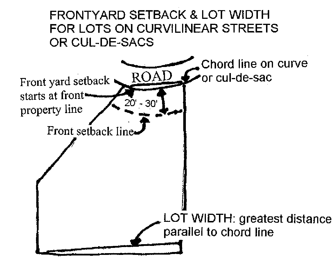
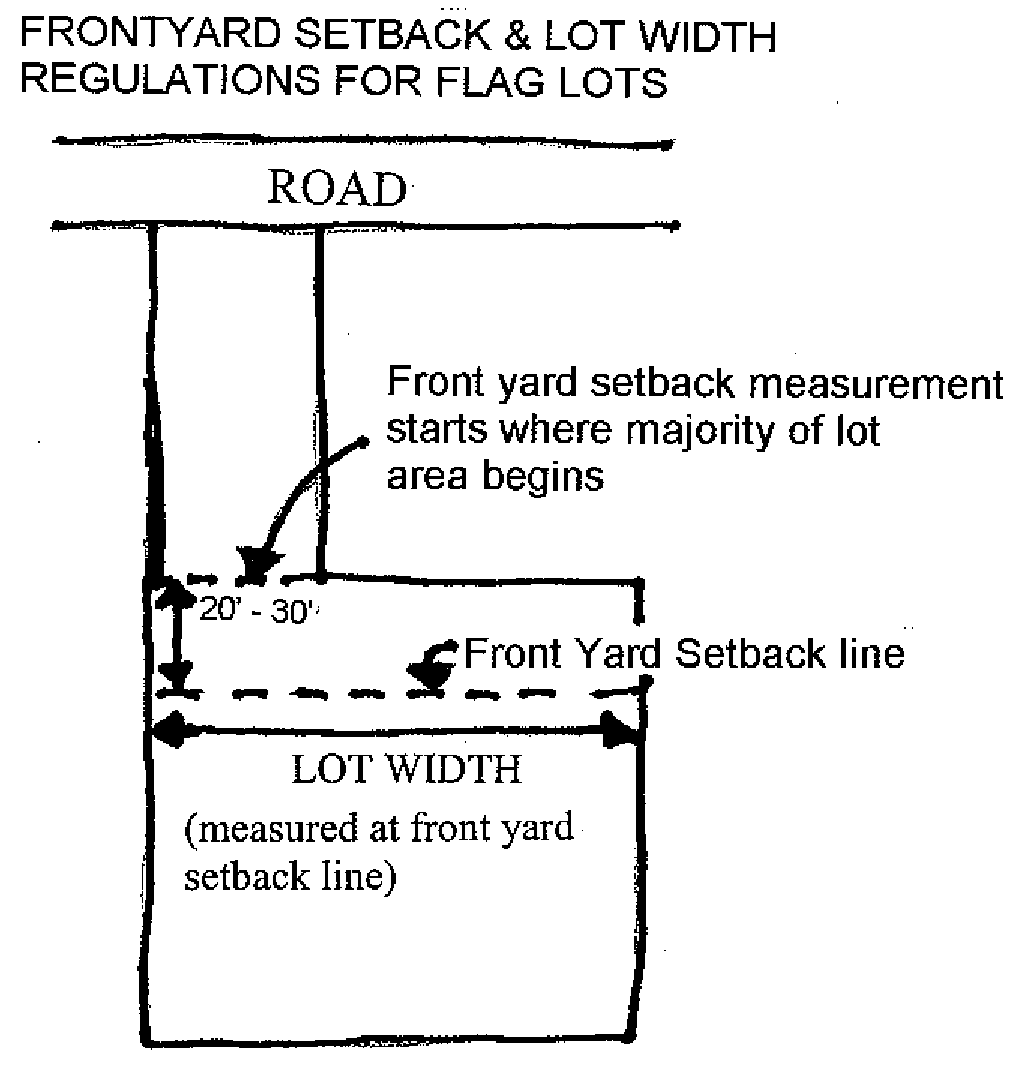
Lot line a line of record bounding a lot thereby dividing such lot from another lot or from a public or private right-of-way.
Lot (or parcel) of record a lot or parcel established and created legally in conformance with the zoning and land development regulations in effect at the time the lot or parcel is created. Such lot or parcel shall have been created by deed or plat recorded in the office of the Clerk of the Circuit Court of Indian River County, St. Lucie County or Brevard County (NOTE: Prior to its inception as a county, Indian River County was part of St. Lucie County and Brevard County, therefore, many Indian River County lots of record were originally filed with the Clerk of the Circuit Court of St. Lucie County or Brevard County).
Low profile luminaire light fixture set on a base which raises the source of the light no higher than forty-eight (48) inches off the ground, and designed in such a way that light is directed downward from a hooded light source.
Low water elevation the dry season groundwater table elevation as determined by the county engineer based on information contained in the soil survey of Indian River County and on-site soil testing reports.
Lowest floor the lowest floor of the lowest enclosed area of a building or structure, including basement, but excluding any unfinished or flood-resistant enclosure, usable solely for vehicle parking, building access or limited storage provided that such enclosure is not built so as to render the structure in violation of the Florida Building Code or ASCE 24. [Also defined in FBC, B].
Main dune bluff the seaward edge of the easternmost highest, most prominent dune immediately west of the vegetation line. This dune can be determined by its continuous relationship to the main dune line extending north and south from the point of determination.
Maintain (maintenance) to keep in an acceptable state of performance and repair and, when referring to the height of grasses in a stormwater management tract or facility, means to keep at a height of twelve (12) inches or less above the ground.
Maintenance guarantee a guarantee of facilities or work to ensure the correction of any failures of any improvements required pursuant to these land development regulations.
Major intersection the location at which two roadway segments located on the concurrency determination network cross or intersect each other.
Major road network system all arterial and collector roads within Indian River County. Indian River County's major road network system is designated in Figure 4.13.2, Thoroughfare Plan Map, and listed in Tables 4.7.1—4.7.3 of the traffic circulation element of the comprehensive plan, which is incorporated herein by reference.
Major structure residential buildings including mobile homes, commercial, institutional, industrial and other construction having the potential for substantial impact on coastal zones.
Major structure, nonhabitable structures including, but not limited to, swimming pools; parking garages; pipelines, piers; canals, lakes, ditches; water and sewage treatment plants; electrical power plants; transmission and distribution lines; transformer pads; vaults, and substations; roads, bridges, streets, and highways; underground storage tanks; communications buildings and towers; flagpoles and signs over fifteen (15) feet in height.
Major trip generators any land uses which are fairly compact in size, have access to the county's transportation system, and produce at least two thousand five hundred (2,500) average annual daily trips (AADT).
Mall, regional a retail shopping facility containing a minimum of four hundred thousand (400,000) square feet of gross leasable area.
Maneuvering a series of changes in direction and positions.
Mangrove rooted trees and seedlings of the following species, but only when having a coastal or estuarine association:
Red mangrove: Rhizophora mangle;
Black mangrove: Avicennia germinans;
White mangrove: Laguncularia racemosa;
Buttonwood or button mangrove: Conocarpus erecta
Mangrove Stand - An assemblage of one or more of the following species: black mangrove (Avicennia germinans); red mangrove (Rhizophora mangle); white mangrove (Languncularia racemosa); and buttonwood (Conocarpus erecta).
Manufactured home a structure, transportable in one (1) or more sections, which is eight (8) feet or more in width and greater than four hundred (400) square feet, and which is built on a permanent, integral chassis and is designed for use with or without a permanent foundation when attached to the required utilities. The term "manufactured home" does not include a "recreational vehicle" or "park trailer." [Also defined in 15C-1.0101, F.A.C.]
Marijuana shall mean cannabis as defined in F.S. § 893.02(3). The term shall include "low-THC cannabis," as defined in F.S. § 381.986(1)(b).
Manufactured home park/subdivision a parcel (or contiguous parcels) of land divided into two (2) or more manufactured home lots for rent or sale.
Marina a watercraft complex on and/or adjacent to a waterway used primarily for recreation purposes, including the refueling of watercraft and providing for minor repair services for such craft, not involving removal of watercraft from the water or removal of inboard or outboard engines from the watercraft.
Market value the price at which a property will change hands between a willing buyer and a willing seller, neither party being under compulsion to buy or sell and both having reasonable knowledge of relevant facts. As used in these floodplain regulations, the term refers to the market value of buildings and structures, excluding the land and other improvements on the parcel. Market value may be established by a qualified independent appraiser; or may reflect actual cash value (replacement cost depreciated for age and quality of construction); or may be established using tax assessment value adjusted to approximate market value by a factor provided by the property appraiser.
Mass transit passenger services provided by public, private, or non-profit entities such as the following surface transit modes: commuter rail, rail rapid transit, light rail transit, light guideway transit, express bus, and local fixed route bus.
Massage parlor an establishment where, for any form of consideration, massage, alcohol rub, fomentation, electric or magnetic treatment, or similar treatment or manipulation of the human body is administered, unless such treatment or manipulation is administered by a medical practitioner, chiropractor, acupuncturist, physical therapist, massage therapist, or similar professional person licensed by the state. This definition does not include an athletic club, health club, school, gymnasium, reducing salon, spa, or similar establishment where massage or similar manipulation of the human body is offered as an incidental or accessory service.
Master stormwater management plan/master plan an engineering plan, written report or engineering drawing outlining the primary and secondary drainage and stormwater treatment facilities needed for the proper development of a specific increment of the unincorporated area of Indian River County.
Maximum daily demand (MDD) (wastewater) the highest demand experienced for a one-day period during the calendar year. It is also measured at treatment plants and is expressed in terms of MGD.
Mean high waterline the intersection of the tidal plane or mean high water with the shore. Mean high water is the average height of high waters over a nineteen-year period.
Mean sea level means the average height of the sea for all stages of the tide. It is used as a reference for establishing various elevations within a floodplain. For purposes of County Land Development Regulations, the term is synonymous with North American Vertical Datum 1988 (NAVD88).
Median a value in an ordered set of values, below and above which there are an equal number of values.
Median (traffic) the physical portion of a highway separating the traveled ways for traffic in opposite directions.
Medical marijuana treatment center shall mean an entity that acquires, possesses, processes (including development of related products such as food, tinctures, aerosols, oils, or ointments), transfers, transports, sells, distributes or dispenses marijuana, products containing marijuana, related supplies, or educational materials to qualifying patients or their personal caregivers and is registered by the department of health or its successor agency, pursuant to Article X, Section 29 of the Florida Constitution.
Merging (traffic) the uniting of two (2) separate traffic streams moving in the same general direction into a single traffic stream.
Mine abandonment the cessation of mining activities including but not limited to excavation, dewatering, stockpiling, and removal of material off-site for a period of more than one year as reflected in an annual mining report, (reference Chapter 934, Excavation and Mining).
Mine dewatering any water that is impounded or that collects in the mine and is pumped, drained or otherwise removed from the mine by the operator. This term shall also include wet pit overflows caused solely by direct rainfall and ground water seepage. However, if a mine is also used for treatment of process generated wastewater, discharges of commingled water from the mine shall be deemed discharges of process generated wastewater.
Miniwarehouse a building or group of buildings in a controlled access compound that contains equal or varying size of individual compartmentalized, and controlled access stalls or lockers for the dead storage of customers' goods or wares.
Miniature golf course see "commercial amusement, unenclosed."
Mining the removal, either in or upon the soil of the earth or beneath the soil, of any valuable inert or lifeless substance formed or deposited in its present position through natural agencies alone, for commercial purposes. Mining shall not include excavation exempt from the requirements of a mining permit, as provided for in Chapter 934, Excavation and Mining, of the county land development code.
Minor coastal structure structures including but not limited to pile-supported, elevated dune and beach walkover structures; beach access ramps and walkways; stairways; pile-supported, elevated viewing platforms, gazebos and boardwalks; lifeguard support stands; public and private bathhouses; sidewalks, driveways, parking areas, shuffleboard courts, tennis courts, handball courts, racquetball courts, and other uncovered paved areas; earth retaining walls; sand fences, privacy fences, ornamental walls, ornamental garden structures, aviaries and other ornamental construction. It shall be characteristic of minor structures that they are considered to be expendable under design wind, wave and storm forces.
Mixed use a real development characterized by
(1) Two (2) or more revenue producing uses (such as retail, office, residential, hotel/motel and recreation which are mutually supporting);
(2) Significant functional and physical integration of project components; and
(3) Development in conformance with a coherent plan which stipulates the type and scale of uses and related items.
Mobile home a structure which is transportable in one or more sections, which is eight (8) body feet (2.4 m.) or more in width and is thirty-two (32) body feet (9.75 m.) or more in length, which is built on a permanent chassis and which is designed to be used as a dwelling with or without a permanent foundation when connected to the required utilities; and the term includes the plumbing, heating, air conditioning, and electrical systems contained therein. This definition does not include modular or prefabricated homes.
Mobile home park a place set aside and offered by a person or public body, for either direct or indirect remuneration of the owner, lessor, or operator of such place, for the parking or accommodation of mobile homes utilized for sleeping or eating.
Month the word "month" shall mean a calendar month.
Motor vehicle a vehicle which is self propelled in, upon or by which any person or property is or may be transported.
Mulch nonliving organic and synthetic materials such as gravel, rock, pebbles, bark, or pine needles used in landscape design to retard erosion and retain moisture.
Multiple-family residence a building or structure that is designed for and capable of housing conveniently two (2) or more individuals or families in separate quarters.
Multi-slip facilities any docking facilities containing three (3) or more boatslips for the purpose of mooring or storing a watercraft.
Municipality any or all incorporated municipalities within Indian River County, Florida.
Murphy Deed Reservation rights reserved by the State of Florida under the 1937 Murphy Act for use of properties for public right-of-way purposes.
National Geodetic Vertical Datum (NGVD) as corrected in 1929, a vertical control used as a reference for establishing varying elevations.
Natural drainage features naturally occurring features of an area which accommodate the flow of stormwater, such as streams, rivers, lakes, and wetlands.
New construction for the purposes of County Code Chapter 930 relating to flood protection and requirements of the Florida Building Code, means any structure for which the "start of construction" commenced after July 3, 1978. The term also includes any subsequent improvements to such structure.
New development any new construction and remodeling of existing structures when such remodeling includes alteration of exterior lighting.
New manufactured home park or subdivision a manufactured home park or subdivision for which the construction of facilities for servicing the lots on which the manufactured homes are to be affixed (including at a minimum, the installation of utilities, the construction of streets, and either final site grading or the pouring of concrete pads) is completed on or after July 3, 1978.
Nightclub a bar, restaurant, coffee house, or similar establishment where a dance floor or entertainment is provided.
Noise level reduction (NLR) (also known as sound level reduction (SLR)) reduction in sound level decibels between two (2) designated locations or rooms for a stated frequency or band.
Noncommencement the cancellation of construction activity involving a material change in a structure, or the cancellation of any other land development activity involving a material change in the use or appearance of land.
Nonresidential districts zoning districts where residential uses, single-family or multiple-family, are not permitted as a principal use, such as but not limited to: OCR, PRO, MED, CVRP, CN, CL, CG, CH, IL, and IG.
Nonconforming building any building that does not meet the limitations on building size and location on a land parcel, for the district in which such building is located, for the use to which such building is being put.
Nonconforming use a use or activity which was lawful prior to the adoption, revision or amendment of land development regulations, but which would be prohibited or further restricted under the terms of such land development regulations.
Nonconformity, site-related a characteristic of the site, such as off-street parking or loading, lighting, landscaping, drainage or similar matters which are incidental to the principal use of the property but which do not satisfy current county standards, as established in these county land development regulations.
Nonpoint source causes of water pollution, such as agricultural fertilizer runoff, and sediment from construction, that are not associated with point sources. Examples include:
1.
Agriculturally related nonpoint sources of pollution including runoff from manure disposal areas, and from land used for livestock and crop production;
2.
Silviculturally related nonpoint sources of pollution;
3.
Mine-related sources of pollution including new, current and abandoned surface and underground mine runoff;
4.
Construction activity related sources of pollution from disposal on land, in wells or in subsurface excavations that affect ground and surface water quality;
5.
Sources of pollution from disposal on land, in wells or in subsurface excavations that affect ground and surface water quality;
6.
Salt water intrusion into rivers, lakes, estuaries and groundwater resulting from reduction of fresh water flow from any cause, including irrigation, obstruction, groundwater extraction, and diversion; and
7.
Sources of pollution related to hydrologic modifications, including those caused by changes in the movement, flow, or circulation of any navigable waters or groundwaters due to construction and operation of dams, levees, channels, or flow diversion facilities.
North American Vertical Datum 1988 (NAVD88) a fixed reference for elevations determined by geodetic leveling. It is the adjustment of geodetic leveling observations in the United States, Canada and Mexico in the height of the primary tidal bench mark. It is the replacement datum for National Geodetic Vertical Datum 1929 (NGVD29).
Nuisance any debris, garbage, junk, trash, weeds, or unserviceable vehicles, or any other substance or material which, by nature of its location, is considered a health or safety hazard, and/or which is considered obnoxious and offensive to the general public. In application to Chapter 925, Open Burning and Air Curtain Incinerator Regulation, "nuisance" means any burning activity which is potentially harmful or injurious to human health or property or which is annoying or offensive to occupants as determined by the local jurisdictional authority.
Nursing/convalescent home (intermediate care facility, continuing care facility) a home, institution, building or residence, public or private, whether operated for profit or not, presently licensed by the state, which provides maintenance, personal care or nursing for a period exceeding twenty-four (24) hours to three (3) or more ill, physically infirm, convalescing, or aged persons who are not related by blood or marriage to the operator. The definition of nursing or convalescent home does not include hospitals, clinics or similar institutions which are devoted primarily to the diagnosis and treatment of the sick or injured.
Off-road vehicle tracks a course of travel purposely constructed including but not limited to landclearing and/or grading activities, to accommodate the recreational use of a vehicle or vehicles designed for traveling off paved roads, such as a trail bike, dune-buggy, four-wheel drive truck, or all-terrain vehicle. In application to Chapter 911, Zoning, and Chapter 971, Special Land Use Criteria, "off-road vehicle track" does not include commercial tracks which would entail viewing stands or the charging of a fee for spectators or track users.
Office a building or portion of a building wherein services are performed involving predominately administrative, professional, or clerical operations.
Office park a large tract of land that has been planned, developed, and operated as an integrated facility for a number of separate office buildings and supporting ancillary uses with special attention given to circulation, parking, utility needs, aesthetics, and compatibility.
Open burning the burning of any matter in such a manner that the products of combustion resulting from the burning are emitted directly into the outdoor atmosphere without passing through a stack or chimney.
Open space the gross area of the site less building coverage, parking surface, internal traffic circulation system, and any exclusions herein specifically set forth. Open space is green area, natural or landscaped. Up to thirty (30) percent of the open space requirement for a development may be satisfied by a body or bodies of water contained within the development area. Specific, alternative means of calculating open space may be set forth for specific conditions in other chapters of the land development code.
Open space, common land within a development, not individually owned or dedicated for public use, which is designed and intended for the common use or enjoyment of the residents of the development and may include such complementary structures and improvements as are necessary and appropriate.
Open Space, Non-Vehicular that portion of a site or parcel upon which buildings, pavement, or other improvements have not been placed, but excluding lakes and wet storage stormwater retention areas.
Open space, private common open space held in private ownership, the use of which is normally limited to the occupants of a single dwelling, building, or development.
Open space, public open space owned by a public agency and maintained by it for the use and enjoyment of the general public.
Open space, recreational and landscaped unroofed or screened roofed ornamental landscaped areas and recreational areas which are easily accessible and regularly available to occupants of all dwelling units on the lot wherein the open space is located. Roof tops, porches, raised decks, parking spaces, driveways, utility and service areas are not calculated as open space.
Origin/destination survey the collection of data on a land use resulting from on-site interview to determine trip characteristics about the travel patterns to and from the land use.
Other service provider any state, regional, municipal or other agency having construction, operational or maintenance responsibility for public services or facilities.
Outdoor storage the keeping in an unroofed area of any goods, material, or merchandise in the same place for more than twenty-four (24) hours. The parking or motor vehicles, in operating condition, which are used in the operation of a commercial establishment shall not be considered outside storage.
Owner the person or persons owning an interest in improved property within the boundaries of Indian River County Florida.
Package wastewater treatment plants small treatment systems designed and built in modular units and having components similar to larger regional treatment facilities. On-site aerobic treatment units shall be considered as package wastewater treatment plants.
Parapet that portion of the facade which extends above the roof immediately adjacent thereto.
Paratransit passenger service provided by public, private, or non-profit entities such as vanpools, jitneys, bus services, and other forms of transportation which are usually characterized by flexible routes and schedules.
Parcel (of land) any contiguous quantity of land capable of being described such that its location and boundaries may be established, that is designated by its owner(s) or developer(s) as land to be used or developed as a unit, or that has been used or developed as a unit.
Park a tract of land, legally reserved by the county, state, or federal government or other entity, for use by the public for active and passive recreation.
Park trailer a transportable unit which has a body width not exceeding fourteen (14) feet and which is built on a single chassis and is designed to provide seasonal or temporary living quarters when connected to utilities necessary for operation of installed fixtures and appliances. [Defined in 15C-1.0101, F.A.C.]
Parking accumulation study a special study which is accomplished per the community development director and the traffic engineer to support a request for technical deviation(s) pursuant to Chapter 954 of the land development regulations.
Parking, off-street an area not within a building service way or other structure where motor vehicles may be stored for the purpose of temporary, daily or overnight parking. This definition shall include a motor vehicle display lot, or display of boats, trailers and mobile homes.
Parking lot an area not within a building where motor vehicles may be stored for the purposes of temporary, daily, or overnight off-street parking.
Party wall a common shared wall between two (2) separate structures, buildings, or dwelling units.
Passerby trips trips that enter and exit a site that would have been travelling on the street adjacent to the site regardless of whether they enter or exit the site.
Peak hour/peak direction/peak season volume the number of vehicles that pass a point on a roadway segment during the highest one hour of traffic during the peak season in the direction of travel with the highest traffic volume.
Peak hour traffic the number of vehicles passing over a designated section of a street during the busiest one-hour period during a twenty-four-hour period.
Percent new trips factor a factor by which the trip rate is multiplied in order to calculate only those new trips that are added to the roadway by new development. This factor is calculated by the formula [1 - (captured or passerby trips divided by the total trips to the land use)].
Percolation the downward movement of water through a layer of permeable layer of earth.
Performance guarantee a financial guarantee to ensure that all improvements, facilities, or work required by these regulations will be completed in compliance with the regulations, and the approved plans and specifications of a development.
Permanent control point (PCP) as defined in Chapter 177, Florida Statutes, a permanent control point which shall be a secondary horizontal control monument and shall be a metal marker with the point of reference marked thereon or a four-inch-by-four-inch concrete monument a minimum of twenty-four (24) inches long with the point of reference marked thereon. Each "P.C.P." shall bear the registration number of the surveyor filing the plat of record.
Permanent reference monument (PRM) as defined in Chapter 177, Florida Statutes, a metal rod a minimum of twenty-four (24) inches long or a one and one-half (1½) inch minimum diameter metal pipe a minimum of twenty (20) inches long, either of which shall be encased in a solid block of concrete or set in natural bedrock, a minimum of six (6) inches in diameter, and extending a minimum of eighteen (18) inches below the top of the monument, or a concrete monument four-inches-by-four-inches, a minimum of twenty-four (24) inches long, with the point of reference marked thereon, and bearing the registration number of the surveyor certifying the plat of record, and the letters "PRM" shall be placed in the top of the monument.
Permitted use any use allowed by right within a given zoning district upon satisfaction of applicable land development regulations.
Person any individual, firm, partnership, corporation, landtrust, joint venture, syndicate or other group or combination acting as a unit, association, corporation, estate, trust, business trust, trustee, executer, administrator, receiver, or other fiduciary and shall include the plural as well as the singular.
Pier, private observation/fishing a structure extending in, on and/or over the waters of the state which is use [used] specifically for fishing, swimming, or other water dependent activities. A fishing pier shall not include a dock or a public pier, as defined in this section, and shall be designed and built in a manner that prohibits the mooring or launching of a boat. A private observation/fishing pier cannot be rented, leased, or sold to a party unless said party rents, leases, or buys the adjacent upland property.
Pier, public a structure extending in, on, or over waters of the state, which is used by the general public for fishing, swimming, wildlife observation, or other water dependent activities. A pier shall not include a dock, as defined in this section and shall be designed and built in a manner that prohibits the mooring or launching of a boat. A public pier is built, used, operated, or owned by a governmental entity. Main access pier the walkway which connects a riparian owner's property to a terminal platform. The main access pier is not used to moor a boat.
Places of worship churches, ecclesiastical or denominational organizations, or established physical places for religious activities in this state at which nonprofit religious services and activities are regularly conducted and carried on, and shall also mean church cemeteries.
Planned residential development (PRD) a land area under unified control which is designed and planned to be developed in a single operation by a series of prescheduled development phases according to an officially approved PRD plan which does not necessarily correspond to the property development and use regulations of the zoning district in which the development is located.
Planning and zoning commission the planning and zoning commission of Indian River County.
Plant nursery any land used to raise trees, shrubs, flowers, and other plants for sale or for transplanting.
Plant species, native any plant species with a geographic distribution indigenous to all or part of South Florida. Plant species which have been introduced by man are not native.
Planting area any area designated for landscape planting having a minimum of ten (10) square feet and at least one dimension on any side of three (3) feet; except that, wherever a tree shall be planted, a minimum area of one hundred (100) square feet, with a minimum dimension of at least ten (10) feet, shall be required.
Plat, final a finished map being a complete, exact representation of a subdivision accurately showing all legal requirements of subdivisions, Chapter 913, which may include "replat," "amended plat" or "revised plat."
Plat, preliminary a tentative plan of a proposed subdivision sufficient in detail to gauge compatibility with the comprehensive plan, zoning chapter and other development regulations of Indian River County.
Plat of record a plat which conforms to the requirements of the laws of the State of Florida and ordinances of Indian River County at the time of approval by the board of county commissioners which is recorded in the official records of Indian River County by the clerk pursuant to law.
Point source a stationary location where pollutants are discharged, usually from an industry; under the Federal Water Pollution Control Act (FWPCA), a point source is any discernable, confined, and discrete conveyance, including but not limited to any pipe, ditch, channel, tunnel, conduit, well, discrete fissure, container, rolling stock, concentrated animal feeding operation, vessel, or other floating craft, from which pollutants are or may be discharged. This term does not include return flows from irrigated agriculture.
Pole light any lighting device elevated by a slender piece of material greater then forty-eight (48) inches above the ground for the purpose of illuminating a broad or specific area.
Porosity the ability of a soil layer to hold water.
Potable water water, either naturally occurring or processed, which is of a quality suitable for consumption.
Potable water system a system of structures designed to treat and distribute potable water, and includes water wells, treatment plants, reservoirs, and distribution mains.
Potentiometric surface the level (elevation) to which the water within an aquifer would rise in a well and is used as a measure of quantity of water within an aquifer.
Pre-application conference (traffic) a meeting between the applicant and/or his engineer and the director of public works that occurs prior to the conduct of a traffic impact study for the purposes of defining the requirements for submission of the traffic impact study.
Premises a distinct unit or parcel of land including the appurtenances thereon.
Primary pedestrian corridor a pedestrian route along traveled legal rights-of-way and easements providing a method of access to and from facilities or services that attract/generate significant pedestrian traffic, such as schools and parks.
Primary frontal dune means a continuous or nearly continuous mound or ridge of sand with relatively steep seaward landward slopes immediately landward and adjacent to the beach and subject to erosion and overtopping from high tides and waves during major coastal storms. The inland limit of the primary frontal dune occurs at the point where there is a distinct change from a relatively steep slope to a relatively mild slope.
Primary treatment a process which removes between thirty (30) and thirty-five (35) percent of the organic material and up to fifty (50) percent of the solids from sewage. Because screens and settling tanks are the most common methods used to remove the solids, this process is also referred to as physical treatment.
Prime natural groundwater areas for the Floridan aquifer lands west and northwest of Indian River County which recharge the Floridan aquifer.
Prime natural groundwater areas for the surficial (shallow) aquifer the lands along the Atlantic Coastal Ridge and the Ten Mile Ridge where coarse permeable sands are exposed at the surface and rainfall is absorbed by the soil and percolates into the groundwater, as depicted in Figure 3.D.2., Aquifer Recharge Sub-Element of the county comprehensive plan.
Principal use the primary use and chief purpose of a lot or structure.
Prior vested development development projects approved prior to September 1, 1990 for which a final development order has been issued, developments of regional impact approved pursuant to Chapter 380 of the Florida Statutes, vested subdivision plats, and those projects initiated prior to September 1, 1990 which are exempted from concurrency review.
Processing plant a facility designed for incineration, resource recovery or recycling of solid waste prior to its final disposal.
Project, insignificant a proposed development which will generate/attract less than five hundred (500) trips per day and is not located at a critical transportation location, as determined by the director of public works.
Project, significant a proposed development which will generate/attract five hundred (500) trips per day or more; or developments where the proposed use is located at a critical transportation location as determined by the director of public works.
Project site (mining) that portion of the real property which is being excavated or mined, together with all property within one hundred (100) feet of the perimeter of the excavation, or mining activity.
Protected tree see "tree, protected."
Protective barrier any structure, device, or visual barrier which effectively identifies the parameters of the protected area.
Public beaches all of that part of the shore of the Atlantic Ocean extending from the ordinary seasonal high water mark to the waters of the Atlantic Ocean.
Public utility any privately-owned, municipally-owned, county-owned, or other government-owned system providing water service to the public which has at least fifteen (15) service connections or regularly serves an average of at least twenty-five (25) individuals daily for at least sixty (60) days of the year, with a minimum permitted withdrawal capacity of one hundred thousand (100,000) gallons per day.
Public water supply well wells withdrawing water from the surficical aquifer for use as potable water that are operated by public utilities.
Public protective services public facilities, or private firms serving the general public, providing emergency police, fire, rescue, or ambulance or similar services, excluding funeral home.
Public rights-of-way any county street, road, alley, or highway or public easement acquired by the county or the public by purchase, gift, devise, dedication, prescription, or otherwise within the unincorporated areas of Indian River County, and those roads and easements under the jurisdiction of the county within municipalities located in Indian River County.
Public services and/or public facilities services for which Level of Service (LOS) Standards are included in the comprehensive plan, whether such services or facilities are provided by government, quasi-public or private providers. Such services and facilities are roadways (traffic circulation), parks, potable water, sanitary sewerage, solid waste and drainage.
Public ways any and all streets, roads, alleys, piers, bulkheads, boardwalks, lanes, trails, or other public ways, and any and all public parks, squares, beaches, parks and any and all recreational facilities operated by the state, county, federal government or special governmental districts.
Public works director or designee the public works director shall be defined as the director of the department of public works within Indian River County or his designee which may include the Indian River County Traffic Engineer.
Pump stations mechanical devices used to pump sewage through the collection network (force mains) for the purpose of transporting the untreated wastewater to the treatment plant.
Recreation tract a tract of land within a residential development either designated on a plan or final plat approved by the county for recreational use(s) or used for recreational purposes and containing recreation-related improvements.
Recreational facility a facility designated for recreational purposes.
Recreational vehicle a vehicle, including a park trailer, which is: [Defined in Section 320.01(b), F.S.)
(1)
Built on a single chassis;
(2)
Four hundred (400) square feet or less when measured at the largest horizontal projection;
(3)
Designed to be self-propelled or permanently towable by a light-duty truck; and
(4)
Designed primarily not for use as a permanent dwelling but as temporary living quarters for recreational, camping, travel, or seasonal use.
Recreational vehicle park a place set aside and offered by a person or public body, for either direct or indirect remuneration of the owner, lessor, or operator of such place, for the parking and accommodation of recreational vehicles utilized for sleeping or eating; and the term also includes buildings and sites set aside for group camping and similar recreational facilities.
Recyclable materials materials separated, at the point of generation, by the generator or his agent, and donated or sold by the generator for the purpose of recycling; including newsprint, cardboard, aluminum, glass, plastic, and ferrous metals.
Recycling any process by which solid waste, or materials which would otherwise become solid waste, are collected, separated, or processed and reused or returned to use in the form of raw materials or products.
Recycling center a facility, that is not a junkyard and is not a demolition debris site, in which recoverable resources, such as newspapers, magazines, books, and other paper products; glass; metal materials; sorted building components such as doors and window frames; vegetation; and other products not including vehicles or boats, and vehicle parts, are separated, consolidated, recycled, processed, or treated to make such materials into useable products or inputs available for production.
Regularly moored watercraft any watercraft vessel habitually or methodically moored or anchored in the same general location for a continual period greater than seventy-two (72) hours or any watercraft vessel which is habitually or methodically moored or anchored in the same general location for a total of four (4) days within any given seven-day period.
Regulatory floodway the channel of a river or other watercourse and the adjacent land areas that must be reserved in order to discharge the base flood without cumulatively increasing the water surface elevation more than a designated height.
Relic seawater water that has been trapped within an aquifer. The source of this water is an ancient sea which inundated the mainland in the geologic past.
Required yard the required setback, such as a front, side, or rear setback, applicable to a building or structure, measured from the building or structure to the lot line.
Resident, group home any of the following: an aged person as defined in Section 400.618(3) F.S,; a physically disabled or handicapped person as defined in Section 760.22(5)(a) F.S.; a non-dangerous mentally ill person as defined in Section 394.455(3) F.S.; or a child as defined in Section 39.01(8) and (10) F.S.
Residential districts these zoning districts where the principal use is single-family or multiple-family residential dwelling units, including the districts such as but not limited to: A-1, A-2, A-3, RFD, RS-1, RS-3, RS-6, RT-6, RM-3, RM-4, RM-6, RM-8, RM-10, RMH-6, RMH-8, ROSE-4, R-BCID, AIR-1, CON-1 and CON-2.
Residential migrant housing facility (migrant labor camp, labor camp) a facility licensed by the State of Florida consisting of one or more buildings, structures, barracks or dormitories, mobile homes, and any portion thereof, together with the land appertaining thereto, constructed, established, operated, or furnished as an incident of employment as living quarters for seasonal, temporary or migrant farmworkers and their families, whether or not rent is paid or reserved in connection with the use and occupancy of such premises.
Residential resort a planned development of not less than fifty (50) acres, containing resort housing and accessory recreational amenities, designed for extended resort and vacation stays.
Residential treatment center a secure facility providing diagnosis, treatment, habitation or rehabilitation on an in-patient basis in a living environment which includes the supervision and care necessary to meet physical, emotional and/or social needs of clients. Residential treatment centers may house a number of unrelated individuals, either patients or staff, and shall meet all licensing requirements of the state.
Residential wastes mixed household wastes, including yard wastes generated by households.
Resort housing structures containing accommodations made available to tourists for temporary occupancy of dwelling units which may be classified as a hotel or motel rooms, apartments or condominium units, time-share units or other such units accommodating transient residential needs.
Resource recovery the process of recovering materials or energy from solid waste, excluding those materials of solid waste under control of the Nuclear Regulatory Commission and the Atomic Energy Commission.
Restaurants (excluding drive-ins) any establishment (which is not a drive-in service establishment) where the principal business is the sale of food, desserts or beverages to the customer in a ready-to-consume state and where the design or principal method of operation includes one or more of the following:
a.
Customers, normally provided with an individual menu, are served generally in non-disposable containers by a restaurant employee at the same table or counter at which said items are consumed.
b.
Ice cream parlors and other small specialty restaurants having floor area exclusively within a shopping or office center and sharing common parking facilities which other businesses within the center and expressly prohibiting freestanding stores having characteristics of a drive-in restaurant.
c.
A cafeteria or cafeteria type operation where foods, desserts or beverages generally are served in nondisposable containers and consumed within the restaurant building.
d.
The restaurants are self-service; food is generally served in disposable containers, and customers generally do the busing and clean-up for themselves or foods.
e.
Customers purchase food, desserts or beverages for carry-out.
Retail sales and services, general commercial establishments that, in addition to serving day-to-day commercial needs of a community, also supply the more durable and permanent needs of a whole community, including convenience stores, supermarkets, department stores, discount stores, variety stores, hardware and garden supply stores, apparel and footwear stores, florists, gift shops, jewelry stores, book and stationary stores, specialty shops, sporting goods stores, furniture and home furnishing stores, office equipment and supplies, automotive supply stores, appliance stores and similar retail sales and services. This use grouping also includes laundry and dry cleaning establishments classified in the Fire Prevention Code IV or V and using only non-flammable Class IV solvents. General retail sales and services expressly excludes sale and rental of motor vehicles, excepting small parts and accessories; sale of construction materials, excepting paint, fixtures, and hardware; vehicular service and maintenance activities including service stations.
Retail shops, specialty commercial establishments such as boutique shops and other special shops that cater to custom markets, such as tourists, collectors, design clientele and similar specialized user groups, and offering goods not generally available in convenience or shoppers goods establishments.
Retail trade the sale of consumer goods, commodities, and services to ultimate consumers.
Retention (to retain) the prevention of, or to prevent the discharge of, a given volume of stormwater runoff into surface waters of the state by storage completely on-site where the capacity to store the given volume of stormwater is restored with in seventy-two (72) hours following the storm event. Retention storage is the amount of water the soil can hold against the pull of gravity. The required storage volume must be provided by a decrease of stored water caused by percolation through soil, evaporation, evapotranspiration, or spray irrigation. Wet retention refers to a basin which penetrates the dry season groundwater table. Dry retention refers to a basin whose bottom is located at least one foot above the wet season groundwater table.
Revenue bonds bonds payable from a specific source of revenue which do not involve a pledge of the full faith and credit of the issuer. Revenue bonds are payable from identified sources of revenue, and do not permit the bondholders to compel taxation or legislative appropriation of funds not pledged for payment of debt service.
Revenues increases in the net current assets of a governmental fund type from other than expenditure refunds and residual equity transfers.
Reverse osmosis (RO) a physical method of water treatment in which water under pressure is forced through a membrane which rejects a percentage of both organic and inorganic impurities within the water.
Review report an analysis of the effect a project will have on various aspects of the community infrastructure. The extent of the report shall vary with the type, extent and intensity of development.
Rezoning petition a request to amend the official zoning atlas for a specific parcel of land meeting the requirements of Chapter 911, Zoning, and Chapter 902, Administrative Mechanisms.
Right-of-Way a strip of land dedicated, deeded, used, or to be used for a street, alley, walkway, boulevard, utility installations, drainage facility, access for ingress or egress, or other purpose by the public, certain designated individuals, or governing bodies. Includes Murphy Deed Reservations.
Riparian lot line a line of division separating the riparian use areas of adjacent waterfront parcels, extending waterward from the point of intersection of a side lot line and a shoreline. The riparian lot line shall be extended to the centerline ("thread") of a waterway, and shall be perpendicular to the general course of the waterway at that point.
Riparian side yard setback a setback pertaining to waterfront structures and associated uses equalling the distance of the required side yard setback of a given property, measured from the riparian lot line.
Road, arterial a road which is a main traffic artery carrying relatively high traffic volumes for relatively long distances. Generally, an arterial road is greater than or planned to be greater than two (2) lanes in width, and longer than two (2) miles in distance. All arterial roads in Indian River County are designated in Figure 4.13.2 (Thoroughfare Plan Map) and listed in Tables 4.7.1 — 4.7.3 of the Traffic Circulation Element of the Comprehensive Plan.
Road, collector a road which carries traffic from local roads to arterial roads. Collector roads have more continuity, carry higher traffic volumes, and may provide less access than local roads. Generally, collector roads are two-lane facilities and generally operate at lower capacity and operating speeds than do arterial roads. All the collector roads in Indian River County are designated in Figure 4.13.2 (Thoroughfare Plan Map), Traffic Circulation Element, Comprehensive Plan.
Road, local a road designated and maintained primarily to provide access to abutting property. A local road is of limited continuity and is not for through traffic. A local road is not considered as part of the major road network system.
Road, public the area of the public right-of-way, either paved or unpaved, which is intended for vehicular traffic.
Road capacity the maximum number of vehicles that can be accommodated by a given roadway during a specified time period under prevailing roadway, traffic and control conditions at that roadway's adopted level of service.
Roadway the portion of highway, including shoulders, for vehicle use. Also see"street."
Roadway, Major a road depicted on the Indian River County Thoroughfare Plan Map (Figure 4.13.2, Traffic Circulation Element, Comprehensive Plan) as a principal arterial, minor arterial, or collector road.
Roadway, shared any roadway upon which a bicycle lane is not designated and which may be legally used by bicycles regardless of whether such facility is specifically designated as a bikeway.
Roadway capital improvement the planning of, engineering for, acquisition of land for, and construction of roads, turn lanes, intersection improvements and signalization, but not including maintenance.
Roof line (deck line) the intersecting lines of a roof formed at the junction of the roof with the walls of a building. On a sloped roof, the deck line is the intersection of the sloped roof sides with the uppermost flat roof.
Rooming house a building that is the primary residence of the owner and in which rooms are provided by the owner, for compensation, to three (3) or more adult persons not related by blood, marriage, or adoption to the owner.
Rooms, occupied rooms within enclosed structures which are or may reasonably be expected to be used for human activities which involve speech communication; sleeping; eating; listening to live, recorded or broadcast music or speech; or the regular use of telephones.
Rubbish refuse accumulations of paper, excelsior, rags or wooden or paper boxes or containers, sweepings, and all other accumulations of a nature other than garbage, which are usual to housekeeping and to the operation of stores, offices and other business places, also any bottles, cans or other containers which, due to their ability to retain water, may serve as breeding places for mosquitoes or other water breeding insects.
Runway a defined area on an airport prepared for landing and takeoff of aircraft along its length.
Sand dunes naturally occurring accumulations of sand in ridges or mounds landward of the beach.
Sanitary sewers mains, pipes and laterals for the reception of sewage and carrying such sewage to a treatment plant or some part of the sewage disposal system, and may embrace pumping stations, outlets and a sewage disposal system where deemed necessary.
Satellite dish antennas (also see antenna) an antenna with a low-noise amplifier, the purpose of which is to receive communication or other signals from orbiting satellites.
School, business and/or collegiate (including vocational or trade School) a private, public, or other non-profit institution conducting educational programming for business, vocational, collegiate, or post-graduate levels, operated by a governmental or non-governmental organization, which is licensed by the State of Florida.
School, hazardous walking conditions as per Florida Statutes, Chapter 234, Section 234.021, the conditions perceived to be hazardous to "students" (means "any public elementary school student whose grade level does not exceed grade 6") who live within two (2) miles from the nearest appropriate school and who walk to school.
School, primary and/or secondary a private or public or not for profit institution conducting regular academic instruction at kindergarten, elementary, and secondary levels, operated by a governmental or non-governmental organization, which is licensed by the State of Florida.
Screening a method of visually shielding or obscuring one abutting or nearby structure or use from another by fencing, walls, berms or densely planted vegetation.
Seasonal and migratory units housing units intended by their design, location, or character to be occupied only during certain seasons of the year or held for occupancy by migratory workers employed in farm work during the crop season.
Seating capacity the actual seating capacity of an area based upon the number of seats or one seat per eighteen (18) inches of bench or pew length. For other areas where seats are not fixed, the seating capacity shall be determined as indicated by the Uniform Building Code.
Secondary treatment a process which removes between eighty (80) and ninety (90) percent of the total organic material and suspended solids from the sewage. This level of treatment generally requires multiple steps involving one biological process and one or more processes for removal of suspended solids.
Sediment fine particulate material which is capable of gravity settlement, whether mineral or organic, and which is in suspension or has settled in a water body.
Segment one or a series of sequential links identified on the concurrency determination network in which the beginning and ending points are defined by the director of public works using criteria that includes changes in roadway operating characteristics, locations of signalized intersections and municipal boundaries.
Self-service storage facility any real property designed and used for the purpose of renting or leasing individual storage spaces to tenants who are to have access to such space for the purpose of storing and removing personal property.
Septic tanks small scale wastewater treatment facilities consisting of a settling tank for solid precipitation and anaerobic biological action and a drainfield for effluent disposal.
Service station any premises where gasoline and other petroleum products are sold and/or light maintenance activities such as engine tuneups, lubrication, minor repairs, and carburetor cleaning are conducted. Service stations shall not include premises where heavy automobile maintenance activities such as engine overhauls, automobile painting, and body fender work are conducted.
Setback the minimum horizontal distance between the front, rear or side lines of the lot and the front, rear or side lines of the building including porches, carports, and accessory uses subject to yard encroachment provisions of Chapter 911, Zoning. However, front yard setbacks shall be measured from the right-of-way line, which includes Murphy Deed Reservations. For flag lots, the front yard setback shall be measured from the line where the majority of the lot area meets the narrow strip of land that connects the lot to the road right-of-way.
Shopping center a group of retail stores planned and developed for the site upon which they are built.
Shoreline the mean high water line for tidal water bodies and ordinary high water for fresh water bodies.
Shrub a self-supporting woody perennial plant of low to medium height characterized by multiple stems and branches continuous from the base.
Sidewalk the portion of a highway designed for preferential or exclusive use by pedestrians.
Sign any writing (including letter, word, or numeral); pictorial representation (including illustration or decoration); emblem (including service mark, symbol, or trademark) except a religious emblem; flag (banner or pennant); any other figure or character or any structure or part thereof on which such writing, pictorial representation, emblem, flag, or other figure or character is installed or placed (except a building to which the same may be attached) which:
(a)
Is used to inform, attract attention, or advertise; and,
(b)
Is readily visible from any public place off the premises where the sign is located.
Whenever the word "sign" appears in chapter 956, sign regulations, it shall include "advertising structure." In addition, whenever the word "sign" is used it shall include buildings or other structures shaped to resemble in configuration or design a product for sale such as, but not limited to, hot dogs, hamburgers, ice cream cones, shoes, automobiles, or fruit.
Sign, A-frame a movable sign not secured or attached to the ground as required by chapter 956, sign regulations.
Sign, abandoned (on-premises) an on-premises sign identifying an establishment that has not been conducting business at the site on which the sign is located or at the location noted on the sign for a period greater than one hundred eighty (180) days or a sign in a condition of disrepair, set forth in chapter 956, sign regulations, of the county land development code. A sign shall not be considered abandoned for businesses which operate on a seasonal basis.
Sign, add-on any additional sign area added to a permitted sign prior to obtaining a permit for the additional sign.
Sign, animated a sign with physical action or motion or the appearance thereof, using manmade or wind actuated elements, including rotating, oscillating, fluttering, flashing, or swinging signs, streamers, balloons, or banners, but excluding allowed flags, traditional barber poles, electronic adjustable alternation displays, and time/temperature units.
Sign, area of sign the area of the single face side of the sign within a perimeter which forms the outside shape, including any frame forms and integral parts of the display, but excluding the necessary supports, pole covers, or uprights on which the sign may be placed. The copy area of the sign shall be the actual area of the sign copy applied to any background as computed by straight lines drawn closest to copy extremities encompassing individual letters or words.
Sign, canopy any sign installed on any ornamental roof-like structure of cloth or otherwise that provides or suggests shelter and projects from a wall or is supported by columns; or any temporary or permanent cover providing shelter or decoration (as over a door or window), including an awning.
Sign, changeable copy a sign which has message characters that are not permanently attached to the sign, but which are attached to permit numerous changes of the message on the sign without repainting of any part of the sign or removal of any parts of the sign except the message characters.
Sign, directional (off premises) see "billboard."
Sign, directional a permanent or temporary sign situated so as to guide or direct pedestrians or vehicles to an event or to a building or facility.
Sign, double-faced a sign with two (2) faces of generally equal dimensions, parallel to each other, and back to back. A double faced sign shall be considered one sign.
Sign, identification a sign which contains no advertising and the message of which is limited to conveying street numbers, the name, address and numbers of the premises, or the name of the owner or occupant of the premises.
Sign, facade see "sign, wall."
Sign, flashing any sign with a light or lights which flash, blink, change in intensity or otherwise create the illusion of flashing or movement.
Sign, freestanding a sign which is supported by one or more columns, uprights, or braces (ground or pole sign) anchored into the ground independent of support from any building, including ground signs and pole signs.
Sign, height the vertical distance to the highest point of a sign. Freestanding signs shall be measured from the average natural grade or the minimum flood elevation, whichever is higher.
Sign, illuminated a sign which gives forth artificial light or reflects such light from an artificial source.
Sign, instructional a sign situated so as to convey instructions with respect to use of the premises on which it is maintained, such as, but not limited to, "exit," "entrance," "parking," "no trespassing," "no solicitation," or similar instruction.
Sign, memorial a sign, tablet or plaque situated on or near a building so as to indicate a dedication or the name of the building.
Sign, message center any sign that can automatically display words, numerals, and/or characters in a programmed manner.
Sign, multiple-faced a sign with more than two (2) faces.
Sign, nonconforming any sign lawfully existing on the effective date of the sign ordinance, Chapter 956, or an amendment thereto, but which would be prohibited or further restricted under the terms of county land development regulations.
Sign, on-premises see "sign, point of purchase."
Sign, point of purchase (on premises sign) any structure, device, display board, screen, surface or wall, characters, letters, or illustrations placed thereto, thereon, or thereunder by any method or means whatsoever where the matter displayed is used for advertising on the premises, a product or service, actually or actively offered for sale or rent thereon or therein.
Sign, pole freestanding sign.
Sign, projecting a sign other than a wall sign which is attached to and projects no more than eighteen (18) inches from a structure or building face. Area of a projecting sign is calculated on one face only.
Sign, public a sign placed under the authority of duly authorized government officials, including traffic signs, civic signs, legal notices, public safety signs, or signs placed by such authorized officials for the public health, safety, welfare, and convenience.
Sign, revolving see "animated sign."
Sign, roof any outdoor advertising display sign, installed, constructed or maintained above the roof line of any building, excepting allowable signs on a parapet or marquee.
Sign, rotating see "sign, animated."
Sign, sandwich see "sign, A-frame."
Sign, snipe any sign placed on any tree, utility pole, or similar object. Also, any sign installed without permission of the owner of the property where the sign is placed.
Sign, swinging any sign installed by any means which allows the sign to swing back and forth by wind action.
Sign, temporary any sign intended to be displayed for a limited period of time only, usually for less than one year.
Sign, time and temperature a display containing illuminated numerals flashing alternately to show the time and/or temperature.
Sign, trailer any sign installed on a portable frame or structure with wheels other than a motor vehicle and excluding commercial trailers used in support of a commercial hauling, lawn mowing, land clearing, or similar mobile commercial service.
Sign, under canopy any sign hung under a canopy.
Sign, Vee-shaped any sign which has two (2) faces which are not parallel.
Sign, vehicular a sign affixed to or painted on a transportation vehicle or trailer, for the purpose of business advertising; however, not including signs affixed to vehicles or trailers for identification purposes.
Sign, wall (facade sign) any sign installed parallel to and flush against the exterior wall of a building, supported by the building and which has only one advertising surface.
Sign, wall area that background area upon which the copy area is placed. Where the copy area is attached to the wall of a building, the wall shall not be construed to be the background area of the sign unless it is an integral part of the sign.
Sign, window any sign placed on the inside or outside of any window of any building or door which is visible from any public right-of-way. This does not include merchandise on display.
Signal any impulse, fluctuating electronic quantity or source of image, message, sound or other indicator that serves as a means of communication or makes known or imparts thoughts, ideas or data of any kind whatsoever.
Significant project see "project, significant."
Silviculture the management of forest land for timber production and harvesting.
Site any tract, lot or parcel of land or combination thereof where development is to be performed as part of a unit, subdivision or project.
Site plan a plan, prepared to scale, showing accurately and with complete dimensioning, the boundaries of a site and the location of all buildings, structures, uses, and principal site development features proposed for a specific parcel of land.
Site plan release release of an approved site plan(s) form the planning division to a project owner or authorized agent upon demonstration by such that all applicable conditions have been met and all required permits have been obtained that are necessary prior to construction.
Small-scale bio-fuel processing plant a facility that produces fuel from biological materials, including but not limited to vegetative material, where the area of development (includes plant equipment, processing areas, bio-fuel storage facilities, feedstock storage and staging areas, parking areas, and transport facilities) does not exceed twenty (20) acres.
Social membership organization membership organizations engaged in civic, social or fraternal activities.
Sodium zeolite softening a chemical method of water treatment involving the exchange of ions (atoms) in which sodium and potassium atoms are exchanged for calcium and magnesium and potassium atoms are exchanged for iron/manganese/tannins.
Soil, excessively drained water is removed from the soil very rapidly. Excessively drained soils are commonly very coarse textured, rocky, or shallow. Some are steep. All are free of the mottling related to wetness.
Soil, moderately well drained water is removed from the soil somewhat slowly during some periods. Moderately well drained soils are wet for only a short time during the growing season, but periodically they are wet long enough that most mesophytic crops are affected. They commonly have a slowly pervious layer within or directly below the solum, or periodically receive high rainfall, or both.
Soil, poorly drained water is removed so slowly that the soil is saturated periodically during the growing season or remains wet for long periods. Free water is commonly at or near the surface for long enough during the growing season that most mesophytic crops cannot be grown unless the soil is artificially drained. The soil is not continuously saturated in layers directly below plow depth. Poor drainage results from a high water table, a slowly pervious layer within the profile, seepage, nearly continuous rainfall, or a combination of these.
Soil, somewhat excessively drained water is removed from the soil rapidly. Many somewhat excessively drained soils are sandy and rapidly pervious. Some are shallow. Some are so steep that much of the water they receive is lost as runoff. All are free of the mottling related to wetness.
Soil, somewhat poorly drained water is removed slowly enough that the soil is wet for significant periods during the growing season. Wetness markedly restricts the growth of mesophytic crops unless artificial drainage is pro-vided. Somewhat poorly drained soils commonly have a slowly pervious layer, a high water table, additional water from seepage, nearly continuous rainfall, or a combination of these.
Soil, very poorly drained water is removed from the soil so slowly that free water remains at or on the surface during most of the growing season. Unless the soil is artificially drained, most mesophytic crops cannot be grown. Very poorly drained soils are commonly level or depressed and are frequently ponded. Yet, where rainfall is high and nearly continuous, they can have moderate or high slope gradients.
Soil, well drained water is removed from the soil readily, but not rapidly. It is available to plants throughout most of the growing season, and wetness does not inhibit growth of roots for significant periods during most growing seasons. Well drained soils are commonly medium textured. They are mainly free of mottling.
Solar facility means a production facility for electric power which:
(a)
Uses photovoltaic modules to convert solar energy to electricity that may be stored on site, delivered to a transmission system, and consumed primarily offsite.
(b)
Consists principally of photovoltaic modules, a mounting or racking system, power inverters, transformers, collection systems, battery systems, fire suppression equipment, and associated components.
(c)
May include accessory administration or maintenance buildings, electric transmission lines, substations, energy storage equipment, and related accessory uses and structures.
Solid waste garbage, refuse, yard trash, clearing debris, white goods, special waste, ashes, sludge, or other discarded material, including solid, liquid, semisolid, or contained gaseous material resulting from domestic, industrial, commercial, mining, agricultural, or governmental operations.
Solid waste disposal charge the annual special assessment charge against a parcel of assessable property for the disposal of solid waste for the applicable fiscal year based upon the classification of the use of such parcel of property as specified in the equivalent residential unit ("ERU") schedule.
Solid waste facility land, equipment and buildings constructed and maintained by the board of county commissioners to transfer and or dispose of solid waste within the county.
Special assessments a compulsory charge made against certain properties to defray part or all of the cost of a specific improvement or service deemed to primarily benefit those properties.
Special exception a use that would not be appropriate generally or without restriction throughout a zoning district but which if controlled as to number, area, location or relation to the neighborhood, would promote the public health, safety, welfare, morals, order, comfort, convenience, appearance, prosperity, or the general welfare. Such uses may be permissible in a zoning classification or district upon the granting of special exception, meeting the requirements of Chapter 911, Zoning.
Special flood hazard area an area in the floodplain subject to a one-percent or greater chance of flooding in any given year. Special flood hazard areas are shown on FIRMs as Zone A, AO, A1-A30, AE, A99, AH, V1-V30, VE or V. [Also defined in FBC, B].
Special vehicle sales event a temporary activity having a duration of four (4) or fewer consecutive days for the sale of vehicles held at a site not approved as a permanent vehicle sales facility and conducted by one or more vehicle dealers having a valid Indian River County occupational license.
Special wastes solid wastes that require special handling and management, including, but not limited to, white goods, whole tires, used oil, mattresses, furniture, lead-acid batteries, and biological wastes, and oversized bulky wastes and materials generated in demolition and construction projects.
Specialty farm an agricultural activity which involves the breeding, raising or overall care for animals which are not classified as a household pet or livestock.
Specified anatomical areas specified anatomical that are:
a.
Less than completely and opaquely covered:
1.
Human genitals or pubic region; or
2.
Cleavage of the human buttocks; or
3.
That portion of the human female breast encompassed within an area at or directly below the areola (the colored ring around the nipple). This definition shall include the entire lower portion of the human female breast exhibited by a dress, blouse, shirt, leotard, bathing suit, or other wearing apparel, provided the areola is not so exposed.
b.
Human male genitals in a discernible turgid state, even if completely and opaquely covered.
Specified sexual activities specified sexual activities consisting of:
a.
Human genitals in a state of sexual stimulation, arousal or tumescence; or
b.
Acts of human adamutism, analingus, bestiality, buggery, cunnilingus, coprophagy, coprophilia, masochism, masturbation, necrophilia, pederasty, pedophilia, sadism, sadomasochism, sapphism, sexual intercourse, sodomy, urolagia or zooerasty; or
c.
Fondling or other erotic touching of human genitals, pubic region, buttock, anus or female breast; or
d.
Excretory functions as part of or in connection with any of the activities set forth in subsections (a) through (b).
Specimen tree a tree which has been determined by the board of county commissioners, following input from county environmental planning staff, to be of high value because of its type, size, age, or other relevant criteria, and has been so designated by the board of county commissioners in the official record books following a public hearing with due notice by certified mail to the owner.
Stable, commercial any premises which provides boarding for horses for a fee and/or where horses are available for rent or sale to the general public.
Stable, noncommercial a boarding facility for horses housing no more than one horse per acre of land area. The house, boarding facility, and land area shall be held under the same ownership. No boarding shall be provided in exchange for a remuneration nor shall the horses be offered for hire or sale.
Stadium see "commercial amusement, unenclosed."
Start of construction the date of issuance for new construction and substantial improvements to existing structures, provided the actual start of construction, repair, reconstruction, or improvement was within one hundred eighty (180) days of the permit date. The actual start means the first placement of permanent construction of a building (including a manufactured home) on a site, such as the pouring of slabs or footings, installation of piles, construction of columns, or any work beyond the stage of excavation or the placement of a manufactured home on a foundation. Permanent construction does not include land preparation, such as clearing, grading and filling; nor does it include the installation of streets and/or walkways; nor does it include excavation for a basement, footings, piers or foundations or the erection of temporary forms; nor does it include the installation on the property of accessory buildings, such as garages or sheds not occupied as dwelling units or not part of the main building. For a substantial improvement, the actual start of construction means the first alteration of any wall, ceiling, floor, or other structural part of a building, whether or not that alteration effects the external dimensions of the building. [Also defined in FBC, B].
Sterilization the process of rendering permanently incapable of reproduction.
Stored any recreational vehicle not in normal daily usage for transportation of the occupants of the residence.
Storm sewers drains or conduits for the passage of stormwater.
Stormwater the flow of water which results from a rainfall event.
Stormwater and flood management system a system of natural or artificial water bodies or watercourses which stores or conveys water.
Stormwater detention (or to detain) the collection and temporary storage of stormwater in such a manner as to provide for treatment and flood attenuation to the receiving waters.
Stormwater management plan an engineering plan and written report outlining the drainage and stormwater treatment facilities required for the proper development of the tract under consideration pursuant to the stormwater management and flood protection chapter.
Stormwater management system, centralized a dedicated stormwater management tract which is not a part of any lot, road right-of-way, backlot, or sidelot easement.
Story that portion of a building included between the surface of any floor and the surface of the next floor above it, or if there be no floor above it, thence the space between such floor and ceiling next above it.
Street (also see roadway) a public or private right-of-way which provides vehicular traffic access between certain points and which also may provide space for the location of utilities. Streets are classified by function as follows:
(1)
Arterial, principal those routes intended to carry heavy volumes of traffic for major distances within or through the county, as delineated on the Indian River County Thoroughfare Plan.
(2)
Arterial, minor those routes intended to carry heavy volumes of traffic for short distances within the county, as delineated on the Indian River County Thoroughfare Plan.
(3)
Collector a street which carries traffic from minor streets to arterial streets, as indicated on the Indian River County Thoroughfare Plan.
(4)
Subdivision collector road a street which serves as the principal entrance street of a residential subdivision or provides for traffic circulation within a subdivision.
(5)
Minor or local street a street of limited continuity used primarily for access to abutting property, including culs-de-sac and nonthrough streets.
(6)
Marginal access streets a street that is parallel and adjacent to a major arterial street or highway and which provides access to abutting property.
(7)
Commercial service street a local street of limited right-of-way width (30 feet—40 feet) that serves commercially zoned property but not residentially zoned property, functions as an alley or secondary service access for property that fronts the commercial service street and an arterial street, and that is designated as a commercial service street by resolution of the board of county commissioners.
Street, private a privately owned access to abutting property, which serves more than one property, is not dedicated to the general public and is maintained by a Property Owner's Association or other entity.
Streetline a dividing line between a lot, tract or parcel of land and a contiguous street.
Structure anything constructed or erected with a fixed location on the ground, or attached to something having or requiring a fixed location on the ground. Structures shall include buildings, mobile homes, walls, fences and signs, paving, sidewalks, utility transmission towers, and other similar improvements.
Structure (floodplain) a walled and roofed building, including a gas or liquid storage tank, that is principally above ground, as well as a manufactured home.
Structure, occupied any building that is regularly occupied by persons, including, but not limited to single-family residences, mobile homes, business offices and retail stores.
Subdivide to create a subdivision.
Subdivision the division of land, whether improved or unimproved, by any means into three (3) or more lots, tracts, parcels, tiers, blocks, sites, units, land condominiums or fee simple townhouses, for any purpose, including sale or lease, whether immediate or future, or any division of land creating or changing any public easement or street, includes additions and subdivisions.
Subdivision, final the plat to be recorded; final engineering plans, specifications and calculations; certification of improvements, as-built drawings, or performance guarantee; and other required certifications, bonds, agreements, approvals, and materials for development phase or the entirety of a parcel of land, meeting the requirements of the land development regulations.
Substantial damage damage of any origin sustained by a structure whereby the cost of restoring the structure to its before-damaged condition would equal or exceed fifty (50) percent of the market value of the structure before the damage occurred. [Also defined in FBC, B].
Substantial improvement any combination of repair, reconstruction, rehabilitation, addition, or other improvement of a building or structure taking place during a ten-year period, the cumulative cost of which equals or exceeds fifty (50) percent of the market value of the building or structure before the improvement or repair is started and determined no sooner than six (6) months before the work is started. For each building or structure, the ten-year period begins on the date of the first improvement or repair of that building or structure subsequent to the effective date of this ordinance. If the structure has incurred "substantial damage," any repairs are considered substantial improvement regardless of the actual repair work performed. The term does not, however, include either: [Also defined in FBC, B].
(1)
Any project for improvement of a building required to correct existing health, sanitary, or safety code violations identified by the building official and that are the minimum necessary to assure safe living conditions.
(2)
Any alteration of a historic structure provided the alteration will not preclude the structure's continued designation as a historic structure.
Substantially improved existing manufactured home parks or subdivisions is where the repair, reconstruction, rehabilitation or improvement of the streets, utilities and pads equals or exceeds fifty (50) percent of the value of the streets, utilities and pads before the repair, reconstruction or improvement commenced.
Surface water water in lakes, ponds, marshes and swamps, manmade impoundments (reservoirs), or in the ocean.
Tailwater conditions the surface water elevation, at a specific time during a storm event, of a body of water which is to receive stormwater or other discharge.
Tavern an establishment serving alcoholic beverages in which the principal business is the sale of such beverages at retail for consumption on the premises and where sandwiches and snacks are available for consumption on the premises. (also see "bar").
Tax collector the office of the tax collector of Indian River County, or any of his employees or agents, including any veterinarian providing licensing services pursuant to a contract with the tax collector's office.
Taxpayer any person liable for taxes imposed under the provisions of these land development regulations; any agent required to file and pay any taxes imposed hereunder; and the heirs, successors, assignees and transferees of any such person or agent.
Temporary meeting, recreation or amusement facility a temporary use such as a carnival, circus, festival, fair, horse or other animal show, tent meeting, music festival, and similar activities.
Temporary pavilion any devise, operational vehicle, apparatus, tent, grouping of tables, or any other display technique or apparatus that is mobile or portable, and that is not a structure.
Temporary structure a structure without any foundation or footings and which is removed when the designated time period, activity, or use for which the temporary structure was erected has ceased.
Temporary use a use established for a fixed period of time with the intent to discontinue such use upon expiration of the time period.
Tenant dwelling a residential structure located on a bona fide farm occupied by a transient farm worker employed on the farm.
Tenure a housing unit which is owner-occupied or renter-occupied. A housing unit is owner-occupied if the owner or co-owner lives in the unit even if it is mortgaged or not fully paid for. All other units are classified as "renter-occupied," including units rented for cash rent and those occupied without payment of cash rent.
Terminal platform that part of a dock or pier, including finger piers, that is connected to the main access pier, is located at the terminus of the facility, and is designed to secure and load or unload a boat on docks, or conduct other water-dependent activities on piers. The terminal platform does not include the main access pier.
Tertiary treatment a level of wastewater treatment which removes the organic material and suspended solids and synthetic organic compounds or inorganic chemicals.
Thoroughfare plan map a component of the transportation element of the Indian River County Comprehensive Plan comprised of the official map of present and future streets as planned by the board of county commissioners.
Time-share estate any interest in a dwelling unit under which the exclusive right of use, ownership, possession, or occupancy of the unit circulates among the various owners of time share estates in such unit in accordance with a fixed time schedule on a periodically recurring basis for a period of time established by such schedule.
Time-share plan any arrangement, plan, scheme, or similar device, whether by membership agreement, tenancy in common, sale, lease, deed rental agreement, license, use agreement, security, or by any other means, whereby a purchaser in exchange for advanced consideration receives a right to use accommodations or facilities, or both for a period of time less than a full year during any given year but not necessarily for consecutive years, and which extends for a period of more than three (3) years.
Time-share unit any dwelling unit in which time-share estates have been created.
Tinted or filmed glass window glass which has been covered with non-reflective window tint or film such that the material has a visible transmittance (the percent of incident radiation passing through a window) of forty-five (45) percent or less, as measured from center-of-glass.
Townhouse a one-family dwelling in a group of at least three (3) such units in which each unit has its own front and rear access to the outside, no unit is located over another unit, and each unit is separated from any other unit by one or more common fire resistant walls.
Total care facility an institution, building(s), or residence(s), public or private, whether operated for profit or not, licensed by the state, which provides housing, food service, and one or more personal services for a period exceeding twenty-four (24) hours to four (4) or more adults who are not related to the operator. The facilities shall be primarily residential in character; however, such facilities may provide extended convalescent, nursing, medical and personal services for the on-site residents as an accessory operation of the facility when licensed by the state. A total care facility may include an adult congregate living facility (ACLF) which provides extended convalescent, nursing and medical care, for its residents, beyond that permitted for an ACLF which stands alone.
Tower height: shall be measured vertically from the tower site's average natural grade elevation to the tower's highest point above the grade, including the highest point of the highest antenna attached to the tower. Required safety appurtenances such as air traffic lighting and lightning rods covering a vertical distance of eight (8) feet or less shall not be included in the calculation of tower height.
Tract a parcel of land that is being subdivided into smaller segments or, if the context is proper, a designated area or parcel on a plat.
Traffic analysis zone (TAZ) a portion of a transportation study area delineated geographically for land use and traffic analysis purposes incorporating household and socioeconomic data.
Traffic assignment the procedure of determining and allocating trips to specific segments on the concurrency determination network as travel occurs from one location to another location.
Traffic circulation plan the official map of present and future streets adopted by the board of county commissioners.
Traffic-control device any sign, signal, marking or device placed or erected for the purpose of regulating, warning, or guiding vehicular or pedestrian traffic.
Traffic count location a location established by the director of public works where periodic traffic counts are taken by the Florida Department of Transportation, Indian River County, or any other local jurisdiction or private entity; and where additional traffic counts may be required as part of the submission requirements of a traffic impact study.
Traffic impact fee districts those nine (9) geographical areas, as identified on the traffic impact fee district map, which is incorporated herein by reference.
Transfer of development rights (TDR) the conveyance of development rights by deed, easement, or other legal instrument authorized by local law to another parcel of land and the recording of that conveyance.
Transfer station a site and equipment designated by the county for the purpose of transferring certain refuse, from collection vehicles to transport vehicles.
Transient merchant any person or business entity that engages in the sale of any personal property, unless such sales are excluded from transient merchant status by other code regulations, including but not limited to food products, agricultural products, and merchandise, from temporary pavilions along public or private streets with the following exceptions:
(1)
Any person selling agricultural products from agriculturally zoned property upon which he or she grew the produce provided the products are not offered for sale in the road right-of-way; and
(2)
Any person who sells his or her own property which was not acquired for resale, barter or exchange and does not conduct such sales or acts as a participant by furnishing property for sale in such a manner more than three (3) times during any calendar year (i.e. garage sales, rummage sales, white elephant sales, etc.) when property is not offered for sale in the road right-of-way.
Transmissivity the ability of a pervious surface to transmit water. Higher transmissivity means more water is penetrating into the aquifer.
Transportation disadvantaged those individuals who because of physical or mental disabilities, income status, or age are unable to transport themselves or to purchase transportation and are therefore dependent upon others to obtain access to health care, employment, education, shopping, social activities, or other life-sustaining activities.
Trash (yard) all horticultural trimmings and all accumulations of grass, weeds, palm fronds, leaves, flowers, shrubs, vines, tree limbs, and other similar accumulations incidental to yard keeping.
Travel trailer a vehicular portable structure not exceeding thirty-six (36) feet in length designed for travel, recreational and vacation uses.
Traveled way the portion of a roadway for the movement of vehicles, exclusive of shoulders and auxiliary lanes.
Tree a woody plant having a well-defined stem, a more or less well defined crown, and which is capable of attaining a height of at least ten (10) feet with a truck diameter of not less than two (2) inches, or a cluster of main stems having an aggregate diameter of not less than two (2) inches, at a point four and one-half (4½) feet above ground.
Tree, protected any tree having a diameter-at-breast-height (dbh) of four (4) inches or more, but not including "specimen trees." Cabbage palms (Sabal palmetto) with ten (10) feet or more of clear trunk, regardless of dbh, are protected trees. Protected trees shall also include each tree, regardless of the dbh of the individual tree, within a significant grouping of trees of West Indian or tropical origin. The following trees, regardless of size or location, and any other trees listed on the Florida Exotic Pest Plant Council's most current list of Invasive Species, shall not be considered to be protected trees:
Casuarina spp. - Australian pine
Enterolobium cyclocarpum - Earpod
Melia azedarach - Chinaberry
Schinus terebinthifolius - Brazilian pepper tree
Melaleuca quinquenervia - Melaleuca, punk or paper tree
Cupania anacardioides - Carrotwood
Citrus trees of all varieties shall not be considered protected trees.
Tree protected area an area surrounding a protected, historic, or specimen tree within which physical intrusion is prohibited in order to prevent damage to the tree, roots and soil around the tree base, the dimensions of which shall be established by a county environmental planner and set forth in a tree removal or land clearing permit, in accordance with Chapter 927.
Tree, shade/canopy a tree, which by virtue of its natural shape, provides at maturity a minimum shade canopy averaging fifteen (15) feet in diameter and a height of fifteen (15) feet.
Tree, specimen a tree that is in good health and sound structural condition and is a species with a diameter-at-breast-height (dbh) as follows:
Any hardwood tree not listed herein that has a dbh of nine (9) inches or greater and is in good health and sound structural condition is deemed a specimen tree; excluding, however, the following trees, regardless of size or location, and any other trees listed on the Florida Exotic Pest Plant Council's most current list of Invasive Species:
Casuarina spp. - Australian pine
Enterolobium cyclocarpum - Earpod
Melia azedarach - Chinaberry
Schinus terebinthifolius - Brazilian pepper tree
Melaleuca quinquenervia - Melaleuca, punk or paper tree
Cupania anacardioides - Carrotwood
Tree survey an aerial photograph or sketch prepared to a scale no smaller than one inch to two hundred (200) feet which provides the location, size and common name of all protected trees located on a given parcel of land intended for development or site planning as a single lot, tract, or building site.
Trihalomethanes cancer causing chemicals found in shallow aquifer groundwater.
Trip generation the number of trips generated by a unit of land use as defined in the Indian River County Trip Rate and Percent New Trips Data Table.
Turf continuous plant coverage consisting of grass species, including but not limited to Bermuda, Centipede, Bahia, St. Augustine, and Zuysia grass.
Turning movement count the collection of data at an intersection which depicts the volumes of traffic that make turns and go through the intersection during the peak periods of 7:00 a.m. to 9:00 a.m., 11:00 a.m. to 1:00 p.m., 3:00 p.m. to 6:00 p.m., or as otherwise specified by the Director of public works.
Turning radius the radius of an arc which approximates the turning path of a vehicle.
Type A Stormwater Management System Permit (SWMS Type A) the permit for approved stormwater conveyance, treatment and discharge associated with development activities where all proposed development is located in flood zone x, or outside of a special flood hazard area.
Type B Stormwater Management System—Flood Protection Permit (SWMS Type B) the permit for approved stormwater conveyance, treatment and discharge associated with development activities where property within the proposed development is partially or wholly encumbered by a special flood hazard area or coastal high hazard area.
Type C Permit a single-family residential (single, duplex, triplex, quadplex) floodplain management permit associated with a structure partially or wholly within a special flood hazard area.
Undeveloped condition the project site in its naturally existing unimproved state.
Understory vegetation plant coverage consisting of shrubs, herbs, and vines which because of their nature will not grow to such a height that they will occur in the canopy layer of trees.
Unenclosed storage the temporary placement of recreational vehicles, boats, trailers and similar recreational equipment in an open area or accessory structure without walls. For the purposes of this section, recreational vehicles and similar equipment stored in accessory garages or attached carports shall be considered to be in enclosed areas.
Unincorporated county the entire geographic area of Indian River County, except for municipalities.
Unserviceable vehicle see "junk vehicle."
Use any activity on a site or within a structure.
Use, change of a change in an existing or previous use on a site or within a structure from one principal use to another principal use such that the change would require a different application of the land development regulations to the latter principal use than what is applicable to the former principal use.
User charge a revenue source to recover all or part of the cost of goods or services from those directly benefitting from them.
Utilities, public or private, heavy all major electrical generation plants (generating fifty (50) megawatts or more), major sewage treatment and disposal facilities, and major water purification plants.
Utilities, public or private, limited the following, when they are the principal use on a lot: electrical substations, package treatment plants, water purification, storage and pumping facilities, sewage pumping facilities, and similar utility uses.
Vacant a housing unit in which no one is living, unless the occupants are only temporarily absent. New units not yet occupied are counted as a dwelling but considered vacant when windows and doors are in place, finish floors are laid, and the building exterior is weatherproof.
Vacation rental any residential dwelling which is rented or leased more than three (3) times in a calendar year to a tenant, individual, group of individuals, or party for a period of less than thirty (30) days, or which is advertised or held out to the public as a dwelling which may be regularly rented or leased for a period of less than thirty (30) days.
Variance a dispensation permitted on individual parcels of property as a method of alleviating unnecessary hardship by allowing a reasonable use of the building, structure, or property, which, because of unusual or unique circumstances, is denied by the terms of Chapter 911, Zoning; or Chapter 930, Stormwater Management and Flood Protection.
Vegetation survey an aerial photograph (or blueprint thereof) or sketch prepared to a scale no smaller than one inch equals two hundred (200) feet which delineates native upland plant communities by general category and distinguishes such communities from non-native plant communities and/or disturbed areas occurring on a site. "Native upland plan community general category" includes coastal strand, coastal/tropical hammocks, pine flatwoods, dry prairies, xeric scrub, cabbage palm hammocks, and upland hardwood hammocks.
Vehicle any wheeled conveyance, whether motor powered, animal drawn or self-propelled. The term shall include any trailer in tow of any size, kind or description.
Vehicular access a driveway, roadway, apron or other travelway to facilitate vehicular movement to and from property adjoining a highway. Includes only that part of a driveway that lies within the highway right-of-way boundaries.
Vehicular race track see "commercial amusement," unenclosed.
Vines any of a group of woody or herbaceous plants which may climb by twining, by means of aerial rootlets or by means of tendrils, or which may simply sprawl over the ground or other plants.
Violation, for purposes of County Code Chapter 930 relating to flood protection, means the failure of a structure or other development to be fully compliant with the provisions of county regulations. A structure or other development without the elevation certificate, other certifications, or other evidence of compliance is presumed to be in violation until such time as that documentation is provided.
Visible light see "illuminate."
Volume (traffic) the number of vehicles to pass a predetermined location during a specified period of time.
Warehouse a building used primarily for the storage of goods and materials.
Waste generation unit (WGU) a basic unit of waste generation equivalent to 1.0 ton per year.
Wastewater untreated sewage.
Wastewater collection network the system of pipes which convey the untreated wastewater from individual homes and other establishments to the treatment plant.
Wastewater interceptors parts of the collection system which connect directly to and convey sewage to the treatment plant.
Wastewater system, regional a regional wastewater system consisting of regional treatment plant, main collection and transmission network located and sized to handle the ultimate usage based on the wastewater master plan.
Wastewater treatment plant the facility which functions to remove solid and organic materials from the wastewater.
Wastewater treatment plants, regional large scale sanitary sewer systems comprised of three (3) components: collection of raw sewage; treatment of the sewage; and the disposal of the treated sludge and effluent.
Wastewater treatment process the means by which solid and organic materials are removed from the untreated wastewater.
Wastewater trunk mains components of the collection system which connect directly to and convey sewage to the interceptors through a gravity system.
Water all water on or beneath the surface of the ground including natural or artificial watercourses, lakes, ponds or diffused surface water and water standing, percolating or flowing beneath the surface of the ground, as well as all coastal waters within Indian River County.
Water or sewer, peak hour demand (PHD) the average flow rate during the peak hour recorded on the maximum demand day. It is measured in gallons per minute (GPM).
Water demand, average daily demand (ADD) the average water demand for one day during a calendar year. It is equal to the total volume of treated water pumped into the distribution system from treatment plants during a calendar year, divided by three hundred sixty-five (365) days. It is expressed in terms of million gallons per day (MGD).
Water demand, fire flow demand the required fire flow water demand established for a specific building structure to be supplied by a water distribution system based on the Insurance Service Office (ISO) Fire Suppression Grading Schedule. The fire flow demand is set for each specific building based on the type of structure, floor area and occupancy.
Water dependent activity an activity which can only be conducted on, in, over, or adjacent to, water areas because the activity requires direct access to the water body for transportation, recreation, energy production or transmission, or source of water and where the use of the water is an integral part of the activity.
Water quality adverse impacts any modifications, alterations or effects upon a feature or characteristic of water or floodprone lands, including but not limited to the quality, quantity, hydrodynamics, surface area living resources, aesthetics or usefulness for human or natural uses of said water or floodprone land, which are, or potentially may be, harmful or injurious to human health, welfare, safety or property, or which unreasonably interfere with the enjoyment of life or property, including outdoor recreation. The term includes secondary and cumulative as well as direct impacts.
Water system, regional a regional water system consisting of regional water plants, storage and distribution networks located and sized to handle the ultimate usage based on the water system master plan.
Water systems wells, treatment facilities, mains, pipes and laterals for the passage of water for private and public use, including public hydrants.
Water table the top of the zone of saturation.
Waterbody any natural or artificial pond, lake, reservoir or similar area which ordinarily contains water and which has a discernable shoreline.
Watercourse any natural or artificial channel, ditch, canal, stream, river, creek, waterway or wetland through which water flows in a definite direction, either continuously or intermittently, and which has a definite channel, bed, banks or other discernible boundary.
Watershed a drainage area or drainage basin contributing to the flow of water into a receiving body of water.
Weeds any accumulation of untended, dead or living grasslike and/or herbaceous vegetation, generally found in association with an unkept yard area, which become infested with vermin, constitute a health hazard, or become a fire hazard under drought conditions. For the purposes of this definition, weeds generally refers to unkept sod grass, such as Bermuda, Centipede, Bahia, St. Augustine, and Zoysia grass. Such definition shall not include trees or shrubs, or understory vegetation which is in association with an undeveloped wooded lot. The term "weeds" shall not be deemed to include any vegetation protected under county land development regulations.
Well any excavation that is drilled, cored, bored, washed, driven, dug, jetted, or otherwise constructed when the intended use of such excavation is to conduct groundwater from a source bed to the surface, by pumping or natural flow, when groundwater from such excavation is used or is to be used for public water supply well.
Wellfield, public an area where one or more public water supply wells are located.
Wellfield, regulated area that area within the zone of protection surrounding each public water supply well.
Wellfield, regulated substances substances which are:
(1)
Known to have hazardous and toxic properties such as those listed by the EPA in federal regulations set forth in 40 CFR 302; or
(2)
Listed as a priority toxic pollutant by the EPA in federal regulations in 40 CFR 122.21; or
(3)
A toxic degradation product, which includes petroleum-based products; or
(4)
On the Restricted Use Pesticide List promulgated pursuant to Chapter 487, Florida Statutes, set forth in Chapters 5E-2 and 5E-9, Florida Administrative Code.
Wellfield, zone of protection that area within a radial distance of one thousand (1,000) feet of a public water supply well.
Wetland land transitional between terrestrial and aquatic systems where the water table is usually at or near the surface or the land is covered by shallow water. For purposes of this classification, wetlands must have one or more of the following three (3) attributes:
1.
At least periodically, the land supports predominantly hydrophytes;
2.
The substrate is predominantly undrained hydric soil; and
3.
The substrate is nonsoil and is saturated with water or covered by shallow water at some time during the growing season of each year.
Wholesale trade the sale of goods for resale by a retail establishment to the ultimate consumer.
Work all construction as shown on approved plans and specifications for all facilities and features of any kind which are required as part of the process of the subdivision of land.
Yard an open space at grade between a building and the adjoining lot lines unoccupied and unobstructed by any portion of a structure from the ground upward, except as otherwise provided herein. In measuring a yard for the purpose of determining the width of a side yard, the depth of a front yard or the depth of a rear yard, the minimum horizontal distance between the lot line or chord line and the structure shall be used.
Yard, front on interior lots the yard being the minimum horizontal distance between the structure and the street right-of-way or Murphy Deed Reservation line. On multi-frontage lots (including corner lots) all yards which abut a street right-of-way or Murphy Deed Reservation are considered front yards, with the following exception:
For parcels adjacent to subdivision street rights-of-way, where the parcel is separated from the subdivision street by landscape improvements required by the subdivision ordinance and where the parcel cannot be accessed from the subdivision street, the portion of the parcel adjacent to the right-of-way shall be treated as a side yard where a side yard would exist, and a rear yard where a rear yard would exist, absent the right-of-way.
On double frontage residentially zoned lots having frontage on opposite sides of the lot or parcel, the yard abutting the street with the lower functional classification as depicted on the county's thoroughfare plan map shall be the front yard. If both streets have the same functional classification, the yard adjacent to the front lot line having the shortest dimension shall be the front yard.
On commercially zoned lots that front an arterial street and a commercial service street on opposite sides of the lot, the yard abutting the arterial street shall be a front yard and the yard abutting the commercial service street shall be a rear yard.
Yard, rear a yard extending across the rear of a lot between the side lot lines and between the rear lot line and the nearest structure. On lots with one front lot line, the lot line opposite the front lot line shall be the rear lot line. On corner lots which abut two (2) streets, the rear lot line shall be the lot line opposite the front lot line having the shortest dimension. On a multi-frontage lot which abuts three (3) streets, the remaining yard not abutting a street shall be a side yard.
Yard, side a yard between any structure and the side line of the lot, and extending from the front building setback line to the rear yard and being the minimum horizontal distance between a side lot line and the side of any structure. A yard which is not a front or rear yard. A yard that abuts a drainage district canal right-of-way or a county right-of-way designated by the board of county commissioners as a limited use right-of-way (e.g. a right-of-way not used for general vehicular traffic).
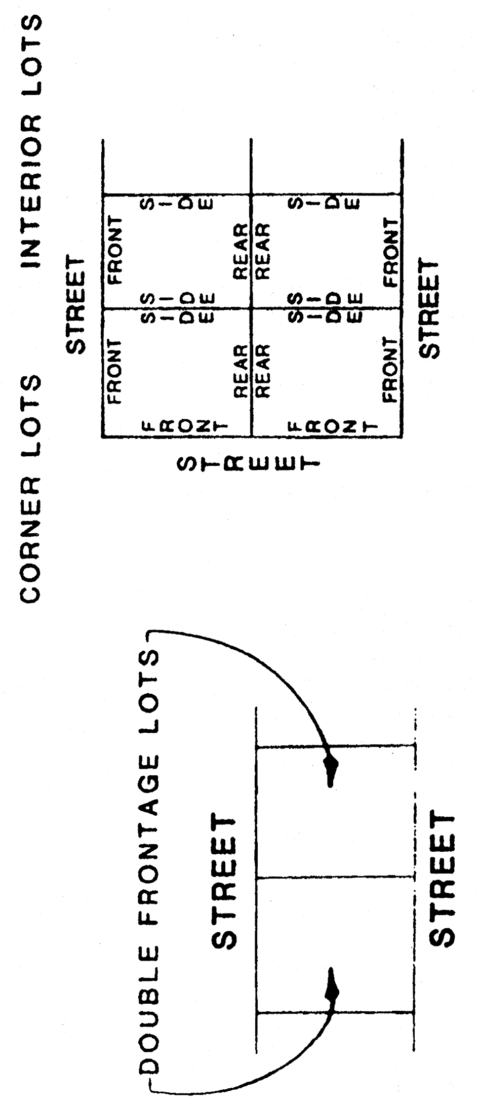
Lots Diagram
Year the word "year" shall mean a calendar year, unless a fiscal year is indicated.
Year-round units housing units available or intended for occupancy at any time of the year. A unit in a resort area occupied either on a year-round basis or occasionally throughout the year is also considered as year-round.
Zero lot line the location of a building on a lot in such a manner that one or more of the building's sides rests directly on a lot line.
Zone a portion of the territory of the county, exclusive of streets, alleys, and other public ways, within which certain uses of land, premises, and buildings are not permitted and within which certain yards and open spaces are required and certain height limits are established for buildings.
Zone of aeration the area where both air and moisture are found in the spaces between soil and rock particles.
Zone of saturation the area where every pore space between rock and soil particles is saturated with water.
Zone of imminent collapse means an area subject to erosion adjacent to the shoreline of an ocean, bay, or lake and within a distance equal to ten (10) feet plus five (5) times the average annual long-term erosion rate for the site, measured from the reference feature.
Zoning district any section or area of Indian River County for which the zoning regulations governing the use, placement of structures, yard and setback requirements, and size and dimension criteria are uniform.
(Ord. No. 90-16, § 1, 9-11-90; Ord. No. 91-7, § 1, 2-27-91; Ord. No. 91-23, § 1, 5-15-91; Ord. No. 91-48, §§ 1—7, 12-4-91; Ord. No. 92-39, §§ 1—4, 9-29-92; Ord. No. 93-7, § 2, 3-18-93; Ord. No. 93-8, §§ 2—7, 32, 3-18-93; Ord. No. 93-29, §§ 1B, 3A, 3B, 4A—4D, 12A, 9-7-93; Ord. No. 94-1, §§ 1A, 2A, 5A—5C, 1-5-94; Ord. No. 94-25, §§ 18(G), (H), 19, 8-31-94; Ord. No. 95-10, §§ 8A, 20A, 5-31-95; Ord. No. 96-6, § 1, 2-27-96; Ord. No. 97-16, § 1(A), (B), 5-6-97; Ord. No. 98-9, §§ 2A, 6, 5-19-98; Ord. No. 99-26, § 2, 9-28-99; Ord. No. 99-13, § 1, 5-5-99; Ord. No. 2000-004, § 1, 2-15-00 Ord. No. 2000-026, § 1, 7-18-00; Ord. No. 2001-016, § 1, 6-19-01; Ord. No. 2002-030, § 1, 11-12-02; Ord. No. 2003-001, § 1, 1-21-03; Ord. No. 2004-041, § 1, 12-7-04; Ord. No. 2007-012, § 1, 3-20-07; Ord. No. 2008-021, § 1, 12-16-08; Ord. No. 2011-008, § 2, 9-13-11; Ord. No. 2012-013, § 1, 7-10-12; Ord. No. 2012-023, § 1, 7-10-12; Ord. No. 2012-036, § 2, 11-6-12; Ord. No. 2014-012, §§ 1, 2, 6-17-14; Ord. No. 2015-013, § 1, 9-22-15; Ord. No. 2015-014, § 1, 10-13-15; Ord. No. 2015-015, § 1, 10-13-15; Ord. No. 2016-011, § 1, 10-18-16; Ord. No. 2017-002, § 1, 3-7-17; Ord. No. 2022-002, § 2, 2-1-22; Ord. No. 2022-014, § 1, 12-6-22; Ord. No. 2023-13, § 1, 9-26-23; Ord. No. 2023-014, 10-17-23)