Indian River County Unincorporated
City Zoning Code
City Zoning Code
CHAPTER 914
SITE PLAN REVIEW AND APPROVAL PROCEDURES
Section 914.01.- Title.
This chapter, the terms and provisions contained herein, shall be known as the "Site Plan Ordinance" of Indian River County, Florida.
(Ord. No. 90-16, § 1, 9-11-90)
Section 914.02. - Purpose and intent.
The purpose of this section is to establish uniform requirements and procedures for reviewing applications for site plan approval. It is further the intent of this section to establish procedures and standards to implement the goals and policies of the Indian River County Comprehensive Plan, and to ensure compliance with the intent, standards, and procedures of all applicable land development regulations.
(Ord. No. 90-16, § 1, 9-11-90)
Section 914.03. - Definitions.
All terms used in this chapter are defined in Chapter 901 of this code.
(Ord. No. 90-16, § 1, 9-11-90)
Section 914.04. - Applicability.
(1)
All site plan applications shall be reviewed pursuant to the procedures set forth in this chapter. Site plans shall be required for each of the following:
(a)
All permitted uses except single-family residences, duplexes on individual lots or parcels of record, and permitted agricultural uses.
(b)
All developments proposing a "change of use."
(c)
All uses requiring an administrative permit.
(d)
All uses requiring special exception approval.
(e)
Planned developments (P.D.), as specified in Chapter 915.
(Ord. No. 90-16, § 1, 9-11-90; Ord. No. 2025-001, § 3, 1-14-25)
Section 914.05. - Technical review committee; duties and responsibilities.
(1)
Refer to Chapter 902 for the establishment, duties, and responsibilities of the technical review committee (hereafter referred to as TRC).
(Ord. No. 90-16, § 1, 9-11-90)
Section 914.06. - General thresholds and procedures for site plan review and approval.
(1)
Site plan thresholds.
(a)
Major site plans. The following projects shall constitute major site plan projects and shall require, except as noted in paragraph 4 below, major site plan approval.
1.
Residential projects having three (3) or more dwelling units.
2.
Nonresidential projects comprised of five thousand (5,000) square feet or more or new impervious surface area, or projects comprised of new impervious surface area representing more than ten (10) percent of the site/area of development, whichever is less.
3.
Where three (3) or more minor site plan requests or six (6) or more administrative approval requests for a single project area/site have been submitted and approved over any five-year period of time; where potential cumulative impacts exceed the criteria of a major site plan application or together may create a substantial impact, the director of the community development department may require any subsequent minor site plan or administrative approval application to be reviewed pursuant to the criteria of a major site plan.
4.
The following major site plan projects shall require the same approval process required of minor site plan projects:
a.
Residential projects that constitute a permitted use and that propose less than twenty-five (25) residential units.
b.
Nonresidential projects involving less than one hundred fifty thousand (150,000) square feet of new impervious surface area, regardless of new building area amount.
c.
Solar facilities located in the A-1, A-2, and/or A-3 zoning districts regardless of new impervious area.
(b)
Minor site plans. The following projects shall constitute minor site plan projects and shall require minor site plan approval.
1.
Nonresidential projects comprised of less than five thousand (5,000) square feet of new impervious surface area.
2.
Nonresidential projects adding or replacing two thousand (2,000) square feet or more of building gross floor area that do not constitute a major site plan.
(c)
Administrative approvals. The following projects shall constitute administrative approval site plan projects and shall require administrative approval.
1.
A modification or alteration to any project covered in section 914.04 of this chapter, consisting of less than one thousand five hundred (1,500) square feet of new impervious surface area which does not require major or minor site plan approval.
2.
Improvements or activities which are required to obtain administrative approval pursuant to requirements specified in other chapters of this code.
(2)
Formal pre-application conference required. For site plans over twenty (20) residential units or over forty thousand (40,000) square feet of new impervious surface a formal pre-application conference is required.
(a)
[Generally.] Applicants are required to participate in a pre-application conference with appropriate county staff prior to submission of a site plan application. All pre-application conference materials are to be submitted by the applicant to the planning division at least seven (7) working days prior to any scheduled pre-application conference.
(b)
[Purpose.] The purpose of the formal pre-application conference is to provide the applicant with the opportunity to explain the proposed development concepts to the staff, and for the staff to examine the policies, ordinances, standards, opportunities and constraints which may be applicable to the site and type of proposed development before the applicant has invested substantial design time or become committed to particular design solutions. The pre-application conference is for informational purposes only and does not confer any approval or waive any requirements that may be applied to any subsequent formal applications.
(c)
Scheduling. Arrangements for this formal conference are to be made through the community development department office by submitting the required application and drawings at least seven (7) working days in advance of the conference date. A filing fee, as established in a resolution adopted by the board of county commissioners, is required at the time of submittal.
1.
The planning division shall review all submitted formal pre-application conference materials to ensure completeness before distribution to reviewing departments and agencies. Incomplete submittals shall not be routed. The planning division shall contact the applicant regarding any incomplete items or materials, so that the applicant can then complete the submittal.
(d)
Submittal requirements. The following shall be provided by the applicant, in the appropriate written or graphic form:
1.
A complete application;
2.
Ten (10) plan sets (twenty-four (24) inches by thirty-six (36) inches) depicting:
a.
Proposed buildings and structures;
b.
Proposed parking areas, vehicular and pedestrian circulation systems;
c.
Location map;
d.
All driveways and roadways near the site;
e.
Open space and all required buffer areas, and native vegetation preservation areas;
f.
Right-of-way and traffic improvements, existing conditions and proposed improvements;
g.
Drainage features, environmentally sensitive areas and environmentally significant areas;
h.
conceptual stormwater management systems;
i.
All fire lanes and emergency access ways;
j.
Location of existing and proposed fire hydrant(s) within five hundred (500) feet.
k.
Provisions for fire protection water supply.
3.
Written data including:
a.
parcel size and proposed uses(s);
b.
proposed number of dwelling units and density (if applicable);
c.
for non-residential uses, the proposed area in square feet for each use proposed;
d.
provisions for water and wastewater;
e.
zoning, land use designation, and existing use(s) of the subject site and adjacent properties;
f.
demonstration that any and all applicable specific land use criteria can be satisfied by the proposed project.
g.
name, address and telephone number of the applicant, surveyor and engineer and a list of all the owners of the property (must be on the application and the drawings);
(3)
Formal pre-application conference optional. For all site plan applications not requiring a formal pre-application conference prior to application submission pursuant to section 914.06, a formal pre-application conference is recommended by staff but is solely an option available to an applicant. Applicants should confer with planning staff to discuss any applicable site plan requirements.
(4)
Submission of formal site plan application and fees.
(a)
Application submittals. All applications for major site plans, minor site plans and administrative approvals shall include:
1.
All required fees as established by the board of county commissioners;
2.
All other necessary county permit applications and information (such as right-of-way, land clearing, tree removal, stormwater, traffic impact statement or study);
3.
A deed for the subject property;
4.
Authorization from the owner for the applicant/agent if different from the owner; and
5.
A concurrency certificate or evidence of application for a certificate, a determination by staff that the project does not require a concurrency certificate, or an acknowledgement that the applicant will apply for a concurrency certificate. The acknowledgement shall be in writing on a form provided by Indian River County.
(b)
Form. All application packages shall be submitted in a form and in a complete manner as specified by the planning division on the site plan application form.
(c)
Application expiration. All applications shall expire and become null and void if approval is not obtained within twelve (12) months from the date a complete application is received by the planning division.
(d)
Application extensions. Upon finding of good cause, the community development director may grant one extension for a period of one year. No further site plan application extensions may be granted. If denied, all appeals of such decisions shall be heard by the planning and zoning commission. All appeals must be filed within ten (10) days of notification of denial. Appeal procedures shall be as specified in Chapter 902.
(5)
Departmental review of site plan applications.
(a)
Coordinating division. The planning division shall be responsible for the coordination of all site plan reviews. Applicants shall submit all applications and materials to the planning division.
(b)
Completeness review:
1.
The planning division shall review all applications to ensure completeness before distribution to reviewing departments and agencies. Only complete applications will be distributed to the reviewing departments and agencies. Failure to submit required application material will result in the application material not being distributed; the application will be deemed incomplete. Planning staff shall notify the applicant within three (3) working days of submittal if the application is incomplete and will route the proposed site plan within three (3) working days of a determination of application completeness.
2.
Applicants shall have thirty (30) days from the notice of an incomplete application to complete the application; failure of the applicant to complete the application within the thirty (30) day period shall void the application request.
3.
Once the application is deemed to be complete, it will be distributed by the planning division for departmental review, and consideration at the appropriate TRC meeting.
(c)
Application distribution for review. For complete applications, the planning division shall distribute all appropriate application material(s) to the appropriate TRC members, all appropriate county departments, and other state, regional and local review agencies.
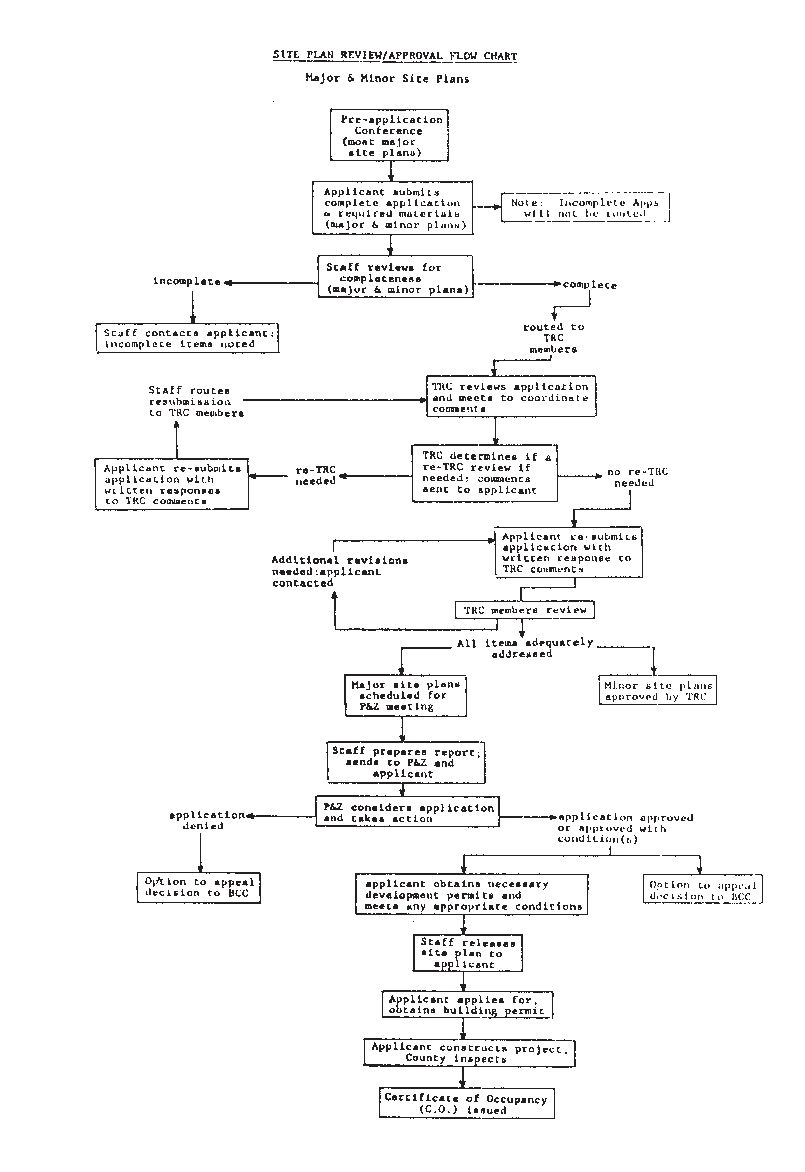
(d)
TRC review and comments. Each TRC member shall review the application and submit written comments to the planning division within eighteen (18) days after the routing of the site plan application materials and prior to the TRC meeting date at which the application is scheduled to be considered.
Prior to each TRC meeting, the planning division shall conduct an inter-departmental staff coordination meeting to coordinate draft comments and transmit post-coordination meeting draft comments to the applicant by email or similar medium prior to the TRC meeting. The technical review committee shall consider each application, shall complete a technical evaluation of the site plan application, shall identify any deficiencies or discrepancies, and for each comment shall either indicate that the comment involves a code, safety, or engineering requirement or that the comment is advisory. Comments shall consist of the draft comments and items discussed at the TRC meeting. Complete and final comments on all applications considered at the TRC meeting shall be assembled and forwarded to the applicant within four (4) working days. At the discretion of the technical review committee, applications with substantial deficiencies may, upon post-TRC re-submittal, be scheduled for re-review at another technical review committee meeting.
(e)
Resubmission, staff-level approval, and scheduling major site plans for planning and zoning commission consideration. The applicant's response to the TRC comments shall consist of five (5) revised plan sets, a traffic study if required by Chapter 952 regulations, a concurrency certificate or evidence of application for a concurrency certificate if required by Chapter 910 regulations, and an itemized letter that recites each staff comment, details how each comment has been adequately addressed, and states where any corresponding plan revision can be located. Once all comments have been adequately addressed, all technical and informational requirements met, and the commenting members of the TRC have recommended approval or approval with conditions on the application, the application shall be approved by the community development director or his designee if staff-level approval, or scheduled for consideration before the planning and zoning commission if not staff level approval.
1.
An applicant may request, at any time in the review process, that the application be forwarded to the planning and zoning commission for consideration. Said request shall be submitted to the planning division in writing and shall acknowledge that, in staffs opinion, the application is not ready for consideration due to a lack of adequate responses to staff and/or reviewing agency comments.
(f)
Approval of minor site plans. The TRC is authorized to approve, approve with conditions or deny minor site plan applications not requiring planning and zoning commission approval. Within seven (7) working days after the applicant submits to staff a complete response to TRC comments (also known as a resubmittal), the county shall either issue site plan approval or a comment letter. Once all commenting TRC members have reviewed and approved the applicant's responses to comments, the minor site plan shall be signed and approved. All approved minor site plans shall be signed by the community development director or his designee.
(g)
For all site plan applications that are not associated with a request involving a public hearing but are required to be reviewed by the Planning and Zoning Commission, the applicant shall submit the following along with his response to TRC comments and revised site plans:
A separate document that verifies the duration of the required sign posting and summarizes all contacts with the public. The summary shall, at a minimum, describe the nature of contacts (e.g. from nearby resident, by phone), the types of comments received, and changes to the project proposal (if any) based on comments received.
(h)
Appeals of decisions made by the community development director or by the TRC may be made by applicants pursuant to the provisions of Section 914.13.
(6)
Planning and zoning commission decision. The planning and zoning commission shall consider each site plan application scheduled for consideration by the TRC and shall base its decision on the use, size and dimension regulations for the respective zoning district, the site review standards established herein and all other applicable land development regulations, and comprehensive plan policies. The planning and zoning commission may impose conditions on-site plan approval which ensure compliance with all applicable land development regulations and comprehensive plan policies.
(a)
All site plan application decisions of the planning and zoning commission for uses not requiring special exception approval are final unless appealed in accordance with the provisions of section 914.13 and 902.07.
(Ord. No. 90-16, § 1, 9-11-90; Ord. No. 91-23 § 8, 5-15-91; Ord. No. 91-48, § 42, 12-4-91; Ord. No. 93-29, § 7, 9-7-93; Ord. No. 94-25, § 10, 8-31-94; Ord. No. 95-10, § 5, 5-31-95; Ord. No. 2000-015, §§ 5, 7, 5-9-00; Ord. No. 2001-016, § 11, 6-19-01; Ord. No. 2001-032, §§ 1, 2, 10-23-01; Ord. No. 2002-004, § 2, 2-12-02; Ord. No. 2006-012, § 5, 4-11-06; Ord. No. 2018-004, §§ 1, 2, 3-13-18; Ord. No. 2023-016, § 1, 10-31-23; Ord. No. 2025-001, § 4, 1-14-25)
Section 914.07. - Administrative approvals and modifications to approved site plans.
(1)
[Generally.] Administrative approvals apply to all uses which require site plan approval under section 914.04 of this chapter. The intent of the Administrative Approval process is to provide a mechanism for minor alterations to the condition of a site or structure or the establishment of minor facilities and structures.
(a)
Threshold. Administrative approval is required for additions, removals or alterations, or the establishment of a new facility or structure to a project site, which constitutes an increase of less than one thousand five hundred (1,500) square feet of new impervious surface.
(b)
Administrative approvals may be required for other types of structures or site modifications, when specifically required in other sections of the land development regulations.
(c)
Conceptual administrative approvals may be obtained in order to satisfy the conceptual site plan approval requirements for affordable housing "grant" applicants seeking funding assistance. Conceptual administrative approvals shall be initially reviewed at a formal pre-application conference, if required, per Section 914.06(2), and then shall follow the administrative approval review procedures of Section 914.07(2).
(2)
Review procedures. All administrative approval applications and materials shall be submitted to the planning division. The planning division shall ensure that the applications are complete and that complete application materials are routed to the appropriate reviewing departments and agencies.
(a)
All administrative approval applications and materials shall be submitted in a form and quantity as specified by the planning division on the application form.
(b)
Administrative approval applications and materials shall demonstrate that all the existing land development regulations are satisfied as applied to the proposed area of development.
(c)
The current development section chief will assign the application to a staff planner for review within one day of submission.
(d)
The reviewing planner shall review the application for completeness and contact the applicant if more information is needed.
(e)
The reviewing planner will obtain comments from all applicable TRC members. The reviewing planner shall forward comments, if any from the reviewing departments and agencies to the applicant.
(f)
Once the applicant has responded to reviewing department and agency comments, if any, and all applicable reviewing departments and agencies have approved the application, the application shall be presented to the community development director for approval, approval with conditions or denial.
(g)
Decisions of the community director may be appealed in accordance with the provisions of Chapter 902.
(3)
Amendments to approved site plans.
(a)
Scope of authority of community development director. The community development director is authorized to approve, approve with conditions, or deny administrative approval applications.
(b)
Limits of authority of community development director. The community development director is not authorized to approve any modification(s) to approved plans which would:
1.
Increase the square footage of buildings, structures or increase a site's impervious area above administrative approval thresholds;
2.
Increase the number of dwelling units; or
3.
Grant any approval that would constitute a variance from the requirements of this ordinance.
(c)
Classifying amendment requests; minor and major. Any amendments to approved site plans where such amendments are not deemed by the community development director to be minor modifications shall be reviewed and approved in the same manner as the original plan.
(d)
Appeals. Decisions of the community development director shall be as provided for in Chapter 902.
(Ord. No. 90-16, § 1, 9-11-90; Ord. No. 2018-020, § 1, 9-18-18)
Section 914.08. - Time limitations on-site plan approval.
(1)
Commencement of construction.
(a)
All site plan approvals shall terminate and become null and void automatically without notice if construction has not commenced within twenty-four (24) months from the date of approval.
(b)
For the purposes of this paragraph, construction will have commenced when the developer has built a portion of a structure shown on the plan (e.g. the pouring of footers), or has made substantial improvements to the site, other than land clearing, or filling or grading, in accordance with the approved site plan, evidencing a good faith effort to diligently pursue construction to completion in accordance with completion dates noted on the approved plans.
(2)
Extensions of site plan approval. Site plan approval may be extended one-time only for good cause. Site plan approvals that were granted by the planning and zoning commission may be extended by the board of county commissioners for a period not to exceed twelve (12) months. Site plan approvals that were granted at staff level may be extended by staff for a period not to exceed twelve (12) months. All requests for extensions must be in writing, and must be received by the planning division prior to expiration of the site plan approval that is the subject of the extension request.
(a)
During review of an extension request, the county shall consider the following:
1.
The effect any delay in proposed project construction and completion will have on the concurrency management system.
2.
The impacts of having any new and existing regulations applied to the project, and whether or not the project will comply with regulations in effect at the time the extension request was filed.
(b)
The county may attach conditions to a site plan extension approval that furthers the intent and purpose or satisfies the requirements of any comprehensive plan policies or land development regulations in effect at the time the extension request was filed.
(c)
No extensions may be granted unless the county determines that an extension satisfies the applicable requirements of the concurrency regulations of Chapter 910.
(3)
Abandonment of construction.
(a)
In cases where construction has commenced according to paragraph 914.08(1)(b) of this chapter and has been subsequently abandoned, the site plan approval shall terminate and become null and void if, after notice to the applicant or successors in title (of record) and hearing by the board of county commissioners, the board moves to terminate the approval. In lieu of approval termination, the board at its discretion may move to validate the approval with conditions that will ensure compliance with any and all then-existing land development regulations and comprehensive plan policies.
(b)
For the purposes of this paragraph, construction shall be considered abandoned or suspended if at the hearing it is shown that an active building permit has not been maintained for the construction of a structure in accordance with the completion dates noted on the approved plan or it is shown to the satisfaction of the board of county commissioners that construction at a level indicating a good faith effort to proceed with completion of the project has not occurred for a continuous period of six (6) months immediately preceding the receipt of notice unless the inactivity is attributable to the deliberate and scheduled phasing of a multi-phase project which has been approved as such by the county.
(c)
Upon determination by the community development director to pursue termination, the county building division shall issue a stop work order for the project. Said order shall be effective until determination by the board of county commissioners. This subsection shall not operate to invalidate any site plan prior to the end of the initial twelve-month period or any authorized extension thereof.
(d)
The board of county commissioners shall consider the time elapsed since the last sigificant construction, any evidence from the developer which indicates a good faith effort to diligently pursue construction to completion, and the impact of permitting the project as approved as compared to the project if approved under a new application in conformance with then-existing land development regulations and comprehensive plan policies.
(e)
If the project's approval is terminated, the board of county commissioners may require the removal of construction work (earth work or structures) which may pose a threat to the public health, safety or welfare, or may otherwise conflict with land development regulations or comprehensive plan policies.
(f)
If the project's approval is not terminated, the project may proceed under timeframes set by the board for the completion of the project.
(Ord. No. 90-16, § 1, 9-11-90; Ord. No. 2009-002, § 3, 2-17-09; Ord. No. 2012-018, § 7, 7-10-12)
Section 914.09. - Transfer of site plan approval.
(1)
Approval runs with the land.
(a)
A site plan approval shall run with the land and shall transfer to a successor in interest from the original applicant upon written disclosure of such transfer to the planning division as to the identity of the successor. The disclosure shall provide the full legal name of the person or business entity acquiring the interest in the property, the nature of the interest, the address of the principal place of business of the successor, telephone number, name and address of registered agent; if the successor is a corporation. In addition, the following information shall be provided: name, address and title of officers or agents authorized to transact business with the County, together with proof of authorization if other than president or vice-president or general partner, and the name and address of any new design professional for the project.
(b)
A transferee developer must also assume in writing on a form acceptable to the county attorney all commitments, responsibilities, and obligations of the prior developer, including all conditions of site plan approval and all the obligations, conditions and requirements of all applicable development permits (including permits from other jurisdictional agencies).
(2)
Disclosure of required information. Failure to make the required disclosure and assumption shall suspend all site plan and zoning approvals until such time as proper disclosure and assumption is made.
(3)
Time limits. Transfer of site plan approval shall not toll or modify the calculation of time limits set forth with respect to commencement or abandonment of construction; following any transfer, such time limits shall be calculated as if the transfer had not occurred.
(4)
Transferability exceptions. This provision does not relate to any transfer of space, units, buildings, or property to a transferee who intends to occupy the property only after issuance of a certificate of occupancy, unless the transferee is the successor developer, nor to the creation or transfer of a nonpossessory lien or encumbrance.
(Ord. No. 90-16, § 1, 9-11-90)
Section 914.10. - Timing of release of approved site plans.
(1)
Issuance of necessary permits.
(a)
It may be necessary for some projects to seek permits from governmental agencies other than the county. In such cases, approved site plans for these projects shall not be released until the applicant submits proof of approval or certification of compliance from those agencies to the planning division when applicable to the project.
(b)
The building division shall not issue a building permit until the applicant has obtained site plan release. The planning division shall release approved site plan sets to the applicant when the applicant demonstrates that all conditions of site plan release are met and when a site plan release form has been completed and signed.
(c)
It is the responsibility of the applicant to list on the plan all permitting agencies which have jurisdiction within the project and the type of permit required.
(d)
Agencies from which permits may be required include, but are not limited to, the following:
1.
Florida Department of Environmental Regulation;
2.
Florida Department of Transportation;
3.
U. S. Army Corps of Engineers;
4.
St. John's River Water Management District;
5.
Florida Health and Rehabilitation Services;
6.
Indian River Farms Water Control District;
7.
St. John's Drainage Water Control District;
8.
Fellsmere Water Control District;
9.
Sebastian River Drainage District;
10.
Other municipalities;
11.
All applicable Indian River County agencies;
12.
Florida Department of Natural Resources;
13.
United States Coast Guard;
14.
Federal Aviation Authority.
(e)
Payment of required county fees. Evidence that the applicant has paid all county fees payable prior to site plan release, including utilities impact fees and application fees, must be submitted to the planning division prior to the release of site plan.
(f)
Dedication of right-of-way. All approved site plans which require lands to be dedicated for road right-of-way will be released by the planning division only after the deed(s) for the right-of-way has been properly executed and accepted by the Indian River County attorney's office for recording. In cases where a dedication requirement is contested by litigation, the deed may be escrowed pending the outcome of the litigation, and the site plan may be released.
(g)
Granting of easements and other required legal documents. All approved site plans which require an easement(s) to be granted or other document(s) (such as unity of title form) to be executed shall be released by the planning division only after the required document(s) have been executed and are in recordable form as determined by the county attorney's office.
(Ord. No. 90-16, § 1, 9-11-90)
Section 914.11. - Timing of issuance of building permits.
No site plan shall be released and no building permit shall be issued by the county until the deadline has passed for appeals to either the planning and zoning commission or the board of county commissioners regarding site plan decisions as applicable, as provided for in section 914.13. If an appeal is so filed, no site plan shall be released until after a final decision of such appeal has been made in accordance with the provisions of Chapter 902. No building permit shall be issued, or in cases of after-the-fact approval no final inspection shall be performed, until all decisions regarding the appeal have been finalized.
(Ord. No. 90-16, § 1, 9-11-90)
Section 914.12. - Inspection and certification.
(1)
Site inspections. Upon approval of a site plan and prior to site plan release, the applicant shall notify the Indian River County planning division in writing of the intent to begin construction and shall submit a proposed construction schedule. Said schedule dates shall not exceed those noted on the approved plans without approval of the community development director. The division may conduct periodic inspections to ensure that the project is completed in accordance with the approved site plan.
(2)
Minor variations. Minor variations in the approved site plan area may be permitted upon approval by the community development director of an administrative approval. Said approval shall be in writing and shall be affixed to the site plan. Cease and desist orders may be issued by the community development director or his designee when violations are discovered. All work not in conformity with the approved site plan shall cease until approval is given by the appropriate approving body or entity.
(3)
Final certification.
(a)
The applicant's site plan professional (architect or engineer) of record shall notify the planning division when the project is completed and shall so certify in writing under seal that the project has been completed and is substantially in conformance with the approved site plan and all county and jurisdictional agencies' permits and conditions attached thereto.
(b)
In cases where an architect's or engineer's services are not required, the applicant shall notify the community development director when the project is complete and shall so certify in writing that it conforms to the approved site plan, that all conditions of site plan approval have been satisfied, that it complies with all necessary county and jurisdictional agency permits and any conditions attached thereto, and that any variations have been approved in writing by the community development director.
(c)
The appropriate reviewing departments shall make a final inspection and verify that the project was completed in accordance with the approved site plan. Notice of verification shall be transmitted in writing to the building division director who shall ensure that copies of final certifications of approval are transmitted to the planning director, to be placed in the project file. No certificate of occupancy (C.O.) or its equivalent shall be issued unless and until the appropriate reviewing departments have verified that the project has been completed in accordance with the approved site plan. For purposes of this section a certificate of occupancy or its equivalent shall be required prior to the operation or occupancy of a building or facility for its ultimate intended residential, commercial or industrial use.
(4)
Funds for required improvements.
(a)
All applicants having site plans which require funds to be escrowed or other security posted for future required improvements must deposit those funds or post security in the form of a letter of credit drawn on a Florida Financial Institution, or provide a performance bond or other surety issued by a company authorized to do business in the State of Florida with the county prior to the issuance of a certificate of occupancy.
(b)
The funds or financial security must be accompanied by an agreement that specifies the purpose and use of the funds and obligations of the applicant, acceptable as to form and legal sufficiency to the county attorney's office.
(5)
Fees. All inspections of a site other than the initial check and one re-inspection shall require the payment of a fee to the planning division by the applicant. Said fee shall be established by resolution of the board of county commissioners.
(Ord. No. 90-16, § 1, 9-11-90; Ord. No. 91-23, § 9, 5-15-91)
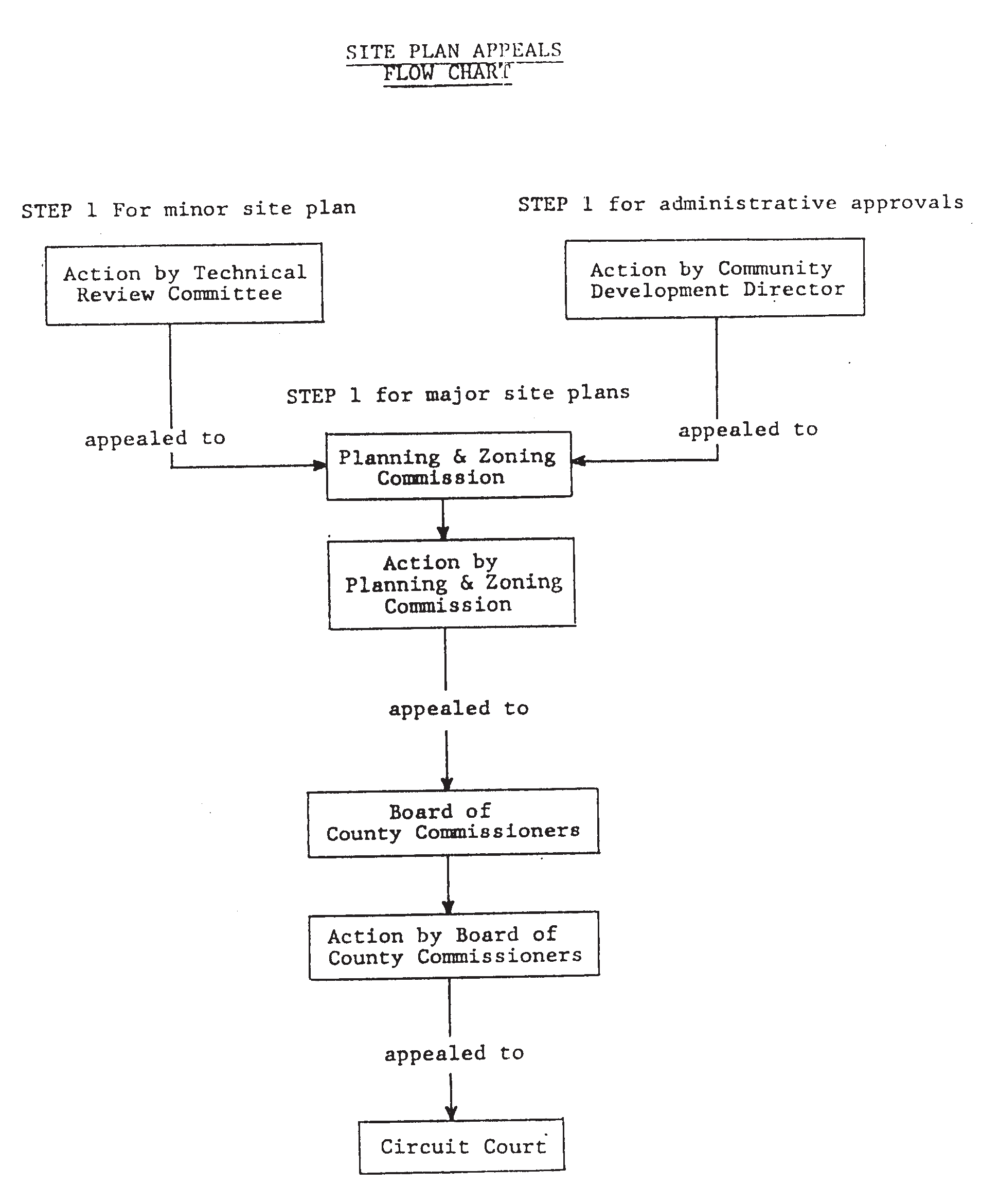
Section 914.13. - Appeals of decisions regarding site plans.
Appeals of site plan decisions rendered by the community development director or by the technical review committee (TRC) may be made in accordance with the provisions of section 902.07," Appeals from decisions of the community development director or his designee." Appeals of planning and zoning commission-site plan decisions may be filed by:
(1)
The applicant;
(2)
County administration;
(3)
Any aggrieved person or group with an interest that will be affected by the project.
An appeal of a planning and zoning commission decision on a site plan must be filed with the community development department within twenty-one (21) days of the meeting wherein the decision appealed was rendered. Upon receipt of an appeal from the appellant, the county administrator will place the site plan application and all recommendations on the agenda of a regularly scheduled meeting of the board of county commissioners for consideration within thirty (30) days. The board of county commissioners will conduct a de novo hearing. The procedures of section 902.07(3) shall apply and the board of county commissioners shall make findings with respect to the criteria of section 902.07(4). Any appellant must receive three (3) affirmative votes from the board of county commissioners to prevail in the appeal.
(Ord. No. 90-16, § 1, 9-11-90; Ord. No. 93-29, § 9, 9-7-93; Ord. No. 2002-004, § 3, 2-12-02)
Section 914.14. - Site plan submittal requirements.
(1)
Purpose and intent. The purpose of this section is to ensure that all major and minor (including administrative approval) site plan applications include sufficient information and analysis for proper review and consideration in light of the comprehensive plan and land development regulations.
(2)
Applicability. All information required herein shall be provided as part of a complete site plan application. All major site plans shall be prepared and sealed by a Florida registered architect or engineer.
(3)
General submittal requirements.
(a)
Three (3) surveys meeting the minimum technical standards and containing the information required in section 914.14(9), are required for major site plans, and may be required by the community development director for minor site plans and administrative approvals.
(b)
Ten (1) plan sets containing all the information required in this section (914.14). If a formal pre-application conference was held for the project, the applicant shall submit a written response to each item in the project's pre-application conference discrepancy letter or a written description of all revisions made to the project plans since the pre-application conference review.
(c)
A completed and signed site plan application form (furnished by the planning division).
(d)
A completed and signed land clearing and tree removal permit application pursuant to Chapter 927, or a completed acknowledgement form (furnished by the planning division) stating that no tree removal and/or land clearing as defined in Chapter 927 is to take place on-site.
(e)
When applicable, a completed stormwater management application and two (2) copies of the stormwater report pursuant to the requirements of Chapter 930.
(f)
A landscape plan meeting the requirements of Chapter 926.
(g)
A copy of the deed for the subject property.
(h)
Written authorization from the property owner(s) if the applicant/agent is other than the property owner(s).
(i)
A concurrency certificate, or evidence of application for a concurrency certificate, or a copy of the approved traffic methodology for the development project.
(j)
For minor site plans and administrative approvals, the community development director or his/her designee may waive or modify submittal, information, tabulation, or any other application requirements if he/she deems that such information is not necessary or appropriate for a review of the proposed project.
(k)
Traffic impact study. All proposed developments which are determined to generate four hundred (400) or more average daily trips, or are located at a critical transportation location as determined by the public works director, shall submit a traffic study pursuant to the requirements of Chapter 952 prior to the post-TRC resubmittal. All projects generating between four hundred (400) or more average daily trips shall submit traffic impact studies prior to the post-TRC resubmittal.
(l)
A shared (non-concurrent) parking study shall be required where there is a proposal by the applicant to reduce normal parking requirements pursuant to section 954.08 of the land development regulations.
(4)
Conceptual site plans; submittal and informational requirements.
(a)
The intent of the conceptual site plan and process is to approve the use, scope, level of intensity, and scale of the proposed project. Also, the concept plan may address and allow approval of specific and detailed, project-wide, design requirements (e.g. drainage, landscaping, parking provisions) that satisfy applicable development regulations. Such plans may be approved for the level of detail covered by the site plan application, as reviewed and approved by staff. Approval of the conceptual plan shall vest the project in relation to county development regulations, at the level of detail of information and design indicated on the approved plans. The design of the overall project will be considered as it relates to general site plan requirements and any applicable specific review criteria contained in Chapter 971. Conceptual site plan applications may be submitted as requests for approval of special exception, administrative permit, or permitted uses. If a conceptual site plan request is approved, a separate and complete, "final" site plan application shall be submitted, reviewed, approved, and released (as specified in this Chapter 914), prior to issuance of a building permit for all or a portion of the development project. Conceptual site plan approval for affordable housing projects seeking funding assistance shall follow the conceptual administrative approval process outlined in Section 914.07(1)(c).
(b)
The following are submittal requirements for conceptual plan applications:
1.
A complete application form with the appropriate review fee.
2.
Two (2) copies of the owners deed and two (2) copies of a letter of authorization from the owner if the owner is different from the applicant.
3.
Ten (10) plan sets to scale on twenty-four-inch by thirty-six-inch sheets at a scale of not greater than one inch equals fifty (50) feet. If a formal pre-application conference was held for the project, the applicant shall submit a written response to each pre-application conference discrepancy letter item.
4.
A written description of the proposed use.
5.
Verification that a concurrency certificate has been applied for, or a determination by staff that the project does not require a concurrency certificate, or an acknowledgement that the applicant will apply for a concurrency certificate. The acknowledgement shall be in writing on a form provided by Indian River County.
6.
The plan shall depict the following information:
a.
Building envelope locations;
b.
Parking areas and circulation patterns;
c.
Stormwater management tract locations;
d.
Setbacks from all property lines;
e.
The location of all driveways;
f.
An estimate of average daily trips (for those uses not required to perform a traffic impact analysis);
g.
Flood zone;
h.
Location map;
i.
Any required buffering or conservation/preservation areas;
j.
Existing road rights-of-way;
k.
All fire lane and emergency access ways;
l.
Location of fire hydrant(s).
7.
Project tabulations by phase and aggregate:
a.
Gross area;
b.
Number of units/density;
c.
Area and percent of site as open space;
d.
Area and percent of site as impervious space;
e.
Area and percent of site as building coverage;
f.
Parking requirements;
g.
Approximate building area by use category;
h.
Area and percentage of site as water;
8.
Existing site conditions:
a.
Waterbodies;
b.
Area and location of jurisdictional wetlands shown on aerial photograph or survey;
c.
Native vegetation coverage;
d.
Protected trees or tree groupings;
e.
Topography and drainage features (including canals and ditches), soil types;
f.
Listed historical or archeological features or such features known or evident to the developer;
g.
Wells, free-flowing or valved;
h.
Buildings, structures, or driveways and their disposition (to be removed, to remain, to be altered);
i.
Utilities services and facilities, including water, sewer, electric, telephone, cable;
j.
Easements.
9.
Vehicular and pedestrian systems, circulation plan, including typical or potential travelway surface(s) and right-of-way widths, proposed connections to existing streets and the planned street network in the vicinity of the project. Existing streets and driveways within three hundred (300) feet of the project area.
10.
A traffic impact analysis if required by the Chapter 952 regulations, in accordance with the Chapter 952 regulations.
11.
Vicinity map, showing the land area within three quarters (¾) of a mile of the project area.
12.
Proposed stormwater management design and a signed and sealed letter from a professional engineer certifying that the conceptual stormwater management plan will be able to meet all applicable stormwater management and flood protection criteria of Chapter 930 relating to the retention/detention requirements of the appropriate Land Development Regulations. Unless requested by the applicant and approved by the Public Works Director, the conceptual plan shall in no way be construed as a final design as required by Chapter 930. The results of the drainage study required under Chapter 930 shall govern the retention/detention areas of the final site plan or plat.
13.
When development or alteration of jurisdictional wetlands is proposed, the applicant shall provide the environmental planner with a qualitative assessment of the existing wetlands and indicate on the plans if wetlands mitigation is proposed on-site, off-site, or is to be satisfied by payment of a fee-in-lieu of direct mitigation.
a.
If on-site mitigation is proposed, the applicant shall indicate if restoration and/or creation of wetlands is proposed, the approximate area and location of such restoration and/or creation, the type of wetlands to be restored or created, and alteration/mitigation area ratios.
b.
If off-site mitigation is proposed, the applicant shall indicate the off-site area(s) to be used for mitigation and the information in subsection a., above.
c.
If a fee-in-lieu of mitigation is proposed, the applicant shall provide an estimate of the fee amount, based on the assessed value of the project site and the area of wetlands to be impacted (reference subsection 928.06(5)).
14.
Additional submittal requirements may be required by staff at a formal pre-application conference or a TRC meeting, whichever occurs first, based upon staff concerns and issues particular to the site, surrounding area, or proposed use. The posted sign notice requirements of 914.14(17) and 914.06(5)(g) shall be applied.
(c)
The review and approval process for a conceptual plan application shall be the process appropriate for the use approval level (special exception, administrative permit, permitted).
(5)
All site plan applications shall include statements on the plans regarding each of the following:
(a)
Name of the project;
(b)
Statement of intended uses to occur on the site;
(c)
A statement describing the proposed means of conveying ownership in the property;
(d)
Name, address, and telephone number of all equitable owners;
(e)
Name, address and telephone number of the applicant and firm which he or she represents;
(f)
Name, address, signature, and registration number of the professionals preparing the plan;
(g)
Legal description, including the section, township and range, and the property appraiser's tax parcel number(s) of the subject property;
(h)
Date plan was drawn and date of any subsequent revision(s);
(i)
Approximate timetable (month and year) for completion of the project, and any proposed phases of a phased development project. All phases of multi-phase projects must be able to meet all of the site plan requirements within the subject phase;
(j)
Existing zoning and comprehensive plan land use map designation(s) of the site and adjacent sites;
(k)
Estimated number of vehicle trips attracted to the site using the latest edition of the ITE Trip generation rates, to ensure compliance with the requirements and provisions of Chapter 952.
(6)
All site plan applications shall include the following calculations:
(a)
Gross acreage of the site, to the nearest one-tenth ( 1/10 ) of an acre, and the square footage of sites;
(b)
Number of proposed dwelling units and gross density (residential). Note the total proposed and total permitted density;
(c)
Number of proposed buildings and structures;
(d)
Floor area of each type of proposed dwelling unit;
(e)
Floor area of each structure; if the structure(s) includes areas for different commercial or industrial uses, the floor area for each use-area shall be provided and clearly shown on the site plan;
(f)
Total square feet and percent of site covered by enclosed structures (ground floor building coverage). Note the total provided and the maximum permitted building coverage;
(g)
Total square feet and percent of site covered by impervious surfaces;
(h)
Total square feet and percent of site provided as green open space. Note the total provided and the minimum permitted open space;
(i)
Total square feet and percent of site covered by lakes and wet stormwater retention areas;
(j)
Number of parking spaces required for each use and the total number of spaces provided, including handicapped and compact. Note the total number of required parking spaces and the total proposed;
(k)
Number of loading spaces required and the total number of spaces provided;
(l)
The above calculations should be shown in the following format:
(1)
Gross area _____ (square feet).
(2)
Building coverage _____ (square feet percent of G.L.A.)
Paved area: _____ (square feet percent of G.L.A.)
Green landscaped area _____ (square feet percent of G.L.A.)
Lakes, canals wetlands _____ (square feet percent of G.L.A.)
Other (explain) _____ (square feet percent of G.L.A.)
(3)
Number of structures _____
(4)
Density (residential)
_____ # dwelling unit: Net land _____ acres or square feet equals DU's per acre.
Example: Unit A _____ (# square feet per unit)
Unit B _____ (# square feet per unit)
Unit C _____ (# square feet per unit)
(5)
Floor area (nonresidential)
Building Coverage: sq. ft. 100 percent of building
Retail: sq. ft. _____ percent of building
Office: sq. ft. _____ percent of building
Restaurant: sq. ft. _____ percent of building
Industrial: sq. ft. _____ percent of building
Warehouse: sq. ft. _____ percent of building
Medical: sq. ft. _____ percent of building (other)
(6)
Building height _____
Number of stories _____
(7)
Parking: provide information as shown in the following example:
EXAMPLE
(7)
Vicinity map and location map.
(a)
A location map showing the general location of the site depicted on a roadway map shall be provided. The scale shall be adequate to cover a region of the county.
(b)
A vicinity map insert, separate from the location map, shall be made part of the site plan showing the specific location of the site using the names and location of nearby streets and prominent natural or manmade landmarks. The scale shall be sufficient to indicate the zoning and current land use of the property contiguous to the site, including properties separated from the site by a public or private street.
(8)
Site conditions. The following information shall appear on the site plan:
(a)
Limits of one hundred year (100) floodplain and/or coastal flood velocity areas (V-zones), as shown on the most recent Federal Emergency Management Agency (FEMA) maps.
(b)
Location of the 1987 Coastal Construction Control Line (CCCL) and the dune stabilization setback line (DSSL), if applicable.
(c)
Existing right-of-way width of all adjacent roadways, road names, and setback lines.
(d)
Location and explanation of any existing easements.
(e)
Location and dimensions of any existing structures on the site, and any parking or loading areas.
(f)
Location and width of existing on-site roadways and rights-of-way.
(g)
Location and dimensions of existing driveways and access points on the property and within three hundred (300) feet of the site.
(h)
Specific boundaries and acreage of wetlands and other environmentally sensitive areas, if any.
(i)
Boundaries and acreage of native vegetative communities preservation areas, including ownership, maintenance, and enforcement responsibilities.
(j)
Location of existing utility lines (water, sewer, power, etc., as applicable) and existing private utility systems (wells and septic tanks) shall be shown extending a minimum of two hundred (200) feet from the site's property.
(k)
Statement noting distance from project site to existing water and wastewater lines.
(l)
Location and size of all natural and manmade waterbodies.
(m)
The ultimate right-of-way width as depicted on the county's thoroughfare plan shall be boldly depicted and the amount of any right-of-way deficiencies.
(9)
Criteria for required surveys.
(a)
Certified survey of the site, including property boundaries and their dimensions.
(b)
Existing topography with a maximum of one-foot contour intervals, based upon North American Vertical Datum 1988 (NAVD88).
(c)
Limits of 100-year floodplain and/or coastal flood velocity areas (V-zones), as shown on the most recent Federal Emergency Management Agency (FEMA) maps.
(d)
Location of coastal construction control line and dune stabilization setback line, if applicable.
(e)
Existing right-of-way width of all adjacent roadways and setback lines. The roadway shall be located within the right-of-way.
(f)
Location and explanation of any existing easements.
(g)
Location and dimensions of any existing structures on the site, and any parking or loading areas.
(h)
Location and width of existing on-site roadways and rights-of-way.
(i)
Specific boundaries, and acreage of wetlands and other environmentally sensitive areas, where such areas exist on-site.
(j)
Location and size of all existing natural and manmade waterbodies.
(k)
The location, size and type of all protected trees on-site, pursuant to the requirements and provisions of Chapter 927, unless the location of protected trees are otherwise depicted within the application materials in a manner acceptable to environmental planning staff (such as the development depicted on an aerial photograph) pursuant to the provisions of Chapter 927.
(10)
Graphic requirements. All required graphic information shall be displayed on twenty-four-inch by thirty-six-inch sheets, at a scale of no less than one inch equals fifty (50) feet, and shall include a north arrow, graphic scale and the date the plans were prepared.
(a)
Plans shall be prepared using an engineering scale of between one inch to ten (10) feet and one inch to fifty (50) feet. A smaller scale may be used for all or part of the project depiction when the project cannot fit on a twenty-four-inch by thirty-six-inch plan sheet, upon approval by the community development director.
(b)
All plans shall include a north arrow, a scale, a legend and the date the plans and all revisions were prepared.
(c)
Matchlines shown on all pages if multiple sheets are used.
(d)
Provide a location key sketch for each plan page, showing the portion of the overall project that each plan page covers.
(e)
All phase boundaries and phase designations shall be shown for all multi-phase projects.
(11)
Proposed buildings and structures. The following information for all structures and buildings must be noted or depicted on the plan:
(a)
Intended use of all principal and accessory structures;
(b)
Location, size, type, and orientation of all signs, including traffic and directional signs;
(c)
Three (3) sets of preliminary exterior building elevations and floor plans prepared by a registered architect with registration number noted, as required by Florida Statutes (Section 481.221.) or, for pre-engineered buildings, elevations and floor plans signed and sealed by a registered professional engineer;
(d)
Distance between structures, and the distance between structures and property boundaries;
(e)
Location of exterior mechanical equipment and/or utilities, and method of screening or buffering, if applicable;
(f)
Location, height and type of construction material of fences;
(g)
Location, height and materials utilized for screening;
(h)
Intended means of outdoor lighting, including location, method of shielding the light source from adjacent properties and roadways, and intensity of outdoor illumination and lighting;
(i)
Intended means of buffering or otherwise attenuating potential noise nuisances generated by the proposed use(s).
General traffic circulation and internal vehicular movement. (See Chapter 952 for further traffic requirements).
(12)
The following information is required to be noted or graphically depicted on all site plans:
(a)
Location and dimensions of all existing and proposed driveways and median cuts, and the distance separating them from intersections and other existing or proposed access points within three hundred (300) feet of the project site;
(b)
Designation of all parking spaces, including the number and dimensions of spaces and whether or not such spaces are designated for handicapped or compact car parking;
(c)
Number and designation of loading spaces;
(d)
Surface materials of roadways and driveways;
(e)
Fire lanes which shall be at least twenty (20) feet in width; exception: reduction of fire lane width may be permitted only when approved by the fire division.
(f)
Overall internal circulation plan, including directional arrows and signs to direct traffic flow. The public works director may request additional information on-site distance triangles if conditions warrant;
(g)
Location of existing and proposed on-site traffic-control signs and signalization devices;
(h)
Posted speed limits of abutting roadways;
(i)
Location and specifications of all existing and committed, abutting and/or transitional deceleration lanes, turning lanes, sidewalks, bikepaths, drainage facilities (underground and surface);
(j)
Location of all existing and proposed sidewalks and/or bikeways abutting the site;
(k)
Where shared parking is proposed, all information required in Off-Street Parking Ordinance, Chapter 954 shall be included in the application (three (3) copies, minimum). All standards contained in Chapter 954 shall be satisfied;
(l)
Certain uses may require additional internal circulation features such as customer drop-off or loading zones, short term parking areas, areas restricted to employee parking, or other features or facilities. These features may be required by the planning and zoning commission after a recommendation from the traffic engineer or community development director, to safely provide for traffic circulation and to accommodate the proposed use;
(m)
A handicap access plan meeting the criteria of the Florida Administrative Code.
(13)
General open space, landscape, and vegetation protection.
(a)
Delineation of permanent green open space areas.
(b)
Delineation of areas specifically designated as common open space for residential projects.
(c)
Proposed landscaping areas or other screening or buffer improvements and areas, including location, height and type of perimeter or ornamental walls, fences, landscaping, including berms and other required screening devices.
(d)
Irrigation method utilized and source of water.
(e)
Location of mangroves, specimen trees, historical trees or other protected trees as specified in the Indian River County Tree Protection Ordinance.
(f)
Transition grades to all abutting properties.
(g)
All areas proposed for conservation and preservation, pursuant to the requirements of Chapter 929.
(14)
Water, sewer, solid waste, and other utility facilities.
(a)
All existing water and sewer lines within the boundaries of, or adjacent to, the site must be shown on the site plan.
(b)
All water and sewer lines within the connection distance required by the Florida Administrative Code must be noted on plans or a proposed connection to public water and sewer must be shown.
(1)
All existing and proposed fire protection water lines within the boundaries of, or adjacent to, the site must be shown. This shall include backflow prevention devices, fire department connections, and fire hydrants.
(c)
All existing on-site sewage disposal facilities and wells on the subject property must be shown.
(d)
All existing private sewage disposal facilities and wells within a radius as required by Florida Administrative Code must be shown.
(e)
General locations of all proposed water and sewer lines, utility/power poles, underground power lines, telephone and television cable transmission lines, and other transmission or generation facilities, and all proposed utility easements.
(f)
Location of all proposed water wells, private wastewater treatment facilities, gas transmission lines, fire hydrants or other similar facilities or services.
(g)
Solid waste storage locations and the method of storage and screening must be provided and identified. Where dumpsters are utilized, the location and paving material of the pad shall also be shown. All dumpsters shall be totally enclosed on all sides.
(h)
All proposed and existing utility rights-of-way and easements.
(i)
When the project proposes to utilize a public or private water franchise and/or sewage system, all application and submittal items and information required by the county utilities department must be satisfied.
(j)
All utilities lines shall be underground, except for agricultural projects, and when the subject utility company issues a letter of objection.
(15)
Drainage plan.
(1)
Major site plans. All major site plans shall provide a drainage plan, which includes all of the information and calculation requirements of the Indian River County Stormwater Management and Flood Water Protection Ordinance (Chapter 930), prior to receiving site plan approval. The applicant may submit such a plan with the site plan application or following the approval of a preliminary drainage plan.
(a)
In lieu of providing a complete drainage plan with the application for site plan approval, the applicant may submit a preliminary drainage plan to be evaluated by the technical review committee. All preliminary drainage plans shall include the following information:
(1)
A soil boring log meeting the requirements of the Indian River Stormwater Management and Floodwater Protection Ordinance.
(2)
Percolation tests pursuant to procedures established in the Indian River County Stormwater Management and Floodwater Protection Ordinance.
(3)
A written opinion from a professional engineer (or architect if under one acre) licensed in the State of Florida certifying the size, configuration and loca
tion of all existing and proposed stormwater management improvements are capable of retaining or detaining the first one inch of rainfall on-site.
(4)
Transitional property line grades.
(5)
Finished ground floor elevations.
(6)
The location and tracing of all legal positive outfalls to be used by the site.
(7)
The depth and location of the wet season groundwater table.
(8)
Size, configuration, and location of proposed stormwater management tracts.
(b)
A complete drainage plan, which includes all of the information and calculations required in chapter 930, shall be submitted and a stormwater management permit issued pursuant to the requirements and provisions of chapter 930 prior to the release of any major site plan.
(c)
Type "B" stormwater permit applications shall not be eligible for preliminary drainage review.
(2)
Minor site plans. Minor site plans shall include the following information regarding drainage conditions and improvements:
(a)
One-foot interval contours based upon coastal geodetic datum.
(b)
Proposed finished elevations of each building site and the first floor level. A proposed grading plan shall be submitted.
(c)
Proposed system for the orderly disposal of surface water runoff with the system capabilities of having a minimum ability to accommodate the runoff from the first inch of rain; all swales and retention areas will be located with grades and elevations provided.
(d)
The size and grade of all existing and proposed drainage facilities including culverts and pipes.
(e)
Centerline elevation of any street contiguous to the site measured at the property lines extended.
(f)
Location and method of linkage with off-site drainage facilities/ditches to accommodate the site's surface water runoff outfall, including documents indicating legal access across private property, if applicable.
(g)
Soil boring log showing representative soil types to a depth of ten (10) feet. This requirement may be waived by the public works director.
(h)
Description of the existing pre-development drainage characteristics of the land, including those areas contributing stormwater which passes through the site.
(i)
Proposed method(s) of erosion protection.
(3)
Administrative approvals. The county engineer may require any information and analysis necessary to ensure compliance of any administrative approval project with the applicable requirements of Chapter 930.
(16)
Additional requirements. The community development director, technical review committee, planning and zoning board, or board of county commissioners may require that additional information be provided in order to facilitate the review of site plans. Additional requirements may include, but are not limited to the following:
(a)
Legal assurances. The applicant will be required, when applicable, to furnish legal assurances confirming the availability of required supportive facilities and systems for water supply, central wastewater disposal, drainage, recreation and other related services before site plan approval.
(b)
Additional surveys. Soil, geologic, hydrological, vegetation or other surveys and test results will be required, when applicable, to demonstrate effectiveness of a component of the site plan.
(c)
Additional information. Any additional information, as may be required, which is commensurate with the purpose and intent of the land development regulations.
(17)
For all site plan applications that are not associated with a request involving a public hearing but are required to be reviewed by the planning and zoning commission, the following shall be submitted with the site plan application:
A written statement, signed by the applicant, certifying that a sign, meeting the requirements below, has been posted on the site. The signed written statement shall be accompanied by a dated photograph or digital photo image of the sign posted on the project site.
a.
Sign specifications: The sign shall have minimum dimensions of sixteen (16) inches × twenty-one (21) inches and shall have a light-colored background (yellow or white) that provides high contrast with dark lettering.
b.
Sign placement: The sign shall be posted at the front lot line of the project site in plain view of the public. The bottom of the sign shall be at least 18" above the ground.
c.
Sign information: In black or dark lettering, with letters at least two (2) inches high, the sign shall state the following:
For non-residential projects, the word "COMMERCIAL", or the specific project use (e.g. CHURCH, OFFICE, DAYCARE), shall be substituted for the word "RESIDENTIAL".
d.
Duration: The sign shall be posted a minimum of three (3) weeks.
(Ord. No. 90-16, § 1, 9-11-90; Ord. No. 92-39, § 18, 9-29-92; Ord. No. 96-6, § 5, 2-27-96; Ord. No. 2000-015, §§ 6, 8, 5-9-00; Ord. No. 2001-016, §§ 12—14, 6-19-01; Ord. No. 2006-012, §§ 3, 4, 4-11-06; Ord. No. 2012-023, § 3, 7-10-12; Ord. No. 2018-004, § 3, 3-13-18; Ord. No. 2018-020, § 2, 9-18-18)
Section 914.15. - Review standards and requirements.
(1)
Purpose and intent. The purpose of this section is to establish standards for reviewing site plans in order to ensure compliance with applicable county regulations.
(2)
Applicability. Site plans shall be reviewed pursuant to all applicable zoning district regulations and regulations for specific land uses, as applicable.
(a)
Major site plans. The standards established herein shall apply to all major site plan applications required pursuant to the procedures of this Code.
(b)
Minor site plans. Minor site plans shall be exempt from installation of marginal access roads, sidewalks and bikepaths, and shall be exempted from the paved road requirements of Chapter 952.
(c)
Administrative approval. Administrative approvals shall be exempt from the installation of marginal access roads, sidewalks and bikeways, and shall be exempted from the paved road requirements of Chapter 952.
(3)
Comprehensive plan consistency. The development of any areas subject to the provisions of this ordinance shall be consistent with the policies regarding land development as established in the various elements of the Indian River County Comprehensive Plan.
(4)
Phasing. Site plan projects may be phased. Phasing, if proposed, shall be shown on all plan sheets and may be modified through the administrative approval process.
(a)
Phasing shall be arranged and designed in such a manner that at any point in a project's development, the initial phase or any successive groups of phases shall be able to "stand alone," meeting all applicable standards set forth and referenced in this chapter and other applicable land development regulations.
(b)
The initial phase and any successive groups of phases shall be able to "stand alone" and function adequately in regards to required improvements, infrastructure, facilities, and in relation to all project conditions so as to be independent from any future phase or phases and improvements or areas contained therein.
(5)
Bikeways. The project developer shall be responsible for the provision of a bikeway(s) along the project site's frontage on all rights-of-way or easements as designated in the Indian River County Comprehensive Bikeway and Sidewalk Plan.
(a)
Specifications. All bikeways shall be constructed in accordance with specifications found in the Florida Department of Transportation (FDOT) Bicycle Facilities Planning and Design Manual (most recent edition), unless otherwise approved by the public works director or the director's appointed designee. In approving construction plans for bikeways, the public works director, or the director's appointed designee, shall also consider the specifications listed in the comprehensive bikeway and sidewalk plan in relation to the following items:
1.
Width: Bikeways shall be constructed at the minimum width specified in the county comprehensive bikeway and sidewalk plan. The public works director, or the director's appointed designee, may approve construction plans proposing less than the listed minimum width in order to accommodate design constraints for the bikeway(s);
2.
Location: Bikeways shall be constructed in the locations specified in the county comprehensive bikeway and sidewalk plan. The public works director, or the director's appointed designee, may approve alternative locations in order to accommodate design constraints for the bikeway(s);
3.
Identification. Bikeways shall be posted or identified by permanent markings as set forth by the FDOT Bicycle Facilities Planning and Design Manual (most recent edition) and the Federal Highway Administration (FHA) Manual on Uniform Traffic Control Devices (MUTCD) (most recent edition).
(b)
Provision. The developer shall be required to provide for construction of a required bikeway segment(s) in compliance with one (1) of the following methods, as approved by the public works director or the director's appointed designee:
1.
Exemptions. The developer is exempted from the requirement to provide a bikeway segment(s) along an unpaved thoroughfare plan roadway which is not scheduled for improvement on the county's twenty-year roadway improvement plan schedule.
2.
Method. When required to construct or provide a required bikeway segment(s), the developer shall:
a.
Construct the required bikeway segment(s) if the roadway and corresponding bikeway segment(s) are designated as a primary pedestrian corridor and if construction can satisfy the design and safety criteria of the FDOT Bicycle Facilities Planning and Design Manual. As an alternative, the developer may delay construction by "bonding-out for construction" of the segment(s) as described in subsection 914.15(5)(c); or
b.
Transfer to the county the obligation to construct the required bikeway segment(s) by providing a cash payment of funds equal to one hundred (100) percent of the estimated cost to construct the required bikeway segment(s) and executing an agreement for the transfer of responsibility for required improvements.
The developer shall be responsible for clearing and grading the intended location of the required bikeway segment(s) at the time clearing and grading for the development project is performed. The value of such clearing and grading shall be reflected in the cash payment amount provided by the developer. The cleared path shall be approved by the public works department and shall be selected so as to maximize tree preservation while maintaining compliance with the FDOT Bicycle Facilities Planning and Design Manual.
(c)
Timing. The developer shall be responsible for providing the required the bikeway segment(s) in compliance with subsection 914.15(5)(b)2.a. or b. prior to receiving an equivalent certificate of occupancy for the project. However, in the event the developer is required to construct the required bikeway segment(s) (subsection 914.15(5)(b)2.1.), the developer may delay construction of the required bikeway segment(s) for a period of two (2) years beyond the date of issuance of an equivalent certificate of occupancy for the project. In electing to bond-out for construction, the developer shall provide a completed contract for construction for remaining required improvements and post security to guarantee the completed contract in conformance with subsection 913.10(1). The developer shall have the ability to extend the contract for construction and posted security for a period of two (2) years, in addition to the original two (2) years, upon approval of both the public works director and the community development director.
(6)
Sidewalks. The project developer shall be responsible for sidewalk improvements along the project site's frontage on local roads and arterial, collector, and subdivision collector roadways (also known as "thoroughfare plan roadways") in compliance with the Indian River County Comprehensive Bikeway and Sidewalk Plan, and the required improvements regulations of the site's applicable zoning district. Sidewalks shall also be provided either on both sides of all interior streets that lie within rights-of-way and/or easements created via a subdivision plat, or as shown on a pedestrian system plan approved by the county engineer that proposes pedestrian system service for each project unit and amenity area.
(a)
Specifications. All construction plans for required sidewalks shall be approved by the county public works director or the director's appointed designee. All sidewalks shall be constructed in accordance with the specifications listed in the comprehensive bikeway and sidewalk plan and the following general specifications:
1.
Width: Be a minimum of five (5) feet wide, or wider if so specified by the comprehensive bikeway and sidewalk plan, along all thoroughfare plan roads, and a minimum of four (4) feet wide along local roads and for internal sidewalks.
2.
Location: Be located outside of the roadside recovery area unless protective devices are provided (e.g., nonmountable curbs).
3.
Accessibility: Have a curb cut and/or ramp at intersections, where required by federal and/or state accessibility requirements.
4.
Culs-de-sac: Be installed on the entire length of internal roadways, except for cul-de-sac circles as specified below and except for cul-de-sac road segments exempted under subsection 913.09(5)(b)2.c. Internal sidewalks are not required around the circumference of roadway cul-de-sac circles. Where sidewalks are required along a roadway which terminates in a cul-de-sac and sidewalks following the circumference of the cul-de-sac circle are not proposed, the sidewalks shall terminate into the cul-de-sac circle pavement utilizing a design approved by the public works director or the director's appointed designee.
5.
Function: Be designed to provide pedestrian access from residences to common recreation/community areas and to the public sidewalk system external to the project. Where a project's internal sidewalk system is designed to connect to the external public sidewalk system through an adjacent project, the applicant for the "dependent" project shall coordinate with the applicant/owner of the adjacent project to ensure that the design and construction of the sidewalk system inter-connection is properly coordinated and accurately reflected on the project's land development permit drawings.
(b)
Provision. The developer shall be required to provide for construction of a required sidewalk segments as follows:
1.
Sidewalk segments along thoroughfare plan roadways.
a.
Exemptions.
i.
The developer is exempted from providing a sidewalk segment(s) along an unpaved thoroughfare plan roadway if the roadway is not scheduled for improvement on the county's twenty-year roadway improvements plan schedule.
ii.
The developer may be exempted from providing a thoroughfare plan sidewalk segment(s) by obtaining a determination from the public works and community development directors that the need for a sidewalk segment(s) along the adjacent thoroughfare plan roadway is precluded by physical or design constraints.
b.
Method. When required to construct or provide a required thoroughfare plan roadway sidewalk segment, the developer shall:
i.
Construct the required sidewalk segment(s) if the roadway and corresponding sidewalk segment(s) are designated as a primary pedestrian corridor and if construction can satisfy the design and safety criteria of subsection 914.15(6)(a), as determined by the public works director or the director's appointed designee. As an alternative, the developer may delay construction by "bonding-out for construction" of the segment(s) as described in subsection 914.15(6)(b)1.c. as approved by the public works director, or
ii.
Transfer to the county the obligation to construct the required sidewalk segment(s) by providing a cash payment of funds equal to one hundred (100) percent of the estimated cost to construct the required sidewalk segment(s) and executing an agreement for the transfer of responsibility for required improvements.
The developer shall be responsible for clearing and grading the intended location of the required sidewalk segment(s) at the time clearing and grading for the development project is performed. The value of such clearing and grading shall be reflected in the cash payment amount provided by the developer. The cleared path shall be approved by the public works department and shall be selected so as to maximize tree preservation while maintaining compliance with the sidewalk design specifications listed in subsection 914.15(6)(a).
c.
Timing. The developer shall be responsible for providing the required thoroughfare plan roadway sidewalk segment(s) in compliance with subsection 914.15(6)(b)1.b.i. or ii. prior to receiving an equivalent certificate of occupancy for the project. In the event that the developer is required to construct the required sidewalk segment(s) (subsection 914.15(6)(b)1.b.i.), the developer may delay construction of the required sidewalk segment(s) for a period of two (2) years beyond the final plat approval date of the corresponding subdivision development. In electing to bond-out for construction, the developer shall provide a completed contract for construction for remaining required sidewalk improvements and post security to guarantee the completed contract in conformance with subsection 913.10(1) construction security requirements. The developer shall have the ability to extend the contract for construction and posted security for a period of two (2) years, in addition to the original two (2) years, upon approval of both the public works director and the community development director.
2.
Internal sidewalk segments along local roadways.
a.
Responsibility. The developer shall be responsible for providing internal sidewalks along internal project roadways adjacent to project entrances and common areas. Those developer-provided sidewalks shall be depicted on the approved project preliminary plat and land development permit.
The builder/lot owner shall be responsible for providing the sidewalk required along his lot's street frontage, as depicted on the approved project preliminary plat and land development permit. For subdivisions platted prior to adoption of this provision (9-8-2009) and that have outstanding obligations for providing internal sidewalks, the provision for builder/lot owner responsibility may be applied if authorized by recorded covenants, restrictions, and lot owner consent and, if applicable, mortgagee consent, in a manner acceptable to the county attorney's office, including a covenant that the applicable covenants and restrictions cannot be modified or terminated without county approval. The sidewalk segment shall be constructed and inspected prior to the issuance of a certificate of occupancy (C.O.) for the residence(s) on the builder's/lot owner's lot.
b.
Multiple phase projects. In addition to the requirements of subsection 913.09(5)(b)2.a. above, the following requirements shall apply to multiple phase projects that are under unified control. If a subdivision consists of multiple phases that are under unified control, sidewalks must be completed on ninety (90) percent of the lots in the preceding phase prior to the issuance of a certificate of completion (C.C.) for the next phase of the project. If a certificate of completion on a subsequent phase is needed prior to the completion of ninety (90) percent of the sidewalks in the preceding phase, then security, in conformance with subsection 913.10(1), construction security requirements, shall be posted to guarantee construction of sidewalks needed to meet the ninety (90) percent completion requirement for the preceding phase.
For purposes of calculating the ninety (90) percent threshold, sidewalks adjacent to lots shall be considered completed if:
i.
A valid reservation agreement (as determined by the county attorney) with deposit has been signed by the end user of the lot;
ii.
A valid contract (as determined by the county attorney) to build with deposit has been signed by the end user of the lot; or
iii.
A building permit application has been applied for construction of a residence on the lot.
c.
Exemptions.
i.
A developer is exempt from providing a required internal sidewalk segment(s) along a local roadway which serves no more than twenty (20) lots and terminates in a cul-de-sac where a future extension of the street beyond the cul-de-sac is not required or possible as determined by the county public works director or the director's appointed designee.
ii.
A developer may obtain a waiver from providing a required internal sidewalk segment(s) by submitting a written request for such waiver from the community development director and the public works director based upon one (1) or more of the following criteria:
A.
It is anticipated that the use(s) (nonresidential projects only) will not attract or generate significant pedestrian traffic;
B.
A nearby existing or planned sidewalk will adequately serve anticipated pedestrian traffic attracted or generated by the corresponding subdivision project;
C.
The anticipated use(s) (nonresidential project only) or vehicular traffic characteristics of the subdivision are incompatible with pedestrian traffic;
D.
The location of the subdivision or existing street conditions are such that it is anticipated that sidewalks could not be effectively integrated into an existing or planned sidewalk system;
E.
The developer provides for an alternate route and/or improvement that adequately accommodates pedestrian traffic and movement and coordinates with existing and planned sidewalks.
Decisions by the community development director and the public works director to approve, approve with conditions, or deny an exemption request may be appealed to the planning and zoning commission pursuant to the provisions of section 902.07. Planning and zoning commission decisions regarding exemption requests may be appealed to the board of county commissioners pursuant to the provisions of section 902.07.
d.
Method. When required to construct or provide a required sidewalk segment(s), the developer shall:
i.
Construct the required sidewalk segment(s) along the local internal roadway or alternative route approved under subsection 913.09(5)(b)2.c.ii.E. As an alternative to "up front" construction, the developer may delay construction by "bonding-out for construction" of the segment(s) as described in subsection 913.09(5)(b)2.e.
e.
Timing. The developer shall be responsible for providing his required internal sidewalk segment(s) in compliance with subsections 914.15(6)(b)2.b. and 914.15(6)(b)2.d.i., above prior to receiving an equivalent certificate of occupancy for the project. However, in the event the developer is required to construct the required sidewalk segment(s) (subsection 914.15(6)(b)2.b.i.), the developer may delay construction of the required sidewalk segment(s) for a period of up to four (4) years beyond the date of issuance of an equivalent certificate of occupancy for the project if such delay is needed to accommodate development of the common area or meet sidewalk requirements for multiple phase projects. If the developer qualifies for delay and elects to delay, then the developer shall provide a completed contract for construction for remaining required sidewalk improvements and post security to guarantee the completed contract in conformance with subsection 913.10(1). The construction contract shall be for a period of two (2) years and may be extended subject to payment of the applicable extension fee adopted by the board of county commissioners and the conditions and timeframes provided in these regulations. The construction contract may provide for annual reductions in the posted security amount based on completed and inspected sidewalk segments deemed acceptable to the county. Reduction requests are subject to payment of the applicable reduction fee adopted by the board of county commissioners and the conditions and timeframes provided in these regulations. The developer may delay construction of the required sidewalk segment(s) for a period of up to four (4) years following final plat approval. A one-time construction contract extension of two (2) years may be granted for any project with a contract in effect prior to June 30, 2012, subject to payment of applicable extension fee adopted by the board of county commissioners and the conditions and timeframes provided in these regulations.
(7)
Use and maintenance of site and zoning standards.
(a)
The site must be used and maintained in conformance with the approved site plan. Any deviation from the approved site plan(s) shall be considered a code violation, and shall require corrective action by the property owner.
(b)
All zoning district criteria must be met, including but not limited to:
(1)
Setbacks;
(2)
Minimum open space;
(3)
Bufferyard requirements;
(4)
Maximum floor area;
(5)
Building separation;
(6)
Lot coverage;
(7)
Building separation;
(8)
Required improvements;
(9)
Density;
(10)
Use(s).
(8)
Other Critical Site Plan Project Requirements and Review Standards. Requirements of the following sections shall be adequately addressed and satisfied via the site plan application and materials. Site plan applications shall comply with all land development regulations. The TRC may require information and analysis deemed necessary to demonstrate compliance with these regulations.
(1)
Concurrency Management, Chapter 910;
(2)
Zoning, Chapter 911;
(3)
Developments of Regional Impact (DRI), Chapter 916;
(4)
Accessory Uses and Structures, Chapter 917;
(5)
Potable Water and Sanitary Sewer, Chapter 918;
(6)
Landscaping and Buffering, Chapter 926;
(7)
Trees Protection and Land Clearing, Chapter 927;
(8)
Environmentally Sensitive Area Protection, Chapter 928;
(9)
Upland Habitat, Chapter 929;
(10)
Floodplain/Stormwater Management, Chapter 930;
(11)
Wellfield/Aquifer Protection, Chapter 931;
(12)
Coastal Management, Chapter 932;
(13)
Historical and Archaeologic Preservation, Chapter 933;
(14)
Mining and Excavation, Chapter 934;
(15)
Traffic, Chapter 952;
(16)
Parking, Chapter 954;
(17)
Specific Land Use Criteria, Chapter 971.
(9)
(a)
Fire hydrants and water supply systems shall be installed, located, and designed in conformance with the rules set forth by the department of utility services and the fire division.
(b)
Fire hydrants shall be installed within five hundred (500) feet of the most remote portion of any new buildings, measured along the fire truck access route to the outside building perimeter.
(Ord. No. 90-16, § 1, 9-11-90; Ord. No. 92-11, § 23, 4-22-92; Ord. No. 93-29, §§ 12D, 12E, 9-7-93; Ord. No. 2001-016, § 15, 6-19-01; Ord. No. 2009-013, § 2, 9-8-09; Ord. No. 2012-018, § 8, 7-10-12)