
Indian River County Unincorporated
City Zoning Code
City Zoning Code
CHAPTER 911
ZONING
Section 911.01.- Short title, purpose and intent.
(1)
Short title. This chapter shall be known as the Indian River County Zoning Ordinance.
(2)
Purpose and intent. In order to lessen congestion in the streets, to secure safety from fire, panic and other dangers; to promote health and general welfare; to provide adequate light and air; to prevent the overcrowding of land; to avoid undue concentration of population; to facilitate the adequate provisions of transportation, potable water, sanitary sewer, schools, parks and other public improvements; to conserve the value of buildings and to encourage the most appropriate use of land within the area delineated on the official zoning map, exclusive of all incorporated areas, there is hereby adopted and established the official zoning plan pursuant to the authority conferred on the board of county commissioners of Indian River County.
(Ord. No. 90-16, § 1, 9-11-90; Ord. No. 91-7, § 3, 2-27-91)
Section 911.02. - Definitions.
All terms defined in Chapter 901, Definitions, are applicable in this chapter.
(Ord. No. 90-16, § 1, 9-11-90)
Section 911.03. - Establishment of districts.
In order to classify, regulate and restrict the use of land, water, buildings, and structures; to regulate and restrict the height and bulk of buildings; to regulate the area of yards and other open spaces about buildings; to regulate the intensity of land use and implement the comprehensive plan, the unincorporated area of Indian River County, Florida is divided into districts as follows:
Agricultural districts
Rural districts
Single-family residential districts
Multiple-family residential districts
Mobile home districts
Commercial districts
Industrial districts
Conservation districts
Special purpose districts
Planned development district
These zoning districts are provided to implement the intent of the comprehensive plan and the land use designations on the future land use map as indicated below:
RELATIONSHIP OF THE ZONING DISTRICTS WITH THE FUTURE LAND USE MAP DESIGNATIONS
P - District permitted
T - District permitted when used as transition from less intense/dense development or consistent with existing development
Shaded - District not permitted
(Ord. No. 90-16, § 1, 9-11-90; Ord. No. 91-7, § 4, 2-27-91; Ord. No. 91-48, § 9, 12-4-91; Ord. No. 98-9, § 9, 5-19-98; Ord. No. 2012-016, § 1, 7-10-12)
Section 911.04. - Application of district regulations.
(1)
Establishment of district regulations.
(a)
Use classes, generally. In order to implement the purpose and intent and provisions of this chapter, the following use classes are hereby established:
Agricultural uses
Residential uses
Institutional uses
Community service uses
Recreation uses
Commercial uses
Industrial uses
Transportation uses
Utility uses
(b)
Designation of specific uses by use class and sub-class. The use classes established above may be divided into various use sub-classes. These sub-classes shall comprise the various specific uses as set forth in the zoning districts, as established in section 911.03.
(c)
Interpretation of use classes and sub-classes. Where the terms listed in section 911.04(1)(a), above, are used in this code in reference to specific land use activities, they shall refer to the use sub-classes which comprise those terms, unless the context of the ordinance otherwise requires.
(2)
Allowed uses.
(a)
[Generally.] It is the intent of this ordinance to permit certain uses, not otherwise illegal, to locate in specified zoning districts, as permitted uses, uses requiring administrative permits, or special exception uses.
(b)
Unlisted uses.
1.
Uses not specifically listed. In the event that a particular use is not listed anywhere in this chapter and that no listed use describes the land use activity in question and that such use is not determined to be an accessory use, then it shall be considered the same as the use having the most similar characteristics. An unlisted use shall be determined to be a permitted use, use requiring an administrative permit or special exception use based on the similarities to other uses listed or defined elsewhere in this chapter.
2.
Criteria for reviewing uses not listed. Upon application for a use not herein listed, the community development director shall determine whether or not the use shall be allowed in the specific zoning district and whether it shall be listed as a permitted use, use requiring an administrative permit, or special exception use.
The basis for reviewing unlisted uses shall be the Standard Industrial Classification (SIC) Code, which shall be used to determine the general classification of uses. Other factors which may be considered shall be traffic generation volume, type of traffic attracted to and generated by the site, parking requirements, compatibility to surrounding land uses, noise, lighting and visual impacts, hours of operation, intensity of use. The community development director may after review of the criteria herein set forth determine that certain uses are prohibited uses and shall not be allowed in any zoning district. In the event that any use is determined to be a prohibited use, record of the reasons given for that decision shall be kept on file and shall be used as guidelines for subsequent use determinations.
3.
Appeals of decisions on unlisted uses. Such decisions may be appealed to the planning and zoning commission in conformance with the provisions of Chapter 902, Administrative Mechanisms.
(c)
Permitted uses. No structure shall be erected, constructed, reconstructed or structurally altered, nor shall any structure or land or combination thereof be used unless the use to which the structure and/or land is to be put is listed in the permitted use section of the applicable zoning district and the use fully complies with all of the applicable district regulations, except for nonconformities as provided in Chapter 904.
(d)
Accessory uses. No accessory use or structure, as defined in Chapter 901, shall hereafter be constructed, remodeled, established, altered or enlarged unless such accessory use or structure complies with the provisions of Chapter 917, Accessory Uses and Structures.
(e)
Uses requiring an administrative permit. It is the intent of this chapter to allow any use requiring an administrative permit in the appropriate zoning district, provided the criteria established for such use in Chapter 971, Specific Land Use Criteria, are satisfied and such use is reviewed and approved pursuant to the procedures of Chapter 914, Site Plan.
(f)
Special exception uses. It is the intent of this chapter to allow any use requiring a special exception approval in the appropriate zoning district, provided the criteria established in Chapter 971, Specific Land Use Criteria, are satisfied and such use is reviewed pursuant to the procedures of Chapter 914, Site Plan.
(g)
Agricultural uses within L-1 and L-2 land use designations. The following agricultural uses which serve as or enhance open space and green belt functions are allowed in the A-1 (Agricultural - 1) zoning district within the L-1 and L-2 land use designations.
1.
General farming
2.
Livestock and poultry raising
3.
Stables
4.
Tree farms
5.
Kennel and animal boarding*
6.
Specialty farms*
7.
Nursery and greenhouses*
8.
Fish farms*
9.
Aquaculture*
10.
Similar uses as determined by the community development director.
*These uses are allowed if substantial open space or green areas meeting or exceeding applicable zoning district standards are involved in the use.
(3)
Establishment of size and dimension criteria. In order to carry out the purpose and intent provisions of this chapter, size and dimension criteria for particular zoning districts are hereby established. Such size and dimension criteria shall be applied in accordance with this section and other applicable provisions of the land development regulations. The minimum area for yards and other open spaces for each and every building hereafter erected, constructed or structurally altered shall not be encroached upon or considered as area, yard or open space requirements or intensity of use requirements for any other building. Variances from these provisions, excluding the maximum density limitations, may be granted by the board of adjustment pursuant to the procedures and criteria of the land development regulations.
(a)
Maximum density. In no instance shall the maximum density specified for a given zoning district be exceeded in the approval of any permit or development order unless it is provided for in section 911.14, Planned Development. Maximum density shall be expressed in number of dwelling units per gross residential acre. In the determination of the maximum number of units to be allowed on a lot, the permitted number shall be made proportional to any fraction of an acre(s) that is a part of the lot. Gross residential area shall mean the area of a lot devoted to residential uses and related open space, yards, parking and circulation, drainage, recreation, waterbodies, and other related or accessory facilities, exclusive of commercial, industrial, and other nonresidential uses.
(b)
Lot size requirements.
1.
Generally. Except as may be qualified by the provisions of the land development regulations, including Chapter 904, Nonconformities, no structure or part thereof shall hereafter be constructed or relocated onto a lot which does not meet all of the minimum lot size requirements established for the zoning district in which the structure is or is to be located. Furthermore, no structure or land shall hereafter be used, occupied or arranged for use on a lot which does not meet all of the minimum lot size requirements presented for the district in which such structure or land is located, unless such lot meets the criteria of section 911.04 (3)(b)5. below. Properties upon which essential services uses are located are exempt from minimum lot size requirements.
2.
Reduction of lot size or yards; subdivision. No lot or yard existing at the effective date of this chapter shall thereafter be reduced in size, dimension, or area below the minimum requirements set out herein, except by reason of a portion being acquired for public use in any manner, including dedication, condemnation, purchase, and the like. Lots or yards created after the effective date of this chapter shall meet the minimum requirements established herein.
3.
Applicability to all uses. All permitted uses, all administrative permit uses, and all special exception uses shall be subject to the lot size requirements specified for a given district, unless other minimum requirements are specified for such uses elsewhere in the land development regulations.
4.
Structure built on two (2) lots. A building constructed on a site consisting of two (2) lots must be located either within the required setback of the individual lot or the setback from the common or unified lot line. Any person wishing to build a structure on two (2) lots must provide legal assurance, approved by the county attorney, which demonstrates unity of title for both lots. In those cases where construction does not commence, such unity of title may be released upon approval of the community development director and recording of a dissolution of unity of title in the public records.
5.
Lots of record less than minimum size. Any lot of record legally created prior to the adoption of this chapter which contains less lot area or width than required in the district in which it is located may be used for a use in such district. This provision shall not be construed to permit more than one dwelling unit on a lot with less lot area per dwelling than required for the district in which such lot is located.
6.
Use of lots in single-family districts. In single-family districts, every building hereafter erected or structurally altered shall be located on a lot as herein defined, and in no case shall there be more than the principal building and the customary accessory buildings on one plot or parcel of land.
(c)
Minimum yard and setback requirements.
1.
Generally. Minimum yard requirements shall be as specified for a given zoning district. The yard requirements shall apply to all buildings and structures, as they relate to the respective lot lines, except as otherwise specifically provided in this chapter or as exempted in subsection 911.04(3)(c)2.
2.
Accessory uses and structures. Special yard requirements related to accessory uses and/or structures are provided in chapter 917.
3.
Yard encroachments. See subsection 911.15(2), encroachments into required yards.
4.
Required yards for lawfully created nonconforming lots. Lawfully created nonconforming lots shall have required yards; provided, however, that the buildable width of such lot shall not be reduced by front or side yard requirements to less than thirty (30) feet and provided further that no accessory structure on a corner lot shall project into the required front yard on any street. In those instances where the thirty-foot minimum applies, the house shall be centered between the lot lines, unless an alternative siting arrangement is approved by the community development director.
5.
Residential lots and units adjacent to the urban service area boundary. Residential subdivision projects, site plan projects, and planned development projects located inside the urban service area where new residential lots or units are proposed adjacent to the urban service area boundary shall include provisions for a special buffer. Project sites are considered adjacent to the urban service area boundary when adjoining that boundary and when separated from that boundary by intervening road and canal rights-of-way. Said buffer shall be provided in a separate tract and provided between the proposed residential lot (single-family) or unit (multi-family) and the urban service area boundary and shall consist of native vegetation planted in a fifty-foot or wider Type "B" buffer with a six-foot opaque feature, as described in chapter 926. Where walls are used, the wall variation requirements of subdivision ordinance subsection 913.09(9) shall apply. Where required, said buffer shall be treated as a required improvement for the project or project phase in which the buffer is to be located.
6.
Yards adjacent to active agricultural operations. Subdivision and planned development projects located within the urban service area where new residential lots are proposed adjacent to active agricultural operations that typically involve application of fertilizers, herbicides, or pesticides (e.g., citrus groves and field crops) shall provide a special buffer. A pasture shall not be considered an active agricultural use for purposes of this buffer requirement unless the pasture is regularly sprayed with fertilizers, herbicides, or pesticides. The buffer shall be provided between the proposed residential lots and the adjacent active agricultural operation and shall consist of the quantity of canopy and understory trees required in a twenty-five-foot wide Type "B" buffer. As an alternative to the Type "B" buffer canopy and understory tree plantings, the developer may propose and the county may approve the planting of a windbreak with appropriate tree species that will form a continuous screen at least eight (8) feet tall within three (3) years of planting.
Where required, the buffer shall be treated as a required subdivision improvement for the project or project phase in which the buffer is to be located. The buffer and opaque feature shall be located within a buffer tract or easement that is dedicated to a homeowners association and is established such that it cannot be extinguished or modified without county consent. The buffer shall be maintained as a required subdivision improvement until such time as the adjacent active agricultural use is converted to a non-agricultural use and the buffer easement or tract has been extinguished with the county's consent.
7.
Residential setbacks, generally. No dwelling shall be erected closer to another dwelling than double the minimum setback restrictions.
8.
Yard requirements for residential uses in nonresidential zoning districts. Whenever a dwelling is to be erected in a district other than an agricultural or residential district, it shall conform to the minimum setback requirements of the RM-8 district.
(d)
Maximum building height. Maximum building height, where specified, shall apply to all structures located in the zoning district except those structures and appurtenances excluded in section 911.15(1), height exceptions. Further, no structure shall exceed any airport height limitations.
(e)
Maximum building coverage. Maximum building coverage, where specified, shall mean that portion of a lot, expressed as a percentage, occupied by all buildings or structures which are roofed or otherwise not open to the sky and that extend more than three (3) feet above the surface of the ground level.
(f)
Minimum open space. The open space requirements presented for a given zoning district shall be considered as a minimum, and such open space shall be located on the same lot as the primary use or structure, except as specifically provided otherwise in the land development regulations. Open space shall be expressed as a percentage and shall be generally defined as the required exterior open area clear from the ground upward, devoid of residential, commercial and industrial buildings, accessory structures and impervious area.
(Ord. No. 90-16, § 1, 9-11-90; Ord. No. 91-48, §§ 10, 11, 12-4-91; Ord. No. 93-8 § 29, 3-18-93; Ord. No. 97-18, § 1, 5-27-97; Ord. No. 2005-030, § 2, 9-6-05; Ord. No. 2012-016, § 2, 7-10-12)
Section 911.05. - Zoning atlas and boundaries.
(1)
Establishment of official zoning atlas. The boundaries of all zoning districts are hereby fixed and established as shown in the official zoning atlas, consisting of sectional maps which are identified by section, township and range. This zoning atlas is on file in the community development department and the office of the board of county commissioners of Indian River County, Florida. Each sectional map is hereby adopted and made a part of this chapter as if the matters and information set forth by said maps were fully described herein.
(2)
Interpretation of district boundaries. The boundaries of the various districts as shown in the zoning atlas and the sectional map sheets shall be determined by the boundaries as shown and outlines thereon and, when not clearly so determined, by use of the scale shown on said maps unless actual dimensions are noted. Where uncertainty exists as to the exact location of said boundaries, the following rules shall apply:
(a)
Centerline as boundaries. Where district boundaries lie on or within streets, highways, road rights-of-way or public water, the district boundaries shall be the centerline of the same.
(b)
District boundaries which bisect blocks. Where district boundary lines approximately bisect blocks, the boundaries are the median lines of such blocks between the centerline of boundary streets.
(c)
District boundaries parallel to rights-of-way. Where district boundaries are approximately parallel to a street, highway, road, alley, railroad right-of-way public water, the distance of such boundaries from the centerline thereof shall be, unless otherwise shown by dimension, the median block line.
(d)
District boundaries of lots adjacent to bodies of water. Where district boundaries are adjacent to bodies of water, the following criteria shall be applied:
1.
For lots bordering or containing lakes or other bodies of water, such lakes and bodies of water will be included in the lot size determination.
2.
Submerged bottomlands of the Indian River and St. Sebastian River will not be included in the lot size determination, but the density of the Conservation-2 district of one unit per acre, transferable to the contiguous upland portion of the lot not to exceed one hundred fifty (150) percent of the total number of units permitted on the receiving site by the land use designation, will be applied to planned developments (PDs).
(e)
District boundaries dividing parcels of land. In unplatted property or where a district boundary divides an unplatted lot, the location of such boundary, unless the same is indicated by dimensions, shall be determined by the use of a scale appearing on the district map. Where a district boundary divides a platted lot, the zone classification of the greater portion shall prevail throughout the lot.
(f)
Action in case of uncertainty. In case any further uncertainty exists, the planning and zoning commission shall interpret the intent of the district map as to location of such boundaries.
(g)
Street and right-of-way abandonments. Where a public road, street, alley or other right-of-way is officially vacated or abandoned, the regulations applicable to the property to which it reverts shall apply.
(h)
Excluded areas. Unless an area is classified on or by the official zoning atlas of Indian River County, or the appropriate classification can be established by the rules above, such area shall be considered to be classified as Agriculture-1 (A-1), unless such area is determined to be within an AG-2 or AG-3 area as designated by the comprehensive plan land use map in which case the zoning designation shall be A-2 in the AG-2 area and A-3 when in an AG-3 area, until such time as the land is rezoned by the board of county commissioners.
(i)
Amendment to the official zoning atlas. No changes or amendments to the official atlas shall be initiated, except in compliance and conformity with all procedures and requirements of this chapter and Chapter 902, Administrative Mechanisms. If in accordance with the procedures of this chapter changes are made in district boundaries or other such information portrayed on the official zoning atlas, such changes shall be made promptly after adoption of the amendment. It shall be unlawful for any person to make any unauthorized change in the official zoning atlas.
(3)
Conservation district boundaries. Boundaries of Con-1, Con-2 and Con-3 zoning districts may be depicted in the official zoning atlas based upon site specific environmental survey information. When a property designated C-1, C-2, or C-3 is the subject of an application to rezone all or a portion of the property to a district other than a conservation district, the applicant shall provide site specific environmental survey information as part of the rezoning application. The environmental survey information provided shall be adequate to determine Con-1, Con-2, or Con-3 district boundaries on the rezoning site. Specific conservation district boundaries shall be determined on a site-by-site basis, as follows:
(a)
Environmentally sensitive estuarine wetlands. The Con-2 conservation district adjacent to the Indian River Lagoon and the St. Sebastian River reflects the extent of environmentally sensitive estuarine wetlands. Specific boundaries of the Con-2 district shall be determined on a site-by-site basis by a site boundary survey. Wetland boundaries shall be determined based on the broadest delineation of jurisdictional wetland regulatory agencies.
(b)
Con-1 conservation district boundaries. The Con-1 conservation district reflects environmentally sensitive and environmentally important lands under public ownership. In cases where the boundary of the Con-1 district is under dispute, the boundary shall be verified based on the extent of public ownership. Likewise, the Con-1 district boundary as depicted in the official zoning atlas shall be periodically updated to correspond with public land acquisition or sale.
(c)
St. Sebastian River Con-3 conservation district boundaries. The boundaries of the St. Sebastian River Con-3 district shall be depicted in the official zoning atlas. The eastern boundary of the Con-3 district shall be the west right-of-way line of Roseland Road. The western boundary of the district shall be generally depicted in the official zoning atlas. The specific boundary of the Con-3 district shall be determined on a site-by-site basis by a boundary survey, based on soil types and the existence of xeric scrub vegetation as verified by county environmental planning staff, in consultation with the Florida Game and Fresh Water Fish Commission (GFC) and other appropriate agencies. Orsino fine sand or Electra sand, in combination with xeric scrub vegetation, shall be indicative of the Con-3 district. Upland areas east of the St. Sebastian River, within the generalized Con-3 boundaries, that are determined by site specific survey not to have the xeric scrub characteristics described herein, shall have an RS-1 district designation.
(Ord. No. 90-16, § 1, 9-11-90; Ord. No. 91-48, § 12, 12-4-91; Ord. No. 2012-016, § 3, 7-10-12)
Section 911.06. - Agricultural and rural districts.
(1)
Purpose and intent. The agricultural, rural fringe development, and RS-1, single-family districts, are established to implement the policies of the Indian River County Comprehensive plan for managing land that is not part of the designated urban service area of the county, as well as land within the urban service area which warrants a very low density designation, by providing areas suitable for agriculture, silviculture, and the conservation and management of open space, vegetative cover, natural systems, aquifer recharge areas, wildlife areas and scenic areas. These districts are also intended to provide opportunities for residential uses at very low densities to promote housing opportunities in the county. These districts are further intended to permit activities which require non-urban locations and do not detrimentally impact lands devoted to rural and agricultural activities. Finally, the RFD, and RS-1 districts are intended to buffer active agricultural areas from urbanization.
(2)
Districts established. The following districts are established to implement the provisions of this chapter.
A-1, A-2, and A-3 agricultural districts.
RFD, rural fringe development district.
RS-1, single-family district.
(3)
Relationship with land use map.
(a)
The agricultural and rural districts may be established in the following land use designations:
X - District permitted
- -District not permitted
(b)
The existing Agricultural-1 and rural districts may continue within the Urban Service Area when those areas are currently used for agricultural uses, serve as or enhance open space or green belt areas of the county.
(4)
Uses. Uses in the agricultural and rural districts are classified as permitted uses, administrative permit uses and special exception uses.
Site plan review shall be required for the construction, alteration and use of all structures and buildings except single-family dwellings and permitted agricultural uses.
No residential development in agriculturally designated areas shall occur unless such development is approved as a planned development and meets the requirements of section 911.14; the following activities shall be exempt from this requirement:
(a)
Construction of a single-family dwelling unit on a tract or parcel existing on October 1, 1990.
(b)
Division of a tract or parcel into two (2) lots, each meeting or exceeding the minimum lot size of the agricultural zoning district and meeting the lot split criteria of section 913.06(3); any subsequent split of such property shall require approval in accordance with subdivision ordinance Chapter 913 requirements or planned development requirements.
(c)
Division of a tract into parcels of at least forty (40) acres in size.
(d)
Division of a tract via a subdivision plat or affidavit of exemption approved in accordance with subdivision ordinance Chapter 913 requirements.
P - Permitted use
A - Administrative permit use
S - Special exception use
*See 971.44(4) to determine whether the administrative permit or special exception use process applies.
1 The requirements of subsection 917.06(11), of the Accessory Uses and Structures Chapter, shall apply to towers.
2 For wireless commercial facilities regulations, see subsection 971.44(5), Section 4 use table.
(5)
Accessory uses and structures as provided in section 917.
(6)
Size and dimension criteria:
*Note: A one-foot additional setback is required for every one (1) foot in building height over twenty-five (25) feet in building height. For example, a building or portion of a building that has a thirty-five-foot building height, as defined in the land development regulations, must have an additional ten-foot setback from any adjacent front, side, or rear property line to that portion of the building that exceeds twenty-five (25) feet in building height.
Maximum FAR (Floor Area Ratio):
• Retail trade 0.23 FAR
• Office, business/personal services, recreational, schools, institutional 0.35 FAR
• Industrial, storage, wholesale/distribution, utilities, heavy repair 0.50 FAR
(Ord. No. 90-16, § 1, 9-11-90; Ord. No. 91-7, §§ 5, 28, 2-27-91; Ord. No. 91-48, §§ 13, 14, 12-4-91; Ord. No. 92-39, §§ 7, 10, 9-29-92; Ord. No. 93-29, §§ 3C, 11B, 9-7-93; Ord. No. 94-1, §§ 1B, 2B, 1-5-94; Ord. No. 95-10, § 8B, 5-31-95; Ord. No. 96-5, § 1(A), 2-27-96; Ord. No. 97-16, § 3(1), 5-6-97; Ord. No. 97-29, §§ 1, 5(A), 12-16-97; Ord. No. 98-9, § 9, 5-19-98; Ord. No. 2000-004, § 2A, 2-15-00; Ord. No. 2000-026, § 3A, 7-18-00; Ord. No. 2000-038, § 1A, 11-21-00; Ord. No. 2001-033, § 1, 10-23-01; Ord. No. 2002-016, § 1A, 4-2-02; Ord. No. 2002-017, § 1, 4-9-01; Ord. No. 2002-031, § 1A, 11-12-02; Ord. No. 2004-003, § 1, 1-6-04; Ord. No. 2012-016, §§ 4, 7A, 7-10-12; Ord. No. 2018-023, § 1, 10-16-18; Ord. No. 2022-002, § 3, 2-1-22)
Section 911.07. - Single-family residential districts.
(1)
Purpose and intent. The single-family districts are established to implement the policies of the Indian River County Comprehensive Plan for managing land designated for residential uses, providing single-family housing opportunities, and ensuring adequate public facilities to meet the needs of residents. These districts are also intended to implement the county's housing policies by providing opportunities for a varied and diverse housing supply.
(2)
Districts established. The following districts are established to implement the provisions of this code:
RS-2
RS-3
RS-6
RT-6
(3)
Relationship with land use map. Single-family districts may be established in the following land use designations:
X
- District permitted
T
- District permitted when used as transition from less intense/dense development or
consistent with existing development
-
- District not permitted
(4)
Uses. Uses in the single-family districts are classified as permitted uses, administrative permit uses, and special exception uses. Site plan review shall be required for the construction, alteration and use of all structures and buildings except for single-family dwellings.
P - Permitted use
A - Administrative permit use
S - Special Exception Use
1 For wireless commercial facilities regulations, see subsection 971.44(5), Section 4 use table.
(5)
Accessory uses and structures as provided in Chapter 917.
(6)
Required improvements. All future subdivisions and site plans for development in single-family districts shall install the following improvements, designed and constructed to meet the requirements and specifications of the Code of Laws and Ordinances of Indian River County and the State of Florida.
(7)
Size and dimension criteria:
1 Nonconforming lots of record lawfully created prior to June 18, 1991 shall meet the RS-6 yard requirements.
2 In no case shall the density exceed the maximum permitted gross density.
3 Maximum building coverage for single-story detached single-family homes in RS-6 and RT-6 is forty (40) percent. For purposes of this regulation, single-story homes shall not include any habitable floor area situated more than three (3) feet above the main ground floor elevation. Maximum building coverage for all other types of buildings is thirty (30) percent in RS-6, thirty-five (35) percent in RT-6.
*Note: A one-foot additional setback is required for every one (1) foot in building height over twenty-five (25) feet in building height. For example, a building or portion of a building that has a thirty-five-foot building height, as defined in the land development regulations, must have an additional ten-foot setback from any adjacent front, side, or rear property line to that portion of the building that exceeds twenty-five (25) feet in building height.
Maximum FAR (Floor Area Ratio):
• Retail trade 0.23 FAR
• Office, business/personal services, recreational, schools, institutional 0.35 FAR
• Industrial, storage, wholesale/distribution, utilities, heavy repair 0.50 FAR
(Ord. No. 90-16, § 1, 9-11-90; Ord. No. 91-48, §§ 15, 16, 12-4-91; Ord. No. 92-39, § 11, 9-29-92; Ord. No. 93-8 § 28, 3-18-93; Ord. No. 93-29, § 5A, 9-7-93; Ord. No. 94-1, §§ 2C, 6B, 9A, 1-5-94; Ord. No. 96-5, § 1(B), 2-27-96; Ord. No. 97-16, § 3(2), 5-6-97; Ord. No. 98-9, §§ 2B, 9, 5-19-98; Ord. No. 2000-004, § 2B, 2-15-00; Ord. No. 2000-026, § 3B, 7-18-00; Ord. No. 2002-016, § 1B, 4-2-02; Ord. No. 2002-031, § 1B, 11-12-02; Ord. No. 2005-030, § 1, 9-6-05; Ord. No. 2010-001, § 1, 1-5-10; Ord. No. 2012-016, §§ 4, 5, 7B, 7-10-12; Ord. No. 2018-023, § 2, 10-16-18)
Section 911.08. - Multiple-family residential districts.
(1)
Purpose and intent. The multiple-family districts are established to implement the policies of the Indian River County Comprehensive Plan for mFSingle-familanaging land designated for residential uses, providing opportunities for multifamily residential units and ensuring adequate public facilities to meet the needs of residents. These districts are also intended to implement the county's housing policies by providing opportunities for a varied and diverse housing supply.
(2)
Districts established. The following districts are established to implement the provisions of this chapter:
RM-3
RM-4
RM-6
RM-8
RM-10
(3)
Relationship to land use map. Multiple-family districts may be established in the following land use designations:
X
- District permitted
-
- District not permitted
(4)
Uses. Uses in the multiple-family districts are classified as permitted uses, administrative permit uses, and special exception uses. Site plan review shall be required for the construction, alteration and use of all structures and buildings except single-family dwellings.
P - Permitted use
A - Administrative permit use
S - Special exception use
1 For wireless commercial facilities regulations, see subsection 971.44(5), Section 4 use table.
(5)
Accessory uses and structures as provided in Chapter 917.
(6)
Required improvements. All future subdivisions and site plans for development in multiple-family districts shall install the following improvements, designed and constructed to meet the requirements and specifications of the Code of Laws and Ordinances of Indian River County and the State of Florida.
A.
Bikeways. The project developer shall be responsible for providing a bikeway(s) along the project site's frontage on all rights-of-way or easements if such bikeway facility is designated in the Indian River County Comprehensive Bikeway and Sidewalk Plan.
B.
Sidewalks: The project developer shall be responsible for providing a sidewalk(s) along the project site's frontage on all rights-of-way (existing or created via the project plat) and/or street easements (existing or created via the project plat) if such sidewalk facility is designated in the Indian River County Comprehensive Bikeway and Sidewalk Plan or required in the site's applicable zoning district. Five-foot wide sidewalks shall also be required on both sides of all interior streets within rights-of-way and/or easements (existing or created via the project plat). A minimum six-foot strip of irrigated, approved ground cover or sodded landscape area shall be provided between the curb and the sidewalk with canopy trees provided every fifty (50) feet.
*C.
Curbs: Curbing, or other barrier approved by the county engineer, is required to be installed between all sidewalks and adjacent interior roadways and parking areas.
*D.
Green space and/or recreation space: All multi-family developments must set aside a minimum of seven and one-half (7.5) percent of the total project site area as dedicated to green space and/or recreation space. Upland preserve, wetland areas, and created littoral zones may be credited toward this requirement. Recreation tracts shall be located, designed, constructed, maintained and operated in such a manner that minimizes adverse noise and lighting impacts on adjacent or nearby developments. For purposes of this regulation, "recreation space" may include recreational facilities and amenities such as parks, ball courts, and pools. Common spaces credited toward meeting this requirement shall be located and designed to be conveniently accessible to all project residents, and shall be sized, located, and designed to function as a project amenity such as a park, conservation area, open air recreation facility, or other similar type of amenity.
1.
Recreation tracts located within one hundred twenty-five (125) feet of the boundary of the development shall be either:
a.
Designated on a final plat, or other document recorded in the public records, as being used for passive recreation uses: no active uses, such as but not limited to basketball or tennis courts, shall be permitted on these tracts.
b.
Buffered from adjacent development boundaries with a minimum twenty-five (25) foot wide Type B (or better) buffer with a six-foot opaque feature (see Chapter 926).
2.
Any and all lighting used within recreation tracts shall be approved by the county and shall be adequately shielded to prevent lighting or glare from encroaching on to properties adjacent to or nearby the development.
*E.
Stormwater management: Open swales along the sides of internal project streets are not permitted. A stormwater management system shall be constructed in accordance with the requirements of Chapter 930. Stormwater shall be retained in a lake for all multi-family developments. Drainage swales shall be permitted only for conveyance purposes and not for capacity calculations. Dry detention may be used only in circumstances where retention in a lake conflicts with the aquifer recharge criteria, where existing trees and vegetation can be preserved in and around a dry detention area, or where approved by the public works director if warranted by soils or other site characteristics in accordance with Chapter 930 provisions and regulations.
*F.
Dedication of rights-of-way: All right-of-way areas set aside for future roadway improvements shall be landscaped, and irrigated to the edge of the paved roadway by the developer and/or homeowner's associations. Maintenance of the right-of-way areas shall be the responsibility of the developer and/or homeowner's association.
*G.
Internal pedestrian systems: Within projects an internal pedestrian system shall be provided which connects to the off-site public sidewalk/pedestrian system. The internal system shall provide five-foot wide sidewalks, or other surface approved by the county engineer, which serve each unit and internal recreation and amenity area.
*NOTE: The requirements of items C, D, E, F, and G shall not apply to legally established individual lots and parcels of record upon which no more than three (3) residential units are proposed.
(7)
Size and dimension criteria:
1 In no case shall maximum density be exceeded
2 One (1) foot additional yard for each two (2) feet in height over twenty-five (25) feet in building height shall apply. Also, the RS-6 yard requirements shall apply to RM-3, RM-4, RM-6 RM-8, and RM-10 zoned nonconforming lots of record lawfully created prior to June 18, 1991.
3 Maximum building coverage for single-story detached single-family homes in RM-6, RM-8, and RM-10 is forty (40) percent. For purposes of this regulation, single-story homes shall not include any habitable floor area situated more than three (3) feet above the main ground floor elevation. Maximum building coverage for all other types of buildings in RM-6, RM-8, and RM-10 is thirty (30) percent.
Maximum FAR (Floor Area Ratio):
• Retail trade 0.23 FAR
• Office, business/personal services, recreational, schools, institutional 0.35 FAR
• Industrial, storage, wholesale/distribution, utilities, heavy repair 0.50 FAR
(8)
Required buffer yards: Where a multi-family project in the RM-6, RM-8 or RM-10 district directly adjoins a single-family zoning district, buffer yards shall be provided along the boundary between the multifamily project and the single-family zoning district. Buffer yards shall be located in common areas or separate buffer tracts, and are required along rear/side property lines, measured at right angles to lot lines, as follows:
a.
Wall variation. Subdivision ordinance section 913.09(9)(c), design requirements for walls along roadways, shall apply in multi-family projects where walls are proposed along roadways.
(Ord. No. 90-16, § 1, 9-11-90; Ord. No. 91-7, § 33, 2-27-91; Ord. No. 91-48, § 17, 12-4-91; Ord. No. 92-39, § 12, 9-29-92; Ord. No. 93-8 §§ 2, 12, 24, 3-18-93; Ord. No. 93-29, § 5B, 9-7-93; Ord. No. 94-1, §§ 2D, 4C, 6C, 1-5-94; Ord. No. 94-25, §§ 8, 22, 8-31-94; Ord. No. 96-5, § 1(C), 2-27-96; Ord. No. 97-16, § 3(3), 5-6-97; Ord. No. 98-9, § 9, 5-19-98; Ord. No. 2000-004, § 2C, 2-15-00; Ord. No. 2000-038, § 1B, 11-21-00; Ord. No. 2002-016, § 1C, 4-2-02; Ord. No. 2002-031, § 1C, 11-12-02; Ord. No. 2006-014, § 1, 5-16-06; Ord. No. 2007-012, § 1, 3-20-07; Ord. No. 2010-001, § 2, 1-5-10; Ord. No. 2012-016, §§ 4, 6, 7C, 7-10-12; Ord. No. 2018-023, § 3, 10-16-18)
_____
Section 911.09. - Mobile home districts.
(1)
Purpose and intent. The mobile home districts are established to implement the policies of the Indian River County Comprehensive Plan for managing land designated for residential use, providing opportunities for developing mobile home subdivisions and ensuring adequate public facilities to meet the needs of residents. These districts are also intended to implement the county's housing policies by providing opportunity for a varied and diverse housing supply.
(2)
Districts established. The following districts are established to implement the provisions of this chapter.
RMH-6, RMH-8
(3)
Relationship with land use map. The mobile home districts may be established in areas designated M-1, or M-2, medium density, on the future land use map.
(4)
Uses. Uses in the mobile home districts are classified as permitted uses, administrative permit uses and special exception uses. Site plan review shall be required for the construction, alteration and use of all structures and buildings except for mobile home dwellings in approved subdivisions and parks.
P - Permitted use
A - Administrative permit use
S - Special exception use
1 For wireless commercial facilities regulations, see subsection 971.44(5), Section 4 use table.
2 Allowed only on platted lots or legally created parcels not located within mobile home parks, where spaces are rented or leased, that existed prior to May 16, 2006.
_____
(5)
Accessory uses and structures as provided in Chapter 917.
(6)
Additional regulations.
(a)
Compliance with subdivision regulations (Chapter 913). All developments within the RMH-6 and RMH-8 districts shall be subdivided and platted pursuant to the provisions of the Indian River County subdivision and platting regulations (Chapter 913).
(b)
Construction standards. All mobile homes shall be constructed in compliance with specifications set forth by the National Fire Protection Association (NFPA) under the association's code of specifications for mobile homes and travel trailers and applicable state and federal regulations.
Each mobile home, trailer, or other portable living unit shall be anchored in a manner prescribed by the building code consistent with the federal department of housing and urban development standards. The minimum first floor elevation shall be at least eighteen (18) inches above the crown of the adjacent street.
All awnings, carports, principal patios and accessories to the building or accessory buildings shall be constructed in compliance with the building code of Indian River County.
(c)
Mobile home undercarriage skirting. The frame, axles, wheels, crawl-space storage area and utility connection of all mobile homes shall be concealed from view through the use of durable all-weather materials manufactured specifically for the purpose of covering the undercarriage area. Such skirting shall be fastened in accordance with manufacturer's instructions and provide for adequate ventilation.
(d)
Common vehicular storage areas. All mobile home developments within the RMH-6 and RMH-8 zoning districts shall provide for a common area for the storage of recreational equipment including boats and recreational vehicles.
1.
Screening. All storage areas shall be a minimum of thirty (30) feet from any adjacent mobile home lot line, enclosed by a security fence, and shall be screened from neighboring residences by a type "C" buffer with a six-foot opaque feature as set forth in Chapter 926, Landscaping and Buffering.
2.
Minimum area. All storage areas shall provide a minimum of one space for every ten (10) mobile homes. All stalls shall have a minimum width of twelve (12) feet and a minimum depth of thirty (30) feet, and all drives shall be a minimum of twenty-five (25) feet wide.
(e)
Buffering along development boundaries. The following buffers shall be required along the boundaries of any mobile home development:
1.
Where the adjoining land use (excluding other mobile home parks) is other similar or higher-density residential use or is a local or collector street, a thirty-foot setback with a type "C" buffer and a six-foot opaque feature as set forth in Chapter 926, Landscaping and Buffering, shall be provided.
2.
Where the adjoining land use is an arterial street, a residential use of lower density or a nonresidential use, a forty-foot setback with a type "B" buffer and a six-foot opaque feature as set forth in Chapter 926, Landscaping and Buffering, shall be provided.
3.
The areas outlined in subsections 1. and 2. above may be included as part of the respective adjacent lots, but shall not be included as part of the required minimum lot area.
(7)
Required improvements. All future subdivisions and site plans for development within the RMH-6, and RMH-8 zoning districts shall install the following improvements, designated and constructed to the requirements and specifications in the Code of Laws and Ordinances of Indian River County and the State of Florida:
(8)
Size and dimension criteria:
1 Except that side yards for mobile home parks in existence prior to April 11, 1985, (regardless of current zoning), shall be established as follows: Every mobile home residence shall be located on a space so that no living space is closer than twenty (20) feet to any adjacent living space and no accessory structure shall be located closer than ten (10) feet to any other structure on an adjoining space. An accessory open carport or a combination open carport/storage shed structure may be located within three (3) feet of a structure on an adjoining park space if the accessory structure is on a park space having an area of less than five thousand (5,000) square feet and if the park space was lawfully established prior to site plan or permitting requirements or was created in accordance with site plan and permitting requirements in effect at the time of the park space establishment.
Maximum FAR (Floor Area Ratio):
• Retail trade 0.23 FAR
• Office, business/personal services, recreational, schools, institutional 0.35 FAR
• Industrial, storage, wholesale/distribution, utilities, heavy repair 0.50 FAR
(Ord. No. 90-16, § 1, 9-11-90; Ord. No. 91-48, §§ 18, 19, 12-4-91; Ord. No. 93-8 § 1, 3-18-93; Ord. No. 94-1, §§ 2F, 4A, 1-5-94; Ord. No. 97-16, § 3(4), 5-6-97; Ord. No. 2002-016, § 1D, 4-2-02; Ord. No. 2002-031, § 1D, 11-12-02; Ord. No. 2006-015, § 1, 5-16-06; Ord. No. 2012-016, §§ 4, 7D, 7-10-12)
Section 911.10. - Commercial districts.
(1)
Purpose and intent. The commercial districts are established to implement the Indian River County Comprehensive Plan policies for commercial development. These districts are intended to permit the development of commercial property to provide an efficient use of land and public infrastructure, promote the economic well being of the county, protect the natural resources and beauty of the county and ensure commercial development compatible with existing and proposed development.
In order to achieve this purpose, these districts shall regulate the size, scope, and location of commercial uses and provide standards to ensure development compatible with the built and natural environment.
(2)
Districts. The following districts are established to implement the provisions of this chapter:
(a)
PRO: Professional office district. The PRO, professional office district, is designed to encourage the development of vacant land and the redevelopment of blighted or declining residential areas along major thoroughfares in selected areas of the county. The selected areas will be deemed as no longer appropriate for strictly single-family use but which are not considered appropriate for a broad range of commercial uses, as permitted in a commercial zoning district. The PRO district may serve as a buffer between commercial and residential uses or be established in areas in transition from single-family to more intensive land uses. The PRO district shall be limited in size so as not to create or significantly extend strip commercial development.
In order to further encourage redevelopment, any legally nonconforming structure may continue to be utilized, and its use may be changed from one nonconforming or conforming use category to another use category permitted in the PRO district, provided the change of use of the legally nonconforming structure receives site plan approval, or any other necessary approvals.
(b)
OCR: Office, commercial, residential district. The OCR, office, commercial, residential district, is intended to provide areas for the development of restricted office, commercial, and residential activities in a manner which will be compatible with surrounding neighborhoods. The OCR district is further intended to provide land use controls for ensuring the separation of potentially incompatible activities, such as intense commercial uses, from established residential areas.
(c)
MED: Medical district. The MED, medical district, is intended to provide a variety of uses which support a major medical facility, and to protect such major medical facility from encroachment by land uses which may have an adverse effect on the operation and potential expansion of the facility. Land uses that could cause an adverse effect would generally include those uses that are likely to be objectionable to neighboring properties because of noise, vibration, odors, smoke, amount of traffic generated, or other physical manifestations.
(d)
CN: Neighborhood commercial district. The CN, neighborhood commercial district, is intended to provide areas for the development of highly restricted commercial activities to serve primarily the residents of the immediate area. The CN district is further intended to limit the intensity of commercial activities in order to ensure compatibility with nearby residential uses.
(e)
CL: Limited commercial district. The CL, limited commercial district, is intended to provide areas for the development of restricted commercial activities. The CL district is intended to accommodate the convenience retail and service needs of area residents, while minimizing the impact of such activities on any nearby residential areas.
(f)
CG: General commercial district. The CG, general commercial district, is intended to provide areas for the development of general retail sales and selected service activities. The CG district is not intended to provide for heavy commercial activities, such as commercial service uses, heavy repair services nor industrial uses.
(g)
CH: Heavy commercial district. The CH, heavy commercial district, is intended to provide areas for establishments engaging in wholesale trade, major repair services and restricted light manufacturing activities. The CH district is further intended to provide support services necessary for the development of commercial and industrial uses allowed within other nonresidential zoning districts.
(3)
Relationship with land use map. The commercial districts may be established in the following land use designations:
C/I - Commercial industrial
PUB - Public
RC - Regional commercial
1 PRO may also be established in L-1, L-2, M-1, and M-2 land use designations.
2 CN may also be established in AG-1, AG-2, AG-3, R, L-1, L-2, M-1, and M-2 land use designations.
(4)
Uses. Uses in the commercial districts are classified as permitted uses, administrative permit uses, and special exception uses. Site plan review shall be required for the construction, alteration and use of all structures and buildings except single-family dwellings.
Commercial uses and activities shall be contained within an enclosed area unless otherwise specifically allowed herein or unless allowed as an accessory or temporary use approved by the community development director.
P = Permitted use
A = Administrative permit use
S = Special exception use
1 No industrial use shall be permitted in the CH district unless public sewer service is provided to the subject property.
2 The requirements of subsection 917.06(11), of the Accessory Uses and Structures Chapter, shall apply to towers less than 70′.
3 Standards for unpaved vehicle storage lots are found in subsection 954.08(6).
4 Uses, such as limousine services, construction offices, and contractors trades offices shall be considered general office uses if the following conditions are met:
• All types of vehicles [reference 911.15(3)(a)) kept on site shall be limited to those types of vehicles allowed in residential areas, except that commercial vehicles completely screened from adjacent streets and properties shall be allowed to be kept on site. All commercial vehicles allowed to be kept on site shall be parked in designated paved spaces.
• The number of vehicles used for business purposes and that meet the above condition and that are kept on site shall be limited to twenty-five (25) percent of the number of parking spaces required for the office use.
• Except for vehicle parking, all uses shall be conducted within an office building.
5 For wireless commercial facilities regulations, see subsection 971.44(5), Section 4 use table.
(5)
Accessory uses and structures as provided in Chapter 917.
(6)
Required improvements. All future subdivisions and site plans for development in commercial districts shall install the following improvements, designed and constructed to meet the requirements and specifications of the Code of Laws and Ordinances of Indian River County, Florida.
(7)
Size and dimension criteria:
Notes:
Yards - Front Yards abutting S.R. 60 shall be seventy-five (75) feet;
Rear Yards (CH only) 0 if abutting FEC Railroad;
Side Yards (MED, CL, CG, CH) 0 if abutting a nonresidential use with interconnected parking and approved access easement 0 if abutting FEC Railroad (CH only).
Height - See section 911.15 for exceptions.
Maximum FAR (Floor Area Ratio):
• Retail trade 0.23 FAR
• Office, business/personal services, recreational, schools, institutional 0.35 FAR
• Industrial, storage, wholesale/distribution, utilities, heavy repair 0.50 FAR
*Maximum building coverage for a single story warehouse or industrial building is fifty (50) percent.
(8)
Required buffer yards:
Buffer yards are required along rear/side property lines and measured at right angles to lot lines. All screening and buffering requirements shall meet the standards established in section 926, Landscaping and buffering. No parking or loading shall be permitted within buffer yards.
When a loading dock is proposed to serve a use that normally requires frequent deliveries (e.g., grocery store, department store, big box retail), and when the loading dock is to be located adjacent to a residentially designated site, and when the loading dock will not be screened from view from an adjacent residential site by an intervening building or structure, an eight-foot high wall shall be required between the loading dock and the residential site. Wall height shall be measured from the grade elevation of the parking area adjacent to the loading dock. Plantings along the wall are required in accordance with the standards of landscape section 926.08.
(9)
Special district requirements.
(a)
PRO—Professional office district.
1.
Location and land use.
a.
The PRO district may be established in areas designated as L-1, L-2, M-1, M-2 or commercial on the future land use map.
b.
The PRO district may be established on residentially designated land if located on an arterial or collector road as identified in the comprehensive plan.
2.
District size. The PRO district shall have a minimum district size of five (5) acres and a maximum district size of twenty-five (25) acres. The PRO district may be reduced to two and one-half (2½) acres if the parcel(s) under consideration to be zoned PRO satisfies all of the following criteria:
a.
The parcel(s) abuts a commercial node or corridor; and
b.
The parcel(s) is located within a substantially developed area; and
c.
The parcel(s) is located in an area dominated by nonresidential uses.
3.
District depth. The PRO district shall have a maximum district depth of three hundred (300) feet, measured from the adjacent collector and/or arterial roadway. The maximum depth may exceed three hundred (300) feet for platted lots of record where the majority of the lot is within three hundred (300) feet of the collector on arterial roadway.
(b)
CN—Neighborhood commercial district.
1.
Land use and location. The CN, neighborhood commercial, district has been established on various sites throughout the county that are designated AG-1, AG-2, AG-3, R, L-l, L-2, M-1 or M-2 on the future land use map. No new CN neighborhood commercial districts shall be established, and no existing CN district shall be expanded.
2.
Allowable uses. Uses allowed within a neighborhood node shall be those uses allowed within the neighborhood commercial (CN) zoning district.
(Ord. No. 90-16, § 1, 9-11-90; Ord. No. 91-7, §§ 6, 8, 2-27-91; Ord. No. 91-48, §§ 20, 22, 23, 12-4-91; Ord. No. 92-11, §§ 3, 14, 24, 4-22-92; Ord. No. 92-39, § 8, 9-29-92; Ord. No. 93-8 §§ 13, 18, 3-18-93; Ord. No. 93-29, §§ 5D, 11C, 9-7-93; Ord. No. 94-1, § 2E, 1-5-94; Ord. No. 94-25, §§ 1, 13, 8-31-94; Ord. No. 96-24, § 6, 12-17-96; Ord. No. 97-16, § 3(5), 5-6-97; Ord. No. 97-21, § 4(A), 7-15-97; Ord. No. 97-29, §§ 2(A), 6, 12, 12-16-97; Ord. No. 98-9, § 9, 5-19-98; Ord. No. 99-13, § 7A, 5-5-99; Ord. No. 2000-039, § 1, 11-21-00; Ord. No. 2002-016, § 1E, 4-2-02; Ord. No. 2002-031, § 1E, 11-12-02; Ord. No. 2003-004, § 1, 2-4-03; Ord. No. 2010-017, § 1, 10-5-10; Ord. No. 2012-016, §§ 4, 7E, 8, 9, 7-10-12; Ord. No. 2015-005, § 1, 6-2-15; Ord. No. 2018-022, § 1, 9-18-18; Ord. No. 2022-014, § 2, 12-6-22)
Section 911.11. - Industrial districts.
(1)
Purpose and intent. The Industrial districts are established to implement the Indian River County Comprehensive Plan policies for Industrial development. These districts are intended to permit the development of industrial property to provide an efficient use of land and public infrastructure, promote the economic well being of the county and ensure industrial development compatible with existing and proposed development.
The industrial districts shall regulate the size, scope, and location of industrial uses and provide standards to ensure development compatible with the built and natural environment.
(2)
Districts established. The following districts are established to implement the provisions of this chapter.
(a)
IL—Light industrial district. The IL, light industrial district, is intended to provide opportunities for limited manufacturing and industrial uses and to promote the establishment of employment centers which are accessible to urban services and facilities, the area labor force, and local industrial and business markets while minimizing the potential for any adverse impacts upon nearby properties.
(b)
IG—General industrial district. The IG, general industrial district, is intended to provide areas where a broad range of industrial activities may locate and operate without significant adverse impacts upon nearby properties. The IG district is further intended to promote the establishment of employment centers which are accessible to the transportation system and other necessary urban services.
(3)
Relationship to land use maps. Industrial districts may be established in the following land use designation:
(4)
Uses. Uses in the industrial districts are classified as permitted uses, administrative permit uses, and special exception uses. Site plan review shall be required for the construction, alteration and use of all structures and buildings.
P= Permitted use
A= Administrative permit use
S= Special exception use
1 The requirements of section 917.06(11) of the accessory uses and structures chapter, shall apply to towers less than seventy (70) feet.
2 Standards for unpaved vehicle storage lots are found in section 954.08(6).
3 For wireless commercial facilities regulations, see section 971.44(5), Section 4 use table.
*See 971.44(4) to determine whether the administrative permit or special exception use process applies.
(5)
Accessory uses and structures. As provided in Chapter 917, Accessory Uses and Structures.
(6)
Required improvements. All future subdivisions and site plans for development, within the industrial districts shall install the following improvements, designated and constructed to the requirements and specifications in the Code of Laws and Ordinances of Indian River County and the State of Florida:
(7)
Buffer yard requirements. Where a nonresidential use within an industrial district directly abuts a single-family or multifamily residential zoning district or use, a landscaped buffer yard meeting the following specifications shall be required along the side and/or rear property lines.
The buffer yards shall be measured at right angles to the lot line. All screening requirements shall meet the standards established in Chapter 926, Landscaping and Buffering. No off-street parking or loading areas shall be permitted within the buffer yard.
When a loading dock is proposed to serve a use that normally requires frequent dock use (e.g. grocery store, department store, big box retail), and is to be located adjacent to a residentially designated site, and will not be screened from view from an adjacent residential site by an intervening building or structure, and eight-inch high wall shall be required between the loading dock and the residential site. Wall height shall be measured from the grade elevation of the parking area adjacent to the loading dock. Plantings along the wall are required in accordance with the standards of landscape section 926.08.
(8)
Size and dimension criteria:
*No rear yard or side yard required where the rear property line or side property line abuts a FEC Railroad.
Maximum FAR (Floor Area Ratio):
*Maximum building coverage for a single story warehouse or industrial building is fifty (50) percent.
(Ord. No. 90-16, § 1, 9-11-90; Ord. No. 91-7, § 9, 2-27-91; Ord. No. 91-23, § 5, 5-15-91; Ord. No. 91-48, § 21, 12-4-91; Ord. No. 94-25, §§ 1, 2, 14, 8-31-94; Ord. No. 97-16, § 3(6), 5-6-97; Ord. No. 97-29, § 13, 12-16-97; Ord. No. 98-9, § 9, 5-19-98; Ord. No. 2002-016, § 1F, 4-2-02; Ord. No. 2002-031, § 1F, 11-12-02; Ord. No. 2007-027, § 1, 7-24-07; Ord. No. 2012-016, §§ 4, 7F, 7-10-12; Ord. No. 2015-005, § 2, 6-2-15; Ord. No. 2016-011, § 2, 10-18-16)
Section 911.12. - Conservation districts.
(1)
Purpose and intent. The conservation districts are established to implement the policies of the Indian River County comprehensive plan for managing lands for conservation uses. These districts are intended to promote the management and protection of natural resources and systems, promote public awareness of the importance of ecologically sensitive lands, provide limited use of publicly held lands for conservation and recreational uses and limited uses of privately owned property.
(2)
Districts established. The following districts are established to implement the provisions of this code.
Con-1—Public lands conservation district.
Con-2—Estuarine wetlands conservation district.
Con-3—St. Sebastian River xeric scrub conservation district.
(3)
Relationship with the future land use maps. The conservation districts are intended for establishment in the C-1, C-2 and C-3 conservation land use designations; however, they may be established in other land use categories which contain unique environmental conditions which would warrant conservation.
(4)
Uses. Uses in the conservation districts are classified as permitted uses, administrative permit uses, and special exception uses. Site plan review shall be required for the construction, alteration, and use of all structures and buildings, except for single-family home construction and alterations on lots of record existing prior to June 18, 1991. For single-family construction and alterations on such lots of record, the provisions of 911.12(4)(e) shall apply.
No residential development in C-2 or C-3 areas shall occur unless such development is approved as a planned development. The county shall require cluster development and density transfers to limit the impact of development on conservation lands. Planned developments and clustering requirements do not apply to single-family lots along the St. Sebastian River existing prior to June 18, 1991. The following criteria shall apply to planned developments in the C-2 or C-3 areas:
(a)
The density of the project shall not exceed the maximum density of the C-2 (for wetlands) or C-3 (for xeric scrub uplands) areas, as applicable; no density transfers from off-site lands and no density bonuses shall be permitted within PD projects on C-2 or C-3 designated lands;
(b)
Lots created through the PD process shall not exceed one (1) acre in size, with the remainder of the planned development area designated as open space;
(c)
Open space areas shall be retained as natural areas; however, up to ten (10) percent of the open space area may be used for recreational purposes in C-3 areas;
(d)
Within the C-3 district, the total area of xeric scrub disturbed by a planned development project shall not exceed twenty (20) percent of the total xeric scrub area occurring on site;
(e)
All residential development in the Con-3 district shall maintain at least a one hundred-foot natural buffer consisting of undisturbed native vegetation measured from the mean high water mark of the river or fifty (50) feet from the landward boundary of jurisdictional wetlands along the river or any tributary, whichever is greater. In no case, however, with reference to existing parcels or lots of record which existed prior to June 18, 1991, shall the buffer be required to exceed fifty (50) feet for unplatted parcels or twenty-five (25) feet for unplatted lots or twenty (20) percent of the parcel or lot depth perpendicular to the applicable waterway, whichever is less.
Cross reference— See also § 929.07.
P= Permitted
A= Administrative permit use
S= Special exception
1 All planned developments shall be reviewed and approved pursuant to the requirements of Chapter 915, Planned Development.
2 For wireless commercial facilities regulations, see section 971.44(5), Section 4 use table.
* See 971.44(4) to determine whether the administrative permit or special exception use process applies.
(5)
Accessory uses and structures as provided in Chapter 917.
(6)
Size and dimension criteria:
Legally created lots of record existing prior to June 18, 1991, in the Con-2 and Con-3 districts, may be developed for one (1) single-family dwelling each, regardless of density; provided all other land development regulation provisions are satisfied. Single-family dwelling construction on these lots must meet the size and dimension requirements of the RS-1 district.
*Note: A one-foot additional setback is required for every one (1) foot in building height over twenty-five (25) feet in building height. For example, a building or portion of a building that has a thirty-five-foot building height, as defined in the land development regulations, must have an additional ten-foot setback from any adjacent front, side, or rear property line to that portion of the building that exceeds twenty-five (25) feet in building height.
Maximum FAR (Floor Area Ratio):
• Retail trade 0.23 FAR
• Office, business/personal services, recreational, schools, institutional 0.35 FAR
• Industrial, storage, wholesale/distribution, utilities, heavy repair 0.50 FAR
(Ord. No. 90-16, § 1, 9-11-90; Ord. No. 91-48, §§ 24—27, 12-4-91; Ord. No. 92-39, § 13, 9-29-92; Ord. No. 93-8 § 8, 3-18-93; Ord. No. 93-29, § 5C, 9-7-93; Ord. No. 94-1, § 2G, 1-5-94; Ord. No. 97-16, § 3(7), 5-6-97; Ord. No. 2000-004, § 2D, 2-15-00; Ord. No. 2000-026, § 3C, 7-18-00; Ord. No. 2002-016, § 1G, 4-2-02; Ord. No. 2002-031, § 1G, 11-12-02; Ord. No. 2012-016, §§ 4, 7G, 7-10-12)
Section 911.13. - Special districts.
The following districts are established to implement the policies of the Indian River County Comprehensive Plan for managing development of land with specialized land use designations or for application in areas which possess unique development patterns or conditions. These districts shall promote the continued and orderly development of the county and ensure adequate facilities to meet the needs of residents.
(1)
CRVP: Commercial recreational vehicle park district.
(a)
Purpose and intent. The CRVP, commercial recreational vehicle park district, is established to implement the Indian River County Comprehensive Plan policies for allocating commercial land uses. The purpose of the CRVP district is to provide areas where transient mobile homes, travel trailers, truck campers, pickup coaches, motor homes, and similar vehicles used for temporary habitation during travel, vacation, and recreation purposes can be accommodated for short periods of time. The CRVP district is intended to accommodate recreational vehicles up to a density of fourteen (14) spaces per gross acre.
(b)
Land use and location. The CRVP, commercial recreational vehicle park district, may be established in areas designated for commercial development. These areas are commercial/industrial nodes and corridors.
(c)
Uses. Uses in the CRVP, commercial recreational vehicle park district, are classified as permitted uses, administrative permit uses, and special exception uses. Site plan review shall be required for the construction, alteration and use of all structures and uses.
P = Permitted
A = Administrative permit
S = Special exception
(d)
Accessory uses and structures. In addition to the limitations established in Chapter 917, Accessory Uses and Structures, the following shall be used in evaluating accessory uses within the CRVP district.
1.
Allowable accessory uses. Management headquarters, recreational facilities, sanitary facilities, dumping stations, showers, coin-operated laundry facilities, child care facilities, and other uses customarily incidental to the operation of a recreational vehicle park and campground are permitted as accessory uses to the park.
2.
In addition to the allowable accessory uses listed above, the following commercial uses shall be permitted as accessory uses, subject to the criteria established herein: Retail sales establishments, personal service establishments, and restaurants. These restricted accessory uses shall be subject to all applicable regulations within this code, and shall further satisfy the following:
a.
Such uses and the parking areas primarily related to their operations shall not occupy more than five (5) percent of the gross area of the park.
b.
Such uses shall be restricted in their use to occupants of the park.
c.
Such uses shall present no visible evidence from any street outside the park of their commercial character which would attract customers other than occupants of the park.
d.
The structures housing such facilities shall not be located closer than one hundred (100) feet to any public street, shall not be accessible from any public street, and shall be accessible only from a street within the park.
(e)
Additional regulations.
1.
Compliance with subdivision regulations, streets and paving. All recreational vehicle parks established after the effective date of this chapter shall comply with the Indian River County subdivision and platting regulations, except as specifically stated otherwise herein, and shall record the individual recreational vehicle spaces in compliance with the standards of this Code.
2.
Required common recreation area.
a.
Minimum area required. A minimum of ten (10) percent of the gross site area of any recreational vehicle park within the CRVP district shall be devoted to open or enclosed common recreational areas and facilities, such as playgrounds, swimming pools, community buildings, ways for pedestrians and cyclists away from streets, and play areas for small children or other similar recreational areas.
b.
Design criteria for common recreation areas.
I.
Areas contained in a continuous pedestrian or cyclist circulation system which consist of permanently maintained walks and trails not less than twelve (12) feet in width leading to principal destinations on the site shall be countable as common recreation areas.
II.
Areas designated as play areas or mini-parks which contain at least one acre and have a minimum dimension of one hundred (100) feet and which are furnished with appropriate recreational equipment including but not limited to playground equipment, picnic tables, barbecue pits, and ball-playing equipment and/or facilities shall be countable as common recreation areas.
III.
If natural habitats of unique and significant value are determined to exist on the site and such areas are left undisturbed or are adequately protected from environmental degradation, the total land and water area of such habitats shall be countable as common recreation areas.
IV.
The entire area occupied by a multiple-use recreation building or facility, including attendant outdoor recreation facilities shall be countable as common recreation areas.
V.
Common recreational area shall not include streets, buffer areas, recreational vehicle spaces, storage areas, utility sites or parking areas; shall be closed to automotive traffic except for maintenance and service vehicles; and shall be improved and maintained for the uses intended.
3.
Use limitations. Structures such as carports, cabanas, screen rooms, or similar structures may be erected or constructed at any recreational vehicle site if such structures are attached to a recreational vehicle with removable attaching devices. Removal of wheels or hitch and the placement of the unit on a foundation or piers is prohibited. Pop-out units and similar equipment integral to the recreational vehicle as manufactured shall be allowed without issuance of county building permits.
4.
Permanent occupancy prohibited. No recreational vehicle shall be used as a permanent place of abode, dwelling, or business or for indefinite periods of time. Continuous occupancy extending beyond six (6) months in any twelve-month period shall be presumed to be permanent occupancy.
Any action toward removal of wheels of a recreational vehicle for temporary purposes of repair or to attach the trailer to the ground for stabilizing purposes is hereby prohibited.
5.
Stabilization of space. Each recreational vehicle space shall contain a stabilized vehicular parking pad composed of shell, marl, paving or other material approved by the county engineer.
6.
Required buffers. Along all major streets abutting a recreational vehicle park, and the other boundaries of the recreational vehicle park a minimum fifty-foot buffer yard with a type "B" landscaped buffer strip and a six-foot opaque feature as set forth in Chapter 926, Landscaping and Buffering, shall be provided.
(f)
Size and dimension criteria:
CRVP ZONING DISTRICT
1 Note: Setbacks and separation distances for mobile homes shall be the same as those in the RMH-8 district. For RVs within unplatted RV parks, the following separation distances between RVs shall apply:
a.
Side-to-side: 10 feet.
b.
End-to-side: 8 feet.
c.
End-to-end: 6 feet.
Maximum FAR (Floor Area Ratio):
(2)
R-BCID: Blue Cypress Improvement District.
(a)
Purpose and intent. The R-BCID Blue Cypress Improvement District is designed to implement comprehensive plan policies for managing development and resource conservation within the Blue Cypress Improvement District as designated on the comprehensive plan land use map. The expressed intent of this district is to provide a regulatory framework for promoting needed improvements within the district.
The R-BCID district is intended to restrict development options in order to avoid potential adverse impacts of continued uncontrolled development. The R-BCID shall continue to accommodate residential and transient housing needs of persons desiring to pursue water-oriented recreational activities on a periodic basis. The allowable land uses are restricted to single-family dwelling units and associated accessory uses. The R-BCID is not intended for use outside specified boundaries delineated on the comprehensive plan.
(b)
Uses. Uses in the R-BCID, Blue Cypress Improvement District, are classified as permitted uses, administrative permit uses and special exception uses. No building or structure shall be erected, altered or used, except for one or more of the following. Minor site plan review shall be required for all new uses on lots that are undeveloped as of the date of this chapter pursuant to the provisions of Chapter 914, Site Plan.
P= Permitted
A= Administrative permit
S= Special exception
1 The requirements of section 917.06(11), of the Accessory Uses and Structures Chapter, shall apply to towers.
2 For wireless commercial facilities regulations, see section 971.44(5), Section 4 use table.
(c)
Accessory uses and structures. As provided in Chapter 917, Accessory Uses and Structures.
(d)
Additional regulations.
1.
Compliance with map of record. The maximum density of future development shall be one unit per lot as shown on the recorded map of the development filed in the Indian River County Official Record Book 453, page 310.
2.
Mobile home undercarriage skirting. The frames, axles, wheels, crawl space, storage area and utility connections of all mobile homes shall be concealed from view through the use of durable all-weather materials and shall effectively cover the undercarriage areas.
3.
Central wastewater system. Prior to any further development, expansion, or addition to a lot, building site, or structure within the R-BCID district, except for additions of docks, utility buildings or similar accessory uses on lots with existing structures, plans for providing a central wastewater system to the district shall be approved by the county, the department of environmental regulation and the St. John's River Water Management District. The county shall require assurances to guarantee availability of the central wastewater system prior to any further building activity in the area.
(e)
Size and dimension criteria.
BCID: Blue Cypress Improvement District
1 Maximum density is limited to one residential unit per lot as shown on the unplatted subdivision of Blue Cypress Fishing Club, located in Township 22 South, Range 36 East, Fellsmere Farms Subdivision, Indian River County Official Record Book 453, pg. 310.
Maximum FAR (Floor Area Ratio):
(3)
ROSE-4: Roseland Residential District.
(a)
Purpose and intent. The Rose-4, Roseland Residential District, is designed to accommodate single-family residences and mobile homes in the Roseland area at a density of up to four (4) units per acre. The Rose-4 district is intended to preserve the existing character of the area and provide for the continued development of the area.
(b)
Land use and location. The Rose-4 district is established in the Roseland area of the county and is consistent with the L-2 land use designation.
(c)
Uses. Uses in the Rose 4 district are classified as permitted uses, administrative permit uses and special exception uses. Site plan review shall be required for all uses except single-family dwellings and mobile homes erected on individual lots. All new mobile home parks or subdivisions must be platted and receive major site plan approval.
P= Permitted
A= Administrative permit
S= Special exception
1 For wireless commercial facilities regulations, see section 971.44(5), Section 4 use table.
(d)
Home occupations.
1.
New home occupation uses. New home occupation uses are allowed subject to the requirements established in Chapter 912, Single-Family Development.
2.
Existing nonconforming home businesses. Any nonconforming home business existing on January 19, 1988, which is not otherwise exempt per Section 912.05 of the Code, shall be considered a vested nonconforming use, provided it meets the following criteria:
a.
The owner shall submit information on a form acceptable to the county which verifies that the business has existed at its current location since February 24, 1982. Verification of existence shall be through presentation of one of the following or a combination of the following materials:
I.
Originals or copies of occupational licenses issued by the Indian River County tax collector's office that the business has maintained an active occupational license at its current location since February 24, 1982;
II.
Business records, including ledgers, invoices, sales receipts, and other evidence showing existence in that location since February 24, 1982;
III.
Cancelled checks issued by the business at its current location dating back to February 24, 1982;
IV.
Proof of exemption from local licensing and zoning regulations;
V.
Evidence that the use has been granted a grandfathered status by Indian River County.
Once all information has been submitted, the community development department staff shall notify the applicant if additional information is required. Based on the information provided, the staff shall either approve or deny the grandfather request. Any individual denied grandfathering status by the staff may appeal the decision. All appeals shall be submitted in writing to the director of community development within fifteen (15) days of the denial. Appeals of this section shall be heard by the planning and zoning commission.
b.
Verification of existence for businesses which qualify under this ordinance must be received by the Indian River County community development department within forty-five (45) days of the effective date of this chapter. All qualified businesses presenting verification shall be issued an Indian River County certificate of zoning approval demonstrating compliance with this chapter. Any qualified business which fails to comply with this ordinance shall be deemed an illegal use and be subject to all penalties under the Codes of Indian River County.
c.
All businesses qualifying with and complying with this chapter shall continue operating under and be subject to the guidelines of Chapter 904, Nonconformities, and all other applicable codes and laws of Indian River County.
(e)
Accessory uses and structures. As provided in Chapter 917, Accessory Uses and Structures.
(f)
Additional regulations.
1.
Compliance with subdivision regulations. All developments within the Rose-4 district shall be subdivided and platted pursuant to the provisions of the Indian River County subdivision and platting regulations.
2.
Construction standards. All mobile homes shall be constructed in compliance with specifications set forth by the National Fire Protection Association (NFPA) under the association's Code of Specifications for Mobile Homes and Travel Trailers and applicable state and federal regulations.
Each mobile home, trailer or other portable living unit shall be anchored in a manner prescribed by the building code consistent with the Federal Department of Housing and Urban Development standards. The minimum first floor elevation shall be at least eighteen (18) inches above the crown of the adjacent street.
All awnings, carports, principal patios and accessories to the building or accessory buildings shall be constructed in compliance with the building code of Indian River County.
3.
Mobile home undercarriage skirting. The frame, axles, wheels, crawl space, storage area and utility connection of all mobile homes shall be concealed from view through the use of durable all-weather materials manufactured specifically for the purpose of covering the undercarriage area. Such skirting shall be fastened in accordance with manufacturer's instructions and provide for adequate ventilation.
(g)
Required improvements. All future subdivisions and site plans for developments within the Rose-4 zoning district shall provide the following improvements, designed and constructed to the requirements and specifications in the Code of Laws and Ordinances of Indian River County and the State of Florida:
1.
Bikeways (as specified in the county bikeway plan, as currently exists or may hereafter be amended);
2.
Sidewalks;
3.
Street lights.
(h)
Size and dimension criteria:
ROSE-4 DISTRICT
*Note: A one-foot additional setback is required for every one (1) foot in building height over twenty-five (25) feet in building height. For example, a building or portion of a building that has a thirty-five-foot building height, as defined in the land development regulations, must have an additional ten-foot setback from any adjacent front, side, or rear property line to that portion of the building that exceeds twenty-five (25) feet in building height.
Maximum FAR (Floor Area Ratio):
• Retail trade 0.23 FAR
• Office, business/personal services, recreational, schools, institutional 0.35 FAR
• Industrial, storage, wholesale/distribution, utilities, heavy repair 0.50 FAR
(4)
AIR 1: Airfield/residential district.
(a)
Purpose. The Air-1, Airfield/residential district, is intended to manage the development of residential subdivisions with private airstrips by providing regulations.
(b)
Land use. The Air-1 district may be established in the following land use districts:
AG-1: Agricultural-1
AG-2: Agricultural-2
AG-3: Agricultural-3
R: Rural
L-1: Low-1 Residential, only within developments where airstrips existed prior to February 13, 1990.
(c)
Uses. Uses in the Air-1, airfield/residential district, are classified as permitted uses, administrative permit uses and special exception uses. Site plan review shall be required for all uses except single-family dwellings.
P= Permitted
A= Administrative permit
S= Special exception
1 The requirements of section 917.06(11), of the Accessory Uses and Structures Chapter, shall apply to towers.
2 For wireless commercial facilities regulations, see section 971.44(5), Section 4 use table.
(d)
Accessory uses and structures. As provided in Chapter 917, Accessory Uses and Structures.
(e)
Required improvements. All future subdivisions and site plans for developments within the Air-1 district shall install the following improvements, designed and constructed to the requirements and specifications in the Code of Laws and Ordinances of Indian River County and the State of Florida:
1.
Bikeways (as specified in the county bikeway plan, as currently exists or may be hereinafter adopted);
2.
Sidewalks if located in L-1 land use designated areas;
3.
Street lights if located in L-1 land use designated areas.
(f)
Additional requirements. All future subdivisions and site plans for private airstrips within the AIR-1 district shall meet the following requirements:
1.
The following information shall be submitted along with any site plan or subdivision application:
a.
A configuration diagram showing the layout of runways, taxiways, approach zones, and overrun areas.
b.
Isosonic contours showing the effects of aircraft operations upon lands within one mile of the boundary of the proposed site.
c.
The number and type of aircraft proposed to be stored including storage areas for aircraft, fuel and motor vehicles and service for aircraft.
d.
Proposed methods for the provision of fire and rescue services shall be provided, and a letter from the appropriate agencies stating that services are available and adequate to protect the proposed facility shall be submitted.
e.
All land uses within the final approach zones of the facility shall be identified.
f.
Certification that all Federal Aviation Administration (FAA) and state standards and requirements have been met shall be provided.
g.
A site plan, pursuant to the requirements of Chapter 914, Site Plan.
2.
All subdivisions and site plans for airstrips shall meet the following criteria:
a.
Evidence shall be furnished of the acquisition of property or air rights over all lands at the ends of all runways where the required glide path of aircraft, for the class of the airport, is thirty-five (35) feet or less elevation from the ground.
b.
All airport drives and parking areas shall have a paved surface pursuant to Section 914, Site Plan. This shall not apply to airstrips.
c.
All applicable FAA and state regulations shall be met.
d.
Letters from appropriate fire and rescue agencies shall be submitted ensuring that protective services can be provided at an adequate level.
(g)
Size and dimension criteria:
1 Size and Dimension Criteria for AG-3 are the same as AG-2; the only difference is in the maximum density and minimum lot size. Maximum density for AG-3 is 1 unit/20 acres, and minimum lot size is 870,000 sq. ft.
2 Air-1 is allowed only within areas where airstrips existed prior to February 13, 1990.
*Note: A one-foot additional setback is required for every one (1) foot in building height over twenty-five (25) feet in building height. For example, a building or portion of a building that has a thirty-five-foot building height, as defined in the land development regulations, must have an additional ten-foot setback from any adjacent front, side, or rear property line to that portion of the building that exceeds twenty-five (25) feet in building height.
Maximum FAR (Floor Area Ratio):
• Retail trade 0.23 FAR
• Office, business/personal services, recreational, schools, institutional 0.35 FAR
• Industrial, storage, wholesale/distribution, utilities, heavy repair 0.50 FAR
(Ord. No. 90-16, § 1, 9-11-90; Ord. No. 91-48, §§ 28—31, 12-4-91; Ord. No. 92-39, § 14, 9-29-92; Ord. No. 93-8 §§ 9, 10, 3-18-93; Ord. No. 94-1, §§ 2H—2J, 1-5-94; Ord. No. 95-10, § 4A, 5-31-95; Ord. No. 96-5, § 1(D), 2-27-96; Ord. No. 97-16, § 3(8)—(10), 5-6-97; Ord. No. 97-21, § 1(A), 7-15-97; Ord. No. 98-9, § 8, 5-19-98; Ord. No. 2000-026, §§ 3D, 3E, 7-18-00; Ord. No. 2002-016, §§ 1H—1J, 4-2-02; Ord. No. 2002-031, §§ 1H—J, 11-12-02; Ord. No. 2012-016, §§ 4, 7H—K, 7-10-12; Ord. No. 2018-023, §§ 4, 5, 10-16-18; Ord. No. 2021-010, § 2, 8-17-21)
Section 911.14. - Planned development district.
(1)
Purpose and intent. The planned development district is established to implement the policies of the comprehensive plan. The purpose and intent of the Planned Development district are as follows:
[a]
To provide for planned residential communities, containing a variety of building arrangements, planned commercial and tourist commercial centers, planned industrial parks, planned public and quasi-public facilities, or planned multiple use centers which include a diversity of residential, commercial, industrial and public uses that are complementary and compatible with adjacent areas and developed in accordance with an approved development plan.
[b]
To allow diversification of uses, structures, and open spaces in a manner compatible with existing and permitted land uses on abutting properties.
[c]
To reduce energy costs through a more efficient use of land design and smaller networks of utilities and streets than is possible through application of other zoning districts and subdivision requirements.
[d]
To ensure that development will occur according to the limitations of use, design, density, coverage and phasing stipulated on an approved development plan.
[e]
To preserve the natural amenities and environmental assets of the land by encouraging the preservation and improvement of scenic and functional open areas.
[f]
To encourage an increase in the amount and use of open space areas by permitting a more economical and concentrated use of building areas than would be possible through conventional zoning districts.
[g]
To provide maximum opportunity for application of innovative concepts of site planning in the creation of aesthetically pleasing living, shopping and working environments on properties of adequate size, shape and location.
[h]
To provide an incentive for the development of housing units affordable to households with low and moderate incomes.
The PD district is a flexible zoning district which is intended to provide an appropriate balance between the intensity of development and the adequacy of support services and facilities.
(2)
Uses.
(a)
Any uses not otherwise prohibited in this chapter shall be considered permitted uses subject to the land development regulations and comprehensive plan of Indian River County and subject to the following restrictions:
1.
Residential communities shall be permitted on property with the following land use designations on the future land use map: M-2, M-1, L-2, L-1, C-2, C-3, R, AG-1, AG-2 and AG-3. All planned development (PD) projects approved in any area designated as AG, Agriculture, on the future land use map shall meet the following criteria:
(i)
The density of the project shall not exceed the maximum density of the AG land use designation; no density transfers from off-site lands and no density bonuses shall be permitted within PD projects in AG designated lands;
(ii)
Lots created through the PD process shall not be less than one (1) acre in size, with the remainder of the area designated as open space. Such open space shall be provided in contiguous areas established through an open space, recreation, conversation and/or agricultural preservation easement(s) or similar instrument acceptable to the county attorney. Open space areas shall be placed under the control of an appropriate entity and maintained in perpetuity. Through deed restrictions or a similar instrument acceptable to the county attorney, infill development of open space areas that increases overall project residential density shall be prohibited. The deed restrictions or similar instrument shall be structured to give the county the right to enforce the prohibition of residential density increase.
(iii)
Applicants shall identify Best Management Practices (BMPs) for stormwater management systems and uses/facilities within the project for which generally recognized BMPs have been established (e.g. agricultural uses, golf courses). BMPs shall address construction, maintenance, and operation. Applicants shall also identify the agency or organization that will certify the project design and operations as meeting BMPs, and shall identify the certification process. Project construction, maintenance, and operations shall comply with the BMPs identified in the approved PD plan in accordance with regulations that govern PD modifications.
(iv)
All recreational amenities within the project shall be depicted on the PD plan and identified as required improvements. Recreational uses, such as vehicle or watercraft racing, that could constitute a nuisance to adjacent properties, shall not be permitted.
Complementary and compatible agriculturally-related commercial and industrial uses may be included provided they occupy no more than ten (10) percent of the total project gross area.
2.
Commercial centers shall be permitted on property with the following land use designations on the future land use map: Commercial/industrial, regional commercial, and public.
3.
Industrial centers shall be permitted on property with the following land use designation on the future land use map: commercial/industrial node and public.
4.
Public and quasi-public centers shall be permitted on property with the following land use designations on the future land use map: Public, any commercial/industrial designation.
5.
Multiple use centers may be permitted on property with the following land use designations on the future land use map: All Commercial and Industrial Nodes. Parcels with more than one land use designation may be developed in accordance with the overall land use designation and corresponding acreage.
(3)
Density.
(a)
The maximum density of residential communities shall be established by the density of the underlying land use designation.
(b)
Residential communities within commercial or industrial land uses shall have a maximum density of eight (8) dwelling units per acre.
(c)
No residential community shall exceed the maximum permitted density as stated in (a) or (b) above unless a density bonus meeting the provisions of section 911.14(4) is approved as part of planned development.
(4)
Density bonus.
(a)
Affordable housing. Residential developments may receive a density bonus not to exceed twenty (20) percent of the density permitted by the applicable zoning district.
1.
For the purpose of this section, an affordable dwelling unit shall be a dwelling unit which:
a.
Has a market value less than two and one-half (2½) times the county's annual median household income for Indian River County as established by the Florida Housing Finance Corporation; or
b.
Has a monthly rent less than one-twelfth ( 1/12 ) times thirty (30) percent of eighty (80) percent of the county's annual median household income for Indian River County as established by the Florida Housing Finance Corporation.
2.
Affordable dwelling units provided in compliance with this section, regardless of whether or not the affordable dwelling units are part of a planned development project, shall comply with the following requirements:
a.
The affordable dwelling unit shall remain available as an affordable dwelling unit for the following periods:
i.
Owner-occupied units shall remain affordable dwelling units for a period of not less than twenty (20) years commencing on the first day following the issuance of a certificate of occupancy, or equivalent final building inspection, for the unit.
ii.
Renter-occupied units shall remain affordable dwelling units for a period of not less than fifteen (15) years commencing on the first day following the issuance of a certificate of occupancy, or equivalent final building inspection, for the unit;
b.
Initial occupancy of an owner-occupied affordable dwelling unit shall be by a household classified as very low-income, low-income or moderate-income whereby the classification is verified by the Indian River County Community Development Department or an agency, either public or private, designated by the community development department or by any state or federal public agencies.
c.
Households occupying an affordable housing rental unit shall be classified as very low, low, or moderate-income households whereby the classification is verified by the Indian River County Community Development Department, or its designee or by any state or federal public agency, prior to the household's occupancy of the unit. While occupying the affordable housing rental unit, a household's annual adjusted gross income may increase to an amount not to exceed one hundred forty (140) percent of one hundred twenty (120) percent of the county's median household income adjusted for household size.
d.
With respect to owner-occupied affordable dwelling units provided under the provisions of the section:
i.
The owner-occupant's household annual adjusted gross median income may increase without limit following the household's purchase of the affordable dwelling unit; and
ii.
Resale of an affordable dwelling unit by the initial owner or any subsequent owner shall be subject to one (1) of the following provisions:
a.
If the purchasing household is not verified to be either a very low, or low income household, then the selling household shall be subject to providing a cash payment of the original loan amount and applicable interest, to the Indian River County Local Housing Assistance Trust Fund.
b.
If the purchasing household is verified to be either a very low, or low income household, then the selling household shall not be required to provide any payment.
e.
For projects utilizing the provision of on-site or off-site affordable dwelling units, no certificate for occupancy for a market rate priced dwelling unit shall be issued unless the ratio of market rate dwelling units certified for occupancy to affordable dwelling units certified for occupancy is equal to or greater than the overall project's approved ratio of market rate dwelling units to affordable dwelling units.
f.
Prior to the issuance of a certificate of occupancy for the affordable dwelling unit(s), a separate private deed covenant, entitled a "restriction on transfer," shall be filed in the public records of Indian River County. The covenant shall be subject to review and approval by county staff in order to verify compliance with the requirements of this section, and the covenant shall:
i.
Identify the subject unit as an affordable dwelling unit and specify that at no time may the identified unit be utilized as a model home, construction office or other non-residential occupancy use; and
ii.
Identify the units corresponding fifteen- or twenty-year affordability timeframe; and
iii.
Identify that the initial owner and each subsequent owner of an owner-occupied affordable dwelling unit must satisfy and comply with the re-sale provision of the county's local housing assistance plan; and
iv.
Identify the Board of County Commissioners of Indian River County or its community development department or as its designee, as the agency with enforcement and verification authority to enforce the terms of the covenant, and as the contact agency for closing agents to obtain estoppel letters; and
v.
Identify any additional terms or conditions relating to the provision of the affordable dwelling unit as established by the Board of County Commissioners via its review and approval of the corresponding planned development approval.
vi.
Specify that monitoring the occupancy of the affordable dwelling unit shall be included in the compliance monitoring activities of the county's local housing assistance program, or a suitable substitute determined by the Indian River County Board of County Commissioners.
vii.
Specify that no provision of the restrictive covenant may be amended without the consent of the Board of County Commissioners of Indian River County.
3.
An applicant may obtain a development density bonus for a planned development project in compliance with one (1) of the following options:
a.
An applicant may obtain a density bonus by providing affordable dwelling units within the residential development project which will utilize the density bonus. For development projects utilizing the on-site affordable dwelling unit density bonus, the affordable housing density bonus shall be determined as indicated in the following table:
*Buffer types are identified in chapter 926 of the county's Land Development Regulations
b.
An applicant may obtain a density bonus by providing affordable dwelling units off-site from the residential development project which will utilize the density bonus. For development projects utilizing the off-site affordable dwelling unit density bonus, the affordable housing density bonus shall be determined as follows:
The percentage of density bonus shall be one-half (½) of the applicable density bonus as determined for on-site affordable housing projects as provided in the above table.
(5)
Projects consisting of non-contiguous properties. A PD zoning district project may include non-contiguous properties as long as each property is included within the PD district associated with the project, or regulated by recorded restrictions in favor of the county if lying within a municipality.
(6)
Approval procedure and other requirements. All planned developments shall be reviewed consistent with the requirements of chapter 915, planned development.
(Ord. No. 90-16, § 1, 9-11-90; Ord. No. 93-29, § 4E, 9-7-93; Ord. No. 98-9, §§ 5, 9, 5-19-98; Ord. No. 2007-030, § 1, 10-9-07; Ord. No. 2012-016, §§ 10, 11, 7-10-12)
Section 911.15. - General provisions.
(1)
Height exceptions and limitations.
(a)
Height exceptions. The height limitations stipulated in the applicable districts shall not apply to the following, provided that no such structure exceeds the height limits for airport approach areas, as established in paragraph (b), below:
Church steeples and spires;
Chimneys;
Flag poles;
Silos;
Windmills;
Aircraft control towers and navigational aids;
Utility transmission towers;
Solar energy collectors; and
Similar structures.
Notwithstanding, any radio, television or microwave transmission or receiving tower which is greater than seventy (70) feet in height shall only be allowed subject to the criteria established for such towers in Chapter 971, Specific Land Use Criteria. Additional information about towers may be found in Chapter 917, Accessory Uses and Structures.
(b)
Height limitations.
1.
No structure shall be erected which would conflict with the airport zoning ordinance height regulations of section 911.17(4)(a).
2.
Parapet walls located at the building roof-top edge may extend no more than five (5) feet above the building height limitations (thirty-five (35) feet or forty-five (45) feet, as applicable).
3.
Other than the parapet wall provision references in 911.15(1)(b)2. above, roof-top structures such as screen walls, elevator shafts and enclosures, stairways and enclosures, and similar structures shall be set back from the building roof-top edge one (1) foot horizontal distance for every one (1) foot of vertical rise above the applicable building height limitation.
(c)
Coastal hotel, motel and resort development height exceptions. The height limitations stipulated in the CG, General Commercial District, may be modified for hotels, motels, and resort developments located east of State Road A1A provided that no building structure exceeds the height limits for airport approach areas and provided that the following criteria are met:
1.
One and one-half (1½) feet of additional setback from the coastal construction control line (CCCL) shall be provided for each foot in height exceeding thirty-five (35) feet.
2.
Once the additional setback is established, all structures exceeding six (6) feet in height shall be prohibited within the designated additional setback area.
3.
In no case shall any building structure be allowed to exceed forty-five (45) feet in height.
(d)
West County Industrial Park height exception. The height limitations stipulated in the IL (Light Industrial), IG (General Industrial), and PD Industrial Zoning Districts may be modified for industrial and warehouse distribution buildings located west of I-95 and within an industrial park, industrial subdivision, or a group of adjacent industrial parks or subdivisions, one hundred (100) acres or larger in size. Building heights may be modified upon a showing of compliance with the following:
1.
A minimum setback of two thousand (2,000) feet from I-95 to the portion of the building that exceeds general height limitations.
2.
A minimum setback of five hundred (500) feet from SR60 and two hundred (200) feet from 98th Avenue to the portion of the building that exceeds general height limitations. Where there is no intervening building between SR60 and 98th Avenue and the portion of the building that exceeds general height limitations, a Type "C" or greater buffer shall be provided between the building and SR60 or 98th Avenue, and the installed buffer plant sizes shall meet or exceed the "replacement landscaping" standards of section 926.12(3) specified for projects more than eighteen (18) months but less than seven (7) years old.
3.
For any industrial park or industrial subdivision perimeter not adjacent to SR60 or 98th Avenue, a special minimum setback shall be provided between the perimeter of the industrial park or industrial subdivision containing the building to the portion of the building that exceeds general height limitations. That special setback shall be equal to the applicable general setback plus an additional setback of four (4) feet (horizontal) for each one (1) foot (vertical) in building height that exceeds general height limitations. For example, a building or portion of a building that exceeds general building limitations by thirty (30) feet shall have an additional setback of one hundred twenty (120) feet from the industrial park or industrial subdivision perimeter. In addition, a Type "C" or greater buffer shall be provided along that perimeter. Where that perimeter abuts residentially designated property, all required buffer landscape materials shall have installed plant sizes that meet or exceed the "replacement landscaping" standards of section 926.12(3) specified for projects more than eighteen (18) months but less than seven (7) years old.
4.
A maximum building height of eighty (80) feet.
In addition, all buildings shall meet the airport zoning height regulations of section 911.17 and applicable normal building coverage and floor area ratio (FAR) requirements.
(2)
Yard encroachments. Every part of a required yard shall be open and unobstructed from the ground to the sky, except as hereinafter provided or as otherwise permitted in this ordinance. No structure shall be erected within any easement, except as specifically authorized by this ordinance.
(a)
Structural overhangs. Cornices, awnings, eaves, gutters or other similar structural overhangs, at least seven (7) feet above grade, may extend up to four (4) feet into any required yard, provided that no such overhang shall extend to within six (6) feet of any property line.
(b)
Sills and belt courses. Sills, belt courses and similar ornamental features may extend six (6) inches into any required yard.
(c)
Air conditioners, pool heaters and similar mechanical equipment. Air conditioning equipment, pool heaters, sprinkler system controls and similar mechanical equipment (including utility pad mounted equipment) may project into any required yard provided that the equipment is mounted adjacent to the building.
In order to minimize potential noise nuisance to adjacent properties, air conditioners, pool heaters and similar mechanical equipment in planned developments and small-lot subdivisions with reduced yard setbacks shall be:
• Located adjacent to a garage or other non-living area, and not located adjacent to an outdoor living area such as a porch or patio; or
• Located at least ten (10) feet from all property lines; or
• County-approved as a "quiet" low decibel model unit or installed with a county-approved sound barrier or other county-approved noise-mitigating improvement.
(d)
Fire escapes, outside stairways, balconies, chimneys and other similar appurtenances. Open or enclosed fire escapes, outside stairways, balconies, and chimneys and flues may project up to four (4) feet into any required yard, provided such projections shall not unduly obstruct light and ventilation.
(e)
Docks and accessory waterfront structures. Docks and other permitted accessory waterfront structures are allowed within required yards, excluding required side yards.
(f)
Swimming pools and related structures.
1.
Swimming pools. No swimming pool shall be located closer than ten (10) feet to any rear property line or within any easement for utilities, drainage or access.
2.
Special yard situations.
a.
On multi-frontage lots with one (1) yard which abuts a road right-of-way classified as an arterial road on the county's thoroughfare plan map, no swimming pool shall be located closer than ten (10) feet to the property line abutting the arterial road, or within any easement for utilities, drainage, or access, provided that the yard adjacent to the arterial road is not the yard providing the main entrance to the lot.
b.
On lots where no rear yard, as defined in the zoning code, exists having a width at least one-half (½) the applicable minimum lot width, one (1) side yard or side yard area may be designated by the property owner as a "rear yard" for purposes of applying the regulations contained within this section.
3.
Pool decks and patios. No deck or patio constructed in conjunction with any swimming pool shall be located within an easement or closer than five (5) feet to any property line.
4.
Pool enclosures. No screen enclosures for swimming pools shall be located within an easement or closer than ten (10) feet to: the rear property line on interior lots, the rear or side property line on corner and multi-frontage lots. For purposes of this paragraph, yards which are not adjacent to the main entrance of the lot, but which abut a road classified as an arterial road on the county's thoroughfare plan map shall be considered rear yards. Pool enclosures shall not encroach on the required rear yard on either double frontage lots or corner lots if the rear yard abuts or faces the front yard providing the main entrance to another lot.
(g)
Play equipment, lights, outdoor furniture. Play equipment, wires, lights, outdoor furniture, mailboxes, ornamental entry columns and gates, and outdoor equipment are allowed within required yards.
(h)
Unenclosed porches, steps and paved terraces. An unroofed porch, steps or paved terrace area may project into the front yard for a distance not to exceed ten (10) feet.
(i)
Gasoline pumps, canopies, and islands. Gasoline pumps and pump islands, associated with either a service station or as an accessory facility, may be located within a front yard, provided they are located no closer than fifteen (15) feet to any public right-of-way. Canopies for the gasoline pumps shall stand alone, independent and unconnected to any other structure on the site. Structural supports for the canopy shall not be located closer than fifteen (15) feet to any public right-of-way and overhanging portions of the canopy shall not be extended closer than ten (10) feet to any public right-of-way.
(j)
Walls and fences. Fences and walls are allowed within required yards, subject to the provisions of chapter 917, Accessory Uses and Structures.
(k)
Utility buildings. Utility buildings or sheds of one hundred (100) square feet or less may be located within a required side or rear yard, provided a minimum of five (5) feet is maintained from the side or rear property line and clear of all easements. Only one (1) such utility building or shed may be allowed to encroach into a required yard on a single lot or parcel of land. A utility building or shed (one hundred (100) square feet or less) that is to be located to within five (5) feet of a side or rear property line shall be located no closer than ten (10) feet to the principal structure and shall not exceed the height of the principal structure. (Refer to chapter 917 regulations for accessory storage buildings.)
(l)
Parking areas and driveways. Where off-street parking is required pursuant to chapter 954, parking, such off-street parking area may encroach into the required front yard setbacks, providing that the encroachment does not extend into a required landscape buffer along the street frontage pursuant to the Indian River County landscape ordinance, chapter 926.
Parking areas and driveways are allowed to encroach within required side yards of multifamily residential and nonresidential districts. Also, within multi-family residential and non-residential districts, parking areas and driveways may encroach within required rear yards of corner lots. On single-family zoned lots, driveways must be located a minimum of five (5) feet from a side or rear lot line (on corner lots) at the point of intersection with the right-of-way. Driveways may come within two (2) feet of a side lot line, subject to the above referenced five-foot minimum setback at the right-of-way line. On corner and other multi-frontage lots, driveways may come within two (2) feet of a rear lot line, subject to the above referenced five-foot minimum setback at the right-of-way line. Common or shared driveways may be located across lot lines and within sideyard setbacks when located within recorded cross-access easements.
(m)
Sidewalks. Sidewalks, pedestrian paths, and recreational courts and similar on-grade improvements formally shared between owners of abutting properties, may encroach within required yards.
(n)
Planters. Planters for flowers and shrubs may be extended up to four (4) feet into any required yard setback provided that the planter is constructed in a manner contiguous to the building.
(o)
[Structures exempted from yard requirements.] The following structures shall be exempted from the minimum yard requirements: underground utility equipments, clothes lines, flag poles, mail boxes, police call boxes, traffic signals, fire hydrants, light poles, or any similar structure or device as approved by the community development director.
(p)
[Dune cross over structures.] Dune crossover structures serving one (1) parcel shall be allowed to be located within five (5) feet of a side property line. Crossover structures shared by two (2) adjacent parcels may be located on and over the common boundary between the two (2) adjacent parcels if located in a common beach access easement. No crossover structure shall be located within any easement other than a beach access easement.
(q)
Screening enclosures, patios, and decks. No screening enclosures, patios, or decks shall be located closer than five (5) feet to any rear property line or within any easement for utilities, drainage, or access.
(r)
Dumpsters. Dumpsters are allowed to encroach within required side yard setbacks in the same manner as allowable parking encroachments as set forth in subsection 911.15(2)(l). Notwithstanding the requirements of subsection 911.15(2), all dumpsters must be screened.
(s)
Compost piles. Compost piles are allowed to be located within rearyard setback areas but may not be located within easements unless written consent is granted by the holder of the dominant estate.
(t)
Building entry/exit landings. An unenclosed building entry/exit landing located adjacent to a building may project up to five (5) feet into any required yard but shall not project into an easement.
(u)
Generators and associated above ground fuel tanks (permanent facilities).
1.
Above ground fuel tanks having a capacity in excess of five hundred (500) gallons are subject to the requirements of [subsection] 917.06(1).
2.
A generator or above ground fuel tank not located within five (5) feet of a building may be located no closer than ten (10) feet from a side or rear property line.
3.
Where allowed by applicable building and fire codes, a generator or fuel tank located within five (5) feet of a building may be allowed within five (5) feet of any side or rear property line. For a legally created lot of record that is less than seventy (70) feet wide, a generator or fuel tank may be located no closer than two and one-half (2.5) feet from a side or rear property line where allowed by applicable building and fire codes.
4.
A generator or above ground fuel tank may be allowed to encroach up to five (5) feet into a required front yard setback.
5.
Generators and above ground fuel tanks shall be screened from adjacent neighboring side and rear yards by a four (4) foot tall opaque feature which may consist of existing or planted vegetation, a wall, a fence, or other improvements approved by the planning division.
6.
No generator or fuel tank (above ground tank or below ground tank) shall be located within a public right-of-way or drainage and/or utility easement.
(3)
Parking of commercial vehicles in residential areas.
(a)
Restrictions on the parking of commercial vehicles in residential areas. No commercial vehicles, as defined in County Code Section 901.03, shall be parked overnight nor for an extended period (more than ten (10) hours in any calendar month) on any residentially used lot, in the street abutting such lot, or on residentially zoned land, except:
1.
Within residential zoning districts, one (1) commercial vehicle consisting of a pick-up truck or van with a rack for transporting materials or equipment and items other than the personal effects of private passengers, not exceeding a length of twenty-three (23) feet, height of nine (9) feet, or gross vehicle weight of fifteen thousand (15,000) pounds, shall be allowed per residential premises.
2.
Commercial vehicles temporarily parked on a lot for the purpose of providing construction, transportation, or other services specifically for the location where such vehicles are parked.
3.
In no case shall a commercial vehicle which is used for hauling explosives, gasoline or liquefied petroleum products be permitted to be parked for an extended period in a residential area.
4.
"Class A" tow trucks or hydraulic wreckers, on an emergency towing service rotation list with the local sheriff's or police department, used by the resident of the premises, limited to one (1) per premises and parked off-street in a garage, carport or driveway. Under this paragraph, one (1) tow truck or wrecker is allowed to be parked or stored at a residence.
5.
One (1) commercial vehicle shall be allowed per residential premises within the A-1, A-2, and A-3 districts.
(4)
Parking or storage of vehicles.
(a)
Parking or storage of junk vehicles. No junk vehicle shall be parked, and no motor vehicle frame, vehicle body, or vehicle body part shall be stored on residentially zoned or used property unless expressly permitted by this chapter, except when parked or stored in a completely enclosed garage or building. In any agricultural district, one such vehicle is permitted in the rear yard, completely screened from view of neighboring homes and properties.
(b)
Parking or storage of automobiles. Except as provided in subsections 1—3. below, a maximum of three (3) automobiles (not including recreational vehicles) may be parked outside of a carport or garage on a single-family zoned lot. However, one (1) additional vehicle for each licensed driver permanently residing at the premises may be parked on the lot. No automobile may be parked or stored in any required yard area except in a designated and improved or stabilized driveway. The limitations on the number of automobiles parked outside of a carport or garage shall not preclude the parking of automobiles by persons visiting a single-family home.
1.
For a vacation rental that has a carport or garage, the number of automobiles that may be parked outside of a carport or garage shall be limited to one automobile per bedroom not to exceed a total of five (5) automobiles parked outside the carport or garage. Automobiles parked outside of a carport or garage shall be parked within a designated and improved or stabilized driveway and not within any required yard area.
2.
For a vacation rental that has no carport or garage, the total number of automobiles parked shall be limited to two automobiles plus one automobile per bedroom not to exceed a total of five (5) automobiles parked on site. Automobiles parked outside of a carport or garage shall be parked within a designated and improved or stabilized driveway and not within any required yard area.
3.
For all vacation rentals, all automobiles except for service and delivery vehicles shall be parked on-site and shall not be parked within a road right-of-way except within a designated and improved or stabilized driveway.
(5)
Setback and buffer requirements.
(a)
Street and road setbacks. In the event of the recording of any proposed street or road in the office of the Clerk of the Circuit Court of Indian River County, or in the event of the designation or establishment by the Board of County Commissioners of any proposed public street or road, the same shall thereupon immediately be used as the reference point for the purpose of determining setbacks for new construction under the terms of this ordinance. This provision shall not prevent the reconstruction of a full or partially damaged or destroyed legally nonconforming structure so long as the rebuilt structure is consistent with the county's building code.
(b)
Required setbacks from natural waterbodies. All residential properties which abut the intracoastal waterway, Indian River or other natural water bodies shall provide for a minimum rear yard setback of fifty (50) feet for unplatted parcels and twenty-five (25) feet for existing platted lots, between all structures and the waterbody. In no case, however, with reference to existing parcels or lots of record, shall the buffer exceed twenty (20) percent of the parcel or lot depth perpendicular to the applicable waterway. Additional setbacks may apply to properties adjacent to the St. Sebastian River and Indian River Lagoon Aquatic Preserve as set forth in Chapter 929, Upland Habitat Protection.
(c)
S.R. 60 front building setback requirement. All developments adjacent to S.R. 60 right-of-way shall have a minimum front setback of seventy-five (75) feet from the S.R. 60 right-of-way. This seventy-five-foot setback shall not apply to individual lots of record lawfully created prior to October 9, 1992 having a depth of one hundred fifty (150) feet or less as measured from S.R. 60 road right-of-way.
(d)
Interstate 95 buffer requirement. All developments that are adjacent to the I-95 right-of-way and that require major site plan approval shall preserve or provide a Type C buffer between any outdoor storage area(s) and I-95 where the outdoor storage areas(s) is not visually screened by an intervening building or structure.
(6)
Required corner visibility.
(a)
Location. On every corner lot, the triangle formed by the street lines of such lot and a line drawn between points on such street lines which are thirty (30) feet from the intersection thereof shall be clear of any structure or planting of such nature and dimension as to obstruct lateral vision; provided that this requirement shall generally not apply to the trunk of a tree, (but shall apply to branches and foliage), or a post, column or similar structure which is no greater than one foot in cross section or diameter. In addition, when applicable, all sight distance requirements of the Indian River County landscape chapter shall also be maintained.
(b)
Vertical clearance. Such lateral vision shall be maintained between a height of thirty (30) inches and ten (10) feet above the average elevation of the existing surface of both streets measured along the centerlines adjacent to the visibility triangle.
(7)
Unenclosed storage of recreational vehicles, trailers and boats.
(a)
Any recreational vehicle not in normal daily usage for transportation of the occupants of the residence shall be considered as "stored" for purposes of this chapter.
(b)
Unenclosed storage of trailers, campers and boats; restrictions in residential zoning districts. Recreational vehicles and boats may be stored on any lot. However, any trailers, campers or boats which are stored in unenclosed areas on any single-family or two family lot in any residential zoning district shall meet the following standards:
1.
Ownership of recreational vehicles and boats; authorized storage. Such storage shall be limited to vehicles owned by the occupant(s) of the residence or the house guests of the occupant(s).
2.
Limitation on number of recreational vehicles. Not more than one recreational vehicle per dwelling unit may be stored in an unenclosed area upon each site, except that one additional recreational vehicle per dwelling unit may be parked on the property for a period not in excess of two (2) weeks in any continuous time period or six (6) weeks in any one-year period.
3.
Limitation on number of boats. No more than one boat per dwelling unit shall be stored in an unenclosed area upon each site except that one additional boat per dwelling may be parked on the property for a period not in excess of two (2) weeks in any continuous time period or six (6) weeks in any one-year period.
4.
Location of unenclosed storage areas. Such storage shall not be located in any required front or side yard, or any easement; except that such vehicles may be stored on a designated driveway.
5.
Licensing. Recreational vehicles and boat trailers shall have a valid motor vehicle license at all times.
6.
Use limitations. Recreational vehicles and boats shall not be used for office or commercial purposes, nor for sleeping, housekeeping or living quarters while so stored.
7.
No public facilities hook-ups. No service facilities, such as water, sanitary, or electrical connections shall be attached; except a temporary electrical extension connected to the vehicle for battery charging or to facilitate repair is permitted.
8.
Limitation on overall size of recreational vehicles. Consistent with the Chapter 901 definition of "Recreational vehicle," the overall size of a recreational vehicle stored outside on a residentially zoned lot shall not exceed four hundred (400) square feet (vehicle length multiplied by width).
(c)
Storage of recreational vehicles and boats in multifamily residential areas. In any apartment, condominium or other multifamily use, recreational vehicle and boat storage may be permitted in a portion of a project which is specifically designated for recreational vehicle and/or boat parking; however, screening measures may also be required as a condition of site plan approval. No recreational vehicle or boat may be stored in the parking lot of a multifamily development, unless such parking lot has been designated on the approved site plan for the development as recreational vehicle storage area.
(8)
Prohibition of commercial event at residence.
(a)
As defined in Section 901.03, it shall be a violation of this Code for any owner to lease a single-family residence as a location for a commercial event at residence to be held. It shall be prima facie evidence of a violation of this code for an owner to advertise or hold out the property to be used as a location for a commercial event at residence.
(b)
A commercial event at residence held at a site that is:
1.
Four (4) acres or greater in area; and
2.
At a site that is zoned agricultural; or
3.
At a site used for agricultural purposes
must first apply for and receive a temporary use permit as prescribed by IRC Code Chapter 972 prior to conducting the commercial event at residence.
(c)
If the owner of the property is not on the premises at the time of a commercial event at residence, it shall be a rebuttable presumption of a violation of this section.
(d)
Notwithstanding the prohibitions contained in paragraph (a) above, should this ordinance impair an existing contract for a commercial event at residence that is scheduled to be performed prior to September 30, 2016, holding the commercial event at residence shall not be a violation of this Code, so long as the contract documents are provided to the community development director by October 31, 2015.
(9)
Vacation rental local license and regulations.
(a)
For purposes of vacation rental local regulations, "bedroom" is defined as follows: any room used principally for sleeping purposes and meeting applicable building code requirements for a bedroom.
(b)
The owner of a vacation rental unit shall obtain from the community development department a vacation rental license. A separate license shall be required for each vacation rental unit. Each license shall be valid for a period of three (3) years from the date of issuance unless terminated by the owner or found by the county to be in violation of license conditions, and each license may be renewed every three (3) years upon approval by the community development department. A license may be transferred to a new owner upon submission of updated license information and execution of and assumption of license obligations and conditions on a form provided by the community development department.
1.
A license application shall be submitted to the community development department on a form provided by the department.
2.
License application review shall be managed by the community development department in coordination with other county departments, local agencies, and state agencies.
3.
Prior to issuance of a license or a license renewal, a county code enforcement officer shall conduct an inspection of the vacation rental unit for compliance with the requirements of this section of the zoning code [section 911.15(9)].
(c)
License application submittal requirements are as follows:
1.
Rental unit manager contact information (cell phone number, email address, mailing address).
2.
Documentation that the applicant has obtained the following:
a.
State license for vacation rental unit.
b.
Local business tax receipt from the tax collector.
c.
Local tourist tax account from the clerk of the circuit court.
3.
Parking compliance information: number of garage and/or carport spaces, number of rental unit bedrooms, maximum number of automobiles allowed outside of garage/carport, location of spaces accommodated on improved or stabilized driveway.
4.
Verification that carbon monoxide alarms, if required by code, and state license fire protection items have been provided in the vacation rental unit: smoke alarms, emergency lighting, fire extinguisher.
5.
Unit interior under air information: square footage and number of bedrooms.
6.
Verification of whether the unit is served by public sewer service or an on-site sewage treatment and disposal system (septic/drainfield system). If served by an on-site sewage treatment and disposal system, the applicant will be required to provide an existing system evaluation approved by the health department if the health department has no record of the system size permitted by the department.
7.
Acknowledgment form provided by the community development department, executed and dated by the rental unit owner and manager. The acknowledgment form shall provide information regarding the following county requirements for vacation rentals.
a.
Prohibition on commercial events at residence (e.g., weddings).
b.
Special parking regulations.
c.
Sea turtle protection and dune protection regulations (for rental units located east of SR A-1-A).
d.
Noise regulations: Chapter 974 noise regulations which include day and night decibel level limitations, more stringent "no disturbance" requirements from 10:00 p.m. to 6:00 a.m., and no excessive noise that would cause annoyance to any reasonable person of normal sensitivity.
e.
Limitations on dock/boat use: (for waterfront rental units): no more than two (2) boats moored per dock, dock used by unit owner or renter only, no live-aboard use; (all rental units): no more than two (2) boats stored or parked per unit.
f.
Fire safety requirements and maximum sleeping occupancy limitations.
g.
Fines and citation penalties for violations.
8.
Acknowledgment that the following information will be posted or displayed inside the vacation rental unit prior to inspection of the unit by the county code enforcement officer and shall thereafter be continuously posted or displayed inside the vacation rental unit:
a.
Manager contact information.
b.
Maximum number of parked automobiles and boats, and approved parking locations.
c.
Trash and recycling pick-up days and protocol for placing and retrieving/storing containers.
d.
Noise regulations: day and night decibel level limitations, more stringent "no disturbance" requirements from 10:00 p.m. to 6:00 a.m., and no excessive noise that would cause annoyance to any reasonable person of normal sensitivity.
e.
Location of smoke alarms, emergency lighting, and fire extinguisher.
f.
Emergency room information.
g.
Sea turtle protection and dune protection information (for rental units located east of SR A-1-A.
h.
Maximum sleeping occupancy (number of persons).
9.
Acknowledgement that the applicant has contacted any applicable property owners association or homeowners association and is aware of private restrictions, if any, that may affect operation of a vacation rental at the subject residence.
10.
Application fee established by resolution of the board of county commissioners.
(d)
Vacation rental local regulations are as follows:
1.
To the extent that there is no conflict with these vacation rental regulations of section 911.15(9), all county regulations applicable to a residential unit that is not operated or used as a vacation rental unit shall also apply to a vacation rental unit.
2.
Parking and storage of vehicles shall conform to the requirements of zoning code section 911.15(4)(b).
3.
Commercial events shall be prohibited in accordance with zoning code section 911.15(8).
4.
The overnight maximum sleeping occupancy of a vacation rental unit shall not exceed the following:
a.
For a unit served by public sewer service, two (2) persons per bedroom plus two (2) additional persons.
b.
For a unit served by an on-site sewage treatment and disposal system (septic/drainfield system), two (2) persons per bedroom plus two (2) additional persons or the number of persons accommodated by the system as determined by the health department, whichever number of persons is less.
c.
Notwithstanding paragraphs 4.a. and 4.b. above, a maximum (cap) of ten (10) persons shall apply to each unit whether the unit is served by public sewer service or by an on-site sewage treatment and disposal system (septic/drainfield system).
The unit occupancy limit confirmed by the county code enforcement officer shall be stated on the local license.
5.
Fire protection items required for a state vacation rental license shall be provided in the vacation rental unit.
a.
In addition, a carbon monoxide (CO) alarm, when required under Section R315, Carbon Monoxide Alarms of the Florida Building Code—Residential, shall be provided.
6.
Changes in the vacation rental manager and/or changes in the manager contact information shall be provided to the community development department within ten (10) days of the change.
7.
The local license number, the occupancy limit confirmed by the county code enforcement officer, the maximum number of vehicles allowed to be parked on site outside any garage or carport, the noise regulations statement contained in subsection (9)(c)7.d. of these regulations, and a statement that there are special sea turtle protection and dune protection regulations for units located east of SR A-1A, shall appear or be stated in any vacation rental unit advertisement or any rental offering associated with a vacation rental unit.
8.
Each year, the applicant shall submit to the community development department a copy of a valid current state license for the vacation rental unit.
9.
No amplification system, device, or sound system speakers, shall be used outdoors or directed outdoors in a manner that is audible from an adjacent residential property.
(e)
Interim operation of vacation rental unit:
1.
Because of the length of time it may take to comply with all of the new requirements on this section, all short term vacation rental owners may lawfully operate but shall have until December 1, 2016, to obtain a license from the county and come into full compliance with the new standards and requirements imposed by this section [911.15(9)].
(f)
Claim of contract impairment:
1.
It is not the intent of this ordinance [section 911.15(9)] to impair any existing contracts, leases, or reservations, that are evidenced by writing. An owner who asserts the enacted ordinance amendment impairs a short term vacation rental contract in effect on or before June 21, 2016, shall submit the contract lease or reservation, evidenced in writing, to the community development director for review and consideration. An owner shall have until December 1, 2016, to submit the claim of impairment to the community development director for determination. Appeal of the decision of the community development director shall follow the appeal procedure set forth in land development regulation section 902.07.
(g)
Units grandfathered-in for a higher occupancy cap.
1.
A vacation rental unit in existence with a valid state license and operating with more than four (4) bedrooms on June 21, 2016, shall be considered grandfathered-in as a legal nonconformity and not subject to the occupancy limit maximum (cap) of ten (10) persons as stated in [subsection] (9)(d)4.c. so long as grandfathering is maintained in accordance with section 904.08(1) for legal nonconformities. Overnight maximum sleeping occupancy for grandfathered-in units shall be determined using the criteria of subsections (9)(d)4.a. and (9)(d)4.b. For purposes of determining the number of bedrooms in operation for a grandfathered-in unit on June 21, 2016, and for calculating the unit's maximum sleeping occupancy the number of bedrooms shown on the unit's approved building permit drawings of record as of June 21, 2016, shall be used.
(Ord. No. 90-16, § 1, 9-11-90; Ord. No. 91-7, § 10, 11, 2-27-91; Ord. No. 91-48, §§ 32, 33, 12-4-91; Ord. No. 92-11, § 11, 4-22-92; Ord. No. 92-39, § 9, 9-29-92; Ord. No. 93-7 § 3, 3-18-93; Ord. No. 93-8, § 25, 3-18-93; Ord. No. 94-25, §§ 3, 23, 8-31-94; Ord. No. 95-10, § 16A, 5-31-95; Ord. No. 96-6, § 18, 2-27-96; Ord. No. 2000-006, § 1, 3-14-00; Ord. No. 2000-026, § 2A, 7-18-00; Ord. No. 2004-005, 2-10-04; Ord. No. 2008-021, § 2, 12-16-08; Ord. No. 2012-016, § 12, 7-10-12; Ord. No. 2013-005, § 1, 6-18-13; Ord. No. 2013-010, § 1, 8-20-13; Ord. No. 2013-022, § 1, 12-10-13; Ord. No. 2015-013, § 1, 9-22-15; Ord. No. 2015-014, § 2, 10-13-15; Ord. No. 2016-006, § 1, 6-21-16)
Section 911.16. - Administrative procedure.
The procedure for amendments to the zoning chapter and the official zoning atlas is set forth in Chapter 902, Administrative Mechanisms.
(Ord. No. 90-16, § 1, 9-11-90)
Section 911.17. - Airport zoning.
(1)
Title. This section shall be known as the Indian River County Airport Zoning Ordinance.
(2)
Purpose and intent. The purpose of this airport zoning ordinance is to provide both airspace protection and land use compatibility with airport operations in Indian River County. This section, through establishment of airport overlay zones and corresponding regulations, provides for independent review of development proposals in order to promote the public interest in safety, health, and general welfare in Indian River County as well as to ensure that all publicly licensed airports in Indian River County can effectively function. Therefore, the Indian River County Board of County Commissioners deems it necessary to regulate uses of land located within or near the traffic patterns of airports through regulation of height of structures and objects of natural growth, and through regulation of land uses within noise impacted areas and runway clear zone areas.
There is hereby adopted and established the official airport zoning regulations pursuant to the authority conferred on the Board of County Commissioners of Indian River County, Florida, consistent with Chapters 163 and 333, Florida Statutes.
(3)
Definitions. All terms defined in the Indian River County Land Development Regulations, Chapter 901, are applicable in this section.
(4)
Airport zones of influence. Indian River County hereby adopts three (3) airport overlay zones which are shown on the county's official zoning atlas. These zones are established to regulate development in proximity to the following licensed public use airports located within Indian River County: Vero Beach Municipal Airport, Sebastian Municipal Airport, and New Hibiscus Airport. The location of these zones of influence is hereby established by this section. Boundaries of these zones of influence may be changed only by way of an amendment of the official zoning atlas, pursuant to section 902.12 of the land development regulations. All development applications for land within these zones of influence shall comply with the airport zoning regulations of section 911.17. In addition, development within these airport overlay zones shall also comply with applicable underlying zoning district requirements as referenced in Chapter 911, Zoning, of the county's land development regulations. Following are the three airport overlay zones:
• Airport Height Notification Zone (Subzone A and Subzone B;
• Airport Runway Clear Zone; and
• Airport Noise Impact Zone.
Where a zone of influence overlays a portion of a property, only that portion within the zone shall be affected by the zone regulations. Furthermore, in relation to applying runway clear zone and noise impact zone requirements, use regulations shall apply to the structure or facilities constituting the use and shall not generally apply to accessory open space, landscape and buffering, stormwater management, or driveway and parking uses.
(a)
Airport height notification zone and regulations.
1.
Establishment of zone. The airport height notification zone is hereby established as an overlay zone on the adopted county zoning atlas. This zone is established to regulate the height of structures and natural vegetation for areas in proximity to the licensed public use airports located within Indian River County. The airport height notification zones, consists of two subzones, defined as follows:
Subzone A. The area surrounding each licensed public use airport extending outward twenty thousand (20,000) feet from the ends and each side of all active runways.
Subzone B. That area within the unincorporated area of the county not within airport height notification Subzone A.
2.
Height notification regulations. All development proposals for land within the height notification zone shall be forwarded to the Federal Aviation Administration (FAA) to be reviewed for conformance with the obstructions standards detailed in Title 14, Code of Federal Regulations, Part 77 Subpart C. (14 CFR Part 77).
a.
A proposed development shall be determined to be a "potential airport obstruction" if the proposed development would result in a structure or natural vegetation having a height greater than an imaginary surface extending outward and upward from the ends and sides of a publicly licensed airport active runway at a slope of one (1) foot vertical to one hundred (100) feet horizontal outward to twenty thousand (20,000) feet for Subzone A or two hundred (200) feet above ground level for Subzone B. Applicants of any development proposal determined by the county to result in a structure(s) that constitutes a "potential airport obstruction" shall be issued a notice of potential airport obstruction during the development proposal review process by the community development director or his designee.
i.
No proposal for development will be approved for construction and no permit for construction will be issued for any proposal to construct any structure which is determined by the county to be a "potential airport obstruction" unless a county airport construction permit is granted or unless a county airport obstruction variance is granted.
b.
Any proposed development which is not determined to be a "potential airport obstruction" is exempt from any airport height notification zone permitting regulations contained herein.
3.
Airport construction permit procedures and criteria for approval. Any applicant affected by a notice of potential obstruction may apply to the community development director for an airport construction permit.
a.
Procedures for obtaining an airport construction permit.
i.
Applicants shall submit to the planning division a completed airport construction permit application form (as provided by the county) and a copy of the notice of proposed construction form submitted to the FAA for the project. Permit requests may be considered by the community development director concurrent with development plan approval consideration.
ii.
Prior to permit requests being considered for approval, applicants shall submit to the planning division the final determination issued by the FAA based on its review of the applicant's notice of proposed construction submitted in accordance with 14 CFR Part 77.
b.
Criteria for granting an airport construction permit.
i.
Where the FAA has reviewed the proposed development and determined its construction would not exceed an obstruction standard of 14 CFR Part 77, the community development director shall grant a airport construction permit for the proposed development provided that a condition is attached to the permit approval to ensure that the approved structure(s) is marked and lighted prior to the issuance of a certificate of occupancy (C.O.) if so required by Chapter 14-60, in accordance with the standards of Rules of the Department of Transportation and Federal Aviation Administration Advisory Circular 70/7460-1, as amended.
ii.
Where the FAA has reviewed a proposed development and determined that the proposed development exceeds the obstruction standards of 14 CFR Part 77, no airport construction permit may be approved, and a county airport obstruction variance (see regulations below) must be obtained by the applicant for the proposed development to proceed.
c.
Appeals. Actions of the community development director relating to granting or denying an airport construction permit may be appealed within fifteen (15) days of the decision rendered. Appeals shall be heard by the board of adjustment and may be filed by the applicant, staff, or any person aggrieved or taxpayer affected or governing body of a political subdivision or FDOT. All appeals shall be filed, reviewed, and heard in a manner consistent with F.S. §§ 333.08 and 333.10.
4.
Airport obstruction variance procedures and criteria.
a.
Procedures for obtaining an airport obstruction variance.
i.
Applicants shall submit to the planning division a completed airport construction variance application form, as provided by the county. Variance requests shall be considered by the board of adjustment. The request may be approved, approved with conditions, or denied.
ii.
Prior to variance requests being scheduled for consideration by the board of adjustment, the applicant shall submit to the planning division the following:
• A copy of the notice of proposed construction form submitted to the FAA;
• A final determination issued by the FAA based on its review of the applicant's notice of proposed construction submitted in accordance with 14 CFR Part 77;
• A valid aeronautical evaluation (may consist of the evaluation performed by the FAA);
• Comments from the FDOT or evidence that the FDOT has made no comments during its required forty-five (45) day comment timeframe. Said evidence shall include a return receipt showing that the FDOT comment time frame has been exceeded.
b.
Criteria for granting an airport obstruction variance. Where the FAA has reviewed the proposed development and determined its construction would exceed an obstruction standard of 14 CFR Part 77, the board of adjustment may grant an airport obstruction variance for a proposed development. Such a variance may be granted if the board determines that a literal enforcement of the regulations would result in practical difficulty or unnecessary hardship and where the relief granted would not be contrary to the public interest (i.e. the development can be accommodated in navigable airspace without adverse impact to the county's public use airports or aviation operations) but would do substantial justice and be in accordance with the spirit of F.S. Ch. 333, and provided that:
i.
A condition is attached to the variance approval to require that the approved structure(s) is marked and lighted to indicate to aircraft pilots the presence of an obstruction in accordance with the standards of FAA Advisory Circular Number 70/7460-IG., as it may be amended. Where such marking or lighting is required, such requirement shall be satisfied prior to the issuance of a Certificate of Occupancy (C.O.) for the affected structure.
ii.
FAA determines the aeronautical evaluations submitted are valid.
iii.
Consideration is given to:
1.
The nature of the terrain and height of existing structures.
2.
Public and private interests and investments.
3.
The character of flying operations and planned development of airports.
4.
FAA designated federal airways.
5.
Whether construction of the proposed structure would cause an increase in the minimum descent altitude or the decision height at the affected airport.
6.
Technological advances.
7.
The safety of persons on the ground and in the air.
8.
Land use density.
9.
The safe and efficient use of navigable airspace.
10.
The cumulative effects on navigable airspace of all existing structures, proposed structures identified in the applicable jurisdictions' comprehensive plans, and all other known proposed structures in the area.
11.
FAA determinations and results of aeronautical studies conducted by or for the FAA.
12.
FDOT comments and recommendations, including FDOT findings relating to F.S. 333.025(1) standards and guidelines.
13.
Comments and recommendations from local airport authorities.
14.
Other testimony and findings of aviation operations and safety experts.
Chapter 902 variance criteria shall not be applicable to airport obstruction variance requests.
(b)
Airport runway clear zone and regulations.
1.
Zone establishment. There is hereby created and established as an overlay zone on the adopted county zoning atlas a runway clear zone for areas at each end of every active runway at all publicly licensed airports. Within a runway clear zone, certain uses are restricted or prohibited to reduce incompatibilities with normal airport operations and danger to public health.
2.
Runway clear zone regulations.
a.
The following types of uses shall be prohibited within the runway clear zone:
i.
Educational centers (including all types of primary and secondary schools, pre-schools, child care facilities).
ii.
Hospitals, medical inpatient treatment facilities, nursing/convalescent home facilities.
iii.
Places of worship.
b.
Allowable uses. Any use which is not prohibited in a runway clear zone as determined in a. above, is allowable within the runway clear zone, subject to compliance with applicable noise impact zone and zoning district regulations.
c.
Appeals. Determinations by the community development director, relating to use interpretations involving section "a." above, may be appealed to the planning and zoning commission sitting as the airport zoning commission, in the manner prescribed by section 902.07(1) through (4) of the Code. Further appeal may be made to the board of adjustment by an applicant or any person aggrieved or taxpayer affected or governing body of a political subdivision or FDOT. All such appeals to the board of adjustment shall be filed, reviewed, and heard in a manner consistent with F.S. §§ 333.08 and 333.10.
(c)
Airport noise impact zone and regulations.
1.
Zone establishment. There is hereby created and established as an overlay zone on the adopted county zoning atlas an airport noise impact zone for areas surrounding all publicly licensed airports. The noise zone is an area in which uses are restricted and special construction standards are to be used to minimize the impact of airport generated noise routinely produced by continuation of normal airport operations. The airport noise impact zone is defined as follows:
An area contiguous to a publicly licensed airport measuring one-half (½) the length of the longest active runway on either side of and at the end of each active runway centerline. For land use control purposes, this boundary shall be considered to be consistent with the sixty-five (65) to seventy (70) ldn zone determined by an official Part 150 Noise Study.
Notwithstanding other provisions of this section, should any publicly licensed airport conduct an official 14 CFR Part 150 study the boundaries of that airport's noise impact zone shall be modified to comply with the official noise study, subject to amendment of the official zoning atlas as addressed in section 911.17(4) of these regulations.
2.
Noise impact zone land use regulations. Provisions of this section shall apply to construction, alteration, moving, repair and use of any building or structure within the noise impact zone.
a.
Permitted uses. The following uses shall be permitted within the established noise overlay zone, unless prohibited by overflight zone or zoning district regulations:
i.
Governmental services.
ii.
Transportation.
iii.
Off-street parking.
iv.
Offices, business and professional.
v.
Wholesale and retail building materials, hardware and farm equipment.
vi.
Retail trade—general.
vii.
Utilities, heavy or limited.
viii.
Communications.
ix.
Manufacturing—general.
x.
Photographic and optical services.
xi.
Mining and fishing, resource production and extraction.
xii.
Nature exhibits and zoos.
xiii.
Amusement parks, resorts and camps.
xiv.
Golf courses, riding stables and water recreation.
xv.
Agricultural operations.
xvi.
Similar uses.
b.
Restricted uses and criteria. The following uses shall be permitted within the established noise overlay zone, (unless prohibited by overflight zone or zoning district regulations) only if the proposed development complies with the applicable criteria described below:
i.
Child care, transient lodgings, educational centers, residential (other than mobile homes), and similar uses. Developers of proposed child care facilities, transient lodgings, educational centers and residential uses (other than mobile homes) shall verify to the county in writing that proposed buildings are designed to achieve an outdoor to indoor noise level reduction (NLR) of at least twenty-five (25) decibels. (Normal residential construction can be expected to provide an NLR of twenty (20) to twenty-five (25) decibels).
ii.
Hospitals, homes for the aged, places of worship, auditoriums, concert halls and similar uses. Hospitals, homes for the aged, places of worship, auditoriums and concert halls shall verify to the county in writing that proposed buildings are designed to achieve an outdoor to indoor noise level reduction (NLR) of at least twenty-five (25) decibels.
iii.
Outdoor sports arenas, spectator sports and similar uses. Outdoor sports arenas and spectator sports facilities must be constructed with special sound reinforcement systems consistent with building code regulations.
In lieu of providing written verification that a proposed building is designed for an NLR of twenty-five (25) decibels (as stated in i., ii., and iii. above), a developer may execute and record an aviation easement as provided in 911.17(4)(c)2.e. below.
c.
Prohibited uses. Uses which are not specified in section 911.17(4)(c)2.a. and b. as permitted or restricted are prohibited within the noise overlay zone
d.
Appeals. Determinations by the community development director, relating to use interpretations involving sections "a." or "b." or "c." above, may be appealed to the planning and zoning commission, sitting as the airport zoning commission, in the manner prescribed by section 902.07(1) through (4) of the Code. Further appeal may be made to the board of adjustment by an applicant any aggrieved person, taxpayer affected, governing body of a political subdivision, or FDOT. All such appeals to the board of adjustment shall be filed, reviewed, and heard in a manner consistent with F.S. §§ 333.08 and 333.10.
e.
Aviation easements. An aviation easement is a legal document that grants to the owner/operator of a nearby airport a right to continue to operate the airport in a manner similar to current operations, despite potential nuisance effects upon uses that are being established in close proximity to the airport. Applicants choosing to provide an aviation easement shall execute said easement to the appropriate airport authority. The easement shall be in a form acceptable to the county attorney's office and shall be executed in a recordable form by the property owner:
• Prior to release of a development site plan,
• Prior to or via recording of a final plat, or
• Prior to issuance of a building permit, as applicable.
The property owner shall record the easement and provide a copy of same to the county.
(d)
Special requirements applicable throughout the unincorporated area of the county. Notwithstanding any other provision of this section (911.17), no use may be made of land or water within the unincorporated area of the county in such a manner as to interfere with operation of an airborne aircraft using a publicly licensed airport. The following special requirements shall apply to proposed developments:
1.
Solid waste disposal sites shall be reviewed in accordance with the State of Florida Department of Environmental Regulation (DER) Rule Chapter 17-701, which requires the following:
a.
No solid waste disposal sites shall be permitted to be located as follows:
i.
Within ten thousand (10,000) feet of any publicly licensed airport active runway used or planned to be used by turbine powered aircraft, or
ii.
Within five thousand (5,000) feet of any publicly licensed airport active runway used only by piston type aircraft, or
iii.
So that it places the active runways and/or approach and departure patterns of an airport between the solid waste disposal site and bird feeding, water or roosting areas, or
iv.
Locations outside the above locations but still within the limits of any airport overlay zone(s) if determined by the FAA to pose a hazard.
2.
Proposed developments which produce lights or illumination, smoke, glare or other visual hazards, or produce electronic interference with airport/ airplane navigation signals are subject to the standards specified in the FAA Procedures Manual 7400-2C, consistent with F.S. Ch. 333.03(3), Florida Statutes, as may be applied and enforced by the state and/or federal governments.
(e)
Nonconforming uses. The regulations prescribed herein shall not be construed to require the removal, lowering, or other change to or alteration of any structure or natural vegetation not conforming to the regulations as of the effective date of this section, or to otherwise interfere with continuance of any nonconforming use except as provided in 333.07(1) and (3). However, no pre-existing nonconforming structure, natural vegetation, or use shall be replaced, rebuilt, altered, or allowed to grow higher, or to be replanted, so as to constitute an increase in the degree of nonconformity with these regulations (911.17). Nothing contained herein shall require any change in the construction, alteration, or intended use of any structure, where the construction or alteration was begun prior to the effective date of this section and is completed within one (1) year thereafter.
The provisions of Chapter 904 of the land development regulations also apply to nonconformities.
(Ord. No. 93-7, § 1, 3-18-93)
Section 911.18. - Wabasso Corridor regulations.
(1)
Purpose and intent. The overall purpose and intent of these regulations is to:
(a)
Preserve and enhance the appearance of the Wabasso Corridor;
(b)
Recognize and enhance the character of the Wabasso community;
(c)
Increase property values in the Wabasso Corridor;
(d)
Prevent the establishment of incompatible land uses and unattractive developments in the corridor;
(e)
Make the Wabasso Corridor area consistent with the following vision statement:
Wabasso will retain the feeling of an uncluttered, well maintained small town. Through attractive landscaping and special development design considerations, Wabasso will preserve and enhance the natural beauty and scenic vistas that give Wabasso its special character. Additionally, this area will be characterized by safe uncongested roads, and by a mix of uses including large and small businesses and a variety of residential options.
(2)
Boundaries of the Wabasso Corridor. The boundaries of the Wabasso Corridor are as shown on the county's official zoning atlas. Generally, the boundaries run along US 1 from 77th Street (all sides of the 77th Street/US 1 intersection) to 95th Street and along CR 510 from 66th Avenue (all sides of the 66th Avenue/CR 510 intersection) to the eastern shore of the Indian River Lagoon.
(3)
Specific development regulations within the Wabasso Corridor. In the Wabasso Corridor, the following special regulations shall apply to new non-residential and mixed use (combination of residential/commercial) development that requires major site plan approval.
(a)
Prohibited uses: The following land uses shall be prohibited:
1.
Outdoor display of automobiles/motorized vehicles for sale or rental;
2.
Outdoor display of mobile homes for sale or rental;
3.
Outdoor display of boats for sale or rental;
4.
Drive-in theaters;
5.
Recycling centers;
6.
Transmission towers;
7.
Flea markets;
8.
Transient merchant uses; and
9.
Temporary sales events that require temporary use permits and are conducted outside of enclosed buildings.
Specifically, there shall be no outside display of merchandise on public sidewalks (within public rights-of-way or easements) or rights-of-way. Outside display of merchandise shall be allowed on private property; provided, however, that outside display of merchandise is allowed only on sidewalks abutting buildings occupied by the business displaying the merchandise. All other uses shall comply with applicable zoning district regulations.
(b)
[Reserved.]
(c)
Exemptions.
1.
Industrial and storage buildings located in the CH, IL, and IG zoning districts shall be exempted from foundation planting landscaping requirements and architectural/building requirements for building facades that do not abut residentially designated areas or front on the public roads. However, industrial buildings shall satisfy the color requirements.
2.
Electrical substations and similar uses that prohibit access by the public onto the site may be exempted from architectural/building requirements, if the exempted building(s) and equipment will be visually screened from adjacent properties and roadways.
3.
Historic Buildings and Resources: In accordance with future land use element objective 8 and LDR Chapter 933, historic buildings and resources identified in the "Historic Properties Survey of Indian River County, Florida," and located within the Wabasso Corridor are exempt from special Wabasso Corridor Plan requirements to the extent that applying the special Corridor requirements would:
a.
Conflict with the preservation or restoration of a historic building or resource; or
b.
Threaten or destroy the historical significance of an identified historic building or resource.
Said exemption shall be reviewed by and be granted by the planning and zoning commission upon receiving a recommendation from staff.
(d)
Special sign regulations.
(1)
Scope: These special regulations consist of additional requirements above and beyond the county sign ordinance and shall supersede any less restrictive provisions found in the sign ordinance. All signs shall comply with the requirements of the sign ordinance except as modified by these special sign regulations.
(2)
Approval for change of sign design required: Any exterior change to Wabasso Corridor signage which was originally required to comply with these special sign regulations shall require review and approval by the community development department. Such changes shall include, but not be limited to, changes of: sign area (square footage), sign copy area (square footage), height, shape, style, location, colors, materials, or method of illumination. Routine maintenance and replacement of materials which do not affect the approved design shall be exempt from this review and approval. Changes to signs not originally required to comply with these special sign regulations are addressed in the "nonconforming signs" section of these regulations.
(3)
Prohibited signs (this is in addition to sign ordinance section 956.12 prohibitions): The following are prohibited:
Prohibited signs:
a.
Lights or illuminations that flash, move, rotate, scintillate, blink, flicker, or vary in intensity or color. Public signs permitted pursuant to sign ordinance section 956.11(2)(b) are excluded from this prohibition and are allowed.
b.
Electronic message boards and message centers, electronic adjustable alternation displays, or any sign that automatically displays words, numerals, and or characters in a programmed manner. Traffic regulatory and directional signs permitted pursuant to sign ordinance section 956.11(2)(b) are excluded from this prohibition and are allowed.
c.
Portable or trailer style changeable copy signs.
d.
Signs with the optical illusion of movement by means of a design that presents a pattern capable of giving the illusion of motion or changing of copy.
e.
Strings of light bulbs used on non-residential structures for commercial purposes, other than traditional holiday decorations at the appropriate time of the year.
f.
Signs that emit audible sound, odor, or visible matter, such as smoke or steam.
g.
Plastic or glass sign faces (including but not limited to: acrylic, Lexan r , or Plexiglas r ). High density polyurethane and PVC are exempt from this prohibition. Portions of a sign which are changeable copy are exempt from this prohibition. When used in conjunction with cut-out or routered metal cabinets, plastic used only for copy or logos is exempt from this prohibition. Plastic used for illuminated individual channel letters or logos is exempt from this prohibition. Although highly discouraged, a plastic sign face will be allowed only when all of the following requirements are met for the plastic portions of a sign:
i.
Plastic shall be pan formed faced (embossed and/or debossed copy and logos are encouraged).
ii.
Regardless of the opaqueness of a sign, all plastic signage backgrounds shall be a dark color to reduce light transmission from signage background); white background shall not be allowed. All signage background colors shall be limited to those colors with a formula having a minimum black content of eleven (11) percent, and a maximum white content of forty-nine (49). Color formulas will be based on the Pantone Matching System r .
iii.
All color must be applied on the "second surface" (inside face of plastic).
iv.
Nothing shall be applied to the "first surface" (outside face of plastic) (i.e.: paint, vinyl, etc.,)
h.
Neon and similar tube, fiber optic, and intense linear lighting systems, where the neon or lighting tube or fiber is visible.
i.
Plywood used for permanent signs.
j.
Any material used in such a manner for a permanent sign that results in a flat sign without dimension, having a semblance to a "plywood or temporary looking sign."
k.
Installation of an additional sign (or signs) that does not harmonize with the design or materials of the initial sign, such as:
i.
Rear illuminated plastic faced sign with a "wood look" front illuminated sign.
ii.
Combination of signs with cabinets, faces or structure of awkwardly different materials or proportions.
iii.
Attachment or mounting of signs where mounting hardware is left exposed.
iv.
Signs with different color cabinets, frames, or structure.
l.
Individual styrofoam, plastic or wood letters or the like exceeding four (4) inches in height for use on any permanent monument, freestanding, roof, wall, or facade signs. This prohibition does not apply to illuminated individual metal channel letters or the plastic letter typically used for changeable copy signs.
(4)
Signs that are encouraged:
a.
Shaped and fashioned "wood look" multi level signs (i.e.; sand blasted or carved), and signs having durable sign cabinet material such as high density polyurethane and PVC, rather than actual wood or MDO.
b.
Internally illuminated aluminum cabinet with textured finish, and cut-out inset or push through acrylic letters. (Note that color may be applied to the "first surface" on push through acrylic letters for this type of sign.)
c.
Backlit reverse pan channel letters (opaque faced) mounted on sign that is harmonious with the project's architecture.
d.
Signage that relates to the building's style of architecture and materials.
e.
Thematic signage.
f.
Changeable copy signs that have a dark opaque background with translucent lettering.
(5)
Reduction in sign sizes and dimensions; Modifications to Table 1 (freestanding signs) and Table 2 (wall signs), Schedule of Regulations for Permanent Signs Requiring Permits, sign ordinance.
a.
Freestanding signs:
i.
Maximum cumulative signage: Reduce to fifty (50) percent of what is allowed in Table 1.
ii.
Maximum signage on a single face: Reduce to fifty (50) percent of what is allowed in Table 1.
iii.
Maximum height: Reduce to thirty (30) percent of what is allowed in Table 1, but no less than six (6) feet and no greater than ten (10) feet.
iv.
For development involving sites of forty (40) acres or more, the ten (10) foot sign height requirement may be waived by the board of county commissioners if the development project applicant prepares and the board of county commissioners approves a sign package that reduces the total sign area otherwise allowed under the corridor plan and sign ordinance by ten (10) percent or more. Outparcels on larger sites shall comply with the six (6) feet to ten (10) foot height limitations specified above.
v.
Required setbacks from property lines or right-of-way: One (1) foot subject to satisfaction of sight distance requirements.
vi.
Number of allowable signs per street frontage: No waivers shall be approved that would reduce the required minimum of two hundred (200) feet of separation between signs along the same street frontage found in Footnote #2 of Table 1 of the sign ordinance. (See Figure F-1 at end of Section 911.8)
b.
Wall/facade signs.
i.
Maximum sign area allowed: Reduce to fifty (50) percent of what is allowed in Table 2.
(6)
Colors:
a.
The following colors are encouraged for signage:
i.
Use of earth-tone colors and pastels.
ii.
Darker backgrounds with light color sign copy.
iii.
Use of colors that match or are compatible with the project's architecture.
iv.
Colors such as medium or dark bronze are acceptable and encouraged. Polished or weathered true bronze, brass, or copper metal finishes are acceptable and encouraged. Precious metal colors are allowed on sand blasted or carved "wood look" style signs.
b.
The following colors are prohibited for signage:
i.
The use of shiny or bright metallic or mill finish colors (i.e.; gold, silver, bronze, chrome, aluminum, stainless steel, etc.).
ii.
The use of garish colors, such as fluorescent.
iii.
The use of black for signage background. Changeable copy signage is excluded from this prohibition.
(7)
Multi-tenant spaces: Applicants of proposed multi-tenant projects, such as shopping centers, out parcels, industrial complexes and parks, and office complexes and parks, shall submit a sign program for review and approval. This sign program shall identify the coordination and consistency of design, colors, materials, illumination, and locations of signage. In a multi-tenant project where no established pattern, as described above exists, the owner of the multi-tenant project shall submit a sign program for approval prior to issuance of any new sign permits for a tenant space.
(8)
Design criteria and additional restrictions:
a.
Freestanding signage:
i.
All freestanding signs shall be of a wide-based monument style. Pole signs are discouraged, but may be permitted when the supporting structures are completely screened from view with landscaping or berm features. Said landscaping and/or berming shall cover and screen the entire area beneath the sign at time of certificate of occupancy (C.O.) issuance, and thereafter.
ii.
Any freestanding signs constructed from flat panel material, such as high density polyurethane, MDO, sheet metal, or the like, shall have a distance of no less than eight (8) inches from face to face, and shall be enclosed on all sides to cover the internal frame.
b.
Freestanding changeable copy signs:
i.
Where a freestanding changeable copy sign is allowed, no more than eighty (80) percent of the sign face area shall be comprised of changeable copy area.
c.
Wall/facade signage:
i.
The maximum vertical dimension of a facade or wall sign shall not exceed twenty-five (25) percent of the building height.
ii.
Awnings with lettering shall be considered wall signs. Where lettering is used on an awning, the area of lettering shall be included in the percentage limitation of a project's sign area.
iii.
Lettering, logos, and trim colors on canopy facia shall be considered a wall sign and shall be limited to thirty-three (33) percent of the facia area of any one elevation. Internally illuminated signs shall not be placed on a canopy structure, and no sign shall be placed above the facia on a canopy structure.
iv.
Wall signs (facade signs) are prohibited on roofs with a slope less than 20:12 (rise:run) pitch. Wall signs mounted on a roof shall be enclosed on all sides to cover the internal frame and its connection to the roof. Also see IRC LDR's Section 956.12(l)(o).
d.
Changeable copy wall signs for theaters:
i.
Theaters may utilize up to eighty (80) percent of actual sign area for display of names of films, plays or other performances currently showing.
e.
Illumination:
i.
All external flood sign illumination shall be mounted at grade, directly in front of the sign area. Light source shall be completely shielded from oncoming motorist's view.
(9)
Nonconforming signs: It is the intent of these regulations to allow nonconforming signs to continue until they are no longer used or become hazardous, and to encourage conformance to these special sign regulations. A "compatible freestanding sign" shall be defined as any freestanding sign permitted prior to the adoption of these special regulations, and conforming to the Wabasso Corridor Plan maximum height requirements for a freestanding sign, and monument style for a freestanding sign.
a.
Nonconforming signs are subject to the following:
i.
Nonconforming signs or nonconforming sign structures on-sites abandoned for twelve (12) or more consecutive months shall not be permitted for reuse.
ii.
Except as otherwise provided herein, there may be a change of tenancy or ownership of a nonconforming sign, without the loss of nonconforming status, if the site is not abandoned for twelve (12) or more consecutive months and if there is no change of use of the site. Also, change of tenancy or ownership shall not affect the status of a non-conforming sign that serves multiple tenants.
iii.
Colors of a nonconforming sign shall not be changed from those existing at the time of the adoption of this Code, unless new colors comply with the Wabasso Corridor special color requirements.
iv.
A nonconforming sign shall not be enlarged or increased in any way from its lawful size at the time of the adoption of these special regulations.
b.
Repairs and maintenance: Normal repairs and maintenance may be made; however, the cost of such repairs and/or maintenance made during any two-year period shall not exceed fifty (50) percent of the replacement cost of the sign at the end of the two-year period.
c.
Reconstruction after catastrophe: If any nonconforming sign is damaged by fire, flood, explosion, collapse, wind, war, or other catastrophe, to such an extent that the cost of repair and reconstruction will exceed fifty (50) percent of the replacement cost at the time of damage, the nonconforming sign shall not be used or reconstructed except in full conformity with the provisions of these special regulations.
(d.1)
Architectural/building standards.
(1)
Prohibited architectural styles: The following are prohibited:
a.
Corporate signature or commercial prototype architecture, unless such is consistent with these special corridor requirements, Examples of such prohibited architecture include flat roofed convenience stores, gas stations, and canopies for gas stations, car washes, and drive through facilities (see Figure F-3).
b.
Any kitsch architecture (such as a building that does not resemble a typical structure), including: structures or elements that resemble an exaggerated plant, fish, edible food, or other such items such as giant oranges, ice cream cones, dinosaurs.
c.
Any architecture having a historical reference that is so different from current design philosophy that such reference is inconsistent and/or incompatible with surrounding structures. Examples of such include: igloos, domes or geodesic domes, Quonset style structures, teepees, western "false fronts," medieval castles, caves, and the like.
(2)
Architectural/building exemptions and special requirements:
a.
Industrial and storage uses in the CH, IL, and IG Districts: Compliance shall be required only for those facades fronting on residentially designated areas or public or platted roads. However, industrial buildings shall satisfy the color requirements.
b.
Electrical substations and similar uses: Electrical substations and similar uses that prohibit access by the public into the site may be exempted from all architectural/building requirements by the community development director if the exempted building(s) and equipment will be visually screened from adjacent properties and roadways.
c.
Historic Buildings and Resources: In accordance with Future Land Use Element objective 8 and LDR Chapter 933, historic buildings and resources identified in the "Historic Properties Survey of Indian River County, Florida," and located within the Wabasso Corridor are exempt from special Wabasso Corridor Plan requirements to the extent that applying the special Corridor Plan requirements would:
1.
Conflict with the preservation or restoration of a historic building or resource; or
2.
Threaten or destroy the historical significance of an identified historic building or resource.
Said exemption shall be reviewed by and may be granted by the Planning and Zoning Commission upon receiving a recommendation from staff.
(3)
General design criteria:
a.
Buildings with facades fronting on more than one street shall have similar design considerations (e.g. exterior finish, roof treatment, building articulation, entrance features, and window placement) and consistent detailing on all street frontages.
b.
General prohibitions and restrictions:
i.
Flat, blank, unarticulated, or massive facades fronting on a roadway, exclusive access drive or residentially designated area are prohibited. Facades fronting such roads, drives, or areas shall be designed to incorporate architectural elements providing breaks in the planes of exterior walls and/or roofs to articulate the building and to lessen the appearance of excessive mass. Facades should incorporate elements relating to human scale, and can be divided by use of: proportional expression of structure, openings, arcades, canopies, fenestration, changes in materials, cornice details, molding details, changes in the heights of different sections of the building, and the like (stepping or sloping of a parapet wall in conjunction with a low sloped roof is prohibited). Flat, blank, unarticulated, or massive facades will be permitted on the sides and rear of a building where "blank facade foundation plantings" are provided for such building facade faces (see foundation plantings section for requirements).
ii.
The following materials or systems are prohibited as a finish and/or exposed product: corrugated or ribbed metal panels, smooth finish concrete block (standard concrete masonry units), precast concrete tee systems, plywood or textured plywood. Plywood shall be allowed for soffit material.
iii.
Plastic or metal is prohibited as a finish material for walls or trim. Plastic is prohibited as a finish material for sloped roofs, visible roof structures, and facias. Although prohibited in general, certain metal and plastic construction products may be approved by the planning and zoning commission, upon a written request and product sample submitted by the applicant. The planning and zoning commission may approve use of the material if the following criteria are satisfied:
• The product shall appear authentic from the closest distance that it will be viewed by the general public.
• The product shall be substantial. Thin and flimsy imitations are unacceptable.
• The product shall hold up as well as the product it is imitating. That is, it must be fabricated in such a way that it will retain its original shape, appearance, and color, as well as the product it is imitating.
• The product's color shall resemble the color of the product it is imitating.
iv.
Any exposed masonry in a stack bond is prohibited.
v.
Lighting structures or strip lighting that follows the form of the building, parts of the building, or building elements is prohibited.
vi.
Neon and similar tube and fiber optic lighting and similar linear lighting systems, where the neon or lighting tube or fiber is visible, is prohibited (this restriction includes site signage).
vii.
Backlit transparent or translucent architectural elements, backlit architectural elements, as well as illuminated or backlit awnings and roof mounted elements are prohibited. This does not prohibit the use of glass blocks. This does not prohibit the use of an illuminated sign attached to a building.
viii.
Facades that appear to be primarily awnings are prohibited. An awning shall not run continuously for more than thirty (30) percent of the length of any single facade, Gaps between awning segments shall be at least twenty-four (24) inches wide. Placement of awning segments shall relate to building features (e.g. doorways and windows), where possible. Awnings shall not exceed twenty-five (25) percent of the area of any single facade.
ix.
Drive-up windows shall not be located on a building facade that faces a residential area or a roadway unless architecturally integrated into the building and screened by landscaping equivalent to the material in a local road buffer that runs the length of the drive-through lane and its speakers shall be oriented so as not to project sound toward residential areas.
x.
Accessory structures, including sheds, out buildings, dumpster enclosures, and screening structures, shall match the style, finish, and color of the site's main building. Metal utility sheds and temporary car canopies are prohibited.
(d.2)
Roofs: All buildings and accessory structures within the plan area shall have sloped roofs (slope pitch at least 4:12) visible from every direction, unless a visible flat roof, parapet roof, or other such roof design is determined by the community development director or his designee to be an integral feature of a recognized architectural style.
1.
Sloped roofs, including mansards, shall have a minimum vertical rise of six feet (not including fascia). Where flat roofs are allowed by the community development director or his designee, buildings and accessory structures may have flat roof systems where flat roof areas are not visible at six (6) feet above grade from all directions.
2.
The ridge or plane of a roof (or visible roof structure) that runs parallel (or slightly parallel) with a roadway shall not run continuous for more than one hundred (100) feet without offsetting or jogging (vertically or horizontally) the roof ridge or plane a minimum of sixteen (16) inches (see Figure B-2). Low slope roofs and parapet walls allowed by the community development director or his designee are excluded from this requirement.
3.
Roofing materials are prohibited for use as a finish material on parapets or any surface with a slope greater than 30:12 (rise:run), up to and including vertical surfaces. This pertains only to those surfaces visible from adjacent property, exclusive access drives or roadways.
(See Figures F-2 and F-3 at end of section 911.18)
(e)
Colors and building graphics.
(1)
The following building graphics are prohibited: polka dots, circles, vertical stripes, diagonal stripes or lines, plaids, animals, and symbols such as lightning bolts. However, legally registered trademarks which directly relate to the building occupant (not trademarks of products or services sold or displayed) are allowed, subject to applicable sign and color regulations.
(2)
Color standards. All buildings and accessory structures within the Wabasso Corridor shall be limited to the following colors:
a.
Base building colors: Base building colors relate to wall and parapet wall areas and shall be limited to the colors listed in the Wabasso Corridor Master Color List. These colors consist of white and light neutral colors in the warm range.
b.
Secondary building colors: Secondary building colors relate to larger trim areas and shall be limited to the colors listed in the Wabasso Corridor Master Color List. Secondary building colors shall not exceed thirty (30) percent of the surface area of any one building facade elevation. These colors consist of a mid-range intensity of the base building colors and complimentary colors, and include all base building colors.
c.
Trim colors: Trim colors are used for accent of smaller trim areas, are the brightest group of colors allowed, and include all base building and secondary building colors. Use of metallic colors (i.e,: gold, silver, bronze, chrome, etc) and use of garish colors, such as fluorescent colors (e.g. hot pink, shocking yellow), are prohibited. Trim colors shall not exceed ten (10) percent of the surface area of any one building facade elevation. Where trim colors are used in a building facade sign, the trim color area of the facade sign shall be included in the percentage limitation on the trim color surface area.
d.
Roof colors (requirements for roofs that are visible from a roadway and/or residentially designated area): Metal roof colors shall be limited to the colors listed in the Wabasso Corridor Master Color List's "Metal Roof Colors." These colors consist of natural mill finish, white, light neutral colors in the warm range, blue, and a limited number of earth-tone colors. Mixing or alternating colors of metal panels is prohibited. For non-metal roofs, other than natural variations in color or color blends within a tile, the mixing or alternating of roof color in the same roof material is prohibited. Colors and color blends shall not be contrary to the intent of this code. Color for roofing which is glazed, slurry coated, or artificially colored on the surface by any other means shall be limited to the same colors as approved for metal roofs.
e.
Natural finish materials: The color requirements listed above shall not apply to the colors of true natural finish materials such as brick, stone, terra cotta, concrete roof tiles, slate, integrally colored concrete masonry units, copper, and wood. Colors commonly found in natural materials are acceptable, unless such material has been artificially colored in a manner which would be contrary to the intent of these requirements. Black, gray, blue, or extremely dark colors for brick, concrete masonry units, roofing, wood or stone is prohibited. (This provision shall not prohibit the use of colors for natural finish roofing materials that match those colors approved for metal roofs.)
f.
Awning colors: Awning colors may include base building colors and/or secondary building colors and/or trim colors. However, secondary building colors and trim color area used for awnings shall be included in the percentage limitation on the secondary building color and trim color surface area of a facade.
(3)
The Wabasso Corridor Master Color List and the approved color board are the same as for the SR 60 Corridor Plan, and shall be maintained by and made available by planning staff. The list can be mailed or faxed upon request.
(f)
Special screening and lighting: Within the plan area, mechanical equipment (ground, building, and roof mounted), including air conditioning units, pumps, meters, walk-in coolers, and similar equipment shall be visually screened from surrounding properties and roadways using architectural features, fencing, walls, or landscaping.
In addition to required landscaping, all loading/unloading docking areas located adjacent to residentially designated areas and/or roadways shall be provided with a solid wall at least eight (8) feet in height above the loading area grade to buffer adjacent roadways and residential sites from noises and sights associated with docks.
Manmade opaque screens which are visible from any public or private right-of-way or street, or any residentially designated area, shall be constructed of a material which is architecturally similar in design, color and finish to the principal structure.
1.
Screening.
i.
All telephones, vending machines, or any facility dispensing merchandise or a service on private property shall be confined to a space built into the building or buildings, or enclosed in a separate structure compatible with the main building's architecture. These areas are to be designed with the safety of the user in mind. Public phones and ATMs should have twenty-four-hour access.
ii.
No advertising will be allowed on any exposed amenity or facility such as benches or trash containers.
iii.
Screening of chain link fencing. Where chain link or similar fencing is allowed to be used (e.g. around stormwater ponds), such fencing shall be green or black and shall be located and landscaped so as to visually screen the fencing from public view.
2.
Lighting. The use of thematic and decorative site lighting is encouraged. Low lights of a modest scale can be used along with feature lighting that emphasizes plants, trees, entrances, and exits. Light bollards are encouraged along pedestrian paths. The color of the light sources (lamp) should be consistent throughout the project. Color of site lighting luminaries, poles, and the like shall be limited to dark bronze, black, or dark green (decorative fixtures attached to buildings are exempt from fixture color requirement).
Lighting is not to be used as a form of advertising or in a manner that draws considerably more attention to the building or grounds at night than in the day. Site lighting shall be designed to direct light into the property. It is to avoid any annoyance to the neighbors from brightness or glare.
i.
Roadway style luminaries (fixtures) such as cobra heads. Nema heads, and the like are prohibited. Wall pack and flood light luminaries are prohibited where the light source would be visible from a roadway, parking area and/or residentially designated area. High intensity discharge (e.g. high pressure sodium, metal halide, mercury vapor, tungsten halogen) lighting fixtures mounted on buildings and poles higher than eighteen (18) feet above parking lot grade, and under canopies, shall be directed perpendicular to the ground. Other than decorative and low level/low height lighting, no light source or lens shall project above or below a fixture box, shield, or canopy.
(See Figures F-12 and F-13 at the end of section 911.19)
(g)
US 1 and CR 510 landscape buffer: Refer to Section 926.09 for roadway landscape requirements.
(See Figures F-4 and F-5 at end of section 911.18)
(h)
Landscape buffer along other streets in the corridor: Refer to Section 926.09 for roadway landscape requirements.
(i)
Landscape buffer along commercial/residential border: Within the corridor, where compatibility bufferyards are required by Chapter 911 regulations, two (2) additional understory trees per thirty (30) lineal feet of required buffer strip shall be provided.
(j)
Foundation plantings: Foundation plantings shall be required as stated below for buildings in commercial and industrial areas and for businesses allowed in residential areas. For industrial and storage buildings located in the CH, IL, and IG zoning districts, however, foundation planting strips shall be exempted for sides of buildings not fronting on a residentially designated area, or public road. Reference [sub]section 911.18(3)(c)3. regarding exemptions for historic buildings and resources.
_____1.
Along the front, sides and rear of buildings, the following foundation planting landscape strips shall be provided in accordance with the building height:
1 Depth shall be measured perpendicular to the building, from the foundation outward. Consistent with the requirements below, greater depths may be required where canopy, palm, and understory trees are planted within the foundation planting strip.
2.
At planting, the minimum separation distance from building facades or walls shall be seven (7) feet to canopy trees and five (5) feet to understory trees and palms. At planting, the minimum separation distance from sidewalks shall be six (6) feet to canopy trees and three (3) feet to understory trees and palms, and shall be three (3) feet from parking spaces to canopy trees, understory trees, and palms. Separation distances shall be measured from the trunk to the nearest building, wall, sidewalk, or parking space.
a.
Exception: narrow, upright canopy tree species, such as varieties of cypress and holly, may be located the same distance from buildings, walls, and sidewalks as understory trees and palms.
b.
Where a magnolia or other canopy tree (not including a narrow species such as a cypress or holly) is used in a foundation planting area, the planting area shall have a minimum depth of ten (10) feet measured from the building.
3.
Within such foundation planting landscape strips, the following landscaping shall be provided:
a.
Forty (40) percent of the foundation perimeter (excluding entranceways and overhead doors) along all building faces shall be landscaped, as follows:
b.
The following modifications are allowed upon approval from the community development director or his designee:
1.
Foundation planting strips may be located away from buildings to adjacent, nearby areas to avoid conflicts with architectural features (e.g., roof overhangs, awnings), driveways, and vehicular areas serving drive-up windows.
2.
The depth of foundation planting strips may be modified if the overall minimum area covered by the proposed foundation plantings meets or exceeds the area encompassed by a typical layout.
3.
Foundation planting areas may be concentrated in one (1) or more areas of the building perimeter, if warranted based upon site constraints or building and site design characteristics. Planting areas shall be provided where the building is most visible from adjacent roadways and on-site areas used by the public.
(j.1)
Increased foundation plantings for "blank facade" building faces. As referenced in the architectural/building standards of these corridor regulations, "blank facade" building faces that are unarticulated are allowed if foundation plantings are provided as specified above with a one hundred (100) percent increase (doubling) in required plant material quantities (as specified above).
(See Figure F-7 through F-10 at the end of section 911.19)
(k)
Landscape planting theme requirements: All property adjacent to US 1 and CR 510 within the corridor has been placed into one of four (4) landscaping theme categories. Within each theme category, required landscape plantings shall be limited to certain species, as specified below, with the exception that sod, annuals, or hardscape may be used in groundcover areas.
1.
Formal Palm theme: CR 510 between Massey Road and the eastern foot of the bridge:
2.
Informal Palm theme: SR A1A/CR 510 intersection west to the eastern foot of the bridge:
3.
Formal Oak theme: US 1 from 84th Street north to Bridge Boulevard (87th Street); CR 510 between FEC Railroad and Massey Road:
4.
Informal native theme: CR 510 west of FEC Railroad; US 1 (81 st Street to 84th Street); US 1 (87th Street to 95th Street):
(4)
Staff will work with applicants to ensure that every effort is made to save protected trees. No protected trees shall be removed unless it is absolutely necessary to accommodate a proposed site plan. In addition, staff will encourage developers to follow the voluntary architectural guidelines found in the Wabasso Corridor Plan.
(5)
Special regulations for administrative approval, minor site plan projects. In the Wabasso Corridor plan area, non-residential and mixed use development and re-development that requires administrative approval or minor site plan approval shall comply with the previously described special regulations for new major development, within the administrative approval or minor site plan project's area of development/redevelopment. The project's area of development/redevelopment is the area of the site containing buildings, additions, structures, facilities or improvements proposed by the applicant or required to serve those items proposed by the applicant. As an example, a small building addition that requires additional parking spaces would result in a project area of development/redevelopment that includes the addition and the parking lot addition and adjacent required landscape areas.
(6)
Non-conformities. Within the Wabasso Corridor Plan area, legally established existing development and uses that do not comply with these special regulations are grandfathered-in under the countywide nonconformities regulations of LDR Chapter 904. All nonconforming uses and structures are governed by the LDR Chapter 904 regulations.
In addition, within the Wabasso corridor plan area the following non-conformities regulations shall apply:
(a)
Nonconforming property: It is the intent of this chapter to allow nonconforming properties to continue, but also to encourage their conformity to what shall be referred to as a "compatible property." A "compatible property" shall be considered in compliance with the intent of the Wabasso Corridor special regulations. For the purposes of the Wabasso Corridor special regulations, "compatible property" is defined as any property with improvements permitted prior to adoption of these special regulations that conform to the US 1 and CR 510 landscape buffer, color, and signage requirements of these special regulations.
(b)
Continuance of nonconforming property: A nonconforming property may be continued, subject to the following provisions:
1.
Use of nonconforming structures abandoned for a period of twelve (12) or more consecutive months (cross-reference LDR section 904.08) located on a nonconforming property shall not be permitted until the property is brought into compliance with the requirements of a compatible property.
2.
Except as otherwise provided herein, there may be a change of tenancy or ownership of a nonconforming property, without the loss of nonconforming status, if use of the nonconforming structures is not abandoned for a period of twelve (12) or more consecutive months.
3.
Colors of a structure located on a nonconforming property shall not be changed from those existing at the time of the adoption of these special regulations, unless the new, to-be-painted colors comply with the Wabasso special color regulations.
4.
Projects on nonconforming properties requiring a building permit (excluding permits for roofs or minor repairs or improvements required by law) shall be required to bring the property into compliance as a "compatible property."
5.
A structure located on a nonconforming property shall not be enlarged or increased in any way from its lawful size at the time of the adoption of these special regulations. Where such changes are made, a building permit and compliance with the requirements of a "compatible property" are required for the enlargement or addition.
(7)
Variances.
(a)
Variances from these special corridor regulations shall be processed pursuant to the procedures and timeframes of F.S. § 70.001. The planning and zoning commission shall recommend variances to the board of county commissioners for final action.
(b)
The planning and zoning commission is authorized to propose settlements of claims under F.S. ch. 70, through any means set out in § 70.001(4)(c).
(c)
Criteria. The planning and zoning commission shall not approve a variance or other proposal for relief unless to finds the following:
1.
The corridor regulation directly restricts or limits the use of real property such that the property owner is permanently unable to attain the reasonable, investment-backed expectation for the existing use of the real property or a vested right to a specific use of the real property with respect to the real property as a whole; or
2.
That the property owner is left with existing or vested uses that are unreasonable such that the property owner bears permanently a disproportionate share of a burden imposed for the good of the public, which in fairness should be borne by the public at large; and
3.
The relief granted protects the public interest served by the regulations at issue and is the appropriate relief necessary to prevent the corridor regulations from inordinately burdening the real property.
(8)
Voluntary guidelines.
(a)
Residential subdivisions within the planning area are encouraged to adhere to the sign and landscape buffer requirements along U.S. 1 and CR 510.
(b)
The following voluntary architectural guidelines are established to encourage, through private and public investment, the development of the Wabasso Corridor as a cohesive, functional and aesthetic whole. The guidelines contain standards addressing components of the physical development of structures in the corridor. Based upon location, history, environmental attributes, historic resources and character, these guidelines reflect an architectural theme using elements found throughout Florida's past, referred to as "Old Florida" style.
1.
General criteria. Besides defining the community's low density, low rise character, building heights should relate to open spaces to allow sufficient light and ventilation, effective use of prevailing winds for cooling, enhancement of views and minimizing the obstruction of views to adjoining structures and other locations.
Buildings should be designed to lessen the appearance of excessive bulk. Ostentatious or overly-prominent building shapes that are out of harmony in context with their visual environment, including adjacent structures and the landscaped framework, are discouraged.
The surfaces of enclosing walls of large-scale commercial structures should incorporate elements relating to the scale of pedestrian movement and view. Vertical enclosing walls should be sub-divided into clearly visible bays, each a minimum of sixty (60) feet in width.
The use of the following devices for establishing scale is encouraged:
a.
Textured surfaces;
b.
Scored joints;
c.
Surface articulation or subdivision of vertical surfaces into distinct areas;
d.
Rhythmic use of openings (doors, windows, etc.);
e.
Scale and proportion of facade;
f.
Use of signage to establish scale and proportion;
g.
Installation of landscape elements in front of walls to break up long wall expanses and sloped or otherwise articulated roof lines to develop visual interest at the roof level.
2.
Specific criteria.
a.
Roofs: The use of vernacular materials such as standing seam metal or wood shake shingles is encouraged. Roof pitch should range from 8:12 to 12:12 for primary roofs, and lower pitch for arcades or overhangs.
b.
Doors/windows: Doors and windows should be symmetrical in placement, and should be true divided lite [light]. Casing trim should be four (4) to six (6) inches and workable shutters sized to fit windows are encouraged.
c.
Siding: Siding should be wood horizontal or vertical boards or shake.
d.
Porches/arcades: The use of wide overhangs which create porch or arcade-like features is strongly encouraged. For instance, commercial buildings should provide front walkways which are a minimum of ten (10) feet wide. This width accommodates two (2) to three (3) abreast pedestrian traffic while allowing for entrance door swing area. Awnings are also encouraged to add color and textural interest to buildings.
e.
Cornice detailing: Open exposed rafter tails are encouraged.
f.
Lighting: The use of thematic lot lighting and signage is encouraged.
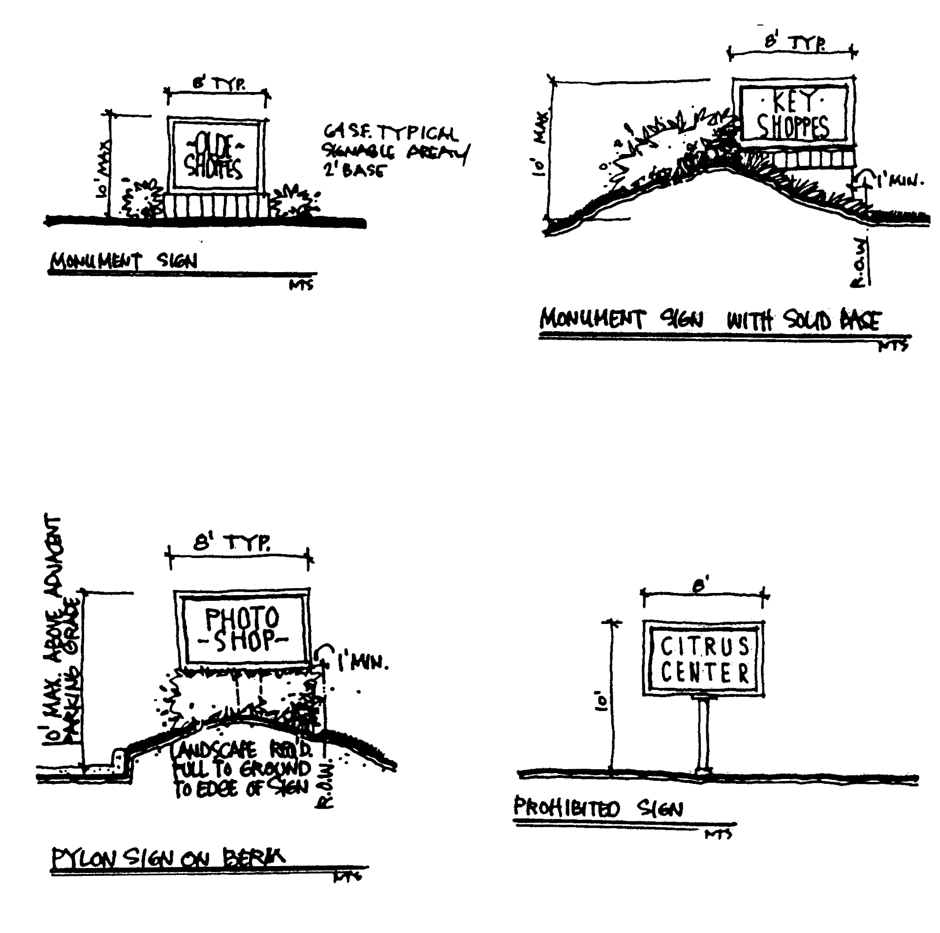
F-1: FREE-STANDING SIGNS
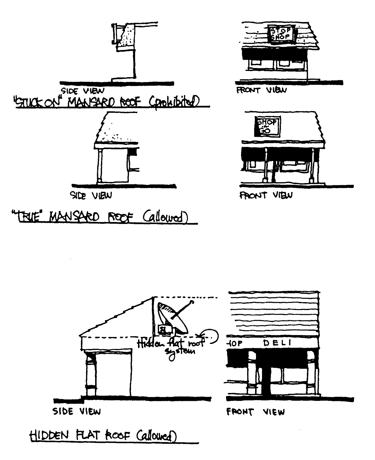
F-2: ROOFS
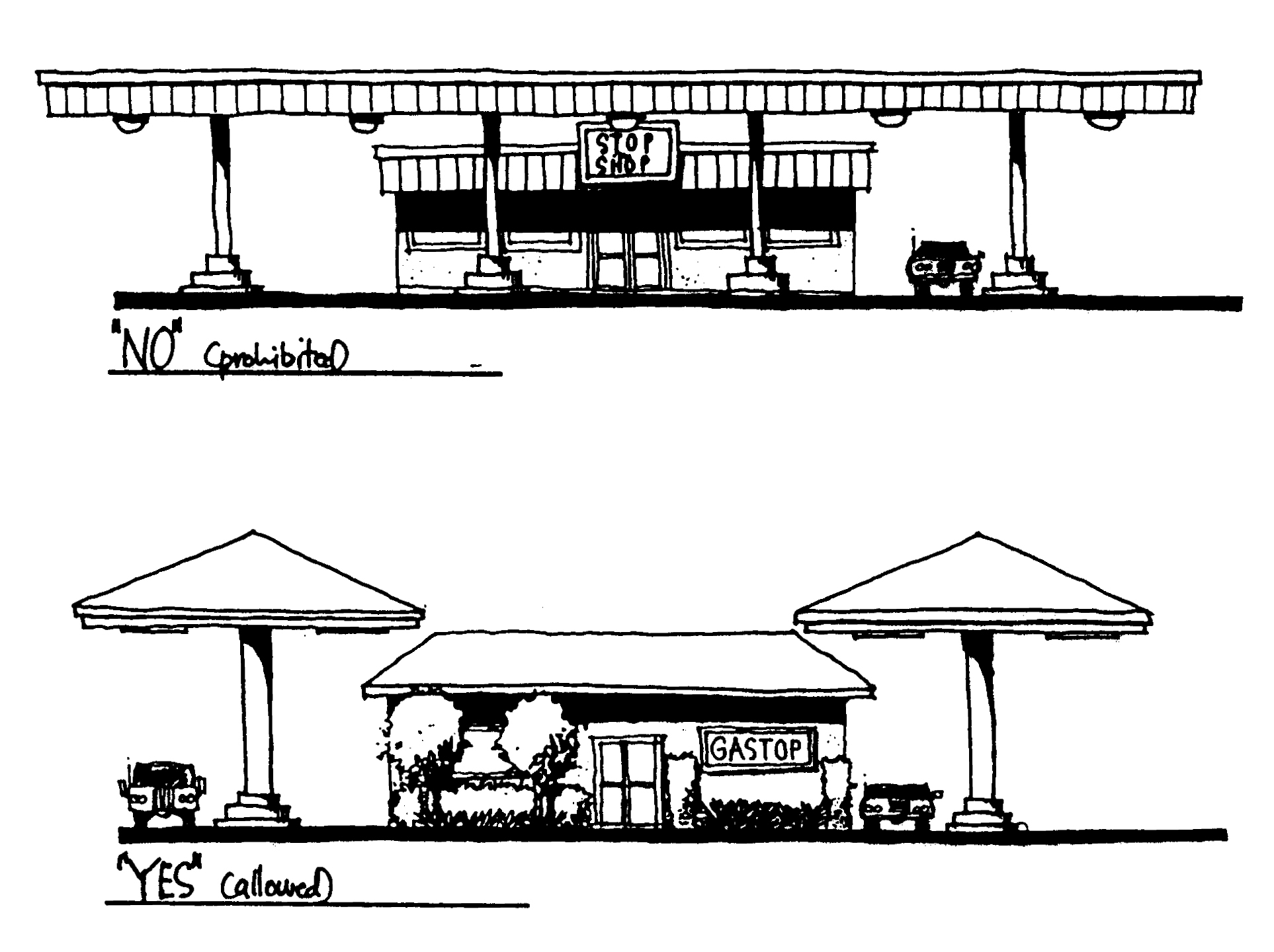
F-3: ROOFS
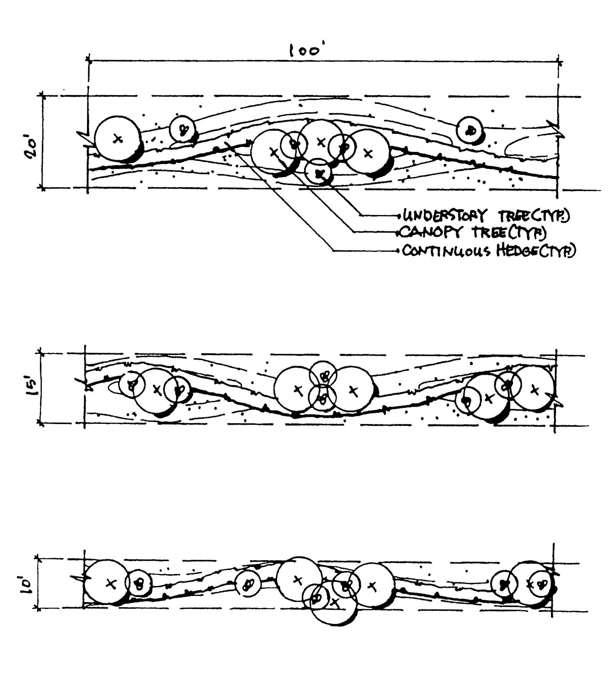
F-4: S.R. A-1-A & C.R. 510 BUFFER
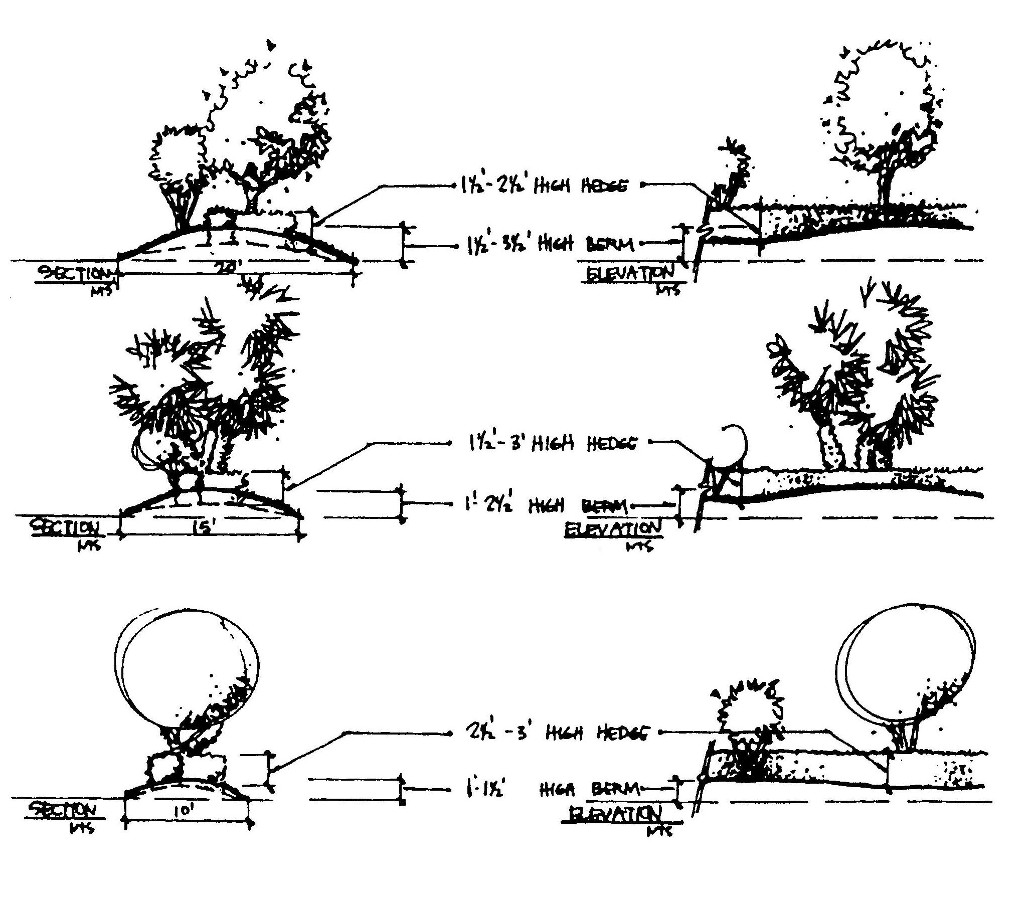
F-4: S.R. A-1-A & C.R. 510 BUFFER
(Ord. No. 96-24, § 7, 12-17-96; Ord. No. 99-26, § 1, 9-28-99; Ord. No. 2000-024, §§ 1A, 1B, 7-18-00; Ord. No. 2001-003, §§ 2, 3, 3-20-01; Ord. No. 2007-012, § 1, 3-20-07; Ord. No. 2010-008, § 1, 3-23-10; Ord. No. 2010-09, §§ 2—4, 5-4-10)
Section 911.19. - SR 60 Corridor special development regulations.
(1)
Purpose and intent. The overall purpose and intent of these regulations is to:
(a)
Promote an attractive and inviting corridor;
(b)
Provide for a sufficient amount of attractive and well-maintained landscaping to complement buildings and structures within the corridor;
(c)
Encourage development of attractive buildings within the corridor;
(d)
Ensure unobtrusive and orderly signage that avoids a garish and visually cluttered appearance along the corridor;
(e)
Encourage creative designs and buildings of quality that are articulated and presented at a human scale;
(f)
Foster creative approaches that result in buildings of enduring character through use of quality design and building materials; and
(g)
Make the SR 60 Corridor consistent with the following vision statement:
As a significant business and residential center and a major entranceway into Indian River County, the corridor will have an attractive, well-maintained, orderly and uncluttered appearance. The corridor will be characterized by impressive vegetation and landscaping; complementary buildings and signs with enhanced designs and aesthetic appearances; and a safe transportation system that accommodates mass transit, pedestrians, bicycles, and other transportation alternatives, as well as automobiles.
(2)
Boundaries of the SR 60 Corridor. The boundaries of the SR 60 Corridor Plan are shown on the county's official zoning atlas. Generally, the boundaries include all the land from 102nd Avenue to 43rd Avenue and from 26th Street to 16th Street and including all C/I designated land in the I-95/SR 60 node located south of 16th Street (extended).
(3)
Specific development regulations within the SR 60 Corridor. In the SR 60 Corridor Plan area, the following special regulations and exemptions shall apply to new development and redevelopment projects that require major site plan approval.
(a)
Exemptions:
1.
Single-family development and redevelopment shall be exempt from all SR 60 Corridor special development regulations.
2.
Multi-family development shall be exempt from foundation planting landscaping requirements, prohibitions on fiberglass and asphalt shingles and textured plywood as a finish product, and from requirements to screen roof vents.
3.
Industrial and storage buildings located in the CH, IL, and IG zoning districts shall be exempted from foundation planting landscaping requirements and architectural/building requirements for building facades that do not abut residentially designated areas or front on public roads. However, industrial buildings shall satisfy the color requirements.
4.
Electrical substations and similar uses that prohibit access by the public onto the site may be exempted from architectural/building requirements, if the exempted building(s) and equipment will be visually screened from adjacent properties and roadways.
5.
98th Avenue Manufacturing District: Industrially zoned manufacturing uses located along 98th Avenue comprise what is herein known as the 98th Avenue manufacturing district. Within this district, manufacturing uses shall be exempt from all architectural/building requirements and foundation planting requirements. Such uses shall comply with the SR 60 Corridor regulations for signs and colors. Along the 98th Avenue frontage of such uses, the SR 60 and thoroughfare plan road buffer shall be provided with the following alternative: the four-foot hedge and berm requirement may be reduced to a two-foot hedge and/or berm in exchange for a twenty (20) percent increase in the required canopy trees or a fifty (50) percent increase in understory tree. As stated in the landscaping and buffer regulations, clustering of trees within the buffer is allowed and encouraged.
6.
Historic Buildings and Resources: In accordance with future land use element objective 8 and LDR Chapter 933, historic buildings and resources identified in the "Historic Properties Survey of Indian River County, Florida," and located within the SR 60 corridor are exempt from special SR 60 Corridor Plan requirements to the extent that applying the special Corridor Plan requirements would:
a.
Conflict with the preservation or restoration of a historic building or resource; or
b.
Threaten or destroy the historical significance of an identified historic building or resource.
Said exemption shall be reviewed by and may be granted by the planning and zoning commission upon receiving a recommendation from staff.
(b)
Uses. With the following exceptions, uses within the corridor area allowed as specified in LDR Chapter 911 (zoning ordinance);
1.
Temporary uses: no temporary outdoor sales uses shall be located closer than two hundred (200) feet to SR 60 or any Thoroughfare Plan road right-of-way unless a SR 60 and Thoroughfare Plan road landscape buffer, as specified in the landscaping section, has been established between the temporary sales use and the adjacent SR 60 or Thoroughfare Plan road right-of-way.
(4)
Definitions. The following terms are defined for the SR 60 special development regulations:
(a)
Facade: For purposes of applying architectural/building standards, a facade shall mean any face of a building (including the visible portion of roof) which is visible from a roadway and/or residentially designated area.
(b)
Low sloped roof: A roof with a slope less than 5:12 (rise:run). Flat roofs are included in this term and classification.
(c)
Visible roof structure: A partial or perimeter roof (used in conjunction with a low sloped roof) that gives the appearance of having a true gable, hip, shed, or mansard roof. A parapet wall is not a "visible roof structure."
(d)
In all sections other than Color and Building Graphics, the terms "finish" and "exposed" shall refer to materials or systems which may be visible, and shall not refer to a paint or coloring system applied over said materials or systems.
(e)
Visually offensive elements: Structures that include: vending machines, gaming machines, ice machines, telephones, walk-in coolers/freezers, transformers, electrical equipment (including panels and meters), water or waste piping and valves, pumps, satellite dishes, antennas, fans, exhaust vents, compressors, generators, tanks, and similar equipment.
(f)
Nuisance elements: Structures that have visual and noise impacts, including; loading and unloading dock areas, dumpster and trash container areas, and commercial grade HVAC equipment.
(g)
Nonconforming sign: A sign located in the SR 60 Corridor that was permitted prior to adoption of the SR 60 Corridor special regulations and does not meet these special sign regulations.
(h)
Nonconforming property: A property with improvements that were permitted prior to the adoption of the SR 60 Corridor special regulations and that do not meet the SR 60 Corridor special regulations.
(i)
Compatible property: Any property with improvements, permitted prior to the adoption of this Code, and conforming to the SR 60 Corridor's: a) SR 60 and thoroughfare plan road buffer: b) color; and c) signage requirements.
(5)
Submittal and review requirements.
(a)
Preliminary review (optional): Preliminary staff review of site plans, landscaping and tree preservation plans, architectural plans, lighting plans, and color and exterior finish samples is strongly encouraged.
(b)
SR 60 review requirements: The drawings listed below are to be submitted on a minimum twenty-four-inch by thirty-six-inch format, and are to be the largest scale which will fit on a twenty-four-inch by thirty-six-inch format:
1.
In addition to normal site plan review submittal requirements, the following are to be submitted at the time of site plan review:
a.
Site plan: Shall indicate setbacks and all site development as required by the site plan ordinance, and shall depict: building orientation; locations of signage; location of service areas, dumpsters, loading zones, mechanical equipment, and any other "visually offensive elements" as described in these requirements; and locations and descriptions of screening devices.
b.
Tree survey: Shall indicate location, diameter at four and one-half (4.5) feet above grade, and species of all trees six-inch caliper (at four and one-half (4.5) feet above ground) and larger.
c.
Landscape plan (may be incorporated into site plan): Shall include calculations demonstrating compliance with each landscape ordinance and SR 60 special landscaping requirement.
d.
Building floor plans: Shall depict general locations of entries and exits, restrooms, and general uses.
e.
Roof plan: Shall indicate roof type, slope, and any "visually offensive elements" (as described in these requirements) and descriptions of screening devices.
f.
Building elevations: Shall include all exterior building elevations, including all items affecting the appearance of the building, including: roof design, complete description of exterior building materials, exterior building colors, all loading zones, mechanical and electrical equipment locations and their required screening devices, and signs attached to buildings.
g.
Certification from the project architect or engineer that proposed roof plans and elevation plans meet the SR 60 corridor architectural/building standards.
2.
Prior to site plan release, applicants shall submit to planning staff three sets of the following and shall obtain planning staff approval of same:
a.
Site lighting plan (may be incorporated into site plan): Must indicate site lighting plan, as well as a light fixture schedule with cut sheets (written specifications and pictorial representation including photometric chart) for all site lighting fixtures. This includes any site lighting fixtures attached to buildings.
b.
Sign elevations (minimum scale: ¾″ = 1′-0″): These are to be detailed drawings of building and site signage, including all items affecting the appearance of signs, including but not limited to: dimensions, area in square feet, complete description of finish materials and their colors, color samples (minimum size three (3) inches × five (5) inches, using Pantone Matching System r numbers with color number on back of each sample) and method of illumination. This is required for all outdoor signs except those which cannot be determined because the occupancy of the space is not known. Any signs not reviewed at site plan review time for this reason must be reviewed under these requirements prior to the issuance of a sign permit.
c.
Building color samples (minimum sample sizes: three (3) inches × five (5) inches): Exterior and exterior signage color samples shall be submitted.
d.
Certification from the project architect or engineer that the proposed site/exterior building lighting, proposed signage, and proposed building and signage colors meet the SR 60 corridor lighting, signage, and color standards.
(c)
Approval for change of exterior design required: Changes to the exterior of any structure in the SR 60 Corridor that was originally required to comply with these special SR 60 corridor requirements shall require review and approval by the community development department. Such changes shall include, but not be limited to, colors, building materials, roof finishes, and signage. Routine maintenance and replacement of materials which do not affect the approved exterior design shall be exempt from such review and approval.
(6)
Landscaping. The countywide landscaping requirements of LDR Chapter 926 shall apply except as noted herein.
(a)
Reserved.
(b)
SR 60 and thoroughfare plan road buffer. Refer to Section 926.09 for roadway landscape requirements.
(c)
Reserved.
(d)
Local road and exclusive access driveway buffer. Refer to Section 926.09 for roadway landscape requirements.
(e)
Interior parking area. In addition to the normal interior parking area requirements of LDR Chapter 926.
1.
Uncovered parking spaces shall be located no more than five (5) spaces away from a planted landscape area. Said landscape area may be on the parking lot perimeter or interior to the parking lot. This requirement may be waived by the planning and zoning commission where tree preservation efforts require a clustering of interior parking green area around existing trees rather than a spread out placement of landscape islands.
2.
Landscape islands shall be backfilled at least to the top of curb or protective barrier, and may be bermed to a maximum height of twenty-four (24) inches above the adjacent parking lot grade.
(f)
Foundation plantings. Foundation plantings shall be required as stated below for buildings in commercial and industrial areas and for businesses allowed in residential areas. For industrial and storage buildings located in the CH, IL, and IG zoning districts, however, foundation planting strips shall be exempted for sides of buildings not fronting on a residentially designated area, or public road. In addition, industrially zoned manufacturing uses in the 98th Avenue manufacturing district and historic buildings and resources are exempt from foundation planting requirements to the extent provided for in [sub]section[s] 911.19(3)(a)5. and 6. of this ordinance.
_____1.
Along the front, sides and rear of buildings, the following foundation planting landscape strips shall be provided in accordance with the building height:
1 Depth shall be measured perpendicular to the building, from the foundation outward. Consistent with the requirements below, greater depths may be required where canopy, palm, and understory trees are planted within the foundation planting strip.
2.
At planting, the minimum separation distance from building facades or walls shall be seven (7) feet to canopy trees and five (5) feet to understory trees and palms. At planting, the minimum separation distance from sidewalks shall be six (6) feet to canopy trees and three (3) feet to understory trees and palms, and shall be three (3) feet from parking spaces to canopy trees, understory trees, and palms. Separation distances shall be measured from the trunk to the nearest building, wall, sidewalk, or parking space.
a.
Exception: narrow, upright canopy tree species, such as varieties of cypress and holly, may be located the same distance from buildings, walls, and sidewalks as understory trees and palms.
b.
Where a magnolia or other canopy tree (not including a narrow species such as a cypress or holly) is used in a foundation planting area, the planting area shall have a minimum depth of ten (10) feet measured from the building.
3.
Within such foundation planting landscape strips, the following landscaping shall be provided:
a.
Forty (40) percent of the foundation perimeter (excluding entranceways and overhead doors) along all building faces shall be landscaped, as follows:
b.
The following modifications are allowed upon approval from the community development director or his designee:
1.
Foundation planting strips may be located away from buildings to adjacent, nearby areas to avoid conflicts with architectural features (e.g., roof overhangs), driveways, and vehicular areas serving drive-up windows.
2.
The depth of foundation planting strips may be modified if the overall minimum area covered by the proposed foundation plantings meets or exceeds the area encompassed by a typical layout.
3.
Foundation planting areas may be concentrated in one (1) or more areas of the building perimeter, if warranted based upon site constraints or building and site design characteristics. Planting areas shall be provided where the building is most visible from adjacent roadways and on-site areas used by the public.
(g)
Increased foundation plantings for "blank facade" building faces. As referenced in the architectural/building standards section of this plan, "blank facade" building faces that are unarticulated are allowed if foundation plantings are provided as specified above with a one hundred (100) percent increase (doubling) in required plant material quantities (as specified above).
(7)
Connection to pedestrian system. Projects fronting on roads with existing or planned/required sidewalks and/or bikeways shall provide a pedestrian path from the project to the existing or future sidewalk and/or bikeway. Said pedestrian path shall have a minimum width of five (5) feet, shall consist of a rigid surface meeting Florida Accessibility Code requirements, and may include properly marked areas that cross parking lots and driveways.
(8)
Architectural/building standards.
(a)
Prohibited architectural styles: The following are prohibited:
1.
Corporate signature or commercial prototype architecture, unless such is consistent with these special corridor requirements. Examples of such prohibited architecture include flat roofed convenience stores, gas stations, and canopies for gas stations, car washes, and drive through facilities (see Figure B-1).
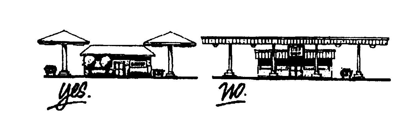
FIGURE B-1
2.
Any kitsch architecture (such as a building that does not resemble a typical structure), including: structures or elements that resemble an exaggerated plant, fish, edible food, or other such items such as giant oranges, ice cream cones, dinosaurs.
3.
Any architecture having a historical reference that is so different from current design philosophy that such reference is inconsistent and/or incompatible with surrounding structures. Examples of such include: igloos, domes or geodesic domes, Quonset style structures, teepees, log cabins, western "false fronts," medieval castles, caves, and the like.
(b)
Architectural/building exemptions and special requirements:
1.
Industrial and storage uses in the CH, IL, and IG Districts: Compliance shall be required only for those facades fronting on residentially designated areas or public roads. However, industrial buildings shall satisfy the color requirements. In addition, industrially zoned manufacturing uses in the 98th Avenue manufacturing district and historic buildings and resources are exempt from architectural/building requirements to the extent provided for in sections 911.19(3)(a)5. and 6. of this ordinance.
2.
Residentially designated properties: The following materials are approved for use in residentially designated areas: fiberglass or asphalt shingle-style roofing for sloped roofs and visible roof structures, and textured plywood as a finish product. Rooftop screening devices shall not be required for attic ventilators or plumbing roof vents on residentially designated properties. However, roof ventilators, roof vents, and the like shall be located where they will be least visible from roadways.
3.
Shopping centers and outparcels: The materials, exterior finishes, signage and colors of shopping centers and structures developed on shopping center outparcels shall be compatible and harmonious with each other as determined by which structures are developed first. This requirement may be waived by the community development department if:
a.
The initial shopping center or outparcel was built prior to the enactment of the SR 60 special regulations and
b.
It is determined by the community development department that enforcement of this requirement would conflict with the intent of these SR 60 special requirements.
4.
Electrical substations and similar uses: Electrical substations and similar uses that prohibit access by the public into the site may be exempted from all architectural/building requirements by the community development director if the exempted building(s) and equipment will be visually screened from adjacent properties and roadways.
(c)
General design criteria:
1.
Buildings with facades fronting on more than one street shall have similar design considerations (e.g., roof treatment, building articulation, entrance features, and window placement) and consistent detailing on all street frontages.
2.
General prohibitions and restrictions:
a.
Flat, blank, unarticulated, or massive facades fronting on a roadway, exclusive access drive or residentially designated area are prohibited. Facades fronting such roads, drives, or areas shall be designed to incorporate architectural elements providing breaks in the planes of exterior walls and/or roofs to articulate the building and to lessen the appearance of excessive mass. Facades should incorporate elements relating to human scale, and can be divided by use of: proportional expression of structure, openings, arcades, canopies, fenestration, changes in materials, cornice details, molding details, changes in the heights of different sections of the building, and the like (stepping or sloping of a parapet wall in conjunction with a low sloped roof is prohibited). Flat, blank, unarticulated, or massive facades will be permitted on the sides and rear of a building where "blank facade foundation plantings" are provided for such building facade faces (see foundation plantings section for requirements).
b.
The following materials or systems are prohibited as a finish and/or exposed product: corrugated or ribbed metal panels, smooth finish concrete block (standard concrete masonry units), precast concrete tee systems, plywood or textured plywood. Plywood shall be allowed for soffit material.
c.
Any canopy (such as for a gas station, car wash, or drive through facility) that is wholly or partially within seventy-five (75) feet of a thoroughfare plan road right-of-way shall meet the following requirements concerning maximum facia height (this pertains to all facia on the above described canopy, including any canopy facia that continues beyond the seventy-five-foot limit):
(See Figure F-11 at the end of section 911.19)
d.
Plastic or metal is prohibited as a finish material for walls or trim. Plastic is prohibited as a finish material for slope roofs, visible roof structures, and facias. Although prohibited in general, certain metal and plastic construction products may be approved by the planning and zoning commission, upon a written request and product sample submitted by the applicant. The planning and zoning commission may approve use of the material if the following criteria are satisfied:
i.
The product shall appear authentic from the closest distance that it will be viewed by the general public.
ii.
The product shall be substantial. Thin and flimsy imitations are unacceptable.
iii.
The product shall hold up as well as the product it is imitating. That is, it must be fabricated in such a way that it will retain its original shape, appearance, and color, as well as the product it is imitating.
iv.
The product's color shall resemble the color of the product it is imitating.
e.
Any exposed masonry in a stack bond is prohibited.
f.
Lighting structures or strip lighting that follows the form of the building, parts of the building, or building elements is prohibited.
g.
Neon and similar tube and fiber optic lighting and similar linear lighting systems, where the neon or lighting tube or fiber is visible, is prohibited (this restriction includes site signage).
h.
Backlit transparent or translucent architectural elements, backlit architectural elements, as well as illuminated or backlit awnings and roof mounted elements are prohibited. This does not prohibit the use of glass blocks. This does not prohibit the use of an illuminated sign attached to a building.
i.
Facades that appear to be primarily awnings are prohibited. An awning shall not run continuously for more than thirty (30) percent of the length of any single facade. Gaps between awning segments shall be at least twenty-four (24) inches wide. Placement of awning segments shall relate to building features (e.g. doorways and windows), where possible. Awnings shall not exceed twenty-five (25) percent of the area of any single facade.
j.
Drive-up windows shall not be located on a building facade that faces a residential area or a roadway unless architecturally integrated into the building and screened by landscaping, equivalent to the material in a local road buffer, that runs the length of the drive-through lane. Speakers shall be oriented so as not to project sound toward residential areas.
k.
Accessory structures, including sheds, out buildings, dumpster enclosures, and screening structures, shall match the style, finish, and color of the site's main building. Metal utility sheds and temporary car canopies are prohibited.
(d)
Roofs and parapets:
1.
Sloped roofs: Gable, hip, and shed style roofs shall have a slope no less than 5:12 (rise:run). Mansard style roofs with a slope greater than 30:12 (rise:run) are prohibited. Generous eaves on sloped roofs are encouraged. Any roof with a slope less than 5:12 (rise:run) ("low sloped roof") shall not be visible from a roadway and/or residentially designated area. Low sloped roofs must be screened with a visible roof structure or parapet wall.
2.
Visible roof structures: Visible roof structures shall be of such height, bulk, and mass, so as to appear structural, even where the design is non-structural, and shall have a minimum vertical rise of six (6) feet (not including facia). Visible roof structures shall have a slope no less than 5:12 (rise:run). Mansard style visible roof structures with a slope greater than 30:12 (rise:run) are prohibited. Where visible roof structures are utilized in a building design, they shall be continuous around all sides of the structure, except where incorporated with a parapet wall or other architectural element (this does not allow "stuck-on" roofs). Any facade that is not visible from a roadway, exclusive access drive, or residentially designated area, such as facades that are interior to a tightly spaced compound of buildings, will not require a continuous visible roof structure on that facade. Any building with less than three thousand five hundred (3,500) square feet of ground floor area shall have a visible roof structure on all facades.
3.
The following roof styles are prohibited: "A frame," bowstring, dome, gambrel, non-symmetrical gable or hip (different slope on each side of ridge). Quonset, and Polynesian (gable or hip roof with up to a 10:12 (rise:run) maximum pitch with a "skirted" or "flared" lower portion at a 3:12 (rise:run) minimum pitch is allowed).
4.
The ridge or plane of a roof (or visible roof structure), that runs parallel (or slightly parallel) with a roadway shall not run continuous for more than one hundred (100) feet without offsetting or jogging (vertically or horizontally) the roof ridge or plane a minimum of sixteen (16) inches (see Figure B-2). Low slope roofs and parapet walls are excluded from this requirement.
5.
Roofing on sloped roofs and visible roof structures shall be limited to the following systems: architectural standing seam metal, galvanized 5-V crimp, cedar shingles or shakes, slate, clay tile, or cement tile. Architectural standing seam roofs shall be limited to the following systems: flat metal panels with narrow raised seams running twelve (12) to twenty (20) inches apart, which are secured with continuous seam covers or mechanically seamed. Light and natural colors, as well as mill finish metal roofs are encouraged. Mixing colors of metal panels is prohibited.
6.
Roofing materials are prohibited for use as a finish material on parapets or any surface with a slope greater than 30:12 (rise:run), up to and including vertical surfaces. This pertains only to those surfaces visible from adjacent property, exclusive access drives or roadways. This does not exclude the use of metal facia six (6) inches or less in height, use of typical metal flashing, wall cap, drip edge, and the like, use of roofing materials as a screening device (as long as it does not function as a building's parapet), and use of cedar shingles or shakes as a wall material used below the roof line.
7.
Fiberglass or asphalt shingle style roofing (except as allowed in residentially designated areas), plastic or metal roof panels or systems, corrugated or ribbed roof panels, hot mopped systems, built-up, gravel, torched on, foam or fluid applied, roll or membrane roofing, and the like are prohibited on any roof which is visible from any roadway and/or residentially designated area. This does not exclude the use of architectural standing seam metal roofing or galvanized 5-V crimp metal roofing. Use of metal or plastic roofing materials may be approved as specified under the section on finish materials for walls, facia, and trim.
8.
"Stuck-on" visible roof structures are not permitted, (see Figure B-3). Partial parapet walls are prohibited. If a parapet wall is used on a building, then a parapet wall of the same style and material is to be continuous around all sides of the structure, except where incorporated with a visible roof structure or other architectural element. Introduction of any visible roof structure shall not appear "fake." Any facade that is not visible from a roadway and/or residentially designated area shall not require a continuous parapet wall on that facade. Steeping or sloping of a parapet wall in conjunction with a low sloped roof is prohibited.
(d)
Site elements:
1.
All telephones, vending machines, or any facility dispensing merchandise or a service on private property shall be confined to a space built into the building or buildings, or enclosed in a separate structure compatible with the main building's architecture. These areas are to be designed with the safety of the user in mind. Public phones and ATMs should have twenty-four-hour access.
2.
No advertising will be allowed on any exposed amenity or facility such as benches or trash containers.
3.
When feasible, existing specimen trees should be preserved in place or relocated on site. Use of tree wells, as well as adaptation and variations of siting in order to conserve native vegetation, is encouraged.
4.
The use of thematic and decorative site lighting is encouraged. Low lights of a modest scale can be used along with feature lighting that emphasizes plants, trees, entrances, and exits. Light bollards are encouraged along pedestrian paths. The color of the light sources (lamp) should be consistent throughout the project. Color of site lighting luminaries, poles, and the like; shall be limited to dark bronze, black, or dark green (decorative fixtures attached to buildings are exempt from fixture color requirement).
Lighting is not to be used as a form of advertising or in a manner that draws considerably more attention to the building or grounds at night than in the day. Site lighting shall be designed to direct light into the property. It is to avoid any annoyance to the neighbors from brightness or glare.
a.
Roadway style luminaries (fixtures) such as cobra heads, Nema heads, and the like are prohibited. Wall pack and flood light luminaries are prohibited where the light source would be visible from a roadway, parking area and/or residentially designated area. High intensity discharge (e.g. high pressure sodium, metal halide, mercury vapor, tungsten halogen) lighting fixtures mounted on buildings and poles higher than eighteen (18) feet above parking lot grade, and under canopies, shall be directed perpendicular to the ground. Other than decorative and low level/low height lighting, no light source or lens shall project above or below a fixture box, shield, or canopy.
(See Figures F-12 and F-13 at the end of section 911.19)
(e)
Screening devices:
1.
"Visually offensive elements," whether freestanding, mounted on roofs, or located anywhere on a structure, shall be concealed from view on all sides. Individual screens, building elements, or appropriate landscaping, are to be used to completely screen the offensive elements from view from adjacent roads, properties, and parking areas. Parapet walls, visible roof structures, individual screens, or building elements; shall be used to completely screen roof mounted, visually offensive elements from view from any point around the entire building perimeter. Screening devices shall relate to the building's style of architecture and materials. All screening devices shall be designed so that no part of the offensive element extends beyond the top of the screen, measured vertically (see Figure B-4). Rooftop screening devices shall not be required for plumbing roof vents which are less than four (4) inches in diameter and less than twelve (12) inches above roof penetration. These roof vents are to be located where they will be least visible from roadways.
2.
"Nuisance elements" shall be visually screened from adjacent roadways and/or residentially designated areas with solid walls in addition to any required landscaping. Loading dock buffering shall meet Chapter 926 standards: all other walls shall be a minimum of six (6) feet in height. All dumpster and trash container areas shall be completely screened on all sides. Acoustical material shall be used on the inside face of walls around HVAC equipment.
3.
Individual screens and walls shall relate to the building's style of architecture and materials. A durable material such as reinforced concrete masonry units is recommended with an architecturally compatible finish. Wood fences are discouraged.
4.
Chain link fencing, with or without slats, is prohibited as a screening device for screening visually offensive elements and nuisance elements.
(9)
Colors and building graphics.
(a)
The following building graphics are prohibited: polka dots, circles, vertical stripes, diagonal stripes or lines, plaids, animals, and symbols such as lightning bolts. However, legally registered trademarks which directly relate to the building occupant (not trademarks of products or services sold or displayed) are allowed, subject to applicable sign and color regulations.
(b)
Color Standards. All buildings and accessory structures within the SR 60 Corridor shall be limited to the following colors:
1.
Base building colors: Base building colors relate to wall and parapet wall areas and shall be limited to the colors listed in the SR 60 Corridor Master Color List. These colors consist of white and light neutral colors in the warm range.
2.
Secondary building colors: Secondary building colors relate to larger trim areas and shall be limited to the colors listed in the SR 60 Corridor Master Color List, Secondary building colors shall not exceed thirty (30) percent of the surface area of any one building facade elevation. These colors consist of a mid-range intensity of the base building colors and complementary colors, and include all base building colors.
3.
Trim colors: Trim colors are used for accent of smaller trim areas, are the brightest group of colors allowed, and include all base building and secondary building colors. Use of metallic colors (i.e.: gold, silver, bronze, chrome, etc…) and use of garish colors, such as fluorescent colors (e.g. hot pink, shocking yellow), is prohibited. Trim colors shall not exceed ten (10) percent of the surface area of any one building facade elevation. Where trim colors are used in a building facade sign, the trim color area of the facade sign shall be included in the percentage limitation on the trim color surface area.
4.
Roof colors (requirements for roofs that are visible from a roadway and/or residentially designated area): Metal roof colors shall be limited to the colors listed in the SR 60 Corridor Master Color List's "Metal Roof Colors." These colors consist of natural mill finish, white, light neutral colors in the warm range, blue, and a limited number of earth-tone colors. Mixing or alternating colors of metal panels is prohibited. For non-metal roofs, other than natural variations in color or color blends within a tile, the mixing or alternating of roof color in the same roof material is prohibited. Colors and color blends shall not be contrary to the intent of this code. Color for roofing which is glazed, slurry coated, or artificially colored on the surface by any other means shall be limited to the same colors as approved for metal roofs.
5.
Natural finish materials: The color requirements listed above shall not apply to the colors of true natural finish materials such as brick, stone, terra cotta, concrete roof tiles, slate, integrally colored concrete masonry units, copper, and wood. Colors commonly found in natural materials are acceptable, unless such material has been artificially colored in a manner which would be contrary to the intent of these requirements. Black, gray, blue, or extremely dark colors for brick, concrete masonry units, roofing, wood or stone is prohibited. (This provision shall not prohibit the use of colors for natural finish roofing materials that match those colors approved for metal roofs.)
6.
Awning colors: Awning colors may include base building colors and/or secondary building colors and/or trim colors. However, secondary building colors and trim color area used for awnings shall be included in the percentage limitation on the secondary building color and trim color surface area of a facade.
(c)
The SR 60 Corridor Master Color List and approved color board shall be maintained by and made available by planning staff. The list can be mailed or faxed upon request.
(10)
Special sign regulations.
(a)
Scope: These special regulations consist of additional requirements above and beyond the county sign ordinance and shall supersede any less restrictive provisions found in the sign ordinance. All signage shall comply with the requirements of the sign ordinance except as modified by these special sign regulations.
(b)
Approval for change of sign design required: Any exterior change to SR 60 Corridor signage which was: originally required to comply with these special sign regulations shall require review and approval by the community development department. Such changes shall include, but not be limited to, changes of: sign area (square footage), sign copy area (square footage), sign copy (this does not apply to "changeable copy" signage), height, shape, style, location, colors, materials, or method of illumination. Routine maintenance and replacement of materials which does not affect the approved design shall be exempt from this review and approval. Changes to signs not originally required to comply with these special sign regulations are addressed in the "nonconforming signs" section of these regulations.
(c)
Prohibited signs (this is in addition to sign ordinance section 956.12 prohibitions): The following are prohibited:
1.
Lights or illuminations that flash, move, rotate, scintillate, blink, flicker, or vary in intensity or color, except for time-temperature-date signs. Public signs permitted pursuant to sign ordinance section 956.11(2)(b) are excluded from this prohibition and are allowed.
2.
Electronic message boards and message centers, electronic adjustable alternation displays, or any sign that automatically displays words, numerals, and or characters in a programmed manner. Traffic regulatory and directional signs permitted pursuant to sign ordinance section 956.11(2)(b) are excluded from this prohibition and are allowed.
3.
Portable or trailer style changeable copy signs.
4.
Signs with the optical illusion of movement by means of a design that presents a pattern capable of giving the illusion of motion or changing of copy.
5.
Strings of light bulbs used on non-residential structures for commercial purposes, other than traditional holiday decorations at the appropriate time of the year.
6.
Signs that emit audible sound, odor, or visible matter, such as smoke or steam.
7.
Plastic or glass sign faces (including but not limited to: acrylic, Lexan r , or Plexiglas r ). High density polyurethane and PVC are exempt from this prohibition. Portions of a sign which are changeable copy are exempt from this prohibition. When used in conjunction with cut-out or routered metal cabinets, plastic used only for copy or logos is exempt from this prohibition. Plastic used for illuminated individual channel letters or logos is exempt from this prohibition. Although highly discouraged, a plastic sign face will be allowed only when all of the following requirements are met for the plastic portions of a sign:
i.
Plastic shall be pan formed faced (embossed and/or de-bossed copy and logos are encouraged).
ii.
Regardless of the opaqueness of a sign, all plastic signage backgrounds shall be a dark color to reduce light transmission from signage background); white background shall not be allowed. All signage background colors shall be limited to those colors with a formula having a minimum black content of eleven (11) percent, and a maximum white content of forty-nine (49). Color formulas will be based on the Pantone Matching System r .
iii.
All color must be applied on the "second surface" (inside face of plastic).
iv.
Nothing shall be applied to the "first surface" (outside face of plastic) (i.e.: paint, vinyl, etc.,)
8.
Neon and similar tube, fiber optic, and intense linear lighting systems, where the neon or lighting tube or fiber is visible.
9.
Plywood used for permanent signs.
10.
Any material used in such a manner for a permanent sign that results in a flat sign without dimension, having a semblance to a "plywood or temporary looking sign."
11.
Installation of an additional sign (or signs) that does not harmonize with the design or materials of the initial sign, such as:
i.
Rear illuminated plastic faced sign with a "wood look" front illuminated sign.
ii.
Combination of signs with cabinets, faces or structure of awkwardly different materials or proportions.
iii.
Attachment or mounting of signs where mounting hardware is left exposed.
iv.
Signs with different color cabinets, frames, or structure.
12.
Appliques or letters of vinyl and similar materials for use on any permanent monument, freestanding, or roof signs. They are also prohibited for use on any permanent wall or facade signs that exceed three (3) square feet. Window signs as allowed in this chapter are excluded from this prohibition. Regardless of size, appliques or vinyl letters are prohibited for use on plastic sign faces.
13.
Individual styrofoam, plastic or wood letters or the like exceeding four (4) inches in height are prohibited for use on any permanent monument, freestanding, roof, wall, or facade signs. This prohibition does not apply to illuminated individual metal channel letters or the plastic letter typically used for changeable copy signs.
14.
Changeable copy signs for office, industrial, commercial and residential uses, except theaters, places of assembly, and the posting of gasoline prices.
(d)
Signs that are encouraged:
1.
Shaped and fashioned "wood look" multi level signs (i.e.: sand blasted or carved), and signs having durable sign cabinet material such as high density polyurethane and PVC, rather than actual wood or MDO.
2.
Internally illuminated aluminum cabinet with textured finish, and cut-out inset or push through acrylic letters. (Note that color may be applied to the "first surface" on push through acrylic letters for this type of sign.)
3.
Backlit reverse pan channel letters (opaque faced) mounted on sign that is harmonious with the project's architecture.
4.
Signage that relates to the building's style of architecture and materials.
5.
Thematic signage.
6.
Where allowed, changeable copy signs that have a dark opaque background with translucent lettering.
(e)
Reduction in sign sizes and dimensions: Modifications to Table 1 (freestanding signs) and Table 2 (wall signs), Schedule of Regulations for Permanent Signs Requiring Permits, sign ordinance.
1.
Freestanding signs:
i.
Maximum cumulative signage: Reduce to fifty (50) percent of what is allowed in Table 1, except for I-95 signs as described in iii, below.
ii.
Maximum signage on a single face: Reduce to fifty (50) percent of what is allowed in Table 1, except for I-95 signs as described in iii, below.
iii.
Maximum height: Reduce to thirty (30) percent of what is allowed in Table 1, but no less than six (6) feet and no greater than ten (10) feet. Maximum height and size modifications do not apply to properties located within one thousand (1,000) feet of I-95 entrance or exit ramps where an applicant demonstrates that a taller proposed sign is oriented so as to be seen by I-95 motorists approaching the SR 60 interchange. For properties located between one thousand (1,000) feet and two thousand (2,000) feet of I-95 entrance or exit ramps, a maximum sign height of twenty (20) feet and a maximum sign area of one hundred (100) square feet shall be allowed. Any pole for such a sign shall be colored dark bronze, black, or dark green. All other special restrictions and prohibitions shall apply.
a.
Sign base and sign pole base landscaping: for signs allowed to exceed twenty (20) feet in height, sign bases and sign pole bases shall be screened from view of the adjacent roadway with a minimum of three (3) canopy trees, three (3) understory trees, and a continuous hedge having a height at planting of at least three (3) feet above grade. For signs allowed to exceed ten (10) feet in height but limited to a height of twenty (20) feet, sign bases and sign pole bases shall be screened from view of the adjacent roadway with a minimum of three (3) understory trees and a continuous hedge having a height at planting of at least three (3) feet above grade. (See Figures F-14 and F-15 at the end of section 911.19).
iv.
For development involving sites of forty (40) acres or more the ten (10) feet sign height requirement may be waived by the Board of County Commissioners if the development project applicant prepares and the Board of County Commissioners approves a sign package that reduces the total sign area otherwise allowed under the corridor plan and sign ordinance by ten (10) percent or more. Outparcels on larger sites shall comply with the six (6) feet to ten (10) feet height limitations specified above.
v.
Required setbacks from property lines or right-of-way: One (1) foot subject to satisfaction of sight distance requirements.
vi.
Number of allowable signs per street frontage: No change from Table 1, Footnote #2 of Table 1 shall be modified, requiring a minimum of two hundred (200) feet of separation between signs along the same street frontage.
2.
Wall/facade signs.
i.
Maximum sign area allowed: Reduce to fifty (50) percent of what is allowed in Table 2.
(f)
Colors:
1.
The following colors are encouraged for signage:
i.
Use of earth-tone colors and pastels.
ii.
Darker backgrounds with light color sign copy.
iii.
Use of colors that match or are compatible with the project's architecture.
2.
The following colors are prohibited for signage:
i.
The use of shiny or bright metallic or mill finish colors (i.e.: gold, silver, bronze, chrome, aluminum, stainless steel, etc…). Colors such as medium or dark bronze are acceptable and encouraged. Polished or weathered true bronze, brass, or copper metal finishes are acceptable and encouraged. Precious metal colors are allowed on sand blasted or carved "wood look" style signs.
ii.
The use of garish colors, such as fluorescent colors, is prohibited.
iii.
The use of black for signage background. Changeable copy signage is excluded from this prohibition.
(g)
Multi-tenant spaces: Applicants of proposed multi-tenant projects, such as shopping centers, out parcels, industrial complexes and parks, and office complexes and parks, shall submit a sign program for review and approval. This sign program shall communicate the coordination and consistency of design, colors, materials, illumination, and locations of signage. In a multi-tenant project where no established pattern exists as described above, the owner of the multi-tenant project shall be required to submit a sign program for approval prior to issuance of any new sign permits for a tenant space.
(h)
Design criteria and additional restrictions:
1.
Freestanding signage:
i.
All freestanding signs restricted to a maximum height of no more than ten (10) feet shall be of a wide-based monument style. Pole signs are discouraged, but may be permitted when the supporting structures are completely screened from view with landscaping or berm features. Said landscaping and/or berming shall cover and screen the entire area beneath the sign at time of certificate of occupancy (C.O.) issuance.
ii.
Any freestanding signs constructed from flat panel material, such as high density polyurethane, MDO, sheet metal, or the like, shall have a distance of no less than eight (8) inches from face to face, and shall be enclosed on all sides to cover internal frame.
2.
Freestanding changeable copy signs:
i.
Where allowed, a freestanding changeable copy sign shall not comprise more than eighty (80) percent of the total area of the actual sign.
3.
Wall/facade signage:
i.
The maximum vertical dimension of a facade or wall sign shall not exceed twenty-five (25) percent of the building height.
ii.
Awnings with lettering shall be considered wall signs. Where lettering is used on an awning, the area of lettering shall be included in the percentage limitation of a project's sign area.
iii.
Lettering, logos, and trim colors on canopy facia shall be considered a wall sign and shall be limited to thirty-three (33) percent of the facia area of any one elevation. Internally illuminated signs shall not be placed on a canopy structure, and no sign shall be placed above the facia on a canopy structure.
iv.
Wall signs (facade signs) are prohibited on roofs with a slope less than 20:12 (rise:run) pitch. Wall signs mounted on a roof shall be enclosed on all sides to cover the internal frame and its connection to the roof. Also see IRC LDR's Section 956.12(1)(o).
4.
Changeable copy wall signs for theaters:
i.
Theaters may utilize up to eighty (80) percent of actual sign area for display of names of films, plays or other performances currently showing.
5.
Illumination:
i.
All external flood sign illumination shall be mounted at grade, directly in front of the sign area. Light source shall be completely shielded from oncoming motorist's view.
6.
Window signs: "Window signs" shall include permanently affixed window signs, temporary window signs, and any signs or displays located within three (3) feet of the window, door, or storefront. Window signs shall not exceed ten (10) percent of the window storefront area (window panes and framing) per store or business, and in no case shall exceed fifty (50) square feet per store or business. Street address numbers and lettering, and flyers or posters related to not for profit events and organizations, shall not count as window signage. "Open," "closed," hours of operations and identification window signage totaling up to four (4) square feet shall not count as window signage.
(i)
Nonconforming signs: It is the intent of these regulations to allow nonconforming signs to continue until they are no longer used or become hazardous, and to encourage conformance to these special sign regulations. A "compatible freestanding sign" shall be defined as any freestanding sign permitted prior to the adoption of these special regulations, and conforming to the SR 60 maximum height requirements for a freestanding sign, and wide-based monument style mounting for a freestanding sign.
1.
Nonconforming signs are subject to the following:
i.
Nonconforming signs or nonconforming sign structures on sites abandoned for twelve (12) or more consecutive months shall not be permitted for reuse.
ii.
Except as otherwise provided herein, there may be a change of tenancy or ownership of a nonconforming sign, without the loss of nonconforming status, if the site is not abandoned for twelve (12) or more consecutive months.
iii.
Colors of a nonconforming sign shall not be changed from those existing at the time of the adoption of this Code, unless new colors comply with the SR 60 Corridor special color requirements.
iv.
A nonconforming sign shall not be enlarged or increased in any way from its lawful size at the time of the adoption of these special regulations.
v.
Except as specified below, nonconforming freestanding signs shall be brought into conformity with the requirements of a "compatible freestanding sign" on or before June 1, 2003. If a property owner documents to the community development director that the cost of lowering a non-conformity sign to a conforming height would exceed fifty (50) percent of the cost to replace the sign, and the building official verifies the appropriateness of the estimated replacement cost, then the sign shall not need to be made a "compatible freestanding sign." However, when such an exemption applies, the property owner shall provide landscaping around the base or support structures of such a sign to visually screen the pole, subject to sight distance requirements, as approved by the community development director.
2.
Repairs and maintenance: Normal repairs and maintenance may be made: however, the cost of such repairs and/or maintenance made during any two-year period shall not exceed fifty (50) percent of the replacement cost of the sign at the end of the two-year period.
3.
Reconstruction after catastrophe: If any nonconforming sign is damaged by fire, flood, explosion, collapse, wind, war, or other catastrophe, to such an extent that the cost of repair and reconstruction will exceed fifty (50) percent of the replacement cost at the time of damage, it shall not be used or reconstructed except in full conformity with the provisions of these special regulations.
(11)
Screening of accessory features:
(a)
Screening of chain link fencing. Where chain link or similar fencing is allowed to be used (e.g. around stormwater ponds), such fencing shall be green or black and shall be located and landscaped so as to visually screen the fencing from public view.
(12)
Project-related median alterations: Where alterations to medians of SR 60 or any thoroughfare plan road within the corridor area are proposed in conjunction with a development project, said median improvements shall include installation of stamped/colored concrete or brick pavers and landscaping improvements consistent with the guidelines for improvements within the SR 60 right-of-way contained in the adopted corridor plan.
(13)
Underground utilities services required: Where new utilities services (e.g. electrical, phone, cable) are provided to project sites, such service shall be installed underground.
(14)
Reserved.
(15)
Major, minor, administrative site plan approval: In the SR 60 Corridor Plan area, development and redevelopment requiring major site plan approval shall comply with the corridor plan requirements. Within the area of development of projects requiring minor site plan approval or administrative approval, the previously described special regulations for new major development shall apply. The area of development for such projects shall be the area of the site containing buildings, additions, structures, facilities or improvements proposed by the applicant or required to serve those items proposed by the applicant. As an example, a small building addition that requires additional parking spaces would result in a project area of development/redevelopment that includes the addition AND the parking lot addition and adjacent required landscape areas.
(16)
Non-conformities: Within the SR 60 Corridor Plan area, legally established existing development and uses that do not comply with these special regulations are grandfathered-in under the countywide nonconformities regulations of LDR Chapter 904. All nonconforming uses and structures are governed by the LDR Chapter 904 regulations.
In addition, within the SR 60 corridor plan area the following non-conformities regulations shall apply:
(a)
Nonconforming property: It is the intent of this chapter to allow nonconforming properties to continue, but also to encourage their conformity to what shall be referred to as a "compatible property." A "compatible property" shall be considered in compliance with the intent of the SR 60 Corridor special regulations.
(b)
Continuance of nonconforming property: A nonconforming property may be continued, subject to the following provisions:
1.
Use of nonconforming structures abandoned for a period of twelve (12) or more consecutive months (cross-reference LDR section 904.08) located on a nonconforming property shall not be permitted until the property is brought into compliance with the requirements of a compatible property.
2.
Except as otherwise provided herein, there may be a change of tenancy or ownership of a nonconforming property, without the loss of nonconforming status, if use of the nonconforming structures is not abandoned for a period of twelve (12) or more consecutive months.
3.
Colors of a structure located on a nonconforming property shall not be changed from those existing at the time of the adoption of these special regulations, unless the new, to-be-painted colors comply with the SR 60 special color regulations.
4.
Projects on nonconforming properties requiring a building permit (excluding permits for roofs or minor repairs) shall be required to bring the property into compliance as a "compatible property."
5.
A structure located on a nonconforming property shall not be enlarged or increased in any way from its lawful size at the time of the adoption of these special regulations. Where such changes are made, a building permit and compliance with the requirements of a "compatible property" are required for the enlargement or addition.
(17)
Variances:
(a)
Variances from these special corridor regulations shall be processed pursuant to the procedures and timeframes of F.S. § 70.001. The planning and zoning commission shall recommend variances to the board of county commissioners for final action.
(b)
The planning and zoning commission is authorized to propose settlements of claims under F.S. ch. 70, through any means set out in § 70.001(4)(c).
(c)
Criteria. The planning and zoning commission shall not approve a variance or other proposal for relief unless it finds the following:
1.
The corridor regulation directly restricts or limits the use of real property such that the property owner is permanently unable to attain the reasonable, investment-backed expectation for the existing use of the real property or a vested right to a specific use of the real property with respect to the real property as a whole; or
2.
That the property owner is left with existing or vested uses that are unreasonable such that the property owner bears permanently a disproportionate share of a burden imposed for the good of the public, which in fairness should be borne by the public at large; and
3.
The relief granted protects the public interest served by the regulations at issue and is the appropriate relief necessary to prevent the corridor regulations from inordinately burdening the real property.
(Ord. No. 98-9, § 10, 5-19-98; Ord. No. 99-31, §§ 1A—1D, 10-26-99; Ord. No. 2000-025, § 1, 7-18-00; Ord. No. 2000-028, §§ 1, 2, 8-22-00; Ord. No. 2007-012, § 1, 3-20-07; Ord. No. 2010-008, § 2, 3-23-10; Ord. No. 2010-09, §§ 5, 6, 5-4-10)
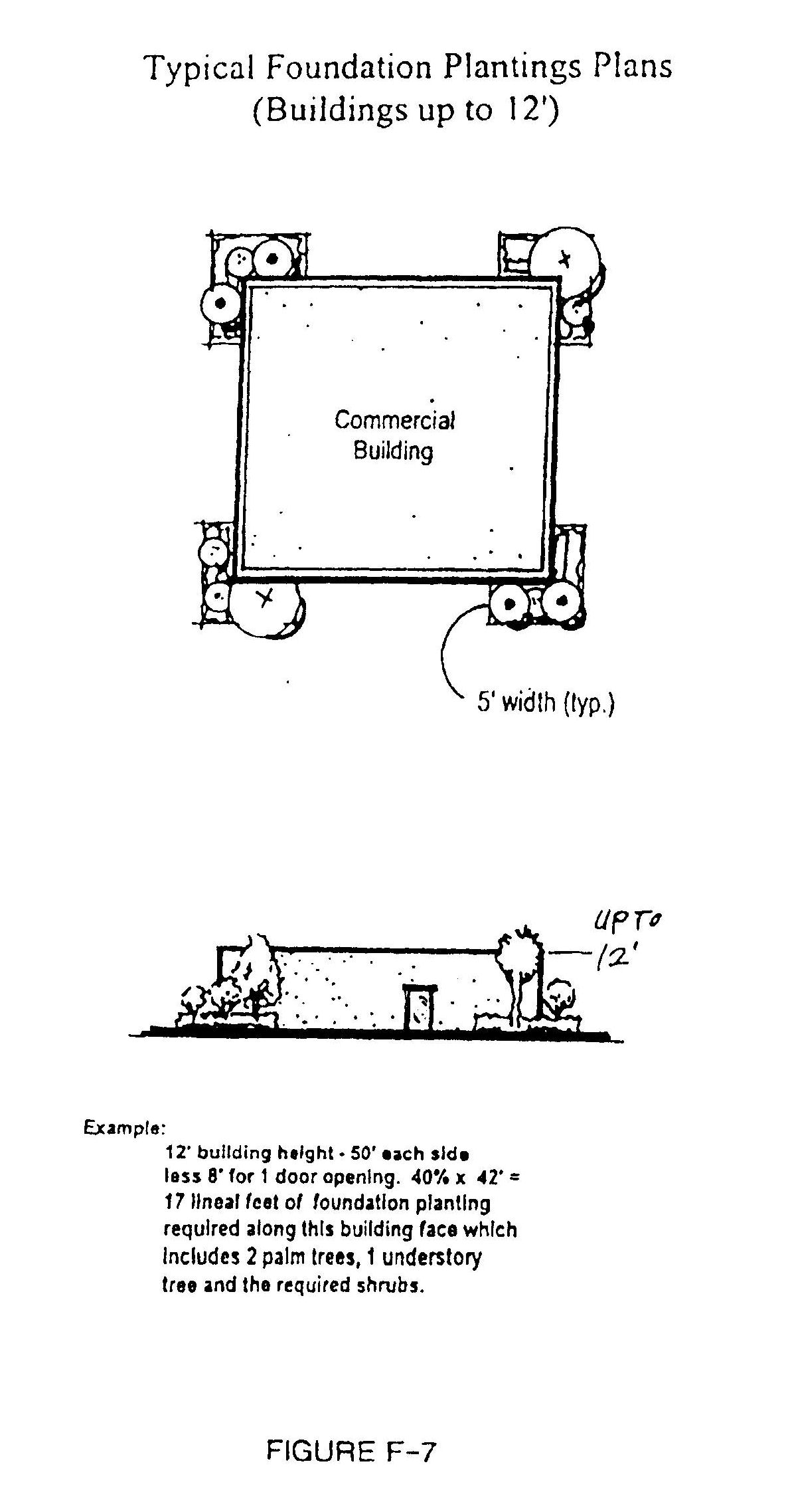
Foundation Plantings
(Ord. No. 98-9, § 10, 5-19-98)
(Ord. No. 98-9, § 10, 5-19-98)
(Ord. No. 98-9, § 10, 5-19-98)
(Ord. No. 98-9, § 10, 5-19-98)
(Ord. No. 98-9, § 10, 5-19-98)
(Ord. No. 98-9, § 10, 5-19-98)
(Ord. No. 98-9, § 10, 5-19-98)
Section 911.20 - North Barrier Island Corridor special development regulations
(1)
Purpose and intent. The overall purpose and intent of these regulations is to:
(a)
Preserve and enhance the appearance of the North Barrier Island community, particularly with respect to the scenic appearance of CR 510 and SR A-1-A.
(b)
Recognize, preserve, and enhance the character of the North Barrier Island Community;
(c)
Increase property values in the North Barrier Island;
(d)
Prevent the establishment of incompatible land uses and unattractive developments in the corridor;
(e)
Make the North Barrier Island area consistent with the following vision statement:
The scenic North Barrier Island area will retain the feeling of an uncluttered, well maintained residential community. Attractive landscaping and special development design considerations for private development and public sector projects will preserve and enhance the natural beauty and scenic vistas that give the North Barrier Island area its special character. Additionally, the area will be characterized by scenic, safe, and uncongested roads, and by low-rise, low-density residential neighborhoods.
(2)
Boundaries of the North Barrier Island Corridor. The boundaries of the North Barrier Island Corridor are as shown on the county's official zoning atlas. Generally, the boundaries cover the area within three hundred (300) feet of either side of the centerline of CR 510 from the edge of the western shore of the Indian River Lagoon to the Atlantic Ocean, and the area within 300 feet of either side of the centerline of SR A-1-A from the northern limits of the Town of Indian river Shores to the Sebastian Inlet.
(3)
Specific development regulations within the North Barrier Island Corridor. In the North Barrier Island Corridor, the following special regulations shall apply to new development or re-development that requires site plan or plat approval, and shall not apply to development or re-development of individual single-family homes and accessory uses/structures to such homes. Special regulations, as specified herein, shall apply to all new development or re-development site plan projects within the North Barrier Island Corridor, as defined herein.
(a)
Prohibited uses: The following land uses shall be prohibited:
1.
Outdoor display of automobiles/motorized vehicles for sale or rental;
2.
Outdoor display of mobile homes for sale or rental;
3.
Outdoor display of boats for sale or rental;
4.
Drive-in theaters;
5.
Recycling centers;
6.
Commercial telecommunications towers:
7.
Flea markets;
8.
Transient merchant uses; and
9.
Temporary sales events that require temporary use permits and are conducted outside of enclosed buildings.
Specifically, there shall be no outside display of merchandise on public sidewalks (within public rights-of-way or easements) or rights-of-way. Outside display of merchandise shall be allowed on private property; provided, however, that outside display of merchandise is allowed only on sidewalks abutting buildings occupied by the business displaying the merchandise. All other uses shall comply with applicable zoning district regulations.
(b)
Restricted uses and North Barrier Island Corridor special regulations:
1.
Within the plan area, vehicle bays or stalls such as those associated with vehicle repair and car wash uses are allowed IF such bays or stalls are oriented and screened from view of SR A-1-A and CR 510 by provision of a Type "B" buffer with four-foot opaque feature.
2.
Real estate signs: Real estate signs are allowed as authorized in the county sign ordinance (Chapter 956). However, no real estate sign shall remain on display for more than fifteen (15) days after the date of closing.
3.
Special buffer for multi-family, planned development, and subdivision projects: Multi-family, planned development, and subdivision projects shall provide the CR 510 and SR A-1-A landscape buffer (as specified herein) with a six-foot opaque feature. Where a wall or fence is used, such wall or fence shall be located within the middle one-third (⅓) of the buffer strip's width (measured perpendicular to CR 510 and A-1-A), and landscaping material shall be planted on each side of the wall or fence.
4.
Canopy fascia restrictions: Any canopy (such as for a gas station, car wash, or drive through facility) that is wholly or partially within seventy-five (75) feet of the CR 510 or SR A-1-A road right-of-way shall meet the following requirements concerning maximum fascia height (this pertains to all fascia on the above described canopy, including any canopy facia that continues beyond the seventy-five-foot limit):
5.
Fiberglass and asphalt shingles: Fiberglass and asphalt shingles (except in residentially designated areas) are prohibited on any roof which is visible from any roadway and/or residentially designated area, unless such shingles are an upgraded shingle designed to imitate something other than asphalt or fiberglass (e.g. shake or tile). Such imitations may be approved by the planning and zoning, after a recommendation from the on-going review committee, if the following criteria are satisfied:
a.
The product shall appear authentic from the closest distance that it will be viewed by the general public.
b.
The product shall be substantial. Thin flimsy imitations are unacceptable.
c.
The product shall hold up as well as the product it is imitating. That is, it must be fabricated in such a way that it will retain its original shape, appearance, and color, as well as the product it is imitating.
d.
The product's color shall resemble the color of the product it is imitating.
6.
Project entry features: Project entry features such as walls and archways shall be limited to a maximum height of eight (8) feet above the project grade. In addition, where a wall or archway is proposed, foundation plantings shall be provided on the CR 510 and SR A-1-A sides of such wall or archway, as specified herein for commercial buildings up to twelve (12) feet high. Said foundation plantings shall be credited toward satisfying any required CR 510 and SR A-1-A landscape buffer. Project entry features such as guardhouses which have sloped roofs are allowed if located no closer than one hundred twenty-five (125) feet from the centerline of CR 510 and/or SR A-1-A and are no taller than twenty (20) feet above grade at the top of the highest roof element.
(c)
Exemptions.
1.
Electrical substations and similar uses that prohibit access by the public onto the site may be exempted from architectural/building requirements, if the exempted building(s) and equipment will be visually screened from adjacent properties and roadways.
2.
Historic buildings and resources: In accordance with future land use element objective 8 and LDR Chapter 933, historic buildings and resources identified in the "Historic Properties Survey of Indian River County, Florida," and located within the North Barrier Island Corridor are exempt from special North Barrier Island Corridor Plan requirements to the extent that applying the special corridor requirements would:
a.
Conflict with the preservation or restoration of a historic building or resource; or
b.
Threaten or destroy the historical significance of an identified historic building or resource.
Said exemption shall be reviewed by and be granted by the planning and zoning commission upon receiving a recommendation from staff.
3.
Individual single-family homes and uses and structures accessory to individual single-family homes shall be exempt from the North Barrier Island Corridor special regulations.
(d)
Special sign regulations.
(1)
Scope: These special regulations consist of additional requirements above and beyond the county sign ordinance and shall supersede any less restrictive provisions found in the sign ordinance. All signs shall comply with the requirements of the sign ordinance except as modified by these special sign regulations.
(2)
Approval for change of sign design required: Any exterior change to North Barrier Island Corridor signage which was originally required to comply with these special sign regulations shall require review and approval by the community development department. Such changes shall include, but not be limited to, changes of: sign area (square footage), sign copy area (square footage), height, shape, style, location, colors, materials, or method of illumination. Routine maintenance and replacement of materials which do not affect the approved design shall be exempt from this review and approval. Changes to signs not originally required to comply with these special sign regulations are addressed in the "nonconforming signs" section of these regulations.
(3)
Prohibited signs (this is in addition to sign ordinance section 956.12 prohibitions): The following are prohibited:
Prohibited signs:
a.
Lights or illuminations that flash, move, rotate, scintillate, blink, flicker, or vary in intensity or color. Public signs permitted pursuant to sign ordinance section 956.11(2)(b) are excluded from this prohibition and are allowed.
b.
Electronic message boards and message centers, electronic adjustable alternation displays, or any sign that automatically displays words; numerals, and or characters in a programmed manner. Traffic regulatory and directional signs permitted pursuant to sign ordinance section 956.11(2)(b) are excluded from this prohibition and are allowed.
c.
Portable or trailer style changeable copy signs.
d.
Signs with the optical illusion of movement by means of a design that presents a pattern capable of giving the illusion of motion or changing of copy.
e.
Strings of light bulbs used on non-residential structures for commercial purposes, other than traditional holiday decorations at the appropriate time of the year.
f.
Signs that emit audible sound, odor, or visible matter, such as smoke or steam.
g.
Plastic or glass sign faces (including but not limited to: acrylic, Lexan®, or Plexiglas®). High density polyurethane and PVC are exempt from this prohibition. Portions of a sign which are changeable copy are exempt from this prohibition. When used in conjunction with cut-out or routered metal cabinets, plastic used only for copy or logos is exempt from this prohibition. Plastic used for illuminated individual channel letters or logos is exempt from this prohibition. Although highly discouraged, a plastic sign face will be allowed only when all of the following requirements are met for the plastic portions of a sign:
i.
Plastic shall be pan formed faced (embossed and/or debossed copy and logos are encouraged).
ii.
Regardless of the opaqueness of a sign, all plastic signage backgrounds shall be a dark color to reduce light transmission from signage background); white background shall not be allowed. All signage background colors shall be limited to those colors with a formula having a minimum black content of eleven (11) percent, and a maximum white content of forty-nine (49). Color formulas will be based on the Pantone Matching System®.
iii.
All color must be applied on the "second surface" (inside face of plastic).
iv.
Nothing shall be applied to the "first surface" (outside face of plastic) (i.e.: paint, vinyl, etc.,)
h.
Neon and similar tube, fiber optic, and intense linear lighting systems, where the neon or lighting tube or fiber is visible.
i.
Plywood used for permanent signs.
j.
Any material used in such a manner for a permanent sign that results in a flat sign without dimension, having a semblance to a "plywood or temporary looking sign."
k.
Installation of an additional sign (or signs) that does not harmonize with the design or materials of the initial sign, such as:
i.
Rear illuminated plastic faced sign with a "wood look" front illuminated sign.
ii.
Combination of signs with cabinets, faces or structure of awkwardly different materials or proportions.
iii.
Attachment or mounting of signs where mounting hardware is left exposed.
iv.
Signs with different color cabinets, frames, or structure.
l.
Individual styrofoam, plastic or wood letters or the like exceeding four (4) inches in height for use on any permanent monument, freestanding, roof, wall, or facade signs. This prohibition does not apply to illuminated individual metal channel letters or the plastic letter typically used for changeable copy signs.
(4)
Signs that are encouraged:
a.
Shaped and fashioned "wood look" multi level signs (i.e.; sand blasted or carved), and signs having durable sign cabinet material such as high density polyurethane and PVC, rather than actual wood or MDO.
b.
Internally illuminated aluminum cabinet with textured finish, and cutout inset or push through acrylic letters. (Note that color may be applied to the "first surface" on push through acrylic letters for this type of sign.)
c.
Backlit reverse pan channel letters (opaque faced) mounted on sign that is harmonious with the project's architecture.
d.
Signage that relates to the building's style of architecture and materials.
e.
Thematic signage.
f.
Changeable copy signs that have a dark opaque background with translucent lettering.
(5)
Reduction in sign sizes and dimensions; modifications to Table 1 (freestanding signs) and Table 2 (wall signs), schedule of regulations for permanent signs requiring permits, Chapter 956 sign ordinance.
a.
Freestanding signs:
i.
Maximum cumulative signage: Reduce to fifty (50) percent of what is allowed in Table 1.
ii.
Maximum signage on a single face: Reduce to fifty (50) percent of what is allowed in Table 1.
iii.
Maximum height: Reduce to thirty (30) percent of what is allowed in Table 1, but no less than six (6) feet and no greater than ten (10) feet.
iv.
For development involving sites of forty (40) acres or more, the ten (10) foot sign height requirement may be waived by the board of county commissioners if the development project applicant prepares and the board of county commissioners approves a sign package that reduces the total sign area otherwise allowed under the corridor plan and sign ordinance by ten (10) percent or more. Out parcels on larger sites shall comply with the six (6) feet to ten (10) foot height limitations specified above.
v.
Required setbacks from property lines or right-of-way: One (1) foot subject to satisfaction of sight distance requirements.
vi.
Number of allowable signs per street frontage: No waivers shall be approved that would reduce the required minimum of two hundred (200) feet of separation between signs along the same street frontage found in Footnote #2 of Table 1 of the sign ordinance. (See Figure F-1 at the end of Section 911.18)
b.
Wall/facade signs.
i.
Maximum sign area allowed: Reduce to fifty (50) percent of what is allowed in Table 2.
(6)
Colors:
a.
The following colors are encouraged for signage:
i.
Use of earth-tone colors and pastels.
ii.
Darker backgrounds with light color sign copy.
iii.
Use of colors that match or are compatible with the project's architecture.
iv.
Colors such as medium or dark bronze are acceptable and encouraged. Polished or weathered true bronze, brass, or copper metal finishes are acceptable and encouraged. Precious metal colors are allowed on sand blasted or carved "wood look" style signs.
b.
The following colors are prohibited for signage:
i.
The use of shiny or bright metallic or mill finish colors (i.e.; gold, silver, bronze, chrome, aluminum, stainless steel, etc.).
ii.
The use of garish colors, such as fluorescent.
iii.
The use of black for signage background. Changeable copy signage is excluded from this prohibition.
(7)
Multi-tenant spaces: Applicants of proposed multi-tenant projects, such as shopping centers, out parcels, industrial complexes and parks, and office complexes and parks, shall submit a sign program for review and approval. This sign program shall identify the coordination and consistency of design, colors, materials, illumination, and locations of signage. In a multi-tenant project where no established pattern, as described above exists, the owner of the multi-tenant project shall submit a sign program for approval prior to issuance of any new sign permits for a tenant space.
(8)
Design criteria and additional restrictions:
a.
Freestanding signage:
i.
All freestanding signs shall be of a wide-based monument style. Pole signs are discouraged, but may be permitted when the supporting structures are completely screened from view with landscaping or berm features. Said landscaping and/or berming shall cover and screen the entire area beneath the sign at time of certificate of occupancy (C.O.) issuance, and thereafter.
ii.
Any freestanding signs constructed from flat panel material, such as high density polyurethane, MDO, sheet metal, or the like, shall have a distance of no less than eight (8) inches from face to face, and shall be enclosed on all sides to cover the internal frame.
b.
Freestanding changeable copy signs:
i.
Where a freestanding changeable copy sign is allowed, no more than eighty (80) percent of the sign face area shall be comprised of changeable copy area.
c.
Wall/facade signage:
i.
The maximum vertical dimension of a facade or wall sign shall not exceed twenty-five (25) percent of the building height.
ii.
Awnings with lettering shall be considered wall signs. Where lettering is used on an awning, the area of lettering shall be included in the percentage limitation of a project's sign area.
iii.
Lettering, logos, and trim colors on canopy facia shall be considered a wall sign and shall be limited to thirty-three (33) percent of the facia area of any one elevation. Internally illuminated signs shall not be placed on a canopy structure, and no sign shall be placed above the facia on a canopy structure.
iv.
Wall signs (facade signs) are prohibited on roofs with a slope less than 20:12 (rise:run) pitch. Wall signs mounted on a roof shall be enclosed on all sides to cover the internal frame and its connection to the roof. Also see IRC LDR's Section 956.12(1)(o).
d.
Changeable copy wall signs for theaters:
i.
Theaters may utilize up to eighty (80) percent of actual sign area for display of names of films, plays or other performances currently showing.
e.
Illumination:
i.
All external flood sign illumination shall be mounted at grade, directly in front of the sign area. Light source shall be completely shielded from oncoming motorist's view.
(9)
Window signs: "Window signs" shall include permanently affixed window signs, temporary window signs, and any signs or displays located within three (3) feet of the window, door, or storefront. Window signs shall not exceed ten (10) percent of the window storefront area (window panes and framing) per store or business, and in no case shall exceed fifty (50) square feet per store or business. Street address numbers and lettering, and flyers or posters related to not for profit events and organizations, shall not count as window signage. "Open," "closed," hours of operations and identification window signage totaling up to four (4) square feet shall not count as window signage.
(10)
Nonconforming signs: It is the intent of these regulations to allow nonconforming signs to continue until they are no longer used or become hazardous, and to encourage conformance to these special sign regulations. A "compatible freestanding sign" shall be defined as any freestanding sign permitted prior to the adoption of these special regulations, and conforming to the North Barrier Island Corridor Plan maximum height requirements for a freestanding sign, and monument style for a freestanding sign.
a.
Nonconforming signs are subject to the following:
i.
Nonconforming signs or nonconforming sign structures on sites abandoned for twelve (12) or more consecutive months shall not be permitted for reuse.
ii.
Except as otherwise provided herein, there may be a change of tenancy or ownership of a nonconforming sign, without the loss of nonconforming status, if the site is not abandoned for twelve (12) or more consecutive months and if there is no change of use of the site. Also, change of tenancy or ownership shall not affect the status of a non-conforming sign that serves multiple tenants.
iii.
Colors of a nonconforming sign shall not be changed from those existing at the time of the adoption of this Code, unless new colors comply with the North Barrier Island Corridor special color requirements.
iv.
A nonconforming sign shall not be enlarged or increased in any way from its lawful size at the time of the adoption of these special regulations.
b.
Except as specified below, nonconforming freestanding signs shall be brought into conformity with the requirements of a "compatible freestanding sign" on or before September 1, 2005. If a property owner documents to the community development director that the cost of lowering a nonconformity sign to a conforming height would exceed fifty (50) percent of the cost to replace the sign, and the building official verifies the appropriateness of the estimated replacement cost, then the sign shall not need to be made a "compatible freestanding sign." However, when such an exemption applies, the property owner shall provide landscaping around the base or support structures of such a sign to visually screen the pole, subject to sight distance requirements, as approved by the community development director.
(11)
Architectural/building standards.
(1)
Prohibited architectural styles: The following are prohibited:
a.
Corporate signature or commercial prototype architecture, unless such is consistent with these special corridor requirements, Examples of such prohibited architecture include flat roofed convenience stores, gas stations, and canopies for gas stations, car washes, and drive through facilities (see Figure F-3 at the end of Section 911.18).
b.
Any kitsch architecture (such as a building that does not resemble a typical structure), including: structures or elements that resemble an exaggerated plant, fish, edible food, or other such items such as giant oranges, ice cream cones, dinosaurs.
c.
Any architecture having a historical reference that is so different from current design philosophy that such reference is inconsistent and/or incompatible with surrounding structures. Examples of such include: igloos, domes or geodesic domes, Quonset style structures, teepees, western "false fronts," medieval castles, caves, and the like.
(2)
Architectural/building exemptions and special requirements:
a.
Electrical substations and similar uses: Electrical substations and similar uses that prohibit access by the public into the site may be exempted from all architectural/building requirements by the community development director if the exempted building(s) and equipment will be visually screened from adjacent properties and roadways.
b.
Historic buildings and resources: In accordance with Future Land Use Element objective 8 and LDR Chapter 933, historic buildings and resources identified in the "Historic Properties Survey of Indian River County, Florida", or identified by the Historic Resources Advisory Committee, and located within the Wabasso corridor are exempt from special Wabasso Corridor Plan requirements to the extent that applying the special corridor plan requirements would:
1.
Conflict with the preservation or restoration of a historic building or resource, or
2.
Threaten or destroy the historical significance of an identified historic building or resource.
Said exemption shall be reviewed by and may be granted by the planning and zoning commission upon receiving a recommendation from staff and the historic resources advisory committee.
(3)
General design criteria:
a.
Buildings with facades fronting on more than one (1) street shall have similar design considerations (e.g. exterior finish, roof treatment, building articulation, entrance features, and window placement) and consistent detailing on all street frontages.
b.
General prohibitions and restrictions:
i.
Flat, blank, unarticulated, or massive facades fronting on a roadway, exclusive access drive or residentially designated area are prohibited. Facades fronting such roads, drives, or areas shall be designed to incorporate architectural elements providing breaks in the planes of exterior walls and/or roofs to articulate the building and to lessen the appearance of excessive mass. Facades should incorporate elements relating to human scale, and can be divided by use of: proportional expression of structure, openings, arcades, canopies, fenestration, changes in materials, cornice details, molding details, changes in the heights of different sections of the building, and the like (stepping or sloping of a parapet wall in conjunction with a low sloped roof is prohibited). Flat, blank, unarticulated, or massive facades will be permitted on the sides and rear of a building where "blank facade foundation plantings" are provided for such building facade faces (see foundation plantings section for requirements).
ii.
The following materials or systems are prohibited as a finish and/or exposed product: corrugated or ribbed metal panels, smooth finish concrete block (standard concrete masonry units), precast concrete tee systems, plywood or textured plywood. Plywood shall be allowed for soffit material.
iii.
Plastic or metal is prohibited as a finish material for walls or trim. Plastic is prohibited as a finish material for sloped roofs, visible roof structures, and facias. Although prohibited in general, certain metal and plastic construction products may be approved by the planning and zoning commission, upon a written request and product sample submitted by the applicant. The planning and zoning commission may approve use of the material if the following criteria are satisfied:
•The product shall appear authentic from the closest distance that it will be viewed by the general public.
•The product shall be substantial. Thin and flimsy imitations are unacceptable.
•The product shall hold up as well as the product it is imitating. That is, it must be fabricated in such a way that it will retain its original shape, appearance, and color, as well as the product it is imitating.
•The product's color shall resemble the color of the product it is imitating.
iv.
Any exposed masonry in a stack bond is prohibited.
v.
Lighting structures or strip lighting that follows the form of the building, parts of the building, or building elements is prohibited.
vi.
Neon and similar tube and fiber optic lighting and similar linear lighting systems, where the neon or lighting tube or fiber is visible, is prohibited (this restriction includes site signage).
vii.
Backlit transparent or translucent architectural elements, backlit architectural elements, as well as illuminated or backlit awnings and roof mounted elements are prohibited. This does not prohibit the use of glass blocks. This does not prohibit the use of an illuminated sign attached to a building.
viii.
Facades that appear to be primarily awnings are prohibited. An awning shall not run continuously for more than thirty (30) percent of the length of any single facade, Gaps between awning segments shall be at least twenty-four (24) inches wide. Placement of awning segments shall relate to building features (e.g. doorways and windows), where possible. Awnings shall not exceed twenty-five (25) percent of the area of any single facade.
ix.
Drive-up windows shall not be located on a building facade that faces a residential area or a roadway unless architecturally integrated into the building and screened by landscaping equivalent to the material in a local road buffer that runs the length of the drive-through lane and its speakers shall be oriented so as not to project sound toward residential areas.
x.
Accessory structures, including sheds, out buildings, dumpster enclosures, and screening structures, shall match the style, finish, and color of the site's main building. Metal utility sheds and temporary car canopies are prohibited.
(12)
Roofs: All buildings and accessory structures within the plan area shall have sloped roofs (slope pitch at least 4:12) visible from every direction, unless a visible flat roof, parapet roof, or other such roof design is determined by the community development director or his designee to be an integral feature of a recognized architectural style.
1.
Sloped roofs, including mansards, shall have a minimum vertical rise of six (6) feet (not including fascia). Where flat roofs are allowed by the community development director or his designee, buildings and accessory structures may have flat roof systems where flat roof areas are not visible at six (6) feet above grade from all directions.
2.
The ridge or plane of a roof (or visible roof structure) that runs parallel (or slightly parallel) with a roadway shall not run continuous for more than one hundred (100) feet without offsetting or jogging (vertically or horizontally) the roof ridge or plane a minimum of sixteen (16) inches (see Figure B-2 at the end of Section 911.19). Low slope roofs and parapet walls allowed by the community development director or his designee are excluded from this requirement.
3.
Roofing materials are prohibited for use as a finish material on parapets or any surface with a slope greater than 30:12 (rise:run), up to and including vertical surfaces. This pertains only to those surfaces visible from adjacent property, exclusive access drives or roadways.
(See Figures F-2 and F-3 at the end of section 911.18)
(e)
Colors and building graphics.
(1)
The following building graphics are prohibited: polka dots, circles, vertical stripes, diagonal stripes or lines, plaids, animals, and symbols such as lightning bolts. However, legally registered trademarks which directly relate to the building occupant (not trademarks of products or services sold or displayed) are allowed, subject to applicable sign and color regulations.
(2)
Color standards. All buildings and accessory structures within the North Barrier Island Corridor shall be limited to the following colors:
a.
Base building colors: Base building colors relate to wall and parapet wall areas and shall be limited to the colors listed in the North Barrier Island Corridor Master Color List. These colors consist of white and light neutral colors in the warm range.
b.
Secondary building colors: Secondary building colors relate to larger trim areas and shall be limited to the colors listed in the North Barrier Island Corridor Master Color List. Secondary building colors shall not exceed thirty (30) percent of the surface area of any one building facade elevation. These colors consist of a mid-range intensity of the base building colors and complimentary colors, and include all base building colors.
c.
Trim colors: Trim colors are used for accent of smaller trim areas, are the brightest group of colors allowed, and include all base building and secondary building colors. Use of metallic colors (i.e.: gold, silver, bronze, chrome, etc) and use of garish colors, such as fluorescent colors (e.g. hot pink, shocking yellow), are prohibited. Trim colors shall not exceed ten (10) percent of the surface area of any one building facade elevation. Where trim colors are used in a building facade sign, the trim color area of the facade sign shall be included in the percentage limitation on the trim color surface area.
d.
Roof colors (requirements for roofs that are visible from a roadway and/or residentially designated area): Metal roof colors shall be limited to the colors listed in the North Barrier Island Corridor Master Color List's "Metal Roof Colors", which is the same as for the SR 60 Corridor. These colors consist of natural mill finish, white, light neutral colors in the warm range, blue, and a limited number of earth-tone colors. Mixing or alternating colors of metal panels is prohibited. For non-metal roofs, other than natural variations in color or color blends within a tile, the mixing or alternating of roof color in the same roof material is prohibited. Colors and color blends shall not be contrary to the intent of this Code. Color for roofing which is glazed, slurry coated, or artificially colored on the surface by any other means shall be limited to the same colors as approved for metal roofs.
e.
Natural finish materials: The color requirements listed above shall not apply to the colors of true natural finish materials such as brick, stone, terra cotta, concrete roof tiles, slate, integrally colored concrete masonry units, copper, and wood. Colors commonly found in natural materials are acceptable, unless such material has been artificially colored in a manner which would be contrary to the intent of these requirements. Black, gray, blue, or extremely dark colors for brick, concrete masonry units, roofing, wood or stone is prohibited. (This provision shall not prohibit the use of colors for natural finish roofing materials that match those colors approved for metal roofs.)
f.
Awning colors: Awning colors may include base building colors and/or secondary building colors and/or trim colors. However, secondary building colors and trim color area used for awnings shall be included in the percentage limitation on the secondary building color and trim color surface area of a facade.
(3)
The North Barrier Island Corridor Master Color List and the approved color board are the same as for the SR 60 Corridor Plan and the Wabasso Corridor Plan, and shall be maintained by and made available by planning staff. The list can be mailed or faxed upon request.
(f)
Special screening and lighting: Within the plan area, mechanical equipment (ground, building, and roof mounted), including air conditioning units, pumps, meters, walk-in coolers, and similar equipment shall be visually screened from surrounding properties and roadways using architectural features, fencing, walls, or landscaping.
In addition to required landscaping, all loading/unloading docking areas located adjacent to residentially designated areas and/or roadways shall be provided with a solid wall at least eight (8) feet in height above the loading area grade to buffer adjacent roadways and residential sites from noises and sights associated with docks.
Manmade opaque screens which are visible from any public or private right-of-way or street, or any residentially designated area, shall be constructed of a material which is architecturally similar in design, color and finish to the principal structure.
1.
Screening.
i.
All telephones, vending machines, or any facility dispensing merchandise or a service on private property shall be confined to a space built into the building or buildings, or enclosed in a separate structure compatible with the main building's architecture. These areas are to be designed with the safety of the user in mind. Public phones and ATMs should have twenty-four-hour access.
ii.
No advertising will be allowed on any exposed amenity or facility such as benches or trash containers.
iii.
Screening of chain link fencing. Where chain link or similar fencing is allowed to be used (e.g. around stormwater ponds), such fencing shall be green or black and shall be located and landscaped so as to visually screen the fencing from public view.
2.
Lighting. The use of thematic and decorative site lighting is encouraged. Low lights of a modest scale can be used along with feature lighting that emphasizes plants, trees, entrances, and exits. Light bollards are encouraged along pedestrian paths. The color of the light sources (lamp) should be consistent throughout the project. Color of site lighting luminaries, poles, and the like shall be limited to dark bronze, black, or dark green (decorative fixtures attached to buildings are exempt from fixture color requirement). Lighting is not be used as a form of advertising or in a manner that draws considerably more attention to the building or grounds at night than in the day. Site lighting shall be designed to direct light into the property. It is to avoid any annoyance to the neighbors from brightness or glare.
i.
Roadway style luminaries (fixtures) such as cobra heads. Nema heads, and the like are prohibited. Wall pack and flood light luminaries are prohibited where the light source would be visible from a roadway, parking area and/or residentially designated area. High intensity discharge (e.g. high pressure sodium, metal halide, mercury vapor, tungsten halogen) lighting fixtures mounted on poles higher than eighteen (18) feet above parking lot grade and under canopies shall be directed perpendicular to the ground. Approved lighting shall shield lighting from roadway, parking, residential, and conservation areas. Other than decorative and low level/low height lighting, no light source or lens shall project above or below a fixture box, shield, or canopy.
(See Figures F-12 and F-13 at the end of section 911.19)
(g)
CR 510 and SR A-1-A landscape buffer: Refer to Section 926.09 for roadway landscape requirements.
(See Figures F-4 and F-5 at the end of section 911.18 and apply to CR 510 and SR A-1-A)
(h)
Landscape buffer along other streets in the corridor: Refer to Section 926.09 for roadway landscape requirements.
(i)
Landscape buffer along commercial/residential border: Within the corridor, where compatibility bufferyards are required by Chapter 911 regulations, two (2) additional understory trees per thirty (30) lineal feet of required buffer strip shall be provided.
(j)
Foundation plantings: Foundation plantings shall be required as stated below for non-residential buildings.
_____1.
Along the front, sides and rear of buildings, the following foundation planting landscape strips shall be provided in accordance with the building height:
1 Depth shall be measured perpendicular to the building, from the foundation outward. Consistent with the requirements below, greater depths may be required where canopy, palm, and understory trees are planted within the foundation planting strip.
2.
At planting, the minimum separation distance from building facades or walls shall be seven (7) feet to canopy trees and five (5) feet to understory trees and palms. At planting, the minimum separation distance from sidewalks shall be six (6) feet to canopy trees and three (3) feet to understory trees and palms, and shall be three (3) feet from parking spaces to canopy trees, understory trees, and palms. Separation distances shall be measured from the trunk to the nearest building, wall, sidewalk, or parking space.
a.
Exception: narrow, upright canopy tree species, such as varieties of cypress and holly, may be located the same distance from buildings, walls, and sidewalks as understory trees and palms.
b.
Where a magnolia or other canopy tree (not including a narrow species such as a cypress or holly) is used in a foundation planting area, the planting area shall have a minimum depth of ten (10) feet measured from the building.
3.
Within such foundation planting landscape strips, the following landscaping shall be provided:
a.
Forty (40) percent of the foundation perimeter (excluding entrance ways and overhead doors) along all building faces shall be landscaped, as follows:
b.
The following modifications are allowed upon approval from the community development director or his designee:
1.
Foundation planting strips may be located away from buildings to adjacent, nearby areas to avoid conflicts with architectural features (e.g., roof overhangs, awnings), driveways, and vehicular areas serving drive-up windows.
2.
The depth of foundation planting strips may be modified if the overall minimum area covered by the proposed foundation plantings meets or exceeds the area encompassed by a typical layout.
3.
Foundation planting areas may be concentrated in one (1) or more areas of the building perimeter, if warranted based upon site constraints or building and site design characteristics. Planting areas shall be provided where the building is most visible from adjacent roadways and on-site areas used by the public.
(k)
Increased foundation plantings for "blank facade" building faces. As referenced in the architectural/building standards section of this plan, "blank facade" building faces that are unarticulated are allowed if foundation plantings are provided as specified above with a one hundred (100) percent increase (doubling) in required plant material quantities (as specified above).
(See Figure F-7 through F-10 at the end of section 911.19)
(1)
Landscape planting theme requirements: All property adjacent to CR 510 within the corridor has been placed into one of two (2) landscaping theme categories. There are no specific landscape theme categories along SR A-1-A. Within each CR 510 theme category, required landscape plantings shall be limited to certain species, as specified below, with the exception that sod, annuals, or hardscape may be used in groundcover areas.
1.
Formal Palm theme: CR 510 between the west shore of the Indian River Lagoon and the eastern foot of the bridge:
2.
Informal Palm theme: SR A1A/CR 510 intersection west to the eastern foot of the bridge:
(4)
No protected trees shall be removed unless it is absolutely necessary to accommodate a proposed site plan.
(5)
Special regulations for administrative approval, minor site plan projects. In the North Barrier Island Corridor plan area, non-residential and mixed use development and re-development that requires administrative approval or minor site plan approval shall comply with the previously described special regulations for new major development, within the administrative approval or minor site plan project's area of development/redevelopment. The project's area of development/redevelopment is the area of the site containing buildings, additions, structures, facilities or improvements proposed by the applicant or required to serve those items proposed by the applicant. As an example, a small building addition that requires additional parking spaces would result in a project area of development/redevelopment that includes the addition and the parking lot addition and adjacent required landscape areas.
(6)
Nonconformities. Within the North Barrier Island Corridor Plan area, legally established existing development and uses that do not comply with these special regulations are grandfathered-in under the countywide nonconformities regulations of LDR Chapter 904. All nonconforming uses and structures are governed by the LDR Chapter 904 regulations.
In addition, within the North Barrier Island corridor plan area the following non-conformities regulations shall apply:
(a)
Nonconforming property: It is the intent of this chapter to allow nonconforming properties to continue, but also to encourage their conformity to what shall be referred to as a "compatible property." A "compatible property" shall be considered in compliance with the intent of the North Barrier Island Corridor special regulations. For the purposes of the North Barrier Island Corridor special regulations, "compatible property" is defined as any property with improvements permitted prior to adoption of these special regulations that conform to the CR 510 and SR A-1-A and landscape buffer, color, and signage requirements of these special regulations.
(b)
Continuance of nonconforming property: A nonconforming property may be continued, subject to the following provisions:
1.
Use of nonconforming structures abandoned for a period of twelve (12) or more consecutive months (cross-reference LDR section 904.08) located on a nonconforming property shall not be permitted until the property is brought into compliance with the requirements of a compatible property.
2.
Except as otherwise provided herein, there may be a change of tenancy or ownership of a nonconforming property, without the loss of nonconforming status, if use of the nonconforming structures is not abandoned for a period of twelve (12) or more consecutive months.
3.
Colors of a structure located on a nonconforming property shall not be changed from those existing at the time of the adoption of these special regulations, unless the new, to-be-painted colors comply with the North Barrier Island Corridor Plan special color regulations.
4.
Projects on nonconforming properties requiring a building permit (excluding permits for roofs or minor repairs or improvements required by law) shall be required to bring the property into compliance as a "compatible property."
5.
A structure located on a nonconforming property shall not be enlarged or increased in any way from its lawful size at the time of the adoption of these special regulations. Where such changes are made, a building permit and compliance with the requirements of a "compatible property" are required for the enlargement or addition.
(7)
Variances.
(a)
Variances from these special corridor regulations shall be processed pursuant to the procedures and timeframes of F.S. § 70.001. The planning and zoning commission shall recommend variances to the board of county commissioners for final action.
(b)
The planning and zoning commission is authorized to propose settlements of claims under F.S. ch. 70, through any means set out in § 70.001(4)(c).
(c)
Criteria. The planning and zoning commission shall not approve a variance or other proposal for relief unless to finds the following:
1.
The corridor regulation directly restricts or limits the use of real property such that the property owner is permanently unable to attain the reasonable, investment backed expectation for the existing use of the real property or a vested right to a specific use of the real property with respect to the real property as a whole; or
2.
That the property owner is left with existing or vested uses that are unreasonable such that the property owner bears permanently a disproportionate share of a burden imposed for the good of the public, which in fairness should be borne by the public at large; and
3.
The relief granted protects the public interest served by the regulations at issue and is the appropriate relief necessary to prevent the corridor regulations from inordinately burdening the real property.
(8)
Public sector development guidelines. The following design enhancements are guidelines that shall be considered in the design of roadway projects and other public sector improvements within the CR 510 and SR A-1-A right-of-way:
1.
Providing irrigation coverage within medians and interchanges, and along roadway edges.
2.
Providing curbed medians and roadway edges in a manner that allows for planting and maintaining more substantive landscaping materials such as canopy trees.
3.
Providing a separated "recreational path" system (used by pedestrians and bicyclists) that meanders along the corridor and is integrated into the pedestrian systems of individual sites.
4.
Planting live oaks, cabbage palms, washingtonian palms, pines, crepe myrtles, wax myrtles and other canopy and understory trees found or used within the corridor. No symmetrical arrangement of material is required.
5.
Providing landscaping, berming and other features that are consistent with line of sight guidelines to signify and enhance the appearance of intersections, access points, medians, and traffic island and separators.
6.
Providing lighting for streets and the separated recreational pedestrian path system with lighting structures that blend in with the surroundings or complement the built environment.
7.
Using dark colors for support poles and structures used for such things as lighting, traffic signals, utilities, and signs, so that such structures do not "stand out" but blend into the surroundings.
8.
Minimizing the number of poles and support structures by eliminating redundant signs and co-locating signs, street lighting, and other structures supported by poles.
9.
Providing pavers and special surface treatments to accent landscape areas, intersections access points, medians, traffic islands and separators, and crosswalks.
10.
Eliminating or reducing overhead transmission and service lines and poles.
(Ord. No. 2001-003, § 1, 3-20-01; Ord. No. 2007-012, § 1, 3-20-07; Ord. No. 2010-008, § 3, 3-23-10; Ord. No. 2010-09, §§ 7, 8, 5-4-10)
Section 911.21. - Roseland Corridor regulations.
(1)
Purpose and intent. The overall purpose and intent of these regulations is to:
(a)
Preserve and enhance the appearance of the Roseland Corridor;
(b)
Recognize and enhance the historic, ecological, and low-density character of the Roseland community;
(c)
Increase property values in the Roseland Corridor;
(d)
Encourage the establishment of compatible land uses and attractive development in the Roseland Corridor;
(e)
Make the Roseland Corridor area consistent with the following vision statement:
Roseland will retain the feeling of an uncluttered, well-maintained neighborhood. Through attractive landscaping and special development design considerations, the Roseland Corridor Plan regulations will preserve and enhance the natural beauty, historic integrity, and scenic vistas that give Roseland its special character.
(2)
Boundaries of the Roseland Corridor. The boundaries of the Roseland Corridor include commercial and industrial zoned land on both sides of US 1 north of the City of Sebastian city limits, and continue north along both sides of US 1 to the north county limit, and would also contain that portion of Roseland Road that is currently designated as commercial/industrial on the Future Land Use Map. Also, these regulations will govern all new institutional development north of the City of Sebastian city limits, east of the St. Sebastian River and west of the Indian River lagoon.
(3)
Specific development regulations within the Roseland Corridor. In the Roseland Corridor, the following special regulations shall apply to new non-residential and mixed use (combination of residential/commercial) development that requires major site plan approval. For non-residential administrative approval and minor site plan projects, the special regulations of section 5 [(3)(d)5.] shall apply.
(a)
[Reserved. ]
(b)
Exemptions.
1.
Industrial and storage buildings located in the CH, IL, and IG zoning districts shall be exempted from foundation planting landscaping requirements and architectural/building requirements for building facades that do not abut residentially designated areas or front on public roads. However, industrial buildings shall satisfy the color requirements.
2.
Electrical substations and similar uses that prohibit access by the public onto the site may be exempted from architectural/building requirements, if the exempted building(s) and equipment will be visually screened from adjacent properties and roadways.
3.
Historic Buildings and Resources: In accordance with future land use element objective 8 and LDR Chapter 933, historic buildings and resources identified in the "Historic Properties Survey of Indian River County, Florida," and located within the Roseland corridor are exempt from the special Roseland Corridor Plan requirements to the extent that applying the special Corridor requirements would:
a.
Conflict with the preservation or restoration of a historic building or resource; or
b.
Threaten or destroy the historical significance of an identified historic building or resource.
Said exemption shall be reviewed by and be granted by the planning and zoning commission upon receipt of a recommendation from staff.
(c)
Uses. With the following exceptions, uses within the corridor are allowed as specified in LDR Chapter 911 (zoning ordinance):
1.
Temporary uses: no temporary outdoor sales uses shall be located closer than 200' to US 1 or any Thoroughfare Plan road right-of-way unless a US 1 and Thoroughfare Plan road landscape buffer, as specified in the landscaping section, has been established between the temporary sales use and the adjacent US 1 or Thoroughfare Plan road right-of-way.
2.
Uses involving vehicle and service bays that are oriented perpendicular to US 1 or Roseland Road are allowed only if a Type "B" buffer with a 4' opaque feature is provided along the site's US 1 or Roseland Road frontage.
(d)
Special sign regulations.
1.
Scope. These special regulations consist of additional requirements above and beyond the county sign ordinance and shall supersede any less restrictive provisions found in the sign ordinance. All signs shall comply with the requirements of the sign ordinance except as modified by these special sign regulations.
2.
Approval for change of sign design required. Any exterior change to Roseland Corridor signage which was originally required to comply with these special sign regulations shall require review and approval by the community development department. Such changes shall include, but not be limited to, changes of: sign area (square footage), sign copy area (square footage), height, shape, style, location, colors, materials, or method of illumination. Routine maintenance and replacement of materials which do not affect the approved design shall be exempt from this review and approval. Changes to signs not originally required to comply with these special sign regulations are addressed in the "nonconforming signs" section of these regulations.
3.
Prohibited signs: In addition to sign ordinance section 956.12 prohibitions, the following are prohibited in the Roseland Corridor:
a.
Lights or illuminations that flash, move, rotate, scintillate, blink, flicker, or vary in intensity or color. Public signs permitted pursuant to sign ordinance section 956.11(2)(b) are excluded from this prohibition and are allowed.
b.
Electronic message boards and message centers, electronic adjustable alternation displays, or any sign that automatically displays words, numerals, and or characters in a programmed manner. Traffic regulatory and directional signs permitted pursuant to sign ordinance section 956.11(2)(b) are excluded from this prohibition and are allowed.
c.
Portable or trailer style changeable copy signs.
d.
Signs with the optical illusion of movement by means of a design that presents a pattern capable of giving the illusion of motion or changing of copy.
e.
Strings of light bulbs used on non-residential structures for commercial purposes, other than traditional holiday decorations at the appropriate time of the year.
f.
Signs that emit audible sound, odor, or visible matter, such as smoke or steam.
g.
Plastic or glass sign faces (including but not limited to: acrylic, Lexan r , or Plexiglas r ). High density polyurethane and PVC are exempt from this prohibition. Portions of a sign which are changeable copy are exempt from this prohibition. When used in conjunction with cut-out or routered metal cabinets, plastic used only for copy or logos is exempt from this prohibition. Plastic used for illuminated individual channel letters or logos is exempt from this prohibition. Although highly discouraged, a plastic sign face will be allowed only when all of the following requirements are met for the plastic portions of a sign:
i.
Plastic shall be pan formed faced (embossed and/or debossed copy and logos are encouraged).
ii.
Regardless of the opaqueness of a sign, all plastic signage backgrounds shall be a dark color to reduce light transmission from signage background); white background shall not be allowed. All signage background colors shall be limited to those colors with a formula having a minimum black content of eleven (11) percent, and a maximum white content of forty-nine (49). Color formulas will be based on the Pantone Matching System r .
iii.
All color must be applied on the "second surface" (inside face of plastic).
iv.
Nothing shall be applied to the "first surface" (outside face of plastic) (i.e.: paint, vinyl, etc.,)
h.
Neon and similar tube, fiber optic, and intense linear lighting systems, where the neon or lighting tube or fiber is visible.
i.
Plywood used for permanent signs.
j.
Any material used in such a manner for a permanent sign that results in a flat sign without dimension, having a semblance to a "plywood or temporary looking sign."
k.
Installation of an additional sign (or signs) that does not harmonize with the design or materials of the initial sign, such as:
i.
Rear illuminated plastic faced sign with a "wood look" front illuminated sign.
ii.
Combination of signs with cabinets, faces or structure of awkwardly different materials or proportions.
iii.
Attachment or mounting of signs where mounting hardware is left exposed.
iv.
Signs with different color cabinets, frames, or structure.
l.
Individual styrofoam, plastic or wood letters or the like exceeding four (4) inches in height for use on any permanent monument, freestanding, roof, wall, or facade signs. This prohibition does not apply to illuminated individual metal channel letters or the plastic letter typically used for changeable copy signs.
4.
Signs that are encouraged:
a.
Shaped and fashioned "wood look" multi level signs (i.e.; sand blasted or carved), and signs having durable sign cabinet material such as high density polyurethane and PVC, rather than actual wood or MDO.
b.
Internally illuminated aluminum cabinet with textured finish, and cut-out inset or push through acrylic letters. (Note that color may be applied to the "first surface" on push through acrylic letters for this type of sign.)
c.
Backlit reverse pan channel letters (opaque faced) mounted on sign that is harmonious with the project's architecture.
d.
Signage that relates to the building's style of architecture and materials.
e.
Thematic signage.
f.
Changeable copy signs that have a dark opaque background with translucent lettering.
5.
Reduction in sign sizes and dimensions. Modifications to Table 1 (freestanding signs) and Table 2 (wall signs), Schedule of Regulations for Permanent Signs Requiring Permits, sign ordinance.
a.
Freestanding signs:
i.
Maximum cumulative signage: Reduce to fifty (50) percent of what is allowed in Table 1.
ii.
Maximum signage on a single face: Reduce to fifty (50) percent of what is allowed in Table 1.
iii.
Maximum height: Reduce to thirty (30) percent of what is allowed in Table 1, but no less than six (6) feet and no greater than ten (10) feet.
iv.
For development involving sites of forty (40) acres or more: The ten (10) foot sign height requirement may be waived by the board of county commissioners if the development project applicant prepares and the board of county commissioners approves a sign package that reduces the total sign area otherwise allowed under the corridor plan and sign ordinance by ten (10) percent or more. Outparcels on larger sites shall comply with the six (6) feet to ten (10) foot height limitations specified above.
v.
Required setbacks from property lines or right-of-way: One (1) foot subject to satisfaction of sight distance requirements.
vi.
Number of allowable signs per street frontage: No waivers shall be approved that would reduce the required minimum of two hundred (200) feet of separation between signs along the same street frontage found in Footnote #2 of Table 1 of the sign ordinance. (See Figure F-1 at end of Section 911.18)
b.
Wall/facade signs.
i.
Maximum sign area allowed: Reduce to fifty (50) percent of what is allowed in Table 2.
6.
Colors:
a.
The following colors are encouraged for signage:
i.
Earth-tone colors and pastels.
ii.
Darker backgrounds with light color sign copy.
iii.
Colors that match or are compatible with the project's architecture.
iv.
Colors such as medium or dark bronze are acceptable and encouraged. Polished or weathered true bronze, brass, or copper metal finishes are acceptable and encouraged. Precious metal colors are allowed on sand blasted or carved "wood look" style signs.
b.
The following colors are prohibited for signage:
i.
Shiny or bright metallic or mill finish colors (i.e.; gold, silver, bronze, chrome, aluminum, stainless steel, etc.).
ii.
Garish colors, such as fluorescent.
iii.
Black for signage background. Changeable copy signage is excluded from this prohibition.
7.
Multi-tenant spaces. Applicants of proposed multi-tenant projects, such as shopping centers, out parcels, industrial complexes and parks, and office complexes and parks, shall submit a sign program for review and approval. This sign program shall identify the coordination and consistency of design, colors, materials, illumiantion, and locations of signage. In a multi-tenant project where no established pattern, as described above exists, the owner of the multi-tenant project shall submit a sign program for approval prior to issuance of any new sign permits for a tenant space.
8.
Design criteria and additional restrictions:
a.
Freestanding signage:
i.
All freestanding signs shall be of a wide-based monument style. Pole signs are discouraged, but may be permitted when the supporting structures are completely screened from view with landscaping or berm features. Said landscaping and/or berming shall cover and screen the entire area beneath the sign at time of certificate of occupancy (C.O.) issuance, and thereafter.
ii.
Any freestanding signs constructed from flat panel material, such as high density polyurethane, MDO, sheet metal, or the like, shall have a distance of no less than eight (8) inches from face to face, and shall be enclosed on all sides to cover the internal frame.
b.
Freestanding changeable copy signs:
i.
Where a freestanding changeable copy sign is allowed, no more than eighty (80) percent of the sign face area shall be comprised of changeable copy area.
c.
Wall/facade signage:
i.
The maximum vertical dimension of a facade or wall sign shall not exceed twenty-five (25) percent of the building height.
ii.
Awnings with lettering shall be considered wall signs. Where lettering is used on an awning, the area of lettering shall be included in the percentage limitation of a project's sign area.
iii.
Lettering, logos, and trim colors on canopy facia shall be considered a wall sign and shall be limited to thirty-three (33) percent of the facia area of any one elevation. Internally illuminated signs shall not be placed on a canopy structure, and no sign shall be placed above the facia on a canopy structure.
iv.
Wall signs (facade signs) are prohibited on roofs with a slope less than 20:12 (rise:run) pitch. Wall signs mounted on a roof shall be enclosed on all sides to cover the internal frame and its connection to the roof. Also see IRC LDR's Section 956.12(1)(o).
d.
Changeable copy wall signs for theaters.
i.
Theaters may utilize up to eighty (80) percent of actual sign area for display of names of films, plays or other performances currently showing.
e.
Illumination.
i.
All external flood sign illumination shall be mounted at grade, directly in front of the sign area. Light source shall be completely shielded from oncoming motorist's view.
9.
Nonconforming signs. It is the intent of these regulations to allow nonconforming signs to continue until they are no longer used or become hazardous, and to encourage conformance to these special sign regulations. A "compatible freestanding sign" shall be defined as any freestanding sign permitted prior to the adoption of these special regulations, and conforming to the Roseland Corridor Plan maximum height requirements for a freestanding sign, and monument style for a freestanding sign.
a.
Nonconforming signs are subject to the following:
i.
Nonconforming signs or nonconforming sign structures on-sites abandoned for twelve (12) or more consecutive months shall not be permitted for reuse.
ii.
Except as otherwise provided herein, there may be a change of tenancy or ownership of a nonconforming sign, without the loss of nonconforming status, if the site is not abandoned for twelve (12) or more consecutive months and if there is no change of use of the site. Also, change of tenancy or ownership shall not affect the status of a non-conforming sign that serves multiple tenants.
iii.
Colors of a nonconforming sign shall not be changed from those existing at the time of the adoption of this Code, unless new colors comply with the Roseland Corridor special color requirements.
iv.
A nonconforming sign shall not be enlarged or increased in any way from its lawful size at the time of the adoption of these special regulations.
v.
Except as specified below, nonconforming freestanding signs shall be brought into conformity with the requirements of a "compatible freestanding sign" on or before June 1, 2008. If a property owner documents to the community development director that the cost of lowering a nonconformity sign to a conforming height would exceed fifty (50) percent of the cost to replace the sign, and the building official verifies the appropriateness of the estimated replacement cost, then the sign shall not need to be made a "compatible freestanding sign." However, when such an exemption applies, the property owner shall provide landscaping around the base or support structures of such a sign to visually screen the pole, subject to sight distance requirements, as approved by the community development director.
b.
Repairs and maintenance. Normal repairs and maintenance may be made; however, the cost of such repairs and/or maintenance made during any two-year period shall not exceed fifty (50) percent of the replacement cost of the sign at the end of the two-year period.
c.
Reconstruction after catastrophe. If any nonconforming sign is damaged by fire, flood, explosion, collapse, wind, war, or other catastrophe, to such an extent that the cost of repair and reconstruction will exceed fifty (50) percent of the replacement cost at the time of damage, the nonconforming sign shall not be used or reconstructed except in full conformity with the provisions of these special regulations.
(e)
Architectural/building standards.
1.
Prohibited architectural styles: The following are prohibited:
a.
Corporate signature or commercial prototype architecture, unless such is consistent with these special corridor requirements. Examples of such prohibited architecture include flat roofed convenience stores, gas stations, and canopies for gas stations, car washes, and drive through facilities (see Figure F-3).
b.
Any kitsch architecture (such as a building that does not resemble a typical structure), including: structures or elements that resemble an exaggerated plant, fish, edible food, or other such items such as giant oranges, ice cream cones, and dinosaurs.
c.
Any architecture having a historical reference that is so different from current design philosophy that such reference is inconsistent and/or incompatible with surrounding structures. Examples of such include: igloos, domes or geodesic domes, Quonset style structures, teepees, western "false fronts," medieval castles, caves, and the like.
2.
Architectural/building exemptions and special requirements:
a.
Electrical substations and similar uses. Electrical substations and similar uses that prohibit access by the public into the site may be exempted from all architectural/building requirements by the community development director if the exempted building(s) and equipment will be visually screened from adjacent properties and roadways.
b.
Historic buildings and resources. In accordance with future land use Element objective 8 and LDR Chapter 933, historic buildings and resources identified in the "Historic Properties Survey of Indian River County, Florida" or identified by the Historic Roseland Architectural Review Committee and located within the Roseland corridor are exempt from special Roseland Corridor Plan requirements to the extent that applying the special Corridor Plan requirements would:
i.
Conflict with the preservation or restoration of a historic building or resource, or
ii.
Threaten or destroy the historical significance of an identified historic building or resource.
Said exemption shall be reviewed by and may be granted by the Planning and Zoning Commission upon receiving a recommendation from staff and the Historic Resources Advisory Committee.
3.
General design criteria:
a.
Buildings with facades fronting on more than one street shall have similar design considerations (e.g. exterior finish, roof treatment, building articulation, entrance features, and window placement) and consistent detailing on all street frontages.
b.
General prohibitions and restrictions:
i.
Flat, blank, unarticulated, or massive facades fronting on a roadway, exclusive access drive or residentially designated area are prohibited. Facades fronting such roads, drives, or areas shall be designed to incorporate architectural elements providing breaks in the planes of exterior walls and/or roofs to articulate the building and to lessen the appearance of excessive mass. Facades should incorporate elements relating to human scale, and can be divided by use of: proportional expression of structure, openings, arcades, canopies, fenestration, changes in materials, cornice details, molding details, changes in the heights of different sections of the building, and the like (stepping or sloping of a parapet wall in conjunction with a low sloped roof is prohibited). Flat, blank, unarticulated, or massive facades will be permitted on the sides and rear of a building where "blank facade foundation plantings" are provided for such building facade faces (see foundation plantings section for requirements).
ii.
The following materials or systems are prohibited as a finish and/or exposed product: corrugated or ribbed metal panels, smooth finish concrete block (standard concrete masonry units), precast concrete tee systems, plywood or textured plywood. Plywood shall be allowed for soffit material.
iii.
Plastic or metal is prohibited as a finish material for walls or trim. Plastic is prohibited as a finish material for sloped roofs, visible roof structures, and facias. Although prohibited in general, certain metal and plastic construction products may be approved by the planning and zoning commission, upon a written request and product sample submitted by the applicant. The planning and zoning commission may approve use of the material if the following criteria are satisfied:
• The product shall appear authentic from the closest distance that it will be viewed by the general public.
• The product shall be substantial. Thin and flimsy imitations are unacceptable.
• The product shall hold up as well as the product it is imitating. That is, it must be fabricated in such a way that it will retain its original shape, appearance, and color, as well as the product it is imitating.
• The product's color shall resemble the color of the product it is imitating.
iv.
Any exposed masonry in a stack bond is prohibited.
v.
Lighting structures or strip lighting that follows the form of the building, parts of the building, or building elements is prohibited.
vi.
Neon and similar tube and fiber optic lighting and similar linear lighting systems, where the neon or lighting tube or fiber is visible, is prohibited (this restriction includes site signage).
vii.
Backlit transparent or translucent architectural elements, backlit architectural elements, as well as illuminated or backlit awnings and roof mounted elements are prohibited. This does not prohibit the use of glass blocks. This does not prohibit the use of an illuminated sign attached to a building.
viii.
Facades that appear to be primarily awnings are prohibited. An awning shall not run continuously for more than thirty (30) percent of the length of any single facade, Gaps between awning segments shall be at least twenty-four (24) inches wide. Placement of awning segments shall relate to building features (e.g. doorways and windows), where possible. Awnings shall not exceed twenty-five (25) percent of the area of any single facade.
ix.
Drive-up windows shall not be located on a building facade that faces a residential area or a roadway unless architecturally integrated into the building and screened by landscaping equivalent to the material in a local road buffer that runs the length of the drive-through lane and its speakers shall be oriented so as not to project sound toward residential areas.
x.
Accessory structures, including sheds, out buildings, dumpster enclosures, and screening structures, shall match the style, finish, and color of the site's main building. Metal utility sheds and temporary car canopies are prohibited.
(f)
Roofs. All buildings and accessory structures within the plan area shall have sloped roofs (slope pitch at least 4:12) visible from every direction, unless a visible flat roof, parapet roof, or other such roof design is determined by the community development director or his designee to be an integral feature of a recognized architectural style (e.g., Mediterranean).
1.
Sloped roofs, including mansards, shall have a minimum vertical rise of six feet (not including fascia). Where flat roofs are allowed by the community development director or his designee, buildings and accessory structures may have flat roof systems where flat roof areas are not visible at six (6) feet above grade from all directions.
2.
The ridge or plane of a roof (or visible roof structure) that runs parallel (or slightly parallel) with a roadway shall not run continuous for more than one hundred (100) feet without offsetting or jogging (vertically or horizontally) the roof ridge or plane a minimum of sixteen (16) inches (see Figure B-2 at the end of section 911.19). Low slope roofs and parapet walls allowed by the community development director or his designee are excluded from this requirement.
3.
Roofing materials are prohibited for use as a finish material on parapets or any surface with a slope greater than 30:12 (rise:run), up to and including vertical surfaces. This pertains only to those surfaces visible from adjacent property, exclusive access drives or roadways.
(See Figures F-2 and F-3 at the end of section 911.18)
(g)
Colors and building graphics.
1.
The following building graphics are prohibited: Polka dots, circles, vertical stripes, diagonal stripes or lines, plaids, animals, and symbols, such as lightning bolts. However, legally registered trademarks which directly relate to the building occupant (not trademarks of products or services sold or displayed) are allowed, subject to applicable sign and color regulations.
2.
Color standards. All buildings and accessory structures within the Roseland Corridor shall be limited to the following colors:
a.
Base building colors. Base building colors relate to wall and parapet wall areas and shall be limited to the colors listed in the Roseland Corridor Master Color List. The Roseland Corridor Master Color List is the same as the Wabasso Corridor Master Color List (herein referred to as the Roseland Corridor Master Color List). These colors consist of white and light neutral colors in the warm range.
b.
Secondary building colors. Secondary building colors relate to larger trim areas and shall be limited to the colors listed in the Roseland Corridor Master Color List. Secondary building colors shall not exceed thirty (30) percent of the surface area of any one building facade elevation. These colors consist of a mid-range intensity of the base building colors and complimentary colors, and include all base building colors.
c.
Trim colors. Trim colors are used for accent of smaller trim areas, are the brightest group of colors allowed, and include all base building and secondary building colors. Use of metallic colors (i.e.: gold, silver, bronze, chrome, etc) and use of garish colors, such as fluorescent colors (e.g. hot pink, shocking yellow), are prohibited. Trim colors shall not exceed ten (10) percent of the surface area of any one building facade elevation. Where trim colors are used in a building facade sign, the trim color area of the facade sign shall be included in the percentage limitation on the trim color surface area.
d.
Roof colors (requirements for roofs that are visible from a roadway and/or residentially designated area). Metal roof colors shall be limited to the colors listed in the Roseland Corridor Master Color List's "Metal Roof Colors." These colors consist of natural mill finish, white, light neutral colors in the warm range, blue, and a limited number of earth-tone colors. Mixing or alternating colors of metal panels is prohibited. For non-metal roofs, other than natural variations in color or color blends within a tile, the mixing or alternating of roof color in the same roof material is prohibited. Colors and color blends shall not be contrary to the intent of this code. Color for roofing which is glazed, slurry coated, or artificially colored on the surface by any other means shall be limited to the same colors as approved for metal roofs.
e.
Natural finish materials. The color requirements listed above shall not apply to the colors of true natural finish materials such as brick, stone, terra cotta, concrete roof tiles, slate, integrally colored concrete masonry units, copper, and wood. Colors commonly found in natural materials are acceptable, unless such material has been artificially colored in a manner which would be contrary to the intent of these requirements. Black, gray, blue, or extremely dark colors for brick, concrete masonry units, roofing, wood or stone is prohibited. (This provision shall not prohibit the use of colors for natural finish roofing materials that match those colors approved for metal roofs.)
f.
Awning colors. Awning colors may include base building colors and/or secondary building colors and/or trim colors. However, secondary building colors and trim color area used for awnings shall be included in the percentage limitation on the secondary building color and trim color surface area of a facade.
3.
The Roseland Corridor Master Color List and the approved color board are the same as for the Wabasso Master Color List, and shall be maintained by and made available by planning staff. The list can be mailed or faxed upon request.
(h)
Special screening and lighting. Within the plan area, mechanical equipment (ground, building, and roof mounted), including air conditioning units, pumps, meters, walk-in coolers, and similar equipment shall be visually screened from surrounding properties and roadways using architectural features, fencing, walls, or landscaping.
In addition to required landscaping, all loading/unloading docking areas located adjacent to residentially designated areas and/or roadways shall be provided with a solid wall at least eight (8) feet in height above the loading area grade to buffer adjacent roadways and residential sites from noises and sights associated with docks.
Manmade opaque screens which are visible from any public or private right-of-way or street, or any residentially designated area, shall be constructed of a material which is architecturally similar in design, color and finish to the principal structure.
1.
Screening.
a.
All telephones, vending machines, or any facility dispensing merchandise or a service on private property shall be confined to a space built into the building or buildings, or enclosed in a separate structure compatible with the main building's architecture. These areas are to be designed with the safety of the user in mind. Public phones and ATMs should have twenty-four-hour access.
b.
No advertising will be allowed on any exposed amenity or facility such as benches or trash containers.
c.
Screening of chain link fencing. Where chain link or similar fencing is allowed to be used (e.g. around stormwater ponds), such fencing shall be green or black and shall be located and landscaped so as to visually screen the fencing from public view.
2.
Lighting. The use of thematic and decorative site lighting is encouraged. Low lights of a modest scale can be used along with feature lighting that emphasizes plants, trees, entrances, and exits. Light bollards are encouraged along pedestrian paths. The color of the light sources (lamp) should be consistent throughout the project. Color of site lighting luminaries, poles, and the like shall be limited to dark bronze, black, or dark green (decorative fixtures attached to buildings are exempt from fixture color requirement).
Lighting is not to be used as a form of advertising or in a manner that draws considerably more attention to the building or grounds at night than in the day. Site lighting shall be designed to direct light into the property. It is to avoid any annoyance to the neighbors from brightness or glare.
a.
Roadway style luminaries (fixtures) such as cobra heads, Nema heads, and the like are prohibited. Wall pack and flood light luminaries are prohibited where the light source would be visible from a roadway, parking area and/or residentially designated area. High intensity discharge (e.g. high pressure sodium, metal halide, mercury vapor, tungsten halogen) lighting fixtures mounted on buildings and poles higher than eighteen (18) feet above parking lot grade, and under canopies, shall be directed perpendicular to the ground. Other than decorative and low level/low height lighting, no light source or lens shall project above or below a fixture box, shield, or canopy.
(See Figures F-12 and F-13 at the end of section 911.19)
(i)
Roseland Corridor landscape buffer. Refer to Section 926.09 for roadway landscape requirements.
(See Figure F-4 at the end of section 911.18)
(j)
Landscape buffer along other streets in the corridor. Refer to Section 926.09 for roadway landscape requirements.
(k)
Landscape buffer along commercial/residential border. Within the corridor, two (2) additional understory trees per thirty (30) lineal feet of required buffer strip shall be provided where compatibility bufferyards are required by Chapter 911 regulations.
(l)
Foundation plantings. Foundation plantings shall be required as stated below for buildings in commercial and industrial areas and for businesses allowed in residential areas. Reference [sub]section[s] 911.21(b)3. and 6. regarding exemptions for historic buildings and resources.
_____1.
Along the front, sides and rear of buildings, the following foundation planting landscape strips shall be provided in accordance with the building height:
1 Depth shall be measured perpendicular to the building, from the foundation outward. Consistent with the requirements below, greater depths may be required where canopy, palm, and understory trees are planted within the foundation planting strip.
2.
At planting, the minimum separation distance from building facades or walls shall be seven (7) feet to canopy trees and five (5) feet to understory trees and palms. At planting, the minimum separation distance from sidewalks shall be six (6) feet to canopy trees and three (3) feet to understory trees and palms, and shall be three (3) feet from parking spaces to canopy trees, understory trees, and palms. Separation distances shall be measured from the trunk to the nearest building, wall, sidewalk, or parking space.
a.
Exception: narrow, upright canopy tree species, such as varieties of cypress and holly, may be located the same distance from buildings, walls, and sidewalks as understory trees and palms.
b.
Where a magnolia or other canopy tree (not including a narrow species such as a cypress or holly) is used in a foundation planting area, the planting area shall have a minimum depth of ten (10) feet measured from the building.
3.
Within such foundation planting landscape strips, the following landscaping shall be provided;
a.
Forty (40) percent of the foundation perimeter (excluding entranceways and overhead doors) along all building faces shall be landscaped, as follows:
b.
The following modifications are allowed upon approval from the community development director or his designee:
1.
Foundation planting strips may be located away from buildings to adjacent, nearby areas to avoid conflicts with architectural features (e.g., roof overhangs, awnings), driveways, and vehicular areas serving drive-up windows.
2.
The depth of foundation planting strips may be modified if the overall minimum area covered by the proposed foundation plantings meets or exceeds the area encompassed by a typical layout.
3.
Foundation planting areas may be concentrated in one (1) or more areas of the building perimeter, if warranted based upon site constraints or building and site design.
(m)
Increased foundation plantings for "blank facade" building faces. As referenced in the architectural/building standards section of this plan, "blank facade" building faces that are unarticulated are allowed if foundation plantings are provided as specified above with a one hundred (100) percent increase (doubling) in required plant material quantities (as specified above).
(See Figures F-7 through F-9 at the end of section 911.19, also attached in Appendix A)
(n)
Recommended native vegetation for landscaping. Planting native vegetation for landscaping purposes is encouraged. See Appendix B for a table of plants endemic to the Roseland area.
(4)
Notification of development projects sent to friends of Historic Roseland. The county will notify the President of the Friends of Historic Roseland of proposed commercial and industrial projects in the corridor. The President of the Friends of Historic Roseland will be notified by planning staff of the dates of pre-application conferences. Technical review committee, planning and zoning commission, and board of County Commissioners meetings at which proposals for non-residential development within the corridor are reviewed.
Staff will work with applicants to ensure that every effort is made to save protected trees. No protected trees shall be removed unless it is absolutely necessary to accommodate a proposed site plan. In addition, staff will encourage developers to follow the voluntary architectural guidelines found in the Roseland Corridor Plan.
(5)
Special regulations for administrative approval, minor site plan projects. In the Roseland Corridor plan area, non-residential and mixed use development and re-development that require administrative approval or minor site plan approval shall comply with the previously described special regulations for new major development, within the administrative approval or minor site plan project's area of development/redevelopment. The project's area of development/redevelopment is the area of the site containing buildings, additions, structures, facilities or improvements proposed by the applicant or required to serve those items proposed by the applicant. As an example, a small building addition that requires additional parking spaces would result in a project area of development/redevelopment that includes the addition and the parking lot addition and adjacent required landscape areas.
(6)
Non-conformities. Within the Roseland Corridor Plan area, legally established existing development and uses that do not comply with these special regulations are grandfathered-in under the countywide nonconformities regulations of LDR Chapter 904. All nonconforming uses and structures are governed by the LDR Chapter 904 regulations.
In addition, within the Roseland corridor plan area the following non-conformities regulations shall apply:
(a)
Nonconforming property. It is the intent of this chapter to allow nonconforming properties to continue, but also to encourage their conformity to what shall be referred to as a "compatible property." A "compatible property" shall be considered in compliance with the intent of the Roseland Corridor special regulations. For the purposes of the Roseland Corridor special regulations, "compatible property" and "free-standing sign height" shall be defined pursuant to the definitions for those terms in the Other Corridors regulations found in section 911.22(4).
(b)
Continuance of nonconforming property. A nonconforming property may be continued, subject to the following provisions:
1.
Use of nonconforming structures abandoned for a period of twelve (12) or more consecutive months (cross-reference LDR section 904.08) located on a nonconforming property shall not be permitted until the property is brought into compliance with the requirements of a compatible property.
2.
Except as otherwise provided herein, there may be a change of tenancy or ownership of a nonconforming property, without the loss of nonconforming status, if use of the nonconforming structures is not abandoned for a period of twelve (12) or more consecutive months.
3.
Colors of a structure located on a nonconforming property shall not be changed from those existing at the time of the adoption of these special regulations, unless the new, to-be-painted colors comply with the Roseland special color regulations.
4.
Projects on nonconforming properties requiring a building permit (excluding permits for roofs or minor repairs or improvements required by law) shall be required to bring the property into compliance as a "compatible property."
5.
A structure located on a nonconforming property shall not be enlarged or increased in any way from its lawful size at the time of the adoption of these special regulations. Where such changes are made, a building permit and compliance with the requirements of a "compatible property" are required for the enlargement or addition.
(7)
Variances.
(a)
Variances from these special corridor regulations shall be processed pursuant to the procedures and timeframes of F.S. § 70.001. The planning and zoning commission shall recommend variances to the board of county commissioners for final action.
(b)
The planning and zoning commission is authorized to propose settlements of claims under F.S. ch. 70, through any means set out in § 70.001(4)(c).
(c)
Criteria. The planning and zoning commission shall not approve a variance or other proposal for relief unless it finds the following:
1.
The corridor regulation directly restricts or limits the use of real property such that the property owner is permanently unable to attain a reasonable, investment-backed expectation for the existing use of the real property or a vested right to a specific use of the real property with respect to the real property as a whole; or
2.
That the property owner is left with existing or vested uses that are unreasonable such that the property owner bears permanently a disproportionate share of a burden imposed for the good of the public, which in fairness should be borne by the public at large; and
3.
The relief granted protects the public interest served by the regulations at issue and is the appropriate relief necessary to prevent the corridor regulations from inordinately burdening the real property.
(8)
Voluntary guidelines.
(a)
The following voluntary architectural guidelines are established to encourage, through private and public investment, the development of the Roseland Corridor as a cohesive, functional and aesthetic whole. The guidelines contain standards addressing components of the physical development of structures in the corridor. Based upon location, history, environmental attributes, historic resources and character, these guidelines reflect an architectural theme using elements found throughout Florida's past, referred to as "Old Florida" style.
1.
General criteria. Besides defining the community's low density, low rise character, building heights should relate to open spaces to allow sufficient light and ventilation, effective use of prevailing winds for cooling, enhancement of views and minimizing the obstruction of views to adjoining structures and other locations.
Buildings should be designed to lessen the appearance of excessive bulk. Ostentatious or overly-prominent building shapes that are out of harmony in context with their visual environment, including adjacent structures and the landscaped framework, are discouraged.
The surfaces of enclosing walls of large-scale commercial structures should incorporate elements relating to the scale of pedestrian movement and view. Vertical enclosing walls should be sub-divided into clearly visible bays, each a minimum of sixty (60) feet in width.
The use of the following devices for establishing scale is encouraged:
a.
Textured surfaces;
b.
Scored joints;
c.
Surface articulation or subdivision of vertical surfaces into distinct areas;
d.
Rhythmic use of openings (doors, windows, etc.);
e.
Scale and proportion of facade;
f.
Use of signage to establish scale and proportion;
g.
Installation of landscape elements in front of walls to break up long wall expanses and sloped or otherwise articulated roof lines to develop visual interest at the roof level.
2.
Specific criteria.
a.
Roofs: The use of vernacular materials such as standing seam metal or wood shake shingles is encouraged. Roof pitch should range from 8:12 to 12:12 for primary roofs, and lower pitch for arcades or overhangs.
b.
Doors/windows: Doors and windows should be symmetrical in placement, and should be true divided lite [light]. Casing trim should be four (4) to six (6) inches and workable shutters sized to fit windows are encouraged.
c.
Siding: Siding should be wood horizontal or vertical boards or shake.
d.
Porches/arcades: The use of wide overhangs which create porch or arcadelike features is strongly encouraged. For instance, commercial buildings should provide front walkways which are a minimum of ten (10) feet wide. This width accommodates two (2) to three (3) abreast pedestrian traffic while allowing for entrance door swing area. Awnings are also encouraged to add color and textural interest to buildings.
e.
Cornice detailing: Open exposed rafter tails are encouraged.
f.
Lighting: The use of architecturally thematic lot lighting and signage is encouraged (See Figures F-12 and F-13 at the end of section 911.19).
(Ord. No. 203-043, § 1, 12-16-03; Ord. No. 2007-012, § 1, 3-20-07; Ord. No. 2010-008, § 4, 3-23-10; Ord. No. 2010-09, § 9, 5-4-10; Ord. No. 2012-039, § 1, 12-11-12)
Section 911.22. - Other corridors special development regulations.
(1)
Purpose and intent. The overall purpose and intent of these regulations is to:
(a)
Promote attractive and inviting corridors that accommodate mass transit, pedestrians, bicycles, and other transportation alternatives, as well as automobiles;
(b)
Provide for a sufficient amount of attractive and well-maintained landscaping to complement and enhance the visual quality of buildings, parking areas, and other structures within the corridors;
(c)
Encourage development of attractive buildings within the corridors;
(d)
Ensure unobtrusive and orderly signage that avoids a garish and visually cluttered appearance along the corridors;
(e)
Encourage creative designs and buildings of quality that are articulated and presented at a human scale; and
(f)
Foster creative approaches that result in buildings of enduring character through use of quality design and building materials.
(2)
Boundaries of other corridors. The boundaries of the "other corridors" subject to these regulations (911.22) are defined as follows:
(a)
All commercial/industrial, multi-family, and non-residential sites (excluding barns and similar agricultural buildings) adjacent to the following roadway segments:
1.
Oslo Road east of I-95.
2.
"North" US Highway 1 between the Roseland Corridor and Wabasso Corridor boundaries.
3.
"Central" US Highway 1 between the Wabasso Corridor boundary and the Vero Beach city limits.
4.
53rd Street east of 58th Avenue.
5.
"South" US Highway 1, south of the Vero Beach city limits.
6.
"North" Indian River Boulevard, north of the Vero Beach city limits.
7.
"South" Indian River Boulevard, south of the Vero Beach city limits.
8.
37th Street between US Highway 1 and Indian River Boulevard.
9.
"West" CR510 from the Wabasso Corridor (66th Avenue) to CR512.
10.
"West" CR512 from the Sebastian city limits to the western edge of the commercial/industrial area at I-95.
11.
20th Avenue, south of the Vero Beach city limits.
12.
27th Avenue, south of the Vero Beach city limits.
13.
43rd Avenue, south of 53 rd Street.
14.
58th Avenue, south of CR510.
15.
The following streets east of 58th Avenue:
a.
16th Street
b.
12th Street
c.
8th Street
d.
4th Street
e.
1st Street SW
f.
5th Street SW
g.
13th Street SW
h.
17th Street SW
i.
21st Street SW
j.
25th Street SW
16.
The following streets east of 66th Avenue:
a.
26th Street
b.
33rd Street
c.
37th Street
d.
41st Street
e.
45th Street
f.
49th Street
g.
53rd Street
h.
57th Street
i.
61st Street
j.
65th Street
k.
69th Street
l.
73rd Street
m.
77th Street
n.
81st Street
(b)
All commercial/industrial designated areas within the following "nodes":
• Oslo Road/43rd Avenue Node
• Oslo Road/27th Avenue Node
• Oslo Road/20th Avenue Node
• Oslo Road/I-95 and 74th Avenue Node
• Indian River Memorial Hospital Medical and Commercial/Industrial Node
(3)
Exemptions:
1.
Multi-family development shall be exempt from foundation planting landscaping requirements, from prohibitions on textured plywood as a finish product, and from requirements to screen roof vents.
2.
Industrial and storage buildings shall be exempted from foundation planting landscaping requirements and architectural/building requirements for building facades that do not abut residentially designated areas or front on public roads. However, all sides of industrial buildings shall satisfy the color requirements.
3.
Electrical substations and similar uses that prohibit access by the public onto the site may be exempted from architectural/building requirements, if the exempted building(s) and equipment will be visually screened from adjacent properties and roadways.
4.
Historic buildings and resources: In accordance with future land use element objective 8 and LDR chapter 933, historic buildings and resources identified in the "Historic Properties Survey of Indian River County, Florida," and located within the corridor are exempt from special corridor requirements to the extent that applying the special corridor requirements would:
a.
Conflict with the preservation or restoration of a historic building or resource; or
b.
Threaten or destroy the historical significance of an identified historic building or resource.
Said exemption shall be reviewed by and be granted by the planning and zoning commission upon receiving a recommendation from staff.
(4)
Definitions. The following terms are defined for the corridor special development regulations:
(a)
Facade: For purposes of applying architectural/building standards, a facade shall mean any face of a building (including the visible portion of roof) which is visible from a roadway and/or residentially designated area.
(b)
Low sloped roof: A roof with a slope less than 4:12 (rise:run). Flat roofs are included in this term and classification.
(c)
Visible roof structure: A partial or perimeter roof (used in conjunction with a low sloped roof) that gives the appearance of having a true gable, hip, shed, or mansard roof. A parapet wall is not a "visible roof structure."
(d)
In all sections other than color and building graphics, the terms "finish" and "exposed" shall refer to materials or systems which may be visible, and shall not refer to a paint or coloring system applied over said materials or systems.
(e)
Visually offensive elements: Structures that include: vending machines, gaming machines, ice machines, telephones, walk-in coolers/freezers, transformers, electrical equipment (including panels and meters), water or waste piping and valves, pumps, satellite dishes, antennas, fans, exhaust vents, compressors, generators, tanks, and similar equipment.
(f)
Nuisance elements: Structures that have visual and noise impacts, including; loading and unloading dock areas, dumpster and trash container areas, and commercial grade HVAC equipment.
(g)
Nonconforming sign: A sign located in the corridor that was permitted prior to adoption of the corridor special regulations and does not meet these special sign regulations.
(h)
Nonconforming property: A property with improvements that were permitted prior to the adoption of the corridor special regulations and that do not meet the corridor special regulations.
(i)
Compatible property: Any property with improvements, permitted prior to the adoption of this Code, and conforming to the corridor's: a) building thoroughfare plan road buffer: b) color; and c) signage requirements, except that a nonconforming free-standing sign may remain, subject to the non-conforming sign regulations of this Code [911.22(9)(i)] and subject to screening the lower portion of the sign pole/support with landscaping or a decorative base when a building permit is required for project improvements (excluding permits for roofs or minor repairs). See section 911.22(14)(b)4. of this Code.
(j)
Free-standing sign height: The highest point of a sign measured from the grade of the adjacent project parking area or street whichever is higher.
(5)
Landscaping. The countywide landscaping requirements of LDR Chapter 926 shall apply except as noted herein.
(a)
Reserved.
(b)
Thoroughfare plan road buffer. Refer to Section 926.09 for roadway landscape requirements.
(c)
Local road and exclusive access driveway buffer. Refer to Section 926.09 for roadway landscape requirements.
(d)
Interior parking area. In addition to the normal interior parking area requirements of LDR Chapter 926.
1.
Uncovered parking spaces shall be located no more than five (5) spaces away from a planted landscape area. Said landscape area may be on the parking lot perimeter or interior to the parking lot. This requirement may be waived by the planning and zoning commission where tree preservation efforts require a clustering of interior parking green area around existing trees rather than a spread out placement of landscape islands.
2.
Landscape islands shall be backfilled at least to the top of curb or protective barrier, and may be bermed to a maximum height of twenty-four (24) inches above the adjacent parking lot grade.
(e)
Foundation plantings. Foundation plantings shall be required as stated below for buildings in commercial and industrial areas and for businesses allowed in residential areas. For industrial and storage buildings located in the CH, IL, and IG zoning districts, however, foundation planting strips shall be exempted for sides of buildings not fronting on a residentially designated area, or public road. In addition, industrially zoned manufacturing uses in the 98th Avenue manufacturing district and historic buildings and resources are exempt from foundation planting requirements to the extent provided for in [sub]section[s] 911.19(3)(a)5. and 6. of this ordinance.
_____1.
Along the front, sides and rear of buildings, the following foundation planting landscape strips shall be provided in accordance with the building height:
1 Depth shall be measured perpendicular to the building, from the foundation outward. The required combined depth of the thoroughfare plan road buffer and the foundation planting strip on any site shall not exceed ten (10) percent of the depth of the site, measured perpendicular to the thoroughfare plan road. Consistent with the requirements below, greater depths may be required where canopy, palm, and understory trees are planted within the foundation planting strip.
2.
At planting, the minimum separation distance from building facades or walls shall be seven (7) feet to canopy trees and five (5) feet to understory trees and palms. At planting, the minimum separation distance from sidewalks shall be six (6) feet to canopy trees and three (3) feet to understory trees and palms, and shall be three (3) feet from parking spaces to canopy trees, understory trees, and palms. Separation distances shall be measured from the trunk to the nearest building, wall, sidewalk, or parking space.
a.
Exception: narrow, upright canopy tree species, such as varieties of cypress and holly, may be located the same distance from buildings, walls, and sidewalks as understory trees and palms.
b.
Where a magnolia or other canopy tree (not including a narrow species such as a cypress or holly) is used in a foundation planting area, the planting area shall have a minimum depth of ten (10) feet measured from the building.
3.
Within such foundation planting landscape strips, the following landscaping shall be provided:
a.
Forty (40) percent of the foundation perimeter (excluding entranceways and overhead doors) along all building faces shall be landscaped, as follows:
b.
The following modifications are allowed upon approval from the community development director or his designee:
1.
Foundation planting strips may be located away from buildings to adjacent, nearby areas to avoid conflicts with architectural features (e.g., roof overhangs, awnings), driveways, and vehicular areas serving drive-up windows.
2.
The depth of foundation planting strips may be modified if the overall minimum area covered by the proposed foundation plantings meets or exceeds the area encompassed by a typical layout.
3.
Foundation planting areas may be concentrated in one (1) or more areas of the building perimeter, if warranted based upon site constraints or building and site design characteristics. Planting areas shall be provided where the building is most visible from adjacent roadways and on-site areas used by the public.
(f)
Increased foundation plantings for "blank facade" building faces. As referenced in the architectural/building standards of these corridor regulations, "blank facade" building faces that are unarticulated are allowed if foundation plantings are provided as specified above with a one hundred (100) percent increase (doubling) in required plant material quantities (as specified above).
(See Figure F-7 through F-10 at the end of section 911.19)
(6)
Connection to pedestrian system. Projects fronting on roads with existing or planned/required sidewalks and/or bikeways shall provide a pedestrian path from the project to the existing or future sidewalk and/or bikeway. Said pedestrian path shall have a minimum width of five (5) feet, shall consist of a rigid surface meeting Florida Accessibility Code requirements, and may include properly marked areas that cross parking lots and driveways.
(7)
Architectural/building standards.
(a)
Prohibited architectural styles: The following are prohibited:
1.
Corporate signature or commercial prototype architecture, unless such is consistent with these special corridor requirements. Examples of such prohibited architecture include flat roofed convenience stores, gas stations, and canopies for gas stations, car washes, and drive through facilities (see Figure B-1 in 911.19).
2.
Any kitsch architecture (such as a building that does not resemble a typical structure), including: structures or elements that resemble an exaggerated plant, fish, edible food, or other such items such as giant oranges, ice cream cones, dinosaurs.
3.
Any architecture having a historical reference that is so different from current design philosophy that such reference is inconsistent and/or incompatible with surrounding structures. Examples of such include: igloos, domes or geodesic domes, Quonset style structures, teepees, log cabins, western "false fronts," medieval castles, caves, and the like.
(b)
Architectural/building special requirements for shopping centers and out parcels: The materials, exterior finishes, signage and colors of shopping centers and structures developed on shopping center outparcels shall be compatible and harmonious with each other as determined by which structures are developed first. This requirement may be waived by the community development department if:
1.
The initial shopping center or outparcel was built prior to the enactment of the corridor special regulations and
2.
It is determined by the community development department that enforcement of this requirement would conflict with the intent of these corridor special requirements.
(c)
General design criteria.
1.
Buildings with facades fronting on more than one (1) street shall have similar design considerations (e.g. roof treatment, building articulation, entrance features, and window placement) and consistent detailing on all street frontages.
2.
General prohibitions and restrictions:
a.
Flat, blank, unarticulated, or massive facades fronting on a roadway, exclusive access drive or residentially designated area are prohibited. Facades fronting such roads, drives, or areas shall be designed to incorporate architectural elements providing breaks in the planes of exterior walls and/or roofs to articulate the building and to lessen the appearance of excessive mass. Facades should incorporate elements relating to human scale, and can be divided by use of: proportional expression of structure, openings, arcades, canopies, fenestration, changes in materials, cornice details, molding details, changes in the heights of different sections of the building, and the like (stepping or sloping of a parapet wall in conjunction with a low sloped roof is prohibited). Flat, blank, unarticulated, or massive facades will be permitted on the sides and rear of a building where "blank facade foundation plantings" are provided for such building facade faces (see foundation plantings section for requirements).
b.
The following materials or systems are prohibited as a finish and/or exposed product: corrugated or ribbed metal panels, smooth finish concrete block (standard concrete masonry units), precast concrete tee systems, plywood or textured plywood. Plywood shall be allowed for soffit material.
c.
Any canopy (such as for a gas station, car wash, or drive through facility) that is
wholly or partially within seventy-five (75) feet of a thoroughfare plan road right-of-way
shall meet the following requirements concerning maximum facia height (this pertains
to all facia on the above described canopy, including any
canopy facia that continues beyond the seventy-five-foot limit):
(See Figure F-11 at the end of section 911.19)
d.
Plastic or metal is prohibited as a finish material for walls or trim. Plastic is prohibited as a finish material for slope roofs, visible roof structures, and facias. Although prohibited in general, certain metal and plastic construction products may be approved by the planning and zoning commission, upon a written request and product sample submitted by the applicant. The planning and zoning commission may approve use of the material if the following criteria are satisfied:
i.
The product shall appear authentic from the closest distance that it will be viewed by the general public.
ii.
The product shall be substantial. Thin and flimsy imitations are unacceptable.
iii.
The product shall hold up as well as the product it is imitating. That is, it must be fabricated in such a way that it will retain its original shape, appearance, and color, as well as the product it is imitating.
iv.
The product's color shall resemble the color of the product it is imitating.
e.
Any exposed masonry in a stack bond is prohibited.
f.
Lighting structures or strip lighting that follows the form of the building, parts of the building, or building elements is prohibited.
g.
Neon and similar tube and fiber optic lighting and similar linear lighting systems, where the neon or lighting tube or fiber is visible, is prohibited (this restriction includes site signage).
h.
Backlit transparent or translucent architectural elements, backlit architectural elements, as well as illuminated or backlit awnings and roof mounted elements are prohibited. This does not prohibit the use of glass blocks. This does not prohibit the use of an illuminated sign attached to a building.
i.
Facades that appear to be primarily awnings are prohibited. An awning shall not run continuously for more than thirty (30) percent of the length of any single facade. Gaps between awning segments shall be at least twenty-four (24) inches wide. Placement of awning segments shall relate to building features (e.g. doorways and windows), where possible. Awnings shall not exceed twenty-five (25) percent of the area of any single facade.
j.
Drive-up windows shall not be located on a building facade that faces a residential area or a roadway unless architecturally integrated into the building and screened by landscaping, equivalent to the material in a local road buffer that runs the length of the drive-through lane. Speakers shall be oriented so as not to project sound toward residential areas.
k.
Accessory structures, including sheds, out buildings, dumpster enclosures, and screening structures, shall match the style, finish, and color of the site's main building. Metal utility sheds and temporary car canopies are prohibited.
(d)
Roofs and parapets:
1.
Sloped roofs: Gable, hip, and shed style roofs shall have a slope no less than 4:12 (rise:run). Mansard style roofs with a slope greater than 30:12 (rise:run) are prohibited. Generous eaves on sloped roofs are encouraged. Any roof with a slope less than 4:12 (rise:run) ("low sloped roof") shall not be visible from a roadway and/or residentially designated area. Low sloped roofs must be screened with a visible roof structure or parapet wall.
2.
Visible roof structures: Visible roof structures shall be of such height, bulk, and mass, so as to appear structural, even where the design is non-structural, and shall have a minimum vertical rise of six (6) feet (not including facia). Visible roof structures shall have a slope no less than 4:12 (rise:run). Mansard style visible roof structures with a slope greater than 30:12 (rise:run) are prohibited. Where visible roof structures are utilized in a building design, they shall be continuous around all sides of the structure, except where incorporated with a parapet wall or other architectural element (this does not allow "stuck-on" roofs). Any facade that is not visible from a roadway, exclusive access drive, or residentially designated area, such as facades that are interior to a tightly spaced compound of buildings, will not require a continuous visible roof structure on that facade. Any building with less than three thousand five hundred (3,500) square feet of ground floor area shall have a visible roof structure on all facades.
3.
The following roof styles are prohibited: "A frame," bowstring, dome, gambrel, non-symmetrical gable or hip (different slope on each side of ridge). Quonset, and Polynesian (gable or hip roof with up to a 10:12 (rise:run) maximum pitch with a "skirted" or "flared" lower portion at a 3:12 (rise:run) minimum pitch is allowed).
4.
The ridge or plane of a roof (or visible roof structure), that runs parallel (or slightly parallel) with a roadway shall not run continuous for more than one hundred (100) feet without offsetting or jogging (vertically or horizontally) the roof ridge or plane a minimum of sixteen (16) inches (see Figure B-2 in 911.19). Low slope roofs and parapet walls are excluded from this requirement.
5.
Roofing on sloped roofs and visible roof structures shall be limited to the following systems: architectural standing seam metal, galvanized 5-V crimp, cedar shingles or shakes, slate, clay tile, or cement tile. Architectural standing seam roofs shall be limited to the following systems: flat metal panels with narrow raised seams running twelve (12) to twenty (20) inches apart, which are secured with continuous seam covers or mechanically seamed. Light and natural colors, as well as mill finish metal roofs are encouraged. Mixing colors of metal panels is prohibited.
6.
Roofing materials are prohibited for use as a finish material on parapets or any surface with a slope greater than 30:12 (rise:run), up to and including vertical surfaces. This pertains only to those surfaces visible from adjacent property, exclusive access drives or roadways. This does not exclude the use of metal facia six (6) inches or less in height, use of typical metal flashing, wall cap, drip edge, and the like, use of roofing materials as a screening device (as long as it does not function as a building's parapet), and use of cedar shingles or shakes as a wall material used below the roof line.
7.
Plastic or metal roof panels or systems, asphalt or fiberglass shingles that are not dimensional or architectural, corrugated or ribbed roof panels, hot mopped systems, built-up, gravel, torched on, foam or fluid applied, roll or membrane roofing, and the like are prohibited on any roof which is visible from any roadway and/or residentially designated area. This does not exclude the use of architectural standing seam metal roofing or galvanized 5-V crimp metal roofing. Use of metal or plastic roofing materials may be approved as specified under the section on finish materials for walls, facia, and trim.
8.
"Stuck-on" visible roof structures are not permitted, (see Figure B-3 in 911.19). Partial parapet walls are prohibited. If a parapet wall is used on a building, then a parapet wall of the same style and material is to be continuous around all sides of the structure, except where incorporated with a visible roof structure or other architectural element. Introduction of any visible roof structure shall not appear "fake." Any facade that is not visible from a roadway and/or residentially designated area shall not require a continuous parapet wall on that facade. Steeping or sloping of a parapet wall in conjunction with a low sloped roof is prohibited.
(e)
Site elements:
1.
All telephones, vending machines, or any facility dispensing merchandise or a service on private property shall be confined to a space built into the building or buildings, or enclosed in a separate structure compatible with the main building's architecture. These areas are to be designed with the safety of the user in mind. Public phones and ATMs should have twenty-four-hour access.
2.
No advertising will be allowed on any exposed amenity or facility such as benches or trash containers.
3.
When feasible, existing specimen trees should be preserved in place or relocated on site. Use of tree wells, as well as adaptation and variations of siting in order to conserve native vegetation, is encouraged.
4.
The use of thematic and decorative site lighting is encouraged. Low lights of a modest scale can be used along with feature lighting that emphasizes plants, trees, entrances, and exits. Light bollards are encouraged along pedestrian paths. The color of the light sources (lamp) should be consistent throughout the project. Color of site lighting luminaries, poles, and the like; shall be limited to dark bronze, black, or dark green (decorative fixtures attached to buildings are exempt from fixture color requirement).
Lighting is not to be used as a form of advertising or in a manner that draws considerably more attention to the building or grounds at night than in the day. Site lighting shall be designed to direct light into the property. It is to avoid any annoyance to the neighbors from brightness or glare.
a.
Roadway style luminaries (fixtures) such as cobra heads, Nema heads, and the like are prohibited. Wall pack and flood light luminaries are prohibited where the light source would be visible from a roadway, parking area and/or residentially designated area. High intensity discharge (e.g. high pressure sodium, metal halide, mercury vapor, tungsten halogen) lighting fixtures mounted on buildings and poles higher than eighteen (18) feet above parking lot grade, and lighting elements associated with canopies, shall be directed perpendicular to the ground. Other than decorative and low level/low height lighting, no light source or lens shall project above or below a fixture box, shield, or canopy. Each lighting element or fixture associated with a canopy shall be individually recessed into the canopy (above the canopy ceiling).
(See Figures F-12 and F-13 at the end of section 911.19)
(f)
Screening devices:
1.
"Visually offensive elements," whether freestanding, mounted on roofs, or located anywhere on a structure, shall be concealed from view on all sides. Individual screens, building elements, or appropriate landscaping, are to be used to completely screen the offensive elements from view from adjacent roads, properties, and parking areas. Parapet walls, visible roof structures, individual screens, or building elements; shall be used to completely screen roof mounted, visually offensive elements from view from any point around the entire building perimeter. Screening devices shall relate to the building's style of architecture and materials. All screening devices shall be designed so that no part of the offensive element extends beyond the top of the screen, measured vertically (see Figure B-4 in 911.19). Rooftop screening devices shall not be required for plumbing roof vents, which are less than four (4) inches in diameter and less than twelve (12) inches above roof penetration. These roof vents are to be located where they will be least visible from roadways.
2.
"Nuisance elements" shall be visually screened from adjacent roadways and/or residentially designated areas with solid walls in addition to any required landscaping. Loading dock buffering shall meet Chapter 926 standards: all other walls shall be a minimum of six (6) feet in height. All dumpster and trash container areas shall be completely screened on all sides. Acoustical material shall be used on the inside face of walls around HVAC equipment.
3.
Individual screens and walls shall relate to the building's style of architecture and materials. A durable material such as reinforced concrete masonry units is recommended with an architecturally compatible finish. Wood fences are discouraged.
4.
Chain link fencing, with or without slats, is prohibited as a screening device for screening visually offensive elements and nuisance elements.
(8)
Colors and building graphics.
(a)
The following building graphics are prohibited: polka dots, circles, vertical stripes, diagonal stripes or lines, plaids, animals, and symbols such as lightning bolts. However, legally registered trademarks, which directly relate to the building occupant (not trademarks of products or services sold or displayed) are allowed, subject to applicable sign and color regulations.
(b)
Color standards. All buildings and accessory structures within the other corridors shall be limited to the following colors:
1.
Base building colors: Base building colors relate to wall and parapet wall areas and shall be limited to the colors listed in the SR 60 Corridor Master Color List. These colors consist of white and light neutral colors in the warm range.
2.
Secondary building colors: Secondary building colors relate to larger trim areas and shall be limited to the colors listed in the SR 60 Corridor Master Color List, Secondary building colors shall not exceed thirty (30) percent of the surface area of any one (1) building facade elevation. These colors consist of a mid-range intensity of the base building colors and complementary colors, and include all base building colors.
3.
Trim colors: Trim colors are used for accent of smaller trim areas, are the brightest group of colors allowed, and include all base building and secondary building colors. Use of metallic colors (i.e.: gold, silver, bronze, chrome, etc…) and use of garish colors, such as fluorescent colors (e.g. hot pink, shocking yellow), is prohibited. Trim colors shall not exceed ten (10) percent of the surface area of any one (1) building facade elevation. Where trim colors are used in a building facade sign, the trim color area of the facade sign shall be included in the percentage limitation on the trim color surface area.
4.
Roof colors (requirements for roofs that are visible from a roadway and/or residentially designated area): Metal roof colors shall be limited to the colors listed in the SR 60 Corridor Master Color List's "Metal Roof Colors." These colors consist of natural mill finish, white, light neutral colors in the warm range, blue, and a limited number of earth-tone colors. Mixing or alternating colors of metal panels is prohibited. For non-metal roofs, other than natural variations in color or color blends within a tile, the mixing or alternating of roof color in the same roof material is prohibited. Colors and color blends shall not be contrary to the intent of this code. Color for roofing, which is glazed, slurry coated, or artificially colored on the surface by any other means shall be limited to the same colors as approved for metal roofs.
5.
Natural finish materials: The color requirements listed above shall not apply to the colors of true natural finish materials such as brick, stone, terra cotta, concrete roof tiles, slate, integrally colored concrete masonry units, copper, and wood. Colors commonly found in natural materials are acceptable, unless such material has been artificially colored in a manner, which would be contrary to the intent of these requirements. Black, gray, blue, or extremely dark colors for brick, concrete masonry units, roofing, wood or stone is prohibited. (This provision shall not prohibit the use of colors for natural finish roofing materials that match those colors approved for metal roofs.)
6.
Awning colors: Awning colors may include base building colors and/or secondary building colors and/or trim colors. However, secondary building colors and trim color area used for awnings shall be included in the percentage limitation on the secondary building color and trim color surface area of a facade.
(c)
The SR 60 Corridor Master Color List and approved color board shall be maintained by and made available by planning staff. The list can be mailed or faxed upon request.
(9)
Special sign regulations.
(a)
Scope: These special regulations consist of additional requirements above and beyond the county sign ordinance and shall supersede any less restrictive provisions found in the sign ordinance. All signage shall comply with the requirements of the sign ordinance except as modified by these special sign regulations.
(b)
Approval for change of sign design required: Any exterior change to corridor signage which was: originally required to comply with these special sign regulations shall require review and approval by the community development department. Such changes shall include, but not be limited to, changes of: sign area (square footage), sign copy area (square footage), sign copy (this does not apply to "changeable copy" signage), height, shape, style, location, colors, materials, or method of illumination. Routine maintenance and replacement of materials which does not affect the approved design shall be exempt from this review and approval. Changes to signs not originally required to comply with these special sign regulations are addressed in the "nonconforming signs" section of these regulations.
(c)
Prohibited signs (this is in addition to sign ordinance section 956.12 prohibitions): The following are prohibited:
1.
Lights or illuminations that flash, move, rotate, scintillate, blink, flicker, or vary in intensity or color, except for time-temperature-date signs. Public signs permitted pursuant to sign ordinance section 956.11(2)(b) are excluded from this prohibition and are allowed.
2.
Electronic message boards and message centers, electronic adjustable alternation displays, or any sign that automatically displays words, numerals, and or characters in a programmed manner. Traffic regulatory and directional signs permitted pursuant to sign ordinance section 956.11(2)(b) are excluded form this prohibition and are allowed.
3.
Portable or trailer style changeable copy signs.
4.
Signs with the optical illusion of movement by means of a design that presents a pattern capable of giving the illusion of motion or changing of copy.
5.
Strings of light bulbs used on non-residential structures for commercial purposes, other than traditional holiday decorations at the appropriate time of the year.
6.
Signs that emit audible sound, odor, or visible matter, such as smoke or steam.
7.
Plastic or glass sign faces (including but not limited to: acrylic, Lexan®, or Plexiglas®). High density polyurethane and PVC are exempt from this prohibition. Portions of a sign which are changeable copy are exempt from this prohibition. When used in conjunction with cut-out or routered metal cabinets, plastic used only for copy or logos is exempt from this prohibition. Plastic used for illuminated individual channel letters or logos is exempt from this prohibition. Although highly discouraged, a plastic sign face will be allowed only when all of the following requirements are met for the plastic portions of a sign:
i.
Plastic shall be pan formed faced (embossed and/or de-bossed copy and logos are encouraged).
ii.
Regardless of the opaqueness of a sign, all plastic signage backgrounds shall be a dark color to reduce light transmission from signage background); white background shall not be allowed. All signage background colors shall be limited to those colors with a formula having a minimum black content of eleven (11) percent, and a maximum white content of forty-nine (49). Color formulas will be based on the Pantone Matching System®.
iii.
All color must be applied on the "second surface" (inside face of plastic).
iv.
Nothing shall be applied to the "first surface" (outside face of plastic) (i.e.: paint, vinyl, etc.,)
8.
Neon and similar tube, fiber optic, and intense linear lighting systems, where the neon or lighting tube or fiber is visible.
9.
Plywood used for permanent signs.
10.
Any material used in such a manner for a permanent sign that results in a flat sign without dimension, having a semblance to a "plywood or temporary looking sign."
11.
Installation of an additional sign (or signs) that does not harmonize with the design or materials of the initial sign, such as:
i.
Rear illuminated plastic faced sign with a "wood look" front illuminated sign.
ii.
Combination of signs with cabinets, faces or structure of awkwardly different materials or proportions.
iii.
Attachment or mounting of signs where mounting hardware is left exposed.
iv.
Signs with different color cabinets, frames, or structure.
12.
Appliques or letters of vinyl and similar materials for use on any permanent monument, freestanding, or roof signs. They are also prohibited for use on any permanent wall or facade signs that exceed three (3) square feet. Window signs as allowed in this chapter are excluded from this prohibition. Regardless of size, appliques or vinyl letters are prohibited for use on plastic sign faces.
13.
Individual styrofoam, plastic or wood letters or the like exceeding four (4) inches in height are prohibited for use on any permanent monument, freestanding, roof, wall, or facade signs. This prohibition does not apply to illuminated individual metal channel letters or the plastic letter typically used for changeable copy signs.
14.
Changeable copy signs for office, industrial, commercial and residential uses, except theaters, places of assembly, and the posting of gasoline prices.
(d)
Signs that are encouraged:
1.
Shaped and fashioned "wood look" multi level signs (i.e.: sand blasted or carved), and signs having durable sign cabinet material such as high density polyurethane and PVC, rather than actual wood or MDO.
2.
Internally illuminated aluminum cabinet with textured finish, and cut-out inset or push through acrylic letters. (Note that color may be applied to the "first surface" on push through acrylic letters for this type of sign.)
3.
Backlit reverse pan channel letters (opaque faced) mounted on sign that is harmonious with the project's architecture.
4.
Signage that relates to the building's style of architecture and materials.
5.
Thematic signage.
6.
Where allowed, changeable copy signs that have a dark opaque background with translucent lettering.
(e)
Reduction in sign sizes and dimensions: Modifications to Table 1 (freestanding signs) and Table 2 (wall signs), Schedule of Regulations for Permanent Signs Requiring Permits, sign ordinance.
1.
Freestanding signs:
i.
Maximum cumulative signage: Reduce to fifty (50) percent of what is allowed in Table 1, except for I-95 signs as described in iii, below.
ii.
Maximum signage on a single face: Reduce to fifty (50) percent of what is allowed in Table 1, except for I-95 signs as described in iii, below.
iii.
Maximum height: Reduce to thirty (30) percent of what is allowed in Table 1, but no less than six (6) feet and no greater than ten (10) feet. Maximum height and size modifications do not apply to properties located within one thousand (1,000) feet of I-95 entrance or exit ramps where an applicant demonstrates that a taller proposed sign is oriented so as to be seen by I-95 motorists approaching the SR 60 interchange. For properties located between one thousand (1,000) feet and two thousand (2,000) feet of I-95 entrance or exit ramps, a maximum sign height of twenty (20) feet and a maximum sign area of one hundred (100) square feet shall be allowed. Any pole for such a sign shall be colored dark bronze, black, or dark green. All other special restrictions and prohibitions shall apply.
a.
Sign base and sign pole base landscaping: for signs near I-95 allowed to exceed twenty (20) feet in height, sign bases and sign pole bases shall be screened from view of the adjacent roadway with a minimum of three (3) canopy trees, three (3) understory trees, and a continuous hedge having a height at planting of at least three (3) feet above grade. For signs allowed to exceed ten (10) feet in height but limited to a height of twenty (20) feet, sign bases and sign pole bases shall be screened from view of the adjacent roadway with a minimum of three (3) understory trees and a continuous hedge having a height at planting of at least three (3) feet above grade. (See Figures F-14 and F-15 at the end of section 911.19).
iv.
For development involving sites of forty (40) acres or more the ten (10) feet sign height requirement may be waived by the board of county commissioners if the development project applicant prepares and the board of county commissioners approves a sign package that reduces the total sign area otherwise allowed under the corridor plan and sign ordinance by ten (10) percent or more. Outparcels on larger sites shall comply with the six (6) feet to ten (10) feet height limitations specified above.
v.
Required setbacks from property lines or right-of-way: One (1) foot subject to satisfaction of sight distance requirements.
vi.
Number of allowable signs per street frontage: No change from Table 1, Footnote #2 of Table 1 shall be modified, requiring a minimum of two hundred (200) feet of separation between signs along the same street frontage.
2.
Wall/facade signs.
i.
Maximum sign area allowed: Reduce to fifty (50) percent of what is allowed in Table 2.
3.
Modifications to these special sign sizes and dimensions regulations may be approved through the PD (Planned Development) process.
(f)
Colors:
1.
The following colors are encouraged for signage:
i.
Use of earth-tone colors and pastels.
ii.
Darker backgrounds with light color sign copy.
iii.
Use of colors that match or are compatible with the project's architecture.
2.
The following colors are prohibited for signage:
i.
The use of shiny or bright metallic or mill finish colors (i.e.: gold, silver, bronze, chrome, aluminum, stainless steel, etc…). Colors such as medium or dark bronze are acceptable and encouraged. Polished or weathered true bronze, brass, or copper metal finishes are acceptable and encouraged. Precious metal colors are allowed on sand blasted or carved "wood look" style signs.
ii.
The use of garish colors, such as fluorescent colors, is prohibited.
iii.
The use of black for signage background. Changeable copy signage is excluded from this prohibition.
(g)
Multi-tenant spaces: Applicants of proposed multi-tenant projects, such as shopping centers, out parcels, industrial complexes and parks, and office complexes and parks, shall submit a sign program for review and approval. This sign program shall communicate the coordination and consistency of design, colors, materials, illumination, and locations of signage. In a multi-tenant project where no established pattern exists as described above, the owner of the multi-tenant project shall be required to submit a sign program for approval prior to issuance of any new sign permits for a tenant space.
(h)
Design criteria and additional restrictions and allowances:
1.
Freestanding signage:
i.
All freestanding signs restricted to a maximum height of no more than sixteen (16) feet shall be of a wide-based monument style. Pole signs are discouraged, but may be permitted when the supporting structures are completely screened from view with landscaping or berm features. Said landscaping and/or berming shall cover and screen the entire area beneath the sign at time of certificate of occupancy (C.O.) issuance.
Design and locational requirements may be modified for compliance with sight distance standards, upon approval from the public works and community development directors or their designees.
ii.
Any freestanding signs constructed from flat panel material, such as high density polyurethane, MDO, sheet metal, or the like, shall have a distance of no less than eight (8) inches from face to face, and shall be enclosed on all sides to cover internal frame.
2.
Freestanding changeable copy signs:
i.
Where allowed, a freestanding changeable copy sign shall not comprise more than eighty (80) percent of the total area of the actual sign.
3.
Wall/facade signage:
i.
The maximum vertical dimension of a facade or wall sign shall not exceed twenty-five (25) percent of the building height.
ii.
Awnings with lettering shall be considered wall signs. Where lettering is used on an awning, the area of lettering shall be included in the percentage limitation of a project's sign area.
iii.
Lettering, logos, and trim colors on canopy facia shall be considered a wall sign and shall be limited to thirty-three (33) percent of the facia area of any one (1) elevation. Internally illuminated signs shall not be placed on a canopy structure, and no sign shall be placed above the facia on a canopy structure.
iv.
Wall signs (facade signs) are prohibited on roofs with a slope less than 20:12 (rise:run) pitch. Wall signs mounted on a roof shall be enclosed on all sides to cover the internal frame and its connection to the roof. Also see IRC LDR's Section 956.12(1)(o).
4.
Changeable copy wall signs for theaters:
i.
Theaters may utilize up to eighty (80) percent of actual sign area for display of names of films, plays or other performances currently showing.
5.
Illumination:
i.
All external flood sign illumination shall be mounted at grade, directly in front of the sign area. Light source shall be completely shielded from oncoming motorist's view.
6.
Window signs: "Window signs" shall include permanently affixed window signs, temporary window signs, and any signs or displays located within three (3) feet of the window, door, or storefront. Window signs shall not exceed ten (10) percent of the window storefront area (window panes and framing) per store or business, and in no case shall exceed fifty (50) square feet per store or business. Street address numbers and lettering, and flyers or posters related to not for profit events and organizations, shall not count as window signage. "Open," "closed," hours of operations and identification window signage totaling up to four (4) square feet shall not count as window signage.
(i)
Nonconforming signs: It is the intent of these regulations to allow nonconforming signs to continue until they are no longer used or become hazardous, and to encourage conformance to these special sign regulations. A "compatible freestanding sign" shall be defined as any freestanding sign permitted prior to the adoption of these special regulations, and conforming to the SR 60 maximum height requirements for a freestanding sign, and wide-based monument style mounting for a freestanding sign.
1.
Nonconforming signs are subject to the following:
i.
Nonconforming signs or nonconforming sign structures on sites abandoned for twelve (12) or more consecutive months shall not be permitted for reuse.
ii.
Except as otherwise provided herein, there may be a change of tenancy or ownership of a nonconforming sign, without the loss of nonconforming status, if the site is not abandoned for twelve (12) or more consecutive months.
iii.
Colors of a nonconforming sign shall not be changed from those existing at the time of the adoption of this Code, unless new colors comply with the SR 60 Corridor special color requirements.
iv.
A nonconforming sign shall not be enlarged or increased in any way from its lawful size at the time of the adoption of these special regulations.
2.
Repairs and maintenance: Normal repairs and maintenance may be made: however, the cost of such repairs and/or maintenance made during any two-year period shall not exceed fifty (50) percent of the replacement cost of the sign at the end of the two-year period.
3.
Reconstruction after catastrophe: If any nonconforming sign is damaged by fire, flood, explosion, collapse, wind, war, or other catastrophe, to such an extent that the cost of repair and reconstruction will exceed fifty (50) percent of the replacement cost at the time of damage, it shall not be used or reconstructed except in full conformity with the provisions of these special regulations.
(10)
Screening of accessory features:
(a)
Screening of chain link fencing. Where chain link or similar fencing is allowed to be used (e.g. around stormwater ponds), such fencing shall be green or black and shall be located and landscaped so as to visually screen the fencing from public view.
(11)
Project-related median alterations: Where alterations to medians of any thoroughfare plan road within the corridor area are proposed in conjunction with a development project, said median improvements shall include installation of stamped/colored concrete or brick pavers and landscaping improvements consistent with the guidelines for improvements within the SR 60 right-of-way contained in the adopted corridor plan.
(12)
Underground utilities services required: Where new utilities services (e.g. electrical, phone, cable) are provided to project sites, such service shall be installed underground.
(13)
Major, minor, administrative site plan approval: Within the corridor area, development and redevelopment requiring major site plan approval shall comply with the corridor plan requirements. Within the area of development of projects requiring minor site plan approval or administrative approval, the previously described special regulations for new major development shall apply. The area of development for such projects shall be the area of the site containing buildings, additions, structures, facilities or improvements proposed by the applicant or required to serve those items proposed by the applicant. As an example, a small building addition that requires additional parking spaces would result in a project area of development/redevelopment that includes the addition AND the parking lot addition and adjacent required landscape areas.
(14)
Non-conformities: Within the corridor area, legally established existing development and uses that do not comply with these special regulations are grandfathered-in under the countywide nonconformities regulations of LDR Chapter 904. All nonconforming uses and structures are governed by the LDR Chapter 904 regulations.
In addition, within the corridor area the following non-conformities regulations shall apply:
(a)
Nonconforming property: It is the intent of this chapter to allow nonconforming properties to continue, but also to encourage their conformity to what shall be referred to as a "compatible property." A "compatible property" shall be considered in compliance with the intent of the corridor special regulations.
(b)
Continuance of nonconforming property: A nonconforming property may be continued, subject to the following provisions:
1.
Use of nonconforming structures abandoned for a period of twelve (12) or more consecutive months (cross-reference LDR section 904.08) located on a nonconforming property shall not be permitted until the property is brought into compliance with the requirements of a compatible property.
2.
Except as otherwise provided herein, there may be a change of tenancy or ownership of a nonconforming property, without the loss of nonconforming status, if use of the nonconforming structures is not abandoned for a period of twelve (12) or more consecutive months.
3.
Colors of a structure located on a nonconforming property shall not be changed from those existing at the time of the adoption of these special regulations, unless the new, to-be-painted colors comply with the SR 60 special color regulations.
4.
Projects on nonconforming properties requiring a building permit (excluding permits for roofs or minor repairs) shall be required to bring the property into compliance as a "compatible property."
5.
A structure located on a nonconforming property shall not be enlarged or increased in any way from its lawful size at the time of the adoption of these special regulations. Where such changes are made, a building permit and compliance with the requirements of a "compatible property" are required for the enlargement or addition.
(15)
Variances:
(a)
Variances from these special corridor regulations shall be processed pursuant to the procedures and timeframes of Section 70.001. Florida Statutes. The planning and zoning commission shall recommend variances to the board of county commissioners for final action.
(b)
The planning and zoning commission is authorized to propose settlements of claims under F.S. ch. 70, through any means set out in § 70.001(4)(c).
(c)
Criteria. The planning and zoning commission shall not approve a variance or other proposal for relief unless it finds the following:
1.
The corridor regulation directly restricts or limits the use of real property such that the property owner is permanently unable to attain the reasonable, investment-backed expectation for the existing use of the real property or a vested right to a specific use of the real property with respect to the real property as a whole; or
2.
That the property owner is left with existing or vested uses that are unreasonable such that the property owner bears permanently a disproportionate share of a burden imposed for the good of the public, which in fairness should be borne by the public at large; and
3.
The relief granted protects the public interest served by the regulations at issue and is the appropriate relief necessary to prevent the corridor regulations from inordinately burdening the real property.
(Ord. No. 2005-017, § 1, 5-17-05; Ord. No. 2007-012, § 1, 3-20-07; Ord. No. 2010-008, § 5, 3-23-10; Ord. No. 2010-09, § 10, 5-4-10; Ord. No. 2010-023, § 1, 10-19-10; Ord. No. 2012-017, § 1, 7-10-12; Ord. No. 2012-039, § 2, 12-11-12)
Section 911.23. - West Gifford Industrial and Commerce (WGIC) overlay regulations.
(1)
Purpose. The West Gifford Industrial and Commerce (WGIC) overlay regulations are intended to establish special regulations for properties in West Gifford zoned IG, general industrial to accommodate industry and commerce in West Gifford in a manner compatible with community residents and businesses.
(2)
Boundaries of the WGIC overlay regulations area. The West Gifford Industrial and Commerce (WGIC) overlay regulations area is generally located between 43rd Avenue and 58th Avenue, north of 41st Street, south of 47th Street, and overlays all properties within the referenced area that are zoned IG (general industrial).
(3)
Relation to IG district regulations. The WGIC overlay regulations supplement the IG district regulations and supersede the IG district regulations with respect to the uses allowed within the overlay area as shown in the use table below.
(4)
Definitions. The following terms are defined for the purposes of interpreting and implementing the WGIC overlay regulations:
(a)
Junk and salvage yards unenclosed facilities: a use of land meeting the Chapter 901 definition of "Junkyard" conducted primarily outside an enclosed building.
(b)
Salvage facility (enclosed building): a use of land meeting the Chapter 901 definition of "Junkyard" conducted within an enclosed building area with the exception of a loading area screened in accordance with WGIC overlay regulations.
(5)
Uses. Uses in the West Gifford Industrial and Commerce overlay area are classified as permitted uses (P), administrative permit uses (A), and special exception uses (S). Site plan review and approval shall be required for the construction, expansion, and change in use of structures and buildings within the overlay area.
P= Permitted use
A= Administrative permit use
S= Special exception use
*The use shall be conducted within an enclosed building.
**See 971.44 for wireless regulations and to determine whether the administrative permit or special exception use process applies.
(6)
Upgrade of 45th Street appearance. On or before June 30, 2015, the owner of any pre-existing junk and salvage yard (unenclosed facility) that fronts 45th Street shall obtain approval from the community development director or his designee of a landscaping and irrigation plan for a continuous vegetative screening between 45th Street and the salvage yard area. A wall or similar structure with aesthetic features may substitute for continuous vegetative screening if shown on an approved plan. The landscaping and irrigation plan, or plan for a wall or similar structure with aesthetic features, shall be subject to the following:
A.
Landscaping improvements shown on the approved landscaping plan shall be installed, inspected, and deemed acceptable by county staff on or before June 30, 2016.
B.
Plans shall show a wall (or similar structure) with aesthetic features or vegetative screening consisting of one or more of the following: planted berms, vines, shrubs, understory trees and canopy trees. Where used, vines shall be planted no further apart than forty-two (42) inches on center and shrubs shall be planted no further apart than thirty-six (36) inches on center. Landscaping and irrigation improvements shall be designed in a manner that does not increase the degree of non-conformity with respect to parking area for any junk and salvage yard (unenclosed facility).
This requirement to provide a wall (or similar structure) with aesthetic features or continuous vegetative screening shall not infringe upon the right of a property owner to continue to use a legally established (grandfathered in) non-conforming parking area adjacent to 45th Street.
C.
Where a wall or similar structure with aesthetic features is substituted for continuous vegetative screening, the wall or similar structure shall be constructed, inspected, and deemed acceptable by county staff on or before June 30, 2016.
(7)
Buffer yard requirements. For new development, where a nonresidential use within the WGIC overlay area directly abuts a single-family or multifamily residential zoning district or use, a landscaped buffer yard meeting the following specifications shall be required along the side and/or rear property line of the development site:
The buffer yard shall be measured at a right angle to the lot line. All buffering and screening requirements shall meet the standards established in Chapter 926, Landscaping and Buffering. No off-street parking or loading area shall be permitted within the required minimum buffer yard.
A.
A loading dock located adjacent to a residentially designated site and not screened from view of the adjacent residential site by an intervening building or similar structure shall be screened by an eight-foot-high wall located between the loading dock and the residential site. Wall height shall be measured from the grade elevation of the parking area adjacent to the loading dock. Plantings along the wall are required in accordance with the standards of landscape ordinance section 926.08.
B.
A loading area associated with a salvage facility (enclosed building) shall be screened from view from adjacent properties and roadways by an eight-foot-opaque feature consisting of a wall or wall and berm combination.
C.
Roadway buffers shall be provided as specified in landscape ordinance section 926.09, "Landscaping along roadways".
D.
Where a non-residential use abuts a property with a residential land use designation, the required buffer opaque feature shall consist of a wall with required understory trees and shrubs installed on the side of the wall facing the residential property.
E.
Where a wall is used in a buffer area or along a project perimeter, there shall be variation in the design of the wall, as provided below:
Variation shall be provided by use of one (1) or more of the following design criteria or other similar design measures approved in writing by the community development director or his designee:
a.
Using two-color paint schemes.
b.
Staggering the location of the wall. Straight wall length should not exceed one hundred (100) feet. The minimum dimension of a wall offset shall be three (3) feet.
c.
Accenting the wall with articulated decorative features.
d.
Breaking up the appearance of long sections of wall by the placement of landscaped berms in front of the wall. Unbermed wall sections shall not exceed one hundred (100) feet in length.
(8)
Mulch products and services special regulations.
(a)
The administrative permit process and regulations for specific land uses ordinance section 971.04 shall apply to mulch products and services development projects, including projects that propose expansion of existing mulch operations.
(b)
Development application special information requirements:
1.
A list of on-site activities and materials stored, handled, processed, and produced on site (including by-products), together with a list of any MSGP (multi-sector general permit) special industry sector pollution discharge requirements applicable to the proposed project.
2.
A National Pollutant Discharge Elimination System (NPDES) pollution prevention plan. The pollution prevention plans shall adequately address the following:
a.
Containment of runoff from stockpiles.
b.
Containment of leaks and spills from vehicles and equipment used in transporting, handling, or processing materials.
c.
Use of wind erosion control measures in stockpile, mulching/processing, and driveway areas.
3.
A site plan labeling and depicting the distance from any area where materials are stockpiled, loaded/unloaded, or processed outside an enclosed building to any property containing a residential dwelling (including a mobile home) within three-hundred (300) feet of such area.
4.
A comprehensive dust and spillage control plan that, at a minimum, addresses the following:
a.
Treatment of stockpiles, on-site processing areas, and loading/unloading areas;
b.
Control of dust from truck, equipment, and mulching operations on site;
c.
Methods of treatment, such as spraying/watering systems or other dust suppressants, devices and techniques, that prevent or minimize air-borne emissions from on-site and off-site activities;
d.
Use of mechanical dust and particulate recovery devices and techniques;
e.
Methods of preventing, minimizing, and cleaning up material spillage on site and along adjacent roadways;
5.
The applicant shall submit for and obtain fire department approval of a fire protection plan that provides for adequate stockpile management and access, and fire suppression improvements.
(c)
Criteria for mulch products and services:
1.
Dust, particulates, and material spillage shall be controlled in accordance with the project's approved comprehensive dust and spillage control plan submitted in accordance with the above requirements. The county may attach special conditions to project approval. Such conditions may include, but are not limited to, sprinkler systems, monitoring systems, structural enclosures, or operational programs to ensure compliance with the approved dust and spillage control plan.
2.
Material stockpiles of non-combustible material shall not exceed a height of twenty-five (25) feet above the grade of the adjacent project site perimeter. The height of combustible material stockpiles shall be regulated by the project's fire protection plan as approved by the fire department.
3.
No area where raw materials are stockpiled, loaded/unloaded, mulched, or processed outside an enclosed building shall be located closer than three hundred (300) feet to any residential dwelling (including a mobile home) or residentially zoned property.
4.
A Type "A" buffer with six-foot-opaque feature shall be provided between any residentially zoned property or residential dwelling unit (including a mobile home) and any area where materials are stockpiled, loaded/unloaded, mulched, or processed outside an enclosed building.
5.
The following best management practices (BMPS) shall apply to the design and operation of the mulch facility.
A.
Design and build equipment work areas, chemical storage areas, and loading/unloading areas with spill containment features and locate such areas away from any waterbodies, swales, or recharge ditches.
(a)
Maintain an approved spill contingency plan in work, storage, and loading/unloading areas.
(b)
Maintain periodic worker training on spill contingency procedures, including immediate and corrective actions, and the filing of incident reports.
(c)
Maintain spill kits in work, storage, and loading/unloading areas.
B.
Use double-lined fuel tanks with a secondary containment around the tanks.
C.
Provide convenient and proper solid waste disposal for workers and for drivers entering or exiting the site.
D.
Label every fifty-five-gallon drum and every container for fuel, chemical, by-product, and waste including non-hazardous waste.
(1)
Secure all drums with lids and keep all drums in one common area marked either hazardous or non-hazardous as per RCRA (Resource Conservation Recovery Act)
(2)
Store containers and drums under structures that provide cover and protect drums from exposure to precipitation.
(3)
Use a covered area, conex box, or other appropriate container with spill containment to store solvents, anti-freeze, used oil, used oil filters, used rags, aerosol cans, and lead acid batteries.
E.
Display permits on site.
F.
Maintain on site a file of all approved plans, monitoring reports, inspections reports, incident reports, and documentation of corrective actions.
G.
Provide county staff and post at the site entrance an emergency contact that can handle environmental and public safety incidents during and after business hours.
(9)
Demolition debris sites.
(a)
The WGIC overlay special regulations for concrete batch plants shall apply to demolition debris site development projects.
(b)
The special exception process and criteria of regulations for specific land uses ordinance section 971.05 shall apply and the specific land use criteria of section 971.27(1) for demolition debris sites shall apply to demolition debris site development projects.
(10)
Concrete batch plants.
(a)
The special exception process and regulations for specific land uses ordinance section 971.05 shall apply to concrete batch plant development projects.
(b)
Development application special information requirements:
1.
A list of on-site activities and materials stored, handled, processed, and produced on site (including by-products), together with a list of any MSGP (Multi-Sector General Permit) special industry sector pollution discharge requirements applicable to the proposed project.
2.
A national pollutant discharge elimination system (NPDES) pollution prevention plan. Such pollution prevention plan shall incorporate applicable items from the county's list of industrial best management practices (BMPs) into the pollution preventions plan. [Said list is maintained by and available from the county planning department]. In addition, the pollution prevention plans shall adequately address the following:
a.
Containment of runoff from stockpiles.
b.
Containment of leaks and spills from vehicles and equipment used in transporting, handling, or processmg materials.
c.
Use of wind erosion control measures in stockpile, processing areas, and driveway areas.
3.
A site plan labeling and depicting the distance from any area where materials are stockpiled, loaded/unloaded, or processed outside an enclosed building to any property containing a residential dwelling (including a mobile home) within three-hundred (300) feet of such area.
4.
A comprehensive dust and spillage control plan that, at a minimum, addresses the following:
a.
Treatment of stockpiles, on-site processing areas, and loading/unloading areas;
b.
Control of dust from truck, equipment, and operations on site;
c.
Methods of treatment, such as spraying/watering systems or other dust suppressants, devices and techniques, that prevent or minimize air-borne emissions from on-site and off-site activities;
d.
Use of mechanical dust and particulate recovery devices and techniques;
e.
Methods of preventing, minimizing, and cleaning up material spillage on site and along adjacent roadways;
f.
Applicable items from the county's list of industrial operation BMPs.
5.
Noise modeling data and analysis demonstrating compliance with Chapter 974 noise and nuisance requirements, including special conditions necessary to ensure compliance with Chapter 974 requirements. Such conditions may include, but are not limited to, special setbacks, buffers, noise-mitigating structures, equipment specifications, and hours of operation limitations on certain activities.
(c)
Criteria for concrete batch plants:
1.
The noise ordinance requirements of Chapter 974 shall be satisfied. Based on the approved noise modeling data and analysis submitted in accordance with the above requirements, the county may attach special noise mitigation conditions to project approval. Such conditions may include, but are not limited to, limitations on hours of operation, use of sound barriers, and use of muffling devices or techniques to ensure compliance with Chapter 974 requirements. The following noise mitigation criteria shall be satisfied:
a.
Sound-deadening walls or panels shall be placed at truck loading/unloading areas and at bin gates.
b.
An enclosed blower building shall be constructed and used for the pumping of fly ash.
c.
Trucks using the site that are equipped with back-up alarms shall use alarms that direct sound toward the back of the truck.
2.
Dust, particulates, and material spillage shall be controlled in accordance with the project's approved comprehensive dust and spillage control plan submitted in accordance with the above requirements. The county may attach special conditions to project approval. Such conditions may include, but are not limited to, sprinkler systems, structural enclosures, monitoring systems, and/or operational conditions to ensure compliance with the approved dust and spillage control plan. The following dust control and air emissions criteria shall be satisfied:
a.
Covers shall be provided over aggregate conveyors and mixing areas.
b.
Siding, walls, or cladding shall be provided around aggregate discharge gates and scales.
c.
Sprinklers shall be provided and used to wet all site areas and driveways used by trucks.
d.
Wheel wash facilities shall be provided to prevent tracking of material off site.
e.
As a condition of project approval, the county may require an applicant to submit air emissions monitoring reports and take corrective action to ensure compliance with applicable state and federal air emissions requirements.
3.
Material stockpiles shall not exceed a height of fifteen (15) feet above the grade of the adjacent project site perimeter. The following criteria for the outdoor storage of aggregate and similar materials shall be satisfied:
a.
Stockpiles shall be contained in three-walled storage bins oriented to reduce the potential for airborne emissions from prevailing winds.
b.
Storage bins shall be partially roofed to reduce the potential of air-borne emissions.
c.
The height of bin walls, including vertical screening structures placed on top of bin walls, shall exceed the height of materials stockpiled within the bins by at least six (6) feet where bins are open to the sky.
4.
No area where materials are stockpiled, loaded/unloaded, mixed, or processed outside an enclosed building shall be located closer than three hundred (300) feet to any residential dwelling (including a mobile home) or residentially zoned property.
5.
A type "A" buffer with six-foot-opaque feature shall be provided between any residentially zoned property or residential dwelling unit (including a mobile home) and any area where materials are stockpiled, loaded/unloaded, mixed, or processed outside an enclosed building.
6.
Prior to issuance of a certificate of occupancy (C.O.) for the facility, and once a year thereafter, the plant manager shall invite and meet with community representatives to exchange contact information and address actual and potential nuisances related to the plant. The list of community representatives shall be maintained by the community development department.
(11)
Single-family subdivision special regulations.
(a)
The administrative permit process and criteria of regulations for specific land uses ordinance section 971.04 shall apply to single-family subdivision projects.
(b)
Additional information requirements:
1.
Location, width, composition, and a cross-section of each required buffer.
(c)
Criteria for single-family subdivision:
1.
The single-family residential subdivision project site shall be located west of 52nd Avenue, shall abut residentially designated property, and shall not be located or configured so as to project the footprint of a residential use into a commercial/industrial area.
2.
A type "A" buffer with six-foot-opaque feature shall be provided as a required subdivision improvement where the subdivision project abuts property designated C/I (commercial/industrial).
(12)
Multi-family dwellings special regulations.
(a)
The administrative permit process for an administrative permit approved at staff level and the criteria of regulations for specific land uses ordinance section 971.04 shall apply to multi-family dwellings.
(b)
Additional information requirements: A site plan meeting the requirements of Chapter 914.
(c)
Criteria for multi-family dwellings:
1.
All dwelling units shall be accessory to an allowed use within the overlay area;
2.
In cases where a residential unit is being used in conjunction with a business in the same building, the total floor area of the residence may exceed the total floor area of the business.
3.
No ground-floor dwelling unit shall front a street.
(Ord. No. 2014-010, § 1, 6-3-14)