
Kamas City Zoning Code
CHAPTER 15
02.- DEFINITIONS
Sec. 15.02.010.- Definitions.
For the purpose of this code, certain numbers, abbreviations, terms, and words shall be used, interpreted, and defined as set forth herein. Words not defined herein shall have a meaning consistent with Webster's New Collegiate Dictionary, latest edition. Unless the context clearly indicates to the contrary, words used in the present tense include the future tense; words used in the plural number include the singular; the word "herein" means "in these regulations"; the word "regulations" means "these regulations"; "used" or "occupied" as applied to any land or building shall be construed to include the words "intended, arranged, or designed to be used or occupied". A "person" includes a group of people, a corporation, a partnership, a limited liability company, an incorporated association of persons, such as a club.
Access. The provision of vehicular and/or pedestrian ingress and egress to building lots, structures or facilities.
Accessory building, occupied. A building on the same lot as the principal building and that is:
1.
Clearly incidental to, and customarily associated with such principal building;
2.
Operated and maintained for the benefit of the principal use; and
3.
A dwelling unit.
Accessory building, unoccupied. A building on the same lot as the principal building and that is:
1.
Clearly incidental to, and customarily associated with such principal building;
2.
Operated and maintained for the benefit of the principal use; and
3.
Not a dwelling unit.
Accessory use or building. A subordinate use or building customarily incidental to and located upon the same lot occupied by the main use or building.
Administrative law judge. Person designated as the appeal authority to hear and decide appeals and variances pertaining to land use.
Adult/sexually oriented business. Adult/sexually oriented business means any or all of the following or any portions of the following: Adult book store, adult video store, adult novelty store, adult motion picture theater and adult theater.
Affected entity. A county, municipality, special district, special service district established pursuant to the Utah Special Service District Act, school district, interlocal cooperation entity established pursuant to the Utah Interlocal Cooperation Act, specified public utility, property owner, property owners association, or the Department of Transportation, if:
1.
The entity's services or facilities are likely to require expansion or significant modification because of an intended use of land;
2.
The entity has filed with the municipality a copy of the entity's general or long-range plan; or
3.
The entity has filed with the municipality a request for notice during the same calendar year and before the municipality provides notice in compliance with a requirement imposed under the Utah Municipal Land Use, Development and Management Act.
Agriculture. The tilling of soil, raising of crops and animals, grazing, horticulture, gardening and other similar uses for private or commercial purposes.
Agricultural industry or business. An industry or business involving agricultural products in manufacturing, packaging, treatment, sales, or storage, including but not limited to food packaging or processing plants, and similar uses as determined by the planning commission with a conditional use permit. This definition does not include hog farms, commercial poultry businesses or rendering facilities.
Agricultural tourism. An agricultural accessory use that can provide a means of diversifying a farm's income through broadening its offerings and adding value to its products. They provide agriculturally related, and in some instances, non-agriculturally related products and activities that attract members of the public to the farm for retail, educational, recreational, and/or general tourism purposes. Educational and recreational agri-tourism activities/uses may include but not be limited to, educational activities, entertainment opportunities, and/or outdoor recreation (e.g., farm tours, farm/cooking/ecological classes, corn mazes, and special occasions including weddings and family reunions, special events including harvest festivals and musical events, U-pick operations, agriculturally related competitions, and other similar events). Consumer-direct sales of farm products may include but not be limited to, open-air or farmers markets, on-farm produce stands, and value-added product processing and packaging and retail sales facilities (e.g., process pumpkins grown on-premises, into pumpkin pies).
All-weather road. Road that is hard-packed and graded and/or graveled road and/or road of equivalent materials that is passable by vehicles under both wet and dry weather conditions.
Alterations, structural. Any change in the supporting members of a building such as bearing walls, columns, beams, or girders.
Animal waste. The excrement and discharge from an animal, or animal carcasses, or tissues.
Animal hospital/veterinary offices. An establishment where animals are medically treated or lodged by a licensed veterinarian.
Antenna. A transmitting or receiving device used in telecommunications that radiates or captures radio, television, or similar communication signals.
Appeal. A request for review of Kamas City's decision of a land use ordinance or a request for a variance.
Appeal authority. An administrative law judge, board, commission, agency, or other body designated by ordinance to decide an appeal of a decision of a land use application or a variance.
Applicant. The owner of the property that is the subject of the application, or the owner's authorized agent or representative.
Application. A form or checklist supplied by the city indicating the data and information necessary to process the applicant's proposed project(s).
Area of special flood hazard. The land in the floodplain within Kamas City subject to a one percent or greater chance of flooding in any given year.
Assembly facility. A facility where parts are put together to develop a final product.
Assisted living center. A system of housing and limited care that is designed for those who need some assistance with daily activities, but do not require care in a nursing home.
Assisted living facility. A licensed residential facility that provides personal care and supportive services to residents who need help with daily living activities but do not require full-time medical care.
Athletic club/fitness center. An establishment providing facilities for physical development, exercise, sports, or recreation.
Auto, truck and recreational vehicle sales and rental. Sales and rental of both new and used motor vehicles, but not to include non-serviceable or junk vehicles.
Automotive repair establishment. An establishment primarily engaged in the repair or maintenance of motor vehicles, trailers, and similar large mechanical equipment.
Automotive salvage yards. An individual or entity engaged in the business of acquiring or owning salvage automobiles for:
1.
Resale in their entirety or as spare parts; or
2.
Rebuilding, restoration, or crushing. They are prohibited.
Automotive service station. An establishment whose primary purpose is the retail sale of gasoline or other motor vehicle related fuel, oil, or lubricant. Secondary activities may include minor automotive repair, maintenance, or automatic car wash.
Bakery. A business or establishment where baked goods are prepared or sold.
Balcony. A platform that projects from the wall of a building and is enclosed by a railing or parapet.
Banking or financial service. A bank, credit union, savings and loan association, or other establishment with a primary purpose of performing financial advisory service.
Bar, tavern, lounge, or club. An establishment intended primarily for the on-premise sale and consumption of alcoholic beverages, open either to the public or operated as a private club for members only.
Base flood. The flood having a one percent chance of being equaled or exceeded in any given year.
Basement. The lowest habitable story of a building, usually below ground level.
Bed and breakfast. A lodging establishment that provides overnight accommodations in an owner-occupied home, limited to six rooms or less, and less than 30 consecutive days.
Bond, public improvement. A one-year guarantee to the city that all public improvements have been installed to city specifications and will operate properly.
Bottling plant. An industrial facility where drinks are put into bottles and sealed for sale to the public.
Bowling alley. A commercial indoor recreational facility designed and equipped for the game of bowling, including lanes, scoring systems, and seating areas. It may also include food service and other indoor recreational activities that are clearly incidental to the primary bowling activity.
Building. Any structure, whether temporary or permanent, having walls, a roof, and used or built for the shelter or enclosure of persons, animals, possessions, or property.
Building area. The portion of a lot that is within the envelope formed by the required yards or setbacks, within which a structure can be located.
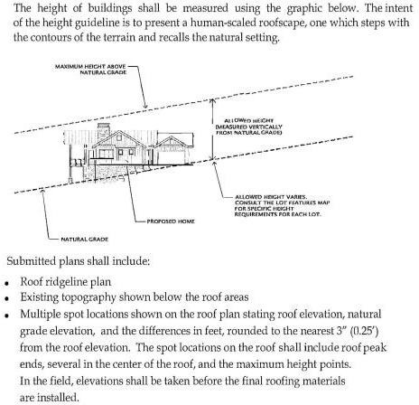
Building Height. The greatest distance measured from any point on a proposed or existing roof or eave (but excluding chimneys, pipes, HVACs, etc.) to the natural grade located directly below said point of the roof or eaves. Within any building footprint, height shall be measured vertically from any point on a proposed or existing roof to the natural grade directly below said point on a proposed or existing roof.
Building inspector. Kamas City official who is designated to inspect new and existing buildings to ensure they comply with building codes.
Building pad. The building pad denotes that area in which the proposed new structure(s) must be located.
Business. A legally recognized organization designed to provide goods and/or services to consumers.
Cabinet shop. A facility where furniture, cabinetry, or similar wood products are manufactured, assembled, or finished using woodworking techniques.
Canopy. A roof or awning constructed of fabric or other material and extending outward from a building to provide a protective shield for doors, windows, or other openings.
Car wash. A building or premises equipped for washing, cleaning, or detailing of cars and other motor vehicles, whether automatic, self-service, or manual.
Carport. A private garage not completely enclosed by walls or doors. For the purpose of this ordinance, a carport shall be subject to all regulations prescribed for a private garage.
Cemetery. Land or buildings used for the burial or interment of the human dead but not including facilities for embalming.
Chief executive officer. The Mayor of Kamas City.
Child care, center based. A facility where care and supervision is provided for four or more children for less than 24 hours a day and for indirect compensation in place of care ordinarily provided in their home.
Child care, home based. Continuous care and supervision of children in lieu of parental care, as per current state code.
Church. A building set apart primarily for the purpose of worship in which religious services are held and with which clergy or a religious leader is associated. The main body of the building is kept for that use and not put to any other use inconsistent with its primary purpose. The building must qualify as tax exempt under Utah law.
Cinema. An enclosed building used primarily for the presentation of a recorded film shown on a screen in a controlled environment for public entertainment.
Civic club. A building or use, other than a church or school, operated by a nonprofit association or organization for a social, fraternal, political, civic, or philanthropic purpose, which may include a meeting hall and cooking and dining facilities for large groups but shall not provide overnight lodging.
Clear vision area. An area outlined by the sight distance triangle where solid fencing or natural vegetation is restricted to a height of four feet and where all structures or other items that would obstruct vision are prohibited.
Clear vision restriction. Any fencing within the 25-foot front setback is restricted to a height of four feet.
Co-location. The location of a telecommunication facility on an existing structure, tower, or building in a manner that precludes the need for that telecommunications facility to be located on a freestanding structure of its own.
Complete application. A submission, which includes all information requested on the appropriate form, and full payment of all applicable fees.
Community garden. A plot of land where a group of people collectively cultivate and maintain plants such as fruits, vegetables, and flowers, rather than a single individual or family.
Complete application. A submission, which includes all required information and supporting documents on the appropriate form, and full payment of all applicable fees.
Conditional use. A land use that, because of its unique characteristics or potential impact on the municipality, surrounding neighbors, or adjacent land uses, may not be compatible in some areas of a zone district, or may be compatible only if certain conditions are required that mitigate or eliminate the detrimental impacts.
Condominium. The ownership of a single unit in a multi-unit project or structure together with an undivided shared interest in the common areas and facilities of the property.
Condominium plat. A plat prepared for the recordation of a condominium project that complies with the Utah Condominium Ownership Act and the city's subdivision ordinance.
Condominium project. A plan or project whereby two or more units, whether contained in existing or proposed apartments, commercial or industrial buildings or structures, or otherwise, are separately offered or proposed to be offered for sale.
Conservation easement. An easement granted for the purpose of preserving, restoring, enhancing, protecting, or sustaining the quality and quantity of natural resources, open space, wildlife habitat, or other ecological features.
Conservation subdivision. A planned residential development that clusters homes on smaller lots to permanently protect a large portion (50 percent or more) of the land as undivided, common open space for recreation, agriculture, wildlife, or natural/historical resource preservation.
Construction services. Commercial activity involving physical and related activities required to build, renovate, or maintain structures and infrastructure.
Constitutional taking. Final action by the city to physically take or exact private real property that requires compensation to the owner because of the mandates of the Fifth or Fourteenth Amendments to the Constitution of the United States, or Article I, Section 22, of the Utah Constitution.
Context map. A map based on data from already published sources such as aerial photographs, USGS topographical maps, FEMA floodplain maps, etc. reproduced to show location of natural features and development patterns within the area of a development site.
Convenience goods sales and services. Stores or shops intended for retail sales of convenience goods or performance of convenience services. Goods and services regarded as convenience are those generally needed for daily home consumption and for which locations near residential neighborhoods are considered desirable.
Corporate, professional, business offices. A commercial building where a company's management and staff conduct business operations.
Council. The duly elected members of the Kamas City Council.
County. The unincorporated area of Summit County.
Coverage. Lot area covered by a building or other impervious surfaces including, but not limited to parking areas, driveways or sidewalks.
Creamery. A building where milk and cream are processed for the production of dairy products for the purpose of commercial sales.
Cul-de-sac. A minor street having an open end and being terminated at the other end by a vehicle turnaround.
Culinary water authority. The department, agency, or public entity with responsibility to review and approve the feasibility of the culinary water system and sources.
Cultural, civic services. A building primarily used for the public, nonprofit display of art, historic or cultural artifacts.
Dairy. A farm or agricultural operation used for the keeping, breeding, or raising of dairy cattle or other milk-producing animals, and for the production, storage, and handling of milk for wholesale marketing.
Design guidelines. Documentation that is submitted with an application that identifies the requirements and standards for residential densities, building height, bulk and setback requirements by land use type, signage, landscaping, parking, open space and site plan review procedures.
Development. Any man-made change to improved or unimproved real estate, including but not limited to buildings or other structures, mining, dredging, filling, grading, paving, excavation or drilling operations.
Developed activity center. Any area of land within the agricultural tourism zone that is not considered as part of the "greenbelt" shall be considered part of the developed activity center.
Development plan. A map or maps that are submitted with an application that identifies general land use designations, transportation plans, open space, and community facilities.
Development site. A tract, lot or parcel of land intended to be used as a commercial, public, quasi-public, utility or other building site.
Development review committee. A committee comprised of the city planner, city engineer, building inspector, public works director, and other designated officials to review specific types of development and ensure compliance with all land use regulations and requirements.
Disabled care. Assistance provided to individuals with physical, mental, or emotional conditions lasting six months or more, who experience difficulty performing activities of daily living.
District. A designated portion of Kamas City shown on the official zoning map and assigned a specific zone classification in accordance with this chapter.
Dry-cleaning establishment. An establishment for the cleaning or dyeing of fabrics using chemical solvents instead of water.
Dwelling, multi-family. A building arranged or designed to be occupied by two or more families living independently of each other in separate, but attached dwellings. Limited to four families.
Dwelling, single-family. One or more rooms in a dwelling designed and used for living and sleeping purposes, and having a kitchen and a bathroom. Single family dwelling units include modular, manufactured and mobile homes that comply with applicable building codes.
Dwelling unit. one or more rooms in a dwelling designed and used for living and sleeping purposes, and having a kitchen and a bathroom.
Easement. A negotiated interest in the land of another which allows the easement holder specified uses or rights without actual ownership of the land.
Elderly care. A long-term care facility providing housing and assistance for elderly individuals. The term does not include a health care center.
Elderly person. A person who desires or needs to live with other elderly persons in a group setting, who may or may not be capable of living independently.
Enforcement authority. The person or persons responsibility for the enforcement of, or compliance to land use regulations.
Equine facility/public stables. A facility established and maintained for the care, accommodation, or training of horses, which may include commercial activities such as horse boarding, riding lessons, or similar equine-related services.
Equipment rental. A facility for the rent or lease of vehicles or equipment used in farming, construction, or other related services.
Escrow. A deposit of cash with the city or an approved, alternate security in lieu of cash held to ensure a guarantee.
Exaction. Act of demanding or levying by force or authority.
Existing resources and site analysis map. A document showing the location of noteworthy natural and cultural features including note-worthy trees, geological formations, significant view corridors into the property from public roads or highways, etc.
Exotic animals. Rare or unusual animals, or an animal, not commonly thought of as a pet, kept within a human household. Rodents, reptiles, and amphibians are considered exotic animals. Exotic animals are defined pursuant to Utah code.
Family. An individual, or two or more persons related by blood, marriage or adoption, or a group of not more than four persons who are not related, occupying the same dwelling unit on a continuous basis.
Farm animals. Animals other than household pets or exotic animals, that may, where permitted, be kept and maintained on private property.
Farm tour, agricultural tourism. An agri-tourism use/activity that offers opportunities for the "non-farm" public to learn how a farm functions and where/how food, fiber, fuel, and other agricultural products are produced and/or packaged. Farm tours frequently highlight the history of the subject farm and in general, foster a broader understanding of the importance of agriculture and educate the public as to current agricultural practices and technology.
Fence. A structure constructed for reasons of privacy, security, or aesthetics that is located in such a manner as to separate or divide areas. Fences may include hedges and masonry walls and may or may not be sight obscuring or opaque.
Fence, electric. A fence wired with low voltage (12 volt max) electricity for the purpose of containment, security, or other approved uses.
Fence, razor. A fence with sharp blade-like edges made of metal wrapped around a high tensile wire core.
Fence, wildlife. Open fencing allowed at a height of six feet or higher when a need is shown to protect animals from entering or leaving an area.
Final action. The conclusive, definitive step such as a vote/decision that ends a process of resolving issues by a governing body marking the end of deliberation.
Final completion. The culinary water, sewer, and storm water, must be installed and tested as a complete system. All road base, asphalt roads, curb, gutter, sidewalks and/or trails, must be installed. All street lights, street signs, roadway striping, landscaping and public utilities, must be installed. The entire development or phase of the development shall be complete and functioning as shown on the construction plans and as determined by the city engineer.
Final plat. A formal accurately surveyed map of a land division recorded in the county recorder's office.
Financial institutions. Establishments that engage in the handling of financial transactions such as banks, credit unions, insurance, and investment companies; and mortgage and loan offices.
Finished grade (grade). The final elevation and contour of the ground surface after all construction and landscaping is complete.
Fireworks sales/stands. The temporary display and sale of legally allowed fireworks. This use requires a Kamas City business license and a temporary permit issued from the South Summit Fire District.
Flag/panhandle lot. A lot of record with a long narrow strip (the handle) connecting and providing access to a larger buildable lot (the pan) to a public street.
Flood/flooding. A general and temporary condition of partial or complete inundation of normally dry land areas from the unusual and rapid accumulation or run-off of surface waters from any source.
Floodway. The channel of a river or other water course and the adjacent land areas that must be reserved in order to discharge the base flood without cumulatively increasing the water surface elevation more than one foot.
Floodplain or flood-prone area. Any land area susceptible to being inundated by water from any source (see definition of flooding).
Floor area, gross. The area of a building, including all enclosed areas. Gross floor area does not include unenclosed porches, balconies, patios and decks, vent shafts, courtyards or garages, up to a maximum floor area of 600 square feet.
Floor area, net leasable space. Gross floor area excluding common hallways, mechanical and storage areas, and restrooms.
Fractional numbers or measurements. In determining compliance with any requirement, whenever a fraction of a number or a unit is one-half or greater, and whenever a fraction of a number or unit resulting from a computation is one-half or greater, said fraction shall be rounded up and considered as a whole number or a unit; where the fraction is less than one-half, said fraction shall not be included in determining requirements and the number shall be rounded down. This general definition is subject to the following exceptions:
1.
Specific regulations: Whenever a requirement specifically provides for fractional numbers or measurements, such specific provision shall control.
2.
Minimum requirements: Whenever a requirement provides for a minimum number, size, measurement, or other standard, rounding shall not be used to reduce or avoid compliance with the minimum requirement.
3.
Computation of parking requirements: When measurements determining the number of required parking spaces result in a fractional or partial parking space, the number of required spaces shall be rounded up to the next whole number.
Frontage. The length of the property line of the lot fronting on one side of a street.
Furniture sales, new and used. A retail store that sells furniture and related accessories.
Garage. An accessory building or portion of a main building for the parking or temporary storage of motor vehicles.
Gated community. A subdivision or residential area where primary access is regulated through a gated entry point.
General plan. A comprehensive plan for Kamas City, prepared and adopted by the planning commission and city council, pursuant to state law, and including land use planning and development goals, objectives and policies.
Governing body. The Kamas City Council.
Greenbelt Act. Otherwise known as the Utah Farmland Act or FAA allows qualifying agricultural property to be assessed and taxed based upon its productive capability instead of the prevailing market value. Must be at least five contiguous acres of land.
Grocery store. A grocery store is a retail store that primarily sells food and other related goods.
Gross acreage. The total area of the development, including all rights-of-way and other areas devoted to nonresidential or public uses.
Group facility. A facility where individuals live together in a home-like environment with supervision or support rather than independent living. It is usually licensed or certified and serves people who need assistance or supervision because of disability, age, or special care needs.
Handicapped person. A person who has a severe, chronic disability that is attributable to mental or physical impairments, that is likely to continue indefinitely, and that results in a substantial functional limitation.
Hardware/lawn and garden store. An establishment that sells goods for home improvement, maintenance, and garden-related goods.
Health center. A facility that provides medical, preventive, diagnostic, or therapeutic services to patients.
Health department. The Utah State Division of Environmental Health or local health agency having jurisdiction.
Heavy/farm equipment sales. The sale of vehicles or equipment in excess of one ton used in farming, construction, or other related services.
Home occupation. An occupation, profession, activity, or use that is clearly a secondary use of a residential dwelling unit and which does not alter the exterior of the property or affect the residential character of the neighborhood.
Hospital. A licensed health care institution that provides medical and surgical care to patients, including diagnosis, treatment, continuous nursing services, and other related facilities, and that may admit patients for inpatient care. Offers 24 hour care.
Hotel/motel. A building designed for occupancy as an abiding place of individuals who are lodged, with or without meals, for less than 30 consecutive days.
Household pets. Animals or birds ordinarily permitted in the house and kept for company or pleasure. The maximum number of household pets must not exceed three.
Impervious materials. Matter that is impenetrable by moisture.
Inaction. An application is inactive and subject to denial on the basis of inactivity if any of the following occur, through the act or omission solely of the applicant and not the city:
1.
More than six months have elapsed since a request for additional information was made by the city without a documented response from the applicant;
2.
Upon notice the applicant is more than 60 days in default of the payment of any fee assessed by resolution, or has not paid the fee under protest;
3.
The applicant has stated his/her intent to abandon the project;
4.
The application appears to have been filed in bad faith for the purpose of attempting to vest rights prior to a zoning change, without actual intent to construct the project applied for; or
5.
Any conditional use permit, if not put into effect within one year shall be null and void.
The applicant will need to submit a new application following any inaction as defined herein.
Indoor recreation facility. A facility containing (but not limited to) uses such as gymnasiums, basketball and racket ball courts, swimming pools, etc. for recreational use.
Industrial (or research) park. A tract of land that is subdivided and developed according to a plan for the use of a community of industries and related uses and that is of sufficient size and physical improvement to protect surrounding areas and the general community and to assure a harmonious integration into the neighborhood.
Industry, light. The manufacturing, compounding, processing, assembling, packaging, or testing of goods or equipment entirely within an enclosed structure, with no outside storage, serviced by small (one ton) trucks or vans, and imposing a nearly negligible impact upon the surrounding environment by noise, vibration, smoke, dust, or pollutants.
Institution of higher education. Any school, university, college or technical institute offering post-secondary education.
Intermittent use. A temporary business of selling and delivering goods, wares and merchandise within the City of Kamas for any time period of 30 days or less.
Itinerant merchant. Any person, firm or corporation, who engages in a temporary business of selling and delivering goods, wares and merchandise within the municipality.
Kennel. Any lot, building, structure or premises where four or more dogs or cats over the age of six month are kept, boarded, bred for commercial purposes, or trained for a fee.
Land use application. An application required by a municipality's land use ordinance.
Land use authority. A person, board, commission, agency, or other body designated by the local legislative body to act upon a land use application.
Land use ordinance. A planning, zoning, development, or subdivision ordinance of the municipality, but does not include the general plan.
Landscape services. Those involved in the design, implementation or maintenance of trees, shrubs, plants and other vegetation.
Landscaping. A combination of planted trees, shrubs, vines, ground cover, flowers, or lawns. In addition, the combination of design may include rocks and such structural features as fountains, pools, art works, screens, walls, fences, walks, or benches, but such objects alone shall not meet the requirements of this chapter.
Laundromat. An establishment in which patrons wash, dry, or dry-clean clothing and other fabrics in coin-operated, self-service machines.
Laundry and dry cleaning. An establishment in which patrons wash, or dry clothing and other fabrics in self-service machines or a full-service establishment where staff handle washing, drying, pressing, and dry cleaning.
Legislative body. The Kamas City Council.
Liquor store. A retail sales store authorized by the Utah State Liquor Commission to sell packaged alcoholic beverages for off-premise consumption.
Livestock. Any domesticated animal typically kept for use, pleasure, or profit, specifically those traditionally raised in an agricultural setting for the production of food, fiber, or labor.
Local jurisdiction. Kamas City.
Lot. A parcel of land occupied or to be occupied by a main building or group of buildings (main and accessory), together with such yards, open spaces, lot width, and lot area as are required by this ordinance and having frontage upon a street.
Lot, corner. A lot situated at the intersection of two streets, the interior angle of such intersection does not exceed 135 degrees. A corner lot fronts two streets.
Lot depth. The minimum distance measured from the front property line to the rear of the same property boundary.
Lot line. The legal boundary line of a piece of property.
Lot line, front. The distance between the side lot lines adjacent to the public right-of-way.
Lot line, rear. The property line opposite the front lot line.
Lot line, side. Any lot or property line other than a front or rear lot line.
Lot, width. The distance between the side lot lines.
Lumber sales and storage. The sale and display of lumber and building supplies, including the outside storage of lumber and related merchandise.
Manufacturing use. Research and development facilities, testing laboratories, and facilities for the production, fabrication, processing, or assembly of goods and products.
Manufactured home. A multi-sectional home not exceeding two stories in height that is designed to be installed on a permanent foundation system that was manufactured after June 15, 1976.
Massage therapy services. See office, professional.
Medical clinic. See office, professional.
Metal works. Shaping, cutting, and joining materials like steel, aluminum, or copper to create structural components, machinery, and artistic, custom, or functional objects.
Miniature golf. A commercial enterprise offering a novelty version of golf played with a putter on a miniature course, typically featuring obstacles and artificial turf.
Mobile home. A detached single-family dwelling unit of not less than 30 feet in length, designed for long-term occupancy and to be transported on its own wheels or on a flatbed or other trailers or detachable wheels; containing a flush toilet, sleeping accommodations, a tub or shower bath, kitchen facilities, and plumbing and electrical connections provided for attachment to appropriate external systems, and ready for occupancy except for connections to utilities and other work. Presectionalized, modular, or prefabricated houses not placed on permanent foundations, shall be regarded as mobile homes and only authorized in mobile home parks.
Mobile home lot. A designated portion of a mobile home park designed for the accommodation of one mobile home and its accessory buildings or structures which complies with all relevant building codes and ordinances.
Mobile home park. A residential development in which owners of mobile homes or manufactured housing may rent or lease a lot on which to place their home. Such developments shall provide all of the amenities and improvements typical of subdivisions.
Mobile home park plumbing system. The park sewer and water supply systems within the park property line.
Mobile home service building. A building which is not a mobile home which houses separate toilet and bathing facilities for men and women and which may also have laundry facilities, sink, and other facilities as may be required by the ordinances of Kamas City.
Mobile home park sewage system. Any pipe or line not built into the mobile home which is used for the disposal of human waste.
Model home. A dwelling unit used initially for display or marketing purposes, with a certificate of occupancy, which typifies the units that will be constructed.
Modular home. A permanent dwelling structure built of prefabricated units which are assembled and erected on the site, and placed on a permanent foundation, and which meets the International Building Code.
Monument sign. A sign six feet or less in height which is flush to the ground.
Mortuary, funeral home. An establishment in which the human dead are prepared for burial or cremation. The facility may include a chapel for the conducting of funeral services, spaces for informal gatherings, and related accessory uses.
Motor vehicle. Every vehicle that is self-propelled and every vehicle which is propelled by electric power, but not operated upon rails. This term shall be interpreted broadly to include, but is not limited to:
• Standard vehicles: Automobiles, trucks, vans, and motorcycles.
• Off-highway vehicles: ATVs, UTVs (side-by-sides), and snowmobiles.
Micro-mobility devices:
• Electric bicycles (E-bikes): Any bicycle equipped with fully operable pedals and an electric motor of less than 750 watts (Class 1, 2, and 3).
• Motorized scooters: Any device with no more than two ten-inch or smaller diameter wheels that has a floorboard for the operator to stand upon, and is powered by an electric or gasoline motor.
• Other devices: Segways, electric skateboards, and self-balancing boards.
Exclusions: This definition shall not include motorized wheelchairs or medical mobility devices used by persons with disabilities, nor shall it include "toys" designed for use by children that cannot exceed a speed of 5 miles per hour.
Motor vehicle sales and rental. Sales and rental of both new and used motor vehicles, but not to include non-serviceable or junk vehicles.
Municipal facilities. Those improved properties owned by the municipality.
Museum. A depository for collecting and displaying objects having scientific, historical or artistic value.
Natural grade. The elevation of the existing surface prior to commencement of construction of any improvements proposed or any previous site disturbance.
Natural vegetation. Those plants, shrubs and trees that are indigenous to the Kamas Valley.
Natural waterways. Those areas, varying in width, along streams, creeks, springs, gullies, or washes that are natural drainage channels.
New development. Any new construction activity.
Noncomplying structure. A pre-existing structure that legally existed before its current zoning designation and because of a zoning change does not conform to the zoning district's development standards.
Nonconforming sign. A sign or sign structure or portion thereof lawfully existing prior to the adoption of this ordinance which does not conform to all height, area, lighting or other regulations prescribed in the zone in which it is located.
Nonconforming use. A use of a lot or parcel that legally existed on the lot or parcel before its current zoning designation, has been maintained continuously for the preceding 12 months, and does not conform with the zoning regulations that now govern the land.
Nursery. A business that grows, cultivates, and/or distributes and sells plants and other landscaping or horticulture related items.
Nursing home. A business described also as a "rest home", or "convalescent home", other than a hospital, in which persons are lodged long-term and furnished with care rather than diagnosis or treatment.
Office, business or government. A place intended for the conducting or administration of services by a business enterprise or unit of government.
Office, professional. A place intended for the conducting of a recognized learned profession. Such uses include offices or clinics devoted to the treatment and care of human illness or injury (medical, dental, chiropractic offices, massage therapist, and similar uses). Other professions so defined would include, but not be limited to accountants, architects, engineers, and lawyers. Definition does not allow for in-patient care facilities or adult-oriented businesses.
Official streets master plan. As adopted by the city council, the designation of each existing and planned street and right-of-way, and those located on approved and filed plats, for the purpose of providing for the development of the streets, highways, roads, and rights-of-way and for their future improvement, reconstruction, realignment, and necessary widening, including provision for curbs and sidewalks. The classification of each street and right-of-way is based upon its location in the respective zoning district of the city, its present and estimated future traffic volume and its relative importance and function.
Official zoning map. The map adopted by the city council pursuant to law showing the streets, zoning districts, and city boundaries, and any amendments or additions thereto resulting from the approval of rezones, subdivisions or annexation plats and the subsequent filing of such approved plats.
Open space. An open piece of land that is undeveloped (void of buildings or other structures).
Ordinary high water mark. The line on the bank to which the high water ordinarily rises annually in season as indicated by changes in the characteristics of soil, vegetation or other appropriate means. Where the ordinary high water mark cannot be found, the top of the channel bank shall be substituted. In interconnected channels, the ordinary high water mark or substitute shall be measured so as to include the entire stream feature.
Outdoor park or playground (public or private). An area free of buildings except for rest rooms, dressing rooms, equipment storage and maintenance buildings, and open air pavilions and used primarily for recreation activities not involving motor vehicles or overnight use.
Owner. Any person, or group of persons, having record title to property.
Packaging and delivery services. A business or organization that handles collations, labeling, packaging and distribution of items.
Parcel. A unit of land described by metes and bounds and designated by the Summit County Recorder's Office with a unique tax identification number.
Park & Ride. A system of reducing traffic, in which drivers leave their cars in designated parking lots to travel via carpool or public transportation.
Parking area. An un-enclosed area or lot other than a street used or designed for parking.
Parking area, private. An open area, other than a street, used for the parking of automobiles for occupants of a business or home.
Parking, public. A parking area or parking facility to be used by the public.
Parking, residential. A parking area or structure used exclusively for residential, non-commercial uses.
Parking, shared. The development and use of parking areas on two or more separate properties for joint use by the businesses or residents of those properties.
Personal services. Work performed by a provider for a customer for services rendered. Kamas City allows for uses such as, but not limited to, cosmetology, music, dance, art, or martial arts instruction, esthetician, massage therapy, personal trainer, travel agent, florist, dietitian, and handyman.
Pet grooming. The grooming of small pets such as dogs and cats, provided that no more than five animals may be on the premises at one time and that no lodging of animals is allowed.
Petting farm. Features a combination of domesticated farm animals that are docile enough to touch and feed.
Photo lab. A business where one buys, sells, and repairs camera equipment and supplies and develops, copies, enlarges and restores photographs.
Planned unit development (PUD). A site-specific zoning district tailored to a specific location and use. PUDs are used to specify development parameters for projects that are not easily accommodated in standard zoning districts. PUDs allow greater flexibility in specifying a range of land uses, development conditions or restrictions, and site specific compatibility standards. However, the development quality of a PUD must be equal to or better than what would be required by standard zoning, and the PUD must be compatible with surrounding developments.
Planned unit development agreement. The development plan and design guidelines that are agreed upon by Kamas City and the developer.
Planning commission. The Kamas City Planning Commission.
Plat. A map or other graphical representation of lands being laid out and prepared in accordance with Utah Code Section 10-9-804.
Preliminary plat. The preliminary drawings of a proposed subdivision, specifying the layout, uses, and restrictions.
Preschool. The education or teaching of children including kindergarten preparation, music lessons, etc.
Principal building. A building within which the principal land use of the lot is conducted.
Product, agriculturally related. Any item that is sold at a specific farm, approved for agri-tourism, which attracts customers and promotes the sale of agricultural products. Such items may include, but are not limited to, all agricultural products, baked goods, cheese, ice cream and ice cream-based desserts and beverages, jams, honey, and other food items or products that feature ingredients produced on a specific farm, approved for agri-tourism, or other farm located within Kamas City or Summit County. Additional agriculturally related products may consist of, but are not limited to, gift items, clothing and other items that directly promote the specific farm and/or the agriculture industry.
Product, non-agriculturally related. Any item that is sold at a specific farm, approved for agri-tourism, which is not connected to farming nor derived from that farm's operation or other farm located in Kamas City. Non-agriculturally related products may include, but are not limited to, novelty t-shirts or other clothing, crafts, knickknacks and/or products.
Professional services. Accounting, legal, medical and other such services provided by a formally certified member of a professional body.
Property. Any parcel, lot, or tract of land, including improvements thereon, in the possession of or owned by, or recorded as the real property of the same person or persons.
Property line. The boundary line of a parcel or lot.
Property line, front. That part of a parcel or lot, which abuts a street.
Public hearing. A hearing at which members of the public are provided a reasonable opportunity to comment on the subject of the hearing.
Public improvement. Any building, water system, drainage ditch, roadway, parkway, sidewalk, pedestrian way, tree, lawn, off-street parking lot, space or structure, lot improvement, or other facility, for which the city may ultimately assume responsibility, or which may affect a city improvement.
Public meeting. A meeting that is required to be open to the public under Utah Title 52, Chapter 4, Open and Public Meetings Act.
Public right-of-way. An area of land that is legally described in a registered deed for the provision of public access.
Public service. Uses, which may be housed in separate buildings, or which may occupy a space within a building, that are operated by a unit of government to serve public needs such as police (with jail), fire service, ambulance, post office, or judicial court.
Public street. A street, including the entire right-of-way, which has been dedicated to and accepted by Kamas City or other governmental agency or which has been devoted to public use by legal mapping, use or other means.
Public utility stations. A structure or facility used by a public or quasi-public agency to store, distribute, generate, or chemically treat water, power, gas, sewage, equipment, or other service elements.
Quasi-public. Essentially public (as in services rendered) although under private ownership or control.
Reasonable notice. The requirements of reasonable notice are met by complying with the Class A notice as required under U.C.A. § 63G-30-102.
Reception center. A building where cultural events are held and guests are received.
Record of survey map. A graphic illustration of a survey of land prepared in accordance with state laws.
Recreation vehicle. A vehicular unit primarily designed as a temporary dwelling for travel, recreational, and vacation use, which is either self-propelled or is mounted on or pulled by another vehicle, including but not limited to a travel trailer, a camping trailer, a truck camper, a motor home or a fifth-wheel trailer.
Recreational vehicle park. Any area or tract of land or separately designed section where lots are rented to one or more owners or users of recreational vehicles for a temporary time.
Repair services, small appliance or equipment. An establishment for the repair of household or other small appliances or equipment and at which no such appliances or their parts are stored out-of-doors.
Residential. An area primarily used for housing.
Restaurant, cafe, confectionery. An establishment where food is prepared and served to customers for consumption on the premises.
Restaurant, fast food, drive-in. An establishment distinguished from a traditional sit-down restaurant in that service is provided from a counter or window for consumption either off or on the premises.
Retail sales. Stores, department stores, or shops intended for sale of goods or merchandise.
Ridgeline. The natural crest of a hill or mountain.
Right-of-way. A strip of land, dedicated to public use that is occupied, or reserved to be occupied, by a street, crosswalk, trail, utilities, or for other special use.
Riparian buffer. A vegetated area near a stream or waterway that helps shade and partially protect that stream or waterway from the impact of adjacent land uses.
Road classification. The streets and rights-of-way designated on the Streets Master Plan (see General Plan).
Road, right-of-way width. The distance between property lines measured at right angles to the centerline of the street.
Sanitary sewer authority. The department with responsibility to review and approve the feasibility of sanitary sewer services or onsite wastewater systems.
Satellite receiving station. Any apparatus or device designed for the purpose of transmitting and/or receiving radio, television, satellite, microwave, or other electromagnetic energy signals.
School, private or quasi-public. A school operated by a private or quasi-public organization or individual, which has a program similar to that provided in any public school in the State of Utah, except that such curriculum may include religious instruction.
Schools, public. An educational facility operated by a school district or other public agency of the State of Utah.
Screen or screened. The act, process, or result of visually and/or audibly shielding or obscuring a structure or use from adjacent property by fencing, walls, berms, densely planted vegetation or other features.
Self-service storage facility. Any real property designated and used for the purpose of renting or leasing individual storage space to occupants who are to have access to such facility for the purpose of storing and removing personal property.
Senior citizen center. A government sponsored public building, other than a church or school, serving the social and recreational needs of the elderly. Such a center may include a meeting hall and cooking and dining facilities for large groups but shall not provide overnight lodging.
Sensitive lands. Areas of ground containing natural or environmentally hazardous areas, floodplains, slopes greater than 15 percent, stream corridors, wetlands, wildlife corridors, etc. Entry corridors, scenic view sheds, foothills and ridgelines may also be designated as sensitive lands as determined by the staff, planning commission and city council.
Setback. The required minimum distance between a building or structure and the closest of the following:
1.
Property line;
2.
Platted street; or
3.
Existing curb or edge of a street.
Shopping center, commercial. A completely planned and designed commercial development providing for the sale of general merchandise and convenience goods and including a variety store, discount store, or supermarket (maximum floor space of 40,000 square feet per business).
Showroom. A commercial establishment primarily used for the display and demonstration of products, where on-site inventory is limited and the use is characterized by low customer turnover.
Sign. Any words, letters, parts of letters, figures, numerals, phrases, sentences, emblems, devices, trade names or trade marks, by which anything is made known. Sign shall also include the sign structure supports, lighting system and any attachment, ornaments or other features.
Significant vegetation. Includes all large trees six inches in diameter or greater measured at breast height, all groves of small trees, and all clumps of oak or maple covering an area 50 square feet or more.
Site walk. An on-site visit of property with the applicant, planning staff, planning commission members and/or adjoining property owners to discuss existing resources.
Site development standards. Regulations unique to each zone concerning standards for development including, but not limited to lot areas, setbacks and building height.
Site distance triangle. A triangular area at the intersection of two streets bounded by top back of curb/property line and a line connecting them at points 25 feet from the intersection of the two curb lines/property lines.
Sketch plat. A sketch preparatory to the preliminary plat, or subdivision plat in the case of minor subdivisions, to enable the owner to save time and expense in reaching general agreement with the planning commission as to the form of the plat.
Slope. The percentage of inclination of ground from horizontal.
Small animal clinic. An establishment where small animals such as dogs, cats, birds, and other small household pets are medically treated by a licensed veterinarian.
Small engine repair. An establishment engaged in the repair and maintenance of small engines with an engine displacement size no greater than 2000 cc. This includes but is not limited to motorcycles, OHVs, ATVs, home and garden tools and equipment, outboard motor watercraft (engine removed), snowmobiles, chainsaws, and other similar small engines.
Solicitors. A solicitor is any person who goes upon the premises of any business or private residence, not having been invited by the occupant thereof for the purpose of selling, offering for sale, or taking orders for merchandise or services door to door within the city.
Special district. An entity established under the authority of Utah Title 17A, Special Districts.
Stable, private. A detached accessory structure used for the keeping and housing of livestock by the occupants of the premises.
Stable, public. A stable other than a private stable.
Stealth telecommunications facility. A telecommunications facility, which is disguised as another object or otherwise concealed from public view.
Stream. A naturally fed watercourse, that flows year-round or intermittently during years of normal rainfall. This definition excludes ditches and canals constructed for irrigation and drainage purposes.
Stream corridor. The corridor defined by the stream's ordinary high water mark.
Street. A private or public right-of-way, highway, avenue, boulevard, parkway, road, bridge or public easements.
Street, arterial. A street which provides for through traffic movement between areas and across the city, with moderate access to abutting property subject to necessary control of entrances, exits, and curb use and also provides access to highways.
Street, local. A street that provides for direct access to abutting land and for local traffic movements.
Street, major collector. A street that provides for a high volume of traffic movement between major arterials and local streets, and direct access to abutting property.
Street, minor collector. A street which conveys traffic to more dwellings and includes through traffic between access streets and collectors.
Street, private. A right-of-way or easement in private ownership, not dedicated or maintained as a public street.
Streetscape. The distinguishing characteristics of a particular street including paving materials, adjacent space on both sides of the street, landscaping, retaining walls, sidewalks, building facades, lighting, medians, street furniture and signs.
Structural alterations. Any change in the supporting members of a building, such as bearing walls, columns, beams, or girders.
Subdivision. Any land, vacant or improved, which is divided or proposed to be divided into two or more lots, parcels or separate interest. "Subdivision" includes the division of residential and nonresidential zoned land, whether by deed, metes and bounds description, devise, intestacy, lease, map, plat or other recorded instrument. See U.C.A. § 10-9a-103(50)(a) and (b).
Subdivision amendment. A change in a map of an approved or recorded subdivision plat if such change affects any right-of-way, or lot line; or any change in a map or plan legally recorded prior to the adoption of regulations controlling subdivisions.
Subdivision, major. All subdivisions of six or more lots, or any size subdivision requiring any new street or extension of municipal facilities, or the creation of any public improvements, and not in conflict with any provision or portion of the Kamas City General Plan, official land use map, Streets Master Plan, or these regulations.
Subdivision, minor. Any subdivision containing five lots or less not requiring a new street or extension of municipal facilities that may require the recordation of a plat and all or part of the development requirements of a major subdivision, and not in conflict with any provision or portion of the Kamas City General Plan, official land use map, Streets Master Plan, or these regulations.
Subdivision plat. The final map or drawing, on which the applicant's plan of subdivision is presented to the city council for approval and which, if approved, may be submitted to the Summit County Recorder for filing.
Subdivision, simple lot. Any subdivision containing not more than two lots fronting on an existing street, not involving any new street, or the extension of municipal facilities, or the creation of any public improvements, and not adversely affecting the remainder of the parcel or adjoining property, and not in conflict with any provision or portion of the Kamas City General Plan, official land use map, streets master plan, or these regulations.
Subdivision yield plan. A plan that exhibits the base density allowed in the underlying zone minus areas protected through sensitive area designation prior to preliminary plat for a conservation subdivision.
Surplus, second-hand store. An establishment that sells surplus items, used furniture, appliances, clothing, and miscellaneous small items. Excluded from this definition are establishments selling used motor vehicles, their parts, military surplus, and other heavy equipment.
Telecommunications facility. A telecommunications facility of less than 35 feet in height consisting of antenna, equipment shelters, and related structures used for transmitting and/or receiving telecommunications and/or radio stations.
Temporary use. A use, activity or special event that is not permanent in nature and after a 72-hour time period ceases or is removed.
Theater, concert hall. A building or amphitheater used primarily for the presentation of live stage productions or performances.
Towing/impound yard. The temporary storage of vehicles that have been towed, carried, hauled, or pushed from public or private property for impoundment in a public or private impound yard.
Townhome. One of up to four homes sharing common walls, with no neighbors above or below.
Transfer station. A facility designed for the transfer of solid waste.
Unincorporated. The area outside of the incorporated boundaries of cities and towns.
Use. The activity occurring on a lot or parcel of land for which the land or a building is designed, or for which it may be designed.
Use/activity, agriculturally related. A use or activity that is part of a specific agri-tourism operation's total offerings and is primarily tied to that farm operation's agricultural products, buildings and/or equipment. Such agriculturally related uses/activities may include, but are not limited to, petting farm, corn mazes, pumpkin patches, barn dances, sleigh/hayrides, and educational activities, such as farm tours, food preparation or ecological classes.
Use/activity, non-agriculturally related. A use or activity that is part of a specific agri-tourism operation's total offerings but is not tied to farming or that farm operation's agricultural products, buildings and/or equipment.
Use, pre-existing. A use, which validly existed prior to the adoption of this land use ordinance and has not been abandoned for more than six months.
Vending cart. A small-wheeled, non-motorized vehicle from which to sell food and/or merchandise for immediate consumption or use.
Warehouse storage. A building in which goods, merchandise, and/or equipment are stored for eventual distribution (not rental units).
Wholesale distribution. The selling of goods in large quantities to be retailed by others.
Wine bottling facility. A physical location where finished or blended wine is put into bottles or similar containers, corked or capped, labeled, and packaged for distribution, with the following conditions:
1.
<2,500 square feet of operational area;
2.
No hazardous materials;
3.
No heavy truck traffic;
4.
Enclosed operations only;
5.
Limit of annual output <24,000 bottles;
6.
No external noise, dust, or odor; and
7.
This does not include facilities where drinks are fermented or manufactured.
Xeriscape. Landscaping designed specifically for areas that are susceptible to drought, or for properties where water conservation is practiced.
Yard, front. An open, unoccupied space, in the same lot with a building, between the front line of the main building and the front property line and extending for the full width of the lot.
Yard, rear. A yard extending across the full width of the lot between the most rear main building and the rear lot line. The depth of the required rear yard shall be measured horizontally from the nearest point of the rear lot line. On lots that are not rectangular in shape, the required minimum rear yard may be an average of the distances measured from the rear corners of the main building directly to the rear lot line.
Yard, side. An open, unoccupied space, except as otherwise provided in this ordinance, on the same lot with the building, between the side line of the building and the side lot line, and extending from the front yard to the rear yard; or the shortest distance across said space from the main building to the side lot line.
Zoning map. A map, also known as a land use map, adopted as part of a land use ordinance that depicts land use zones, overlays, or districts.
(Ord. 2015-04, 11/10/2015; Ord. 2017-01, 3/14/2017; Ord. 2017-02, 3/14/2017; Ord. 2018-01, 3/13/2018; Ord. 2018-02, 4/10/2018; Ord. 2018-05, 9/11/2018; Ord. 2020-01, 3/10/2020; Ord. No. 2021-04, § 1(Exh. A), 8/10/2021; Ord. No. 2022-06, § 1(Exh. A), 3/8/2022; Ord. No. 2024-05, § 1(Exh. A), 8/13/2024; Ord. No. 2025-03, § 1 (Exh. A), 2/11/2025; Ord. No. 2025-09, § 1 (Exh. A), 9/23/2025; Ord. No. 2026-03, § 1 (Exh. A), 1/13/2026; Ord. No. 2026-04, § 1 (Exh. A), 1/13/2026; Ord. No. 2026-07, § 1 (Exh. A), 1/27/2026; Ord. No. 2026-09, § 1 (Exh. A), 2/10/2026)