
Kamas City Zoning Code
CHAPTER 15
31.- ANNEXING AND VACATING PROPERTY
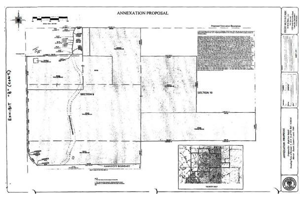
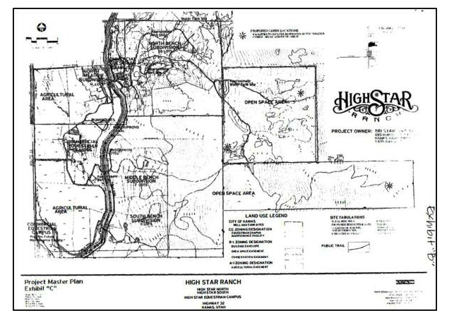
Sec. 15.31.010.- Annexing real property: High Star Ranch.
The real property, which is the subject of this ordinance namely High Star Ranch, is described as follows:
A tract of land located in Summit County, Utah and being a part of Sections 9, 10 & 16 of Township 2 South, Range 6 East, Salt Lake Base and Meridian and having a Basis of Bearing taken as N 00°38'02" W between the Southwest Corner of Section 16 and the Northwest Corner of Section 16 described as follows:
Beginning at a point which is North 4005.71 feet and East 15.23 feet from the Northwest Corner of Section 16, T2S, R6E, SLB&M (said point being located on the Easterly Right-of-Way Line of SR 32 and running thence South 89°36'12" East 55.25 feet along an existing fence line; Thence North 75°43'03" East 30.58 feet along an existing fence line; Thence North 87°06'03" East 1924.90 feet more or less to the Westerly Line of the Provo River Water Users Canal; Thence South 88°11'39" East 139.71 feet to a point on the Easterly Line of the Provo River Water Users Canal, the next (11) courses are along the Easterly Line of said canal, thence North 16°42'09" West 104.94 feet; thence 106.73 feet along the arc of a 299.26 feet radius curve to the right through a central angle of 20°26'00"; thence North 3°43'51" East 203.60 feet; thence 108.52 feet along the arc of a 656.78 feet radius curve to the right through a central angle of 9°28'00"; thence North 13°11'51" East 106.50 feet; thence 107.99 feet along the arc of a 347.94 feet radius curve to the left through a central angle of 17°47'00"; thence North 4°35'09" West 236.80 feet; thence 125.98 feet along the arc of a 227.94 feet radius curve to the right through a central angle of 31°40'00"; thence North 27°04'51" East 168.98 feet; thence North 27°04'51" East 10.26 feet; thence North 4°36'32" East 33.17 feet more or less to the northerly line of Section 9, T2S, R6E; thence North 89°28'30" East 325.00 feet more or less to the North ¼ Corner of said Section 9; thence South 89°26'11" East 2695.09 feet more or less to the stone marking the Northeast Corner of said Section 9; thence South 0°37'03" East 1349.26 feet along the Section Line to the Northerly Line of Parcel CD-528-A; thence North 89°43'59" East 2618.85 feet along said Northerly Line of Parcel CD-528-A; thence South 0°20'20" West 2686.98 feet more or less along the Easterly Line of said Parcel CD-528-A to a point on the Northerly Line of Parcel CD-530; thence North 89°36'51" East 2732.18 feet along the Northerly Line of Parcel CD-530 to the Easterly Line of Section 10, T2S, R6E, SLB&M; thence South 0°54'43" East 1340.79 feet more or less to the Forest Service Monument marking the Southeast Corner of said Section 10; thence North 89°54'30" West 2761.26 feet along the Southerly Line of Section 10; thence South 89°03'23" West 2592.16 feet along said line to the Easterly Line of Section 9, T2S, R6E, SLB&M; thence South 0°31'20" West 1077.24 feet along the Section Line; thence North 89°17'55" West 4834.35 feet; thence North 33°30'43" West 26.19 feet; thence South 89°26'55" West 5.13 feet; thence North 38°07'19" West 566.25 feet; thence North 0°25'52" West 61.76 feet; thence North 36°51'52" West 53.12 feet more or less to a point on the Easterly Right-of-Way Line of SR 32; the next (8) courses are along said Easterly Right-of-Way Line of SR 32, thence North 0°09'04" East 273.92 feet; thence North 0°32'20" West 499.37 feet; thence North 0°31'14" West 500.17 feet; thence North 0°35'15" West 499.91 feet; thence North 0°27'46" West 500.02 feet; thence North 0°34'12" West 499.87 feet; thence North 0°31'45" West 250.36 feet; thence North 0°31'39" West 1588.94 feet to the POINT OF BEGINNING; said described tract containing 1042.86 Acres, more or less. Excepting therefrom any portion of the above described property lying within the bounds of the Weber-Provo Diversion Canal.
(Ord. 2015-04, 11/10/2015)
Sec. 15.31.020. - Annexing real property: Simmons-White Knight.
1.
The real property, more particularly described in this section, is hereby annexed to Kamas City, Utah and the corporate limits of Kamas City are hereby extended accordingly.
2.
The area proposed for annexation is bordered by the Meadow View Subdivision of Kamas to the north and SR32 to the west, more specifically described as follows:
A tract of land located in the Southwest ¼ of Section 21, Township 2 South, Range 6 East, Salt Lake Base and Meridian and having a basis of bearing taken as South between and the Northwest Corner and the West ¼ Corner of said Section 21 described as follows:
Beginning at a point which is South 0.39 feet and East 49.50 feet from the West ¼ Corner of Section 21, T2S, R6E, SLB&M and running thence S 89°41'22" E 1287.26 feet along an existing fence line to a fence corner, thence South 242.55 feet along an existing fence line; thence N 89°41'22" W 1287.26 feet to the Easterly Right-of-Way line of State Road 32; thence North 242.55 feet along said Right-of-Way line to the POINT OF BEGINNING.
Containing 7.17 Acres.
(Ord. 2015-04, 11/10/2015)
Sec. 15.31.030. - Annexing real property: Highway 248.
A portion of land located in the North Half of Section 20 and the South Half of Section 17, Township 2 South, Range 6 East, Salt Lake ease and Meridian and having a Basis of Bearing taken as West between the Northeast corner of said Section 20 and the North ¼ corner of Section 19, described as follows:
Beginning at a point North 49.5 feet and West 594.00 feet from the Northeast corner of Section 20, Township 2 South, Range 6 east, Salt Lake ease and Meridian, which point is located more or less on the westerly line of the Kamas City Boundary, and running thence South 1277.47 feet along said line to a fence line extension point; thence South 89°48'51" W 588.01 feet along said extension line and fence line: thence South 15°04'58" East 67.81 feet, along a fence line; thence North 77°36'11" West 148.22 feet, along a fence line; thence South 2°14'7" West 786.49 feet, along a fence line; thence North 81°08'04" West 786.96 feet, along a fence line, more or less; thence North 79°36'49" West 612.14 feet, along a fence line, more or less; thence North 00°56'30" West 170.72 feet, along a fence line; thence North 77°52'58" West 1164.18 feet, along a fence line; thence North 1°11'14" East 114.51 feet, along a fence line; thence North 89°54'08" West 1088.69 feet, along a fence line; thence North 00°09'31" East 1288.36 feet, along a fence line and extension of said fence, more of less, to the northerly line of said Section 20; thence, more or less, along said section line West 374.57 feet to a point on an extension line of an existing fence line; thence North 00°03'13" East 2042.78 feet, along said extension line and fence line; thence South 77°31'46" East 1306.75 feet, more or less, along a fence line; thence South 73°28'01" east 772.20 feet, more or less, along a fence line; thence South 79°03'12'East 815.18 feet, along a fence line; thence South 5°27'45" West 531.72 feet. along a fence line; thence South 86°53'20" East 459.48 feet, along a fence line; thence North 1°10'03" East 470.04 feet, along a fence line; thence South 79°02'36" East 305.46 feet, along a fence line to the westerly line of the Kamas City Boundary; the following calls are along the said boundary; South 105.20 feet; East 391.55 feet; South 3°25'34" West 1089.65 feet; South 50.80 feet; South 7°00'33" West 70.64 feet; South 4°22'42'West 198.44 feet; South 17°14'17" East 54.60 feet; South 89°33'42" East 817.71 feet; North 00°13'22" east 376.06 feet; East 50.04 feet to the point of beginning.
Containing 285.62 Acres.
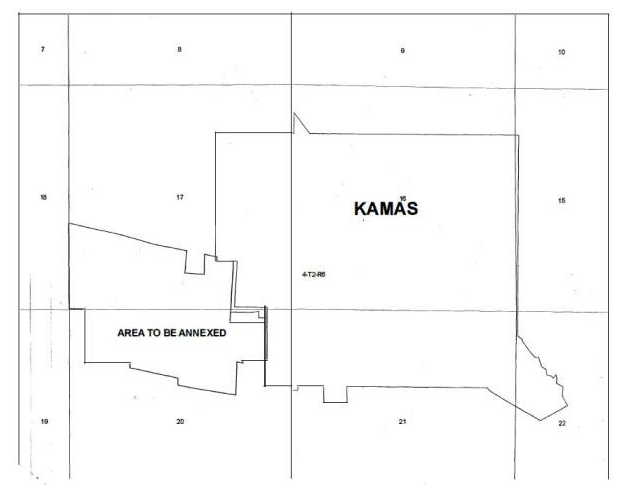
(Ord. 2015-04, 11/10/2015)
Sec. 15.31.040. - Annexing real property: Foothill Drive-Travis Hatch.
The real property shall be classified as being in the M-1 Manufacturing Zone as set forth in the Kamas City Development Code, is described as follows:
COMM S 1243.16 FT & E 2284.66 FT FROM NW COR SEC 21 T2SR6E SLBM; TH ALONG FENCE LINES S 89°50'18" E 402.69 FT; S 01°35'17" E 238.48 FT; N 88°39'39" E 220.49 FT; S 00°34'49" W 737.86 FT; S 88°44'14" W637.11 FT; N 00°51'15" E 986.34 FT TO BEG CONT 13.003 AC(LESS 7.00 AC ASSESSED IN TOWN KT-280) (LESS 0.6 AC FOOTHILL ESTATES PHASE I SUBDIVISION) (LESS 2.56 AC 1671-1891 CD-623-A)BAL 2.84 AC MIL M34-395 XWD171 M146-657 2163-1877-1888.
BEG AT A PT WH IS S 2182.96 FT (PLATTED 2181.50) & E 2269.46 FT (PLATTED 2270.67) FROM THE NW COR OF SEC 21 T2SR6E SLBM (SD PT BEING ON THE NW COR OF THE FOOTHILL ESTATES PHASE 1 SUBDIVISION RECORDED JULY 27, 2000 ENTRY #569757) & RUN TH N 00°43'41" E 175.01 FT; TH E 635.89 FT; TH S00°30'55" W 175.00 FT TO THEN LINE OF SD SUBDIVISION; TH W 636.54 FT ALONG SD LINE TO THE PT OF BEG CONT 2.56 AC 1671-1891 TRAVIS RAY HATCH & TONY A LEE HATCH CO-TRUSTEES OF THE HATCH FAMILY TRUST.
(Ord. 2015-04, 11/10/2015)
Sec. 15.31.041. - Annexing real property: Nancy Hooton.
A portion of a tract of land located in the Northeast Quarter of Section 20, Township 2 South, Range 6 East, Salt Lake Base and meridian described as follows:
BEGINNING AT A POINT ON THE SECTION LINE SAID POINT ALSO BEING THE CENTERLINE OF MAIN STREET, SAID POINT BEING 821.83 FEET NORTH ALONG THE SECTION LINE FROM THE EAST QUARTER CORNER OF SAID SECTION 20; AND RUNNING THENCE WEST 562.43 FEET MORE OR LESS TO A POINT ON THE NORTHERLY BOUNDARY OF THE RICHARD R. & MARLENE N. OLIVER TRUST; THENCE S81'00'00"E 569.44 FEET ALONG SAID NORTHERLY BOUNDARY LINE TO A POINT ON SAID SECTION LINE; THENCE NORTH 89.08 FEET TO THE POINT OF BEGINNING.
AREA = 0.575 ACRE
Parcel CD-619-A
(Ord. 2018-03, 5/8/2018)
Sec. 15.31.042. - Annexing real property: Blazzard.
1.
The real property, more particularly described in subection 2 below, is hereby annexed to Kamas City, Utah, and the corporate limits of Kamas City are hereby extended accordingly,
2.
The real property, which is the subject of this section namely Blazzard Annexation is described as follows:
COMMENCING AT THE NORTHEAST CORNER OF SECTION 17, TOWNSHIP 2 SOUTH, RANGE 6 EAST, SALT LAKE BASE AND MERIDIAN ESTABLISHED BY RECORD OF SURVEY FILE NO. S-4064; THENCE SOUTH 89°26'31" EAST 52.496 FEET ALONG THE SECTION LINE TO THE EXISTING KAMAS CITY BOUNDARY; THENCE ALONG THE KAMAS CITY BOUNDARY THE FOLLOWING TWELVE COURSES: (1) SOUTH 0°09'45" WEST 315.298 FEET; (2) SOUTH 0°51'09" WEST 273.920 FEET; (3) SOUTH 36°09'47" EAST 53.120 FEET; (4) SOUTH 0°16'13" WEST 61.760 FEET; (5) NORTH 37°25'14" WEST 49.123 FEET (6) SOUTH 0°04'03" WEST 510.982 FEET; (7) SOUTH 89°59'21" WEST 1905.837 FEET; (8) NORTH 60°27'02" WEST 670.232 FEET; (9) NORTH 59°54'01" WEST 981.350 FEET; (10) NORTH 41°30'24" WEST 71.836 FEET; (11) NORTH 8°23'04" EAST 248.450 FEET; (12) SOUTH 89°54'45" WEST 2023.019 FEET; THENCE ALONG A FENCE LINE AND THE EXTENSION THEREOF BEING THE APPARENT WESTERLY LINE OF PARCEL CD-510-X THE FOLLOWING TWO COURSES: (1) NORTH 0°08'49" WEST 651.881 FEET; (2) NORTH 686.978 FEET TO A FENCE CORNER AND THE APPARENT NORTHWEST CORNER OF PARCEL CD-510-X; THENCE ALONG A FENCE LINE AND THE APPARENT NORTHERLY LINE OF PARCELS CD-510-X, CD-508-X AND CD-509-X, THE FOLLOWING SEVEN COURSES: (1) SOUTH 88°53'24" EAST 33.357 FEET; (2) SOUTH 88°10'05" EAST 119.226 FEET; (3) SOUTH 87°40'32" EAST 231.186 FEET; (4) SOUTH 88°13'23" EAST 403.824 FEET; (5) SOUTH 87°38'16" EAST 434.305 FEET; (6) SOUTH 88°12'47" EAST 595.846 FEET; (7) SOUTH 88°08'51" EAST 451.340 FEET TO A FENCE CORNER; THENCE ALONG THE APPARENT EASTERLY LINE OF PARCEL CD- 509-X THE FOLLOWING TWO COURSES: (1) SOUTH 3°26'06" WEST 260.372 FEET; (2) SOUTH 11°01'53" WEST 986.230 FEET TO A FENCE CORNER; THENCE NORTH 86°40'23" EAST 629.020 FEET ALONG THE APPARENT NORTHERLY LINE OF PARCEL CD-551-X TO THE NORTH QUARTER CORNER OF SECTION 17; THENCE SOUTH 89°30'35" EAST 1838.760 FEET ALONG THE APPARENT SECTION LINE TO THE WESTERLY LINE OF LOT 3 OF THE SHIRLEY'S SUBDIVISION (ENTRY NO. 511859); THENCE ALONG THE BOUNDARY OF SAID SHIRLEY'S SUBDIVISION THE FOLLOWING THREE COURSES: (1) SOUTH 0°04'44" WEST 13.200 FEET (2) SOUTH 89°06'26" EAST 754.000 FEET; (3) NORTH 0°05'37" EAST 18.497 FEET TO THE APPARENT SECTION LINE; THENCE SOUTH 89°30'35" EAST 41.856 FEET ALONG THE SECTION LINE TO THE POINT OF BEGINNING.
Contains 141.578 acres or 6,167,138 square feet, more or less.
3.
The real property described in subsection 2 above shall be classified as listed below as set forth in the Kamas Municipal Code,
CD-548-A: Manufacturing
CD-548: A-5 Agriculture
CD-548-B-X: Public Facility
CD-551-X: Public Facility
CD-509-X: Public Facility
CD-508-X: Public Facility
CD-510-X: Public Facility
S-147: Public Facility
(Ord. 2025-07, §§ 1—3 (Exh. A), 7/8/2025)
Sec. 15.31.050. - Vacating Edman Subdivision.
1.
The council hereby finds that neither the public nor any person will be materially injured by the vacation of the Edman Subdivision Plat, and there is good cause to approved the vacation because it will allow a better development for the community which better conforms to the Kamas City Zoning Ordinance and General Plan.
2.
The council hereby officially amends the following as of the effective date of this ordinance:
a.
Vacate Edman Subdivision, consisting of two lots.
(Ord. 2015-04, 11/10/2015)
Sec. 15.31.060. - Vacating portion of 530 South Street.
That 530 South Street shall be narrowed by a width of 20 feet. Said 20 feet shall be from the north side of the street and shall be in favor of the abutting property owners, who shall take ownership with all rights, privileges, and duties in accordance with state and city laws and ordinances.
(Ord. 2015-04, 11/10/2015)