
Kern County Unincorporated
City Zoning Code
City Zoning Code
CHAPTER 19
98 - OIL AND GAS PRODUCTION2
Editor's note— Ord. No. G-8992, § 23, adopted March 8, 2021, amended Ch. 19.98 in its entirety to read as herein set out. Former Ch. 19.98, §§ 19.98.010—19.98.070, pertained to similar subject matter, and derived from the prior code §§ 7260.01—7260.07; Ord. G-5346 § 100, adopted in 1990; Ord. G-5885 § 136, adopted in 1993; Ord. G-6077 §§ 310, 312—315, 317, adopted in 1994; Ord. G-6551 § 98, adopted in 1998; Ord. No. G-8035, § 84, adopted April 20, 2010; Res. No. 2020-116, § 2, adopted May 19, 2020; Res. No. 2020-116, adopted § 2, May 19, 2020.
19.98.010 - Purpose and application.
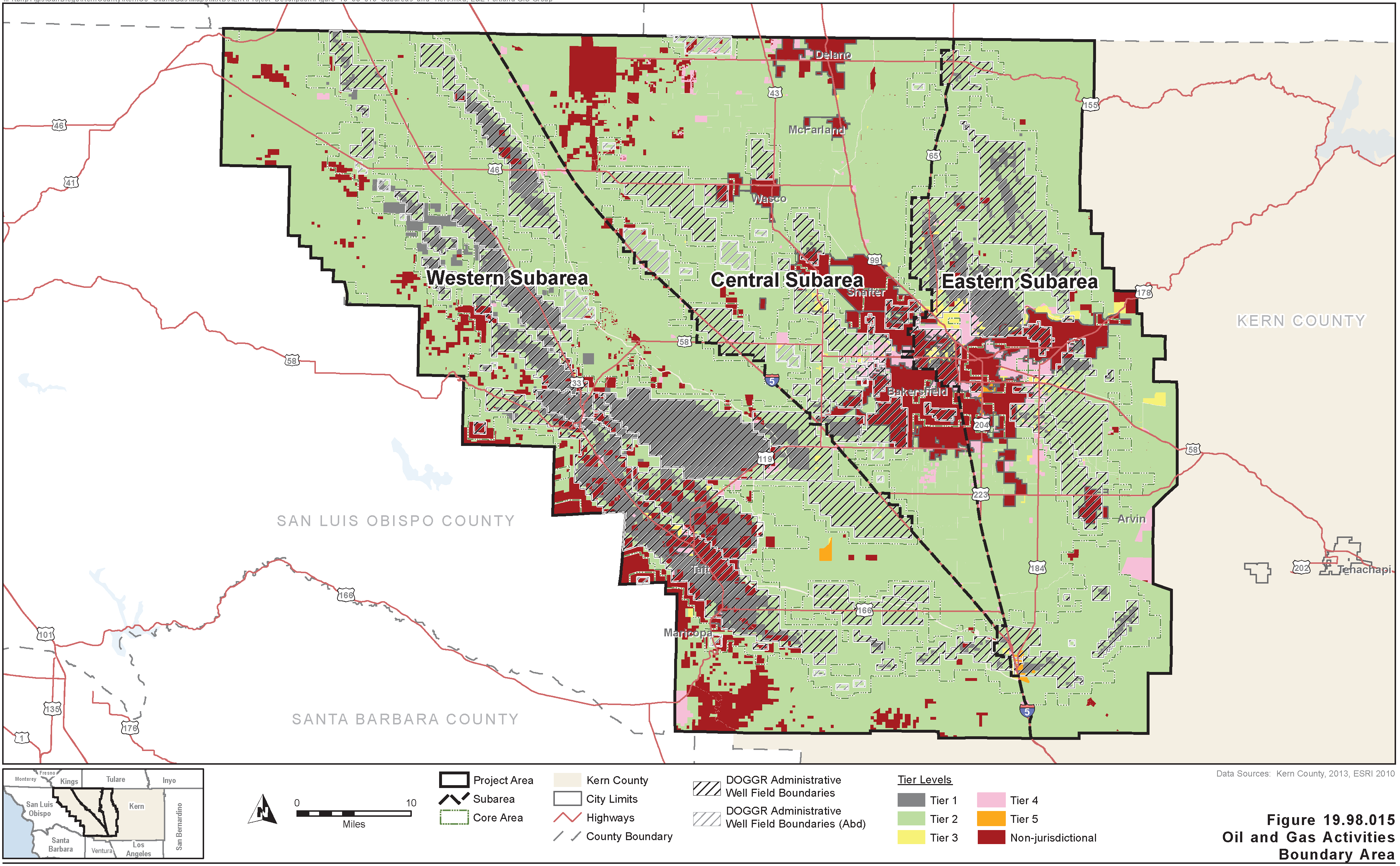
The purpose of this chapter is to ensure the protection of the health, safety and general welfare of communities, residents, and visitors though the permitting of responsible, streamlined and economically viable recovery of oil, gas, and other hydrocarbon substances in a manner compatible with surrounding land uses. It establishes reasonable limitations, safeguards, and controls on exploration, drilling, and production of hydrocarbon resources. The procedures and standards contained in this chapter shall apply to all exploration drilling and production activities related to oil, gas, and other hydrocarbon substances carried out within the unincorporated San Joaquin Valley portion of Kern County (see Figure 19.98.015). The effective date of this version of Chapter 19.98 is April 7, 2021.
(Ord. No. G-8992, § 23, 3-8-21)
19.98.020 - Definitions of oil and gas production activities.
Oil and gas exploration and operations contain many highly technical activities. For the purposes of this Chapter 19.98, definitions of activities are located throughout the chapter, where applicable. Unless otherwise indicated in this chapter, the definitions in Chapter 19.04 remain applicable.
(Ord. No. G-8992, § 23, 3-8-21)
19.98.030 - Oil and gas production boundary area and tier areas.
Oil and gas production in Kern County occurs within the portion of Kern County depicted in Figure 19.98.015. This oil and gas activities boundary area is divided into five (5) tier areas and depicted in Figure 19.98.015. Changes to the oil and gas production boundary area and tier boundaries of Figure 19.98.015 shall be through the procedures in Chapter 19.112.
The tier areas were designated based on the following land use planning considerations:
A.
Tier 1 Area is defined as all areas in which oil and gas activity is the primary land use. The existing well and activity densities preclude almost all other uses except for passive uses such as grazing.
B.
Tier 2 Area is defined as all areas that are classified Exclusive Agriculture (A) or Limited Agriculture (A-1) Districts, have agriculture as the primary surface land use, and are not included in Tier 1.
C.
Tier 3 Area is defined as other areas not within a Tier 1 Area that are located in one (1) of the following zone districts:
•
Natural Resource (NR)
•
Recreation Forestry (RF)
•
Light Industrial (M-1)
•
Medium Industrial (M-2)
•
Heavy Industrial (M-3)
•
Floodplain Primary (FPP)
•
Drilling Island (DI)
•
Zone districts that have the Petroleum Extraction (PE) Combining District
D.
Tier 4 Area is defined as areas not within Tier 1, 2, or 3, that include at least one (1) of the following zone districts:
•
Estate (E)
•
Low-density Residential (R-1)
•
Medium-density Residential (R-2)
•
High-density Residential (R-3)
•
Commercial Office (CO)
•
Neighborhood Commercial (C-1)
•
General Commercial (C-2)
•
Highway Commercial (CH)
•
Open Space (OS)
•
Platted Lands (PL)
•
Mobilehome Park (MP)
Authorized oil and gas activities in Tier 4 are subject to approval of a conditional use permit in accordance with Chapter 19.104 of this title.
E.
Tier 5 are areas including all current and future specific plan boundaries either adopted with a Special Planning (SP) District or which include specific provisions for oil and gas operations. Oil or gas exploration and production activities would be allowed with a conditional use permit or as permitted by the regulations contained within the adopted specific plan in Tier 5 Areas.
F.
All other areas not defined as Tier 1-5 Areas within the oil and gas production area are considered non-jurisdictional because they are not within the jurisdiction of Kern County. Land owned by the United States, State of California or land within an incorporated city are exempt, unless under the authority of a written agreement with the board of supervisors. The regulations set forth in this chapter pertain only to accessory structures, facilities or uses that are physically connected to, provide access or services to, or otherwise support, oil and gas activities in these non-jurisdictional areas.
(Ord. No. G-8992, § 23, 3-8-21)
19.98.040 - Oil and gas activities by ministerial permit.
A.
No well for use as an injection well and no well for the exploration for or development or production of oil or gas or other hydrocarbon substances may be drilled, and no related accessory equipment, structure, or facility may be installed in any Tier 1, 2, and 3 Areas until an application for oil and gas conformity review or minor activity review has been submitted to and approved, with all adopted fees and mitigation paid, by the planning director as consistent with the standards set out in Section 19.98.060 of this chapter and in accordance with the procedures set out in Sections 19.98.070 through 19.98.120 of this chapter. No such well may be drilled, or related accessory equipment, structure, or facility installed, in a Tier 5 Area unless the specific plan procedures for authorizing such activities have been completed, or if no such procedures are included in a specific plan unless the oil and gas conformity review or minor activity review has been submitted and approved consistent with the procedures applicable to Tier 1, 2 and 3 Areas.
B.
Disposal of nonhazardous oilfield fluid waste and production water is considered an accessory facility only if the facility complies with the following:
1.
The nonhazardous oilfield fluid waste or production water is produced and disposed of within the same designated oilfield; or
2.
The nonhazardous oilfield fluid waste or production water disposed of outside the designated oilfield of origin is produced by and disposed of solely and only by the same individual, corporation, or entity or by reciprocal agreement among oil and gas operators in Kern County.
C.
The provisions of this section apply to the first two thousand six hundred ninety-seven (2,697) new individual well permit issued each calendar year, within the oil and gas production boundary area. Any new well permits beyond two thousand six hundred ninety-seven (2,697) applied for in a calendar year would be subject to a conditional use permit.
(Ord. No. G-8992, § 23, 3-8-21)
19.98.050 - Oil and gas activities by conditional use permit.
A.
In Tier 4, no well for use as an injection well and no well for the exploration for or development or production of oil, gas, or other hydrocarbon substances may be drilled, and no related accessory equipment, structure, facility or use may be installed in any zoning district described in this title in which such uses are permitted as conditional uses, or on land owned by the State of California subject to provisions of 19.98.030, until an application for a conditional use permit, which includes the information specified in Section 19.98.080, has been submitted to and approved by the planning commission as consistent with the standards set out in Section 19.98.060 of this chapter and in accordance with the standards and procedures set out in Sections 19.102.130 through 19.102.180 and Chapter 19.98 of this title. In approving a conditional use permit, the planning commission may waive any condition set out in Section 19.98.060 of this chapter if it determines that such waiver will not result in material detriment to the public welfare or the property of other persons located in the vicinity, based on findings of fact and compliance with the California Environmental Quality Act.
B.
No well for use as an injection well and no well for the exploration for or development or production of oil, gas, or other hydrocarbon substances may be drilled, and no related accessory equipment, structure, or facility, outside the boundaries as defined in Figure 19.98.015, may be installed in any zoning district described in this title in which such uses are permitted, or on land owned by the State of California subject to provisions of 19.98.030, until an application for a conditional use permit, which includes the information specified in Section 19.98.080, has been submitted to and approved by the planning commission as consistent with the standards set out in Section 19.98.060 of this chapter and in accordance with the standards and procedures set out in Sections 19.102.130 through 19.102.180 and Chapter 19.98 of this title. In approving a conditional use permit, the planning commission may waive any condition set out in Section 19.98.060 of this chapter if it determines that such waiver will not result in material detriment to the public welfare or the property of other persons located in the vicinity, based on findings of fact and compliance with the California Environmental Quality Act.
C.
Should any activity requiring approval of an oil and gas conformity review or minor activity review pursuant to Sections 19.98.070 through 19.98.120 of this chapter, not be able to comply with the Implementation Standards and Conditions set forth in Section 19.98.060, an application for a conditional use permit, which includes the information specified in Section 19.98.080, shall be submitted to and approved by the planning commission in accordance with the standards and procedures set out in Sections 19.102.130 through 19.102.180 and Chapter 19.98 of this title. In approving a conditional use permit, the planning commission may waive/modify any condition set out in Section 19.98.060 of this chapter if it determines that such waiver or modification will not result in material detriment to the public welfare or the property of other persons located in the vicinity, based on findings of fact and compliance with the California Environmental Quality Act.
D.
If a well is not completed upon land subject to a conditional use permit issued pursuant to this chapter and Chapter 19.104 of this title within twelve (12) months from the date of issuance of the permit, or within any approved period thereof, the conditional use permit shall expire and the premises shall be restored as nearly as practicable to their original condition. No permit shall expire while the permittee is continuously conducting drilling, redrilling, completing or abandoning activities, or related operations, in a well on the lands covered by such permit, which activities were commenced while said permit was otherwise in effect. Continuous activities are those suspended for not more than ninety (90) consecutive days. If, at the expiration of the twelve- (12-) month period, the permittee has not completed his drilling program on the lands covered by such permit, the decision making authority, upon a written request of the permittee, may extend the permit for the additional time requested by permittee for the completion of such drilling, in accordance with the standards and procedures set out in Sections 19.102.130 through 19.102.180.
E.
The following accessory uses shall require a conditional use permit:
1.
Cogeneration facility.
2.
Landfills.
(Ord. No. G-8992, § 23, 3-8-21)
19.98.060 - Implementation standards and conditions.
Pursuant to this chapter, all activities for the exploration for or development or production of oil, gas, and other hydrocarbon substances and related accessory buildings, structures, facilities, and activities shall comply with the following standards, unless otherwise provided in this chapter:
A.
No oil or gas well shall be drilled within the following distances:
1.
One hundred (100) feet of any public major or secondary highway or building not necessary to the operation of the well.
2.
Two hundred ten (210) feet of any sensitive receptor (single or multi-family dwelling unit, place of public assembly (a legally permitted place where one hundred (100) or more people together in a building, or structure, for the purpose of amusement, entertainment or retail sales), churches, institution, or hospital); or
3.
One hundred (100) feet of any building utilized for commercial purposes, not used for oil and gas operations.
4.
Three hundred (300) feet of the legal parcel property line that contains a permitted public or private school. A single family or multi-family dwelling unit that may have home schooling activities shall use the single-family dwelling unit distance.
B.
All drilling and production activities shall conform to all applicable fire and safety regulations. Firefighting apparatus and supplies required by the Kern County fire department shall be maintained on the site at all times during drilling and production operations.
C.
All required federal, state, and county rules and regulations shall be complied with at all times, including, but not limited to, the rules and regulations of the following agencies:
1.
California Geologic Energy Management Division (CalGEM)
2.
Kern County Fire Department
3.
Kern County Public Health Department
4.
Regional Water Quality Control Board
5.
San Joaquin Valley Air Pollution Control District
6.
Kern County Public Works Department
7.
California Department of Fish and Wildlife
8.
United States Bureau of Land Management
9.
United States Fish and Wildlife Service
10.
United States Environmental Protection Agency
D.
The applicant shall comply with all applicable mitigation measures as shown in the steps to compliance checklist in the approved Mitigation Monitoring and Reporting Program (MMRP) for the revisions to the Zoning Ordinance (A) — 2020
E.
Temporary noise attenuation measures shall be allowed in all zone districts with the written permission of the property owner, a specific timeframe for installation and removal and a site plan review with appropriate fees.
(Ord. No. G-8992, § 23, 3-8-21)
19.98.070 - Oil and gas conformity review and approval—Required.
In Tiers 1, 2, 3 and 5, except as provided in this section, no permitted use shall be established, no permitted development shall occur, and no building permit or grading permit shall be issued for any permitted use or development subject to this chapter until an oil and gas conformity review or minor activities review has been submitted to and approved by the planning director in accordance with the procedures set out in Sections 19.102.040 through 19.102.060 of this title.
(Ord. No. G-8992, § 23, 3-8-21)
19.98.080 - Oil and gas conformity review—Application contents (Tier 1).
Applications for an oil and gas conformity review within Tier 1 Areas, pursuant to Section 19.98.040 of this chapter shall include the following:
A.
Name, telephone number and address of the applicant.
B.
Name(s), telephone number(s) and address(es) of the surface property owner(s), mineral owner(s), oil and gas operator (if different than the applicant).
C.
Assessor's parcel number(s) of all parcels located within the boundaries of the proposed operation, including accessory equipment, structures, and/or facilities. Latitude/Longitude coordinates for all existing and proposed wells.
D.
Description of the project area, including total site acreage, accessory equipment, structures, and/or facilities.
E.
A site plan drawn to scale, sufficient in size to show all necessary details, no larger than eleven inches by seventeen inches (11″×17″), with multiple sheets (if necessary), which includes the following information:
1.
Project boundary lines and dimensions, including lease lines and property lines and site size in square feet and acres.
2.
Location and coordinates of all proposed well holes and related accessory equipment. Location of all roadways, pipelines, tanks, treatment or other structures and facilities to be installed. Distance from proposed well holes to section/midsection lines, located within one-half &(frac12;) mile.
3.
Location of all existing dwellings and structures, located within four thousand (4,000) feet, of the proposed well holes. Identification of the use of each structure, and distances between well holes and existing buildings shall be noted. The location of the nearest sensitive receptor shall be shown in both feet and with coordinates. Location of existing property lines and distance from well site to property line.
4.
Location of all new flare gas production lines, lines for production, electrical lines, and location of tank farms to be used.
5.
North arrow, date the site plan was prepared, and scale.
6.
Location of all accessory/ancillary facilities (including trucking parking, onsite storage, etc.) to be installed with the proposed wells.
7.
California Geologic Energy Management Division permit application number, if available.
8.
Identify the proposed source of water (domestic or production), if applicable.
9.
Show location of all proposed underground pipelines.
10.
Location of any existing oil and gas conformity review boundaries within and/or contiguous to the proposed boundary, including total site acreage and identification of tier area.
11.
Written documentation to allow the county to determine that all conditions required in Section 19.98.060 will be complied with, including all applicable mitigation measures as listed in the approved mitigation monitoring and reporting program for the revisions to the Zoning Ordinance (A) — 2020
12.
Evidence that notice was provided to land/surface owners as required by Section 19.98.080(G).
G.
Notification Requirements:
1.
A physical letter of notification of application that requires a signature for delivery shall be sent by the applicant to all land/surface owners of the property for which the conformity review is being requested, if the land/surface owners are different from the mineral owners. The notice shall include all information required by state law. The letter of notification package shall include a copy of proposed site plan, including an official county handout explaining the conformity review process. The package shall be sent thirty (30) days before submittal of the application. The application shall include evidence that the letter was sent and the signatures received. Any application for which the land/surface owner letter is returned for failure to obtain a signature, the applicant shall provide evidence that the land/surface owner of the property cannot be located through normal means such as tax records. A dated letter of authorization, with specific assessor parcel numbers and the period of time applicable, from the land/surface owner addressed to the county of Kern may be submitted asking that the notification be waived as allowed by state law. In site locations where mineral rights are owned by the United States Government and the surface is privately owned, the application package shall include confirmation that the proposed site plan has been submitted to the United States Bureau of Land Management.
2.
A second letter shall be sent, by the applicant, when the application is submitted to the county. A dated letter of authorization, with specific assessor parcel numbers and the period of time applicable, from the land/surface owner, addressed to the county of Kern, may be submitted asking that the notification of application submitted be waived.
3.
Access of the surface for purposes of conducting pre-application activities, such as surveys, shall be subject to any existing agreement between the mineral owner and the land/surface owner, and state regulations. Such access is not subject to the notification requirements set forth in this title.
(Ord. No. G-8992, § 23, 3-8-21)
19.98.085 - Oil and gas conformity review and conditional use permit—Application contents (Tiers 2—5).
Applications for an oil and gas conformity review within Tiers 2, 3, or Tier 5 Areas, pursuant to Section 19.98.040 of this chapter, or for a conditional use permit, for oil and gas activities within a Tier 4 Area, pursuant to Section 19.98.050 of this chapter, shall include the following:
A.
Name, telephone number and address of the applicant.
B.
Name(s), telephone number(s) and address(es) of the surface property owner(s), mineral owner(s), oil and gas operator (if different than the applicant).
C.
Assessor's parcel number(s) of all parcels located within the boundaries of the proposed operation, including accessory equipment, structures, and/or facilities. Latitude/longitude coordinates for all existing and proposed wells.
D.
Preliminary title report, not over ninety (90) days old. A guarantee of title may be submitted for parcels with a preliminary title report on file, over ninety (90) days old.
E.
Legal description of the project area, including total site acreage, located within the boundaries of the proposed operation, including accessory equipment, structures, and/or facilities in aliquot format, unless a more precise legal description is determined to be needed by the planning director.
F.
A site plan drawn to scale, sufficient in size to show all necessary details, no larger than eleven inches by seventeen inches (11″×17″), with multiple sheets (if necessary), which includes the following information:
1.
Topography and proposed grading of the site plan.
2.
Project boundary lines and dimensions, including lease lines and property lines and site size in square feet and acres.
3.
Location and coordinates of all proposed well holes and related accessory equipment. Location of all roadways (access roads), any proposed landscaping, pipelines, tanks, treatment or other structures and facilities to be installed, and any existing or abandoned wells if such are known to exist.
4.
Location of all existing dwellings and structures, located within four thousand (4,000) feet, of the proposed well holes. Identification of the use of each structure, and distances between well holes and existing buildings shall be noted. The location of the nearest sensitive receptor shall be shown in both feet and with coordinates. Location of existing property lines and distance from well site to property line.
5.
Location of all new flare gas production lines, lines for production, electrical lines, and location of tank farms to be used.
6.
North arrow, date the site plan was prepared, and scale.
7.
Location of all recorded easements onsite, roads, section/midsection lines, located within one-half (½) mile of the proposed wells.
8.
Location of all accessory/ancillary facilities (including trucking parking, onsite storage, etc.) to be installed with the proposed wells. Location of planned ground disturbance on irrigated or prime agricultural land.
9.
Description of project boundary in relation to tier areas as defined in Figure 19.98.015.
10.
California Geologic Energy Management Division permit application number, if available.
11.
Identify the location of the one hundred- (100) year floodplain, if applicable.
12.
Identify the proposed source of water (domestic or production), if applicable.
13.
Show location of all new proposed underground pipelines.
14.
Location of any existing oil and gas conformity review boundaries within and/or contiguous to the proposed boundary.
15.
Written documentation in sufficient detail to allow the county to determine that all conditions required in Section 19.98.060 will be complied with, including all applicable mitigation measures as listed in the approved mitigation monitoring and reporting program for the revisions to the Zoning Ordinance (A) — 2020.
16.
Evidence that notice was provided to land/surface owners as required by Section 19.98.085(H).
G.
Signature Block and Statement (Land/Surface Owner, Mineral Owner and Operator. The following statement shall be included on the first page of the site plan. The statement shall be signed by all parties, irrespective of ownership relationship. Multiple lines may be added for multiple ownership signatures. A dated letter of authorization, with specific assessor parcel numbers, from the land/surface owner addressed to the county of Kern may be submitted asking that the signature on the site plan be waived.
REQUIRED STATEMENT
The undersigned Land/Surface Owner is the owner of APN#________. The undersigned is the Mineral Owner and/or Operator or Lessee of the Mineral Owner. The Land/Surface Owner and the Mineral Owner and/or the Operator or Lessee have come to an agreement regarding the use of the surface of the property in connection with the Kern County permit that is being issued with this site plan.
H.
Notification Requirements—Tier 2, 3, 4 and 5 Areas.
1.
A physical letter of notification of application that requires a signature for delivery shall be sent by the applicant to all land/surface owners of the property for which the conformity review is being requested, if the land/surface owners are different from the mineral owners. The notice shall include all information required by state law. The letter of notification package shall include a copy of proposed site plan, and invitation to the land/surface owner(s) offering a meeting with the mineral owner or operator, and including an official county handout explaining the conformity review process. The package shall be sent thirty (30) days before submittal of the application. The application shall include evidence that the letter was sent and the signatures received. Any application for which the land/surface owner letter is returned for failure to obtain a signature, the applicant shall provide evidence that the land/surface owner of the property cannot be located through normal means such as tax records. A dated letter of authorization, with specific assessor parcel numbers and the period of time applicable, from the land/surface owner addressed to the county of Kern may be submitted asking that the notification be waived as allowed by state law. In site locations where mineral rights are owned by the United States Government and the surface is privately owned, the application package shall include confirmation that the proposed site plan has been submitted to the United States Bureau of Land Management.
2.
Access of the surface for purposes of conducting pre-application activities, such as surveys, shall be subject to any existing agreement between the mineral owner and the land/surface owner, and state regulations. Such access is not subject to the notification requirements set forth in this title. On split estates, it is the intent of the county that the decisions generated by this chapter only apply to the mineral estate. No decisions generated by this chapter shall change the existing rights or authority of the private surface owners to full use and enjoyment of their property under laws and regulations in effect prior to the effective date of this chapter, or change the existing rights or authority of the mineral owner to pursue mineral exploration and production except to require compliance with this chapter. The right to enter split estate private surface lands to permit oil and gas operations shall be consistent with existing law or as limited by private agreement between the parties. The right to enter split estate private surface lands by individuals or entities for purposes of conducting biological and cultural resource surveys is limited to those individuals or entities under contract to, and liable to, the mineral owner/operator, and is further limited to the locations of existing or planned oil and gas activities, and such adjacent areas required by survey protocols for relevant species.
(Ord. No. G-8992, § 23, 3-8-21)
19.98.090 - Oil and gas conformity review—With applicable surface owner signature.
A.
An applicant for a ministerial oil and gas conformity review permit pursuant to this chapter shall submit an application to the planning director in the format and number of copies specified by the planning director. The application shall contain all the information specified for the application by the applicable section of this chapter. The application shall be accompanied by the fee established by the board of supervisors pursuant to Section 19.06.040 of this title. For Tier 2, 3 and 5 Areas, a copy of the application shall be provided to the land/surface owner per the requirements of Section 19.98.085(H) above. The application must contain the signature block and statement pursuant to Section 19.98.085(G), or shall contain a letter from the land/surface owner waiving the need for said signature on the specified parcel of the proposed application. The waiver letter must be dated and provide specific language as to the length of time the letter is valid if to be used for future oil and gas conformity reviews.
B.
The planning director shall inform the applicant in writing within seven (7) business days of receipt that the application is complete and shall issue the permit if he/she determines that the proposed use meets the implementation standards and conditions specified in the applicable provisions of this chapter or inform the applicant that additional information is needed to complete the application and therefore the application is deemed incomplete.
C.
Within three (3) business days of reviewing the second submittal, if required, to correct any deficiencies, the planning director shall issue the permit if he/she determines that the proposed use meets the implementation standards and conditions specified in the applicable provisions of this chapter or inform the applicant that additional information is needed to complete the application and therefore the application is deemed incomplete.
D.
Within seven (7) business days of reviewing the third submittal to correct any deficiencies, the planning director shall issue the permit if he/she determines that the proposed use meets the implementation standards and conditions specified in the applicable provisions of chapter. If the application remains incomplete, a mandatory in person meeting with the applicant, and any consultant processing the application on behalf of the applicant, will be required to resolve the issues preventing issuance of the permit. The in-person meeting cannot be waived, and shall be held at the Kern County planning and natural resources department.
E.
Failure of the planning director to meet any deadline for application review or permit issuance as provided in this section shall not cause a permit to be deemed approved.
F.
Any reviews beyond three (3), as provided above, shall require additional fees to be paid, as set forth pursuant to Section 19.06.040 of this title, and shall be completed within thirty (30) days after the application is deemed complete.
G.
Prior to conducting any drilling activity, the applicant (or operator, if acting on behalf of an applicant) must have received and have on file both the approved permit to conduct well operations from California Geologic Energy Management Division of Oil, and an approved oil and gas conformity review unless the activity involves facility placement not subject to California Geologic Energy Management Division permit approval.
H.
Upon issuance of this permit:
1.
The county shall send a notification to the applicant, applicable responsible agencies, and the land/surface owner (if different from the mineral owner) stating a permit has been issued by the county. The approval letter shall include a stamped site plan, list of applicable conditions and mitigation measures, and a determination that the permit approval falls within the scope of the Supplemental Recirculated Environmental Impact Report (2020/2021) prepared for the revisions to the Zoning Ordinance (A) — 2020, and that other state, regional, and local agencies are responsible agencies under the California Environmental Quality Act.
2.
The applicant shall notify the land/surface owner of the proposed dates for access of the property to commence operations and/or to comply with mitigation measures. Such notification may take the form of multiple letters. A dated letter of authorization, with specific assessor parcel numbers and the period of time applicable, from the land/surface owner, addressed to the county of Kern, may be submitted asking that the notification of access be waived or has already been satisfied with a single notification letter.
I.
If the development for which a permit has been approved pursuant to this article has not commenced within two (2) years of the granting of the permit, or if the permit has been unused, abandoned, discontinued, or has ceased for a period of two (2) years, the permit shall become null and void and of no effect.
(Ord. No. G-8992, § 23, 3-8-21)
19.98.100 - Oil and gas conformity review—Without required surface owner signature.
The provisions contained in this section apply only to applications submitted within Tier 2, 3 and 5 Areas, which do not contain the surface owner signature as required by Section 19.98.070, above:
A.
An applicant for a ministerial oil and gas conformity review permit pursuant to this chapter, which does not include the land/surface owner signature required pursuant to Section 19.98.085(F), shall submit an application to the planning director in the format and number of copies specified by the planning director. The application shall contain all the information specified for the application by the applicable provisions of this chapter. A copy of the application shall be provided to the land/surface owner per the requirements of Section 19.98.080(F) above. The application shall be accompanied by the fee established by the board of supervisors pursuant to Section 19.06.040 of this title.
B.
The planning director shall inform the applicant in writing on the thirtieth (30 th ) calendar day of receipt that the application is complete or that additional information is needed to complete the application and therefore the application is deemed incomplete. The planning director shall notify the surface/land owner of their option for an in-person meeting with the department to discuss the conformity review process and answer questions regarding the site plan, to be scheduled within the thirty- (30) day period stated above.
C.
Second Thirty- (30) Day Review Period.
1.
If the application is deemed complete during the thirty- (30) day period in Section 19.98.100(B), a mandatory second thirty- (30) calendar day review will commence immediately following the end of the first review period.
2.
If the application is found to be incomplete during the review period in Section 19.98.100(B), a subsequent thirty- (30) day review period will commence at the time of submittal by the applicant of the additional documentation.
3.
The planning director shall notify the surface/land owner of their option for an additional in-person meeting with the department to answer questions including review of any revisions to the site plan, to be scheduled within the thirty- (30) day period stated above.
4.
The planning director shall request to schedule a mandatory in-person meeting with the applicant to review the current site plan and discuss the conformity review process.
5.
On the first business day following the thirty- (30) day review period, the planning director shall issue the permit if he/she determines that the proposed use meets the implementation standards and conditions specified in the applicable provisions of this chapter or inform the applicant that additional information is needed to complete the application and therefore the application is deemed incomplete.
D.
All subsequent reviews, due to incomplete application submittals, shall require a mandatory thirty- (30) calendar day review period. The planning director shall issue the permit if he/she determines that the proposed use meets the development standards and conditions specified in the applicable provisions of this chapter or inform the applicant that additional information is needed to complete the application and therefore the application is deemed incomplete. If application remains incomplete, a mandatory in-person meeting with the applicant, and any consultant processing the application will be required to resolve the issues preventing issuance of the permit. The in-person meeting cannot be waived.
E.
Any reviews beyond three (3), as provided above, shall require additional fees to be paid, as set forth pursuant to Section 19.06.040 of this title, and shall be completed within thirty (30) days after the application is deemed complete.
F.
At any time during the review periods in Sections 19.98.100(A) through (D) the applicant submits proof of the required surface owner signature on the site plan, the application will be deemed acceptable to be processed under the provisions set forth in Section 19.98.090.
G.
Failure of the planning director to meet any deadline for application review or permit issuance as provided in this section shall not cause a permit to be deemed approved.
H.
No sooner than thirty (30) calendar days from issuance of the Kern County oil and gas conformity review and any other necessary state or federal permits, the applicant may begin construction of the facility. This period shall be used to coordinate deposits and inspections pursuant to Section 19.98.140 (Inspection compliance). Prior to conducting any drilling activity the operator must have received and have on file both the approved Permit to conduct well operations, from California Geologic Energy Management Division and an approved oil and gas conformity review unless the activity involves facility placement not subject to California Geologic Energy Management Division permit approval.
I.
Upon issuance of this permit:
1.
The county shall send a notification to the applicant, applicable responsible agencies, and the land/surface owner stating a permit has been issued by the county. The approval letter shall include a stamped site plan, list of applicable conditions and mitigation measures, and a determination that the permit approval falls within the scope of the environmental impact report prepared for the revisions to the Zoning Ordinance (A) — 2020, and that other state, regional, and local agencies are responsible agencies under the California Environmental Quality Act.
2.
The applicant shall notify the land/surface owner of the proposed dates for access of the property to commence operations and/or to comply with mitigation measures. Such notification may take the form of multiple letters.
J.
If the development for which a permit has been approved pursuant to this article has not commenced within two (2) years of the granting of the permit, or if the permit has been unused, abandoned, discontinued, or has ceased for a period of two years (2), the permit shall become null and void and of no effect.
(Ord. No. G-8992, § 23, 3-8-21)
19.98.110 - Minor activity review—Application contents.
An application for minor activity review ministerial permit for Tier 1—3 and 5 Areas, pursuant to Section 19.98.040 of this chapter, shall include the following:
A.
Name, telephone number and address of the applicant.
B.
Name(s), telephone number(s) and address(es) of the property owner(s), mineral owner(s), oil and gas operator (if different than the applicant).
C.
Assessor's parcel number(s) of all parcels located within the boundaries of the proposed operation, including accessory equipment, structures, and/or facilities. Latitude/longitude coordinates for all wells.
D.
Preliminary title report, not over ninety (90) days old. A guarantee of title may be submitted for parcels with a preliminary title report on file, over (90) days old. For all Tier 2—5 applications only.
E.
Description of proposed oil and gas activity and written documentation in sufficient detail to allow the county to determine that all conditions required in Section 19.98.060 will be complied with, including all applicable mitigation measures as listed in the approved mitigation monitoring and reporting program for the revisions to the Zoning Ordinance (A) — 2020.
F.
Sufficient number of photographs to identify the extent of existing ground disturbance.
G.
For Tier 2, 3 and 5 Areas only, documentation of a letter submitted to the land/surface owner(s), if different from the mineral owner, informing the land/surface owner of the minor activity review application and providing a complete copy of the application, shall be mailed and received a minimum of thirty (30) days prior to application being submitted to the county for review.
(Ord. No. G-8992, § 23, 3-8-21)
19.98.120 - Minor activity review.
A.
An applicant for a minor activity review ministerial permit for Tiers 1—3, and 5, pursuant to this chapter shall submit an application to the planning director in the format and number of copies specified. The application shall contain all the information specified for the application by the applicable section of this chapter. The application shall be accompanied by the fee established by the board of supervisors pursuant to Section 19.06.040 of this title. For Tier 2, 3 and 5 Areas, a copy of the application shall be provided to the land/surface owner per the requirements of Section 19.98.080(F) above.
B.
The planning director shall inform the applicant in writing within seven (7) business days of receipt that the application is complete and shall issue the permit if he/she determines that the proposed use meets the development standards and conditions specified in the applicable provisions of this chapter or inform the applicant that additional information is needed to complete the application and therefore the application is deemed incomplete.
C.
Within three (3) business days of reviewing the second submittal, if required, to correct any deficiencies, the planning director shall issue the permit if he/she determines that the proposed use meets the development standards and conditions specified in the applicable provisions of this chapter or inform the applicant that additional information is needed to complete the application and therefore the application is deemed incomplete.
D.
Within seven (7) business days of reviewing the third submittal, if required, to correct any deficiencies, the planning director shall make reasonable efforts to issue the permit if he/she determines that the proposed use meets the development standards and conditions specified in the applicable provisions of title. If additional information is needed, a mandatory in-person meeting with the applicant, and any consultant processing the application will be required to resolve the issues preventing issuance of the permit. The in-person meeting cannot be waived.
E.
Failure of the planning director to meet any deadline for application review or permit issuance as provided in this section shall not cause a permit to be deemed approved.
F.
Any reviews beyond three (3), as provided above, shall require additional fees to be paid, as set forth pursuant to Section 19.06.040 of this title, and shall be completed within thirty (30) days after the applicant is deemed complete.
G.
Prior to conducting any activity, the operator must have received and have on file both approved applicable California Geologic Energy Management Division permit(s), if necessary, and an approved minor activity review pursuant to the chapter.
H.
Upon issuance of this permit, the county shall send a notification to the applicable responsible agencies stating a permit has been issued by the county and that the agency has certain requirements under the California Environmental Quality Act as a responsible agency.
I.
If the development for which a permit has been approved pursuant to this article has not commenced within two (2) years of the granting of the permit, or if the permit has been unused, abandoned, discontinued, or has ceased for a period of two (2) years, the permit shall become null and void and of no effect.
(Ord. No. G-8992, § 23, 3-8-21)
19.98.130 - Self-certification.
Upon issuance of oil and gas conformity review or minor activity, as specified in Sections 19.98.090 and 19.98.120 of this chapter, and any other necessary state or federal permits, the applicant may begin construction of the facility. The provisions of this section do not apply to issuance of an oil and gas conformity review pursuant to Section 19.98.100 (Oil and gas conformity review—Without required surface owner signature) of this chapter. The applicant must self-certify compliance with Chapter 19.98 during the construction and operation process. Once the project applicant has completed the construction of the oil and gas facilities, as indicated on the approved site plan, the project applicant shall provide a self-certified statement, and signed job card, in writing, to the county, in a format specified by the director within thirty (30) days of completion of the work.
During construction and continued operations of the activities specified by the approved site plan, the applicant will be responsible for complying with the issued oil and gas conformity review, and all applicable implementation standards as outlined in this chapter. Should a violation of a permit issued under this chapter occur on-site, a certification and finalization process for the oil and gas conformity review will be conducted by the county oil and gas inspector or other designated county staff and self-certification for the permit will no longer be permitted for the applicant for the next issued permit, as a probationary period. Once the applicant has demonstrated compliance on the following permit, any subsequent permit may be self-certified.
(Ord. No. G-8992, § 23, 3-8-21)
19.98.140 - Inspection compliance.
Upon receipt of an issued permit pursuant to Section 19.98.100 (Oil and gas conformity review—Without required surface owner signature), the applicant must contact the planning and natural resources development department and the public works department to pay pursuant to Section 19.06.040 of this title and provide a signed cost recovery agreement, and submit a video surveillance plan to be implemented during all activities related to the oil and gas conformity review. All compliance verification costs shall be incurred by the applicant, including any costs for requested onsite inspections by environmental resource experts such as biological or cultural monitors to confirm or resolve compliance issues. During construction for all activities specified by the approved site plan, the video surveillance plan shall be operational to monitor and provide for review by staff to confirm the applicant's compliance with the issued oil and gas conformity review, and all applicable standards and conditions as outlined in the permit. The applicant's surveillance plan can be submitted without surface owner agreement, as long as there is no residence on the property. If there is a residence on the property, the surface owner must be consulted and agree to the plan details on the location of cameras and the details are shown to ensure the privacy of the residence is not compromised by the placement of the video surveillance. If a resolution cannot be reached on the surveillance plan with the surface owner for a property that contains a residence, the planning director shall make a final determination on the details of the plan after a meeting with the surface owner. The plan shall outline the use of onsite cameras with real-time surveillance or twenty-four- (24) hour a day taped or other surveillance methods approved by the planning director, in conjunction with review and/or potential onsite inspections by staff, the county inspector or third-party inspector retained by the county. Throughout operations of the activities specified by the approved site plan, the applicant shall comply with the issued oil and gas conformity review, and all applicable standards and conditions as outlined in the permit.
(Ord. No. G-8992, § 23, 3-8-21)
19.98.145 - Idle wells.
A.
An operator shall file a notification with the county, and with the surface/land owner (if different from the mineral owner) of any idle or long-term idle well, within thirty (30) days of changing the well status in Tier 2 through 5.
B.
For purposes of this section, a "Idle Well" is defined as a well that has not produced oil or natural gas, or has not been used for injection for six (6) consecutive months of continuous operation during the last five (5) or more years. A "long-term idle well" means any well that has not produced oil or natural gas, or has not been used for injection for six (6) consecutive months of continuous operations during the last ten (10) or more years. An "active observation well" means a well being used for the sole purpose of gathering reservoir data, such as pressure or temperature in a reservoir being currently produced or injected by the operator, and the data is gathered at least once every three (3) years. An idle well or long-term idle well does not include an active observation well.
C.
Any well operator, land owner or resident within one (1) mile of an idle or long-term idle well (or surface owner if different from mineral owner of the actual idle or long-term idle well subject to the notice) may file a notice with the county asking for confirmation of the status that a well is either a idle or long-term idle well, and the county shall forward this notice to the California Geologic Energy Management Division to seek information about the status of this well and the owner/permittee for the well. The county shall cooperate with the California Geologic Energy Management Division in its enforcement of regulations applicable to these wells.
D.
The county shall check with the California Geologic Energy Management Division as to whether an applicant for an oil and gas conformity review permit or conditional use permit, in Tier 2 through 5, is the subject of complaint pursuant to California Public Resources Code Section 3235 for an idle well located in Tier 2 through 5, and if so shall coordinate with the California Geologic Energy Management to assure that the applicant is in compliance with applicable idle well regulations for the well(s) included in the complaint(s). An applicant not in compliance with idle well regulations, as determined by official correspondence from the California Geologic Energy Management Division, shall not be eligible to receive additional oil and gas conformity review permits or conditional use permits under this chapter until such time as the California Geologic Energy Management Division has advised the county that the applicant is in compliance or has entered into a written agreement with the California Geologic Energy Management Division for achieving compliance. The county shall continue to process oil and gas conformity review permits or conditional use permits under this chapter for an applicant until such time as the county has received the official correspondence from the California Geologic Energy Management Division, making its compliance determination regarding the idle well(s) in the compliant(s).
E.
The planning and natural resources development department shall obtain, on an annual basis, a copy of the idle well list from the California Geologic Energy Management Division.
(Ord. No. G-8992, § 23, 3-8-21)
19.98.150 - Plugged and abandoned.
Any permit issued pursuant to this chapter must plug and abandon all permitted wells per the following procedures:
A.
The applicant shall obtain a minor activity review permit for all wells to be plugged and abandoned that were drilled without an oil and gas conformity review and including all legal non-conforming wells.
B.
The applicant shall plug and abandon all facilities in accordance with applicable laws and regulations as administered by the California Geologic Energy Management Division.
C.
Within thirty (30) days from completion of the plugged and abandoned procedures for any well-constructed under an oil and gas conformity review permit the applicant shall submit to the planning and natural resources department a letter stating which facilities have been abandoned, including the unique well identification number for each well. Compliance with this requirement shall include written confirmation from California Geologic Energy Management Division.
(Ord. No. G-8992, § 23, 3-8-21)
19.98.160 - Permit revocation and modification.
Any permit issued pursuant to this chapter may be revoked or modified pursuant to Section 19.102.020 of this title.
(Ord. No. G-8992, § 23, 3-8-21)