
La Quinta City Zoning Code
CHAPTER 9
70 - NONRESIDENTIAL DISTRICTS
9.70.010 - Summary of district regulations.
A.
Purpose. This chapter contains the purpose and intent of each nonresidential district.
B.
Permitted Uses. Chapter 9.80 specifies the land uses allowed in each nonresidential district.
C.
Development Standards. Development standards (such as minimum setbacks and maximum building heights) for each nonresidential district are contained in Chapter 9.90.
D.
Supplemental Regulations. Sections containing supplemental regulations applicable to nonresidential uses are as follows:
Table 9-4 Supplemental Nonresidential Regulations
(Ord. 550 § 1, 2016; Ord. 512 § 1, 2013; Ord. 325 § 1, 1998; Ord. 284 § 1, 1996)
9.70.030 - CR Regional Commercial District.
A.
Purpose and Intent. To provide for the development and regulation of regionally oriented commercial areas located along the Highway 111 corridor as shown on the general plan. The CR district is intended to provide a broad range of goods and services serving the entire region. Representative land uses include corporate headquarters, regional service centers, research and development facilities, major community facilities, major medical facilities, overnight commercial lodging, entertainment, and automobile-oriented sales and services.
B.
Permitted Uses. Chapter 9.80 lists permitted land uses.
C.
Development Standards. Chapter 9.90 contains development standards and illustrations.
(Ord. 584 § 2, 2020; Ord. 550 § 1, 2016; Ord. 466 § 1, 2009; Ord. 284 § 1, 1996)
9.70.040 - CP Commercial Park District.
A.
Purpose and Intent. To provide for the development and regulation of heavy commercial and light industrial uses located within the Highway 111 corridor as shown on the general plan. Representative uses include automobile repair, warehousing and storage, office/showroom, office/warehouse, high-tech light manufacturing, and similar uses which serve the needs of the local and regional trade area.
B.
Permitted Uses. Chapter 9.80 lists permitted land uses.
C.
Development Standards. Chapter 9.90 contains development standards and illustrations.
9.70.050 - CC Community Commercial District.
A.
Purpose and Intent. To provide for the development and regulation of medium- to large-scale commercial areas located at the intersections of arterial highways as shown on the general plan. The CC district is intended to provide for the sale of general merchandise, hardware and building materials, food, drugs, sundries, personal services and similar goods and services to meet the needs of a multi-neighborhood area.
B.
Permitted Uses. Chapter 9.80 lists permitted land uses.
C.
Development Standards. Chapter 9.90 contains development standards and illustrations.
9.70.060 - CN Neighborhood Commercial District.
A.
Purpose and Intent. To provide for the development and regulation of small-scale commercial areas located at the intersections of arterial highways as shown on the general plan. The CN district is intended to provide for the sale of food, drugs, sundries and personal services to meet the daily needs of a neighborhood area.
B.
Permitted Uses. Chapter 9.80 lists permitted land uses.
C.
Development Standards. Chapter 9.90 contains development standards and illustrations.
9.70.070 - CT Tourist Commercial District.
A.
Purpose and Intent. To provide for the development and regulation of a narrow range of specialized commercial uses oriented to tourist and resort activity, located in areas designated on the general plan.
Representative land uses include destination resort hotels, conference-oriented hotels and motels, eating and drinking establishments, accessory retail and personal service shops and recreational uses.
B.
Permitted Uses. Chapter 9.80 lists permitted land uses.
C.
Development Standards. Chapter 9.90 contains development standards and illustrations.
9.70.080 - CO Office Commercial District.
A.
Purpose and Intent. To provide for the development and regulation of office-oriented uses serving the local and regional trade area, located as shown on the general plan. Representative land uses include financial, medical, legal, professional service uses, and limited accessory retail uses.
B.
Permitted Uses. Chapter 9.80 lists permitted land uses.
C.
Development Standards. Chapter 9.90 contains development standards and illustrations.
9.70.090 - MC Major Community Facilities District.
A.
Purpose and Intent. To provide for major community facilities such as government offices, fire and police stations, post offices, public schools, libraries, community centers, corporate yards and similar uses at locations identified on the general plan. Emergency shelters are also permitted.
B.
Permitted Uses. Chapter 9.80 lists permitted land uses.
C.
Development Standards. Public and utility projects shall be subject to the same standards as private sector projects. Chapter 9.90 contains development standards and illustrations.
(Ord. 550 § 1, 2016; Ord. 512 § 1, 2013; Ord. 284 § 1, 1996)
9.70.100 - Village Commercial District.
A.
Purpose. The purpose of the Village Commercial District is to develop the village area as a year-round commercial, residential and recreational location, serving residents and guests of the greater La Quinta community; to promote development standards to accommodate projects and activities which will provide goods, services and housing; promoting pedestrian accessibility and scale, maintaining connections to La Quinta's artistic and architectural heritage; and guiding design to acknowledge and embrace the desert environment.
B.
Permitted uses in the VC zoning district will combine urban living, essential day-to-day neighborhood goods and services, tourism and visitor-based retail and entertainment opportunities, and facilities necessary for the operational demands of such uses.
C.
Except as otherwise approved as part of a specific plan for the property, the uses permitted in the VC zoning district are listed in Table 9-5.
(Ord. 553 § 1, 2017; Ord. 550 § 1, 2016; Ord. 498 § 1, 2012; Ord. 480 § 1, 2010; Ord. 361 § 1, 2001; Ord. 323 § 3, 1998; Ord. 284 § 1, 1996)
9.70.110 - Village Build-Out Plan Area.
A.
Purpose. The Village Build-Out Plan Area is the area depicted in the map below. The purpose of the Village Build-Out Plan Area is to promote development and redevelopment of the village by providing development standards that encourage the implementation of mixed-use projects, pedestrian scale development and connectivity, and economic growth.
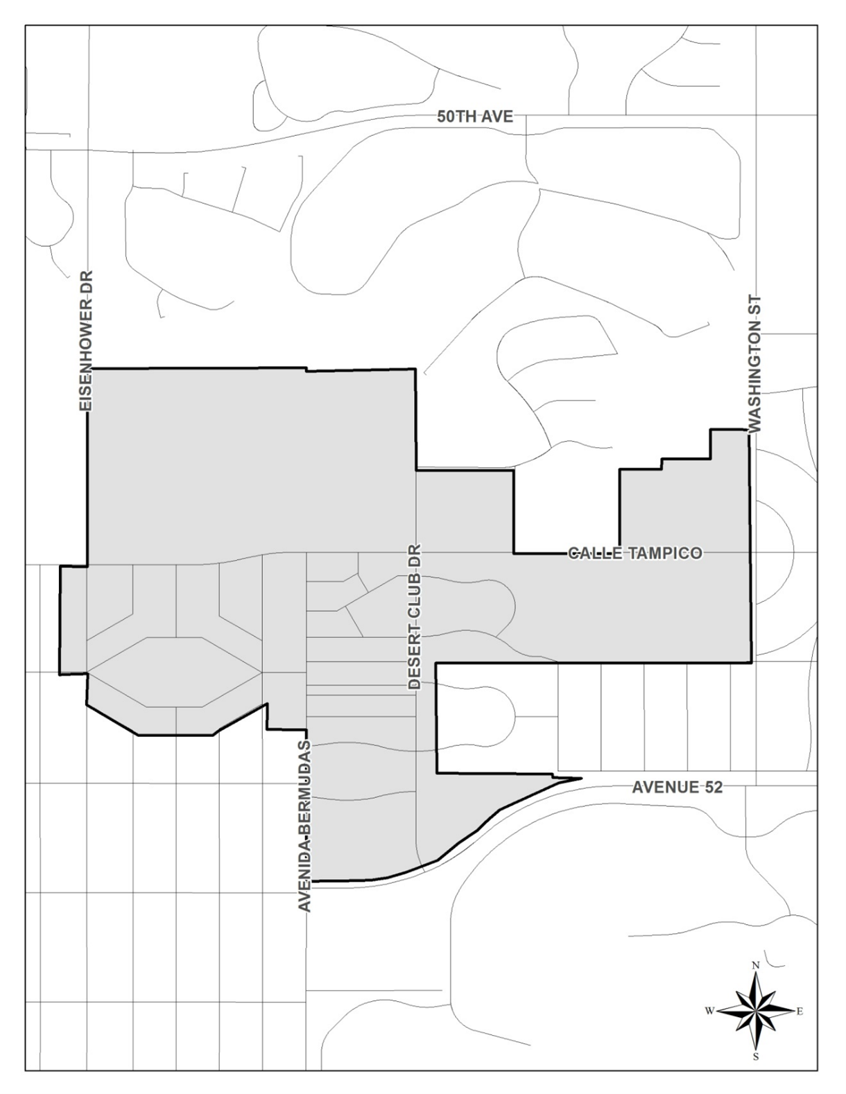
Village Build-Out Plan Area
The Village Build-Out Plan Area is planned to contain the following build-out assumptions. Although the market will dictate the actual intensities that are developed, this table will be used by the city to monitor development activity.
Build-Out Assumptions by Area
Source: City of La Quinta Village Build-Out Plan Land Use Data, August 2015.
Notes:
1. Assumes new dwelling units will be developed over commercial uses, in multiple
story buildings.
2. Assumes the existing dwelling units will remain in place.
3. Assumes that some existing nonresidential buildings will be replaced with new buildings.
B.
Development Standards. Projects in the Village Build-Out Plan Area are encouraged to implement the standards and incentives of Section 9.140.090, the mixed use overlay. If the mixed use overlay is not implemented, projects proposed within the Village Build-Out Plan Area shall be subject to the development standards in the underlying zone contained in Section 9.90.040, Table 9-6, with the following exceptions.
1.
The maximum density allowed in the Build-Out Plan Area is twenty-five (25) units per acre south of Calle Tampico, and thirty (30) units per acre north of Calle Tampico.
2.
The maximum building height is forty-five (45) feet. Any proposed building height over forty-five (45) feet requires conditional use permit approval and shall not exceed a maximum building height of sixty (60) feet. Building heights proposed above forty-five (45) feet must support the purpose and intent of the Village Build-Out Plan and be compatible with surrounding development and design. Any development proposal that exceeds forty-five (45) feet shall relate to adjacent single-family residential districts by stepping down the scale, height, and density of buildings at the edges of the project adjacent to less intense development. Buildings at any height cannot be monolithic, and must include variations in vertical planes, view corridors or openings or other features to reduce the mass and scale of structures.