
Lakeland City Zoning Code
ARTICLE 1
- INTRODUCTION AND USE OF THIS CODE
1.1 - INTENT AND APPLICABILITY
1.1.1
TITLE
This Code shall be entitled "The City of Lakeland Land Development Code" and may also be referred to herein as the "Land Development Code" or the "Code".
1.1.2
APPLICABILITY
No building, structure, or land located within the city shall hereafter be used or occupied, and no building, structure, or part thereof shall hereafter be erected, constructed, reconstructed, located, moved or structurally altered except in conformity with the regulations herein specified for the zoning district and context sub-district in which it is located, and in conformity with all other applicable provisions of this Code.
1.1.3
POWERS
a.
This Code is intended to implement powers of the city to plan, zone, regulate development, control density and administer planning, zoning and development activities pursuant to Article VIII of the Constitution of the State of Florida, Florida Statutes, various Special Acts and the City Charter.
b.
This Code is intended to implement powers conferred by or available to the city through Section 163.3161 et seq., Florida Statutes, entitled the "Community Planning Act" and any amendments thereto.
(Ord. No. 5455, 07-21-14)
1.1.4
OTHER REGULATIONS AND ORDINANCES
1.1.4.1
Engineering Standards Manual
When real property is developed or redeveloped, the infrastructure facilities contained within said property or serving said property shall be constructed in accordance with the requirements set forth in the City of Lakeland Engineering Standards Manual, prepared pursuant to Ordinance No. 3175, as amended.
1.1.4.2
Conflicting Regulations and Ordinances
Whenever any provision of this Code imposes more stringent requirements, regulations, restrictions or limitations than are imposed or required by the provisions of any other law or ordinance, then the provisions of this Code shall govern. Whenever the provisions of any other law or ordinance impose more stringent requirements than are imposed or required by this Code, then the provisions of such law or ordinance shall govern.
1.1.5
RELATIONSHIP TO THE COMPREHENSIVE PLAN
The regulations and requirements herein set forth have been established in accordance with a Comprehensive Plan with reasonable consideration given to, among other things, the prevailing land uses, growth characteristics and the character of the respective districts and their peculiar suitability for particular uses and to encourage the most appropriate use of land throughout the city. Specifically, this Code provides regulations to implement applicable goals, objectives and policies of the city's adopted Comprehensive Plan and amending ordinances.
1.1.6
INTENT OF THE LAND DEVELOPMENT CODE
The provisions of this Code are intended to be the minimum requirements to promote the public health, safety, comfort, good order, appearance, morals and general welfare of the city; to conserve the taxable value of land and buildings and to protect the character and maintain the stability of residential, business and industrial areas within the city in order to promote the orderly and beneficial development of such areas. Among other purposes, this Code is intended to:
a.
To provide a wholesome, serviceable, and attractive community;
b.
To increase the safety and security of home life;
c.
To preserve and create a more favorable environment in which to rear children;
d.
To stabilize and enhance civic values;
e.
To stabilize and enhance property values;
f.
To provide more reasonable and serviceable means and methods of protecting and safeguarding the economic and social structure upon which the good of all depends;
g.
To provide for appropriate density and intensity of land uses;
h.
To provide for a diverse mix of land uses;
i.
To provide for a compact, walkable, energy-efficient, transit-supportive urban form;
j.
To increase traffic safety and ease transportation problems;
k.
To provide for a desirable land-use pattern;
l.
To provide more adequately for light, air, and privacy;
m.
To provide more adequately for housing;
n.
To provide more adequately for job opportunity;
o.
To provide more adequately for the safety and convenience of access to property;
p.
To provide more adequately for parks, parkways, recreation, schools, public buildings and facilities, water, sewerage, sanitation, and other public requirements;
q.
To provide for a desirable tax assessment base;
r.
To lessen congestion, disorder, and danger which often are associated with unplanned and unregulated urban development;
s.
To divide the city into districts restricting and regulating therein the construction, reconstruction, alteration and use of buildings, structures and land for residence, business, industrial and other specified uses;
t.
To regulate the size of buildings and ensure desirable amounts of open space surrounding buildings;
u.
To develop meaningful and productive relationships between the private sector and city government;
v.
To aid in development and redevelopment of the city; and
w.
To define the powers and duties of the administrative officers, Boards and Commissions provided herein.
To further the objective of the city's adopted Comprehensive Plan and the intent and purpose of this Code, the city is divided into districts of such number, shape, characteristics, area, common unity of purpose, adaptability, or use as will accomplish the objectives of the plan and this Code.
1.1.7
VIOLATIONS, FINES
Any person who shall violate any of the provisions of the Code herein adopted, or fail to comply therewith, or with any of the requirements thereof, or shall build or alter any building in violation of any detailed statement or plan, submitted and approved herein, or shall use his, her or its property in violation of the provisions of said Code, shall be guilty of a violation of this ordinance and upon conviction thereof shall be penalized by a fine of not more than $500.00 or imprisonment of not more than 60 days, or by both such fine and imprisonment. Each day such a violation is permitted to exist shall constitute a separate offense. Violations of this Code may also be enforced by the Code Enforcement Board.
1.1.8
PUBLICATION
a.
The Land Development Code shall be published in book form which shall contain a certificate of the City Clerk of the City of Lakeland that said book is an exact copy of the Code, as amended.
b.
Three copies of the Land Development Code shall be filed in the office of the City Clerk, and be available to all persons desiring to examine same.
1.1.9
ENACTMENT
This Code shall take effect on March 3, 2014, as provided by law.
ADVERTISED: November 25 and December 11, 2013
READ FIRST TIME: December 2, 2013
READ SECOND TIME: December 16, 2013
DATE OF ADOPTION: December 16, 2013
APPROVED:
/s/ Gow B. Fields
Mayor
ATTEST:
/s/ Kelly S. Koos
City Clerk
(Ord. No. 5455, 07-21-14)
1.2 - STRUCTURE AND USE OF THIS CODE
1.2.1
ORGANIZATION
a.
This Code is organized into articles, sections and sub-sections according to the following format:
b.
Unless the context clearly indicates a different meaning, references to "Code" shall mean this Land Development Code in its entirety, references to "article" shall mean the current or referenced article in its entirety, references to "section" shall mean the current or referenced section in its entirety and references to "sub-section" shall mean the current or referenced sub-section in its entirety.
1.2.2
OVERVIEW
a.
This Code uses zoning districts to govern the use of property and context sub-districts to govern the physical layout and form of development in accordance with the boundaries thereof in the Official Zoning Map.
b.
This Code is organized into articles which are summarized as follows:
Article 1: Introduction and Use of This Code
This article establishes the legal basis for the Code and explains the intent and the relationship to the goals, objectives and policies of the Comprehensive Plan. It defines certain terms that have special meaning as used in the Code. It also establishes the Official Zoning Map which sets out the geographic boundaries of the various zoning districts, context sub-districts and SPI Districts.
Article 2: Use Standards
This article enumerates the various zoning districts and outlines the land uses that are permitted by right or by conditional use in each district. The uses are described in greater detail in the Master Use List. The article also contains standards for conditional uses, temporary uses and accessory uses.
Article 3: Urban Form Standards
This article sets out the development standards governing urban form. It establishes context districts, context sub-districts and a street classification system. It establishes development standards for each context sub-district and additional development standards for certain principal building types.
Article 4: General Site Development Standards
This article sets out general standards for the development of property in all districts. These standards are in addition to the standards governing basic urban form outlined in Article 3.
Article 5: Standards for Specific Uses
This article establishes use and/or development standards for certain land uses that have unique characteristics.
Article 6: Natural Resource Protection Standards
This article establishes regulations for the protection of significant natural resources including lakes, wetlands, floodplains and aquifers. It also establishes special regulations for the Green Swamp Area of Critical State Concern.
Article 7: Planned Unit Development Standards
This article establishes standards and procedures for the creation of Planned Unit Developments (PUDs) which are unique zoning districts having use and/or development regulations that are tailored to the particular site.
Article 8: Special Public Interest (SPI) District Standards
This article establishes standards and procedures for the creation of Special Public Interest (SPI) Districts which are modifications to the standard use and/or development regulations that apply within a specified geographic area. Only the city can create or amend an SPI District.
Article 9: Subdivision Standards
This article establishes standards and procedures for the subdivision of land including standards and procedures for the construction of improvements such as roads and utility systems.
Article 10: Concurrency Standards
This article establishes standards and procedures for assuring that the minimum level of service standards established by the Comprehensive Plan are maintained.
Article 11: Historic Preservation Standards
This article establishes standards and procedures for the creation of historic districts and standards for design review of development within such districts to assure compatibility with the historic character.
Article 12: Administration and Enforcement
This article sets out the powers and responsibilities of the Planning and Zoning Board, the Zoning Board of Adjustments and Appeals and the city's administrative staff. It establishes procedures for the rezoning of property, for the review and approval of conditional uses and for amending the Code. It provides for the enforcement of the provisions of this Code.
Article 13: Nonconformities
This article establishes rules for the continuance, expansion and modification of existing uses, lots and structures that do not conform to the provisions of this Code.
Commentary: Navigating the Code
The following steps will help you navigate this Code. The order in which the steps are taken will depend on your particular circumstances.
1.
Determine the zoning district classification of the property and understand the uses that are permitted within that district.
Refer to the Official Zoning Map to determine the zoning district classification of the property. (Example: RA-4.) Refer to Table 2.3-1 to determine what principal uses are permitted in that district.*
2.
Determine the context sub-district classification of the property and understand the development standards pertaining to that sub-district.
Refer to the Official Zoning Map to determine the context sub-district of the property. (Example: UNH) Each context is divided into sub-districts according to the underlying zoning district. Refer to Article 3 (Urban Form Standards) for the development standards pertaining to that context sub-district.*
3.
Understand the general site development standards.
Refer to Article 4 (General Site Development Standards) to find the rules pertaining to specific elements of site design such as access management, landscaping, signs, etc.
4.
Understand the natural resource protection standards.
Refer to Article 6 (Natural Resource Protection Standards) to find the rules pertaining to natural resources such as lakes, wetlands and floodplains. If the property is located in the Green Swamp Area of Critical State Concern, refer to Section 6.3.
5.
Understand the engineering standards and other permitting requirements contained in other documents.
City standards for the engineering of development sites are contained in the Engineering Standards Manual. Other regulations and administrative procedures might also apply, such as those necessary to obtain water, sewer and electric service and those of outside agencies such as those of the Southwest Florida Water Management District (wetlands, stormwater management), the Florida Department of Transportation (state-controlled roads) and Polk County (county-controlled roads).
*The rules pertaining to use and urban form might be different if the property is zoned PUD, is located in an SPI district, located in a historic district or is one of the specific uses covered in Article 5.
(Ord. No. 5455, § 2, 07-21-14)
1.3 - CONSTRUCTION OF LANGUAGE
1.3.1
CONSTRUCTION OF LANGUAGE
The following rules of construction apply to the text of this Code:
a.
The particular shall control the general.
b.
In the case of any differences of meaning or implication between the text of this Code and any caption or illustration, the text shall control.
c.
The word "shall" is always mandatory and never discretionary. The word "may" is permissive.
d.
Words used in the present tense shall include the future. Words used in the singular number shall include the plural, and the plural, the singular, unless the context clearly indicates the contrary.
e.
The word "building" or "structure" includes any part thereof.
f.
The phrase "used for" includes "arranged for," "designed for," "maintained for," or "occupied for."
g.
The word "person" includes an individual, corporation, partnership, incorporated association, or any other similar entity.
h.
The word "he" or "his" shall include "her" or "hers."
i.
Unless the context clearly indicates the contrary, where a regulation involves two or more items, conditions, provisions or events, connected by the conjunction "and," "or," or "either or," such conjunction shall be interpreted as follows:
1.
"And" indicates that all the connected items, conditions, provisions or events shall apply.
2.
"Or" indicates that the connected items, conditions provisions, or events may apply singularly or in any combination.
3.
"Either...or" indicates that the connected items, conditions, provisions or events shall apply singularly but not in combination.
j.
Terms not herein defined shall have the meaning customarily assigned to them.
1.4 - GENERAL DEVELOPMENT REGULATIONS
1.4.1
REGULATIONS GOVERNING DEVELOPMENT IN GENERAL
1.4.1.1
Density and Intensity of Use—General
a.
Limits established by Comprehensive Plan
The Comprehensive Plan establishes certain limits on the density and intensity of use within each future land use designation on the Future Land Use Map. These are summarized in b. and c. below. Except where otherwise specifically provided in this Code, the density and intensity of development shall not exceed those limits.
b.
Residential Density Limits
The Comprehensive Plan establishes a maximum residential density within each future land use designation and a minimum residential density within certain Transit-Oriented Corridors (TOCs) as set forth in Table 1.4-1. The roads on which the corridors are centered are illustrated in Figure 1.4-1. New residential development or redevelopment shall not exceed these limits, except that non-complying lots existing as of the effective date of this Code may be built upon without the need for a variance, provided that the lots otherwise comply with the development regulations. These densities are not entitlements and all property is subject to the application of zoning and context classifications in accordance with the requirements and procedures of this Code.
Table 1.4-1: Residential Density Limits (dwelling units per gross acre)
Figure 1.4-1 Transit Oriented Corridors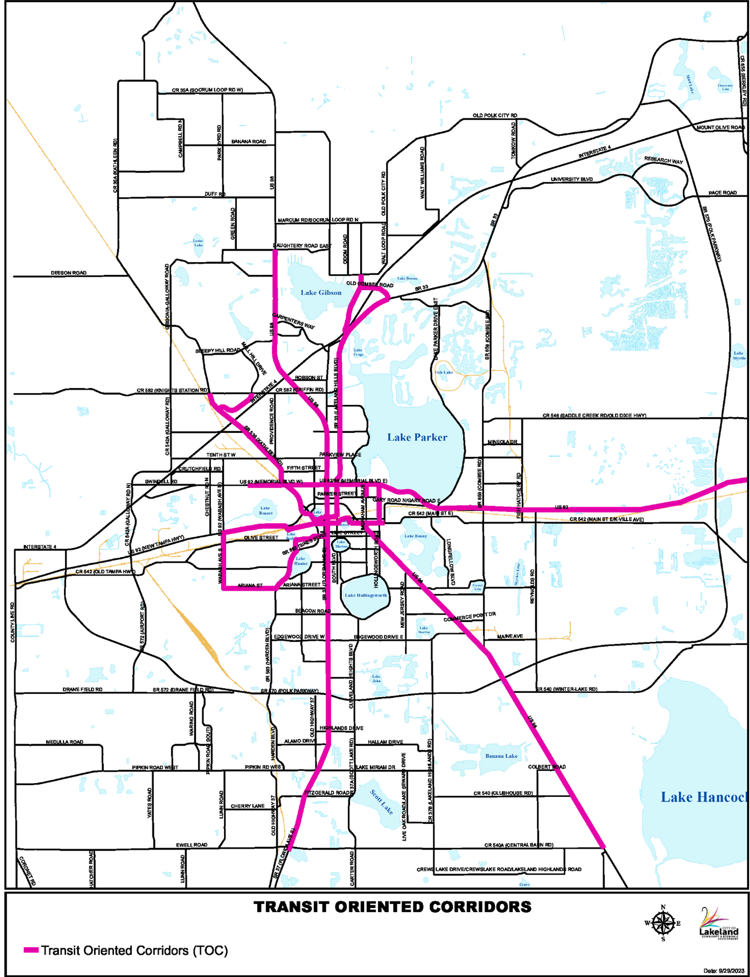
c.
Non-Residential and Mixed Use Intensity Limits
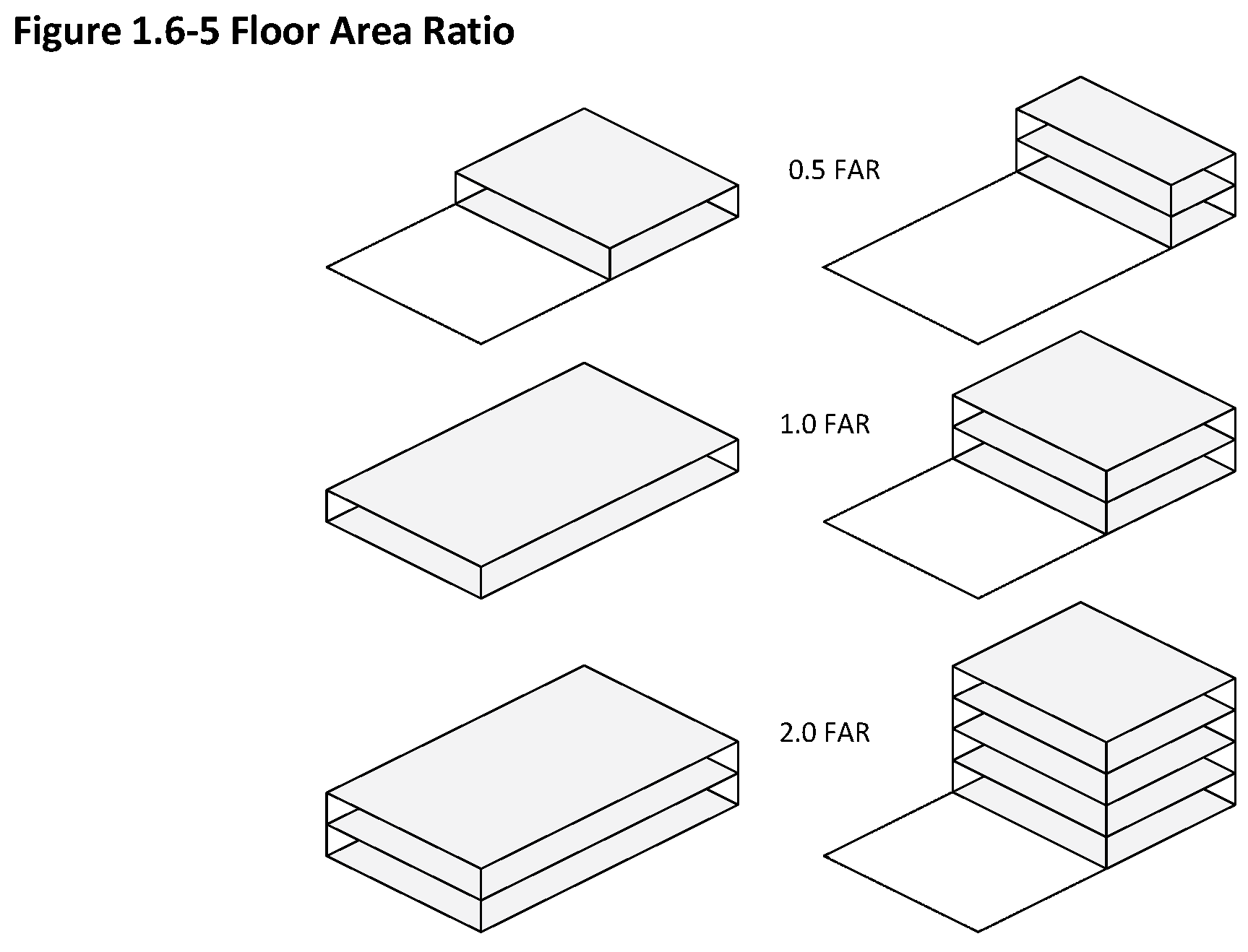
The Comprehensive Plan establishes a maximum floor area ratio for non-residential and mixed uses within each future land use designation and within described development districts as set forth in Table 1.4-2. These floor area ratios are not entitlements and all property is subject to the application of zoning and context classifications in accordance with the requirements and procedures of this Code.
(Ord. No. 5455, 07-21-14; Ord. No 5522, 07-20-15; Ord. No. 5559, 01-19-16; Ord. No. 6021, § 2(Att. A), 1-16-24)
Table 1.4-2: Maximum Floor Area Ratio
1.4.1.2
LOTS, YARDS, STRUCTURES—GENERAL
a.
Reduction of Lot Area Restricted
No lot shall be reduced in area so as to be smaller than prescribed in the regulations for the district in which said lot is located. Whenever such a reduction in lot area occurs, any building located on such lot shall not thereafter be used until such building is altered, reconstructed, or relocated so as to comply with the applicable area and yard requirements.
b.
Joint Use of Yards Restricted
No required yard about any building for the purpose of complying with the provisions of these regulations shall be considered as a yard for any other buildings; and no yard of a building on one lot shall be considered as a yard for a building on any other lot.
c.
Erection of Accessory Structures Prior to Principal Structures Prohibited
In all districts, no accessory building or structure may be erected prior to the erection of the principal building or structure. Accessory buildings and structures may be erected concurrent with or after the erection of principal buildings and structures.
1.4.1.3
DESIGN REVIEW REQUIRED IN CERTAIN AREAS
a.
Historic Districts
Within designated historic districts, new construction and alterations to existing buildings, structures or sites (including but not limited to, windows, doors, roofing, siding, columns, exterior additions, fences, walls and signs) shall require a Certificate of Review prior to issuance of a building permit or other required city approvals. Depending on the type and extent of the project, approval of a Certificate of Review is the responsibility of the Design Review Committee of the Historic Preservation Board or the administrative staff. Demolition of structures in historic districts requires the approval of the Design Review Committee.
b.
C-6 Zoning District
Prior to issuance of a building permit for new construction, additions and exterior demolition or alterations, proposed site plans, including parking and landscape/streetscape improvements, building elevations and first floor building plans, shall be submitted to the Board of Directors of the Downtown Development Authority for review and approval. Building elevations shall illustrate building materials, textures and color, as well as entrances, storefronts and other features.
c.
C-7 Zoning District
Prior to issuance of a building permit for new construction, additions and exterior demolition or alterations, proposed site plans, including parking and landscape/streetscape improvements, building elevations and first floor building plans, shall be submitted to the City of Lakeland Historic Preservation Board for review and approval. Building elevations shall illustrate building materials, textures and color, as well as entrances, storefronts and other features.
d.
SPI Districts
Design Review might be required for development activity in certain SPI Districts. The reviewing body and criteria for review shall be as specified in the ordinance enacting the particular SPI District.
(Ord. No. 5455, 07-21-14)
1.4.2
POLK COUNTY AIRPORT ZONING REGULATIONS
To ensure that land uses, activities and structures are compatible with the operations of Lakeland Linder Regional Airport, development shall conform to the standards set forth in the Polk County Airport Zoning Regulations, established by the Polk County Joint Airport Board pursuant to Chapter 333, Florida Statutes. The regulations establish certain limits and requirements pertaining to structure height, noise-sensitive land uses, land uses within overflight zones, educational facilities, and land uses or activities that may induce a bird strike hazard or visual or electronic interference with aircraft.
1.5 - OFFICIAL ZONING MAP
1.5.1
ESTABLISHMENT AND AUTHORITY
a.
The city is divided into zoning districts and context sub-districts, the boundaries and designations of which are shown in a series of maps, covering in combination the entire land and water area of the city, and identified as the Official Zoning Map of the City of Lakeland. The Official Zoning Map, together with all lawfully adopted explanatory material shown therein, is hereby adopted by reference and declared to be part of this Code.
b.
The Official Zoning Map and amendments thereto located in the office of the Community Development Department shall be the final authority as to the current zoning and context status of all lands and waters in the city, and shall be the final authority as to regulations set forth therein as applying to such districts.
c.
Where SPI Districts created in accordance with this Code have the effect of superseding previously existing districts or sub-districts or portions of districts, the SPI District boundaries and designations shall be shown directly on the basic map sheets. Where SPI Districts have the effect of modifying requirements, regulations, or procedures applying in existing districts, but do not supersede such districts, the boundaries of such SPI Districts may either be indicated by SPI designation to the basic map sheet or by SPI District map supplements.
d.
Where the scale generally applicable to the basic map sheets or supplemental maps is inadequate for presentation of details in particular areas, such areas may be cross-referenced on the basic map sheets or supplemental maps to separate inset maps drawn at appropriate scale. Other supplements, in the form of maps, indexes, guides, illustrations, records, reports, interpretive material and standards may be officially adopted, directly or by reference, to facilitate administration and public understanding of the Official Zoning Map, or of regulations adopted for the zoning districts or context sub-districts or other divisions established thereby.
(Ord. No. 5455, 07-21-14)
1.5.2
RULES FOR ZONING DISTRICT AND CONTEXT DISTRICT BOUNDARIES
a.
Except as otherwise specifically provided, a district or sub-district symbol or name shown within district boundaries in the Official Zoning Map indicates that regulations pertaining to the district or sub-district extend throughout the entire area within the boundary line.
b.
Where the zoning district or sub-district of a parcel is not shown on the map, the following rules shall apply:
1.
Where a district or sub-district designation is not indicated for an area in the Official Zoning Map, the area shall be construed to be zoned as for the most restrictive adjoining district or sub-district.
2.
Upon discovery of such omissions, the Director of Community Development shall initiate the proposed corrective amendment.
c.
Where uncertainty exists as to location of district or sub-district boundaries or other areas delineated for regulatory purposes in the Official Zoning Map, the rules set forth in d. through j., below, shall apply.
d.
Where district or sub-district boundaries are indicated as approximately following the center line of streets, highways, or alleys or their extensions, street lines, highway right-of-way lines, railroad right-of-way lines, or alley lines or their extensions, such center lines or their extensions, street lines, right-of-way lines, alley lines or their extensions shall be construed to be said boundaries.
e.
Where district or sub-district boundaries are indicated as approximately following lot lines or their extensions, such lot lines or their extensions shall be construed to be said boundaries.
f.
Where district or sub-district boundaries obviously do not coincide with any of the aforesaid lines, and are so indicated that they are approximately parallel to the center lines or street lines of streets or alleys or projections thereof, or the center lines of right-of-way lines of highways or railroads or projections thereof, or the lot lines or projections thereof, such district or sub-district boundaries shall be construed as being parallel thereto and at such a distance therefrom as indicated on the Zoning Map. If no distance is given, such dimensions shall be determined by the use of the scale shown on the Zoning Map.
g.
Boundaries indicated as approximately following mean high water lines or center lines of streams, canals, lakes, bays, or other bodies of water shall be construed as following such mean high water lines or center lines. In the case of a change in mean high water line, the boundary shall be construed as moving with the change, except where such would change the zoning status of a lot or parcel, in which case the boundary shall be interpreted in such manner as to avoid such change.
h.
Boundaries indicated as approximately following the corporate limits of the City of Lakeland shall be construed as following said city limits.
i.
Where distances are not specifically indicated on any map in the Official Zoning Map, they shall be determined by reference to the scale of the map.
j.
In other circumstances not covered above, or where existing natural or man-made features are at variance with those shown in the Official Zoning Map, or where the map is illegible or unclear, or where interpretations based on the above rules appear to produce contradictions or conflicts with the intent of the Land Development Code, or upon request from the Director of Community Development or from any affected property owners, or on its own initiative upon determination that inconsistencies or uncertainties exist, the Zoning Board of Adjustment and Appeals shall make a finding and interpretation concerning the boundaries involved in accord with the intent and purpose of this Land Development Code. In cases where such finding and interpretation involves only correction to the Official Zoning Map or any official supplement, and does not change the zoning of any lot, the Zoning Board of Adjustment and Appeals may direct corrections without proposing an amendment to the map involved. In cases where the zoning of any lot would be changed by such correction, the Zoning Board of Adjustment and Appeals shall initiate a proposed corrective amendment and transmit its recommendations thereon to be considered by the Planning and Zoning Board in accord with Article 12 (Administration and Enforcement).
1.5.3
AUTHENTICATION AND LOCATION
a.
Each basic map sheet and each overlay or supplemental element thereto contained in the Official Zoning Map shall be authenticated by the signature of the mayor; attested by the signature of the City Clerk, and bear the seal of the city, under the following words:
"This is to certify that this is (page number, title, or other specific identification) of the Official Zoning Map referred to and adopted by reference by Land Development Code No. 5425 of the City of Lakeland, Florida, adopted December 16, 2013."
b.
The Official Zoning Map shall be located in the office of the Community Development Department.
(Ord. No. 5455, 07-21-14)
1.5.4
AMENDMENT OF OFFICIAL ZONING MAP
a.
The Official Zoning Map is subject to amendment as set out in Article 12 (Administration and Enforcement). Any proposed amendment shall be identified by reference to the map sheet and/or supplement involved, in addition to legal description or other property identification or such other information as is required to make specific the application of the amendment.
b.
Amendments shall be authenticated by entries on map sheets, supplements, or schedule sheets affected, and a record of the nature and date thereof maintained. Such entries shall indicate the date the change became effective, the number of the amending ordinance, and an indication of the nature of the change sufficient to facilitate specific identification.
c.
No changes of any nature shall be made in the Official Zoning Map, or any information shown thereon, except in conformity with the requirements and procedures set forth in this Code. Any unauthorized changes of whatever kind by any person or persons shall be considered a violation of this Code and punishable as provided by this Code; provided, this provision shall not be held to foreclose action under other applicable criminal statutes of the State of Florida against any person or persons alleged to have made unauthorized changes in this Code.
1.5.5
RETENTION AND REPLACEMENT OF ZONING MAPS
a.
At least one copy of all zoning maps, or remaining portions thereof, which have had the force and effect of official zoning maps for the city prior to the effective date of adoption or amendment of this Code shall be retained by the office of the Community Development Department and preserved as a public record and as a guide to the zoning status of lands and waters prior to such dates.
b.
At any time the Official Zoning Map, or any portion thereof becomes damaged, lost, destroyed, or difficult to interpret by reason of the nature or number of changes, the City Commission may by resolution adopt a new Official Zoning Map, or any portion thereof, which shall supersede that previously in effect. The superseding document or documents may correct errors or omissions in prior versions, but no such correction shall have the effect of amending the district designation of any property, except where such replacement is accompanied by action in the form of an amendment making such changes.
c.
Where replacement does not involve amendment, replacing elements shall individually bear a record of authority for such replacement indicating the number and date of the resolution, the date of the replacement, and specific identification of the material replaced, attested by the City Clerk.
d.
Where replacement is accompanied by amendment, in addition to the entry indicated above, an entry shall be made as required generally for amendments in Sub-Section 1.5.4.b.
(Ord. No. 5455, 07-21-14)
1.6 - DEFINITIONS
1.6.1
INTENT
It is the intent of this section to provide definitions for certain words and terms that have special meanings as used in this Code. Other words and terms having special meanings specific to other articles or sections are defined elsewhere in this Code are not included in this section. Unless the context clearly indicates a different meaning, those words and terms shall be as defined as indicated in the particular article or section. Words and terms not specifically defined in this Code shall have their standard dictionary meaning.
1.6.2
DEFINITIONS
Unless the context clearly indicates a different meaning, for the purposes of this Code, the following words and terms shall be defined as follows:
Abut: To physically touch or border upon; or to share a common property line.
Access: A way or means of approach to provide physical entrance to a property.
Accessory Dwelling Unit: A dwelling unit detached from a principal dwelling located on the same lot and incidental and subordinate to the principal dwelling.
Accessory Structure (or Accessory Building): A structure detached from a principal building on the same lot and customarily incidental and subordinate to the principal building or use. For the purpose of this definition, the term detached shall mean a building or structure that is structurally independent and does not share a common wall with the principal structure.
Accessory Use: A use of land or portion thereof customarily incidental and subordinate to the principal use of the land or building and located on the same lot with such principal use.
Addition: A structure added to the original structure at some time after the completion of the original.
Adjacent Land or Lot: A lot or parcel of land which shares all or part of a common lot line with another lot or parcel of land.
Alley: A permanent service way providing a secondary means of public access to abutting property and not intended for general traffic circulation.
Applicant: Any person applying for or who has been granted a specified permit.
Architectural Relief: Variation in architectural details along the face of a wall intended to avoid blank walls. Architectural relief includes changes in materials or textures; changes in volume or wall plane; and the use of awnings, canopies, porticos, pilasters or similar architectural elements.
Awning: A roof-like cover that projects from the wall of a building and may be used to shield a doorway or window from the elements. An awning that is permanent in nature is subject to restrictions on overhang or encroachment into required yards. For purposes of sign regulation, this term is further defined in Section 4.9 (Signs).
Basement: Any building story having a floor below grade with one-half or more of its floor-to-ceiling height above the average level of the finished grade.
Block: A unit of land bounded by streets or by a combination of streets and public land, railroad rights-of-way, waterways or any other barrier to the continuity to development.
Board of Adjustment: The Zoning Board of Adjustment and Appeals as set forth in Article 12 (Administration and Enforcement).
Building: Any structure having a roof supported by columns or walls and intended for the shelter, housing or enclosure of any individual(s), animal, process, equipment, goods or materials.
Building Area: The total of areas of all buildings on a lot or parcel taken on a horizontal plane at the main grade level, exclusive of uncovered off-street parking areas.
Building Code: The structural, mechanical, electrical, and plumbing standards enforced by the Building Official.
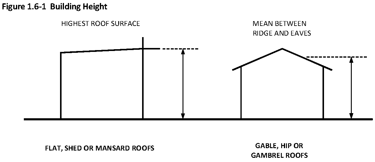
Building Height: The vertical distance from finished grade to the highest finished roof surface in the case of flat, shed or mansard roofs or the mean height between eaves and ridge in the case of gable, hip or gambrel roofs.
Building Official: The Manager of the Building Division of the Community Development Department, or his duly appointed and authorized agent.
Building Permit: Written approval from the city allowing construction activities to occur following review and approval.
Canopy: See Awning.
Cellar: A space with less than one-half of its floor-to-ceiling height above the average finished grade of the adjoining ground.
Certificate of Occupancy: The certificate issued by the Building Official which permits the use of a building in accordance with the approved plans and specifications and which certifies compliance with the provisions of law for the use and occupancy of the building.
Change of Use: Any use which differs substantially from the previous use of a building or land, or a discontinuance of an existing use and the substitution thereof of a different kind of class. Change of use is not intended to include a change of tenants or proprietors, unless accompanied by a change to a use of a different kind or class.
City: The City of Lakeland.
City Manager: The City Manager of the City of Lakeland, or his duly appointed and authorized agent.
Civic Open Space: Open space permanently available for social gatherings, civic activity or recreation.
Common Area: Land within or related to a development, not individually owned or dedicated for public use, which is designed and intended for the common use or enjoyment of the residents of the development. Common areas may include private parks, recreational paths, or areas, special feature entrance areas, private lakes, retention areas, stormwater management areas, or any other such area within the subdivision or other development set aside for the collective use or benefit of the owners of land within the subdivision or other development.
Common Facilities and Improvements: Amenities, parts of buildings, central services and utilities, and any other elements of a development which are owned in common by the individual owners having an interest in the development and designated in the master deed as common elements. Common facilities and improvements may consist of roadways; street lights; utilities; swales, retention areas and other stormwater management facilities; sidewalks; recreational paths; and traffic control devices.
Common Ownership: Any form of ownership of two or more contiguous lots by one or more individuals.
Commercial Use: Any use listed under the general category Commercial in Table 2.3-1 or Table 2.3-2.
Compatible: In harmony with the surrounding land uses, context, building forms and environment.
Comprehensive Plan: The most recent comprehensive long-range plan adopted by the Lakeland City Commission under the authority of and in compliance with Florida Statutes. The Comprehensive Plan includes the Future Land Use Map.
Conditional Use: A use permitted in a zoning district only upon demonstrating that such use will comply with all the conditions and standards for the location or operation of such use as specified in this Code and authorized by the City Commission.
Condominium: That form of ownership of real property which is comprised of units that may be owned by one or more persons and in which there is appurtenant to each unit an undivided share in common elements.
Construction Plans: Construction plans for subdivision plats include such drawings and specifications as are necessary for construction according to sound engineering practice, the City of Lakeland Engineering Standards Manual and this Code.
Context (Context District, Context Sub-District): Land areas specifically delineated on the Official Zoning Map within which regulations and requirements uniformly govern urban form. The context describes the desired general character of the built environment of an area as distinguished by block size; by lot and parcel size; by the predominant types of land uses; by the types of streets; by the types of open spaces; and by the size, scale and disposition of buildings and structures.
Contiguous: Next to, abutting, or touching and having a boundary, or portion thereof, which is coterminous. (See Abut, Adjacent Land or Lot.)
Covenant: See Deed Restriction.
Cul-de-sac: The turnaround at the end of a dead-end street.
Dedication: Gift or donation of an interest in property by the owner to another party.
Deed Restriction: A restriction on the use of land usually set forth in the deed.
Density: The number of dwelling units per gross acre of land.
Developer: The legal or beneficial owner(s) of land included in a proposed development including the holder of an option or contract to purchase, or other persons having enforceable proprietary interests in such land.
Development: The division of a parcel of land into two or more parcels. The construction, reconstruction, conversion, structural alteration, relocation or enlargement of any structure. Any mining, excavation, landfill or land disturbance and any use or extension of the use of land.
Development Review Team: An internal review team composed of the directors of each city department having responsibility for enforcement of this Code, or their designees.
Director of Community Development: The Director of the Community Development Department, as defined by Section 6, Chapter 30919, Special Laws of Florida, or his duly appointed and authorized agent.
Director of Lakeland Electric: The General Manager of the Lakeland Electric Utility Department, or his duly appointed and authorized agent.
Director of Parks and Recreation: The Director of Parks and Recreation, or his duly appointed and authorized agent.
Director of Public Works: The Director of the Department of Public Works, or his duly appointed and authorized agent.
Director of Water Utilities: The Director of the Water Utilities Department, or his duly appointed and authorized agent.
District: A part, zone or geographic area within the City of Lakeland municipality within which uniform regulations apply.
Dwelling: A building or portion thereof which is used exclusively for human habitation.
Dwelling, Multi-Family: A building or parcel of land containing three or more dwelling units in which each unit is directly accessed from the outside or from a common, interior hallway.
Dwelling, Single-Family: A building containing one dwelling unit.
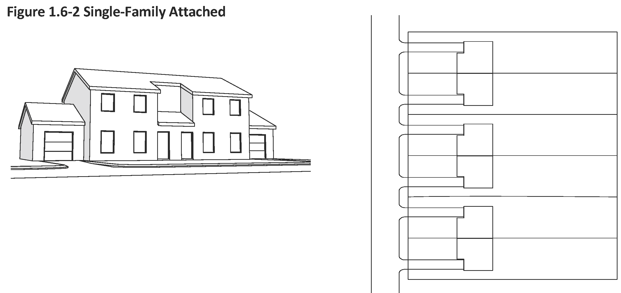
Dwelling, Single-Family Attached: A building containing a one-family dwelling on its own lot or parcel attached by common vertical walls to one or more other one-family dwellings located on other lots or parcels. Each single-family attached dwelling unit has one or more at-grade entrances and at least 40 percent of its living area at grade.
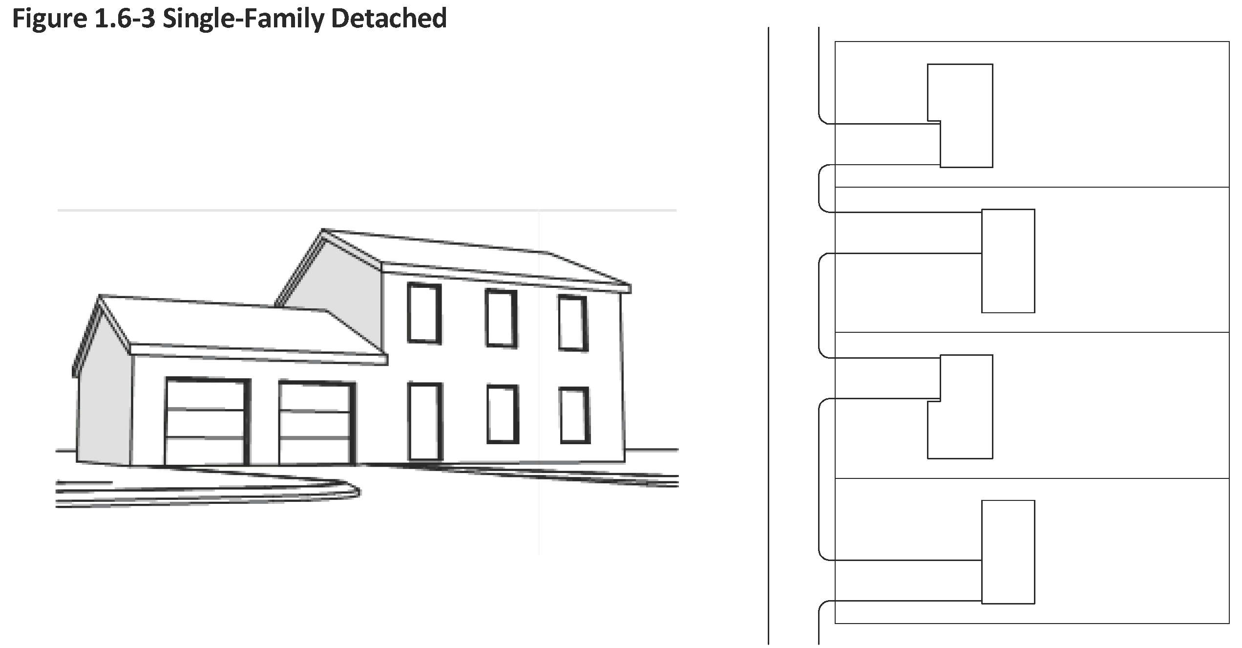
Dwelling, Single-Family Detached: A dwelling which is designed for and occupied by not more than one family and surrounded by open space or yards and which is not attached to any other dwelling by any means.
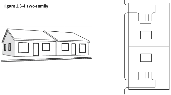
Dwelling, Two-Family: A building on a single lot or parcel of land containing two dwelling units, in which each unit has frontage on the primary street adjacent to the lot or parcel and is totally separated from the other by either an unpierced wall extending from ground to roof or an unpierced ceiling and floor extending from exterior wall to exterior wall, except for a common stairwell exterior to both units.
Dwelling Unit: A single unit providing complete, independent living facilities for one or more persons including permanent provisions for living, sleeping, eating, cooking and sanitation. For purposes of this definition, sanitation provisions shall mean a toilet and a shower or bathtub. Cooking provisions shall mean a range or a 220 volt or gas hookup that would permit the installation of a range.
Easement: A grant of one or more of the property rights by the property owner to and/or for the use by the public, a corporation or another person or entity.
Elevation:
A.
A vertical distance above or below a fixed reference level; or
B.
A two-dimensional drawing of the front, rear, or side of a building.
Engineer: Any person currently licensed in the State of Florida to practice Civil Engineering.
Engineer of Record: The engineer certifying all site plans for the development in question.
Engineering Standards Manual: A manual adopted by the City of Lakeland establishing minimum standards for the development of infrastructure within the city and unincorporated areas served by city-owned utilities. Such infrastructure includes but is not limited to, streets, drainage, stormwater management facilities, wastewater, refuse collection, potable water systems and electric utilities.
Erosion: The detachment and movement of soil or rock fragments, or the wearing away of the land surface by water, wind, ice and gravity.
Excavation: Removal of soil, rock, minerals, mineral substances or organic substances beneath the ground surface, whether exposed or submerged.
Existing Use: The present use of a lot or structure.
Exterior Wall: Any wall which defines the exterior boundaries of a building or structure.
Family:
A.
One or more persons related by blood, marriage, adoption or foster care relationship occupying a dwelling unit and living as a single, nonprofit housekeeping unit; or
B.
A collective number of persons occupying a dwelling unit, not related by blood, marriage, adoption or foster care relationship, and living together as a single nonprofit housekeeping unit, provided however, that the maximum number of unrelated persons shall not exceed five.
Fence: An artificially constructed barrier of any material or combination of materials erected to enclose or screen areas of land.
Fenestration: The design, number and placement of exterior openings of a building including windows, doors or transoms but not including garage door openings of attached garages.
First Floor: The first floor of a building other than a cellar or basement.
Floor: The top surface of an enclosed area in a building (including basement), i.e., top of slab in concrete slab construction or top of wood flooring in wood frame construction. The term does not include the floor of a garage used solely for parking vehicles.
Floor Area, Gross: The sum of the gross horizontal areas of the several floors of a building measured from the exterior face of exterior walls, or from the centerline of a wall separating two buildings, but not including interior parking spaces or loading space for motor vehicles.
Floor Area Ratio: The gross floor area of all buildings on a lot divided by the gross land area.
Food Truck: A mobile food unit, mobile food vendor or any other food service/vending vehicle or cart that has been inspected and licensed as such by the appropriate state agency.
Food Truck Court: Two or more food trucks as either a principal or accessory use located on the same parcel.
Frontage: The horizontal distance measured along the front lot line between the side lot lines.
Future Land Use Map: A map adopted as part of the Comprehensive Plan which graphically depicts the extent of each future land use category described in the Comprehensive Plan.
Garage: A building or enclosed space providing for the storage of motor vehicles. A garage attached to or part of the main structure is to be considered part of the main building. A detached garage is considered an accessory building.
Grade, Existing (Elevation): The vertical location of the ground surface prior to excavating or filling.
Grade, Finished: A reference plane representing the average of final ground level adjoining the building at all exterior walls.
Hazardous Substances: Any substance or material which, by reason of its toxic, caustic, corrosive, abrasive, or otherwise injurious properties, has been determined to be detrimental or deleterious to the health of any person handling or using or otherwise coming into contact with such material or substance.
Historic District: A district or zone designated by the city, state or federal government within which the buildings, structures, appurtenances and places are of basic and vital importance because of their association with history, or because of their unique architectural style and scale, including color, proportion, form and architectural detail, or because of their being a part of or related to a square, park, or area the design or general arrangement of which should be preserved and/or developed according to a fixed plan based on cultural, historical or architectural motives or purposes.
Historic Preservation: The act of protection, rehabilitation, and restoration of districts, sites, buildings, structures and artifacts significant in American history, architecture, archaeology, or culture.
Home-Based Business: A business that operates, in whole or in part, from an improved residential property and meets the criteria in Section 559.955, Florida Statutes and the minimum standards in Section 5.10 of this code.
Improvement: Any man-made, immovable item which becomes part of, placed upon, or is affixed to, real estate.
Industrial Use: Any use listed under the general category Industrial in Table 2.3-1 or Table 2.3-2.
Intensity: The potential impact of a non-residential use generally expressed as density in the case of residential uses and floor area ratio in the case of commercial, office and industrial uses.
Land Use (Use): The manner in which land is occupied or utilized or intended to be occupied or utilized.
Living Area: The measurement of living area shall be the sum of the area of the first story measured to the exterior face of exterior wall; plus, similarly measured, the area of any upper story that is connected to the first floor by a fixed stairway and which may be made usable for human habitation; but excluding the floor area of basements not used for dwelling purposes, garages, accessory buildings, attics, breezeways and unenclosed porches.
Loading Space: An off-street space or berth used for the loading or unloading of commercial vehicles.
Lot: A designated parcel, tract or area of land established by plat, subdivision, or as otherwise permitted by law, to be used, developed or built upon as a whole.
Lot Area: The area of a horizontal plane measured at grade and bounded by the front, side and rear lot lines.
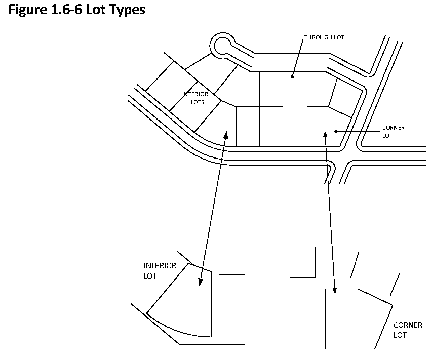
Lot, Corner: A lot or parcel of land abutting upon two or more streets at their intersection, or upon two parts of the same street forming an interior angle of less than 135 degrees.
Lot Coverage: That portion of the lot that is covered by buildings and certain building-like structures specified in this Code. Does not include pools, pool cages, uncovered patios, walkways and surface parking areas.
Figure 1.6-7 Lot Coverage
Lot Depth: The average distance, measured from the front lot line to the rear lot line, measured in the general direction of the side lot lines.
Lot, Flag: A lot not meeting minimum lot frontage requirements so shaped and designed that the main building site area is set back from the street on which it fronts and includes a narrow access strip connecting the main building site with the public or private frontage street.
Lot Frontage: The length of the front lot line measured at the street right-of-way line.
Lot, Interior: A lot other than a corner lot or through lot.
Lot Line: A line of record bounding a lot which divides one lot from another lot or from a public or private street or any other public space.
Lot Line, Front:
A.
For interior lots, the lot line abutting the street right-of-way.
B.
For corner lots zoned single-family or two-family, that portion of the lot line abutting the street right-of-way upon which the lot has the least frontage where the width or lesser dimension of the lot is less than 90 percent of the depth or greater dimension. Where the width is equal to or greater than 90 percent of the depth, the lot line abutting the street right-of-way on which the principal building has or will have its street address, or as determined by the Director of Community Development.
C.
For all other corner lots, that portion of the lot line abutting the street with the highest classification as designated on the Comprehensive Plan major street plan. Where the abutting streets have an equal classification, the lot line abutting the street right-of-way on which the principal building has or will have its street address, or as determined by the Director of Community Development.
D.
For through lots, the lot line abutting the street right-of-way on which the principal building has or will have its street address, or as determined by the Director of Community Development.
Lot Line, Interior Side: Any lot line other than a front, rear or street side lot line.
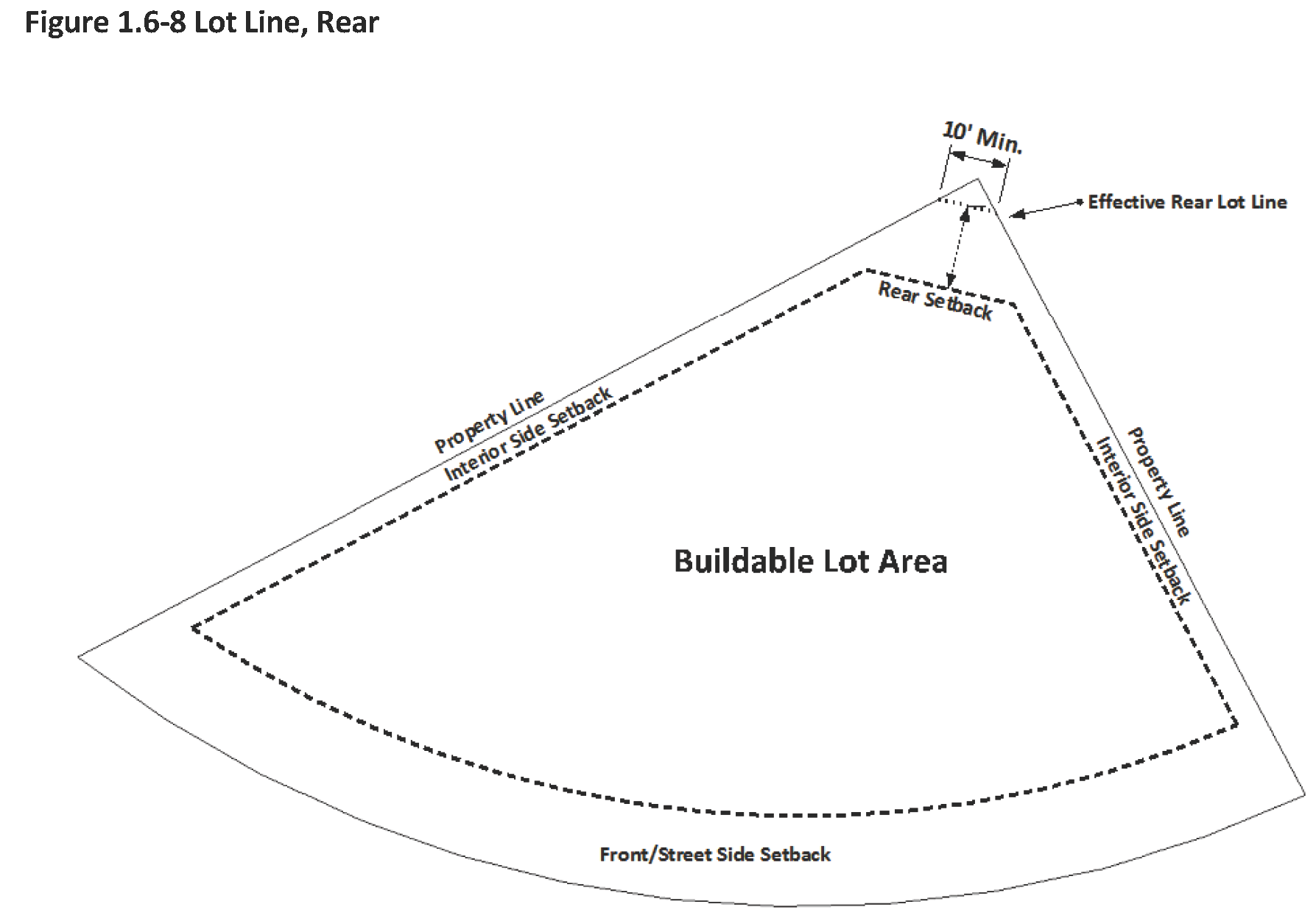
Lot Line, Rear: The lot line opposite and most distant from the front lot line. For triangular or other irregular lots with side lot lines which converge at the rear, the effective rear lot shall be a line, at least ten feet long, which lies completely within the lot and connects the two side lot lines. If the front lot line is straight, the line shall be oriented parallel to the front lot line. If the front lot line is curved, the line shall be oriented perpendicular to a line which bisects the angle created by the convergence of the two rear lot lines.
Lot Line, Street Side: Any lot line abutting a street which is not the front lot line.
Lot of Record: A lot which exists as shown or described on a plat or deed in the records of the Clerk of the Circuit Court, Polk County, Florida.
Lot, Through: A lot which fronts upon two parallel streets, or which fronts upon two streets which do not intersect at the boundaries of the lot.
Lot Width: If the minimum front setback line is straight, the lot width shall be the horizontal distance between the side lot lines measured along the minimum front setback line. If the minimum front setback line is not straight, then the lot width shall be measured along the shortest line which:
•
Connects the side lot lines;
•
Touches the minimum front setback line at least at one point; and
•
Lies completely within the front yard except at the point or points where it touches the minimum front setback line.

Low-THC Cannabis: A plant of the genus Cannabis, the dried flowers of which contain 0.8 percent or less of tetrahydrocannabinol and more than 10 percent of cannabidiol weight for weight; the seeds thereof; the resin extracted from any part of such plant; or any compound, manufacture, salt, derivative, mixture or preparation of such plant or its seeds or resin that is dispensed from a Medical Marijuana Treatment Center.
Medical Marijuana: All parts of any plant of the genus Cannabis, whether growing or not; the seeds thereof; the resin extracted from any part of the plant; and every compound, manufacture, salt, derivative, mixture or preparation of the plant or its seeds or resin, including Low-THC Cannabis, which are dispensed from a Medical Marijuana Treatment Center for medical use by a qualified patient pursuant to constitutional amendment or other provisions of state law.
Medical Marijuana Dispensing Facility: A facility operated by a Medical Marijuana Treatment Center as defined herein and engaged in the sale and dispensing of Medical Marijuana and related supplies to qualified patients or their caregivers pursuant to constitutional amendment or other provisions of state law.
Medical Marijuana Treatment Center: An entity that acquires, cultivates, possesses, processes (including development of related products such as food, tinctures, aerosols, oils or ointments), transfers, transports, sells, distributes, dispenses or administers marijuana, products containing marijuana, related supplies or educational materials to qualified patients or their caregivers pursuant to constitutional amendment or other provisions of state law and is registered by the State Department of Health.
Mobile Home: A structure, transportable in one or more sections, which is at least eight body feet or more in width and which is built on an integral chassis and designed to be used as a dwelling when connected to the required utilities and includes the plumbing, heating, air-conditioning, and electrical systems contained therein. This definition shall include Park Models.
Motor Home: Any self-propelled vehicle fitted and equipped for temporary living purposes, including facilities for sleeping or the preparation of food.
Motor Vehicle: A self-propelled device used for transportation of people or goods over land surfaces and licensed as a motor vehicle.
Newsrack: Any self-service or coin-operated box, container, storage unit or other dispenser installed, used or maintained for the display or distribution and sale of newspapers, periodicals, advertising circulars or other publications.
Nonconforming: A lot, structure, or use which was lawful prior to the adoption of a Land Development Code or an amendment thereto, which renders such lot, structure or use nonconforming because it does not conform to all the standards and regulations of the adopted or amended Code.
Off-Street Parking Space: A temporary storage area for a motor vehicle that is directly accessible to an access aisle, and which is not located on a dedicated street right-of-way.
Open Space: Any parcel or area of land or water set aside, dedicated, designated or reserved for public or private enjoyment or use.
Overhang:
A.
The part of a roof or wall which extends beyond the facade of a lower wall; or
B.
The portion of a vehicle extending beyond the wheel stops or curb.
Owner: Any person, agent, firm or corporation having a legal or equitable interest in a property.
Parcel: A lot or tract of land.
Parking Area: Any public or private land area designed and used for the parking of motor vehicles including parking lots, garages, private driveways and legally designated areas of public streets.
Parking Lot: An off-street, ground level area, usually surfaced and improved, for the parking of motor vehicles.
Parking Space: A space for the parking of a motor vehicle within a parking area.
Patio: A level, landscaped and/or surfaced area directly adjacent to a principal building at or within three feet of the finished grade and not covered by a permanent roof.
Pavement:
A.
A hard surface that will bear traffic; or
B.
That part of a public or private right-of-way having an improved surface.
Permit (Development Permit): Formal permission to erect, construct, reconstruct, alter, raze, move, remove, or otherwise develop or use land within the corporate limits of the City of Lakeland. This includes any building permit, zoning permit, subdivision approval, rezoning, concurrency certificate, conditional use, variance, or any other official action of local government having the effect of permitting the development of land.
Permitted Use: Any use allowed in a zoning district and subject to the restrictions applicable to that zoning district.
Person: A natural person, his heirs, executors, administrator, or assigns, or a firm, corporation, company or partnership and its successors or assigns, or the agent of any of the aforesaid.
Planning and Zoning Board: The Planning and Zoning Board of the City of Lakeland as established by Article 12 of this Code and as defined in Chapter 30919, Special Laws of Florida, 1955.
Premises: A lot, parcel, tract or plot of land together with the buildings and structures thereon.
Primary Street: Any street abutting a front lot line.
Principal Building: A building in which is conducted the principal use of the lot on which it is located.
Principal Use: The primary or predominant use of any lot.
Prohibited Use: A use that is not permitted in a zoning district.
Recreational Vehicle: A vehicular-type portable unit without permanent foundation, which can be towed, hauled or driven and primarily designed as temporary living accommodation for recreational, camping and travel use and including, but not limited to, travel trailers, truck campers, camping trailers and self-propelled motor homes.
Reservation:
A.
A provision in a deed or other real estate conveyance which preserves a right for the existing owner even if other property rights are transferred; or
B.
A method of holding land for future public use by designating public areas on a plat, map or site plan as a condition of approval.
Residence: A home, abode or place where an individual is actually living at a specific point in time.
Residential Use: Any use listed under the general category Residential in Table 2.3-1 or Table 2.3-2.
Restriction: A limitation on property use which may be created in a plat, deed, covenant, mortgage or other recorded instrument, through certain zoning or subdivision regulations, or as a condition of approval of an application for development.
Resubdivide: The further division of lots or the relocation of lot lines of any lot or lots within a subdivision previously made and approved or recorded according to law; or the alteration of any streets or the establishment of any new streets within any such subdivision, but not including conveyances made so as to combine existing lots by deed or other instrument.
Retention pond: Any area used for the purpose of collecting stormwater runoff.
Rezone: To change the zoning classification of particular lots or parcels of land.
Right-of-Way: A strip of land acquired by reservation, dedication, government maintenance, prescription or condemnation and intended to be occupied or occupied by a road, crosswalk, railroad, electric transmission lines, oil or gas pipeline, water line, sanitary and storm sewer and other similar uses.
Right-of-Way Lines: The lines that form the boundaries of a right-of-way.
Roof: The outside top covering of a building.
Sanitary Sewer: Pipes that carry only domestic or commercial sewage and into which storm, surface and ground waters are not intentionally admitted.
Scale:
A.
The relationship between distances on a map and actual ground distances; or
B.
The proportioned relationship of the size of parts to one another.
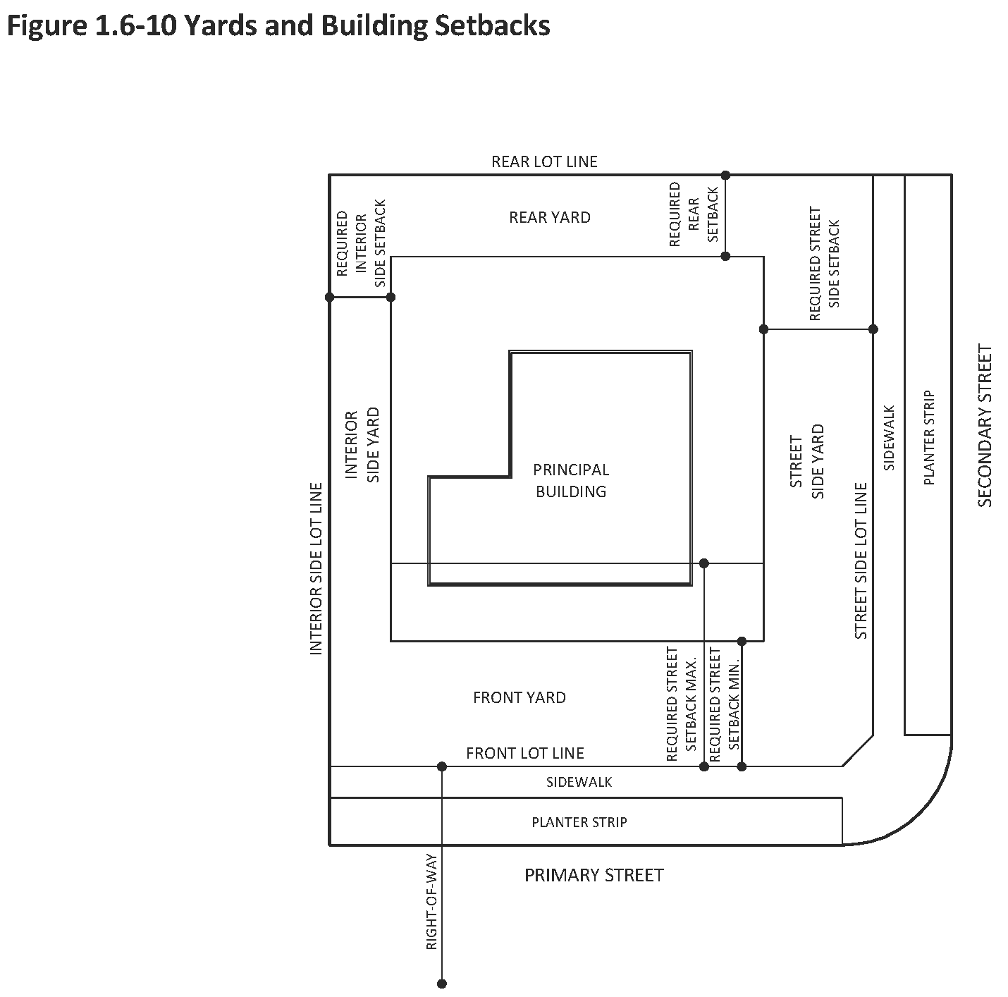
Setback: The distance between a lot line and a building or structure measured perpendicular to the lot line.
Setback Line (Yard Line): A line drawn parallel to a lot line at a distance there from equal to the minimum front, side or rear setback in the case of a front, side or rear yard, respectively.
Shopping Center: A group of commercial establishments planned, constructed and managed as a total entity related in its location, size and type of shops to the trade area that the center serves. Customer and employee parking is provided on-site, with provision for goods delivery separated from customer access.
Sign: Any object, device, display or structure, or part thereof, situated outdoors or indoors, which is used to advertise, identify, display, direct or attract attention to an object, person, institution, organization, business, product, service, even or location by any means, including words, letters, figures, design, symbols, fixtures, colors, illumination or projected images.
Site (Building Site, Development Site): The entire lot or parcel of land, or combination of contiguous lots or parcels of land, on which development occurs.
Stop Work Order: A written order issued by a duly authorized official which orders all construction, site alteration or other development activities to cease and desist immediately.
Storm Sewer: A conduit that collects and transports stormwater runoff.
Story: That portion of a building included between the upper surface of a floor and upper surface of the floor or roof next above.
Street: Any vehicular way, other than an alley, which:
•
Is an existing state, county or municipal roadway;
•
Is shown upon a plat approved pursuant to law;
•
Is approved by other official action; or
•
Is shown on a plat duly filed and recorded in the office of the county recording officer prior to the appointment of a planning board and the grant to such board of the power to review plats; and includes the land between the street lines, whether improved or unimproved.
•
For purposes of this Code, streets are further defined in Section 3.3. Unless the context indicates otherwise, the term street shall also include road, roadway, lane, avenue, boulevard or highway and vice versa.
Street Grade, Established: The elevation of the centerline of the streets as officially established by the City Engineer.
Street Line: The lines that form the boundaries of a right-of-way.
Structural Alteration: Any change in either the supporting members of a building or a structure, such as bearing walls, columns, beams and girders, or in the dimensions or configurations of the roof or exterior walls of a building.
Structure: That which is built or constructed on, above, or below the surface of land or water.
Subdivider: Any person having an interest in land that is the subject of an application for subdivision.
Survey: The process of precisely ascertaining the area, dimensions and location of a piece of land.
Temporary Use: A use established for a fixed period of time with the intent to discontinue such use upon the expiration of the time period.
Tenant: An occupant of land or premises who occupies, uses, and enjoys real property for a fixed time, usually through a lease arrangement with the property owner and with the owner's consent.
Tiny Home: A small single-family dwelling constructed on a permanent towable trailer chassis that is intended for long-term living accommodations and licensed and registered as an RV under Florida Law.
Traffic Control Devices: All street name signs, traffic control signs, pavement markings and traffic signals installed either within the right-of-way or on private property.
Transit Oriented Corridors (TOC): Corridors centered on certain streets identified in the Comprehensive Plan and illustrated in Figure 1.4-1 within which higher development densities are allowed due to existing and planned premium transit services including 30-minute frequencies, circulator routes with 30- or 60-minute frequencies, planned bus rapid transit services and/or connections to intermodal facilities such as bus terminals, train stations and park-and-ride lots. Roadway level-of-service standards are less stringent due to the presence of an extensive bicycle and pedestrian network, public transit service with frequencies generally 30 minutes or less and transit facilities.
Urban Form: The physical layout and design of the city. The essential elements of urban form include blocks, lots and parcels, streets and other transportation corridors, buildings and structures, open spaces and landscaping.
Use: The purpose or activity for which land or buildings are designed, arranged, or intended, or for which land or buildings are occupied or maintained.
Variance: Permission granted by the Zoning Board of Adjustments and Appeals to depart from the literal requirements of this Code.
Vehicle Use Area: Any surface area, whether pervious or impervious, used for the off-street parking, storage or display of vehicles; the off-street movement of vehicles such as driveways and drive aisles; the off-street loading and unloading of goods, materials or passengers; service areas and the like. Driveways serving single-family or two-family dwellings and parking garages of any type shall not be considered vehicle use areas.
Wall:
A.
The vertical exterior surface of a building;
B.
Vertical interior surfaces which divide a building's space into rooms; or
C.
A masonry fence.
Water Supply System: The system for the collection, treatment, storage and distribution of potable water from the source of supply to the consumer.
Yard: An open space that lies between the principal or accessory building or buildings and the nearest lot line. Such yard is unoccupied and unobstructed from the ground upward except as may be specifically provided in this Code.
Yard, Front: A yard extending the full width of a lot between any building and the front lot line.
Yard, Rear: A yard extending across the full width of a lot between any building and the rear lot line, measured perpendicular to the rear lot line.
Yard, Required: A yard between a lot line and the nearest principal building minimum setback line measured perpendicular to the lot line.
Yard, Side: A yard extending from the front yard to the rear yard between any building and the side lot line measured perpendicular to the side lot line.
Yard, Street Side: A yard extending the full width of a lot between any building and the street side lot line.
Zoning District: Land areas in the city specifically delineated on the Official Zoning Map within which regulations and requirements uniformly govern the use of land and buildings.
(Ord. No. 5455, 07-21-14; Ord. No 5522, 07-20-15; Ord. No 5645, 07-17-17; Ord. No. 5794, § 1.2, (Att. A), 11-18-19); Ord. No. 5799, § 1.2, (Att. A), 11-18-19); Ord. No. 5801, § 1.1, (Att. A), 11-18-19; Ord. No. 5900, § 2(Atts. C, D), 10-18-21; Ord. No. 5901, § 2(Att. A), 10-18-21; Ord. No. 6021, § 2(Att. B), 1-16-24; Ord. No. 6124, § 2(Att. A), 12-15-25)