Lakeland City Zoning Code
ARTICLE 4
- GENERAL SITE DEVELOPMENT STANDARDS
4.1 - INTENT AND APPLICABILITY
4.1.1
INTENT
It is the intent of this article to establish minimum standards for the layout and design of development sites to ensure a quality urban form that is compatible with the context. These standards are intended to supplement the development standards set forth in Article 3.
4.1.2
GENERAL APPLICABILITY
a.
Except as otherwise provided in this Code, no building, structure, or land located within the city shall hereafter be developed except in conformity with the standards and requirements of this article. Determinations regarding applicability shall be made by the Director of Community Development.
b.
Nonconforming Sites Lawfully Existing as of the Effective Date of this Code
1.
Except as otherwise specifically provided herein, existing development that does not conform to the standards and requirements of this article shall conform in full or, where site constraints exist, shall conform to the greatest practical extent upon:
(a)
Expansions of principal buildings which exceed 50 percent of the existing square footage of the building, or buildings in the case of a multi-building complex, or
(b)
Building alterations if the aggregate cost exceeds 50 percent of the assessed value of the structure or structures.
2.
Except as otherwise specifically provided herein, where an improvement or alteration is proposed to a portion of an existing nonconforming development site, the standards and requirements of this article shall apply only to that portion of the site.
Example 1: If only a section of a nonconforming fence is replaced, only that section of the fence must meet the standards and requirements for fences.
Example 2: If only a portion of a nonconforming parking lot is repaved, only that portion must meet the standards and requirements for vehicle use areas.
3.
Except as otherwise specifically provided herein, where an improvement or alteration is proposed to an existing development site that eliminates constraints or impediments that had prevented conformity with one or more of the standards and requirements of this article, the standards and requirements thus enabled shall henceforth conform to the greatest practical extent. (Example: If a new conforming access point eliminates the need for a nonconforming access point, the nonconforming access point shall be removed.)
c.
Each section of this article contains further applicability provisions which are specific to that set of standards and requirements.
d.
If any provision of this article is found to be in conflict with the development standards set forth in Article 3, the adopted Design Guidelines for a Historic District, the conditions of an Special Public Interest District, the conditions of a Planned Unit Development or the conditions of a Conditional Use, the more restrictive shall prevail.
(Ord. No. 5455, 07-21-14; Ord. No. 5714, 06-18-18)
4.2 - ACCESS MANAGEMENT
4.2.1
INTENT AND APPLICABILITY
4.2.1.1
Intent
The intent of this section is to provide and manage access to properties while preserving the operating efficiency of the roadway system, to improve the safety of motorists and non-motorists, reduce traffic congestion and delay associated with poor access location and design, to coordinate access management with the Florida Department of Transportation (FDOT) and Polk County, and to support a multi-modal transportation system. This section is also intended to help implement the access management policies of the US Highway 98 South Corridor Access Management Plan.
4.2.1.2
Applicability
This section shall apply to all arterial and collector roadways within the city limits, and to all properties that abut or have access to these roadways.
4.2.2
DEFINITIONS
Access Classification: A system for assigning the appropriate degree of access control to roadways, based upon roadway function, traffic characteristics, and community development objectives.
Access Management: The process of providing and managing access to land development, while preserving the safety and efficiency of travel on the surrounding roadway system.
Arterial Roadways: Routes that provide service that is relatively continuous and of relatively high traffic volume, long average trip length, high operating speed, and high mobility importance. In addition, every United States numbered highway is an arterial road. Arterial roadways are given the highest capacities since they are designed to carry the greatest amount of through-traffic while generally providing a lower amount of access to adjacent land uses.
Central City Transit Supportive Area (CCTSA): Area within which roadway levels-of-service are less stringent due to the presence of a traditional street grid network, extensive bicycle and pedestrian networks and transit services and facilities.
Collector Roadways: Routes which provide service which is of moderately average traffic volume, moderately average trip length, and moderately average operating speed. Such a route also collects and distributes traffic between local roads or arterial roads and serves as a linkage between land access and mobility needs.
Connection: A driveway, street, turnout, or other means of providing for the right of vehicle access to or from transportation facilities. For the purpose of this section, two one-way connections to a property may constitute a single connection.
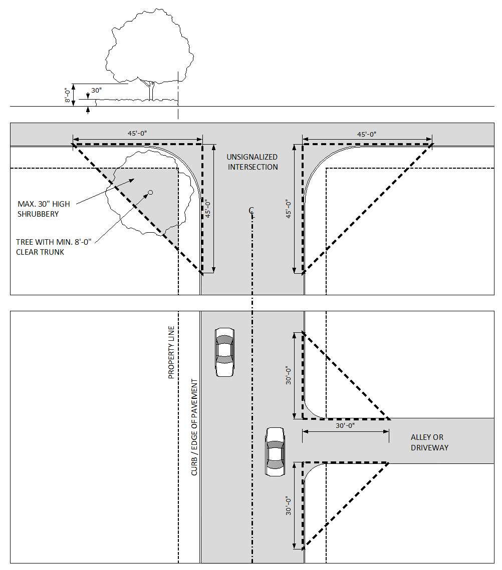
Corner Clearance: The distance from an intersection of a public or private road to the nearest connection along the public roadway. The distance is measured from the closest edge of pavement of the intersecting road to the closest edge of the pavement of the connection. The projected future edge of pavement of the intersecting road should be used, where available. (See Figure 4.2-1.)
Cross Access: An easement or service drive providing vehicular access between two or more contiguous sites.
Directional Median Opening: An opening in a restrictive median that provides for specific traffic movements and physically restricts other movements.
Edge of Pavement: The physical existing edge of a paved road or the future edge. Future edge shall be used for the measurement where the associated capacity improvements are within an adopted five-year capital improvements program or within the Polk Long Range Transportation Plan short-term, financially feasible work program.
Full Median Opening: An opening in a restrictive median designed to allow all turning movements to take place from the public road system and the adjacent connection, and which therefore is intended for signalization.
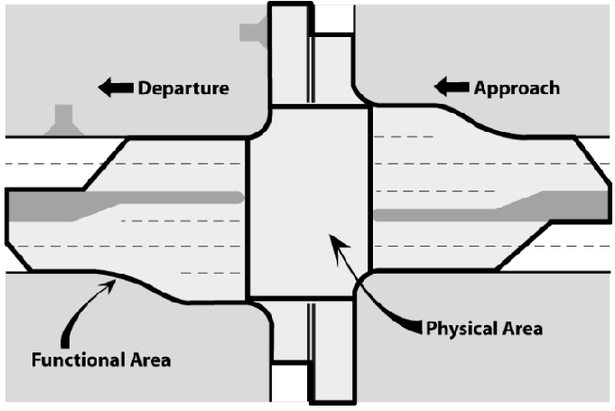
Functional Area (of an intersection): That area beyond the physical intersection of two roadways that comprises decision and maneuver distance, plus any required vehicle storage length, and is protected through corner clearance standards and connection spacing standards.
Functional Classification: A system used to group public roadways into classes according to their purpose in moving vehicles and providing access.
Joint Access (or Shared Access): A driveway connecting two or more contiguous sites to the public street system.
Local Roads: Routes providing service that is of relatively low average traffic volume, short average trip length or minimal through-traffic movements, and high land access for abutting property. Local roads provide the greatest amount of access to adjacent properties and have the lowest vehicle capacities.
Lot Frontage: The linear portion of property that directly abuts a roadway.
Minimum Connection Spacing: The minimum allowable distance between conforming connections, measured from the closest edge of the pavement of the first connection to the closest edge of the pavement of the second connection along the edge of the traveled way.
Minimum Median Opening Spacing: The minimum allowable spacing between openings in a restrictive median to allow for crossing the opposite traffic lanes to access property or for crossing the median to travel in the opposite direction (U-turn). The minimum spacing or distance is measured from centerline to centerline of the openings along the traveled way.
Minimum Signal Spacing: The minimum spacing or distance between adjacent traffic signals on a public roadway measured from centerline to centerline of the signalized intersections along the traveled way.
Multi-Modal Transportation Level of Service: Refers to minimum level of service standards for roadways outlined in the Comprehensive Plan, in the Transportation Element, whereby the standards will vary based upon transit service frequency, bicycle amenities and pedestrian facilities.
M-3 Level of Service District: The geographic area, adopted in the Comprehensive Plan, which provides a multi-modal level of service standard for transportation facilities. The M-3 District is where the local bicycle-accommodated bus system provides service at least every 30 minutes and where there is a substantial sidewalk system present within ¼ mile of those 30-minute routes.
Non-Restrictive Median: A median or painted centerline that does not provide a physical barrier between center traffic turning lanes or traffic lanes traveling in opposite directions. This includes highways with continuous center turn lanes and undivided highways.
Outparcel: A lot identified on a site plan or subdivision plan that is owned by a party other than the primary owner of the parent property, and is intended to be developed separately from the parent property and/or is intended to be developed for a different use (e.g., a non-residential use vs. residential use).
Peak Hour: The highest hour of vehicular traffic volume on the adjacent public street network as measured for the city's level of service standards for transportation. In some instances, the peak hour of the development is evaluated for access management purposes when the project could create an operational or safety problem on the public road network during an off-peak time for adjacent street traffic.
Reasonable Access: The minimum number of connections, direct or indirect, necessary to provide safe ingress and egress to the public road system based on the access management classification (if any), the proposed connection(s) and projected roadway traffic volumes, posted speeds, and the type and intensity of the land use.
Restrictive Median: The portion of a divided highway physically separating vehicular traffic traveling opposite directions. Restrictive medians include physical barriers that restrict movement of traffic across the median such as a concrete barrier, a raised concrete curb and/or island, and a grass or a swaled median.
Service Road: A public or private street or road, auxiliary to a controlled access facility, which has as its purpose the maintenance of local road continuity and provision of access to parcels adjacent to the controlled access facility.
Stub-Out (Stub Street): A portion of a street or cross access drive used as an extension to an abutting property that may be developed in the future.
Throat Length: The distance parallel to the centerline of a driveway to the first on-site location at which a driver can make a right turn or a left turn. On roadways with curb and gutter, the throat length shall be measured from the face of the curb to the end of the physical barrier. On roadways without a curb and gutter, the throat length shall be measured from the edge of the paved shoulder to the end of the physical barrier.
Transit Oriented Corridors (TOC): See definition in Article 1.
4.2.3
CONNECTION LOCATION STANDARDS
4.2.3.1
Connection Spacing
a.
Roadways classified under the State Access Classification System shall, at a minimum, meet FDOT Access Management Standards for the roadway as prescribed by Florida Statutes and Florida Administrative Code, unless waived by the FDOT. Driveway connections within the US Highway 98 South corridor must meet the FDOT adopted spacing criteria as outlined in the US Highway 98 South Corridor Access Management Plan. Any existing substandard connections within the US Highway 98 South corridor shall be removed at the time of re-development where alternate access to the property exists or is feasible.
b.
Roadways operated/maintained by Polk County shall, at a minimum, meet the standards that are outlined in the Polk County Land Development Code, unless waived by the County.
c.
Separation between access connections on all collector and arterial roadways under the jurisdiction of the City of Lakeland shall meet the minimum connection requirements set forth in Table 4.2-1.
Table 4.2-1 Minimum Connection Spacing Standards
d.
Connection spacing shall be measured from the closest edge of the pavement of one connection to the next closest edge of the pavement of the next connection. (See Figure 4.2-1.)
Figure 4.2-1 Corner Clearance and Connection Spacing
e.
The minimum lot frontage for all newly created lots on public arterial or collector roadways shall not be less than the applicable minimum connection spacing standards of this section, unless the property is served by an internal road system.
f.
Existing individual or assembled lots with less than the required frontage may be permitted individual access where the Director of Public Works determines joint or cross access is infeasible.
g.
Adjacent properties under the same ownership shall be considered as a single property for application of connection spacing or for connection permits.
h.
Applications for multiple connections for a single development shall conform to the spacing standards of this section. Multiple connections shall be considered by the Director of Public Works for approval based on the following criteria:
1.
Separation of standard vehicles from heavy trucks or emergency vehicles;
2.
Two one-way connections that in combination serve ingress and egress to the development;
3.
Multiple connections enhance the safety of the abutting roadway and improve the on-site traffic circulation.
i.
To reduce turning movement conflicts, connections on undivided arterial and collector roadways should be aligned with those connections across the roadway. If such alignment is not possible, connections on opposite sides of the undivided roadway shall be designed to meet the standards shown in Table 4.2-2 to ensure safety in traffic and turning movements.
Table 4.2-2 Connection Offsets
4.2.3.2
Connections at Intersections
a.
General
1.
New connections shall not be permitted within the functional area of an intersection, as illustrated in Figure 4.2-2, unless:
(a)
No other reasonable access to the property is available, and
(b)
The connection does not create a potential safety or operational problem as determined by the Director of Public Works, and
(c)
A condition is included in the permit that the applicant shall agree to close the access if and when alternative access becomes available that is more consistent with the corner clearance standards for the abutting roadways.
Figure 4.2-2 Functional and Physical Area of the Intersection
2.
Where no other alternatives exist, construction of an access connection may be allowed along the property line farthest from the functional area of the roadway intersection as a non-conforming access. Property access will be restricted to the roadway with the lower functional classification and shall be closed within six months of when any conforming access becomes available.
b.
Limited Access Interchange Areas
1.
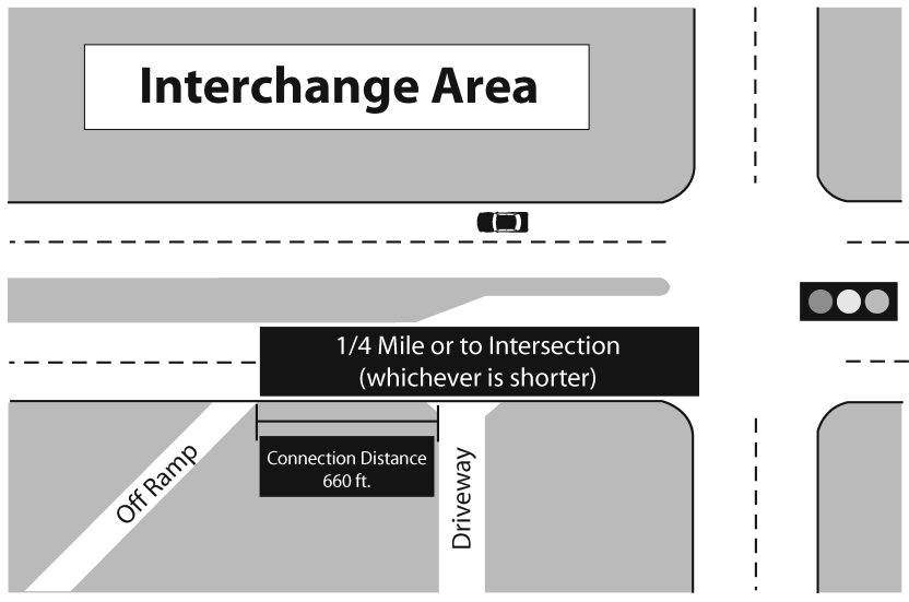
Connections and median openings on arterial and collector roadways located up to 1,320 feet (1/4 mile) from an interchange area or up to the first intersection, whichever distance is less, shall be regulated to protect the safety and operational efficiency of the limited access facility and the interchange area. (See Figure 4.2-3.)
Figure 4.2-3 Interchange Area Connections
2.
The minimum distance to the first connection from the terminus of the exit ramp shall be at least 660 feet (1/8 mile). (See Figure 4.2-3.)
3.
The city may require the use of service roads for direct access to property within the area abutting freeway interchanges. These roads shall be designed to connect to more than one other roadway, wherever feasible, to enhance the overall accessibility of interchange development to the surrounding area.
4.
The minimum distance to the first full median opening shall meet FDOT connection spacing standards.
4.2.3.3
Connection to Lower Classification Roadway
a.
Where property is served by roads of different functional classifications, the City may require development to provide primary access on the road with the lower functional classification in order to minimize access and traffic congestion on the primary roadway.
b.
Access to through lots shall be required on the street with the lower functional classification (See Figure 4.2-4). Access onto the higher functional classification roadway may be approved by the Director of Public Works.
Figure 4.2-4 Double Frontage Lot Access
(Ord. No. 5455, 07-21-14)
4.2.3.4
Service Roads
a.
Service roads and/or shared access roads may be required on roadways operating below acceptable level-of-service standards to help mitigate the adverse impact of access on roadway safety and efficiency for concurrency purposes.
b.
Parcels that abut service roads must provide a primary connection to the service road. Secondary driveways to the public road system shall be prohibited. In instances where a connection cannot be made to a service road (for example, the planned service road has not yet been constructed to the subject property), a temporary connection to the public road system may be granted by the proper permitting authority (City, County or State). This temporary connection must be removed within six months from the time that a service road is constructed to or adjacent to the subject property.
c.
Service roads shall not access any roadway within the functional area of an existing intersection and shall not create a new access point that violates the connection spacing criteria in this section.
d.
All service roads shall be constructed to public street standards.
4.2.3.5
Cross Access and Joint Access
a.
If the connection spacing standards of this section cannot be achieved, then joint use connections and/or cross access easements shall be required.
b.
Applicants for all non-residential developments may be required to use cross access easements and joint use connections to connect adjacent properties in order to reduce curb cuts, to increase the area for parking and landscaping, and to preserve the capacity and safety of the roadway system.
c.
Property owners utilizing joint and/or cross access shall record with the Polk County Clerk of Court:
1.
An easement allowing cross access to and from the adjacent properties;
2.
A joint maintenance agreement defining maintenance responsibility of property owners that share the joint use connection and cross access system.
d.
Property owners that provide for joint and cross access may be granted a temporary connection permit, where necessary, to provide reasonable access until such time as the joint use connection and cross access connections are provided with adjacent properties.
e.
Within six months after construction of a joint use or cross access connection, property owners utilizing such access shall close and remove any existing temporary connections provided for access in the interim.
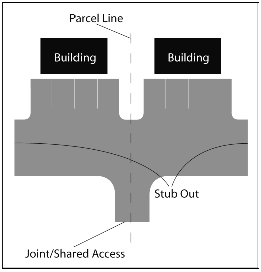
f.
Development may be required to construct a paved stub-out to the property line in anticipation of a future cross access connection. (See Figure 4.2-5.)
Figure 4.2-5 Cross Access Stub-Outs
g.
The design of the cross access corridor or joint connection including driveway apron shall conform to the Engineering Standards. The design shall ensure efficient and safe vehicular operation and pedestrian movements for internal traffic circulation and for traffic mobility on the adjacent roadway.
h.
Cross access easements are not intended to be publicly maintained.
i.
Properties that provide for joint use driveways under this section shall be eligible for a reduction in the number of required off-street parking spaces of up to 15 percent, subject to review and approval of the Director of Community Development.
4.2.3.6
Unified Access
a.
In the interest of promoting unified access and circulation systems, development sites under the same ownership or consolidated for the purposes of development and comprised of more than one building site shall be considered unified parcels for purposes of this section. This shall also apply to phased development plans and master developments such as Planned Unit Developments that contain a mix of land uses. Accordingly, the following requirements shall apply:
1.
The number of connections permitted shall be the minimum number necessary to provide reasonable access to the overall site and not the maximum available for that frontage.
2.
All easements and agreements required under Sub-Section 4.2.3.5 shall be provided.
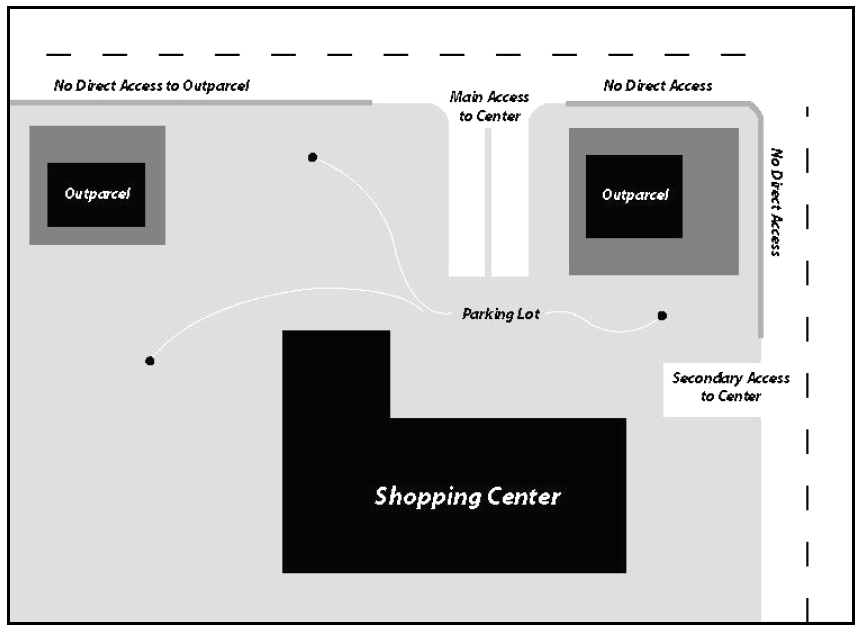
3.
Access to outparcels shall be internalized using the shared circulation system (See Figure 4.2-6). Internal connections (vehicular and non-vehicular) shall be made between different land uses within a master or planned development. The shared internal circulation system shall be designed to avoid excessive movement across parking aisles or queuing across surrounding parking and driving aisles and shall encourage pedestrian and bicyclist safety.
Figure 4.2-6 Internalized Access to Out-Parcels
b.
Where abutting properties are in different ownership and not part of an overall development plan, cooperation among the various owners in development of a unified access and circulation system is encouraged; this includes pedestrian connections. Such coordinated access may qualify for impact fee credits where it in effect creates a reliever road system and provides at least two points of connection to the public road network. Only the building sites under consideration for development approval shall be subject to the requirements of this section. Abutting properties shall not be required to provide unified access and circulation until they are developed or are redeveloped.
c.
Access to an outparcel shall be appropriately designed and marked with pavement markings, signage, and similar appropriate guidance to maximize the efficiency of the internal traffic circulation.
d.
An adequately demarcated pedestrian pathway shall provide a safe route for pedestrians between the outparcel and the primary development.
e.
Outparcels for land uses with connection volumes exceeding 100 peak hour trips may be considered for a single right-in access point. This access shall not be within the functional area of an existing intersection. The Director of Public Works shall determine whether or not the proposed right-in access point is appropriate, based upon the roadway characteristics, relevant traffic data, and the existing and proposed land uses.
4.2.4
CORRIDOR MANAGEMENT FOR "TYPE I" ROADWAYS
4.2.4.1
General
a.
The Comprehensive Plan identifies "Type I" roadways that are of particular significance for freight movement and high capacity connectivity to Lakeland's urban core. Type I roadways include: US 98, County Line Road, SR 548 (George Jenkins Boulevard from Sloan to US 98), SR 563 (Harden Boulevard from Ariana to SR 570/Polk Parkway), State Road 33 (north of Granada Street), West Pipkin Road (west of Old Highway 37 to County Line Road) and SR 546 (Memorial Boulevard between US 92/Wabash Avenue and Interstate 4).
b.
To minimize local traffic and improve corridor efficiency and safety, access to development sites on Type I roadways shall be controlled and cross-access and/or service roads to adjacent properties and improvements to adjacent corridors shall be required.
c.
Access from development sites to County Line Road shall be restricted to the minimum amount necessary to provide safe ingress/egress. Driveway connections shall be coordinated with Polk County as the permitting agency.
4.2.5
CONNECTION DESIGN STANDARDS
4.2.5.1
General
a.
Connections shall not be designed to require vehicles to back out directly onto the abutting roadway except for driveways serving single-family detached or two-family dwellings on individual lots.
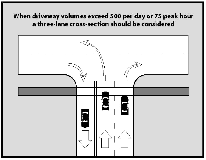
b.
Where the roadway is undivided or where there is no signal control, and when existing or projected connection volumes exceed 75 vehicles in the peak hour or 500 vehicles per day, a 3-lane connection typical section may be required. (See Figure 4.2-7.)
Figure 4.2-7 Large Volume Connection Diagram
c.
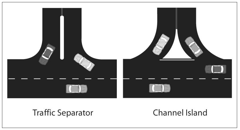
Where there is no traffic signal, raised traffic separators may be required when connection volumes exceed 200 vehicles in the peak hour or 1,000 vehicles per day. Channelization islands shall conform to appropriate City, County or State design standards and shall be reviewed by the Director of Public Works (See Figure 4.2-8). Small "pork chop" raised islands are not an appropriate design alternative.
Figure 4.2-8 Traffic Separators
4.2.5.2
Throat Length
a.
The minimum throat length for unsignalized driveway connections to arterial and collector roadways shall, at a minimum, meet the following standards shown in Table 4.2-3 and Figure 4.2-9. However, deviations may be allowed by the Director of Public Works for all constrained development sites on a Transit Oriented Corridor or within the Central City Transit Supportive Area.
Table 4.2-3 Connection Throat Length - Unsignalized
b.
Connection throat lengths for signalized driveways shall meet the minimum standards shown in Table 4.2-4 (See also Figure 4.2-9). Deviations shall be allowed by the Director of Public Works for all sites within the M-3 Level of Service District.
Table 4.2-4 Connection Throat Length - Signalized
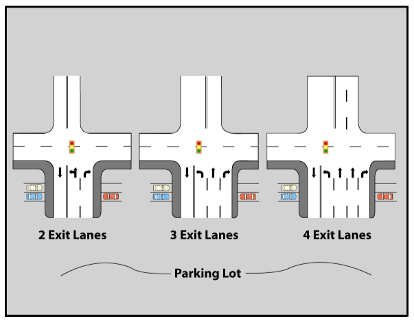
Figure 4.2-9 Throat Length
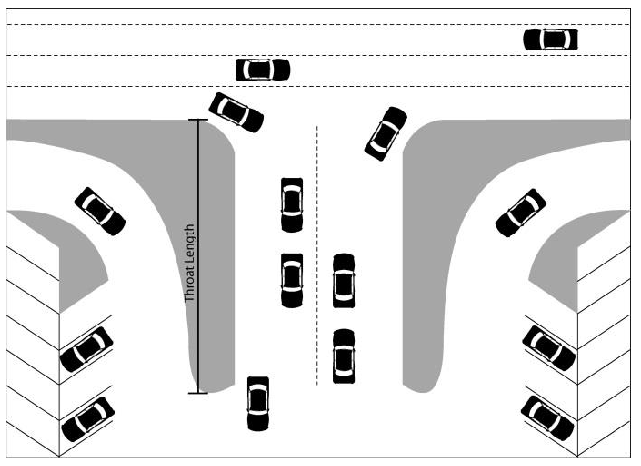
Figure 4.2-10 Number of Exit Lanes
4.2.5.3
Turn Lanes
a.
Exclusive turn lanes for connections required on divided or undivided arterials or collector roadways shall not violate any spacing standards that have been established by City, County or State. Exclusive left turn lanes if the following conditions are met:
1.
Posted roadway speed limit 35 mph or more and 40 or more existing and/or projected left turns in the peak hour.
b.
Exclusive right turn lanes for connections may be required if any of the following conditions are met:
1.
Posted roadway speed limit equal to or greater than 45 mph and 50 or more right turns in the peak hour, or
2.
Posted roadway speed limit less than 45 mph and 80 or more right turns in the peak hour.
c.
The left turn storage lengths and deceleration lengths are required in accordance with the FDOT Plans Preparation Manual.
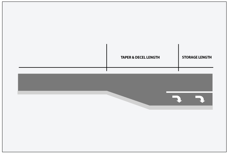
d.
Queue (storage) and taper plus deceleration lane lengths for right turn lanes shall, at a minimum, meet the standards set forth in Table 4.2-5. (See also Figure 4.2-11.)
Table 4.2-5 Right Turn Lane Taper and Storage
Figure 4.2-11 Right Turn Storage and Taper Lanes
e.
Continuous right turn lanes shall be prohibited.
f.
Turn lane warrant requirements may be modified for a development based on factors including, but not limited to, higher peak period traffic volumes, higher operating speeds, localized roadway congestion, pedestrian volume, crash experience (especially rear-end crashes) and facilities that have a larger number of heavy trucks or similar vehicles. Modifications to requirements shall be supported by traffic operations data and approved by the Director of Public Works.
4.2.6
INTERNAL SITE CIRCULATION
a.
For non-residential developments that are projected to generate 300 or more total peak hour trips and that are located along a roadway that has public transit service, the following internal traffic circulation features shall be included in the development plans. These features are in addition to other site plan requirements in the Land Development Regulations.
1.
Internal service roads to serve as internal collectors and which can accommodate transit vehicles shall be defined through the use of pavement markings/striping and if possible, via physical delineation techniques such as curbing of landscaped areas in the parking lot. (See Figure 4.2-12.)
Figure 4.2-12 Service Road
2.
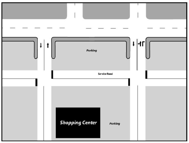
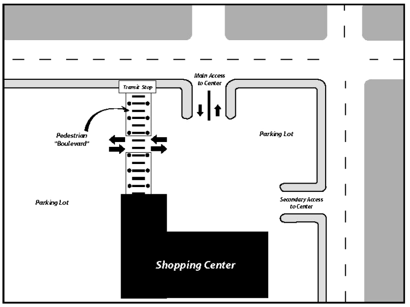
Coordination with the local transit system and Director of Public Works or their designee(s) regarding the feasibility of a transit circulation route that allows for a transit stop within the site and near or along the front of the principal building(s).
3.
Separation of heavy trucks routed to the side or rear of the principal building(s) including use of appropriate directional signage, as necessary.
b.
Non-residential developments that are adjacent to a public sidewalk and projected to generate less than 300 peak hour trips shall provide an adequately marked pedestrian pathway between the building entrance and the adjacent sidewalk. For projects located on corner parcels fronting more than one public street with a sidewalk, the number of dedicated pedestrian pathways shall correspond to the number of project driveways onto the public street system, with a maximum of one such connection per frontage. Additional connections may be required for large retail and employment center projects, including those within Developments of Regional Impact or Planned Unit Developments (See Figure 4.2-13). Marking for the pedestrian pathway may include pavement striping, landscaping, bollards, or similar markings and appropriate directional signage, as needed.
Figure 4.2-13 Pedestrian Crossing within a Site
c.
Residential developments shall provide internal Americans with Disabilities Act (ADA)-compliant pedestrian connectivity within the development with special emphasis on access to on-site recreational amenities, trails, clubhouses and open spaces.
d.
The internal road networks for new or redevelopment plans shall include, at minimum, a mainline internal roadway that maximizes on-site connectivity and shall also include, wherever possible, a system of internal grid or modified grid connections throughout the plan. This provision shall not be interpreted to prevent all use of the cul-de-sac but shall promote internal connections for vehicular traffic to the degree such is reasonable and possible. Where cul-de-sacs or other street terminations are used, sidewalk extensions or other such pathway connections to adjacent streets may be required to maintain or enhance overall network connectivity.
e.
Developments with drive-through facilities shall have adequate space to store the projected peak demand of vehicles off the public rights-of-way and off public and private streets. The minimum vehicle queue storage lengths for developments with drive-through facilities that have direct access to arterial or collector roadways shall, at a minimum, meet the standards set forth in Table 4.2-6.
Table 4.2-6 Drive-Through Queues
Note: The length of multiple queue lanes, such as at a bank, may be added together to meet the total required queue length.
(Ord. No. 5455, 07-21-14)
4.2.7
DEVIATION FROM CONNECTION STANDARDS
a.
Meeting the standards of this section may not always be possible. Therefore, the following process is available to evaluate requested deviations from the standards of this section. In all cases, however, safety for the driving public and pedestrians shall be the primary consideration.
b.
The Director of Public Works may make a determination to modify or waive the requirements of Sub-Section 4.2.3.5 (Cross Access and Joint Access) where the characteristics of abutting parcels would make adherence to the standards infeasible. This determination shall be made in consultation with the Director of Community Development.
c.
Deviations of up to 10 percent of the connection standards in this section or deviations of up to 100 feet, whichever is less, are considered Minor Deviations. The Director of Public Works may grant such deviations based on roadway characteristics, land use, traffic operations, and safety.
d.
Except where otherwise provided for in this section for determination by the Director of Public Works, other requests for deviations are considered Major Deviations and shall be considered by the Zoning Board of Adjustment and Appeals (ZBAA) in accordance with the standards for variances contained in Article 12.
e.
In addition to the general requirements for a variance contained in Article 12, the applicant for a variance (major deviation) from the terms of this section shall provide adequate data and analysis to the Director of Public Works to demonstrate how the proposed alternate access management and/or site circulation plan is equal to or better than the relevant required access management and internal circulation provisions of this section. A staff report and recommendation from the Director of Public Works, prepared in consultation with the Director of Community Development, shall accompany the major deviation request to the ZBAA. Applicants for major deviations from access spacing standards shall submit an access management plan to the Director of Public Works as follows:
1.
Encompasses a study area that includes the length of the property frontage on all abutting roadways, plus the distance established by access spacing standards on either side of the property lines, and the corresponding area on the opposite side of undivided roadways or divided roadways where a median opening is present.
2.
Addresses existing and future access for study area properties.
3.
Evaluates impacts of the proposed plan versus impacts of adherence to adopted standards.
4.
Includes all improvements and recommendations necessary to implement the proposed plan.
4.3 - ACCESSORY STRUCTURES
4.3.1
GENERAL
a.
Certain accessory structures are permitted in addition to principal structures in accordance with all standards of the context sub-district in which they are located and the procedures and standards of this section.
b.
Accessory structures shall be clearly incidental and subordinate to the principal structure and located in a district that allows the principal use.
c.
No accessory structure shall be constructed prior to the construction of a principal structure.
d.
Accessory structures shall be located on the same lot or parcel as the principal structure.
e.
Vehicles and trailers including overseas shipping containers are prohibited as storage buildings except as provided in Sub-Section 2.6.5 (Temporary Uses Listed and Defined) and Sub-Section 5.17.3.3 (Construction and Storage Trailers Permitted and Regulated).
f.
Shipping containers may be used as accessory structures for certain commercial uses, as specified in Sub-Section 5.25.1.3 (Shipping Containers as Accessory Structures for Certain Commercial Uses).
g.
For lots or parcels zoned for either single-family or two-family residential uses, the issuance of a separate electrical meter for accessory structures shall be prohibited. If electrical power is to be provided, it shall only be fed from the electrical service/main panel located on the principal dwelling unit on the same lot or parcel to a sub-panel on the accessory structure.
h.
Accessory Structures to Office, Commercial, Industrial and Multi-Family Residential Uses (All Other Accessory Structures): Accessory structures with more than 1,000 sq. ft. of floor area shall be subject to the setback and height requirements for principal buildings in the zoning context sub-district in which they are located. Where applicable, such structures shall be subject to architectural materials, ground floor transparency and facade variation requirements for principal structures specified by Sub-Sections 3.4.7.3, 3.4.7.4 and 3.4.7.5 of the Land Development Code.
i.
Accessory Structures Exempt from Permitting Requirements: Structures exempt from the Florida Building Code, such as portable carports, patio covers, chickee huts and recreational/play equipment, which do not require a building permit shall be subject to the same setback and building height requirements as permanent accessory structures.
(Ord. No. 5455, 07-21-14; Ord. No. 5898, § 2(Att. A), 10-18-21; Ord. No 6051, § 2(Att. A), 9-16-24)
4.3.2
ACCESSORY DWELLING UNITS
4.3.2.1
General Standards
a.
Subject to the following standards and procedures, accessory dwelling units shall be permitted in urban contexts where any legally-conforming single-family detached dwelling unit is the principal structure on, or under construction on, the same lot or parcel. Accessory dwelling units shall also be permitted where specifically allowed as part of a residential Planned Unit Development or Special Public Interest District.
b.
Only one accessory dwelling unit shall be permitted per lot or parcel and the lot or parcel shall have a minimum area of 5,000 square feet.
c.
Accessory dwelling units may be constructed over a garage in accordance with Table 4.3-1.
d.
Either the principal dwelling unit or the accessory dwelling unit shall be the legal residence of the property owner.
e.
Accessory dwelling units shall have a separate street address from the principal dwelling.
f.
Electric service to accessory dwelling units shall be by a feed from the principal dwelling. Accessory dwelling units shall not have a separate electric meter from the principal dwelling.
g.
Accessory dwelling units shall not be sold separately from the principal dwelling.
h.
Where a lot or parcel is non-conforming by virtue of containing two legally established dwelling units in a single-family zoning district, one of the two units may be converted to an accessory dwelling unit, provided that it meets all of the requirements of this section.
(Ord. No. 5455, 07-21-14)
4.3.2.2
Design Standards
a.
Accessory dwelling units shall be detached from the principal dwelling and shall be located in rear yards or interior side yards in accordance with the following standards:
Table 4.3-1 Accessory Dwelling Unit Standards
b.
Vehicle access to the accessory dwelling unit shall be from an alley, from the side street of a corner lot, or from a shared driveway connection to the street.
c.
A minimum of one off-street parking space shall be provided for the accessory dwelling unit in addition to off-street spaces required for the principal dwelling. Tandem parking in driveways is permitted.
d.
The design and exterior treatment of accessory dwelling units shall be architecturally compatible with the principal dwelling as determined by the Planning and Zoning Board or by the Historic Preservation Board, if located in a designated historic district.
e.
The sides of accessory dwelling units facing abutting residential property shall be designed to protect the privacy of neighbors. This may include no windows or privacy windows on the abutting side and may include fencing and/or landscaping to provide screening.
4.3.2.3
Procedure for Establishment
a.
For proposed accessory dwelling units not in designated historic districts, the applicant shall submit to the Planning and Zoning Board a site development plan showing site layout with respect to the principal dwelling, vehicle access and other appropriate site features, and elevations or other architectural drawings showing the proposed exterior treatment. The Board shall make determinations regarding d.1 through 5 below.
b.
For proposed accessory dwelling units in designated historic districts, the applicant shall submit to the Planning and Zoning Board a site development plan showing site layout with respect to the principal dwelling, vehicle access and other appropriate site features. The Planning and Zoning Board shall make determinations regarding d.3, 4 and 5 below. If approved by the Planning and Zoning Board, the applicant shall then apply to the Historic Preservation Board for a Certificate of Review/Appropriateness. The Historic Preservation Board shall make determinations regarding the criteria outlined in d.1 and 2 below.
c.
The Planning and Zoning Board shall notify the owners of record of properties abutting or across the street from the lot or parcel on which the accessory dwelling unit is proposed and shall conduct a public hearing on the matter at a regular meeting.
d.
In making its determination, the Board (or Boards) shall find that:
1.
The exterior design is architecturally compatible with the principal dwelling with respect to building form, height, materials, colors and landscaping. If located in a historic district, the Historic Preservation Board shall make this determination with specific reference to the design guidelines for the historic district in which the accessory dwelling unit is to be located.
2.
The exterior design is in harmony with and maintains the scale of the neighborhood. If located in a historic district, the Historic Preservation Board shall make this determination with specific reference to the design guidelines for the historic district in which the accessory dwelling unit is to be located.
3.
The accessory unit does not result in excessive noise, traffic, or parking congestion.
4.
There is adequate open space for both the principal and accessory units and, to the extent feasible, significant trees are retained.
5.
The accessory unit does not significantly impact the privacy, light, air, or parking of adjacent properties.
e.
The Planning and Zoning Board may impose any conditions or limitations upon the establishment, location, construction, maintenance or operation of the accessory dwelling unit which in its judgment may reasonably be necessary to prevent the use from being detrimental to other permitted land uses and for the protection of the public interest and welfare. Conditions and requirements stated as part of the approval shall be a continuing obligation of holders of approval.
Figure 4.3-1 Accessory Dwelling Unit/General Accessory Structure

4.3.3
SCREEN ENCLOSURES
Screen enclosures, including unroofed screen rooms and swimming pool cages, shall be located only in rear yards or interior side yards in accordance with Table 4.3-2. For context sub-districts not listed in the table, screen enclosures shall be permitted in rear yards or interior side yards in accordance with the principal building envelope standards of the context sub-district.
Table 4.3-2 Screen Enclosure Standards
Figure 4.3-2 Screen Enclosure
4.3.4
SWIMMING POOLS
Swimming pools including above-ground and in-ground swimming pools, spas and hot tubs shall be located only in rear yards or interior side yards in accordance with Table 4.3-3. In-ground swimming pools, spas and hot tubs may also be located in front yards or street side yards in accordance with the principal building envelope standards. For context sub-districts not listed in the table, above-ground and in-ground swimming pools, spas and hot tubs shall be permitted in rear yards or interior side yards in accordance with the principal building envelope standards of the context sub-district.
Figure 4.3-3 Swimming Pool
Table 4.3-3 Swimming Pool Standards
4.3.5
GENERAL ACCESSORY STRUCTURES
All other accessory structures not specifically listed in this section shall be classified as general accessory structures and shall be located in accordance with the Table 4.3-4. (See Section 6.4 for regulations governing docks, boat houses and other water access structures.)
4.3.6
TENTS
Tents may be erected as temporary accessory structures subject to the following:
4.3.6.1
General Standards Applicable to All Tents
a.
The use of tents shall be consistent with the uses permitted in the underlying zoning district.
b.
Tents shall be located in accordance with the minimum setback requirements for principal buildings specified by the applicable context sub-district.
c.
Tents shall not block emergency vehicle lanes, handicap parking spaces, driveways or travel aisles within vehicle use areas.
d.
In the event of a severe weather forecast, such as a tropical storm or hurricane, tents shall be taken down at least 24 hours in advance.
e.
Tents shall not be used for storage purposes.
f.
No signage or advertising shall be placed on the tent.
g.
Structures intended for use for a period of 180 days or longer shall be considered permanent structures and may only be installed in accordance with an approved building permit and all current fire, building and zoning codes.
4.3.6.2
Tents as Temporary Accessory Structures for Temporary Uses and Short-Term Events of Limited Duration (Transient Merchants and Special Events)
a.
Unless otherwise provided for in this Sub-section, tents may be erected as accessory structures for temporary uses as defined by this code and for short-term special events for a period not to exceed 15 consecutive calendar days of total duration.
b.
At the end of the 15-day period or upon the conclusion of the event, whichever occurs sooner, all tents must be removed from the site for a minimum of 60 days prior to erecting another tent.
4.3.6.3
Tents as Temporary Accessory Structures for Permitted Principal Uses
a.
Tents may be erected as temporary accessory structures for a permitted principal uses as allowed by the underlying zoning district or through a conditional use.
b.
Tents may be used as temporary accessory structures for more than 90 total cumulative days within any 12-month time period. This period may be extended at the discretion of the Director of Community Development provided that such an extension does not have negative impacts on the subject or neighboring properties, as determined by the criteria below, and the tent is in compliance with all other standards set forth herein.
c.
Criteria for approval of an extension shall include, but not be limited to:
1.
Times of activity;
2.
Compatibility with adjacent uses; and
3.
Any environmental impacts generated by the use such as motor vehicle traffic, noise, glare, vibrations, and any odors, air pollution or emissions.
4.3.6.4
Permit Procedures
a.
All tents greater than 120 square feet in area shall require an approved building permit issued by the Building Inspection Division. Once installed, tents may not be relocated unless a new permit is issued.
b.
All electrical, mechanical or plumbing work performed shall be done in accordance with an approved permit issued by the Building Inspection Division.
c.
Tents greater than 900 square feet in area are subject to the Florida Fire Prevention Code and shall require a separate assembly permit issued by the Lakeland Fire Department.
d.
Following installation, tents shall be maintained in good condition, free from excessive wear and tear, for the duration of the permit.
4.3.6.5
Required Documentation for Tent Permits
a.
A site plan which shows the tent location and the distance from property lines and structures;
b.
Information specifying the means of egress and occupant load.
4.3.7
ABOVE-GROUND TANKS
Above-ground tanks used for the storage of combustible liquids are permitted as an accessory use within all zoning districts, subject to the requirements specified below. Above-ground storage tanks as a principal use shall only be permitted within I-2 and I-3 zoning districts. In the event that any of these requirements conflict with the Florida Building Code or the Florida Fire Prevention Code, the more restrictive requirement shall apply.
4.3.7.1
Above-ground Tanks Accessory to Residential Uses
a.
For single-family and two-family residential uses, above-ground tanks shall be limited to a maximum capacity, whether a single take or in aggregate, of no more than five hundred fifty (550) gallons.
b.
For multi-family dwellings, mobile home and recreational vehicle parks, above-ground tanks shall comply with the capacities stipulated in the Florida Building Code and the Florida Fire Prevention Code.
c.
Above-ground tanks shall be placed in rear or interior side yards only, with a minimum setback of five (5) feet from any property line.
4.3.7.2
Above-ground Tanks Accessory to Non-Residential Uses
a.
Above-ground tanks shall comply with the capacities stipulated in the Florida Building Code and the Florida Fire Prevention Code.
b.
Above-ground tanks shall only be located in interior side and rear yards which do not abut a residential zoning district with a minimum setback of ten (10) feet from any property line.
c.
When visible from any public or private street, above-ground tanks shall be completely screened from view through the use of a view blockage fence or wall.
Table 4.3-4 General Accessory Structure Standards
(Ord. No 6051, § 2(Att. A), 9-16-24)
4.3.8
CLOTHING COLLECTION AND DONATION BINS
4.3.8.1
Definitions
Clothing Collection/Donation Bin: A storage container in which clothing, shoes, blankets, linens or other household and apparel items are collected and donated for resale, reuse or recycling.
4.3.8.2
General Provisions
a.
Clothing collection/donation bins shall only be permitted within O-3, C-2, C-4, C-5, and I-1 zoning districts or in conjunction with an approved PUD or CUP in which such zoning districts are permitted.
b.
Clothing collection bins shall not exceed the following dimensions:
1.
Maximum Height: Seven (7) feet
2.
Maximum Width: Six (6) feet
3.
Maximum Depth: Six (6) feet
4.3.8.3
Location Standards
a.
No more than two (2) clothing/donation bins shall be permitted per premises.
b.
Clothing collection/donation bins shall not be located in required front or street side yards, within 5 feet of any parcel boundaries or 10 feet of any overhead utilities.
c.
The placement of clothing collection/donation bins shall not interfere with the operation of any access drives, maneuvering aisles or impede access to any required off-street parking spaces or pedestrian facilities.
d.
Clothing collection/donation bins shall not be located within any easements or block access to any designated fire lanes or building entrances/exits.
4.3.8.4
Performance Standards
a.
Clothing collection/donation bins shall be maintained in good condition at all times with no visible structural damage, corrosion or graffiti.
b.
The name, address, website and phone number of the operator of the bins shall be displayed on the front side of the bin.
c.
Clothing collection/donation bins shall be designed such that only the owner or operator of the bin can remove and retrieve contents.
d.
Donation items shall be collected by the owner/operator of the bin on a regular basis to ensure that items do not accumulate outside of the bin.
e.
Donation items shall not be permitted to be deposited or stored outside of the donation bin.
(Ord. No. 5455, 07-21-14; Ord. No. 5578, 05-16-16; Ord. No. 5722, 06-18-18; Ord. No. 5898, Att. B, 10-18-21)
4.4 - FENCES AND WALLS
4.4.1
PERMIT REQUIRED
No fence or wall, or any portion of a fence or wall, shall be erected on any lot or parcel within the City without first obtaining a fence permit or building permit, unless otherwise stated herein.
a.
Applications for a fence permit shall include a site plan which depicts the dimensions of the proposed fence or wall, the location of the fence or wall in relation to property lines, and any other information deemed necessary by the Community and Economic Development Department.
b.
Building permit applications for a wall shall include both a site plan and construction drawings signed and sealed by a Professional Architect or Engineer licensed to practice in the State of Florida.
c.
A permit shall not be required for general maintenance and repair of existing fences, provided that no more than 25 percent of the total linear footage of a fence is replaced within a 12-month period and any replacement fencing is of the same height, style and materials as the existing fencing.
d.
At the discretion of the Director of Community and Economic Development, the requirement for a permit to repair or replace fencing in excess of 25 percent may be waived when damage is sustained due to a natural disaster which results in widespread damage throughout the City for a time period not to exceed six months from the date of the disaster.
(Ord. No 6052, § 2(Att. A), 9-16-24)
4.4.2
GENERAL
a.
For purposes of this section, fences and walls shall mean free-standing fences and walls that are not structural elements of a building.
b.
Fences and walls, whether required or optional, shall be constructed of the following types of materials:
1.
Chain link or ornamental wire manufactured for fences with uniformly spaced metal or wood posts; or
2.
Ornamental wrought iron, aluminum, or plastics manufactured for fences; or
3.
Treated or finished wood or wood units of uniform size; or
4.
Brick, stone, split block, stucco on concrete block or other finished precast masonry units of uniform size; or
5.
Finished poured concrete.
c.
The Director of Community and Economic Development may approve other fence or wall materials on a particular site if he finds that the proposed materials would provide equal or greater protection, would result in equivalent impacts on the general appearance of near or adjacent property, and do not violate the intent of this code.
d.
Barbed Wire, Razor Wire, and Electric Fencing:
1.
Residential Zoning Districts: The use of barbed wire, razor wire and electrified fencing shall be prohibited in all residential zoning districts or the portion of any PUDs zoned for residential uses.
2.
Office (O-1, O-2, O-3), Commercial (C-1, C-2, C-3, C-4, C-5, C-6, C-7), and Light Industrial (I-1) Zoning Districts: Electrified fencing may be used for security purposes within all office, commercial, and light industrial zoning districts or the portion of any PUDs zoned for office, commercial and/or I-1 uses. Use of such fencing shall be limited to interior side and rear yards. The use of barbed wire fencing in such zoning districts may be considered through the variance process, subject to the same locational standards as electrified fencing, when the applicant can demonstrate a significant security need such that denial of use of the fencing material would result in an unnecessary hardship. In applying the variance criteria, the Zoning Board of Adjustment and Appeals shall consider the visual impact of such fencing when viewed from any adjacent streets or rights of way and may require landscaping or other mitigation measures as conditions of approval. The use of razor wire fencing in all office, commercial and light industrial zoning districts, or the portion of any PUDs zoned for office, commercial and/or I-1 uses, shall be prohibited.
3.
Medium (I-2) and Heavy (I-3) Industrial Zoning Districts: Barbed wire, razor wire or electrified fence may be used for security purposes within I-2 and I-3 zoning districts or the portion of any PUDs zoned for medium and/or heavy industrial uses. The use of razor wire fencing, however, shall be limited to interior side and rear yards.
4.
Utility and Essential Services Facilities: Notwithstanding the above provisions, the use of barbed wire or electrified fencing may be used for security purposes for Utility and Essential Services Facilities (All Levels) within any zoning district.
e.
Fences and walls, whether required or optional, may be erected adjacent to or on property lines, subject to the standards herein and subject to regulations relating to visibility triangles.
f.
Where a lot or parcel abuts a use or district that allows a higher fence or wall, a fence or wall may be erected at the greater height along the common property boundary without requiring a variance. For example, a residential use having a maximum fence height of six feet that abuts a commercial use having a maximum fence height of eight feet may erect an eight-foot fence along the common property boundary.
g.
In the case of through-lots, the Director of Community and Economic Development shall have the discretion to apply rear yard standards to one of the two frontages upon a determination that a particular yard functions as a rear yard.
h.
The measurement of maximum fence or wall height shall not include decorative caps on wall columns or fence posts, or decorative arches above gates.
i.
Fences and walls, whether required or optional, shall be maintained in sound condition.
j.
No fence or wall shall be erected in such a manner as to interfere with drainage.
k.
Where adjacent to any street or improved alley, fences with a finished or unfinished side (i.e., wood stockade, board-on-board) shall be installed such that the finished side of the fence faces outward toward the adjacent street or alley.
l.
The attachment of fabric, shade cloth, slats or other material to any chain link or similar open fence shall be prohibited on all perimeter and view blockage fencing. This standard shall not apply to athletic fields and courts, fencing interior to a project site, or construction sites with an active permit.
(Ord. No 6052, § 2(Att. A), 9-16-24)
4.4.3
REQUIRED BUFFER FENCES AND WALLS
a.
Fences or walls required as part of a required buffer shall have at least 90 percent opacity and are referred to herein as view blockage fences or walls.
b.
Openings shall be permitted in required buffer fences or walls in side and rear yards for the purpose of secondary vehicular access to an alley or secondary street. Each such opening shall not exceed 20 feet in width and there shall be no more than one such opening for each one 100 linear feet of side or rear yard dimension. All other fence or wall openings in side and rear yards shall contain a gate constructed of materials permitted herein and shall have at least 90 opacity.
(Ord. No 6052, § 2(Att. A), 9-16-24)
4.4.4
OPTIONAL FENCES AND WALLS
a.
Single-Family, Two-Family and Multi-Family Residential Zoning Districts
Standards for the location and height of optional fences and walls in single-family, two-family and multi-family residential zoning districts shall be as set forth in Figure 4.4-1.
Figure 4.4-1 Residential Fences and Walls

b.
Mobile Home and Recreational Vehicle Parks and Non-Residential Zoning Districts
1.
Optional fences or walls erected in areas zoned for mobile home and recreational vehicle parks, office/commercial uses or in the I-1 zoning district shall not exceed eight feet in height, except that in required front yards, the portion of such fences or walls that extends above four feet in height shall be made of pickets, wrought iron, chain link or similar open construction having no greater than 50 percent view blockage when viewed from an angle perpendicular to the face of the fence or wall.
2.
Optional fences or walls erected in the I-2 or I-3 zoning districts shall not exceed eight feet in height.
c.
Security Fencing on Vacant Property
Security fencing may be erected on any vacant, undeveloped properties zoned for residential or non-residential uses. Such fencing shall not exceed six feet in height and shall be made of chain link, metal picket or other similar style of fencing which has no greater than 50 percent view blockage when viewed from an angle perpendicular to the face of the fence. Security fencing may be erected on or within all property boundary lines, including front and street-side property lines, subject to the sight visibility triangle requirements of Section 4.12 and a three-foot setback from improved alleys. Security fencing may remain on the property until developed, at which time security fencing shall be removed and any new fencing shall adhere to the standards for residential, mobile home and recreational vehicle parks, or non-residential zoning districts, whichever is applicable.
(Ord. No 6052, § 2(Atts. A, B), 9-16-24; Ord. No. 6126, § 2(Att. A), 12-15-25)
4.4.5
EXISTING FENCES AND WALLS
Existing fences and walls erected prior to the effective date of these standards (whether lawfully or otherwise) and which do not conform to the standards of this section shall be subject to the following:
a.
Existing non-conforming fences and walls may be maintained and repaired, provided that maintenance and repair does not increase or intensify the extent or size of the nonconformity or exceed the limits specified in 4.4.5.a and 4.4.5.c. below.
b.
Where 50 percent or more of the linear footage of a non-conforming fence or wall within a single yard (front, street side, interior side, or rear) is to be replaced, the entire linear footage of the fence or wall within that yard shall be required to conform with the requirements of this section.
c.
Where 50 percent or more of the total linear footage of a non-conforming fence or wall is to be replaced within a 12-month period, the entire fence or wall shall be required to conform with the requirements of this section.
(Ord. No 6052, § 2(Att. A), 9-16-24)
Editor's note— Ord. No. 6052, § 2(Att. A), adopted Sept. 16, 2024, amended § 4.4 in its entirety, in effect repealing and reenacting said § 4.4 to read as set out herein. The former § 4.4 pertained to similar subject matter and derived from Ord. No. 5455, adopted July 21, 2014; Ord. No. 5694, adopted Feb. 19, 1918; Ord. No. 5795, § 1.2(Att. A), adopted Nov. 18, 2019.
4.5 - LANDSCAPING, TREES AND BUFFERING
4.5.1
INTENT AND APPLICABILITY
4.5.1.1
INTENT
It is the intent of this article to protect the public health, safety and welfare and to improve the quality and appearance of the built environment by preserving natural vegetation and trees where possible and by incorporating new landscaping and trees into development; to establish minimum standards for landscaped areas; to establish and maintain street trees within rights-of-way; to establish minimum standards for buffer screens between incompatible land uses; to establish minimum standards for water efficient irrigation systems; to prevent excessive surface water runoff and maintain permeable land areas; to encourage the use of native plants and discourage the use of exotic or nuisance plants in landscape design.
It is further the intent of this article to prevent the destruction of existing tree canopy where possible and to mitigate for the loss of tree canopy when its destruction cannot be avoided. Trees are a valuable public resource. A healthy tree canopy prevents soil erosion; provides windbreaks; beautifies the urban environment; increases the value of land; reduces noise, dust, and glare; controls air pollution through the production of oxygen and the reduction of carbon dioxide; provides wildlife habitat and moderates extreme temperatures.
4.5.1.2
APPLICABILITY
Except as otherwise provided herein, the requirements of this article shall apply as follows:
a.
Upon the construction of any principal structure, the entire site shall conform to the requirements of this article, except as follows:
1.
In the case of single-family and two-family structures, only the minimum tree density requirements of Sub-Section 4.5.4.2 shall apply.
2.
In the case of phased development, the requirements of this article shall apply to phases in accordance with the approved landscape plan.
3.
In the case of multiple structure complexes, the requirements of this article shall apply only to that portion of the site containing the new structure unless Sub-Sections 4.5.1.2.b or c applies.
b.
When any principal non-residential structure or complex of structures is enlarged by 50 percent or more in gross floor area, the entire site shall conform to the requirements of this article.
c.
When alterations to any principal non-residential or multi-family structure or complex of structures exceed 50 percent of the assessed value, the entire site shall conform to the requirements of this article.
d.
When any vehicle use area is constructed or established or when any existing vehicle use area is enlarged by 50 percent or more in area, the entire vehicle use area shall conform to the requirements of Sub-Section 4.5.7. When any existing vehicle use area is enlarged by less than 50 percent in area, the requirements of Sub-Section 4.5.7 shall apply only to the enlarged area unless Sub-Sections 4.5.1.2.b or c applies.
e.
Proposed subdivisions requiring landscaping within rights-of-way and/or common areas in accordance with Article 9 Subdivision Regulations.
f.
The requirements of this article shall not apply to those portions of an airport or heliport determined by the Federal Aviation Administration or the Florida Department of Transportation to be required for the ground or aerial maneuvering of aircraft, or land owned or operated by a public aviation authority in connection with the development, operation or maintenance of airports and aviation areas or facilities used for runways, taxiways, aprons, runway protection zones and approaches, air traffic control towers, and aircraft navigational aids.
4.5.2
ADMINISTRATIVE MODIFICATIONS
The Director of Parks and Recreation shall be authorized to modify the requirements of this article pertaining to street trees and to the preservation of regulated trees as provided herein. At the recommendation of the Director of Parks and Recreation, the Director of Community Development may modify other requirements of this article under the following circumstances. Such modifications shall be noted on the applicable permit or site plan. Applicants are not entitled to such modifications which are at the discretion of the Director of Community Development or Director of Parks and Recreation.
4.5.2.1
Modification for Physical Limitations
If the Director of Community Development determines that it is impossible or impractical to meet the requirements of this article due to physical limitations imposed by the location and arrangement of existing buildings, existing site dimensions or other existing physical constraints, he may allow part or all of the required landscaping to be provided elsewhere on the same site, or waive part of such requirements altogether, provided that the requirements are implemented to the fullest extent possible given the physical limitations.
4.5.2.2
Modification for Solar Access
If the Director of Community Development determines that required trees or landscaping will materially impede the functioning of any solar energy system or solar power generating facility, he may allow part or all of the required landscaping to be provided elsewhere on the same site, or modify the landscape requirements, provided that the modification is the minimum necessary to allow the solar energy system or solar power generating facility to operate properly.
4.5.3
DEFINITIONS
Unless the context clearly indicates a different meaning, for the purposes of this Article, the following words and terms shall be defined as follows:
Beautification Board: A board appointed by the City Commission empowered to consider and study beautification in the City of Lakeland.
Canopy: The area shaded by the crown spread of a tree.
Destroy: The cutting, removing or loss of 30 percent or more of the crown, trunk or root system of a tree or plant as the result of natural causes, accident, willful action or neglect, including but not limited to, the failure to irrigate, or any action which results in the loss of aesthetic or physiological viability of the plant or tree or which causes the plant or tree to fall or be in danger of falling.
Diameter at Breast Height (DBH): The standard measure of the diameter of a single-stemmed tree at four and one-half feet above grade. In the case of multi-stemmed trees, the DBH shall be equal to the sum of the diameters of the individual stems.
Drip-Line: An imaginary, vertical line that extends downward from the outermost tips of the tree branches to the ground.
Florida-Friendly Landscaping: Science-based, low-impact, sustainable, environmentally friendly landscaping practices that conserve water, reduce pollutant loading to Florida waters, and protect Florida's natural resources, in accordance with the University of Florida IFAS Extension and FDEP's "Landscape Irrigation and Florida-Friendly Landscape Design Standards," as amended.
Groundcover: Low-growing plants that cover the ground.
Hedge: A dense row of shrubs intended to provide a visual barrier. Specific types of hedges are defined as follows:
Type A Hedge:
A hedge with a minimum height of 18 inches and 50 percent view blockage at the time of planting, with the capability of attaining a minimum height of four feet and 90 percent view blockage within two years.
Type B Hedge:
A hedge with a minimum height of 30 inches and 50 percent view blockage at the time of planting, with the capability of attaining a height of six feet and 90 percent view blockage within three years.
Natural Vegetation: A grouping of native or naturalized plants occurring in a natural state, relatively undisturbed by human activity and growing under natural hydrologic and soil conditions requiring little or no maintenance, irrigation or fertilization.
Regulated Trees: Living pine trees that are 12 inches DBH or greater and living trees of all other species listed in Table 4.5-6 (Qualified Trees) that are six inches DBH or greater but not including such trees located within the footprint of any building shown on an approved site plan and not including street trees or trees growing on public property.
Required Landscaping: All landscaping including trees, shrubs and groundcover required by development under this article in accordance with the approved landscape plan at the time of building permit approval in the case of single-family or two-family development, or at the time of site plan approval in the case of multi-family or non-residential development or the approved subdivision construction plan at the time of final plat approval in the case of a subdivision. Required landscaping shall also include existing trees and natural vegetation designated for preservation on the landscape plan.
Shrub: A woody, perennial plant.
Street Tree: Any tree located or required to be planted within road rights-of-way.
Tree: A perennial woody plant usually having a distinct crown.
Tree Abuse:
A.
Damage inflicted upon any part of a tree, including the root system, by machinery, storage of material, soil compaction, excavation, vehicle accidents, chemical application or change to the natural grade;
B.
Cutting flat the top of a tree, cutting the leader or leaders, or otherwise cutting a tree in a manner which destroys its natural shape ("hatracking");
C.
Tearing or splitting of limb ends; peeling and stripping of bark or bark; removal of one-third or more of the canopy of the tree; or
D.
Nailing or mounting of signs, grade stakes, or any other foreign materials on protected trees or trees on a public right-of-way.
Tree Trust Fund: A city account established for the receipt of funds, as specified herein, to be used for the planting, establishment, and care of new trees on city-owned properties, dedicated open spaces and rights-of-way.
Vehicle Use Area: Any surface area, whether pervious or impervious, used for the off-street parking, storage or display of vehicles; the off-street movement of vehicles such as driveways and drive aisles; the off-street loading and unloading of goods, materials or passengers; service areas and the like. Driveways serving single-family or two-family dwellings and parking garages of any type shall not be considered vehicle use areas for purposes of this article.
(Ord. No. 5455, 07-21-14; Ord. No. 5522, 07-20-15; Ord. No 6053, § 2(Att. A), 9-16-24)
4.5.4
MINIMUM TREE DENSITY
4.5.4.1
Applicability
Development listed in Sub-Section 4.5.1.2 shall have a minimum number of trees on the same lot or parcel in accordance with the following. The tree size classifications are as set forth in Table 4.5-6, subject to allowable substitutions in accordance with Sub-Section 4.5.11.2.
4.5.4.2
Minimum Tree Density Requirements
a.
Single-Family and Two-Family (Duplex) Residential: One A (Large) tree for each dwelling unit. In lieu of a landscape plan, the required landscape information may be provided on the site plan.
b.
Multi-Family Residential: One A (Large) tree for each dwelling unit.
c.
Mobile Home Parks or Mobile Home Subdivisions: One B (Medium) tree for each dwelling unit.
d.
Non-Residential Development: One A (Large) tree for each one-eighth acre (5,445 square feet) of land or fraction thereof in the development. Trees that are part of the interior and perimeter landscaping shall count towards this requirement.
4.5.5
FOUNDATION LANDSCAPING
4.5.5.1
Intent
It is the intent of this section to establish minimum standards for the landscaping of certain non-residential and multi-family building facades that otherwise would have little or no landscaping between the building and the street.
4.5.5.2
Applicability
Non-residential and multi-family building facades 35 feet or longer that face streets, including the facades of parking garages, shall provide foundation landscaping in accordance with these standards, with the following exceptions:
a.
Where there is a frontage buffer meeting the requirements of Sub-Section 4.5.7.3.a between the façade and the street.
b.
Where the façade is immediately adjacent to a sidewalk or public entrance.
c.
Where the façade is adjacent to an alley.
d.
Where the façade is adjacent to service or loading areas.
Figure 4.5-1 Foundation Landscaping

4.5.5.3
Standards
a.
Foundation landscaping shall consist of a minimum of one shrub, accent plant or ornamental bunch (tussock) grass per three linear feet of façade and one C (Small) tree per 30 linear feet of façade. The balance of the planter area shall be planted with turf grass or groundcover plants so that 100 percent ground coverage is achieved within one year of planting. Foundation landscaping shall not be required in front of doors or under canopies and such areas shall not be included in the calculation of foundation plants required.
b.
Where foundation plants are planted adjacent to a building façade, the minimum planter width shall be five feet; seven feet if vehicles are allowed to overhang the planter. However, wider planters are permitted and required foundation plants and trees may be planted up to ten feet away from the façade.
c.
The required foundation plants may be planted evenly along the façade or they may be planted in groups for aesthetic effect or for safety in accordance with Crime Prevention Through Environmental Design (CPTED) principles.
d.
Required C (Small) foundation trees shall apply toward tree density requirements in accordance with Sub-Section 4.5.11.2.
4.5.6
STREET TREES
4.5.6.1
Applicability
a.
The Director of Parks and Recreation shall determine the number, species and spacing of street trees to be planted on any particular street segment.
b.
The developer of any subdivision shall plant street trees within subdivision rights-of-way in accordance with Sub-Section 9.9.1.7 where the Director of Parks and Recreation has determined that street trees are appropriate.
c.
The developer of other development projects listed in Sub-Section 4.5.1.2 shall plant street trees within the right-of-way of streets abutting the project where the Director of Parks and Recreation has determined street trees are appropriate and where such trees do not exist at the time of application for development approval.
d.
The Director of Parks and Recreation may modify the requirements of this section where there is insufficient planter strip width, where there are conflicts with utilities, where the road is scheduled to be widened or other mitigating circumstances.
4.5.6.2
Street Tree Standards
a.
Species Selection, Spacing and Location
Street trees shall be limited to those species listed as Street Trees in Table 4.5-6. Street trees shall be planted so as to create the appearance of a uniformly tree-lined street. The Director of Parks and Recreation shall determine the particular species and spacing of street trees to be used in a particular case, subject to the following guidelines. Where a pattern of street tree planting pre-exists elsewhere along a street, the pattern with respect to species, spacing and location shall be continued. Otherwise, the desired spacing is one tree per 50 linear feet of roadway for A (Large) trees, one tree per 40 linear feet of roadway for B (Medium) trees and 1 C (Small) tree per 30 linear feet of roadway for C (Small) trees, subject to the Visibility Triangle requirements of Section 4.12. The location of street trees with respect to utilities and other infrastructure shall be in accordance with Figures 9.9-3 and 9.9-4, unless the Director of Parks and Recreation authorizes alternative locations.
b.
Minimum Planting Standards
1.
Minimum street tree specifications:
Container size: 15 gallons or balled and burlapped
Height: 8 feet
Caliper: 1 inch DBH
2.
The developer shall irrigate newly planted street trees by means of a permanent in-ground irrigation system or temporary irrigation system approved by the Director of Parks and Recreation for a minimum of one year or until the Director of Parks and Recreation considers the trees established and accepts them for city maintenance.
3.
The Director of Parks and Recreation may require the use of tree grates, tree wells, root barriers or other special treatments as he deems necessary to assure the viability of street trees in particular locations.
c.
Acceptance for Maintenance
The Director of Parks and Recreation shall determine the terms and conditions upon which the city will accept established street trees for maintenance.
4.5.7
VEHICLE USE AREAS
4.5.7.1
Intent
The intent of this section is to establish minimum standards for the landscaping of vehicle use areas, to maintain or establish a tree canopy over vehicle use areas, to incorporate existing trees and natural vegetation into the landscape design where possible, to use landscape areas for stormwater retention and treatment where possible, and to buffer roadways and protected uses from the negative impacts of vehicle use areas.
4.5.7.2
Applicability
a.
Vehicle use areas serving development in accordance with Sub-Section 4.5.1.2 shall be landscaped and buffered in accordance with this section, subject to administrative modifications. The required landscaping of vehicle use areas consists of a frontage buffer where the vehicle use area abuts a street, a side or rear yard buffer where the vehicle use area abuts another use and interior landscaping.
b.
Where off-street parking is provided within the Parking Exempt Area (Figure 4.11-1), it shall be landscaped in accordance with this section.
Figure 4.5-2 Landscaping of Vehicle Use Areas
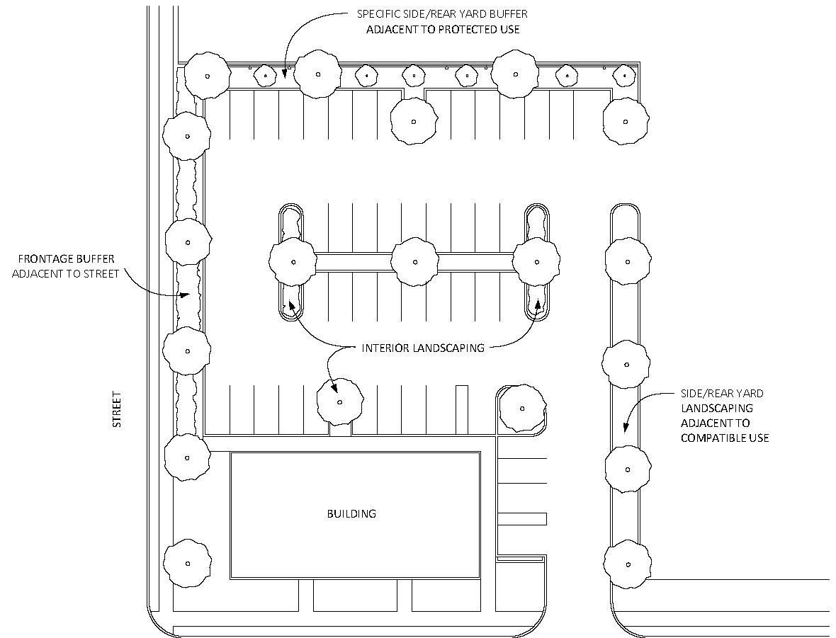
4.5.7.3
Landscape Standards
a.
Frontage Buffer
Where a vehicle use area is adjacent to a street, a frontage buffer shall be provided in accordance with Table 4.5-1.
TABLE 4.5-1 FRONTAGE BUFFER OPTIONS
Figure 4.5-3 Frontage Buffer Options
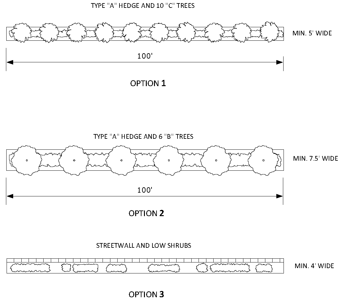
b.
Side or Rear Yard Landscaping
1.
Where a vehicle use area is adjacent to a protected use, a required buffer shall be provided in accordance with Tables 4.5-2 and 4.5-3.
2.
Where a vehicle use area is adjacent to a use that is not a protected use, the side or rear yard landscaping shall consist of a minimum of five feet wide planter strip with one B (Medium) tree per 20 linear feet or one C (Small) tree per 16 linear feet.
3.
In either case, where the planter strip is less than 7.5 feet wide, landscape islands shall also be provided a minimum of one every ten parking spaces as illustrated in Figure 4.5-4 (Side or Rear Yard Landscaping Options). One B (Medium) tree shall be planted within each landscape island.
4.
Planter dimensions are measured to the inside of curbs but may include fences or walls.
5.
All ground area within planters shall be covered by turf grass, low shrubs or groundcover plants.
Figure 4.5-4 Side or Rear Yard Landscaping Options
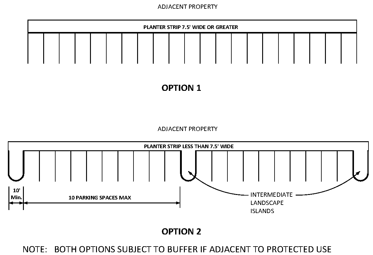
c.
Interior Landscaping
1.
Parking spaces interior to vehicle use areas shall be landscaped in accordance with the design options illustrated in Figure 4.5-6 which may be used singly or in combination, except that interior landscaping shall be optional for any vehicle use area containing 20 or fewer total parking spaces. Planter dimensions are measured to the inside of curbs. The design options may be modified to suit angled parking.
2.
Where a vehicle use area is adjacent to a building, terminal and intermediate landscape islands, each having the length of one parking space, a minimum of ten feet wide and spaced a minimum of every ten parking spaces, shall be provided.
Figure 4.5-5 Parking Adjacent to Building

3.
Trees shall be planted within each terminal landscape island, each intermediate landscape island and each interior landscape median in accordance with Figure 4.5-5 and Figure 4.5-6.
4.
Tree species shall be selected and planted in accordance with Table 4.5-6.
5.
All ground area within planters shall be covered by turf grass, low shrubs or groundcover plants.
6.
Interior portions of vehicle use areas specifically designated on the approved site plan for the display of motor vehicles for sale or rent or for the parking, maneuvering or storage of commercial trucks or trailers shall provide interior landscaping in accordance with the following options which may be used singly or in combination. The location and design of such landscaping shall be as determined by the Director of Parks and Recreation at the time of site plan approval.
(a)
Option 1: Provide interior planters and trees in accordance with a. above.
(b)
Option 2: Provide interior planters without trees and locate the trees elsewhere on the site.
(c)
Option 3: In lieu of interior planters, provide an equivalent amount of landscaped open space and trees elsewhere on the site.
(d)
Option 4: In lieu of required trees, pay a fee into the Tree Trust Fund, the amount of which shall be determined by the Director of Parks and Recreation. The fee schedule shall be as established by resolution of the City Commission.
Figure 4.5-6 Interior Landscaping Options
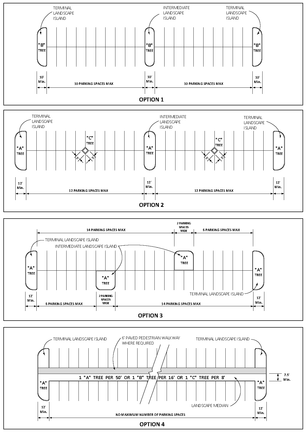
(Ord. No. 5455, 07-21-14; Ord. No 6053, § 2(Att. B), 9-16-24)
4.5.8
LANDSCAPING OF OTHER ON-SITE FACILITIES
4.5.8.1
Backflow Prevention Assemblies, Utility Meters and Fire Sprinkler Monitoring Systems
Unless deemed impractical at the time of site plan review, backflow prevention assemblies, utility meters and fire sprinkler monitoring systems shall be located away from building entrances and pedestrian facilities, such that visual impacts are minimized when viewed from adjacent sidewalks and streets. Outside of downtown, when located adjacent to a street or sidewalk, backflow preventers shall be screened from view through the use of a Type A hedge on three sides, leaving the service side open for maintenance and repair accessibility as illustrated in Figure 4.5-7 (Landscaping of Backflow Prevention Assemblies). Such landscaping, along with the proposed location of the backflow preventer, shall be shown on the landscaping plan at the time of site plan submittal. In downtown, within the Urban Center (UCT) context sub-district, backflow preventers, utility meters and fire sprinkler monitoring systems shall be located on either an alley or the service side of a building, or entirely hidden from view to pedestrian and vehicular traffic through the use of landscape planters, street furniture or other decorative concealment measures.
Figure 4.5-7 Landscaping of Backflow Prevention Assemblies
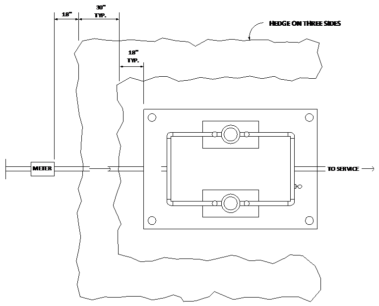
(Ord. No. 5802, § 1.2(Att. A), 11-18-19)
4.5.8.2
Transformer and Switchgear Boxes
Trees and shrubs planted around pad-mounted transformer and switchgear boxes shall maintain minimum planting clearances as illustrated in Figure 4.5-8 (Landscaping of Transformer and Switchgear Boxes).
Figure 4.5-8 Landscaping of Transformer and Switchgear Boxes
![]()
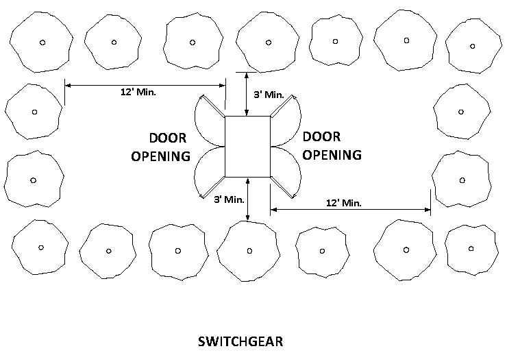
4.5.8.3
Stormwater Management Facilities
a.
To the extent practicable, stormwater management facilities shall have non-angular, freeform, curvilinear contouring that mimics natural terrain.
b.
Berms and swales above the high water line shall be sodded and planted with trees on the ratio of one B (Medium) tree per 50 linear feet along the top of bank and shrubs covering 25 percent of the top of bank. Trees and shrubs may be grouped to mimic natural growth and need not be evenly spaced.
c.
Plant material shall be selected from Tables 4.5-6, 4.5-7 and 4.5-8 and shall be suitable for the individual characteristics of the site including soil, slope, aspect, hydro-period and microclimate. Areas designed to be permanently or seasonally wet may include native aquatic plants.
4.5.9
BUFFERING OF PROTECTED USES
4.5.9.1
When any burdened use listed in Table 4.5-2 is adjacent to a listed protected principal use, the burdened use shall provide a buffer on or near the intervening property boundary in accordance with the minimum standards for that type as set forth in Table 4.5-3. Where more than one buffer type is listed, any of the listed types may be used. The burdened uses listed include all vehicle use areas serving those uses.
4.5.9.2
The buffer types listed in Table 4.5-3 may also be used for other buffer applications as specified elsewhere in this Code.
4.5.9.3
Tree species shall be selected and planted in accordance with Table 4.5-6. Plant species to be used for hedges shall be selected and planted in accordance with Table 4.5-8.
4.5.9.4
The incorporation of existing trees, tree lines, shrubs, hedge rows and other natural vegetation into buffers is encouraged and the Director of Parks and Recreation may recommend that the Director of Community Development modify these requirements if existing vegetation will provide a buffer of equal or greater density and view blockage to the required buffer.
TABLE 4.5-2 REQUIRED BUFFER BY TYPE
Figure 4.5-9 Required Buffers
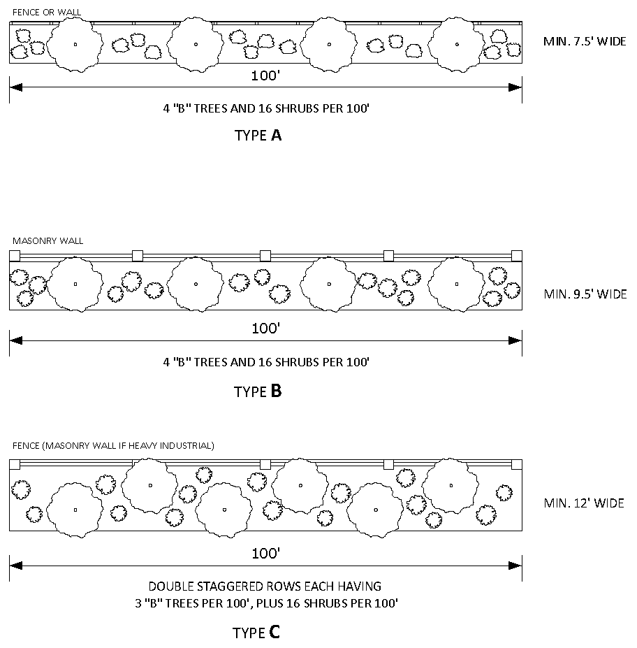
TABLE 4.5-3 REQUIRED BUFFER STANDARDS
4.5.9.5
Development located adjacent to limited access highways shall plant A (Large) trees adjacent to the right-of-way on the ratio of one tree for each 50 linear feet of frontage.
4.5.10
TREE PRESERVATION
4.5.10.1
Intent and Applicability
a.
Intent
1.
It is the intent of this section to establish standards to prevent, mitigate or compensate for the loss of the public resource where tree canopy is proposed to be destroyed by development.
2.
Except as specifically provided herein, the preservation of existing trees on development sites is to be preferred to the planting of new trees.
3.
Efforts to preserve existing trees are encouraged and the Director of Parks and Recreation may recommend that the Director of Community Development modify development standards in order to save specific trees.
b.
Applicability
The provisions of this section shall apply to the proposed destruction or relocation of any regulated tree as the result of development activity, with the following exceptions:
1.
Lots or parcels zoned for single-family or two-family dwellings less than one acre in size and comprised of not more than two lots of record, which are not part of a proposed development or subdivision plan;
2.
Any vertical mixed use development where residential or office uses are located above ground floor commercial and a minimum of 60 percent of the building frontage is dedicated to retail or service commercial uses;
3.
Bona fide agricultural uses, commercial nurseries and botanical gardens;
4.
Bona fide utility maintenance, safety or fire reduction activities; or
5.
Emergency or disaster recovery activities.
(Ord. No 6053, § 2(Att. A), 9-16-24)
4.5.10.2
Credit for Preservation of Existing Trees
a.
Existing trees (except palms) located in proposed vehicle uses areas, proposed perimeter buffers or proposed stormwater retention areas that are preserved in accordance with this section shall be credited toward the number of trees otherwise required by this Code as follows:
TABLE 4.5-4 TREE PRESERVATION CREDIT
b.
To receive credit, the tree or trees to be preserved shall be identified on the landscape plan or site alteration plan as preserved, shall be free from disease and flourishing and shall be protected during construction in accordance with Sub-Section 4.5.10.5. Trees damaged during construction shall not receive credit.
4.5.10.3
Preservation of Regulated Trees
a.
Tree Removal Permit Required
1.
Except as otherwise provided herein, no regulated tree may be removed, relocated or destroyed without a tree removal permit as provided in this section.
2.
For development activity requiring a landscape plan or site alteration plan, the approval of the landscape plan or site alteration plan shall constitute the tree removal permit.
3.
Any regulated tree that is proposed to be removed, relocated or destroyed for any other reason shall require a separate tree removal permit using such form and submittals as the Director of Parks and Recreation may require.
b.
Identification on Landscape Plan or Site Alteration Plan
1.
The location, size and species of all regulated trees shall be indicated on the landscape plan or site alteration plan and shall indicate whether each is proposed to be preserved, relocated or destroyed. As an alternative, regulated trees proposed to be destroyed may be documented on a separate tree survey or existing conditions plan. A table shall be included summarizing the total number of trees by species and the total caliper inches of trees to be preserved, relocated or destroyed. The applicant shall consider the following as a means to preserve regulated trees and incorporate them into the site design:
(a)
The location of proposed buildings;
(b)
The location and design of proposed roads and vehicle use areas;
(c)
The location and design of proposed drainage systems and stormwater retention ponds;
(d)
The use of tree wells, tree guards, root protection devices, hardening of utilities or other methods of protecting trees on developed sites.
2.
The landscape plan or site alteration plan shall indicate proposed grade changes which may adversely impact or endanger regulated trees to be preserved. Spot elevations may be required prior to the issuance of a tree removal permit.
c.
Review by Director of Parks and Recreation
1.
The Director of Parks and Recreation shall review the landscape plan, site alteration plan or tree removal permit, which review shall include a field visit to the site, and shall either approve or deny the plan as to each regulated tree proposed to be preserved, relocated or destroyed.
2.
Approval Criteria
The Director of Parks and Recreation shall approve the plan or permit upon a finding that the regulated trees will be preserved, or that adequate measures are in place to assure the viability of regulated trees proposed to be relocated, or that compensation has or will be provided for regulated trees proposed to be destroyed.
d.
Compensation Required
When the Director of Parks and Recreation approves a plan authorizing the destruction of regulated trees, such trees shall be subject to compensation in accordance with the following. Trees located within the footprint of any building shown on an approved site plan shall not be subject to compensation. Replacement trees shall be planted in accordance with Sub-Section 4.5.11. Trees planted in fulfillment of other requirements of this article, such as required trees in vehicle use areas or required buffers, shall count toward the number of trees required as compensation for destroyed regulated trees. Compensation shall not be required for regulated trees that the Director of Parks and Recreation determines pose a safety hazard, have been weakened by disease, age, storm, fire or other injury or are near the end of their lifespan and likely to become a hazard; are of negligible public value including exotic, invasive, ornamental or fruit-bearing species; are likely to cause damage to buildings, utilities or other planned infrastructure; or are overcrowded and selective thinning is appropriate.
1.
Option 1: Tree Replacement on Same Lot or Parcel
Each destroyed regulated tree subject to compensation shall be replaced elsewhere on the same lot or parcel as follows:
2.
Option 2: Off-Site Mitigation
If the Director of Parks and Recreation determines that it is impractical to locate the replacement trees on the same lot or parcel, he may authorize the replacement trees to be planted at one or more off-site locations within the corporate limits of the City of Lakeland.
3.
Option 3: Payment of Fee-in-Lieu
If he determines that other options are not feasible, the Director of Parks and Recreation may authorize the payment of a fee-in-lieu for the value of regulated trees that are destroyed. The fee schedule shall be as established by resolution of the City Commission. If a fee-in-lieu is approved, the fee shall be paid into the Tree Trust Fund prior to the issuance of any permit authorizing construction or site alteration.
(Ord. No. 5522, 07-20-15)
4.5.10.4
Preservation of Street Trees
a.
No person shall destroy, remove, mutilate or abuse any street tree except as provided herein.
b.
Visibility of signage other than signs within rights-of-way shall not be grounds for the destruction, removal or trimming of street trees.
c.
The maintenance of all street trees shall be the responsibility of the city, except where trees within rights-of-way are maintained by a homeowner's association or other entity in accordance with a duly recorded agreement. Authorized city personnel and authorized contractors working for the city may trim or remove street trees as needed to maintain the health of street trees; to allow free passage of pedestrians and vehicles; to prevent the obstruction of or interference with utilities, street lights, traffic lights, street signs and traffic control devices; or to prevent obstruction of the view of vehicle operators at any street intersection.
d.
Nothing in this section shall prevent the cutting or removal of any street tree that in the opinion of the Director of Parks and Recreation is required for public safety.
e.
Authorization Required to Work on Street Trees
1.
Except where trees within rights-of-way are maintained by a homeowner's association or other entity in accordance with an agreement with the city, all work on street trees shall be done only with the authorization of the Director of Parks and Recreation. The Director of Parks and Recreation may authorize utility companies, including contractors working for utility companies, and tree service contractors to perform the following types of work on or near street trees: tree removal, trimming or pruning, grading or trenching near street trees, installation of pavement over street tree root zones, transport of buildings or other large items that could damage street trees. All underground work performed in the city-maintained right-of-way shall also require a right-of-way permit issued by the Public Works Department. In the event of an emergency such as a storm, such work may be performed without prior authorization, provided that documentation of the work performed is provided afterward to the Director of Parks and Recreation.
2.
In granting such authorization, the Director of Parks and Recreation shall find that there is a need for the proposed work; that those who are to perform the work are qualified to do so and are insured, bonded or pre-registered with the city; and that any potential detriment to the city's street tree population entailed by the proposed work is justified in the individual case. In making this determination, the Director of Parks and Recreation shall consider factors such as the probability that the proposed work will destroy or seriously injure the tree, the tree's health, whether the tree's condition and size threaten serious damage to property, the condition and number of other city street trees in the vicinity and other related criteria.
3.
The Director of Parks and Recreation may place conditions on any such authorization that he deems necessary.
4.
Where tree roots damage sidewalks, curbs, underground pipelines or similar public facilities, every effort shall be made to correct the problem without removing or damaging the tree. The Director of Parks and Recreation shall determine corrective measures in consultation with the Public Works Department. If repairs will result in extensive root damage, the Director of Parks and Recreation may direct the department to remove the tree prior to facility repairs.
5.
All pruning shall be done in accordance with ANSI A300 (Part 1) Pruning. Any proposed deviation from this standard must be approved by the Director of Parks and Recreation in advance.
6.
All trenching and tunneling shall be done in accordance with Trenching & Tunneling Near Trees: A Field Pocket Guide for Qualified Utility Workers, by Dr. James R. Fazio, 1998, The National Arbor Day Foundation. Any proposed deviation from this standard must be approved by the Director of Parks and Recreation in advance.
7.
The Director of Parks and Recreation may inspect such work and shall have the authority to stop any work if the standards of this article are not being followed.
8.
In the event that development activity will destroy or require the relocation of street trees or other public landscaping, the developer shall relocate such trees and landscaping or shall replace such trees in accordance with Table 4.5-5 in a location approved by the Director of Parks and Recreation. Such proposed replacement or relocation shall be approved in advance by the Director of Parks and Recreation and shall be shown on-site plans or construction plans submitted for review and approval. Such work shall be performed only by those authorized by the Director of Parks and Recreation and shall include any required irrigation systems. Repairs for any damage caused to utilities during such relocation shall be at the expense of the developer.
TABLE 4.5-5 PUBLIC TREE REPLACEMENT STANDARDS
4.5.10.5
Protection of Trees During Development Activity
Trees identified for preservation on the approved landscape plan, whether individually or within a generalized area of natural vegetation, shall be protected during development activity as follows:
a.
Protected trees or groups of trees shall be clearly marked by flagging, painting or other means.
b.
All protected trees shall have the trunk and roots protected by protective barriers erected prior to development activity in accordance with the following:
1.
Protective barriers constructed of wood rails, pipe, chain link fabric or orange plastic safety netting shall be placed around the tree or trees to form a continuous barricade at least four feet high. Ideally such barriers will form a protection zone described by the drip line. The Director of Parks and Recreation may allow a smaller protection zone or alternative tree protection measures where space is constrained. The barriers shall be shown on the site alteration plan and/or landscaping plan.
2.
Signs or other markings shall be placed on all sides of the protective barrier to designate the protected area.
3.
Protective barriers shall remain in place until landscape operations begin or until construction in the immediate area has been completed.
4.
Existing street trees located within rights-of-way interior to or adjacent to the development shall have protective barriers before site work begins.
5.
Trenching for underground utilities shall be prohibited inside the protective barriers. If underground utilities must be routed through the protected area, tunneling shall be required. All landscape preparation in these areas shall be conducted by hand, except for mechanical tunneling as needed.
6.
No vehicles, equipment, materials or fill shall be placed or stored within the protected area.
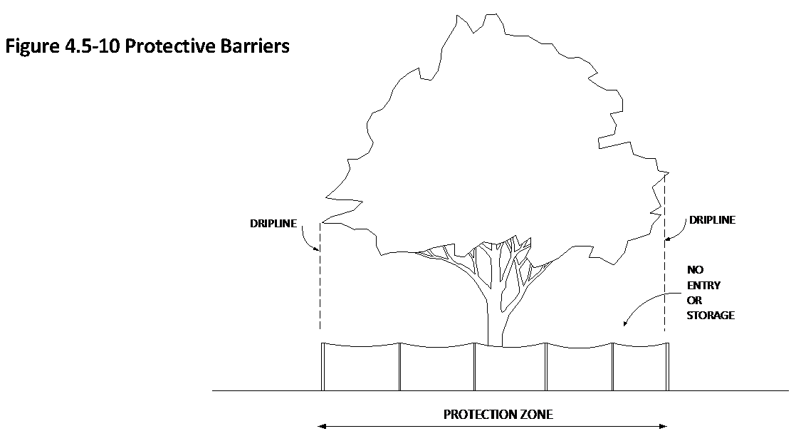
4.5.11
STANDARDS FOR LANDSCAPE DESIGN, INSTALLATION AND MAINTENANCE
4.5.11.1
Required landscaping and irrigation systems shall be designed, installed and maintained in accordance with Florida-Friendly Landscaping practices and the following standards. Approved landscape and irrigation plans shall provide the basis on which compliance is determined.
(Ord. No 6053, § 2(Att. A), 9-16-24)
4.5.11.2
Selection and Installation of Plant Material
a.
Required plant material shall be selected from and planted in accordance with Tables 4.5-6, 4.5-7 and 4.5-8. Other species not listed may be approved by the Director of Parks and Recreation.
b.
A (Large) trees shall be used except when the use of B (Medium) or C (Small) trees is specified or permitted herein. The Director of Parks and Recreation may authorize the use of smaller tree sizes depending on specific site conditions. If so, tree size substitution shall be made on the following basis: One A (Large) tree shall equal three B (Medium) trees or six C (Small) trees. One B (Medium) tree shall equal three C (Small) trees.
c.
Newly planted trees shall be a minimum eight feet high and a minimum diameter of one inch DBH or one and one-half inches six inches above grade at the time of planting.
d.
Upon the recommendation of the Director of Parks and Recreation, palms listed in Table 4.5-7 may be used in place of required qualified trees on a case-by-case basis such as where planting space is limited or where immediate vegetation height is needed. The substitution ratio shall be as determined by the Director of Parks and Recreation.
e.
The use of exotic and nuisance plants is prohibited. For purposes of this section, exotic and nuisance plants shall be those on the most recent Invasive Plant List of the Florida Exotic Pest Plant Council.
f.
Plant material shall conform to the standards for Florida No. 1, or better, based on the Florida Department of Agriculture and Consumer Services Publications "Grades & Standards of Nursery Plants, Parts I and II."
g.
Grass areas shall be planted in species normally grown in permanent lawns in Polk County. Grass areas may be sodded, plugged, sprigged, or seeded. Solid sod shall be used in swales and other areas subject to erosion. In areas where grass seed is needed, nurse grass seed (i.e., rye, millet) shall also be sown for immediate effect.
h.
Ground covers used in lieu of grass shall be planted so as to provide full coverage within one year after planting.
i.
No tree shall be planted closer than 15 feet to any light pole.
j.
All newly planted trees shall be properly guyed and staked. Guys and stakes shall be maintained for a minimum of one year.
k.
Plant material that has been subjected to severe pruning or maintenance practices that results in stunted or abnormal growth shall not be accepted as required plants.
l.
Planter beds shall be filled to a depth of three inches with weed-free native topsoil incorporated with organic matter. Bare soil shall be covered with a minimum of three inches of mulch consisting of shredded softwood or hardwood chips, nuggets, needles or oak leaves, or two-inch diameter stone or brick chips. Non-porous materials shall not be placed under or over the mulch.
Table 4.5-6 Qualified Trees
(Ord. No 6053, § 2(Att. C), 9-16-24)
Table 4.5-7 Qualified Palms
(Ord. No 6053, § 2(Att. D), 9-16-24)
Table 4.5-8 Qualified Shrubs, Flowers and Groundcovers
(Ord. No 6053, § 2(Att. E), 9-16-24)
4.5.11.3
Irrigation Systems
The following standards shall apply to the installation of new residential and non-residential irrigation systems, and the retrofit or replacement of existing residential and non-residential irrigation systems.
a.
Unless otherwise provided herein, all required landscaping shall be irrigated by a permanent irrigation system designed for maximum water conservation, which shall provide 100 percent coverage of plant material and shall be fully operational before building occupancy except that no irrigation systems shall be required in those areas where existing trees or areas of natural vegetation are to be preserved, non-required landscape areas, or as indicated on the approved landscape plan. If approved by the Director of Parks and Recreation, newly planted trees may be irrigated by a temporary irrigation system. Newly planted trees shall be irrigated until they are established at which time irrigation may be terminated and any temporary system removed.
b.
A rain sensor or equal technology that inhibits or interrupts operations of the irrigation system during periods of sufficient moisture shall be installed and control all irrigation zones. Rain sensor and related hardware shall be installed per manufacturer specifications.
c.
Irrigation systems serving landscape areas with different irrigation demands shall be zoned accordingly to vegetated groupings (e.g., turfgrass, shrubs, trees) and the watering requirements of the plants. Turfgrass and landscaped beds, such as trees, shrubs and groundcover beds shall not be irrigated in the same zone.
d.
Rotary irrigation heads and spray irrigation heads should be kept in separate zones, and no irrigation zone shall include both rotary and spray irrigation heads.
e.
All sprinkler heads with spray nozzles shall be pressure regulated at the head and/or valve. Adequate pressure per the manufacturer specifications must be achieved throughout an entire zone.
f.
Narrow areas, 4 feet or less, shall not be irrigated unless correctly installed low-volume irrigation or end-strip/side-strip nozzles are used.
g.
Large sod zones shall be irrigated using rotors or similar devices to achieve maximum irrigation efficiency.
h.
Distribution equipment in a given zone shall have matched precipitation rates.
i.
All irrigation installations will include backflow assembly per Florida Building Code. If a chemical injection system is present for any reason, a reduced pressure principal backflow assembly is required.
j.
A minimum separation of 4 inches shall be required between distribution equipment and pavement.
k.
Sprinklers in low-lying areas shall have check valves to prevent head drainage.
l.
Irrigation design should include head-to-head spacing and consider soil, slope, and other site characteristics to minimize water waste, such as: overspray, off-site runoff, the watering of impervious surfaces and other non-vegetated areas.
m.
Sprinklers shall rise above turfgrass height:
1.
Minimum 6-inch pop-up for sprays and 4-inch pop-up for rotors for St. Augustine, Zoysia, and Bahia grasses;
2.
Minimum 4-inch pop-up for sprays and rotors for Centipede, Bermuda, and Seashore Paspalum grasses.
n.
Irrigation installers shall provide property owners and users with post-construction maintenance and system information, including:
1.
Design drawings as detailed in Appendix F of the Plumbing Volume of the Florida Building Code.
2.
Recommended maintenance activities and schedules.
3.
Operation schedule.
4.
Instructions on adjusting the system to irrigate in accordance with the rules of the Southwest Florida Water Management District after landscaping is established.
5.
Water shut-off method.
6.
Manufacturer's operational guide for the controller.
o.
Water Source
1.
At the discretion of the Water Utilities Department, the use of non-potable water sources may be required for irrigation. Non-potable sources include shallow wells, agricultural wells, lakes, ponds, stormwater retention and detention facilities, and reclaimed/reuse water systems. Where non-potable irrigation water systems are planned but not yet operational, at the discretion of the Water Utilities Department the irrigation system may be connected to the potable water system and disconnected when non-potable irrigation water becomes available. The use of non-potable irrigation water sources shall not exempt development from the water-efficient landscaping principles of this article.
2.
Irrigation systems shall not be connected to both potable and non-potable sources due to the potential of contaminating the City's potable water system. Any water source other than the City's potable water system is an "auxiliary supply." Where an auxiliary supply is used, there shall be a physical disconnect (air gap) between the two piping systems. An approved backflow prevention assembly shall be installed at the City's water service connection to any premises where there is an auxiliary water supply, even though there is no connection between the auxiliary water supply and the public potable water system. Backflow prevention assemblies approved by the Water Utilities Department shall be installed on all potable water service connections/meters to the site, including those for domestic, fire service and irrigation water.
p.
All irrigation restrictions imposed by the City of Lakeland and/or the Southwest Florida Water Management District shall be adhered to within 60 calendar days after landscape installation and the plant establishment period.
q.
All irrigation systems shall be installed and maintained in accordance with manufacturer's specifications.
r.
The following are exempt from the Irrigation System standards but should follow applicable Florida-Friendly Landscaping best management practices:
1.
Bona fide agricultural activities;
2.
Vegetable gardens and fruit and nut trees;
3.
Athletic parks;
4.
Parks and recreational areas;
5.
Golf course play areas;
6.
Cemeteries;
7.
Nurseries;
8.
Botanical gardens;
9.
Open space;
10.
Temporary establishment irrigation.
(Ord. No 6053, § 2(Att. A), 9-16-24)
4.5.11.4
Maintenance of Landscaping
a.
Required landscaping shall be maintained in healthy condition at all times. No required shrubs or trees shall be destroyed without a permit issued by the Director of Parks and Recreation upon approval of a proposed landscape plan or subdivision construction plan.
b.
Required trees shall not be abused. Required trees shall not be pruned or trimmed in such a manner as to prevent the tree from reaching its mature height and canopy.
c.
All areas that are to be preserved as natural vegetation shall be maintained to eliminate invasive vegetation, lawn grasses, trash, or other debris and shall be managed to maintain the plant community in its natural state.
d.
Stormwater management facilities shall be maintained free of cattails or other invasive or noxious growth in accordance with City of Lakeland and SWFWMD requirements and permits.
e.
Landscaping within visibility triangles shall be maintained in accordance with 4.12.
f.
Mulch shall be replenished as necessary to maintain a three-inch depth.
g.
This section shall not apply to tree clearance activity or emergency repair work authorized by a public utility within a right-of-way or utility easement.
4.5.12
LANDSCAPE AND IRRIGATION PLANS
4.5.12.1
Landscaping and Irrigation Plans Required
a.
A landscape plan and an irrigation plan, prepared in accordance with this article and the most recent administrative procedures, shall be submitted with applications for building permits, site plans, preliminary subdivision plats and occupancy permits for all projects to which this article applies (See Sub-Section 4.5.1.2 Applicability.) Additional landscaping, landscape plans and irrigation plans shall not be required for premises with conforming landscaping. Landscape and irrigation plans for non-residential and multi-family projects of five acres or greater shall be signed and sealed by a Registered Landscape Architect licensed in the State of Florida.
b.
A separate landscape plan and an irrigation plan is optional in the case of single-family or two-family structures. In lieu of a separate landscape plan, the location of all trees necessary to meet minimum tree density and all trees to be preserved and protected during construction shall be shown on the construction plans as part of the application for a building permit. Where irrigation is provided, rain shut-off devices and back flow preventers are required and non-potable water sources may be required.
(Ord. No. 5522, 07-20-15)
4.5.12.2
Landscaping Plan Requirements
Landscaping plans shall contain the following minimum information:
a.
Name, address, and telephone number of both the owner and the designer.
b.
Scale (minimum 1" = 40'), north arrow, and date.
c.
Location, common name and DBH of all regulated trees. Indicate whether each is to be preserved, relocated or destroyed. The new location of all relocated trees. The proposed location of replacement trees. As an alternative, regulated trees proposed to be destroyed may be documented on a separate tree survey or existing conditions plan. This requirement may be waived by the Director of Parks and Recreation if he finds after a field visit that there are no significant trees in the site.
d.
Areas of natural vegetation proposed to be preserved.
e.
Location and dimensions of all planter strips, planter beds, landscape islands and plant materials.
f.
Vehicle use areas including parking spaces, driveways, drive aisles, loading areas and other vehicle maneuvering areas.
g.
Abutting rights-of-way, street names, centerlines, curb lines, curb cuts and median openings.
h.
Stormwater retention ponds, backflow prevention assemblies, transformers, switchgear boxes and other on-site facilities.
i.
Overhead and underground utilities.
j.
Sight visibility triangles in accordance with Section 4.12.
4.5.12.3
Irrigation Plan Requirements
Irrigation plans shall contain the following minimum information. Such plans should be separate from the landscape plan but should use the same format and scale.
a.
Location of rotor and spray heads, drip system mainlines, valves and valve boxes, controller, rain shut-off devices, and back flow preventer;
b.
Location and identification of water source including, if applicable, location of well and size of pump;
c.
Location and size of pipes;
d.
Location of sleeves, if any;
e.
Design radius of rotor and spray heads; and
f.
Flow rate and static water pressure at the point of connection.
4.5.13
ENFORCEMENT
4.5.13.1
General
a.
No building permit shall be issued unless the landscape and irrigation plans have been approved.
b.
No Certificate of Occupancy shall be issued unless all required landscaping has been installed in accordance with the approved landscape and irrigation plans, unless a cash bond in the amount of 200 percent of the cost of the required landscaping is posted by the developer in lieu of complete installation. The amount of the bond shall be determined by the Director of Parks and Recreation. The owner shall comply with these landscaping requirements within 30 days from the date the bond is posted.
c.
Failure to comply with the provisions of this article shall constitute grounds for the issuance of a stop work order and/or the withholding or revocation of site plan approval, building permits, certificates of occupancy or any other approvals necessary to commence or continue development.
d.
The property owner shall take immediate corrective action upon notice from the city that any tree or landscaping is a threat to public safety or to property.
e.
This section shall not apply to tree clearance activity or emergency repair work authorized by a public utility within a right-of-way or utility easement.
4.5.13.2
Penalties for Non-Compliance
Should a non-compliance with the requirements of this article be found to exist at any time, the property owner shall take remedial action within 30 days from the date of notification from the city in accordance with the following:
a.
Required Landscaping Damaged or Destroyed Due to Natural or Accidental Causes
1.
Required landscaping damaged as the result of natural or accidental causes may require pruning, fertilizing, watering or other remedial action to restore the health of the landscaping, as the Director of Parks and Recreation may determine.
2.
Required landscaping destroyed as the result of natural or accidental causes shall be replaced on a plant by plant basis. Each required tree that is destroyed shall be replaced with a tree or number of trees equivalent to the diameter of the required tree when it was destroyed. The quantity and quality of replacement plant material shall be in accordance with the approved landscape plan or subdivision construction plan and the requirements of this article. In the event that replacement trees cannot be located in accordance with the original landscape plan, alternative locations or other mitigating actions may be approved by the Director of Parks and Recreation.
b.
Required Landscaping Damaged or Destroyed Due to Willful Action or Neglect
1.
Required landscaping damaged as the result of willful action or neglect, including the failure to irrigate, may require pruning, fertilizing, watering or other remedial action to restore the health of the landscaping and may be subject to penalties as the Director of Parks and Recreation may determine is warranted under the particular circumstances.
2.
Required landscaping destroyed by willful action or neglect, including failure to obtain a tree removal permit or other permission, shall be replaced on a plant by plant basis and, in addition, may be subject to the following penalties as the Director of Parks and Recreation may determine is warranted under the particular circumstances. In the event that replacement trees cannot be located in accordance with the original landscape plan, alternative locations or other mitigating actions may be approved by the Director of Parks and Recreation.
(a)
Installation of landscape plantings over and above plant by plant replacement, not to exceed 150 percent of the required landscaping in the case of shrubs or 150 percent of the diameter of required trees based on the diameter of each required tree when it was destroyed.
(b)
Payment of a fine into the Tree Trust Fund, not to exceed 150 percent of the valuation of required trees based on the diameter of each required tree when it was destroyed. Fines shall be as adopted by resolution of the City Commission.
3.
The quantity, quality and location of replacement plant material shall, at a minimum, be in accordance with the approved landscape plan or subdivision construction plan and the requirements of this article.
4.
In the event a person abuses a tree in violation of this article, the violator shall be responsible for the cost of pruning and other remedial actions that the Director of Parks and Recreation determines are reasonably necessary to protect public safety and property, and to help the tree survive the abuse.
5.
In the case of street trees destroyed by willful action or neglect, the violator shall be required to mitigate the loss with the installation of replacement trees. The Beautification Board may require up to ten times the DBH of the destroyed tree in replacement trees in accordance with Table 4.5-5. The minimum size of replacement trees shall be two-inch caliper.
4.5.13.3
Referral to Code Enforcement Board
In the event that a property owner is unwilling or unable to resolve a non-compliance by remedial actions in accordance with Sub-Section 4.5.13.2, the Director of Parks and Recreation shall notify the Code Enforcement Board and request a hearing.
4.5.14
APPEALS
4.5.14.1
Any order, requirement, decision or determination by any official or by the Beautification Board alleged to have been made in error of this article may be made to the Zoning Board of Adjustment and Appeals.
4.5.14.2
In cases where literal enforcement of the terms of this article would result in unnecessary hardship and the granting of a variance would not be contrary to the public interest, application for a variance may be made to the Zoning Board of Adjustment and Appeals, in accordance with the provisions of Article 12.
4.6 - OUTDOOR LIGHTING
4.6.1
INTENT AND APPLICABILITY
4.6.1.1
Intent
It is the intent of this section to minimize the amount of light trespass onto adjacent properties and thoroughfares, minimize the amount of light spill into the night sky and minimize the negative impacts of excessive outdoor light while preserving safety, security and nighttime use and enjoyment of property.
4.6.1.2
Applicability
a.
Unless otherwise provided herein, all development shall meet the requirements of this section.
b.
Subject to Sub-Section 4.1.2, development lawfully existing as of the effective date of this Code may be maintained, renovated or repaired without modifying outdoor lighting in conformance with this section.
c.
This section shall not apply to:
1.
Single-family or two-family dwellings.
2.
Lights within road rights-of-way.
3.
Lighting required by the Federal Communications Commission, Federal Aviation Administration, Federal Occupational Safety and Health Administration, or other federal, state or county agencies.
4.
Lighting required by law enforcement, fire and rescue, or other emergency response agencies to perform emergency or construction repair work or to perform nighttime road construction.
5.
Holiday lighting displays.
6.
Ornamental lighting using low voltage, low wattage light fixtures and neon lighting used to outline buildings or structures.
4.6.2
OUTDOOR LIGHTING STANDARDS
4.6.2.1
General
a.
Outdoor lighting levels shall be the lowest levels that meet the requirements of the task.
b.
All outdoor lighting shall be located, aimed or shielded so as to minimize stray light trespassing across property boundaries.
c.
Except for security lighting fixtures, all outdoor lighting fixtures (luminaires) shall be of the fully shielded type such that the light emitting, distributing, reflecting and refracting components of the light fixture (lamp, lens, reflective surfaces, etc.) do not extend beyond the opaque housing of the fixture.
d.
Light fixtures shall be aimed no higher than 45 degrees above vertical down (half-way between straight down and straight to the side) when the light source is visible from any off-site residential property or thoroughfare.
e.
Lighting of canopy areas over motor vehicle fuel pump islands, drive-through lanes or similar installations shall use fully shielded or fully recessed light fixtures.
f.
Prohibited Lights
•
Flashing, revolving or intermittent lights visible from any property line.
•
High intensity light beams such as but not limited to searchlights, laser lights or strobe lights visible from any property line.
(Ord. No. 5522, 07-20-15)
4.6.2.2
Security Lighting
a.
Security lighting fixtures such as wall packs shall be restricted to loading, storage, and service locations and shall not be substituted for appropriate fully shielded area lighting such as in parking areas or walkways.
b.
Security lighting fixtures such as wall packs shall be shielded to avoid light trespass onto residential dwellings or adjacent thoroughfares.
c.
Building-mounted security lighting fixtures such as wall packs shall not project above the fascia or roof line of the building.
4.6.2.3
Architectural Lighting
Lighting used to illuminate architectural details of buildings, landscaping, flags, statues, signs or other objects shall use fully shielded lighting fixtures that are aimed and controlled so that the directed light is substantially confined to the object intended to be illuminated.
4.6.2.4
Outdoor Recreation Facilities
Because of their unique requirements for nighttime visibility and their limited hours of operation, outdoor active recreation facilities, including but not limited to, ball diamonds, athletic fields, tennis courts and driving ranges, are exempt from the outdoor lighting standards of this section, subject to the following:
a.
All playing field/court lighting fixtures shall use full cut-off or directionally shielded lighting fixtures, aimed toward the playing field/court and shielded in directions away from the playing field/court so as to minimize glare and light trespass onto adjacent properties.
b.
The use of outdoor playing field/court lighting shall not be permitted between the hours of 11:00 PM and 7:00 AM, unless other hours are specifically approved as part of a PUD, SPI, conditional use or special event permit.
(Ord. No. 5522, 07-20-15)
4.6.2.5
EXCEPTIONS
a.
The provisions of this section are not intended to prevent the use of any design, material or method of lighting not specifically prescribed herein, provided that any such alternative is designed by a registered engineer, architect or certified lighting designer and meets the intent of this section as determined by the Director of Community Development.
b.
The Director of Community Development may authorize the temporary use of outdoor lighting not in conformance with the standards and requirements of this section for a period not to exceed thirty days.
Figure 4.6-1 Fully Shielded Light Fixture

Figure 4.6-2 Recessed Canopy Light
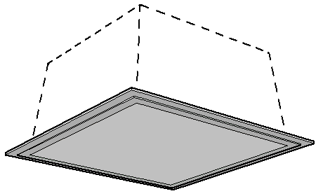
Figure 4.6-3 Wall Pack

4.7 - PEDESTRIAN, BICYCLE AND TRANSIT FACILITIES
4.7.1
INTENT
It is the intent of this section to establish minimum standards for pedestrian, bicycle and transit facilities, to reduce reliance on the automobile by promoting safe and efficient mobility by other modes of travel, to establish connections between different modes of travel, to implement the transportation policies of the Comprehensive Plan.
4.7.2
SIDEWALKS
4.7.2.1
Applicability
a.
Principal Structure on Lot or Parcel
Prior to the issuance of a Certificate of Occupancy for any residential or non-residential principal structure, the developer or property owner shall construct sidewalks along roadways adjacent to all front and street side lot lines where sidewalks do not presently exist, except for any new single-family or two-family structure on any local street where a sidewalk presently exists directly on the opposite side of the street. Such sidewalks shall not be required for the enlargement, alteration or reconstruction of existing single-family or two-family structures, provided that a building permit for reconstruction is pulled within 12 months of the demolition of the existing single-family or two-family principal structure. In the case of new principal structures in existing multi-building complexes, such sidewalks shall only be required when the aggregate cost of the improvements exceeds 50 percent of the total assessed value of all structures located on the same lot or parcel.
b.
Enlarged, Altered or reconstructed Multi-Family or Non-Residential Principal Structure on Lot or Parcel
Prior to the issuance of a Certificate of Occupancy for any enlarged, altered or reconstructed multi-family or non-residential principal structure on a lot or parcel, the developer or property owner shall construct sidewalks along roadways adjacent to all front and street side lot lines where sidewalks do not presently exist when the aggregate cost of the improvements exceeds 50 percent of the total assessed value of all structures located on the same parcel.
c.
Subdivisions (including Mobile Home Subdivisions).
1.
Abutting Streets: Upon the construction of roadways for any new subdivision or resubdivision, the developer shall construct sidewalks along the subdivision side of each roadway abutting the subdivision where sidewalks do not presently exist, except that in the case of abutting local streets, no sidewalk shall be required where a sidewalk presently exists directly on the side opposite the subdivision and, if no sidewalk presently exists on either side, the required sidewalk may be constructed on the side opposite the subdivision if it results in better pedestrian connectivity.
2.
Internal Streets: Upon the construction of roadways for any new subdivision or resubdivision, the developer shall construct sidewalks along both sides of arterial and collector roadways internal to the subdivision, and along at least one side of local streets internal to the subdivision. As an alternative, required sidewalks on internal local streets adjacent to building sites may be constructed on a lot by lot basis prior to the issuance of a Certificate of Occupancy for a structure on each respective lot. If this alternative is used, the developer shall construct sidewalks on arterial roadways, collector roadways, and on local streets adjacent to common areas that are not building sites at the time of roadway construction. If the developer elects to have sidewalks on only one side of any internal local street, he shall indicate on the plat the side of the street on which the sidewalk will be constructed. Such sidewalks shall be continuous on one side of the street within the same block but may cross to the other side on the next block. In the case of through lots, the Director of Community Development shall determine which yards function as rear yards and which functions as front yards and the developer shall constructed sidewalks adjacent to any yards that function as rear yards at the time of roadway construction. Sidewalks adjacent to through lot yards that function as front yards may be constructed on a lot by lot basis as above.
d.
Multi-family Developments
Prior to the issuance of a Certificate of Occupancy for the first unit in any new multi-family residential development, the developer or property owner shall construct sidewalks along the development side of each roadway abutting the development where sidewalks do not presently exist, except on any local street where a sidewalk presently exists directly on the opposite side of the street, and along at least one side of all internal roadways. Internal sidewalks shall connect all buildings, on-site amenities and any existing or planned external sidewalks along the project frontage.
e.
Mobile Home Parks
Prior to the issuance of a Certificate of Occupancy for any new mobile home park, the developer or property owner shall construct sidewalks along the development side of each roadway abutting the development where sidewalks do not presently exist, except on any local street where a sidewalk presently exists directly on the opposite side of the street, and along at least one side of all entrance roadways.
f.
Shopping Centers
Prior to the issuance of a Certificate of Occupancy for the first unit in any new shopping center, the developer or property owner shall construct sidewalks along the development side of each roadway abutting the shopping center where sidewalks do not presently exist.
g.
Multi-Unit Industrial or Office Park Developments
Prior to the issuance of a Certificate of Occupancy for the first unit in any new multi-unit industrial or office park development, the developer or property owner shall construct sidewalks along the development side of each roadway abutting the development where sidewalks do not presently exist, except on any local street where a sidewalk presently exists directly on the opposite side of the street, and along at least one side of the principal entrance roadway. Sidewalks shall be constructed between the principal customer entrances of each building entrance within an office park campus.
h.
On Designated Main Streets within Urban Neighborhood (UNH), Center (UCT), Corridor (UCO) and Special Purpose (USP) Context Districts
For new or reconstructed multi-family or non-residential principal structures, the developer or property owner shall construct six- to twelve-foot wide sidewalks along frontages of designated Main streets as illustrated in Figure 3.3-1 (Street Types), with right-of-way or easements being dedicated to the City for any portions of required sidewalks that would otherwise extend outside of public right-of-way. The final sidewalk width shall be determined by the City Engineer prior to engineered site or construction plan approval.
(Ord. No 6054, § 2(Att. A), 9-16-24)
4.7.2.2
Exceptions
a.
Payment in Lieu of Construction
1.
Local Streets, Where Sidewalk Network Does Not Exist: In the case of new single-family and two-family infill development or infill redevelopment on a local street where there is no existing sidewalk on the same side of the street and no existing sidewalk directly on the opposite side of the street, the developer or property owner shall make a payment into the Sidewalk Construction Fund in lieu of constructing sidewalks along local streets. Such payment shall be equivalent to one-hundred percent of the per linear foot cost to the City for installing the sidewalk based upon the current market price as determined by the City Engineer. In those instances where sidewalk segments exist on both sides of a street, then the City Engineer shall determine the preferred side of the street where sidewalk construction will be required by new development or redevelopment based on such factors as amount of existing sidewalk, physical impediments and right-of-way restrictions that cannot be mitigated. Payment shall be made prior to the issuance of a building permit for the structure. This exception shall not apply in the case of lots in subdivisions where the developer has chosen to construct sidewalks on a lot-by-lot basis in accordance with Sub-Section 4.7.2.1.c.2.
2.
Any Street, Regardless of Classification, Where Sidewalk Not Feasible: The City Engineer shall be authorized to determine if the construction of sidewalks required by this section is infeasible, impractical, unsafe or otherwise undesirable in a particular case due to topographic conditions, right-of-way restrictions that cannot be mitigated, the presence of existing physical impediments including trees, impending roadway or utility construction, or other circumstances that the City Engineer shall deem appropriate. In such case, the developer or property owner shall make a payment into the City of Lakeland Sidewalk Construction Fund in lieu of constructing the required sidewalks. Such payment shall be equivalent to one-hundred percent of the cost to the city for installing the sidewalk, including design, earthwork and drainage costs, based upon the current market price as determined by the City Engineer. Payment shall be made prior to the issuance of any building permit for the development, or in the case of a subdivision, prior to final plat approval.
b.
Sidewalks shall not be required along roads that are specifically exempted as part of an approved Alternative Pedestrian Circulation System Plan pursuant to Sub-Section 4.7.2.3.
c.
The Director of Community Development may grant relief from some or all of the requirements of this section for qualified affordable housing developments including single-family, two-family and multi-family developments, in accordance with administrative policies for affordable housing. In granting such relief, the Director may propose a plan to fund the construction of sidewalks from other sources, including but not limited to the City of Lakeland Sidewalk Construction Fund.
(Ord. No. 5455, 07-21-14; Ord. No 6054, § 2(Att. A), 9-16-24)
4.7.2.3
Alternative Pedestrian Circulation System Plan
To allow for flexibility and to encourage innovative design, the developer may submit an alternative pedestrian circulation system plan as part of a Planned Unit Development, conditional use or subdivision plat. The city may also initiate an alternative pedestrian circulation system plan as part of a Special Public Interest District. Such plan may incorporate paths, trails, overpasses, underpasses or other design features that provide equal or greater pedestrian mobility to the requirements of this section. If the site design elements of the plan are approved, relief may be granted from some or all of the requirements of this section. Facilities that are part of an alternative pedestrian circulation system that are not conventional sidewalks to be dedicated for public maintenance shall be privately maintained. All components of an alternative pedestrian network shall be located within a dedicated access easement approved by the Director of Public Works.
(Ord. No. 5455, 07-21-14)
4.7.2.4
Sidewalk Construction Standards
All required sidewalks shall meet requirements of the City of Lakeland Engineering Standards Manual regardless of whether they are located in a public right-of-way, private right-of-way, or easement.
4.7.2.5
Donation of Right-of-Way or Easement
Sidewalks may be constructed within public road rights-of-way, private road rights-of-way, or within suitable easements. Where sidewalks required by this section are to be publicly maintained and sufficient public right-of-way does not exist to construct the sidewalks, the property owner shall donate the right-of-way or shall provide easements to allow the sidewalks to be constructed. The City Engineer shall determine the amount of right-of-way or easement needed in each case. Where the donation of additional right-of-way would cause unnecessary hardship with respect to minimum building setbacks, the Zoning Board of Adjustment and Appeals may issue a variance. A private entity such as a developer or property owners association may construct required sidewalks on private property without donating land for public right-of-way, provided that the sidewalks are privately maintained.
4.7.2.6
Protection of Street Trees
Where possible, sidewalks shall be routed to avoid existing street trees and root zones of street trees. Sidewalk construction that will involve the removal of street trees or paving over or grading within 30 percent or more of the root zone of street trees shall require authorization of the City Arborist in accordance with Section 4.5 (Landscaping, Trees and Buffering).
4.7.2.7
Construction Bond
Construction plans shall include sufficient detail for the construction of required sidewalks. Except as noted herein, construction of sidewalks shall be completed prior to the issuance of a Certificate of Occupancy, provided, however, that in instances where completion of sidewalk construction is delayed due to circumstances beyond the reasonable control of the developer or property owner, and all other requirements for a Certificate of Occupancy have been met, the Building Official shall be authorized to issue the Certificate of Occupancy upon receipt of a cash bond in the amount of 110 percent of the cost of the sidewalk construction. Such bond shall be held for a period not to exceed four weeks from date of receipt; after which if the sidewalk construction has not been started by the developer or property owner, the bond shall be applied toward construction of the sidewalk by the city.
4.7.2.8
Maintenance
Sidewalks within public rights-of-way shall be maintained by the City of Lakeland. The City of Lakeland shall repair defects caused by normal deterioration in accordance with Public Works Department policy, provided, however, that in the event any sidewalk is damaged by the act or omission of the abutting property owner or one acting by, through or with the permission of the abutting property owner, including lack of maintenance of vegetation that causes damage or slippery conditions to the sidewalk, then the cost of repairing any damage occasioned by the act or omission of the abutting property owner or the act or omission of other person acting by, through or with the permission of the abutting property owner shall be borne by such abutting property owner. If the abutting property owner fails to cause such repairs to be made, the City of Lakeland shall repair or restore the sidewalk and shall assess the cost of such repair or restoration against such abutting property owner in the manner prescribed for the assessment of local improvements.
4.7.3
MULTI-USE PATHWAYS AND BIKE LANES
4.7.3.1
Applicability
a.
Prior to the issuance of a first Certificate of Occupancy, development located on any Priority Pathways Corridor, as designated in the Transportation Element of the Comprehensive Plan, and which generates more than 120 daily automobile trips, shall construct the appropriate pathway or bike lane segment in accordance with the following:
1.
The type of pathway or bike lane shall be in accordance with Table III-17 of the Comprehensive Plan Transportation Element and constructed in accordance with Sub-Section 4.7.3.2.
2.
The pathway or bike lane shall provide a continuous route that connects with existing or future segments of the Priority Pathways Corridor and shall be routed along the project frontage or within or through the development as the Director of Public Works may determine is most appropriate.
3.
If construction of the Priority Pathway segment is not feasible, with the approval of the Director of Public Works the developer may pay a fee in lieu of construction into the Transportation Fund for Pathways Projects. The fee shall be based on a signed and sealed cost estimate prepared by a registered professional engineer in the State of Florida. If the pathway facility is not necessary to achieve a favorable transportation concurrency determination, the development may provide a payment to the Pathways Fund equivalent to the Sidewalk Construction Fund payment otherwise allowed under Sub-Section 4.7.2.2.
b.
Any subdivision or development proposing a multi-use pathway as part of an Alternative Pedestrian Circulation System Plan shall do so in accordance with the requirements of Sub-Section 4.7.3.2 for the appropriate pathway type.
c.
Any development not located on a Priority Pathways Corridor which voluntarily provides multi-use pathways or bike lanes, shall do so in accordance with the requirements of Sub-Section 4.7.3.2 for the appropriate pathway type.
4.7.3.2
Standards
a.
General
1.
Pathways not located within a public right-of-way shall be within a minimum 20-foot wide easement and shall be privately maintained unless a public agency agrees to maintain the facility.
2.
Design and construction shall be in accordance with the American Association of State Highway and Transportation Officials (AASHTO) Bicycle Facilities Guide.
3.
Signage shall be in accordance with the Manual of Uniform Traffic Control Devices (MUTCD).
4.
Surfaces shall be paved except that off-road pathways located within any Conservation context, wetland or required minimum setback from a protected lakeshore may have a stabilized, unpaved surface.
5.
Site design shall minimize driveway crossings and other conflicts with pathways and bike lanes to the greatest practical extent.
b.
Specific to Type
1.
Priority Pathway, Off-Road
Minimum 12-foot wide asphalt trail with two-foot shoulder/clear zone on each side. Minimum five-foot separation between pathway and roadway. Minimum 10-foot wide, stabilized, unpaved trail may be used in bona fide conservation areas such a wetlands.
2.
Priority Pathway, On-Road
Minimum five-foot wide designated bicycle lane on curbed roadway section without gutter. Minimum four-foot wide with curb-and-gutter. A minimum four-foot wide paved shoulder may be used where roadway is constrained, subject to appropriate signage and striping.
3.
Alternative Pedestrian Routes
Minimum eight-foot wide asphalt or concrete off-road pathway. Stabilized, unpaved trail may be used in bona fide conservation areas such a wetlands.
4.7.4
TRANSIT FACILITIES
4.7.4.1
Applicability
a.
Development that is required to incorporate transit facilities as part of transportation concurrency mitigation requirements of Article 10, or in accordance with any other provision of this Code, shall do so in accordance with the standards and requirements of this section.
b.
Development which voluntarily provides transit facilities shall do so in accordance with the standards and requirements of this section.
4.7.4.2
Standards
a.
The location of transit stops on the public street system or internal to a development site shall be as approved by the Lakeland Area Mass Transit District or successor agency (transit agency).
b.
Transit stops shall be designed in accordance with the Engineering Standards Manual and shall comply with Americans with Disabilities Act (ADA) standards.
c.
Transit stops shall be placed within a right-of-way or recorded easement. Easements shall be executed prior to the issuance of a first Certificate of Occupancy for the development.
d.
Transit shelter pads and associated structures shall require a building permit. Transit shelter pads constructed within public rights-of-way shall require a right-of-way use permit. Site plans for transit shelters, including those submitted by the transit agency, shall be reviewed by the Development Review Team.
e.
Transit stops shall provide connections to the nearest sidewalk or pedestrian pathway.
f.
Where a transit stop is required to be located internal to a development, to the greatest practical extent the site shall be designed to minimize conflicts between transit vehicles and off-street parking areas and shall be located to minimize pedestrian travel distance between the transit stop and principal building entrances.
4.8 - RADIO AND TELEVISION ANTENNAS
4.8.1
INTENT
It is the intent of this section to regulate the placement and height of antennas for radios, televisions and similar devices for the purpose of limiting their visual impact and ensuring compatibility with surrounding land uses.
4.8.2
APPLICABILITY
Antennas and large dish antennas are permitted as accessory uses in all zoning districts subject to the standards set forth in this section.
4.8.3
DEFINITIONS
Unless the context clearly indicates a different meaning, for the purposes of this section, the following words and terms shall be defined as follows:
Antenna: An external device for sending or receiving electromagnetic signals for radios, televisions or similar devices and which is accessory to the principal use or structure on or about which it is located. This shall include small parabolic or dish-shaped antennas one meter in diameter or less. This shall not include antennas which are part of Personal Wireless Service Facilities or antennas mounted on communication towers.
Building-Mounted: An antenna mounted on the roof, eaves or wall of a structure or on a support, mast or pole that is attached to a roof, eaves or wall of a structure.
Ground-Mounted: An antenna mounted on a free-standing support, mast or pole on the ground.
Large Dish Antenna: A parabolic or dish-shaped antenna greater than one meter in diameter.
4.8.4
STANDARDS FOR ANTENNAS
a.
Location: Ground-mounted antennas shall be located in rear or side yards. Building-mounted antennas shall be permitted on all buildings.
b.
Setbacks: Ground-mounted antennas shall meet the setback requirements for accessory structures in the zoning district where located.
c.
Maximum Height: The maximum height of antennas shall be subject to Sub-Section 3.5.2. This shall not apply to any antenna owned and operated by a federally licensed amateur radio station operator (ham), provided, however, that said owner/operator complies with applicable federal, state or county laws, regulations, or standards.
(Ord. No. 5455, 07-21-14)
4.8.5
STANDARDS FOR LARGE DISH ANTENNAS
a.
Building Permit Required
A building permit shall be required prior to installing any large dish antenna.
b.
Ground-Mounted
1.
Location: Ground-mounted large dish antennas shall be located in rear yards unless a side yard exception is granted. (See "Placement Permit".) No large dish antenna shall be located in any front yard, except that a properly licensed business which sells large dish antennas may display them in the front yard of its properly zoned business location for demonstration or sales promotion purposes.
2.
Setbacks: Ground-mounted large dish antennas shall meet the setback requirements for accessory structures in the zoning district where located except that in no case shall any portion of a large dish antennas extend to within ten feet of any property line.
3.
Maximum Height:
A.
Residential and O-1 Districts: 20 feet
B.
Office (other than O-1), Commercial
C.
Industrial Districts: 25 feet
c.
Building-Mounted
1.
Location: Building-mounted large dish antennas are permitted on principal or accessory building within any office (except O-1), commercial or industrial district.
2.
Setbacks: In no case shall any portion of a large dish antenna extend to within ten feet of any property line.
3.
Maximum Height: Large dish antennas shall not exceed a height of more than 15 feet above the roof of the building upon which it is mounted, including base.
d.
Placement Permit
Prior to the side yard placement of any ground-mounted large dish antenna, the owner must secure a placement permit from the city. The application for the placement permit must be accompanied by a plot plan showing the lot lines and dimensions of the subject property, the location and dimensions of any structures thereon, the location of any public or private rights-of-way adjacent to said property and the proposed placement site for the antenna. Additionally, the application shall be accompanied by an affidavit from the owner or installer stating that a rear yard placement is not possible and the reasons therefore. The fee for a placement permit shall be set by Resolution.
4.8.6
GROUNDS FOR VARIANCE
The Zoning Board of Adjustments and Appeals may approve antennas and large dish antennas in other locations upon finding that adherence to the standards of this section does not permit the antennas to receive or send an acceptable quality signal and the alternative location does not otherwise violate the intent of this code.
4.8.7
ANTENNAS IN HISTORIC DISTRICTS
Antennas and large dish antennas proposed in designated historic districts may be subject to design review for architectural or historic compatibility provided, however, that such antennas and large dish antennas are restricted no more than other comparable devices allowed in those districts.
4.9 - SIGNS
4.9.1
INTENT
It is the intent of the City Commission through the provisions of this article to create the legal framework for comprehensive sign regulations. Furthermore, it is the intention of this article to authorize the use of signs which are:
a.
Compatible with the surroundings;
b.
Appropriate to the type of activity to which they pertain;
c.
Expressive in the identity of individual proprietors or of the community as a whole; and
d.
Legible in the circumstances in which they are seen.
The City Commission has determined that the public has a primary interest in controlling the erection, location, and maintenance of on-premises and off-premises signs in a manner designed to protect the public health and safety, to promote the public welfare, including the preservation and improvement of the aesthetic beauty of the community and to protect the free speech rights of its citizens. The number, size and location of such signs may, if uncontrolled, detract from traffic safety by diverting the driver's attention away from the driving task. The indiscriminate erection and maintenance of numerous large signs seriously detract from the enjoyment and pleasure of the natural scenic beauty of the city.
Therefore, the promotion and preservation of the public health, safety and welfare of the people of the city requires that the erection, construction, location, maintenance, size, and number of signs be regulated and controlled.
4.9.2
DEFINITIONS
Unless the context clearly indicates a different meaning, for the purposes of this Code, the following words and terms shall be defined as follows:
Abandoned Sign: Any sign, including the sign structure, which has been abandoned by its owner. Abandonment shall be presumed if, for a period of 180 days or longer, the sign has not: 1) advertised goods, services, facilities, events or attractions available on the premises where located, 2) identified the owner or occupant, 3) directed traffic on the premises, or 4) displayed a noncommercial message which may or may not relate to an activity located on the premises.
Animated Sign: Any sign which involves motion or rotation of any part by any means, or displays flashing, intermittent or color changing light or lighting, except as defined under Electronic Message Center Sign.
Awning Sign: A building sign applied to or hanging from an awning; said awning to mean a structure made of cloth or metal with a rigid frame that is attached to a building wall so as to provide cover over a storefront, window or door.
Banner Sign: A sign made of cloth, paper, or non-rigid material of any kind, either with or without frames, excluding flags as permitted by this article.
Bench Sign: A sign imprinted upon a public service bench whose primary purpose is a collateral transportation service to the public.
Billboard: An outdoor advertising sign which exceeds 25 feet in height and 250 square feet in sign area.
Building Sign: An on-premises sign applied to or mounted on a wall, awning, marquee, window, door, parapet, mansard or other part of a building, the display surface of which does not extend above the roof line, parapet, marquee or mansard, whichever forms the top line of the building silhouette. Awning signs, marquee signs, projecting signs and wall signs are included within this definition.
Figure 4.9-1 Building Signs
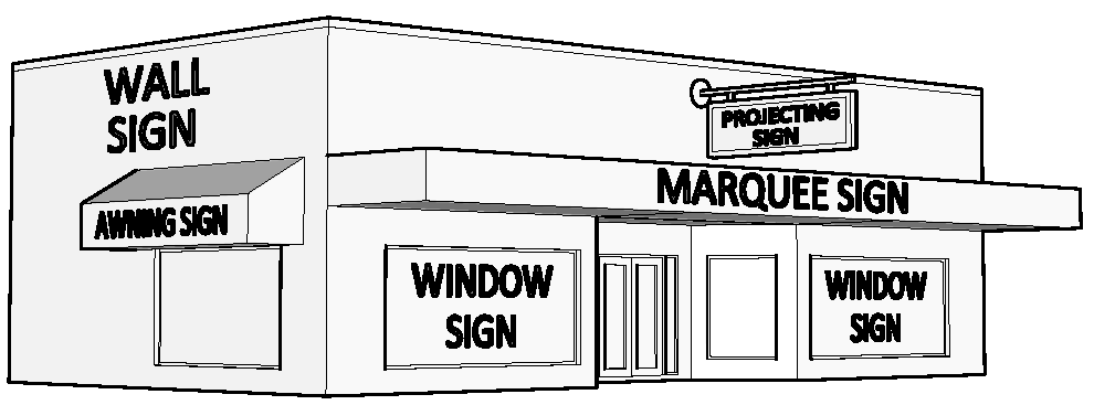
Changeable Copy Sign: Any sign with copy that can be changed, rearranged, or altered manually whereby the sign face is not changed.
Community Development Director: The officer, or his designee, charged with the administration and enforcement of this article.
Cornerstone Sign or Tablet: A sign cut into any masonry surface and constructed of bronze or other non-combustible materials.
Directional Sign: An on-premises sign providing direction or indicating the location of any object, place or area located on the premises, including, but not limited to, those signs indicating avenues of ingress and egress from the premises.
Directory Sign: An on-premises sign located on property with two or more separate commercial buildings.
Drive Through Sign: A sign located on property which has previously been approved for a restaurant with drive through window(s).
Electronic Message Center Sign: An internally illuminated sign on which the copy can be changed, rearranged, or altered automatically through electrical or electronic means.
Flag: A square or rectangular sign made of cloth, paper, or non-rigid material of any kind and displayed from a flagpole by being tethered along one side.
Flagpole: A freestanding, ground-mounted structure, or a structure mounted to a building, wall, or roof and used for the sole purpose of displaying a flag.
Functional Sign: A ground sign located on property where new cars and/or trucks are sold.
Ground Sign: A sign which is supported by structures or supports, in or upon the ground, and independent of support from any building.
Height, Sign: The distance from the top of the combination sign and sign structure to the ground elevation above which the sign is located.
Home Occupation Sign: A building sign displayed where there is a licensed home occupation.
Human Sign: A sign held by or attached to a person that displays a commercial message advertising or otherwise drawing attention to a business, commodity, service or product.
Illuminated Sign: Any sign illuminated by any light source including by not limited to electric bulbs, luminous tubes, fiber optics and LED (light emitting diodes), whether or not the light source is part of the sign proper.
Illuminated Sign, Externally: A sign illuminated by an external light source, including flood or spotlights, directed primarily toward such sign.
Figure 4.9-3 Externally Illuminated Sign
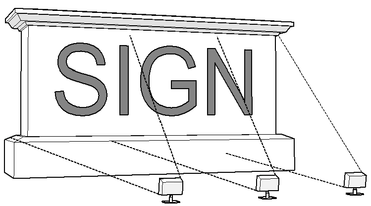
Illuminated Sign, Internally: Any sign illuminated by one or more light sources constituting an integral part of the sign proper.
Figure 4.9-2 Internally Illuminated Sign/Electronic Message Center Sign

Marquee Sign: A building sign upon, attached to, or hanging from a marquee; said marquee to mean a canopy or covered structure projecting from and supported by a building when such canopy or covered structure extends beyond the building line or property line.
Monument Sign: Any sign, other than a pole sign, which is placed upon or supported by structures or supports in or upon the ground and independent of support from any building.
Figure 4.9-4 Monument Sign

Nonconforming Sign: A sign or sign structure which was lawful when erected, but which does not conform to the requirements of this Ordinance.
Off-Premises Sign: A sign relating, in its subject matter, to other than the premises on which it is located or to products, accommodations or activities available on premises other than the premises on which the sign is located. A sign bearing a non-commercial message shall be deemed to be On-premises.
On-Premises Sign: Any sign which: 1) advertises goods, services, facilities, events or attractions available on the premises where located, 2) identifies the owner or occupant of the premises, 3) directs traffic on the premises, or 4) displays a non-commercial message which may or may not relate to an activity located on the premises.
Parapet: That part of a perimeter wall vertically extending above the juncture of the roof and perimeter wall.
Parasite Sign: Any sign, for which no permit has been issued, which is attached to another sign.
Pole Sign: A ground sign that is mounted on freestanding poles or other supports such that the bottom edge of the sign face is eight feet or more above grade.
Figure 4.9-5 Pole Signs

Portable Sign: A sign which is not permanently erected upon the ground or on the roof of any building or affixed to the wall of any building and shall include, but is not limited to, the following:
a.
Trash receptacles, and similar sidewalk appliances which display advertising copy;
b.
Sidewalk signs; and
c.
A sign, of any material, for use with or without changeable copy, illuminated or non-illuminated, mounted on a trailer or similar device, with or without wheels.
Projecting Sign: A building sign projecting perpendicular from and supported by a wall of a building.
Real Estate Sign: A sign erected on a premises which is for sale, lease or exchange.
Roof Line: The juncture of the roof and the perimeter wall of the structure or the top of the parapet or mansard, whichever forms the top line of the building silhouette.
Roof Sign: A sign which is wholly or partially fastened to and supported by or on the roof of a structure, or which extends above the mansard roof line of a structure.
Setbacks, Sign: The minimum horizontal distance between the lot line and the closest edge or part of the sign structure.
Sidewalk Sign: A self-supporting, portable sign designed to be placed upon a public or private sidewalk, plaza, courtyard or other area where pedestrians walk or gather.
Sign: A name, identification, image, description, display, illustration, device, figure, drawing, message, placard, poster, or other thing, designed, intended, or used to advertise or inform the public which is affixed to, painted, or represented directly or indirectly upon a building, structure, or piece of land, and which directs attention to an object, product, place, activity, facility, service, event, attraction, person, institution, organization, or business and which is visible from any street, right-of-way, sidewalk, alley, park, private parking lot, private street, or access drive where the general public customarily has access. Customary displays of merchandise placed behind a store window are not signs or parts of signs.
Sign Area: The entire area within one circle, triangle, or parallelogram enclosing the extreme limits of writing, representation, emblem, or any figure of similar character together with any frame of other material or color forming an integral part of the display or used to differentiate the sign from the background against which it is placed; excluding the sign structure unless the sign structure contains copy or is used as an integral part of the sign by introducing or extending the design, emblem, or logo or by utilizing colors or lighting in such a way as to attract attention to the sign. Where a sign has two or more faces or where the sign faces are mounted on a wall constructed of masonry or wood materials, the area of all faces shall be included in determining the area of the sign, except; where two such faces are placed back to back and are at no point more than two feet from one another, the area of the sign shall be taken as the area of one face if the two faces are of equal area, or as the area of the larger face if the two faces are of unequal area. Where a sign consists solely of lettering or other sign elements printed or mounted on a wall of a building without any distinguishing border, panel or background, any blank rectangular area which is more than 10 percent of the area of the sign as otherwise computed shall be disregarded. All of the lettering and other sign elements printed or mounted upon a wall of a building without any distinguishing border, panel or background shall be treated as a single sign for purposes of area computation. (See Figure 4.9-6)
Figure 4.9-6 Sign Area Computations
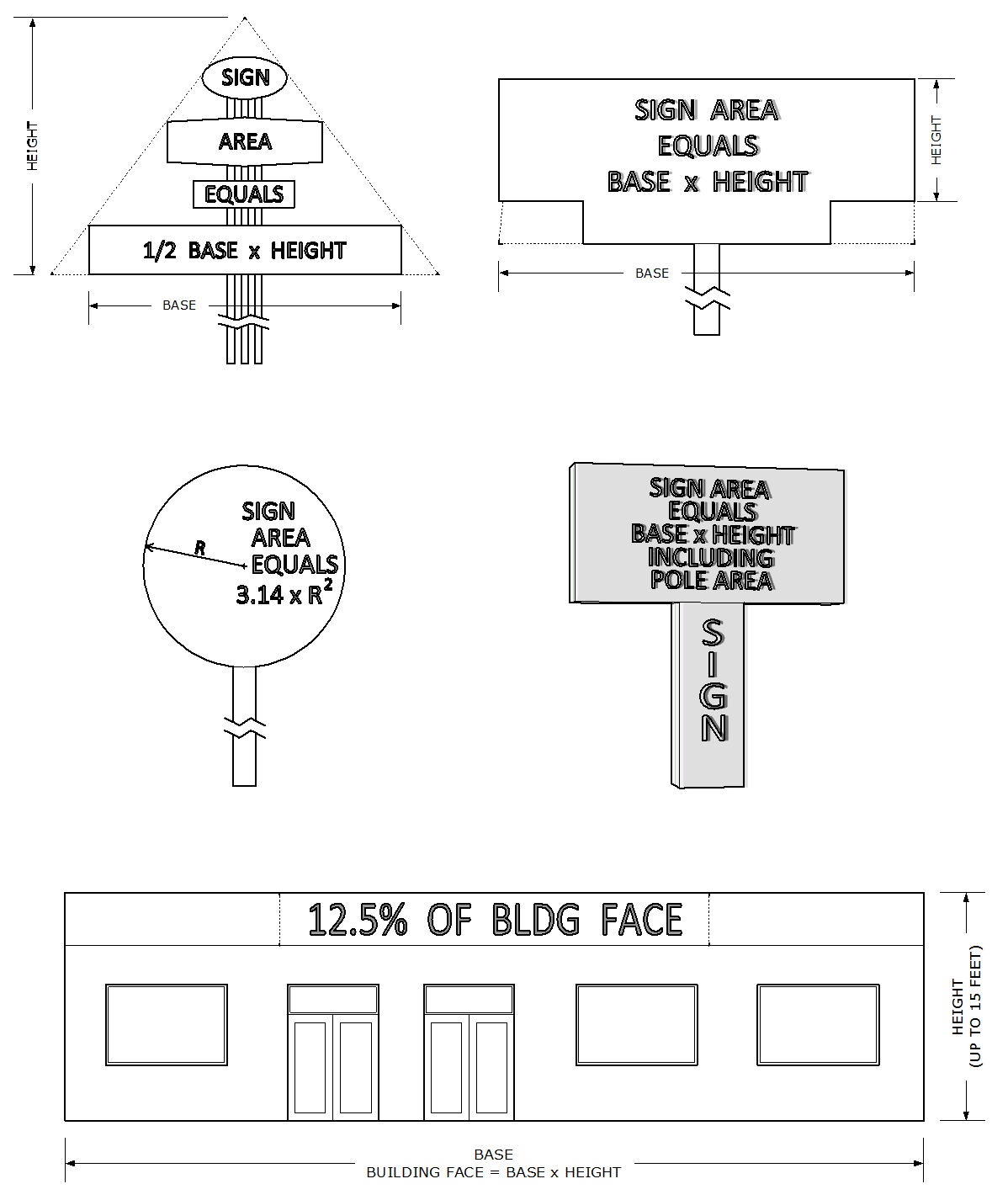
Sign Face: The display surface of a sign including non-structural trim but excluding the sign structure supports.
Sign, Nonstructural Trim: The molding, battens, capping, nailing strips, latticing, and walkways attached to the sign structure.
Sign Structure: The supports, uprights, braces, and framework supporting the sign.
Unlawful Sign: No sign shall be considered to be a lawful nonconforming sign if it was erected without approval of the permitting authority or a building and/or sign permit having been obtained, or if the sign was erected contrary to the provisions or limitations of a building and/or sign permit. Any such sign shall be considered unlawful and shall be subject to removal in accordance with these regulations.
Vehicle Sign: A sign displayed upon a vehicle where the vehicle is routinely parked or displayed adjacent to and visible from the public right-of-way and where other parking spaces are available to the vehicle that are not adjacent to and visible from the public right-of-way.
Wall Sign: A building sign applied to or mounted on a wall, the display surface of which is parallel to the plane of the building wall on which it is applied to or mounted on and which does not extend more than 18 inches from the surface of the wall.
Window Sign: A sign applied to or mounted on the window panes or glass of any window or door.
4.9.3
GENERAL PROVISIONS
4.9.3.1
General Requirements throughout the City
a.
Traffic Hazard Signs
Signs shall not be located, constructed, or maintained in such a way that such sign may be confused or interfere with any official traffic sign, signal, or device placed by any public authority or which may obstruct or interfere with the driver's view of approaching, merging, or intersecting traffic.
b.
Obstructing Signs
Signs shall not be located as to obstruct any window, door, fire escape, stairway, or any opening required for legal ventilation, ingress, or egress for any building or structure.
c.
Signs Projecting Over Pedestrian Pathways within Public Right-of-Way
Signs shall not be erected within or overhanging any public right-of-way, except that signs on marquees and awnings and projecting signs may overhang that portion of the public right-of-way that includes a pedestrian pathway, subject to the following conditions:
1.
Marquee signs may be attached to the sides and front of a marquee, and shall not extend beyond the surface area of the marquee, except as hereinafter provided.
2.
A sign may be attached to the bottom horizontal surface of a marquee in a position which is perpendicular to the street right-of-way, but not parallel thereto, and shall not extend more than one foot below such bottom horizontal surface and shall maintain a vertical clearance of eight feet above the sidewalk or ground level. No sign shall be attached to the top horizontal surface of a marquee.
3.
Marquee and awning signs shall be included in calculating the maximum allowable building sign area for the zoning districts in which they are located.
4.
Projecting signs permitted in accordance with Sub-Section 4.9.3.1.l shall maintain a vertical clearance of eight feet between the bottom edge of the sign and the sidewalk or ground level of the pedestrian pathway.
d.
Sign Supporting Structures
Signs shall not be tacked, painted, posted, or affixed in any manner on trees, utility poles, rocks, and other such supporting structures.
e.
Illuminated Signs
Illuminated signs are subject to the following restrictions:
1.
Illuminated signs are permitted only in Office Commercial, Retail Commercial and Industrial zoning districts; and in the PUD district for non-residential uses which are also permitted in the aforementioned conventional zoning districts; and in residential zoning districts for Conditional Uses where such uses are permitted on arterial or collector streets and the Conditional Use specifically permits an illuminated sign(s).
2.
Illuminated signs erected in a commercial district contiguous to a residential district shall be so shielded or directed so that the light or brightness shall not exceed five foot candles of light measuring at the property line contiguous to the residential district.
3.
No light from an illuminated sign shall be emitted into any residential dwelling or premises in excess of three foot candles of light measuring at any exterior wall of the residential dwelling or premises provided said dwelling or premises is located in a residential district.
4.
No illumination or glare from any sign shall be emitted directly onto a public street or roadway so as to constitute a hazard or impediment to motorist traffic or safety, nor shall any sign impair or obstruct a full view of a traffic control device.
5.
No revolving or rotating beam or beacon of light that simulates any emergency light or device shall be permitted as part of any sign. Flashing signs and flashing lighting devices shall not be permitted upon a sign.
6.
Electronic message center signs are permitted only in Office, Commercial, Retail Commercial and Industrial zoning districts; and in a PUD districts for non-residential uses which are also permitted in the aforementioned conventional zoning districts; and in residential zoning districts for Conditional Uses as specified below. An electronic message center sign may only be used as part of a permitted ground sign, and shall not exceed 20 square feet. No exposed reflective type bulb or incandescent lamp which exceeds 11 watts shall be used on the exterior surface of any sign so as to expose the face of the bulb, light or lamp to any public street or adjacent property. Electronic message center signs shall not change more frequently than once every five seconds. An electronic message center sign shall not flash or animate static information. Electronic message center signs in residential zoning districts may only be permitted as a conditional use in accordance with Sub-Section 4.9.3.1.e.1 and Sub-Section 4.9.4.1.a.1 and shall be subject to the following conditions:
(a)
The conditional use shall have at least 500 lineal feet of frontage on an arterial or collector roadway; and
(b)
The conditional use shall not be located across the street from property containing a residential dwelling.
f.
Abandoned Signs
Any abandoned sign, now or hereafter existing, shall be taken down and removed by the owner, agent, or person having the beneficial use of the building, structure, or property upon which such sign may be found, within 30 days after written notification from the Community Development Director. Upon failure to comply with such notice within the time specified by such order, the Community Development Director shall notify the Code Enforcement Board and request a hearing. In making a determination that a sign is abandoned the Community Development Director shall consider among other factors, the existence or absence of a current Business Tax Receipt for the premises, whether there are active utilities or a utilities service deposit at that location, and use of the premises.
g.
Non-use of On-premises Sign
Any on-premises sign which otherwise conforms to the provisions of this article, and by reason of the cessation of activity on the premises, becomes an off-premises sign, may be retained by one of the following methods:
1.
Painted Sign: The sign shall be covered by painting over the sign area.
2.
Removable Sign Face: The sign face shall be removed and replaced with a blank insert or the sign face may be reversed.
3.
Temporary Covering: The sign face may be temporarily covered by the installation of a sock or boot.
h.
Nonconforming Signs
1.
A sign within the corporate limits of the City of Lakeland which was lawfully erected, but by the date hereof should have been removed under provisions of prior law, and is not permitted herein, shall be immediately removed or made to comply with the requirements of this Code. A sign which is subject to the provisions of Section 70.20 F.S., shall be removed in conformance with the requirements of that section.
2.
Subject to the provisions of this section, any sign which does not conform to the requirements of this Code shall be removed or brought into compliance with this Code on or before the expiration of five years: i) from the date of the adoption of this Code, or any subsequent amendment making the sign nonconforming, or ii) from the date the premises was annexed into the city, whichever is later. A sign which is subject to the provisions of Section 70.20 F.S., shall be removed as provided in this sub-section, but only after compliance with the requirements of Section 70.20 F.S.
3.
On-Premises Signs: Nonconforming on-premises sign(s) shall be removed as provided in Sub-Sections h.1. and 2. above, except as follows:
(a)
Single Occupant Premises
One nonconforming ground or building sign per street frontage for each premise may be continued provided such nonconforming sign is maintained in accordance with the requirements of this article. No changes to the sign shall be permitted except a change in copy. In the event a change of occupancy occurs, which for purposes of this article is defined as a change of tenants or proprietors, and the new tenant or proprietor chooses to change advertising on the sign or change the name of the business as advertised on the sign, the previously allowed nonconforming sign shall be brought into conformance with this article.
(b)
Multiple Occupant Premises
Shopping centers and other multi-occupant premises shall be permitted to continue only one nonconforming ground sign per street frontage for each premise, and one building sign for each unit. No changes to the sign shall be permitted except a change in copy. In the event a change of ownership of the shopping center or multi-occupant premises occurs and the new owner chooses to change advertising on the sign or change the name of the center or premises as advertised on the sign, the previously allowed nonconforming sign shall be brought into conformance with this article.
(c)
Nonconforming signs shall not be reestablished after damage or destruction if the estimated cost of reconstruction or repair exceeds 50 percent of the reproduction and installation cost of the sign.
(d)
Nonconforming on-premises signs may be considered conforming to this ordinance, if determined to be a historic or landmark sign subject to the terms and conditions set forth below:
i.
Any person who chooses to pursue the historic or landmark designation for a nonconforming sign shall make application to the Historic Preservation Board. The Historic Preservation Board shall conduct such investigation and inquiry as is necessary to determine that a sign is eligible for the historic or landmark designation. The Board may refer the application to its Design Review Committee for a recommendation to the full Board. The Board is not empowered to approve an increase in the degree of nonconformity of a sign when approving it for a historic or landmark designation.
ii.
To be considered for designation as an historic or landmark sign by the Historic Preservation Board, a sign shall be 50 years old, or possess one or more of the following characteristics:
The sign must be structurally sound or repairable;
The sign is associated with historic or cultural figures, events, or places;
The sign is significant as evidence of the history of a product, business, or service advertised;
The sign is significant as reflecting the history of a building or the development of a historic district;
The sign is important in defining the character of a district;
The sign is characteristic of a specific historic period, such as, but not limited to, gold leaf on glass, neon, or stainless steel lettering;
The sign is integral to a building's design or physical fabric;
The sign is an outstanding example of the signmaker's art, whether because of its excellent craftsmanship, use of materials, or design;
The sign is a locally recognized as a popular focal point in Lakeland.
iii.
Effect of historic or landmark sign designation. Historic or landmark signs shall be maintained and kept in good repair. Historic or landmark signs may not be altered, removed, or covered unless the Historic Preservation Board grants a Certificate of Review to that effect. (See Section 11.6 Certificates of Review).
4.
On-Premises Signs, Areas Annexed Pursuant to Annexation/Wastewater or Water Service Agreements: Any On-Premises sign erected or installed on a parcel or premises after the effective date of a city Annexation/Wastewater or Water service agreement for said parcel or premises, shall conform to the city sign regulations in effect at the time of the erection of the sign. Any sign, in existence on the date of the Annexation/Wastewater or Water Service Agreement which does not conform to the provisions of the sign regulations shall be brought into conformance or shall be taken down and removed by the owner, agent, or person having beneficial use of the building, structure or property upon which such sign may be found within 30 days after written notification.
i.
Bench Signs
Bench signs will be permitted, provided the signs are located only on benches which are placed according to agreements approved by the City Commission and subject to the conditions expressed therein.
j.
Temporary Signs
1.
Sign types: A temporary sign may be a ground sign or a building sign, but may not be illuminated by electricity and must be constructed of rigid materials. Each premises shall be permitted temporary signs as follows:
(a)
One real estate sign per street frontage.
(b)
Three construction signs provided that such sign shall not be displayed prior to submission of an application for Building Permit for the project, and shall be removed no later than the date of issuance of the Certificate of Occupancy for the construction project. In the event a construction sign is displayed but construction is not initiated within 60 days after the sign is erected, or if construction is discontinued for a period of more than 60 days, the construction sign shall be removed.
(c)
Temporary non-commercial signs displayed before, during, or after an event or occurrence scheduled to take place at a specific time and place are permitted in all zoning districts and shall be removed within 21 days after the end of the scheduled event or occurrence to which they relate.
(d)
One temporary "grand opening" commercial sign which may be displayed for 30 days after the issuance of a Business Tax Receipt for any new business, new owner of an existing business, or business name change.
2.
Maximum size: Each premises may display temporary signs, the area of which shall not exceed 32 square feet per sign. Temporary non-commercial signs shall not exceed an aggregate sign area of 32 square feet. Real estate signs located in residential districts shall not exceed five square feet in sign area.
3.
Maximum height: Temporary signs shall not exceed eight feet in height.
k.
Flags
Flags are permitted in all zoning classifications provided that no more than three flags may be displayed per premises, and each flag must be flown from a flagpole, subject to the following conditions:
1.
Except for flags flown on single-family property, the height of a flag permitted by this section shall not exceed 25 percent of the total height of the flagpole.
2.
The display of flags permitted pursuant to this section shall not count as chargeable square footage under the sign regulations.
l.
Projecting Signs
Projecting signs shall be permitted as building signs within the C-6 and C-7 zoning districts subject to the following conditions:
1.
Projecting signs shall be included in calculating the maximum allowable building sign area and shall have no more than two sides.
2.
One projecting sign may be permitted per principal ground-floor business.
3.
Projecting signs shall not exceed eight square feet in sign area if mounted at a height of 15 feet or lower measured from the finished sidewalk to the bottom of the sign.
4.
Projecting signs shall not exceed 25 square feet in sign area if mounted higher than 15 feet measured from the finished sidewalk to the bottom of the sign.
5.
Projecting signs shall be located within five feet of the principal business entrance. In no case, however, shall a projecting sign be mounted within 10 feet of any other projecting sign.
6.
Projecting signs may project no more than 42 inches from the building wall.
7.
Projecting signs shall maintain an eight-foot clearance, between the bottom of the sign and the finished surface of all public and private pedestrian pathways.
8.
Within the C-7 zoning district, exceptions to conditions b. through e. above, may be approved by the Historic Preservation Board based upon a determination that sufficient historical documentation exists to justify the exception(s).
9.
Projecting signs on South Florida Avenue shall be subject to FDOT review and approval.
(Ord. No. 5455, 07-21-14; Ord. No. 5724, 06-18-18)
4.9.3.2
Prohibited Signs
All of the following signs shall be prohibited and shall be removed in accordance with the procedure established for each category of prohibited signs:
1.
Abandoned signs.
2.
Animated signs and flashing lights on signs.
3.
Banners, pennants, spinners, streamers, balloons, inflatable objects, fluttering devices other than flags, and lights designed to attract attention.
4.
Billboards and Off-premises signs.
5.
Parasite signs.
6.
Portable signs, except sidewalk signs where specifically permitted.
7.
Signs located on public rights-of-way or public property, except signs displayed by the governmental agency having jurisdiction over the public right-of-way and as may be authorized by law.
8.
Roof signs, unless retained and maintained as the one nonconforming sign an owner is permitted to continue in use.
9.
Horizontal and vertical advertising, not required by State or Federal laws, located on motor vehicle fuel pump island canopy supports, "spanner boards", and on light poles or other supporting structures at non-canopied pump islands, to be removed within 30 days after written notification.
10.
Vehicle signs as defined by these regulations.
11.
Any sign that is not specifically described or enumerated as permitted by these regulations.
Figure 4.9-7 Examples of Prohibited Signs
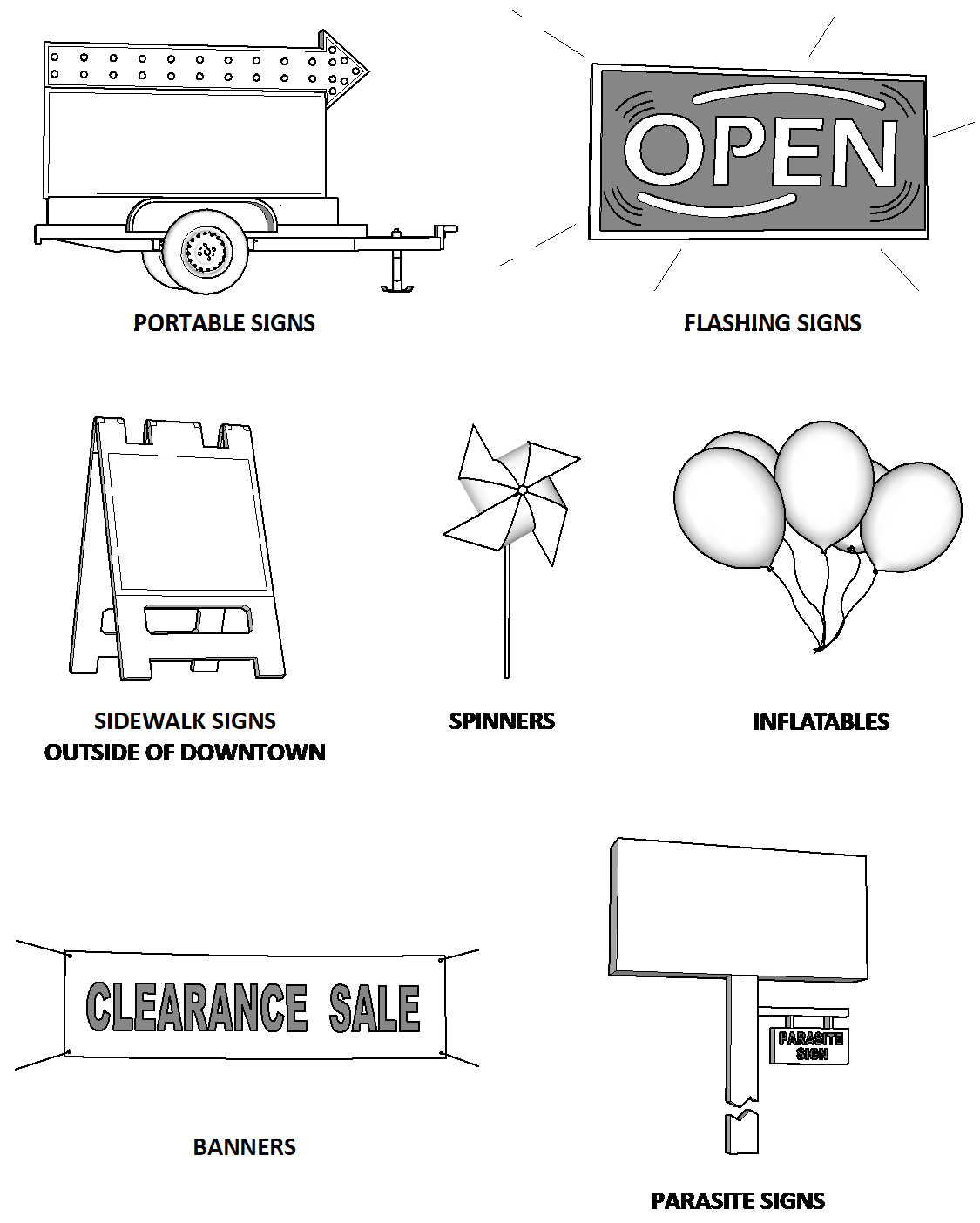
4.9.3.3
Exemptions
a.
Exemptions from Permitting Requirements
The provisions of this article which require permits shall not apply to the following signs; however, said signs shall be subject to the requirements of these sign regulations and other applicable codes of the city:
1.
Signs on a truck, bus, or other motor vehicle;
2.
Cornerstone signs or tablets not exceeding six square feet when cut into any masonry surface or when constructed of any noncombustible material and affixed to a building;
3.
Signs within the structure or structures of shopping centers or multi-occupant premises;
4.
Flags;
5.
Temporary signs;
6.
Signs permitted by Sub-Sections 4.9.4.1.a.8 and 4.9.4.2.a.6;
7.
Home Occupation signs;
8.
Window signs in accordance with the maximum sign area specified for each zoning district;
9.
Fuel point of sale and fuel pump topper signs provided that such signs utilize a rigid frame that is permanently affixed to or integrated into the structure of the pump enclosure. This includes fuel pump toppers that utilize electronic visual displays;
10.
Human signs in accordance with Sub-Section 4.9.4.4.c.
b.
Other Exemptions
The provisions of this section shall not apply to traffic control, directional, and street name signs installed by state or local jurisdictions or to signs for municipal facilities on public property that are deemed necessary by the City Manager or his designee.
(Ord. No. 5724, 06-18-18)
4.9.4
ZONING DISTRICT REGULATIONS
4.9.4.1
Single-Family, Two-Family, and Mobile Home Zoning District Regulations (RA-1, RA-2, RA-3, RA-4, RB, and MH)
a.
Permitted Signs
1.
Signs which are permitted in single-family, two-family, and mobile home districts may be externally illuminated. Notwithstanding this provision, internally illuminated signs may be considered in accordance with Sub-Section 4.9.3.1.e.1 for non-residential uses in residential zoning where such uses are permitted as a conditional use and an illuminated sign is expressly permitted.
2.
Home Occupation Signs: One per street frontage, not to exceed one square foot in area.
3.
Subdivision and Mobile Home Park Identification Signs: Such signs may be permitted per each public street frontage at the perimeter of the subdivision or park and may be provided in accordance with one of the following alternatives:
(a)
One double-faced sign may be erected perpendicular to the perimeter street. Such sign shall not exceed 32 square feet in area and shall not exceed six feet in height to the top of the sign above the established grade at the base of the wall or sign structure. In the event certain design features such as berms and landscaping are utilized as part of the subdivision entrance, the top of the sign shall not exceed 10 feet above the finished elevation of the crown of the entrance street.
(b)
One single-faced sign may be erected on one or both sides of the subdivision or park entrance street. Each sign shall not exceed 32 square feet in area and shall not exceed six feet in height to the top of the sign above the established grade at the base of the wall or sign structure. In the event certain design features such as berms and landscaping are utilized as part of the subdivision entrance, the top of the sign shall not exceed 10 feet above the finished elevation of the crown of the entrance street. Where a fence or wall is constructed at the perimeter of a subdivision or mobile home park, such sign(s) may be located on the face of the fence or wall.
4.
Clubs, Golf Courses, Parks and Other Recreation Uses, Public Buildings, Cemeteries, Utilities and Other Similar Uses: Shall be permitted one on-premises sign per public street frontage, which sign shall not exceed 20 square feet in area and shall not exceed six feet in height.
5.
Public and Private Schools:
(a)
Ground Signs for Middle Schools and High Schools - One sign per each public street frontage, subject to the following:
i.
Sign Area and Sign Height, Principal Street - One square foot of sign area for each two lineal feet of street frontage or 20 square feet of sign area, whichever is larger. The maximum sign area shall not exceed 50 square feet and the sign shall not exceed 15 feet in height.
ii.
Sign Area and Sign Height, Secondary Street
Maximum sign area: 20 square feet
Maximum height: 6 feet
(b)
Ground Signs for Public and Private Elementary Schools -
One sign per public street frontage, subject to the following:
i.
Sign Area and Sign Height, Principal Street - One square foot of sign area for each two lineal feet of street frontage or 20 square feet of sign area, whichever is larger. The maximum sign area shall not exceed 36 square feet and the sign shall not exceed 10 feet in height.
ii.
Sign Area and Sign Height, Secondary Street
Maximum sign area: 20 square feet
Maximum height: 6 feet
(c)
Building Signs for Public and Private High Schools, Middle Schools and Elementary Schools - Building signs shall not exceed an aggregate sign area equal to 12.5 percent of the square footage of the first 15 feet in height of the wall face upon which the sign is located. In the event the height of the wall is less than 15 feet, the allowable building sign area is the aggregate sign area equal to 12.5 percent of the square footage of the wall face upon which the sign is located.
6.
Churches:
(a)
Ground Signs for Churches
One ground sign per public street frontage, subject to the following:
i.
Sign Area and Sign Height, Principal Street - One square foot of sign area for each two lineal feet of street frontage or 20 square feet of sign area, whichever is larger. The maximum ground sign area shall not exceed 36 square feet and the sign shall not exceed 10 feet in height.
ii.
Sign Area and Sign Height, Secondary Street
Maximum sign area: 20 square feet
Maximum height: 6 feet
(b)
Building Signs for Churches - Building signs shall not exceed an aggregate sign area equal to 12.5 percent of the square footage of the first 15 feet in height of the wall face upon which the sign is located. In the event the height of the wall is less than 15 feet, the allowable building sign area is the aggregate sign area equal to 12.5 percent of the square footage of the wall face upon which the sign is located.
7.
Directional Signs for Accessory Off-Street Parking Areas: Directional signs shall not exceed two square feet in sign area and shall not exceed 30 inches in height. Only one directional sign may be erected at each point of ingress and egress and may be located at the property line, but shall not be located on or overhang the public right-of-way.
8.
On-premises sign: One on-premises sign not to exceed five square feet in sign area or six feet in height. Home occupation signs shall be governed by Sub-Section 4.9.4.1.a.2.
b.
General Restrictions
Minimum Sign Setbacks: Signs permitted in the single-family, two-family, and mobile home zoning districts shall not be erected within five feet of any property line, except subdivision identification signs on a perimeter wall and directional signs for off-street parking areas as specified herein.
4.9.4.2
Multiple-Family Zoning District Regulations (MF-12, MF-16 and MF-22)
a.
Permitted Signs for Residential Uses
1.
Signs which are permitted in multiple-family zoning districts may be externally illuminated.
2.
Multiple-Family Apartments: On-premises signs for multiple-family apartment developments are permitted according to the following conditions:
Maximum sign area:
Developments ≤ 50 units: 20 square feet per public street frontage
Developments > 50 units: 50 square feet per public street frontage
Minimum sign setbacks:
Front, side or rear setback: 5 feet
Maximum sign height:
Signs located in the area between minimum sign setback line and building setback line: 4 feet
Signs located at or behind the building setback line: 10 feet*
*(May also be permitted on a wall of an apartment structure)
Where a boundary fence or wall is constructed at the perimeter of a rental or condominium apartment development, an identification sign may be located on the face of the fence or wall in the same manner as for subdivisions.
3.
Home Occupation Signs: Same as single-family zoning districts.
4.
Subdivision Signs: Same as single-family zoning districts.
5.
Directional Signs for Accessory Off-Street Parking Areas: Directional signs may be located anywhere on site and shall not exceed two square feet in area and thirty inches in height. Directional signs shall be set back a minimum of five feet from any perimeter property line, except one directional sign may be erected at each point of ingress and egress and may be located at the property line, but shall not be located on or overhang the public right-of-way.
6.
One On-premises sign not to exceed five square feet in sign area or six feet in height. Home occupation signs shall be governed by Sub-Section 4.9.4.1.a.2.
b.
Permitted Signs for Non-Residential Uses
1.
Externally Illuminated Signs: Are permitted for non-residential permitted uses.
2.
On-premises Signs for Churches, Public and Private Schools, Clubs, Golf Courses, Parks and Other Recreation Uses, and Public Buildings, Cemeteries, Utilities and Other Similar Uses: As permitted in single-family zoning districts.
3.
Subdivision Signs: Same as single-family zoning districts.
4.
Signs for Off-Street Parking Lots as Principal Uses: When parcels are developed for off-street parking lots as the principal use, one on-premises sign shall be permitted per public street frontage, with a maximum sign area not to exceed 16 square feet and a maximum height not to exceed 10 feet. Such signs shall not be erected on required parking spaces.
5.
Directional Signs of Off-Street Parking Areas: The requirements as specified for multiple-family apartment accessory parking areas shall apply.
c.
General Restrictions
1.
Internally Illuminated Signs: Shall not be permitted in multiple-family zoning districts. Notwithstanding this provision, internally illuminated signs may be considered in accordance with Sub-Section 4.9.3.1.e for non-residential uses in residential zoning where such uses are permitted as a conditional use and an illuminated sign is expressly permitted.
2.
Minimum Sign Setbacks: Signs permitted in multiple-family zoning districts shall not be erected within five feet of any property line, except subdivision and apartment identification signs on a perimeter wall and directional signs for off-street parking areas as specified herein.
4.9.4.3
Office Commercial and Small Lot General Commercial Zoning District Regulations (O-1, O-2 and C-1)
a.
Permitted On-Premises Signs
On-premises signs are permitted subject to the following conditions:
1.
Ground Signs: Ground signs are permitted in accordance with the following provisions:
(a)
Limited Commercial Uses on Less Than Five Acres of Land - One ground sign per premises (whether in a single usage or as a group of structures or businesses on a single premises).
i.
Sign Area - One square foot of sign area for each two lineal feet of street frontage, or 20 square feet of sign area, whichever is larger. No premises shall have a total ground sign area in excess of 50 square feet.
(b)
Limited Commercial Developments and Establishments on Five or More Acres of Land - One ground sign is permitted for each frontage on an arterial or collector street as designated in Figure 3.3-1 as follows:
i.
Sign Area - One square foot of sign area for each two lineal feet of street frontage, or 20 square feet of sign area, whichever is larger. No premises shall have a total ground sign area in excess of 50 square feet for each frontage on an arterial or collector street.
(c)
Minimum Sign Setbacks
Front, side and rear setback: 5 feet
Adjacent to Residential Zoning District - A ground sign shall be located not closer than 75 feet to any residence in any residential zoning district. Such sign shall be oriented away from residential zoning districts and toward the commercial district in which it is located.
(d)
Maximum Sign Height
Maximum height: 10 feet
2.
Building Signs:
(a)
Building signs, excluding window signs, shall not exceed an aggregate sign area equal to 12.5 percent of the square footage of the first 15 feet in height of the wall face upon which the sign is located. In the event the height of the wall is less than 15 feet, the allowable building sign area is equal to 12.5 percent of the square footage of the actual height of the wall face upon which the sign is located.
(b)
Window signs shall be permitted along the ground floor elevations of buildings and shall cover no more than 25 percent of each window. Window signs shall not be included in calculating the aggregate sign area of building signs.
3.
Directory Signs: Directory signs are permitted on properties of three acres or more in accordance with the following provisions:
(a)
One directory sign is permitted for each street frontage.
Maximum sign area: 20 square feet
Minimum sign setbacks:
Public street right-of-way: 30 feet
Interior property lines: 5 feet
Maximum height: 6 feet
4.
Subdivision Signs: Same as single-family zoning districts.
5.
Signs for Off-Street Parking Lots as Principal Uses: The same requirements as specified for multiple-family zoning districts shall apply.
6.
Directional Signs for Off-Street Parking Areas: The same requirements as specified for multiple-family zoning districts shall apply.
b.
General Restrictions
Minimum Sign Setbacks: Signs permitted in office commercial zoning districts shall not be erected within five feet of any property line, except directional signs for off-street parking areas as specified herein.
4.9.4.4
Retail Commercial and Large Lot Office Zoning District Regulations (C-2, C-3, C-4, C-5, C-6, C-7 and O-3)
a.
Permitted On-Premises Signs
On-premises signs are permitted subject to the following conditions:
1.
Ground Signs: Ground signs are permitted in accordance with the following provisions:
(a)
Ground Signs on Less than Five Acres of Land - One ground sign per premises (whether in a single usage or as a group of structures or businesses on a single premises).
i.
Sign Area - One square foot of sign area for each two lineal feet of street frontage along the front lot line, or 32 square feet of sign area, whichever is larger. No premises shall have a total ground sign area in excess of 150 square feet.
(b)
Ground Signs on Five or More Acres of Land - One ground sign is permitted for each frontage on an arterial or collector street as designated on Figure 3.3-1. In the event the functional classification of a street is not contained on Figure 3.3-1 or is uncertain, the Community Development Director shall make a determination of the functional classification for purposes of this article.
i.
Sign Area - One square foot of sign area for each two lineal feet of street frontage or 50 square feet of sign area per acre of the premises, whichever is larger. No premises shall have a total ground sign area in excess of 250 square feet on the principal street. Maximum ground sign area on secondary streets shall be 125 square feet.
(c)
Ground Signs for Theaters in Shopping Centers Containing Five or More Acres of Land - Any movie theater located in a shopping center containing five or more acres, may have one ground sign separate from the ground sign for the shopping center.
i.
Sign Area - Such sign shall not exceed 150 square feet in area.
(d)
Minimum Sign Setbacks
Front, side or rear setback: 5 feet
Adjacent to residential zoning district - A ground sign shall be located not closer than 75 feet to any residence in any residential zoning district. Such sign shall be oriented away from residential zoning districts and toward the commercial district in which it is located.
Lakeland Electric shall have the authority to review and approve all applications for pole signs for which the height would exceed 15 feet, to ensure that the setbacks for such signs provide a sufficient separation between existing or proposed electric utility lines and support facilities and any portion of the sign and sign structure.
(e)
Maximum Sign Height
Maximum height on commercial corridors*: 15 feet
Maximum height on non-commercial corridors*: 10 feet
Maximum height on commercial corridors* and within an Interchange Activity Center as designated by the Comprehensive Plan: 35 feet
*As defined on Figure 4.9-8
2.
Building Signs: The same requirements as specified for office commercial zoning districts shall apply.
3.
Directory Signs: The same requirements as specified for office commercial zoning districts shall apply.
4.
Subdivision Signs: Same as single-family zoning districts, except such signs may contain a maximum size of 72 square feet.
5.
Signs for Off-Street Parking Lots as Principal Uses: The same requirements as specified for multiple-family zoning districts shall apply.
6.
Directional Signs. The same requirements as specified for multiple-family zoning districts shall apply.
7.
Functional Signs:
(a)
One functional sign may be permitted for each entrance to the dealership from the principal street; not to exceed a maximum number of three functional signs, regardless of the number of entrances from the principal street. A maximum of one functional sign may be permitted on a secondary street regardless of the number of entrances from the secondary street. When functional signs are utilized, directional signs shall not be utilized at the same entrance.
Sign Area - Shall not exceed 50 percent of the allowable ground sign area.
Minimum Setbacks: 5 feet from any property line
Maximum height on commercial corridors*: 15 feet
Maximum height on non-commercial corridors*: 10 feet
*As defined on Figure 4.9-8
Figure 4.9-8 Designated Commercial Corridors

8.
Drive Through Signs: Drive through signs are only allowed on lots which have previously been approved for restaurants with drive through windows and under the following conditions:
(a)
Two drive through signs per drive through lane
Maximum sign area: 32 square feet
Maximum height: 6 feet
Minimum setback from public street Right-of-way: 30 feet
b.
Sidewalk Signs
1.
Sidewalk signs are limited to the C-6 and C-7 zoning districts and shall be subject to the following conditions:
(a)
Location Standards
i.
One sidewalk sign may be permitted per principal ground-floor retail business use frontage, which sign may be placed on a sidewalk, plaza, courtyard or other pedestrian walkway directly in front of the business premises.
ii.
The display of sidewalk signs shall be limited to business hours only.
iii.
Signs shall only be placed where the sidewalk or pedestrian walkway is a minimum of 10 feet in width.
iv.
Signs shall not block or restrict pedestrian movement and when the sign is in place, there shall be a minimum of five feet clear sidewalk or walkway width for pedestrian travel.
v.
Signs shall not be placed within two feet of the face of any curb.
vi.
Signs shall not be placed where they interfere with any exit, fire hydrant, parking meter, bus stop, loading zone, bicycle rack, sidewalk ramp, wheelchair ramp, or similar public facility.
vii.
Signs shall not be attached to any tree, light pole, fire hydrant, street furniture or similar fixed object.
(b)
Design Standards
i.
Signs shall be of a type that has been pre-approved by the Lakeland Downtown Development Authority (LDDA) or alternative designs meeting these standards may be submitted to the LDDA for review and approval.
ii.
Signs shall be constructed of durable, weather-resistant materials such as wood, steel, aluminum and PVC. The use of cardboard, paper, fabric and non-rigid materials is prohibited.
iii.
Maximum sign area: Six square feet per side. Maximum number of sides: Two.
iv.
Sign height: Maximum four feet. Minimum three feet.
v.
Signs must be readily portable but stable, able to withstand modest wind speeds and accidental contact from pedestrians.
vi.
Signs shall not be illuminated.
vii.
Signs may contain a changeable copy area which shall consist of a chalkboard or whiteboard only.
viii.
Signs may have a transparent sleeve or holder that does not extend beyond the sign area in which temporary printed material may be displayed.
ix.
Lights, balloons, parasite signs or other attachments are prohibited.
(c)
Other
i.
Sidewalk signs shall require sign permits. For those signs to be placed on public property, the permit shall include proof of Comprehensive General Liability insurance with limits of at least $300,000 per occurrence naming the City of Lakeland as an additional insured and an agreement to indemnify and hold the city harmless in any claim or cause of action against the city arising from the placement of such signs. Violation of any provisions or conditions of this section shall be grounds for revocation of the sign permit.
ii.
Sidewalk signs shall not be displayed during severe weather watches or warnings.
iii.
Sidewalk signs on South Florida Avenue shall be subject to FDOT review and approval.
2.
Amortization
Sidewalk signs in use as of the effective date of this section that do not conform to the above standards and conditions shall be removed and their use discontinued within six months of the effective date of this section.
c.
Human Signs
Human Signs are permitted in all non-residential zoning districts and shall be subject to the following conditions:
1.
Only one human sign per business is permitted; and
2.
Human signs must remain on the same parcel on which the business, commodity, service or product being advertised is located or within the common areas of a commercial subdivision within which the business, commodity, service or product being advertised is located; and
3.
Human signs shall not occupy and portion of the public right-of-way or other public property.
4.9.4.5
Industrial Zoning District Regulations (I-1, I-2 and I-3)
Permitted On-Premises Signs
The same requirements as specified for retail commercial zoning districts shall apply.
4.9.4.6
Planned Unit Development (PUD) Zoning District Regulations
Signs for the types of developments and land uses in PUD zones shall be determined by applying the sign regulations for the conventional zoning district classifications in which the types of development and land uses are customarily permitted, except as otherwise provided below.
4.9.4.7
Comprehensive Sign Plans for Large Developments
Comprehensive Sign Plan
a.
Where a proposed or existing development contains 50 acres or more, the applicant may elect to submit a comprehensive sign plan for the development. Such a plan may propose signs which depart from the conventional sign regulations for the zoning district in which the development is located, provided that the signs have a uniform or coordinated design motif that is compatible with the development and surrounding land uses.
b.
A comprehensive sign plan shall include a site development plan showing the locations of proposed signs by type and elevations illustrating the height, area and significant design features of each sign type.
4.9.4.8
Procedure for Approval
a.
The applicant shall submit the proposed comprehensive sign plan to the Planning & Zoning Board which shall conduct a public hearing on the matter at a regular meeting. If the comprehensive sign plan proposes signs that exceed the height and/or area of signs otherwise permitted in the zoning district, the Board shall notify the owners of record of properties abutting or across the street from the development sites.
b.
In approving a comprehensive sign plan, the Board shall find that the proposed signs are compatible with the character of the surrounding area. Historic Preservation Board (HPB) approval of the sign plan will also be required for developments located within a designated historic district in which the review authority for signs is specifically granted to the HPB.
(Ord. No. 5724, 06-18-18)
4.9.5
ADMINISTRATION
4.9.5.1
Permits, Applications, Structural Requirements, Fees, Issuance of Permit, and Inspection
a.
Permits Required
It shall be unlawful for any person to erect, construct, alter, display, or relocate within the city any sign, not otherwise exempted, as provided in this article, without first obtaining a permit from the Building Inspection Division and making payment of the required fee.
b.
Application for Sign Permit
The city shall provide application forms for sign permits, which forms will require the following information:
1.
Name, address, telephone number, and signature of the owner of the premises granting permission for the construction, operation, maintenance or displaying of sign or sign structure;
2.
Name, address, telephone number and signature of sign contractor, if any;
3.
Legal description and street address of premises or property upon which the sign is to be located;
4.
The height, shape and dimensions of the sign structure, if any, and the dimensions and shape of the sign area;
5.
The approximate value of the sign to be installed, including the installation cost;
6.
Type of sign for which a permit is being sought; and
7.
Two copies of a sketch, drawing, print or similar presentation drawn to scale and dimensioned, showing elevations of the sign as proposed on a building facade, awning or canopy, provided further, the relationship to other existing adjacent signs shall also be shown. In the case of a freestanding sign, these sketches shall include a site plan showing the sign location.
c.
Structural Requirements
1.
All signs shall comply with the appropriate detailed provisions of the building code, relating to design, structural members and connections. Signs shall also comply with the provisions of the electrical code.
2.
All signs that contain more than 50 square feet in area or are greater than 15 feet in height shall be designed by an engineer registered in the State of Florida. Structural drawings along with wind load calculations shall be prepared by the engineer and submitted prior to a permit being issued.
d.
Sign Permit Fees
Prior to receiving a permit for the erection, reconstruction, alteration, placement, or relocation of a sign, the applicant shall pay to the City of Lakeland all required fees, as established by resolution of the City Commission.
e.
Issuance of Permit
It shall be the duty of the Chief Building Official, upon receiving an application for a sign permit, to examine such plans and specifications and other data, and if considered necessary, inspect the premises upon which it is proposed to erect the sign or other advertising structure. If the proposed structure, or sign, is in compliance with all of the requirements of this article and all other applicable laws and ordinances of the city, a sign permit shall then be issued.
Every sign permit issued by the Building Inspection Division shall become null and void if erection is not completed within six months from the date of the permit. In order to start, continue, or restart work on the sign or sign structure after the six-month period has expired, a new permit application and fees will be required.
f.
Inspections
1.
All signs for which a permit is required by this article are subject to inspection by the Building Inspection Division.
2.
When requested by the permit holder, the following required inspections shall be made by the city:
(a)
A foundation inspection prior to pouring concrete for any approved ground or freestanding sign;
(b)
Final electrical inspection for all electrical signs; and
(c)
Final inspection for completion of all signs in accordance with approved plans.
3.
If corrections of defects, or nonconformities, are not made within 10 days after notification, no permits for any sign work will be issued to the delinquent contractor until after all corrections have been completed.
4.9.5.2
CODE REQUIREMENTS
a.
Building Code Requirements
The application for a permit for erection of a sign or other advertising structure must meet all of the applicable requirements of the building code before a sign permit is issued.
b.
Electrical Code Requirements
The application for a permit for erection of a sign or other advertising structure in which electrical wiring and connections are used must meet the requirements of the electrical code before a sign permit will be issued. The sign company representative shall check with Lakeland Electric for power line clearance.
c.
Code Conflict
In the event any of these regulations are in conflict with the requirements of the building code, electrical code or other governmental regulations; the more restrictive provisions of either shall govern. Nothing in this article shall be construed to authorize signs if otherwise regulated or prohibited by private restrictions.
4.9.5.3
ENFORCEMENT
a.
Enforcement of Regulations
It shall be the duty of the Community Development Director to administer and enforce the provisions of this article in conjunction with the city's Building and Electrical Codes.
b.
Unsafe Signs
All signs shall be maintained in proper repair and in a proper state of preservation. Should any sign become insecure or in danger of falling, in disrepair or a deteriorated state of preservation, or otherwise unsafe in the opinion of the Community Development Director, the owner thereof or the person or firm maintaining the same shall, secure the same or cause the same to be placed in good repair in a manner to be approved by the Community Development Director, in conformity with the provisions of this code and any other applicable laws or ordinances of the city or said sign must be removed. If such order is not complied with the city may remove said sign at the expense of the owner or lessee thereof. If the cost of removal is not paid within 90 days after said charges have been submitted to the owner or lessee, same shall become a lien upon the property from which the sign is removed upon the passage of a resolution by the City Commission.
c.
Variances and Appeals
1.
In those situations where streets have been widened and existing setbacks which were previously in compliance with zoning are reduced or where property was developed before the existence of zoning, and strict adherence to the setback provisions of this code is impossible or impractical, the sign permit applicant may erect a building sign parallel to the adjacent public right-of-way within a required setback area without applying for a variance.
2.
The Zoning Board of Adjustment and Appeals is hereby authorized:
(a)
To hear and decide appeals where it is alleged there is an error in any order, requirement, decision or determination made by an administrative official in the enforcement of this article or of any amendments adopted pursuant thereto; and
(b)
To hear applications for variances from the provisions of this article regulating the height and setbacks of signs and to grant variances from such height and setback provisions where, owing to special conditions, literal enforcement of the requirements of said provisions will result in unnecessary hardship; will not be contrary to the public interest; will observe the spirit and intent of this article; and will do substantial justice.
The Zoning Board of Adjustment and Appeals shall not have the power to vary any other provisions of these sign regulations except as set forth hereinabove.
3.
Any person aggrieved by a decision of the Zoning Board of Adjustment and Appeals may seek judicial review by filing a petition for writ of certiorari in the Circuit Court within 30 days from the date of the written order appealed from.
d.
Construction and Application
Anything contained in this article to the contrary notwithstanding, any sign authorized by this code is allowed to contain non-commercial copy or messages in lieu of any other copy or message. For purposes of this Code, all non-commercial speech shall be deemed On-Premises.
4.10 - SOLID WASTE COLLECTION BINS
4.10.1
GENERAL
a.
For purposes of this section, the term "solid waste collection bin" shall include all solid waste containers or devices that require mechanical pickup or servicing, including dumpsters, trash compactors, bailers etc.
b.
Solid waste collection bins shall be provided in all office, commercial, and industrial development or redevelopment projects and in multi-family development or redevelopment projects of five or more dwelling units. The minimum number, size and type of solid waste collection bins required for a development site shall be as determined by the Public Works Department as appropriate for the proposed use. The Director of Public Works may waive provisions of this section or may authorize curbside pickup of solid waste where, in his opinion, site conditions make strict adherence to these regulations infeasible.
c.
The construction specifications for bin pads and bin enclosures shall be as set forth in the Engineering Standards Manual.
d.
The location of solid waste collection bins and the construction of bin pads and bin enclosures shall be approved by the Public Works Department through the site plan review and inspection process in accordance with the following standards. Alternative locations for solid waste collection bins may be approved as part of adopted site development plans for Planned Unit Developments or Conditional Uses.
e.
Where site conditions on redevelopment projects make the application of a particular standard impractical on a specific site, the Director of Public Works may authorize an administrative variance in accordance with the procedure set forth in the Engineering Standards Manual.
4.10.2
LOCATION STANDARDS
a.
Solid waste collection bins shall not be located in required front or street side yards.
b.
Solid waste collection bins shall be located where collection vehicles have an unobstructed path to enter, collect the waste or service the device, back up, and depart without having to make unnecessary or unsafe maneuvers. Over-the-cab collection vehicles must be able to lift solid waste collection bins without overhead obstructions.
c.
Solid waste collection bins that are serviced by the city shall be located so that collection vehicles are not required to back up more than 60 feet in order to service the solid waste collection bin.
d.
Solid waste collection bins shall not be placed on or encroach upon any public right-of-way or where they would require collection vehicles to back out onto the public right-of-way.
e.
Solid waste collection bins and bin enclosures shall not be offset more than 30 degrees from the direction of collection vehicle approach.
f.
Solid waste collection bins shall be located away from building entrances and exits.
g.
Solid waste collection bins and bin enclosures shall be located at least three feet away from any non-combustible existing or planned structure and at least five feet away from any combustible existing or planned structure.
Figure 4.10-1 Solid Waste Collection Bin Location and Screening
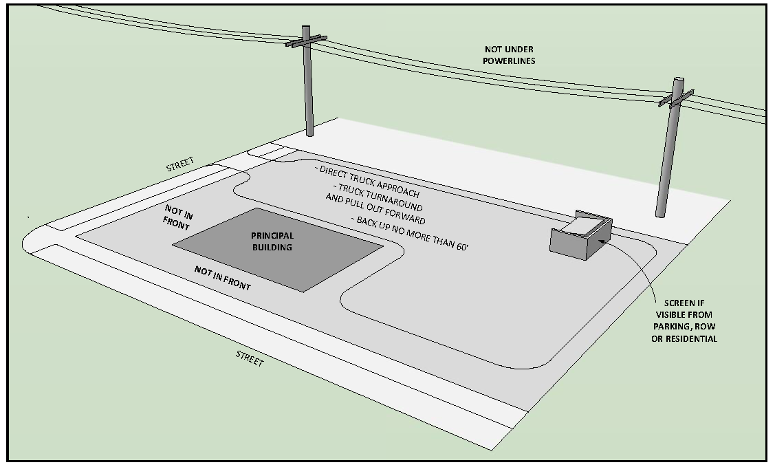
4.10.3
VISIBILITY AND SCREENING STANDARDS
a.
Solid waste collection bins shall be screened from view from the right-of-way of any public or private named street, and from any adjacent residentially zoned property, as viewed from any point on the property line at a height of five feet above grade. In shopping centers, office complexes, business parks and other multi-building sites, solid waste collection bins shall be screened from view from public areas of the site including parking lots, walkways, driveways, etc., to which the public normally has access.
b.
Solid waste collection bins may be screened from view by principal or accessory structures; perimeter fences, walls or hedges; or by bin enclosures.
c.
Where needed to screen solid waste collection bins from view, bin enclosures shall be constructed of durable, opaque materials that are compatible with the design, color and materials of the principal structures as determined by the city during site plan review. Where needed to screen solid waste collection bins from view, bin enclosures shall include gates of durable, opaque materials. Bin enclosures located in historic districts shall comply with the design review guidelines for historic districts.
d.
Chain-link fencing with woven opaque slats shall be acceptable as a bin enclosure material only where the enclosure also incorporates a hedge or other view-blocking vegetation on the outside as determined by the city during site plan review.
e.
Bin enclosures shall be maintained in good condition and appearance at all times. If needed for proper screening, bin enclosure gates shall remain closed except to access the solid waste collection bin and shall be maintained in operable condition.
4.11 - VEHICLE USE AREAS
4.11.1
INTENT
It is the intent of this section to provide minimum standards for the off-street parking, display, storage and maneuvering of vehicles, to provide for adequate loading space, to ensure the safe movement of traffic on the public streets, and to mitigate the potential adverse impacts of traffic and parking congestion on adjacent land uses and the human and natural environment.
4.11.2
APPLICABILITY
The vehicle use area requirements of this section shall apply throughout the city. Development within that portion of Downtown described in Figure 4.11-1 shall be exempt from providing off-street parking, however, where such parking is provided, it shall conform to the design and dimensional standards of this section. Prior to issuance of any building or construction permit, all required off-street parking spaces and loading space requirements shall be provided for on the required parking plan. Unless otherwise provided in this section, the total off-street parking and loading space requirement shall be the sum of the requirements for all uses on the same lot or parcel.
Figure 4.11-1 Parking Exempt Area
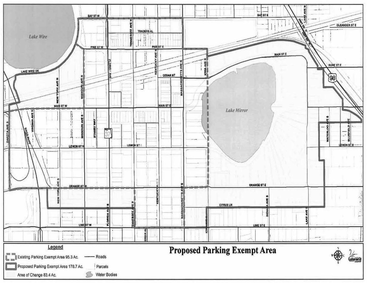
4.11.2.1
Establishment of New Use
a.
When a specified new use is established within a new structure or existing structure, whether in place of or in addition to existing uses, off-street parking and loading space shall be provided in accordance with this section.
b.
When an unspecified new use is established within a new structure or existing structure, whether in place of or in addition to existing uses, off-street parking and loading space shall be provided in accordance with the highest requirements applicable to any use permitted in the zoning district in which the new structure is to be located, as set forth in Table 4.11-1.
4.11.2.2
Expansion of Existing Use or Change of Use
When there is an expansion of an existing use or a change of use resulting in an increase in required off-street parking and/or loading space in excess of 125 percent of the overall requirement for the current use, such additional space shall be provided in accordance with the provisions of this section. Otherwise, additional off-street parking and/or loading space shall not be required.
(Ord. No. 5455, 07-21-14; Ord. No. 5898, Att. C, 10-18-21)
4.11.3
DEFINITIONS
Unless the context clearly indicates a different meaning, for the purposes of this section, the following words and terms shall be defined as follows:
Bicycle Parking Facility: A device such as a rack or locker where bicycles can be parked and secured.
Employee: Employee shall mean the total number of employees present on the site at any one time.
Gross Floor Area (GFA): Gross Floor Area (GFA) shall mean the sum of the gross horizontal areas of the several floors of a building measured from the exterior face of exterior walls, or from the centerline of a wall separating two buildings, but not including interior parking spaces, loading space for motor vehicles, or any space where the floor-to-ceiling height is less than six feet.
Off-Street Parking: An area, space or facility for the temporary off-street keeping of motor vehicles of occupants, employees, patrons, students or visitors of the use or uses served.
Person-Capacity: Person-capacity shall mean the capacity of a use to accommodate one person, based on the maximum design capacity of the use.
For public assembly uses utilizing fixed seats, one unit shall mean one patron seat.
For public assembly uses utilizing temporary seating arrangements, one unit shall mean 20 square feet of the floor area utilized for temporary seating.
For uses involving public assembly for the purpose of dancing, one unit shall mean 50 square feet of dance floor area.
Seat: For public assembly uses, seat shall mean either one fixed seat or each 24 lineal inches of benches, pews or other similar seating arrangements.
4.11.4
VEHICLE USE AREA STANDARDS
4.11.4.1
Required Off-Street Parking Spaces
a.
The minimum number of off-street parking spaces to be provided shall be as set forth in Table 4.11-1. The maximum number of off-street parking spaces allowed shall be the minimum number plus 10 percent. A modification to these requirements may be considered by the Director of Community Development pursuant to Sub-Section 4.11.5.
b.
The minimum number of handicapped/accessible parking spaces shall be as set forth in the applicable building codes.
c.
When the calculation of the number of required parking spaces results in a fractional number, any fraction over one-half shall be counted as one whole space.
d.
Existing parking facilities which provide required parking shall not be reduced in capacity to an amount less than hereinafter required for a similar new building or use.
e.
Existing parking facilities which provide required parking shall not be changed to any other use unless and until equal facilities are provided according to the provisions of this section.
(Ord. No. 5455, 07-21-14)
(Ord. No. 5721, 06-18-18)
4.11.4.2
Use and Location of Off-Street Parking Spaces
a.
Off-street parking spaces required by this section shall be used solely for the purpose of parking by occupants, employees, patrons, students or visitors in connection with the use or uses served and shall be limited to motor vehicles. Use of required parking spaces for placement of motor vehicles for purposes of display, sale, repair or storage is prohibited. Use of required parking spaces for the display or storage of merchandise is prohibited.
b.
No off-street parking space shall exist or encroach upon any street right-of-way nor shall any part of any vehicle overhang the right-of-way of any public street, road, highway, alley or walkway.
c.
For uses not specifically mentioned, the off-street parking space requirements for a use which is so mentioned and similar in character to the use not listed shall apply.
d.
Residential
1.
Required off-street parking spaces for single-family and two-family residential uses shall consist of a parking lot, driveway, garage, carport or combination thereof, and shall be located on the same lot or parcel as the building they are intended to serve.
2.
Required off-street parking facilities serving multi-family residential uses of three or more dwelling units shall be located on the same lot or parcel as the residential uses served. Tandem parking is permitted where parking is reserved and both tandem spaces are assigned to the same dwelling unit.
e.
Non-Residential
Required off-street parking spaces for non-residential uses shall be located on the same lot or parcel as the use or structure to be served, or may be located on a separate lot or parcel provided that the property upon which the required parking is to be located meets the following criteria:
1.
Is within 600 feet of the primary entrance of the structure to be served, as measured by the shortest route of pedestrian travel which does not cross an arterial street.
2.
Is located in either a commercial or industrial zoning district, or is approved for accessory parking as a conditional use.
3.
Is owned by the same person as the property upon which the principal use is located, jointly owned with another person, or is under unified control which will ensure its continued use for required parking, as evidenced by city-approved agreements, contracts, covenants, deed restrictions, sureties or other instruments. If a written agreement securing the required number of parking spaces is not provided, then the use and occupancy of the premises shall cease until the parking requirements of these regulations are satisfied.
4.11.4.3
Use and Location of Truck Parking, Vehicle Display and Vehicle Storage Areas
a.
Where permitted in accordance with the applicable zoning district, vehicle use areas may contain separate areas for truck parking, vehicle display and/or vehicle storage areas in addition to the required off-street parking area. Such areas shall be located on the same lot or parcel as the building they are intended to serve.
b.
Every company or government car, truck, tractor and trailer legally and normally kept or parked on the site shall be provided with a space in an area reserved for that purpose, in addition to the off-street parking spaces required for the use.
4.11.4.4
Parking Plan Required
A parking plan shall be submitted as part of the permit application for construction of any new off-street parking facility or expansion of any existing off-street parking facility. For uses to which site plan review requirements apply, the parking plan shall be submitted as part of the site plan.
4.11.4.5
Vehicle Use Area Design and Construction Standards
Vehicle use area design and construction standards set forth in this section shall apply to vehicle use areas for non-residential uses and multi-family residential uses.
a.
Vehicle use areas shall be designed in accordance with the minimum dimensional standards as set forth in Figure 4.11-3. Each required off-street parking space and truck parking space shall be a clearly designated and marked stall for one vehicle. Unpaved parking facilities may use wheelstops to demarcate individual parking spaces.
b.
Curbing or wheelstops shall be used to control vehicle overhang in accordance with Figure 4.11-2. Vehicles shall not overhang sidewalks. Minimum landscape planter widths are exclusive of vehicle overhang. Where vehicles are allowed to overhang planters, a minimum of one foot shall be added to the width of the planter. A minimum of 2 feet shall be added to the width of the planter where vehicles overhang both sides of a planter median.
Figure 4.11-2 Curb-Wheelstop Location
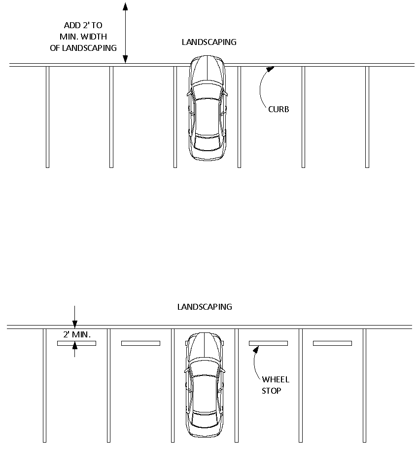
c.
Handicapped/accessible parking spaces shall be designed and marked in accordance with the applicable building codes.
d.
Driveways shall conform to those sections of the latest Engineering Standards Manual pertaining to driveways. Private streets shall conform to those sections of the latest Engineering Standards Manual pertaining to streets.
e.
Vehicle use areas shall ensure that adequate fire lane access is provided.
f.
Vehicle use areas shall ensure that parking stalls, aisles, layout, ingress/egress, and other design features are functional and that maneuvering can be accomplished in a safe manner.
g.
Setback Requirements
The minimum setback for off-street vehicle use areas in the front and street side yard shall be five feet.
h.
Access Requirements
All off-street vehicle use areas shall have direct access to a public right-of-way or be linked to a public right-of-way by private streets, driveways or permanent easements which provide a suitable means of vehicular access.
i.
Maneuvering Space Requirements
1.
Maneuvering space and access aisles shall be provided for all parking areas, except those serving single-family or two-family dwellings. Maneuvering space and access aisles shall be sufficient to ensure that motor vehicles are not required to back into or maneuver within the street right-of-way when entering or leaving a parking space. No parking stall shall be so located as to require a vehicle to back up more than 40 feet in order to vacate the stall.
2.
Alleys may be used as maneuvering space for off-street parking areas where space is constrained. When 90-degree parking is directly off of an alley, an apron shall be provided such that the combined width of the alley and apron provide a minimum of 23 feet of maneuvering space. When an alley serves a parking garage, the garage door that faces the alley shall be set back a minimum of five feet from the lot line abutting the alley.
j.
Landscaping and Buffering
Vehicle use areas shall be landscaped and buffered in accordance with Section 4.5 (Landscaping, Trees and Buffering).
k.
Surface Maintenance and Drainage Requirements
Vehicle use areas shall be surfaced and maintained to provide a durable, dust-free surface and shall provide adequate drainage facilities for disposal of all collected surface water. The use of floatable materials such as wood chips and shredded rubber as surfacing material is prohibited.
l.
Lighting Requirements
All off-street parking facilities as a principal use or accessory to commercial uses shall be lighted after dark throughout the hours during which such facilities are to be used by the public in accordance with Section 4.7 (Outdoor Lighting).
Figure 4.11-3 Minimum Parking Dimensions (Nonparallel)
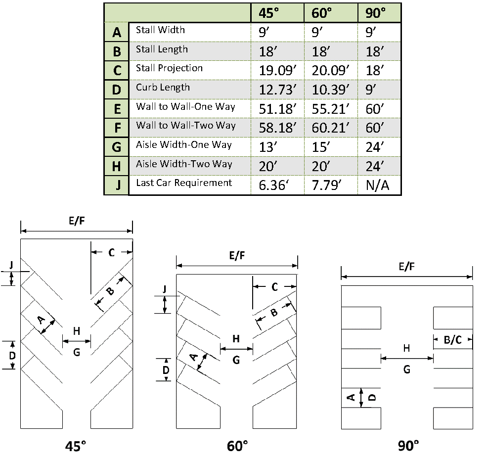
Figure 4.11-4 Minimum Parking Dimensions (Parallel)
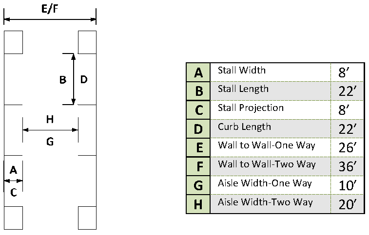
* Where abutting a wall, fence, support column or other vertical structure which would obstruct access to the vehicle, the minimum stall width shall be increased by two feet.
4.11.4.6
Vehicle Use Area Design & Construction Standards for Single-Family and Two-Family Residential Uses
It is the intent of this section to adopt standards for the design and construction of off-street parking for single-family and two-family residential uses to minimize visual impacts on building frontages/streetscapes; impacts to pedestrians; and impacts on adjacent property owners. The standards set forth in this section shall only apply to parking located within the front or street side yards of any property zoned or developed for either single-family or two-family residential uses.
a.
In accordance with Table 4.11-1, parking shall be provided at the ratio of two spaces/dwelling unit. All parking shall be located on the same lot or parcel as the residential use and within either the actual driveway itself, an accessory parking pad, under a carport or within an enclosed garage. Driveways shall terminate only in in front of a garage, within a carport, or within the interior side yard of the principal structure on the lot or parcel.
b.
Driveway Dimensions: The minimum and maximum dimensions shall be as specified below:
1.
Standard Driveways: For properties located within a designated historic district, the minimum width for standard driveways shall be eight (8) feet and the maximum width ten (10) feet. For all other areas, the minimum driveway width shall be ten (10) feet and the maximum width twenty-four (24) feet.
2.
Ribbon Driveways: Minimum width seven (7) feet, from outer edge to outer edge, and a maximum width of ten (10) feet. Minimum width for vehicle tire tracks: two (2) feet.
3.
Circular Driveways: Minimum width ten (10) feet and a maximum width of fourteen (14) feet. Minimum lot frontage of seventy-five (75) feet.
4.
To accommodate vehicle turning movements into and from a property, driveway aprons may exceed the maximum driveway widths specified above, up to a maximum of three (3) feet on either side of the driveway.
5.
Minimum Driveway Length and Setbacks: All driveway and/or parking pads shall extend for a minimum distance of 20 feet on the property, not including any portion of the driveway located within the right-of-way which serves as a connection to an adjacent street or alley. To account for the driveway apron flare, the portion of the driveway located within any right-of-way shall be setback a minimum distance of three (3) feet from any side lot line.
6.
If the minimum amount of parking required will be accommodated through tandem parking in a single-car driveway, the driveway shall extend for a minimum distance of forty (40) feet.
c.
Surface Materials: Residential driveways and parking areas shall be constructed of asphalt, concrete, brick or ornamental pavers, crushed stone, rock, gravel or other similar materials and shall be maintained as a durable, dust free surface at all times. The use of crushed shell and other floatable materials such as wood chips, mulch or shredded rubber shall be prohibited.
d.
Curb Cuts: There shall be no more than one (1) driveway apron/curb cut, per lot or parcel, with the exception of circular driveways, driveways serving two-family dwellings constructed in a side-by-side configuration, and properties with access to an improved alley.
e.
Accessory Parking Pads: Within front and street side yards, a parking pad up to ten (10) feet in width may be constructed accessory to a legal, conforming driveway provided that the pad is located entirely within the property boundaries.
f.
Side Loaded Garages: Driveways serving side loaded garages shall provide a minimum of twenty-four feet (24) feet of maneuvering space for vehicle turning movements.
g.
Garage Conversions: Conversion of existing garages to other uses shall not be permitted if such a conversion reduces the amount of off-street parking available below the minimum amount required for all uses on the property.
h.
Non-Conformities: Non-conforming driveways and off-street parking areas constructed prior to the effective date of these standards shall be deemed legal, non-conforming structures and may be maintained and repaired provided that the extent or size of the nonconformity is not increased or intensified. Upon construction of a new single-family or two-family home, such driveways and parking areas shall be brought into conformance.
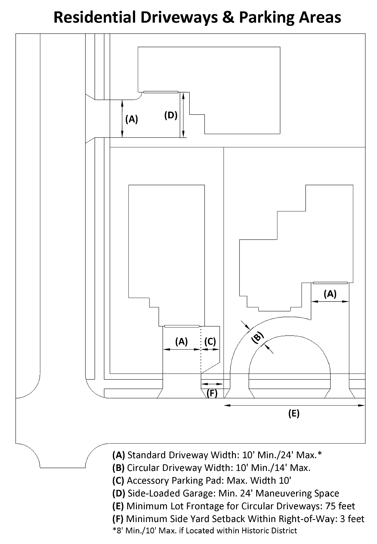
(Ord. No. 5793, § 1.2(Atts. A, B), 11-18-19
4.11.5
ADMINISTRATIVE MODIFICATIONS
4.11.5.1
General Procedures
a.
The purpose of this section is to provide flexibility in modifying the minimum required and the maximum allowed number of off-street parking spaces of Sub-Section 4.11.4.1 through a number of parking options which may be approved through an administrative modification.
b.
An administrative modification to Sub-Section 4.11.4.1 that utilizes one or more of the Parking Options listed below may be approved by the Director of Community Development or his designee after consultation with the Public Works Department.
c.
Applications seeking to modify the required number of parking spaces shall be made in writing to the Director of Community Development and shall:
1.
Demonstrate that a particular use or situation, such as physical site constraints, is unusual or unique to the extent that it poses practical difficulty in complying with the required number of off-street spaces; and
2.
Include technical justification in the form of an independent parking analysis or alternative standards published by a recognized professional organization such as the American Planning Association (APA), the Urban Land Institute (ULI) and/or the Institute of Traffic Engineers (ITE).
(Ord. No. 5455, 07-21-14)
4.11.5.2
Parking Options
a.
Alternative Design
Parking quantities above the maximum allowed under Sub-Section 4.11.4.1 may be considered for projects which document a demonstrated need and incorporate alternative design techniques to minimize impervious surface areas within the project. Such techniques may include, but are not limited to, the use of pervious pavers for perimeter and/or overflow parking, the use of bioswales and the creation of site amenities such as additional green space areas.
b.
Parking Offsets (Reductions)
1.
Tree Protection Offset
The required number of off-street parking spaces may be reduced by up to 20 percent if that area which would normally be required for parking is used for the protection of existing trees or for landscaping in addition to the minimum required by Section 4.5 (Landscaping, Trees and Buffering).
2.
Transit Offset
The required number of off-street parking spaces may be reduced up to a maximum of 10 percent for non-residential or multi-family projects that are located along a fixed transit route operated by either the Lakeland Area Mass Transit District (LAMTD) or the Polk County Transit Authority. The route on which the project is located must provide service at headways, or frequency, of sixty minutes or less and must have a designated transit stop located within 1,320 feet (¼ mile) of a project's boundaries.
3.
Cumulative Parking Offsets
In no case shall the reduction of required off-street parking spaces by offsets be greater than 20 percent. This includes any credit against minimum off-street parking requirements that may be granted through the provision of bicycle parking facilities in accordance with Sub-Section 4.11.6.
c.
Tandem Parking
Tandem parking may be allowed for existing commercial buildings or existing buildings which undergo a change in use (e.g., residential to commercial). Tandem parking shall be defined as the arrangement of not more than two parking spaces in depth, wherein one space is located directly in front of another space, so that one vehicle must be moved before the other can be accessed. The use of tandem spaces shall be subject to the following:
1.
Tandem spaces shall be reserved for employee parking and shall be identified and designated as such through the use of signage and/or pavement markings.
2.
No more than 25 percent of the required parking spaces may be tandem spaces.
d.
Joint Use Facilities and Shared Parking
The total parking space requirement for individual uses or structures may be reduced by the Director of Community Development through joint/shared parking facilities which serve two or more uses or structures, subject to the following conditions:
1.
The minimum number of off-street parking spaces shall be calculated using a professionally accepted methodology that is based upon parking demands for individual uses occurring at different times. Such methodologies may include those published by the professional organizations cited in Sub-Section 4.11.5.1.c.2.
2.
Not more than 50 percent of the off-street parking spaces required for theaters, churches, bowling alleys, dance halls, and establishments for the sale and consumption of alcoholic beverages, food or refreshments shall be supplied by off-street parking spaces required by other uses or structures.
3.
A copy of the agreement between joint users shall be filed with the required parking plan and recorded with the Clerk of the Circuit Court for Polk County. The agreement shall include a guarantee for continued use of the parking facility by each party. Any violation of such an agreement shall be a violation of this code.
4.
The required off-street parking for a particular use may be reduced by its proportionate share of any publicly-owned parking area for which it has been specially allocated.
e.
On-Street Parking within Adjacent Rights-of-Way
To encourage urban density and a more compact, pedestrian oriented development pattern, on-street parking located along a development site's frontage, directly abutting lot or parcel boundaries, may be utilized and count towards the minimum parking required when the following conditions are met:
1.
The development site is zoned for multi-family residential, office or commercial uses and located within an urban context sub-district.
2.
Ample room is available within the right-of-way to accommodate on-street parking without having a negative impact on traffic circulation and pedestrian facilities.
3.
All costs associated with the construction of new parking spaces within rights-of-way shall be borne by the applicant, including the relocation of any existing sidewalks or utilities, as deemed necessary at the time of site plan review.
4.
On-street parking located on the opposite of the street from a development site may not be used towards fulfilling the minimum parking requirement, except when a determination is made by the Director of Community Development that the adjacent lot or parcel is open space or otherwise undevelopable land that does not generate parking demand.
5.
Parallel parking shall be the preferred configuration for the design of on-street spaces. Alternative designs may be considered if determined to be more appropriate by the Director of Community Development given traffic circulation patterns or the mix of adjacent land uses.
6.
All parking spaces created within rights-of-way shall be freely available for public use, subject only to regulation by the Public Works Department's Parking Division. The restriction of on-street parking spaces for the benefit of individual property owners, tenants or customers shall be prohibited.
(Ord. No. 5455, 07-21-14; Ord. No. 5721, 06-18-18)
4.11.6
BICYCLE PARKING REGULATIONS
4.11.6.1
Applicability
a.
Bicycle parking facilities shall be required for each new or redeveloped non-residential or multi-family principal building requiring 10 or more off-street motor vehicle parking spaces when such building is located:
1.
In any Activity Center as identified on the Future Land Use Map;
2.
In the Central City Transit Supportive Area or on a Transit Oriented Corridor as defined in the Comprehensive Plan;
3.
On any current or proposed public transit route as identified in the Transportation Development Plan;
4.
On any corridors identified in the Pathways Plan or Lake-to-Lake Greenway Connector Network as defined in the Comprehensive Plan;
5.
In any individual or unified development complex having or expected to have more than 50 employees on site at any one time;
6.
In the following public or quasi-public facilities: Schools; colleges, junior colleges, universities, seminaries; hospitals; museums; recreation facilities including parks; and community buildings.
b.
Principal buildings listed above that are located within the area exempt from off-street motor vehicle parking requirements in accordance with Figure 4.11-1 shall provide bicycle parking notwithstanding that exemption. The amount of bicycle parking shall be in accordance with Sub-Section 4.11.6.3 as applicable and shall be based upon the amount of off-street motor vehicle parking that would otherwise be required if the motor vehicle parking exemption were not in effect. The renovation of existing buildings in the Central Business District shall be exempt from the bicycle parking requirements.
c.
The following uses shall be exempt from bicycle parking requirements: Residential for the elderly; houses of worship.
(Ord. No. 5455, 07-21-14)
4.11.6.2
Minimum Number of Bicycle Parking Spaces Required:
a.
Two bicycle parking spaces for the first 10 required off-street motor vehicle parking spaces.
b.
Two additional bicycle parking spaces for each additional 20 required off-street motor vehicle parking spaces or fraction thereof.
c.
In no case shall more than 32 bicycle parking spaces be required.
d.
Where 32 bicycle parking spaces are required, 10 of these spaces shall be covered spaces for long-term bicycle parking. Covered spaces may include racks under roof or lockers that protect bicycles from the elements.
e.
Where space within a building is dedicated to and available for the parking of bicycles, credit shall be given against the bicycle parking requirements on a one to one basis. To receive credit, such interior bicycle parking shall be noted on the site plan.
4.11.6.3
Bicycle Parking Facility Design Standards
a.
Bicycle racks shall support the bicycle frame at two points, not just the wheel; shall allow both the frame and one wheel to be locked to the rack; and shall accommodate bicycles of all types and frame sizes. Facilities that support the bicycle only at the wheel are not acceptable.
b.
Bicycle lockers shall be lockable and shall provide a secure enclosure around the bicycle.
c.
Bicycle parking facilities shall be permanently affixed to a hard surface such as concrete, asphalt, or pavers.
d.
It is the intent of this section to locate bicycle parking facilities on the project site where they will best encourage the use of bicycles for transportation. Bicycle racks shall be visible from and located no more than 40 feet from the primary entrance. The Director of Community Development or his designee shall have the authority to identify alternative locations during site plan review.
e.
Bicycle parking facilities shall be located outside of the public right-of-way except where public bicycle parking is provided by a governmental entity.
f.
Bicycle parking facilities shall not impede ingress or egress to any building or project site and shall not be placed in the functional area of a sidewalk or where it interferes with any fire hydrant, parking meter, bus stop, loading zone, sidewalk ramp, wheelchair ramp, or similar public facility.
g.
Bicycle parking facilities shall be identified using signage and/or pavement markings.
(Ord. No. 5721, 06-18-18)
4.11.6.4
Credit Against Minimum Off-Street Parking Requirements
For non-residential or multi-family principal buildings located anywhere in the city, the minimum number of motor vehicle parking spaces required by Sub-Section 4.11.4.1 may be reduced at the rate of one motor vehicle space per two bicycle parking spaces provided, whether or not such bicycle parking spaces are required, to a maximum of 10 percent of the required motor vehicle parking spaces.
(Ord. No. 5455, 07-21-14)
4.11.6.5
Administrative Waivers
a.
The Director of Community Development or his designee shall have the authority to modify the bicycle parking requirements contained in this section, including but not limited to situations in which compliance cannot be met due to physical site constraints. Such modification shall be noted on the site plan.
b.
The Director of Community Development or his designee may recommend to the Zoning Board of Adjustments and Appeals that bicycle parking facilities be provided by any development project that is granted a variance to the minimum number of required off-street motor vehicle parking spaces.
4.11.7
OFF-STREET LOADING SPACE REGULATIONS
4.11.7.1
Applicability
a.
Uses involving the receipt or delivery by vehicles of materials or merchandise shall provide the indicated number of permanent, paved 10' x 25' and 10' x 50' off-street loading spaces. The Director of Community Development may waive or modify the requirements of this section due to physical limitations of the site or if he determines that the particular use has little or no need for deliveries or that public right-of-way or adjacent property provides a safe, legal and available loading space location.
b.
Off-street loading spaces shall be located on the same premises as the use requiring such spaces and shall be accessible to delivery vehicles when all parking spaces are filled. Off-street loading spaces may be open or enclosed.
c.
Off-street loading spaces serving two or more uses or structures on the same zoning lot may be located in a common area, provided that the number of spaces is not less than the sum of the spaces required for each individual use or structure served.
4.11.7.2
Number of Off-Street Loading Spaces Required
a.
Office, public and quasi-public non-commercial, churches, synagogues and other houses of worship, colleges, junior colleges, universities and seminaries, vocational training uses:
b.
Commercial, industrial, warehouse, wholesale trade, communication, utility and essential services uses:
c.
For uses not specifically listed, the off-street loading space requirement shall be that for a use which is so mentioned and similar in character to the use not listed shall apply.
4.12 - VISIBILITY AT INTERSECTIONS
4.12.1
INTENT AND APPLICABILITY
4.12.1.1
Intent
It is the intent of this section to provide minimum standards for visibility at street intersections and the intersections of driveways with streets.
4.12.1.2
Applicability
This section shall apply citywide to non-signalized street intersections and to intersections of non-signalized driveways or alleys with streets, except driveways serving single-family or two-family dwellings.
4.12.2
STANDARDS
No structure, object, fence, wall, hedge, tree, shrub, earth berm, sign, bus bench, newsrack, or portions of same shall be placed, erected, constructed or maintained in such a manner as to materially obstruct the visibility of vehicle operators between the heights of 24 inches and 8½ feet above grade within the following described visibility triangles:
a.
Non-Signalized Intersections:
Beginning where the edges of the pavement of the intersecting streets meet at the corner, or in the case of rounded corners, the point at which they would meet without such rounding, thence 45 feet along one edge of pavement, thence diagonally to a point along the edge of pavement of the intersecting street 45 feet from the point of beginning, thence to the point of beginning. In the case of rounded corners having a radius larger than 45 feet, both legs of the triangle at the edge of pavement shall be equal to the radius. Example: For a corner radius of 55 feet, both legs shall be 55 feet.
b.
Intersection of Non-Signalized Driveways or Alleys with Streets:
Beginning where the edges of the pavement (or stabilized way) of the intersecting driveway or alley and street meet at the corner, or in the case of rounded corners, the point at which they would meet without such rounding, thence 30 feet along the edge of pavement of the driveway or alley, thence diagonally to a point along the edge of pavement of the intersecting street 30 feet from the point of beginning, thence to the point of beginning. In the case of rounded corners having a radius larger than 30 feet, both legs of the triangle at the edge of pavement shall be equal to the radius. Example: For a corner radius of 35 feet, both legs shall be 35 feet.
c.
Exceptions
1.
Up to 24 inches combined diameter of the trunks of required trees or of poles, all having clear spans between 30 inches and eight feet above grade, may be located within the visibility triangle outside of the right-of-way.
2.
Utility poles, street trees, traffic signs, traffic control devices, fire hydrants and similar infrastructure may be located within the visibility triangle in accordance with the traffic engineering standards applicable to the intersection.
3.
Where grade differentials, horizontal curves or other physical characteristics materially affect vehicle operator visibility at a particular intersection, the Director of Public Works may recommend to the Director of Community Development that the visibility triangle be modified, consistent with the intent of this section.
4.12.3
MAINTENANCE
The city shall maintain street trees located within the visibility triangle in accordance with this section. The property owner shall maintain all other landscaping within the visibility triangle in accordance with this section at all times and shall trim all other trees and vegetation accordingly.
Figure 4.12-1 Visibility Triangles (Radius 45' or less)