Lakeland City Zoning Code
ARTICLE 3
- URBAN FORM STANDARDS
3.1 - INTENT AND APPLICABILITY
3.1.1
INTENT
It is the intent of this article to establish minimum urban form standards in order to implement the goals, objectives and policies of the Comprehensive Plan; to create a compact, walkable, energy-efficient, transit-supportive urban form; to encourage a diverse mix of land uses and to ensure a high quality public realm. The elements of urban form include streets, blocks, lots and parcels, buildings and structures and open spaces.
3.1.2
APPLICABILITY
a.
Except as otherwise provided herein, no building, structure, or land located within the city shall hereafter be used or occupied except in conformity with the urban form standards of this article for the context sub-district classification of the property as depicted on the Official Zoning Map.
b.
Applicability of Certain Urban Form Standards
Certain urban form standards set forth in this article are intended for development of undeveloped sites and for substantial alteration or redevelopment of developed sites. They are not intended for minor or incidental expansions or changes to existing development. Therefore, the following urban form standards shall apply only under the circumstances indicated. In the case of a multi-building complex containing more than one principal building, these urban form standards shall apply only to the new, enlarged or renovated principal building.
1.
Maximum Block Face, Maximum Block Perimeter
(a)
Upon the creation of any new block.
(b)
Upon the redevelopment of any existing block in such a way that allows the introduction of new public or private roads to create conforming blocks, as determined by the Director of Community Development.
2.
Maximum Lot Width and Maximum Lot Area
Upon the creation of any new lot or parcel.
3.
Maximum Building Setbacks, Frontage Buildout
Upon the construction of a principal building.
4.
Parking Location
(a)
Upon the construction of a principal building, except where the Director of Community Development shall determine a conforming parking location is not feasible due to physical site constraints or to maintain existing cross access connections.
(b)
Upon the redevelopment of any existing development in such a way that allows the minimum amount of code-required off-street parking to be provided in a conforming location or locations, as determined by the Director of Community Development.
5.
Entrance Feature
(a)
Upon the construction of any principal building.
(b)
Upon enlargement by 50 percent or more of the existing gross floor area of any existing principal building or of the total of all principal buildings in the case of a site legally containing more than one principal building.
(c)
Upon renovation valuing 75 percent or more of the current assessed value of any existing principal building or of the total of all principal buildings in the case of a site legally containing more than one principal building.
6.
Civic Open Space
(a)
Upon the platting of any residential subdivision requiring the provision of civic open space in accordance with Sub-Section 3.4.6.
(b)
Upon the construction of any principal building or project requiring the provision of civic open space in accordance with Sub-Section 3.4.6.
(c)
Upon enlargement by 50 percent or more of the existing gross floor area of any existing building, complex of buildings or project triggering the civic open space requirements.
(d)
Upon renovation valuing 75 percent or more of the current assessed value of any existing building, complex of buildings or project triggering the civic open space requirements.
c.
Applicability With Respect to PUDs and SPI Districts
To the extent that any adopted Planned Unit Development (PUD) or Special Public Interest (SPI) District provides specific development standards or regulations, those development standards or regulations shall prevail. To the extent that any adopted Planned Unit Development or SPI District does not provide such development standards or regulations, the urban form standards set forth in this article shall apply in accordance with the context sub-district that most closely approximates the intent of the PUD or SPI District as the Director of Community Development shall determine.
(Ord. No. 5455, 07-21-14)
3.2 - ESTABLISHMENT OF CONTEXT DISTRICTS
3.2.1
GENERAL
Context Districts and their associated standards describe the general form of the desired built environment and are referred to herein as context districts or contexts. Contexts may be assigned to perpetuate the existing character or pattern of development of an area or to encourage change to a more desirable character or pattern of development. A primary distinction is made between areas that are urban in character and those that are suburban in character. Urban contexts generally exhibit a more fine-grained built environment with higher densities, a more well-connected street pattern, smaller blocks, smaller parcels and shorter setbacks relative to suburban contexts. The urban and suburban areas are classified into Neighborhoods, Centers, Corridors and Special Purpose contexts. There is also one Preservation, Conservation, Recreation context. The contexts are further classified into context sub-districts according to the underlying zoning districts to account for development patterns that were established when the zoning districts governed physical development under previous codes.
3.2.1.1
Context Districts Enumerated
The City of Lakeland is divided into the following context districts and context sub-districts for the purpose of regulating urban form. The context sub-districts coincide with specific underlying zoning districts as indicated by sets of parentheses. For example, SNH (RA-3, RA-4) is a discrete context sub-district to which specific development regulations apply.
(Ord. No. 5522, 07-20-15)
3.2.2
INTENT OF CONTEXT DISTRICTS
3.2.2.1
Urban Neighborhood (UNH) District
The UNH district is intended to describe urban residential areas where people live and which incorporate facilities within walking distance for gathering, going to school, worshiping, shopping for daily needs and recreating. The district is characterized by moderate to high density development, a relatively small block structure, a highly walkable environment and high connectivity. It is oriented toward public spaces such as sidewalks and parks and may contain some civic and small-scale office and commercial uses.
3.2.2.2
Urban Center (UCT) District
The UCT district is intended to describe relatively compact urban areas having land uses that attract a substantial number of people for purposes such as shopping, employment, health care, education, government services, entertainment and civic participation. The district is characterized by moderate to high density development, a mixed and multi-use environment typically consisting of retail, office, civic, and residential uses, a relatively small block structure, a highly walkable environment and high connectivity. It is typically served by urban, high capacity, slow-speed roadways.
3.2.2.3
Urban Corridor (UCO) District
The UCO district is intended to describe linear areas along urban, high capacity, high-speed roadways and having typically retail or office uses with or without above-ground-floor residential uses. The district is characterized by low to moderate density with higher density within Transit Oriented Corridors, a relatively small block structure, a relatively shallow parcel depth, a limited to moderately walkable environment and high connectivity.
3.2.2.4
Urban Special Purpose (USP) District
The USP district is intended to describe generally single-use urban areas that accommodate uses such as business and industrial parks or special facilities such as hospitals and universities and may have supporting retail or service commercial uses. The district is characterized by moderate to high density development, no consistent block structure and a moderate to highly walkable environment.
3.2.2.5
Suburban Neighborhood (SNH) District
The SNH district is intended to describe suburban residential areas composed almost entirely residential uses and characterized by low to moderate density development, a relatively large block structure, a low to moderately walkable environment that requires primarily vehicular mobility and has limited connectivity. The SNH district may transition over time to a more urban form that is more walkable with smaller blocks, greater connectivity, higher density and that incorporates facilities within walking distance for gathering, going to school, worshiping, shopping for daily needs and recreating, particularly within Transit Oriented Corridors.
3.2.2.6
Suburban Center (SCT) District
The SCT district is intended to describe relatively compact suburban areas having land uses that attract a substantial number of people for purposes such as shopping, employment, health care, education, government services, entertainment and civic participation. The district is characterized by low to moderate density development a multi-use environment typically consisting of retail and office uses, a relatively large block structure, a low to moderately walkable environment and limited connectivity. It is typically adjacent to suburban, high capacity, high-speed roadways. The SCTR district may transition over time to a more urban form that is more walkable with smaller blocks, more mixed use and greater connectivity, particularly within Transit Oriented Corridors.
3.2.2.7
Suburban Corridor (SCO) District
The SCO district is intended to describe linear areas along major suburban roadways having typically retail or office uses. The district is characterized by low to moderate density development, a relatively large block structure, a low to moderately walkable environment and limited connectivity. The SCOR district may transition over time to a more urban form that is more walkable with smaller blocks, greater connectivity, more mixed use and higher density, particularly within Transit Oriented Corridors.
3.2.2.8
Suburban Special Purpose (SSP) District
The SSP district is intended to describe generally single-use suburban areas that accommodate uses such as business and industrial parks or special facilities such as hospitals, universities, power plants, freight yards and airports. The district is characterized by low to moderate density development, no consistent block structure, and a typically low walkable environment. It is typically located on periphery of developed areas and oriented toward major transportation facilities.
3.2.2.9
Preservation, Conservation, Recreation (PCR) District
The PCR district is intended to describe areas designated as Preservation, Conservation or Recreation on the Future Land Use Map. These include major wetlands and other areas having environmental constraints where little or no development should occur, and lakeshores and parks where development is limited to park and recreation facilities. Such areas have no consistent block structure, have generally large parcel size or are contained within large parcels and often have meandering boundaries. This district can be mapped in urban and suburban areas.
3.2.3
PROCESS FOR CREATING AND AMENDING CONTEXT DISTRICTS
Only the Community Development Department, the Planning and Zoning Board or the City Commission may initiate proposals for the creation or amendment of context districts. Changes to context districts shall be by the same procedure as for Code amendments generally.
3.3 - STREET TYPES
3.3.1
GENERAL
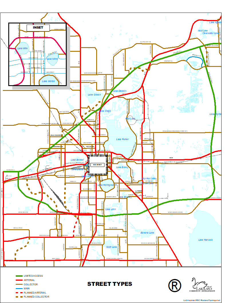
Streets are classified in accordance with roadway typologies adopted as part of the Transportation Element of the Comprehensive Plan. Each type has a different function and provides the framework for a different urban form. Consequently, some urban form standards vary depending on the street type. Development that is required to construct new streets in accordance with the block structure standards of Section 3.4, or otherwise, shall do so in accordance with these standards, except where a variation is specifically authorized as part of a PUD, SPI District or as approved by the Planning and Zoning Board pursuant to Sub-Section 9.7.1.6. All streets and roads shall be constructed in accordance with the City of Lakeland Engineering Standards Manual and Article 9 (Subdivision Standards).
(Ord. No. 5455, 07-21-14)
3.3.1.1
Classification of Street Types
a.
Public and private streets are classified according to the following types. The titles are intended for the regulatory purposes of this Code only and are not synonymous with words or terms used elsewhere to describe the functional classification, maintenance classification or other classification of streets or roadways. Existing and planned street types are illustrated in Figure 3.3-1.
TITLE
Arterial
Collector
Main Street
Local Street
Figure 3.3-1 Street Types
b.
Limited Access Roads
The city also contains high speed limited-access freeways and expressways. These roads are shown on Figure 3.3-1 but do not provide direct access to property or bicycle or pedestrian facilities and are not included among the enumerated street types.
c.
Alleys
The city also contains alleys which are an important means of secondary access to property, especially in urban contexts. Alleys do not provide the primary means of access to property and are therefore not included among the enumerated street types. Alleys may be constructed where appropriate but may not be used to create a required block structure.
3.3.2
INTENT OF STREET TYPES
The intent of each street type is described in Table 3.3-1 according to its essential characteristics. Each type is described as an ideal type and the specific characteristics are desired or typical and are not necessarily present in all cases. Some design variation may occur within the general classification of each street type. Other street types not listed may be approved by the city if the Director of Community Development determines that the alternative street type is appropriate in a particular instance.
Table 3.3-1: Street Type Typical Characteristics
3.3.3
STREET TYPES LIMITED BY CONTEXT
Except where streets of any type are approved in accordance with the adopted roadway improvement plans of the State of Florida, Polk County or the City of Lakeland, new streets within each context shall be limited by type in accordance with Table 3.3-2.
Table 3.3-2: Allowable Street Types by Context
3.3.4
PROCESS FOR CLASSIFICATION OF STREET TYPES
Only the Community Development Department, the Planning and Zoning Board or the City Commission may initiate proposals for the classification or reclassification of street types. Changes to street types shall be by the same procedure as for Code amendments generally.
3.4 - CONTEXT STANDARDS
3.4.1
GENERAL
Tables 3.4-1 through 3.4-13 set forth the minimum standards specific to each context and context sub-district. Sub-Sections 3.4.2 through 3.4.5 describe each standard referenced in the tables, explain how it is measured and provide additional details or criteria regarding how it is applied.
(Ord. No. 5455, 07-21-14)
3.4.2
BLOCK REQUIREMENTS
3.4.2.1
General
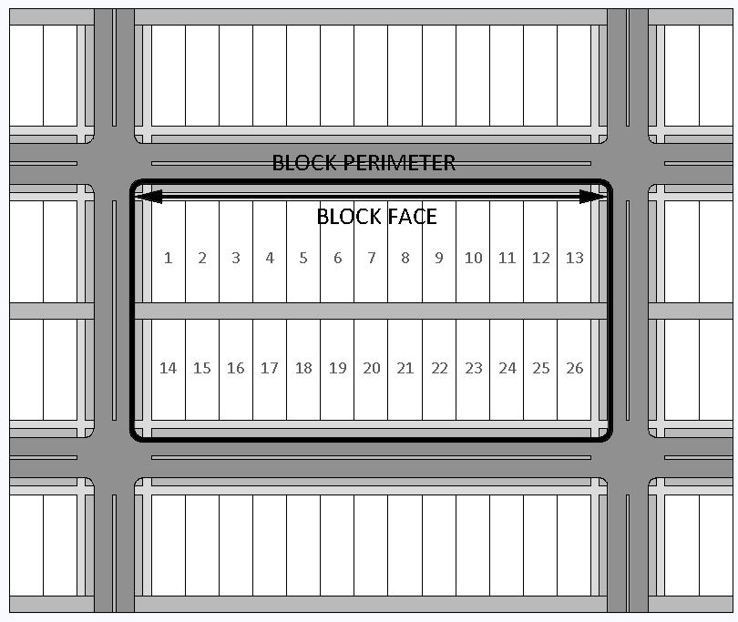
a.
Block Requirements describe minimum standards for the creation of blocks. It is the intent of the Block Requirements to create blocks of walkable scale that form an interconnected network of streets, maximize connectivity, minimize travel distances and provide a framework for the subdivision of land and the placement of buildings. In general, the vacation of existing rights-of-way to create larger blocks is discouraged.
b.
When a development lot or parcel exceeds the maximum block face or maximum block perimeter set forth in Tables 3.4-1 through 3.4-13, the development shall provide public or private streets to form blocks meeting those criteria unless the Director of Community Development makes a determination that the required block structure in a particular instance is contrary to the desired development pattern or that physical site constraints or lack of adjoining streets make the creation of the required block structure impractical.
Figure 3.4-1 Block Face and Block Perimeter
3.4.2.2
Block Formation
a.
Block faces shall be measured from the outer parcel boundaries of lots or parcels comprising the block or along the margins of continuous physical features such as lakes, railroads and canals that may form the face of a block. Block perimeter shall be the sum of all block faces that enclose the block.
b.
Block faces shall be more or less rectilinear unless the continuation of existing streets or physical site constraints provides no practical alternative as determined by the Director of Community Development or unless block alternatives are specifically provided in an approved PUD, SPI District or subdivision plat.
c.
Blocks composed primarily of lakes, wetlands, parks, or Civic Open Space shall have no maximum length, width or perimeter requirements.
d.
Where they do not exist, collector or arterial streets shall be constructed a minimum of every one-quarter mile (1,320 ft.) in urban contexts and every one-half mile (2,640 ft.) in suburban contexts, unless the Director of Community Development makes a determination that such streets are contrary to the desired development pattern of the area or where an adopted street plan calls for a different street pattern.
e.
Where block structure is required interior to unified development parcels, such as within shopping centers and school campuses, streets may be private with no publicly dedicated right-of-way, but the typical cross sections shall otherwise meet the requirements of this section and the Engineering Standards Manual.
f.
Alleys may be constructed interior to blocks but shall not be used to form the perimeter of blocks.
g.
Blocks shall provide for the continuation of and connection to existing streets except where the Director of Community Development makes a determination that such extension is contrary to the desired development pattern or where an adopted street plan calls for a different street pattern.
h.
Street stubouts shall be provided to adjacent undeveloped land except where otherwise indicated in an adopted street plan.
i.
Cul-de-sacs or other street terminations shall be prohibited except where physical barriers such as limited access highways, railroads, canals or wetlands prevent connectivity or where street connections cannot be made to existing development, as determined by the Director of Community Development.
Figure 3.4-2 Block Formation
(Ord. No. 5455, 07-21-14)
3.4.3
BUILDING TYPES
3.4.3.1
General
a.
Building Types describe the types of principal buildings allowed. For purposes of this section, a detached building is a freestanding building, regardless of the number of units it contains, that is not attached to a building located on another lot. An attached building is a building, regardless of the number of units it contains, that is attached to another building located on another lot.
b.
Mobile Homes, Personal Wireless Service Facilities and Utility and Essential Service Facilities are not included and are regulated elsewhere.
(Ord. No. 5582, 05-16-16)
3.4.3.2
Special Building Types
a.
The following special building types are allowed as indicated in the context tables and where the principal use is permitted by right or as a conditional use by the underlying zoning designation, except for within single-family zoning sub-districts as outlined in Sub-Section 3.4.3.2.b. below. Lot and principal building requirements for each special building type are specified in Tables 3.4-10 through 3.4-13.
b.
Within single-family zoning sub-districts, the Cottage (CT) and Zero Lot Line (ZLL) special building types shall only be established subject to the following procedures and in accordance with the lot and principal building requirements specified in Tables 3.4-10 and 3.4-13.
1.
For proposed special building type lots not in designated historic districts, the applicant shall submit to the Planning and Zoning Board a site development plan showing the lot configuration, building placement and orientation, vehicle access and other appropriate site features, and elevations or other architectural drawings showing the proposed exterior treatment. The Board shall make determinations regarding 4.(a) through (e) below.
2.
For proposed special building type lots in designated historic districts, the applicant shall submit to the Planning and Zoning Board a site development plan showing the site layout with respect to the lot configuration, building placement and orientation, vehicle access and other appropriate site features. The Planning and Zoning Board shall make determinations regarding 4.(a) through (d) below. If approved by the Planning and Zoning Board, the applicant shall then apply to the Historic Preservation Board for a Certificate of Review/Appropriateness. The Historic Preservation Board shall make a determination regarding the design of the buildings as specified in 4.(e) below.
3.
The Planning and Zoning Board shall notify the owners of record of properties within 250 feet of the subject property and shall conduct a public hearing on the matter at a regular meeting.
4.
In making its determination, the Board (or Boards) shall find that:
(a)
The proposed lot configuration is compatible with the block and lot configuration of the district and not hazardous or inconvenient to surrounding residents or injurious to the long-range development of the district for residential purposes.
(b)
The special building type does not result in excessive noise, traffic, or parking congestion.
(c)
There is adequate open space provided for both the special building type and the adjacent properties.
(d)
The special building type does not significantly impact the privacy, light, air, or parking of adjacent properties.
(e)
The design of the buildings shall be compatible with that of the residential structures in the same general area or neighborhood. Such a finding shall be based on a consideration of the building mass, height, materials, window arrangement, yards, landscaping and any other pertinent considerations. If located in a historic district, the Historic Preservation Board shall make this determination with specific reference to the design guidelines for the historic district in which the special building type is to be located.
5.
The Planning and Zoning Board may impose any conditions or limitations upon the establishment, location, construction, maintenance or operation of the special building type which in its judgment may reasonably be necessary to prevent the use from being detrimental to other permitted land uses and for the protection of the public interest and welfare. Conditions and requirements stated as part of the approval shall be a continuing obligation of the property owners.
(Ord. No. 5582, 05-16-16)
3.4.4
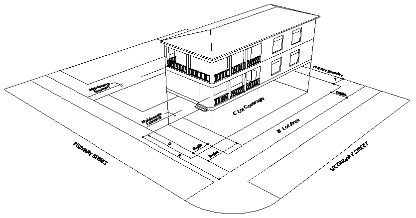
LOT REQUIREMENTS
a.
Lot Width: Describes minimum and maximum lot widths in feet. (See definition in Section 1.6.)
b.
Lot Area: Describes minimum and maximum lot areas in square feet.
c.
Lot Coverage: Describes minimum and maximum collective square footage of all building footprints as a percentage of total lot area. This does not apply to paved areas and is not a measure of impervious surface coverage.
3.4.5
PRINCIPAL BUILDING REQUIREMENTS
a.
Street Setback: Describes minimum and maximum principal building setbacks in feet from the front lot line and from the street side lot line, depending on the street type classification.
1.
Street setbacks vary depending on the classification of the street. See Figure 3.3-1. The primary street shall be the street or streets abutting the front lot line as defined in Section 1.6.
2.
On through lots or other atypical lot configurations, the Director of Community Development shall determine which streets function as primary streets and which function as secondary streets and which yards function as front yards and which function as rear yards and shall apply the appropriate standards based on that determination.
3.
For purposes of this section, limited access highways abutting lots shall not be considered primary or secondary streets. Abutting streets do not necessarily provide access to lots.
4.
For private streets within unified development projects, the setback shall be measured from the nearest edge of the street cross section.
b.
Interior Side Setback: Describes minimum and maximum principal building setbacks in feet from the interior side lot line.
c.
Rear Setback: Describes minimum and maximum principal building setbacks in feet from the rear lot line.
d.
Frontage Buildout: The minimum width for the front elevation of a principal structure, as a percentage of the width of a lot or parcel, that must be located within the front setback range established for a given zoning district.
e.
Building Height: Describes the minimum and maximum building height in feet measured as the vertical distance from finished grade to the highest finished roof surface in the case of flat or mansard roofs, or to the mean height between eaves and ridge in the case of gable, hip or gambrel roofs.
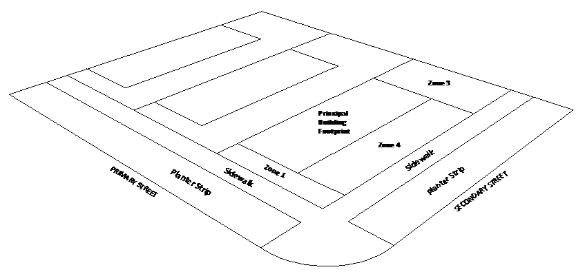
f.
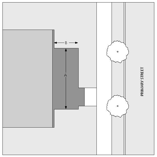
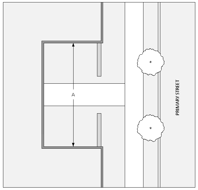
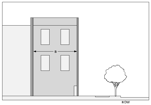
Parking Location: Describes areas where off-street parking spaces may be located with respect to the principal building. This standard does not include enclosed garages and does not regulate the location of driveways. The parking zones are the land areas between the principal building and the:
Zone 1: Right-of-way of the primary street, spanning the entire width of the lot.
Zone 2: Common interior lot line.
Zone 3: Rear lot line, spanning the entire width of the lot.
Zone 4: Right-of-way of any secondary street.
g.
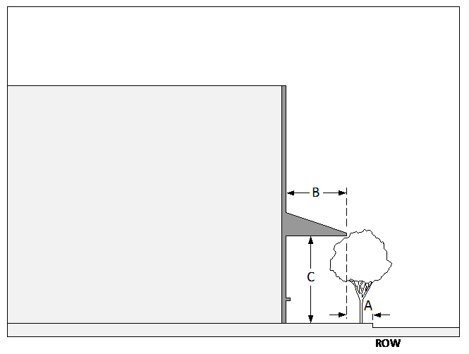
Entrance Feature: Describes the required entrance feature. Where more than one type of entrance feature is listed, any of the listed entrance feature types may be used. Figures 3.4-5 through 3.4-8 set forth the standards for each entrance feature type. The drawings are intended to illustrate typical applications and are not intended to require any particular design or style of architecture. In each case, many different designs are possible.
1.
Entrance features shall include an operable entrance and the associated design elements as set forth herein. Entrances shall provide a clear, obvious, publicly-accessible connection between the primary street (front lot line) and the principal use(s) within the building(s).
2.
For single-family and two-family buildings, the entrance feature shall be located on the primary street or on a corner at the primary street.
3.
For multi-family buildings, the entrance feature shall be located on the primary street, on a corner at the primary street or on any part of a forecourt that is open to the primary street.
4.
For commercial and mixed use buildings, the entrance feature shall be located on the primary street, on a corner at the primary street, or on a side of the building perpendicular to the primary street provided that the entrance feature is within 30 feet of the primary street and there is a direct pedestrian connection between the entrance feature and the primary street.
5.
Entrance Feature Types
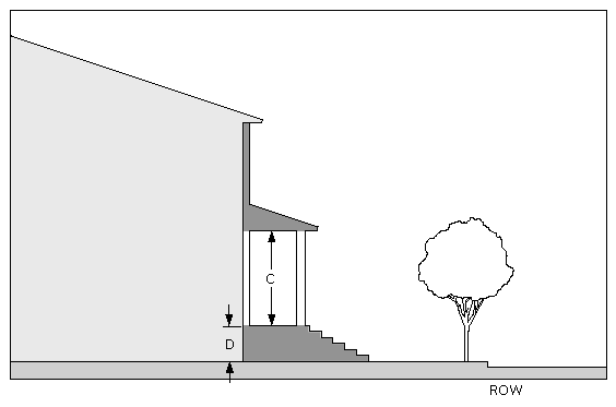
(a)
Stoop
A stoop is an elevated, roofed landing at the building entrance with steps or stairs leading to grade. A walkway extends from the bottom of the steps or stairs to the sidewalk or street. A stoop may be screened but not enclosed by walls or windows on the primary street side.
Figure 3.4-5 Stoop
 | |
 |
(b)
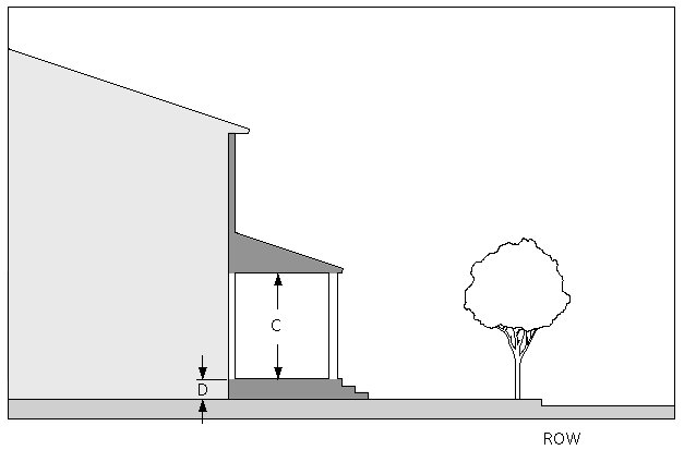
Porch
A porch is an elevated, roofed, open area at the building entrance with steps or stairs leading to grade. A walkway extends from the bottom of the steps or stairs to the sidewalk or street. A porch may be screened but not enclosed by walls or windows on the primary street side.
Figure 3.4-6 Porch
 | |
 |
(c)
Forecourt
A forecourt is an uncovered courtyard formed where a portion of the building façade is recessed or where multiple buildings form a recessed courtyard. A paved walkway extends from the building entrance(s) to the sidewalk or street. A hedge, fence or streetwall may be used to define the private space of the courtyard. The courtyard may be elevated behind a retaining wall with steps leading to sidewalk grade.
Figure 3.4-7 Forecourt
 | |
 |
(d)
Commercial (Shopfront)
A commercial (shopfront) entrance feature is a building entrance at sidewalk grade. If the entrance is not immediately at the sidewalk, a paved walkway extends between the entrance and the sidewalk. The entrance may be overhung by an awning, canopy, gallery or arcade which may extend over the public sidewalk, subject to permitting. The entrance may be recessed into the building. The entrance may be at the corner of the building at an angle to the primary street or on the side of the building, provided that it is within 30 feet of the primary façade and there is a direct pedestrian connection to the primary street.
Figure 3.4-8 Commercial (Shopfront)
(Ord. No. 5455, 07-21-14; Ord. No. 5580, 05-16-16; Ord. No. 5798, § 1.2(Att. A), 11-18-19)
3.4.6
CIVIC OPEN SPACE REQUIREMENTS
3.4.6.1
General
Civic Open Space Requirements describe minimum standards for the creation of civic open space. It is the intent of the Civic Open Space Requirements to provide opportunities for civic activity and recreation, spatially define the urban form, provide aesthetic relief, provide wildlife habitat, reduce stormwater runoff and add value to development.
a.
Civic open space shall be privately maintained unless dedicated to and accepted by the city as a public park or recreation facility, in which case it may be eligible for impact fee credits in accordance with city impact fee ordinances. Required civic open space in public housing developments shall be maintained by the public housing authority.
b.
Civic open space shall be indicated on the site plan or plat as applicable.
c.
Each area of land designated as civic open space shall meet the minimum criteria for a civic open space type in accordance with Sub-Section 3.4.6.2. Such land areas may also be incorporated into larger parks or recreation facilities in accordance with minimum criteria contained in the City of Lakeland Parks, Recreation and Trails Master Plan. More than one type may be provided.
d.
Civic open space that is not dedicated to and accepted by the city for maintenance may be made available to the general public or restricted by covenant to residents of the development or subdivision.
e.
Civic open space shall not include rights-of-way, except where the right-of-way incorporates a multi-use path system meeting the minimum standards for Urban Trails outlined in the City of Lakeland Parks, Recreation and Trails Master Plan.
f.
Civic open space shall not include stormwater management areas unless such areas have been specifically designed and made available for public use.
g.
In calculating the required amount of civic open space for any residential subdivision or multi-family development, credit shall be given on an acre-for-acre basis for existing publicly-maintained parks or recreation facilities located within a quarter mile (1,320 feet) of the development. The quarter mile distance shall be measured by the shortest route of pedestrian travel from any pedestrian access to the subdivision or multi-family development to the nearest pedestrian access to the public park or recreation facility.
h.
For commercial, mixed use and multi-family development projects located within an urban context sub-districts, amenities such as courtyards and roof top terraces may be considered as an alternative to the Civic Open Space Types specified under Sub-Section 3.4.6.3 when ample land is not available.
(Ord. No. 5455, 07-21-14; Ord. No. 5797, § 1.2(Att. A), 11-18-19)
3.4.6.2
Quantity of Civic Open Space Required
a.
Subdivisions containing twenty-five or more single-family or two-family lots or parcels:
1.
25—50 dwelling units: 200 square feet per dwelling unit
2.
Over 50 dwelling units: 100 square feet for each additional dwelling unit over 50
b.
Multi-family development projects containing twenty-five or more dwelling units:
1.
25—50 dwelling units: 150 square feet minimum per dwelling unit
2.
Over 50 dwelling units: 75 square feet minimum for each additional dwelling unit over 50
c.
Except in Industrial zoning districts and except for Utility and Essential Service Facilities, non-residential buildings or building complexes containing more than 50,000 square feet shall provide a minimum of 20 square feet of civic open space per 1,000 square feet of gross floor area.
3.4.6.3
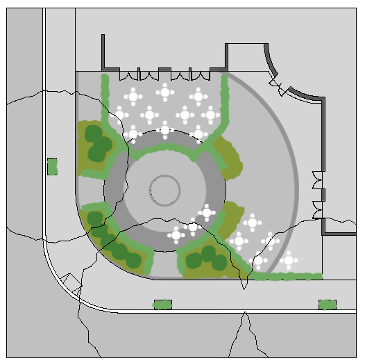
Civic Open Space Types
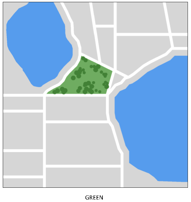
a.
Green
1.
Description and General Criteria: An open, generally free-form area available for civic activities and passive recreation. Its landscape shall consist of lawns, trees and other vegetation naturally disposed.
2.
Contexts where allowed: UCT, UNH, SCT, SNH
3.
Minimum Size: 1/4 acre
Figure 3.4-9 Green
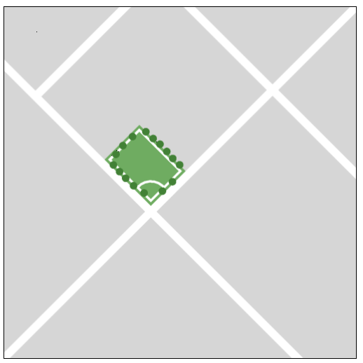
b.
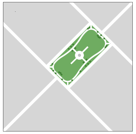
Square
1.
Description and General Criteria: An open, generally rectilinear area available for civic activities and passive recreation and bound by streets or front-facing lots. Its landscape shall consist of lawns, trees and other vegetation formally disposed and may contain hardscaped areas.
2.
Contexts where allowed: UCT, UNH, SCT, SNH
3.
Minimum Size: 1/2 acre
Figure 3.4-10 Square
c.
Plaza
1.
Description and General Criteria: An open area available for public gathering and civic activities and spatially defined by streets and/or buildings. Plazas may be roofed, provided that they are open on at least two sides. Plazas are primarily hardscape but may contain landscaping. In commercial applications, plazas may include space devoted to outdoor dining.
2.
Contexts where allowed: UCT, UCO, UNH, SCT, SCO, USP, SSP
3.
Minimum Size: 1,000 square feet
Figure 3.4-11 Plaza
d.
Mini-Park (aka Tot Lot)
1.
Description and General Criteria: A compact, open area designed for the recreation of children. It may contain playground equipment and may be fenced for security. It shall be located to facilitate access by children by foot and bicycle.
2.
Contexts where allowed: UCT, UNH, SCT, SNH
3.
Minimum Size: 1,500 square feet
Figure 3.4-12 Mini-Park
e.
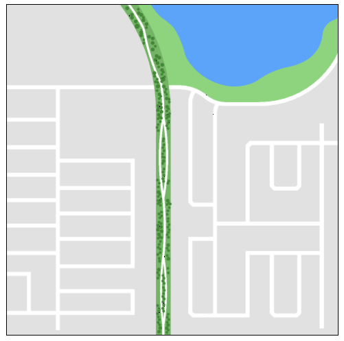
Greenway
1.
Description and General Criteria: A linear, open area designed to accommodate a pedestrian or bicycle trail or to accommodate uses such as fishing, picnicking or nature observation along the margins of a waterbody. It may incorporate trees and other vegetation naturally disposed to serve as wildlife habitat or as a wildlife corridor.
2.
Contexts where allowed: All
3.
Minimum Size: Width 30 feet. Length 100 feet.
Figure 3.4-13 Greenway
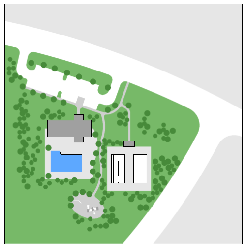
f.
Recreation Center
1.
Description and General Criteria: A special purpose area designed to accommodate facilities for active and passive recreation. Examples of such facilities include but are not limited to clubhouses, swimming pools, tennis courts, basketball courts and playgrounds.
2.
Contexts where allowed: UNH, SNH, subject to zoning restrictions
3.
Minimum Size: 1/2 acre
Figure 3.4-14 Recreation Center
3.4.7
DESIGN STANDARDS FOR PRINCIPAL BUILDINGS
3.4.7.1
Attached Garages Integral to Single-Family and Two-Family Principal Buildings
a.
In the Urban Neighborhood Context (UNH), attached garages shall be limited to no more than 50 percent of the overall width of the front elevation of the principal structure or a maximum width of 36 feet, whichever is less.
b.
In the Suburban Neighborhood Context (UNH), attached garages shall be limited to no more than 60 percent of the overall width of the front elevation of the principal structure or a maximum width of 36 feet, whichever is less.
c.
Maximum Garage Door Height: 8 feet.
3.4.7.2
Screening of Mechanical Equipment
Except for Single-Family and Two-Family buildings, all mechanical equipment at ground level shall be located behind the front façade of the principal structure. Mechanical equipment at ground level that is visible from an adjacent street shall be screened from view by a wall or fence using materials compatible with the architecture of the principal structure. Alternatively, a Type A hedge as defined by Sub-Section 4.5.3 may be used in lieu of a screening wall. Roof-mounted mechanical equipment that is visible from an adjacent street shall be screened from view by elements that are an integral part of the building design.
3.4.7.3
Materials
Except for Single-Family and Two-Family buildings, all street facing building façades shall be architecturally finished with materials such as stucco, brick, stone, finished or decorative cast concrete, decorative concrete masonry, wood or simulated wood (including aluminum or vinyl). Except within the MH, I-2 and I-3 zoning districts, corrugated or structural metal walls, metal sheeting or metal siding shall cover no more than 30 percent of any street-facing facade and no more than 50 percent of the total surface area of the building.
3.4.7.4
Ground Floor Building Transparency
a.
Ground Floor Transparency for Buildings on Properties located within C-1, C-6, and C-7 zoning districts
For street facing building facades, a minimum of fifty percent (50%) of the ground floor façade, when measured between two feet above grade and ten feet above grade at the pedestrian/sidewalk level, shall consist of clear glass windows and doors with a visible transmittance rating of no less than seventy percent (70%).
b.
Ground Floor Transparency for Buildings on Properties located within O-1, O-2, O-3, C-2, C-3, C-4, C-5, and I-1 zoning districts
For street facing building facades, a minimum of forty percent (40%) of the ground floor facade, when measured between two feet above grade and ten feet above grade at the pedestrian/sidewalk level, shall consist of glass windows and doors with a visible transmittance rating of no less than forty percent (40%).
3.4.7.5
Façade Variation of Buildings in Commercial, Office and I-1 Industrial Zoning Districts
Building facades facing streets and customer parking areas with more than 50 spaces shall include fenestration, architectural relief, or both so that no portion of a façade shall have a blank area greater than 24 feet in width measured horizontally along the face of the building.
3.4.7.6
Service and Loading Areas
Within Commercial, Office and I-1 Industrial zoning districts, service and loading dock areas that are visible from an adjacent street or customer parking area with more than 50 spaces, shall be screened by a view blockage wall or fence compatible with the architecture of the principal structure.
3.4.7.7
Drive-Through Facilities
Drive-through customer service facilities such as those for fast food restaurants, dry cleaners and banks shall be located at the rear or interior side of the building.
(Ord. No. 5455, 07-21-14; Ord. No. 5580, 05-16-16; Ord. No. 5800, § 1.2(Att. A), 11-18-19; Ord. No. 5902, § 2(Att. A), 10-18-21)
3.4.8
OTHER STANDARDS
a.
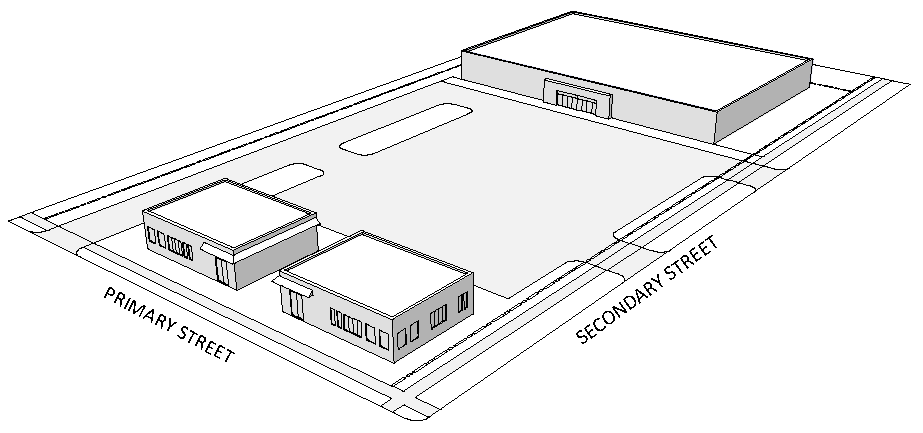
Multiple Principal Buildings on Same Lot or Parcel
Provided that the principal buildings fronting on public or private streets do not exceed the setback maximum and otherwise meet the requirements of this article, additional principal buildings located on the same lot or parcel shall not be subject to maximum setback, frontage buildout, parking location or entrance feature requirements. All buildings shall be subject to Article 4 (General Site Development Standards).
Figure 3.4-16 Multiple Principal Buildings on a Lot
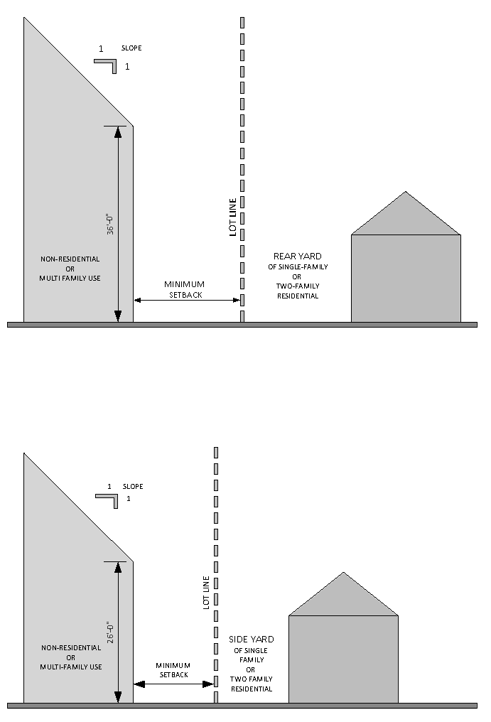
b.
Bulk Plane Limit
1.
Where a building used for non-residential or multi-family uses is adjacent to the rear yard of a lot or parcel zoned RA (Single-Family) or RB (Two-Family), no portion of such building shall extend beyond a bulk plane beginning at 36 feet above grade at the minimum setback line and extending upward one foot for every additional one foot into the site from the minimum setback line.
2.
Where a building used for non-residential or multi-family uses is adjacent to the side yard of a lot or parcel zoned RA (Single-Family) or RB (Two-Family), no portion of such building shall extend beyond a bulk plane beginning at 26 feet above grade at the minimum setback line and extending upward one foot for every additional one foot into the site from the minimum setback line.
c.
Minimum Living Area
Residential dwelling units shall have the minimum gross living areas specified below. In no case shall any individual unit be less than 300 sq. ft.
Single-Family, Attached and Detached .....660 sq. ft.
Multiple-Family .....300 sq. ft.
Two-Family .....660 sq. ft.
Figure 3.4-17 Bulk Plane
(Ord. No. 5455, 07-21-14; Ord. No. 5522, 07-20-15)
3.5 - EXCEPTIONS TO URBAN FORM STANDARDS
3.5.1
PERMITTED PROJECTIONS INTO REQUIRED SETBACKS
Awnings, cornices, eaves, lintels, planter boxes, roof overhangs, bay windows that do not extend to ground level, gutters, belt courses, and other ornamental features that are completely supported by a building may project no more than three feet into any required minimum setback.
3.5.2
HEIGHT EXCEPTIONS
Church steeples and bell towers shall be exempt from the maximum building height requirements. Tanks, decorative features, elevator-lift housing, air conditioning units, television or radio antennas, or other mechanical or functional features may exceed the maximum building height requirement up to a maximum of twenty feet without requiring a variance.
Table 3.4-1 Urban Neighborhood Standards
(Ord. No. 5455, 07-21-14; Ord. No. 5522, 07-20-15; Ord. No. 5582, 05-16-16; Ord. No. 5734, 07-16-18; Ord. No. 5798, § 1.2(Att. A), 11-18-19; Ord. No 6050, § 2(Att. A), 9-16-24)
Table 3.4-2 Urban Corridor Standards
(Ord. No. 5455, 07-21-14; Ord. No. 5522, 07-20-15; Ord. No. 5725, 07-02-18)
Table 3.4-3 Urban Center Standards
(Ord. No. 5455, 07-21-14; Ord. No. 5725, 07-02-18; Ord. No. 5796, § 1.2(Att. A), 11-18-19)
Table 3.4-4 Urban Special Purpose Standards
(Ord. No. 5455, 07-21-14; Ord. No. 5725, 07-02-18)
Table 3.4-5 Suburban Neighborhood Standards
(Ord. No. 5455, 07-21-14; Ord. No. 5582, 05-16-16; Ord. No. 5798, § 1.2(Att. A), 11-18-19; Ord. No 6050, § 2(Att. A), 9-16-24)
Table 3.4-6 Suburban Corridor Standards
(Ord. No. 5455, 07-21-14)
Table 3.4-7 Suburban Center Standards
(Ord. No. 5455, 07-21-14)
Table 3.4-8 Suburban Special Purpose Standards
(Ord. No. 5455, 07-21-14)
Table 3.4-9 Preservation, Conservation, Recreation Development Standards
Table 3.4-10 Special Building Type Standards
Cottage (CT)
Description: A detached single-family dwelling unit on a relatively small lot. The Cottage building type requires three or more contiguous Cottage lots. Within single-family zoning sub-districts, the Cottage (CT) special Building type may only be established subject to the procedures in Sub-Section 3.4.3.2 and in accordance with the lot and principal building requirements specified below.
(Ord. No. 5455, 07-21-14, Ord. No. 5582, 05-16-16)
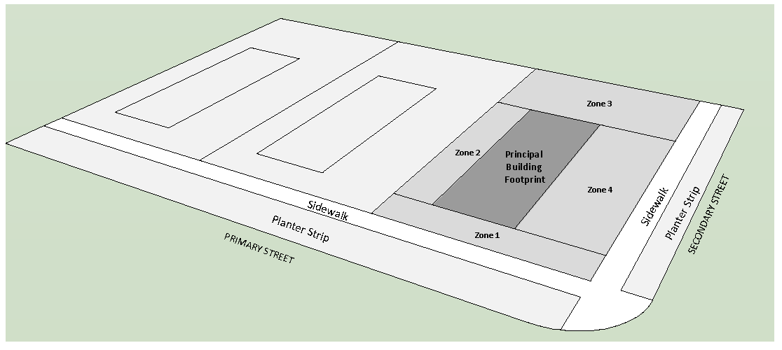
Table 3.4-11 Special Building Type Standards
Single-Family Attached (SFA)
Description: A single-family dwelling unit on its own lot which is attached to another single-family dwelling unit or units located on a separate lot or lots. The Single-Family Attached building type requires two or more contiguous Single-Family Attached lots. This building type is allowed where Single-family, attached uses are permitted as a principal use in a zoning district by right or as a conditional use as indicated in Table 2.3-1 (Permitted Principal Uses).
(Ord. No. 5455, 07-21-14; Ord. No. 5522, 07-20-15, Ord. No. 5582, 05-16-16; Ord. No. 5719, 06-18-18)
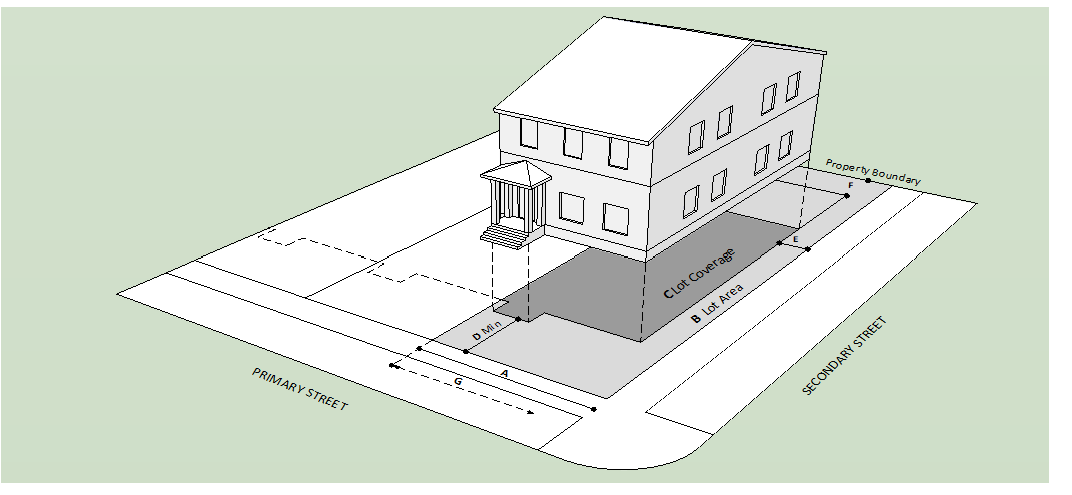
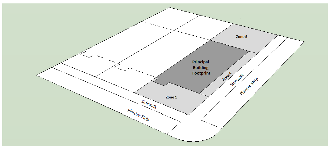
Table 3.4-12 Special Building Type Standards
Small Mixed Use (SMU)
Description: A building containing one or more non-residential uses and which may contain residential dwelling units above the first floor and which is typically but not necessarily attached to another building located on another lot. The Small Mixed Use building type requires three or more contiguous Small Mixed Use lots.
(Ord. No. 5455, 07-21-14)
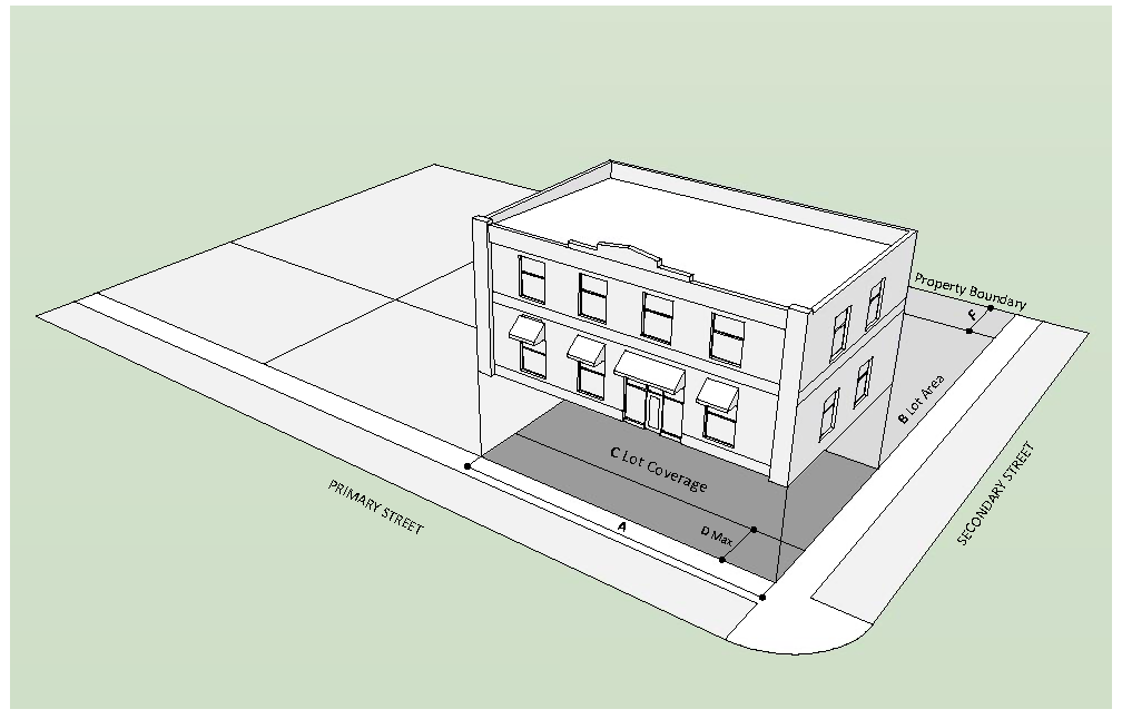
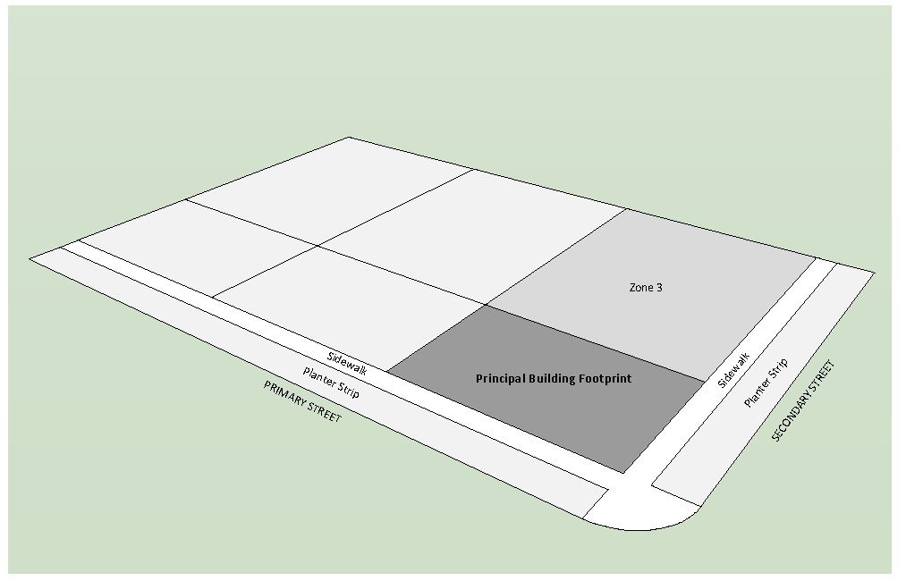
Table 3.4-13 Special Building Type Standards
Zero Lot Line (ZLL)
Description: A single-family detached dwelling with no side yard on one side. The Zero Lot Line building type requires three or more contiguous Zero Lot Line lots. Within single-family zoning sub-districts, the Zero Lot Line (ZLL) special building type may only be established subject to the procedures in Sub-Section 3.4.3.2 and in accordance with the lot and principal building requirements specified below.
(Ord. No. 5455, 07-21-14, Ord. No. 5582, 05-16-16)