
Lakeland City Zoning Code
ARTICLE 6
- NATURAL RESOURCE PROTECTION STANDARDS
6.1 - GENERAL
6.1.1
INTENT
It is the intent of this article to protect, maintain and enhance the health, safety and general welfare of the community by regulating land development activity with the potential of degrading important natural resources. More specifically, it is the purpose of this article to create a clear compilation of regulatory standards which implement the environmental goals, objectives and policies of the Comprehensive Plan.
6.1.2
DEFINITIONS
For the purpose of this article, the following words and terms shall be defined as follows. Where terms are not defined herein and are defined in the Florida Building Code, such terms shall have the meanings ascribed to them in that code. Where terms are not defined in this article or the Florida Building Code, such terms shall have their standard dictionary meaning.
Adverse Impacts: Any direct or indirect effect likely to cause, or actually causing, a decline in the quality, stability, natural function, diversity or aesthetic value of a natural resource.
Alter: To change, rearrange, enlarge, extend or reduce any land or part thereof.
Alteration of a Watercourse: A dam, impoundment, channel relocation, change in channel alignment, channelization, or change in cross-sectional area of the channel or the channel capacity, or any other form of modification which may alter, impede, retard or change the direction and/or velocity of the riverine flow of water during conditions of the base flood.
Aquifer: An underground formation, group of formations, or part of a formation that is permeable enough to transmit, store or yield a quantity of water providing a beneficial use.
ASCE 24: A standard titled Flood-Resistant Design and Construction that is referenced by the Florida Building Code. ASCE 24 is developed and published by the American Society of Civil Engineers, Reston, VA.
Base Flood: The flood having a one percent chance of being equaled or exceeded in any given year. [Also defined in FBC, B, Section 202.] The base flood is commonly referred to as the "100-year flood" or the "1-percent-annual chance flood."
Base Flood Elevation: The elevation of the base flood, including wave height, relative to the National Geodetic Vertical Datum (NGVD), North American Vertical Datum (NAVD) or other datum specified on the Flood Insurance Rate Map (FIRM). [Also defined in FBC, B, Section 202.]
Basement: The portion of a building having its floor subgrade (below ground level) on all sides. [Also defined in FBC, B, Section 202; see "Basement (for flood loads)".]
Biological Inventory: A biological inventory prepared for a defined area of land based upon standard in-field methodologies to derive habitat types, species populations, biological interactions and other associated ecological factors.
Biotechnical Erosion Control Method: Primarily non-structural method of shoreline stabilization which uses native vegetation to stabilize the shoreline substrate.
Buffer Zone: An area, exclusive of land development activity, used to visibly separate one use from another or to shield or block noise, lights or other nuisances.
Contaminant: An undesirable substance not naturally present or an unusually high concentration of a naturally occurring substance in water, soil, or other environmental medium in addition to regulated substances listed in Table 6.7-1.
Cut and Fill: The practice, associated with development, involving the removal of soil or substrate from one area and relocation of that soil to another location for the purpose of land alteration.
Design Flood: The flood associated with the greater of the following two areas: [Also defined in FBC, B, Section 202.]
(1)
Area with a floodplain subject to a 1-percent or greater chance of flooding in any year; or
(2)
Area designated as a flood hazard area on the community's flood hazard map, or otherwise legally designated.
Design Flood Elevation: The elevation of the "design flood," including wave height, relative to the datum specified on the community's legally designated flood hazard map. In areas designated as Zone AO, the design flood elevation shall be the elevation of the highest existing grade of the building's perimeter plus the depth number (in feet) specified on the flood hazard map. In areas designated as Zone AO where the depth number is not specified on the map, the depth number shall be taken as being equal to 2 feet. [Also defined in FBC, B, Section 202.]
Development: Any man-made change to improved or unimproved real estate, including but not limited to, buildings or other structures, tanks, temporary structures, temporary or permanent storage of equipment or materials, mining, dredging, filling, grading, paving, excavations, drilling operations or any other land disturbing activities.
Discharge: The release of stormwater by any means into the environment excluding transpiration, evaporation, or natural percolation into the groundwater.
Encroachment: The placement of fill, excavation, buildings, permanent structures or other development into a flood hazard area which may impede or alter the flow capacity of riverine flood hazard areas.
Existing Building and Existing Structure: Any buildings and structures for which the "start of construction" commenced before September 16, 1981. [Also defined in FBC, B, Section 202.]
Flood or Flooding: A general and temporary condition of partial or complete inundation of normally dry land areas from the overflow of inland or tidal waters or the unusual and rapid accumulation or runoff of surface waters from any source.
Flood Damage-Resistant Materials: Any construction material capable of withstanding direct and prolonged contact with floodwaters without sustaining any damage that requires more than cosmetic repair. [Also defined in FBC, B, Section 202.]
Flood Hazard Area: The greater of the following two areas: [Also defined in FBC, B, Section 202.]
(1)
The area within a floodplain subject to a 1-percent or greater chance of flooding in any year.
(2)
The area designated as a flood hazard area on the community's flood hazard map, or otherwise legally designated.
Flood Insurance Rate Map (FIRM): The official map of the community, on which the Federal Emergency Management Agency has delineated both special flood hazard areas and the risk premium zones applicable to the community.
Flood Insurance Study (FIS): The official report provided by the Federal Emergency Management Agency that contains the Flood Insurance Rate Map, the Flood Boundary and Floodway Map (if applicable), the water surface elevations of the base flood, and supporting technical data. [Also defined in FBC, B, Section 202.]
Floodplain Administrator: The office or position designated and charged with the administration and enforcement of this article (may be referred to as the Floodplain Manager).
Floodplain Development Permit or Approval: An official document or certificate issued by the community, or other evidence of approval or concurrence, which authorizes performance of specific development activities that are located in flood hazard areas and that are determined to be compliant with this article.
Floodway: The channel of a river or other watercourse and the adjacent land areas that must be reserved in order to discharge the base flood without cumulatively increasing the water surface elevation more than one foot.
Floodway Encroachment Analysis: An engineering analysis of the impact that a proposed encroachment into a floodway is expected to have on the floodway boundaries and base flood elevations; the evaluation shall be prepared by a qualified Florida licensed engineer using standard engineering methods and models.
Functionally Dependent Use: A use which cannot perform its intended purpose unless it is located or carried out in close proximity to water, including only docking facilities, port facilities that are necessary for the loading and unloading of cargo or passengers, and ship building and ship repair facilities; the term does not include long-term storage or related manufacturing facilities.
Hazardous Materials/Wastes: Substances or materials which, because of their chemical, physical, or biological nature, pose a potential risk to life, health, or property if they are released. A release may occur by spilling, leaking, emitting toxic vapors, or any other process that enables the material to escape its container, enter the environment, and create a potential hazard. Hazardous materials include, but are not limited to: explosive, flammable, combustible, corrosive, oxidizing, toxic, infectious, poisonous, or radioactive materials that when involved in an accident and released in sufficient quantities put some portion of the general public in immediate danger from exposure, contact, inhalation, or ingestion.
Highest Adjacent Grade: The highest natural elevation of the ground surface prior to construction next to the proposed walls or foundation of a structure.
Historic Structure: Any structure that is determined eligible for the exception to the flood hazard area requirements of the Florida Building Code, Existing Building, Chapter 12 Historic Buildings.
Impervious Surface: Any surface of material that prevents the absorption of water into the underlying soil.
Lake Bottom Construction: The construction, alteration or repair of any shoreline stabilization structure or water access structure.
Land Clearing: The removal of vegetation from any site, parcel or lot, however, land clearing does not include the removal of dead trees or routine mowing, trimming or pruning to maintain vegetation in a healthy, viable condition.
Letter of Map Change (LOMC): An official determination issued by FEMA that amends or revises an effective Flood Insurance Rate Map or Flood Insurance Study. Letters of Map Change include:
(1)
Letter of Map Amendment (LOMA): An amendment based on technical data showing that a property was incorrectly included in a designated special flood hazard area. A LOMA amends the current effective Flood Insurance Rate Map and establishes that a specific property, portion of a property, or structure is not located in a special flood hazard area.
(2)
Letter of Map Revision (LOMR): A revision based on technical data that may show changes to flood zones, flood elevations, special flood hazard area boundaries and floodway delineations, and other planimetric features.
(3)
Letter of Map Revision Based on Fill (LOMR-F): A determination that a structure or parcel of land has been elevated by fill above the base flood elevation and is, therefore, no longer located within the special flood hazard area. In order to qualify for this determination, the fill must have been permitted and placed in accordance with the community's floodplain management regulations.
(4)
Conditional Letter of Map Revision (CLOMR): A formal review and comment as to whether a proposed flood protection project or other project complies with the minimum NFIP requirements for such projects with respect to delineation of special flood hazard areas. A CLOMR does not revise the effective Flood Insurance Rate Map or Flood Insurance Study; upon submission and approval of certified as-built documentation, a Letter of Map Revision may be issued by FEMA to revise the effective FIRM.
Light-Duty Truck: As defined in 40 C.F.R. 86.082-2, any motor vehicle rated at 8,500 pounds Gross Vehicular Weight Rating or less which has a vehicular curb weight of 6,000 pounds or less and which has a basic vehicle frontal area of 45 square feet or less, which is:
(1)
Designed primarily for purposes of transportation of property or is a derivation of such a vehicle; or
(2)
Designed primarily for transportation of persons and has a capacity of more than 12 persons; or
(3)
Available with special features enabling off-street or off-highway operation and use.
Lowest Floor: The lowest floor of the lowest enclosed area of a building or structure, including basement, but excluding any unfinished or flood-resistant enclosure, other than a basement, usable solely for vehicle parking, building access or limited storage provided that such enclosure is not built so as to render the structure in violation of the non-elevation requirements of the Florida Building Code or ASCE 24. [Also defined in FBC, B, Section 202.]
Manufactured Home: A structure, transportable in one or more sections, which is eight (8) feet or more in width and greater than four hundred (400) square feet, and which is built on a permanent, integral chassis and is designed for use with or without a permanent foundation when attached to the required utilities. The term "manufactured home" does not include a "recreational vehicle" or "park trailer." [Also defined in 15C-1.0101, F.A.C.]
Manufactured Home Park or Subdivision: A parcel (or contiguous parcels) of land divided into two or more manufactured home lots for rent or sale.
Market Value: The value of buildings and structures, excluding the land and other improvements on the parcel. Market value is the Actual Cash Value (in-kind replacement cost depreciated for age, wear, tear, and neglect, and quality of construction), or tax assessment value adjusted to approximate market value by a factor provided by the county Property Appraiser.
Natural Resources: Those resources, functions, and forms, concrete or abstract, which are of natural creation or form and which directly or indirectly contribute to the health, safety, general welfare and wellbeing of the community.
New Construction: For the purposes of administration of this article and the flood-resistant construction requirements of the Florida Building Code, structures for which the "start of construction" commenced on or after September 16, 1981 and includes any subsequent improvements to such structures.
Ordinary High Water Line: The ten-year flood elevation for each respective lake as provided through the Flood Insurance Study or historical city records and is ultimately established by the City Public Works Director.
Park Trailer: A transportable unit which has a body width not exceeding fourteen (14) feet and which is built on a single chassis and is designed to provide seasonal or temporary living quarters when connected to utilities necessary for operation of installed fixtures and appliances. [Defined in section 320.01, F.S.]
Physical Protection Devices: Berms, fences, vegetation, water features, or similar physical barriers established for the purpose of protecting habitat or to minimize disturbance to a protected species.
Potable Public Groundwater: All public groundwater supplies meeting the standards of Class II water within Chapter 17, F.A.C. and the drinking water criteria of Health and Rehabilitative Services of the Polk County Health Department.
Protected Species: Animal species listed as endangered, threatened, or of special concern by the Florida Game and Fresh Water Fish Commission in Rules 39-27.003, 39-27.004, 39-27.005, Florida Administrative Code.
Recreational Vehicle: A vehicle, including a park trailer, which is: [see in section 320.01, F.S.)
(1)
Built on a single chassis;
(2)
Four hundred (400) square feet or less when measured at the largest horizontal projection;
(3)
Designed to be self-propelled or permanently towable by a light-duty truck; and
(4)
Designed primarily not for use as a permanent dwelling but as temporary living quarters for recreational, camping, travel, or seasonal use.
Regulated Substance: Any substance listed in Table 6.7-1 that meets or exceeds specified thresholds.
Setback: A minimum distance in which a structure or use can be located in proximity to a physical feature or specific boundary (property line, mean high water line).
Shoreline Stabilization Structure: Any structure or man-made feature whose purpose is to stabilize the shoreline substrate and protect it from erosion. Shoreline stabilization structures include but are not limited to, seawalls, revetments, rip-rap and biotechnical erosion control methods.
Special Flood Hazard Area: An area in the floodplain subject to a 1 percent or greater chance of flooding in any given year. Special flood hazard areas are shown on FIRMs as Zone A, AO, A1-A30, AE, A99, AH, V1-V30, VE or V. [Also defined in FBC, B Section 202.]
Start of Construction: The date of issuance of permits for new construction and substantial improvements, provided the actual start of construction, repair, reconstruction, rehabilitation, addition, placement, or other improvement is within 180 days of the date of the issuance. The actual start of construction means either the first placement of permanent construction of a building (including a manufactured home) on a site, such as the pouring of slab or footings, the installation of piles, the construction of columns.
Permanent construction does not include land preparation (such as clearing, grading, or filling), the installation of streets or walkways, excavation for a basement, footings, piers, or foundations, the erection of temporary forms or the installation of accessory buildings such as garages or sheds not occupied as dwelling units or not part of the main buildings. For a substantial improvement, the actual "start of construction" means the first alteration of any wall, ceiling, floor or other structural part of a building, whether or not that alteration affects the external dimensions of the building. [Also defined in FBC, B Section 202.]
Stormwater Runoff: The total volume of water accumulated over a surface during any form of precipitation resulting in a flowing quantity of water upon a site. Such waters are resistant to percolation into the groundwater due to the saturation of the soil matrix, impervious surface, or the large volume accumulated at the immediate time of occurrence.
Substantial Damage: Damage of any origin sustained by a building or structure whereby the cost of restoring the building or structure to its before-damaged condition would equal or exceed 50 percent of the market value of the building or structure before the damage occurred. The term also includes flood-related damage sustained by a structure on two separate occasions during a 10-year period for which the cost of repairs at the time of each such flood event, on average, equals or exceeds 25 percent of the market value of the structure before the damage occurred.
Substantial Improvement: Any repair, reconstruction, rehabilitation, addition, or other improvement of a building or structure, the cost of which equals or exceeds 50 percent of the market value of the building or structure before the improvement or repair is started. If the structure has incurred "substantial damage," any repairs are considered substantial improvement regardless of the actual repair work performed. The term does not, however, include either: [Also defined in FBC, B, Section 202.]
(1)
Any project for improvement of a building required to correct existing health, sanitary, or safety code violations identified by the building official and that are the minimum necessary to assure safe living conditions.
(2)
Any alteration of a historic structure provided the alteration will not preclude the structure's continued designation as a historic structure.
Surface Waters: Natural or man-altered lands which are submerged during normal hydroperiods. Surface waters include lakes, ponds, rivers, creeks, canals and ditches. The landward extent of surface waters shall be delineated using methods prescribed in Florida Administrative Code Rule Chapter 17-301.
Undisturbed Land: A parcel, lot, or plot of land which has been absent of land use activities for a period exceeding 20 years.
Water Access Structure: Any man-made structure which has as its purpose the facilitation of human or vehicular access to surface waters, including, but not limited to, docks, floating docks, piers, mooring pilings, boat ramps, boathouses and boat lifts.
Watercourse: A river, creek, stream, channel or other topographic feature in, on, through, or over which water flows at least periodically.
Wetlands: All areas within dredge and fill jurisdictions of the Department of Environmental Regulation (pursuant to Section 403, Florida Statutes); the Army Corp of Engineers (pursuant to Section 404, Clean Water Act, Florida Statutes): or the Southwest Florida Water Management District (pursuant to chapter 40D-4, Florida Administrative Code). These may include, but are not limited to, areas; inundated by water periodically through the seasons, characterized by specific vegetation, in the base floodplain or characterized by specific soil types.
(Ord. No. 5560, 01-19-16; Ord. No. 5610, 12-20-16; Ord. No 6056, § 2(Att. A), 9-16-24)
6.1.3
RULES OF INTERPRETATION
For the purpose of the administration and enforcement of these regulations, unless specifically stated otherwise within this text, the following standard rules of interpretation shall apply to the text hereof.
6.1.3.1
Calculating Time Periods
In calculating any period of time prescribed for or allowed by this regulation, the day of the act, event or default from which the designated period of time begins to run, shall not be included. The last day of the period so computed shall be included unless it is a Saturday, Sunday or legal holiday, in which event the period shall run until the end of the next day which is neither a Saturday, Sunday or legal holiday. Where "working days" are specified for a computation, intermediate Saturdays, Sundays and legal holidays, shall be excluded in the computation.
6.1.3.2
Conflict with Standing Regulations
Where this regulation conflicts with or overlaps other standing regulations, whichever imposes the more stringent restrictions or limitations, shall prevail.
6.1.3.3
Interpretation by City Officials
Notwithstanding specified rules of language or definitions, city permitting agents and city regulatory inspectors shall interpret all conditions, provisions, and standards herein, in a reasonable manner to achieve the goals and purposes intended by this regulation.
6.2 - FLOODPLAIN MANAGEMENT
6.2.1
INTENT
The purpose of this section is to establish minimum requirements to safeguard the public health, safety, and general welfare and to minimize public and private losses due to flooding through regulation of development in flood hazard areas to:
a.
Minimize unnecessary disruption of commerce, access and public service during times of flooding;
b.
Require the use of appropriate construction practices in order to prevent or minimize future flood damage;
c.
Manage filling, grading, dredging, mining, paving, excavation, drilling operations, storage of equipment or materials, and other development which may increase flood damage or erosion potential;
d.
Manage the alteration of flood hazard areas, watercourses, and shorelines to minimize the impact of development on the natural and beneficial functions of the floodplain;
e.
Minimize damage to public and private facilities and utilities;
f.
Help maintain a stable tax base by providing for the sound use and development of flood hazard areas;
g.
Minimize the need for future expenditure of public funds for flood control projects and response to and recovery from flood events; and
h.
Meet the requirements of the National Flood Insurance Program for community participation as set forth in the Title 44 Code of Federal Regulations, Section 59.22.
(Ord. No. 5610, 12-20-16)
6.2.2
APPLICABILITY
The provisions of this section shall apply to all development that is wholly within or partially within any flood hazard area as established in Subsection 6.2.2.3 including but not limited to, the subdivision of land; filling, grading, and other site improvements and utility installations; construction, alteration, remodeling, enlargement, improvement, replacement, repair, relocation or demolition of buildings, structures, and facilities that are exempt from the Florida Building Code; placement, installation, or replacement of manufactured homes and manufactured buildings; installation or replacement of tanks; placement of recreational vehicles; installation of swimming pools; and any other development.
(Ord. No. 5610, 12-20-16)
6.2.2.2
Coordination with the Florida Building Code
This section is intended to be administered and enforced in conjunction with the Florida Building Code. Where cited, ASCE 24 refers to the edition of the standard that is referenced by the Florida Building Code.
(Ord. No. 5610, 12-20-16)
6.2.2.3
Basis for Establishing Flood Hazard Areas
The Flood Insurance Study for Polk County, Florida and Incorporated Areas dated December 22, 2016, and all subsequent amendments and revisions, and the accompanying Flood Insurance Rate Maps (FIRM), and all subsequent amendments and revisions to such maps, are adopted by reference as a part of this section and shall serve as the minimum basis for establishing flood hazard areas. Studies and maps that establish flood hazard areas are on file at the Lakeland Planning Division, 228 South Massachusetts Ave., Lakeland, 33801.
(Ord. No. 5610, 12-20-16)
6.2.2.4
Submission of Additional Data to Establish Flood Hazard Areas
To establish flood hazard areas and base flood elevations, pursuant to Subsection 6.2.5, the Floodplain Administrator may require submission of additional data. Where field surveyed topography prepared by a Florida licensed professional surveyor or digital topography accepted by the community indicates that ground elevations:
a.
Are below the closest applicable base flood elevation, even in areas not delineated as a special flood hazard area on a FIRM, the area shall be considered as flood hazard area and subject to the requirements of this section and, as applicable, the requirements of the Florida Building Code.
b.
Are above the closest applicable base flood elevation, the area shall be regulated as special flood hazard area unless the applicant obtains a Letter of Map Change that removes the area from the special flood hazard area.
(Ord. No. 5610, 12-20-16)
6.2.3
Disclaimer of Liability
a.
The degree of flood protection required by this section is considered the minimum reasonable for regulatory purposes and is based on scientific and engineering considerations. Larger floods can and will occur. Flood heights may be increased by man-made or natural causes. This section does not imply that land outside of mapped special flood hazard areas, or that uses permitted within such flood hazard areas, will be free from flooding or flood damage. The flood hazard areas and base flood elevations contained in the Flood Insurance Study and shown on Flood Insurance Rate Maps and the requirements of Title 44 Code of Federal Regulations, Sections 59 and 60 may be revised by the Federal Emergency Management Agency, requiring this community to revise these regulations to remain eligible for participation in the National Flood Insurance Program. No guaranty of vested use, existing use, or future use is implied or expressed by compliance with this section.
b.
This section shall not create liability on the part of the City or by any officer or employee thereof for any flood damage that results from reliance on this section or any administrative decision lawfully made thereunder.
(Ord. No. 5610, 12-20-16)
6.2.3
DUTIES AND POWERS OF THE FLOODPLAIN ADMINISTRATOR
6.2.3.1
Floodplain Administrator
The Director of Public Works is designated as the Floodplain Administrator. The Floodplain Administrator may delegate performance of certain duties to other employees.
(Ord. No. 5610, 12-20-16)
6.2.3.2
General
The Floodplain Administrator is authorized and directed to administer and enforce the provisions of this section. The Floodplain Administrator shall have the authority to render interpretations of this section consistent with the intent and applicability subsections and may establish procedures in order to clarify the application of its provisions. Such interpretations and procedures shall not have the effect of waiving requirements specifically provided for in this section without the granting of a variance pursuant to Subsection 6.2.7.
(Ord. No. 5610, 12-20-16)
6.2.3.3
Applications and Permits
The Floodplain Administrator, in coordination with other pertinent offices of the City, shall:
a.
Review applications and plans to determine whether proposed new development will be located in flood hazard areas;
b.
Review applications for modification of any existing development in flood hazard areas for compliance with the requirements of this section;
c.
Interpret flood hazard area boundaries where such interpretation is necessary to determine the exact location of boundaries; a person contesting the determination shall have the opportunity to appeal the interpretation;
d.
Provide available flood elevation and flood hazard information;
e.
Determine whether additional flood hazard data shall be obtained from other sources or shall be developed by an applicant;
f.
Review applications to determine whether proposed development will be reasonably safe from flooding;
g.
Issue floodplain development permits or approvals for development other than buildings and structures that are subject to the Florida Building Code, including buildings, structures and facilities exempt from the Florida Building Code, when compliance with this section is demonstrated, or disapprove the same in the event of noncompliance; and
h.
Coordinate with and provide comments to the Building Official to assure that applications, plan reviews, and inspections for buildings and structures in flood hazard areas comply with the applicable provisions of this section.
(Ord. No. 5610, 12-20-16)
6.2.3.4
Substantial Improvement and Substantial Damage Determinations
For applications for building permits to improve buildings and structures, including alterations, movement, enlargement, replacement, repair, change of occupancy, additions, rehabilitations, renovations, substantial improvements, repairs of substantial damage, and any other improvement of or work on such buildings and structures, the Floodplain Administrator, in coordination with the Building Official, shall:
a.
Estimate the market value, or require the applicant to obtain an appraisal of the market value prepared by a qualified independent appraiser, of the building or structure before the start of construction of the proposed work; in the case of repair, the market value of the building or structure shall be the market value before the damage occurred and before any repairs are made;
b.
Compare the cost to perform the improvement, the cost to repair a damaged building to its pre-damaged condition, or the combined costs of improvements and repairs, if applicable, to the market value of the building or structure;
c.
Determine and document whether the proposed work constitutes substantial improvement or repair of substantial damage; for proposed work to repair damage caused by flooding, the determination requires evaluation of previous permits issued to repair flood-related damage as specified in the definition of "substantial damage"; and
d.
Notify the applicant if it is determined that the work constitutes substantial improvement or repair of substantial damage and that compliance with the flood-resistant construction requirements of the Florida Building Code and this section is required.
(Ord. No. 5610, 12-20-16)
6.2.3.6
Notices and Orders
The Floodplain Administrator shall coordinate with appropriate local agencies for the issuance of all necessary notices or orders to ensure compliance with this section.
(Ord. No. 5610, 12-20-16)
6.2.3.7
Inspections
The Floodplain Administrator shall make inspections of all development for which floodplain development permits or approvals are issued. As part of inspecting buildings, structures and facilities exempt from the Florida Building Code and manufactured homes, the Floodplain Administrator shall obtain from permittees certification of the elevation of the lowest floor prepared and sealed by a Florida licensed professional surveyor. The Floodplain Administrator shall inspect flood hazard areas to determine if development is undertaken without issuance of a permit.
(Ord. No. 5610, 12-20-16)
6.2.3.8
Other Duties of the Floodplain Administrator
The Floodplain Administrator shall have other duties, including but not limited to:
a.
Establish, in coordination with the Building Official, procedures for administering and documenting determinations of substantial improvement and substantial damage made pursuant to Subsection 6.2.3.4;
b.
Require that applicants proposing alteration of a watercourse notify adjacent communities and the Florida Division of Emergency Management, State Floodplain Management Office, and submit copies of such notifications to the Federal Emergency Management Agency (FEMA);
c.
Require applicants who submit hydrologic and hydraulic engineering analyses to support permit applications to submit to FEMA the data and information necessary to maintain the Flood Insurance Rate Maps if the analyses propose to change base flood elevations, flood hazard area boundaries, or floodway designations; such submissions shall be made within 6 months of such data becoming available;
d.
Review required design certifications and documentation of elevations specified by this section and the Florida Building Code to determine that such certifications and documentations are complete; and
e.
Notify the Federal Emergency Management Agency when the corporate boundaries of City of Lakeland are modified.
(Ord. No. 5610, 12-20-16)
6.2.3.9
Floodplain Management Records
Regardless of any limitation on the period required for retention of public records, the City shall maintain and permanently keep and make available for public inspection all records that are necessary for the administration of this section and the flood-resistant construction requirements of the Florida Building Code, including Flood Insurance Rate Maps; Letters of Map Change; records of issuance of permits and denial of permits; determinations of whether proposed work constitutes substantial improvement or repair of substantial damage; required design certifications and documentation of elevations specified by the Florida Building Code and this section; notifications to adjacent communities, FEMA, and the state related to alterations of watercourses; assurances that the flood-carrying capacity of altered watercourses will be maintained; documentation related to appeals and variances, including justification for issuance or denial; and records of enforcement actions taken pursuant to this section and the flood-resistant construction requirements of the Florida Building Code. These records shall be available for public inspection at, 228 South Massachusetts Ave., Lakeland, 33801.
(Ord. No. 5610, 12-20-16)
6.2.4
PERMITS
6.2.4.1
Permits Required
Any owner or owner's authorized agent (hereinafter "applicant") who intends to undertake any development activity within the scope of this section, including buildings, structures and facilities exempt from the Florida Building Code, which is wholly within or partially within any flood hazard area shall first make application to the Floodplain Administrator, and the Building Official if applicable, and shall obtain the required permit(s) and approval(s). No such permit or approval shall be issued until compliance with the requirements of this section and all other applicable codes and regulations has been satisfied.
(Ord. No. 5610, 12-20-16)
6.2.4.2
Floodplain Development Permits or Approvals
Floodplain development permits or approvals shall be issued pursuant to this section for any development activities not subject to the requirements of the Florida Building Code, including buildings, structures and facilities exempt from the Florida Building Code. Depending on the nature and extent of proposed development that includes a building or structure, the Floodplain Administrator may determine that a floodplain development permit or approval is required in addition to a building permit.
(Ord. No. 5610, 12-20-16)
6.2.4.3
Buildings, Structures and Facilities Exempt from the Florida Building Code
Pursuant to the requirements of federal regulation for participation in the National Flood Insurance Program (44 C.F.R. Sections 59 and 60), floodplain development permits or approvals shall be required for the following buildings, structures and facilities that are exempt from the Florida Building Code and any further exemptions provided by law, which are subject to the requirements of this section:
a.
Railroads and ancillary facilities associated with the railroad.
b.
Nonresidential farm buildings on farms, as provided in section 604.50, F.S.
c.
Temporary buildings or sheds used exclusively for construction purposes.
d.
Mobile or modular structures used as temporary offices.
e.
Those structures or facilities of electric utilities, as defined in section 366.02, F.S., which are directly involved in the generation, transmission, or distribution of electricity.
f.
Chickees constructed by the Miccosukee Tribe of Indians of Florida or the Seminole Tribe of Florida. As used in this paragraph, the term "chickee" means an open-sided wooden hut that has a thatched roof of palm or palmetto or other traditional materials, and that does not incorporate any electrical, plumbing, or other non-wood features.
g.
Family mausoleums not exceeding 250 square feet in area which are prefabricated and assembled on site or preassembled and delivered on site and have walls, roofs, and a floor constructed of granite, marble, or reinforced concrete.
h.
Temporary housing provided by the Department of Corrections to any prisoner in the state correctional system.
i.
Structures identified in section 553.73(10)(k), F.S., are not exempt from the Florida Building Code if such structures are located in flood hazard areas established on Flood Insurance Rate Maps.
(Ord. No. 5610, 12-20-16)
6.2.4.4
Application for a Permit or Approval
To obtain a floodplain development permit or approval the applicant shall first file an application in writing on a form furnished by the community. The information provided shall:
a.
Identify and describe the development to be covered by the permit or approval.
b.
Describe the land on which the proposed development is to be conducted by legal description, street address or similar description that will readily identify and definitively locate the site.
c.
Indicate the use and occupancy for which the proposed development is intended.
d.
Be accompanied by a site plan or construction documents as specified in Subsection 6.2.5.
e.
State the valuation of the proposed work.
f.
Be signed by the applicant or the applicant's authorized agent.
g.
Give such other data and information as required by the Floodplain Administrator.
(Ord. No. 5610, 12-20-16)
6.2.4.5
Validity of Permit or Approval
The issuance of a floodplain development permit or approval pursuant to this section shall not be construed to be a permit for, or approval of, any violation of this Code, the Florida Building Codes, or any other ordinance of the City of Lakeland. The issuance of permits based on submitted applications, construction documents, and information shall not prevent the Floodplain Administrator from requiring the correction of errors and omissions.
(Ord. No. 5610, 12-20-16)
6.2.4.6
Expiration
A floodplain development permit or approval shall become invalid unless the work authorized by such permit is commenced within 180 days after its issuance, or if the work authorized is suspended or abandoned for a period of 180 days after the work commences. Extensions for periods of not more than 180 days each shall be requested in writing and justifiable cause shall be demonstrated.
(Ord. No. 5610, 12-20-16)
6.2.4.7
Suspension or Revocation
The Floodplain Administrator is authorized to suspend or revoke a floodplain development permit or approval if the permit was issued in error, on the basis of incorrect, inaccurate or incomplete information, or in violation of this section or any other ordinance, regulation or requirement of the City of Lakeland.
(Ord. No. 5610, 12-20-16)
6.2.4.8
Other Permits Required
Floodplain development permits and building permits shall include a condition that all other applicable state or federal permits be obtained before commencement of the permitted development, including but not limited to the following:
a.
The Southwest Florida Water Management District; section 373.036, F.S.
b.
Florida Department of Health for on-site sewage treatment and disposal systems; section 381.0065, F.S. and Chapter 64E-6, F.A.C.
c.
Florida Department of Environmental Protection for activities subject to the Joint Coastal Permit; section 161.055, F.S.
d.
Florida Department of Environmental Protection for activities that affect wetlands and alter surface water flows, in conjunction with the U.S. Army Corps of Engineers; Section 404 of the Clean Water Act.
e.
Federal permits and approvals.
(Ord. No. 5610, 12-20-16)
6.2.5
SITE PLANS AND CONSTRUCTION DOCUMENTS
6.2.5.1
Information for Development in Flood Hazard Areas
The site plan or construction documents for any development subject to the requirements of this section shall be drawn to scale and shall include, as applicable to the proposed development:
a.
Delineation of flood hazard areas, floodway boundaries and flood zone(s), base flood elevation(s), and ground elevations if necessary for review of the proposed development.
b.
Where base flood elevations or floodway data are not included on the FIRM or in the Flood Insurance Study, they shall be established in accordance with Subsections 6.2.5.2.b. or 6.2.5.2.c.
c.
Where the parcel on which the proposed development will take place will have more than 50 lots or is larger than 5 acres and the base flood elevations are not included on the FIRM or in the Flood Insurance Study, such elevations shall be established in accordance with Subsection 6.2.5.2.a.
d.
Location of the proposed activity and proposed structures, and locations of existing buildings and structures.
e.
Location, extent, amount, and proposed final grades of any filling, grading, or excavation.
f.
Where the placement of fill is proposed, the amount, type, and source of fill material; compaction specifications; a description of the intended purpose of the fill areas; and evidence that the proposed fill areas are the minimum necessary to achieve the intended purpose.
g.
Existing and proposed alignment of any proposed alteration of a watercourse.
The Floodplain Administrator is authorized to waive the submission of site plans, construction documents, and other data that are required by this section but that are not required to be prepared by a registered design professional if it is found that the nature of the proposed development is such that the review of such submissions is not necessary to ascertain compliance with this section.
(Ord. No. 5610, 12-20-16)
6.2.5.2
Information in Flood Hazard Areas Without Base Flood Elevations (Approximate Zone A)
Where flood hazard areas are delineated on the FIRM and base flood elevation data have not been provided, the Floodplain Administrator shall:
a.
Require the applicant to include base flood elevation data prepared in accordance with currently accepted engineering practices.
b.
Obtain, review, and provide to applicants base flood elevation and floodway data available from a federal or state agency or other source or require the applicant to obtain and use base flood elevation and floodway data available from a federal or state agency or other source.
c.
Where base flood elevation and floodway data are not available from another source, where the available data are deemed by the Floodplain Administrator to not reasonably reflect flooding conditions, or where the available data are known to be scientifically or technically incorrect or otherwise inadequate:
1.
Require the applicant to include base flood elevation data prepared in accordance with currently accepted engineering practices; or
2.
Specify that the base flood elevation is two (2) feet above the highest adjacent grade at the location of the development, provided there is no evidence indicating flood depths have been or may be greater than two (2) feet.
d.
Where the base flood elevation data are to be used to support a Letter of Map Change from FEMA, advise the applicant that the analyses shall be prepared by a Florida licensed engineer in a format required by FEMA, and that it shall be the responsibility of the applicant to satisfy the submittal requirements and pay the processing fees.
(Ord. No. 5610, 12-20-16)
6.2.5.3
Additional Analyses and Certifications
As applicable to the location and nature of the proposed development activity, and in addition to the requirements of this section, the applicant shall have the following analyses signed and sealed by a Florida licensed engineer for submission with the site plan and construction documents:
a.
For development activities proposed to be located in a regulatory floodway, a floodway encroachment analysis that demonstrates that the encroachment of the proposed development will not cause any increase in base flood elevations; where the applicant proposes to undertake development activities that do increase base flood elevations, the applicant shall submit such analysis to FEMA as specified in Subsection 6.2.5.4 of this section and shall submit the Conditional Letter of Map Revision, if issued by FEMA, with the site plan and construction documents.
b.
For development activities proposed to be located in a riverine flood hazard area for which base flood elevations are included in the Flood Insurance Study or on the FIRM and floodways have not been designated, hydrologic and hydraulic analyses that demonstrate that the cumulative effect of the proposed development, when combined with all other existing and anticipated flood hazard area encroachments, will not increase the base flood elevation more than one (1) foot at any point within the community. This requirement does not apply in isolated flood hazard areas not connected to a riverine flood hazard area or in flood hazard areas identified as Zone AO or Zone AH.
c.
For alteration of a watercourse, an engineering analysis prepared in accordance with standard engineering practices which demonstrates that the flood-carrying capacity of the altered or relocated portion of the watercourse will not be decreased, and certification that the altered watercourse shall be maintained in a manner which preserves the channel's flood-carrying capacity; the applicant shall submit the analysis to FEMA as specified in Subsection 6.2.5.4.
(Ord. No. 5610, 12-20-16)
6.2.5.4
Submission of Additional Data
When additional hydrologic, hydraulic or other engineering data, studies, and additional analyses are submitted to support an application, the applicant has the right to seek a Letter of Map Change from FEMA to change the base flood elevations, change floodway boundaries, or change boundaries of flood hazard areas shown on FIRMs, and to submit such data to FEMA for such purposes. The analyses shall be prepared by a Florida licensed engineer in a format required by FEMA. Submittal requirements and processing fees shall be the responsibility of the applicant.
(Ord. No. 5610, 12-20-16)
6.2.6
RESERVED
6.2.7
VARIANCES AND APPEALS
6.2.7.1
General
In accordance with the procedures, powers and duties specified in Section 12.7, the Zoning Board of Adjustment and Appeals is hereby authorized to hear and decide on requests for appeals and requests for variances from the strict application of this section. The Zoning Board of Adjustment and Appeals has the right to attach such conditions as it deems necessary to further the purposes and objectives of this article and the applicable provisions of the Florida Building Code. In reviewing requests for variances, the Zoning Board of Adjustment and Appeals shall consider all relevant factors, including the comments and recommendations of the floodplain administrator, all applicable provisions of the Florida Building Code, this Code, and the following:
a.
The danger that materials and debris may be swept onto other lands resulting in further injury or damage;
b.
The danger to life and property due to flooding or erosion damage;
c.
The susceptibility of the proposed development, including contents, to flood damage and the effect of such damage on current and future owners;
d.
The importance of the services provided by the proposed development to the community;
e.
The availability of alternate locations for the proposed development that are subject to lower risk of flooding or erosion;
f.
The compatibility of the proposed development with existing and anticipated development;
g.
The relationship of the proposed development to the comprehensive plan and floodplain management program for the area;
h.
The safety of access to the property in times of flooding for ordinary and emergency vehicles;
i.
The expected heights, velocity, duration, rate of rise and debris and sediment transport of the floodwaters and the effects of wave action, if applicable, expected at the site; and
j.
The costs of providing governmental services during and after flood conditions including maintenance and repair of public utilities and facilities such as sewer, gas, electrical and water systems, streets and bridges.
(Ord. No. 5610, 12-20-16; Ord. No 6056, § 2(Att. A), 9-16-24)
6.2.7.2
Conditions for Issuance of Variances
Variances shall be issued only upon determination that:
a.
The granting of a variance will not result in increased flood heights, additional threats to public safety, extraordinary public expense, nor create nuisances, cause fraud on or victimization of the public or conflict with existing local laws or ordinances.
b.
For proposed development in a floodway, no increase in base flood elevations would result, as evidenced by the applicable analyses and certifications required in Subsection 6.2.5.3.
c.
The variance is the minimum necessary, considering the flood hazard, to afford relief.
d.
If the request is for a variance to allow construction of the lowest floor of a new building, or substantial improvement of a building, below the required elevation, that a written notice from the Floodplain Administrator will be sent to the applicant for the variance, specifying the difference between the base flood elevation and the proposed elevation of the lowest floor, stating that the cost of federal flood insurance will be commensurate with the increased risk resulting from the reduced floor elevation (up to amounts as high as $25.00 for $100.00 of insurance coverage), and stating that construction below the base flood elevation increases risks to life and property.
(Ord. No. 5610, 12-20-16; Ord. No. 5695, 2-19-18)
6.2.8
RESERVED
6.2.9
BUILDINGS AND STRUCTURES
6.2.9.1
Design and Construction of Buildings, Structures and Facilities Exempt from the Florida Building Code
Pursuant to Subsection 6.2.4.3, buildings, structures, and facilities that are exempt from the Florida Building Code, including substantial improvement or repair of substantial damage of such buildings, structures and facilities, shall be designed and constructed in accordance with the flood load and flood-resistant construction requirements of ASCE 24. Structures exempt from the Florida Building Code that are not walled and roofed buildings shall comply with the requirements of Subsection 6.2.15.
(Ord. No. 5610, 12-20-16)
6.2.9.2
Amendments to the Florida Building Code.
a.
Definition for the term "Substantial Damage" shall be as provided in Subsection 6.1.2.
b.
The minimum elevation for buildings within the scope of the Florida Building Code, Building, shall be as specified in ASCE 24 or the base flood elevation plus two (2) feet, whichever is higher.
c.
The minimum elevation for one- and two-family dwellings and townhouses within the scope of the Florida Building Code, Residential, shall be the base flood elevation plus two (2) feet, or at least four (4) feet if a depth number is not specified.
d.
The interior portions of enclosures below elevated buildings shall not be partitioned or finished into separate rooms except for stairwells, ramps, and elevators, unless a partition is required by the fire code. The limitation on partitions does not apply to load bearing walls interior to perimeter wall (crawlspace) foundations.
(Ord. No 6056, § 2(Att. A), 9-16-24)
6.2.10
SUBDIVISIONS
6.2.10.1
Minimum Requirements
Subdivision proposals, including proposals for manufactured home parks and subdivisions, shall be reviewed to determine that:
a.
Such proposals are consistent with the need to minimize flood damage and will be reasonably safe from flooding;
b.
All public utilities and facilities such as sewer, gas, electric, communications, and water systems are located and constructed to minimize or eliminate flood damage; and
c.
Adequate drainage is provided to reduce exposure to flood hazards; in Zones AH and AO, adequate drainage paths shall be provided to guide floodwaters around and away from proposed structures.
(Ord. No. 5610, 12-20-16)
6.2.10.2
Subdivision Plats
Where any portion of proposed subdivisions, including manufactured home parks and subdivisions, lies within a flood hazard area, the following shall be required:
a.
Delineation of flood hazard areas, floodway boundaries and flood zones, and design flood elevations, as appropriate, shall be shown on preliminary plats;
b.
Where the subdivision has more than 50 lots or is larger than 5 acres and base flood elevations are not included on the FIRM, the base flood elevations determined in accordance with Subsection 6.2.5.2.a.; and
c.
Compliance with the site improvement and utilities requirements of Section 6.2.11.
(Ord. No. 5610, 12-20-16)
6.2.11
SITE IMPROVEMENTS, UTILITIES AND LIMITATIONS
6.2.11.1
Minimum Requirements
All proposed new development shall be reviewed to determine that:
a.
Such proposals are consistent with the need to minimize flood damage and will be reasonably safe from flooding;
b.
All public utilities and facilities such as sewer, gas, electric, communications, and water systems are located and constructed to minimize or eliminate flood damage; and
c.
Adequate drainage is provided to reduce exposure to flood hazards; in Zones AH and AO, adequate drainage paths shall be provided to guide floodwaters around and away from proposed structures.
(Ord. No. 5610, 12-20-16)
6.2.11.2
Sanitary Sewage Facilities
Installation of new septic tank systems is prohibited in the regulatory floodway. All new and replacement sanitary sewage facilities, private sewage treatment plants (including all pumping stations and collector systems), and on-site waste disposal systems shall be designed in accordance with the standards for onsite sewage treatment and disposal systems in Chapter 64E-6, F.A.C. and ASCE 24 Chapter 7 to minimize or eliminate infiltration of floodwaters into the facilities and discharge from the facilities into floodwaters, and impairment of the facilities and systems.
(Ord. No. 5610, 12-20-16)
6.2.11.3
Water Supply Facilities
All new and replacement water supply facilities shall be designed in accordance with the water well construction standards in Chapter 62-532.500, F.A.C. and ASCE 24 Chapter 7 to minimize or eliminate infiltration of floodwaters into the systems.
(Ord. No. 5610, 12-20-16)
6.2.11.4
Limitations on Sites in Regulatory Floodways
Fill for structural support of buildings and structures is prohibited in the regulatory floodway. No development, including but not limited to site improvements, and land disturbing activity involving fill or regrading, shall be authorized in the regulatory floodway unless the floodway encroachment analysis required in Subsection 6.2.5.3.a. demonstrates that the proposed development or land disturbing activity will not result in any increase in the base flood elevation.
(Ord. No. 5610, 12-20-16)
6.2.11.5
Limitations on Placement of Fill
Subject to the limitations of this section, fill shall be designed to be stable under conditions of flooding including rapid rise and rapid drawdown of floodwaters, prolonged inundation, and protection against flood-related erosion and scour. In addition to these requirements, if intended to support buildings and structures (Zone A only), fill shall comply with the requirements of the Florida Building Code.
(Ord. No. 5610, 12-20-16)
6.2.12
MANUFACTURED HOMES
6.2.12.1
General
All manufactured homes installed in flood hazard areas shall be installed by an installer that is licensed pursuant to section 320.8249, F.S., and shall comply with the requirements of Chapter 15C-1, F.A.C. and the requirements of this section.
(Ord. No. 5610, 12-20-16)
6.2.12.1.1
Limitations on Installation in Floodways
New installations of manufactured homes shall not be permitted in regulatory floodways except within existing approved manufactured home parks or platted manufactured home park subdivisions.
(Ord. No. 5610, 12-20-16)
6.2.12.2
Foundations
All new manufactured homes and replacement manufactured homes installed in flood hazard areas shall be installed on permanent, reinforced foundations that are either:
a.
Consistent with the site and flood limitations and design criteria and the recommended prescriptive designs specified in FEMA P-85, Protecting Manufactured Homes from Floods and Other Hazards.
b.
Engineered by a licensed design professional for the base flood conditions at the site in accordance with the foundation requirements of ASCE-24, ASCE-7, and this section.
(Ord. No. 5610, 12-20-16; Ord. No 6056, § 2(Att. A), 9-16-24)
6.2.12.3
Anchoring
All new manufactured homes and replacement manufactured homes shall be installed using methods and practices which minimize flood damage and shall be securely anchored to an adequately anchored foundation system to resist flotation, collapse or lateral movement. Methods of anchoring include, but are not limited to, use of over-the-top or frame ties to ground anchors. This anchoring requirement is in addition to applicable state and local anchoring requirements for wind resistance.
(Ord. No. 5610, 12-20-16)
6.2.12.4
Elevation
All manufactured homes that are placed, replaced, or substantially improved in flood hazard areas shall be elevated such that the bottom of the frame is at or above the elevation required in the Florida Building Code, Residential Section R322.2 (Zone A)e.
(Ord. No. 5610, 12-20-16; Ord. No 6056, § 2(Att. A), 9-16-24)
6.2.12.5
Enclosures
Enclosed areas below elevated manufactured homes shall comply with the requirements of the Florida Building Code, Residential Section R322.2 for such enclosed areas.
(Ord. No 6056, § 2(Att. A), 9-16-24)
6.2.12.6
Utility Equipment
Utility equipment that serves manufactured homes, including electric, heating, ventilation, plumbing, and air conditioning equipment and other service facilities, shall comply with the requirements of the Florida Building Code, Residential Section R322.
(Ord. No. 5610, 12-20-16; Ord. No 6056, § 2(Att. A), 9-16-24)
Editor's note— Ord. No 6056, § 2(Att. A), adopted Sept. 16, 2024, deleted §§ 6.2.12.5 and 6.2.12.6 and renumbered §§ 6.2.12.7 and 6.2.12.8 as §§ 6.2.12.5 and 6.2.12.6. Former §§ 6.2.12.5 and 6.2.12.6 pertained to the general elevation requirement and elevation requirement for certain existing manufactured home parks and subdivisions, respectfully, and derived from Ord. No. 5610, adopted Dec. 20, 2016.
6.2.13
RECREATIONAL VEHICLES AND PARK TRAILERS
6.2.13.1
Temporary Placement
Recreational vehicles and park trailers placed temporarily in flood hazard areas shall:
a.
Be on the site for fewer than 180 consecutive days; or
b.
Be fully licensed and ready for highway use, which means the recreational vehicle or park model is on wheels or jacking system, is attached to the site only by quick-disconnect type utilities and security devices, and has no permanent attachments such as additions, rooms, stairs, decks and porches.
(Ord. No. 5610, 12-20-16)
6.2.13.2
Permanent Placement
Recreational vehicles and park trailers that do not meet the limitations in Subsection 6.2.13.1 for temporary placement shall meet the requirements of Subsection 6.2.12 for manufactured homes.
(Ord. No. 5610, 12-20-16)
6.2.14
TANKS
6.2.14.1
Underground Tanks
Underground tanks in flood hazard areas shall be anchored to prevent flotation, collapse or lateral movement resulting from hydrodynamic and hydrostatic loads during conditions of the design flood, including the effects of buoyancy assuming the tank is empty.
(Ord. No. 5610, 12-20-16)
6.2.14.2
Above-ground Tanks, Not Elevated
Above-ground tanks that do not meet the elevation requirements of Subsection 6.2.14.3 shall be permitted in flood hazard areas provided the tanks are anchored or otherwise designed and constructed to prevent flotation, collapse or lateral movement resulting from hydrodynamic and hydrostatic loads during conditions of the design flood, including the effects of buoyancy assuming the tank is empty and the effects of flood-borne debris.
(Ord. No. 5610, 12-20-16)
6.2.14.3
Above-ground Tanks, Elevated
Above-ground tanks in flood hazard areas shall be attached to and elevated to or above the design flood elevation on a supporting structure that is designed to prevent flotation, collapse or lateral movement during conditions of the design flood. Tank-supporting structures shall meet the foundation requirements of the applicable flood hazard area.
6.2.14.4
Tank Inlets and Vents
Tank inlets, fill openings, outlets and vents shall be:
a.
At or above the design flood elevation or fitted with covers designed to prevent the inflow of floodwater or outflow of the contents of the tanks during conditions of the design flood; and
b.
Anchored to prevent lateral movement resulting from hydrodynamic and hydrostatic loads, including the effects of buoyancy, during conditions of the design flood.
(Ord. No. 5610, 12-20-16)
6.2.15
OTHER DEVELOPMENT
6.2.15.1
General Requirements for Other Development
All development, including man-made changes to improved or unimproved real estate for which specific provisions are not specified in this section or the Florida Building Code, shall:
a.
Be located and constructed to minimize flood damage;
b.
Meet the limitations of Subsection 6.2.11.4 if located in a regulated floodway;
c.
Be anchored to prevent flotation, collapse or lateral movement resulting from hydrostatic loads, including the effects of buoyancy, during conditions of the design flood;
d.
Be constructed of flood damage-resistant materials; and
e.
Have mechanical, plumbing, and electrical systems above the design flood elevation or meet the requirements of ASCE 24, except that minimum electric service required to address life safety and electric code requirements is permitted below the design flood elevation provided it conforms to the provisions of the electrical part of building code for wet locations.
6.2.15.2
Fences in Regulated Floodways
Fences in regulated floodways that have the potential to block the passage of floodwaters, such as stockade fences and wire mesh fences, shall meet the limitations of Subsection 6.2.11.4.
(Ord. No. 5610, 12-20-16)
6.2.15.3
Retaining Walls, Sidewalks and Driveways in Regulated Floodways
Retaining walls and sidewalks and driveways that involve the placement of fill in regulated floodways shall meet the limitations of Subsection 6.2.11.4.
6.2.15.4
Roads and Watercourse Crossings in Regulated Floodways
Roads and watercourse crossings, including roads, bridges, culverts, low-water crossings and similar means for vehicles or pedestrians to travel from one side of a watercourse to the other side, that encroach into regulated floodways shall meet the limitations of Subsection 6.2.11.4. Alteration of a watercourse that is part of a road or watercourse crossing shall meet the requirements of Subsection 6.2.5.3.c.
6.2.15.5
Hazardous Materials
No hazardous materials or waste shall be stored in flood hazard areas.
(Ord. No. 5610, 12-20-16)
6.3 - GREEN SWAMP AREA OF CRITICAL STATE CONCERN
6.3.1
INTENT AND APPLICABILITY
a.
Intent
The Green Swamp Area of Critical State Concern (ACSC) as defined under Ch. 380, Sec. 5, Florida Statutes, has been identified as a geographical area with special environmental significance and is protected by guiding principles which outline key issues of state concern. This section is established to address minimum standards for development and redevelopment within the ACSC in the City of Lakeland.
b.
Applicability
Applies to all public and private land located within the geographic boundaries of the Green Swamp ACSC within the City of Lakeland.
6.3.2
DENSITY AND INTENSITY OF USE
6.3.2.1
Future Land Use Designations
The following Future Land Use designations may be permitted in the Green Swamp ACSC, as defined in the Future Land Use Element of the Comprehensive Plan.
a.
Agricultural Residential Low (ARL)
b.
Residential Very Low (RVL)
c.
Public Institutional (PI)
d.
Business Park (BP)
e.
Convenience Center (CC)
f.
Recreation (R)
g.
Conservation (C)
h.
Preservation (P)
(Ord. No. 5522, 07-20-15)
6.3.2.2
Density and Infrastructure Requirements
Table 6.3-1: Green Swamp Density and Infrastructure Requirements
(Ord. No. 5522, 07-20-15)
6.3.2.3
Permitted Zoning Districts
Table 6.3-2: Green Swamp Permitted Zoning Districts
(Ord. No. 5522, 07-20-15)
6.3.2.4
Prohibited Uses
In addition to those uses that are prohibited by the respective zoning district classification of the property; the following uses shall also be prohibited in the Green Swamp ACSC:
a.
Chemical research operations
b.
Dry cleaning plants
c.
Electric power generation facilities of any type
d.
Golf Courses
e.
Hazardous substances or materials; no substances or materials shall be stored or used except as they would, in such quantity, be permissible for domestic or household purposes
f.
Industrial activities as defined in the Federal EPA's National Pollution Discharge Elimination System (NPDES) for Stormwater Associated with Industrial Activity (Ch. 40, CFR, Part 122), with the exception of general construction activities
g.
Mining
h.
Package wastewater treatment facilities; wastewater treatment residuals and the spreading of sludge from septic tanks
i.
Petroleum pipelines
j.
Petroleum related industries and fuel dealers (not including gas stations)
k.
New schools, private or public
l.
Wholesale chemical operations
m.
Noxious forms of agriculture (specifically, agricultural activity such as crop production, silviculture, cattle grazing/pasture uses and aquaculture uses ARE allowed, but feed lots, poultry farms and similar "noxious" uses shall be prohibited)
6.3.2.5
Use of Conservation Lands
Conservation land uses on privately owned lands may allow passive recreation uses and up to one unit per 10 acres if clustered on upland areas and outside of wetland and 100-year floodplain areas. Level one Utility and Essential Service Facilities as defined in Article 2, and as permitted by the city and applicable federal, state and/or regional agencies, are permitted in Conservation land uses. Any changes to Utility and Essential Service Facilities shall be subject to state review for impacts to the ACSC.
(Ord. No. 5522, 07-20-15)
6.3.3
DEVELOPMENT REGULATIONS
6.3.3.1
Minimum Lot Size Requirements
Minimum lot size requirements shall be in accordance with the underlying zoning district, except for the following:
LD zoning district, when
Water and wastewater are available: 5 acres
Water and wastewater are unavailable: 10 acres
RA-1 zoning district: 14, 520 sq. ft. 1
40,000 sq. ft. 2
1 Only permitted with an RVL Future Land Use designation. Central water and wastewater, as well as paved external and internal access roads are required.
2 Only permitted with an ARL Future Land Use designation. Development must be clustered to meet the open space, wetland and/or floodplain protection requirements. The gross density for the overall development must not exceed the requirements for the applicable Future Land Use designation.
6.3.3.2
Setbacks
The setbacks for principal and accessory structures shall be in accordance with the underlying zoning district classification.
6.3.3.3
Open Space, Lot Coverage and Impervious Surface Ratios
a.
The minimum open space, maximum lot coverage and impervious surface ratio requirements shall be in accordance with the underlying zoning district classification, except for the following:
Table 6.3-3: Green Swamp Residential Developments
Table 6.3-4: Green Swamp Non-Residential Developments
b.
Site plans and subdivision plats shall identify portion of land reserved for open space and shall state "No clearing and no structures of any kind are allowed in the open space area." Stormwater retention, as allowed by regulatory and permitting agencies, would be permitted in open space areas.
c.
At least 10 percent of the above open space requirements for all types of land uses shall be on the uplands portion of the property in order to preserve some portion of original aquifer recharge rates.
d.
No variances or waivers shall be granted for open space provisions in the Green Swamp ACSC within the City of Lakeland.
6.3.4
LANDSCAPING
In addition to the landscape requirements established in Article 4, all development and redevelopment in the Green Swamp ACSC shall employ Xeriscaping techniques to reduce water consumption.
Xeriscaping, as a method of landscaping that conserves water by clustering plants according to similar sunlight and water needs. Where possible, irrigation systems should use stormwater runoff to irrigate landscaped areas and should preserve existing on-site vegetation.
6.3.5
WATER AND WASTEWATER UTILITY REQUIREMENTS
a.
Connection to city wastewater service shall be required where it is available, as defined by Statute. Necessary septic system permits shall be obtained and submitted prior to issuance of a building permit.
b.
New septic systems shall not be permitted for non-residential uses.
c.
The city shall enforce the cases referred to it by the Polk County Health Department for violations of the Health Department's special septic system inspection program in the Green Swamp ACSC. That inspection program provides for notices to be mailed every five years to those who have a septic system indicating it must be cleaned and maintained. Failure to meet the inspection program requirements will result in referral to the local code enforcement board for further action and as referred to in City Resolution 4465.
d.
Wastewater treatment package plants, if allowed, shall have a minimum treatment capacity of at least 100,000 gallons per day.
6.3.6
ROAD REQUIREMENTS
a.
Parking, loading and internal circulation of developments within the Green Swamp ACSC shall be of pervious materials wherever feasible.
b.
Paved external and internal access roads are required for all development.
c.
In Conservation (C) future land use areas within the Green Swamp ACSC, a single primary access road shall be allowed to access upland areas where upland options are not feasible and where not in conflict with city policies and standards including those for natural resource protection, and as approved by the Public Works Department. Identified wetlands shall not be impacted unless such results in a taking of private property. Any impacts to the 100-year floodplain for such an access road shall be made only as a last resort, shall be minimized and compensated to avoid a taking of property and must include all mitigation measures as required by applicable local, regional and state agencies.
6.3.7
TRANSIT DISTRICT REQUIREMENTS
Submission of a voluntary petition for inclusion into the Lakeland Area Mass Transit District (LAMTD) shall be required for the following developments within the Green Swamp ACSC, prior to issuance of site plan approval, subdivision plat approval or building permit:
a.
All development along Interstate 4 or SR 33
b.
Any development or redevelopment in a non-residential or multi-family residential zoning district
c.
Any residential subdivision of 10 acres or more
6.3.8
WETLANDS AND FLOODPLAIN AREAS
6.3.8.1
Development Criteria
a.
No new lots shall be created which are entirely within a wetland or FEMA designated 100-year floodplain area.
b.
No development shall be permitted within an identified wetland or within the 100-year floodplain area except where allowed by the applicable federal, state or regional permitting agencies and as specified below. Development shall cluster in non-wetland and non-floodplain areas. All structures (other than pile supported docks) shall be set back a minimum of 50 feet from the most landward extent of a jurisdictional wetland.
c.
No disturbance of wetlands within the Green Swamp ACSC is allowed unless authorized or exempted from the regulation by the Florida Department of Environmental Protection, the U.S. Army Corps of Engineers, and the applicable water management district. Evidence of the appropriate permit or exemption shall be required prior to the commencement of development.
d.
Where impacts to wetlands cannot be avoided, all permits for an agency with jurisdiction shall be approved prior to the city issuing a final development order. An "intent to issue a final development order" may be issued in writing prior to the issuance of said order if pre-approval is required by an agency with jurisdiction. Consideration of wetland impacts shall include, but not necessarily be limited to, the following circumstances where no reasonable alternative exists:
1.
To provide access to the site;
2.
To provide necessary internal traffic circulation;
3.
To provide necessary utility lines;
4.
To provide necessary pre-treated stormwater management;
5.
For purposes of public safety;
6.
To avoid precluding all beneficial use of the property.
e.
All wetland and 100-year floodplain areas must be identified as environmental set-aside areas on all final site plans or subdivision plats.
f.
Septic systems shall be set back a minimum of 75 feet from designated wetlands and 100 feet from the high water line of water bodies and outside the 100-year floodplain.
g.
Where base flood elevations are not included on the FIRM and subdivision proposals and other proposed development have more than 50 lots or have five acres or more of the 100-year floodplain, base flood elevations shall be determined in accordance with Subsection 6.2.5.2.a.
h.
Subsequent development phases are not exempt from this section if the overall development meets the five acre criterion. If existing subdivisions are proposed for re-platting, the re-platted portion shall be required to comply with this requirement if the re-platted portion meets the five acre criterion.
i.
Subdivisions which contain 10 lots or less shall be exempt from these requirements.
j.
The construction of a single-family residence on a parcel of land containing five or more acres within the 100-year floodplain which is not part of a subdivision or which is part of a subdivision in existence prior to December 1, 1992, is exempt from this requirement.
k.
Wetlands shall be maintained in their natural and unaltered state. However, controlled burns, selective thinning, and ecosystem restoration and maintenance are permissible activities within the wetlands, provided they are performed in accordance with current Silviculture Best Management Practices published by the Division of Forestry. Any isolated wetlands of less than one acre shall be exempt from these requirements.
(Ord. No 6056, § 2(Att. A), 9-16-24)
6.3.8.2
Density Transfers
a.
Development within wetland or 100-year floodplain areas may be allowed to transfer density of up to one dwelling unit per 20 acres to contiguous uplands (non-wetland and non-floodplain) areas on property under the same ownership or control.
b.
Gross density requirements still apply and open space and impervious surface limits shall be maintained.
c.
Lot sizes shall be as governed by the assigned city context classification.
d.
Transfers of density shall be noted on the face of the final plat as a restrictive covenant.
6.3.9
STORMWATER MANAGEMENT FACILITIES
a.
Stormwater management shall be executed in a manner consistent with the level of service policies in the Infrastructure Element of the Comprehensive Plan. Specifically, all development is required to manage runoff from the 25-year frequency, 24-hour duration design storm event on-site so that post-development runoff rates, volumes and pollutant loads do not exceed pre-development conditions.
b.
Stormwater management facilities shall not cause a reduction in the flood storage capacity of the 100-year floodplain.
c.
Stormwater management facilities shall be designed to accommodate access for maintenance equipment, and shall facilitate regular operational maintenance including under-drain replacement, unclogging filters, sediment removal, mowing and vegetation control.
d.
Prior to final plat or site plan approval, the developer shall ensure that a designated responsible entity, approved by the city for the maintenance of the stormwater management system has been established and is listed on the plat or final site plan.
e.
Monitoring and operational requirements for stormwater management facilities shall include the following:
1.
Periodic inspections of the system with a written inspection report to the appropriate water management district and a copy sent to Public Works Engineering to ensure that the system is functioning as designed and permitted.
2.
Inspection reports will be submitted one year after construction and every year thereafter to the relevant water management district.
3.
A registered professional engineer must sign and seal the report certifying the stormwater management system is operational as designed and maintained adequately for that design.
4.
Pollution abatement requirements shall be the first one inch (or 2.5 inches times the impervious area) of runoff for the developed site, or as per the regulations of SWFWMD, with this volume being recovered within 72 hours.
5.
Projects or portions of projects in Most Effective Recharge Areas must retain three inches of runoff from directly connected impervious areas within the project. Applicants may instead demonstrate that the-post-development recharge will be equal to or greater than the pre-development recharge. Most Effective Recharge Areas are those areas with soils classified by the Soil Conservation Service as Type "A" Hydrologic Soil Group. Directly connected impervious areas are those impervious areas which are connected to the surface water management system by a drainage improvement such as a ditch, storm sewer, paved channel, or other man-made conveyance. Stormwater that is retained must be infiltrated into the soil or evaporated such that the storage volume is recovered within 14 days following a storm event.
6.3.10
LISTED SPECIES SURVEYS
a.
To protect fauna and flora species identified as being endangered, threatened, and/or species of special concern by the U.S. Fish and Wildlife Service (USFWS) and/or the Florida Fish and Wildlife Conservation Commission, (FWC), the developer shall perform and pay for listed species survey for the following types of development:
1.
Any residential development consisting of 100 acres or more, or
2.
Any residential development of more than 10 lots, or
3.
Any non-residential development in excess of five acres.
If it is determined that listed species are located on the site, the developer shall prepare a habitat management plan using guidelines and protocols of the FWC and/or USFWS. It shall be the responsibility of the owner and/or developer to notify the city, the FWC and/or the USFWS of proposed development which will affect protected habitat and subsequently prepare and submit the above referenced habitat management plan. Prior to final plat or site plan approval, the city must receive a letter from FWC stating that the proposed Management Plan meets the standards placed on Management Plans by the FWC.
b.
Protected habitat, for the purpose of the Management Plan, shall be defined as habitat for endangered, threatened, and/or species of special concern, and in most cases, the specific boundaries of these areas may not be determined until site-specific field inspections are conducted to verify those boundaries. It shall be the responsibility of the owner and/or developer to submit documentation to all relevant review agencies including exhibits, studies, etc., for the purpose of establishing that properties should not be classified as protected habitat for such species.
c.
Those properties identified as containing protected habitat shall comply with the following requirements:
1.
Development shall be required to locate on the non-protected habitat portions of a development site. Transfer of residential densities shall be permitted from protected habitat areas to contiguous non-protected habitat areas within the same subdivision, subject to the following:
2.
Residential densities shall be transferred from protected habitat areas to non-protected habitat areas at the underlying density and shall be clustered to the greatest extent possible to protect habitat.
3.
Any transfer of density to facilitate clustering shall not result in lot sizes, or areas per dwelling unit less than that required by this Code (the minimum lot/area size shall be exclusive of the wetland area); for lots utilizing septic tanks, the area shall not be less than 40,000 square feet.
4.
Portions of lots may be platted into habitat areas and shall not be construed as having disturbed the habitat area for a density-transfer provision so long as that portion of the lot does not include any fill, construction, improvements, or other development, and a restriction is placed upon the plat to prohibit such future actions within habitat areas.
5.
All such transfers of density shall be to contiguous property under the same ownership or control and shall only be permitted within a subdivision platted and developed in accordance with this Code. Such transfers shall be noted on the face of the final plat as a restrictive covenant.
6.
Commercial and industrial development shall locate on the non-protected habitat portion of a development site.
6.3.11
PERMITTING REQUIREMENTS AND EFFECTIVE DATES
a.
In accordance with Chapter 9J-1, F.A.C., the Community Development Department shall render development orders to the State Land Planning Agency (LPA) for development approvals that shall include, but not be limited to:
1.
zoning
2.
rezoning
3.
conditional use
4.
variance
5.
plat approval
6.
major development review
7.
community impact assessment
8.
building permit
9.
fill permit
10.
excavation permit
11.
land clearing or landscaping permit
12.
any change or amendment to a previously issued development order
13.
any action that increases the impervious surface
14.
any other action having the effect of permitting development
b.
It shall be the responsibility of the developer to provide all necessary exhibits, applications, or documents to the City of Lakeland to be included in the development order for rendition to the LPA.
c.
City permits will include a reminder note that a development order in the Green Swamp Area of Critical State Concern shall not take effect or be acted upon by the developer until 45 calendar days after rendition to the LPA, unless a later date is specified in the order. If no comments are received from the LPA by the 45th day, the development order may be acted upon.
6.3.11.1
Additional Review Requirements
a.
In the Green Swamp ACSC, Planning and Zoning Board review and approval shall be required for all site plans and subdivision construction plan approvals.
b.
Prior to commencement of development, all state and federal permits must be obtained.
c.
All development approvals within the Green Swamp ACSC are subject to review and approval by the LPA, up to 45 days after such approvals have been officially rendered to the LPA by the City. The LPA has authority to appeal any development approvals in the ACSC.
6.3.11.2
Application Narrative Requirement
All development, as defined in Section 380.04, FS, with the exception of a single-family dwelling unit and accessory uses, shall submit to the city a project narrative describing the proposed development. This narrative shall also address how their development supports the following State objectives in the Green Swamp Area of Critical State Concern:
a.
Minimize the adverse impacts of development on resources of the Floridan Aquifer, wetlands, and flood-detention areas.
b.
Protect or improve the normal quantity, quality and flow of ground water and surface water which are necessary for the protection of resources of state and regional concern.
c.
Protect or improve the water available for aquifer recharge.
d.
Protect or improve the functions of the Green Swamp Potentiometric High of the Floridan Aquifer.
e.
Protect or improve the normal supply of ground and surface water.
f.
Prevent further salt-water intrusion into the Floridan Aquifer.
g.
Protect or improve existing ground and surface water quality.
h.
Protect or improve the water retention capabilities of wetlands.
i.
Protect or improve the biological-filtering capabilities of wetlands.
j.
Protect or improve the natural flow regime of drainage basins.
k.
Protect or improve the design capacity of flood detention areas and the water management objectives of these areas through the maintenance of hydrologic characteristics of drainage basins.
(Ord. No. 6124, § 2(Att. C), 12-15-25)
6.4 - LAKE AND NATURAL HABITAT PROTECTION
6.4.1
INTENT AND APPLICABILITY
a.
Intent
It is the intent of this section to preserve environmentally sensitive or beneficial areas including lakes, lakeshores, wetlands, areas harboring protected species, fisheries and conservation areas.
b.
Applicability
The requirements established within this section shall apply to all construction or site alteration activity occurring or proposed upon a site in which the potential exists to impact protected habitat areas defined in this section or to impact a parcel of undisturbed land.
6.4.2
DETERMINATION OF PROTECTED HABITAT BOUNDARIES
It shall be the responsibility of the developer or landowner, the city and all effected regulatory agencies to establish to what extent protected habitat exists upon a site prior to development or site alteration activity. Delineation of a protected habitat area shall be based upon the following criteria:
6.4.2.1
Protected Lakeshores
Protected lakeshores shall exist around the following natural lakes:
6.4.2.2
Wetlands
Wetland boundaries shall be determined by the compilation of relevant evidence collected by professional in-field survey methods to derive botanical, physical, geomorphological and historic indicators that, when considered by a qualified professional, can delineate an area as a wetland. At a minimum, areas which meet the following established criteria shall be defined as wetlands:
a.
Areas within the dredge and fill jurisdiction of the FDEP as authorized by Chapter 403, Florida Statutes;
b.
Areas within the jurisdiction of the Army Corp of Engineers as authorized by Section 10, River and Harbor Act; and
c.
Areas within the jurisdiction of the Southwest Florida Water Management District pursuant to Chapter 40D-4 and 40D-40, Florida Administrative Code.
6.4.2.3
Protected Species
The city shall reserve the right to require a biological inventory of a development site to be performed in response to the documented presence or sighting of a protected species or based on the size or ecological diversity of the proposed development site. Determination of areas harboring or supporting protected species shall be delineated by standardized field assessments conducted by a qualified professional.
6.4.2.4
Fisheries
Fishery habitats shall include all natural lakes within the corporate limits.
6.4.2.5
Conservation Areas
Conservation areas are designated upon the future land use map of the Comprehensive Plan.
6.4.2.6
Community Development Department Resources
The Community Development Department shall maintain and update maps contained within the Comprehensive Plan showing the general location of each regulated habitat type to the extent of available information. These maps shall be available to the public for reference to general habitat locations, however, habitat area boundaries may be established wherever the criteria for their determination exists.
6.4.3
STANDARDS FOR PROTECTED HABITAT AREAS
6.4.3.1
Identification within the Site Plan Review Process
Development plans submitted for site plan review shall be required to identify the extent and location of any protected habitat (lakeshores, wetlands, protected species, fisheries, conservation areas) areas within the proposed development plan. Failure to indicate these areas may result in the rejection of the site plan.
6.4.3.2
Minimum Setbacks for Protected Lakeshores
a.
All commercial, residential and industrial structures, either primary or accessory, shall maintain a minimum landward setback of 50 feet from the ordinary high water line around protected lakeshores. Activity within the 50-foot setback shall be regulated by the following:
1.
Gravel paths, non-contiguous wood steps or wood platforms, raised boardwalks, docks and boathouses are exempt from these setback requirements.
2.
All ground area within the setback shall be covered with some form of vegetative ground cover. Barren soil shall not be exposed for a period exceeding one day.
3.
Pesticides, excluding appropriate herbicides, shall not be used within the setback distance due to their potential to harm the aquatic ecosystem. All required state or federal permits shall be obtained prior to the control or management of any wetland or aquatic plants. Fertilizer products may be applied to this setback area, in amounts prescribed by label, no more than once a year.
4.
Where determined by the Manager of Lakes and Stormwater that proposed structures will not have an adverse impact to adjacent water body and nearby properties, an administrative variance to the 50-foot lakeshore setback may be considered. Such variances may be granted for shoreline stabilization structures (e.g., seawall and riprap) and for principal and accessory structures including, but not limited to, swimming pools and screen pool enclosures. Administrative variance requests shall be submitted in writing with the associated building or site plan permit. Consideration for such variances shall be based on the relative impacts to the water body and the setbacks of existing structures and improvements on adjacent and nearby properties.
b.
It shall be unlawful for any person to build, place or cause to be built or placed any building, house, shed, dock, wharf or any other structure of any kind or nature whatsoever upon the shores or margin of the following parkway lakes: Lake Mirror, Lake Morton, Lake Wire, Lake Beulah, Lake Hunter, Lake Hollingsworth, Lake Bonny and Lake Parker, where such lake is surrounded or bordered by a public collector roadway, as defined in Article 2, without obtaining the proper permits and permissions.
1.
All of that certain area within the city, lying within 500 feet of the high water mark and between any public collector roadway, as defined in Article 2, and the waterline of either and all of the above named lakes, is hereby designated for parks and parkways and restricted against the planting of any and all shrubs or plants without a specific permit issued by the City Manager, said permit being valid for 60 days. It being the purpose of this section to establish and maintain a healthy and functioning lake ecosystem and establish a systematic beautification of such area.
2.
It shall be unlawful for any person to place or cause to be placed upon the area defined herein, any brush, debris, wood, structure or other thing or object of whatsoever kind or nature except as authorized herein.
3.
Nothing herein shall be construed to prohibit the city from building or placing buildings, structures or other objects at such points within the area described in Subsection b.1 above, when such construction or placement is approved by action of the City Commission. Prior to approval, the City Commission shall determine that the building, structure or other object will not constitute a hazard to or interfere with traffic nor mar the beauty or appearance of the adjacent property or area surrounding the site of said building, structure or other object.
6.4.3.3
Lake Bottom Construction Regulations
This section shall apply to all lake bottom construction, as defined herein, on all lakes and wetlands within the city. In addition to the regulations and approvals required below, specific types of lake bottom construction on the entire lakeshore of the parkway lakes listed in Subsection 6.4.3.2 shall be subject to City Commission review and approval. Nothing in this section shall be construed to prohibit the placement of ski ramps upon lakes within the city if the City Commission shall determine that the placement of any such ski ramp will not be detrimental to the public health, safety and welfare, the management of fish and wildlife, or the water quality of the lake.
a.
Regulations Applicable to All Lake Bottom Construction
Lake bottom construction shall:
1.
Minimize changes in the physical or biological conditions of the natural environment within or adjacent to the area that result in a detrimental effect upon flora, fauna, air, water, minerals or other natural characteristic(s) of the area. Special consideration shall be given to the protection of listed species.
2.
Minimize adverse impacts on the natural beauty of wetlands/waters within the city.
3.
Minimize adverse impacts on navigability of adjacent waters.
4.
Minimize the adverse impacts on traditional and future recreational uses of adjacent wetlands/waters.
5.
Minimize adverse impacts on historic resources.
6.
Minimize adverse impacts on views from adjacent properties.
7.
Be consistent with the Comprehensive Plan.
8.
Be maintained in sound condition. All elements, such as railings, planks, pilings, and ornamentation, shall be securely attached. All unsecured, missing, rotten, decayed, or corroded elements shall be repaired or replaced. Any structure deemed to be unsafe by the Building Official shall be restored to a safe and sound condition or shall be demolished.
b.
Regulations Applicable to All Water Access Structures
1.
All water access structures shall be located along the riparian shoreline where the least destruction will occur to shoreline and aquatic vegetation, and the associated faunal communities.
2.
Dredging or filling to provide access from uplands to a water access structure, or to provide access from a water access structure to deeper water, where such access has not previously existed, is prohibited.
3.
No water access structure shall include fueling facilities of any kind.
4.
No water access structure shall be larger than necessary to provide access to the water for customary recreational purposes.
c.
The construction of boat ramps shall be permitted in those surface waters where public access facilities are not available. Where possible, multiple boat ramps shall be consolidated or shared to minimize shoreline disturbance.
d.
Standard water access structures are water access structures that meet the following criteria:
1.
All decks, platforms, gangways and similar elements of the water access structure shall be no higher than three feet above the Ordinary High Water Line (OHW) except and only where necessary to make a connection to the upland shore.
2.
Vertical elements such as pilings and railings shall extend no higher than 3 1/2 feet above the deck, platform, gangway or other surface and shall not include or accommodate non-water dependent structures (e.g., gazebos, screen houses or other enclosed or semi-enclosed structures).
3.
The water access structure shall meet the minimum side yard structure setbacks for from the side lot lines of the lot or parcel that the structure serves extended into the water.
4.
The total horizontal area of all decks, platforms, gangways and other surfaces shall not exceed 500 square feet over water.
5.
The length of the water access structure shall be no greater than 50 feet over water.
e.
Extraordinary water access structures include any water access structures that do not meet the criteria for standard water access structures, including, but not limited to, those with boathouses.
1.
Boathouses shall not be larger than the minimum size required to accommodate one watercraft. A boathouse shall not be enclosed or include living quarters. There shall be no fueling facilities in a boathouse located over water.
f.
Regulations Applicable to Shoreline Stabilization Structures
1.
No shoreline stabilization structure shall be permitted unless the applicant clearly demonstrates that an erosion problem is posing a significant threat to life or property.
2.
To the maximum extent possible, shoreline stabilization should be accomplished by using a biotechnical erosion control method which uses appropriate native vegetation.
3.
A seawall may be constructed only as a last resort where the applicant shows that neither biotechnical erosion control methods nor rip-rap type revetments will alleviate a significant threat to life or property.
(Ord. No. 5579, 05-16-16)
6.4.3.4
Lake Bottom Construction Permit Procedures
It shall be unlawful for any person to erect or deposit any object upon, or fix, fill or otherwise use the bottom of any lake or to construct or alter any water access structure or shoreline stabilization structure within the corporate limits of the city, or cause the same to be done by or through any person, without first obtaining a permit from the City in accordance with the following procedures:
a.
All Permit Applications Shall be Accompanied by the Following Information:
1.
A location map of the proposed improvement.
2.
A detailed statement describing the proposed improvement, including a list of plants to be used for shoreline stabilization, where applicable.
3.
Copies of permits from applicable state and federal regulatory agencies. Water access structures over 1,000 square feet must obtain the proper permissions from the Southwest Florida Water Management District and the Florida Department of Environmental Protection before submitting an application to the City of Lakeland. A city permit for lake bottom construction shall be issued only after all required state and federal permits have been obtained.
4.
Detailed drawings of the proposed improvement, including construction materials and planting schemes where applicable.
5.
Satisfactory evidence of title or other riparian rights of the applicant to the riparian upland ownership or submerged ownership, with a copy of the applicant's deed in the chain of title.
b.
All permit applications shall be submitted to the Building Inspection Division along with the applicable fee. If the submission is determined to be sufficient, the permit application will be reviewed by the Building Official and the Manager of the Lakes and Stormwater Division. Before any permit is issued, the Building Official will review the plans to ensure compliance with applicable building codes; the Manager of Lakes and Stormwater shall make a written determination that all applicable conditions are met. If a negative determination is made as to any applicable condition, the permit shall be denied.
c.
Permitting Procedures for Standard Water Access Structures and Shoreline Stabilization Structures on Parkway and Non-Parkway Lakeshores
Standard water access structures and shoreline stabilization structures on parkway and non-parkway lakeshores shall require review and approval of the Manager of the Lakes and Stormwater Division and Building Official before a permit is issued. Upon a determination that the permit application is sufficient and all applicable conditions are met, the Building Inspection Division shall provide the required building permits. No further reviews shall be required.
(Ord. No. 5579, 05-16-16)
Figure 6.4-1 Standard Water Access Structure
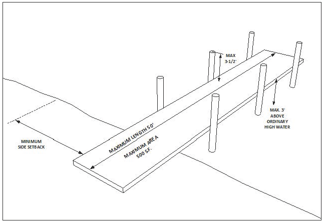
d.
Permitting Procedures for Extraordinary Water Access Structures on Non-Parkway Lakeshores
Extraordinary water access structures on non-parkway lakeshores shall require initial review and approval of the Manager of the Lakes and Stormwater Division and Building Official. Upon a determination that the permit application is sufficient and all applicable conditions have been met, the Building Inspection Division shall send a notice letter by regular mail to all neighbors within 250 feet of the applicant's property advising them of the proposed structure and of the city's intention to issue a permit for the structure unless a written request for a public hearing and decision by the Zoning Board of Adjustment and Appeals is received by the Building Inspection Division within 30 days of the date of the letter. If a written request for public hearing is not received within said 30-day period, the Building Inspection Division shall issue a permit for the structure. If a written request for a public hearing is timely received, the Building Inspection Division shall schedule a hearing before the Zoning Board of Adjustment and Appeals and mail notice of said hearing to the permit applicant and all neighbors within 250 feet of the applicant's property. The Zoning Board of Adjustment and Appeals shall conduct a hearing in accordance with its normal procedures. The Board shall consider the testimony and evidence and determine whether or not all conditions applicable to the structure have been met. If the Board finds that all conditions have been satisfied, it shall approve the application and direct the Building Inspection Division to issue a permit for the structure. If the Board finds that one or more applicable conditions have not been satisfied, the Board shall disapprove the application and direct the Building Inspection Division to deny the permit. The decision of the Zoning Board of Adjustment and Appeals shall constitute final action by the city and may be appealed in the same manner as any other decision of the Zoning Board of Adjustment and Appeals.
e.
Permitting Procedures for Extraordinary Water Access Structures on Parkway Lakeshores
Extraordinary Water Access Structures on parkway lakeshores, as outlined in Subsection 6.4.3.2 shall require City Commission review and approval before a permit is issued. The Manager of the Lakes and Stormwater Division and Building Official shall review each application for sufficiency. Upon a determination that the permit application is sufficient for review, the Building Inspection Division shall schedule the application before the City Commission and send a notice letter by regular mail to all property owners within 250 feet of the applicant's property advising them of the proposed water access structure and of the date and time of the City Commission meeting. Proposed extraordinary water access structures shall be reviewed by both the Lakes and Stormwater Division and the Community Development Planning Division, who shall jointly provide a written recommendation to the City Commission. The City Commission shall consider all relevant public comment and determine whether or not all conditions applicable to the structure have been met. Because of the public significance of parkway lakeshores, the City Commission may also consider any other factor appropriate for legislative consideration, including whether or not the proposed structure furthers or adversely impacts the overall public health, safety and welfare of the city. If the Commission finds that all conditions have been met and that the proposed structure is otherwise appropriate, it shall approve the application and direct the Building Inspection Division to issue a permit for the structure. If the Commission finds that one or more applicable conditions have not been satisfied, or that the proposed structure is otherwise incompatible with the public health, safety and welfare of the City, the Commission shall disapprove the application and direct the Building Inspection Division to deny the permit.
f.
If approved, the Building Inspection Division shall issue a permit subject to the condition that all work shall be fully and completely finished, in accordance with the approved plans, within the period of one year. Permits issued pursuant to this article shall expire if the work authorized by the permit has not commenced within one year.
g.
Repair and Maintenance of Existing Structures
A permit shall not be required for the routine repair or maintenance of water access or shoreline stabilization structures constructed pursuant to all other required Federal, State and local permits provided the work does not change the original dimensions, design, or placement of the structure; does not involve the replacement of structural supports; and is necessary to maintain the structure in good condition.
(Ord. No. 5455, 07-21-14; Ord. No. 5579, 05-16-16)
6.4.3.5
Minimum Standards for Protection of Wetland Habitats
All residential, commercial or industrial structures are prohibited within the jurisdictional boundaries of a wetland.
6.4.3.6
Lakeshore and Wetland Area Buffer Requirement
A natural vegetative buffer zone of 15 feet measured landward from the ordinary high water line or the delineated boundary of the wetland shall be maintained around all protected lakeshores and wetland areas. This buffer shall exist within the 50-foot lakeshore protection setback area and shall remain undisturbed and free of development activity at all times except for maintenance in the form of trimming.
6.4.3.7
Required Protected Species Habitat Management
Upon completion of an environmental assessment establishing the extent to which a protected species exists upon a site, special management programs shall be created by the developer or landowner to preserve the species upon the site by protection of its supporting habitat. Management programs, implemented in coordination with the development activity, shall use buffer zones, setbacks, conservation areas or easements and physical protection devices to preserve the supporting habitat and prevent disturbance of the species.
6.4.3.8
Protection of Fisheries
Protection of fishery habitats shall be accomplished by following all standards established within these regulations. Measures to ensure surface water quality, lakeshore and conservation area protection shall apply to the preservation of local fisheries.
6.4.3.9
Maximum Allowable Density
Maximum density within a conservation area shall not exceed a gross density of one unit per ten acres. All land development within these areas shall take measures to ensure minimal disruption to the natural environment.
6.5 - SITE ALTERATION
6.5.1
APPLICABILITY
A site alteration permit shall be required for all clearing, contouring and grading of land including, but not limited to, the alteration of land in preparation for sale or development, the placement or storage of fill, borrow pits, and/or the removal of regulated trees as defined in Section 4.5, regardless of changes to grade. The provisions of this section shall not apply to existing platted lots zoned for single-family or two-family dwellings, to bona fide general maintenance or agricultural maintenance not undertaken in association with the preparation of land for sale or development, or to operations necessary for the substantial improvement of existing structures.
6.5.2
SITE ALTERATION PLAN
6.5.2.1
Site Alteration Plan Required
A site alteration plan shall be prepared by a professional engineer, architect or landscape architect registered in the State of Florida based on contours and site feature locations that have been verified, signed and sealed by a land surveyor and mapper registered in the State of Florida. The plan shall not exceed one inch equals 200 feet in scale and shall contain the following information and documentation. For projects requiring site plan review, a separate site alteration plan shall not be required if this information can be shown on the site plan.
a.
Existing topography versus graded topography indicated as cut and fill areas (contours shall be shown in one foot intervals);
b.
The exact location of drainage basins, streams, channels, floodplains, floodways, wetlands, and lakes, which exist on the site;
c.
The location of any protected habitat areas which exist on the site pursuant to the provisions of Subsection 6.4.3;
d.
An Erosion Control Plan;
e.
The location of all regulated trees as defined in Section 4.5; and
f.
A legend containing the definition of all symbols used in the layout of the plan, the scale of the map, the orientation and location, including the legal description.
6.5.2.2
Plan Submission
If a separate site alteration plan is required, six copies of the plan shall be submitted to the Building Official who shall transmit copies to the Public Works Department, the Parks and Recreation Department and the Community Development Department for review. One copy shall remain with the Building Inspection Division.
6.5.2.3
Plan Review
The Public Works Department, the Parks and Recreation Department and the Community Development Department shall approve or disapprove the site alteration plan within 20 days of receipt of a complete plan. The basis for approval shall be a finding by the Public Works Department that the plan provides for adequate erosion control, a finding by the Parks and Recreation Department that the plan provides for the protection of regulated trees or compensation for the destruction of regulated trees, and a finding by the Community Development Department that the plan provides adequate habitat protection standards in accordance with this section.
Upon the approval of the plan by all review departments, the Building Official shall issue the site alteration permit. The applicant shall display the permit on the site at all times during site alteration work.
The site alteration permit shall constitute a tree removal permit in accordance with Section 4.5.
6.5.3
EROSION CONTROL STANDARDS
6.5.3.1
Criteria for Erosion Control Devices
Measures of erosion control needed to minimize or eliminate any transfer or removal of soil from a site during a rainfall event shall be established upon all applicable sites. Compilation of all features upon a site may necessitate unified measures of control.
6.5.3.2
Natural Bodies of Water
The use of natural bodies of water for siltation settling ponds shall be strictly prohibited.
6.5.3.3
Development Adjacent to Roadways and Rights-of-Way
All roads and public rights-of-way shall be protected from the encroachment of any siltation or erosion-created spoils. Any material encroaching upon a roadway or public right-of-way due to the effects of erosion from a private site shall be immediately removed by the owner or developer of the property and all damages compensated or the material will be removed by the city at the expense of the owner or developer.
6.6 - SURFACE WATER QUALITY
6.6.1
INTENT AND APPLICABILITY
a.
Intent
It is the intent of this section to maintain standards of water quality and quantity within local bodies of water by establishing provisions regulating the management of stormwater within the city.
b.
Applicability
1.
The requirements established within this section shall apply under the following conditions:
(a)
Construction of a structure or the alteration of a site;
(b)
Alteration to the rate, volume, and quality characteristics of stormwater runoff occurring upon a site; or
(c)
Increase in the amount of impervious surface area upon a site.
c.
Exemptions to Stormwater Management Provisions
The following land development activities are exempt from the stormwater management provisions:
1.
A single-family or a single duplex dwelling unit;
2.
Any structure constructed prior to the requirement for a stormwater plan;
3.
Those projects which have received a Southwest Florida Water Management District permit prior to the adoption of these regulations, including multiple-use developments which have an approved master drainage plan;
4.
Maintenance activity that does not change or affect the quality, intensity, volume, or location of stormwater runoff upon the site; and
5.
Actions taken under emergency conditions to prevent imminent harm or danger to persons, or to protect property from imminent damage. A report of the emergency action shall be made to the Public Works Department immediately following the event.
All activities which are exempt, nevertheless, are to be accomplished in a manner which prevents flooding of adjacent sites and roadways by stormwater runoff.
6.6.2
STORMWATER MANAGEMENT PLAN
A stormwater management plan shall be prepared for each site proposed for development in accordance with the following:
a.
Prior to the issuance of a permit for any construction activity which increases the area of impervious surface, except that deemed exempt, a stormwater management plan shall be submitted to the Public Works Department for review and approval.
b.
The stormwater management plan shall be made a part of the required site plan for any proposed alteration, addition, structure or development and shall include the following:
1.
All required information pursuant to Southwest Florida Water Management District application requirements for the management and storage of surface waters contained in Chapter 40D, Florida Administrative Code (FAC);
2.
The location of all bodies of water and jurisdictional wetlands indicated upon the topographic map required within Chapter 40D, FAC;
3.
Any additional stormwater related information that the Public Works Department finds to be necessary for the proper review of the proposed activity; and
4.
Certification that the plan was prepared by a professional engineer registered in the State of Florida.
6.6.3
GENERAL STORMWATER MANAGEMENT REQUIREMENTS
6.6.3.1
Maintenance of Pre-Development Standards
The characteristics of stormwater conveyed from the site shall, at a minimum, approximate the volume, quality and intensity that occurred on the site prior to development activity.
6.6.3.2
Water Quality Standards of Treated Stormwater
Treated stormwater standards are set forth and hereby adopted within these regulations by reference to Section 62-25 and Section 62-302 of the Florida Administrative Code.
6.6.3.3
Compliance with State and Regional Regulations
The design and performance of all stormwater management systems shall comply with the following State of Florida regulations:
a.
Section 62-25, Florida Administrative Code, regulating stormwater discharge;
b.
Requirements of the Southwest Florida Water Management District, Section 40D-4 and 40D-40, Florida Administrative Code; and
c.
Chapter 373, Florida Statutes.
6.6.3.4
Intergovernmental Coordination of Approval
Prior to approval by the Public Works Department, the stormwater management plan shall be reviewed and its approval documented by all other governmental authorities having jurisdiction. Approval by such authorities shall be a mandatory requirement prior to obtaining a building permit from the city. Government agencies which may have authority include:
a.
Florida Department of Transportation (FDOT);
b.
Southwest Florida Water Management District (SWFWMD);
c.
Florida Department of Environmental Protection (FDEP);
d.
Polk County Board of County Commissioners (BOCC);
e.
Army Corp of Engineers (ACOE); and
f.
The Environmental Protection Agency (EPA).
6.6.4
STORMWATER MANAGEMENT SYSTEM STANDARDS
6.6.4.1
Minimum Design Standards for Stormwater Systems
All structures required as necessary devices within a stormwater management system shall be designed and constructed so as to conform with the Engineering Standards Manual.
6.6.4.2
Certification of Established Systems
The design and construction of the proposed stormwater management system shall be certified as meeting the requirements of this section by a professional engineer registered in the State of Florida.
6.6.4.3
Systems within Phased Developments
In phased developments, stormwater systems for each integrated phase shall be independently functional unless specific development provisions are approved by the Public Works Department.
6.6.4.4
Access to Stormwater Structures
All man-made components within a stormwater management system shall be easily accessible for maintenance by streets, public rights-of-way or access easements.
6.6.4.5
Responsibility for Maintenance
It shall be the landowner who is responsible for maintenance of the established stormwater management system and structures therein unless legal and binding agreements are established to transfer this responsibility.
6.7 - WELLHEAD AND AQUIFER PROTECTION
6.7.1
INTENT AND APPLICABILITY
a.
Intent
It is the intent of this section to preserve the quality and availability of safe drinking water by protecting large capacity wells and areas of high aquifer recharge from the potential of contamination and degradation due to the proximity of specific land uses or activities. The Community Development Department shall review applicable development activity for conformance with this section.
b.
Applicability
The requirements of this section shall apply to non-residential uses and to the construction or expansion of any non-residential structure or any impervious surface, or any change in use involving such structure or site, if any part of the development site (lot or parcel) falls within a Wellhead Protection Zone or within a designated area of high aquifer recharge as defined herein.
(Ord. No. 5560, 01-19-16)
6.7.2
WELLHEAD PROTECTION STANDARDS
6.7.2.1
Wellhead Protection Zones
Wellhead Protection Zones having a radius of 500 feet around each public potable water wellhead possessing a pumping capacity of one million gallons a day or greater shall be delineated on the Official Zoning Map.
6.7.2.2
Prohibited Uses within Wellhead Protection Zones
The following uses, temporary or permanent, shall be prohibited, unless a facility is an Existing Installation as defined by F.A.C. Chapter 62-521.200:
a.
Sanitary landfills and junk yards;
b.
Wastewater treatment plants;
c.
Petroleum storage and distribution facilities as a primary use and all underground fuel, petroleum or chemical storage facilities;
d.
Dairy farming;
e.
Agricultural land treated with any regulated substance listed in Table 6.7-1;
f.
Land uses incorporating deep penetration injector wells; and
g.
Facilities which store, process, or handle any hazardous, toxic or medical waste.
Table 6.7-1: Regulated Substances
(Ord. No. 5560, 01-19-16)
6.7.2.3
Wellhead Protection Zone Operating Permit
Any non-residential use, temporary or permanent, that is located within a wellhead protection zone shall require a wellhead protection zone operating permit. Construction activities do not require a wellhead protection zone operating permit; however construction sites are subject to Regulated Substances Containment in accordance with Subsection 6.7.2.4 of this code. Uses requiring a permit shall include, but not be limited to, the following:
a.
Commercial laundry, dry cleaning, dying processes, textile manufacturing;
b.
Printing, photographic processing, and paper manufacture;
c.
Herbicide, fertilizer and pesticide manufacturing or distribution;
d.
Manufacturing or distribution of chemical products, plastics or other general manufacturing which may or may not use any of the regulated substances listed in Table 6.7-1; and
e.
Uses associated with automobile maintenance, storage and repair.
Application for a wellhead protection zone operating permit shall be made through the Water Utilities Department in accordance with such submittals and procedures as the department shall require.
(Ord. No. 5560, 01-19-16)
6.7.2.4
Restricted Use Operating Permit
Secondary containment is required for the storage, use or production of any regulated substance within a wellhead protection zone that meets or exceeds the threshold limits listed in Table 6.7-1. Secondary containment shall meet the requirements found in the wellhead protection zone operating permit application.
(Ord. No. 5560, 01-19-16)
6.7.2.5
Wellhead Protection Non-Compliance
The City may issue a cease and desist order to a developer or landowner in the interest of enforcing the provisions of these regulations. A cease and desist order may be issued when the impact of an existing activity or the impact of a development activity violates the provisions of this article. If necessary, enforcement action may be taken in accordance with Florida Law.
(Ord. No. 5560, 01-19-16)
6.7.3
AQUIFER RECHARGE PROTECTION STANDARDS
In the event that any areas of high aquifer recharge are determined by the Southwest Florida Water Management District to exist upon a property within the corporate limits, the city shall reserve the right to limit land use intensity and set specific standards regulating stormwater management upon the affected parcels.
6.7.4
PREVENTION OF SINKHOLE CONTAMINATION
Sinkholes, sinks and similar karst formations, having direct connection with the aquifer system, shall be protected from contamination by the following:
6.7.4.1
Stormwater Contamination
Stormwater runoff shall be prohibited from direct or indirect discharge into any geological feature possessing unrestricted connection to an aquifer system or any channeling structure that directly achieves this action. Exceptions may be considered pursuant to Chapter 17-25, Florida Administrative Code, if pre-development standards of runoff warrant such an exemption of treated stormwater runoff.
6.7.4.2
Fill Material
Material to be used for the purpose of bulk fill of a sinkhole cavity shall be clean and free of the following contaminants:
a.
All regulated substances listed in Table 6.7-1;
b.
All petroleum based products including tar and roofing material; and
c.
Biological wastes.
6.8 - ENFORCEMENT
6.8.1
ENFORCEMENT
6.8.1.1
Stop Work Order
The city may, at any time during development or site alteration activity, reserve the right to issue a stop work order to a developer or landowner in the interest of enforcing the provisions of these regulations. A stop work order may be issued when the impact of a development activity violates the purpose or provisions of this article. This may include the following:
a.
Non-compliance with the requirements of this article;
b.
Documented or verifiable evidence reveals the presence of a protected species or protected habitat on a site not recognized or specifically reviewed in the site alteration plan;
c.
Habitat management programs have not been implemented according to pre-development approval conditions;
d.
Erosion control devices have not been established pursuant to the approved site alteration plan;
e.
Improper use, disposal, handling or spillage of regulated substances, construction supplies or other materials which may result in an adverse impact upon a natural resource protected within these regulations; or
f.
Necessary permits from state or regional government agencies have not been properly obtained.
6.8.1.2
Removal of a Stop Work Order
The Stop Work Order can only be removed by fulfilling all remedial requirements and compliance with the provisions of these regulations.
6.8.1.3
Monitoring
Management measures implemented or devices required by these regulations shall be subject to spot inspections by the city. Violations may be recorded at any time and referred to the Code Enforcement Board.
6.8.2
VIOLATIONS AND PENALTIES
6.8.2.1
General Violations
A violation against any provision of these regulations may be held as grounds for denying or repealing a development permit.
6.8.2.2
Repeated Non-Compliance
Any owner, developer, or other party representing a site which does not conform to the provisions of this article shall be referred to the Code Enforcement Board. The board shall have the authority to impose a re-occurring daily fine for non-compliance.