
Lancaster County Unincorporated
City Zoning Code
City Zoning Code
ARTICLE 22
- SITE PLANS COMMERCIAL, INDUSTRIAL, MULTIFAMILY
Statement of Intent
This article is enacted to assure compliance with all applicable ordinances and statutes, to promote innovative and creative design, to protect and enhance the values of the natural environment in Lancaster County, to protect the economic value of the natural environment from unwise and disorderly development, to ensure the efficient use of land, and to promote high standards in the layout, design, landscaping, and construction of development.
(Ord. of 12-13-18(3))
22-1.- Applicability.
Any use and development of land for commercial, industrial, or multifamily purposes requiring a building permit and which involves a land area disturbance greater than 2,500 square feet shall require a site plan prepared and approved in accordance with the provisions of this article. A site plan will not, however, be required for the repair or rehabilitation of an existing structure when such work does not involve and is not related to either a change in use or an increase in the intensity of the use, as determined by the county planner.
(Ord. of 12-13-18(3))
22-2. - Performance standards.
An application for a permit shall provide documentation that the intended use will comply with the performance standards enumerated below. In the case of a structure being built where the future use is not known, a construction permit may be issued with the condition that no certificate of occupancy will be issued until such time as this documentation is submitted with respect to the particular occupant. A new application and a new certificate of occupancy shall be required in the event of a change of use of any commercial or industrial structure. In reviewing any site plan, the county shall consider the following:
22-2-1. Traffic. Pedestrian and vehicular traffic movement within and adjacent to the site should be carefully reviewed. Particular emphasis should be on the provision and layout of parking areas and off-street loading and unloading, as well as the movement of people, foods and vehicles from access roads within the site, and between buildings and vehicles. The county shall ensure that all parking spaces are safe, usable and conveniently arranged. Access to the site from adjacent roads shall be designed to minimize interference with traffic flow and to permit vehicles a rapid and safe ingress and egress to the site.
22-2-2. Design and layout. The design and layout of buildings and parking areas shall be reviewed so as to provide an aesthetically pleasing design and efficient arrangement. Particular attention shall be given to safety and fire protection, impact on surrounding development and contiguous and adjacent buildings and lands.
22-2-3.Lighting. Adequate lighting shall be provided to ensure safe movement of persons and vehicles and for security purposes. Lighting standards shall be of a type approved by the county. Directional lights shall be arranged so as to minimize glare and reflection on adjacent properties and/or oncoming traffic.
22-2-4. Buffers. Buffering shall be located around the perimeter of the site and/or in groupings at strategic locations in order to minimize the glare of headlights of vehicles, lights from structures, noise and the movement of people and vehicles and to shield activities from adjacent properties. Buffering may consist of fencing, evergreens, shrubs, earthen berms, bushes, deciduous trees or combinations thereof to achieve the stated objectives.
22-2-5. Landscaping. Landscaping shall be provided as part of the overall site plan design and integrated into building arrangements, topography, parking and buffering requirements. Landscaping shall include trees, bushes, shrubs, ground cover, perennials, annuals, plants, sculpture and art.
22-2-6. Signs. Signs shall be designed so as to be harmonious with other signs on the site and located so as to achieve their intended purpose without constituting a hazard to vehicles and pedestrians, and in accordance with article 11.
22-2-7. Storm drainage, sanitary waste disposal and water supply. Storm drainage, sanitary waste disposal and water supply shall be reviewed and considered. Particular emphasis shall be given to the adequacy of the existing system and the need for improvements, both onsite and offsite, to adequately carry runoff and sewerage and to maintain an adequate supply of water at sufficient pressure.
22-2-8. Garbage disposal. Garbage disposal should be adequate to ensure freedom from vermin and rodent infestation and be buffered.
22-2-9. Environmental elements. Environmental elements relating to soil erosion, preservation of trees, protection of watercourses and resources, emission of glare, noise, odor, air and water pollution, aesthetic conditions, topography, soil and animal life shall be reviewed and the design of the plan shall minimize any adverse impact on these elements.
22-2-10. Support facilities. Support facilities, including the proximity and capacity of community facilities necessary to sustain the needs and demands of the proposed development, should be carefully considered so as to maintain and promote balanced community environments. These support facilities may include benches, bike racks, trash receptacles, bus shelters, playgrounds, game fields, dog parks, open space and land dedication for educational facilities, firehouses, etc.
(Ord. of 12-13-18(3))
22-3. - Submission requirements.
22-3-1. Site plans or any portion thereof involving engineering, architecture, landscape architecture, or land surveying shall be respectively certified by an engineer, architect, landscape architect, or land surveyor duly authorized by the commonwealth to practice as such.
22-3-2. Site plans shall be prepared to a scale of one inch equals 50 feet or larger. Site plans shall be submitted in clearly legible blue or black line copies. The size of each print shall be 24 by 36 inches.
22-3-3. A site plan may be prepared in one or more sheets to show clearly the information required by this article and to facilitate the review and approval of the plan. If prepared on more than one sheet, match lines shall clearly indicate where the several sheets join and shall not be drawn across lots, but shall be along property lines.
22-3-4. A master site plan may be submitted for large areas developed in phases. Further changes, additions, or deletions may be submitted as site plans wherein only that portion of the land or building affected need be shown.
22-3-5. Three copies of the site plan shall be filed with the county planner. The filing of the plan signed by the applicant and his or her agent shall constitute the application for approval.
22-3-6. The format of site plans shall be in conformance with the following sketch:
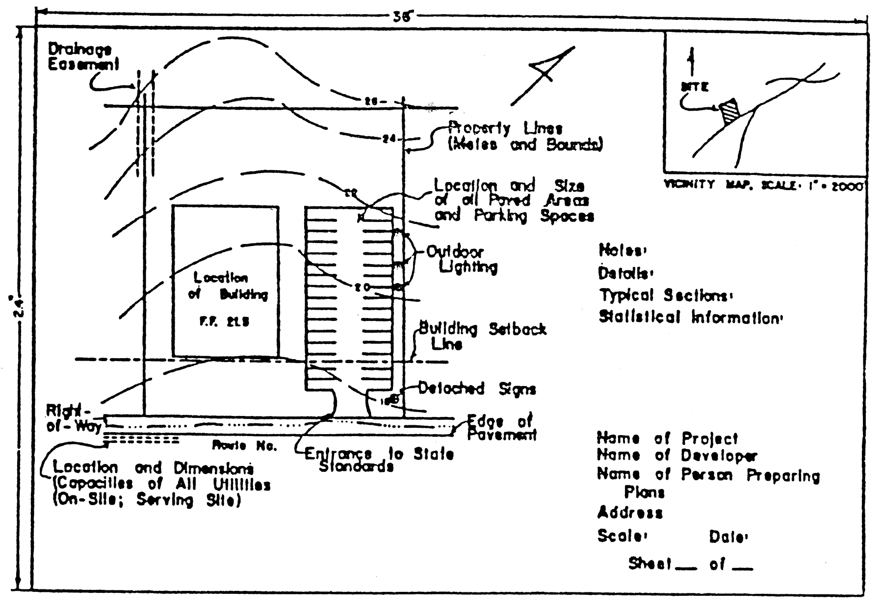
(Ord. of 12-13-18(3))
22-4. - Chesapeake Bay preservation.
Site plans shall comply with the requirements of Chesapeake Bay Preservation Ordinance.
(11-28-05(1); Ord. of 12-13-18(3))
22-5. - Sketch site plan.
The submission of a sketch site plan as well as the scheduling of a pre-development conference prior to the submission of a preliminary site plan is encouraged in order to enable the applicant to benefit from a review of a sketch against ordinance provisions pertaining to performance standards and Chesapeake Bay preservation standards before major engineering expenditures are incurred.
(Ord. of 12-13-18(3))
22-6. - Preliminary site plan.
An applicant seeking approval of a plan under this article shall submit a preliminary site plan containing the following information where necessary and applicable, unless the county planner determines that due to the scope and nature of the proposed development some of the information is unnecessary or can be combined:
(a)
Location of tract or parcel by a vicinity map at a scale of not less then one inch equals 2,000 feet, indicating scaled coordinates referred to in the U.S. Geological Survey Topographic Quadrangle, state grid north, and landmarks sufficient to properly identify the location of the property.
(b)
A boundary survey of the tract or site plan limit, with an error of closure within the limit of one in 10,000, related to the true meridian, showing the location and type of boundary evidence.
(c)
Certificate signed by the surveyor or engineer setting forth the source of title of the owner of the tract, the place of record of the last instrument in the chain of title (including deed book and page number), and a legal description showing subdivision lot, block, and section number, where applicable, or a legal property description.
(d)
Name and address of the development. Name and address of the owner or owners of record and the applicant, if different.
(e)
Name, address, telephone number, signature and registration number of the professional preparing the plan.
(f)
Zoning of the tract and total land area, as well as the approximate land area of any separate parcels of land contained in the subject tract.
(g)
The owner or owners and last known mailing address, the zoning classification or classifications, the tax parcel identification number or numbers, and present use of all adjoining property or properties except where the property is a subdivision, then the name of the subdivision.
(h)
Date, graphic scale, north point, number of sheets.
(i)
Existing topography with a maximum of two-foot contour intervals within the limits of clearing and a maximum of five-foot contour intervals for the remainder of the tract, and proposed finished grades.
(j)
The location of all existing trees on the site six inches or greater in diameter at breast height (DBH). Where there are groups of trees, stands may be outlined. Trees to be preserved, removed, relocated, or replaced shall be so designated on the plan. The limits of clearing, including that to be done subsequently for the installation of public utilities, shall be clearly designated on the site plan or on a separate clearing and grading plan.
(k)
All building restriction lines, highway setback lines, easements, covenants, reservations, and rights-of-way of record.
(l)
Public storm drainage systems and natural and artificial watercourses.
(m)
All existing improvements excluding privately owned underground utilities and the like.
(n)
Limits of any resource protection area.
(o)
Limits of any required buffer areas.
(p)
Limits of any established 100-year floodplains and the source of floodplain information.
(q)
Identification of hydric soils and the limits of any wetlands not otherwise contained in an RPA.
(r)
Location of proposed landscaping and buffering improvements.
(s)
Solid waste management facilities and proposed buffering of same.
(t)
Outdoor lighting plan.
(u)
The location, dimension, size and height of the following when existing or proposed:
(1)
Sidewalks, streets, alleys, easements, and utilities.
(2)
Buildings and structures, including number of floors, distance between buildings, floor area, height and location of each building, and proposed general use for each building. If single-family attached or multifamily, the number, size, and type of dwelling units shall be shown.
(3)
All off-street parking and parking bays, loading spaces and walkways indicating type of surfacing, size, angle of stalls, width of aisles, and a specific schedule showing the number of parking spaces provided and the number required in accordance with this ordinance.
(4)
Public sanitary sewer systems.
(5)
Public water mains and fire hydrants.
(6)
Slopes, terraces, retaining walls, fencing and screening within the required yards.
(7)
Location and size of signing as provided in article 11.
(8)
Shoreline stabilization structures.
(Ord. of 12-13-18(3))
22-7. - Preliminary plan review procedures.
22-7-1. Preliminary site plans shall be filed with the county planner. The filing of the plan, signed by the applicant or his or her agent, together with payment of the prescribed filing fees, shall constitute the application for approval.
22-7-2. The county planner shall check the preliminary site plan for general completeness and compliance with such administrative requirements as are established.
22-7-3. All site plans which are appropriately submitted and conform to standards and requirements set forth in this ordinance article shall be reviewed by the appropriate departments of the county and the state relative to:
(a)
Compliance with all applicable requirements of this ordinance and other conditions of zoning, including but not limited to setbacks, height of building, lot area, lot coverage, fencing, landscaping and screening.
(b)
Location and design of vehicular and pedestrian access points, to include concurrence from the Virginia department of transportation on proposed entrances and exits from public streets.
(c)
Location and adequacy of automobile parking areas.
(d)
Adequacy of drainage, water supply, fire protection, and sanitary sewer facilities, and compliance with established design criteria, construction standards, and specifications.
(e)
Protection of environmentally sensitive features.
(f)
Provision of adequate erosion and sedimentation control measures of both a temporary and permanent nature as provided by the erosion and sediment control ordinance of Lancaster County.
(g)
Provisions of the Uniform Statewide Building Code.
22-7-4. The county planner shall consider the preliminary site plan in light of the provisions of this article and approve, conditionally approve, or disapprove the plan with modifications, requesting thereon any changes or additional information that will be required. One copy of the plan shall be returned to the applicant, with the date of such approval, conditional approval, or disapproval noted thereon over the signature of the county planner.
(Ord. of 12-13-18(3))
22-8. - Final site plan.
The submission of a final site plan shall be in compliance with the approved preliminary site plan. It may either be a final plan of the entire site as shown on the preliminary site plan or a section of the approved preliminary plan. If a final section, a proposed phasing plan for the entire site shall accompany this submittal.
(Ord. of 12-13-18(3))
22-9. - Final plan review procedures.
The county planner will review the plan to ensure compliance with ordinance provisions and with the approved preliminary plan. The county planner will review a final section and the phasing plan to ensure that the staging of the construction can occur without adverse impacts. The county planner shall not approve a final plan unless the plan delineates the RPA boundary and the required buffer areas and is accompanied by all necessary wetland permits and maintenance agreements. Upon a finding that a final site plan complies in all respects, the county planner shall approve the final plan. Upon a finding that the final site plan does not comply with a previously approved preliminary site plan or the provisions of this or any county ordinance, the applicant shall be so advised and shall be allowed to either bring the final plan into compliance in all respects, submit a new preliminary site plan for processing as if no plan has been previously considered, or withdraw the application without refund of fees.
(Ord. of 12-13-18(3))
22-10. - Period of validity of approved site plan.
An approved preliminary site plan shall become null and void if the final site plan is not submitted to the county planner within one year from the date of approval of the preliminary plan. An approved final site plan shall become null and void if no significant work is done or development is made on the site within six months after final site plan approval. Construction or development may begin upon approval of the final site plan by the county planner and acquisition of building permits. The county planner may grant a single one-year extension upon written request of the applicant.
(Ord. of 12-13-18(3))
22-11. - Minor or major adjustment in approved site plan.
22-11-1. After a site plan has been approved by the county planner, minor adjustments of the site plan, which comply with the spirit of this ordinance, with the intent of the approving departments in their approval of site plans, and with the general purpose of the comprehensive plan for development of the area, may be approved by the county planner with concurrence of the reviewing departments concerned. Deviation from an approved site plan without the written approval of the county planner shall void the plan and the county planner shall require the applicant to resubmit a new site plan for consideration.
22-11-2. Any major revision of an approved site plan may be made again in the same manner as originally approved and any requirements of this article may be waived by the county planner in specific cases where such requirement is found to be unreasonable and where such waiver will not be adverse to the purpose of this or any county ordinance.
(Ord. of 12-13-18(3))
22-12. - Waiver of submittal requirements.
The county planner may waive certain submittal requirements if he determines that a comprehensive and effective review can be accomplished without said information.
(Ord. of 12-13-18(3))
22-13. - Installation and bonding requirements.
Installation and bonding requirements referenced on site plans are specifically listed in the Subdivision Ordinance for road construction, Erosion and Sediment Control Ordinance for erosion control measures and the Chesapeake Bay Preservation Ordinance for structural stormwater improvements.
(Ord. of 12-13-18(3))
22-14. - Appeals.
Appeals from a decision of the county planner or to seek relief from a design standard shall be in accordance with article 14, Provisions for Appeal.
(Ord. of 12-13-18(3))