
Lancaster County Unincorporated
City Zoning Code
City Zoning Code
ARTICLE 26
- HIGHWAY CORRIDOR OVERLAY DISTRICT6
Editor's note— An ordinance adopted April 24, 2003, did not specifically amend the Code. Therefore, such ordinance has been added as a new article 26, §§ 26-1—26-10 at the editor's discretion.
26-1.- Establishment and intent.
The highway corridor overlay district (HCOD) is hereby established for the purpose of protecting the county's major roadway corridors, which directly impact the public health, safety, and welfare. As the transportation lifelines of the community, these routes provide access to schools, jobs, and other destinations. They also facilitate the provision of emergency services, and foster tourism and economic development. As resources made possible through public investment, such roadways warrant protection in order to preserve their safety, capacity, and function. Finally, as visible elements of the county, they require management to protect and enhance community character.
(Ord. of 4-24-03)
26-2. - Applicability.
The HCOD shall apply to Routes 3, 354, and 200 for their entire length in Lancaster County, with the exception of that area within the town limits of Kilmarnock, White Stone, and Irvington. Any development abutting these routes shall be subject to these requirements. The HCOD shall also apply to redevelopment, which shall include measures to bring non-conforming sites into compliance, as outlined herein.
For the purposes of this ordinance, large developments consisting of multiple parcels (including but not limited to shopping centers and business parks) shall be treated as individual development projects. Logical extensions of such developments shall also be subject to these regulations, regardless of whether they abut the highway. For developments subject to these regulations, all required plans may be submitted as a single plan, provided all required information is clearly shown to meet the requirements outlined herein.
To ensure adequate coordination with the Virginia Department of Transportation (VDOT), the County shall seek comments from the Resident Engineer or his/her designated representative on the proposed roadway, driveway, and circulation systems.
(Ord. of 4-24-03)
26-3. - Access.
The purpose of this section is to manage vehicular and non-vehicular access. To ensure that development in the HCOD supports the County's access management policies, all site plans shall include an access plan, drawn to the same scale as the site plan and showing the location and dimensions of all streets, driveways, turn lanes, access drives, interparcel connections, bicycle and pedestrian access, parking areas, and other relevant information. Access to HCOD routes shall be provided by direct or indirect means, consistent with the following:
• Number of access points: Each tract of land recorded prior to effective date shall be permitted one point of direct or indirect access to the public roadway system, provided that such access conforms to the corner clearance and sight distance requirements of this ordinance. Where the roadway frontage of a tract of land is greater than 500 feet, an additional access point may be permitted, if it is determined in consultation with VDOT that such access will not be detrimental to highway safety, capacity, or function. Any such additional access shall comply with all applicable sections of this ordinance. Where multiple parcels are developed as a single project, such as a shopping center or similar use, they shall be treated as a single parcel for the purposes of determining the permitted number of access points. For town and village settings, driveway access to the roadway may not always be possible, appropriate, or permissible. In these areas, the county and VDOT shall review requests for access based on the potential for shared access, the need for parking, desired corner clearance, and driveway spacing.
• The minimum corner clearance* (see attached map) of driveways from intersecting streets shall be 400 feet approaching the intersection. Downstream corner clearance shall be 250 feet minimum. For side street approaches to a designated highway, the minimum corner clearance shall be 250 feet upstream and 100 feet downstream. At signalized intersections, corner clearances in excess of these minimum dimensions may be required, in consultation with VDOT. Where a traffic study is submitted that shows 20-year peak period 95-percentile queue lengths will not extend past the driveway location, corner clearances may be reduced, in consultation with VDOT. These standards may not be possible or desirable in town and village settings. In these areas, corner clearance shall be a factor in analyzing access requests, discussed above.
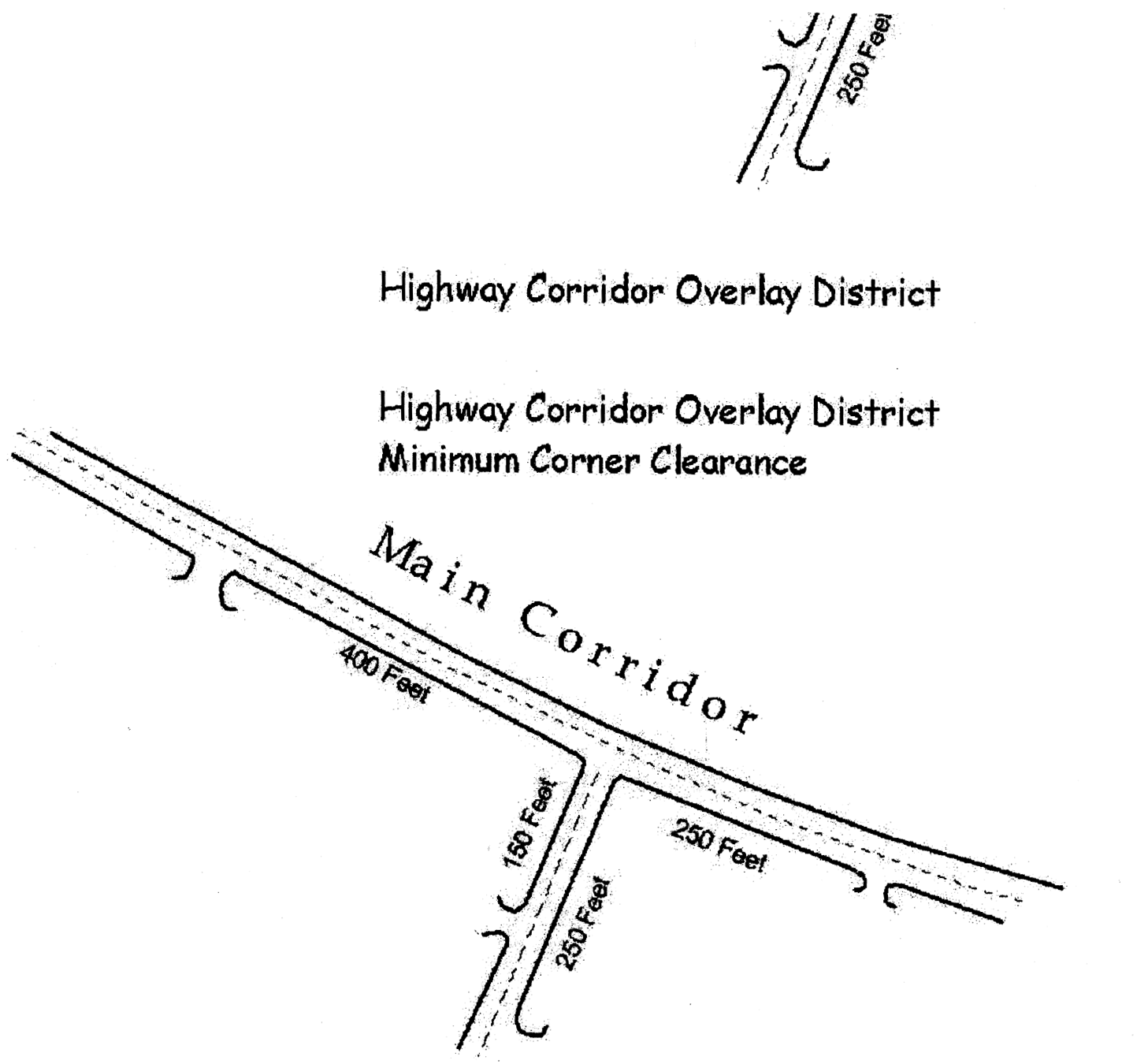
* See map for clarification
• Minimum sight distances along the highway shall be provided to allow vehicles to safely turn left or right onto the highway. Sight distances provided along the HCOD shall be a minimum of 1,000 feet. Where town and village areas have posted speed limits below those on the main artery, the County and VDOT may consider sight distances less than 1,000 feet.
• Outparcels: All access to outparcels shall be internalized utilizing the main access drive of the principal commercial center. Access to the outparcel shall be as direct as possible, avoiding excessive movement across the parking aisles and queuing across surrounding parking and driving aisles. In no instance shall the circulation and access of the principal commercial facility and its parking and service be impaired.
• New residential subdivisions shall include an internal street layout that shall continuously connect to the streets of surrounding developments to accommodate travel demand between adjacent neighborhoods without the necessity of using the highway.
• Median crossovers: Where a proposed development fronts an existing or planned median crossover, access from the development to adjacent sites shall be provided, so as to promote shared access and minimize demand for additional crossovers.
• Shared access and reverse frontage: Interparcel connections shall be provided to facilitate the local movement of traffic and minimize demand for local trips on the highway. Based on consultation with the VDOT Resident Engineer, interparcel access may take the form of direct driveway connections or reverse frontage roads.
• Pedestrian access: Pedestrian walkways shall be incorporated into each project and shall be coordinated with on-site landscaping so as to minimize conflicts with vehicular traffic. Pedestrian circulation systems shall connect uses within individual projects, and shall be extended to adjacent parcels where inter-parcel vehicular access is required. Where pedestrian access crosses an access drive (such as crossing from a parking aisle to a building entrance), crosswalk improvements shall be required.
(Ord. of 4-24-03)
26-4. - Required improvements and traffic impact analysis.
The county shall consult with VDOT to determine the necessary improvements to support the proposed use. The developer shall be responsible for the provision of the improvements, which shall be shown on the site plan. This determination shall be based on:
• The Comprehensive Plan.
• Applicable roadway and/or access management plans.
• Applicable traffic impact analyses.
• Highway safety and capacity.
All proposed developments expected to generate more than 1,000 average daily trips shall prepare and submit a traffic impact analysis. The projected number of average daily trips shall be calculated using the trip generation rates as defined by the most recent publication of the Institute of Transportation Engineers "Trip Generation". In addition, the county may require a traffic impact analysis for developments expected to generate fewer than 1,000 average daily trips when it is determined, in consultation with VDOT, that safety concerns warrant such analysis. The traffic impact analysis shall identify level of service impacts of the proposed development, based on a twenty-year demand projection, and shall be used to determine necessary improvements to support the development. At a minimum, the impact analysis shall address the following:
• Turn lane and access improvements.
• Internal site circulation.
• Shared access/access to adjacent sites.
• Impacts to intersections and median crossovers.
• Potential need for signalization.
• Relationship of the proposal to applicable roadway and/or access management plans.
(Ord. of 4-24-03)
26-5. - Setbacks.
In order to preserve and enhance highway safety and efficiency, setbacks shall be provided for front, side, and rear yards on all developments subject to the HCOD. Setbacks shall remain free from all development, including buildings, parking areas, gas pumps, canopies, and similar structures and facilities. Signs shall be permitted in setbacks, consistent with the regulations outlined herein. Where necessary to accommodate an approved circulation plan, access driveways are permitted within setbacks. For large developments such as shopping centers, setbacks shall apply to the full perimeter of the project, not to internal property lines. Specific setbacks for rural roadway sections, which shall be shown on site plans, shall be as follows:
• Front yard: 150 feet from the centerline of the roadway on existing two lane highways; or 75 feet from the centerline of the roadway on existing four lane highways.
• Side yard: 15 feet from the property line.
• Rear yard: 20 feet from the property line.
For town and village areas, where traditional shallow setbacks contribute to local character, new development and redevelopment shall conform to the traditional setbacks. In these areas, existing building frontages shall constitute a "build-to" line, with moderate variations permitted based on the existing pattern. Side and rear setbacks shall also follow traditional patterns.
NOTE: Because the village concept is under development, special exception should be made to accommodate the closer road frontage.
(Ord. of 4-24-03)
26-6. - Signs.
To manage roadway signs in a manner consistent with traffic safety and corridor appearance, the following standards shall apply. Site plans shall identify the number, location, size, and height of signs, consistent with the following:
Rural roadway sections.
• Number:
□ Residential subdivisions and multi-family complexes: these residential uses shall be permitted one freestanding sign per main entrance, not to exceed two sign per development.
□ Commercial and industrial uses: Each parcel shall be permitted one freestanding sign, provided all other standards are met. In addition, each structure shall be permitted one on-structure sign. For the purposes of this section, a shopping center or similar use shall be permitted one main freestanding sign; no freestanding signs shall be permitted for individual establishments in shopping centers or similar uses.
• Size: Sign area shall include the entire face of the sign (one side only). Where the sign consists of individual raised letters or a sign face of irregular shape, the sign area shall include the smallest rectangle that can encompass the letters or the sign face. Space for changeable copy (including fuel prices or similar displays) shall be included in the area of the sign. The size for a freestanding sign shall be one square foot per five linear feet of lot frontage, up to a maximum of 32 square feet, provided that shopping centers or similar uses with five or more establishments shall be permitted up to 40 square feet of sign area. The square footage for on-structure signs shall be as follows:
□ For wall signs mounted flat on the building: One square foot per linear foot of building frontage, up to a maximum of 100 square feet.
□ For projecting signs: One square foot per linear foot of frontage up to a maximum of 12 square feet.
• Location: No freestanding sign shall be located closer than 15 feet to the right-of-way of a designated HCOD route. Signs shall not obstruct sight distances as required herein.
• Height: The maximum height for freestanding signs shall be five feet above grade. Signs may be placed on landscaped berms or structural bases no higher than three feet tall, provided that these support methods contain no wording, logos, or other advertising material. When constructed in this manner, sign height shall be measured from the top of such berm or base. On-structure signs shall not project above the eaves line for buildings with pitched roofs, not above the roofline for buildings with flat roofs. In addition, the top of wall signs shall be placed no higher than 20 feet above ground, and wall signs shall not extend from the wall more than 12 inches. The top of projecting signs shall not be higher than 15 feet and the base shall not be lower than eight feet. Projecting signs shall not project more than four feet from the wall on which they are mounted.
• Construction: Freestanding signs shall be ground mounted, monument type structures. No pole or pylon signs shall be permitted. Signs shall be designed and constructed to complement the architecture of the building to which the sign refers.
• Illumination: Signs shall comply with the lighting requirements provided herein. Signs shall not have reflective backgrounds but may use reflective lettering. Digital or electronically controlled message components shall comprise no more than 50 percent of sign area. No flashing or scrolling text shall be permitted and, with the exception of the date and time, no message shall be displayed for an interval of less than 30 seconds. Freestanding signs may be illuminated only by an externally located stationary light source, shielded and directed solely at the sign (one source per sign face). Colored lamps are not permitted.
• Landscaping: Landscaping shall be integrated with installation of freestanding signs, and shall count towards the perimeter landscaping requirements contained in this section. The landscaped area around the base of freestanding signs shall not be less than 100 square feet.
Town and village areas.
• Number:
□ Residential subdivisions and multi-family complexes: these residential uses shall be permitted one freestanding sign per main entrance, not to exceed two sign per development.
□ Commercial and industrial uses: Each parcel shall be permitted one freestanding sign, provided all other standards are met. In addition, each structure shall be permitted one on-structure sign. For the purposes of this section, a shopping center or similar use shall be permitted one main freestanding sign; no freestanding signs shall be permitted for individual establishments in shopping centers or similar uses.
• Size: The maximum size for a freestanding sign shall be 20 square feet. The maximum size for on-structure signs shall be 40 square feet.
• Location: Signs shall not obstruct sight distances as required herein, nor shall signs impede rights-of-way or pedestrian access.
• Height: The maximum height for freestanding signs shall be 12 feet. On-structure signs shall not project above the eaves line for buildings with pitched roofs, not above the roofline for buildings with flat roofs. In addition, the top of wall signs shall be placed no higher than 20 feet above ground, and wall signs shall not extend from the wall more than 12 inches. The top of projecting signs shall not be higher than 15 feet and the base shall not be lower than eight feet. Projecting signs shall not project more than four feet from the wall on which they are mounted.
• Construction: Freestanding signs shall be ground mounted, monument type structures or shall be mounted on poles designed to complement building architecture. Signs shall be designed and constructed to complement the architecture of the building to which the sign refers.
• Illumination: Signs shall comply with the lighting requirements provided herein. Signs shall not have reflective backgrounds or reflective lettering. Digital or electronically controlled message components shall comprise no more than 50 percent of sign area. No flashing or scrolling text shall be permitted and, with the exception of the date and time, no message shall be displayed for an interval of less than 30 seconds. Signs may be illuminated only by an externally located stationary light source, shielded and directed solely at the sign (one source per sign face). Colored lamps are not permitted.
• Landscaping: Landscaping shall be integrated with installation of freestanding signs, provided sight distances and pedestrian access can be maintained.
(Ord. of 4-24-03)
26-7. - Lighting.
The following lighting standards shall apply to all exterior lighting sources, including but not limited to lighting for parking, access drives, and walkways, gasoline canopy lighting, and internally and externally illuminated signs. Site plans shall include a lighting plan, drawn at the same scale as the site plan, to demonstrate compliance with the following standards.
• All lighting shall be designed, located, and arranged so as not to direct glare on adjoining streets or residential properties. The intensity at adjoining streets or residential properties shall not exceed 0.5 foot candles.
• Site lighting other than that needed for security purposes shall be set on a timer system that shuts off all but security lighting by 11:00 p.m.
• Lighting fixtures shall comply with the shielding requirements in the table below. Excepted from these requirements are: roadway and airport lighting, lighting activated by motion sensor devices, temporary circus, fair, carnival, or civic uses, construction or emergency lighting, temporary lighting, and lighting associated with agricultural pursuits. For the purposes of this ordinance, a fully shielded fixture shall be defined as an outdoor lighting fixture that is shielded or constructed so that all light emitted is projected below a horizontal plane running through the lowest part of the fixture.
Table of Shielding Requirements
Note: Incandescent includes tungsten-halogen (quartz) lamps.
(Ord. of 4-24-03)
26-8. - Landscaping.
Well planned and maintained landscaping will achieve several benefits in furtherance of this ordinance. Specifically, this section is intended to:
• Preserve and enhance the visibility of traffic on major highways.
• Preserve and enhance the visual quality of designated corridors.
• Reduce the volume and improve the quality of stormwater run off.
• Shade parking lots, reducing heat generation.
Site plans shall include a landscaping plan, drawn to the same scale as the site plan, and showing the location, size, and description of all landscaping materials in relation to structures, parking areas, and driveways.
• Plant materials specifications: All plant materials shall be living and in healthy condition, and shall conform to the standards of the most recent edition of the "American Standard for Nursery Stock," published by the American Association of Nurserymen. In order to achieve the highest likelihood of survival, plants shall be suitable for climatic zone 7. In order to maximize plant success, and to minimize maintenance expense, plant materials shall be suitable for their location on an individual site. Such concerns as danger to structures, shade requirements, wind protection, water needs, and plant spacing shall be incorporated into the landscaping plan. Where appropriate, supplementary review guidelines and expert advice may be used in the review of landscaping plans.
• Minimum size standards:
□ Large deciduous trees—Large deciduous trees shall be of a species having an average minimum mature crown spread of greater than 30 feet. A minimum caliper of 2½ inches at the time of planting shall be required.
□ Small deciduous trees—Small deciduous trees shall be of a species having an average minimum mature crown spread of greater than 12 feet. A minimum caliper of at least 2½ inches at the time of planting shall be required.
□ Evergreen trees—Evergreen trees shall have a minimum height of five feet at the time of planting.
□ Shrubs—Shrubs shall have a minimum height of two feet at the time of planting.
• Tree preservation: Preservation of existing trees shall be maximized. Except when otherwise necessary to provide access, or in accordance with accepted landscape practice, trees of eight inches or greater diameter at breast height, located within any required setback, shall be preserved. Where any such tree is unhealthy, or needs to be removed in accordance with accepted landscape practice, its removal shall be indicated on the landscaping plan. Any healthy tree or shrub that is preserved may be credited toward the requirements of this section. All vegetation to be preserved shall be shown on the landscaping plan, and groups of trees and/or shrubs may be outlined as a single unit.
• Maintenance: The owner, or his agent, shall be responsible for the maintenance, repair, and replacement of all landscape materials required by this section. All plant materials shall be maintained in a healthy growing condition and free from debris and refuse at all times. All unhealthy plant material shall be replaced during the next planting season. All landscape areas shall be provided with a readily available water supply, which shall be shown on the landscaping plan. Water sources that require extending hoses over parking areas or access drives do not meet this requirement.
• Installation and bonding requirements: All landscaping shall be installed in accordance with accepted landscape practices. All areas approved for landscaping shall be enclosed with a visible barrier prior to the start of any site preparation or construction. Nothing shall be driven across, stored within, or otherwise intrude within these areas. Where this is not possible or where this requirement is violated, landscape areas shall be repaired by means of loosening compacted soil to a depth of three feet. Once completed, landscaping areas shall be protected from vehicular encroachment. When occupancy of a structure is desired prior to completion of the required landscaping, due to seasonal considerations, surety shall be provided in an amount equal to the costs of the landscaping. All landscaping shall be installed during the first planting season following occupancy, or the surety may be forfeited to the county. This requirement does not preclude phasing of landscaping for larger developments, the timing of which shall be shown on landscaping plans.
• Perimeter landscaping (this section does not apply to town and village settings): Landscaping shall be required at the outer boundaries of projects, or within the required setbacks, and shall be provided except where driveways or other openings may be required. For large development projects such as shopping centers, perimeter landscaping shall apply to the full perimeter of the project, and not to internal property lines. The linear feet guidelines below are to be used to calculate the number of required plantings; they do not require that plantings be uniformly spaced. Rather, grouping of plants consistent with accepted landscape practice is encouraged. Specific requirements are as follows:
□ At least one large deciduous tree for each 50 linear feet.
□ At least one small deciduous tree for each 30 linear feet.
□ At least one evergreen tree for each 30 linear feet.
□ At least one shrub for each ten linear feet.
• Parking lot landscaping: Parking lots containing five or more spaces shall be internally landscaped, so as to provide shade and screening, and in order to facilitate the safe and efficient movement of traffic. The area designated as required setbacks shall not be included as part of the required landscaping. Plantings shall be spaced and grouped consistent with accepted nursery standards, and shall not be located in a manner that impedes driver visibility. Specific requirements are as follows:
□ At least 20 square feet of landscaped area shall be provided per each parking space.
□ Landscaped areas shall contain no less than 100 square feet, and shall be no less than nine feet in average width.
□ Trees shall be planted as follows: at least one small deciduous tree for every 100 square feet of landscaped area, or at least one large deciduous tree for every 200 square feet of landscaped area, or some combination thereof.
□ At least three shrubs shall be planted per each tree planted.
□ All landscaped areas shall be planted with vegetative groundcover or shall be mulched, so that no bare ground exists.
□ For double rows of parking spaces, landscaped islands shall be placed such that no row exceeds eight spaces in length. Single rows of parking spaces, separated by a continuous landscaped island, shall be encouraged.
• Beneficial plants: The following is a partial list of beneficial plants. In general, plantings should be native species, and should be selected for suitability to the Northern Neck as well as to their specific location on site. The following list is adapted from the Bay Scapes program. It is not an exhaustive list, but provides examples of beneficial species.
□ Large trees:
• Red maple - Acer rubrum
• River birch - Betula nigra
• Red or green ash - Fraxinus pennsylvanica
• Sweet gum - Liquidambar styraciflua
• Tulip tree - Liriodendron tulipifera
• Black gum - Nyssa sylvatica
• White oak - Quercus alba
□ Small trees/large shrubs:
• Shadblow serviceberry - Amelanchier canadensis
• Flowering dogwood - Cornus florida
• Witch hazel - Hamamelis virginiana
• Common elder - Sambucus canadensis
• Highbush blueberry - Vaccinum corymbosum
• Southern arrowwood - Viburnum dentatum
□ Evergreen trees/shrubs:
• American holly - Ilex opaca
• Winterberry holly - Ilex verticillata
• Northern bayberry - Myrica pennsylvanica
• Common juniper - Juniperus communis
• Eastern red cedar - Juniperus virginiana
□ Small shrubs:
• Fothergilla - Fothergilla gardenii
• Inkberry holly - Ilex glabra
• Compact Oregon grapeholly - Mahonia aquifolium
(Ord. of 4-24-03)
26-9. - Architecture.
In order to preserve and enhance community character, architectural design shall in general reflect the traditional forms found on the Northern Neck, and also shall complement surrounding structures on adjacent parcels. Site plans shall include front, side, and rear building elevation sketches, and shall specify building materials and colors. The following general standard shall apply:
• No building exterior that is visible from any residential, agricultural, or office district, or from any public right-of-way, shall be constructed of unadorned concrete block or corrugated/sheet metal.
• Mechanical and air conditioning/ventilation shall be screened from view. Screening materials shall be designed as integral parts of the building architecture.
(Ord. of 4-24-03)
26-10. - Redevelopment.
In order to promote the orderly retrofit of existing developments that do not conform to the requirements of the HCOD, while encouraging reuse of previously developed properties, the following redevelopment standards shall apply. Given the varying conditions of existing development, some administrative flexibility is required in applying standards to redevelopment. The following standards provide guidelines for use in bringing nonconforming sites as close to conformance as possible. All trip generation shall be based on ITE methods as described herein.
• Access: Reconstruction, relocation, or elimination of access points shall be required under any of the following circumstances. In such cases, necessary improvements shall be identified in consultation with the VDOT Resident Engineer, and shall be designed to bring the site as close to compliance as possible with the access provisions of this ordinance.
□ The redevelopment will cause an increase of ten average daily trips (ADT) and 20 percent or more.
□ The redevelopment will cause any turning movement to increase by five ADT and 20 percent or more.
□ The redevelopment will cause an increase in use by vehicles exceeding 30,000 pounds gross vehicle weight of ten vehicles per day or 20 percent or more.
□ Structural enlargements, building improvements, or other site improvements are made resulting in an increase of 20 percent of building square footage or totaling 20 percent of current building value.
□ As required to address identified safety deficiencies, based on consultation with the VDOT Resident Engineer.
• Traffic impact analysis: A traffic impact analysis shall be submitted for all redevelopment projects in which the proposed use will generate more than 2,000 ADT and increase existing ADT by 50 percent or more.
• Required improvements: Improvements required to support the redevelopment shall be based on consultation with the VDOT Resident Engineer, the Comprehensive Plan, applicable roadway and/or access management plans, required traffic impact analyses, and highway safety and capacity.
• Signs: Reconstruction, relocation, or elimination of freestanding signs shall be required under the following circumstances. Required improvements shall bring on site signage as close to compliance as possible.
□ Structural enlargements, building improvements, or other site improvements are made resulting in an increase of 20 percent of building square footage or totaling 20 percent of current building value.
□ Any freestanding sign is refaced, remodeled, or otherwise altered.
□ Existing signs interfere with required site distances.
• Lighting: Where structural enlargements, building improvements, or other site improvements are made resulting in an increase of 20 percent of building square footage or totaling 20 percent of current building value, all lighting shall be brought into compliance with this ordinance.
• Landscaping: Where structural enlargements, building improvements, or other site improvements are made resulting in an increase of 20 percent of building square footage or totaling 20 percent of current building value, landscaping shall be brought as close to compliance as possible. This shall include appropriate landscaping of existing green space, as well as provision of additional green space to the extent that is does not interfere with traffic flow or required parking. Where additional green space is required, priority shall be given to establishing front yard green space.
(Ord. of 4-24-03)