
Lees Summit City Zoning Code
ARTICLE 7
- SUBDIVISIONS
Sec. 7.010. - Application of subdivision regulations.
Except as otherwise noted in this chapter for minor subdivisions, the regulations contained herein apply to the division of a lot, tract or parcel of land into two or more lots, tracts, parcels or other divisions of land for the purpose of sale or building development, whether immediate or future, including the resubdivision or replatting of land or lots. Where no new streets or access easements, on or off-site, are involved, the division of land into parcels of ten or more acres for agricultural purposes shall not require a subdivision plat.
Sec. 7.020. - Subdivision requirements and enforcement.
The Director shall be responsible for enforcing the following requirements regarding the subdivision and platting of property:
A.
No subdivision (except a minor subdivision as defined herein) may be developed in the City until both a preliminary and a final plat have been submitted and approved and all applicable conditions of this chapter have been satisfied.
B.
No person shall create a minor subdivision, plat amendment, resurvey or any other similar act within the City, except in conformance with the provisions of this chapter.
C.
No lot, tract or parcel of land shall be divided by a metes and bounds description for the purpose of sale, transfer, or lease except in conformity with these requirements.
D.
No subdivision shall contain a lot that is less than the minimum dimensions set out in the applicable zoning district regulations.
E.
No lot, tract or parcel of land as part of any plat or replat of any subdivision shall be sold or offered for sale, traded or otherwise conveyed unless the plat or replat first shall have been approved in accordance with the provisions of this chapter and recorded in the Office of the Recorder of Deeds of Jackson or Cass County, as the case may be.
F.
No building permit shall be issued for the construction of any building or structure located on a lot, tract or parcel or plat divided or sold in violation of the provisions of this chapter.
G.
No building permit shall be issued for a lot that is not platted as required by this chapter.
H.
No person shall change any recorded subdivision plat if the change affects any street layout shown on the plat, or area reserved for public use, or any lot line, or if it affects any map legally recorded prior to the effective date of this chapter, unless the parcel shall be approved by the City under the procedures established by this chapter.
I.
No changes, erasures, modifications or revisions shall be made to any plat after approval has been given by the Governing Body unless the plat is first resubmitted for review and approval as required by this chapter.
J.
Minor plats that create new lots shall construct public infrastructure in conformance with the provisions of this article.
(Ord. No. 9743, § 1, 9-5-2023)
Sec. 7.030. - Building or construction on property lines.
No building or structure shall be constructed across a property line in the City. If a building or structure is to be constructed on or across two or more separately platted or subdivided lots, the lots must be replatted into a single lot in accordance with the provisions of this article before a building permit is issued for the project.
Sec. 7.040. - Insurance.
Throughout the duration of the development of any subdivision, the subdivider shall secure and maintain insurance of the types and in the amounts as are required herein. The subdivider shall provide certificates of insurance confirming the required protection on forms acceptable to the City. The City shall be notified by receipt of written notice from the insurer at least 30 days prior to material modification or cancellation of any policy listed on the certificates.
Sec. 7.050. - Conditions, dedications and modifications stated on plat.
All conditions of approval of a subdivision that run with the land, the acceptance of dedications of land by the Governing Body, and all modifications granted by the Governing Body shall be clearly stated on the final plat prior to its recording.
Sec. 7.060. - Modifications.
The requirements of this article may be modified only through approval of a preliminary development plan by the Governing Body in accordance with the procedure set forth in Article 2, or by the Planning Commission in accordance with Article 2, or through approval of a variance by the Board of Adjustments in accordance with the procedure set forth in Article 17.
(Ord. No. 9782, § 4, 11-14-2023; Ord. No. 10040, § 4(Exh.), 12-17-2024)
Sec. 7.070. - Condominium plats.
A.
Any proposed development of property using the condominium form of ownership shall be treated by the City, for all purposes under the UDO and the City Building Code, the same as a physically identical development under a different form of ownership.
B.
In addition to any submission requirements for a plat application, the Director may require an applicant proposing the condominium form of ownership to submit with the application the condominium declaration and the condominium plat that are prepared in conformance with Chapter 448 of the Missouri Statutes. This information may be used to evaluate the application under the procedures, standards and criteria that are applicable to the application under the UDO.
Sec. 7.080. - General application requirements.
A.
Plat application requirements. Unless otherwise indicated in this chapter or by the Director, all applications for preliminary plat, final plat, or minor plat approval shall contain the following items and materials:
1.
Date prepared;
2.
Name, address and telephone number of the applicant and the name, address and telephone number of the landowner if different than the applicant;
3.
Affidavit testifying to proof of ownership or of authorization of agent, pursuant to Article 4;
4.
Name, address and telephone number of all persons preparing any technical studies, maps, drawings and documents submitted with the application;
5.
Any technical studies that may be required by the Director pursuant to Article 4;
B.
Plat submission requirements. Unless otherwise indicated in this chapter or by the Director, each preliminary plat, final plat, or minor plat submitted for approval shall contain the following on the drawing:
1.
Proposed name of subdivision. Name shall not duplicate or closely approximate the name of any existing subdivision;
2.
Date prepared;
3.
Maximum sheet size shall be 24 inches by 36 inches with one-inch border;
4.
Graphic, engineering scale not to exceed 1:100, unless approved by the Director. All plats shall be drawn to a standard engineer's scale;
5.
North arrow. Plat shall be oriented so north is to the top or to the left side of sheet;
6.
Vicinity map with north arrow indicating the location of the property within the City.
Sec. 7.090. - Preliminary plat; when required.
A preliminary plat shall be required for the approval of any subdivision of land that is not a minor subdivision. Approval of the preliminary plat is required before the final plat may be considered.
Sec. 7.100. - Preliminary plats; application—Contents and submission requirements.
A.
Pre-application conference. A pre-application conference shall be required for all preliminary plats, pursuant to Article 4.
B.
Preliminary plat submission. After the pre-application conference, the subdivider shall prepare and submit the number of copies of the preliminary plat as required by the Director.
C.
Contents. The preliminary plat shall contain the following information:
1.
All general plat application requirements and plat submission requirements listed in Section 7.080.
2.
A legal description which accurately describes the limits of the property to be subdivided.
3.
Names, addresses, and phone numbers of the developer and the engineer, surveyor, planner, or landscape architect preparing the plat.
4.
Existing conditions. Provide information on the existing conditions on the proposed subdivision site and adjacent to the site within 185 feet of the plat boundaries:
a.
Location and limits of the one percent annual chance flood, as set forth on the current FEMA maps with reference to the panel number. Elevations shall be provided if shown on the FEMA map.
b.
Existing streams, bodies of water, and surface drainage channels.
c.
Location, massing and pattern of existing vegetation.
d.
Topography with contours at two-foot intervals. In areas where grades are gentle, the Director may require a lesser contour interval.
e.
Location of all oil and gas wells, whether active, inactive, or capped, if any, based on available information.
f.
Special features (such as ponds, dams, steep slopes or unusual geology) or unusual historical features (such as former landfills, fill areas or lagoons) must be identified by the applicant, to the best of his/her knowledge or belief based on available information. The applicant, at the Director's discretion, may be required to provide professional analysis of these conditions to address health, safety and general welfare questions related to the proposed subdivision.
g.
The location and size of retention basins, detention basins and drainage structures, such as culverts, paved or earthen ditches or storm water sewers and inlets.
h.
Location, width and name of any existing or platted street (public or private), alley or any other dedicated rights-of-way.
i.
Location, width and dimensions of existing utility easements, with document reference if dedicated by separate document;
j.
Existing and proposed buildings (not including single-family homes), which exist on plans on file with the City. Existing single- and two-family buildings may be shown in approximate location and general size and shape.
k.
Location and size of all existing utility lines and storm water management/detention facilities;
l.
Names of abutting subdivisions and owners of abutting parcels of unsubdivided land;
m.
Surrounding land uses and zoning districts of adjacent properties.
5.
Proposed development.
a.
Layout, number and approximate dimensions of lots and approximate lot areas.
b.
Location, right-of-way width, pavement width, radii, centerline, and grade of proposed streets and alleys, both public and private. Private streets shall be shown as common area tracts.
c.
Names of proposed streets. Every street shall have one suffix (such as drive, street or circle) and a directional prefix (NE, NW, SE, SW). Street names shall not duplicate or closely resemble the name of any existing street, except that street names shall continue existing street names where appropriate, based on the addressing grid.
d.
Location and width of proposed sidewalks and pedestrian walkways.
e.
Location and width of proposed easements.
f.
Building setback lines from streets with dimensions.
g.
Location and approximate dimensions of culverts and bridges.
h.
Location of driveways, curb cuts, median breaks and turn lanes.
i.
The general location and approximate size of all proposed utility lines, including water, storm water, and sanitary sewers.
j.
A sanitary sewer impact statement that will address the proposed discharge into the existing sanitary sewer receiving system, if required by the City Engineer.
k.
Appropriate water service demand data (including, but not limited to, planned land usage, densities of proposed development, pipe sizes, contours and fire hydrant layout) to allow for the preliminary analysis of the demand for water service if required by the City Engineer.
l.
Information (proposed size, nature and general location) on all proposed storm water management facilities and detention facilities. A preliminary storm water report shall be submitted unless the requirement is waived by the City Engineer. All preliminary storm water reports shall include:
(1)
current and proposed land use assumptions,
(2)
identification of the watershed in which the project is located,
(3)
identification of offsite drainage areas,
(4)
surrounding property information,
(5)
any other pertinent information about the site which may influence storm water runoff,
(6)
proposed storm water facilities,
(7)
the downstream effects of the development,
(8)
calculations for the 100 percent, ten percent, and one percent storms. All calculations must be submitted with the report; a summary table is not acceptable,
(9)
If the storm water report indicates that detention is not required, supporting calculations evaluating the downstream effects must be provided,
(10)
All reports shall be signed and sealed by a professional engineer registered in the State of Missouri.
m.
Location and size of proposed open space for public use proposed to be dedicated or reserved and any conditions of such dedication or reservation; parks, playgrounds, churches, or school sites or other special uses of land to be considered for public use, or to be reserved by deed or covenant for the use of all property owners in the subdivision.
n.
Proposed topography at two-foot intervals, including general drainage patterns.
D.
Phasing. A phasing schedule for the entire project shall accompany the preliminary plat, if such project is to be final platted in more than one phase. The phasing schedule shall include, but is not limited to, clearly defined areas for phasing, estimated dates for completed phases, and utility design.
E.
Supplementary requirements.
1.
Sketch plat. When a subdivision is a portion of a larger area planned as a phased and related development, a sketch plat of the entire development shall be submitted with the preliminary plat of the portion first to be subdivided. An approved conceptual development plan, pursuant to Article 4, may substitute for a sketch plat. The sketch plat shall include the following information:
a.
Name of subdivision, location, north arrow, and acreage.
b.
Graphic, engineering scale, not to exceed 1:100, unless specifically approved by the Director.
c.
Existing topography with contours at five-foot intervals.
d.
The proposed development by phase of construction, identifying for each phase and for the total development: The proposed use; the density by number of dwelling units per gross residential acre; the approximate gross floor area of commercial and industrial use; and the floor area ratio (FAR) of commercial and industrial use.
e.
General street layout.
f.
General lot and parcel layout.
g.
Preliminary water and sanitary sewer calculations.
h.
The proposed location of major public uses, such as schools, open spaces, and recreation space.
2.
Additional information. The Director may require such additional information as is needed for the Commission and/or Governing Body to determine that the preliminary plat presented is in accordance with the Ordinance's purposes, that the City's public health, safety and general welfare are provided for and protected, that adequate public facilities are available, or will be available, to support the need for public facilities generated by the proposed subdivision, and to ensure that adjacent and neighboring subdivisions are compatible with one another. Such additional information may be provided by such studies as the Director shall require. An adjacency compatibility statement shall be submitted for all preliminary plats for single-family detached residential developments, in accordance with the requirements of Article 2.
3.
Appeal. The process for appealing the Director's requirement for additional studies shall be as set forth in Article 2.
F.
Common property maintenance plan. The written plan approved along with the approval of the preliminary development plan for the development, or if the development was not subject to the preliminary development plan requirements of this chapter, then a written plan in such form as may be prescribed by the Director, that demonstrates that all common property, if any, will be owned and maintained in accordance with Article 4 of this chapter, shall be submitted with the application for preliminary plat approval.
Sec. 7.110. - Consideration of preliminary plats.
A.
Review of plats. The Director shall coordinate review and analysis of the preliminary plat application by the City staff. The results of this analysis shall be compiled by the Director into a staff report prepared for the Commission's consideration.
B.
Action by commission.
1.
No application shall be submitted to the Commission until it is deemed complete pursuant to this section.
2.
Within 60 days after the submission of a completed preliminary plat application to the Commission, the Commission shall approve, conditionally approve or disapprove the preliminary plat; otherwise the plat is deemed approved by the Commission, except that the Commission, with the consent of the applicant for the approval, may extend the 60-day period.
3.
The subdivider or his representative shall be present at the Commission meeting at which the preliminary plat is considered. Continuance within the initial 60-day period, approval, conditional approval or disapproval of the preliminary plat shall be by motion of the Commission. Continuance for more than the initial 60-day period shall be by motion of the Commission and with the consent of the applicant.
4.
If the plat is disapproved, the Commission shall state the reasons for the action and requirements that must be met to obtain the approval of the Commission.
5.
As part of the consideration of a preliminary plat with more than one phase, the Commission may recommend the imposition of conditions upon the filing of the phases that it deems necessary to ensure the orderly development of the plat.
6.
The Commission shall consider whether the preliminary plat is consistent with the approved preliminary development plan for the property, if any, and any modifications granted by the Governing Body pursuant to Article 5.
7.
No modifications shall be granted by the Commission as part of a preliminary plat approval, unless such modifications have been granted by the Governing Body pursuant to an application for preliminary development plan approval for a planned district, following the procedures set forth in Article 5, or granted by the Board of Adjustments pursuant to an application filed under Article 11.
C.
Appeal to the Governing Body.
1.
If the Commission disapproves, conditionally approves, tables, or continues consideration of the preliminary plat without the consent of the applicant, the applicant may request that the preliminary plat be submitted to the Governing Body. This request shall be made in writing to the Director within five business days of the Commission action. Upon receipt of the request, the Director shall forward the proposed plat to the Governing Body, together with the report of the Commission, stating the reason or reasons for the action taken.
2.
Except as provided below, the Governing Body may then approve, conditionally approve, or disapprove the preliminary plat, thereby overriding the decision of the Commission. The Governing Body may also remand the plat back to the Commission for reconsideration.
D.
Request for review by the Governing Body.
1.
If the Commission approves, disapproves, conditionally approves, tables, or continues consideration of the plat without the consent of the applicant, three Governing Body members may request review of the preliminary plat within five days of Commission action, by notifying the City Clerk in writing. The City Clerk will place the request for review on the subsequent Governing Body agenda.
2.
If a majority of the Governing Body agrees, the preliminary plat shall be reviewed. The Governing Body may then approve, conditionally approve, or disapprove the preliminary plat, thereby overriding the decision of the Commission. The Governing Body may also agree to return the plat to the Commission for reconsideration.
3.
If a majority of the Governing Body does not agree to review the plat, the decision of the Commission shall control.
E.
Criteria for approval. The Commission, or Governing Body on appeal or upon a request for review, shall not approve the preliminary plat unless it finds that the subdivider has presented clear and convincing evidence that:
1.
All submission requirements have been satisfied;
2.
The proposed preliminary plat conforms to the requirements of this chapter, the applicable zoning district regulations, the approved preliminary development plan, including any modifications requested and approved pursuant to Article 2 as part of the preliminary development plan, and any other applicable provisions of the City Code;
3.
The subdivision represents an overall development pattern that is consistent with the Comprehensive Plan, as amended, including all of its component plans and studies, the Capital Improvement Plan, and other plans and policies adopted by the Commission or the Governing Body;
4.
The plat contains a sound, well-conceived parcel and land subdivision layout that is consistent with good land planning and site engineering design principles;
5.
The spacing and design of proposed streets, curb cuts, intersection locations, medians and traffic signalization and the number of ingress and egress points to the land covered by the plat are consistent with good traffic engineering design and public safety considerations;
6.
Services and facilities are available and adequate to meet the demand for facilities and services generated by the use of the land covered by the plat;
7.
The subdivision will be compatible with proposed and existing adjacent development; and
8.
In considering any preliminary plat application, the Commission and the Governing Body may also give consideration to criteria applicable to preliminary development plans set forth in Article 2.
Sec. 7.120. - Subdivision approval; preliminary development plan as substitute for preliminary plat.
Where a preliminary development plan is required, an approved preliminary development plan may substitute for a preliminary plat where the preliminary development plan contains all information required for preliminary plats as set forth in this article.
Sec. 7.130. - Effect of preliminary plat approval.
A.
Two-year effective period. The approval of the preliminary plat shall be effective for a period of two years from the date of Commission or Governing Body approval. If no final plat has been submitted for approval within two years from the date of approval of the preliminary plat, the preliminary plat approval shall terminate and be null and void. If the preliminary plat is phased over two or more final plats, and there is a lapse of two years or more between the approval of any final plat and the submission of the next final plat, the preliminary plat approval shall terminate and be null and void. If a preliminary plat becomes null and void, a preliminary plat must again be submitted to the Director and approved in compliance with this article and all other Codes and Ordinances of the City in effect at the time of resubmittal.
B.
Extension of time period. Requests for extension of the time period specified above shall be made in writing to the Director prior to the expiration date. Extensions may only be granted by one of the following:
1.
The Director may administratively grant a one year extension provided no changes have been made to any city ordinance or regulation that would require a change in the preliminary plat. Denial by the Director to administratively grant a one year extension for any reason may be appealed to the Governing Body.
2.
The Governing Body, upon appeal from the Director's decision to deny a preliminary plat extension, may grant a one year extension upon finding that such extension will not impact the city's ability to administer current ordinances or regulations.
C.
Authorization to prepare final plat. The approval of the preliminary plat does not constitute an acceptance of the subdivision, but rather is deemed to be an authorization to proceed with the preparation of the final plat. The preliminary plat must be approved or conditionally approved before the final plat can be considered. Preliminary and final plats may be considered simultaneously at the discretion of the Director.
Sec. 7.140. - Final plats; applications—Contents and submission requirements.
A.
Requirement. After approval of the preliminary plat, the subdivider shall prepare and submit the number of copies of the final plat as required by the Director, along with all other required supplementary information.
B.
Contents. The final plat shall contain the following information:
1.
All general application requirements and plat submission requirements listed in Section 7.080.
2.
Name and address of developer and surveyor preparing the plat.
3.
A legal description which describes the limits of the property and meets the accuracy requirements of the Missouri Minimum Standards for Property Boundary Surveys as adopted by the Missouri Board for Architects, Professional Engineers, Professional Land Surveyors, and Landscape Architects.
4.
Coordinates, based on the Missouri Coordinate System 1983, on the corners of the plat boundary, the control station, station coordinates, and grid factor used in accordance with the regulations of the Missouri Department of Natural Resources.
5.
Sufficient data (distances and directions) to positively locate the surveyed parcel within the United States Public Land Survey, or within the recorded subdivision. All section and land corners referenced on the plat and legal description shall be identified as to what was physically found or set, e.g., aluminum monument, one-half-inch iron bar. Monumentation shall be in accordance with the regulations of the Missouri Department of Natural Resources.
6.
Total acreage of the proposed subdivision.
7.
Location of lots, streets, alleys, sidewalks, tracts and other features with accurate bearings and dimensions of all lines and the length and radius of all curves, along with all other information necessary to reproduce the plat on the ground. All bearings shall be shown to the nearest second of arc and all dimensions, lengths and radii shall be shown to the nearest hundredth of a foot between all corners, angle points and points of curvature.
8.
Area in square feet for each lot, parcel, or tract.
9.
Location of any oil and/or gas wells, if any, based on available information.
10.
Lot numbers and tract identification for each lot and tract, and block numbers or letters, if applicable. Consecutive lot numbering is preferred over block numbering.
11.
Location, right-of-way width, bearing and distance, and length and radius of all street and alley centerlines, both public and private. Private streets shall be shown as common area tracts.
12.
Names of proposed streets. Every street shall have one suffix (such as Drive, Street, or Circle) and a directional prefix (NE, NW, SE, SW). Street names shall not duplicate or closely resemble the name of any existing street, except that street names shall continue existing street names where appropriate, based on the addressing grid.
13.
Location and width of proposed sidewalks. Easements shall be provided if public sidewalks are to be located on private property.
14.
Location, purpose and width of all existing and proposed easements. Existing easements dedicated by separate document shall include references to the County recording data, including date, instrument number, and book and page number, if any.
15.
Building setback lines on the front of all lots and the side streets of corner lots, including dimensions.
16.
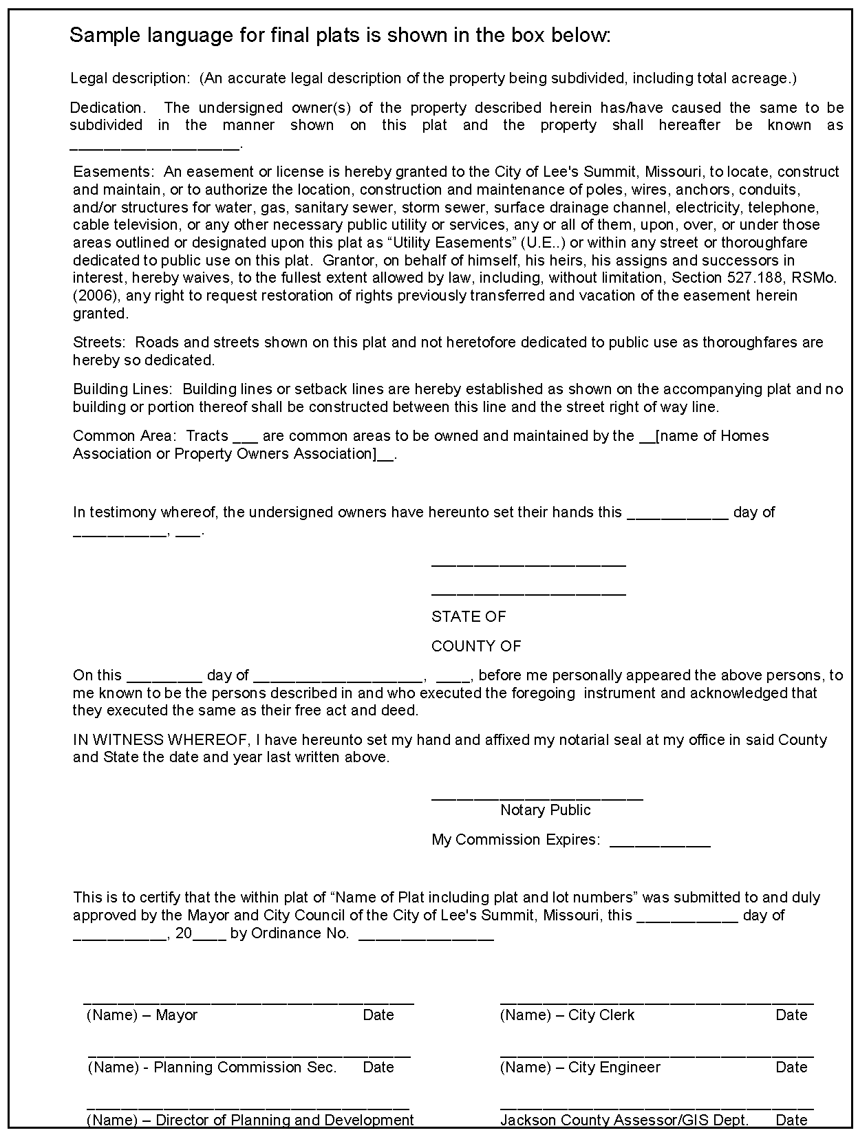
Statements dedicating all easements, streets, sidewalks, alleys and other public areas. Language shall be added to every plat in which an easement is dedicated, stating that the grantor, on behalf of himself, his heirs, his assigns and successors in interest, hereby waives, to the fullest extent allowed by law, including, without limitation, RSMo 527.188 (2006), any right to request restoration of rights previously transferred and vacation of the easement herein granted.
17.
Statement establishing ownership and maintenance responsibility for all common area tracts, private easements, or other non-public areas.
18.
Signature blocks for the following certificates, with the corresponding name typed, printed or stamped beneath the signature:
a.
Signatures of the owner or owners and notary public.
b.
Certification by a registered land surveyor that the survey was executed in accordance with the current Missouri Minimum Standards for Property Boundary Surveys.
c.
Certificate of approval to be signed and dated by Mayor, City Clerk, Commission Secretary, City Engineer, Director of Planning and Development, and County Assessor or GIS Department. If the plat consists of more than one sheet, the certifications for city approval shall be repeated on each sheet, in approximately the same location on each sheet.
19.
Location and limits of the one percent annual chance flood, as set forth on the current FEMA maps, with reference to the panel number. Elevations shall be provided if shown on the FEMA map.
20.
Information required to be recorded on the final plat or a reference to documents required to be recorded with the final plat. Such information shall include but not be limited to covenants that run with the land and conditions of final plat approval imposed by the Governing Body.
21.
Notes shall be included on the plat specifying that individual lot owner(s) shall not change or obstruct the drainage flow lines on the lots covered by the Master Drainage Plan, unless specific application is made and approved by the City Engineer.
C.
Supplementary information. The following supplementary documents and information shall be submitted with the final plat:
1.
Engineering plans. An application for engineering approval pursuant to the Design and Construction Manual. All applications for engineering approval shall be accompanied by the number of copies of the following as required by the City Engineer:
a.
Engineering drawings with the information required in the Design and Construction Manual;
b.
Plans, profiles and details for streets, curb and gutters, sidewalks, storm and sanitary sewers, and water lines;
c.
A written benchmark description and elevation;
d.
A storm water Master Drainage Plan that contains detailed plans for storm drainage, storm water detention, and grading plans, as specified in the Design and Construction Manual.
e.
A designation of easements, if applicable.
f.
All other requirements relating to the submission of engineering plans, as specified in the Design and Construction Manual.
2.
Covenants and restrictions. Any private restrictions affecting the subdivision or any part of the subdivision. If the plat contains any common property, the covenants and restrictions shall conform to the common property regulations in Article 4.
Sec. 7.150. - Consideration of final plats.
A.
Review of plats. The Director shall coordinate review and analysis of the final plat application by the City staff. The results of this analysis shall be compiled by the Director and a staff report prepared for the Commission's consideration.
B.
Action by Commission.
1.
The Commission shall consider and make a recommendation to the Governing Body on the final plat within 30 days after the application is submitted to the Commission. The Commission may recommend approval of the final plat if the subdivider presents clear and convincing evidence that the final plat substantially conforms to the approved preliminary plat, the plat conforms to all applicable requirements of the Code and any modifications granted pursuant to this article and all submission requirements have been satisfied.
2.
If no recommendation is made by the Commission within 30 days after the date of submission of the application, the Commission shall be deemed to have recommended approval of the final plat, as filed, to the Governing Body. The period for Commission recommendation, however, may be extended by written approval of the subdivider or his agent, or if the subdivider or his agent orally agrees to a continuance to a date certain on the record at a meeting of the Commission.
C.
Governing body action upon Commission recommendation. Following review and recommendation by the Commission, the final plat shall be transmitted to the Governing Body for final action. The actions of the Governing Body shall be by ordinance, which shall include approval of the final plat for recording. Upon approval by the Governing Body by ordinance duly passed, such approval shall be endorsed by the Mayor under the hand of the City Clerk and the seal of the City.
D.
Criteria for approval. The Governing Body shall not approve the final plat unless it finds that the subdivider has presented clear and convincing evidence that the final plat substantially conforms to the approved preliminary plat, the plat conforms to all applicable requirements of the Code and any modifications granted pursuant to this chapter, all submission requirements have been satisfied, and the subdivider has satisfied all conditions attached to approval of the preliminary plat.
E.
Common property requirements. No final plat shall be recorded by the developer until the Director and the City Attorney shall have reviewed and approved the declaration of covenants and restrictions pertaining to common property as prepared in accordance with Article 4 of this chapter. No building permit shall be issued for any lot in the subdivision until the Director has received verification from the applicant of the existence and good standing of the condominium or property owners' association required by Article 4 of this chapter. The City Attorney is authorized to undertake any actions at law as may be reasonably required to rescind, invalidate, or void a final plat if such verification is not submitted.
Sec. 7.160. - Conditions stated on plat and endorsement of plat.
A.
Final plat copies. After approval of a final plat by the Governing Body, the subdivider shall prepare and submit for recording purposes, the number of copies of the final plat as required by the Director, properly signed and acknowledged by appropriate persons.
B.
Conditional approval.
1.
If the plat is conditionally approved, the Governing Body shall clearly state the conditions of approval to be satisfied.
2.
The Director shall not endorse the final plat until all conditions for approval imposed by the Governing Body on such final plat are satisfied.
Sec. 7.170. - Recordation of plats.
The approved plat shall be recorded at the appropriate county recorder of deeds office at the subdivider's expense.
Sec. 7.180. - Effect of failure to timely record a final plat.
Except as provided below, if a final plat is not recorded within one year of the date of the Governing Body's approval of the final plat, the approval shall become null and void and a new final plat must be submitted to the Commission and the Governing Body for their consideration.
Sec. 7.190. - Final plat extensions.
Requests for final plat extension shall be made in writing to the Director prior to the one year expiration date provided above. Final plat extensions may only be granted by one of the following:
A.
The Director may administratively grant a one year extension provided no changes have been made to any city ordinance, regulation or approved engineering plans that would require a change in the final plat. Denial by the Director to administratively grant a one year extension for any reason may be appealed to the Governing Body.
B.
The Governing Body, upon appeal from the Director's decision to deny a final plat extension, may grant the one year extension upon finding that such extension will not impact the city's ability to administer current ordinances or regulations.
C.
The Governing Body, in addition to the one year extension above, may grant one additional one year extension, provided that additional engineering plans may be required by the City Engineer to comply with current City ordinances and regulations.
Sec. 7.200. - Minor subdivisions (minor plats); when allowed.
Minor plats may include:
A.
A division of land into no more than three lots.
B.
An adjustment in boundaries between the owners of adjoining platted lots.
C.
An adjustment of building lines.
D.
A resurvey to combine two or more lots or tracts into no more than three new lots.
E.
A resurvey of up to three lots containing two-, three- or four-family residential structures, for the purpose of subdividing the dwelling units for individual ownership of each unit. Common area(s) previously created on a final plat may be re-subdivided on such a minor resurvey, but no common area shall be created on a minor plat.
Sec. 7.210. - Minor plat; application—Contents and submission requirements.
A.
Requirement. The subdivider or surveyor shall submit the minor plat to the Director for review.
B.
Contents. The minor plat shall contain the following information:
1.
All general application requirements and plat submission requirements listed in Section 7.080.
2.
Name and address of developer and surveyor preparing the plat.
3.
A legal description which accurately describes the limits of the property and meets the accuracy requirements of the Missouri Minimum Standards for Property Boundary Surveys as adopted by the Missouri Board for Architects, Professional Engineers, Professional Land Surveyors, and Landscape Architects.
4.
Coordinates, based on the Missouri Coordinate System 1983, on the corners of the plat boundary, the control station, station coordinates, and grid factor used in accordance with the regulations of the Missouri Department of Natural Resources.
5.
Sufficient data (distances and directions) to positively locate the surveyed parcel within the United States Public Land Survey, or within the recorded subdivision. All section and land corners referenced on the plat and legal description shall be identified as to what was physically found or set, e.g., aluminum monument, one-half-inch iron bar. Monumentation shall be in accordance with the regulations of the Missouri Department of Natural Resources.
6.
Total acreage of the proposed subdivision.
7.
Location of lots, streets, alleys, sidewalks, tracts and other features with accurate bearings and dimensions of all lines and the length and radius of all curves, along with all other information necessary to reproduce the plat on the ground. All bearings shall be shown to the nearest second of arc and all dimensions, lengths and radii shall be shown to the nearest hundredth of a foot between all corners, angle points and points of curvature.
8.
Area in square feet for each lot, parcel, or tract.
9.
Location of any oil and/or gas wells, if any, based on available information.
10.
Lot numbers and tract identification for each lot and tract.
11.
Location, right-of-way width, bearings and distances, and length and radius of all street and alley centerlines.
12.
Names of existing and proposed streets.
13.
Location and width of existing and proposed sidewalks.
14.
Location, purpose and width of all existing and proposed easements. Existing easements shall include references to the recorded document number, including book and page if any.
15.
Exact location of all existing structures and physical improvements, when requested.
16.
Building setback lines.
17.
Signature blocks for the following certifications, with the corresponding name typed, printed or stamped beneath the signature:
a.
Signature of the owner or owners and notary public.
b.
Certification by a registered land surveyor that the plat was executed in accordance with the current Missouri Minimum Standards for Property Boundary Surveys.
c.
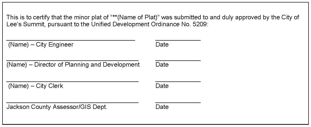
Certification of approval to be signed by City Clerk, City Engineer, Director of Planning and Development, and County Assessor or GIS Department. If the plat consists of more than one sheet, the certifications for city approval shall be repeated on each sheet, in approximately the same location on each sheet.
Sample signature block for minor plats is shown below:
18.
Statement dedicating all easements. Language shall be added to every plat in which an easement is dedicated, stating that the grantor, on behalf of himself, his heirs, his assigns and successors in interest, hereby waives, to the fullest extent allowed by law, including, without limitation, RSMo 527.188 (2006), any right to request restoration of rights previously transferred and vacation of the easement herein granted.
19.
Location and limits of the one percent annual chance flood, as set forth on the current FEMA maps, with reference to the panel number. Elevations shall be provided if shown on the FEMA map.
20.
Notes shall be included on the plat specifying that individual lot owner(s) shall not change or obstruct the drainage flow lines on the lots covered by the Master Drainage Plan, unless specific application is made to and approved by the City Engineer.
C.
Supplementary information. The following supplementary documents and information shall be submitted with the minor plat:
1.
Engineering plans, if required. (See Final plat section above.)
Sec. 7.220. - Consideration, approval and recordation of minor plats.
A.
Review of minor plats. The Director shall coordinate review and analysis of the minor plat by the City staff.
B.
Approval by City staff.
1.
The Director and City Engineer or his/her designee may approve the minor plat if the subdivider presents clear and convincing evidence that the minor plat conforms to all applicable requirements of the Municipal Code and any modifications granted pursuant to this section, and that all submission requirements have been satisfied. The Director may refer a proposed minor plat to the Commission and Governing Body.
2.
The City Council hereby authorizes the Director to require the construction of public improvements as a condition of approval of a minor plat. A requirement to construct public improvements in connection with a minor plat shall follow the requirements of Section 1.110 and other relevant provisions of this UDO. A requirement to construct public improvements for a minor plat may be appealed by the applicant to the City Council as set forth in Section 7.230.
C.
Recordation of plat. After approval by City staff, the subdivider shall prepare and submit for recording purposes, the number of copies of the minor plat as required by the Director, properly signed and acknowledged by appropriate persons. The approved plat shall be recorded at the appropriate county recorder of deeds office at the subdivider's expense.
(Ord. No. 9743, § 1, 9-5-2023)
Sec. 7.230. - Minor plat; general requirements.
A.
Lot size. All lots platted or any remaining platted or unplatted land shall meet all zoning requirements for lot sizes. All RLL, R-1, RP-1 and RP-2 zoned lots proposed to be platted through the minor plat process or any remaining platted or unplatted land resulting therefrom shall meet the following requirements:
1.
Lots created or resulting from a minor plat shall meet or exceed the minimum lot size requirements of the individual zoning district in which located; and
2.
Lots created or resulting from a minor plat shall be not less than 80 percent of the average size of the existing lots within the neighborhood or subdivision in which located, as determined by the Director. Once the initial average lot size has been determined, it shall become and remain the standard by which all other such lots resulting from minor plats within the same neighborhood shall be compared i.e., new lots shall not be used to recalculate an average lot size each time a minor plat is requested; and
3.
For purposes of calculating the area of existing lots, all lots within the same subdivision shall be used to determine the average lot size. If no such subdivision exists then all existing lots within a 500-foot radius or other such measurement, as determined by the Director, shall be used for the average lot size determination. If the applicant for the minor plat disagrees with the Director's determination he/she may file a written appeal with the City Clerk to place such appeal before the Governing Body within ten calendar days of the Director's determination.
4.
Lots created or resulting from a minor plat not meeting the 80 percent area requirement in subsection 2. above may only be approved through the final plat process requiring both Commission and Governing Body review.
B.
Public improvements. No building permit shall be issued for a lot or tract resulting from a minor plat unless all required public improvements for the minor plat have been substantially completed, as provided in this article.
C.
Dedication requirements. A minor plat may not include a new street to be dedicated to the city. A minor plat may include the dedication of additional right-of-way on an existing dedicated street, subject to the approval of the City Engineer. A minor plat may include the dedication of utility easements.
D.
Appeals process for minor plats.
1.
The denial of a minor plat, or the Director's requirement to construct public improvements in connection with approval of a minor plat, may be appealed pursuant to this subsection.
2.
The applicant may appeal the Director's decision to the City Council by filing a written application for appeal with the City Clerk within 20 business days of the date that the Director's decision is served. Upon receipt of any appeal filed pursuant to this section, the City Clerk shall forward the written application for appeal to the Director, who upon receipt shall schedule an appeal hearing before the Planning Commission for its recommendation to City Council.
3.
Notice of hearings before the Planning Commission and City Council shall be provided to the applicant.
4.
Appeal recommendation hearing before the Planning Commission. The purpose of the hearing before the Planning Commission is to make a recommendation to the City Council. The Commission shall hold a hearing upon notification by the Director that an appeal has been filed. During the hearing, the applicant and Director may present information, other persons who may provide information on their respective behalf, and other evidentiary matters for the Commission's consideration, but the formal rules of evidence shall not apply. Any person who receives a mailed notice shall be permitted to provide information to the Commission. The Commission may also receive information from anyone who attends the hearing. Upon the close of the hearing, but not later than two regularly scheduled meetings of the Commission, the Commission shall submit to the City Council its recommendation on whether or not to affirm, reverse or modify the decision of the Director and the reasons therefore.
5.
Upon receipt of the Commission's recommendation, the City Clerk shall place the consideration of the appeal on the next available regular session meeting agenda of the City Council and provide notice to the applicant of the date, time and place that the appeal shall be heard by the City Council. The applicant may present evidence and testimony in support of his/her appeal before the City Council in the same manner as a public hearing for a rezoning of property. The staff shall prepare a staff report for consideration by the City Council summarizing the evidence and testimony presented by all parties at the Planning Commission hearing. The City Council may render a final decision on the appeal by motion, resolution or ordinance.
(Ord. No. 9743, § 1, 9-5-2023)
Sec. 7.240. - Blocks.
A.
Block length. In general, block lengths are determined by intersecting streets and shall be provided at such intervals as to serve cross traffic adequately and to meet existing streets or customary subdivision practices in the neighborhood.
1.
Maximum block length in residential areas shall be based on land use and zoning district, as shown in Table 7-1 below. Block length in non-residential areas shall be subject to the provisions of the Access Management Code.
Table 7-1
2.
Blocks up to ten percent longer than the maximum listed above may be administratively approved if the requirements above cannot be met due to physical constraints, such as topography, drainageways, and existing surrounding streets.
3.
Provision of mid-block connections, in the form of sidewalks, pedestrian walkways, bicycle paths, trails, or alleys, shall be a factor in considering blocks longer than the above maximum lengths. Spacing of pedestrian walkways should be 600 feet or less. Pedestrian ways through the block may be required to serve nearby public facilities or to access common areas. Such pedestrian ways shall be paved and shall have a minimum width of five feet, and shall generally be located within common areas to be maintained by the homeowners or property owners association.
B.
Intersection spacing. Blocks adjacent to collectors and arterials shall have minimum intersection spacing in compliance with the Access Management Code.
C.
Block width. The width of the block shall normally be sufficient to allow two tiers of lots of appropriate depth. Where only one tier of lots is necessary because the subdivision abuts an arterial or collector street, a landscaped common area tract should generally be provided adjacent to the arterial or collector street. Such tract should be a minimum of 20 feet in width, with berms and landscaping as needed to provide appropriate screening.
Sec. 7.250. - Lots.
A.
The minimum lot requirements shall be governed by this chapter.
B.
Side lines of lots shall be approximately at right angles to street lines or radial to curved street lines.
C.
Single-tier lots shall not have access to both front and rear streets. Single-tier lots should be avoided when possible.
D.
Unless otherwise approved during rezoning or preliminary development plan review, each lot in a subdivision shall have a minimum of SO feet of frontage on a public or private street, except that lots on a cul-de-sac or eyebrow shall have a minimum chord of 37.64 feet and a minimum arc distance of 38.59 feet at the front property line. The cul-de-sac or eyebrow minimums are based on a SO-foot radius and a 65-foot width at the 30-foot building line.
(Ord. No. 9907, § 4, 5-14-2024)
Sec. 7.260. - Driveways.
A.
Access—General. Access to individual lots shall not be allowed from an arterial or collector street when access from a local or access street is available. In the absence of a local or access street, the lot shall only have access from the street with the lowest functional classification, in conformance with the Access Management Code.
B.
Access—Corner lots.
1.
Access to corner lots shall be placed as far from the nearest street intersection as possible to achieve the maximum available corner clearance and avoid the intersection functional area.
2.
Access shall not be located within an intersection sight triangle.
3.
Access may be obtained from each abutting street, so long as such street is not an arterial or collector and the location of such access complies with all other conditions of this section.
Sec. 7.270. - Streets
A.
Street Connectivity.
1.
Arrangements of major streets in the subdivision shall conform as nearly as possible to the Comprehensive Plan as adopted by the City and provisions shall be made for the extension of arterial and collector streets. Except for cul-de-sacs or eyebrows, streets shall connect with streets already dedicated in adjacent subdivisions, shall be provided for future connections to adjoining unsubdivided tracts, or shall be a reasonable projection of streets in the nearest subdivided tracts.
2.
All new developments shall be designed to discourage the use of local and residential collector streets by non-local traffic, while maintaining the overall connectivity with the surrounding system of roadways. This may be accomplished through the use of modified grid systems, T-intersections, roadway jogs, or other appropriate traffic calming or street design measures within the development.
B.
Cul-de-sacs. Cul-de-sacs and eyebrows will be permitted where topography or other conditions justify their use, and provisions shall be made for adequate traffic circulation, subject to the following limitations:
1.
The total number of cul-de-sac lots in a subdivision shall be no more than ten percent of the total number of lots in the subdivision. The number of cul-de-sac lots may be increased to 20 percent if provisions are made for pedestrian and bicycle connectivity by way of interconnecting walkways, trails or bikeways, with connections to other public or private sidewalks. "Bulbs" or "eyebrows" containing four lots or less shall not be subject to the ten percent limit.
2.
For all cul-de-sacs, a turnaround shall be provided at the closed end, with an outside curb radius of at least 39 feet and a right-of-way radius of not less than 50 feet.
3.
Cul-de-sacs shall be no longer than 500 feet and the maximum number of dwelling units on a cul-de-sac shall be 20 (except as provided below).
4.
Cul-de-sacs longer than 500 feet, but no longer than 1,000 feet, may be permitted if the subdivider submits clear and convincing evidence to the City that the property is limited by one or more of the following, to such an extent that it is impracticable to provide the area a second means of access that would avoid the cul-de-sac or allow the cul-de-sac to meet the cul-de-sac length limit (e.g., by providing a loop road into the area of the cul-de-sac, or extending the cul-de-sac to connect to another road in the subdivision). The maximum number of dwelling units on a cul-de-sac over 500 feet shall not exceed 30 dwelling units.
a.
Difficult terrain (such as steep slopes) that make it difficult to provide a second means of access.
b.
Floodplain through the property that makes it impracticable to extend or connect the street.
c.
Physical limitations (such as a highway abutting the property or major utilities such as a transmission main).
d.
Remnant parcel where other properties adjoining the area have already been subdivided or developed in a manner that precludes connecting to a surrounding existing or potential road system.
5.
Water lines serving cul-de-sacs shall be designed to meet the requirements of the Design and Construction Manual.
6.
Cul-de-sac length shall be measured from the center point of the bulb of the cul-de-sac, along the centerline of the right-of-way, to the centerline of the right-of-way of the nearest intersecting street that is not a cul-de-sac.
C.
Ingress and egress. There shall be an adequate number of points of ingress to and egress from the subdivision to ensure sound traffic engineering design, smooth traffic flow into and out of all portions of the subdivision (based upon the projected traffic generation from the subdivision and projected traffic on streets adjacent to a subdivision), and the public's safety. In determining whether the subdivision provides for an adequate number of points of ingress and egress, all relevant factors shall be considered, including but not limited to the following:
1.
Residential subdivisions. One point of ingress to and egress from the subdivision shall be required for a residential area generating no more than 500 average daily trips (ADT), or 50 single-family homes. A residential area generating more than 500 ADT shall have at least two points of access. A transportation impact study will be required if the subdivision generates 100 or more trips in a peak hour, and the city traffic engineer shall determine whether the number and location of access points are appropriate based on the study and sound traffic engineering design.
2.
Nonresidential subdivisions. The adequacy of the number of points of ingress to and egress from nonresidential subdivisions shall be determined as a part of and based on the consideration of the site plan for the proposed development. The plat for such development shall show the same number of ingress and egress points as are shown on the approved site plan. If no site plan has been approved, all approvals of the preliminary plats shall be conditioned upon the final plat being consistent with the site plan with respect to the number of points of ingress to and egress from the subdivision.
3.
General factors.
a.
Traffic accumulation. The level of traffic using each point of ingress to and egress from the subdivision should not exceed the level of traffic that the type of street proposed (i.e., residential local or access street, residential collector, etc.) is designed to accommodate.
b.
Access for emergency vehicles. The points of ingress to and egress from the subdivision should be adequate to ensure that emergency vehicles can gain access to all proposed uses within the subdivision whenever necessary.
c.
Intersection of points of ingress to and egress from the subdivision with streets abutting the subdivision. The impact of injecting traffic from the proposed subdivision into the existing street network shall be mitigated by location, design, and control measures consistent with the standards of traffic engineering.
d.
Access to major street. The proposed subdivision or each section of the proposed subdivision with 50 or more lots shall have direct access to a major street (i.e., residential collector or arterial) within or abutting the proposed subdivision.
e.
With respect to:
(1)
A subdivision that is a portion of a larger area planned as a phased and related development and for which a sketch plat must be submitted with the preliminary plat of the area first to be subdivided, and
(2)
To a final plat for a subdivision that covers an area that is less than that covered by the related preliminary plat,
the determination of the adequacy of points of ingress and egress shall be made independently for and considering the cumulative effect of each proposed phase of the development or subdivision, as the case may be.
D.
Future street system.
1.
Where the plat to be submitted includes only part of the tract owned or intended for development by the subdivider, a tentative plan of a proposed future street system, including all points of ingress to and egress from the subdivision, for the unsubdivided portion shall be prepared and submitted by the subdivider, as part of the requirement for preliminary plats.
2.
When a tract is subdivided into larger than required minimum size building lots or parcels, such lots or parcels shall be so arranged as to permit the continuous location and opening of future streets and appropriate resubdivision.
E.
Angle of intersection. Streets shall be laid out so as to intersect as nearly as possible at right angles, except where topography or other conditions justify variations. The minimum angle of intersection of streets generally shall be 80 degrees.
F.
Offsets. Streets entering the opposite sides of a cross-street shall either be directly across from each other or offset by at least 100 feet from the right-of-way of a residential local or residential access street to the nearest right-of-way of another residential local or residential access street. Spacing requirements for all other streets shall be in accordance with the regulations set forth in the Access Management Code.
G.
Limited access. If a commercial or residential subdivision abuts or contains an existing or proposed limited access highway or arterial street, the Commission may require a public street parallel to the highway or arterial, or cross access easements across the lots, as necessary for compliance with the Access Management Code, for adequate protection of residential properties, to afford separation of through and local traffic, and to provide safe, attractive roadways.
H.
Design standards. For all streets hereafter dedicated and accepted in any subdivision, the minimum standards for right-of-way width, pavement width, street grades, and street alignment shall be as set out in the "Design and Construction Manual."
I.
Alleys. Except where justified by special conditions, such as the continuation of an existing alley in the same block, alleys will not be approved in residential districts. Alleys, where provided, shall not be less than 20 feet wide. Intersecting alleys shall have corner cutoffs of at least 20 feet on a side. Dead-end alleys shall be avoided wherever possible, but if unavoidable, such dead-end alleys may be approved if adequate turnaround facilities are provided at the closed end.
J.
Half streets. Dedication of half streets will not be approved except in the public interest.
K.
Private streets. Except where justified by special conditions, private streets will not be approved. Should the Governing Body approve a subdivision containing a private street, the private street shall be shown on the plat as a common area tract, and the provisions of Article 4 concerning common property shall apply.
L.
Curb radii. Where two residential streets intersect at approximately right angles, so that the smallest angle of intersection is not less than 80 degrees, the curb at each block corner shall be rounded with a radius of 25 feet. At all other intersections or where residential street intersects with a divided arterial or arterial street, or where two or more divided arterials or arterials meet, cross, or otherwise intersect in any combination, the curb radii at such intersections shall be subject to the approval of the City Engineer.
M.
Sight distance. No landscaping or screening materials, signs, parked vehicles, or other objects other than essential directional signs, traffic control devices, and utility structures approved by the City shall interfere with the line of sight between a height of two feet and eight feet above the adjoining street or driveway pavement, within the triangular area formed by lines 25 feet in length along the edges of the pavement of intersecting streets or a driveway intersecting a street, from their point of intersection.
N.
Street name and traffic signs. The subdivider shall procure street name and traffic (regulatory) signs, including posts and signs, and install said signs in conformance with the Design and Construction Manual and the approved engineering plans.
Sec. 7.280. - Sidewalks.
A.
Location requirements.
1.
On local and access streets in residential areas, sidewalks shall be constructed on one side of the street if the single-family density is 1.5 to 4.0 dwelling units per gross acre excluding common area and on both sides of the street if the density is over 4.0 dwelling units per gross acre. Sidewalks are not required on either side of a local or access street in a residential area if the density is less than 1.5 dwelling units per acre. On cul-de-sac streets serving single-family development where sidewalks are required only on one side of the street, the sidewalks need not extend around the bulb of the cul-de-sac. Duplex and multi-family development shall require sidewalks on both sides of the street.
2.
On all other streets (including, but not limited to, major and minor arterials, industrial and commercial collectors, and residential collectors), sidewalks shall be required on both sides of the street.
B.
Water line conflict. When a sidewalk is required on one side of a street, the sidewalk should be placed on the opposite side of the street from the water line, where feasible.
C.
Sidewalk width. Minimum sidewalk width shall be five feet. Construction standards shall be in accordance with the "Design and Construction Manual."
Sec. 7.290. - Easements.
A.
Location. An easement for utilities, at least seven and one-half feet wide, shall be provided alongside and rear lot lines where necessary to form a continuous right-of-way at least fifteen (15) feet in width. If necessary for the extension of main water or sewer lines or similar utilities, including storm or sewer lines, easements of greater width will be required along lot lines or across lots.
B.
Connectivity. Utility easements shall connect with easements established on adjoining properties.
C.
Pole guys. Additional easements for pole guys should be provided at the outside of turns. Where possible, lot lines shall be arranged to bisect the exterior angle so that pole guys will fall along the side lot lines.
D.
Storm sewers. Utility easements for public storm sewers shall be required. Easements shall not be required for open drainage courses.
E.
General utility easements. The subdivider shall be required to work out all easements required by all public utility companies, including but not limited to gas, electric, telephone, water and sewer. The subdivider shall provide documentation to the City showing he/she has sent copies of the preliminary and final plat to the utility companies and asked for their input prior to approval by the City.
F.
Street lighting consideration. Placement of utility easements in residential subdivisions shall take into consideration City of Lee's Summit street lighting standards.
G.
Vacation of conflicting easements. Existing easements that are recorded and/or platted but not needed and public roadways that conflict with the proposed use or plat must be vacated prior to final plat approval.
H.
Dedication of easements. The following language or similar language shall be added to every document in which an easement is dedicated to the City of Lee's Summit:
"Grantor, on behalf of himself, his heirs, his assigns and successors in interest, hereby waives, to the fullest extent allowed by law, including, without limitation, RSMo 527.188, (2006), any right to request restoration of rights previously transferred and vacation of the easement herein granted."
This would not prohibit the City from agreeing to vacate the easement at a later date for no monetary consideration to the Grantor, including his heirs, assigns and successors in interest.
Sec. 7.300. - Dedications for public sites and open spaces.
A.
Dedication procedures. All areas to be reserved for or dedicated to public use shall be indicated on the preliminary plat in order that it may be determined when, if, and in what manner such areas will be dedicated to or acquired by the appropriate agency and shall conform as nearly as possible to the recommendations of the Comprehensive Plan.
B.
Revisions. All streets, alleys, sidewalks, easements, and other public sites, when approved by ordinance, shall not thereafter be changed without the approval of the Governing Body by ordinance following recommendation of the Commission.
Sec. 7.310. - Planned mixed use developments.
Planned mixed use developments are to be reviewed on their individual merits upon specific application of a developer. Any conflicting regulations herein may be waived to carry out intent of plan.
Sec. 7.320. - Adoption of administrative guidelines.
A.
Authorization. The Director is authorized, as deemed necessary, to prepare administrative guidelines to augment, implement and provide further details and examples of methods and manners of complying with the minimum design standards of this section, and to assist City staff, the Commission and Governing Body in evaluating whether a proposed subdivision complies with the minimum design standards.
B.
Procedure. No later than 14 days in advance of the effective date as set by the Director, of an administrative guideline, the Director shall provide a copy of the administrative guideline to each member of the Governing Body. Upon receipt of the administrative guideline, any member of the Governing Body may request a review of the administrative guideline, and a majority may approve all or a portion of such guidelines by resolution. Any portion reviewed by the Governing Body and not so approved shall not take effect. If the Governing Body does not request review, the administrative guideline shall take effect on the date set by the Director. All administrative guidelines that take effect in this manner and have not been previously adopted by the Governing Body shall be adopted by the Governing Body, by resolution, annually.
Sec. 7.330. - Required public improvements.
All subdivision-related public improvements required by this chapter must be completed as a condition precedent to the approval of the final plat, unless security is provided pursuant to Section 7.340. No building permit shall be issued until the required public improvements are available to each lot for which a building permit is requested in accordance with the Design and Construction Manual, or until satisfactory security is provided pursuant to Section 7.340.
Sec. 7.340. - Plat approval and security in lieu of constructing public improvements.
A.
Authority. The City Council may grant approval of a plat prior to completion of all subdivision-related public improvements if the developer complies with the requirements of this section.
B.
Approval of security. Upon approval of the City Council and in lieu of completion of all subdivision-related public improvements prior to the final approval of a plat, the City shall accept, at the option of the developer, a form of security as approved by the City Attorney for the purpose of providing for and securing the actual construction and installation of the public improvements and utilities within a period specified in the ordinance approving the final plat and expressed in the security.
C.
Requirements for security. The following requirements shall apply to security for public improvements:
1.
The amount of the required security shall be provided to developer by the Development Services Department or City Engineer. The dollar amount of the security shall be based on:
a.
An estimate of the cost to complete the construction and installation of all public improvements and as determined and certified by the design engineer and as approved by the City Engineer,
b.
An additional amount to adjust for inflation, based on the latest projected date that the public improvements may be completed,
c.
Any additional amount needed for contingency, as deemed necessary by the Development Services Department or the City Engineer, and
d.
An amount for administrative and management costs expected to be incurred by the City in the course of administering the design and construction contracts that may be required to complete the public improvements.
2.
The form of any security allowed under this section is subject to the approval of the City Attorney and the Director of Finance, and all such documents shall be filed with the Director of Finance. The party providing the security shall use the form that is approved by the City Attorney, which may contain such changes as requested by the provider and as accepted by the City Attorney.
3.
The security instrument or agreement may express an expected termination date, but the security instrument or agreement shall not terminate except upon approval of the Director of Finance. Any form of security which fails to contain such clause ("shall not terminate except upon approval of the Director of Finance") shall be deemed to remain in effect and may not terminate or be terminated except upon approval of the Director of Finance.
4.
Any security provided in compliance with this section may be enforced by all appropriate legal and equitable remedies.
5.
The City may accept, in lieu of completion of all subdivision-related public improvements prior to the final approval of a plat, an assessment or other method whereby the City is put in an assured position to do the necessary work for construction and installation of the subdivision-related public improvements at the cost of the owners of the property within the subdivision. Any surety or financial institution proposed to be used under this subparagraph is subject to the approval of the Director of Finance with regard to the issue of sufficient financial capability.
6.
When the security involves the deposit of cash with the City, the developer shall enter into a deposit agreement with the City in a form approved by the City Attorney. The City shall maintain any escrow funds deposited by a developer for the purpose of constructing public improvements in a separate account or fund established for the public improvements. Any funds deposited with the City shall earn interest at the rate earned on the City's pooled cash in accordance with the City's investment policy, and such interest will be paid to the City to cover administrative and other costs associated with maintaining the cash deposit unless otherwise provided in the escrow agreement.
7.
The terms of all letters of credit shall include the following:
a.
The letter of credit may be drawn upon, at the election of the City (i) by physical presentation of the letter by the City at a bank location in Lee's Summit, or in the Kansas City metropolitan area if no bank location exists in Lee's Summit, or (ii) by mailing the letter of credit and appropriate documentation by U.S. Mail or courier service to a bank location specified in the letter;
b.
The letter of credit shall not be reduced without the written approval of the Finance Director;
c.
The letter of credit shall not expire until the earlier of: (i) the date that the City has issued a certificate of final acceptance for all of the public improvements that are covered by the letter of credit, or (ii) 30 days after the City has received written notification from the issuing bank that the letter of credit will be deemed terminated due to developer's failure to timely complete the required public improvements by the expiration date stated in the letter;
d.
The letter of credit shall be deemed to be extended until the City has issued a certificate of final acceptance for all of the public improvements that are covered by the letter of credit; and
e.
Other terms and conditions as approved by the City Attorney.
D.
Reductions in the amount of security. Any request for a reduction in the effective amount of the security instrument or cash deposit for the partial completion of the required public improvements shall be in accordance with the following:
1.
If a developer seeks to reduce the effective amount of the security, the developer or design engineer shall transmit to the City Engineer the desired amount of the reduction, accompanied by sufficient information and documentation to justify the requested reduction. The City Engineer shall review the request to evaluate whether the reduction is warranted, and whether the remaining amount of the security will continue to put the City in a secured position regarding completion of the remaining public improvements that are covered by the security.
2.
The City Engineer may communicate back to developer, or the design engineer on behalf of developer, that developer may commence the process to reduce the effective amount of the security, which shall thereafter be transmitted to the Finance Director by developer, the design engineer, the issuing bank or other appropriate party, for approval. No security shall be reduced without the written approval of the Finance Director. Any communication by the City Engineer or Development Services Department regarding reduction in the effective amount of the security shall not be deemed a final approval, and such final approval for a reduction in security may only be granted by the Director of Finance.
E.
Draws on security. Security provided to the City may be drawn upon in compliance with the following:
1.
The City may draw on the security when a project site has been abandoned by the developer, or a contractor for developer.
2.
A project site shall be deemed abandoned if no substantial work to complete the public improvements has been performed for a period of at least 60 days. The re-commencement of work during such 60-day period that does not substantially advance the completion of the public improvements and which are designed solely to avoid a draw on the security shall not be treated a re-commencement of the work.
3.
The City shall have discretion regarding the decision of whether and when to draw on security to complete the public improvements after abandonment, and nothing in the City Code or the Design and Construction Manual shall compel the City to draw on such security.
F.
Treatment of security upon transfer of title to subdivision property. In the event that a developer who has posted security seeks to transfers title of the subdivision property prior to full release of the security, the City will accept suitable replacement security in compliance with this Section from the successor developer in the amount of the security held by the City at the time of the property transfer. Upon receipt of the replacement security, the original security instrument shall be released in part or in full, as appropriate, and the prior developer shall be released from all further obligations with respect to the subdivision-related public improvements if the successor developer assumes all of the outstanding obligations of the previous developer.
G.
Release of security. The appropriate portion of a security instrument or deposit held by the City to secure construction and installation of each component of the public improvements or utilities shall be released within 30 days after completion of each category of public improvement or utility work to be installed, minus a maximum retention of five percent which shall be released upon completion of all improvements and utility work. Any such category of public improvement or utility work shall be deemed to be completed upon certification by the City Engineer that the project is complete in accordance with the ordinances of the City including the filing of all documentation and certifications required, in complete and acceptable form. The release shall be deemed effective when the security instrument is returned to the owner or developer or sent by United States Postal Service or other agreed-upon delivery service, or when the escrow funds or bond amount are hand delivered to an authorized person or place as specified by the owner or developer.
(Ord. No. 8895, § 1, 6-9-2020)
Sec. 7.350. - Permanent markers and monuments.
A.
Permanent reference points. The subdivider shall cause a registered land surveyor to install permanent reference points on all perimeter corners of the property and shall tie all property corners to the quarter section. The construction and placement of permanent markers shall conform to the current "Minimum Standards for Property Boundary Surveys, 10 CSR 30-2, Missouri Code of Regulations" (as amended).
B.
Permanent markers. Permanent markers shall be placed at points of curvature and points of tangency on street lines and at each angle point on the boundary of the subdivision. In situations where conditions prohibit the placing of markers in the locations prescribed above, offset markers will be permitted. Permanent monuments shall be placed at all quarter section points within the subdivision or on its perimeter.
Sec. 7.360. - Streets.
Classification of streets shall be as adopted in the City of Lee's Summit's Comprehensive Plan as shown on the Thoroughfare Master Plan. The required street improvements that will be accepted and maintained shall be as determined by the City Code and the Design and Construction Manual.
Sec. 7.370. - Sidewalks.
Sidewalks shall be constructed and installed in conformance with the minimum design standards set forth in Division III of this article. The determination as to whether a sidewalk is required adjacent to a particular lot shall be made by the City, with consideration given to the recorded plat for the lot in question, adjacent recorded plats, engineering plans, water line locations, and the design standards set forth in this article.
A.
Responsibility for construction.
1.
Where a sidewalk is required adjacent to a buildable lot, sidewalks shall be constructed by the builder prior to occupancy of any structure on that lot.
2.
When a sidewalk is required adjacent to either a common area tract, or any unplatted land, or any land where no structure is intended to be built, the developer shall construct the sidewalk at the time the street is constructed.
B.
Escrow. Should construction or installation of the sidewalks be impossible because of weather or other conditions, the person or legal entity responsible for the construction of the sidewalk shall deposit with the City a cash sum in an amount equal to the construction cost of said sidewalk.
C.
Payment in lieu of sidewalk installation.
1.
If the property owner feels a hardship exists that reasonably precludes the construction of a sidewalk, the property owner may submit a written request to the Director of Development Services ("Director") for payment in lieu of construction of sidewalk together with such information and studies as the Director may deem necessary to consider the request. Upon filing a complete application, this request will be reviewed and approved or denied by the Director based on the following criteria:
a.
The currently adopted City Capital Improvement Plan includes public improvements in the same area which would certainly result in damage, deconstruction and/or replacement of the proposed sidewalk;
b.
The street is generally unimproved or built to an interim standard, typically characterized without curb and gutter unless such construction was intentional and in combination with sidewalk accommodation;
c.
Practical barriers exist to the construction of sidewalk or reasonably obstruct sidewalk connectivity including significant slopes or space limited, grade separated, rail, waterway or freeway crossings;
d.
Adjacent properties have been developed without sidewalk and the nearest existing sidewalk connection to the subject property exceeds 660 feet; or
e.
Another jurisdiction prohibits sidewalks along their right-of-way.
If the Director approves the request or such request is granted by the City Council by appeal, the property owner shall submit payment as calculated in Section B, to the City Finance Department and when such payment is received in full the sidewalk obligation for development shall be considered met.
If the Director denies the request, the property owner may then appeal to the City Council through an applicable development application that requires public hearing. The City Council may consider an appeal that the denial was arbitrary and capricious and the appellant shall submit sufficient facts and evidence to establish that the Director has acted in such fashion. If the City Council finds by an affirmative vote that the Director did act in an arbitrary and capricious fashion, a payment in lieu of construction shall be allowed.
2.
The payment shall be calculated as the average unit price from all bids received by the City on public works projects in the most recent preceding three calendar years in which projects were competitively bid.
3.
The payment shall be held by the City of Lee's Summit Finance Department in an account for the City to use for sidewalk construction only.
4.
Use of monies paid in lieu of sidewalk construction. At a time to be determined by the City Manager and/or Director of Public Works, collected monies in lieu sidewalk construction of shall be used to construct sidewalk in the same address grid quadrant as the property from where the payment was collected if it is not used to construct sidewalk adjacent to said property.
(Ord. No. 8895, § 1, 6-9-2020)
Sec. 7.380. - Street name and traffic signs.
The subdivider shall install street name signs at all street intersections and traffic (regulatory) signs in conformance with the Design and Construction Manual and the approved engineering plans.
Sec. 7.390. - Sanitary sewers.
A sanitary sewer system shall be constructed by the subdivider in accordance with the Design and Construction Manual. When public sewers are not available, the subdivider shall construct a sewage collection system in accordance with the requirements of Jackson or Cass County, as the case may be, and the Missouri Department of Natural Resources. The maintenance bond requirements will be the same for a public sewer or individual collection system. A Certificate of Substantial Completion must be issued prior to the issuance of building permits.
Sec. 7.400. - Sanitary sewers to adjacent property.
Sanitary sewers shall be extended to the subdivision boundary line to serve adjacent property, except where adjacent property can be served by future sewer extension through dedicated right-of-way. These sewers shall be of adequate size to serve the upstream basin, as determined by the City Engineer.
Sec. 7.410. - Storm sewers.
All storm sewers constructed within the City shall be in accordance with the Design and Construction Manual. Storm water detention facilities and/or sedimentation facilities shall be constructed prior to the issuance of building permits and shall be maintained as required to control off-site drainage impacts. All storm drainage calculations shall be made in accordance with the Design and Construction Manual. Detention facilities on private property shall be maintained in accordance with the provisions set forth elsewhere in this chapter.
Sec. 7.420. - Abutting streets.
Abutting streets shall be improved in accordance with the Thoroughfare Master Plan where necessary. Such improvements may include street widening, street resurfacing or replacement, installation of curbs and gutters, sidewalks, and storm water management facilities.
Sec. 7.430. - Water service.
A.
Requirements. Water lines shall be constructed by the subdivider in accordance with "American Water Works Association Standards" and the Design and Construction Manual.
B.
Building permit issuance.
1.
Water lines, hydrants, and base course for streets must be installed prior to issuance of building permits, pursuant to the International Fire Code.
2.
A Certificate of Substantial Completion must be issued prior to the issuance of building permits.
Sec. 7.440. - Power distribution and telephone lines.
A.
Power distribution lines. In all subdivisions, power distribution lines shall be installed underground adjacent to lots proposed for residential, commercial or industrial use, except in the case of a minor plat or replat containing three or fewer lots where overhead lines are in existence on abutting property. Power lines classed as transmission or three-phase feeder need not be placed underground. All installations shall be in conformance with the minimum standards and practices of the power company having jurisdiction.
B.
Telephone lines. In all subdivisions, telephone lines shall be installed underground adjacent to lots proposed for residential use, except in the case of a lot split or other division of land or replat containing three or fewer lots where overhead telephone lines are in existence on abutting property.
Sec. 7.450. - Construction commencement.
Construction of a public improvement project may commence only after the following requirements are fully met:
A.
The City Engineer approves a final engineering submittal;
B.
Inspection fees are paid to the assigned Public Works Inspector (fees shall be in amounts established by the Design and Construction Manual); and
C.
The Public Works inspectors have been notified 48 hours prior to anticipated commencement of construction.
Sec. 7.460. - As-built mylars with engineering certificates.
A.
Submittal requirements. As-built mylars must be received by the City before final acceptance of any improvement project. The mylars must include results of a post-construction survey. The post-construction survey shall include the following:
1.
Elevation of all sewer structures including pipe inverts and structure top elevations;
2.
Final adjusted stationing of all sewer structures and water line valves, hydrants and blow-off assemblies; and
3.
Final adjusted contours as shown in the grading plans and master drainage plan.
B.
Certification. As-built mylars must include a certification by a professional engineer licensed in the State of Missouri stating that the drawings are as-built and conform to construction records and post-construction survey information.
Sec. 7.470. - Improvement inspections.
All required subdivision improvements shall be subject to inspection and approval by the City Engineer.
Sec. 7.480. - Acceptance of improvements.
A certificate of final acceptance for required public improvements will be issued, provided the requirements set forth in the Design and Construction Manual are fully met within the time frame established therein.
Sec. 7.490. - Partial acceptance of work.
The City may accept and make use of any completed section of the public improvement work without obligating the City to accept the remainder of the public improvement work or any portion thereof. The warranty period for the accepted section shall not start until the project is complete and the City has issued the certificate of final acceptance.