
Lewisville City Zoning Code
SUBPART 1
ADMINISTRATION
CHAPTER I.1.- TITLE
This volume of the City of Lewisville Code of Ordinances shall be known and may be cited as the "Unified Development Code," the "UDC" or the "Zoning and Development Ordinance." This UDC is comprised of four (4) subparts. Subpart 1 sets forth an overview of the zoning and development terms and procedures. Subpart 2 sets forth the regulations related to zoning and shall be known and may be cited as the "Zoning Ordinance." Subpart 3 sets forth design and development regulations and shall be known as the "Design Standards." Subpart 4 sets forth the subdivision regulations and shall be known and may be cited as the "Land Development Regulations" or the "LDR."
CHAPTER I.2. - PURPOSE
The regulations as herein established have been made in accordance with all adopted long range plans which function collectively as the City of Lewisville's comprehensive plan for the purpose of promoting the health, safety, morals and general welfare of the City and in furtherance of the following related and more specific objectives:
A.
Provide sufficient space in appropriate locations for a variety of residential, recreational, commercial and industrial uses and open space, both public and private; according to their respective environmental requirements to meet the needs of all citizens.
B.
Secure safety from fire, flood, panic and other natural and human-initiated disasters.
C.
Provide adequate light, air and open space.
D.
Promote a desirable visual environment through creative development techniques and good civic design and arrangement.
E.
Promote the establishment of appropriate population densities and concentrations that will contribute to the well-being of persons and neighborhoods.
F.
Encourage the appropriate and efficient expenditure of public funds by the coordination of public development with land use policies.
G.
Promote the conservation of open space and valuable natural resource and prevent urban sprawl and degradation of the environment through improper use of land.
H.
Encourage the location and design of transportation routes which will promote the free flow of traffic while discouraging location of such facilities and routes which may result in congestion or blight.
I.
Encourage coordination of the various public and private procedures and activities shaping land development with the goal of increasing the efficiency of the land development process and appropriate use of land.
J.
Protect and preserve areas of environmental, historical, cultural and architectural importance and significance within the City.
CHAPTER I.3. - AUTHORITY
This Unified Development Code is adopted pursuant to the statutory authority conferred by the Texas Local Government Code, as amended, and the City charter of the City of Lewisville and pursuant to and in accordance with all adopted long range plans which function collectively as the City of Lewisville's comprehensive plan.
CHAPTER I.4. - APPLICABILITY
The regulations of this UDC shall apply to all buildings, structures, land and uses within the corporate limits of the City of Lewisville, and where allowed by law, within the City's extraterritorial jurisdiction.
CHAPTER I.5. - INTERPRETATION
The Planning Director and City Engineer are responsible for making any interpretations of this UDC, except as otherwise provided herein. Persons may appeal an interpretation of this UDC to the Board of Adjustment in accordance with Article IV.5 of this UDC, which shall have the authority to deter-mine the meaning and interpretation of any provision of this Article.
CHAPTER I.7. - ENFORCEMENT AND PENALTIES
Any person, firm or corporation found to be violating any term or provision of this UDC shall be subject to a fine in accordance with Volume 1, Chapter 1, Section 1-15 of the Code of Ordinances for each offense. Every day a violation continues shall constitute a separate offense.
CHAPTER I.8. - PRESERVING RIGHTS IN PENDING LITIGATION
It is the intent and declared purpose of this UDC that no offense committed and no liability, penalty or forfeiture, either civil or criminal, incurred prior to the time the proper existing ordinance was repealed and this UDC adopted, shall be discharged or affected by such repeal; but prosecutions and suits for such offenses, liabilities, penalties or forfeitures may be instituted or causes presently pending proceeded with in all respects as if such prior ordinance had not been repealed.
CHAPTER II.1.- INTERPRETATION OF LANGUAGE
All provisions, terms, phrases and expressions contained in this UDC shall be liberally construed in order that the true intent and meaning of the City Council may be fully implemented. Interpretation shall utilize the following principles in addition to the rules of construction outlined in Volume 1, Chapter 1.1-2 of the City of Lewisville Code of Ordinances:
CHAPTER III.3. - CERTIFICATES OF OCCUPANCY
Certificates of occupancy shall be required in accordance with Volume 1, Chapter 4, Article II, Section 4-36 of the Code of Ordinances.
CHAPTER V.2. - TERMINATION OF NONCONFORMING USES[1]
Editor's note— Ord. No. 0608-23-ORD, § 4, adopted Nov. 6, 2023, repealed the former Ch. V.2, §§ V.2.1—V.2.7, and enacted a new Ch. V.2 as set out herein. The former Ch. V.2 pertained to termination of nonconforming uses and signs and derived from the original Unified Development Code.
Section I.6.1. - Compliance Required
All land, buildings, structures, or appurtenances thereon located within the City of Lewisville, Texas which are hereafter occupied, used, erected, altered, or converted shall be used, placed, and erected in conformance with the regulations prescribed for in this UDC.
Section I.6.2. - Plat Required
No permit for the construction of a building or buildings upon any plot or tract within the City of Lewisville or its extraterritorial jurisdiction shall be issued unless the plot or tract is part of a recorded plat, as required by this UDC and properly approved by the City Council, Planning and Zoning Commission or City staff as authorized herein.
Section I.6.3. - Accessibility
All development and redevelopment must comply with all applicable local, state, and federal laws and regulations including the ADA and Texas Accessibility Standards.
Section II.1.1. - Headings, Illustrations and Text
In the event of a conflict or inconsistency between the text of this UDC and any heading, caption, figure, illustration, table or map, the text shall control.
Section II.1.2. - Lists and Examples
Unless otherwise specifically indicated, lists of items or examples that use terms such as "for example," "including," and "such as" or similar language are intended to provide examples and are not exhaustive lists of all possibilities.
Section II.1.3. - Delegation of Authority
Whenever, by the provisions herein, any officer, employee, department, board, commission or other agency of the City is assigned any duty or empowered to perform any act or duty, reference to such officer, employee, department, board, commission or other agency shall mean and include such officer or any designee or authorized subordinate and shall also include the successor in function to such officer, employee, department, board, commission or agency, unless the terms of the provision or section specifies otherwise.
Section II.1.4. - Words Used
Words used in the present tense shall include the plural and the singular; the term "used for" or "engaged in" includes the meaning "designed for" or "intended for"
Section II.1.5. - Nontechnical and Technical Words
Words and phrases shall be construed according to the common and approved usage of the language, but technical words and phrases and such others as may have acquired a peculiar and appropriate meaning in law shall be construed and understood according to such meaning.
Section II.1.6. - Mandatory and Discretionary Terms
The words "shall," "must," and "will" are mandatory, establishing an obligation or duty to comply with the particular provision. The words "may" and "should" are permissive.
Section II.1.7. - City, State, or Federal Law Reference
Any reference to a city, state, or federal law shall mean and refer to the most recent version of that law, as it may be amended, unless otherwise specified.
Section II.2.1. - Definitions
Access Aisle - A paved surface to allow vehicular movement through a property, between properties, or to parking spaces.
Accessory Building, Accessory Structure, or Accessory Use - One which: (a) is subordinate to and serves a principal building, principal structure, or principal use; (b) is subordinate in area, extent or purpose to the principal building, principal structure, or principal use served; (c) contributes to the comfort, convenience and necessity of occupants of the principal building, principal structure, or principal use served; and (d) is located on the same building lot as the principal building, principal structure, or principal use served.
Accessory Dwelling Unit (Commercial) - A dwelling unit located within a non-residential use as an accessory use where the occupant is the owner lessor, or manager, security guard, or other individual employed full-time by the owner or lessor of the site. The principal use of the site must require a caretaker for security purposes, or for care of people, plants, animals, equipment, or other conditions on site, so that the accessory dwelling unit is directly accessory to the non-residential use.
ADA - The Americans with Disabilities Act, as amended.
Administrative Modification - A limited modification of certain standards of this UDC which may be approved by City staff as outlined in Article IV.3 or Article VI.7.1 of this UDC.
Agricultural, Farming, Ranching - The cultivation of agricultural commodities such as vegetables, fruits, grains, and some animal products. Animals may include poultry, horses, cattle, and sheep. Necessary accessories for the raising, treating, and storing of agricultural products may be included. Any type of agriculture or husbandry activity that is specifically prohibited by ordinance or law is not included in this definition.
Agricultural Structure or Building - A structure or building that is designed, constructed, and used to house farm implements, livestock, or agricultural goods and that is used by the owner, lessor, immediate family of the owner, and/or persons engaged in the pick-up or delivery of agricultural goods grown or raised on the premises. This definition shall not include a building used as a dwelling.
Airport - Any area of land or water designed and set aside for the landing and take-off of aircraft, including all necessary facilities for the housing and maintenance of aircraft, including and not limited to, air traffic control facilities, terminal buildings and airport auxiliary facilities.
Alternative Energy - Energy sources that are renewable and which typically have lower carbon emissions compared to fossil fuel energy sources. These include biomass energy systems, solar energy systems, geothermal energy systems, wind energy conversion systems, and hydroelectric energy sources.
Alternative Standard - A more significant modification of certain standards of this UDC which must be approved by the Planning and Zoning Commission or the City Council as provided in Article III.4 or Article VI.7.1 of this UDC.
Amateur Radio Communications Antennas/Support Structure - An antenna or other communication device used in the transmission and reception of radio waves by an amateur radio operator. This includes any associated towers, support structures, or related, necessary equipment.
Amenity Zone - That portion of the public right-of-way or land adjacent to private vehicular route in which the adjacent property owner is responsible for the placement of required sidewalks, trees, and street furnishings in a manner that does not obstruct pedestrian access or motorist visibility.
Animal Care (Indoor) - An establishment primarily dedicated to the personal care for and/or grooming of domestic animals, typically dogs and cats, excluding activities that involve outdoor storage, outdoor pens, or outdoor kennels.
Animal Care (Outdoor Pens or Runs) - An establishment primarily dedicated to the personal care for and/or grooming of domestic animals, typically dogs and cats, including activities that involve outdoor storage, pens, or kennels.
Animation - The rapid display of a sequence of images of two-dimensional or three-dimensional artwork or model positions in order to create an illusion of movement.
Apartment - A dwelling unit in an apartment building.
Apartment Building - A building, or any portion thereof, which contains three (3) or more dwelling units, located in the same building lot. An apartment building is a multi-family dwelling.
Appeal - An application to review a decision as allowed for in this UDC.
Applicant - The person responsible for the submission of an application. The applicant shall be either the actual owner of the property for which an application is submitted or a duly authorized representative of the property owner.
Architect - Any state-registered architect.
Architectural Screen - Any permanent, semi opaque screening device that is integrated with the architectural facade design of a building.
Arena - See "Stadium."
Art - Sculpture, water features, and murals, or paving designs of a unique and attention-getting character, excluding corporate logos or commercial messaging.
Articulation - Features that divide building facades into distinct and significant parts through architectural detail, projections, differentiation, and openings.
Asphalt/Concrete Batch Plant (Permanent) - A permanent improvement or series of improvements that are primarily used in the manufacturing, processing, or production of concrete or asphalt.
Asphalt/Concrete Batch Plant (Temporary) - An improvement or series of improvements, none of which are permanent, that are primarily used in the manufacturing, processing, or production of concrete or asphalt and which are supplying a specific project or development.
Assisted Living Facility - A community or establishment, other than a single-family dwelling, that provides food, shelter, and other necessities for seven (7) or more elderly or disabled individuals who are unrelated to the proprietor. Personal care services, as defined by V.T.C.A., Health and Safety Code ch. 247, may be provided, including assistance with daily life in the form of dressing, movement, bathing, or other needs. Other services may include housekeeping, meals, transportation and central activity room.
Auction Yard (Vehicle) - A place where operable motor vehicles are offered for sale to persons who bid on the vehicles in competition with each other.
Automobile Parts Sale - A business primarily engaged in the retail sale of new parts or accessories for vehicles, excluding establishments that engage in the on-site repair of automobiles or contain repair bays.
Automotive Repair (Major) - The repair, rebuilding, or reconditioning of engines, air conditioning systems, transmissions, and electronic systems for motor vehicles; wrecker service; collision services, including body, frame or fender straightening or repair; customizing, painting; vehicle steam cleaning, undercoating and rust proofing; any use defined as "Automotive Repair (Minor) on a heavy load vehicle; and any use included under "Automotive Repair (Minor)."
Automotive Repair (Minor) - The repair or replacement of brakes, parts, tires, and batteries; diagnostic services; oil and filter changes; emergency road service; performing state inspections; normal servicing of air conditioning systems; and other similar minor services for motor vehicles except heavy load vehicles.
Automobile Sales and Leasing - A business primarily engaged in the retail sale or leasing of new or used automobiles, including accessory uses such as repair and sale of parts and accessories.
Automobile Sales and Leasing (Online) - A business primarily engaged in the online retail sale or leasing of new or used automobiles and not including storage, display and repair.
Automobile Salvage - A business primarily engaged in the storage, collection, processing, repair, purchase, or sale of salvaged auto parts.
Awning - A roof-like cover which may be fixed in place or retractable that is not a permanent integral element of the building to which is attached, projecting from the facade of a building for the purpose of shielding a doorway or window from the elements.
Bakery/Food Production with Retail Sales - A retail establishment dedicated to the on-site production and sale of baked goods or specialty food items for display and consumption.
Backyard Cottage - A detached, self-contained dwelling unit that is secondary to the principal building and is subordinate in area, extent, or purpose to the principal building or principal use served. An accessory building with shower/bath and kitchen facilities is considered a backyard cottage.
Bank or Financial Institution - A establishment open to members of public with primary business activities that involve the depositing, loading, exchanging, or issuing of money. These institutions may also be involved in the extension of credit to qualified persons, as well as the facilitation of the transmission of funds to other locations, including automated teller machines. A bank or financial institution does not include a credit access business.
Bar - An establishment licensed by the state for the sale of alcoholic beverages that derives more than 75 percent of the establishment's gross revenue from the on-premises sale of alcoholic beverages for on-premises consumption.
Bed and Breakfast - An establishment offering the use of guest rooms and meals in an owner- or operator-occupied dwelling unit to the transient public for compensation.
Beverage Container Recycling Collection Unit - A unit used for the commercial collection and temporary storage of empty beverage containers for recycling purposes conducted totally within an enclosed structure or container. This definition does not include home recycling containers or beverage container processing except for "can banks" that crush cans as they are deposited.
Block - An area of land bounded by public or private streets or private vehicular routes, or by a combination of public or private streets and public parks, cemeteries, railroad rights-of-way, highways, streams, or corporate boundary lines of the City. There may be more than one (1) lettered or numbered block as shown on a plat falling within a single block as herein defined.
Block Perimeter - The sum total dimension of all sides of a block which is circumscribed by public streets or private vehicular routes as measured along the property lines.
Board - The Board of Adjustment of the City of Lewisville.
Boat Sales and Service - A business primarily engaged in the sales, leasing or repair of motorized and non-motorized boats or watercraft and associated uses such as sales of parts or accessories.
Brewery - An establishment where beer or malt liquor is brewed.
Brick Veneer - That form of construction composed of individual kiln fired brick units, stone, split face block, glass block or combination of these materials laid up unit-by-unit, set in mortar and installed per the adopted building code.
Broadcasting Station or Studio with Towers (Radio or Television) - A building used for the creation and distribution of audio or visual content for the purpose of distribution to a dispersed audience via any electronic mass communication medium and containing or directly adjacent to communication antennas or communication support structures that are used for said distribution.
Build - To erect, convert, enlarge, reconstruct or alter a building or structure.
Build-to Zone - An area of a specified depth, parallel to and touching a specified lot line or other setback line, within which the building's facade shall be placed.
Buildable Width - The width of the building site left to be built upon after the required side yards are provided.
Building Material Sales, including Lumber Yard - Land and/or buildings in which raw building materials or lumber, including associated materials and supplies, are stored for sale.
Building - Any structure with a minimum of four (4) walls and a roof built for the shelter of people, animals, chattels, or movable property of any kind.
•
Building, Attached - A building that either shares an exterior wall with or that is touching the exterior wall of another building.
•
Building, Detached - A building surrounded by yards or open space on the same building lot.
•
Building, Residential - A building for residential occupancy by one (1) or more families or lodgers.
Building Code - The building code as currently adopted in the City of Lewisville Code of Ordinances.
Building Frontage Build-Out - The length of the portion of the principal building and/or parking structure which shall be located within the required build-to zone, as a percentage of the total width of the lot line.
Building Height - The number of stories contained in a building and/or the vertical distance from finished grade to roof peak or to the top of a parapet wall. See Exhibit II.2-1.
EXHIBIT II.2-1 ROOF TYPES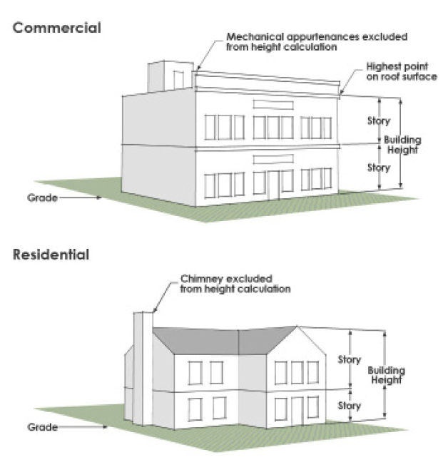
Building Line - The rear line of a required front yard which is generally parallel to the street line forming the front lot line.
Building Pad - The actual foundation area of a building.
Business or Commercial School or other Institution of Education - An entity other than public, parochial and private schools as otherwise defined, that offers instruction in the acquisition of knowledge and skills associated with a trade, art, or occupation.
Canopy - A roof-like structure that is an integral element of a building and extends horizontally more than one (1) foot from the face of a building facade.
Car Wash - A building or structure, or portion thereof, for washing automobiles which may be self-service or use automated methods including chain conveyor, blower, steam cleaning device, or other mechanical devices.
Carport - An accessory structure which open on three (3) sides and is designed or used for the storage of vehicles for the occupants of the building to which it is an accessory.
Cemetery - Land for the interment of human remains and may include the following accessory uses if operated within the boundaries of said cemetery: a crematorium, mausoleum, columbarium, mortuaries, and necessary sales and maintenance facilities.
Certificate of Occupancy - A document issued by the City allowing the occupancy or use of a building and certifying that the structure or use has been constructed and will be used in compliance with all the applicable municipal codes and ordinances.
Chapter 748 Operation - A residential child-care operation that provides child care, including treatment services and/or programmatic services, for 13 or more children or young adults, which is regulated by V.T.C.A., Administrative Code ch. 748, Title 26.
City Council or Council - The legislative and governing body of the City of Lewisville.
Cleaning, Laundry and Textile Processing Plant - A building or structure where articles of clothing, linens, and other textiles are brought for processing, laundering, pressing, dyeing or dry cleaning, and not including retail drop-off and pick up activities.
Clear-Cutting - The random cutting, plowing, grubbing or other method for removal of trees without regard to type or size for the purpose of clearing land.
Clear Vision Area - A part of a tract or lot which may not be utilized for plantings, walls, fences or other items which would cause danger to traffic by obstructing the view between two feet (2') above street grade to seven feet (7') above street grade.
Columbarium - A structure designed for the purpose of interring cremated human remains in sealed compartments which may include a crematorium as an accessory use.
Commencement of Construction - The initial disturbance of soils associated with clearing, grading, or excavating activities.
Commercial Amusement (Indoor) - An amusement or entertainment enterprise wholly enclosed and operated within a building. This includes, but is not limited to, bowling alleys, skating rinks, laser tag, paint ball, health clubs, racquetball clubs, indoor tennis courts, gymnasiums, swimming pools, teen clubs, and dance halls.
Commercial Amusement (Outdoor) - An enterprise offering entertainment or games of skill to the general public for a fee or charge or to members and guests of a private association wherein any portion of the activity takes place in the open. This includes, but are not limited to, batting cages, a golf driving range, paintball facility, archery range and miniature golf course, amusement park, water park, and go-cart tracks.
Commercial Development - Any non-residential development; except that, mixed-use developments, which include residential units, are considered commercial development.
Commissary - An building or structure in which food, containers, or supplies are kept, handled, prepared, packaged, or stored for transportation by mobile food establishments and that serves as an operating base where a mobile food establishment may be stored, parked, serviced, cleaned, supplied, and maintained.
Communication Antenna - A signal transmission or receiving device, including satellite dishes, for radio, television, telephone or other electronic signals including accessory mechanical equipment and accessory structures used solely for housing accessory equipment. An antenna may stand alone or be attached to a building, structure, rooftop, monopole or lattice tower.
•
Satellite Dish - Any dish-shaped device used for transmission or receiving of radio, television, telephone or other electronic signals, including accessory mechanical equipment attached to a tower and accessory structures used solely for housing of the accessory equipment. A communications dish shall be considered an antenna.
Communication Support Structure - A communication support structure is a structure primarily to support transmission equipment for telephone, radio and other communication purposes. Communication support structures are typically categorized as monopole (freestanding) or lattice (self-supporting or anchored with guy wires or cables). Communication support structures shall include:
•
Lattice Tower - A lattice structure used to support antennas or communications dishes, including accessory mechanical equipment attached to the tower and accessory structures used solely for housing of the tower or accessory equipment.
•
Monopole Platform - That portion of a monopole tower, located on or near the top of the tower, supporting directional, transmitting and receiving antennas.
•
Monopole Tower - A pole used to support antennas or communications dishes, including accessory mechanical equipment attached to the pole and accessory structures used solely for housing of the monopole or accessory equipment.
Community Center - A building or series of buildings that house social services or cultural, recreational or similar activities, which are owned or operated by a governmental agency or a private non-profit agency.
Complete Application - An application that meets the standards of this UDC and has been deemed complete by the City and the V.T.C.A., Local Government Code ch. 245, or successor statute.
Complete Streets - The design and construction of a transportation system that accommodates various modes of travel, which may include public and private streets, bicycle lanes, sidewalks, trails, mass transit and green corridors within the City.
Comprehensive Plan - The adopted long-range plans which function collectively for the purpose set forth in Article II.1.3 of this UDC.
Concept Plan - A plan showing the applicant's proposal for the development or redevelopment of land within the existing zoning district, meeting all criteria in this UDC and as may be required, supported by written documentation and additional information that illustrate the proposed development.
Condominium - A building or series of buildings containing multiple individually-owned dwelling units, offices, or floor area, each with a recordable deed, and in which the structure, common areas, and amenities are jointly owned on a proportional, undivided basis. A residential condominium is considered a multi-family dwelling.
Condominium Detached Units - Individually-owned dwelling units, buildings, offices, or floor areas, each with a recordable deed, and in which common areas and amenities are jointly owned on a proportional, undivided basis and which are detached and do not share a common wall with other detached units. A residential condominium, Detached Units is considered a multifamily dwelling.
Construction Plans - The drawings and technical specifications that conform to this UDC and all other applicable ordinances of the City. Construction plans, including bid documents, contract conditions, and escrow agreements, where applicable, provide a graphic representation and written description of the character and scope of the work to be performed in construction of a development.
Continuing Care Facility - A building or series of buildings where any combination of independent-living, assisted-living, or long-term care may be provided on the same property.
Contractor's Yard - A lot or portion of a lot dedicated to the outside storage and maintenance of materials, vehicles, facilities, and equipment customarily used in the building and construction trades.
Control of Access Line - Lines along sections of public streets and alleys which delineate areas where no driveway access is permitted.
Convenience Store - A retail establishment offering for sale a limited line of groceries and household items for the convenience of the neighborhood.
Corner Clip - A triangular area of additional right-of-way at public street or alley intersections.
Cornice - An ornamental piece that forms the top edge of the front of a building or pillar.
Corridor District - The IH-35E Corridor Overlay District as outlined in this UDC.
Country Club or Golf Course - Land or buildings dedicated to facilitate the playing of nine (9) or more holes of the game of golf, including ancillary uses such as a clubhouses, shops, or restaurants.
Court - A type of open area bounded on more than two (2) sides by the walls of the building. An inner court is a court entirely surrounded by the exterior walls of a building. An outer court is a court having one side open to a public or private street, alley, yard, or other permanent open space.
Credit Access Business - A credit services organization that obtains for a consumer or assists a consumer in obtaining an extension of consumer credit in the form of a deferred presentment transaction or a motor vehicle title loan, as established in V.T.C.A., Finance Code § 393.601, as amended. This use also includes a "Regulated Lender" as defined in state law and regulated by the State of Texas.
Crematorium - A building, structure or part thereof used for the purposes of the cremation of human remains.
Criminal or Penal Institution - A building used for detention related to criminal justice and associated office or administrative uses.
Day Care Center - An establishment at a location other than a residence to provide care for children.
Day Care, In-Home - An operation providing care for children in the caretaker's residence as a home occupation.
Detention - The storage of stormwater runoff for a controlled release during or immediately following a rain event. Regional detention refers to storage of stormwater runoff from an entire drainage area or basin.
Developer - A person, limited to the property owner or duly authorized representative thereof, who proposes to undertake or undertakes activities that constitute development.
Development (as determined by context) -
•
(noun) The process of subdividing land, and/or construction, reconstruction, expansion, structural alteration, or conversion of a new building or any structure on a building lot, the relocation of an existing building or structure on another building lot, or the use of open land for a new use.
•
(noun) An area of land with buildings, structures, or improvement on it.
•
To "develop" is to engage in the process of development or create a development.
Development Application - The application and other information, plans, or materials required by the City to initiate review and approval of a development or project this includes Concept Plans. Engineering Site Plans, Construction Plans, Plats, Zoning Petitions, Special Use Permits, Planned Developments and any requests for relief from development standards.
Diameter at Breast Height (DBH) - The measurement of the diameter of a tree trunk in inches taken at four and one-half feet (4.5') above ground level. Multi-trunk measurements shall be an aggregate total of each trunk's individual diameter.
Directionally Shielded Luminary - A light fixture designed to direct and confine light to the object being illuminated.
Display - A formal exhibition of goods done in a manner so as to cause the goods to be favorably seen.
Display Windows - The main portion of glass on a storefront where goods and services are displayed.
Distillery - An establishment where alcoholic liquor is distilled.
Dormitory for Students - A building designed and used as group living quarters for students as an accessory use to a college, university, boarding school, or similar institutional use.
Drive - See "Access Aisle."
Driveway - An opening along the curb line at which point vehicles may enter or leave a property from a public street, private vehicular route, or alley.
Dry Cleaning/Laundry Service - An establishment dedicated to the pick-up, drop-off, or delivery of clothing that is dry cleaned/laundered at another location, with no dry cleaning/laundry operations on-site.
Duplex - A detached residential building containing two (2) dwelling units that provide separate accommodations, share a common wall, and are totally separated from each other, though they may share utilities such plumbing or electrical lines. Also referred to as Dwelling, Two-Family.
Dwelling - A building or portion thereof, designed and used exclusively for residential occupancy, including one-family dwellings, two-family dwellings, manufactured homes, and multi-family dwellings, but not including hotels, motels or inns.
Dwelling, Single-Family Attached - A building containing three (3) or more dwelling units, each designed and constructed for occupancy by one family, with each dwelling unit attached by a common wall to another dwelling unit and platted on individual lots.
Dwelling, Single-Family Detached - A building containing only one (1) dwelling unit, designed and constructed for occupancy by one family and located on its own lot so as to allow for yards along all sides of the building.
Dwelling, Two-Family - See "duplex."
Dwelling Unit - One (1) or more rooms for occupancy by a family containing at least one (1) bathroom and one (1) kitchen with stove or cooking device.
Easement - A property right granted for a specific purpose over, under, through, across, or along land.
Electrical Energy Generating Plant - A building, structure, or a series of buildings or structures belonging to a public or privately-owned utility company for the purposes of providing electricity into the electric grid.
Engineering Site Plan - The plan for development of one (1) or more lots upon which is shown all information required by this UDC and sealed by a state-licensed civil engineer.
Enhanced Sidewalk - A wider sidewalk which provides pedestrian connections as part of the City's trail system or in areas with a high density of pedestrian-oriented land uses.
Entry - A pedestrian entrance to a building, which may be set back from the sidewalk in a protected recess.
Excavation or Gravel Pit - An area where minerals, gravel, or other similar materials are excavated or quarried below the natural grade of the surface.
Extended Stay Hotel - An establishment offering lodging, the use of guest rooms or sleeping accommodations, to the public for compensation, which furnishes a kitchen including a cook-top or oven in any guest room. This definition shall not include other dwelling units as defined by this UDC. A Extended Stay hotel is a non-residential use.
Exterior wall - The exterior boundaries of a building that have a slope of 60 degrees or greater with the horizontal plane.
Extraterritorial Jurisdiction (ETJ) - The unincorporated area, not a part of any other municipality, which is contiguous to the corporate limits of the City, the outer limits of which are measured from the extremities of the corporate limits of the City outward for the distance as stipulated in V.T.C.A., Local Government Code ch. 42, according to the population of the City, and in which area the City may, among other things, regulate subdivisions and enjoin violations of provisions of this UDC.
Facade - The portion of any exterior elevation on the building extending from grade to top of the parapet, wall, or eaves and the entire width of the building's elevation but excluding the roof. Where separate faces are oriented in the same direction or in directions within 45 degrees of one another, they are to be considered as part of a single facade. Multiple buildings on the same lot will each be deemed to have separate facades.
Facade Rhythm - The repetition of certain elements (windows, doors, columns, etc.) in regular manner along a building's elevation.
Family - One (1) or more individuals, each related to the other by blood, marriage or adoption; a group of not more than five (5) individuals (excluding servants) who are living together in a dwelling unit; or a household care facility.
Farm Implement Sales and Service - A retail establishment primarily engaged in the sale of agricultural lifestyle or commercial products or goods, including manufacturing equipment, farm animal food, recreational gear, hardware, lawn and garden supplies, or related commodities.
Fence - An artificially constructed barrier of any material or combination of materials erected to enclose, screen, or separate areas.
Filling - The depositing on land, whether submerged or not, of gravel, earth, or other natural materials in any combination.
Fire Code - The fire code as currently adopted in the City of Lewisville Code of Ordinances.
Fire Lane - An access road that is designed to allow access of fire apparatus to buildings and structures.
Flea Market — Outdoor - A swap shop, or similar activity by whatever name, where the use involves the setting up of two (2) or more booths, tables, platforms, racks, or similar display areas for the purpose of selling, buying, or trading merchandise, goods, materials, products, or other items offered for sale outside an enclosed building on a regular basis. This definition does not include similar uses at permitted special events or accessory outside display.
Flood Insurance Rate Map (FIRM) - An official community map showing special flood hazard areas and the risk premium zones applicable to the community as issued by the Federal Insurance and Mitigation Administration under Federal Emergency Management Agency.
Floodplain - The 100-year floodplain as designated by the Federal Emergency Management Agency.
Floodway - The channel of a river or other watercourse and the adjacent land areas that must be reserved in order to discharge the base flood without cumulatively increasing the water surface elevation more than a designated height.
Food Truck - A self-contained motorized vehicle in which food items are cooked, processed or portioned for sale to the public. Also known as a mobile food establishment, excluding limited service pushcarts, in Volume 1, Chapter 7 of the Code of Ordinances.
Food Truck Park - An area accommodating two (2) or more food trucks offering food and/or beverages for sale to the public.
Foot Candle - The amount of illumination provided by one (1) lumen uniformly distributed on one (1) square foot of surface.
Fraternal Organization or Lodge - A membership-based organization dedicated to a social cause, community service, or fraternal activities.
Front Entry - A property designed so that the driveway for vehicular access comes from a public or private street as opposed to an alley.
Frontage - Any and all sides of a lot, parcel or tract abutting a street.
Frontage Road - Roads that run parallel to a limited access highway that provide access to abutting landowners and distribute and collect traffic to and from the limited access highway.
Full Cut-Off Fixture - A light fixture that allows no emission above a horizontal plane through the fixture.
Funeral Home - An establishment primarily engaged in the preparation of the deceased for interment and the management of associated activities, including funeral services, cremation, off-site burial, other religious services, and viewings.
Gas and Oil Drilling Related Use - Gas and oil drilling uses not specified within the City's oil and gas drilling and production ordinance, which may include but are not limited to, a centralized natural gas compression facility, centralized water collection facility, or centralized natural gas lift facility.
Gasoline Service Station - Any building or premises used for the dispensing or sale of any automobile fuels or oils. A gasoline service station may also include a convenience store.
Governmental Office and Service - An establishment primarily associated with a public entity, including local, county, state, and federal governments and school districts, in the administration of public policy and services. This definition includes, but is not limited to, public libraries, police and fire stations, post offices, recreation centers, and associated parking lots or structures.
Grading - The mechanical or physical act of disturbing, moving, removing, transferring, or redistributing soil.
Graphic Representation - Any sketch, photograph, or similar representation.
Grocery Store - A store where most of the floor area is devoted to the sale of food products for home preparation and consumption, which typically also offers other home care and personal care products.
Ground Floor - That portion of a building extending 12.5 feet above the street-level finish floor elevation.
Ground-Mounted Equipment - any air conditioning or heating equipment, ductwork or ventilation, chillers, generations, pool pumps or filters, or other similar equipment that is on the ground as opposed to a roof of a building.
Hardscape - Paving materials, which may have architectural design features or patterns, and lay flush on the ground.
Hazardous Material - Those materials which are capable of causing injury to living organisms by chemical means when present in relatively small amounts.
Heavy Equipment Sales/Rental and Service - A building, structure or portion of the building lot used for the display, sale, rental, storage or service of heavy machinery, either machines in general or a group of machines which function together as a unit.
Heavy Load Vehicle - Any vehicle exceeding 8,501 pounds, including but not limited to box trucks, cement mixers, refuse trucks, dry vans, or vans carrying more than 12 individuals.
Helipad or Helistop - A landing pad for occasional and infrequent use by helicopters. No on-site servicing or fueling is allowed.
Heliport - An area of land or water or a structural surface which is used for the landing and taking off of helicopters, and any appurtenant areas which are used for heliport buildings and other heliport facilities.
Home Occupation - A business, occupation, or profession that is a customary, incidental, and secondary use of a residential unit conducted by an occupant residing on the premises.
Homeowners' Association (HOA) - An association which is organized within a development in which individual owners share common interests and responsibilities for open space, landscaping, or other amenities, and which operates under recorded land agreements. This term also includes property owners' associations (POAs) and property management corporations (PMCs) which are more typically formed for multi-family and commercial developments.
Horizontal Illumination - The amount of light falling on a horizontal surface.
Horizontal Plane - A line horizontal to the lowest point on the light fixture from which light is emitted.
Hospital - A institution in which there are complete facilities for diagnosis, treatment, surgery, laboratory, X-ray, and the prolonged care of bed patients. Medical offices and clinics may have some but not all of these facilities.
Hotel, Motel or Inn - An establishment offering lodging, the use of guest rooms or sleeping accommodations, to the transient public for compensation, which furnishes customary hotel services and may contain a restaurant, banquet hall, meeting rooms and other accessory uses. A hotel, motel or inn is a non-residential use.
Household Care Facility - A dwelling unit that provides residence and care to not more than eight (8) individuals, regardless of legal relationship, who are elderly or disabled, living together with no more than two (2) caregivers as a single household. Where applicable, a household care facility shall have appropriate licensing and/or registration by the state of Texas.
Illumination - The density of the luminous flux (lumens) incident on a surface. It is the quotient of the luminous flux divided by the area of the surface, expressed in foot candles.
Improvement - Any man-made fixed item which becomes part of or placed upon, over or under real property.
Improvement, Public - Any improvement together with its associated public site, right-of-way or easement necessary to provide transportation, storm drainage, public or private utilities, parks or trails or similar essential public services and facilities, for which the City ultimately assumes the responsibility, upon a letter of final acceptance being issued by the City, for maintenance, operation and/or ownership.
Independent Living Facility - A building or series of buildings specifically designed for families (1) with at least one (1) family member who is 55 years of age or older; and (2) that do not require significant, regular assistance or medical services. An independent living facility may offer services such as meals, housekeeping, transportation and activity rooms.
Infrastructure - The provision of systems that provide vehicular, cyclist, and pedestrian transportation, water, wastewater, solid waste, stormwater drainage, electrical and franchise facilities typically required to service development.
Inlet - An opening into a storm drain system for the entrance of surface stormwater runoff.
Junk Yard - A lot upon which waste or scrap materials, including vehicles are bought, sold, exchanged, stored, packed, disassembled, or handled, including scrap iron and other metals, papers, rags, rubber tires and bottles. A junk yard does not include such uses conducted entirely within an enclosed building or landfill operations and accessory use. A "junk yard" includes automobile salvage.
Kickplate - A part of a building typically found beneath a display window, also called a bulkhead panel.
Kiosk - A small freestanding building for commercial business operation. The building as defined may be manned or automatic without an attendant.
Laboratory-Scientific Research and Testing - A building or series of buildings or structures primarily engaged in testing or the research and development of new products in the fields of medicine, science, or technology, with all activities, equipment, and materials confined to the building or series of buildings.
Landfill Operations and Accessory Use - An engineered land burial facility for the disposal of nonbiodegradable, nonhazardous and nonmedical solid waste and which is located, designed, constructed, and operated to contain and isolate the solid waste so that it does not pose a substantial present or potential hazard to human health or the environment.
Landscape Area - Any area containing intentional plantings including trees, shrubs, groundcovers or turf.
Landscape Island - An area containing trees, shrubs, groundcover or turf that is located within a parking lot.
Landscape Strip - An area containing trees, turf, groundcover and other plant materials that is located along a public or private street, fire lane, parking lot, building or structure.
LED Strip Lighting - A flexible circuit board populated by surface-mounted light-emitting diodes and other components that usually come with an adhesive backing. LED lighting includes: Module Lighting - A string of lights consisting of LED chips set into a small enclosure unit and that unit is then linked to the next by a wire.
Rope Lighting - A string of LED lights that are encased in a flexible translucent/semi-translucent jacket or tube.
Letter of Design Approval - A written document certifying appropriateness by the Old Town Design Review Committee of proposed specific improvements within the Old Town District overlay district and the Old Town Center Design District overlay district.
Level of Service - A measure of the level of traffic congestion experienced on roadways.
Licensed Massage Therapy - A health care service practiced by a licensed massage therapist as defined and regulated by state law.
Light Spillover - Light falling outside the boundary of property upon which the light fixture is installed. Also referred to as light trespass.
Living Screen - A continuous line of evergreen shrubs planted and used as a screening.
Loading Space - A space within the principal building or on the same lot therewith providing for the standing, loading or unloading of trucks provided on the same building lot as the principal use served by the loading space.
Long Term Care Facility - A building or series of buildings in which in-patient nursing or medical care or services are provided to individuals chronically ill, aged or disabled due to injury or disease.
Lot - An undivided tract or parcel of land that is or may be offered for sale, conveyance, or development. A lot is shown on a plat of record.
Lot Area - The area of a horizontal plane intercepted by the vertical projections of the front, side, and rear lot lines of a building lot.
Lot, Building - A single tract of land located within a single block which, (at time of filing for a building permit) is designed by its owner or developer as a tract to be used, developed or built upon as a unit, under single ownership or control. It shall front upon a public or private street or City-approved place. A building lot may be subsequently subdivided into two (2) or more building lots, and a number of building lots may be combined into one (1) building lot, subject to the provisions of this UDC.
Lot, Corner - A building lot situated at the intersection of two (2) streets (either public or private), the interior angle of such intersection not to exceed 135 degrees.
Lot Coverage - The percentage of the total area of a lot occupied by the ground floor of the principal building and any allowed accessory buildings.
Lot Depth - The horizontal distance between the front lot line and the rear lot line of a building lot measured at the respective mid-points of the front lot line and rear lot line within the lot boundary. See Exhibit II.2-2 Lot Depth.
EXHIBIT II.2-2 LOT DEPTH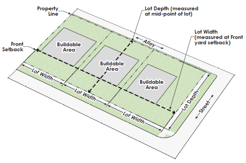
Lot Frontage - The dimension of a lot or portion of a lot abutting on a street.
Lot, Interior - A lot other than a corner lot.
Lot Line - A boundary of a lot. See Exhibit II.2-3 Lot Standards.
EXHIBIT II.2-3 LOT STANDARDS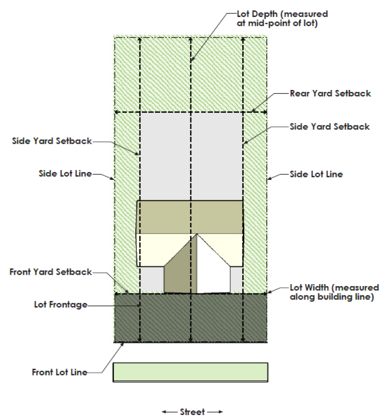
Lot Line, Front - That boundary of a lot which is the line of an existing or dedicated public or private street right-of-way, public park or open space on which the lot fronts. Upon corner lots, either streetline may be selected as the front lot line providing a front and rear yard are provided adjacent and opposite, respectively, to the front lot line.
Lot Line, Rear - That boundary of a building lot which is most distant from and is, or most nearly, parallel to the front lot line.
Lot Line, Side - That boundary of a building lot which is not a front lot line or a rear lot line.
Lot, Through - A type of interior lot where both the front and rear lot lines adjoin streetlines. On a through lot, both streetlines shall be deemed front lot lines.
Lot Width - The minimum distance between the side lot lines of a building lot measured along a straight line at the rear of the required front yard and parallel to the streetline or a line tangent thereto. See Exhibit II.2-4 Lot Width.
EXHIBIT II.2-4 LOT WIDTH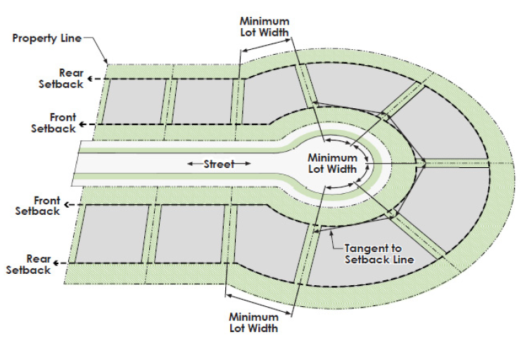
Lumen - The quantity of luminous flux intercepted by a surface of one (1) square foot, all points of which are one (1) foot from a uniform source of one (1) candela. A one-candela source provides 12.57 lumens.
Manufactured Home - A dwelling that meets the definition of a "HUD-code manufactured home" as defined in the Texas Manufactured Housing Standards Act, as amended (V.T.C.A., Occupations Code ch. 1201, as amended). This definition excludes campers, trailer, and recreational vehicles.
Manufactured Home Display and Sale - The sale and display of manufactured and modular homes.
Manufactured Home Community - Land dedicated to the residential use of two (2) or more manufactured homes.
Manufacturing, Light Intensity - The indoor assembly, packaging, processing, and manufacturing of finished products or parts from previously prepared materials and parts. Fabrication may be used in limited form to shape or define the final product but shall not comprise the primary activity of such operations. Uses may include production of custom or small-scale consumer goods, such as packaging and advertisements, printing, repackaging of materials or personal care products.
Manufacturing, Heavy Intensity - Basic industrial processing which transforms materials, particularly raw materials or hazardous materials, into a new substance, compound, or product. Uses include meat packing, chemical and petroleum processing and manufacturing, and foundries.
Manufacturing, Medium Intensity - The manufacturing of finished products and component products or parts, including the transportation, treatment, or processing of materials or substances, exclusive of basic industrial processing. Uses may include consumer electronic production, furniture production, food products or other industrial processes that do not generate hazardous materials.
Masonry - Brick, stone, rock, stucco, plaster, cement, or concrete tilt wall installed in accordance with the building code. It shall not include EIFS (Exterior Insulation and Finish System), Hardie plank, or materials of similar characteristics.
Masonry Veneer - That form of construction consisting of masonry installed per the adopted building code.
Mausoleum - Property used for the interring of the dead and where human bodies are interred above ground in stacked vaults.
Medical Office and Clinic - A building or series of buildings where professional or consulting services and treatments in various medical or health care fields are provided, including general medicine, vision and dental care, and mental health care.
Merchandise - Commodities, wares, goods or items that are for sale or displayed to promote sales.
Mews Street - A public right-of-way, typically wider than an alley, which provides rear access to a residential property and may also provide required frontage and access for a lot.
Mining Activity - All or any part of the process involved in the mining of minerals by removing overburden and mining directly from the mineral deposits, open pit mining or minerals naturally exposed, mining by auger method, dredging and quarrying, underground mining, and surface work incidental to an underground mine.
Minor Plat - A plat of a subdivision that involves four (4) or fewer lots which front on an existing public or private street and do not require the creation of any new public or private street or the extension of municipal facilities and has been approved in accordance with the requirements of this UDC, and a copy of which has been filed for record with the appropriate county clerk.
Mixed-Use - The combination of residential and non-residential use categories within a single site, building, or structure.
Mobile Home - A dwelling that meets the definition of "mobile home" as defined in the Texas Manufactured Housing Standards Act, as amended (V.T.C.A., Occupations Code, ch. 1201, as amended). This term does not include a manufactured home.
Modular Home - A factory-built dwelling, attached or detached, which is wholly or partially constructed away from its building lot and moved to a building lot where it is affixed or situated as a permanent building. A mobile home or manufactured home shall not be construed to be a modular home.
Mortuary - A place for the storage of human bodies prior to their burial or cremation.
Motor Freight Terminal - An operation or facility that is primarily outdoors in which freight or goods for distribution are brought by motor vehicle, assembled, stored, sorted, loaded, transferred, queued, and/or dispatched for local delivery, interstate commerce, or intrastate commerce by motor vehicle. This may include but is not limited to truck terminals, e-commerce distribution, last-mile distribution (and any parking related thereto) or neighborhood fulfillment centers.
Motor Vehicle or Vehicle - A self-propelled vehicle not operating on stationary rails or tracks. This includes automobiles, motorcycles, trucks, recreational vehicles, all-terrain vehicles, and buses.
Motorcycle Sales and Service - A business primarily engaged in selling or leasing and servicing of motorcycles, all-terrain vehicles, or similar types of vehicles.
Multi-Family Development - Any development containing one (1) or more apartment buildings and is not considered mixed-use.
Multi-Family Dwelling - A building or portion thereof containing three (3) or more dwelling units located upon the same building lot or a building constructed with at least one (1) dwelling unit above another dwelling unit.
Multi-Tenant Center - A platted commercial development having four (4) or more tenants.
NCTCOG - The North Central Texas Council of Governments.
New Development - The site preparation and construction of new buildings on property previously undeveloped.
Nightclub - An establishment operated as a place of entertainment, characterized by any of the following as a principal use of the establishment:
1.
Live, recorded or televised entertainment, including performances by magicians, musicians or comedians; and/or
2.
Dancing.
"Nightclub" shall not include theaters, auditoriums and stadiums with fixed row seating, private clubs, bars, or any establishment defined elsewhere in the Code of Ordinances as a sexually-oriented business.
Nonconforming Building - A building that is not in conformance with current UDC, but which was legally established at a prior date at which time it was in conformance with the then-applicable standards.
Nonconforming Lot - A lot that is not in conformance with current UDC, but which was legally established at a prior date at which time it was in conformance with the then-applicable standards.
Nonconforming Site Improvement - The existence of any required improvement that is not in conformance with this UDC but was lawfully in existence at a prior date at which time it was in conformance with the then-applicable standards or the lack of any such feature, if the lack of such feature was in conformance with the then-applicable standards.
Nonconforming Structure - A structure that is not in conformance with current UDC, but which was legally established at a prior date at which time it was in conformance with the then-applicable standards.
Nonconforming Use - A use that is not in conformance with current UDC, but which was legally established at a prior date at which time it was in conformance with the then-applicable standards.
Non-Residential Use - A use that does not contain a residential component (excluding hotels, motels and inns and extended stay hotels), including retail, service, manufacturing and industrial, and vehicle and related uses.
Official Filing Date - The date an application is deemed complete by the responsible official in the manner prescribed by Article III, Chapter 2, Section 6.
Opaque - A material or screening device which cannot be seen through.
Open Area - That part of a building lot, including courts or yards which:
1.
Is open and unobstructed from its lowest level to the sky;
2.
Is accessible to all residents upon a building lot; and
3.
Is not part of the roof of that portion of the building containing dwelling units.
Open Space - An area of land set aside, dedicated, designated, or reserved for public or private use for recreational activities or other amenities, including parks, courtyards, plazas, patios, etc. Open space may be owned and maintained by the property owner, the City, or held in common and maintained by a homeowners' association.
Ornamental Moldings/Belt Course - Decorative architectural features which may be located above storefronts and are horizontal projecting elements that provide a visual break in or termination to a wall.
Outside Display - The incidental display or sale of merchandise placed outside during operating hours in front of the store selling the merchandise.
Outside Storage - The outdoor storage of items, when not accessory to an existing residential use, which are located outside a fully enclosed building, and without regard to being formally displayed for sale; except that, vehicle storage is only considered outside storage when vehicles are staged or stored in association with an auction yard (vehicle), automotive repair (major), a wrecker service, automobile salvage or junk yard.
Overlay District - A set of regulations for a defined geographic area that imposes additional requirements beyond those required by an underlying zoning classification, with the purpose of achieving specific land-use and design objectives.
Parapet - That portion of a building wall or facade that extends above the roof line of the buildings.
Parking Garage or Structure - A structure used for the parking of vehicles, for which a fee may be charged, and which serves as a use on the lot.
Parking Lot - A paved surface with on-site parking at grade level.
Parking, Off-Street or On-Site - Parking spaces located completely within a property and not along or in a public right-of-way or private street.
Parking, On-Street - Parking spaces located completely or partially within a public right-of-way, private vehicular route, or public or private street.
Parking Space - A surface area, enclosed or unenclosed, sufficient in size to store one vehicle together with a surfaced driveway connecting the parking space with the public or private street or alley and permitting ingress or egress of any vehicle.
Parking Surface - The material upon which vehicles are parked or stored.
Parks Master Plan - The City's officially adopted plan governing the future development of the City's parks, recreation and open space system.
Pavers - Brick or other man-made masonry units including stamped concrete and asphalt pavers intended for surface paving specifically, though not exclusively, excluding split-faced block, or CMU (Concrete Masonry Units) block.
Pawn Shop - A retail establishment engaged in the lending of money on the security of personal property pledged in the keeping of the proprietor or other representative of the establishment, and the retail sale of such goods and merchandise.
Pedestrian Access - A specifically designated place, path, means, or way by which pedestrians shall be provided safe, adequate, and usable circulation through the interior of a property or development.
Pedestrian Pass-Through - A paved and lighted walk for pedestrians which connect streets or provide a connection between adjacent properties.
Period of Emergency - A weather-related event that creates significant hazardous conditions, such as from downed trees or other damage.
Permit - Is as defined in V.T.C.A., Local Government Code § 245.001, as amended.
Person with a Disability - Is as defined in the ADA or applicable state law.
Personal Service - A commercial establishment primarily engaged in providing personal self-improvement, beautification, or the maintenance of individual wellbeing, including barbers, salons, spas, nail salons, tattooing or similar services.
Photometric Plan - A plan showing quantitative measurements of light levels and distribution and location of light fixtures proposed for a particular development or property.
Planned Development District - A special zoning district established to allow alternatives to the standard zoning requirements set forth in the UDC which provide design flexibility in combining and mixing various uses and development types.
Plant Nursery, Retail Sale (Indoor) - A business that engages in the retail sale of plants and their associated supplies for the purposes of landscaping, gardening, and cultivating, which does not involve the outside storage of said plants or associated products or equipment.
Plant Nursery, Retail Sale (Outdoor) - A business that engages in the retail sale of plants and their associated supplies for the purposes of landscaping, gardening, and cultivating, which involves the outside storage of said plants or related products or equipment.
Plat-A - Complete and exact plan, map, or drawing, on which a subdivider's plan of a subdivision is presented and is submitted for approval, and a copy of which has been or will be filed in the office of the appropriate county clerk. Plats may be further categorized as follows:
Plat, Amended Final - A plat of a subdivision modifying a previously approved final plat which is not an amending plat.
Plat, Amending - A plat of a subdivision correcting a previously approved plat as provided in V.T.C.A., Local Government Code § 212.016, as amended.
Plat, Final - A plat of a subdivision which has prepared in accordance with the requirements of this UDC and the Texas Local Government Code.
Plat, Minor - A plat of a subdivision that involves four (4) or fewer lots which front on an existing public or private street and do not require the creation of any new public or private street or the extension of municipal facilities.
Plat, Preliminary - A preliminary plan or drawing that represents a subdivider's plan of the subdivision, showing all boundaries and location of individual properties, utilities proposed and streets; provided, however, that preliminary plats are not filed in the office of the appropriate county clerk.
Replat - An approved or recorded plat which has been changed. This term does not include an amending final plat.
Primary Entrance - An entrance providing entry to a main lobby, waiting room, or foyer.
Primary Facade - The side of a building facing the public or private street or open space from which the public or may enter, except as modified by written request from the property owner and approved by the City.
Primary Pedestrian Street - Public rights-of-way in the Article VI, Chapter 8, Section 1, IH-35E Corridor Overlay District that are also high-quality pedestrian routes, offer adequate buffers between moving vehicles and pedestrians, contain a higher level of pedestrian amenities, and link major destinations.
Principal Building, Principal Structure, Principal Use - The main building, structure, or use of land as distinguished from an accessory use. Private Club - An entity that has obtained a private club registration permit through the Texas Alcohol and Beverage Commission.
Private Recreation Area/Facility - A privately-owned recreational building or structure or series of buildings or structures or area, whether indoor or outdoor, for use solely by the residents or guests of a particular neighborhood or development.
Private Utility Plant or Substation - An industrial building or structure or series of building or structures that are owned and used by a non-governmental entity for the production, processing, or transformation of electricity, natural gas, drinking water, wastewater, telecommunications, or solid waste with a primary intent of distribution.
Private Vehicular Route - A private street which has the same design requirements as a primary pedestrian street and is situated within a privately-owned and maintained cross or joint access easement.
Professional and Administrative Office - The provision of professional or consulting services in various fields as a primary commercial activity. These services may include law, architecture, design, engineering, accounting, financial services, real estate, and other fields where the sale of goods is not the primary commercial activity.
Progress (Towards Completion) - Shall have the same meaning set forth in V.T.C.A., Local Government Code § 245.005(c), as it exists or may be amended, unless another meaning is specified.
Project - An endeavor over which the City exerts its jurisdiction and for which one (1) or more permits are required to initiate, continue, or complete the endeavor.
Property Owner - The legally recognized owner of the land.
Proportionality/Proportional Share - The developer's portion of the costs of a public improvement as determined and in accordance with V.T.C.A., Local Government Code § 212.904 and considered to be the "roughly proportional share" of such public improvement that is created by a proposed development or subdivision.
PROWAG - The Public Right-of-Way Accessibility Guidelines promulgated by the United States Access Board.
Public Park and Playground - Any park, playground, beach, or greenbelt nature trail, recreational facility or wildlife conservation and management area located within the City and owned, controlled or operated by any school district, municipality, county, state or federal government, which is open for use by the general public.
Public Utility Plant or Substation - An industrial building or structure or series of buildings or structures that are owned and used by a governmental entity for the production, processing, or transformation of electricity, natural gas, drinking water, wastewater, telecommunications, or solid waste.
Public Way - A privately maintained access easement which is open to unrestricted and irrevocable public access and providing the primary means of access and frontage for two (2) or more non-residential lots.
Real Estate Sales Office (Temporary) - The temporary, physical location of business activity in which the selling of real estate in a development or developments is the primary purpose.
Record Drawings - A group of drawings or plans that depicts the final configuration of the installed or constructed improvements of a development which have been verified by the contractor as their installation or construction occurs during development. The record drawings shall reflect the construction plans (or working drawings) used, corrected, or clarified in the field.
Recreational Vehicle - A vehicle designed for travel, recreational and vacation usage. Recreational vehicles include travel and tent trailer, pickup campers and shells, motor homes, converted buses, and similar vehicles used for temporary portable housing or recreational use.
Recreational Vehicle Park - A parcel of land which is used solely for the rental or lease of lots for or temporary parking of recreational vehicles. Uses where unoccupied recreational vehicles are for sale or lease or stored are not included.
Recreational Vehicle Sales and Service - A business primarily engaged in the sale or lease and service of recreational vehicles, including the display or exhibition of such vehicles on-site.
Recreational Vehicle Storage - The storage of recreational vehicles on land or in a building or structure that is primarily dedicated to such activity.
Recycling Facility - A building or structure or series of buildings or structures where recyclable materials, including newspapers, magazines, books, and other paper products, glass, metal are recycled, reprocessed, and treated in order to return such products to a condition where they may be reused. Processing means the preparation of material for shipment, or an end user's specifications, by such means as baling, briquetting, compacting, flattening, grinding, crushing, mechanical sorting, shredding, cleaning, and remanufacturing. Recycling facilities include storage and loading spaces located entirely on the processing center site. Recycling of tires and shingles shall not be allowed.
Redevelopment - The demolition of all or a portion of an existing building, structure, buildings, or structures and the construction of new buildings on the property.
Reflective Glass - Glass having a reflectance of greater than ten percent (10%).
Release for Construction - City authorization given by the City Engineer that indicates conformance with City regulations and authorizes the commencement of construction of improvements or other described construction, in conformance with approved construction plans, on the premises for which it is given.
Religious Facility - Shall mean a building or structure or series of buildings or structures, or any portion thereof, principally housing regular religious assembly and activities that are customarily associated with worship. Other associated accessory structures and activities may include living quarters for the principal religious leaders, social centers, fellowship halls, cemeteries and columbariums, classrooms for religious instruction, schools, and day care centers.
Residential Driveway - A driveway serving a single family attached dwelling, single family detached dwelling or duplex.
Residential Garage - An area of a residential building or accessory structure that is enclosed and provides at least one (1) parking space.
Residential Zoning District - Shall mean any area zoned AO, R-18, R-12, R-9, R-7.5, R-6, R-5, TE, DU, ETH, TH, TH-2, MF-1, MF-2, MF-3, MHP and, or any planned development zoning district or portion thereof with one of those zoning districts as its base zoning district.
Residential Storage Building - A detached building used for on-site storage of items related solely to residential purposes and located on a lot with a single family attached or detached dwelling unit. Residential Use shall mean any use with a dwelling unit, including a single-family attached dwelling, single-family detached dwelling, multi-family dwelling, duplex, mobile home, manufactured home, or modular home.
Restaurant - An establishment primarily engaged in the preparation, serving, and retail sale of prepared food and beverages.
Restaurant, Stand Alone - Shall mean a restaurant that occupies the entirety of a building with yards on all sides.
Retail Store or Shop - A business engaged in the selling of goods and merchandise directly to a consumer and including services incidental to the sale of such goods.
Right-of-Way (ROW) - A type of easement dedicated by plat or metes and bounds for use by the public, which is separate and distinct from the lots and parcel abutting it, and which is not included within the dimensions or areas of such lots or parcels. The term generally describes an area used for the provision of streets and utilities. The term includes any public street, highway, roadway, alley, mews street, or sidewalk dedicated to and maintained by any public entity. Unless otherwise specified, the term right-of-way shall refer to a public right-of-way.
Road, or Roadway - See "Street, Public."
Roof-Mounted Equipment - Any air conditioning or heating equipment, ductwork or ventilation, chillers, generations, pool pumps or filters, or other similar equipment that is on the roof as opposed to the ground outside of a building.
School, Parochial - A religious institution primarily engaged in the formal education or instruction of students in an elementary or secondary curriculum but not including private schools or business or commercial schools or other institutions of education as defined by this UDC.
School, Private - A private institution primarily engaged in the formal education or instruction of students in a curriculum equivalent to public school as defined by this UDC.
School, Public - A public institution primarily engaged in the formal education or instruction of students in an elementary or secondary curriculum but not including parochial or private schools or business or commercial schools or other institutions of education as defined by this UDC.
Screening - A barrier to separate and limit visibility between that which is on either side of the barrier, for example, screening between a thoroughfare and adjacent land uses.
Screening Wall - A type of screening made of brick, stone, decorative concrete block, thin-wall brick or other material permitted by this UDC at design to be opaque and block views to or from a property.
Seasonal Sales - The temporary outdoor sale of merchandise that directly relates to a specific time of the year, such as a holiday season or fresh fruit season. Examples of a seasonal sales use include Christmas tree lots, pumpkin patches, or fruit stands.
Secondary Facade - Any side of a building not facing the street from which it draws its address or which has been designated as the primary facade.
Secondary Walkway - A walkway immediately adjacent to a building that is set back from the private or public street by a parking lot. Such a walkway may be parallel to the sidewalk.
Self-Service Storage Facility - Individual storage units for rent or lease, restricted solely to the storage of household and personal property.
Service Area - An area used for activities and elements that support the primary use of a building, including but not limited to loading spaces, delivery zones, trash receptacles and utility equipment.
Service Contractor - A business that specializes in providing services to consumers that involve building or structural repair or manual labor, including pest extermination, lawn care, painting, plumbing, electrical work, heating, air conditioning, renovation services, and janitorial and building cleaning.
Service Station - See "Gasoline Service Station."
Setback Line - A line from which a building must be set back from a property line, public or private street or easement line. See Exhibit II.2-5 Setback Lines.
EXHIBIT II.2-5 SETBACK LINES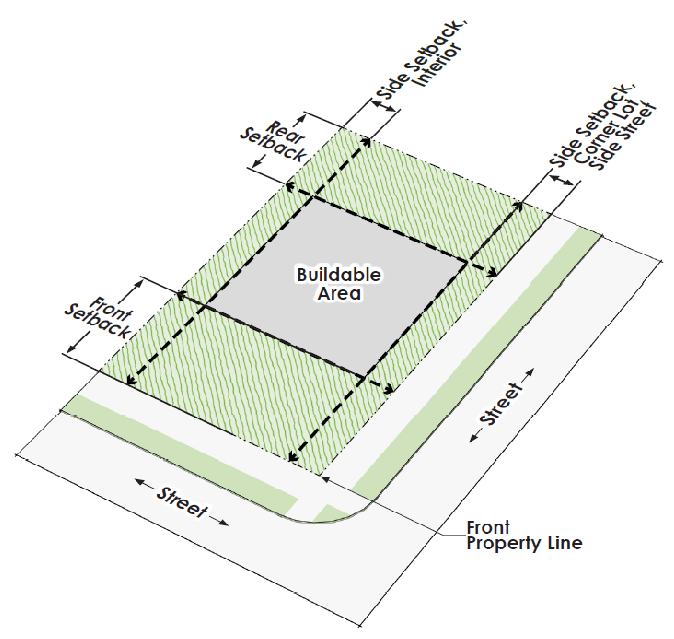
Sexually-Oriented Business - Has the meaning given in Volume 1, Chapter 7, Article XI of the Code of Ordinances.
Shared Parking - Parking that is utilized by buildings or tenants on two (2) or more parcels.
Shielding - A physical structure designed to restrict emitted light.
Shooting Range, Indoor/Outdoor - An area, either outdoors or within a building or structure, specially designed for the safe discharge and use of rifles, shotguns, pistols, black powder, or any similar firearm and silhouettes, skeet, or trap.
Short-Term Rental Unit - Any dwelling unit or portion thereof offered to the transient public for compensation for a period of less than 30 consecutive days. The term shall not include a hotel, motel, or inn or bed and breakfast.
Sidewalk - A paved surface designed for pedestrians which are open to the public and are usually provided parallel to public and private streets and within the street right-of-way, if a public street.
Single-Family Residential Development - A development containing only Single Family Attached or Detached Dwellings and customary accessory uses.
Single-Family Residential Zoning - A term used to reference the following zoning districts: R-18, R-12, R-9, R-7.5, R-6, R-5, DU, ETH TH, TH-2, MHP.
Site Improvements - All necessary site-related improvements required by this UDC, and categorized as follows:
•
Off-Site Public Improvement - All public improvements constructed on public property or a separate private property within an easement.
•
On-Site Public Improvements - All public improvements constructed on the subject private property in public easements.
•
Semi-Public Improvements - All improvements required by this UDC installed on private property and privately maintained (including fire lanes, fire lines, on-site private fire hydrants, screening devices, landscaping, on-site drainage, meters, and backflow devices).
Smoking Establishment - any use in which smoking indoors is allowed in an area open to the public under an exception to the City's smoking ordinance (local amendment to Chapter 310 of the International Fire Code as outlined in Volume 1, Chapter 5, Section 5-94.5 of Subpart I of the City of Lewisville Code of Ordinances).
Solar Energy System - A system that transforms energy from sunlight into electricity or heat using specialized electrical or mechanical equipment. The two (2) types of systems are:
•
Building-Mounted System - A solar energy system that is attached to any part or type of roof on a building.
•
Ground-Mounted System - A solar energy system mounted on a structure, pole, or series of poles constructed specifically to support the solar energy system and not attached to any other structure.
Special Exception - A permission or approval from the Zoning Board of Adjustment to address specific circumstances related to non-conforming uses, buildings, and structures as allowed by this UDC.
Special Use Permit - A discretionary permit issued by the City Council allowing certain land uses, which are identified in the City's use and parking tables, to occur within specific zoning districts when specific provisions, conditions, or additional restrictions are deemed to have been met by City Council.
Sports Field - A publicly- or privately-owned field that is primarily used for the purposes of athletic competition and practice.
Stacking Space - A place in a designated lane or aisle for the queuing of vehicles.
Stadium or Arena - A public or private structure with tiers of seats rising around a field or court, designed to be used primarily for the viewing of athletic events. Stadiums may also be used for entertainment and other public gathering purposes, such as conventions, circuses or concerts.
Standards - Basic requirements for any development in this UDC.
Standard Construction Details - A document, which establishes standards for the design and construction of public facilities.
State-Licensed Vehicle Storage Facility - An auction yard (vehicle) or other facility licensed by the State of Texas to store vehicles. A garage, parking lot, or other facility owned or operated by a person other than a governmental entity for storing or parking ten (10) or more vehicles per year and licensed by the state of Texas as a vehicle storage facility.
Storage Yard - See "Outside Storage."
Storage Warehouse with Outside Storage Yards - A fully enclosed building with adjacent unenclosed areas used for outside storage, not accessory to an existing residential use, without regard to being formally displayed for sale.
Story - That part of a building between the surface of a floor and the ceiling immediately above.
Street - An area for paving, and utility installation and designed to accommodate and convey vehicular traffic, bicyclists, pedestrians and other transportation. Streets may be public or private. Streets may be further categorized as follows:
•
Alley - A service roadway which provides a secondary means of access to abutting property and is not intended for general traffic circulation. May serve as the primary means of access for properties that do not face or abut a street at any point.
•
Alley, Interior - Alleys within a subdivision and not immediately adjacent and parallel to a public street.
•
Alley, Perimeter - Alleys that are located on the perimeter of a subdivision and parallel to a public street.
•
Alley, Unimproved - An Alley that does not meet the City's minimum standards regarding right-of-way width, pavement width, or pavement type, as defined in this UDC.
•
Arterial Street - A major street in the City's street system that serve to circulate traffic onto, out, or around the City and carry high volumes of vehicular traffic. Designated on the Thoroughfare Plan as P6D and P4D.
•
Thoroughfare, Major - An arterial street designed to accommodate cross-city traffic movement, distributing traffic to and from minor thoroughfares and collector streets. Major thoroughfares are divided streets that typically have an ultimate width of six (6) lanes. Such streets shall also be as described and as shown on the Thoroughfare Plan Map.
•
Thoroughfare, Minor - An arterial street designed to accommodate neighborhood-to-neighborhood traffic movement, distributing traffic to and from collector streets.
•
Collector Street - A street primarily designed to carry traffic between residential streets and arterial streets, but that may also provide direct access to abutting properties, including the streets serving the principal entrance of a residential development. Designated on the Thoroughfare Plan as C2U and C4U. A collector street can be divided or undivided.
•
Controlled-Access Street - Streets which are parallel to and adjacent to arterial streets or highways and provide access to abutting properties with limited opportunities for direct access and through traffic.
•
Cul-de-Sac - A street having only one (1) vehicular access connection to another street and terminated by a vehicular turnaround.
•
Cycle Track - A street which includes designated lanes for bicycles which are physically separated from lanes used for vehicular traffic.
•
Dead-End Street - A street other than a cul-de-sac with only one (1) outlet.
•
Local Street - A street providing the primary means of access to properties which shall generally accommodate low traffic speeds and volumes.
•
Residential Street - A street which is primarily used to provide traffic circulation within a residential neighborhood, bicyclist, and vehicles.
•
Sharrow - A street where outside lanes are designed and marked to share with bicyclists.
•
Slip Road - A street which vehicles use to join or leave a public street and which runs parallel to the street. A slip road may provide access to multiple lots.
•
Unimproved Street - A street that does not meet the City's minimum standards regarding right-of-way width, pavement width, or pavement type, as defined in this UDC.
Street, Private - A street which is not dedicated to the public and is not publicly maintained.
Street, Public - A street and associated right-of-way dedicated to the public and maintained by a government entity.
Street Furnishings - Any elements useful for pedestrian convenience and comfort including pedestrian lights, benches, newspaper racks, trash receptacles, bollards, planters, tree grates, fences, railings, bicycle racks, mailboxes, fountains, and kiosks.
Streetline - The outer boundary of a street or street right-of-way.
Streetscape - The appearance of view of street impacted by the various potential elements including traffic lanes, on-street parking, sidewalks, street furnishings and landscaping.
Streetscape Zone - The area located outside of the travel zone of a public or private street and including the amenity zone and sidewalks.
Structure - Anything constructed or erected, the use of which requires attachment to the ground or attachment to something located on or under the ground, inclusive of items specifically defined in this UDC as a building.
Subdivision
•
(verb) - The division of a parcel of land into two (2) or more parts or building lots for purpose of sale or development (whether immediate or future) including one-lot subdivision and all divisions of land involving dedication of public streets, alleys, and easements, or change in existing public streets. The term also includes re-subdivision. Divisions of land for agricultural purposes in parcels of five (5) acres or more shall not be included within this definition, unless any such division of five (5) acres or more include the planning or development of a new public street or access easement.
•
(noun) - The lots and public or private streets created by a recorded final plat.
Subdivision Improvement Agreement - A legally binding document that is required by this UDC and which outlines the developer's acknowledged responsibility to complete and warranty public improvements and to provide financial security for such improvements.
Submission Date - The date an applicant delivers, either electronically or in person, an application or petition under this UDC to the director of the applicable City department, along with all required fees and documents, or the date on which an applicant deposits an application or petition with the United States Postal Service by certified mail addressed to the director of the applicable City department, along with all required fees and documents.
Substandard - A condition of a public street or other public improvement that does not meet the City's current right-of-way, design, capacity or construction standard(s).
Surety - A bond, letter of credit, or letter of financial guarantee from a financial institution.
Swimming Pool - A pool of water 24 inches or greater in depth either indoors or outdoors and used for swimming or other water-related recreation, including spas and hot tubs.
TCEQ - The Texas Commission on Environmental Quality.
Temporary Building - A building without a permanent foundation design to be moved or temporary in nature.
Temporary Construction Building - A temporary building that provides space for activities and employees related to a specific construction or development.
Temporary Snow Cone Stand - A temporary or portable building that primarily engages in the retail sale of shaved ice or similar products.
Theater - An indoor venue primarily dedicated to the display of films or live performances for the members of the public, and incidental activities including the sale of food and drink items for patrons.
Thoroughfare Plan - The long-range plan adopted by the City Council showing the approximate design and location of a street system and the regional passenger rail system within the City, as well as proposed connections to the street system in adjacent cities.
Tract - An unplatted parcel of land where the boundaries have been established by a recorded deed and which is recognized as a separate parcel for purpose of transfer of title.
Traffic Impact Analysis - An assessment, prepared by a state licensed engineer, of the impacts of a development on the Level of Service as relates to streets provided on adjacent and nearby streets and intersections and providing recommended mitigation strategies to maintain or improve the Level of Service.
Trails Master Plan - The plan adopted by the City Council governing the future development of the City's hike-and-bike trail system.
Transom - The upper portion of a display window or door, usually separated by a frame.
Travel Zone - The portion of a public street or private vehicular route dedicated to vehicular traffic, medians, bike lanes and on-street parking.
Tree, Canopy - See Shade Tree, Ornamental - See Understory Tree.
Tree, Protected - Tree, Protected - Hackberry trees 12 inches in DBH and any other tree eight (8) inches in DBH except for trees with the common names of Bois d'Arc, cottonwood, Chinese pistache, junipers, mesquite, all Callery pear cultivars and any tree species determined to be invasive by the Parks and Recreation Director.
Tree, Replacement - A tree which is required to be planted after removal, or damage or destruction during construction, of a protected tree.
Tree, Shade - A tree with a typical height over 25 feet at maturity and typically single-trucked.
Tree, Understory - A tree or large shrub with a typical height of 25 feet or less which may be single-trunked or multi-trunked.
Tree, Unprotected - Any tree that is not a protected tree or underbrush.
Truck Court - The area next to or near a truck dock which includes loading spaces, truck maneuvering zones, and truck and/or trailer parking areas.
Truck Dock - An area that may or may not be raised, containing an opening to a building and that is used for loading and unloading of trucks.
Truck Lay - The route that a fire department apparatus travels from a fire hydrant to all points of a building, structure or combustible storage area. Actual distance is measured along a paved private or public street and/or fire lane as the apparatus would travel.
Truck Parking Lot - An area primarily used for the parking, refueling, repairing, or other servicing of trucks or tractor-trailers, which may also offer services and amenities for drivers.
TxDOT - The Texas Department of Transportation.
Underbrush - Low-growing vegetation, brush and trees with a DBH of three (3) inches or less.
Undeveloped Property - A property for which a certificate of occupancy has not been issued by the building official, or a residential property for which authorization to occupy has not been issued.
Unified Development - Multiple lots with the same subdivision name or multiple lots which were depicted on the same final plat.
Upper-Story Windows - Windows located above street level and typically oriented vertically.
Use of Property - The purpose or activity for which the land, or building/structure thereon, is designed or arranged, or for which it is occupied or maintained and shall include any manner of such activity with respect to the standards of this UDC.
Use, Temporary - The use of land, buildings or structures for an activity of limited duration which is not permanent and does not require construction of a permanent building or the connection to permanent infrastructure or services.
Utilities - Services, and any related improvements, for providing both public and private utilities.
Utility Company - Companies, corporations and other entities which undertake transmission and distribution of electricity, telecommunications, radio or television communications.
Utility Lines - Poles, structures, wire, aerial cables and related facilities used in transmission and distribution of telecommunications, radio or television communications or electricity having a voltage rating less than 60,000 volts.
Utility Line, Transmission - An electric line used for electrical distribution having a voltage rating of 60,000 volts or higher.
Utility, Private - Services, and any related improvements (e.g., distribution lines), not customarily provided by the City or public entities; such services generally include electricity, natural gas, and telecommunications.
Utility, Public - Services, and any related improvements (e.g., distribution lines), typically provided by the City, county, or publicly owned entity; such services include potable water distribution, wastewater collection, and storm water management.
Variance - A relief from the provisions of the zoning ordinance relating to building height, setbacks, side yards, frontage requirements, lot coverage, or other physical requirements that, if applied to the parcel in question, would reduce or eliminate a hardship due to special conditions of the property.
Vehicle - See "Motor Vehicle."
Vested Right - A right of an applicant in accordance with V.T.C.A., Local Government Code ch. 245, as amended.
Vested Rights Petition - A request for relief from any standard or requirement of this UDC based on an assertion that the applicant (petitioner for relief) has a vested right.
Veterinarian (Indoor Pens) - An establishment operated by a licensed practitioner of veterinary medicine for the purposes of healing or administering medical services to typical domestic animals or pets. This may include the short-term boarding of typical domestic animals or pets in indoor kennels, with no outside pens or runs.
Veterinarian (Outdoor Pens and Runs) - An establishment operated by a licensed practitioner of veterinary medicine for the purposes of healing or administering medical services to typical domestic animals or pets. This may include the short-term boarding of typical domestic animals or pets in indoor or outdoor kennels, including pens or runs.
Violation - Any failure to fully comply with this UDC.
Walkway - Any pedestrian accommodation that provides internal connectivity within a site.
Wall Pack - A light fixture designed to be mounted on a wall or pole.
Warehouse Distribution Facility - A building or structure or series of buildings or structures that store or distribute materials, products, or equipment, and associated loading space.
Wheel Stop - A barrier which is used to prevent cars from pulling too far into the space and obstructing an adjacent parking space, curb, landscaping or sidewalk.
Wholesale Establishment - The sale and storage of goods or other items to another segment of a supply chain that is not the ultimate consumer.
Wind Energy Conversion System - A system designed to use wind to generate energy and consisting of a turbine, tower and associated equipment, and designed for local or on-site electric use.
Window Sill - The horizontal ledge at the bottom of a window opening.
Winery - An establishment where wine is made.
Wrecker Service - A business that provides wrecker or towing service for vehicles.
X Lot - A lot containing common open space or owned by a homeowners' association.
Yard - An open area on the same building lot with a building. A yard extends along a lot line and at right angles to such lot line to a depth or width specified in the yard regulations of the zoning district in which such building is located. Yard may be further categorized as follows:
•
Yard, Front - A yard extending along the whole length of the front lot line between the side lot lines.
•
Yard, Rear - A yard extending across the rear of a lot between the side lot lines.
•
Yard, Side - A yard extending along the side lot line from the front yard to the rear yard.
Zoning District - A zoning or overlay district which is a part of the City wherein regulation of this UDC is uniform.
Zoning District Change - A change, or application for a change, in the boundary of a zoning district or overlay district or the change in zoning district on a property.
Zoning Map, Official - The official map outlining zoning districts within the City under the direction of the Planning Director.
Zoning Petition - An application for a zoning district change, Planned Development Zoning District, Special Use Permit or amendment to a Planned Development District of Special Use Permit requiring public hearings.
Zoning Plan - A graphic representation showing the applicant's intent for the use and development of land within the requested zoning district, and as may be required, supported by written documentation and additional information that illustrates the proposed development.
(Ord. No. 0665-24-ORD, § 1, 6-17-2024; Ord. No. 0717-24-ORD, § 1, 12-9-2024; Ord. No. 0800-25-ORD, § 2, 10-6-2025)
Section III.1.1. - Purpose
This Chapter establishes and prescribes the basic duties and operating procedures of the entities responsible for administering and enforcing this UDC.
Section III.1.2. - City Council
The City Council shall have the following authority and duties in administering this UDC:
A.
Amendments to the UDC - The City Council may from time to time amend, supplement or change by ordinance the text of this UDC on its own initiative or upon application for a text amendment.
B.
Amendments to District Boundaries - The City Council may, upon petition from property owners or on its own initiative, amend or change the boundaries of the zoning districts contained herein.
C.
Review Authority - The City Council shall finally decide:
1.
All types of zoning petitions;
2.
Appeals or petitions for relief as authorized by the City's charter, the constitution and laws of the State of Texas and the Code of Ordinances.
Section III.1.3. - Planning and Zoning Commission
The Planning and Zoning Commission, established by the City's Charter, shall have the following authority and duties in administering this UDC:
A.
Advisory Board - The Planning and Zoning Commission shall act as an advisory body to the City Council and, in that capacity shall review, prepare reports and make recommendations concerning approval, conditional approval or denial, as authorized by this UDC, of the following:
1.
Petitions to zone and rezone properties;
2.
Amendments to the text and regulations contained within this UDC;
3.
Development applications as outlined in this Subpart;
4.
Classification of new uses;
5.
Amendments to the Comprehensive Plan as defined in Article II of this UDC; and
6.
All matters related to the physical growth and development of the City as assigned by City Council.
B.
Review Authority - The Planning and Zoning Commission shall finally decide or initially decide, subject to appeal to the City Council, applications and petitions as identified in this UDC and as delegated by the City Council, and in accordance with the procedures and standards that apply to the specific type of development application.
C.
Overlay District Board - The Planning and Zoning Commission shall also serve as the Overlay District Board in accordance with the provisions of Article VI.8.1, IH-35E Corridor Overlay District.
Section III.1.4. - Board of Adjustment
The Board of Adjustment is established by this Code and shall have the following authority and duties in administering this UDC:
A.
Membership - The membership of the board shall consist of five (5) members, in places 1 through 5, and two (2) alternates, each to appointment or reappointed by City Council for two-year terms of office with appointments beginning July 1. Places 1, 3, 5 and Alternate 1 shall be appointed in odd-numbered years and places 2, 4 and alternate 2 shall be appointed in even numbered years.
B.
Review Authority - The Board of Adjustment shall act as a final decision maker or authority in deciding appellate and relief requests in accordance as outlined in Article IV of this UDC, in accordance V.T.C.A., Local Government Code ch. 211, and in deciding exemptions from location requirements as provided for in Article VII.3.16. Subsection D (Sexually-Oriented Businesses) of this UDC.
C.
Limitations on Authority - The authority delegated to the Board of Adjustment shall not be construed to affect any of the following:
1.
Approval of a request for an administrative modification or alternative standard;
2.
Authorization of a use not authorized in the zoning district in which the applicant's property is located, except to the extent necessary to decide an application for a change in the status of a non-conformity.
D.
Rules Governing Proceedings
1.
A quorum shall consist of four (4) members of the Board of Adjustment.
2.
The concurring vote of four (4) members of the Board of Adjustment is necessary to reverse an order, requirement, decision or determination of any administrative official, or to decide in favor of the applicant on a matter upon which the Board is required to pass under this UDC, or to authorize a variance from the terms of a provision of the zoning regulations contained within this UDC or a special exception for a non-conforming use or structure.
3.
The Board by majority vote shall adopt rules in accordance with this Article and in accordance with V.T.C.A., Local Government Code § 211.008 and with the approval of the governing body.
4.
Notwithstanding any rules outlined in this Section, for a hearing under Article VII.3.16. Subsection D (Sexually-Oriented Businesses) of this UDC, the Board of Adjustment shall proceed under the rules therein outlined.
Section III.1.5. - Old Town Design Review Committee
The Old Town Design Review Committee shall have the following authority and duties in administering this UDC:
A.
Membership - The Old Town design review committee shall consist of five (5) members, each appointed by the City Council. Members shall be appointed by places numbered 1 through 5, with places 1, 3 and 5 to be appointed in odd-numbered years, and places 2 and 4 to be appointed in the even-numbered years so that memberships will be staggered. Terms of office will be for a period of two (2) years, with terms expiring on June 30. Initially, places 1, 3 and 5 will be appointed to full two-year terms; and places 2 and 4 will be appointed to one-year terms to maintain staggered positions.
1.
Qualifications.
a.
Members shall serve without compensation.
b.
In the event of a vacancy, the City Council shall appoint a member to serve for the unexpired term. Any member may be removed by the City Council at any time.
c.
The five (5) members of the Old Town design review committee shall consist of one (1) person who owns real estate and resides in the Old Town Design District or Old Town Center Design District as defined in the City Old Town development ordinance, three (3) City residents who also own real estate within the City, and one (1) Old Town business representative who is employed within the Old Town Center design district or Old Town design district.
d.
The City Manager, or her designee, shall hire a licensed architect or firm with experience in historic design and preservation to serve as advisor to the committee. The licensed architect or firm shall be present at all committee meetings but shall not be considered a member of the committee nor have a vote on any items before the committee. The licensed architect or firm shall exclusively serve as advisor(s) to the committee and shall not represent or separately advise any applicants on business before the committee.
2.
Officers - The board shall yearly elect from its membership a chairperson to preside at meetings and perform such other duties as usually pertain to his or her office or as may be instructed by the committee and a vice-chairperson to perform the duties of the chairperson in their absence.
B.
Review Authority - The Old Town Design Review Committee shall review and approve, approve with conditions or deny applications for letters of design approval required for projects within the Old Town Design District and the Old Town Center Design District, and, upon final approval or approval with conditions, issue letters of design approval. The Old Town Design Review Committee may also propose amendments to the Old Town Design Standards and Guidelines.
C.
Rules governing proceedings
1.
A quorum shall consist of three (3) members of the Old Town Design Review Committee.
2.
The concurring vote of three (3) members of the Old Town design review Committee is required to approve a Letter of design approval or recommend an amendment to the Old Town Design Standards and Guidelines.
3.
The regular meetings of the Old Town Design Review Committee shall be monthly or as otherwise determined by the Committee. Special meetings may be called by the Chairperson.
Section III.1.6. - I-35E Corridor Overlay District Board
The Planning and Zoning Commission shall serve as the I-35E Overlay District Board with the authority to approve alternative standards and make recommendations to the City Council in accordance with Article VI.8.1.
Section III.1.7. - City Staff
City staff shall have the following authority and duties in administering this UDC:
A.
Review Authority - City staff shall have the authority to approve, approve with conditions or deny development applications as authorized by this UDC including Concept Plans, Engineering Site Plans, Construction Plans, Plats and are hereby authorized to approve administrative modifications as specified in this UDC.
B.
Administrators of UDC - The administrators of this UDC are the Planning Director and the City Engineer, with the responsibility for taking the following actions with regard to development applications:
1.
Accept the application for filing, collecting the appropriate fee, and processing the application;
2.
Take all actions necessary for administration of the provisions of this UDC with respect to the application;
3.
Approving, approving with conditions, or denying development applications as authorized by this UDC;
4.
Delegating the official's authority to subordinate officials for the purpose of carrying out the delegated duties.
C.
Floodplain Administrator - The City Manager is the floodplain administrator for the City and shall carry out the duties and responsibilities indicated in Volume 1, Chapter 5.5 of the Code of Ordinances.
(Ord. No. 4740-25-ORD, § 1, 3-3-2025)
Section III.2.1. - Purpose
This Section sets forth standard procedures and requirements for the submission, acceptance and processing of development applications.
Section III.2.2. - Initiation of Development Application
Any person may initiate a development application provided they are the owner of the property for which a development application is submitted or a duly authorized representative of the property owner. If the applicant is an authorized representative of the property owner, the development application shall include a written letter of authorization from the property owner authorizing the representative to submit the development application.
Section III.2.3. - Order of Submittal
The general sequence of the development application process is as follows:
A.
Pre-submittal process:
1.
Pre-submittal meeting is an optional step to meet with City staff prior to starting a project to discuss site conditions, the proposed project, and the process required. No development application shall be accepted at a pre-submittal meeting. A pre-submittal meeting is voluntary and does not trigger any vested rights or begin a review period.
2.
Pre-submittal assessment is an optional step designed to provide an initial review and identification of issues, applicable ordinances and requirements, and any needed administrative modifications and alternative standards. It is recommended before the formal submittal process. See Exhibit III.2.4-1 and Exhibit III.2.4-2.
B.
Submittal process:
1.
Any needed zoning petitions are recommended to be submitted and approved prior to any Engineer Site Plan, Plats or Building Permits required.
2.
Concept plans and preliminary plats, if required, should be submitted concurrently.
3.
Engineering site plans, construction plans and the final plat, amending plat, replat or minor plat, if required, shall be submitted concurrently.
4.
Building permits and architectural plans should be submitted after receiving the first round of comments on the engineering site plans.
C.
Alternative Standards and Administrative Modifications:
1.
Alternative standards and administrative modifications may be requested at any time during this process.
2.
Generally, it is recommended that alternative standards or administrative modifications be submitted after a pre-submittal meeting, if held, but before submittal of the engineering site plan or plat to which the alternative standard or administrative modification is requested.
D.
Subsequent submittals: It is recommended that the applicant wait for the first round of comments before moving to the subsequent submittal. The Planning Director or City Engineer may approve modifications to the order of submittals based on the specifics of each case.
Section III.2.4. - Acceptance, Completeness Determination, and Expiration
A.
Acceptance - The City shall accept every development application that is deemed complete, as provided below, and gives fair notice of the project and the nature of the decision, permit or approval sought. The City is not required to review a development application unless it is determined to be complete.
B.
Completeness Determination
1.
Requirements: The Planning Director and City Engineer shall establish procedures, forms and standards with regard to content, format and number of copies of information constituting a complete development application. A complete application shall include payment of the appropriate fee set forth in Volume 1, Chapter 2, Article VIII, Section 2-201 of the Code of Ordinances.
2.
Timeline: Every submitted development application shall be subject to a determination of completeness, as follows:
a.
No later than the tenth (10th) business day after the development application is submitted, the Planning Director shall determine either:
1)
That the development application is complete and provide a written determination to the applicant; or
2)
That the development application is not complete and provide written notice specifying the necessary documents or other information and the date the development application will expire if the documents or other information is not provided.
b.
If no official determination is made by the Planning Director within the required time period, the development application is deemed complete.
3.
Expiration of incomplete applications:
a.
The development application shall expire on or after the 45th day after the date the development application is submitted if:
1)
The applicant fails to provide documents or other information necessary to comply with the City's technical requirements relating to form and content of the development application;
2)
The Planning Director provides the notice described above; and
3)
The applicant fails to provide the specified documents or other information within the time provided in the notice.
EXHIBIT III.2.4-1 UNPLATTED RESIDENTIAL OR COMMERCIAL SUBDIVISION FLOW CHART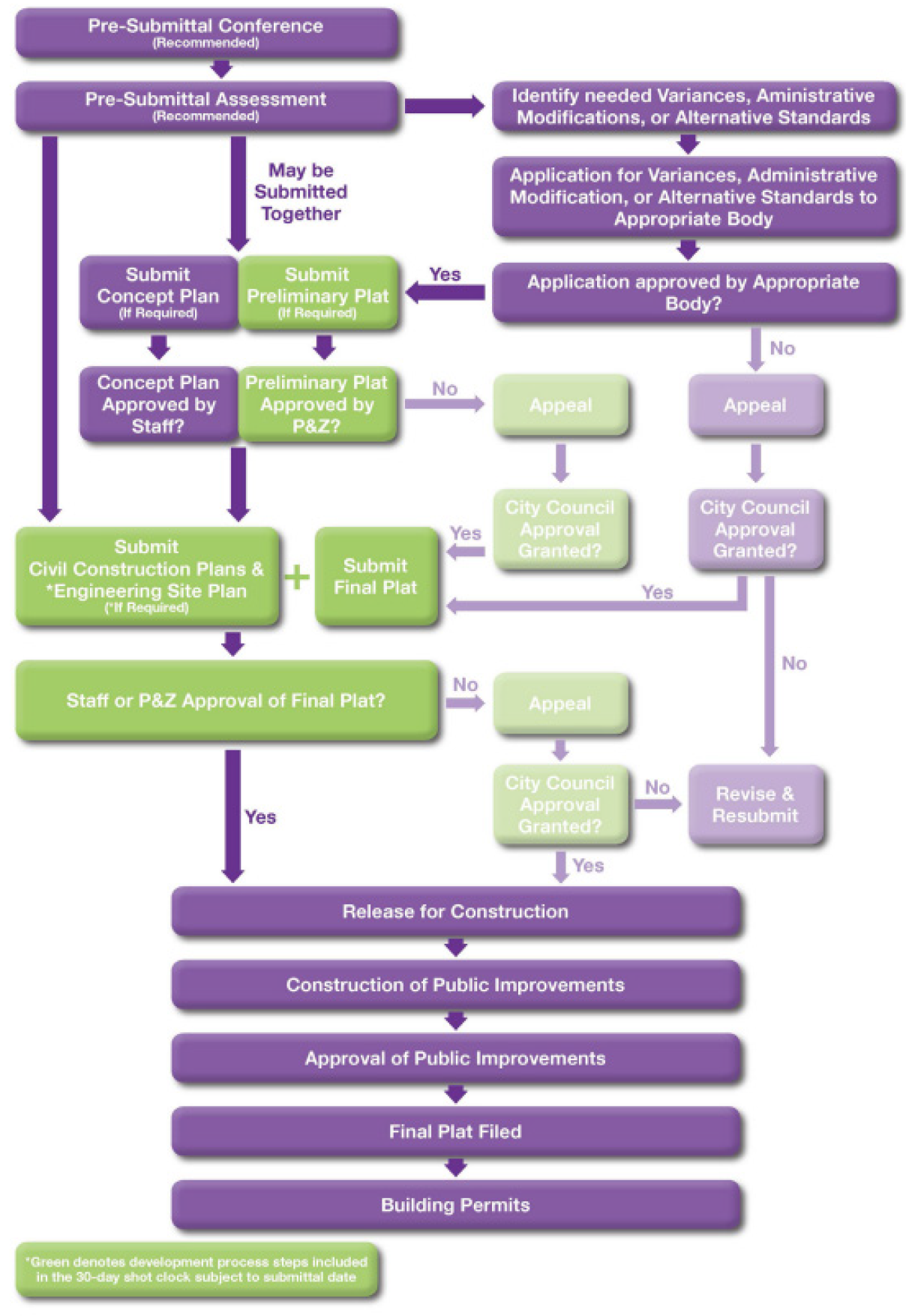
EXHIBIT III.2.4-2 PREVIOUSLY PLATTED MULTI-FAMILY OR COMMERCIAL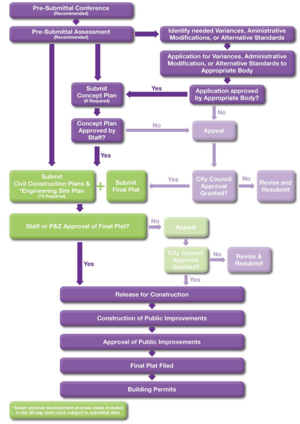
b.
If the development application expires, the applicant shall file a new development application and pay the required fees to obtain the requested approval.
4.
Limits of Review: A determination of completeness shall not constitute a determination of compliance with the substantive requirements of this UDC or other relevant ordinances applicable to development standards.
5.
Effect of Completeness Determination: Whenever this UDC establishes a time period for processing a development application, the time period does not begin until the Planning Director has determined that the development application is complete.
6.
Timing on Certain Development Plans: Once a Concept Plan, Engineering Site Plan, Construction Plan or Plat application is determined to be complete, it shall be reviewed under the provisions outlined in Section III.2.7, below.
Section III.2.5. - Timing and Procedures for Concept Plans, Engineering Site Plans, Construction Plans and Plats
A.
Purpose - This Section sets forth the timing and procedures for Concept Plans, Engineering Site Plans, Construction Plans and Plats.
B.
Applicability - The timing and procedures in this Section apply to the following development applications:
1.
Preliminary plats;
2.
Final plats;
3.
Replats;
4.
Minor plats;
5.
Amending plats;
6.
Concept plans;
7.
Engineering site plans; and
8.
Construction plans.
C.
Timing and Procedures - After a complete development application for the plan or plat application types listed in subsection B above is submitted to and accepted by the City as provided for in this Chapter, the following timing and procedures shall apply:
1.
The City shall approve, approve with conditions, or disapprove a plan or plat subject to these regulations within 30 days after the date the plan or plat is submitted.
2.
If a plan or plat is approved with conditions or disapproved, the City shall provide the applicant a written statement of each specific condition for approval with conditions or each specific reason for disapproval. Each condition or reason must:
a.
Be directly related to the requirements specified within this UDC;
b.
Include a citation to the requirement that is the basis for the conditional approval or disapproval; and
c.
Not be arbitrary.
3.
If the City conditionally approves or disapproves a plan or plat, the applicant may submit a written response that satisfies or remedies each condition listed in the written statement. After receipt of the applicant's response, the City shall approve, approve with conditions or disapprove the plan or plat no later than the 15th day after the date the response was submitted. If the plan or plat is approved with conditions or disapproved, the City shall again provide the applicant a written statement meeting the requirements of Section III.2.5.C.2 above, and the applicant may submit a written response that satisfies or remedies each condition listed in the written statement. The plan or plat is approved if the applicant has filed a response that satisfies or remedies each condition listed in the City's written statement or the City does not disapprove the plan or plat no later than the 15th day after the date the second response was submitted.
Section III.4.1. - Purpose
The review process for concept plans, engineering site plans and construction plans is intended to ensure compliance with the development and design standards of this UDC and to encourage quality development reflective of the adopted goals and objectives of the City. The process ensures that potential adverse impacts associated with the proposed development are addressed and mitigated.
Section III.4.2. - Concept Plan Requirements and Approval
A.
Applicability - A concept plan shall be required for:
1.
A commercial or multi-family development of five (5) acres or larger in size;
2.
When required by overlay district regulations;
3.
A development of single-family attached dwellings; and
4.
A manufactured home community use.
B.
Waiver of Concept Plan Requirement - The Planning Director may waive the requirement for a concept plan based on the following factors:
1.
The simplicity of the proposal. For example, the proposed development consists of one (1) building on one (1) lot, regardless of the size of the property.
2.
Previous approvals. For example, the proposed development has been identified as a separate phase of development on an approved valid concept plan or a Zoning Plan showing the proposed development with Special Use Permit, Mixed Use Zone Change request or Planned Development Zone Change Request.
3.
Scale of the project. For example, for development of single-family attached dwellings, the proposed development is on a tract less than five (5) acres in size, and the surrounding properties are developed.
C.
Application Procedures and Requirements - A concept plan is subject to the requirements of Article III.2.5 related to timing and processing and shall include the information and be presented as follows:
1.
A title block located at the bottom right hand side of the page to include project's name, addition's name, lot, block and phase designations, total acreage, zoning classification and address if available a template will be available from the Planning Director.
2.
A summary table for approximate building square footage, proposed use, building height, landscape percentage and total number of parking spaces required for each proposed classification and ROW square footage or acreage (if applicable).
3.
Approval signature block, a templates will be available from the Planning Director.
4.
Tax certificate showing all tax payments to the City are current.
5.
North point arrow (oriented to the top or right of the sheet) and date of original submittal. Dates revisions of the concept plan are submitted are also to be added with each modified set of plans.
6.
Location map one inch equals 1,000 feet (1" = 1,000') (Must use City base map).
7.
Sheet size of 22 inches × 34 inches.
8.
Scale of one inch equals 20 feet (1" = 20') maximum for lots up to three (3) acres, and one (1) inch equals 40 feet (1" = 40') maximum for lots exceeding three (3) acres. The Planning Director may prescribe a different scale for concept plans for large properties or with unusual lot configurations.
9.
Name, address and phone number of contact person for developer, owner, builder, engineer, or surveyor.
10.
Distances and bearings of the proposed or existing lots including total land area, subdivision lot and block designation, and phase lines if phases are proposed.
11.
Iron rods set or found.
12.
Contours with intervals of five (5) feet or less, referred to sea level datum, including City benchmark. Information can be obtained from the City Engineer's office.
13.
Approximate shape, use, and placement of buildings or structures.
14.
Building setback lines.
15.
Zoning of subject lot and adjoining property.
16.
Easements or encumbrances which impact development of the lot.
17.
Floodplains, drainage ways, and creeks.
18.
Existing and proposed median openings, driveways, traffic islands, turning lanes, and acceleration and deceleration lanes.
19.
Rights-of-way and private streets adjacent to the site showing boundaries of the right-of-way and limits of paving.
20.
General parking layout, including the number of parking spaces required and proposed.
21.
Aerial photograph showing trees on the property, including the extent of the tree canopy present on the property.
22.
Approximate location of landscaped strips and areas, public parks, and open space.
23.
A preliminary utility plan showing proposed water, sanitary sewer, and drainage systems.
24.
Any requested or approved variances, administrative modifications, or alternative standards shall be listed on the concept plan.
25.
A copy of the approved final plat for the property, if applicable.
26.
If an existing concept plan is being revised, a statement of the purpose for the revision.
D.
Approval Authority - The Planning Director may approve, approve with conditions, or disapprove all concept plans, including administrative modifications included in a concept plan, as delegated by Article IV, Chapter 3 in this UDC.
E.
Effect of Approval - As long as the concept plan remains valid, the location of public streets, driveways, access aisles, median breaks, and curb cuts shall remain fixed and any subsequently prepared concept plan for an adjacent property or property located on the opposite face of a public street abutting the site shall coordinate its public streets, driveways, access aisles, median breaks and curb cuts to the earlier approved public streets, drives, median breaks and curb cuts in the existing concept plan. If an approved concept plan delineates separate phases of development, each phase may be independently planned and developed provided it is in accordance with the concept plan and other applicable regulations.
F.
Period of Validity - An approved concept plan shall expire two (2) years following the date of the original approval, if no progress has been made toward completion of the project, as "progress" is defined in V.T.C.A., Local Government Code § 245.005.
Section III.4.3. - Engineering Site Plan Requirements and Approval
A.
Applicability - An engineering site plan is required for the following types of development, subject to the regulations contained within this Chapter:
1.
Commercial and multi-family development;
2.
A development of multiple single-family detached dwellings when on lots of 4,000 square feet or less in size;
3.
A development of single-family attached dwellings;
4.
A manufactured home community use;
5.
Development of parking lots, parking garages or outside storage; and
6.
Additions or alterations to existing structures or buildings that exceed ten percent (10%) of the aggregate building or structure area on the lot or 5,000 square feet, whichever is less.
B.
Exemptions - The following types of development are exempted from the engineering site plan requirements:
1.
Agricultural buildings.
2.
Temporary buildings.
3.
Parking lot reconstruction or expansions, if ten (10) or fewer parking spaces are added or the number of additional parking spaces does not exceed 15 percent of the total number of existing parking spaces, whichever is greater. A grading/paving permit will be required regardless of the number of additional parking spaces.
4.
A single family attached or detached dwelling on an existing platted lot where streets and City utilities are provided.
C.
Application Procedures and Requirements - An engineering site plan is subject to the requirements of Article III.2.5 related to timing and processing.
1.
An engineering site plan shall include and be presented as follows:
a.
All sheets shall be formatted as follows and include the information below unless otherwise specified:
1)
North arrow.
2)
Scale - Maximum scale of one inch equals 20 feet (1" = 20') for lots up to three (3) acres and one inch equals 40 feet (1" = 40') for lots over three (3) acres.
3)
Be on a sheet size that is 22 inches by 34 inches.
4)
Location map in top right corner or top left corner, one inch equals 1,000 feet (1" = 1,000') (Must use City base map).
5)
The date the original plans were submitted and dates of revisions for resubmittals.
6)
A title block located at top center of the cover sheet and the bottom right hand side of subsequent pages to include project's name, addition's name, lot, block and phase designations, total acreage, zoning classification and address if available. A template will be available from the Planning Director.
7)
Information shall be consistent and accurate on all pages of the engineering site plan.
b.
Cover sheet which shall include:
1)
Approval signature block. A template will be available from the Planning Director.
2)
Location map centered on the page, one inch equals 1,000 feet (1" = 1,000') (Must use City base map).
3)
Name, address and phone number of contact person of developer, owner, builder, engineer or surveyor.
4)
All previously approved or new requests for variances, administrative modifications and alternative standards.
c.
The site plan sheets shall Include the following. This information may be shown on several sheets to promote legibility and clarity of plans:
1)
A summary table for building square footage by proposed use with total number of parking spaces required for each, building height, impervious area in square feet and R.O.W. square footage or acreage (if applicable).
2)
Distances and bearings of the lot including total land area, subdivision lot, and block designation and phase lines. The entire platted lot shall be shown on the engineering site plan.
3)
Iron rods set or found.
4)
Contours with intervals of two (2) feet or less, referred to sea level datum, including City benchmark.
5)
Building setback lines including required setback from all water, sanitary sewer and drainage easements.
6)
Zoning of subject lot and adjoining property.
7)
Easements or encumbrances which impact development of the lot.
8)
Control of access lines, corner clips and clear vision areas.
9)
Traffic control signals, devices, and striping and traffic control plan in conformance with the latest edition of the Texas Manual on Uniform Traffic Control Devices.
10)
Median openings, traffic islands, turning lanes, and acceleration and deceleration lanes.
11)
Public streets, alleys, and easements adjacent to the site showing right-of-way and limits of paving.
12)
The dimensions, locations, and design of the proposed driveway(s), existing driveway(s) and associated deceleration lanes, if any.
13)
All existing or proposed driveways, gutters, storm sewers, manholes, fire hydrants, utility poles, service fixtures, trees and other features which may affect proposed driveway, turn lane or median opening location and operation.
14)
Any existing driveways or curb cuts located on adjacent lots or lots across the street.
15)
All of the geometric design features of the roadway, including medians, the number and width of travel lanes, the presence or absence of a shoulder or on-street parking.
16)
Driveways, sidewalks, water and sanitary sewer services, grading, drainage and other Site Improvements.
17)
Parking layout, including maneuvering, loading and unloading service areas, and required truck berths.
18)
Screening, including height and type of construction.
19)
Landscaping and open space with dimensions and total square footage.
20)
Construction details for all site improvements, as applicable.
21)
Fire protection including fire hydrants, fire lanes, fire lines and related fire protection devices.
22)
Location and screening of all outdoor receptacles.
23)
Other utilities.
24)
Finished floor elevation.
25)
Requested administrative modifications and alternative standards.
26)
Note stating required exterior finish, if applicable.
27)
Location of all proposed free-standing signage.
28)
Location of free-standing light fixtures.
d.
Construction plans, as outlined in Section III.4.4.B., for any site improvements.
e.
Traffic Impact Analysis. Assumptions and parameters for the Traffic Impact Analysis shall be approved by the City Engineer prior to completing the analysis. May be on 8.5" by 11" paper with no location map, scale or north arrow.
f.
Landscape Plan, prepared by a landscape architect registered in the State of Texas which shall include and be presented as follows:
1)
Landscape requirement table listing each applicable landscaping requirement and the landscaping provided to meet that requirement; landscape strip, tree in strip, parking lot landscape area, tree in parking lot, mitigation requirement (if any).
2)
Landscape materials table listing the common name, scientific name, quantity, size, and any symbol or abbreviation used on the plan for each plant species used.
3)
All easements and utility lines, overhead and underground.
4)
All pavement area measure in square feet, building areas measured in square feet, and detention/retention areas.
5)
All landscaped areas including landscape strips, buffers, parking lot islands, and any other plantings etc.
6)
Show location of all proposed plant materials, with species clearly labeled, consistent with landscape materials table.
7)
Label any trees planted for mitigation purposes with an "M."
8)
Name address and phone number for developer and landscape architect/designer.
9)
Site boundary.
10)
Landscape must be consistent with all other sheets submitted as part of the Engineering Site Plan.
11)
Landscape notes, including a note on automatic irrigation to be provided and planting details.
g.
Tree survey and tree preservation plan, where required by and in compliance with Article VIII.4.
1)
Location of all protected trees.
2)
All pavement, building footprints, easements and existing and proposed grade.
3)
Table containing list of all protected trees, with information on species, Diameter at Breast Height size, whether preserved or removed, whether exempt or mitigation required and, if mitigation is required, the amount of inches or fee for that mitigation.
4)
A summary of the total inches removed requiring mitigation and how that mitigation will be provided.
h.
Conceptual façade plans showing each building elevation with building materials labeled, windows, doors, heights and including a material percentage table. Building elevations shall be labeled by the cardinal direction they face and reference the street they face, [if] any.
i.
Turning templates to ensure fire access. Details on requirements for turn templates shall be kept on file by the Fire Marshal.
j.
Tax certificates showing no taxes due. These do not need to be formatted.
k.
Photometric Plans with information as required in Article VIII.11.7.
l.
Other approvals as required by this UDC.
2.
The City Engineer may waive the submission of certain information or plans if in his judgment said information or plans are not necessary based on the particular characteristics of the proposed development.
D.
Approval Authority - Engineering site plans and any associated administrative modifications as defined in Article IV.3 of this UDC may be approved by the Planning Director or City Engineer, as provided for in that Chapter. Requests for variances or alternative standards must be approved in accordance with this UDC before staff can approve an engineering site plan.
E.
Effect of Approval - Approval of an engineering site plan is the City's authorization for commencement of construction of private and public infrastructure and to apply for approval of building permits. So long as the engineering site plan remains valid, the City shall not apply any additional requirements concerning building placement, streets, drives, parking, landscaping, or screening. Engineering site plan approval is separate and distinct from other permits and approvals as may be required by the City and other regulatory agencies. Approval of an engineering site plan shall not affect other applicable regulations concerning development and land use. Engineering site plan approval shall expire upon completion of the improvements shown on the engineering site plan. Subsequent additional development, site modifications, and redevelopment shall be permitted only in accordance with this Chapter.
F.
Period of Validity - An approved engineering site plan shall expire two (2) years following the date of original approval, if no progress has been made toward completion of the project, as "progress" is defined in V.T.C.A., Local Government Code § 245.005. If progress has been made for only for a single phase of the property and for improvements, the engineering site plan for the remaining phase shall be null and void.
G.
Lapse in Approval - The applicant shall be required to submit a new engineering site plan for review and approval subject to the then existing regulations. However, the applicant may apply to extend the period of validity in accordance with Section III.4.5.B of this Chapter, below.
Section III.4.4. - Construction Plan Requirements and Approval
A.
Applicability - A construction plan is required for all subdivisions incorporating public streets or extension of public utilities subject to the regulations contained within this Chapter.
B.
Application Procedures and Requirements - A Construction plan is subject to the requirements of Article III.2.5 related to timing and processing.
1.
Complete construction plans for public improvements shall accompany submittal of a plat, if a plat is required. Construction plans shall contain engineering data for the construction of all public improvements (streets, water, sanitary sewer, storm sewer, grading, filling, erosion control and paving) and be presented and contain information as follows:
a.
Plans and profiles shall be drawn on sheets measuring 22" × 34" overall dimensions.
b.
Maximum scale for all construction plans shall be one inch equals 40 feet (1" = 40') horizontal and one inch equals five feet (1" = 5') vertical. (e.g., 1" = 50' horizontal and 6' vertical are not acceptable) Construction plans for street reconstruction shall be drawn to a one inch equals twenty feet (1" = 20') scale.
c.
North point arrow oriented to top or right of the sheet.
d.
Date: (Dates of revisions to be added with each modified set of plans).
e.
Benchmark description to sea level datum (to be obtained from City Engineer's office). In the event a benchmark is not available near the project site, a temporary benchmark shall be established based on the City's benchmark.
f.
Cross-sections of proposed streets and alleys drawn to a maximum scale of one inch equals ten feet (1" = 10') horizontal and 1" = 2' vertical and drawn from beyond right-of-way to beyond right-of-way.
g.
Proposed street and alley pavement sections shall include thickness of pavement, base course, subgrade, pavement cross-slope, parkway cross-slope, location and width of sidewalks, typical location of underground utilities.
h.
Plan and profile of each street and alley with top of curb grades for streets and center lines for alleys. The plan view shall show all existing features and the profile view shall include the existing ground. The profile gradelines and cross-sections of intersecting streets should be adjusted to provide a smooth junction and proper drainage.
i.
A drainage area map to a maximum scale one inch equals two hundred feet (1" = 200'), (1" = 1000' if the area is over 500 acres) of all areas contributing storm water runoff or drainage within and surrounding the proposed subdivision. The drainage area map shall include size of areas, storm frequency, duration data, amounts of runoff, points of concentration and any additional data determined to be necessary by the City Engineer for the proper design of drainage facilities.
j.
A plan and profile of proposed storm sewer showing hydraulic gradient and hydraulic data, pipe grades and sizes, manholes, inlets, pipe connections, culverts, outfall structures, bridges, ditches.
k.
A plan and profile of the proposed water distribution system showing pipe sizes, location of valves, fire hydrants, fittings and other appurtenances, including installation and backfill details.
l.
A plan and profile of the proposed sanitary sewer system with pipe grades and sizes, manholes, cleanouts and other appurtenances, including installation and backfill details.
m.
All utility profiles shall include the elevation of other utility crossings.
n.
Each plan and profile sheet shall be signed and sealed by a state-licensed professional civil engineer.
o.
Trench safety plan, prepared by a state-licensed professional engineer, and soil analysis when required by state or federal law.
p.
The City reserves the right to require corrections to the submitted construction plans based on actual field conditions which are found to be contrary to the information shown on the plans.
q.
The engineer certifying the construction plans is responsible for the accuracy and completeness of plans submitted for review and construction.
r.
Grading plans which show contour intervals of two (2) feet or less, finished contours and/or grades.
s.
Finished floor elevation, proposed grading and drainage for all lots designated for single-family uses. The builder is responsible for furnishing a certification of the foundation elevation and building setbacks prior to construction of a foundation.
t.
Tree survey and tree preservation plan, where required by and in compliance with Article VIII.4.7 and a tree mitigation plan, where required by and in compliance with Article VIII.4.8.
u.
Erosion control plans for both during and after construction.
v.
A traffic control plan shall be submitted for all proposed construction within a right-of-way. The traffic control plan shall incorporate all applicable TxDOT traffic control plan sheets.
w.
A street lighting plan in accordance with this UDC. The City will coordinate the installation of the street lighting system with the utility company.
x.
External agency permit submittals. Submittals for floodplain development to F.E.M.A., and the U.S. Corps of Engineers (C.D.C. applications), can be processed concurrently with City staff approval. Submittals for TXDOT permits will be processed through City initiation (per TXDOT policy) only upon completion of City staff review. Permits are granted only to the City by TXDOT and not to private developers.
y.
The contractor shall establish erosion control devices in accordance with the current Texas Pollution Discharge Elimination System (TPDES) requirements.
z.
All previously approved or new requests for variances, administrative modifications and alternative standards.
2.
The City Engineer may waive the submission of certain information or plans if in his judgment said information or plans are not necessary based on the particular characteristics of the proposed development.
C.
Approval Authority - Construction plans and any associated administrative modifications as defined in Article IV.3 of this UDC may be approved by the Planning Director or City Engineer, as provided for in that Chapter. Requests for variances or alternative standards must be approved in accordance with this UDC before staff can approve construction plans.
D.
Effect of Approval - Approval of a construction plan is the City's authorization for commencement of construction of public infrastructure. So long as the construction plan remains valid, the City shall not apply any additional requirements concerning building placement, streets, drives, parking, landscaping, or screening. Construction plan approval is separate and distinct from other permits and approvals as may be required by the City and other regulatory agencies. Approval of a construction plan shall not affect other applicable regulations concerning development and land use. Construction plan approval shall expire upon completion of the improvements shown on the construction plan. Subsequent additional development, site modifications, and redevelopment shall be permitted only in accordance with this Chapter.
E.
Period of Validity - An approved construction plan shall expire two (2) years following the date of original approval, if no progress has been made toward completion of the project, as "progress" is defined in V.T.C.A., Local Government Code § 245.005.
F.
Lapse in Approval - If an approved construction plan expires, the applicant may apply to extend the period of validity in accordance with Section III.4.5.B of this Chapter, below. If denied, the applicant shall be required to submit a new construction plan for review and approval subject to the then existing regulations.
Section III.4.5. - Amendments, Extensions, or Reinstatements of Concept Plans, Engineering Site Plans or Construction Plans
A.
Amendments
1.
Minor Amendments - The Planning Director may approve or disapprove a minor amendment to an approved, valid concept plan, engineering site plan or construction plan. Minor amendments may require the submission of revised engineering plans if required by the City Engineer. Minor amendments include the following, so long as the amendments would not otherwise require an administrative modification or alternative standard:
a.
Corrections of distances and dimensions.
b.
Adjustments such as, but not limited to, changes in building location of approximately ten (10) feet or less in any direction based on final engineering, that do not significantly change the orientation or arrangement of buildings, increase the number of buildings, or change the use of building space if designated on the approved concept plan or engineering site plan.
c.
Minor realignment of median openings, driveways, fire lanes, and access aisles, that do not substantially change the original plan or proposed traffic patterns, do not reduce or increase access, and meet all requirements.
d.
Layout of parking.
e.
Adjustments to open space, landscaping, and screening that do not reduce the amount of open space, total plant material, or effectiveness of the screening provided.
f.
Changes to utilities and service locations which do not reduce the level of service provided on the original concept plan or engineering site plan.
g.
The addition or deletion of no more than ten percent (10%) of the existing building square footage, up to a maximum of 5,000 square feet.
2.
Major Amendments - Amendments that do not qualify as minor amendments are subject to the complete concept plan or engineering site plan review process.
B.
Extension and Reinstatement Procedures
1.
Sixty (60) days prior to or following the expiration of the approval of a concept plan or the validity of the engineering site plan as provided in this UDC, the property owner may petition the Planning and Zoning Commission to extend or reinstate the approval of a concept plan or the validity of the engineering site plan. Such petition shall be considered by the Planning and Zoning Commission.
2.
In determining whether to grant such request, the Planning and Zoning Commission shall take into account the reasons for lapse and the extent to which newly adopted regulations would apply to a new concept plan or engineering site plan.
3.
The Planning and Zoning Commission may extend or reinstate the approval pf a concept plan or the validity of an engineering site plan subject to additional conditions based upon newly enacted regulations or may deny the request, in which instance, a new application for a concept plan or engineering site plan shall be submitted.
Section III.5.1. - Purpose
The platting process is intended to protect and provide for the public health, safety, and general welfare of the City by requiring the orderly layout and use of land and to ensure proper legal descriptions and monumentation of platted land, and to remedy the problems associated with inappropriately platted properties, including premature subdivision, incomplete subdivision and scattered subdivision.
(Ord. No. 0740-25-ORD, § 2, 3-3-2025)
Section III.5.2. - Authority
This Section is adopted under the authority of and in accordance with V.T.C.A., Local Government Code ch. 212.
(Ord. No. 0740-25-ORD, § 2, 3-3-2025)
Section III.5.3. - Jurisdiction
This Section is applicable to all land within the City limits of the City of Lewisville and its extraterritorial jurisdiction, except as expressly stated herein.
(Ord. No. 0740-25-ORD, § 2, 3-3-2025)
Section III.5.4. - Plat Required
A.
Division of Land - The platting of property is required when a tract of land is divided in two (2) or more parts.
A division of a tract under this subsection includes a division regardless of whether it is made by using a metes and bounds description in a deed of conveyance or in a contract for a deed, by using a contract of sale or other executory contract to convey, or by using any other method.
B.
Building or Alteration of a Building - The platting of property is required when any new building or addition to an existing structure or building is proposed.
C.
Exemptions - The following types of subdivision, development, or alteration of an existing building do not require approval by the City:
1.
The division of land into two (2) or more parts where all parts are larger than five (5) acres and where each part has access and no public improvements are being dedicated.
2.
The division of property through inheritance, the probate of an estate, or by a court of law.
3.
When a new building or addition is no more than ten percent (10%) of the size of the existing building or buildings on the tract, provided there are one (1) or more buildings already located on the tract. This provision shall apply up to a maximum addition or new building of 5,000 square feet in size when there are no significant impacts to the property as determined by a current survey. A plat will be required, however, if there are changes in drainage, City utilities, or required parking which necessitate an engineering site plan.
4.
For the purposes of adding an accessory structure to a residential lot, including a back yard cottage.
D.
The City shall not extend utilities, provide access to public rights-of-way, or issue building permits for the development of any property which has not received final plat approval unless it is otherwise exempted from platting requirements by this UDC.
E.
A written request may be directed to the Planning and Zoning Commission for a determination regarding whether or not a plat is required as outlined in V.T.C.A., Local Government Code § 212.0115.
(Ord. No. 0740-25-ORD, § 2, 3-3-2025)
Section III.5.5. - Preliminary Plats
A.
Applicability - Unless exempted by Section III.5.4.C above, a preliminary plat is required for:
1.
The subdivision of an unplatted tract when the dimensions of the unplatted track do not conform with the tract dimensions shown in the current central appraisal district records.
2.
The proposed subdivision of a tract which will involve dedication of public streets, right-of-way for storm water drainage and/or extension of public utilities.
B.
Application Procedures and Requirements - A preliminary plat is subject to the requirements of Article III.2.5 related to timing and processing of applications.
C.
Information Required for Preliminary Plat Application - A preliminary plat application shall include and be presented as follows:
1.
All sheets shall be formatted and include the information below unless otherwise specified:
a.
A title block located at top center of the cover sheet and the bottom right-hand side of subsequent pages to include project's name, addition's name, lot, block and phase designations, total acreage, zoning classification and address if available.
b.
Location map in top right corner or top left corner, one inch equals 1,000 feet (1" = 1,000') (Must use City base map).
c.
The date the original plans were submitted and dates of revisions for resubmittals.
d.
For all residential subdivisions, a plan summary table, to include total acreage per phase, total number of lots and number of lots per phase, and zoning classification, minimum lot size, minimum dwelling size, and density per acre.
e.
Name, address and phone number of contact person of developer, owner or builder, engineer or surveyor.
f.
Be on a sheet size that is 22 inches by 34 inches.
g.
The maximum scale shall be one inch equals 100 feet (1" = 100'), except that tracts in commercial developments over 100 acres may be drawn to a maximum scale of one inch equals 200 feet (1" = 200').
2.
The following information shall be provided:
a.
Abstract(s) and survey(s) of subject tract.
b.
Abstract and survey lines.
c.
Boundary lines, accurate in scale, of the subject tract.
d.
The layout, building setback lines including setbacks from water, sanitary sewer and drainage easements and approximate dimensions of proposed lots, blocks, etc.
e.
Lot number, block letter designations and acreage of each lot.
f.
Zoning of subject lot and adjoining property.
g.
Contours with intervals of two (2) feet or less, referred to sea level datum, including benchmark.
h.
The names of adjacent subdivisions and/or the names of record owners of adjoining parcels of unplatted land.
i.
Lines or limits designating boundaries of municipalities, counties, and special districts such as municipal utility districts, road utility districts, levee districts, etc.
j.
Existing and proposed sanitary sewer and water system shown adjacent to or within 200 feet of the subject property if no services are adjacent. The Director of engineering may require a longer distance than 200 feet depending on the specific circumstances.
k.
Other utilities, proposed and existing, including private transmission lines.
l.
A drainage plan, as a separate exhibit, of the proposed and existing drainage systems, including all drainage areas (on-site and off-site) that affect the area being platted. The plan shall show the property both in its natural state and in the final development, location of lines, inlets, existing and proposed easements, proposed rights-of-way for stormwater drainage, all required drainage calculations in accordance with the City drainage criteria manual. In addition, the 100-year floodplain, if applicable, shall be delineated.
m.
Existing and proposed public or private streets and alleys, including widths of right-of-way and pavement. Street names shall provide continuity with existing streets. Where a development abuts or contains a street shown on the City's thoroughfare plan, the preliminary plat shall include a proposed dedication of right-of-way in accordance with the requirements of the thoroughfare plan.
n.
Cross-section of proposed streets and alleys showing the width of pavement, type of pavement and location and width of sidewalks.
o.
Easements, deed restrictions or encumbrances which impact development of the lot.
p.
Control of access lines, corner clips and clear vision areas.
q.
Traffic control signals, devices and striping.
r.
Median openings, turning lanes, and acceleration and deceleration lanes.
s.
For residential developments, park dedication provisions shall be noted on the face of the plat.
t.
All land proposed for public use dedication or to be reserved for the common use of all property owners, together with conditions or limitations of such use, and must be identified with a lot and block designation except public street and alley rights-of-way.
u.
If Phased development is proposed, phase lines must be clearly delineated, with site improvements capable of standing alone as development occurs and not depending on future construction to meet City standards or requirements.
v.
Requested and or approved administrative modifications and alternative standards shall be listed on the face of the plat.
w.
Any approved variances shall be listed on the face of the plat.
x.
City signature block.
y.
Where an engineering site plan is not required, a tree survey and tree preservation plan, as required by and in compliance with Chapter III.4.
D.
Reinstatement Procedures
1.
Before the sixtieth (60 th ) day following the expiration of the approval of a preliminary plat as provided in this UDC, the property owner may petition the Planning and Zoning Commission to reinstate the approval of a preliminary plat. Such petition shall be considered by the Planning & Zoning Commission.
2.
In determining whether to reinstate a preliminary plat, the Planning and Zoning Commission shall take into account the reasons for the expiration and the extent to which newly adopted regulations would apply to a new preliminary plat application.
(Ord. No. 0740-25-ORD, § 2, 3-3-2025)
Section III.5.6. - Final Plats
A.
Applicability - A final plat is required in accordance with Section III.5.4 of this Chapter.
B.
Application Procedures and Requirements - A final plat is subject to the requirements of Section III.2.5 related to timing and processing of applications.
C.
Information Required for Final Plat Applications - A final plat application shall include and be presented as follows:
1.
All sheets shall be formatted and include the information below unless otherwise specified:
a.
A title block located at the bottom right hand side to include project's name, addition's name, lot, block and phase designations, total acreage, zoning classification and address if available. A template will be available from the Planning Director.
b.
Location map in top right corner or top left corner, one inch equals 1,000 feet (1" = 1,000') (Must use City base map).
c.
The date the original plans were submitted and dates of revisions for resubmittals.
d.
For all residential subdivisions, a plan summary table, to include total acreage per phase, total number of lots and number of lots per phase and zoning classification, minimum lot size, minimum dwelling size and density per acre.
e.
Name, address and phone number of contact person of developer, owner or builder, engineer or surveyor.
f.
Be on a sheet size that is 22 inches by 34 inches.
g.
The maximum scale shall be one inch equals 100 feet (1" = 100'), except that tracts in commercial developments over 100 acres may be drawn to a maximum scale of one inch equals 200 feet (1" = 200').
h.
North point arrow (oriented to the top or right of the sheet) and date. Dates of revisions are also to be added with each modified set of plans.
i.
Address and phone number of contact person of developer, owner or builder, engineer or surveyor.
j.
Information shall be consistent and accurate on all pages of the engineering final plat.
2.
The following information shall be provided on the face of the plat:
a.
Boundary lines, accurate in scale and with exact distances and bearings, of the subject tract and each lot within the subdivision including exact acreage per lot for all non-single-family developments. Location of corner pins and monuments, including description and whether found or set.
b.
Metes and bounds description of the subdivision, with exact acreage, in reference to the deed records of the county, including the volume and page of the deed for the land being platted.
c.
Lot number and block letter designations. Setback lines shall be shown or noted including setback lines from all water, sanitary sewer, and drainage easements.
d.
Zoning of subject lot and adjacent property.
e.
The names of adjacent subdivisions and/or the names of record owners of adjoining parcels of unsubdivided land.
f.
Lines or limits designating boundaries of municipalities, counties, and special districts such as municipal utility districts, road utility districts, levee districts, etc.
g.
Existing and proposed streets, alleys and access easements, including street names, with all curve data and widths of rights-of-way.
h.
Easements or encumbrances which impact development of the lot.
i.
Control of access lines, corner clips and clear vision areas.
j.
All land proposed for public use dedication or to be reserved for the common use of all property owners, together with conditions or limitations of such use. Such reservations and dedications must be identified with a lot and block designation except street and alley rights-of-way. R.O.W. dedication square footage and acreage must be listed on the plan.
k.
The 100-year floodplain per current FEMA Flood Insurance Rate Map (FIRM), if applicable, shall be delineated. If the floodplain is not mapped, the developer is responsible for making this determination using a FEMA approved method.
l.
Flowage easements, if any, pertaining to drainage including a note regarding responsibility for maintenance.
m.
Right-of-way and public property to be abandoned should be identified on the plat with additional information being provided separately as required by Chapter III.12 Abandonment of Real Property.
n.
Certification by a licensed land surveyor, registered in the state, to the effect that the plan represents a survey made by him or under his direct supervision and that all the monuments and corner pins shown exist and are correctly described.
o.
A certification of ownership and dedication of all streets, alleys, parks, easements and public ways, signed and acknowledged before a notary public by the owner, trustee(s) or person(s) duly authorized to sign the plat. This will include any lienholder(s) on the property.
p.
City signature block.
q.
Requested and or approved administrative modifications and alternative standards shall be listed on the face of the plat.
r.
Any approved variances shall be listed on the face of the plat.
(Ord. No. 0740-25-ORD, § 2, 3-3-2025)
Section III.5.7. - Minor Plats
A.
Applicability - A minor plat may be used in lieu of a final or replat for all subdivisions of four (4) or fewer lots where no public improvements are required and the boundary of the area to be platted aligns with County Appraisal District records for the existing tract.
B.
Application Procedure and Requirements - A minor plat is subject to the requirements of Section III.2.5 related to timing and processing of applications.
C.
Information Required for Minor Plat Applications - A minor plat application shall include and be presented as follows:
1.
All sheets shall be formatted and include the information below unless otherwise specified:
a.
A title block located at top center of the cover sheet and the bottom right hand side of subsequent pages to include project's name, addition's name, lot, block and phase designations, total acreage, zoning classification and address if available.
b.
Location map in top right corner or top left corner, one inch equals 1,000 feet (1" = 1,000') (Must use City base map).
c.
The date the original plans were submitted and dates of revisions for resubmittals.
d.
For all residential subdivisions, a plan summary table, to include total acreage per phase, total number of lots and number of lots per phase and zoning classification, minimum lot size, minimum dwelling size and density per acre.
e.
Name, address and phone number of contact person of developer, owner or builder, engineer or surveyor.
f.
Be on a sheet size that is 22 inches by 34 inches.
g.
North point arrow (oriented to the top or right of the sheet) and date.
h.
Dates of revisions are also to be added with each modified set of plans.
i.
The maximum scale shall be one inch equals 100 feet (1" = 100') except that tracts in commercial developments over 100 acres may be drawn to a maximum scale of one inch equals 200 feet (1" = 200').
2.
The following information shall be provided on the face of the plat:
a.
Boundary lines, accurate in scale and with exact distances and bearings, of the subject tract and each lot within the subdivision including exact acreage per lot for all non-single-family developments. Location of corner pins and monuments, including description and whether found or set.
b.
Metes and bounds description of the subdivision, with exact acreage, in reference to the deed records of the county, including the volume and page of the deed for the land being platted.
c.
Lot number and block letter designations. Setback lines shall be shown or noted including setback lines from all water, sanitary sewer, and drainage easements.
d.
Zoning of subject lot and adjacent property.
e.
The names of adjacent subdivisions and/or the names of record owners of adjoining parcels of unsubdivided land.
f.
Lines or limits designating boundaries of municipalities, counties, and special districts such as municipal utility districts, road utility districts, levee districts, etc.
g.
Existing and proposed streets, alleys and access easements, including street names, with all curve data and widths of rights-of-way.
h.
Easements or encumbrances which impact development of the lot.
i.
Control of access lines, corner clips and clear vision areas.
j.
All land proposed for public use dedication or to be reserved for the common use of all property owners, together with conditions or limitations of such use. Such reservations and dedications must be identified with a lot and block designation except street and alley rights-of-way. R.O.W. dedication square footage and acreage must be listed on the plan.
k.
The 100-year floodplain per current FEMA Flood Insurance Rate Map (FIRM), if applicable, shall be delineated. If the floodplain is not mapped, the developer is responsible for making this determination using a FEMA approved method.
l.
Flowage easements, if any, pertaining to drainage including a note regarding responsibility for maintenance.
m.
Right-of-way and public property to be abandoned should be identified on the plat with additional information being provided separately as required by Chapter III.12.
n.
Certification by a licensed land surveyor, registered in the state, to the effect that the plan represents a survey made by him or under his direct supervision and that all the monuments and corner pins shown exist and are correctly described.
o.
A certification of ownership and dedication of all streets, alleys, parks, easements and other public ways, signed and acknowledged before a notary public by the owner, trustee(s) or person(s) duly authorized to sign the plat. This will include any lienholder(s) on the property.
p.
City signature block.
q.
Requested and or approved administrative modifications and alternative standards shall be listed on the face of the plat.
r.
Any approved variances shall be listed on the face of the plat.
(Ord. No. 0740-25-ORD, § 2, 3-3-2025)
Section III.5.8. - Replats
A.
Applicability - Unless otherwise expressly provided for herein, a property owner who proposes to change any portion of an approved final plat, other than to amend or vacate the plat, must first obtain approval for a replat under the same standards, and by the same procedures prescribed for the platting of land by these regulations.
B.
Application Procedure and Requirements - A replat is subject to the requirements of Section III.2.5 related to timing and processing of applications.
C.
Information Required for a Replat Application - A replat must contain the information required for final plats in Section III.5.6.C above, and construction plans may be required by the City Engineer if applicable. The replat shall clearly note the reason for the replat. Any replat that adds or deletes lots must include the original lot boundaries.
D.
Replatting Without Vacating Preceding Plat - A replat of a final plat or portion of a final plat without vacating the preceding plat may be done in accordance with V.T.C.A., Local Government Code § 212.014 or V.T.C.A., Local Government Code § 212.0145; provided however, that certain replats as described in V.T.C.A., Local Government Code § 212.015 shall comply with the requirements set forth therein, including public hearings. Any references to variances and exceptions in V.T.C.A., Local Government Code § 212.015 shall include administrative modifications and alternative standards.
(Ord. No. 0740-25-ORD, § 2, 3-3-2025)
Section III.5.9. - Amending Plats
A.
Applicability - An amending plat may be submitted solely for one (1) or more of the purposes outlined in V.T.C.A., Local Government Code § 212.016.
B.
Application Procedures and Requirements - Amending plats shall be processed using procedures for minor plats set forth in Section III.5.7 of this Chapter. An application for an amending plat shall include all information required for minor plats as set forth in Section III.5.7 of this Chapter. An amending plat shall not require public notice, a public hearing, or approval of other lot owners. An amending plat is subject to the requirements of Section III.2.5 related to timing and processing of applications.
(Ord. No. 0740-25-ORD, § 2, 3-3-2025)
Section III.5.10. - Plat Vacation
A.
Applicability - Plats may be vacated as provided for in V.T.C.A., Local Government Code § 212.013.
B.
Information Required for A Plat Vacation - The application to vacate a plat shall be submitted in a form and manner prescribed by the Planning Director and accompanied by copies of the plat to be vacated.
C.
Approval Authority - The Planning and Zoning Commission shall approve the application for vacation in the manner prescribed for the original plat.
D.
Record of Notice - If the Planning and Zoning Commission approves the application vacating a plat in whole, it shall record a signed acknowledge instrument declaring the plat vacated in the appropriate county clerk's office. If the Planning and Zoning Commission approves the application vacating a plat in part as provided for in V.T.C.A., Local Government Code § 212.013, it shall record a revised final plat which shows that portion of the original plat that has been vacated and that portion that has not been vacated to be recorded in the appropriate county clerk's office.
E.
Effect of Approval - On the execution and recording of the vacating instrument, the vacated plat shall have no effect.
(Ord. No. 0740-25-ORD, § 2, 3-3-2025)
Section III.5.11. - Plat Approval Process for All Plats
A.
Approval Authority - The Planning Director shall have the authority to approve, approve with conditions, or disapprove plats. The Planning Director may, for any reason, elect to present any plat to the Planning and Zoning Commission, which shall have authority to hear and approve, approve with conditions, or disapprove such plats. Requests for alternative standards or variances shown on the plat must be approved by the City Council, Planning & Zoning Commission or Zoning Board of Adjustment, as applicable, prior to approval of the plat.
B.
Certificate of Approval - In accordance with V.T.C.A., Local Government Code § 212.0115, upon approval of a plat, the City shall issue to the applicant a certificate stating that the plat has been reviewed and approved by the appropriate authority. If the City fails to approve, approve with conditions, or disapprove a plat within the prescribed period, then on the applicant's request, the City shall issue a certificate stating the date the plat was filed and that the City failed to act on the plat within the period.
C.
Effect of Approval - Approval of a final plat, minor plat, amending plat or replat constitutes authorization for the City Engineer to release construction plans subject to his final approval and to authorize grading of the site and construction. Approval of a plat shall certify compliance with the regulations of the City of Lewisville pertaining to the subdivision of land. An approved and signed plat, excluding preliminary plat, shall be filed with the appropriate county clerk as a record of the subdivision of land.
D.
Period of Validity - If a plat is not filed with the appropriate county clerk, or if an approved preliminary plat is not provided to the City for signatures, approval shall expire two (2) years following the date of original approval, if no progress has been made toward the completion of the project, as "progress" is defined in V.T.C.A., Local Government Code § 245.005.
E.
Appeals. The final decision of the Planning Director to disapprove a plat may be appealed by the applicant to the Planning and Zoning Commission, which shall have authority to hear and decide such appeals. The final decision of the Planning and Zoning Commission to disapprove a plat may be appealed by the applicant to the City Council, which shall have authority to hear and decide such appeals. The City Council decision on the plat shall be final.
(Ord. No. 0740-25-ORD, § 2, 3-3-2025)
Section III.6.1. - Purpose
This chapter describes the procedures for zoning petitions on property to change to another zoning district as is established in Subpart 2, to adopt a Planned Development Zoning District or to adopt a Special Use Permit, in accordance with the provisions of Chapter 211 of the Texas Local Government Code.
(Ord. No. 0608-23-ORD, § 1, 11-6-2023)
Section III.6.2. - Initiation of Zoning Petitions
Zoning Petitions may be initiated as follows:
A.
Any person may initiate a zoning district petition provided they are the property owner or the property owner's designated agent of the subject property. If the applicant is a designated agent, the zoning petition shall include a written letter of authorization from the property owner authorizing the agent to file the application. Such zoning petition shall be made in writing on a form provided by the Planning Department and shall be submitted to the Planning Department accompanied by the appropriate fee set forth in Volume 1, Chapter 2, Article VIII, Section 2-201 of the Code of Ordinances.
B.
City staff or the Planning and Zoning Commission, on its own motion, may initiate proceedings to consider a change in zoning petition on any property.
(Ord. No. 0608-23-ORD, § 1, 11-6-2023)
Section III.6.3. - Petition Requirements
To ensure the submission of adequate information, the Planning Department shall maintain, update and distribute a list of specific requirements for each type of zoning petition. In addition, all zoning petitions shall include the following:
A.
Property location and boundaries;
B.
The acreage of the property;
C.
The current and proposed zoning designation;
D.
The zoning designations on adjacent properties; and
E.
A statement reading as follows: "Approval of the zoning case associated with this exhibit shall not imply approval of any associated study, plat or plan, approval of development standards shown hereon, or the initiation of the development process. Planning and Zoning Commission and/ or City Council action on studies, plats or plans relating to the development of this property shall be considered as an action separate from action taken on this zoning case".
(Ord. No. 0608-23-ORD, § 1, 11-6-2023)
Section III.6.4. - Public Hearing and Public Notice Requirements
Notice of a public hearing for zoning petitions before the Planning and Zoning Commission and City Council shall meet or exceed the requirements of the Texas Local Government Code, as follows:
A.
Planning and Zoning Commission Public Hearings - Not later than the 10th day before the hearing date, written notice of a proposed change in a zoning classification shall be sent to each owner, as indicated by the most recently approved municipal tax roll, of real property within 200 feet of the property on which the change in classification is proposed. The notice may be served by its deposit in the municipality, properly addressed with postage paid, in the United States mail. For recently annexed land that is not included on the most recent tax roll, notice may be given by published notice in a newspaper of general circulation in the City.
B.
City Council Public Hearings - For changes in zoning for property, the City Secretary shall provide one notice of a public hearing before the City Council hearing in a newspaper of general circulation in the City, stating the time and place of the hearing and the nature of the requested zoning change or amendment to regulations or text of the ordinance. The notice shall be published before the 15th day before the date of the public hearing.
C.
Signs - The applicant shall place the appropriate zoning change sign(s) or Special Use Permit sign(s) on the subject property, in a form, manner and design approved by the City. The sign(s) shall remain in place until final action has been taken on the request by City Council.
D.
Notice of Nonconforming Use - In addition to any other required notice, written notice of each public hearing regarding the adoption of the proposed change in zoning classification shall be sent, in compliance with Section 211.006(a-1) of the Texas Local Government Code, as amended, if the adoption of the proposed change in zoning classification will result in a current conforming use of a property becoming a nonconforming use.
(Ord. No. 0608-23-ORD, § 1, 11-6-2023)
Section III.6.5. - Planning and Zoning Commission Action
A.
Public Hearing Required - The Planning and Zoning Commission shall hold a public hearing on any zoning petition for any amendment or changes prior to making its recommendation and report to the City Council. The Commission may establish such regulations and restrictions regarding the presentation of a zoning request at the public hearing as they may deem necessary.
1.
Request to Withdraw or Reschedule - Prior to the issuance of the notice of public hearing, the applicant may, by written notice, withdraw the zoning petition or request rescheduling of the public hearing to a later regular meeting of the Planning and Zoning Commission.
2.
Once public notice is given, the applicant may request the withdrawal of the zoning petition or the rescheduling of the public hearing only with the approval of the Planning and Zoning Commission.
3.
The Planning and Zoning Commission may approve a request to withdraw a zoning petition, reschedule the public hearing, or reject a request to withdraw a zoning petition or to reschedule the public hearing and conduct the public hearing as noticed.
B.
Planning and Zoning Commission Action - Following the public hearing, the Planning and Zoning Commission may vote to make a recommendation to the City Council to approve, approve with amendments and or deny in whole or in part the zoning petition. When a zoning petition is recommended for denial, the Planning and Zoning Commission shall offer reasons to the applicant for such denial. The Planning & Zoning Commission may table for study any zoning petition.
(Ord. No. 0608-23-ORD, § 1, 11-6-2023)
Section III.6.6. - City Council Action
A.
Public Hearing Required - After report and recommendation by the Planning and Zoning Commission on the zoning petition, the City Secretary shall schedule a public hearing to be held before the City Council, giving notice as required above.
B.
Request to Withdraw or Table - At any time, the applicant may request withdrawal of the zoning petition or tabling of the zoning petition to a specified future City Council meeting. City Council may approve the request to withdraw or table or conduct the public hearing as noticed.
C.
City Council Action - After a public hearing, the City Council may approve, deny (in whole or in part), table, or refer the zoning designation change petition back to the Planning and Zoning Commission for further study.
D.
Supermajority Vote Requirements - An affirmative vote of at least three-fourths of all members of the City Council is required to approve a zoning designation change petition in the following circumstances:
1.
Recommendation of Denial - If the Planning and Zoning Commission has recommended denial, in whole or in part, of a zoning petition.
2.
Protests - If a protest has been submitted as outlined in Section 211.006 of the Texas Local Government Code, as amended.
a.
Form of Protest - Such protest must be in writing and must be signed by the owner(s) of the property in question.
b.
Presumption of Validity - In all cases where a protest has been properly signed pursuant to this subsection, the City shall presume that the person(s) whose signature(s) appear on the protest are valid.
c.
Withdrawal of Protest - A withdrawal of a protest must be in writing. In the event that multiple protests and withdrawals are filed on behalf of the same owner(s), the instrument with the latest date and time of execution controls.
(Ord. No. 0608-23-ORD, § 1, 11-6-2023; Ord. No. 0724-25-ORD, § 1, 1-6-2025)
Section III.6.7. - Recording a Change on the Official Zoning Map
All approved zoning petitions shall be referenced and the associated districts changed as applicable on the Official Zoning Map.
(Ord. No. 0608-23-ORD, § 1, 11-6-2023)
Section III.7.1. - Purpose
This Chapter describes the procedures for changing from one (1) or more zoning districts to other zoning districts established in Subpart 2, Article VI.5 of this UDC.
Section III.7.2. - Applicability
This is intended to be used when changing circumstances merit a reconsideration of the current zoning district.
Section III.7.3. - Establishment
A zoning district shall be established in accordance with the zoning petition procedures contained in Article III.6 of this Article and with additional requirements as described within this Chapter.
Section III.7.4. - Application Requirements
To ensure the submission of adequate information, the Planning Department shall maintain, update and distribute a list of specific requirements for zoning district change applications. At a minimum the application shall include all items required for any zoning] petition in Chapter 6, of this Article.
Section III.7.5. - Effect of Approval
The standards in the requested zoning district will apply uniformly to the subject property. No changes to standards within the requested zoning district, design or development standards or land development regulations in this UDC are permitted with a zoning district change.
Section III.8.1. - Purpose
A planned development district is intended to accommodate innovative forms of development by tailoring regulations to better accomplish the City's adopted plans for development, redevelopment and revitalization. A planned development district should mitigate the impacts of development upon the environment, traffic, public services and facilities, and adjacent and area land uses, and protect and enhance the aesthetic and visual quality of the City.
Section III.8.2. - Applicability
A planned development district should not be used when a special use permit, administrative modification, alternative standard, or an existing base zoning district could achieve a similar result.
Section III.8.3. - Establishment
A planned development district shall be established in accordance with the zoning application procedures contained In Chapter 6 of this Article and with additional requirements as described within this Chapter. The boundary of each planned development district shall be defined on the zoning map and identified as a unique district. The standards shall be drafted using a template provided by the Planning Director.
Section III.8.4. - Base Zoning District Required
Each planned development district shall be based on a standard zoning district or districts defined in, Article VI.5 of this UDC, and may modify, supplement and/or delete the regulations of that base zoning district(s). The planned development standards shall be established using a template prescribed by the Planning Director to ensure all needed regulations are clearly established. Except as specified in the adopting ordinance for the planned development district, the regulations of the base district shall apply and any subsequent general amendment to the base zoning district shall apply to the property within the planned development district.
Section III.8.5. - Permitted Areas of Regulation
Planned development districts may be used to:
A.
Define and condition land uses permitted within the district, including expanding or restricting uses permitted by right or by special use permit within the base zoning district. The location of uses and standards for their operation and performance may also be specified.
B.
Specify development standards and requirements to protect the environment and to preserve natural features and areas within the district.
C.
Define development standards for residential density, lot size and dimensions, setbacks, building height, floor area ratio, parking, access, screening, landscaping, accessory buildings, hours of operation, signs, lighting, site improvements, project phasing, coordination with the construction of and availability of public improvements, management of common areas and amenities and design of open spaces. Planned development districts may modify, delete or add to those standards provided in a base zoning district, and may be more or less restrictive.
D.
Specify the location and design of public and private streets, drives, on-site and off-site parking, trails, sidewalks and bike lanes. Planned development zoning may be used to modify the Design and Development Standards in Article VIII and the Public and Private Improvement Regulations in Article IX.
E.
Provide for the construction of public improvements and facilities on the site or within public easements and rights-of-way abutting the site as required to adequately serve and proportionally benefit development within the district or as may be required to mitigate impacts resulting from the development.
Section III.8.6. - Prohibited Areas of Regulation
A planned development may not be used to:
A.
Secure agreements between owners of property within the district and third parties.
B.
As sign responsibility to the City for enforcement of private deed restrictions or covenants.
C.
Waive or modify the requirements of ordinances other than as specifically authorized by this Section.
Section III.8.7. - Zoning Plan Required
A zoning plan is required as part of the zoning petition to establish or amend a planned development district. Upon approval by the City Council of the zoning petition, the zoning plan shall be attached to and included as part of the ordinance.
A.
Zoning plans shall contain the following information unless waived by the Planning Director:
1.
A title block located at the bottom right-hand side of the page to include project's name, addition's name, lot, block and phase designations, total acreage, proposed base zoning district and address if available a template will be available from the Planning Director.
2.
A summary table for approximate building square footage, proposed use, building height, landscape percentage and total number of parking spaces required for each proposed classification and ROW square footage or acreage (if applicable).
3.
Tax certificate showing all tax payments to the City are current. Taxes must be current as of the date of formal City approval of the concept plan.
4.
North point arrow (oriented to the top or right of the sheet) and date. Dates of revisions are also to be added with each modified set of plans.
5.
Location map one inch equals 1,000 feet (1" = 1,000') (must use City base map).
6.
Sheet size of 22" × 34."
7.
Scale of one inch equals 20 feet (1" = 20') maximum for lots up to three (3) acres, and one inch equals 40 feet (1" = 40') maximum for lots exceeding three (3) acres. The Planning Director may prescribe a different scale for concept plans for large properties or with unusual lot configurations.
8.
Name, address and phone number of contact person of developer, owner or builder, engineer or surveyor.
9.
Distances and bearings of the proposed or existing lots including total land area, subdivision lot and block designation and phase lines.
10.
Iron rods set or found.
11.
Contours with intervals of five (5) feet or less, referred to sea level datum, including City benchmark. Information can be obtained from the City Engineer's office.
12.
Approximate shape, use, and placement of buildings.
13.
Building setback lines.
14.
Zoning of subject lot and adjoining property.
15.
Existing easements or encumbrances which impact development of the lot.
16.
Floodplains, drainage ways and creeks.
17.
Existing and proposed median openings, driveways, traffic islands, turning lanes, acceleration and deceleration lanes.
18.
Streets, alleys and street easements adjacent to the site showing right-of-way and limits of paving.
19.
General parking layout, including the number of spaces required and proposed.
20.
Aerial photo showing trees and natural areas on the property including the extent of the tree canopy present on the property.
21.
Approximate location of landscaped strips and areas, public parks and common open space areas.
22.
A preliminary utility plan showing proposed water, sanitary sewer, and drainage systems.
23.
Any requested variances, administrative modifications or alternative standards shall be listed on the concept plan.
24.
Copy of the approved final plat for the property, if applicable.
25.
If revised, a statement of the purpose for the revision.
26.
Additional information, studies and plans may be required by the City to determine the merit of establishing a district and to develop regulations to be incorporated into the ordinance establishing or amending a planned development district.
Section III.8.8. - Amendments
A.
Amendments to the Planned Development District Ordinance - A request for an amendment to an established Planned Development shall be considered as outlined below. The Planning Director shall establish procedures, forms and standards with regard to content, format and number of copies of information constituting a complete an amendment to a planned development application. The petition shall be accompanied by the appropriate fee as set by City Council for administering the zoning petition.
B.
Amendments to the Zoning Plan - The Planning Director shall establish procedures, forms and standards with regard to content, format and number of copies of information constituting a complete an amendment to a zoning plan application. The petition shall be accompanied by the appropriate fee as set by City Council for administering the zoning petition.
1.
Minor Amendments - The Planning Director is authorized to approve minor amendments to location and layout of buildings and structures, parking or drive aisles in the zoning plan only if the amendments would not otherwise require an administrative modification or alternative standard, and do not:
a.
Increase the density or intensity of development;
b.
Substantially alter the arrangement of buildings by moving or adjusting the shape of one (1) or more buildings more than ten (10) feet in any direction, increase the height or number of buildings or change the use of building space designated on the original plan;
c.
Substantially alter by changing the access and circulation patterns the configuration of streets or lots, vehicular circulation or placement of parking areas;
d.
Reduce the amount of open space, total plant material, or effectiveness of the screening provided; and
e.
Conflict with any regulations specified within the ordinance establishing the district.
2.
Major Amendments - Anything not considered to be a Minor Amendment by the Planning Director is a Major Amendment. Major amendments to the zoning plan must be approved through the same procedures required for establishment of the planned development district.
C.
Multiple Ownership - Where the land within a planned development district is divided among multiple owners and no other process for amendments is established within the adopted ordinance, all owners may authorize the request by signing the application or providing a notarized authorization letter. If all owners are not in agreement, regarding an amendment to the planned development district,
1.
Any owner may submit a request in writing to the Planning Department to initiate the amendment.
2.
The Planning Department shall schedule the request for consideration by the Planning and Zoning Commission and shall provide written notice in accordance with Article III.6.4 to the other property owners within the planned development district.
3.
The Planning and Zoning Commission may approve or deny the request to initiate the amendment to the planned development district ordinance. If the Planning and Zoning Commission approves the request to amend the planned development district ordinance, the owner may initiate the zoning petition process in accordance with Article III.6.
Section III.8.9. - Relationship to Other Provisions of This UDC
Where the requirements of this UDC conflict with any standards specific to a planned development district, the standards specific to that planned development district shall control within that district.
Section III.9.1. - Purpose
A special use permit provides a means for evaluating certain land uses as identified in Subpart 2, Article VII.2, Allowed Uses by District to ensure compatibility with adjacent properties. The special use permit process allows consideration of certain uses that may be incompatible or be overly dominant in the area in which they are located, but these characteristics may be addressed through the provisions of additional restrictions and conditions.
Section III.9.2. - Compatibility Criteria for Approval
The Planning and Zoning Commission and the City Council, in considering a special use permit shall consider:
A.
Compatibility with surrounding uses and community facilities,
B.
Compatibility with the comprehensive plan and any adopted long-range plans addressing the area;
C.
Enhancement or promotion of the welfare of the area;
D.
Whether the use will be detrimental to the public health, safety or general welfare; and
E.
Conformity with all zoning regulations and standards.
Section III.9.3. - Additional Conditions
The City Council may, in the interest of the public welfare, establish conditions that minimize the impact of the proposed use on the surrounding properties.
Section III.9.4. - Zoning Amendment Process
A request for a special use permit shall be considered in accordance with the zoning petition procedures contained In Chapter 6 of this Article and with additional requirements as described within this Chapter. The City may require the applicant to provide plans, information, operating data and expert evaluation concerning the location, function and characteristics of any building or use proposed beyond what is required by the zoning petition process.
Section III.9.5. - Zoning Plan Required
A zoning plan meeting the requirements in Article III.8.7 of this UDC shall be submitted with a special use permit petition.
Section III.9.6. - Effect of Approval
The granting of a special use permit has no effect on uses permitted by right and does not waive the regulations of the underlying zoning district.
Section III.9.7. - Changes in Owner or Occupant
Unless otherwise expressly stated in an ordinance granting a special use permit, a special use permit shall be run with the land from one (1) owner or occupant of the subject property to a new owner or occupant of the subject property; provided that, the use of the property requiring the Special Use Permit is not ceased for a period 90 days or longer. All regulations and conditions of the special use permit shall remain in effect and shall be applicable to the new owner or occupant of the property.
Section III.9.8. - Amendments
Amendments may be made as follows:
A.
Amendments to the Ordinance Granting the Special Use Permit - The ordinance granting the special use permit shall be amended through the same public hearing and public notice process as required for initial establishment. If the approved conditions are not being met, the City Council may call a public hearing, on its own motion, to consider repealing the ordinance granting a special use permit.
B.
Amendments to the Zoning Plan Only - Minor amendments shall be allowed in accordance with Article III.8.8 of this UDC but major amendments will require an amendment to the ordinance granting a special use permit.
Section III.10.1. - Purpose
This Chapter describes the requirements and procedures for amending the text of the zoning regulations contained within Subpart 2, Article VI, Zoning Districts and Article VII, Uses and Supplemental Use Regulations of this UDC, in accordance with the provisions of Chapter 211 of the Texas Local Government Code.
(Ord. No. 0608-23-ORD, § 2, 11-6-2023)
Section III.10.2. - Initiation of Text Amendments
Text amendments to the zoning regulations contained within Subpart 2, Article VI Zoning Districts and Article VII Uses and Supplemental Use Regulations of this UDC may be initiated by City Staff, the Planning and Zoning Commission or City Council. The Commission may, on its own motion or on request from City Council, propose changes and amendments in the public interest.
(Ord. No. 0608-23-ORD, § 2, 11-6-2023)
Section III.10.3. - Public Hearing and Public Notice Requirements
Notice of a public hearing for text amendments before the Planning and Zoning Commission and City Council shall meet or exceed the requirements of the Texas Local Government Code, as follows:
A.
Planning and Zoning Commission Public Hearing - Notice of the public hearing shall be given by publication in a newspaper of general circulation in the City. The notice shall state the time and place of the hearing and the nature of the amendment(s) to be considered and shall be published before the 10th day before the hearing date.
B.
City Council Public Hearings - The City Secretary shall provide one notice of a public hearing before the City Council hearing in a newspaper of general circulation in the City, stating the time and place of the hearing and the nature of the requested zoning change or amendment to regulations or text of the ordinance. The notice shall be published before the 15th day before the date of the public hearing.
C.
Notice of Nonconforming Use - In addition to any other required notice, written notice of each public hearing regarding the adoption of the proposed text amendment shall be sent in compliance with Section 211.006(a-1) of the Texas Local Government Code, as amended, if the adoption of the proposed text amendment will result in a current conforming use of a property becoming a nonconforming use.
(Ord. No. 0608-23-ORD, § 2, 11-6-2023)
Section III.10.4. - Planning and Zoning Commission Action
A.
Public Hearing Required - The Planning and Zoning Commission shall hold a public hearing on any petition for any text amendment or changes prior to making its recommendation and report to the City Council.
B.
Planning and Zoning Commission Action - Following the public hearing, the Planning and Zoning Commission may vote to approve, approve with amendments and conditions, table, or recommend denial in whole or in part the petition for a text amendment.
C.
Tabling of a Petition for a Text Amendment - The Planning & Zoning Commission may table for study any text amendment.
(Ord. No. 0608-23-ORD, § 2, 11-6-2023)
Section III.10.5. - City Council Action
A.
Public Hearing Required - After a public hearing and action by the Planning and Zoning Commission on the petition, the City Secretary shall schedule a public hearing to be held before the City Council, giving notice as required above.
B.
After a public hearing is held before the City Council regarding the text amendment petition, the City Council may approve, a change in the text of this ordinance as appropriate within the context of the public notice provided. City Council may deny (in whole or in part), table the petition, or refer it back to the Planning and Zoning Commission for further study. In the event the petition has been denied by the Planning & Zoning Commission then the petition shall not be approved except by a three-fourths vote of all members of the City Council.
(Ord. No. 0608-23-ORD, § 2, 11-6-2023)
Section III.11.1. - Purpose
This Chapter describes the requirements and procedures for amending the text of the regulations within this UDC that are not referenced in Chapter 10 above.
Section III.11.2. - Initiation of Text Amendments
Text amendments other than those regulated by Chapter III.10 may be initiated by City Staff, the Planning and Zoning Commission or City Council. The Commission may, on its own motion or on request from City Council, propose changes and amendments in the public interest.
Section III.11.3. - Public Hearing and Public Notice Requirements
Notice of a public hearing for text amendments before the Planning and Zoning Commission and City Council shall meet or exceed the requirements of the Texas Local Government Code, as follows:
A.
Planning and Zoning Commission Public Hearing - Notice of the public hearing shall be given by publication in a newspaper of general circulation in the City without the necessity of notifying property owners by mail. The notice shall state the time and place of the hearing and the nature of the amendment(s) to be considered and shall be published before the tenth day before the hearing date.
B.
City Council Public Hearings - The City Secretary shall provide one (1) notice of a public hearing before the City Council hearing in a newspaper of general circulation in the City, stating the time and place of the hearing and the nature of the requested zoning change or amendment to regulations or text of the ordinance. The notice shall be published before the 15th day before the date of the public hearing.
Section III.11.4. - Planning and Zoning Commission Action
A.
Public Hearing Required - The Planning and Zoning Commission shall hold a public hearing on any petition for any text amendment or changes prior to making its recommendation and report to the City Council.
B.
Planning and Zoning Commission Action - Following the public hearing, the Planning and Zoning Commission may vote to approve, approve with amendments and conditions, table, or recommend denial in whole or in part the petition for a text amendment.
C.
Tabling of a Petition for a Text Amendment - The Planning & Zoning Commission may table for study any text amendment.
Section III.11.5. - City Council Action
A.
Public Hearing Required - After a public hearing and action by the Planning and Zoning Commission on the petition, the City Secretary shall schedule a public hearing to be held before the City Council, giving notice as required above.
B.
After a public hearing is held before the City Council regarding the text amendment petition, the City Council may approve, a change in the text of this UDC as appropriate within the context of the public notice provided. City Council may deny (in whole or in part), table the petition, or refer it back to the Planning and Zoning Commission for further study. In the event the petition has been denied by the Planning & Zoning Commission then the petition shall not be approved except by three-fourths (¾) vote of all members of the City Council is required.
Section III.12.1. - General Provisions
This Section sets forth the process and requirements for abandonment of rights-of-way and easements. Abandonments may be accomplished through approval of an ordinance or by approval of a certificate of abandonment as required below.
Section III.12.2. - Application by Property Owner for Abandonment of Rights-of-Way or Easement
A property owner whose property is encumbered by or abuts a City-owned easement, including a right-of-way, and who owns the underlying fee simple in the area sought to be abandoned, may apply to the City for the abandonment of such easement or right-of-way, in whole or in part, as outlined in this Section.
A.
For Abandonment of Right-of-Way or Easement Dedicated By Separate Instrument - If a right-of-way or easement was dedicated to the City by separate instrument an applicant may apply to the City for the abandonment by separate instrument, in whole or in part, of the abutting right-of-way or easement. An abandonment application will be processed upon submitting the following to the City of Lewisville Engineering Department:
1.
An application fee, as set forth in Volume I, Chapter 1.VIII.2-201 of the Code of Ordinances. This fee shall be nonrefundable, regardless of the ultimate action of the City, and shall be in addition to other fees hereinafter described.
2.
A completed application on a form approved by the City. The form should contain the following:
a.
A metes and bounds description of the right-of-way or easement proposed for abandonment. The description shall describe any save and except property as required and shall be signed, sealed, and dated by a Registered Professional Land Surveyor (RPLS) in the State of Texas.
b.
A survey map of the right-of-way or easement proposed for abandonment containing the names of any abutting property owners, the lot and block numbers of all contiguous property, and the location and description of any public facilities or encroachments situated on or adjacent to the right-of-way or easement proposed for abandonment. This survey map shall be signed, sealed, and dated by a Registered Professional Land Surveyor in the State of Texas.
c.
Written concurrence of the owners of all other property abutting the right-of-way or easement proposed for abandonment, as shown on the survey map required above. The City Engineer may waive the requirement for written concurrence when, in the opinion of the City Engineer, the abandonment of such right-of-way or easement does not adversely affect the property owner(s) or impact their property(s). The City Engineer may require the written concurrence of additional property owner(s), including but not limited to owners of properties that do not abut the right-of-way or easement proposed for abandonment but would be impacted by the proposed abandonment. In addition, the City Engineer may require that additional property owner(s) be notified of the proposed right-of-way or easement abandonment.
d.
Written concurrence from each utility service provider in the City of Lewisville.
e.
Any additional information required by the City Engineer as outlined in Section III.12.4, below.
3.
County filing fees required to file all documents that are required to record the transaction with the office of the county clerk of the county in which the right-of-way or easement proposed to be abandoned is located.
4.
Any application which is found by City staff to be incomplete will be rejected. The applicant will be notified of the rejection via email at the email address provided on the application and via United States regular mail at the address provided on the application. The applicant may appeal such rejection using the process outlined in Section III.12.8, below.
B.
For Abandonment of a Right-of-Way or Easement Dedicated By Plat - If a right-of-way or easement was dedicated by plat, then it may be abandoned by plat through the platting process if:
1.
The property is being replatted for other purposes;
2.
The plat is a plat vacation that reverts back to a previous plat and where no existing infrastructure is in the right-of-way or easement proposed to be abandoned; or
3.
As approved by the City Engineer. Said plat shall be submitted in accordance with all other platting requirements outlined in this Chapter. Abandonment by plat will not be allowed if the sole purpose of the plat is for abandonment. While submittal of a separate application on a form supplied by the City shall not be required, all documentation and fee requirements for abandonment of a right-of-way or easement dedicated by separate instrument as outlined in Section III.12.2.A above, with the exception of the metes and bounds description and survey map, shall apply to an application for abandonment by plat and shall be submitted with the plat application. The City Engineer may deny the application to abandon by plat and require that the right-of-way and/or easement(s) be abandoned using the process required for an abandonment of an easement dedicated by separate instrument if the City Engineer determines that such process would be more appropriate.
Section III.12.3. - Review Process for Abandonment of Right-of-Way or Easement
A.
Easement or Right-of-Way Dedicated By Separate Instrument - Upon receipt of a completed application for the abandonment of a right-of-way or easement dedicated by separate instrument and the required fees, the City shall review the request, which shall include the following:
1.
The application shall be reviewed by affected City departments to determine if the right-of-way or easement proposed for abandonment is still in use or may be needed in the future by the City. Each department shall approve, deny, or comment on the application.
a.
An application may be denied by any affected City department because the right-of-way or easement proposed for abandonment is still in use or may be needed in the future by the City. Upon denial, the City shall notify the applicant in writing via email and CMRRR at the addresses listed on the application. The applicant may appeal such denial to the City Council using the process outlined in Section III.12.8, below.
b.
If an affected City department comments on the application, such application shall be returned to the applicant with the comments via email at the email address provided in the application. If an application is returned to the applicant with comments and not resubmitted with amendments within 180 days, it will be considered withdrawn, and the applicant must submit a new application to move forward with the abandonment process.
2.
Once an application has been reviewed and approved by all affected City departments, the City will prepare the abandonment document on City approved form and record with the office of the county clerk of the county in which the right-of-way or easement proposed to be abandoned is located, or schedule for City Council action, when applicable.
B.
Easement or Right-of-Way Dedicated By Plat - An easement or right-of-way dedicated by plat and being abandoned by plat shall follow the same review process outlined in Subsection III.12.2.B above, in addition to all other ways follow the plat review processes outlined in Article III.5 of this UDC.
Section III.12.4. - Additional Requirements
The City Engineer may require the applicant to meet additional conditions as a condition of approval for the abandonment application or abandonment by plat, including but not limited to the conditions listed herein. The applicant will be responsible for any cost associated with these requirements.
A.
Retention of other easements by the City within the right-of-way or easement proposed for abandonment may be required.
B.
A drainage study, utility capacity study, and/or a traffic study prepared by a licensed professional engineer may be required.
C.
Relocation or removal of existing public or private infrastructure improvements may be required, or certain public infrastructure improvements may be required to be converted to private maintenance. Dedication to the City of alternate or replacement rights-of-way or easements, onsite or offsite of the subject property, may also be required. The application will not proceed until the public or private infrastructure improvements have been relocated, removed, or converted to be privately maintained.
D.
Replatting of the applicant's abutting property to incorporate the abandoned right-of-way or easement.
E.
If a remuneration fee is required as outlined in Section III.12.5, below, an independent property appraisal to determine the value of remuneration of the right-of-way or easement proposed for abandonment shall be required.
Section III.12.5. - Remuneration Fee
A.
A remuneration fee will be assessed for the City to abandon a right-of-way or easement where the City purchased or provided other consideration (e.g., impact fee credits, exchange of property, etc.) for the original right-of-way or easement proposed for abandonment, regardless of whether the easement or right-of-way was dedicated by separate instrument or by plat. For all other right-of-way or easement abandonments, a remuneration fee shall not be charged.
B.
The remuneration fee will be based on fair market value of the right-of-way or easement proposed for abandonment. The City will commence with the determination of the fair market value after the completed application and independent appraisal required by Section III.12.4.E, above, is submitted to the City. If the estimated fair market value provided in the independent appraisal is disputed by the City, the City shall obtain an independent appraisal from another source of its choice. If the City determines that there is a substantial difference between the appraisals, the City shall then engage an independent appraiser to perform a review appraisal. The applicant shall be responsible for the cost of the review appraisal whether or not the abandonment is approved. The City Engineer shall then make a final determination of fair market value which shall be binding on both parties. The remuneration fee shall be paid to the City prior to the filing of the abandonment document with the office of the county clerk of the county in which the right-of-way or easement proposed to be abandoned is located. The determined amount of the remuneration fee may be appealed using the process outlined in Section III.12.8, below.
Section III.12.6. - Administrative Approval
When an application is approved following the review process, and all requirements have been satisfied, the City Engineer shall process the request administratively and recommend approval of the abandonment to the City Manager, except as provided for in Section III.12.7, below. The City Council hereby delegates to the City Manager the authority for approving the abandonment of such right-of-way or easement and for filing the abandonment document with the with the office of the county clerk of the county in which the right-of-way or easement proposed to be abandoned is located when such abandonment request is recommended for approval by the City Engineer.
Section III.12.7. - City Council Approval
A.
The application shall be forwarded to the City Council for consideration following review and staff approval when:
1.
The abandonment involves an existing public easement or right-of-way that is currently in use for vehicular or pedestrian traffic; or
2.
At the discretion of the City Engineer.
B.
Abandonment of a right-of-way or easement by the City Council will be in the form of an ordinance on the agenda of a regularly scheduled City Council meeting. A public hearing is not required but may be held. If approved, the ordinance and the abandonment document shall be filed with the office of the county clerk of the county in which the right-of-way or easement proposed to be abandoned is located.
Section III.12.8. - Appeal
A.
The applicant may appeal the following decisions of the City Engineer to the City Council:
1.
The rejection or denial of an abandonment application;
2.
The amount of the remuneration fee due.
B.
The burden of proof is on the property owner or applicant to demonstrate that the abandonment application was denied by the City engineer without cause or the amount or applicability of the fee was not calculated accurately according to the guidelines established for determining such amounts. The property owner or applicant must file a written notice of appeal with the City Secretary within 30 days following the action or decision by the City Engineer. The filing of an appeal shall stay the matter until final determination by the City Council.
Section III.12.9. - Indemnification
As a condition of approval of any abandonment (whether by separate instrument or by plat), the applicant agrees to indemnify, protect, defend, and hold harmless the City against all suits, costs, expenses, losses, claims, and damages that may arise or occur in connection with the abandonment.
Section IV.1.1. - Purpose
The purpose of a variance application is to vary one (1) or more standards of the zoning regulations related to the physical requirements of the building or lot contained in Subpart 2 Article VI.5 (Individual Zoning Districts) of this UDC, subject to the limitations set forth in this Section or elsewhere in this UDC.
Section IV.1.2. - Applicability
Any property owner seeking relief from the zoning regulations for building height, setbacks, side yards, frontage requirements, lot coverage, or other physical requirements contained within Subpart 2, Article VI.5 may apply for a variance when the strict application of such provisions would meet the criteria listed in Section IV.1.5 below.
Section IV.1.3. - Application Process
The Planning Director shall establish procedures, forms and standards with regard to content, format and number of copies of information constituting a complete variance application. A complete application shall include payment of the appropriate fee set forth in Volume 1, Chapter 2.VIII.2-201 of the Code of Ordinances. The Planning Director shall then forward the application to the Board of Adjustment meeting all state required notification requirements.
Section IV.1.4. - Authority
Variance applications shall be decided by the Board of Adjustment in accordance with this Chapter and with V.T.C.A., Local Government Code § 211.009(a)(3), as amended.
Section IV.1.5. - Criteria for Approval
In making its decision on the variance application, the Board of Adjustment shall apply the following criteria:
A.
There are special conditions arising from the physical surroundings, shape, topography, or other physical feature affecting the land subject to the variance application, and a literal enforcement of this UDC would result in an unnecessary hardship, and a variance would observe the spirit of this UDC and achieve substantial justice.
B.
A literal application of the UDC requirements would result in an unnecessary hardship upon or for the applicant, as distinguished from a mere economic impact, an inconvenience, frustration of objectives in developing the land, not permitting the highest and best use for the land, or depriving the applicant of the reasonable and beneficial use of the land. In determining if there is an unnecessary hardship for a variance the Board may consider:
1.
If the financial cost of compliance is greater than 50 percent of the appraised value of the structure as shown on the most recent appraisal roll certified by the County;
2.
If compliance would result in a loss to the lot on which the structure is located of at least 25 percent of the area on which development may physically occur;
3.
If compliance would result in the structure not being in compliance with a requirement of a municipal ordinance, building code, or other requirement;
4.
If compliance would result in the unreasonable encroachment on an adjacent property or easement; or
5.
If the municipality considers the structure to be a nonconforming structure.
C.
The circumstances causing the unnecessary hardship do not similarly affect all or most properties in the vicinity of or similarly classified as the applicant's land;
D.
The variance is necessary for the preservation and enjoyment of a substantial property right of the applicant;
E.
Granting the variance shall not be detrimental to the public health, safety or welfare, or injurious to other property within the vicinity;
F.
Granting the variance shall not have the effect of preventing the orderly use and enjoyment of other land within the area in accordance with the provisions of this UDC, or adversely affect the rights of owners or residents of surrounding property;
G.
The unnecessary hardship suffered by the applicant is not caused wholly or in substantial part by the applicant;
H.
The application for a variance is not based exclusively on the applicant's desire for increased financial gain from the property or to reduce an existing financial hardship;
I.
The degree of variance requested is the minimum amount necessary to alleviate the unnecessary hardship of the applicant; and
J.
The variance does not authorize a use other than those permitted in the zoning district for which the variance is sought.
Section IV.1.6. - Appeals
Any persons aggrieved by the decision of the Board, or any taxpayer or any officer, department or board of the City may appeal a decision of the Board in accordance with V.T.C.A., Local Government Code ch. 211.011. Such petition shall be presented to the court within ten (10) days after the filing of the Board's decision. The Board's decision shall be considered filed in the office of the Board on the first business day following the date on which the action was taken.
Section IV.2.1. - Purpose
The purpose of an application for a special exception is to address specific circumstances related to nonconforming uses, nonconforming structures, and nonconforming buildings.
Section IV.2.2. - Applicability
A.
The owner of a nonconforming building or nonconforming structure may seek a special exception to permit the reconstruction of said building or structure in accordance with Article V.1.8.B of this UDC.
B.
The owner of a nonconforming use may seek a special exception to reinstate nonconforming use status in accordance with this Chapter and Article V.1.6.A of this UDC.
Section IV.2.3. - Application Process
A.
An owner or operator of a nonconforming use, structure or building that has been deemed permanently abandoned may request a special exception to reinstate the nonconforming use status. To do so, the owner or operator must submit a written request for a special exception with the Planning Director within ten (10) business days of the City's written determination that the use has been abandoned.
B.
The owner of a destroyed nonconforming building or nonconforming structure may request a special exception to reconstruct the nonconforming building or nonconforming structure. To do so, the owner must submit a written request for a special exception with the Planning Director within 30 days following the event which caused the destruction.
C.
The Planning Director, upon receipt of the written request, shall schedule a hearing before the Board of Adjustment.
Section IV.2.4. - Authority
Applications for special exceptions shall be decided by the Board of Adjustment in accordance with this Chapter and with V.T.C.A., Local Government Code § 211.009(2).
Section IV.2.5. - Decisions by the Board of Adjustment
Decisions by the Board shall be based on the following:
A.
Nonconforming Buildings or Nonconforming Structures - The Board of Adjustment may permit a nonconforming building or nonconforming structure to be rebuilt only if it finds the following:
1.
The reconstruction of the nonconforming building or nonconforming structure will not adversely impact surrounding properties;
2.
The building or structure was not destroyed by an intentional act of the owner or the owner's agent; and
3.
Allowing the reconstruction of the nonconforming building or nonconforming structure is consistent with the intent of this UDC.
The Board can consider any evidence that may support or refute the above-listed criteria.
B.
Nonconforming Uses - The Board of Adjustment may reinstate a nonconforming use status only if it finds that the owner or operator did not intend to abandon the nonconforming use. The Board can consider any evidence that may support or refute the intent to abandon the nonconforming use.
Section IV.2.6. - Appeals
Any persons aggrieved by the decision of the Board, or any taxpayer or any officer, department or board of the City may appeal a decision of the Board, in accordance with Chapter 211.011. Such petition shall be presented to the court within ten (10) days after the filing of the Board's decision. The Board's decision shall be considered filed in the office of the Board on the first business day following the date on which the action was taken.
Section IV.3.1. - Purpose
The purpose of an application for an administrative modification is to modify one (1) or more standards applicable to a development application, subject to the limitations set forth in this Chapter or elsewhere in this UDC.
Section IV.3.2. - Applicability
Administrative modifications may be considered for the following:
A.
Modification of up to ten percent (10%) of any numerical standard of the design and development standards set forth in Subpart 3, Article VIII of this UDC.
B.
Modifications, regardless of extent or numerical percentage, of the public improvement regulations set forth in Subpart 4 (Land Development Regulations), Article IX of this UDC.
C.
Modifications, as specified in Subpart 2, Article VI.8.1 (IH-35E Corridor Overlay District), of the IH-35E Corridor Overlay standards.
D.
Standards which this UDC specifically provides may be the subject of an administrative modification;
Section IV.3.3. - Application Process
The Planning Director shall establish procedures, forms and standards with regard to content, format and number of copies of information constituting a complete administrative modification application. A complete application shall include payment of the appropriate fee set forth in Volume 1, Chapter 2.VIII.2-201 of the Code of Ordinances.
Section IV.3.4. - Authority
The following individuals shall have authority to approve administrative modifications:
A.
The Planning Director - The Planning Director shall have the authority to approve administrative modifications to design and development standards set forth in Subpart 3 of this UDC and to the IH-35E Corridor Overlay standards as specified in Subpart 2, Article VI.8.1 of this UDC.
B.
The City Engineer - The City Engineer shall have the authority to approve administrative modifications to public improvement regulations set forth in Subpart 4 Article IX of this UDC.
Section IV.3.5. - Prohibited Use
An administrative modification may not be requested or granted in the following circumstances:
A.
For any standards involving:
1.
Use,
2.
Density,
3.
Height,
4.
Allowed square footage.
B.
As a means of amending the text of this UDC or of changing a zoning district designation of the property for which the administrative modification is sought.
Section IV.3.6. - Effect
The granting of an application for an administrative modification, in whole or in part, authorizes the applicant to obtain plan approvals with the standard(s) as modified and authorizes the Planning Director or City Engineer, whichever is applicable, to evaluate and approve development applications using the modified standard.
Section IV.3.7. - Application Requirements
An administrative modification must be requested with consideration of a development application and specify which applicable standard is requested to be modified.
Section IV.3.8. - Approval Process
A.
Burden of Proof - The applicant bears the burden of proof to demonstrate that an administrative modification of the standards applicable to a development application or zoning plan should be granted. Staff may request any information deemed necessary to fully evaluate the request.
B.
Decision on Application - The Planning Director or City Engineer, as applicable, shall grant, grant subject to conditions, or deny the request for one (1) or more administrative modification.
Section IV.3.9. - Criteria for Approval
In deciding the administrative modification application, the following criteria shall be applied:
A.
The requested administrative modification is justified by the purposes and intent of this UDC;
B.
The requested administrative modification is consistent with the comprehensive plan;
C.
The requested administrative modification is consistent with the general purpose and intent of the applicable development regulations and the character of the zoning district;
D.
The related development application meets all other applicable standards and requirements of this UDC;
E.
The degree of modification requested is the minimum amount necessary;
F.
The requested administrative modification will not adversely impact adjacent properties and uses; and
G.
The requested administrative modification addresses a unique condition exclusive to the property or proposed development.
Section IV.3.10. - Expiration and Extension
An administrative modification shall expire simultaneously with the expiration of the development application to which the administrative modification relates and shall be automatically extended or shall expire, as applicable, upon extension or expiration of such related development application.
Denial of the development application to which an application for administrative modification relates shall constitute denial of the requested administrative modification.
Section IV.3.11. - Appeals
Any decision on an application for an administrative modification may be appealed in accordance with Chapter 5 of this Article.
Section IV.4.1. - Purpose
The purpose of an application for an alternative standard is to modify one (1) or more standards applicable to a development application, subject to the limitations set forth in this Chapter or elsewhere in this UDC.
(Ord. No. 0623-23-ORD, § 1, 11-20-2023)
Section IV.4.2. - Applicability
An alternative standards request may be filed in conjunction with a zoning plan, concept plan, engineering site plan or plat application. Alternative standards may be considered for the following:
A.
Standards which this UDC specifically provides may be the subject of an alternative standard;
B.
Modification of more than ten percent (10%) of any numerical standard of the standards set forth in Subpart 3, Design and Development Standards of this UDC;
C.
Modifications or waivers of non-numerical design and development standards set forth in Subpart 3 this UDC; and
D.
Modifications, as specified in Subpart 2, Article VI.8.1 (IH-35E Corridor Overlay District), of the IH-35E Corridor Overlay District standards.
E.
Modifications of any design and development standards for the Old Town Center Design District, as set forth in Subpart 2, Article VI.8.2.C, except signage standards as set forth in Article VI.8.2.C.7.
F.
Modifications of any design and development standards for the Old Town Design Overlay District, as set forth in Subpart 2, Article VI.8.3.C, except signage standards as set forth in Article VI.8.3.C.9.
(Ord. No. 0623-23-ORD, § 1, 11-20-2023)
Section IV.4.3. - Application Process
The Planning Director shall establish procedures, forms and standards with regard to content, format and number of copies of information constituting a complete alternative standard application. A complete application shall include payment of the appropriate fee set forth in Volume 1, Chapter 2.VIII.2-201 of the Code of Ordinances. The Planning Director shall then forward the application to the Planning and Zoning Commission or City Council as required.
(Ord. No. 0623-23-ORD, § 1, 11-20-2023)
Section IV.4.4. - Authority
Alternative standards shall be considered for approval as follows:
A.
Planning and Zoning Commission
1.
The Planning and Zoning Commission shall have the authority to approve the following:
a.
Alternative standards applications to modify numerical standards for landscaping requirements, as set forth in Subpart 3, Article VIII.3 Landscaping and Article VIII.4 Tree Preservation, greater than ten percent (10%) but less than 25 percent of the original numerical standard.
b.
Alternative standards applications to modify numerical standards for design and development standards, other than landscaping requirements and tree preservation requirements reference in subsection a, above, greater than ten percent (10%) up to 60 percent of the original numerical standard.
c.
Alternative standards applications as specified in Subpart 2, Article VI.8.1 (IH-35E Corridor Overlay District).
d.
An application for modification of a standard for which this UDC specifically provides may be the subject of an alternative standard and provides the Planning and Zoning Commission the authority to approve.
2.
The Planning and Zoning Commission shall make a recommendation to the City Council regarding alternative standards applications enumerated in Section IV.4.4.B, below.
B.
City Council - After receiving the recommendation of the Planning and Zoning Commission, the City Council shall have the authority to approve the following:
1.
Alternative standards applications to modify numerical standards for landscaping requirements, as set forth in Subpart 3, Article VIII.3 Landscaping and Article VIII.4 Tree Preservation, greater than 25 percent of the original numerical standard.
2.
Alternative standards applications to modify numerical standards for other design and development regulations, other than landscaping requirements and tree preservation requirements referenced in subsection 1, above, greater than 60 percent.
3.
Alternative standards applications to modify or waive non-numerical design and development standards, as set forth in Subpart 3.
4.
Alternative standards applications as specified in Subpart 2, Article VI.8.1 (IH-35E Corridor Overlay District).
5.
Alternative standards applications to modify any design and development standards for the Old Town Center Design District, set forth in Subpart 2, Article VI.8.2.C, except signage standards as set forth in Article VI.8.2.C.7.
6.
Alternative standards applications to modify any design and development standards of the Old Town Design Overlay District, set forth in Subpart 2, Article VI.8.3.C, except signage standards as set forth in Article VI.8.3.C.9.
(Ord. No. 0623-23-ORD, § 1, 11-20-2023)
Section IV.4.5. - Prohibited Use
An alternative standard may not be requested or granted in the following circumstances:
A.
For any standards involving:
1.
Use,
2.
Density,
3.
Height,
4.
Allowed Square Footage.
B.
As a means of amending the text of this UDC or of changing zoning district designation of the property for which the alternative standard is sought.
(Ord. No. 0623-23-ORD, § 1, 11-20-2023)
Section IV.4.6. - Effect
A.
The granting of an alternative standard, in whole or in part, authorizes the applicant to proceed with a development application which complies with the alternative standard and authorizes the Planning Director or City Engineer, as applicable, to evaluate the initial and subsequent development applications using the alternative standard.
B.
Unless otherwise specified by the City Council or Planning and Zoning Commission, an alternative standard shall run with the land from one owner or occupant of the subject property to a new owner or occupant of the subject property.
(Ord. No. 0623-23-ORD, § 1, 11-20-2023)
Section IV.4.7. - Application Requirements
An alternative standard must be requested with the development application for which an applicable standard is requested to be modified.
(Ord. No. 0623-23-ORD, § 1, 11-20-2023)
Section IV.4.8. - Approval Process
A.
Burden of Proof - The applicant bears the burden of proof to demonstrate that an alternative standard applicable to a development application should be granted. Staff may request any information deemed necessary to fully evaluate the request.
B.
Decision on Application - The Planning and Zoning Commission or City Council, as applicable, shall grant, grant subject to conditions, or deny the request for one (1) or more alternative standards. Alternative standards submitted with a zoning plan shall be approved subject to City Council's approval of the associated zoning petition.
(Ord. No. 0623-23-ORD, § 1, 11-20-2023)
Section IV.4.9. - Criteria for Approval
In deciding the alternative standards application, the following criteria shall be applied:
A.
The requested alternative standard(s) is justified by the purposes and intent of this UDC;
B.
The requested alternative standard is consistent with the comprehensive plan;
C.
The requested alternative standard is consistent with the general purpose and intent of the applicable development regulations and the character of the zoning district;
D.
The related development application meets all other applicable standards and requirements of this UDC;
E.
The degree of modification requested is the minimum amount necessary;
F.
The requested alternative standard will not adversely impact adjacent properties and uses; and
G.
The requested alternative standard addresses a unique condition exclusive to the property or proposed development.
(Ord. No. 0623-23-ORD, § 1, 11-20-2023)
Section IV.4.10. - Expiration and Extension
An alternative standard shall expire simultaneously with the expiration of the development application to which the alternative standard relates and shall be automatically extended or shall expire, as applicable, upon extension or expiration of such related development application.
(Ord. No. 0623-23-ORD, § 1, 11-20-2023)
Section IV.4.11. - Appeals
The City Council may hear and decide appeals of final decisions made by the Planning and Zoning Commission.
(Ord. No. 0623-23-ORD, § 1, 11-20-2023)
Section IV.5.1. - Purpose
The purpose is to allow an appeal of an order, requirement, decision or determination made by an administrative official in the enforcement of this UDC.
Section IV.5.2. - Applicability
Decisions, other than those addressed in Chapter IV.6 below, may be appealed in the following circumstances:
A.
In General - Decisions not related to a specific application address or project may be appealed by any person aggrieved by or any officer, department or board of the City affected by the decision.
B.
Specific Applications, Addresses or Projects - Decisions related to a specific application, address or project may be appealed by a person who:
1.
Filed the application that is the subject of the decision; or
2.
Is the owner or representative of the owner of the property that is the subject of the decision; or
3.
Is aggrieved by the decision and is the owner of real property within 200 feet of the property that is the subject of the decision; or
4.
Any officer, department or board of the City affected by the decision.
Section IV.5.3. - Authority
Appeals of a decision by an administrative official shall be considered and decided by the Board of Adjustment in accordance with the requirements set forth below.
Section IV.5.4. - Effect
An appeal shall stay all proceedings in furtherance of the action appealed from unless the Building Official certifies to the Board of Adjustment that by reason of facts in the certificate, a stay would cause imminent peril to life or property, in which case proceedings shall not be stayed otherwise than by a restraining order, which may be granted by the Board of Adjustment or by a court of equity, after notice to the office or person from whom the appeal is taken and on due cause shown.
Section IV.5.5. - Application Requirements
A written appeal, accompanied by the appropriate fees, must be filed with the Planning Director not later than the 20th day after the date the decision is made and must clearly state the basis for the appeal.
Section IV.5.6. - Approval Process
A.
A public hearing shall be scheduled before the Board to consider the appeal, and written notice of the hearing shall be mailed to the appellant.
B.
The Board shall decide the appeal at the next meeting for which notice can be provided following the hearing and not later than the 60th day after the date the appeal is filed.
C.
The Board may reverse or affirm wholly or partly or may modify the order, requirements, decision or determination as in its opinion ought to be made in the premises, and to that end, shall have the powers of the officer or department from whom the appeal is taken.
D.
The appeal must be heard by at least four (4) members of the Board, and a minimum of four (4) members must concur for approval of an appeal.
Section IV.5.7. - Appeals
Any persons aggrieved by the decision of the Board, or any taxpayer or any officer, department or board of the municipality may, in accordance with V.T.C.A., Local Government Code § 211.011, present to a district court, a county court or county court at law a petition, duly verified, setting forth that such decision is illegal, in whole or in part, and specifying the grounds of the illegality. Such petition shall be presented to the court within ten (10) days after the filing of the Board's decision. The Board's decision shall be considered filed in the office of the Board on the first business day following the date on which the action was taken.
Section V.1.1. - Purpose
The purpose of this Chapter is to establish provisions for uses, building lots, buildings, structures, and site improvements, or the lack thereof, which do not conform to currently applicable standards, but which were in conformance with standards in place at the time of their inception, and have been rendered nonconforming due to a change in applicable standards. Nonconforming signs shall comply with the provisions of Volume I, Chapter 11.VI.11-7(p) of the Code of Ordinances.
Section V.1.2. - Intent
It is the declared intent of this UDC that nonconforming uses, building lots, structures and site improvements eventually be eliminated and comply with the regulations of this UDC, having due regard for the property rights of the persons affected, the public welfare, and the character of the surrounding area.
Section V.1.3. - Types of Nonconformities
For purposes of this Chapter, nonconformities occur in four (4) general categories: uses, building lots, structures, and site improvements.
Section V.1.4. - Status
For purposes of interpretation of this Chapter, any uses, buildings, structures, building lots and site improvement which, in whole or in part, are not in conformance with current standards shall be considered and defined in this Chapter as follows:
A.
Legal Nonconforming - Nonconforming uses, non-conforming buildings, nonconforming structures, nonconforming building lots, and nonconforming site improvements shall be considered legal nonconforming and may be maintained or altered subject to the provisions of this Chapter.
B.
Illegal Status - Those uses, buildings, structures, building lots or site improvements which, in whole or in part, are not in conformance with the current standards and were not in conformance with applicable standards at the time of their inception shall not be considered nonconforming, but shall be considered illegal uses, buildings, structures, site improvements or building lots, shall not be approved for any alteration or expansion, and shall undertake necessary remedial measures to comply with current standards, or be discontinued, as applicable.
C.
Exceptions - The dwelling units described herein will be grandfathered rather than given legal nonconforming status and are not required to comply with the restrictions regarding nonconformities herein, unless other nonconformities are present:
1.
Dwelling units which would be considered nonconforming buildings only due to a failure to meet the current minimum floor area required for their zoning district;
2.
Dwelling units which would be considered nonconforming uses only due to nonconformance with the zoning district in which they are currently located; or
3.
A mobile home or nonconforming manufactured home may be replaced in accordance with V.T.C.A., Occupations Code ch. 1201.
D.
Burden of Proof - The burden of establishing nonconforming status shall be borne by the owner of such nonconformity.
Section V.1.5. - Annexation
If a use, building lot, building, structure, or site improvement was in existence at the time of its annexation to the City and has since been in regular and continuous use since that date, it shall be deemed to be a legal nonconforming use, building lot, building, structure, or site improvement under this Chapter. Any regulation of legal nonconforming use described by this Section shall be subject to V.T.C.A., Local Government Code § 43.002.
Section V.1.6. - Nonconforming Uses
A.
Continuation of Nonconforming Use - A person using a parcel of land in a manner considered to be a nonconforming use as a result of the adoption of or change to a zoning regulation or boundary may continue to use the parcel of land in the same manner unless required by the City to stop the nonconforming use of the parcel of land.
B.
Abandonment of Nonconforming Use - If a nonconforming use on a particular parcel of land has been intentionally abandoned for at least six (6) months, then such nonconforming use shall be deemed to be permanently abandoned. Unless the owner or operator of a nonconforming use seeks and receives a special exception to reinstate the nonconforming use as provided for in Article IV.2, all future uses on the parcel of land must be in full conformance with the zoning ordinance. This Section shall not apply when the nonconforming use on the parcel of land changes into a conforming use; in such event, Section V.1.6.E., below, shall apply.
C.
Expansions of Nonconforming Uses - A nonconforming use within a building shall not be extended to occupy any land outside the building but may be extended throughout such portions of the building as is arranged or designed for such use at the time the use becomes nonconforming. A nonconforming use of land shall not be enlarged, increased, or extended to occupy a greater area of land than was occupied at the time the use became nonconforming.
D.
Remodeling a Conforming Building or Structure that Houses a Nonconforming Use - A person may renovate, remodel, or repair a conforming building or structure housing a nonconforming use if the work does not enlarge the nonconforming use, and the renovation, remodel, or repair is in compliance with all laws and regulations, including this UDC. But with any renovation, remodel, or repair, the number of dwelling units or rooms in a nonconforming residential use shall not be increased so as to exceed the number of dwelling units or rooms existing at the time said use became nonconforming, except as provided for in Section V.1.4.C., above.
E.
Changing from a Nonconforming Use - Nonconforming use status is lost when a nonconforming use changes to a conforming use. Once such change is made, the use shall not be changed back to a nonconforming use of any kind. A nonconforming use may not be changed to any other nonconforming use.
(Ord. No. 0608-23-ORD, § 3, 11-6-2023)
Section V.1.7. - Nonconforming Building Lots
A.
A building or structure situated on a nonconforming building lot shall be considered a nonconforming building or nonconforming structure, as applicable, subject to the provisions of this Chapter.
B.
A nonconforming building lot may be used for construction of a building or structure allowed in the applicable zoning district, provided that all other zoning standards are met.
Section V.1.8. - Nonconforming Buildings or Nonconforming Structures
A.
Destruction of Nonconforming Buildings or Nonconforming Structures - For the purposes of this Section, a nonconforming structure or nonconforming building is destroyed if it has suffered damage exceeding 50 percent of the total improvement value of all buildings and structures on the site.
B.
Reconstruction of Nonconforming Buildings or Nonconforming Structures
1.
If a nonconforming structure or nonconforming building is not destroyed, the Building Official shall issue a permit for reconstruction of the nonconforming building or nonconforming structure, but the nonconforming building or nonconforming structure cannot be expanded upon reconstruction.
2.
If a nonconforming building or nonconforming structure is destroyed, the owner of the destroyed nonconforming building or nonconforming structure may request a special exception per Article IV, Chapter 2, Special Exceptions.
C.
Abandonment of Nonconforming Building or Nonconforming Structure - If the use of a nonconforming building or nonconforming structure is discontinued for a period of more than 18 months, the nonconforming building or nonconforming structure shall be deemed to be permanently abandoned. If an engineering site plan is required pursuant to this UDC or if no valid engineering site plan exists for the property, the nonconforming building or nonconforming structure must be in full conformance with this UDC before it may be reused. Abandonment of nonconforming uses is addressed by Section V.1.6.A., above.
D.
Repairing/Remodeling a Nonconforming Building or Nonconforming Structure - Nonconforming buildings and nonconforming structures shall be maintained in full compliance with all applicable building codes. A person may renovate, remodel, repair, or enlarge a nonconforming building or nonconforming structure if the renovated, remodeled, repaired, or enlarged portion of the building or structure meets all building code requirements, conforms to this UDC, and does not cause the nonconforming building or nonconforming structure to become more nonconforming under the provisions of this UDC. If the nonconforming building or nonconforming structure houses a nonconforming use, all restrictions on renovating, repairing, remodeling, and enlarging the nonconforming use from Section V.1.6 of this Chapter will also apply.
Section V.1.9. - Nonconforming Site Improvements
A.
A nonconforming site improvement may continue in its existing condition unless and until development or redevelopment of the site requires the submission of an engineering site plan and compliance with this UDC.
B.
No action shall be taken that increases the degree of the nonconformity of a nonconforming site feature.
Section V.2.1. - Purpose
The purpose of this Chapter is to terminate a nonconforming use.
(Ord. No. 0608-23-ORD, § 4, 11-6-2023)
Section V.2.2. - Definitions
For purposes of this Chapter, the following definitions shall apply:
A.
"Compliance Date" means the date by which the nonconforming use must terminate.
B.
"Market Value" has the same meaning as in Section 211.019 of the Texas Local Government Code, as amended.
(Ord. No. 0608-23-ORD, § 4, 11-6-2023)
Section V.2.3. - Initiation of Determination of Adverse Effect
Only the City Council, by majority vote of those present and voting, provided, however, that at least three (3) councilmembers vote in the affirmative, may request that the Board of Adjustment determine whether a nonconforming use has an adverse effect necessitating its termination.
(Ord. No. 0608-23-ORD, § 4, 11-6-2023)
Section V.2.4. - Public Hearing
Upon receiving a request under Section 3, staff shall schedule a public hearing before the Board of Adjustment. Written notice of the public hearing shall be sent 15 days prior to the public hearing to the property owner and lessee.
A.
The Board of Adjustment shall hold a public hearing to determine whether the continued operation of the nonconforming use will have an adverse effect on nearby properties, at which the owner and lessee of the nonconforming use and the Planning Director shall have the opportunity to present evidence.
B.
In determining whether the continued operation will have an adverse effect on nearby properties, the Board of Adjustment shall consider the following factors:
1.
Adopted area plans and other adopted policies and plans for the property/area.
2.
The character of the surrounding neighborhood.
3.
The degree of incompatibility of the use with the zoning district in which it is located.
4.
The manner in which the use is being conducted.
5.
The hours of operation of the use.
6.
The extent to which continued operation of the use may threaten public health or safety.
7.
The environmental impacts of the use's operation, including but not limited to the impacts of noise, glare, dust, and odor.
8.
The extent to which public disturbances and nuisances may be created or perpetuated by continued operation of the use.
9.
The extent to which traffic or parking problems may be created or perpetuated by continued operation of the use.
10.
Any other factors relevant to the issue of whether continued operation of the use will adversely affect nearby properties.
C.
If, based on the evidence presented at the public hearing, the Board of Adjustment determines that the continued operation of the nonconforming use will have an adverse effect on nearby properties, it shall impose a requirement to stop the nonconforming use.
(Ord. No. 0608-23-ORD, § 4, 11-6-2023)
Section V.2.5. - Notice of Decision
A.
Not later than the 10 th day after the date of the public hearing wherein the Board of Adjustment found that the continued operation of the nonconforming use has an adverse effect on nearby properties and imposed a stop to the nonconforming use, it shall provide written notice to each owner or lessee of the property, as indicated by the most recently approved tax roll, who is required to stop a nonconforming use of the requirement to stop the use and of the remedies which an owner or lessee is entitled to under Section 211.019 of the Texas Local Government Code, as amended.
B.
The owner or lessee of the property that is subject to a requirement to stop a nonconforming use shall, not later than the 30 th day after the date the Board of Adjustment gives the notice required by Section 5.A, above, respond in writing to the Planning Director indicating the remedy under Section 211.019 of the Texas Government Code, as amended, chosen by the owner or lessee. Failure to timely do so shall be handled as allowed by Section 211.019 of the Texas Government Code, as amended.
(Ord. No. 0608-23-ORD, § 4, 11-6-2023)
Section V.2.6. - Determination of Payment Amount or Compliance Date
If the Board of Adjustment has determined that the continued operation of the nonconforming use has an adverse effect on nearby properties and imposed a stop to the nonconforming use, the Planning Director shall determine a payment amount or compliance date in accordance with Section 211.019 of the Texas Local Government Code, as amended.
A.
No later than thirty (30) days after the Board of Adjustment's notice of decision, the owner or lessee shall provide documents necessary to establish the payment amount as set forth in Section 211.019 of the Texas Government Code, as amended, or any other documents requested by the Planning Director. If the owner or lessee does not provide said documentation by the required date, the Planning Director is authorized to determine the payment amount or compliance date based on reasonably available public records and public testimony at the public hearing. Failure by the owner or lessee to provide the requested financial documents and records shall not prevent the Planning Director determining a payment amount or compliance date.
B.
The Planning Director shall provide written notice, via regular mail and certified mail, return receipt requested, to the owner's or lessee's address on file at the appropriate county's appraisal district, of the payment amount or compliance date.
(Ord. No. 0608-23-ORD, § 4, 11-6-2023)
Section V.2.7. - Ceasing Operations
A person receiving payment must stop the nonconforming use not later than the 10 th day after the date of payment. A person who continues the nonconforming use until the payment amount is recovered through continued business activities must stop the nonconforming use immediately on the recovery of the payment amount determined under Section 6 above.
(Ord. No. 0608-23-ORD, § 4, 11-6-2023)
Section V.2.8. - Appeals
All appeals shall be conducted in accordance with Section 211.019 of the Texas Local Government Code, as amended.
(Ord. No. 0608-23-ORD, § 4, 11-6-2023)
Section V.2.9. - Continuation of Certain Uses
Notwithstanding anything to the contrary in this UDC, the Board of Adjustment cannot prohibit the continuation of certain uses, as set forth in Sections 43.002 and 211.018 of the Texas Local Government Code, as amended, Section 1201.008 of the Texas Occupations Code, as amended, or any other applicable state statute.
(Ord. No. 0608-23-ORD, § 4, 11-6-2023)
Section V.2.10. - Waiver
An owner or lessee may waive the rights and remedies provided by this Chapter and Section 211.019 of the Texas Government Code, as amended, by providing a written waiver to the Planning Director.
(Ord. No. 0608-23-ORD, § 4, 11-6-2023)