
Lewisville City Zoning Code
SUBPART 4
LAND DEVELOPMENT REGULATIONS
Section IX.1.1. - Purpose
These regulations are adopted for the following purposes:
A.
To protect and provide for the public health, safety, and general welfare of the City.
B.
To guide the future growth and development of the City in accordance with adopted plans and policies, and to further the orderly layout and use of land.
C.
To ensure safety from fire, flood, and other danger, and to prevent overcrowding of the land and undue congestion of population.
D.
To guide public and private development in order to provide adequate and efficient transportation, water, sewerage, drainage, stormwater quality, and other public requirements and infrastructure.
E.
To ensure that adequate public infrastructure and services are available in an equitable manner to all parts of the City and will have sufficient capacity to serve a proposed subdivision or development and that the community will be required to bear no more than its fair share of the cost of providing the improvements, infrastructure and services.
F.
To prevent the pollution and sedimentation of streams and ponds; to ensure the adequacy of drainage systems; to safeguard the water table; to encourage the wise use and management of natural resources; and enhance the stability and beauty of the community and the value of the land.
G.
To provide for open spaces through the most efficient design and layout of the land.
H.
To promote development that supports the City's goals to protect the environment and to use sustainable construction design, materials and practices.
Section IX.1.2. - Applicability
These regulations apply to all subdivisions of land, development, redevelopment, and land disturbing activities located within the corporate limits of the City and within the City's extraterritorial jurisdiction, as provided by law and to all additions of land within the corporate limits of the City, except as expressly stated in this UDC.
Section IX.2.1. - Adequate Public Infrastructure Required
The land proposed for subdivision must be adequately served by essential public infrastructure and services. These include but are not limited to street access, water, wastewater disposal, stormwater management and parks and trails. No plat or replat may be approved unless it conforms to these requirements. These requirements may be further defined and supplemented by other ordinances adopted by the City. The City Engineer may require additional studies and analysis to determine the capacity and adequacy of existing and proposed public improvements and infrastructure.
A.
Street Access - All platted lots must have safe and reliable street access for daily use and emergency purposes.
1.
All platted lots must have direct access to an improved public street, private street, mews street or an approved public way, and connected by improved public streets to an improved public thoroughfare.
2.
Except for lots which are provided access from an approved cul-de-sac, all subdivisions must have two (2) means of access or approach. Where development phasing or constraints of the land prevent the provision of a second, separate means of access, the City may accept a temporary street connection, or a median divided street or entry to satisfy this requirement.
B.
Water - All platted lots must be connected to a public water system which is capable of providing water for health and emergency purposes.
1.
Except for lots along an approved cul-de-sac, all lots must be provided service connections from a looped water main providing water flow from two (2) directions or sources.
2.
Water service must be sufficient to meet the fire flow requirements of the proposed development, except where a suitable alternative means of fire protection is approved by the Fire Department.
3.
The City may accept development phasing, development restrictions, and/or the construction of improvements to maintain adequate fire protection.
C.
Wastewater - All platted lots must be served by an approved means of wastewater collection and treatment.
1.
Onsite wastewater treatment systems will not be permitted, except for the pretreatment of industrial waste and as allowed by this Article.
2.
The projected wastewater discharge of a proposed development shall not exceed the capacity of the wastewater system.
3.
The City may accept the phasing of development and/or improvements to the systems so as to maintain adequate wastewater capacity.
D.
Stormwater Management - Increased stormwater runoff attributable to new development must not exceed the capacity of the downstream drainage system or adversely affect adjoining property. Where the projected runoff would exceed capacity, the City may accept one (1) or more of the following: the phasing of development, the use of control methods such as retention or detention, and/or the construction of offsite drainage improvements as means of mitigation.
1.
Alternative Public Infrastructure Design for Stormwater Management - Alternative public infrastructure design intended to reduce stormwater quantity will be considered if submitted as part of a site-specific stormwater management plan. Alternative infrastructure design shall be subject to approval by the City Engineer.
E.
Parks and Trails - Pedestrian, bicycle and streetscape improvements are required and determined to be adequate when the proposed new development meets the requirements for new streets and trails in accordance with Articles IX and X of this UDC. Where a proposed trail is shown on the Park Master Plan, the Trails Master Plan or other adopted plan is located in whole or in part in a development, the City shall require dedication of an easement, land or payment of fees in accordance with Article X of this UDC.
Section IX.2.2. - Dedication and Construction Requirements
A.
Support for New Development and Redevelopment
1.
New development must be supported by adequate levels of public infrastructure and services as outlined in Section A above.
2.
Dedication of rights-of-way and easements for public improvements are required to support new development and redevelopment.
B.
Essential Nexus - There is an essential nexus between the demand on public infrastructure and services created by new development and redevelopment and the requirement to dedicate rights-of-way and easements and to construct capital improvements to offset such impacts.
C.
Mitigation of Development Impacts - The City desires to assure that development impacts are mitigated through contributions of rights-of-way, easements and construction of capital improvements, and that a development project contribute its fair share of such costs.
Section IX.3.1. - Lots
A.
General Provisions - All lots shall meet the following requirements:
1.
Lot Arrangement - All lots shall be designed and arranged in compliance with this UDC, adopted building codes and other applicable ordinances, laws and regulations. See Exhibit IX.3.1-1 Lot Types.
2.
Lot Frontage - Each lot shall have access and frontage from an approved public street, private street built to public street standards, or mews, unless otherwise allowed through a planned development district or in Sections IX.3.2.A(1) and IX.3.3.A below. Only commercial and multi-family lots may derive access and frontage on a public way or an easement, as allowed in Section IX.3.3.A below.
3.
Lot Dimensions - Lot dimensions shall comply with the minimum standards for size, lot width and lot depth required by Article VI Zoning Districts of this UDC.
Exhibit IX.3.1-1 Lot Types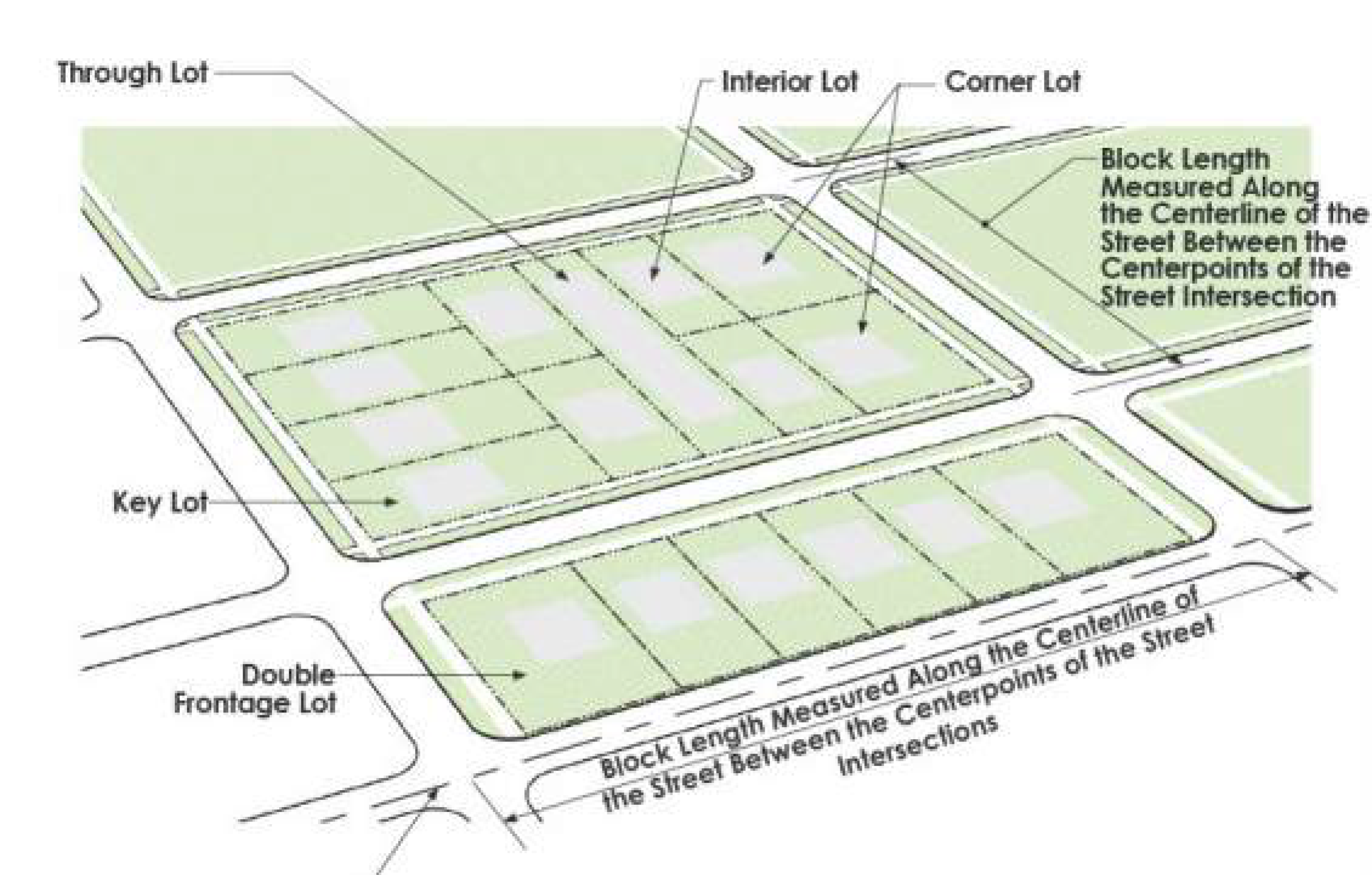
Section IX.3.2. - Single Family and Two-Family Lots
A.
Frontage Requirements
1.
Single-Family and two-family lots may also front directly on to a public park or private open space instead of a public or private street only if accessed from a rear mews. No on-street parking shall be allowed on mews street.
2.
Lots shall have a minimum of 22 feet of frontage on eyebrow and cul-de-sacs.
B.
Flag Lots - The creation of new flag Lots is prohibited. See Exhibit IX.3.2-1.
Exhibit IX.3.2-1 Flag Lots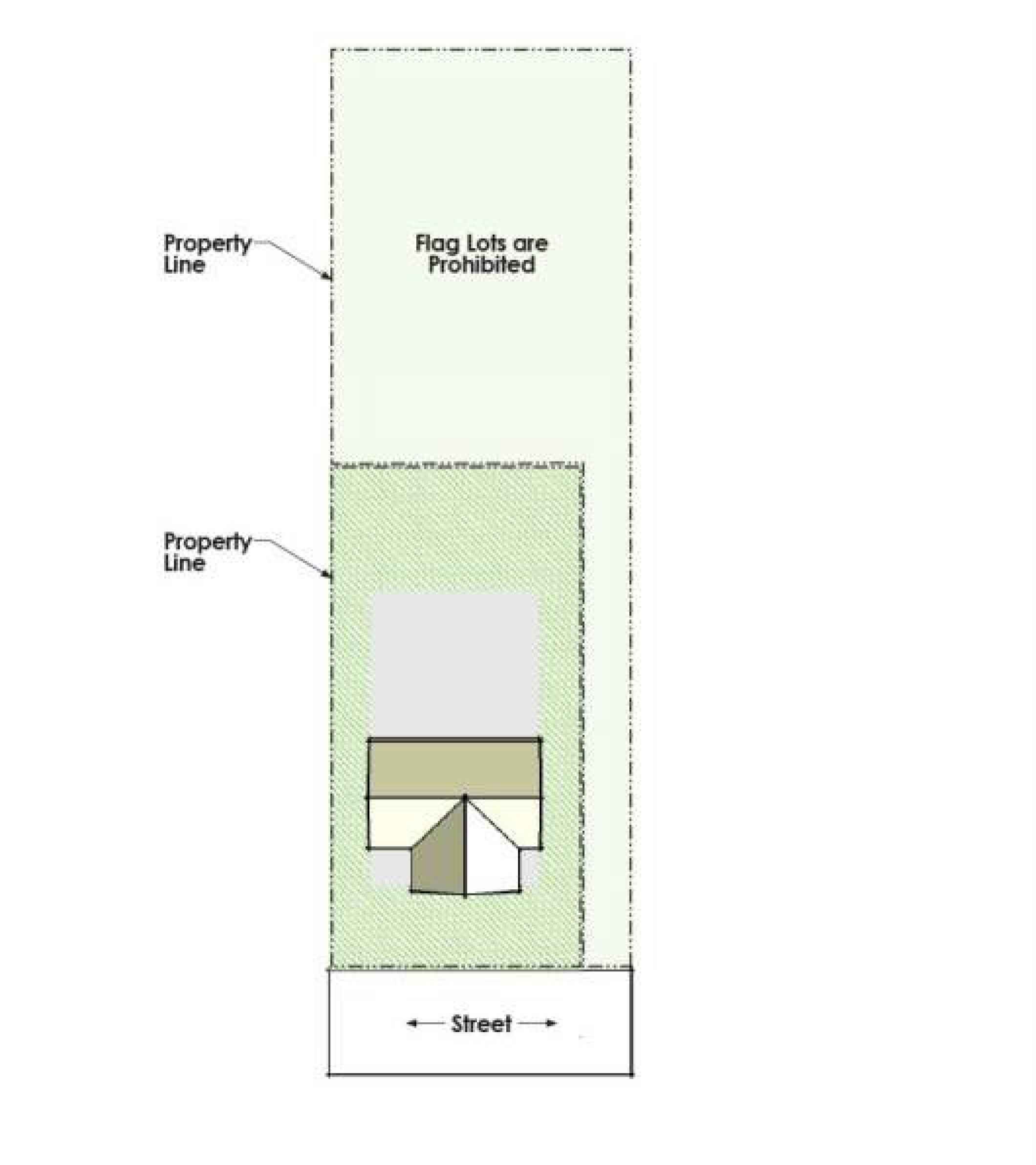
C.
Orientation of Lot Lines - Side lot lines shall be approximately at right angles to straight streets and radial to curved streets, except for townhouse developments.
D.
Double Frontage - Double frontage and reversed frontage lots are prohibited except where lots back to major and minor arterials and are screened in accordance with Article VIII.5.5 and Exhibits VIII.4.5-1 and VIII.4.5-2.
E.
Orientation to Certain Streets - Single-family detached, duplex and single-family attached lots shall not face or have access to arterial streets or designated four-lane collector streets. Lots may face two-lane collector streets but must have driveway access only from a rear alley, mews or slip road.
F.
Orientation to Public Parks - See Exhibit IX.3.2-2. Where lots are proposed adjacent to public parks and floodways or floodplains that have been designated as part of the park or trail system, lots shall have frontage on:
1.
Parallel streets fronting the park;
2.
Cul-de-sacs which provide public access to the park; or
3.
Loop streets which provide public access fronting on the park
Exhibit IX.3.2-2 Orientation to Public Parks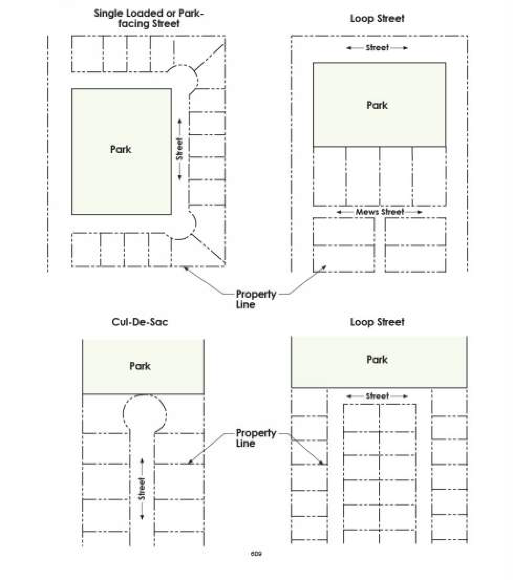
Section IX.3.3. - Multi-Family, Commercial and Industrial Lots
A.
Frontage Requirements - Multi-family, commercial and industrial lots may also have frontage only on an access easement or public way. The access easement or public way shall be a minimum of 24 feet in width and connect to public street.
B.
Flag Lots - The creation of new flag lots are prohibited.
C.
Lot Layout - Depth and width of properties platted for multi-family, commercial, or industrial purposes shall be adequate to provide for the off-street parking, landscaping, and loading space required by this UDC.
Section IX.3.4. - Blocks
A.
General Provisions — The design and layout of blocks shall meet the following requirements. All distances are measured along the center line of the street right-of-way between the center point of street intersections.
B.
Single-Family, Duplex and Single-Family Attached Blocks
1.
Residential blocks shall have sufficient width to provide for two (2) tiers of lots of appropriate depths, except:
a.
Where adjacent to or across a street from a public park or public or private open space. If lots are not separated from the park or public or private open space by a street, frontage and access shall be provided by a rear mews street in accordance with Article IX, Chapter 4, Section 4 of this Chapter;
b.
To allow for unusual topographic conditions; or
c.
Where lots back to an arterial street or other designated street as allowed in Article IX, Chapter 3, Section 2.D. above.
2.
Where streets are stubbed out to facilitate the development of adjacent property, the street stubs shall be in locations that will provide for two (2) tiers of lots.
3.
Block lengths for single-family and duplex residential subdivisions shall contain no more than 18 platted lots on either side between intersections and shall not exceed a maximum distance of 800 feet. A residential block shall only be allowed to exceed 800 feet if a pedestrian pass through a minimum of 15 feet in width is provided mid-block. See Exhibit IX.3.4-1.
4.
The Fire Code Official may require a minimum 40-foot-wide fire control easement to be dedicated to define the appropriate block length if a street cannot be installed. If all residences are equipped with fire sprinkler systems the 40-foot-wide easement shall not be required.
EXHIBIT IX.3.4-1 PEDESTRIAN PASS THROUGH
C.
Multi-Family, Commercial and Industrial Blocks
1.
Except as allowed in the I-35E Overlay District, block lengths shall be a minimum of 500 feet and a maximum of 1,800 feet in length.
2.
Where no existing subdivision controls block length, blocks along arterial streets shall be a minimum of 660 feet and maximum of 2,600 feet in length.
Section IX.4.1. - General Provisions
A.
The regulations within this Section are intended to balance the needs of all modes of travel, including motorized vehicles, bicyclists and pedestrians. The arrangement, width, grade and location of all proposed streets, alleys, sidewalks and trails shall conform to the adopted policies and plans listed below as well as the City's construction standards, and shall take into consideration existing and planned streets, topographic conditions, convenience, safety and the type and relationship of uses which will be served by the improvements and infrastructure. Streets, alleys, sidewalks and trails shall be designed to accommodate vehicles, bicycles and pedestrians in a safe and efficient manner. Access to streets shall be managed to preserve capacity, improve the flow of traffic and reduce the potential for accidents.
B.
The location, design and construction of streets (including private streets), alleys, sidewalks, bike routes and spines, and trails should support and be in accordance with the provisions of this Section and:
1.
The adequate public Infrastructure, Improvements and dedication requirements in Section IX.4.1 of this Chapter;
2.
The Thoroughfare Plan;
3.
The Complete Streets Policy;
4.
The Parks Master Plan and Trails Master Plan;
5.
The standard construction details; and
6.
Other adopted plans and policies of the City related to transportation;
Section IX.4.2. - Developer's Obligations
The developer is responsible for the following:
A.
New and Existing Streets and Alleys - The developer is responsible for the dedication of rights-of-way and construction of all streets, alleys and associated improvements, including sidewalks, median openings and left turn lanes and deceleration lanes, within a proposed development and for one-half of the streets which abut the development. Adequate provisions shall be made for culverts, drainage and bridges. Where the City Engineer determines that it is impractical to construct one-half of a street, the developer shall escrow the full value of the improvements prior to the approval of the engineering site plan Any off-site street(s) required to provide access to the development to meet adequate public infrastructure, improvements and dedication requirements shall be the entire responsibility of the developer. These requirements shall also apply to existing substandard streets.
B.
Turn Lanes at Intersections - The developer shall be responsible for the dedication of right-of-way and easements and the construction of turn lanes at intersections where the property is undeveloped. The City will be responsible for the construction of right and left turn lanes at intersections where abutting properties are developed or are redeveloped, or the property is one (1) acre or less in size.
C.
Railroad Crossings - The developer shall pay 100 percent of the total cost of all design and construction for railroad crossings. The developer who first develops any quadrant of a street/railroad crossing shall pay 100 percent of the total cost of the construction and shall be eligible for reimbursements from the other three (3) quadrant developer(s)/owner(s) in accordance with Article IX.12.6.
D.
Bridges - The developer shall pay 100 percent of the total cost of all design and construction for proposed bridges. The City shall help coordinate approval processes through other federal and state agencies, as needed. The developer shall be eligible for reimbursement from the other three (3) quadrant developers/property owners in accordance with the provisions of Section IX.12.6.
Section IX.4.3. - Traffic Impact Analysis
A.
A traffic impact analysis (TIA) may be required by the City Engineer as part of a concept plan or engineering site plan submittal to:
1.
Determine the impact of proposed development on the Level of Service and capacity of street intersections:
2.
Determine the appropriate design and capacity of left and right turn lanes and deceleration lanes; and
3.
Support a request for an Administrative Modification or Alternative Standard.
B.
A traffic impact analysis shall include the following components as determined by the City Engineer:
1.
Trip generation — Trip generation shall be based on the latest edition of the Transportation Engineers Trip Generation Manual unless another source provides acceptable data.
2.
Trip Distribution - The developer shall consult with city staff to determine the appropriate trip distribution, based on the City's travel demand model.
3.
Traffic Assignment - Trip assignment at the proposed access points shall be conducted to determine the forecasted turning movements attributable to the proposed development.
4.
Existing traffic volumes, including turning movements at intersections. Traffic volumes will be forecasted using an annual growth rate based on the build-out year of the proposed development. The resulting traffic volumes shall be used as background traffic volumes and the assigned turning movements will be added to the background traffic volumes resulting in the total traffic volumes.
C.
The information in Section IX.4.3.B above shall be provided for intersections adjacent to the proposed development site as determined by the City Engineer. The City Engineer may also require operational analysis for the study intersections.
D.
The applicant's TIA shall include recommendations for mitigation measures should the impact of the proposed access points result in unacceptable levels of service. Mitigation measures shall be required if the Level of Service decreases by one (1) letter grade or drops below Level of Service "D."
Section IX.4.4. - Design and Construction Standards for Streets, Alleys and Mews Streets
Streets, alleys and mews streets shall be designed and constructed in accordance with the Thoroughfare Plan, the standard construction details and meet the criteria and design standards in this Chapter and with the typical street sections shown in Exhibits IX.4.4-1 through IX.4.4-9.
A.
Street Design Standards
1.
All streets shall be laid out and designed to:
a.
Provide for the continuation of existing streets;
b.
Connect subdivisions as neighborhoods develop by stubbing out each street for future extension to adjacent undeveloped property. Temporary cul-de-sacs shall be installed by the developer when required by phasing;
c.
Enable residents of neighborhoods and employees or customers of non-residential developments to walk, bike or use other non-motorized mobility options to safely reach desired destinations;
d.
Avoid the creation of reserve strips that would deny access from adjacent property to any street or alley;
e.
Make use of existing median openings and provide the required left-turn storage and transition lanes for the new street.
2.
Minimum ROW and Pavement Requirements - All street rights-of-way, pavement widths and other design features shall conform to adopted construction standards and specifications contained or referenced in these regulations and shall be incorporated into the construction plans required for engineering site plan and plat approval.
a.
Right-of-Way, Pavement Width and Street Design Requirements - The minimum standard rights-of-way, pavement widths and street design standards are as follows in Exhibit IX.4.4-10. These are minimum standards and shall be adjusted as needed and approved by the City Engineer to accommodate design elements such as grades, sight distance and other engineering requirements. Additional right-of-way and wider pavement may be required to accommodate left and right turn lanes, bike lanes, wider sidewalks, acceleration and deceleration lanes and other improvements as required by this UDC and the City's Thoroughfare Plan and Trails Master Plan.
EXHIBIT IX.4.4-1 RESIDENTIAL STREET (50' ROW - 31' PAVEMENT AND CROSS SECTION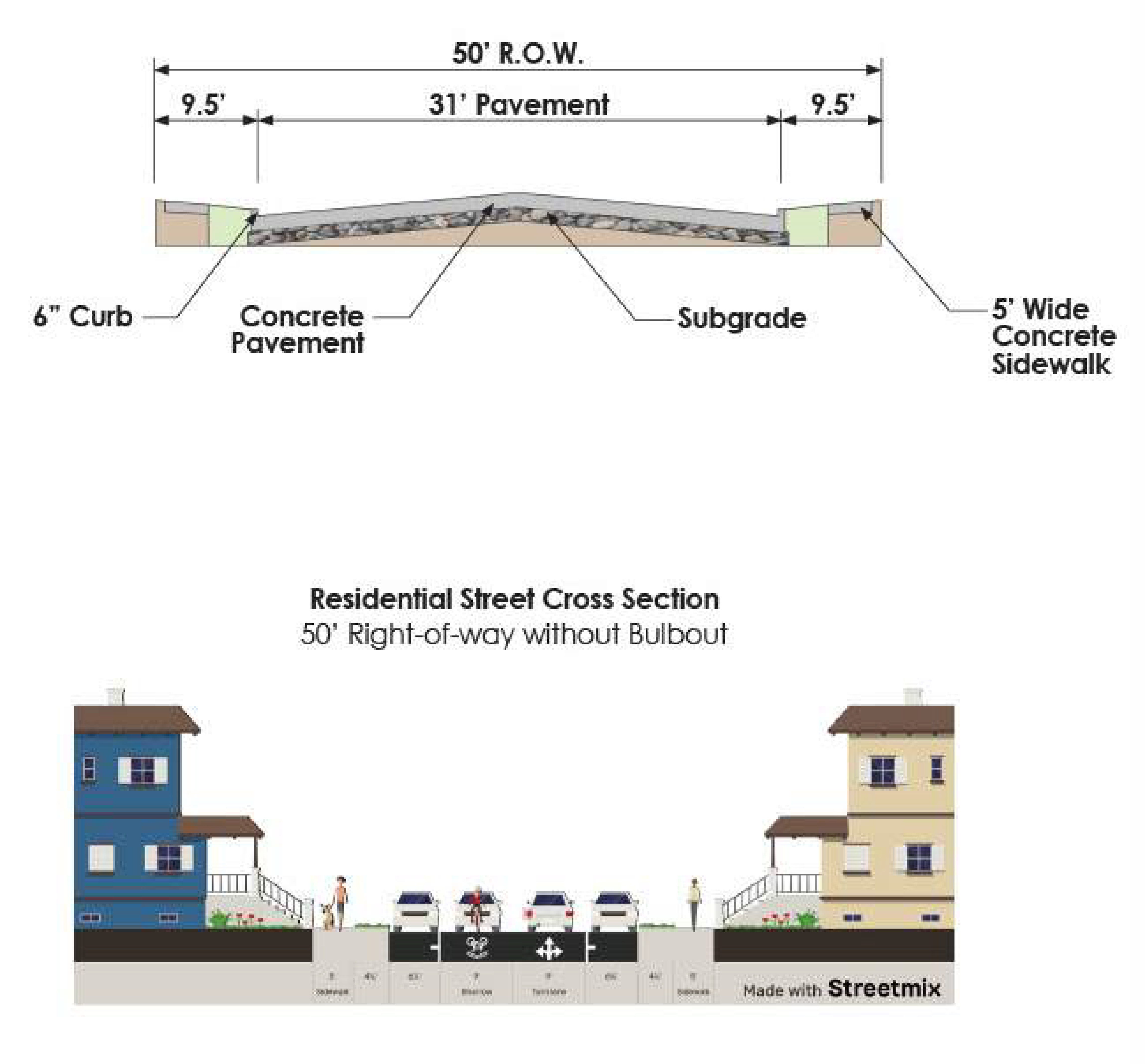
>EXHIBIT IX.4.4-2 RESIDENTIAL STREET WITH BULB OUTS (50' ROW - 31' PAVEMENT AND PLAN
VIEW)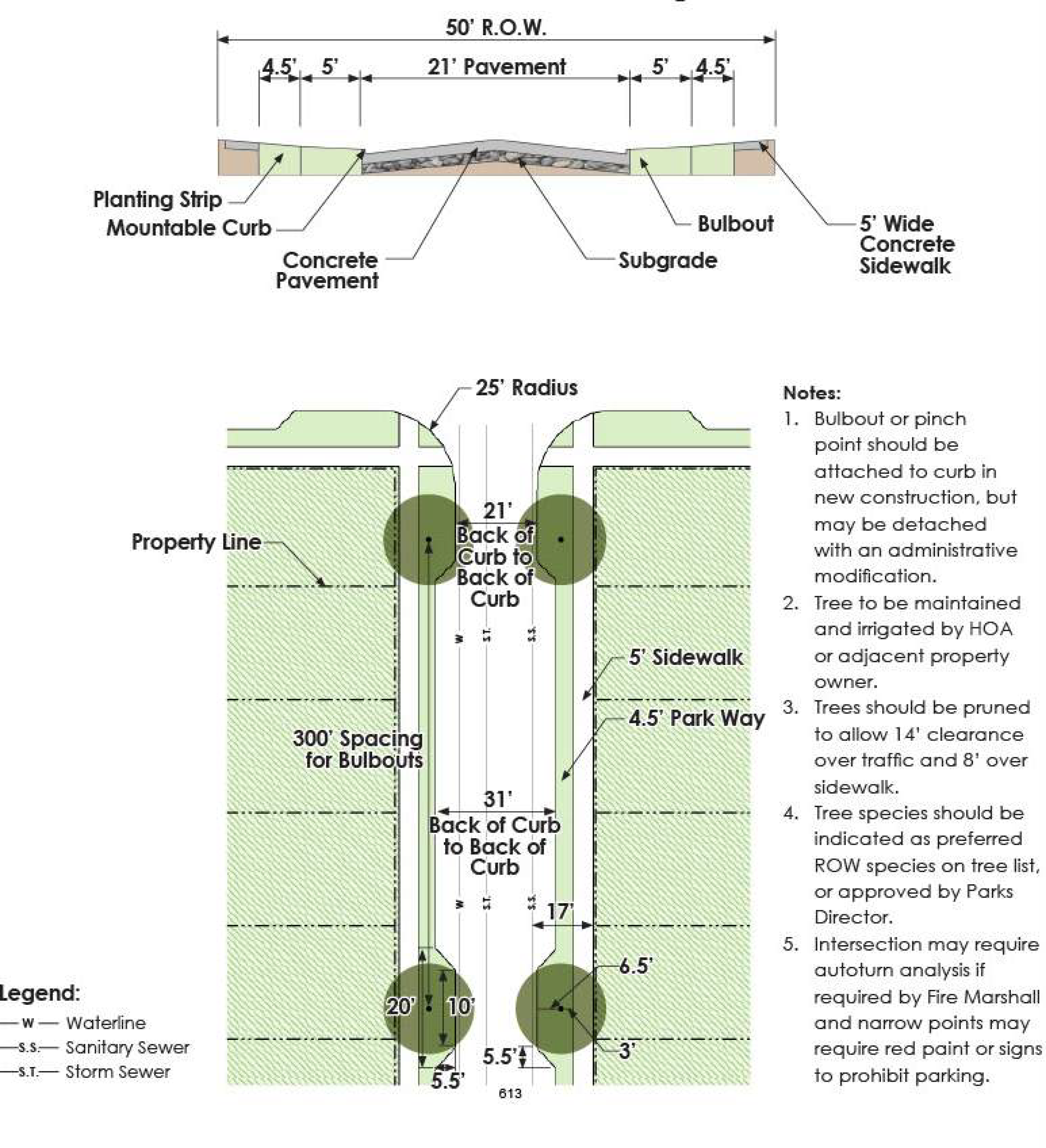
EXHIBIT IX.4.4-3 RESIDENTIAL STREET WITH CONTINUOUS STREET TREES (53' ROW - 31' PAVEMENT
AND PLAN VIEW)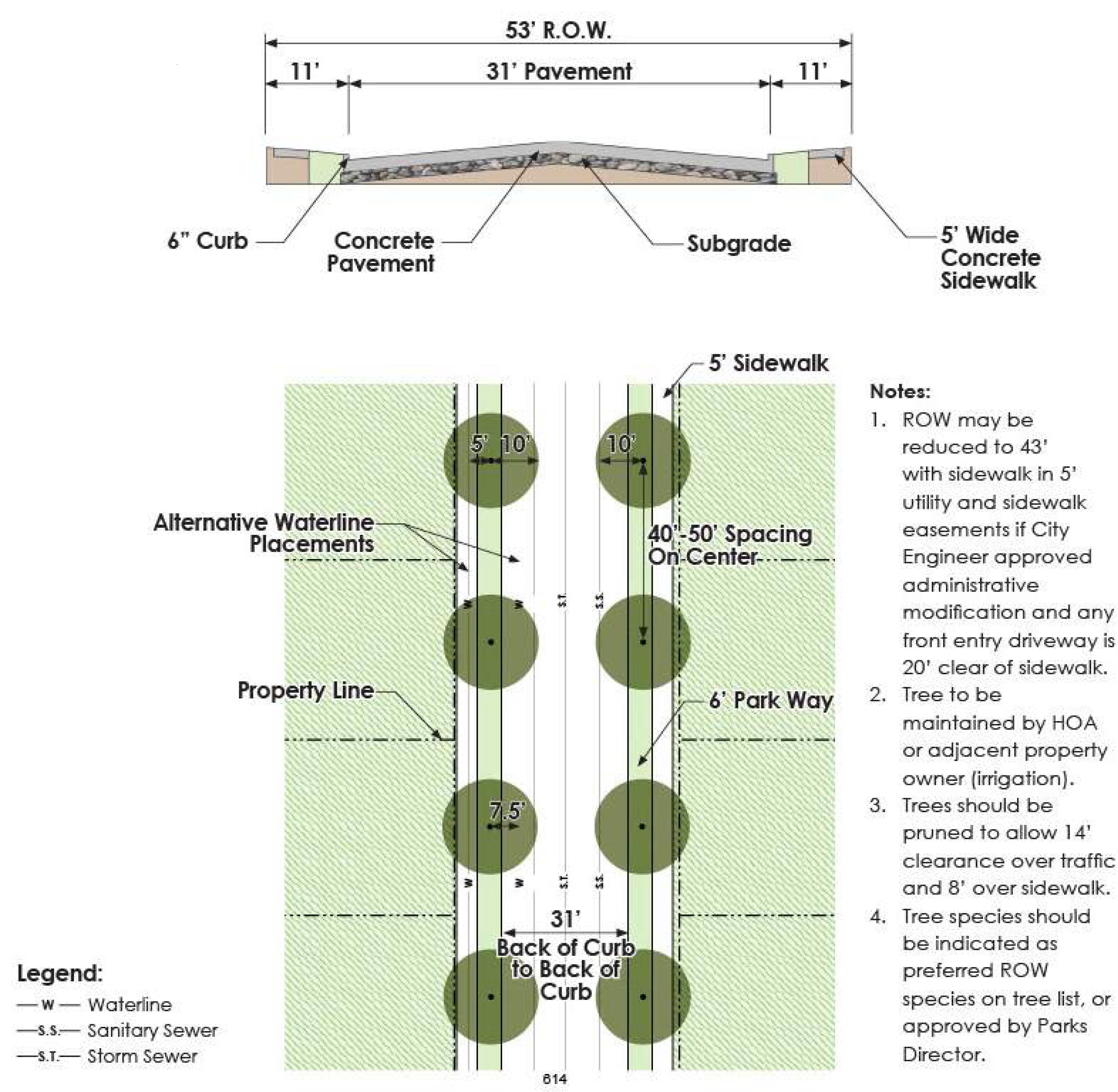
EXHIBIT IX.4.4-4 RESIDENTIAL STREET WITH MOUNTABLE CURB (50' ROW - 33' PAVEMENT AND
CROSS SECTION)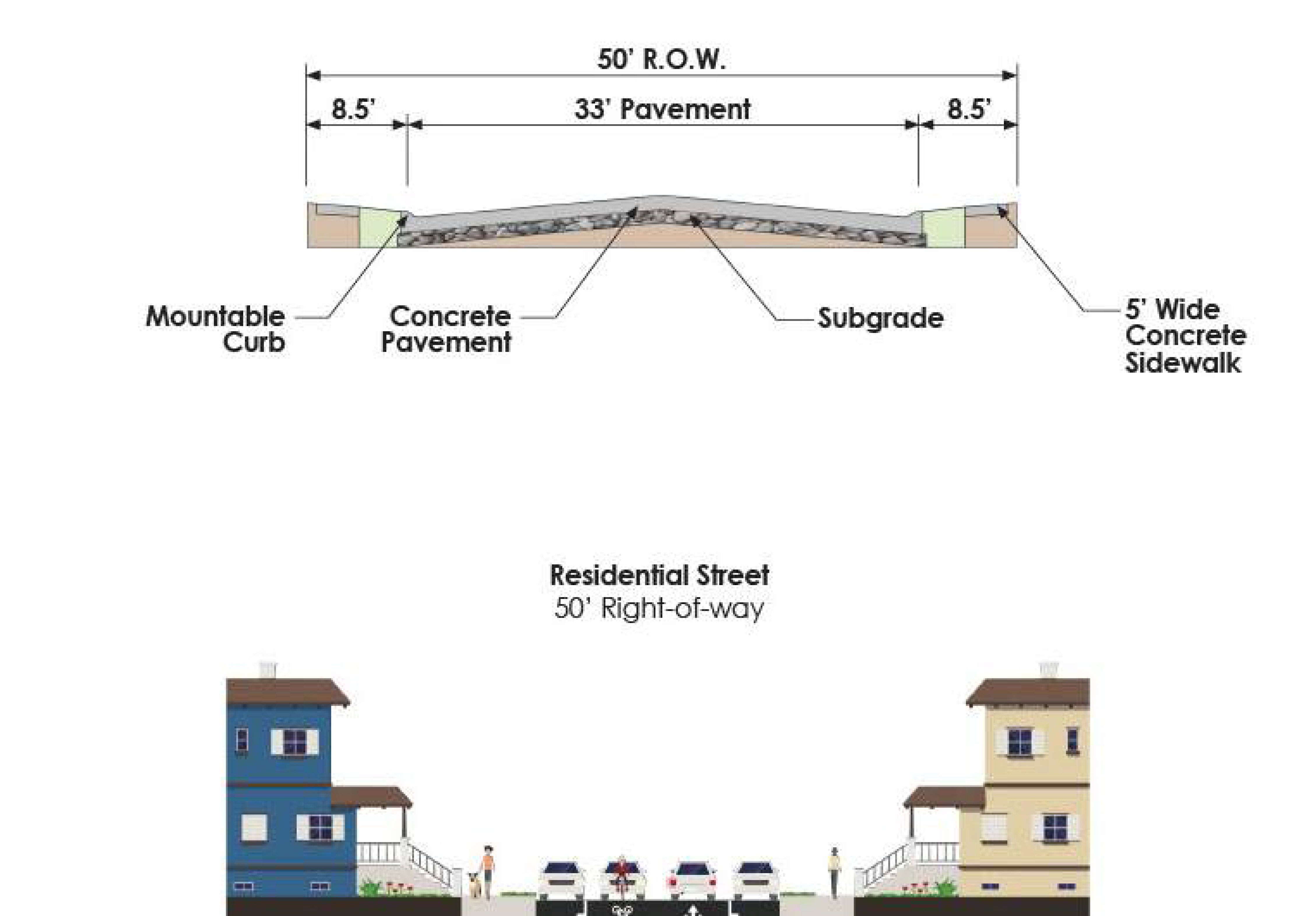
EXHIBIT IX.4.4-5 FRONT ENTRY RESIDENTIAL STREET WITH CONTINUOUS STREET TREES (53'
ROW - 33' PAVEMENT AND PLAN VIEW)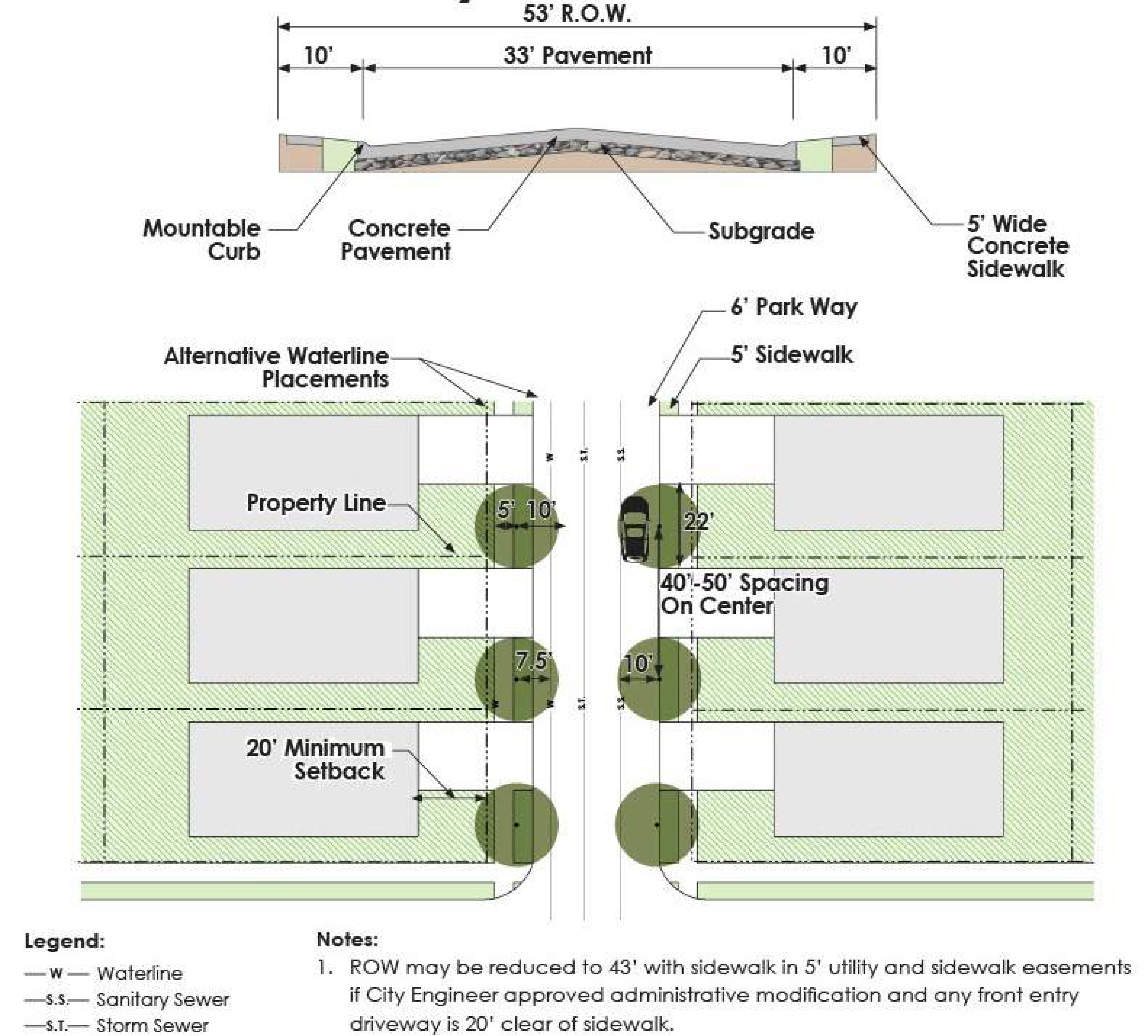
EXHIBIT IX.4.4-6 COLLECTOR STREET - C2U (60' ROW - 37' PAVEMENT AND CROSS SECTION)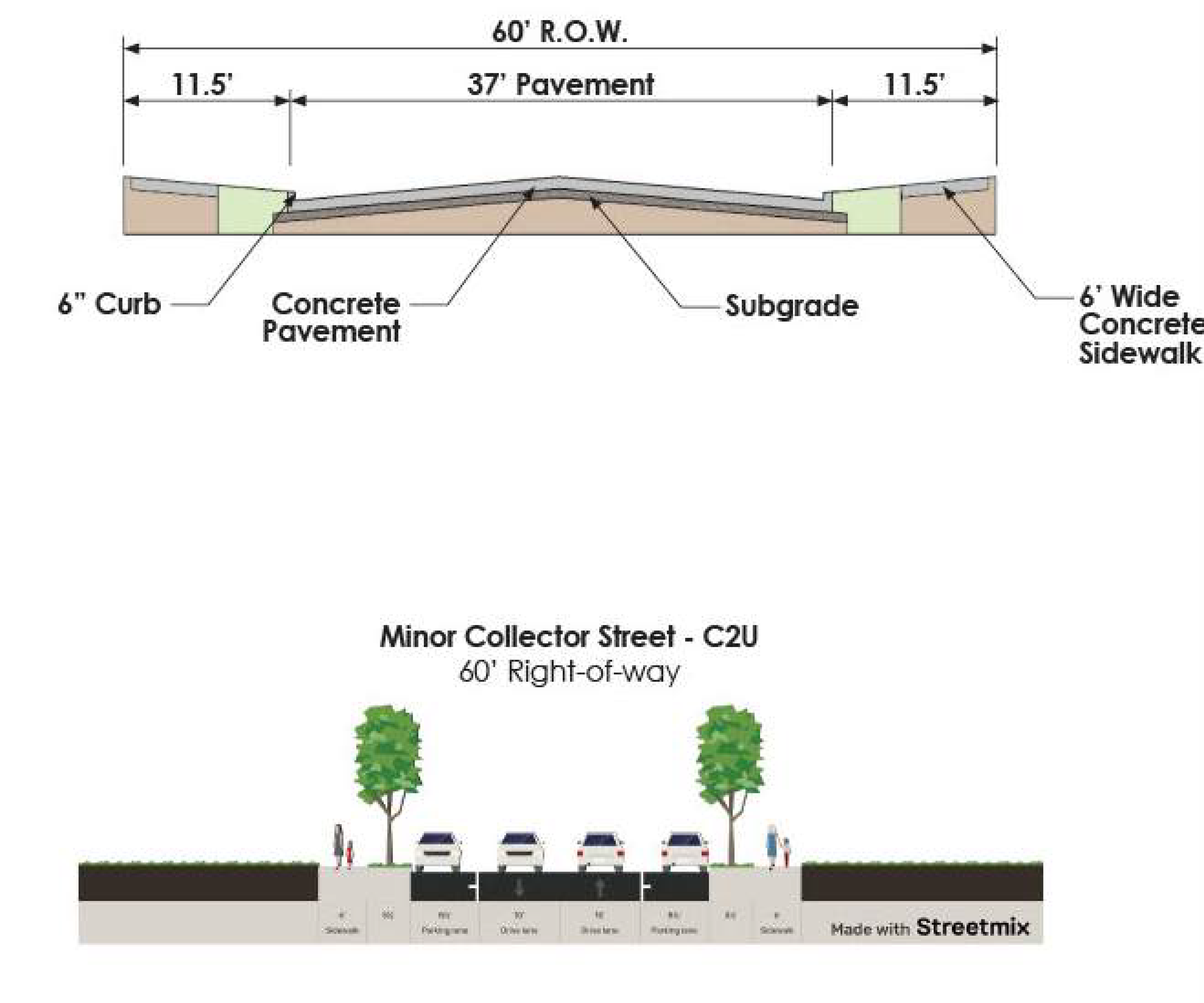
EXHIBIT IX.4.4-7 COLLECTOR STREET - C4U (80' ROW - 49' PAVEMENT AND CROSS SECTION)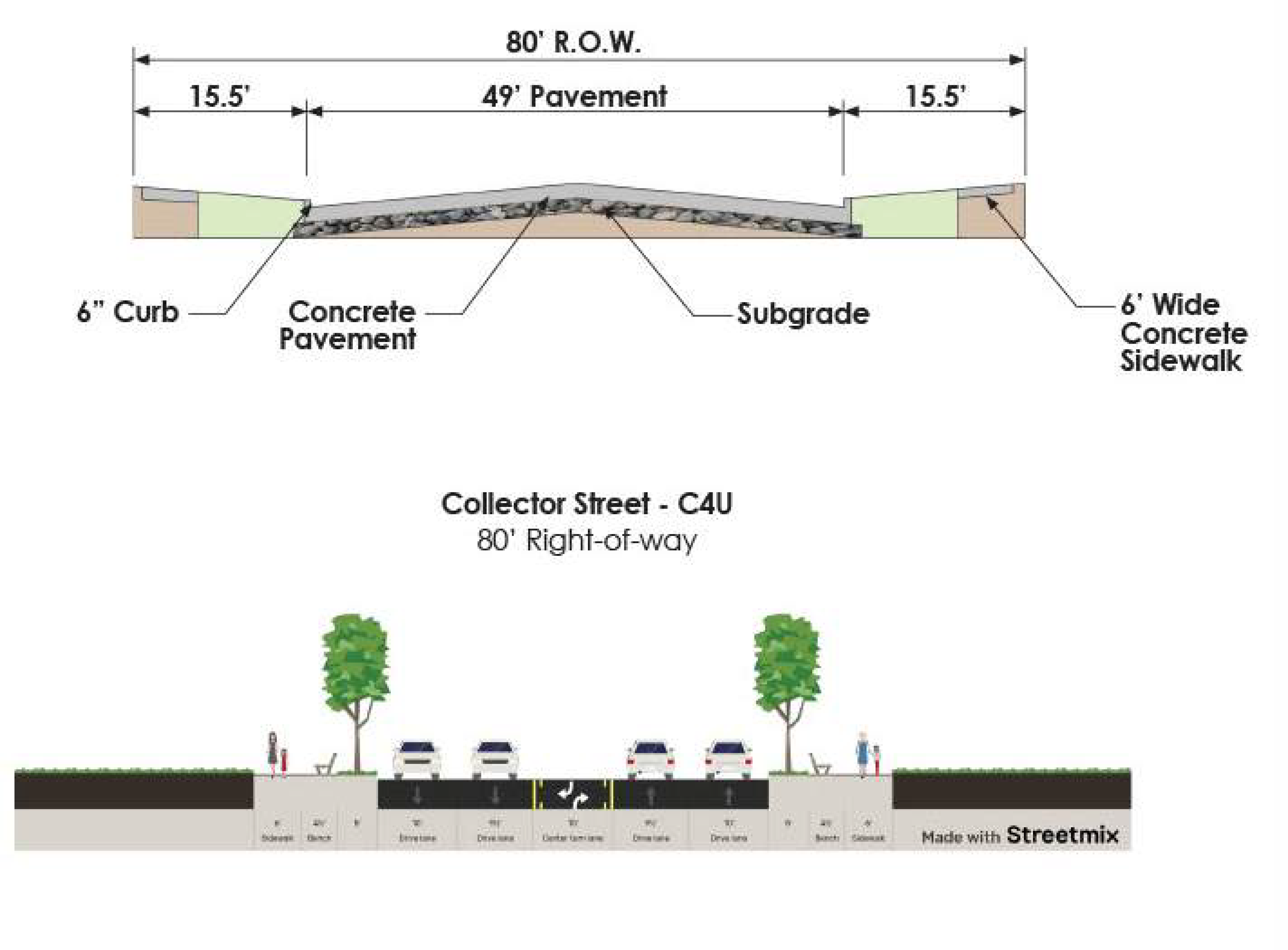
EXHIBIT IX.4.4-8 MINOR ARTERIAL STREET - P4D (100' R.O.W - 50' PAVEMENT AND CROSS
SECTION)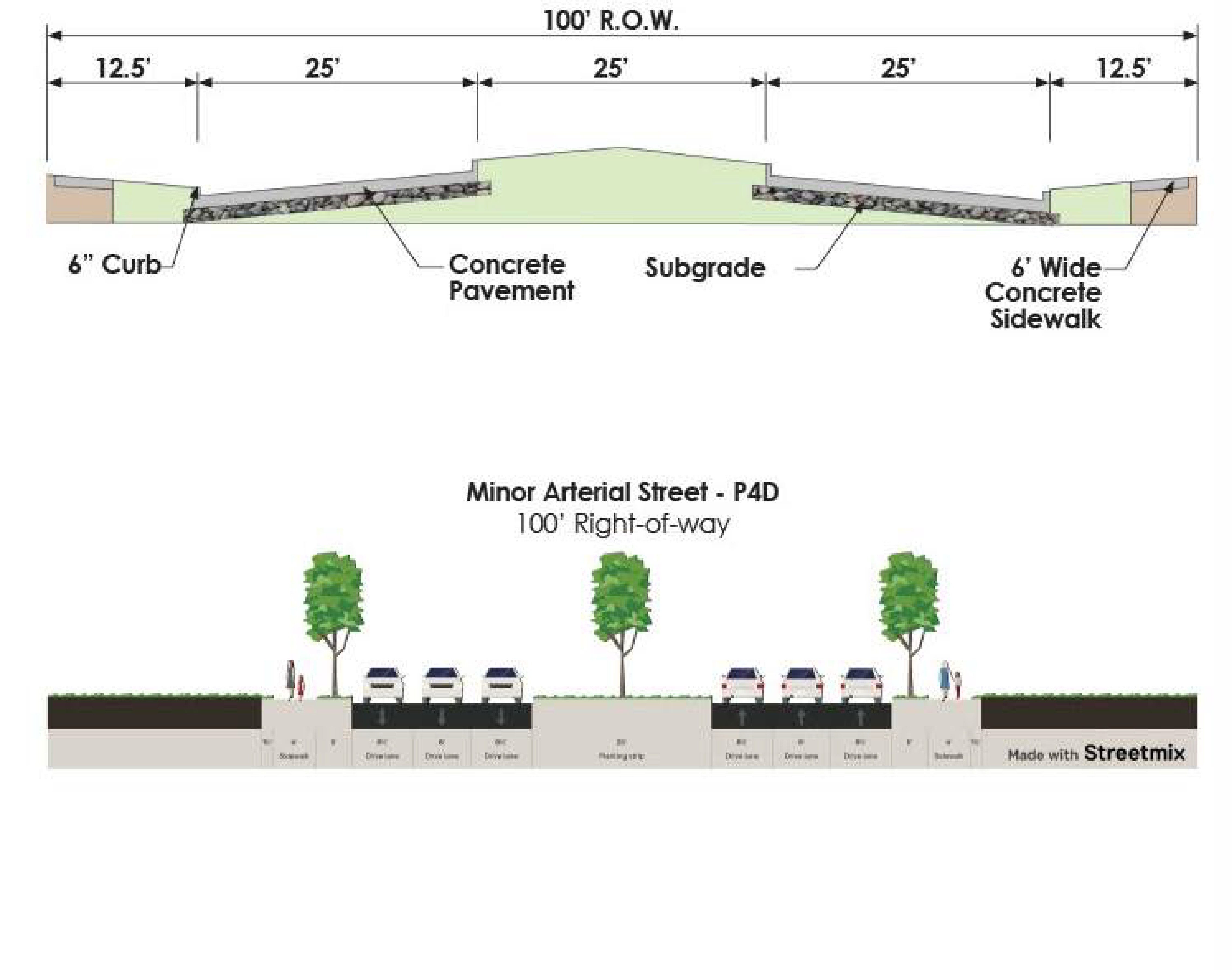
EXHIBIT IX.4.4-9 MAJOR ARTERIAL STREET - P6D (120' R.O.W. - 74' PAVEMENT AND CROSS
SECTION)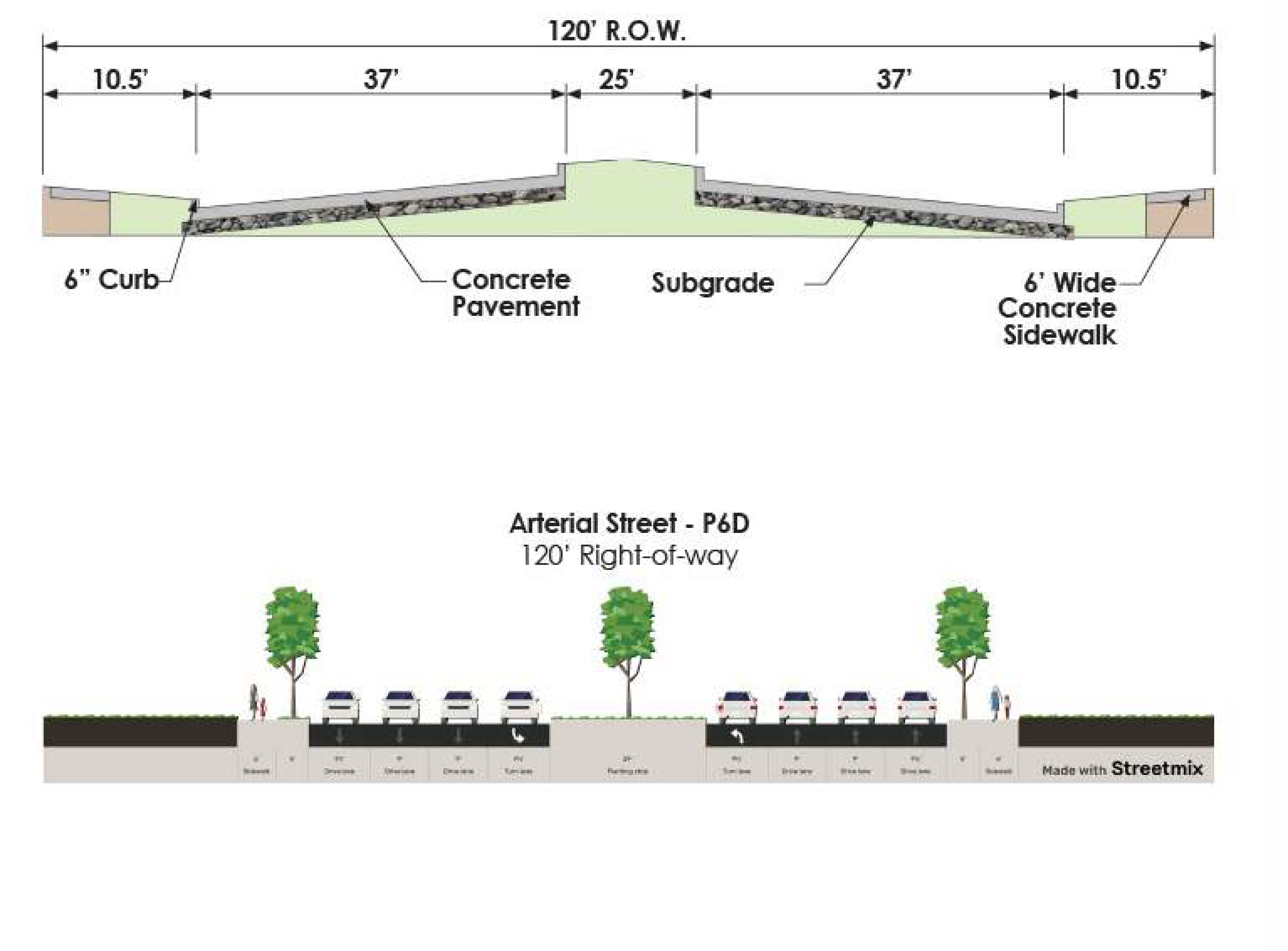
3.
Half-Streets - Half streets are prohibited, except as required in Subsection B.1. above, or where the City determines it will be practical to require the dedication of the other half when adjoining property is platted. Where a residential or collector street is being dedicated along a common property line, the initial dedication shall be one-half (½) of the required right-of-way plus five (5) feet, with a minimum of 20 feet of pavement width to be constructed. See Exhibit IX.2.3-12 Half Street.
EXHIBIT IX.4.4-12 HALF STREET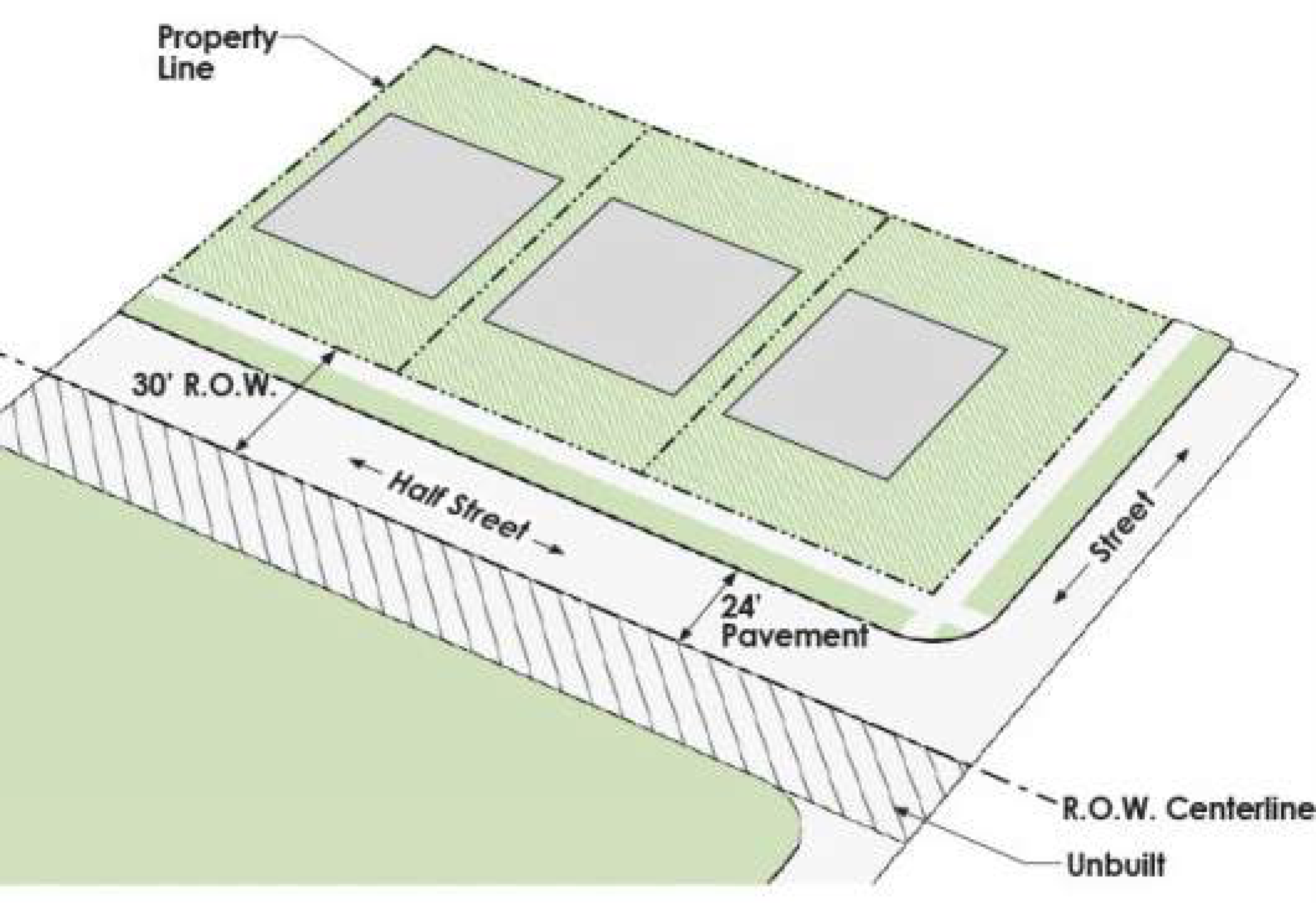
4.
Dead-End Streets - Dead-end streets are prohibited, unless the street is stubbed out for future extension to adjacent property or approved by the City Engineer. A temporary turn around may be required in accordance with Section A.1.b above.
5.
Culs-de-Sac - Culs-de-sac are prohibited unless approved as an Alternative Standard by the Planning and Zoning Commission, based on the size and street layout of the proposed development. Where provided, the maximum length of a cul-de-sac shall be 300 feet, measured from the intersecting centerline to the radius point of the cul-de-sac turnaround. The cul-de-sac shall terminate with turnaround having an outside minimum radius of 60 feet from the right-of-way line. A pedestrian pass-through is required at the end of a cul-de-sac to provide access to abutting properties or to another street. The pedestrian pass-through shall be a minimum of 15 feet wide with a five-foot (5') wide sidewalk with lighting as required in Article VIII, Chapter 7. The pedestrian pass-through shall be platted as an X lot with a public access easement and owned and maintained by a homeowners' association. See Exhibit IX.4.4-13, Cul-de-Sac with Pass-Through.
EXHIBIT IX.4.4-13 CUL-DE-SAC WITH PASS-THROUGH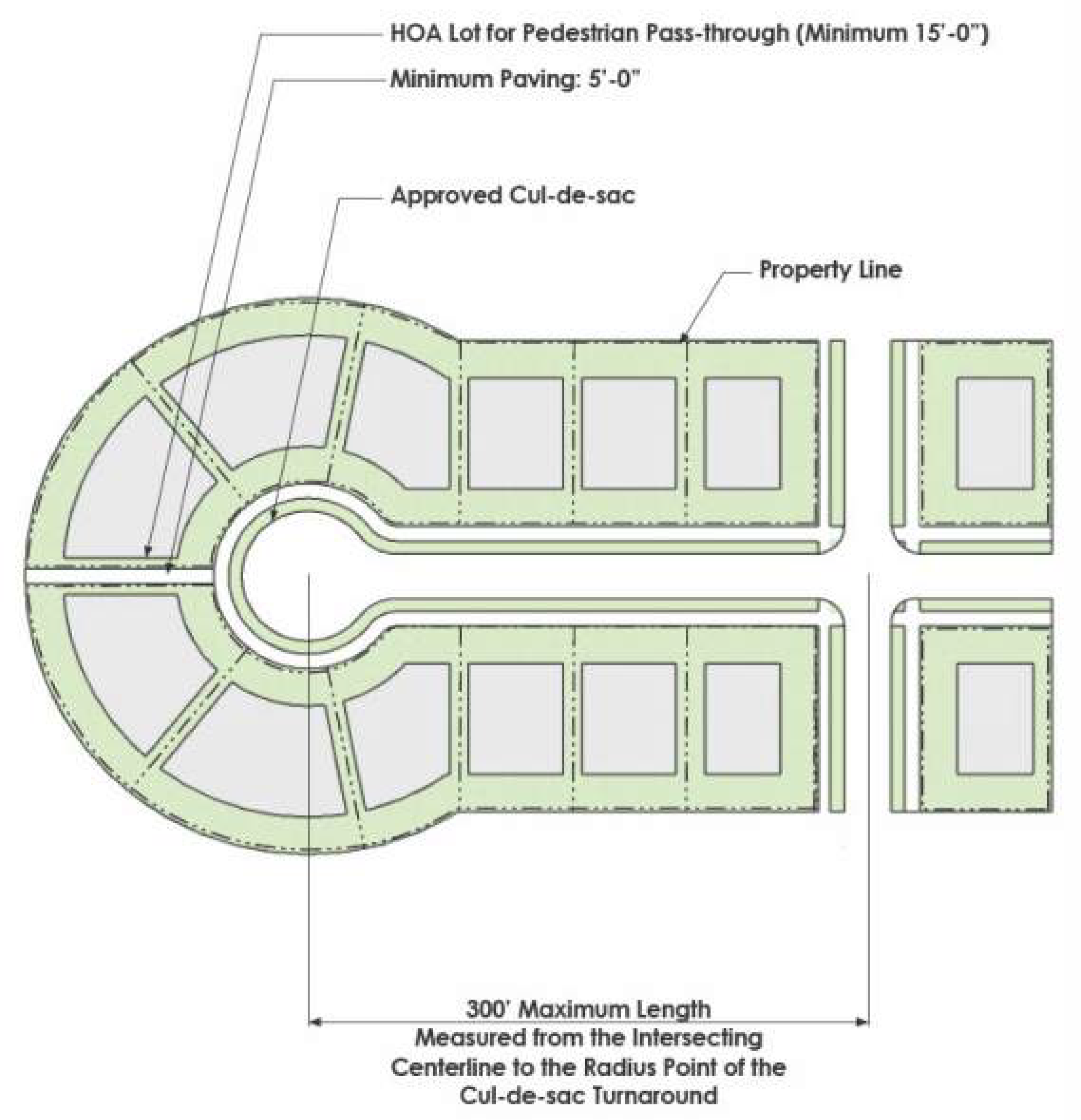
6.
Street Eyebrows - A street eyebrow design that provides additional space for turning vehicles shall be required for single-family and two-family developments where streets make a 45 degree or greater change in direction. See Exhibit IX.4.4-14 Eyebrow on Street Corners.
EXHIBIT IX.4.4-14 EYEBROW ON STREET CORNERS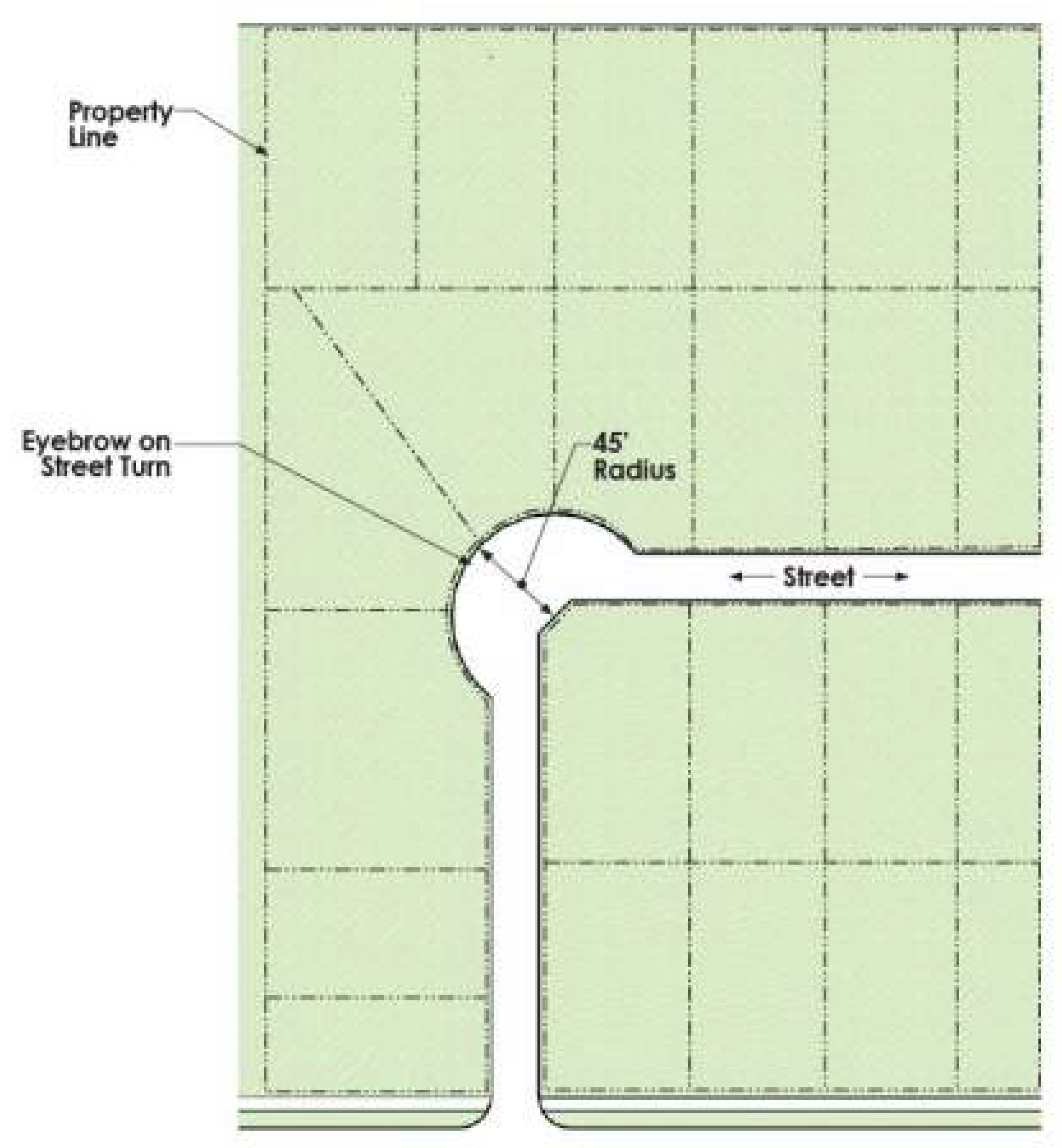
7.
Bicycle Lanes and Infrastructure — Bicycle infrastructure shall be designed and constructed in accordance with the recommendations for spine corridors, off-street trails, enhanced sidewalks and on-street bike routes as contained within the Parks Master Plan and Trails Master Plan, the Complete Streets Policy.
8.
On-Street Parking - On-street parking is allowed or required as indicated in the street sections shown in Chapter as well as regulated in Article VI.8.1, the I-35E Overlay District, Article VI.8.2 the Old Town Center Overlay District and Article VI.8.3 the Old Town Design Overlay District.
9.
Street Trees - The alternative street sections utilizing street trees may be constructed with the approval of the City Engineer. Residential subdivisions with front yard setbacks of 15 feet or less shall utilize one (1) of the street sections shown in Exhibit IX.4.4-2 or Exhibit IX.4.4-3. The species of street trees shall be chosen from the lists in Exhibits VIII.3.2-1 and VIII.3.2-2 and are limited to those indicated as appropriate for use as street trees. Root barriers shall be required and installed in accordance with the standard construction details and Exhibit IX.4.5-4 on page 281.
B.
Design Standards for Alleys and Mews Streets - Alleys and mews streets shall be designed in accordance with the Thoroughfare Plan and the following standards and meet the criteria and design standards in this Chapter.
1.
Residential Alleys - Alleys are not required for detached and attached single-family residential zoning districts, but if provided they shall be constructed in accordance with this Section.
2.
Mews Streets - Mews streets shall be required for attached or detached single family and two-family lots that front onto an open space. The mews street shall serve as the only vehicular access and emergency access for these lots. Mews streets shall also be required for rear entry lots where driveways a minimum of 20 feet in length are not provided.
3.
Commercial Alleys - Alleys may be provided to serve other types of development but are not required if maneuvering, loading, unloading and parking can be accommodated within the lot. Vehicles shall not back into the alley.
4.
Alley design shall conform to the following requirements:
a.
Interior Alleys - 18 feet of right-of-way with 12 feet of pavement, centered within the right-of-way.
b.
Perimeter Alleys - 20 feet of right-of-way with 12 feet of pavement.
c.
Intersections - All residential alleys shall intersect residential streets. All commercial alley intersections with a street shall meet the minimum control of access distances for driveways in Exhibit IX.2.3-35.
1)
With streets - 90 degrees, with no curvature closer than 20 feet to the point of intersection. The width shall transition to 16 feet in width with a minimum radii of 20 feet. The City Engineer may require different dimensions as part of an administrative modification. See Exhibit IX.4.4-15.
EXHIBIT IX.4.4-15 ALLEY TO STREET INTERSECTION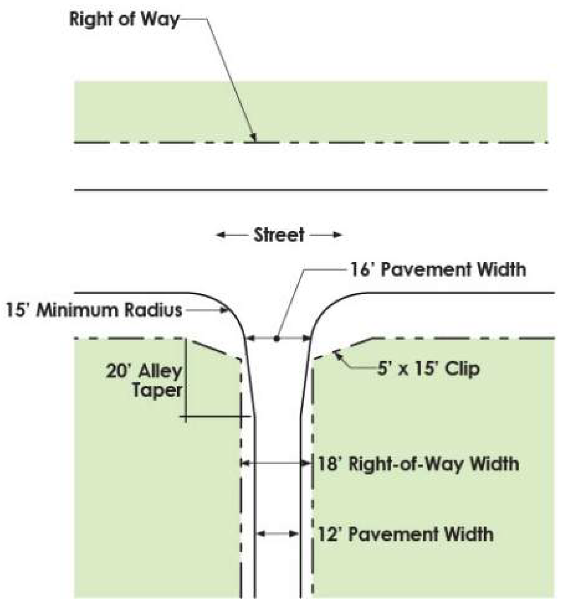
2)
Alley T-Intersection - in conformance with Exhibit IX.4.4-16. Where alleys intersect or change alignment, a corner clip of 20 feet shall be required on adjacent lots.
EXHIBIT IX.4.4-16 ALLEY T-INTERSECTION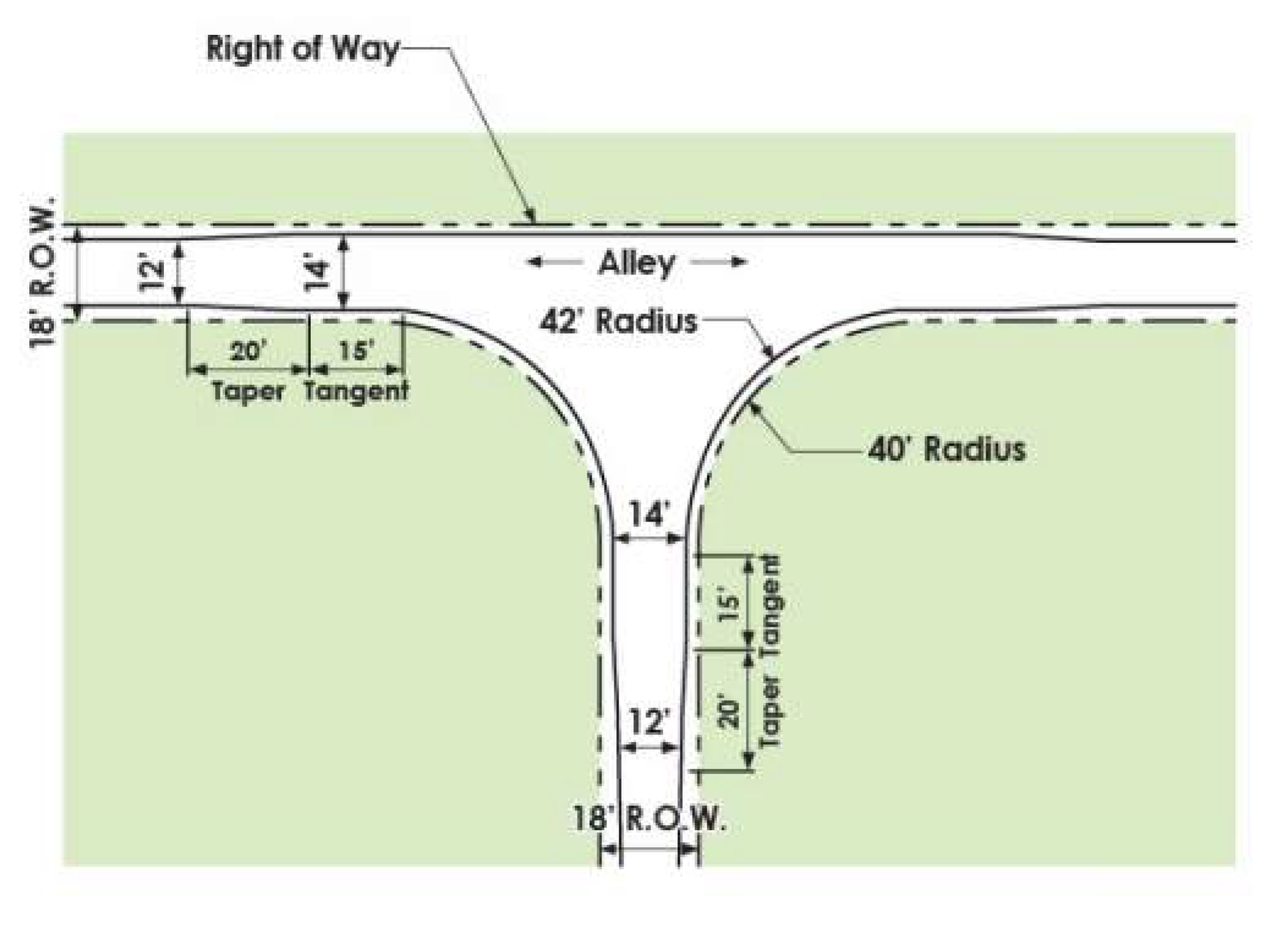
3)
Alley Bends - in conformance with Exhibits IX.4.4-17 and IX.4.4-18.
EXHIBIT IX.4.4-17 RESIDENTIAL ALLEY BEND (90 DEGREES)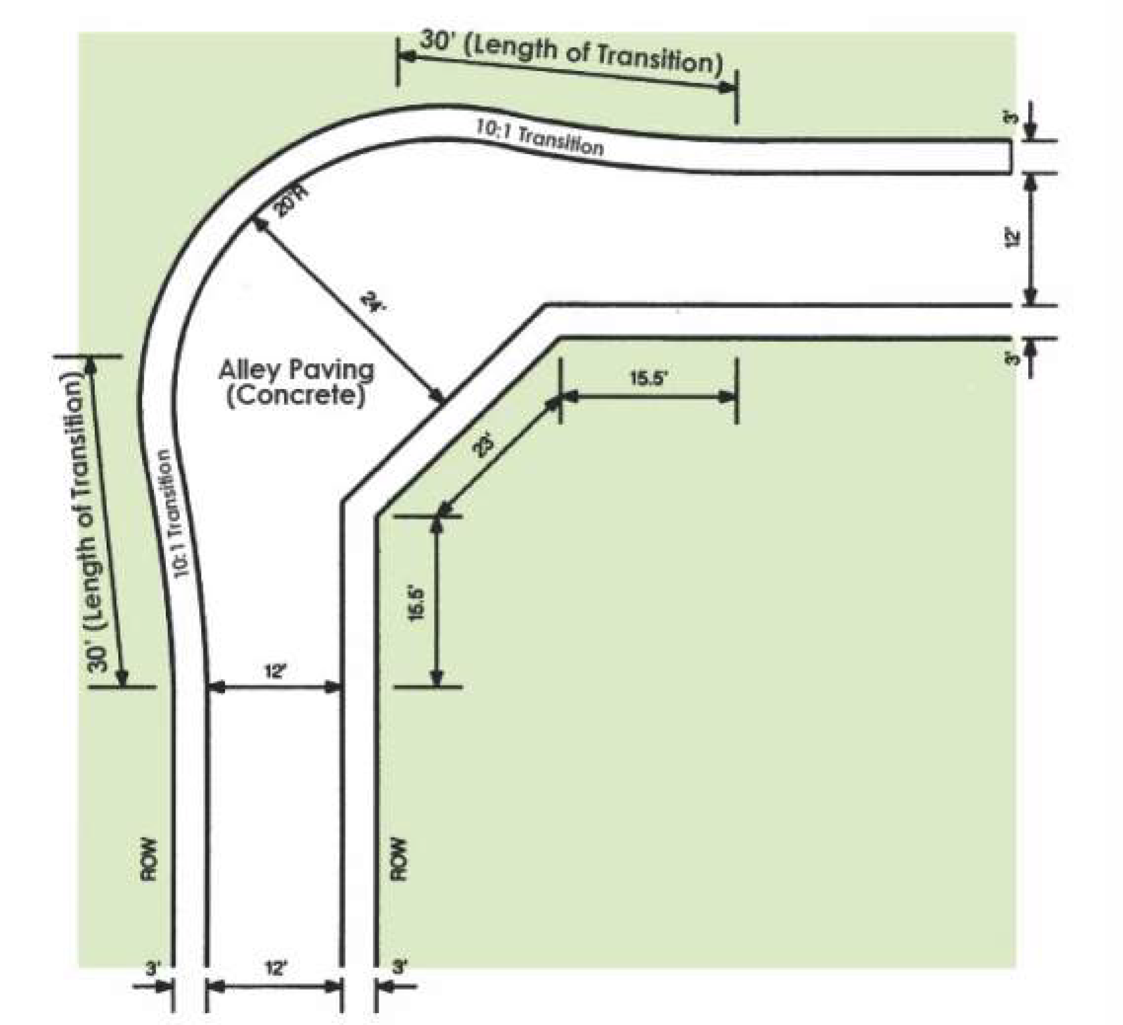
EXHIBIT IX.4.4-18 RESIDENTIAL ALLEY BEND (45 DEGREES)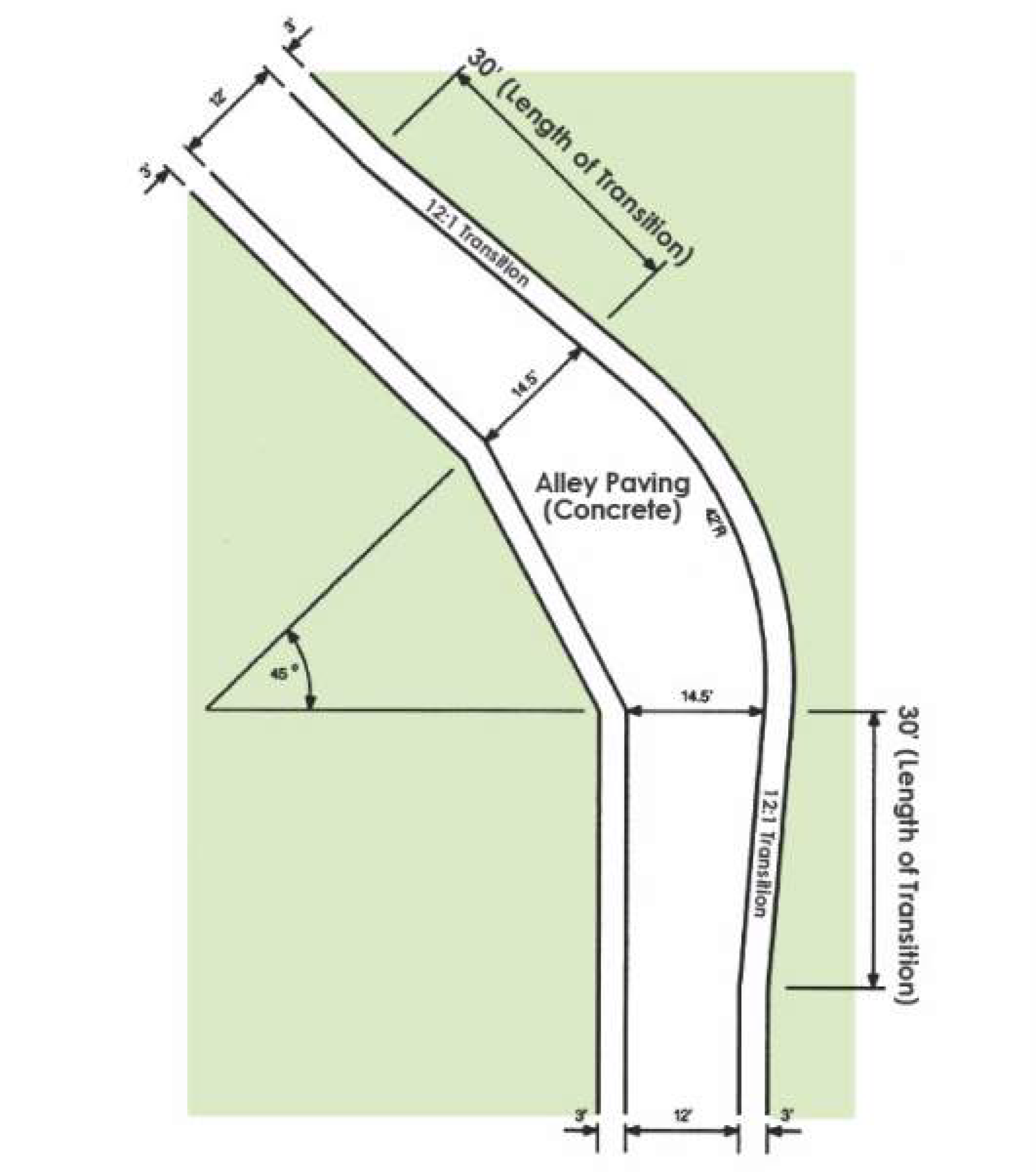
4)
Turnouts - Alley turnouts shall have a minimum ten-foot (10') paving radii to the back of curb. The alley invert shall be no more than four (4) inches except at points of sidewalk intersection, where the maximum invert shall be three (3) inches. The invert shall meet federal and state accessibility standards.
5)
Pedestrian crossing of alleys must meet accessibility standards.
d.
Dead-end alleys are prohibited, unless approved as part of a phased residential development with turn-arounds as approved by the City Engineer.
e.
All alleys must be paved in conformance with the requirements for paving surfaces in Subsection D.3 below.
f.
Residential alleys that abut a screening wall along a major thoroughfare shall be constructed in accordance with Exhibit IX.4.4-19.
EXHIBIT IX.4.4-19 RESIDENTIAL ALLEY ADJACENT TO MAJOR THOROUGHFARE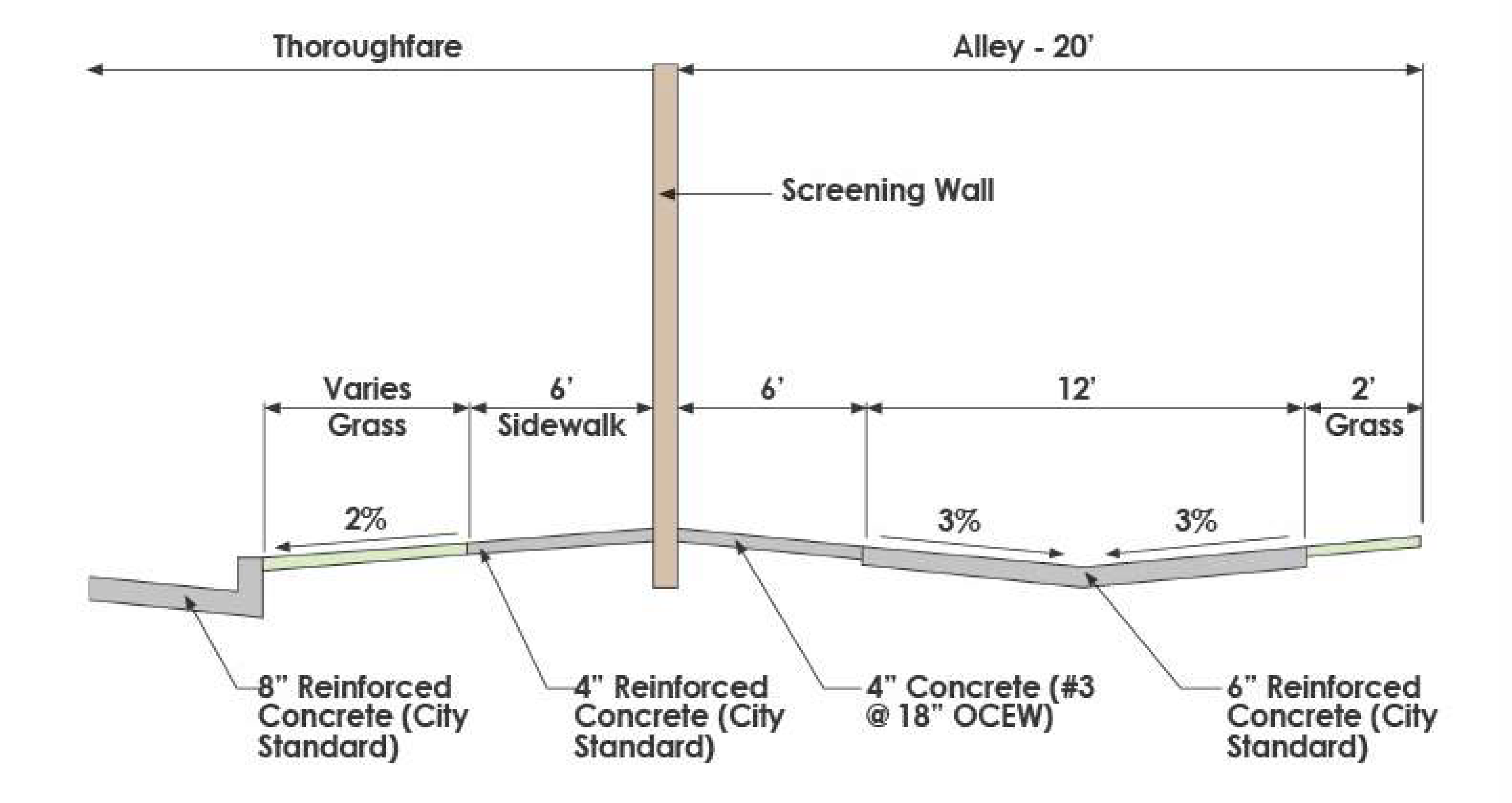
5.
Mews street design shall conform to the following requirements:
a.
A mews street shall have a pavement width of 24 feet centered within 30 feet of right-of-way.
b.
A mews street shall have a pavement edge radius of 20 feet at its intersection with a street.
c.
Accordance with Exhibit IX.4.4-21
d.
Parking is prohibited within mews streets, and no parking signs per Texas MUTCD standards shall be installed by the developer.
e.
Right-of-way corner clips, in addition to visibility easements, are required where a mews street intersects with a street.
1)
Inbound side of the mews street - a triangle with one side measuring 15 feet along the street and the other side five (5) feet along the mews street.
2)
Outbound side of the mews street - a triangle with one side measuring ten (10) feet along the street and the other side ten (10) feet along the mews street.
3)
A 15-foot by 15-foot visibility easement shall also be provided at the intersection with the street.
f.
All mews streets must be paved in conformance with the requirements for paving surfaces in Section IX.4.4.C. below.
C.
Construction Standards for Streets, Alleys and Mews Streets - Street grading, paving, curbs, street lighting and traffic control devices shall be provided in accordance with this Section, the City's standard construction details and where adopted, the NCTCOG Public Works Construction Standards.
1.
Grading - For all curbed streets, the minimum street grade shall be 0.60 percent and the maximum street grade shall be six percent (6%) for all streets except residential streets. The maximum street grade for residential streets shall be seven percent (7%). The cross slope for streets shall be three percent (3%). Grades shall be adjusted where necessary to comply with ADA and PROWAG requirements at pedestrian crossings.
2.
Base Course - Base courses shall be provided as follows:
a.
All street and alley paving shall be placed on a base course compacted to a minimum of 95 percent of standard proctor. The base course thickness shall be a minimum of six (6) inches and shall consist of lime or cement stabilization as recommended in the geotechnical report.
b.
In areas where stabilization is not practical, the base course shall consist of six (6) inches of compacted flexible base (95 percent standard proctor) or four (4) inches of asphalt base as required by the City Engineer.
c.
Where the geotechnical report identifies an area having sulfates between 3,000 and 7,999 parts per million the geotechnical report shall recommend appropriate subgrade treatment which may be approved by the City Engineer. Where the geotechnical report identifies areas having sulfates above 8,000 parts per million, the base course shall consist of four (4) inches of asphalt or six (6) inches of flex base on native material compacted to a minimum of 95 percent standard proctor.
d.
All base courses shall be on compacted subgrades and added pavement thickness shall not be substituted for base course.
3.
Paving Thickness
a.
Paving thickness requirements are as follows:
EXHIBIT IX.4.4-21 MEW STREET (30' ROW - 24' PAVEMENT AND CROSS SECTION)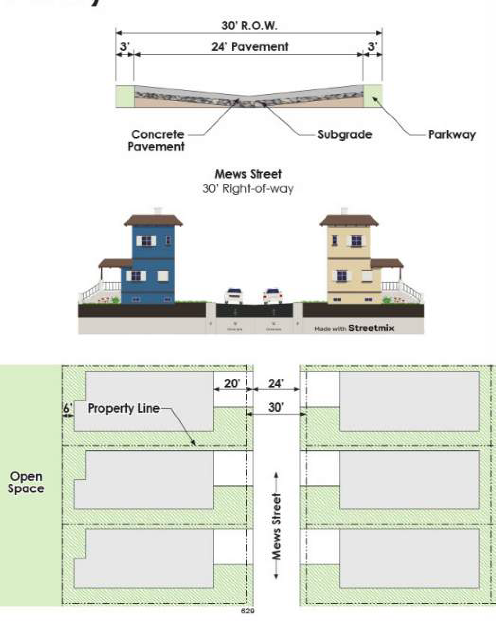
b.
Where right turn, left turn or deceleration lanes are added to existing streets, the minimum pavement thickness shall match the adjacent street. Subgrade shall be provided per Section IX.4.4.C. above.
c.
Where over five percent (5%) of a street's traffic is expected to be comprised of vehicles with a single axle load of 18,000 pounds or greater or a tandem load of 34,000 pounds or greater, the City Engineer may require a different pavement design provided by a geotechnical engineer.
4.
Concrete Strength Requirements - The minimum compressive strength for pavement shall be as follows:
a.
3,500 PSI at 28 days with a minimum cement ratio of five and one-half (5.5) sacks per cubic yard; 3,750 PSI with a minimum cement ratio of six (6) sacks per cubic yard in intersections and areas where hand-finishing is required.
b.
4,200 PSI at three (3) days for early yield high strength concrete used for panel replacements, with a minimum cement ratio of eight (8) sacks per cubic yard.
5.
Temporary asphalt streets, connections and driveways shall be allowed only with approval by the City Engineer.
6.
Curbs - Curbs shall be designed and constructed as follows:
a.
Monolithic curbs shall be constructed on each side of the street pavement and shall be six (6) inches in height and six (6) inches wide in conformance with the standard details.
b.
Rollover/mountable curbs are only allowed for front entry residential lots and where approved as an Administrative Modification by the City Engineer. Where used, the standard right-of-way width shall be maintained but the minimum pavement width shall be increased by two (2) feet measured back to back of curbs. See Exhibit IX.4.4-22.
EXHIBIT IX.4.4-22. MOUNTABLE CURBS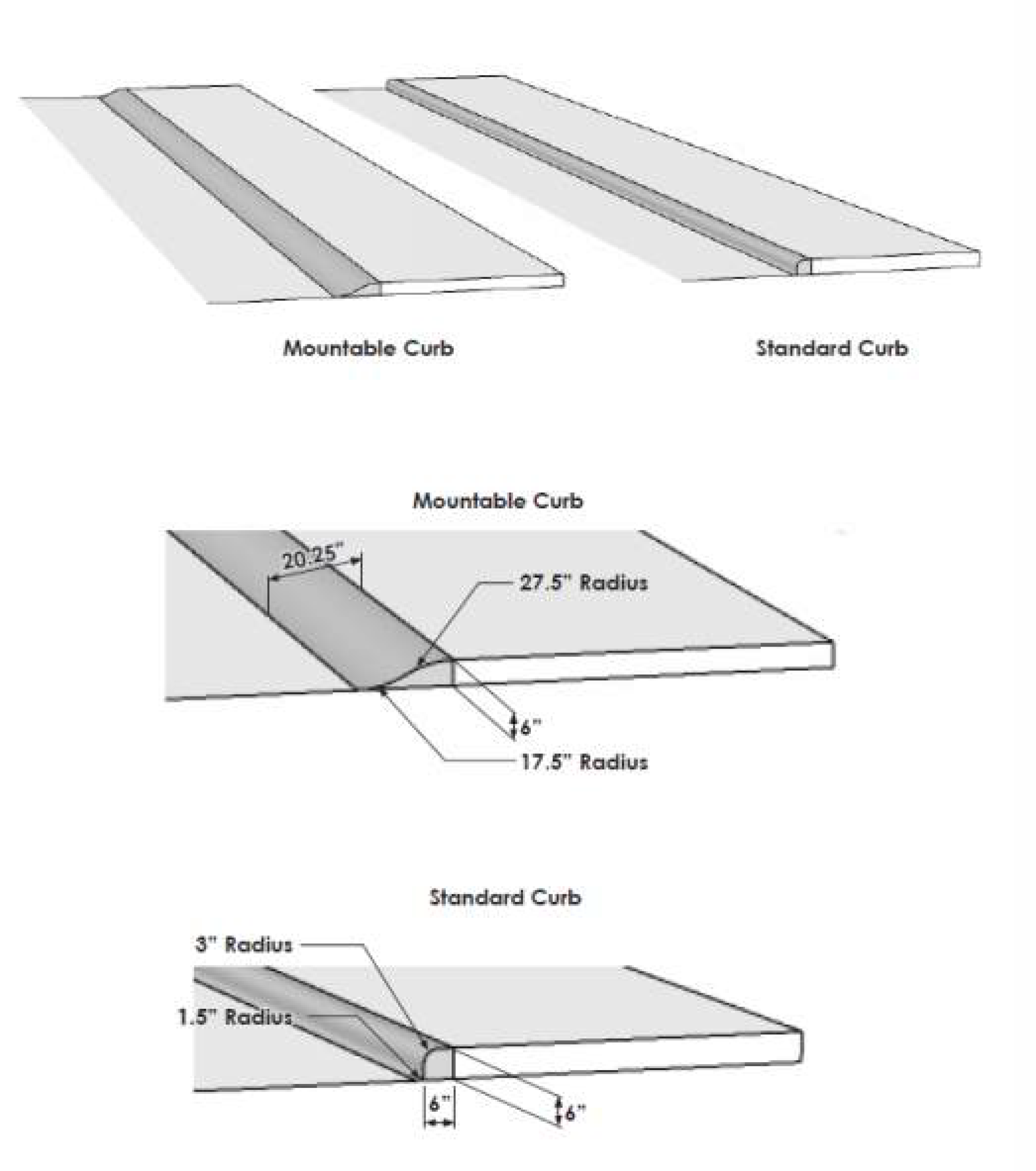
Section IX.4.5. - Medians and Turning Lanes
A.
General Provisions - Medians, median openings and all turn lanes, constructed to serve dedicated streets or private drives, shall be designed, located and constructed in accordance with this Section and other adopted city standards.
B.
Median and Median Openings - Central medians shall be required for all streets designated as Principal Arterials (P6D and P4D) on the Thoroughfare Plan. The minimum width of the median shall be 25 feet. The City Engineer will determine the appropriate median opening width for any new median openings or modification of an existing median opening.
1.
Minimum Median Opening Spacing - Median openings shall be spaced as follows:
2.
Hooded Median Openings - For all mid-block median opening on the selected major traffic carriers identified above, median openings shall be designed to prevent exiting traffic from turning left or crossing the roadway, and shall be a minimum of 600 feet from any other median openings.
In order to prevent wrong-way movements and to discourage unwanted movements at a hooded left turn, a 20-foot section of traffic separator overlap must be provided as in Exhibit IX.4.5-2.
3.
To provide access to median openings, cross access easements are required between all commercial lots on median divided roadways.
a.
Existing trees in medians, if affected by improvements, shall be relocated or replaced. If trees cannot be relocated or replaced in the median, the developer shall pay a mitigation fee in accordance with Chapter VIII.4 of this UDC.
EXHIBIT IX.4.5-2 TRAFFIC SEPARATOR OVERLAP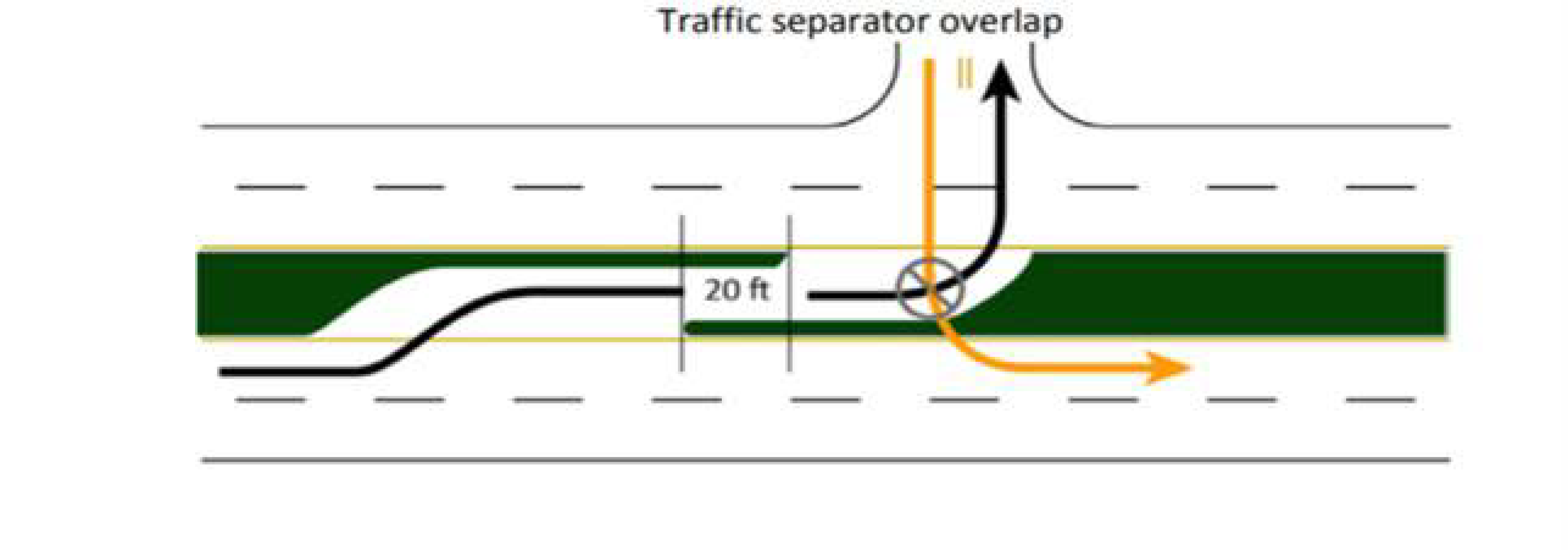
C.
Left Turn Lanes
1.
Responsibility for Dedication and Construction - Developers are responsible for the dedication of right-of-way and the construction of left turn lanes at intersections where property is undeveloped. The City is responsible for the construction of left turn lanes at intersections where the property is developed.
2.
Where Required - Left turn lanes shall be constructed:
a.
At the approaches to intersection of four (4) and/or six (6) lane streets; and
b.
Along all divided streets where median openings provide access to streets, alleys or driveways.
3.
Storage and Transition - Left turn lanes shall provide minimum storage and transition lengths as follows:
a.
At the intersection of four (4) and six (6) lane divided streets - 200 feet, with a transition of 110 feet.
b.
At an intersection with undivided streets - 100 feet, with a transition of 110 feet.
c.
Driveways at a median opening - 100 feet, with a transition of 110 feet.
d.
The required length of the storage and transition may be longer based on a traffic impact analysis to maintain an acceptable level of service.
D.
Right Turn and Deceleration Lanes
1.
Responsibility for Dedication and Construction - The developer is responsible for the dedication of all rights-of-way and construction of all right turn lanes and deceleration lanes. Sufficient right-of-way shall be dedicated to maintain the standard parkway width for the street classification.
2.
Right Turn Lanes - Right turn lanes shall be located, designed and constructed as follows:
a.
Right Turn Lanes are required:
1)
At the approaches to intersections of four (4) and/or six (6) lane streets.
2)
At the approach where a two-lane collector street intersects a four (4) or six (6) lane street. Existing corner lots less than one (1) acre in size are exempt from the right turn lane requirement.
b.
Right-turn lanes at intersections require 210 feet in length (100 feet of storage and a 110 feet transition).
c.
No access shall be allowed within the transition segment of a right turn lane. Storage must be increased to a minimum of 100 feet for each driveway proposed within the storage segment.
d.
For properties located near major street intersections, additional control of access limitations shall apply as required by Section F.4.
3.
Deceleration Lanes - Deceleration lanes shall be located, designed and constructed as follows.
a.
Deceleration lanes are required at commercial and multi-family driveways which:
1)
Access streets where the speed limit is less than 45 miles per hour and where the driveway ingress volume is greater than 50 vehicles per hour (VPH); and
2)
Access streets where the speed limit is greater than or equal to 45 miles per hour and where driveway ingress volume is greater than 60 vehicles per hour (VPH).
b.
The developer shall submit a traffic impact analysis to determine ingress volumes for each driveway.
c.
Deceleration lanes shall provide storage and transition lengths as follows in Exhibit IX.4.5-3 based on the frontage of the lot:
Lots with less than 225 feet of street frontage are exempt from the deceleration lane requirement but a minimum 40-foot ingress radius is required for all driveways.
Cross access easements to adjacent properties which connect to a driveway that is served by a deceleration lane shall be required.
d.
If multiple driveways are proposed to the same street, a continuous deceleration lane will be required based on the traffic impact analysis.
e.
No access shall be allowed within the transition segment of a deceleration lane. Storage must be increased to a minimum of 100 feet for each driveway proposed within the storage segment.
f.
For properties located near major street intersections, additional control of access limitations shall apply as required by Section F.4 below.
Exhibit IX.4.5-4 ROOT BARRIER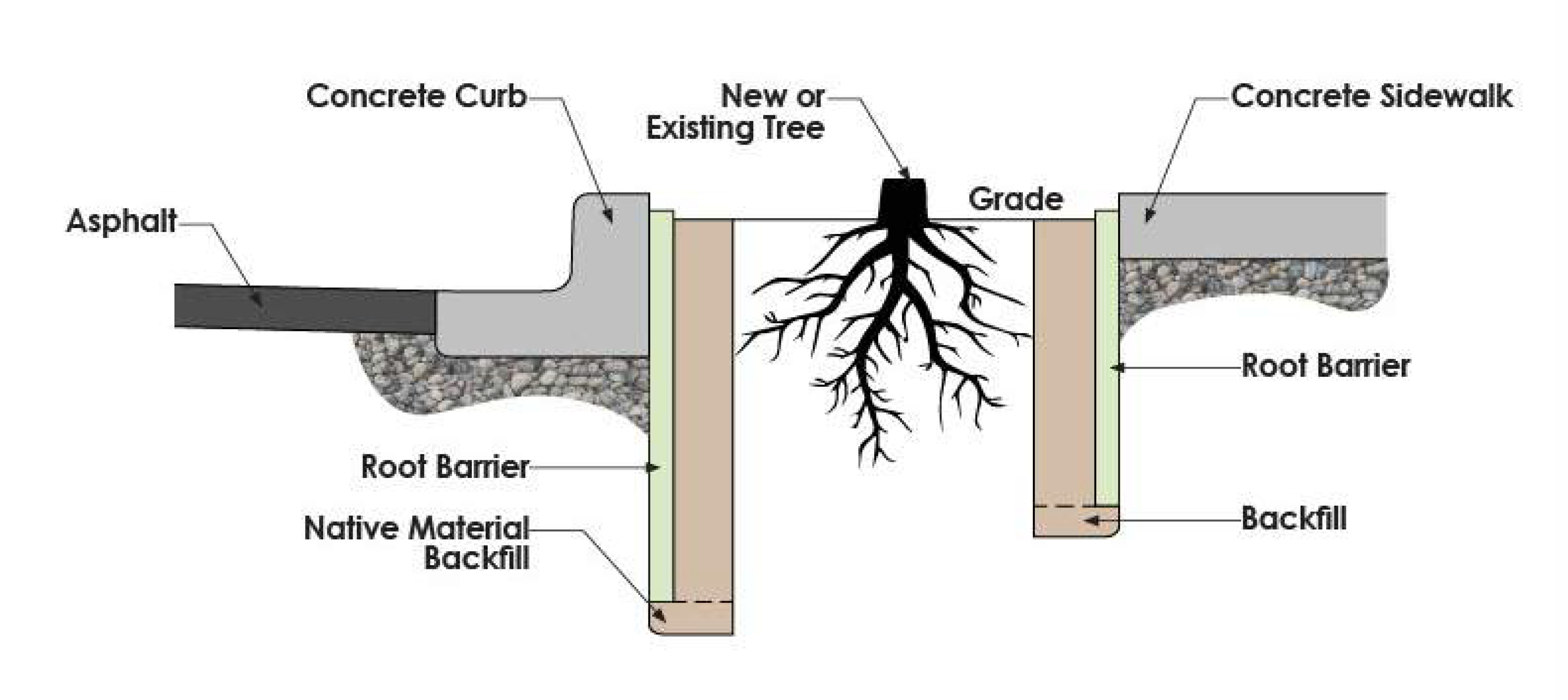
Section IX.4.6. - Driveway Design Standards
A.
General Provisions - The design, configuration and location of driveways shall comply with the requirements of this Section and the Texas Department of Transportation's requirements. No person shall construct, reconstruct, relocate, alter, enlarge, improve or change any driveway except in accordance with these requirements.
B.
Permit Required - A permit approved by the City shall be required for all driveways. Access to state-controlled highways shall require also require a permit from the state.
C.
Driveway Design Standards
1.
General Design Standards for All Driveways
a.
All driveway approaches shall be constructed in accordance with the standard construction details;
b.
Driveways shall align with existing median openings and have minimum left turn lanes as required in Section E.3 above.
c.
The radius or flare point at the street or alley shall not extend past the property line.
d.
Driveways on state-maintained highways shall meet TXDOT requirements and also require approval by the City Engineer.
e.
All dimensions are measured to the near radius or flare point(s) of driveways.
2.
Single Family and Two-Family Driveways
a.
Driveways shall not be permitted to access streets classified as C2U and larger by the City's Thoroughfare Plan.
b.
Where an alley is provided, all driveways shall access the alley instead of the street.
c.
The maximum slope of a residential driveway shall not exceed eight percent (8%) within the street right-of-way and 14 percent beyond the right-of-way line.
d.
Driveways widths and radii shall be:
3.
Non-Residential and Multi-Family Driveways
a.
All two-way driveways shall intersect streets at 90 degrees.
b.
Driveways shall be located in relation to parking spaces to ensure that no vehicle must back into the street right-of-way.
c.
Driveway widths and radii shall be in accordance with Exhibits IX.4.5-2 and IX.4.5-3:
Exhibit IX.4.6-3 COMMERCIAL AND INDUSTRIAL DRIVEWAY LAYOUT - TRUCK ENTRANCE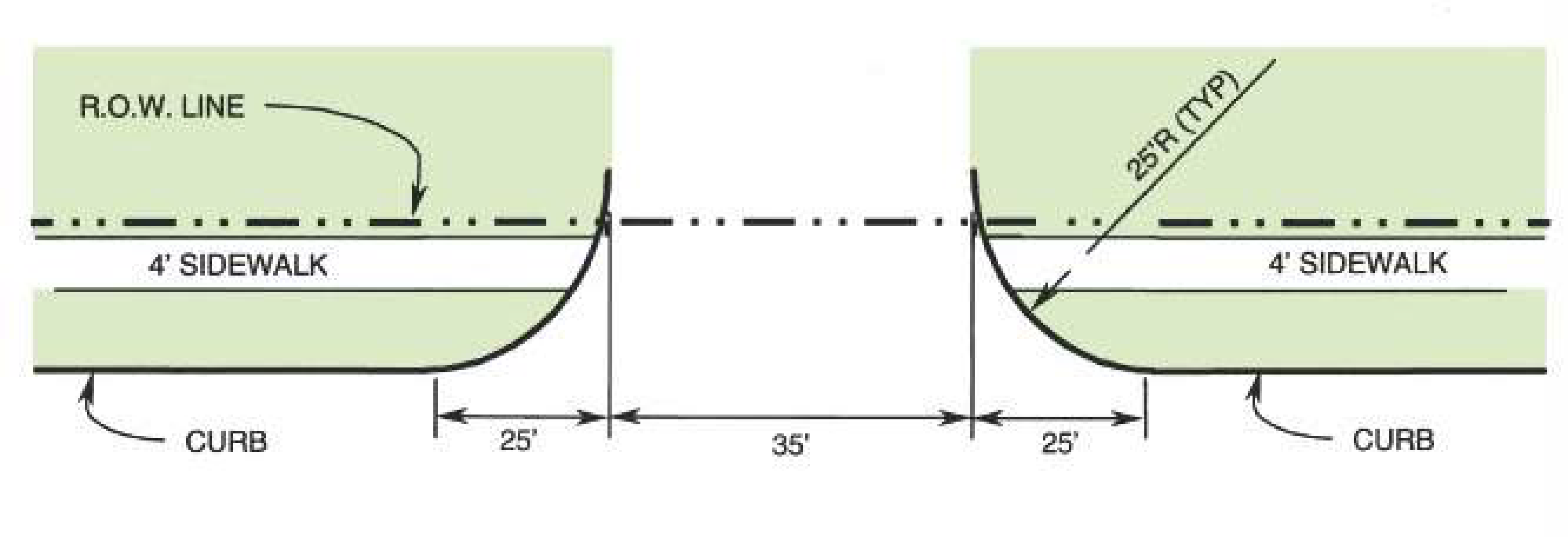
d.
The maximum slope of a non-residential or multi-family driveway shall be eight percent (8%) within the street right-of-way and 14 percent beyond the right-of-way line.
e.
Spacing - Drives shall be located in accordance with the following requirements. Street classifications are based on the City's Thoroughfare Plan. See Exhibit IX.4.6-4 and Exhibit IX.4.6-5.
Exhibit IX.4.6-5 DRIVEWAY ACCESS SPACING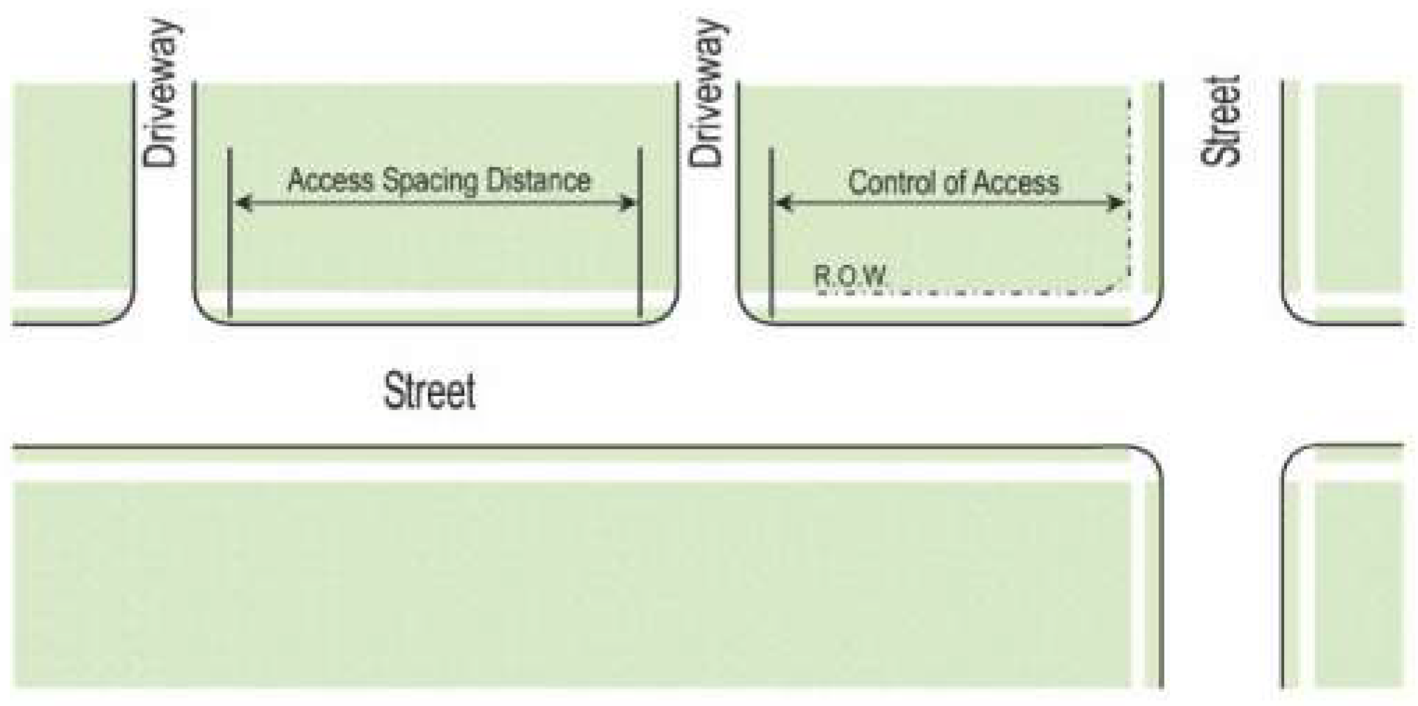
D.
Control of Access Near Intersections
1.
Driveways shall be located in accordance with the following requirements in relation to street intersections. All dimensions are measured to the near radius or flare point(s) of the driveway from the intersecting right-of-way lines. See Exhibit [IX.4.6-6] and Exhibit [IX.4.6-7] for residential and Exhibit [IX.4.6-8] and [IX.4.6-9] for non-residential and multi-family control of access limitations.
Exhibit IX.4.6-7 CONTROL OF ACCESS LINES FOR RESIDENTIAL PROPERTY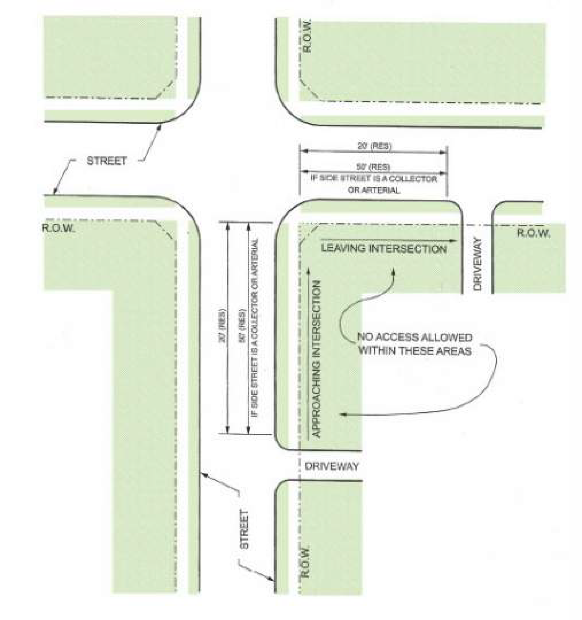
Exhibit IX.4.6-9 CONTROL OF ACCESS LINES FOR COMMERCIAL AND MULTI-FAMILY PROPERTY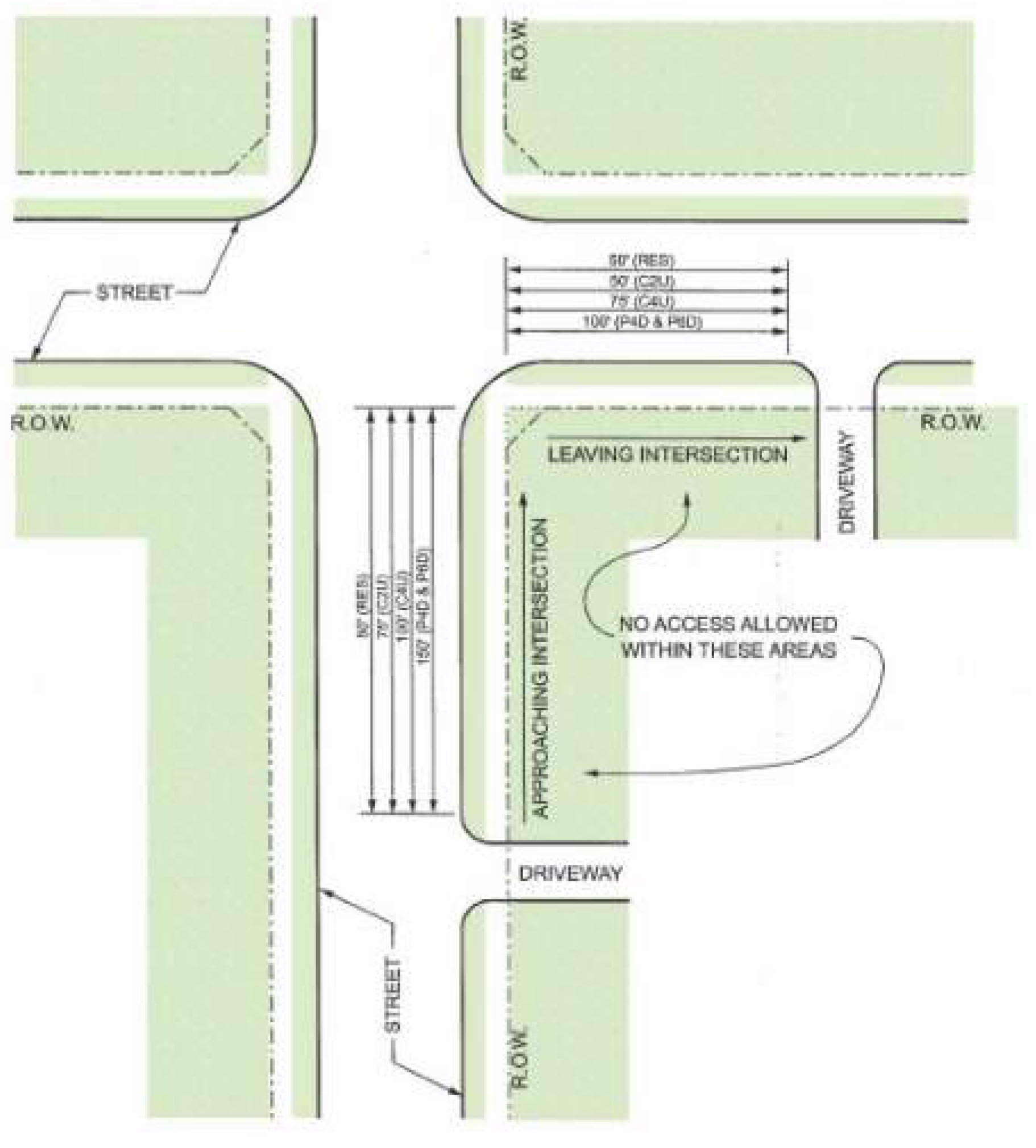
Section IX.4.7. - Visibility Standards
A.
General Provisions - Visibility easements, right-of-way dedications and corner clips are required in accordance with this Section to provide visibility and safety for vehicles, pedestrians, bicyclists and other roadway users.
B.
Obstructions - Visibility easements, rights-of-way and corner clips shall be kept free of obstructions except as allowed by this UDC. Obstructions may include but are not limited to: fences, walls, screens, signs, structures, foliage, hedges, trees, bushes, shrubs, berms, parked vehicles or any other item either man-made or natural that are erected, built, planted or maintained. Single-trunk trees, low-growing shrubs, traffic control devices, streetlights and other utility elements that cannot be placed elsewhere may be placed within a visibility easement, right-of-way or corner clip provided a clear vision area as required by Subsection G.5 below is maintained.
C.
Corner Clips - Triangular corner clips shall be provided and dedicated as right-of-way at the intersections of streets, alleys and driveways as follows.
D.
Clear Vision Areas - A clear vision area providing adequate stoppings sight distance must be maintained as shown in Exhibit IX.4.7-2 Clear Vision Area and shall be kept free of plants and other obstructions except as allowed in Subsection 7.B above. Single-trunk trees and low-growing shrubs may be allowed if maintained at a height of three and one-half (3.5) feet or less or a canopy height of at least eight (8) feet.
Exhibit IX.4.7-2 CLEAR VISION AREA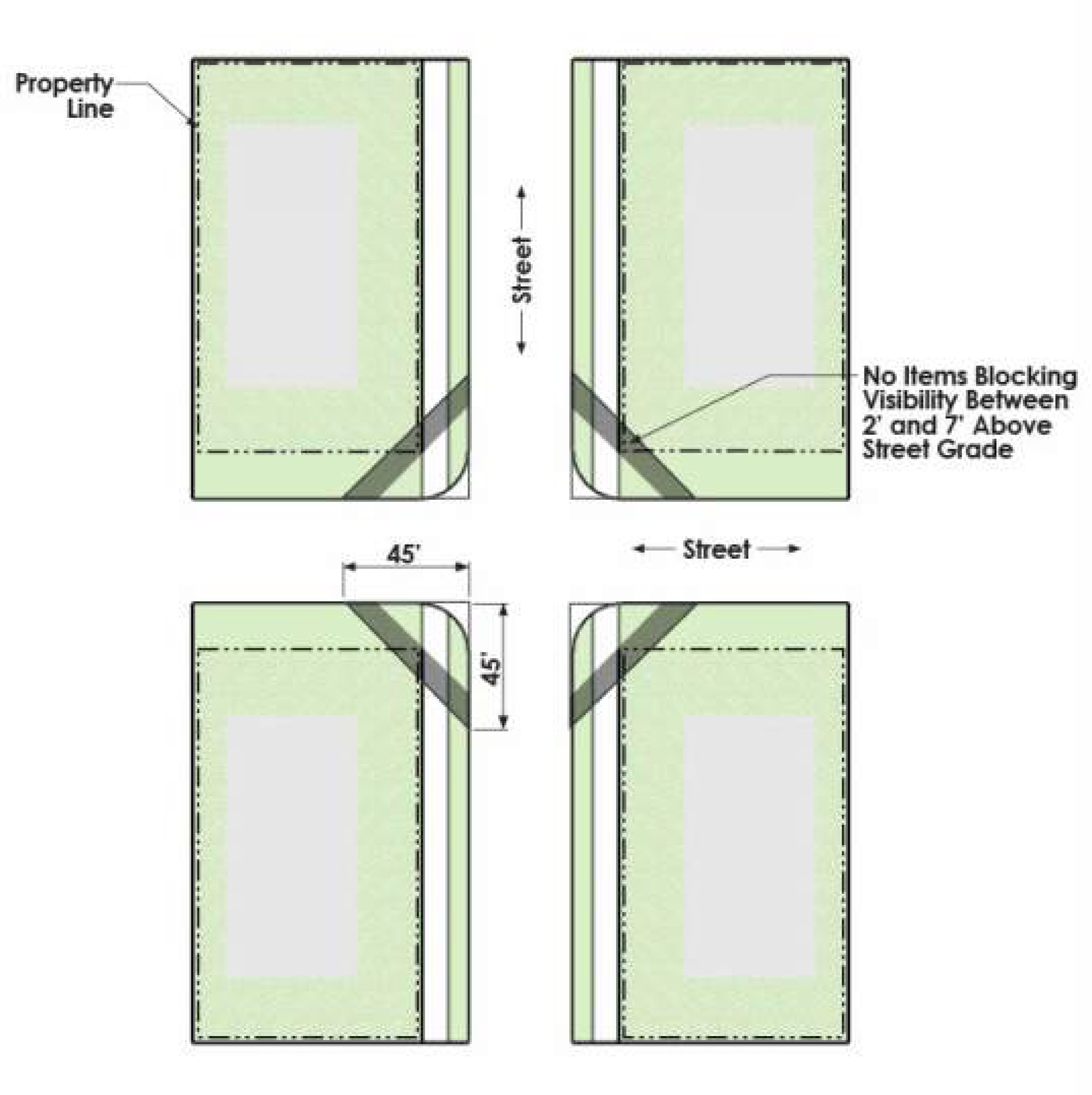
Section IX.4.8. - Sidewalks and Trails
Sidewalks and trails shall be installed in accordance with the following requirements as well as the Texas Accessibility Standards, PROWAG, the Parks Master Plan and Trails Master Plan and the City's standard details.
A.
Connection to Existing Sidewalks and Trails - The developer shall construct connections to existing sidewalks and trails as outlined herein.
B.
Timing of Construction - Sidewalks and trails shall be constructed as part of the infrastructure improvements associated with residential development. For commercial development, the developer shall dedicate the necessary trail easement. The City Engineer may approve the delay of installation for the following:
1.
Adjacent to the front and side yards of residential and commercial lots where subsequent building construction would damage the sidewalk. Grading shall be performed in compliance the typical section found in the standard details.
2.
Where the current street section does not allow for construction of a sidewalk. In this instance the developer shall escrow the cost of the sidewalk installation and, if possible, grading shall be performed in compliance the typical section found in the standard construction details.
C.
Sidewalk and Trail Widths - the minimum width for required sidewalks and trails shall be as follows:
1.
Sidewalks
a.
Five (5) feet along both side of residential streets and six (6) feet along both sides of all other streets.
b.
Six (6) feet where adjacent to screening walls. These sidewalks shall not be constructed as an integral part of the screening wall.
c.
Eight (8) feet for enhanced sidewalks as identified in the parks Master Plan and Trails Master Plan.
2.
Trails - Trails shall be a minimum of ten (10) feet In width; a minimum 12 feet may be required in accordance with the Parks Master Plan and Trails Master Plan and as directed by the Director of Parks and Recreation.
D.
Location of Sidewalks - Sidewalks shall be located one (1) foot from the right-of-way line, but in no instance closer than three (3) feet from the back of curb. The dedication of additional right-of-way or easements may be required to provide adequate space for the construction of sidewalks, including meandering sidewalks, and along state highways the right-of-way or easement shall be dedicated to the City.
E.
Off-site Sidewalks - For all developments, the developer shall construct off-site sidewalks to a maximum distance of 1,000 feet to connect to existing sidewalks. If the distance to existing sidewalks exceeds 1,000 feet, the City shall reimburse the developer through a pro-rata arrangement for the portions over 1,000 feet as adjacent properties develop.
F.
Substandard Sidewalks - If an existing sidewalk does not meet the requirements of this Section or is not structurally sound, the developer of an adjacent property shall remove the existing sidewalks and construct new sidewalks that comply with this UDC. Transitions shall be built to connect to sidewalks of narrower width on adjacent properties.
Section IX.4.9. - Streetlights
Street lights shall be required as follows:
A.
Fixture Type - The standard city streetlight shall be a LED fixture for residential areas, and a LED fixture for all roads on the Thoroughfare Plan.
B.
Pole Design - Light fixtures shall be mounted on poles meeting the design approved by the City Engineer and the energy delivery company providing service to the development.
C.
Spacing - Streetlights shall be installed at 600-foot intervals along all streets. Additionally, streetlights are required to be installed at street intersections, at the end of cul-de-sacs, bridges, railroad crossings and other selected points when the City determines that a streetlight is needed for traffic and pedestrian safety.
D.
Easement Required - Streetlights shall be located in easements adjacent to rights-of-way on residential and undivided streets, unless otherwise approved by the City Engineer. On divided streets, streetlights with dual mast arms and fixtures shall be located within the median.
E.
Plan Required - The developer shall submit a proposed street lighting plan as part of the construction plans for public improvements. The street lighting plan shall be approved by the Public Works Department prior to the commencement of construction. Once the proposed street lighting plan is approved, the developer must arrange for the installation of all street lighting with the appropriate electrical utility company.
F.
Cost of Installation and Operation
1.
Minimum Required Streetlights — The developer shall be responsible for all costs associated with the installation of the proposed street lighting system which meets the minimum requirements. After installation and acceptance, the City will pay the monthly charges for all required streetlights.
2.
Additional Streetlights - Any streetlights that exceed the standards listed above must be located on private property and on a separately metered service. Installation cost, maintenance, and the monthly electrical charges will be the responsibility of the property owner.
G.
Exemptions - The above requirements do not apply to signalized intersections where the streetlights are an integral part of the traffic signal, or to streetlights located within TXDOT rights-of-way.
Section IX.4.10. - Traffic Control Devices
Traffic control devices include traffic signage, street name signs, pavement markings, school beacons, traffic signals, and all related items. All traffic control devices as shown on plans and approved by the City shall be installed by the developer(s) at their sole cost, unless otherwise approved.
A.
Single-Family and Two-Family Subdivisions - After determining the appropriate locations and need for traffic control devices in single-family and two-family subdivisions, the developer shall pay the associated costs for installation, as calculated by the City.
B.
Traffic Signals - Any developer or property owner requesting the installation of a traffic signal shall pay 100 percent of the cost for the design and construction. The City, upon evaluation of the needs and justified warrants of the proposed signal, shall coordinate the approval process on its own thoroughfares, as well as any TXDOT routes. If a proposed development necessitates the modification of an existing traffic signal, the developer shall pay for 100 percent of the total cost of the design and construction of the modifications to the traffic signal, roadway approaches, signage and all related items.
C.
Traffic Calming Devices - All vertical traffic calming devices, including but not limited to speed humps and bumps, speed tables and rumble strips, are prohibited unless approved by the City Engineer and Fire Code Official.
Section IX.4.11. - Street Names
Proposed street names shall be submitted for review and approval by the Fire Code Official with the final plat. Street names shall comply with the street name guidelines maintained by the Fire Code Official. Street names are fixed at the time of final plat approval.
Section IX.5.1. - General Provisions
A.
Dedication Required — In accordance with Section IX.5.1.B.1 of this Chapter, the developer shall acquire, provide and dedicate all required easements for City-owned public infrastructure and utilities, as well as required off-site easements to accommodate such infrastructure and other easements for public purposes such as cross-access between lots or offsite utilities or drainage.
B.
General Width Requirements - Easements for utilities shall be a minimum of 20 feet in width, except as otherwise required in this Section and as follows:
1.
Where two (2) city utility systems are planned for parallel easements, the combined width of the two (2) easements may be reduced by five (5) feet.
2.
Where a city utility easement is located adjacent and parallel to a public street right-of-way, the combined width of the two (2) easements may be reduced by five (5) feet.
C.
Special Requirements for Single-Family and Two-Family Subdivisions - City-owned utilities shall be located within rights-of-way dedicated to the City and not within easements located on single family or two-family lots.
Section IX.5.2. - Water and Sanitary Sewer Easements and Rights-of-Way
A.
The width of easements and rights-of-way for water line and sanitary sewer lines shall be in accordance with the following requirements based on pipe size and depth of cover in Exhibits IX.5.2-1 and IX.5.2-2. The City Engineer may require additional widths based on the engineering design, line size, depth, soil conditions and other criteria.
Section IX.5.3. - Storm Drainage Easements and Rights-of-Way
A.
Special Requirements for Single-Family and Two-Family Subdivisions - Dedication of rights-of-way to the City are required for these residential subdivisions; drainage easements are prohibited within single family lots.
B.
Where required, the width of easements and rights-of-way shall be in accordance with the following requirements and Exhibit IX.5.3-1. The City Engineer may require additional widths based on the engineering design, line size, depth, soil conditions and other criteria.
C.
Box Culverts - The minimum easement widths for box culverts shall be as shown in Exhibit IX.5.3-2 Box Culvert Easement Widths, below.
D.
Open Channels - For all open channels, the floodway shall be dedicated to the City as a public drainage right-of-way. Additional easements shall be dedicated as follows for maintenance. A building setback is also required in accordance with Chapter IX.7 Section 12.B.4. The property owner, property owners' association or homeowners' association is responsible for maintenance.
1.
For open channels which carry less than 500 cubic feet per second (CFS) the public right-of-way shall be designed to the widths required to convey the 100-year design frequency flows plus an additional 15-foot wide easement beyond the top of bank on one side to provide for maintenance equipment access.
2.
For open channels which carry more than 500 CFS the additional 15 feet of easement width referenced in Subsection a., above shall be provided on both sides of the channel.
E.
Private Utility Easements
1.
In single-family and two-family subdivisions, easements for private utilities such as natural gas, electric and communications shall be located in easements which are a minimum seven and one-half (7½) feet in width and which are separate from easements or rights-of-way for public utilities.
2.
On multifamily and non-residential lots, easements for private utilities such as natural gas, electric and communications shall be as required by the utility provides.
3.
Private utility easements shall be accessible for maintenance. Where private utilities are installed in separate easements adjacent to a public utility easement, the City will allow access and use of its easement for ingress and egress and temporary material storage.
Section IX.5.4. - Access Easements
Non-residential lots may be accessed through an access and utility easement in lieu of street frontage. The easement shall be wide enough to accommodate a minimum of 24 feet of pavement and must be maintained by the property owner or property owners' association.
Section IX.5.5. - Fire Hydrants and Water Meter Easements
A blanket easement dedicated to the City and containing a five-foot (5') radius from the center point of all fire hydrants and water meters and all associated equipment such as valves and meter boxes is required. The water line connecting the fire hydrant to the public water line shall also be located in an easement.
Section IX.5.6. - Construction Easements
The developer is responsible for providing to the City necessary temporary construction easements, including slope easements, or letters of agreement from adjacent property owners to allow the construction of streets, drainage and other city infrastructure, if necessary to access those properties to complete the construction.
Section IX.6.1. - Purpose
These regulations are designed to:
A.
Protect the City and property owners from increased flooding, impaired water quality and damage to property during and after the development process.
B.
Preserve and protect the natural character of the land and environmentally sensitive areas by preventing disturbance of soils and reducing sedimentation, air and surface water pollution; and
C.
Comply with state and federal stormwater regulations.
Section IX.6.2. - Grading and Filling
A.
Permit Required - A grading permit is required for any clearing, grading, grubbing, filling, stockpiling, excavating, cutting or other earthwork. A Floodplain Development Permit may also be required in accordance with Volume 1, Chapter 5.5 of the Code of Ordinances.
1.
Exemptions: The following activities do not require a grading permit:
a.
The addition of topsoil or similar material spread over grassed areas in average depths of less than two (2) inches if the property is one-half (½) acre in size or less and the existing drainage pattern is not altered;
b.
Soil disturbing activities, excluding tree removal, that are associated with normal agricultural crop cultivation on properties zoned for agricultural uses; and
c.
Stockpiling and handling of earth materials associated with commercial quarry and landfill operations licensed by the State of Texas and on the same property as the operations.
2.
A grading permit will not be issued for mining operations except as part of an approved engineering site plan.
3.
Limitation on Grading Activity - Activities shall be limited to the area and scope identified on the approved plan submitted to the Engineering Department and authorized by the approved permit.
B.
Plan Required - A grading plan shall be submitted as part of the construction plans required for engineering site plans and plats, or may be submitted separately. Grading plans shall include the information specified in Section III.4.3.C.1 or Section III.4.4.C.1 as applicable.
C.
Lot Grading Requirements - Grading and filling activities shall meet the following requirements:
1.
Lots shall be graded to provide drainage that meets the requirements of this UDC, the Drainage Criteria Manual and erosion and sedimentation standards.
2.
Lots shall be graded to provide positive drainage away from all buildings. There shall be a minimum one percent (1%) slope away from the home to a drainage easement or right-of-way.
3.
Unless lot-to-lot drainage is allowed as provided in Section IX.6.6 of this Chapter, lots shall be graded to avoid concentrated storm water drainage from each lot to adjacent lots.
4.
Single-family and two-family lots shall meet the following requirements:
5.
All lots must be graded to meet the elevation of the adjoining property, unless otherwise approved by the City Engineer. Retaining walls shall be limited to a maximum of four (4) feet in height.
6.
The center of a single-family or two-family lot shall be a minimum of one (1) foot but not higher than three (3) feet above the top of the street curb.
7.
Multi-family and non-residential lots shall be graded to allow cross access where required and to minimize the use of retaining walls. Cuts or fills which do not allow grades to match elevations at adjoining properties shall not be permitted unless approved by the City Engineer.
D.
Stockpiling — Dirt or topsoil may be stockpiled on a property only with the approval of the City Engineer and must be removed before final acceptance of the development.
Section IX.6.3. - Erosion Control
A.
General Provisions - Property owners, developers and builders shall comply with the requirements of this Section, the Drainage Criteria Manual, Volume I, Chapter 16.VIII.16-379 of the Code of Ordinances and all state and federal regulations to limit the erosion of properties or construction sites.
B.
Plan Required - Erosion control plans shall be submitted as part of an engineering site plan or a grading plan if submitted separately from an engineering site plan and shall include the information specified in Volume I, Chapter 16.VIII.16-379 of the Code of Ordinances. At a minimum, erosion control plans shall indicate:
1.
Existing and proposed topography and grading;
2.
Existing and proposed drainage patterns; and
3.
Erosion control measures, routing devices and barriers to be used on a temporary and permanent basis.
C.
Erosion Control Requirements - The developer, builder or property owner shall prevent and/or abate the runoff of dirt, soil and other erodible materials by designing and installing temporary and permanent erosion controls as required by the Drainage Criteria Manual and Volume I, Chapter 16.VIII.16-379 of the Code of Ordinances. A Storm Water Pollution Prevention Plan (SWPPP) is required for all construction sites, regardless of the size of the area of land disturbance.
D.
Erosion Control Devices - Erosion control devices and techniques must be installed prior to the commencement of construction; be maintained during construction and not be removed until vegetation is established and the construction area is stabilized.
E.
Temporary Erosion Control - Temporary erosion control measures shall comply with the standards in the Drainage Criteria Manual and Volume I, Chapter 16.VIII.16-379 of the Code of Ordinances. See Exhibit IX.6.3-1 for examples of temporary erosion control measures.
Exhibit IX.6.3-1 EROSION CONTROL BARRIERS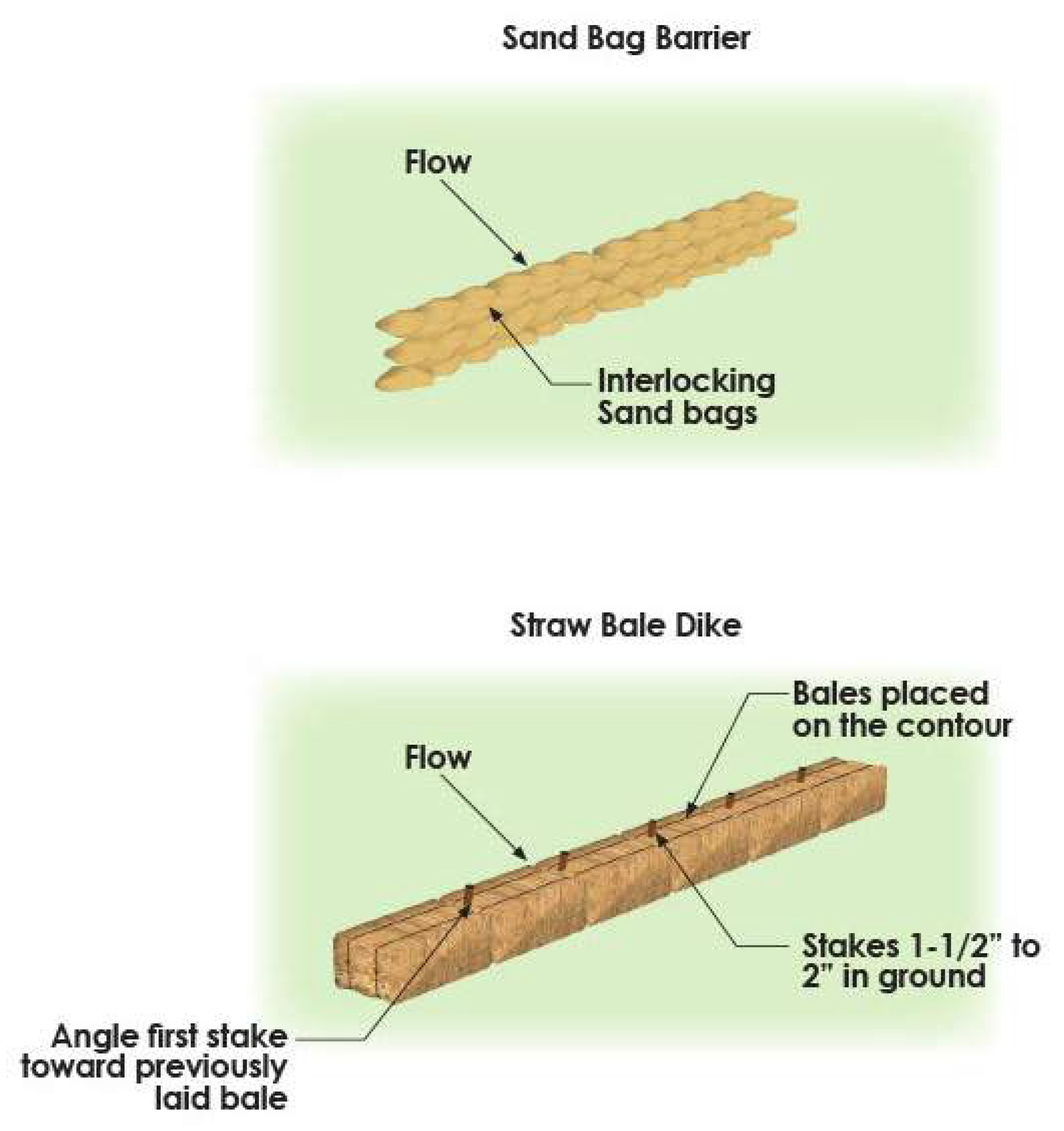
F.
Permanent Erosion Control - Permanent erosion control measures shall comply with the standards in the Drainage Criteria Manual and in Volume I, Chapter 16.VIII of the Code of Ordinances.
G.
Enforcement - Upon observation or notification of any violation of erosion control regulations, the City has the authority to issue a stop work order until the violations are corrected. The City shall notify the property owner, builder or developer of the violations in writing. The violations shall be corrected with seven (7) days of notification. Failure to correct the violations shall result in the revocation of the development permit, the building permit or withholding issuance of a certificate of occupancy or final acceptance of the project. The property owner, builder or developer may appeal these actions to the City Engineer.
Section IX.7.1. - Purpose
The Section describes the requirements for the design, size, type, location and management of storm drainage systems, floodplains, and stormwater controls in accordance with this UDC, the adopted drainage master plans, the City's Drainage Criteria Manual and other standard specifications. These regulations are designed to:
A.
Protect human life, health and property;
B.
Retain natural floodplains in a condition that minimizes interference with floodwater conveyance and storage as well as aquatic and terrestrial ecosystems;
C.
Minimize erosion and sedimentation problems; and
D.
Encourage preservation of natural resources such as riparian buffers and/or natural open space areas and utilization of natural design features for stormwater conveyance.
Section IX.7.2. - Design of Drainage Improvements
Drainage and stormwater systems shall be designed in accordance with the City's Drainage Criteria Manual and with this UDC and shall meet the following requirements to manage water quantities and to maintain and improve water quality. Design and management of drainage and stormwater systems shall support and comply with the City's adopted plans and policies to maintain watercourses in natural states and to integrate creeks and drainageways into the City's parks and trail system in accordance with the Park Master Plan and the Trails Master Plan.
A.
General Requirements:
1.
All storm drainage structures and improvements shall be designed at a minimum to accommodate potential runoff from a storm event of 100-year frequency. The ultimate development of the entire upstream drainage area, whether inside or outside the subdivision or addition, shall be considered and incorporated into the design. Developers are responsible for accurate design, installation and maintenance of drainage improvements.
2.
Effect on Downstream Drainage Areas - The owner's engineer, subject to approval by the Director of Engineering, shall also study the effect of each development's stormwater runoff on the existing underground drainage infrastructure immediately downstream of the development. Where it is determined that existing capacity is not available immediately downstream, the owner's engineer shall design a drainage system, detention facility, or parallel system to mitigate the deficiency. If oversize improvements are required, then the City shall participate in the cost as prescribed by these regulations in Article IX.12.6.
3.
Major creeks shall remain in open natural condition; smaller creeks or drainage ways may be channelized if approved by the City Engineer and the design meets the requirements of the Drainage Criteria Manual.
4.
100-year floodplains shall be preserved and protected from destruction and damage resulting from clearing, grading or dumping of earth, waste or other materials. Development of any type is prohibited within the floodplain of any stream or drainage way unless a permit is issued in accordance with Volume I, Chapter 5.5 of the Code of Ordinances. Floodplains are subject to the tree preservation requirements contained in Article VIII.4.
5.
Structural and/or non-structural storm water management devices shall conform to the standards and specifications of the Drainage Criteria Manual and must be approved by the City Engineer.
a.
Innovative drainage concepts may be considered and approved by the City Engineer and designed to:
1)
Preserve undisturbed natural habitat;
2)
Incorporate individual integrated site design practices into development projects:
3)
Limit the amount of impervious surfaces;
4)
Utilize open space areas as part of the stormwater management system; and Preserve floodplain buffers.
b.
A long-term plan indicating how structural and non-structural water management devices will be maintained in the future shall be submitted to the City. The plan must meet the minimum requirements of the Drainage Criteria Manual and be filed of record with the County Clerk.
c.
Stormwater drainage runoff mitigation measures or best management practices may qualify for stormwater drainage utility fee credits. (See Volume I, Chapter 16.X.16-460 of the Code of Ordinances.)
B.
Design Based on Discharge - Drainage improvements and infrastructure and storm water systems shall be designed based on the following criteria:
1.
Less than 200 CFS in accumulated stormwater run-off—an enclosed system is required.
2.
More than 200 CFS in accumulated stormwater run-off—either an enclosed system or an open channel consistent with the Drainage Criteria Manual is required.
C.
Natural Channels - Where possible and to protect water quality, the natural conditions of a waterway shall be preserved in accordance with the Drainage Criteria Manual.
Section IX.7.3. - Required Drainage Plan and Studies
The City Engineer is authorized to maintain a specific list of requirements related to drainage plans and studies and maintenance plans. The minimum requirements for hydraulic and hydrologic calculations, technical studies and plans are in Exhibit IX.7.3-1 below.
Section IX.7.4. - Drainage System Requirements for Single-Family Detached and Two-Family Subdivisions
A.
Underground drainage improvements and storm water systems shall be located in streets, alleys or in dedicated easements on open space lots maintained by a homeowner's association. No drainage easements shall be located on lots occupied by dwelling units.
B.
Subdivisions shall be designed to direct positive overflow to public rights-of-way or to open space lots, but not to residential lots.
C.
Lot-to-lot drainage is prohibited in single-family detached and two-family subdivisions. (See Section IX.7.5 below for single-family attached regulations for lot-to-lot drainage.)
D.
Open space areas and associated drainage infrastructure owned and maintained by a homeowners' association shall be incorporated as part of an integrated stormwater management design where applicable in accordance with the Drainage Criteria Manual.
Section IX.7.5. - Drainage System Requirements for Single-Family Attached Subdivisions
A.
Drainage systems for single-family attached subdivision shall meet the requirements of Section IX.7.4 above and the Drainage Criteria Manual. However, lot-to-lot drainage may be allowed for front-entry lots only with approval by the City Engineer, and subject to the following requirements:
1.
Private drainage easements must be dedicated and shown on the final plat:
2.
The minimum width of a private easement for lot-to-lot drainage shall be five (5) feet for enclosed systems and ten (10) feet for open systems.
3.
A homeowners' association must be created to assume responsibility for preservation and maintenance of the lot-to-lot drainage system and associated easements;
4.
It shall be noted on the final plat that property owners shall not make any changes to the grading or add fences or other obstructions that impact the private drainage easement and maintenance of the drainage pattern; and
5.
Drainage must be routed to the nearest available public storm sewer system at breaks between buildings. No more than ten (10) lots shall be drained into the street from each break between buildings. In no case shall more than two (2) CFS flow across the sidewalk into the street.
Section IX.7.6. - Drainage System Requirements for Commercial and Multi-Family Development
A.
An on-site storm drainage system connected to an existing public storm sewer system is required if a site discharges more than two (2) CFS of stormwater over the right-of-way at each drive approach. If the public storm water system has inadequate capacity for 100-year storm discharges, the developer has two (2) design options:
1.
Option A - to upgrade the public storm water system to accommodate 100-year storm discharges from the development site as well as any offsite future 100-year discharges upstream, at the developer's expense. The City may participate in these costs in accordance with the oversize participation standards in Article IX.12.6 and subject to the availability of funds.
2.
Option B - to design the on-site storm discharge system to accommodate:
a.
100-year on-site developed runoff and 100-year off-site drainage coming into the property under existing (undeveloped) conditions.
b.
The resulting excess discharge exceeding the capacity of the public storm water system shall be retained or detained on-site. (See Subsection G., below and the Drainage Criteria Manual for alternative designs for retention or detention systems.)
3.
If Option B is chosen, the City will require that upstream development provide on-site retention or detention in the same manner to protect downstream properties.
Section IX.7.7. - Retention and Detention Improvements
All retention and detention improvements, whether maintained by the City, private property owner, homeowners' association, or private entity, shall comply with all applicable design requirements of this UDC and the Drainage Criteria Manual.
A.
Location - Retention and detention infrastructure shall be located as follows:
1.
Commercial and Multi-Family Development - On a lot that also contains a building.
2.
Single-Family and Two-Family Development - on an open space lot owned by a homeowners' association.
B.
Maintenance - Retention and detention infrastructure shall be maintained by the property owner, property owner's association or homeowner's association. A long-term maintenance plan shall be submitted as required in Section IX.7.3 above and in accordance with the Drainage Criteria Manual. The City shall have the right but not the obligation to maintain the retention and detention infrastructure if they are not being properly maintained.
C.
Design - Retention and detention infrastructure shall be designed to integrate into an open space system that serves the development and shall be landscaped in accordance with Article VIII.4.
D.
Mosquito breeding shall be minimized through design and maintenance plans.
E.
In accordance with Chapter 16 of the Code of Ordinances, storm water utility credits may be available with approved retention or detention infrastructure.
Section IX.7.8. - Inlets
Inlets shall be designed and located in accordance with the requirements of the Drainage Criteria Manual.
Section IX.7.9. - Outfalls
All drainage outfalls into creeks and drainageways shall meet the following requirements in addition to those in the Drainage Criteria Manual:
A.
Discharge from outfalls shall be located at the flow lines of creeks and not near the tops of creek banks, and appropriately anchored or supported with piers.
B.
Flumes shall not be used for outfalls, and the design shall incorporate proper erosion and velocity controls.
C.
After the construction of outfalls, creek banks shall be repaired and restored to a natural condition through compaction and seeded or sodded with grass.
Section IX.7.10. - Minimum Finished Floor Elevations
Minimum finished floor elevations for structures shall be indicated on the final plat for all lots, both residential and commercial, which incorporate the 100-year floodplain or abut a drainage easement or right-of-way encompassing a creek or open channel. The minimum finished floor elevations shall be required as follows:
A.
For lots adjacent to a stream without Base Flood Elevations identified on the FEMA FIRM maps or an unmapped stream, the finished floor elevation shall be a minimum of two (2) feet above the 100-year base flood elevation based on a city-approved drainage study provided by the developer. This shall apply to all rivers or streams regardless of whether the 100-year floodplain is shown on the FEMA map. The developer shall submit a flood analysis determining the presence and extent of a special flood hazard area and the 100-year Base Flood Elevation.
B.
For lots adjacent to a stream with Base Flood Elevations identified on the FEMA FIRM maps, the finished floor elevation shall be a minimum of two (2) feet above the 100-year base flood elevation.
Section IX.7.11. - Floodplain Reclamation
Construction and related activities, including filling, within a special flood hazard area require approval by the City and shall meet the Drainage Criteria Manual and the following requirements:
A.
The developer shall submit a study detailing the proposed activity and how impacts upon the special flood hazard area will be mitigated.
B.
Construction and related activities are subject to the following limitations:
1.
There shall be no increase in the 100-year water surface elevation on any properties located upstream, downstream or on the opposite bank (unless both sides are owned by the same developer). The floodplain may be altered only to the extent permitted by equal conveyance reduction on both sides of the channel. A backwater analysis and other supporting data may be required to make this determination.
2.
Any increase in mean stream flow velocity shall not exceed the open channel velocity limitations in the Drainage Criteria Manual.
3.
There shall be no increase in erosion activity on any property upstream, downstream or on the opposite bank.
4.
The toe of any fill slope shall parallel the direction of flow.
5.
The maximum unreinforced fill slope shall be 4:1 unless a steeper grade is approved by the City Engineer. Vertical walls, terracing and other slope treatments also require approval by the City Engineer.
C.
For water courses not covered by the FEMA Flood Insurance Rate Map (FIRM), the developer shall submit a flood analysis determining the presence and extent of a special flood hazard area.
D.
Watercourses covered by the FEMA FIRM shall require the developer to apply for a Conditional Letter of Map Revision and/or a Letter of Map Revisions as determined by the City Engineer.
Section IX.7.12. - Dedication and Maintenance of Drainage Rights-of-Way and Easements
Dedication of easements containing public storm sewer systems and fee simple dedication of floodway and 100-year floodplain areas shall be required as follows. Dedication of easements and rights-of-way shall be shown on the final plat or by separate instrument if no plat is required.
A.
Where public storm drainage systems that convey off-site stormwater are not located within street rights-of-way, perpetual unobstructed drainage easements shall be provided. The installation of the system and the minimum easement width shall be as shown in Exhibit IX.5.3-1 in Chapter 5. No public drainage easement is required for storm drainage systems that convey only on-site stormwater.
B.
For creeks and open drainageways, drainage easements and dedicated rights-of-way must be provided as follows and in accordance with Section IX.7.4 of this Chapter. The City shall determine the minimum required widths of drainage easements and rights-of-way dedications.
1.
For single-family and two-family development, the 100-year floodplain must be dedicated in fee simple as a separate lot to the City. No part of a single-family or two-family lot shall include any portion of the 100-year floodplain. A homeowners' association may assume maintenance of the 100-year floodplain area. The homeowners' association's bylaws and covenants, filed of record, shall provide for ongoing maintenance in accordance with the Drainage Criteria Manual.
2.
For commercial and multi-family development, the 100-year floodway shall be dedicated in fee simple as a separate lot to the City. The 100-year floodplain may be retained as part of a non-residential or multi-family lot and contained within a dedicated drainage easement. It shall be the property owner's responsibility to maintain the floodway and drainage easement in accordance with the Drainage Criteria Manual. A maintenance easement shall be granted to the City which grants the right but not the obligation to maintain and construct drainage infrastructure if the creek or drainageway is not being properly maintained. A lien may be filed against the property in favor of the City to secure payment of any expenses incurred by the City for maintenance.
3.
Adjacent to the dedicated drainage easements and rights-of-way there shall be a minimum 15-foot wide maintenance and access easement along both sides of the creek or open channel. The City Engineer may authorize a single 20-foot wide maintenance and access easement or a reduced maintenance and access easement on both sides, where appropriate. Streets, alleys, hike and bike trails located along or abutting the drainage easement or rights-of-way may serve as part of the maintenance and access area if approved by the City Engineer.
4.
A 20-foot building setback must be maintained from all drainage rights-of-way and easements containing an open channel.
Section IX.8.1. - Purpose
This Section describes the requirements for water and sanitary sewer line location, design, installation in accordance with this UDC, the adopted water and sanitary sewer master plans, the City's standard specifications, the adopted North Central Texas Council of Government's Public Works Standards and all applicable state and federal standards
Section IX.8.2. - Extensions of Water and Sewer Mains
Extensions required to serve new subdivisions and other development shall be as follows:
A.
All water and sanitary sewer lines shall be required to extend across the full width of the lot (defined by plat) in such an alignment that they can be extended to the next property in accordance with the master water and sewer plans for the City or provide continuity of service to the adjoining lot. See Exhibit IX.8.2-1.
Exhibit IX.8.2-1 REQUIRED EXTENSION OF WATER AND SANITARY SEWER LINES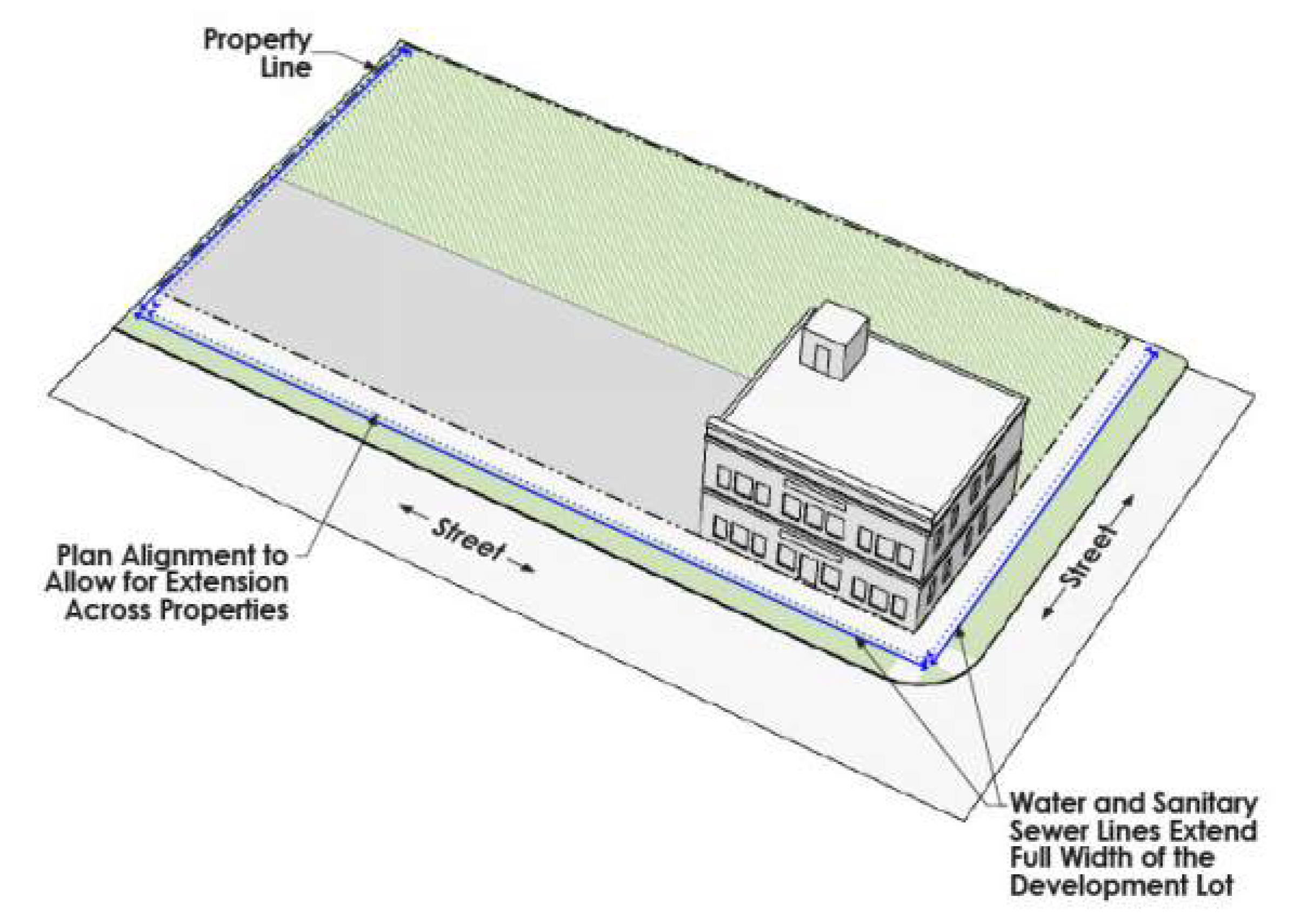
B.
For properties having frontage along multiple streets, water and sanitary sewer lines shall extend accordingly along each street frontage.
C.
Gravity sanitary sewer lines shall, where possible, shall be installed at maximum depth and minimum slope to facilitate future service to upstream properties. The City Engineer may modify this requirement where appropriate.
D.
Properties already served by water and sanitary sewer lines shall not be required to install additional improvements unless:
1.
The current lines do not have adequate capacity to serve the proposed development, in which case the developer will be required to install adequate infrastructure. Where required, downstream capacity shall be included in the determination of sufficient capacity.
2.
The current lines are not of adequate capacity to serve a property where the proposed development is planned for more intense uses than those served by the original utility installation.
E.
Water and sanitary sewer lines shall be sized, designed and installed at the developer's expense in accordance with the master water and sewer plans, the utility location plan, and the oversize participation requirements, except as otherwise approved by the City Engineer.
F.
The City Council may approve extensions outside the city limits if constructed by a neighboring municipality or governmental entity.
G.
The applicant shall dedicate all required easements in accordance with Section IX.8.4 of this Chapter for water and sanitary sewer line installations and extensions.
H.
When water and sanitary sewer lines are installed in conjunction with a new street, eight-inch (8") water stub outs and six-inch (6") or larger sanitary sewer stub outs must be added to serve adjacent undeveloped commercial and multi-family properties.
Section IX.8.3. - Oversize Participation
The City may participate in the costs of water and sanitary sewer line extensions as follows and in accordance with Chapter IX.12.6 of this Article and with City Council approval. If a project requires the City's participation and if city funds are available, the applicant shall design the project and submit the approved plans for bidding by the City. If city funds are not available, the applicant may design and construct the project subject to an agreement for connection and reimbursement in accordance with Volume 1, Chapter 16 of the Code of Ordinances.
Section IX.8.4. - Water Requirements
A.
Water Line Categories - Water lines in the City are categorized as:
1.
Distribution Lines - Fourteen inches and smaller (nominal diameter). Distribution lines shall be of sufficient size to provide adequate water for potable and fire protection needs.
2.
Transmission Lines - Sizes 16 inches through 48 inches or larger (nominal diameter). Transmission lines shall be sized as shown on the City's water distribution system master plan.
B.
Water Line Requirements - Basic minimum water line requirements can be found in Exhibit IX.8.4-1 below.
1.
The minimum size for water lines is eight (8) inches. New 6-, 10- and 14-inch pipes shall not be used.
2.
All waterlines shall be designed to complete a looped system. Dead-end lines are only allowed as follows. See Exhibits IX.8.4-2 and IX.8.4-3.
a.
A maximum of 300 feet for eight-inch (8") pipes
b.
A maximum of 600 feet for 12-inch pipes
3.
90-degree bends in water lines are prohibited. Two 45-degree bends are required.
4.
Cross fittings for water lines are prohibited.
5.
All water line materials (pipes and fittings) shall conform with AWWA standards and the following requirements:
a.
Blue PVC AWWA standard C900 Class 150 (DR18) shall be used for water lines of 12 inches (nominal) or less in diameter
b.
Blue PVC AWWA standard C905, Class 235 (DR18) shall be used for water lines greater than 12 inches in diameter.
c.
Fusible PVC AWWA standard C900 (DR18) shall be used for all waterlines installed by trenchless methods.
d.
Fittings shall be ductile iron and shall be cement lined inside and shall be bituminous coated on the outside.
6.
Valves shall be placed at or near the ends of mains to prevent loss of service from future water line extensions.
7.
Water line locations and installations shall comply with the following:
a.
All water lines shall be installed within a city right-of-way or when necessary, within an easement that is contiguous to the right-of-way, unless otherwise approved by the City Engineer. See Exhibits IX.8.4-4, IX.8.4-5 and IX.8.4-6.
b.
When installed within an easement which is adjacent to a building or other structure, the water line shall be installed at a distance away from the building of three-quarters (¾) of the easement width. See Exhibit IX.8.4-7.
c.
Water lines shall not be installed within a TXDOT right-of-way. A water line easement that is contiguous to the TXDOT right-of-way shall be provided.
d.
The city reserves the right to consider alternative alignments as approved by the City Engineer when field conditions warrant.
In residential developments, water lines shall be installed within rights-of-way. Should a water line exist in an easement prior to development of the property for residential use, the line shall either be relocated to rights-of-way at the developer's cost or the existing easement shall be dedicated to the City as right-of-way.
e.
Water line crossings at all street intersections of streets designated C4U or larger per the adopted Thoroughfare Plan (except service connections) shall be encased in a steel pipe as required by the City. Valves may be required at both ends of street crossings if the crossing is utilized for both domestic service and fire protection needs. See Exhibit IX.8.4-8.
f.
Water line crossings of existing streets must be dry bored with encasements.
g.
Perpendicular crossings of underground public water lines under driveway and sidewalks may be approved by the City Engineer to provide fire protection to a property.
i.
If a public water line is installed under pavement on a private property, the property owner shall be responsible for repairing the pavement and any private improvements removed or disturbed by repair or replacement of the line.
8.
Booster pump stations and force mains serving private development shall be privately maintained.
EXHIBIT IX.8.4-2 WATER LINE EXTENSIONS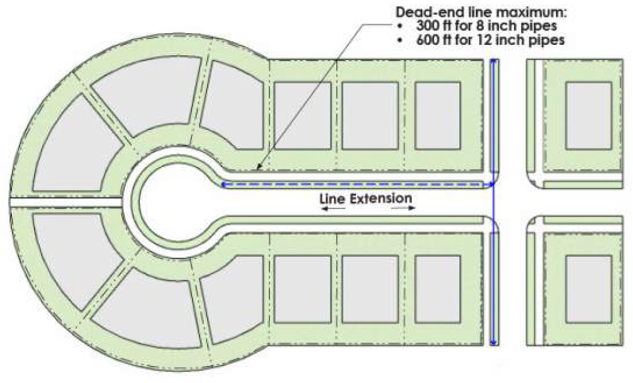
EXHIBIT IX.8.4-3 LOOPED WATER LINE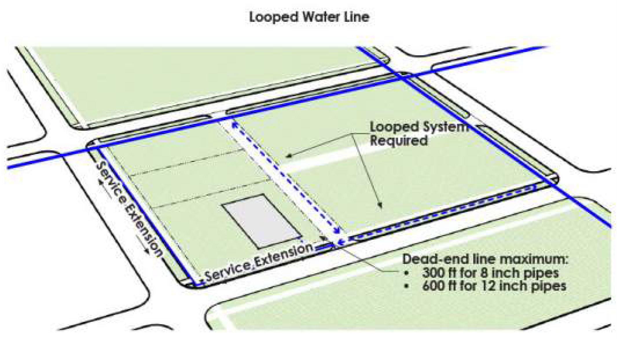
Exhibit IX.8.4-4 UTILITIES LOCATION WITHIN STREET R.O.W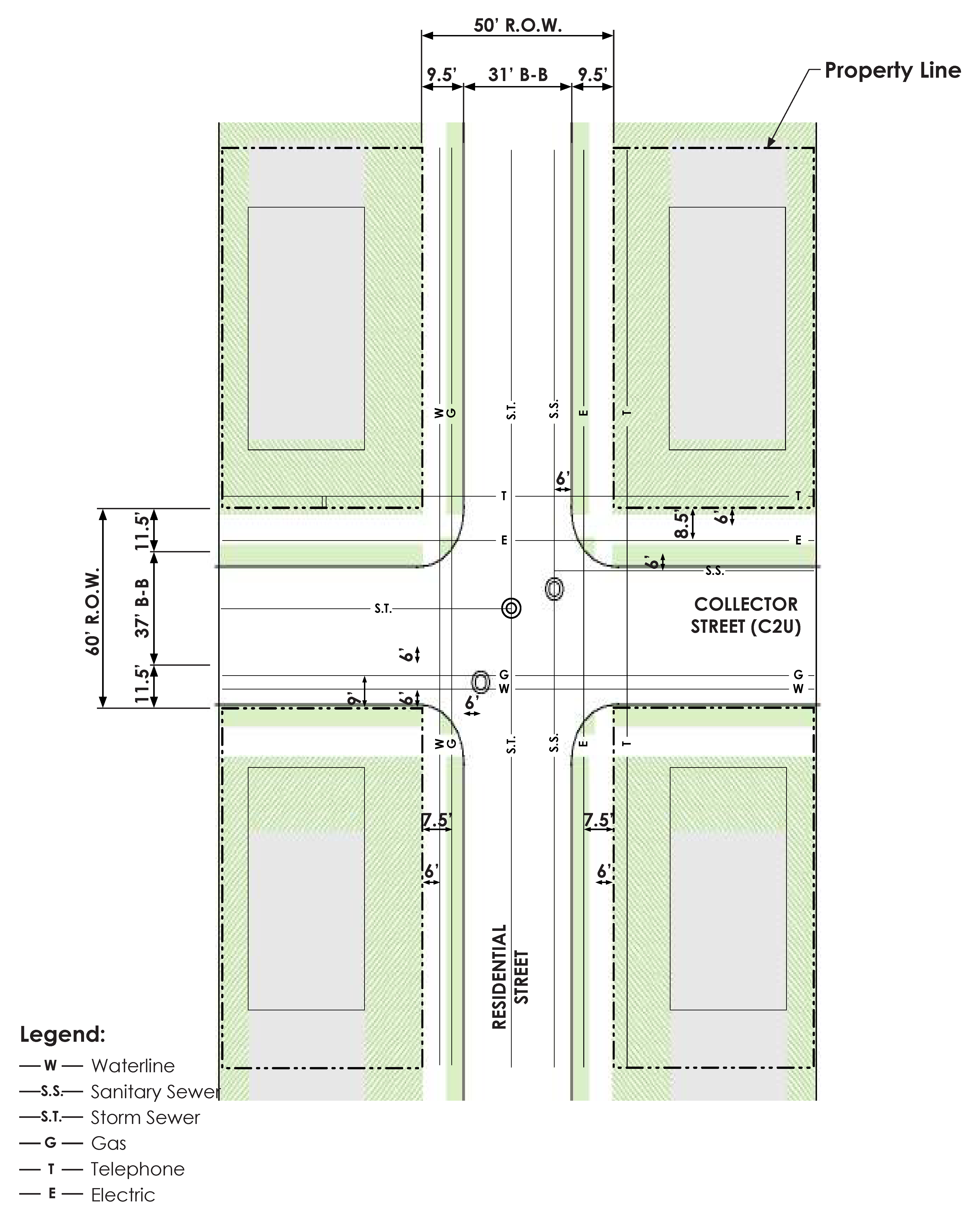
EXHIBIT IX.8.4-5 UTILITIES LOCATION WITHIN STREET R.O.W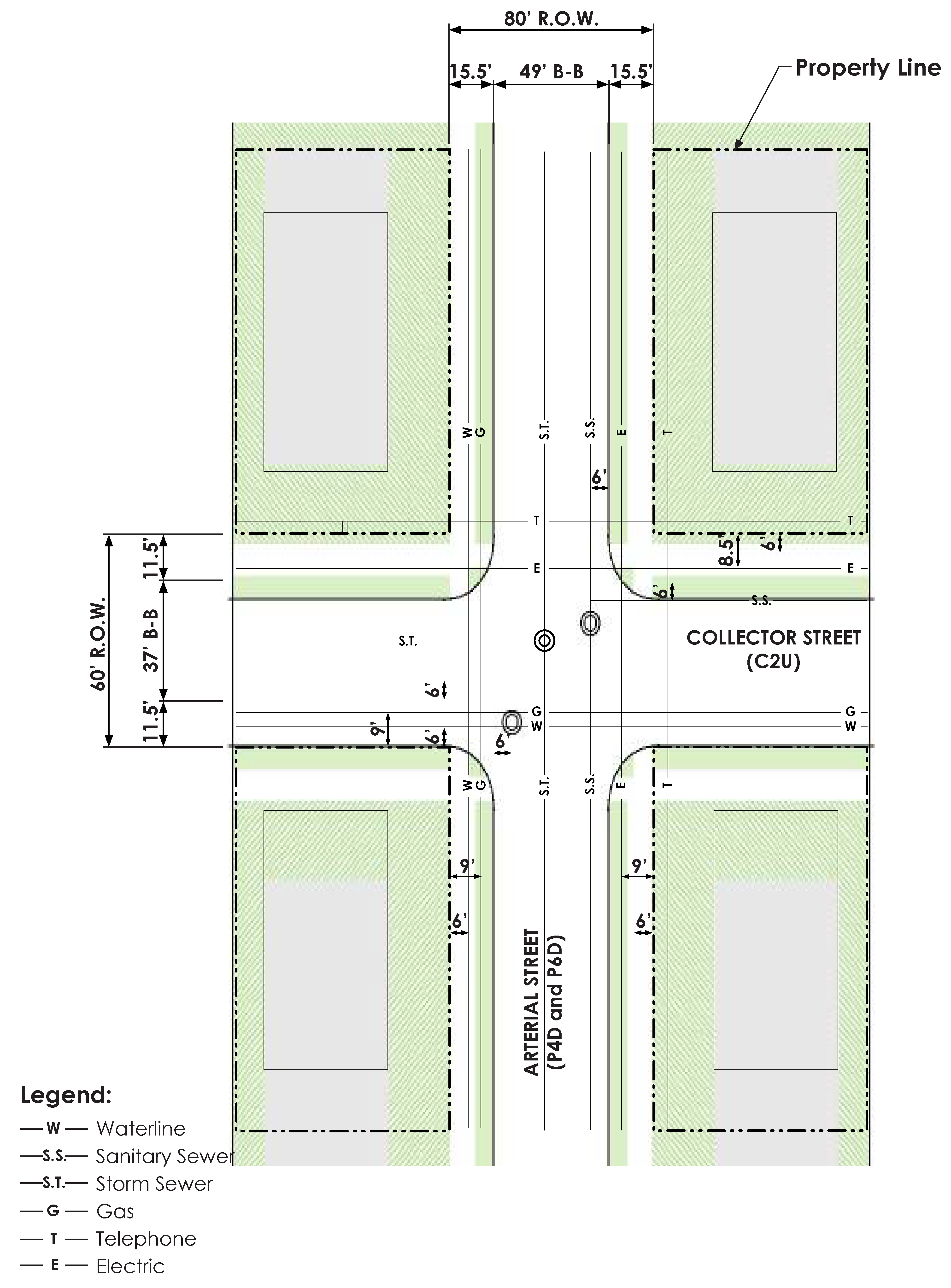
EXHIBIT IX.8.4-6 UTILITIES LOCATION WITHIN STREET R.O.W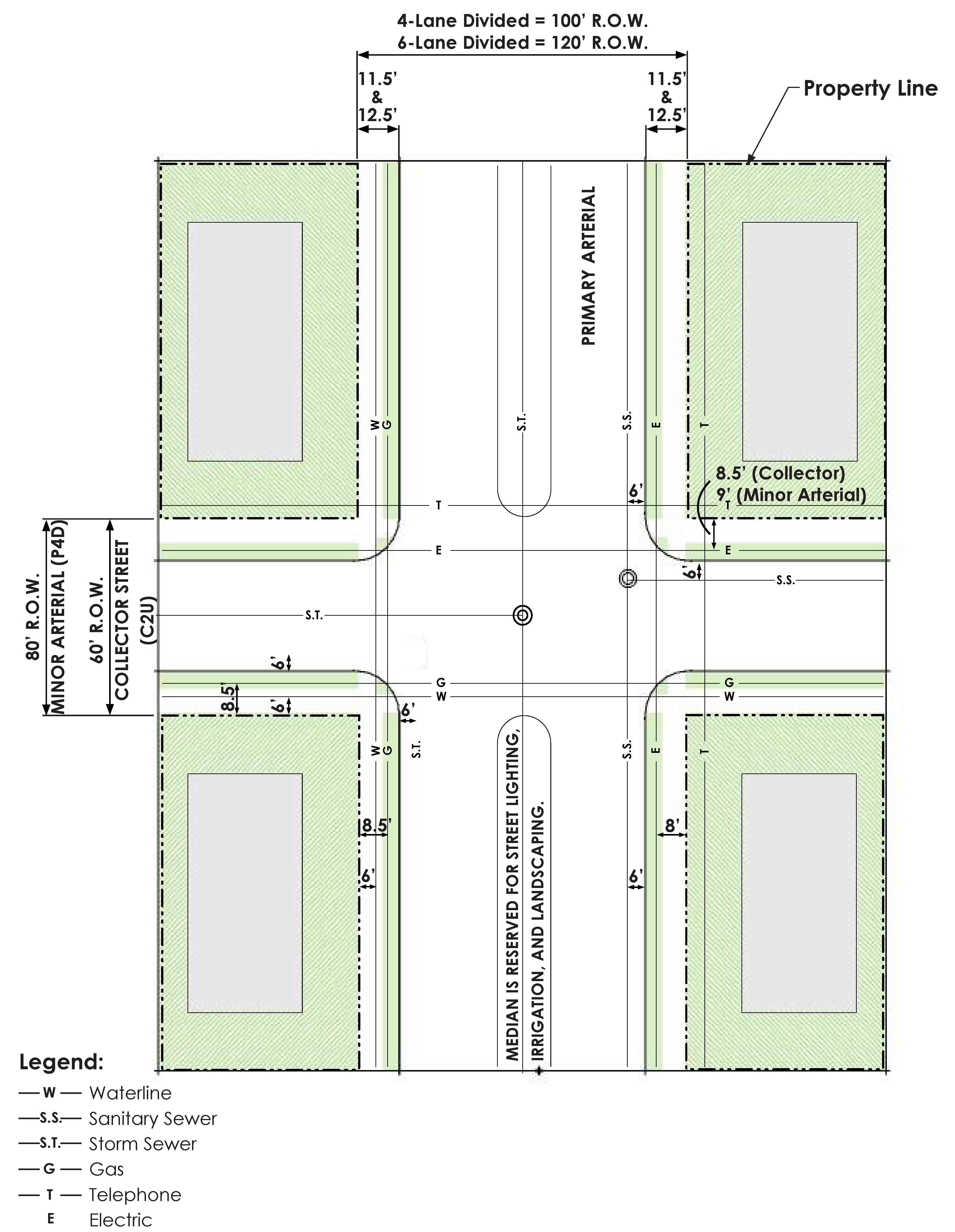
EXHIBIT IX.8.4-7 UTILITY LINE LOCATION IN EASEMENT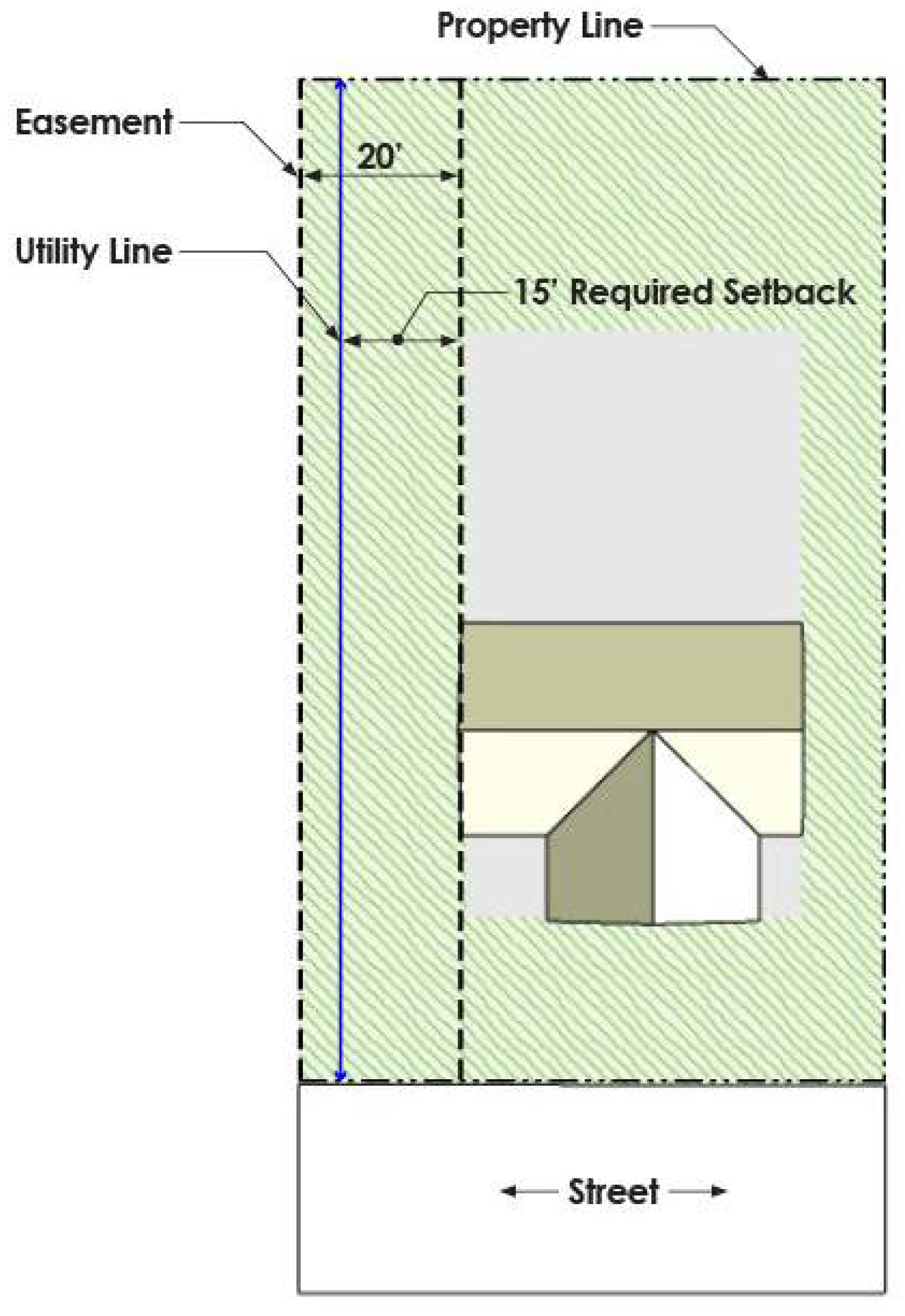
EXHIBIT IX.8.4-8 WATER LINE CROSSING AT INTERSECTION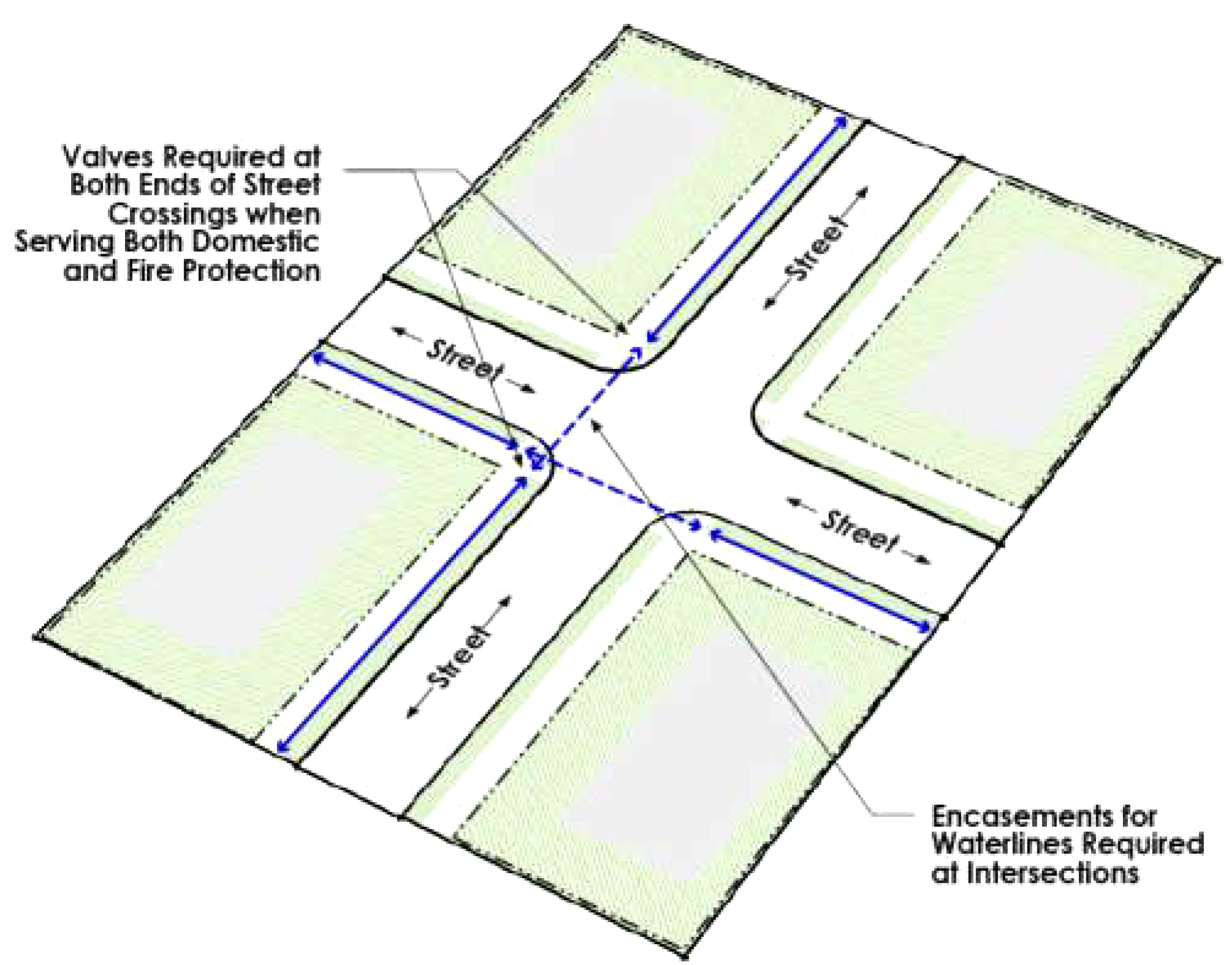
C.
Fire Protection - Water lines, fire hydrants and valves shall be sized and located to provide adequate fire protection in accordance with this Chapter, the currently adopted International Fire Code and as follows:
1.
Dead-end water lines shall terminate with a fire hydrant installed for maintenance purposes. These hydrants may only be used to meet the hydrant density with approval of the Fire Code Official.
2.
Valve and fire hydrant spacing shall comply with the currently adopted city fire code. Additional valves and hydrants may be required as determined by the Fire Code Official. The Fire Code Official may require the installation of additional isolation valves based on the configuration of the fire protection system for a particular development.
3.
See Subsection 6, below for backflow prevention requirements for fire service lines.
4.
Fire hydrants are required at all major intersections and at the end of cul-de-sac streets. Fire hydrants located on the opposite side of a four (4) lane or larger street shall not be used to meet hydrant coverage requirements. Hydrants shall be positioned to allow trucklays to follow normal traffic flow patterns to a property either by street or by fire lane.
5.
Fire hydrants shall be selected from a list of approved devices listed in the Standard Details, and meet the following minimum specifications:
a.
One (1) 4.5-inch pumper nozzle plus two (2) 2.5-inch hose nozzles with the City's standard threads;
b.
A main barrel valve opening of not less than five and one-quarter (5.25) inches;
c.
Six-inch gate valves on all fire hydrant leads;
d.
A valve at the main with flange-to-flange fittings;
e.
Be of a "break-away" design; and
f.
Be painted with two (2) primer coats of paint, with a silver final coat of approve aluminum paint on publicly maintained hydrants. For privately owned and maintained hydrants, a reflective white paint shall be used for the final coat.
D.
Service Lines - All service lines shall comply with the following requirements:
1.
Service lines shall be installed for each lot, and during construction a marker must be placed at the point of stub out for reference in advance of street paving, sidewalk construction or other street construction activities. After completion of street construction, a City-approved identification tag marked with a "W" must be affixed to the face of the curb or on pavement where there is no curb. Service lines shall be provided with a tap saddle and corporation stop at the main and an angle meter stop at the property line. See Exhibit IX.8.4-9 Service Line to Lot.
EXHIBIT IX.8.4-9 SERVICE LINE TO LOT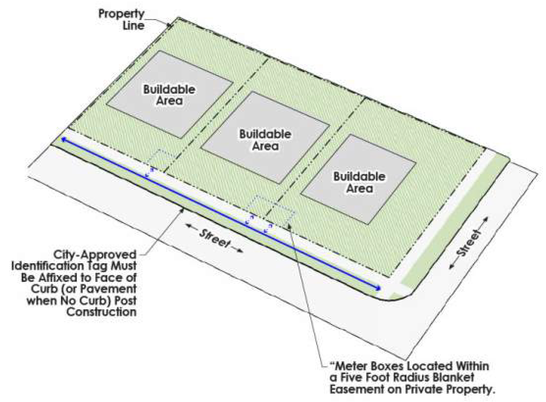
2.
Connections to existing water mains 12 inches or less in size are allowed. Connections to an existing water main larger than 12 inches are only allowed when no smaller water mains are reasonably available and when the proposed tapping method is approved by the City Engineer.
3.
Service connections are not permitted on transmission lines or fire hydrant leads unless approved by the City Engineer.
4.
Connections to an existing water main require a tee and valve. Connections with a tapping sleeve and valve will only be allowed if approved by the City Engineer. The maximum tap size is restricted to one standard pipe size smaller than the tapped pipe.
5.
Bullhead and manifold services are prohibited.
E.
Meters - Water meters shall comply with the following requirements:
1.
Each connection to service individual or multiple spaces or structures shall be metered by an approved device.
2.
Meters from three-quarter (¾) inch and up to and including two (2) inches in sizes shall be purchased through the City (see Volume 1 Chapter 2, Article VIII, Section 2-201 of the Code of Ordinances for fees). Meters larger than two (2) inches in size shall be approved by the Director of Public Services and purchased by the developer, builder, owner or applicant.
3.
Meter boxes shall be located within a five-foot (5') radius blanket easement on private property. Meter vaults for water meter larger than two (2) inches shall be a blanket water easement equal to the vault dimensions plus a five-foot (5') perimeter. See Exhibit IX.8.4-9 Service Line to Lot.
4.
All meters shall be dedicated to the City except devices classified as private and utilized for sub-metering.
5.
All temporary water service shall be metered by a city temporary meter, excluding the water necessary for flushing and disinfecting purposes, in accordance with the water and sewer regulations ordinance.
6.
Applicants for meter installations other than for municipal properties or street medians shall pay all required fees and costs, except that capital recovery fees shall not be required for fire protection lines.
7.
A single master meter is required for each multitenant structure.
8.
Only one (1) meter is permitted per service line.
F.
Backflow Prevention - Backflow prevention shall be accomplished as follows and in accordance with the City's backflow prevention ordinance and other applicable ordinances:
1.
Backflow devices shall be required on all commercial and private irrigation water connections. Requirements for backflow devices other than fire lines are governed by the backflow prevention ordinance.
2.
Approved double check detector check valves must be installed on all privately maintained fire lines. Required valves shall be installed in an underground vault located on private property adjacent to the property line or public easement, whichever is applicable, on the private side of the water service.
3.
If the double check detector check valves for a fire service line cannot be placed in a vault near the property line and the line serves only an automatic sprinkler system, the Fire Code Official may approve an Administrative Modification locating the double check detector check valve on the interior of a building in a fire control room. The length of the fire line as measured from the nearest edge of right-of-way or utility easement to the interior double check detector check valve shall not exceed 50 feet or as approve by the Fire Code Official.
4.
When an in-building backflow device is allowed a valve shall be installed on the water line at the property line to indicate the demarcation of public/private responsibility.
G.
Testing and Inspection - All new water lines shall be purged, disinfected and tested in accordance with the NCTCOG Public Works Standards Section 506.7. A passing result is required from the city lab before the new water line can be placed into service. All new water lines shall be pressure tested in accordance to NCTCOG Public Works Standards Section 506.
Section IX.8.5. - Sanitary Sewer Requirements
A.
Required Connections to Public Sanitary Sewer Lines - Where the property line of any lot or parcel of land on which a building is located is within 100 feet of a public sanitary sewer, the owner or occupants are required to connect to the sanitary sewer line and provide water closets as required by the Building Code. No new septic tanks may be installed and utilized except as approved by the City Engineer. Where an existing septic tank in proper working order exists, it may remain in use until such time as it may be found to be unsanitary. After the City gives notice, the property owner shall have ten (10) days to remove the septic tank and connect to the sanitary sewer line, as required by this Section.
B.
Industrial Pre-Treatment - Development with the potential to have tenants that may produce controlled waste as defined by the Industrial Water/Pretreatment and Pollution Control Ordinance may be required to install a Sanitary Sewer Access Device in accordance with Chapter 16.111 of the Code of Ordinances.
C.
Sanitary Sewer Line Categories - Sanitary sewer lines in the City are categorized as:
1.
Collection Lines - 12 inches and less in diameter.
2.
Trunk Lines - Larger than 15 inches in diameter.
D.
Sanitary Sewer Line Requirements - Sanitary sewer lines shall be sized, designed and installed in accordance with the following:
1.
Minimum pipe size shall be eight (8) inches in diameter for lines to be maintained by the City.
2.
All sanitary sewer line materials shall conform with the following:
a.
Green PVC ASTM D3034 (SDR-35) shall be used for pipes 15 Inches in diameter or less. PVC SDR-26 shall be used if the pipe is installed deeper than 11 feet.
b.
Green PVC ASTM F679 (T-1) shall be used for lines larger than 15 inches in diameter.
3.
Sanitary sewer lines shall be designed to not exceed a maximum depth of 12 feet measured from finished grade to the bottom of the pipe. Depths greater than 12 feet shall only be permitted when parallel lines to serve properties on both sides of a street are provided and with City Engineer approval.
E.
Manholes - Manholes shall comply with the following:
1.
Manholes are required at the following locations and must be spaced and sized in accordance with Exhibit IX.2.7-11, below:
a.
At all points of directional change, including the P.C. and P.T. on horizontal curves;
b.
At vertical points of intersection (vertical curves are not allowed unless approved by the City Engineer); and
c.
Where sanitary sewer lines terminate.
2.
Manholes can either be cast-in-place or pre-cast, as required by Exhibit IX.8.5-1.
3.
Manhole size criteria is determined based on depth/diameter/maximum allowable pipe connection/pipe size relationship, as outlined in Exhibit IX.8.5-1.
4.
Where drop manholes are proposed, the City Engineer shall approve the proper sizing for these installations. Drop manholes shall have external drops. An external drop connection designed in accordance with the City's standard details is required on all new connections to a manhole if the connection is more than 24 inches from the bottom of the manhole. An internal drop connection will only be allowed if approved by the City Engineer. Where internal drop connections are allowed, an extra foot shall be added to the manhole diameter.
F.
Sanitary Sewer Lines - Sanitary sewer line locations and installations shall comply with the following:
1.
All sanitary sewer lines shall be installed within rights-of-way or sanitary sewer easements. See Exhibits IX.8.4-4, IX.8.4-5 and IX.8.4-6.
2.
When installed within an easement which is adjacent to a building or other structure, the sanitary sewer line shall be installed at a distance away from the building of three-quarters (¾) of the easement width. See Exhibit IX.2.7-7.
3.
Sanitary sewer lines shall not be located in easements in the yard of any residential lot. Should a line exist in an easement prior to the rezoning or development of the property for residential use, the line shall either be relocated to rights-of-way at the developer's expense or the existing easement shall be dedicated to the City as right-of-way.
4.
Additional easements for sanitary sewer lines shall be dedicated along state-controlled highways, and any other route where the right-of-way is not sufficient to adequately provide for construction and maintenance.
5.
If a public sanitary sewer line is installed under pavement on a private property, the property owner shall be responsible for repairing the pavement and any private improvements removed or disturbed by repair or replacement of the line.
G.
Service Lines - All service lines shall comply with the following requirements:
1.
No sanitary sewer service line less than four (4) inches in diameter shall be connected to a City-maintained sanitary sewer main. Services of six (6) inches in diameter or larger shall connect only at manholes. A city-approved identification tag marked with an "S" must be affixed to the face of the curb or on pavement where there is no curb.
2.
Four-inch (4") connections shall be made by coring an existing manhole or tapping the existing sanitary sewer main in accordance with the City's standard details. Connections that are six (6) inches and larger shall be made by coring the existing manhole or by installing a new manhole if approved by the City Engineer. Any connection to an existing vitrified clay tile pipe shall only be allowed when authorized by the City Engineer.
3.
Service lines shall be stubbed out a minimum of eight (8) feet into all residential lots and end at a property line clean-out in accordance with the City's standard details.
4.
The elevation of all service lines shall be established to provide adequate service to each lot.
5.
Connections to an existing sanitary sewer main 12 inches in size and under are allowed. Connection to an existing sanitary sewer main larger than 12 inches will only be allowed when no smaller gravity lines are reasonably available and the proposed connection method is approved by the City Engineer.
H.
Lift Stations and Force Mains - All lift stations and force mains that serve new developments shall be privately owned and maintained to the point where the force main discharges into the public system. Only City Council can accept new public lift stations.
I.
Testing and Inspection - Before acceptance and placement into service, new sanitary sewer lines shall be tested and inspected as follows:
1.
All new sanitary sewer lines shall be air tested, mandrel tested and TV inspected in accordance with the NCTCOG Public Works Standards 507.5. Any issues discovered by testing must be resolved prior to city acceptance at the expense of the developer.
2.
TV inspection of all new sanitary sewer lines will be performed by the City 20 months from the date of acceptance of the development. Prior to the issuance of a permit for installation, the developer shall pay the appropriate fee in accordance with the City's Fee Schedule for this inspection. Any issues discovered by testing must be resolved by the developer's contractor before 24 months from the date of acceptance or the City will make a claim on the associated maintenance bond.
3.
All new sanitary sewer manholes shall be vacuum tested in accordance with the NCTCOG Public Works Standards 502.1.5.2. Any issues discovered by testing must be resolved prior to city acceptance at the expense of the developer.
Section IX.9.1. - General Provisions
Developers shall coordinate the provision of private utilities and services with the utility providers and with the City as part of the development process. Installation, maintenance and replacement of private utilities shall comply with this UDC and with Volume I, Chapter 13 of the Code of Ordinances.
Section IX.9.2. - Location
No private utility including above-ground pedestals and boxes, shall be installed or constructed closer than two (2) feet from the curb of any public street, private street meeting public street standards or from public alley or mews street pavement. See Exhibit IX.9.2-1.
EXHIBIT IX.9.2-1 LOCATION OF PRIVATE UTILITIES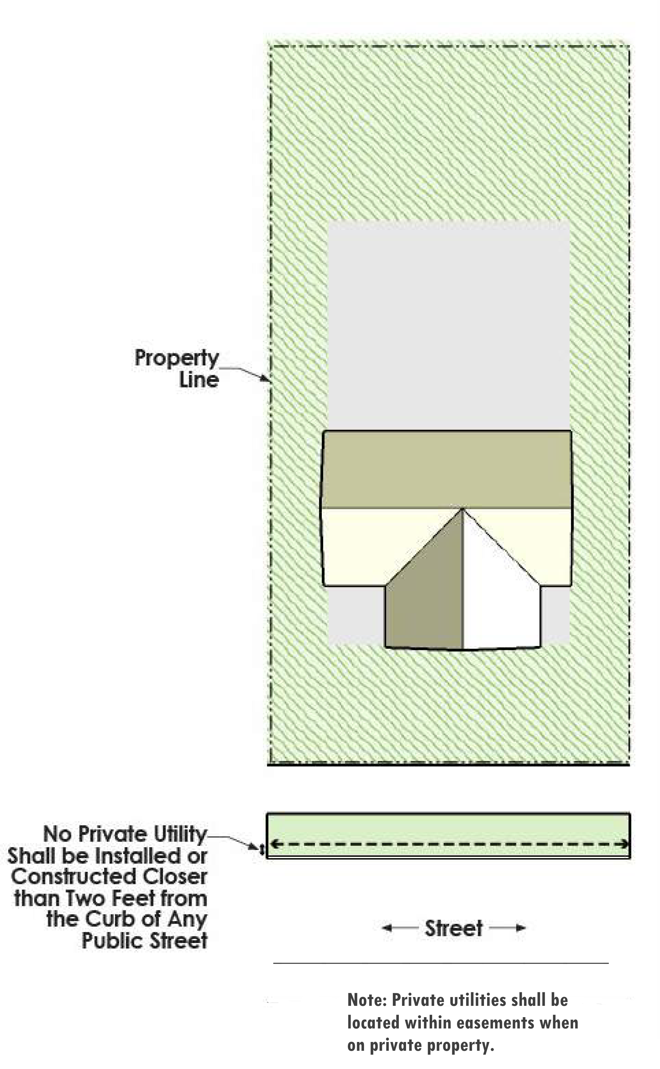
Section IX.9.3. - Easements
Private utilities shall be located within easements when on private property.
Section IX.9.4. - Requirements for Underground and Overhead Electrical Utilities
Electrical service shall be provided as follows:
A.
The developer is responsible for the cost of locating all new lines carrying 60 KV and less underground.
B.
Where overhead lines exist, they may remain and be upgraded, repaired, replaced and maintained as necessary.
C.
Electrical service to multi-family and non-residential properties from overhead lines shall be placed
Section IX.9.5. - Authority to Grant Easements
The City Manager shall have authority to grant an easement for private utility lines that are serving City-owned buildings, equipment or other appurtenances. Said easements can be approved by plat or by separate instrument filed with the appropriate county.
Section IX.10.1. - General provisions
Sufficient utility capacity, fire hydrants and other fire suppression installations shall be provided to ensure adequate fire protection for all proposed developments, in accordance with this UDC and with the currently adopted International Fire Code as amended.
Section IX.10.2. - Fire Hydrant Specifications
Each fire hydrants shall meet the following specifications:
A.
One (1) four and one-half-inch (4.5") pumper nozzle plus two (2) two and one-half-inch (2.5") hose nozzle with the City's standard threads;
B.
A main barrel valve opening of not less than five and one-quarter (5.25) inches;
C.
Six-inch gate valves on all fire hydrant leads;
D.
A valve at the main with flange to flange fittings;
E.
Be of a "break-away" design; and
F.
Two primer coats of paint, with a silver final coat of approved aluminum paint on publicly maintained hydrants. For privately owned and maintained hydrants, a reflective white paint shall be used for the final coat.
Section IX.11.1. - General Provisions
The developers of properties located in areas of the City potentially impacted by aircraft sound exposure shall provide an avigation release of liability as part of the subdivision process.
Section IX.11.2. - Where Required
The adopted map entitled "Aircraft Sound Exposure: Dallas/Fort Worth Regional Airport and Environs" (dated October 14, 1971), Exhibit IX.10.2-1, determines which areas are subject to the avigation release requirement. The developer of any property located within Zone "B" and Zone "C" as shown on this map shall execute an avigation release as part of the final plat process.
Section IX.11.3. - Form of Avigation Release
The avigation release shall be added to the final plat and filed with the county as required by Chapter III.5, of this UDC.
Section IX.12.1. - Improvements and Subdivision Improvement Agreements
A.
Completion of Improvements - Before the final plat is filed, all applicants shall be required to complete, in accordance with approved construction plans as required in Article III.4.4 and to the satisfaction of the City Engineer, all street, drainage and stormwater, public utilities and other public improvements necessary to serve the development. Necessary improvements include lot improvements such as grading, proper drainage, all franchise utilities, telecommunications infrastructure and erosion control on individual residential lots. The installation of public improvements may only be delayed as allowed by Subsection IX.12.1.B and Section IX.12.4 below.
B.
Subdivision Improvement Agreement Required - Subdivision improvement agreements shall be required for the following:
1.
Filing of Final Plat Prior to Installation of Public Improvements — To ensure the completion of public improvements, developers who wish to file a final plat before installation and acceptance of public improvements shall be required to provide surety in the form of cash escrow or a performance bond in an amount equal to 125 percent of the estimated cost of completion of the required public improvements. This option is available only for commercial and multi-family developments.
2.
Phased Developments-When development will be phased as indicated on the approved final plat, developers shall be required to enter into a subdivision improvement agreement and either construct all public improvements per phase or provide surety in the form of cash escrow of a performance bond for 125 percent of the estimated cost of the deferred improvements.
3.
Building Permit Issuance - A building permit may be issued prior to the construction of certain public improvements, such as sidewalks, driveway approaches, right-turn lanes, grading and drainage improvements and water and sanitary sewer service connections, only if approved by the City Engineer. If approved, the developer shall enter into a subdivision improvement agreement and provide surety in the form of cash escrow or a performance bond for 125 percent of the estimated cost of the public improvements
4.
Deferral of Public Improvements - Where improvements are deferred in accordance with Section IX.12.4 below, the developer shall be required to enter into a subdivision improvement agreement and provide surety in the form of cash escrow for 125 percent of the estimated cost of the deferred improvements.
5.
Oversize Reimbursement - Where the developer is requesting reimbursement from the City for oversize costs as provided in Section IX.12.6 below and in Volume I, Chapter 16 of the Code of Ordinances, the developer and the City shall enter into a subdivision improvement agreement.
C.
Administration of Subdivision Improvement Agreements - Subdivision improvement agreements shall be in a form approved by the City Attorney and City Engineer.
1.
Fees - The developer shall pay all required fees for review, approval and administration of agreements in accordance with the City's adopted fee schedule for review and approval of an agreement.
2.
Reduction in Surety - If cash escrow has been provided in accordance with Subsection B above, the developer may request a reduction in the escrow amount as public improvements are completed as required. A reduction may not be requested until it constitutes at least 50 percent of the escrow amount. Only one (2) reduction in surety may be requested before all public improvements are installed and accepted by the City. For phased developments, a reduction in the escrow amount may be requested as each phase is completed.
D.
Failure to Complete Improvements - In addition to all other remedies where a subdivision improvement agreement has been executed and surety has been posted, if public improvements have not been installed in accordance with the terms of the agreement, the City may:
1.
Declare the agreement to be in default and require that all the public improvements be installed regardless of the extent of completion of the development at the time the agreement is declared to be in default;
2.
Obtain funds under the surety provided and complete the improvements itself or through a third party; or
3.
Assign its right to receive funds under the surety to any third party, including a subsequent owner of the development, in exchange for the subsequent owner's agreement and posting of surety to compete the public improvement serving the tract.
Section IX.12.2. - Construction Procedures and Management
A.
The process for commencement of construction and management of construction of public improvements shall be in accordance with the following:
1.
Permit Required - The City will issue a permit for all public improvements to be constructed within rights-of-way and easements, after review and approval of construction plans. No work requiring a permit shall begin without a permit. Prior to issuance of a permit, the City shall:
a.
Collect construction inspection fees and any other applicable fees in accordance with the City's fee schedule:
b.
Confirm that a final plat (if required) has been approved for the project:
c.
Receive all necessary off-site easements or dedications required for City-maintained infrastructure and improvements and being conveyed to the City; and
d.
Confirm the receipt of all subdivision improvement agreements and any other required contract documents.
2.
Exception to Permit Requirement - A permit is not required for utility companies to make repairs and perform routine maintenance; however, the utility company shall notify the City prior to beginning work. This exemption does not apply to utility construction activities for new developments and relocations.
3.
Pre-Construction Meeting - Prior to commencement of construction, the contractor for each project or project phase shall notify the City of the intent to begin work and schedule a pre-construction meeting to review the project. All contractors involved in the project are required to attend the pre-construction meeting.
4.
Material Testing-The developer shall provide all material testing services required during the construction process for the proposed development and shall provide a copy of the test results to the City. The testing shall be performed by a geotechnical testing laboratory company under the supervision of a licensed professional engineer.
Section IX.12.3. - Inspection and Acceptance of Public Improvements
A.
Regular Inspections - The City shall make inspections of the land or premises during development and construction to ensure full compliance with all terms, conditions, and requirements of the approved construction plans. Acceptance of the public improvements shall not occur until all inspections are completed and the work has been deemed to be in compliance.
B.
Final Acceptance - Final acceptance is the formal approval of the City and shall be made in writing based on the finding that the improvements have been installed in a satisfactory manner and that all requirements have been met, including payment of fees, filing of the final plat, submission of record drawings and acquisition of maintenance bonds.
C.
Partial Acceptance and Conditional Acceptance - The City will not accept any part of a development prior to the completion and acceptance of the entire development unless the installation of public improvements has been deferred in accordance with Subsection 1.B. above and Section IX.12.4 of this Chapter. Conditional acceptance may be allowed if the City Engineer finds unusual conditions in effect and no adverse impacts on the City.
D.
Record Drawings - To receive final acceptance, the developer must submit a final set of record drawings including any revisions made during construction. Record drawings shall meet the requirements determined by the City Engineer.
E.
Maintenance Bond Required - Prior to final acceptance the developer shall provide a two-year maintenance bond covering 100 percent of all items of construction dedicated to the City. The City shall inspect the public improvements and notify the developer of any needed repairs or replacement. Repair and/or replacement shall be completed before expiration of the maintenance bond,
F.
Effect of Acceptance - Acceptance of the development shall mean that the developer has transferred all rights to all the public improvements to the City for use and maintenance. Approval or recordation of a final plat shall not constitute acceptance of any of the public improvements required to serve the subdivision or development. No public improvements shall be accepted for dedication except in accordance with this Section.
G.
Recordation of Final Plat - The final plat for the development shall be recorded with the county prior to final acceptance.
Section IX.12.4. - Deferral of Required Documents
A.
Petition to Defer - Upon petition of the developer, the City Engineer may, as an Administrative Modification, defer at the time of final approval of construction plans, the provision of any or all public improvements which are not required in the interests of public health, safety and general welfare. Specific conditions and time limits for the ultimate construction of the deferred public improvements may be imposed.
B.
Escrow Required - Whenever a petition to defer the construction of any public improvement required under these regulations is approved, the developer shall deposit in escrow his share of the costs, in accordance with Section IX.12.6 of this Chapter, of the future public improvements and enter into a subdivision improvement agreement as required by Section IX.12.1.B.
Section IX.12.5. - Issuance of Building Permits and Certificates of Occupancy
A.
Public Improvements Required - No building permit (except for temporary power permits associated with construction) shall be issued for any residential or commercial building until all public improvements are completed and accepted by the City, or a subdivision improvement agreement has been executed and surety provided as required in Section IX.12.1.B.
B.
Commercial and Multi-Family Development - For commercial and multi-family developments, required private improvements such as fire lanes, fire hydrants, sidewalks, drive approaches, as shown on an approved engineering site plan must also be constructed and accepted prior to issuance of building permits or a subdivision improvement agreement has been executed and surety provided. Construction above the slab requires that fire lanes, hydrants and other fire protection waterlines be in place and approved by the City.
C.
Simultaneous Construction - For commercial and multi-family development, simultaneous construction of public and private improvements shall be allowed only with approval by the City Engineer when only minor public improvements are remaining. Cash escrow or performance bond shall not be required. The City Engineer may also approve issuance of a foundation permit if the engineering site plan indicates the locations and elevations of water and sanitary sewer service in relation to the proposed finished floor elevation of the building.
D.
Residential Units - The City Engineer and Building Official may authorize the issuance of permits for residential units, including model homes, provided that a final plat has been approved and all public improvements have been completed for that portion of a development, including but not limited to fire protection and emergency access. No lot may be sold or title conveyed until a final plat has been recorded or Certificate of Occupancy issued until all public improvements are installed and accepted by the City.
Section IX.12.6. - Participation and Escrow Requirements
A.
City's Share of Improvement Costs - The City may participate in the costs of public improvements which are not for the primary benefit of the development and which have been oversized to serve developments other than for which a plat has been submitted for approval, only to the extent and according to the standards stated in this Section and in Chapter 16 of the Code of Ordinances. A Subdivision Improvement Agreement must also be executed in accordance with Section IX.12.1.B.5 of this Chapter.
B.
Developer's Responsibility
1.
Costs of Design and Installation - The developer shall be responsible for the entire costs of designing and installing all public improvements which primarily serve the subdivision or addition. Improvements required by these regulations, unless listed in Section IX.12.6.C below, shall be considered as primarily serving the subdivision or addition unless otherwise determined by the City.
2.
Oversized or Off-Site Public Improvements - The developer shall be responsible for the development's share of the costs of oversized or off-site public improvements needed to assure adequacy of public infrastructure and services, as required in Article IX.2.1 and subject to the participation and escrow policies contained in this Section and the oversized participation requirements in Chapter 16 of the Code of Ordinances.
3.
Extension of Off-Site Infrastructure - The developer shall be responsible for extending streets, sidewalks, water, sewer and/or drainage infrastructure and improvements off-site to the subject property.
4.
Pro-Rata Required - Should the subdivision or addition abut an existing water line, sanitary sewer line, railroad crossing or bridge installed by someone other than the City, the developer shall pay to the City a charge to be refunded to the original installer of the line or bridge, as prescribed by the pro-rata policies of the City and in accordance with Chapter 16 of the Code of Ordinances.
C.
Improvements Eligible for City Participation
1.
The City may participate in the cost of installing public improvements as follows:
a.
A portion of the costs of all water and sanitary sewer lines larger than 12 inches, subject to pro rata provisions and if shown on the water and sewer distribution master plans, and in accordance with the requirements of Chapter 16 - Utilities of the City's Code of Ordinances.
b.
Up to 50 percent of the cost of an upgraded storm sewer system as described in Article IX, Chapter 7, Section 6.A.1.
2.
Limitations and Exceptions - Notwithstanding Section IX.12.6.C.1 above, the City shall not participate in the following costs:
a.
Those portions of the costs of any public improvements not expressly described in Section IX.12.6.C.1 above.
b.
Costs of clearing and grubbing for streets and thoroughfares.
c.
Costs of constructing streets built wider than designated in the Thoroughfare Plan.
d.
Costs of lights, decorative finishes or other similar expenses, unless require by the City Engineer.
e.
Costs of underground box culverts not required by the City.
f.
Costs of pipe or box culvert, headwalls, regardless of size, or the costs of retention/detention ponds or slope protection, except rip-rap under a bridge.
g.
Costs of detours, pavement transitions and crossovers.
h.
Costs of relocating or adjusting private utility company improvements or infrastructure.
3.
Procedures for City Participation
a.
The City Engineer shall determine the City's participation in the cost of public improvements, in accordance with the criteria in Section IX.12.6.C above and with Chapter 16 of the Code of Ordinances. Reimbursement funds for the City's share of the public infrastructure improvements shall be as scheduled in the City's capital improvements program, subject to available funding.
b.
To qualify for repayment, the oversized public improvements must be installed and accepted by the City and the final plat associated with the development must be recorded.
c.
A request for repayment must include record drawings showing the reimbursable items, letter of acceptance of public improvements by the City, maintenance bonds, a copy of the contractor's bid for construction, final payment with quantities and unit costs, oversize calculations for all reimbursement items and a project location map.
C.
Escrow Requirements
1.
Deposit with the City - Whenever the City agrees to accept escrow deposits in lieu of construction by the developer under these regulations, the developer shall deposit an amount equal to his share of the costs of design and construction in escrow with the City. Escrow payments shall be paid prior to the release of construction plans by the City Engineer.
2.
Fee Required - An administrative fee shall be required for escrow payments in accordance with Volume 1, Chapter 2.VIII.2-201 of the Code of Ordinances.
3.
Termination of Escrow - Escrows which have been placed with the City and which have been held for a period of ten (10) years from the date of the payment or agreement, in the event that the City has not authorized the preparation of plans and specifications for construction of the improvements or infrastructure for which escrow was provided, shall upon written request be returned to the developer with accrued interest. Such return does not remove any obligations of the developer or property owner for construction of the required infrastructure or improvements if a building permit has not been issued for the subject property or if a new building permit application is made.
Section X.1.1. - Purpose
This Chapter sets forth the requirements for the imposition of land dedication requirements or a fee-in-lieu of dedication to provide parks, trails and other necessary recreational and open space to serve residents of the City. This Chapter is intended to further the goals of the Park Master Plan and the Trails Master Plan to provide sufficient and appropriate parks and recreational opportunities and to support the City's adopted goal of a minimum ten-minute walk to a park for every resident and to ensure a minimum level of access and improvements for parks and trails through the land development process.
A.
A park fee is imposed on residential development to assure that park and related improvements and infrastructure, including trails, are available and adequate to meet the needs created by such development while maintaining current and proposed park and recreation standards in accordance with the adopted Healthy Infrastructure Plan, Park Master Plan and Trails Master Plan. The park fee consists of a parkland dedication requirement and a park development fee. The park fee shall be imposed by the City on all residential development, and all funds collected shall be used solely and exclusively for the purpose of acquisition and development of parks and related infrastructure and improvements necessitated by and serving such development.
B.
If a park fee (including parkland dedication or cash-in-lieu of parkland dedication) has been paid prior to the adoption of this Chapter that park fee (including parkland dedication or cash-in-lieu of parkland dedication) shall be controlled by the provisions of the ordinance in effect at the time such obligation arose.
Section X.1.2. - Applicability
These regulations shall be uniformly applicable to residential development of property in the City which is or will be served by parks.
A.
Exemptions - This Chapter does not apply to activities involving:
1.
The replacement, reconstruction, remodeling, rehabilitation or other improvements to an existing building;
2.
The rebuilding of a damaged building;
3.
To permits required for accessory uses; and
4.
The addition of a backyard cottage, as regulated by Article VII.3.1 of this UDC.
B.
Where properties are redeveloped, the park fee is only assessed on the additional number of residential units.
C.
For purposes of this Chapter, property is "served by" parks when funds collected for such improvements and infrastructure have been spent as identified in the Park Master Plan or Trails Master Plan within ten (10) years from the date of collection.
Section X.1.3. - Authority
A.
The park fee requirements are based on the adopted Park Master Plan and Trails Master Plan for the entire City, which identifies the parks and related improvements which are to be acquired through parkland dedication requirements or financed in whole or in part through the imposition of park fees. Park fees may only be spent for parks and related improvements identified in such plans.
B.
Imposition of a park fee does not alter, negate, supersede or otherwise affect any other requirements of City, county, state or federal legislation or regulations that may be applicable to a development, including city zoning and/or land development regulations.
C.
The provisions of this Chapter shall not be construed to limit the power of the City to utilize other methods authorized under state law or pursuant to other City powers to accomplish the purposes set forth herein, either in substitution or in conjunction with this Chapter. Guidelines may be developed by resolution or ordinance to implement and administer this Chapter.
Section X.1.4. - Parkland Dedication and Improvement and Park Fee Requirements
A.
Parkland Dedication Requirement
1.
For residential and mixed-use development, the parkland dedication requirement shall be determined by a ratio of three (3) acres for each 100 dwelling units. For calculation of developments with less than 100 dwelling units, each dwelling unit shall equal 0.03 acres. (Example: 25 dwelling unit development will require three-quarter (0.75) acres).
a.
Jurisdictional wetlands and property in established floodplains may be used to satisfy up to one-half (½) of the parkland dedication requirement.
b.
All plats shall show the area proposed to be dedicated under this Section. The property must be reviewed and accepted by the Director of Parks and Recreation. If the area proposed for dedication is not consistent with the goals established in the Parks Master Plan or the Trails Master Plan, the City may require a cash-in-lieu of parkland dedication. Specified park sites and trails shall be dedicated to the City after completion and acceptance of improvements made by the developer and filing of the approved final plat.
2.
Cash-in-Lieu of Parkland Dedication
a.
The City may require cash-in-lieu of parkland dedication. Such payment in lieu of land shall be made prior to final plat approval or engineering site plan for multifamily and mixed-use development where a plat is not required. The payment shall be proportional to the amount of land required to be dedicated and shall use the fair market value of the land at the time of construction of the development.
The amount of the cash-in-lieu of parkland dedication shall be based on the following formula:
(A × V) = M
A = the area of land required for dedication as determined in Subsection X.1.4.A.1 above.
V = the fair market value (per acre) of the property as established by a land appraisal conducted by a third party.
M = the number of dollars to be paid in lieu of the parkland dedication requirement.
b.
The Director of Parks and Recreation shall be responsible for verifying the amount due.
c.
A combination of parkland dedication and cash-in-lieu of parkland dedication can be utilized to meet the parkland dedication requirement.
3.
Minimum Park Improvements—Unless waived by the Director of Parks and Recreation and the City Engineer, parks and trails shall be improved by the developer prior to acceptance by the City. The minimum park and trail improvements shall include:
a.
Grading and clearance of unwanted vegetation.
b.
Installation of drainage and erosion controls.
c.
Establishment of turf and planting of trees.
d.
Installation of perimeter streets and streetlights.
e.
Provision of water and sewer service; and
f.
When required, the installation of trails in accordance with the design standards in the Parks Master Plan and Trails Master Plan.
4.
Additional Improvements - The developer may request to construct additional park improvements above the minimum improvements above if in conformance with the design criteria and objectives of the Healthy Infrastructure Plan, Park Master Plan and Trails Master Plan. Additional improvements may be denied by the Director of Parks and Recreation and the City Engineer if they would impose an unreasonable maintenance responsibility on the City or are judged to be premature based on service demand.
5.
Park Plan and Development Agreement - If the developer desires to add additional improvements outlined in Section X.1.4 above a park plan shall be submitted as part of the engineering site plan. The plan shall include all proposed improvements with cost estimates. Prior to improving the site, the developer and the City shall execute a subdivision improvement agreement which details construction schedules, costs, performance surety and the amount to be reimbursed and a schedule for reimbursement.
B.
Park Development Fee
1.
The amount of the park development fee shall be based on the following formula:
(R × DU) = F
R = the park development fee rate found in Volume 1, Chapter 2.VIII.201 of the Code of Ordinances.
DU = the total number of dwelling units in the residential development.
F = the number of dollars to be paid.
2.
Credit against Park Development Fee - The developer's cost to provide certain park improvements in addition to the minimum improvements required in Subsection A.3 above may qualify for reimbursement of part or all of the required park development fee. The following improvements in a park may be counted towards the park development fee reimbursement:
a.
Landscaping
b.
Park improvements as required for each park as determined by the Director of Parks and Recreation, including but not limited to:
1)
Multi-use paths and trails
2)
Playgrounds and play structures
3)
Accessory structures
4)
Seating
5)
Signage
6)
Lighting
Section X.1.5. - Processing and Collection
Applicants for a residential development must submit an engineering site plan or a plat for review and approval in accordance with the requirements of this UDC.
A.
The parkland dedication requirement (or cash-in-lieu of parkland dedication) and park development fee shall be imposed on all residential development in the City at the time of approval of an engineering site plan or filing a final plat pursuant to the land development regulations, and all amounts due shall be paid prior to final plat or engineering site plan approval.
B.
The parkland dedication requirement for each residential development shall contain a clear, fee simple dedication of an area of land within the development to the City for parks.
C.
Upon receipt of an engineering site plan, preliminary plat or final plat the City shall calculate the amount of the park development fee and the amount of cash-in-lieu of parkland dedication (when applicable) due pursuant to Section X.1.4 above.
D.
If fewer dwelling units are constructed than planned by the final plat or site plan, the property owner may apply for a refund for the difference in the number of dwelling units pursuant to Section X.1.7 below.
Section X.1.6. - Use of Funds
A.
Cash-in-lieu of parkland dedication and park development fees collected must be used solely for one (1) of the following purposes:
1.
To acquire and develop parks, in accordance with the Park Master Plan and Trails Master Plan, subject to the provisions herein;
2.
To reimburse the City for prior acquisition and development of such parks, which will benefit the new residential development inhabitants; or
3.
To make refunds in accordance with Section X.1.7.
B.
Cash-in-lieu of development fees collected shall not be used to maintain or operate the existing park system or to finance park and recreational activities other than park and trail improvements.
C.
Nothing in this Chapter shall prevent the City from issuing and utilizing general obligation bonds, revenue bonds, revenue certificates or other certificates of indebtedness as are within the authority of the City in such manner and subject to such limitations as may be provided by law in furtherance of the financing and provision of park infrastructure and improvements as set forth in the Park Master Plan. Cash-in-lieu of parkland dedication and park development fees paid pursuant to this Chapter, however, shall be used for park and trail land acquisition and development.
D.
Interest earned on cash-in-lieu of parkland dedication and park development fees shall be used solely for the purposes specified herein.
E.
The City shall establish adequate financial and accounting controls to ensure that cash-in-lieu of parkland dedication and park development fees disbursed are utilized solely for the purposes and intent of this Chapter; provided, however, that such funds shall be expended within a reasonable period of time, not to exceed ten (10) years from the date the funds are collected.
F.
The City shall maintain and keep financial records for the cash-in-lieu of parkland dedication and park development fees which shall show the source and disbursement of all funds collected.
Section X.1.7. - Refunds
A.
The current owner of property on which a cash-in-lieu of parkland dedication payment and park development fee has been paid may apply for a refund of such funds if:
1.
The property on which the funds have been paid has not been served by parks, as provided in Section X.1.2 above; or
2.
Fewer dwelling units are constructed than planned by the final plat or engineering site plan.
B.
Only the current owner of the property may petition for a refund. A petition for refund shall be filed within one (1) year of the event giving rise to the right to claim a refund, or the refund will not be granted.
C.
The petition for refund must be submitted to the Director of Parks and Recreation on a form provided by the City for such purpose. The petition must contain the following: a certified copy of the latest recorded deed for the property; a current legal description; and a statement of the reasons for which a refund is sought.
D.
A refund shall be due under Subsection X.1.7.A.1 only if the Director of Parks and Recreation determines that the total funds collected for which a refund is being sought exceeds the total expenditures for park facility purposes allowed by this Chapter for the same period ("excess amount"). The refund amount shall be the development's pro rata share of the excess of funds collected over expenditures, together with interest earned on such amount for the period. The City may periodically compute the difference between expenditures and funds collected for purposes of reviewing refund requests under this subsection. The City Council may, after notice by publication in the section of a local newspaper reserved for legal notices, and after a public hearing, vote to apply any unclaimed excess amounts to the remaining park improvements. When the City Council votes to apply the excess amounts, the right to refund of the applied excess amounts shall be extinguished.
E.
Within one (1) month of the date of receipt of a petition for refund, the Director of Parks and Recreation must provide the petitioner, in writing, with a decision on the refund request. The decision must include the reasons for the decision. If a refund is due to the petitioner, the Director of Parks and Recreation shall notify the City's finance department and request that a refund payment be made to petitioner.
F.
The petitioner may appeal the determination of the Director of Parks and Recreation to the City Council, and its decision shall be final.
Section X.1.8. - Procedures for Updating the Parkland Dedication Requirement and Park Fee
A.
At least every five (5) years, the Director of Parks and Recreation shall prepare a report to the City Council on the parkland dedication and park fee program. In the preparation of such report, the following information shall be reviewed:
1.
A statement summarizing the parkland dedication requirements and the cash-in-lieu of parkland dedication requirements and park development fees collected and disbursed since the previous report;
2.
A statement summarizing park acquisition and development and the status thereof since the previous report;
3.
A statement summarizing the administration and enforcement of the parkland dedication and park fee program; and
4.
A statement and recommendation from the park board on all aspects of the parkland dedication and park fee program and city park needs.
B.
The report shall make recommendations, if appropriate, on amendments to this Chapter, changes in the administration or enforcement, changes in the parkland dedication requirements, cash-in-lieu of parkland dedication and park development fee rates, and changes in the Park Master Plan and the Trails Master Plan.
C.
Based upon the report and such other factors as the City Council deems relevant and applicable, the City Council may amend the park fee. If the City Council fails to take action, the park fee then in effect shall remain in effect. Nothing herein precludes the City Council or limits its discretion to amend the park fee at such other times as may be deemed necessary.
Section X.1.9. - Appeals
A.
The property owner or applicant may appeal the following decisions of the Director of Parks and Recreation to the City Council:
1.
The applicability of the parkland dedication and park fee program;
2.
The amount of the dedication or park fee due; or
3.
The amount of refund due, if any.
B.
The burden of proof is on the property owner or applicant to demonstrate that the amount or applicability of the dedication, fee or refund, was not calculated according to the applicable schedule of dedication or fees or the guidelines established for determining such amounts. The property owner or applicant must file a notice of appeal with the City Secretary within 30 days following the determination by the Director of Parks and Recreation. The filing of an appeal shall stay the matter until final determination by the City Council.
C.
The City Council may approve an appeal from any requirements of this Chapter, upon written request by a property owner or applicant, only upon a finding that a strict application of such requirement would result in a substantial hardship which is not common to similarly situated property owners.
Section X.1.10. - Parkland Dedication and Park Fee as Additional and Supplemental Requirement
A.
The parkland dedication requirements and park fee is additional and supplemental to and not in substitution of any other requirements imposed by the City on the development of the land. It is intended to be consistent with and to further the objectives and policies of the Park Master Plan, the Trails Master Plan and the comprehensive plan and to be coordinated with other city policies, ordinances and resolutions by which the City seeks to ensure the provision of adequate park access, land and improvements in conjunction with the development of land. In no event shall a property owner be obligated to dedicate land or pay for park improvements in an amount in excess of the amount calculated pursuant to this division; but provided that a property owner may be required, pursuant to city zoning and land development regulations, to provide open lands, setbacks, buffers and other non-buildable area on-site in addition to meeting the park fee requirements.