
Mauldin City Zoning Code
ARTICLE 5
- ZONING DISTRICT REGULATIONS
Sec. 5:1 - General Regulations for all Residential Districts.
5:1.1 Utilities.
It shall be unlawful to construct or occupy any residential dwelling that is not connected to an approved water supply and sewerage disposal facility. Wherever public or community water and sewerage systems are available, dwellings shall be connected to such systems. In every other case, individual water supply and sewerage disposal facilities must meet the requirements set by the Greenville County Health Department.
5:1.2 Utilities—Lots of Record.
Area requirements for individual lots in all districts are minimum requirements with an approved water and sewerage disposal system accessible to the lot. If a lot of record with less than the minimum area is proposed for use and does not have an approved water and sewerage system available, a certificate from the Greenville County Board of Health approving the proposed facility must accompany a request for a zoning certificate.
5:1.3 Reserved.
5.1.4 Landscaping, Buffering and Screening Standards.
Landscaping and/or buffering shall be provided as required in Section 6:2 of this Ordinance.
5.1.5 Lighting Standards.
Exterior Lighting shall be provided as required in Section 6:3 of this Ordinance.
5:1.6 Parking and Loading Standards.
Unless otherwise stipulated, parking shall not be permitted in the front setback for any non-residential use(s) located in a residential district. Off-street parking and loading shall be provided as required by Section 6:1 of this Ordinance.
5:1.7 Zoning Review and Permitting.
All new construction, building additions, and accessory structures shall require a zoning permit and shall be provided in accordance with Section 4:1.1.3 of this Ordinance.
(Ord. No. 786, amd. 3, 3-16-2015; Ord. No. 805, § 1, 5-16-2016; Ord. No. 836, amd. 3, 11-20-2017; Ord. No. 970, § 3, 4-19-2021)
Sec. 5:2 - Residential Districts: R-20, R-15, and R-12.
These low density residential districts are established as areas in which the principal use of land is for single-family dwellings and for related recreational, religious, and educational facilities normally required to provide an orderly and attractive residential area. The standards are intended to protect the districts residential character while promoting a suitable environment for single-family living.
5:2.1 Uses Allowed.
See the Table of Allowed Uses provided in Article 7.
5:2.2 Reserved.
5:2.3 Reserved.
5:2.4 Dimensional Standards Table.
(Ord. No. 786, amd. 4, 3-16-2015; Ord. No. 917, § 2, 9-16-2019; Ord. No. 970, § 3, 4-19-2021)
Editor's note— Ord. No. 786, amd. 4, adopted March 16, 2015, changed the title of § 5:2 from "R-20, R-15, R-12, and R-10 Residential Districts" to read as herein set out.
Sec. 5:3 - Residential Districts: R-10, R-8, and R-6.
These medium density residential districts are intended to provide (primarily) single family living and also encourage diverse functioning neighborhoods that may include various types of residential development, and limited nonresidential uses normally required to provide the basic elements of a balanced and attractive residential area.
5:3.1 Uses Allowed.
See the Table of Allowed Uses provided in Article 7.
5:3.2 Reserved.
5:3.3 Reserved.
5.3.4 Development Standards Table
(Ord. No. 786, amd. 4, 3-16-2015; Ord. No. 917, § 1, 9-16-2019; Ord. No. 970, § 3, 4-19-2021)
Editor's note— Ord. No. 786, amd. 4, adopted March 16, 2015, changed the title of § 5:3 from "R-M1, Mixed Residential Districts" to read as herein set out.
Sec. 5:4 - Residential District: R-M1, Mixed Residential District.
This residential district is established to provide for medium residential density. The principal use of land is for detached and attached single-family residential dwellings and recreational, religious, and educational facilities normally associated with residential development.
5:4.1 Uses Allowed.
See the Table of Allowed Uses provided in Article 7.
5:4.2 Reserved.
5:4.3 Reserved.
5.4.4 Development Standards Table.
(Ord. No. 786, amd. 4, 3-16-2015; Ord. No. 917, § 1, 9-16-2019; Ord. No. 970, § 3, 4-19-2021)
Editor's note— Ord. No. 786, amd. 4, adopted March 16, 2015, changed the title of § 5:4 from "R-M, Residential, Multifamily District" to read as herein set out.
Sec. 5:5 - Residential: Multi-Family District (RM).
This residential district is established to provide a full range of medium to high density multi-family housing types along with single-family detached and attached residences population density. Other uses include recreational, religious, and educational facilities normally required to provide an orderly and attractive residential area. This district is also intended to provide a transitional area between single-family districts and commercial districts where certain land uses may not be compatible.
5:5.1 Uses Allowed.
See the Table of Allowed Uses provided in Article 7.
5:5.2 Reserved.
5:5.3 Reserved.
5:5.4 Development Standards Table.
(Ord. No. 786, amds. 4, 13, 14, 3-16-2015; Ord. No. 917, § 1, 9-16-2019; Ord. No. 970, § 3, 4-19-2021)
Sec. 5:6 - CRD, Central Redevelopment District.
The intent of this district is to encourage the re-development of the central core of the city in such a way as to create an identifiable and pedestrian friendly downtown, and to create a district where individuals can live, dine, shop, and work.
5:6.1 Uses Allowed.
See the Table of Allowed Uses provided in Article 7.
5:6.2 Reserved.
5:6.3 Reserved.
5:6.4 Dimensional Requirements.
A.
Height. No structure shall exceed a height of fifty-five (55) feet unless a height bonus is achieved per Section 3:8.1, Building Height Bonuses. New principal structures must be a minimum height of two (2) habitable stories. As an alternative, new one-story principal structures may be permitted only if the height of the building is at least eighteen (18) feet and the building includes a band of clerestory windows at least thirty (30) inches tall. Clerestory windows shall occupy at least sixty-five (65) percent of the length of each façade visible from a public right-of-way or public open space. Clerestory windows shall not count toward the minimum requirement for public entryways and windows for ground floors.
B.
Setbacks.
1.
Front and Corner Setbacks. Principal structures shall be built to the front property line and shall not be set back more than fifteen (15) feet from the front property line, except to accommodate for a plaza, forecourt or outdoor dining area.
Where used, forecourts and plazas shall have a minimum width of fifteen (15) feet and a minimum depth of ten (10) feet. Forecourts and plazas should be substantially paved and enhanced with landscaping.
2.
Side and Rear Setbacks. No minimum side and rear setbacks shall apply, except on lots adjacent to residential districts, for which the principal structure(s) shall be set back at least ten (10) feet from the property line share with the residential district.
3.
Accessory structures. All accessory structures shall be located entirely in a side or rear yard and located behind the building line of the principle structure. Accessory structures shall be screened (as applicable) in accordance with Section 6:2.9, Additional Screening Requirements: Outdoor Storage Areas, Utility Structures, and Dumpsters.
4.
Outside merchandise. All outside merchandise for sale and/or on display shall be set back a minimum of fifteen (15) feet from street right-of-way line. When pedestrian oriented design features are incorporated into the building and site design, the Business and Development Services Director may approve alternate locations for display of outdoor merchandise.
5:6.5 Screening.
Mechanical equipment, electrical meter and service components, and similar utility devices, whether ground level, wall-mounted, or roof-mounted, should be located so as to minimize visibility from all streets and public gathering areas. Mechanical equipment and other like appurtenances shall be screened from view at the front property line and any active street side. Exterior screening materials shall be the same as the predominant exterior materials of the principal building.
Screening shall be provided in accordance with Section 6:2.9, Additional Screening Requirements: Outdoor Storage Areas, Utility Structures, and Dumpsters.
5:6.6 Off-Street Parking and Parking Structures.
A.
Off-Street Parking. Off-street parking shall be provided in accordance with the provisions set forth in Section 6:1, Off-Street Parking Requirements.
1.
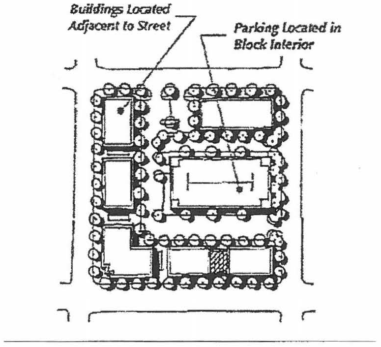
Location. In order to minimize the negative impact of large paved surfaces and maintain the quality of the visual environment, new surface parking lots and parking structures should located in the block interior, side and rear yards and not be located between the building and any abutting street.
2.
Landscaping. In addition, new surface parking lots shall be landscaped in accordance with Section 6:2, Landscape and Design Standards.
a)
Parking lots installed in the side yard shall also provide the following:
1.
Continuous landscape screen, consisting of an evergreen or deciduous hedge, shall be provided along the entire street frontage adjacent to the parking area. Hedges shall be planted in a minimum five-foot wide continuous landscape zone.
2.
Solid masonry wall, at least thirty-six (36) inches tall, can be substituted for hedge to screen parking areas. Materials must match the site's exterior building materials. Where such walls replace hedges, the five-foot landscape zone should be maintained.
3.
Driveway. In order to create a safe environment for both vehicles and pedestrians, the width of the driveway shall not exceed twenty-seven (27) feet throughout the right-of-way and the required street yard buffer, except for driveways at facilities for emergency response vehicles.
B.
Parking Structures. Parking structures shall be compatible in color, form, materials, texture and quality with adjacent buildings. Structures should be setback a minimum of six (6) to ten (10) feet from the sidewalk. This setback shall be landscaped with trees, shrubs, and ground covers to soften views of the structure, provide visual interest and establish a sense of human scale. Vehicular entries shall be clearly marked.
Parking structures shall provide adequate ground floor dimensions to allow use by or conversion to pedestrian-active uses. Adequate dimensions shall include floor-to-floor heights, structural, driving aisle and utility layouts within thirty (30) feet of the public right-of-way designed to accommodate occupancy by pedestrian-active uses.
Parking structures fronting on key pedestrian streets shall only be permitted when the structure's façade provides a compatible streetscape frontage and is concealed with an active habitable space. Parked automobiles, signage, and light sources within the interior of the structure shall not be visible from outside the structure.
Façade openings which face any public right-of-way or open space shall be vertically and horizontally aligned and the floor fronting on such façades shall be level.
Exposed parking structures that are not wrapped with an active use shall provide landscape screening at a rate of one (1) tree and two (2) shrubs per thirty (30) linear feet of the parking structure's perimeter.
5:6.7 Service and Off-Street Loading Areas.
Service and loading areas should be located to minimize their visibility from public streets. Refuse containers and actively used service and loading areas must be screened from view by the buildings they serve or by solid masonry walls which are designed as an integral part of the building, and finished with compatible materials.
Off-street loading and screening of service areas shall be provided in accordance with the provisions set forth in subsection 6:1.1.4, Off-street Loading Requirements and the screening requirements of Section 6:2.9, Additional Screening Requirements: Outdoor Storage Areas, Utility Structures, and Dumpster.
5:6.8 Drainage.
A complete drainage plan of the entire site shall be submitted meeting the requirements prescribed in the Mauldin City Drainage Ordinance shall be provided.
5:6.9 Streetscape and Landscaping.
Landscaping shall generally be provided in accordance with the provisions set forth in Section 6:2, Landscape and Design Standards, except that large maturing deciduous street trees shall be provided along all public streets, spaced at thirty-foot maximum intervals.
Street trees may be planted in a continuous planting strip of not less than seven (7) feet in width, in-ground planters, or may be located in tree grates, bulb outs (etc.) as part of a coordinated streetscape design.
5:6.10 Accessory Dwellings.
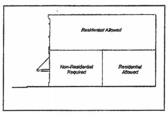
Accessory dwelling units are generally permitted in the CRD district. However, accessory dwelling units shall be prohibited on the ground floor adjacent to the right-of-way. Additionally, no more than forty-nine (49) percent of the entire ground floor area of a building may be occupied by a residential use.
5:6.11 Signage.
Signage shall be permitted in accordance with Section 6:4, Signs.
5:6.12 Outside Display or Storage.
A.
Outdoor Display of Goods and Products. The outdoor display of goods and products is permitted within the public right-of-way when accompanying a shop or store located in an adjacent building. At least six (6) feet of continual sidewalk clearance shall be maintained to provide for adequate pedestrian circulation. Outdoor displays shall also stay clear of display windows and entryways of adjacent businesses. Merchandise must be moved indoors at the close of each business day.
B.
Outdoor Display or Storage Not Permitted. Outdoor display of products does not include merchandise or material in boxes, crates, or pallets or other kind of shipping containers. No other outside display of merchandise, or storage of any non-fixed equipment or merchandise is permitted.
5:6.13 Outdoor Fencing.
Fencing shall be confined to the side and rear yards of the site and not located closer to the street than the leading edge of the principle structure. Fencing which is visible from a public right-of-way shall be strictly of an ornamental nature (e.g., wrought iron or picket fence).
5:6.14 Outdoor Dining.
Outdoor dining is permitted within the public right-of-way when accompanying a restaurant located in an adjacent building. At least six (6) feet of continual clearance shall be maintained to provide for adequate pedestrian circulation and to maintain accessibility. Dining furnishings shall also stay clear of display windows and entryways of adjacent businesses.
Tables and chairs used in outdoor dining areas shall be constructed of heavyweight, high-quality materials like metal or wood. Lightweight materials such as plastic or vinyl which may be blown astray by moderate winds are prohibited.
The outdoor dining area shall be maintained in a clean and safe condition at all times, including promptly and properly disposing of all trash generated by the operation.
No additional parking spaces shall be required for outdoor dining areas.
5:6.15 Pedestrian Design: Sidewalks.
A public sidewalk shall be required within the right-of-way along all adjacent streets. The sidewalk shall be constructed of concrete, unless otherwise approved by the Mauldin Public Works Director. The width of the sidewalk shall not be less than ten (10) feet along City-maintained rights-of-way and not less than six (6) feet along other rights-of-way. The thickness of the sidewalk shall not be less than four (4) inches. The sidewalk shall not exceed the maximum grade required by the Standard Building Code in accordance with the Americans with Disabilities Act. Sidewalks shall align vertically and horizontally with abutting sidewalks.
Shelter, shade, and/or weather protection in the form of shade trees, awnings, arcades, balconies, overhangs, or other similar means approved by the Business and Development Services Director shall be provided along the public sidewalk.
5:6.16 Drive-thru Facilities.
New drive-thru facilities are allowed within this district in the following limited circumstances: Properties that had a drive-thru facility at any time between January 1, 2022, and December 31, 2023, may continue to have a drive-thru facility provided that the drive-thru lanes are not accessible by a direct driveway connection to any new public streets planned or constructed in the Central Redevelopment District such as Jenkins Court.
5:6.17 Architectural Design.
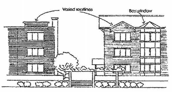
Building walls and façades should have perceivable thickness, visual interest, and character. A selection of architectural details such as vertical and horizontal recesses and projections, changes in height, floor levels, roof forms, parapets, cornice treatments, belt courses, pilasters, window reveals, and forms, and color as appropriate to each site can create shadows and texture and add to the character of the building.
A.
Building Orientation. In order to protect the pedestrian character of this district, the main entrance of each principal building shall face the adjacent street. On corner lots, the main entrance may face either of the streets or be oriented to the corner. With buildings that have more than one (1) main entrance, only one (1) entrance must meet this requirement.
B.
Exterior Finish Materials and Color. Plain concrete block, plain concrete, corrugated metal, plywood, and sheet pressboard are not allowed as exterior finish material.
No intense or distracting colors or color schemes shall be used. The City encourages the use of neutral or earth tone colors with low reflectance. Vibrant colors shall only be used to accentuate trim and other architectural elements.
C.
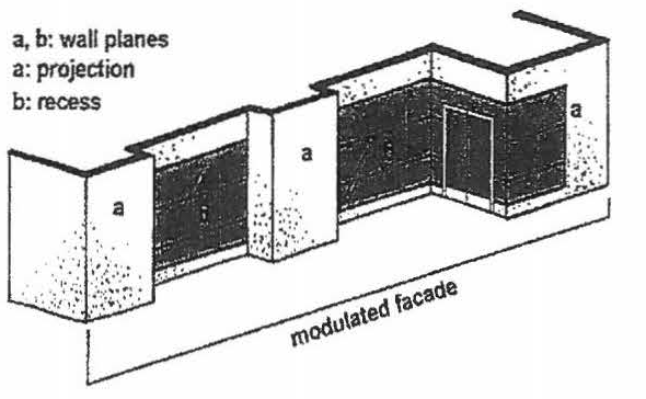
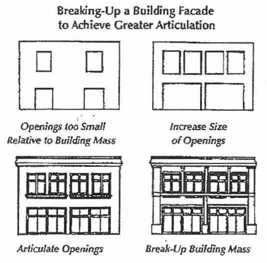
Horizontal Massing. Buildings should be designed to incorporate varied massing and design across long façades. Building walls shall be articulated at a minimum of every fifty (50) feet. Articulation may include storefront bays with modulating building elements such as recesses, projections, expressed entries, building form, columns, pilasters, colonnades, arcades, and/or other clearly expressed architectural details. No horizontal section of the building façade shall exceed fifty (50) feet without incorporating visible changes in the façade elevation.
D.
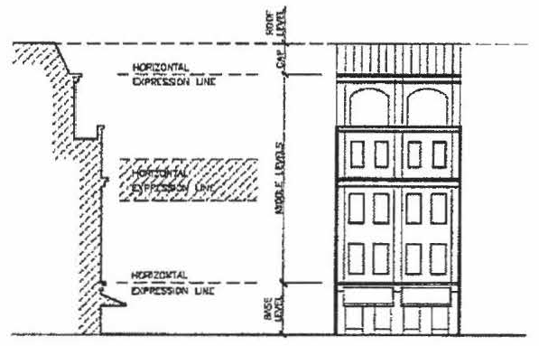
Vertical Massing. Multi-story buildings shall generally include a base, middle, and cap. The base generally consists of the entryway(s) and large transparent windows. The middle is generally described as the upper stories of a building and typically features windows and/or balconies. The cap includes the area from the top floor to the roof of the building.
In order to modulate their scale, multi-story buildings shall articulate the base, middle, and cap through the use of expression lines, cornices, string cornices, step-backs, or similar articulating features as follows:
1.
A horizontal expression line between the base and the middle is vital for reinforcing the pedestrian scale at the adjacent sidewalk. The expression line may entail a molding or reveal placed between the first and second stories or over the second story. The molding or reveal shall have a depth of at least two (2) inches and a height of at least four (4) inches.
2.
The middle may also utilize expression lines to articulate long vertical sections of the building.
3.
The cap shall include an expression line consisting of a cornice or a roof overhang.
E.
Expression lines, including moldings, cornices, and windowsills, shall generally align with those of adjacent buildings.
F.
Entryway Design. Entryways provide a special opportunity to make a building unique while providing a highly visible customer entrance and discernable public address. All buildings shall have their principal entrance face the street, square, plaza, or public sidewalk. The principal entrance shall not open onto a parking lot. Buildings shall maintain a regular rhythm of storefronts with entrances at least every fifty (50) feet on average.
Building entrances should be prominent and easy to identify. Awnings, changes in the roofline, or other acceptable means shall be used to define the building entrance facing the street right-of-way. Pedestrian lighting shall be provided at building entrances. Appropriate fixtures, devices, and placement shall be considered so as to prevent or eliminate glare from the lighting. Doors may be recessed up to five (5) feet into the face of the building to provide a sense of entry and to add variety to the streetscape. Doors which are not recessed into the face of the building shall not pivot or swing open into any right-of-way or public sidewalk.
G.
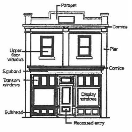
Windows/Fenestration Design. The ground floors of all buildings shall be designed to encourage and to complement pedestrian-scale activity by the use of windows and doors arranged so that the uses are visible from and/or accessible to the street. At the ground level, at least sixty (60) percent, but not more than ninety (90) percent, of the total surface area of the each elevation adjacent to a public street shall be in public entryways, windows (including retail display windows but not including clerestory windows), and transoms. The bottom of windows used on storefronts shall be at least twelve (12) inches but not more than thirty-six (36) inches above the grade of the adjacent sidewalk and shall be separated from the ground by a bulkhead. Reflective and heavily tinted windows at the ground level are prohibited.
On upper stories above the ground level, windows, doors and other openings shall make up at least thirty (30) percent, but not more than sixty (60) percent, of the wall surface of the upper stories.
All windows shall incorporate decorative architectural features such as sills, trim, and lintels. Windows should be inset a minimum of three (3) inches from the exterior wall surface to add visual relief to the wall.
H.
Galleries and Arcades. Galleries and arcades are permitted to encroach into the right-of-way provided that they are set back from the curb at least two (2) feet. Galleries and arcades shall extend for a width of at least ten (10) feet. Any gallery or arcade which overlaps a sidewalk shall maintain a minimum clearance of at least ten (10) feet above the sidewalk. Galleries shall not exceed a height of two (2) stories. Columns and arches shall be shall be spaced at least eight (8) feet apart. The height and proportions should be consistent with the architectural style of the building.
I.
Awnings and Canopies. Awnings, canopies, and other features that provide shade for pedestrians are strongly encouraged and should be integrally designed with the building. Awnings should fit within framed-in storefronts, primarily covering openings such as windows and doors and not extending along the entire façade.
Awning shape, size, color, and material should be consistent with the architectural style and character of the building. Awnings should be compatible with adjacent awnings. The shape, size, and height of each awning should be proportional to the façade. Awnings shall be made of fabric, metal, glass, or similar durable material.
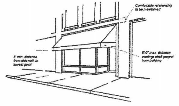
Awnings may encroach into right-of-way provided that they are set back from the curb at least two (2) feet. Any awning which overlaps a sidewalk shall maintain a minimum clearance of at least eight (8) feet above the sidewalk.
J.
Balconies. Balconies are permitted to encroach into the right-of-way provided that they are set back from the curb at least two (2) feet. Any balcony which overlaps a sidewalk shall maintain a minimum clearance of at least ten (10) feet above the sidewalk.
K.
Roof Design. Roof lines should vary and be expressed in a visually interesting manner that complements the composition of the building and the surrounding area. Flat roofs shall incorporate a strong, attractively detailed cornice or parapet. To create a varied roof line, different types of cornices and varied cornice lines are encouraged. Sculpted roof forms shall employ high quality roofing materials.
(Ord. No. 786, amds. 13, 14, 3-16-2015; Ord. No. 831, amd. 1, 9-18-2017; Ord. No. 835, amd. 3, 11-20-2017; Ord. No. 954, § 1, 8-17-2020; Ord. No. 970, § 3, 4-19-2021; Ord. No. 1014, § 2, 12-19-2022; Ord. No. 1029, § 1, 4-15-2024)
Sec. 5:7 - C-1, Light Commercial District.
This district is established to promote small-scale retail, service, and professional offices that provide goods and services to the residents of a nearby or adjacent neighborhood. This district is primarily intended to provide locations for appropriate business and similar activities adjacent to residential districts.
5:7.1 Uses Allowed.
See the Table of Allowed Uses provided in Article 7.
5:7.2 Reserved.
5:7.3 Reserved.
5:7.4 Height Limitation.
No structures shall exceed a height of forty-five (45) feet except as provided in Section 3:8.
5.7.5 C-1, Commercial District, Setback Requirements.
1.
Front Setback. Principle structures shall be set back a minimum of twenty-five (25) feet from the street right-of-way line, except that the minimum setback may be reduced to ten (10) feet where road widening is not anticipated and provided that all parking is located to the side or rear and not closer to the street than the edge of the front façade of the principal structure, and where pedestrian-oriented design features are incorporated in building and site design.
Accessory structures: All accessory structures shall be located entirely in a side or rear yard and behind the building line of the principle structure.
Outside merchandise: All outside merchandise for sale and/or on display shall be set back a minimum of fifteen (15) feet from street right-of-way line. When pedestrian oriented design features are incorporated into the building and site design, the Business and Development Services Director may approve alternate locations for display of outdoor merchandise.
2.
Side Setback (C-1). None is required, except on corner lots and lots adjacent to any residential district. On corner lots, all commercial buildings, structures, and merchandise on display shall be set back not less than twenty-five (25) feet from the street right-of-way line on the side with street frontage. On lots adjacent to any residential district all commercial buildings, structures, and merchandise on display shall be set back not less than twenty (20) feet from the property line on the side adjacent to the residential district. When a side yard is provided, it shall be not less than five (5) feet in width.
3.
Rear Setback. No building shall be located closer than twenty (20) feet to a rear lot line.
5:7.6 Screening.
A wall, fence, dense hedge, or other permanent year-round foliage, or a combination thereof, which provides a solid, opaque, visual barrier at least six (6) feet in height shall be provided along the side and rear lot lines where any nonresidential use in this district is adjacent to a residential district. Such screening shall also prohibit, for safety reasons, passage by children and/or other pedestrians. Screening design shall visually compliment the surrounding residential district. Additionally, maintenance shall be performed to ensure that the screen continues to meet the provisions set forth herein. Strict enforcement of these provisions shall be in accordance with subsection 4:1.1.1 of this Ordinance.
5:7.7 Off-Street Parking.
Off-street parking shall be provided in accordance with the provisions set forth in Section 6:1.
5:7.8 Off-Street Loading.
Off-street loading shall be provided in accordance with the provisions set forth in subsection 6:1.2.
5:7.9 Drainage.
A complete drainage plan of the entire site meeting the requirements prescribed in the Mauldin City Drainage Ordinance shall be provided.
5:7.10 Outdoor Fencing.
Fencing shall be confined to the side and rear yards of the site and not located closer to the street than the leading edge of the principle structure.
(Ord. No. 786, amds. 13—15, 3-16-2015; Ord. No. 789, § 1, 6-1-2015; Ord. No. 831, amd. 2, 9-18-2017; Ord. No. 834, amd. 1, 9-18-2017; Ord. No. 954, § 2, 8-17-2020; Ord. No. 970, § 3, 4-19-2021)
Editor's note— Ord. No. 970, § 3, adopted April 19, 2021, changed the title of § 5:7 from "C-1 Commercial District" to read as herein set out.
Sec. 5:8 - C-2, General Commercial District.
This district is established to promote accessible and central concentrations of business activities and commercial establishments offering both retail goods and services to people from throughout the community. This district is intended to serve both pedestrians as well as people who travel by automobile. Therefore, this district is primarily located along major roadways, and businesses are encouraged to locate in close proximity to one another. Where necessary, adjacent residential areas are protected through landscaping and site design.
5:8.1 Uses Allowed.
See the Table of Allowed Uses provided in Article 7.
5:8.2 Reserved.
5:8.3 Reserved.
5:8.4 Height Limitation.
No structures shall exceed a height of forty-five (45) feet except as provided in Section 3:8.
5:8.5 C-2, Highway Commercial, Setback Requirements.
1.
Front Setback. Principle structures shall be set back a minimum of thirty-five (35) feet from the street right-of-way line, except that the minimum setback may be reduced to ten (10) feet where road widening is not anticipated and provided that all parking is located to the side or rear and not closer to the street than the edge of the façade of the principal structure, and where pedestrian-oriented design features are incorporated in building and site design.
Accessory Structures: All accessory structures shall be located entirely in a side or rear yard and behind the building line of the principle structure.
Gasoline Service Stations: Commercial gasoline islands and canopies shall be set back a minimum of fifteen (15) feet from all street right-of-way lines.
Outside merchandise: All outside merchandise for sale and/or on display shall be set back a minimum of fifteen (15) feet from street right-of-way line. When pedestrian oriented design features are incorporated into the building and site design, the Business and Development Services Director may approve alternate locations for display of outdoor merchandise.
2.
Side Setback (C-2). None is required, except on corner lots and lots adjacent to any residential district. On corner lots, all commercial buildings, structures, and merchandise on display shall be set back not less than twenty-five (25) feet from the street right-of-way line on the side with street frontage. On lots adjacent to any residential district, all commercial buildings, structures, and merchandise on display shall be set back not less than twenty (20) feet from the property line on the side adjacent to the residential district. When a side yard is provided, it shall be not less than five (5) feet in width.
3.
Rear Setback. No building shall be located closer than twenty (20) feet to a rear lot line. All outside merchandise on display shall be set back not less than fifteen (15) feet from property lines.
5:8.6 Screening.
A wall, fence, dense hedge, or other permanent year-round foliage, or a combination thereof, which provides a solid, opaque, visual barrier at least six (6) feet in height shall be provided along the side and rear lot lines where any nonresidential use in this district is adjacent to a residential district. Such screening shall also prohibit, for safety reasons, passage by children and/or other pedestrians. Screening design shall visually compliment the surrounding residential district. Additionally, maintenance shall be performed to ensure that the screen continues to meet the provisions set forth herein. Strict enforcement of these provisions shall be in accordance with subsection 4:1.1.1 of this Ordinance.
5:8.7 Off-Street Parking.
Off-street parking shall be provided in accordance with the provisions set forth in Section 6:1, Off-street parking.
5:8.8 Off-Street Loading.
Off-street loading shall be provided in accordance with the provisions set forth in subsection 6:1.2.
5:8.9 Drainage.
A complete drainage plan of the entire site meeting the requirements of the Mauldin City Drainage Ordinance shall be provided.
5:8.9.1 Outdoor Fencing.
Fencing shall be confined to the side and rear yards of the site and not located closer to the street than the leading edge of the principle structure.
5:8.10 Requirements for Planned Shopping Centers.
1.
Height Limitations. No building shall exceed forty-five (45) feet except as provided in Section 3:8.
2.
Lot Area. The shopping center shall be located on a parcel of land not less than two (2) acres in area.
3.
Dimensional Requirements.
(a)
Setback from Streets. All buildings shall be set back from all street right-of-way lines not less than fifty (50) feet.
(b)
Setback from Side Property Lines. All buildings shall be set back from side property lines not less than twenty-five (25) feet.
(c)
Setback from Rear Property Lines. All buildings shall be set back from the rear property line not less than twenty-five (25) feet.
4.
Screening. A wall, fence, dense hedge, or other permanent year-round foliage, or a combination thereof, which provides a solid, opaque, visual barrier at least six (6) feet in height shall be provided along the side and rear lot lines where any nonresidential use in this district is adjacent to a residential district. Such screening shall also prohibit, for safety reasons, passage by children and/or other pedestrians. Screening design shall visually compliment the surrounding residential district. Additionally, maintenance shall be performed to ensure that the screen continues to meet the provisions set forth herein. Strict enforcement of these provisions shall be in accordance with Section 8:1 of this Ordinance.
5.
Off-Street Parking. Off-street parking shall be provided in accordance with the provisions set forth in Section 6:1.
6.
Off-Street Loading. Off-street loading shall be provided in accordance with the provisions set forth in subsection 6:1.2.
7.
Application Procedure. Each application for a zoning certificate/building permit for a planned shopping center shall be accompanied by the following:
A.
A development plan of the proposed development at a scale of not less than one (1) inch equals one hundred (100) feet showing:
1.
The location and size of the site;
2.
The dimensions of the property;
3.
The location and proposed use of buildings and their general exterior dimensions;
4.
A traffic, parking, and circulation plan showing proposed locations, arrangements, and dimensions of parking spaces, loading areas, drives, and ingress and egress to and from adjacent streets;
5.
The proposed location and materials to be used for screening;
6.
A title showing the names of the developers, the date, scale of the plan, and the name of the individual or firm preparing the plan.
B.
A statement to be filed with the Business and Development Services Director indicating readiness to proceed with construction of the proposed development within one (1) year from the date the proposal is approved.
C.
Drainage. A complete drainage plan of the entire site meeting the requirements prescribed in the Mauldin City Drainage Ordinance shall be provided.
8.
Zoning Certificate/Building Permit. No zoning certificate/building permit shall be issued for any building in a shopping center until a final development plan shall have been approved by the Zoning Administrator.
(Ord. No. 786, amds. 13—15, 3-16-2015; Ord. No. 789, § 1, 6-1-2015; Ord. No. 831, amd. 2, 9-18-2017; Ord. No. 834, amd. 2, 9-18-2017; Ord. No. 954, § 2, 8-17-2020; Ord. No. 970, § 3, 4-19-2021)
Editor's note— Ord. No. 970, § 3, adopted April 19, 2021, changed the title of § 5:8 from "C-2 Highway Commercial District" to read as herein set out.
Sec. 5:9 - S-1, Trades and Commercial Services District.
This district is established to provide a transition between commercial and industrial districts by allowing (1) commercial uses which are service related; (2) service-related commercial uses which sell merchandise related directly to the service performed; (3) commercial uses which sell merchandise which requires storage in warehouses or outdoor areas; and (4) light industries which in their normal operations would have a minimal effect on adjoining properties. All of the uses permitted in this district shall be conducted in such a manner that no noxious odor, fumes, smoke, dust, or noise will be emitted beyond the property line of the lot on which the use is located.
5:9.1 Uses Allowed.
See the Table of Allowed Uses provided in Article 7.
5:9.2 Reserved.
5:9.3 Reserved.
5:9.4 Height Limitation.
No building or structure shall exceed forty-five (45) feet in height except as provided in Section 3:8.
No building or structure on a lot in the Services District which is adjacent to a residential district shall exceed the maximum building height permitted in the residential district unless there is one (1) additional foot of setback on the sides adjacent to the residential district for each additional foot of height.
5:9.5 S-1, Services District, Setback Requirements.
1.
Front Setback. Principle structures shall be set back a minimum of thirty-five (35) feet from the street right-of-way line, except that the minimum setback may be reduced to ten (10) feet where road widening is not anticipated and provided that all parking is located to the side or rear and not closer to the street than the edge of the front façade of the principal structure, and where pedestrian-oriented design features are incorporated in building and site design.
Accessory structures: All accessory structures shall be located entirely in a side or rear yard and behind the building line of the principle structure.
Gasoline Service Stations: Commercial gasoline islands and canopies shall be set back a minimum of fifteen (15) feet from all street right-of-way lines.
Outside merchandise: All outside merchandise for sale and/or on display shall be set back a minimum of fifteen (15) feet from street right-of-way line. When pedestrian oriented design features are incorporated into the building and site design, the Business and Development Services Director may approve alternate locations for display of outdoor merchandise.
2.
Side Setback. No building shall be located closer than twenty-five (25) feet to a side lot line except next to rail siding. All outside merchandise on display shall be set back not less than fifteen (15) feet from property lines.
3.
Rear Setback. No building shall be located closer than twenty-five (25) feet to a rear lot line except next to rail siding. All outside merchandise on display shall be set back not less than fifteen (15) feet from property lines.
5:9.6 Screening.
A wall, fence, dense hedge, or other permanent year-round foliage, or a combination thereof, which provides a solid, opaque, visual barrier at least six (6) feet in height shall be provided along the side and rear lot lines where any nonresidential use in this district is adjacent to a residential district. Such screening shall also prohibit, for safety reasons, passage by children and/or other pedestrians.
Screening design shall visually compliment the surrounding residential district. Additionally, maintenance shall be performed to ensure that the screen continues to meet the provisions set forth herein. Strict enforcement of these provisions shall be in accordance with subsection 4:1.1.1 of this Ordinance.
5:9.7 Off-Street Parking.
Off-street parking shall be provided in accordance with the provisions set forth in Section 6:1.
5:9.8 Off-Street Loading.
Off street loading shall be provided in accordance with the provisions set forth in subsection 6:1.2.
5:9.9 Drainage.
A complete drainage plan of the entire site meeting the requirements of the Mauldin City Drainage Ordinance shall be provided.
5:9.10 Outdoor Fencing.
Fencing shall be confined to the side and rear yards of the site and not located closer to the street than the leading edge of the principle structure.
(Ord. No. 786, amds. 13—15, 3-16-2015; Ord. No. 789, § 1, 6-1-2015; Ord. No. 831, amd. 2, 9-18-2017; Ord. No. 834, amd. 3, 9-18-2017; Ord. No. 970, § 3, 4-19-2021)
Editor's note— Ord. No. 970, § 3, adopted April 19, 2021, changed the title of § 5:9 from "S-1 Services District" to read as herein set out.
Sec. 5:10 - I-1, Industrial District.
This district is established as a district for manufacturing plants, assembly plants, and warehouses. The regulations are intended to protect neighboring land uses from potentially harmful noise, odor, smoke, dust, glare, stream pollution, or other objectionable effects.
5:10.1 Uses Allowed.
See the Table of Allowed Uses provided in Article 7.
5:10.2 Reserved.
5:10.3 Reserved.
5:10.4 Height Limitation.
No building or structure shall exceed ninety (90) feet in height except as provided in Article 3, Section 3:8. No building or structure on a lot in the industrial district which is adjacent to a residential district shall exceed the maximum building height permitted in the residential district unless there is one (1) additional foot of setback on the sides adjacent to the residential district for each additional foot of height.
5:10.5 Dimensional Requirements.
1.
Front Setback. All buildings shall be set back from the street right-of-way not less than fifty (50) feet. An advertising sign shall be permitted no closer than fifteen (15) feet to street right-of-way, and an advertising sign exceeding twenty-five (25) feet in height shall be located no less than thirty (30) feet from a public right-of-way.
2.
Side Setback. No building shall be located closer than twenty-five (25) feet to a side lot line except when the property is adjacent to a railroad right-of-way and written approval from the railroad authorities has been obtained to utilize a railroad spur for loading and unloading.
3.
Rear Setback. No building shall be located closer than twenty-five (25) feet to a rear lot line except when the property is adjacent to a railroad right-of-way and written approval from the railroad authorities has been obtained to utilize a railroad spur for loading and unloading.
5:10.6 Screening.
A wall, fence, dense hedge, or other permanent year-round foliage, or a combination thereof, which provides a solid, opaque, visual barrier at least six (6) feet in height shall be provided along the side and rear lot lines where any nonresidential use in this district is adjacent to a residential district. Such screening shall also prohibit, for safety reasons, passage by children and/or other pedestrians. Screening design shall visually compliment the surrounding residential district. Additionally, maintenance shall be performed to ensure that the screen continues to meet the provisions set forth herein. Strict enforcement of these provisions shall be in accordance with subsection 4:1.1.1 of this Ordinance.
5:10.7 Off-Street Parking.
Off-street parking shall be provided in accordance with the provisions set forth in Article 6, Section 6:1.
5:10.8 Off-Street Loading.
Off-street loading shall be provided in accordance with the provisions set forth in Article 6, subsection 6:1.2.
5:10.9 Drainage.
A complete drainage plan of the entire site meeting the requirements of the Mauldin City Drainage Ordinance shall be provided.
(Ord. No. 786, amd. 14, 3-16-2015; Ord. No. 970, § 3, 4-19-2021)
Sec. 5:11 - P-D, Planned Development.
5:11.1 Intent.
The PD district is established to encourage innovative and creative design of residential and/or commercial developments and to permit a greater amount of flexibility to a developer by removing some of the restrictions of conventional zoning. It is the intent of the district that such design and planning features be incorporated properly into all PD districts hereafter created, and that the Planning Commission and City Council shall consider the existence and appropriateness of such features before any amendment to the Zoning Map is adopted to create such districts. The district is also intended to encourage developments, which provide a full range of residential types to serve the inhabitants of the district.
The regulations provide a mechanism to evaluate each application on its own merit. It is recognized that some concepts will be more successful than others will and the approval of an application in one (1) situation does not necessarily indicate the development will be applicable in other situations. It should also be emphasized that these provisions are not to be confused with nor designed to circumvent the intent or use of conventional zoning classifications as set forth in the Ordinance.
5:11.2 Types of Planned Development Districts.
Two (2) types of planned development districts accommodating primarily residential or non-residential uses are created as follows:
A.
PD-R Planned Development—Residential. The PD-R district is intended to accommodate primarily residential uses; with nonresidential uses integrated into the design of such districts as secondary uses.
B.
PD-C Planned Development—Commercial. The PD-C district is intended to accommodate primarily nonresidential uses; with residential uses integrated into the design of such districts as secondary uses.
5:11.3 Permitted Principal Uses and Structures.
Permitted principal uses and structures vary with increasing size and are different for PD-R and PD-C districts. Permitted principal uses and structures for various site sizes and types of PD districts are as follows:
5:11.4 Maximum Area of Commercial or Industrial Uses in PD-R Districts.
In PD-R districts in which commercial or service uses are permitted, the area of land devoted to such uses, including structures, parking, and related characteristics and accessory uses thereto shall not exceed the following percentages for any specific site size:
Provided, however, that these percentages shall apply only to commercial and service uses, and not to other non-residential uses such as schools, parks, community buildings, or public facilities. Required parking for commercial and service uses shall be counted towards maximum percentages.
5:11.5 Permitted Accessory Uses and Structures.
Accessory uses and structures shall be permitted as for the least restrictive districts indicated in subsection 5:11.3 for any specific site size.
5:11.6 Uses and Structures Permitted by Special Exception.
No review actions by the Board of Appeals are required to establish any specific use. Uses and structures permitted in the least restrictive land use classifications indicated in subsection 5:11.3 for any specific site size are permitted outright, provided that the Planning Commission and City Council shall ascertain that the effects and benefits usually derived from safeguards and conditions normally imposed upon uses permitted by review are upheld.
5:11.7 Prohibited Uses and Structures.
Certain uses and structures shall be prohibited as for the least restrictive uses indicated in subsection 5:11.3 for any specific site size.
5:11.8 Minimum Lot Area.
No minimum lot area is required for any specific structure; however, a minimum site size to accommodate specific uses shall be as listed in subsection 5:11.3.
5:11.9 Minimum Lot Width, Minimum Yard Requirements, Maximum Lot Coverage, Maximum Height of Structures.
No structure shall be erected within twenty-five (25) feet from any external lot line of any planned development. Minimum lot width, minimum yard sizes, maximum lot coverage, and maximum height are not otherwise regulated within PD districts, provided, however, that the Planning Commission and City Council shall ascertain that the characteristics of building siting shall be appropriate as related to structures within the planned development and otherwise fulfill the intent of this Ordinance.
5:11.10 Minimum Off-Street Parking and Loading.
The Planning Commission shall not approve a PD site plan until the Zoning Administrator has reviewed and approved a parking scheme for the development.
5:11.11 Signs.
Signs are permitted in PD districts only in accordance with provisions of the Sign Ordinance.
5:11.12 PD Application and Preliminary Development Plan Approval.
A.
An applicant is encouraged to communicate his intentions to establish a Planned Development district and the proposed characteristics thereof to the Zoning Administrator and Greenville County Planning Commission staff prior to initiating an application for amendment to the zoning map in order to avoid undue delay in the review process after initiating such applications.
B.
Applications for Planned Development district shall be by amendment to the official Zoning Map in accordance with the provisions of Section 4:2 and shall include the following:
1.
Preliminary Development Plan. The applicant shall submit one (1) reproducible vellum copy (22″ × 27″ minimum size) and one (1) paper copy (11″ × 17″ in size) of the proposed Planned Development which shall include the following:
a.
Vicinity map, title block, scale, north arrow, and property line survey.
b.
Total number of acres of overall site.
c.
Location and number of acres of various areas by type of use (e.g., single-family detached, recreation, office, commercial, etc.).
d.
Number of units and density of various residential types, such number to represent the maximum number of units.
e.
Approximate square footage of non-residential use and approximate number of bedrooms in each residential unit.
f.
Primary traffic circulation pattern, including major points of ingress and egress.
g.
Approximate number of parking spaces per use.
h.
An indication that an acceptable drainage system can be designed for the proposed project.
i.
Any such information or descriptions as may be deemed reasonably appropriate for review.
2.
Statement of Intent. The applicant shall submit three (3) copies of a descriptive statement setting forth the characteristics for the proposed Planned Development including the following:
a.
A description of the responsibilities of any proposed homeowners association or group maintenance agreement.
b.
A statement setting forth the proposed development schedule.
c.
A statement of the public improvements both on- and off-site that are proposed for dedication and/or construction and an estimate of the timing for providing such improvements.
d.
A statement from the public facility providers, including water, sewer collection and treatment, schools, garbage collection, fire protection, etc., and letters from the appropriate agencies or districts verifying that such facilities or services are available and adequate to serve the proposed Planned Development.
e.
A statement concerning the appearance, landscaping, screening, and maintenance of any proposed pond, lake, or retention pond contained in the development.
f.
Any such information or descriptions as may be deemed reasonably appropriate for review.
C.
A public hearing shall be held by the Planning Commission in accordance with procedures set forth in Section 4:2.
D.
The Planning Commission shall make a recommendation upon the proposed Planned Development, which shall be advisory to City Council.
E.
The City Council may, after fulfilling all applicable requirements of this section and all applicable requirements of Section 4:2, act to either approve, approve with modification, or disapprove the application for a Planned Development.
F.
Following approval of a PD district, the official zoning map shall be amended to reflect such approval. Approval of a Planned Development district shall constitute authority for the applicant to submit a Final Development Plan to the Planning Commission for approval in accordance with the provisions of subsection 5:11.14.
5:11.13 Failure to Submit a Final Development Plan.
Approval of a PD district granted by City Council shall be valid for one (1) year by the end of which time a Final Development Plan must be submitted. Prior to the expiration of the approval, the Zoning Administrator shall submit a progress report to Council on the status of the development. One-year extensions may be granted by City Council. If an extension(s) is not granted, City Council may rezone the property to its original classification in accordance with Section 4:2.
5:11.14 Final Development Plan.
All final development plans in the Planned Development District will require a site plan review and approval by the City of Mauldin. Site plan requirements and procedures for the Planned Development District are outlined in Section 3 of the Mauldin City Land Development Regulations.
5:11.15 Recording of Final Development Plan and Statement of Intent.
Following approval of the Final Development Plan by the Planning Commission, one (1) copy of the Final Development Plan and Statement of Intent shall be recorded in the Register of Mesne Conveyances of Greenville County; one (1) copy of both documents shall be filed with the Zoning Administrator; and one (1) copy of both documents shall be filed with the City of Mauldin.
5:11.16 Subdivision Plats, Building Permits, and Certificates of Occupancy.
Approval of a Final Development Plan shall constitute authority for the applicant to prepare subdivision plats, if applicable, in accordance with procedures set forth in the Greenville County Subdivision Regulations. No building permit or Certificate of Occupancy shall be issued in a PD district until a Final Development Plan has been recorded.
5:11.17 Changes to Planned Development Districts.
Changes to a proposed Planned Development district or to an approved Planned Development district may be permitted in accordance with one (1) of the following procedures as determined by the Zoning Administrator:
A.
Minor Changes. Changes to a Planned Development district which are of a design nature and which do not alter the original concept or use characteristics of the Planned Development district may be approved by the Planning Commission in accordance with the procedures established by the Land Development Regulations, Section 3 provided that no minor change may be approved by the Planning Commission which is in conflict with specific conceptual considerations previously contained in City Council's preliminary approval. Examples of Minor Changes may include, but are not limited to the following:
•Reductions in:
•Density;
•Signage;
•Square footage;
•Increases in:
•Landscaping;
•Open space;
•Setbacks;
•Landscaping;
•Lighting;
•Location of land uses;
•Parking;
•Signage;
•Site plan;
•Minor changes to allow:
•Reorientation of structures;
•Realignment of approved access;
•More restrictive land uses, e.g. commercial to residential;
•Shift in approved density from one (1) area of PD to another.
B.
Major Changes. Changes to a Planned Development district which would alter the basic concept and general characteristics of the Planned Development district may be approved by City Council in accordance with the procedures established by subsection 5:11.12. Approval of a major change by City Council must be followed by final development plan approval with a detailed design plan showing such changes by the Planning Commission in accordance with the Land Development Regulations, Section 3. Examples of major changes include but are not limited to the following:
•Boundary changes;
•Changes in the maximum number of structures or residential units;
•Increased density;
•Substantial changes to residential housing type;
•Use changes; or
•Access changes; etc.
5:11.18 Failure to Begin, Failure to Complete, or Failure to Make Adequate Progress.
One (1) year after final approval and each year thereafter, the Zoning Administrator shall present to City Council's Public Works Committee a status report on the progress of the approved development. If there is failure to begin, failure to complete, or failure to make adequate progress as set forth in the Statement of Intent, City Council may change the district classification of the Planned Development in accordance with provisions of Section 4:2.
Sec. 5:12 - POD, Planned Office District.
This district is established to accommodate office development, which is found to be compatible with surrounding physical development, particularly neighboring residential properties. Uses permitted in this district are limited to office and research facilities and shall not include any use engaged in retail sales or the stocking and storage of merchandise except as provided by subsection 5:5.2 and [subsection] 5:5.2.1.
5:12.1 Uses Permitted.
Uses permitted in the Planned Office District are the same as those uses permitted in subsection 5:5.1, Uses Permitted, and subsection 5:5.2, Uses Permitted by Special Exception, in the O-D, Office District.
5:12.2 Accessory Retail Uses Permitted.
Accessory retail uses permitted in the Planned Office District are the same as those permitted in the O-D, Office District, as set forth in subsection 5:5.2.1.
5:12.3 Relationship of Buildings to Lots.
One (1) or more principal structures may be permitted on a single lot.
5:12.4 Minimum Area.
No minimum area is required.
5:12.5 Minimum Yard Requirements.
Front 45 feet
Side 25 feet
Rear 25 feet
For additional minimum setback requirements, refer to Section 3:11 Additional Minimum Setback Requirements for Certain Streets.
5:12.6 Maximum Height.
Maximum height of all structures shall not exceed forty-five (45) feet.
5:12.7 Off-Street Parking.
Off-street parking shall be provided in accordance with Section 6:1.
5:12.8 Site Plan Review.
All uses permitted in the Planned Office District will require a site plan review and approval by the Mauldin City Planning Commission. Site plan requirements and procedures for the Planned Office District are outlined in Section 4 of the Mauldin City Land Development Regulations.
Sec. 5:13 - O-D, Office District.
This district is established to provide an office district for the convenience of local residents. The uses permitted in this district are limited to office and research facilities and shall not include any use engaged in retail sales or the stocking and storage of goods or merchandise. No use shall be permitted in this district which will be detrimental to the development of the district as an office research park.
5:13.1 Uses Allowed.
See the Table of Allowed Uses provided in Article 7.
5:13.2 Reserved.
5:13.3 Reserved.
5:13.4 Height Limitation.
No structure shall exceed a height of forty-five (45) feet except as provided in Section 3:8.
5:13.5 Dimensional Requirements.
1.
Front Setback. All buildings and structures shall be set back from all street right-of-way lines not less than twenty-five (25) feet. All outside merchandise on display shall be set back not less than fifteen (15) feet from property lines.
2.
Side Setback. None is required except on corner lots and lots adjacent to any residential district, in which case all commercial buildings, structures, and merchandise on display shall be set back not less than fifteen (15) feet from property lines. When a side yard is provided, it shall be not less than five (5) feet in width.
3.
Rear Setback. No building shall be located closer than twenty (20) feet to a rear lot line. All outside merchandise on display shall be set back not less than fifteen (15) feet from property lines.
5:13.6 Screening.
A wall, fence, dense hedge, or other permanent year-round foliage, or a combination thereof, which provides a solid, opaque, visual barrier at least six (6) feet in height shall be provided along the side and rear lot lines where any nonresidential use in this district is adjacent to a residential district. Such screening shall also prohibit, for safety reasons, passage by children and/or other pedestrians. Screening design shall visually compliment the surrounding residential district. Additionally, maintenance shall be performed to ensure that the screen continues to meet the provisions set forth herein. Strict enforcement of these provisions shall be in accordance with subsection 4:1.1.1 of this Ordinance.
5:13.7 Off-Street Parking.
Off-street parking shall be provided in accordance with the provisions set forth in Section 6:1.
5:13.8 Drainage.
A complete drainage plan of the entire site meeting the requirements as prescribed in the Mauldin City Drainage Ordinance shall be provided.
5:13.9 Outdoor Fencing.
Fencing shall be confined to the side and rear yards of the site and not located closer to the street than the leading edge of the principle structure.
(Ord. No. 786, amds. 13—15, 3-16-2015; Ord. No. 970, § 3, 4-19-2021)
Editor's note— At the request of the city, former § 5:5, O-D, Office District, has been redesignated as § 5:13.
Sec. 5:14 - AP, Airport Protective Areas.
5:14.1 Airport Protective Areas Established as Supplementary.
The "AP" designation is not intended to be utilized as a district classification but as a designation which identifies areas subject to regulations which are supplementary to the regulations of the district to which such designation is attached, appended, or "overlaid." Regulations, which apply to areas, designated on the Zoning map, as being within such appended or overlaid designation must be determined by joint reference to the regulations of both the basic district classification and the appended or overlay classification. The basis for preparing these supplementary regulations is contained in the Federal Aviation Regulations (FAR), Vol. XI, Part 77, Objects Affecting Navigable Airspace.
5:14.2 AP, Intent.
It is the intent of this Ordinance to restrain influences which are adverse to the proper and safe conduct of aircraft operations in the vicinity of airports, to prevent creation of conditions hazardous to aircraft operations, and to encourage development which is compatible with airport use characteristics within the intent and purpose of zoning. To this end, the "AP" designation, when appended to a basic district classification, is intended to coordinate the purposes and intent of this Ordinance with other regulations duly established by the City of Mauldin whose primary intent is to further the purposes set out above.
5:14.3 Action Upon Applications Within Areas Designated "AP."
The Zoning Administrator shall take no action upon issuance of a zoning permit or presentation of an application to the Board of Appeals or other similar administrative procedures until it has been duly certified to him by proper authorities that the proposal upon which he is requested to act is in compliance with regulations of the AP Protective Area regulations as detailed in this section.
5:14.4 Definitions.
1.
Airports. Greenville-Spartanburg International Airport, Greenville Downtown Airport, and Donaldson Center.
2.
Airport Elevation. The highest point of an airports usable landing area measured in feet above mean sea level (MSL).
3.
Approach Surface. A surface longitudinally centered on the extended runway centerline, extending outward and upward from the end of the primary surface and at the same slope as the approach zone height limitation slope set forth in subsection 5:14.6 of this Ordinance. In plan the perimeter of the approach surface coincides with the perimeter of the approach zone.
4.
Approach, Transitional, Horizontal, and Conical Zones. These zones are set forth in subsection 5:14.5 of this Ordinance.
5.
Board of Appeals. A board consisting of five (5) members and two (2) alternates appointed by City Council as provided in subsection 4:1.2 of the Mauldin City Zoning Ordinance.
6.
Conical Surface. A surface extending outward and upward from the periphery of the horizontal surface at a slope of twenty (20) to one (1) for a horizontal distance of four thousand (4,000) feet.
7.
Hazard To Air Navigation. An obstruction determined to have a substantial adverse effect on the safe and efficient utilization of the navigable airspace.
8.
Height. For the purpose of determining the height limits in all zones set forth in this Ordinance and shown on the zoning map, the datum shall be mean sea level (MSL) elevation unless otherwise specified.
9.
Heliport Primary Surface. The area of the primary surface coincides in size and shape with the designated takeoff and landing area of a heliport. This surface is a horizontal plane at the elevation of the established heliport elevation.
10.
Horizontal Surface. A horizontal plane one hundred fifty (150) feet above the established airport elevation, the perimeter which in plan coincides with the perimeter of the horizontal zone.
11.
Larger Than Utility Runway. A runway that is constructed for and intended to be used by propeller driven aircraft of greater than twelve thousand five hundred (12,500) pounds maximum gross weight and jet powered aircraft.
12.
Nonconforming Use. Any pre-existing structure, object of natural growth, or use of land, which is inconsistent with the provisions of this Ordinance or an amendment thereto.
13.
Obstruction. Any structure, or other object, including a mobile object, which exceeds a limiting height set forth in subsection 5:13.6 of this Ordinance.
14.
Person. An individual, firm, partnership, corporation, company, association, joint stock association, or governmental entity; includes a trustee, a receiver, an assignee, or a similar representative of any of them.
15.
Precision Instrument Runway. A runway having an existing instrument approach procedure utilizing an Instrument Landing System (ILS), Differential Global Positioning System (DGPS) or a Precision Approach Radar (PAR). It also means a runway for which a precision approach system is planned and is so indicated on an approved airport layout plan or another planning document.
16.
Primary Surface. A surface longitudinally centered on a runway. When the runway has a specially prepared hard surface, or planned hard surface, the primary surface extends two hundred (200) feet beyond each end of that runway; for military runways or when the runway has no specially prepared hard surface or planned hard surface, the primary surface ends at each end of that runway. The width of the primary surface is set forth in subsection 5:13.5 of this Ordinance. The elevation of any point on the primary surface is the same as the elevation of the nearest point on the runway centerline.
17.
Runway. A defined area on an airport prepared for landing and take-off of aircraft along its length.
18.
Structure. An object constructed or installed by man, including, but without limitation, buildings, towers, smokestacks, earth formation, and overhead transmission lines.
19.
Transitional Surfaces. These surfaces extend outward at ninety-degree angles to the runway centerline and the runway centerline extended at a slope of seven (7) feet horizontally for each foot vertically from the sides of the primary and approach surfaces to where they intersect the horizontal and conical surfaces. Transitional surfaces for those portions of the precision approach surfaces, which project through and beyond the limits of the conical surface, extend a distance of five thousand (5,000) feet measured horizontally from the edge of the approach surface and at ninety-degree angles to the extended runway centerlines.
20.
Tree. Any object of natural growth.
21.
Utility Runway. A runway that is constructed for and intended to be used by propeller driven aircraft of twelve thousand five hundred (12,500) pounds maximum gross weight and less.
22.
Visual Runway. A runway intended solely for the operation of aircraft using visual approach procedures.
5:14.5 Airport Zones.
In order to carry out the provisions of this Ordinance, there are hereby created and established certain zones which include all of the land lying beneath the approach surfaces, transitional surfaces, horizontal surfaces, and conical surfaces as they apply to Greenville-Spartanburg International Airport, Greenville Downtown Airport, and Donaldson Center. Such zones are shown on the official Greenville County Zoning Map, which is on display in the Greenville County Planning Commission office. An area located in more than one (1) of the following zones is considered to be only in the one (1) with the more restrictive height limitations. The various zones are hereby established and defined as follows:
1.
Utility Runway Visual Approach Zone. The inner edge of this approach zone coincides with the width of the primary surface and is two hundred fifty (250) feet wide for utility runways with only visual approaches and five hundred (500) feet wide for utility runways with a non-precision approach on the opposite end. The approach zone expands outward uniformly to a width of one thousand two hundred fifty (1,250) feet at a horizontal distance of five thousand (5,000) feet from the primary surface. Its centerline is the continuation of the centerline of the runway.
2.
Runway Larger Than Utility Visual Approach Zone. The inner edge of this approach zone coincides with the width of the primary surface and is five hundred (500) feet wide for such runways with a visual approach or non-precision approach on the opposite end and one thousand (1,000) feet wide for those with a precision approach on the opposite runway end. The approach zone expands outward uniformly to a width of one thousand five hundred (1,500) feet at a horizontal distance of five thousand (5,000) feet from the primary surface. Its centerline is the continuation of the centerline of the runway.
3.
Precision Instrument Approach Zone. The inner edge of this approach zone coincides with the width of the primary surface and is one thousand (1,000) feet wide. The approach zone expands outward uniformly to a width of sixteen thousand (16,000) feet at a horizontal distance of fifty thousand (50,000) feet from the primary surface. Its centerline is the continuation of the centerline of the runway.
4.
Transitional Zones. The transitional zones are the areas beneath the transitional surfaces.
5.
Heliport Transitional Zones. These zones extend outward from the sides of the primary surface and the heliport approach zones a horizontal distance of two hundred fifty (250) feet from the primary surface centerline and the heliport approach zone centerline.
6.
Horizontal Zones. The horizontal zone is established by swinging arcs of a given radii from the center of each end of the primary surface of each runway and connecting the adjacent arcs by drawing lines tangent to those arcs. The radii of these arcs are as follows: five thousand (5,000) feet for all runways designated utility or visual, and ten thousand (10,000) feet for all other runways. The radii of the arcs for each end of the runway shall be the same and consist of the longest radius determined for either runway end. When a five-thousand-foot arc is encompassed by tangents connecting two (2) adjacent ten-thousand-foot arcs, the five-thousand-foot arc shall be disregarded. The horizontal zone does not include the approach and transitional zones.
7.
Conical Zone. The conical zone is hereby established as the area that commences at the periphery of the horizontal zone and extends outward therefrom a horizontal distance of four thousand (4,000) feet. The conical zone does not include the precision instrument approach zones and the transitional zones.
5:14.6 Airport Zone Height Limitations.
Except as otherwise provided in this Ordinance, and with the exception of structures erected for aeronautical purposes, no structure shall be erected, altered, or maintained, and no tree shall be allowed to grow in any zone created by this Ordinance to a height in excess of the applicable height limit herein established for such zone. Such applicable height limitations are hereby established for each of the zones in question as follows:
1.
Utility Runway Visual Approach Zone. Slopes twenty (20) feet outward for each foot upward beginning at the end of and at the same elevation as the primary surface and extending to a horizontal distance of five thousand (5,000) feet along the extended runway centerline.
2.
Runway Larger Than Utility Visual Approach Zone. Slopes twenty (20) feet outward for each foot upward beginning at the end of and at the same elevation as the primary surface and extending to a horizontal distance of five thousand (5,000) feet along the extended runway centerline.
3.
Precision Instrument Runway Approach Zone. Slopes fifty (50) feet outward for each foot upward beginning at the end of and at the same elevation as the primary surface and extending to a horizontal distance of ten thousand (10,000) feet along the extended runway centerline; thence slopes upward forty (40) feet horizontally for each foot vertically to an additional horizontal distance of forty thousand (40,000) feet along the extended runway centerline.
4.
Heliport Approach Zone. Slopes eight (8) feet outward for each foot upward beginning at the end of and at the same elevation as the primary surface and extending to a distance of four thousand (4,000) feet along the heliport approach zone centerline.
5.
Transitional Zones. Slopes seven (7) feet outward for each foot upward beginning at the sides of and at the same elevation as the primary surface and approach surface, and extending to a height of one hundred fifty (150) feet above the airport elevation, which is 963.8 feet MSL for GSP International Airport, one thousand forty-eight (1,048) feet MSL for Greenville Downtown Airport, and 956.2 feet MSL for Donaldson Center. In addition to the foregoing, there are established height limits sloping seven (7) feet outward for each foot upward beginning at the sides of and at the same elevation as the approach surface, and extending to where they intersect the conical surface. Where the precision instrument runway approach zone projects beyond the conical zone, there are established height limits sloping seven (7) feet outward for each foot upward beginning at the sides of and the same elevation as the approach surface, and extending a horizontal distance of five thousand (5,000) feet measured at ninety-degree angles to the extended runway centerline.
6.
Heliport Transitional Zones. Slopes two (2) feet outward for each foot upward beginning at the sides of and at the same elevation as the primary surface and the heliport approach zones and extending a distance of two hundred fifty (250) feet measured horizontally from and at ninety-degree angles to the primary surface centerline and heliport approach zones centerline.
7.
Horizontal Zone. Established at one hundred fifty (150) feet above the airport elevation or at a height of 1,113.8 feet MSL for GSP International Airport, one thousand one hundred ninety-eight (1,198) feet MSL for Greenville Downtown Airport, and 1,106.2 feet MSL for Donaldson Center.
8.
Conical Zone. Slopes twenty (20) feet outward for each foot upward beginning at the periphery of the horizontal zone and at one hundred fifty (150) feet above the airport elevation and extending to a height of three hundred fifty (350) feet above the airport elevation.
9.
Excepted Height Limitations. Nothing in this Ordinance shall be construed as prohibiting the construction or maintenance of any structure, or growth of any tree to a height up to fifty (50) feet above the surface.
5:14.7 Use Restrictions.
Notwithstanding any other provisions of this Ordinance, no use may be made of land or water within any zone established by this Ordinance in such a manner as to create electrical interference with navigational signals or radio communication between the airport and aircraft, make it difficult for pilots to distinguish between airport lights and others, result in glare in the eyes of pilots using the airport, impair visibility in the vicinity of the airport, create bird strike hazards, or otherwise in any way endanger or interfere with the landing, takeoff, or maneuvering of aircraft intending to use the airport.
5:14.8 Nonconforming Uses.
1.
Regulations Not Retroactive. The regulations prescribed by this Ordinance shall not be construed to require the removal, lowering, or other change or alteration of any structure or tree not conforming to the regulations as of the effective date of this Ordinance, or otherwise interfere with the continuance of nonconforming use. Nothing contained herein shall require any change in the construction, alteration, or intended use of any structure; the construction or alteration of which was begun prior to the effective date of this Ordinance, and is diligently prosecuted.
2.
Marking and Lighting. Notwithstanding the preceding provision of this section, the owner of any existing nonconforming structure or tree is hereby required to permit the installation, operation, and maintenance thereon of such markers and lights as shall be deemed necessary by the Greenville-Spartanburg Airport Commission, Greenville Downtown Airport Commission or the Donaldson Center Airport Commission to indicate to the operators of aircraft in the vicinity of the airport the presence of such airport obstruction. Such markers and lights shall be installed, operated, and maintained at the expense of the respective Airport Commission.
5:14.9 Permits.
1.
Future Uses. Except as specifically provided in a, b, and c hereunder, no material change shall be made in the use of land, no structure shall be erected or otherwise established in any zone hereby created unless a permit therefor shall have been applied for and granted. Each application for a permit shall indicate the purpose for which the permit is desired, with sufficient particularity to permit it to be determined whether the resulting use or structure would conform to the regulations herein prescribed. If such determination is in the affirmative, the permit shall be granted. No permit for a use inconsistent with the provision of this Ordinance shall be granted unless a variance has been approved.
a.
In the area lying within the limits of the horizontal zone and conical zone, no permit shall be required for any structure less than seventy-five (75) feet of vertical height above the ground, except when, because of terrain, land contour, or topographic features, such structure would extend above the height limits prescribed for such zones.
b.
In areas lying within the limits of the approach zones, but at a horizontal distance of not less than four thousand two hundred (4,200) feet from each end of the runway, no permit shall be required for any structure less than seventy-five (75) feet of vertical height above the ground, except when such structure would extend above the height limit prescribed for such approach zones.
c.
In the areas lying within the limits of the transition zones beyond the perimeter of the horizontal zone, no permit shall be required for any structure less than seventy-five (75) feet of vertical height above the ground, except when such structure, because of terrain, land contour, or topographic features, would extend above the height limit prescribed for such transition zones.
Nothing contained in any of the foregoing exceptions shall be construed as permitting or intending to permit any construction, or alteration of any structure in excess of any of the height limits established by this Ordinance except as set forth in Subsection 5:13.6.9.
2.
Existing Uses. No permit shall be granted that would allow the establishment or creation of an obstruction or permit a nonconforming use or structure to become a greater hazard to air navigation than it was on the effective date of this Ordinance or any amendments thereto or than it is when the application for a permit is made. Except as indicated all applications for such a permit shall be granted.
3.
Nonconforming Uses Abandoned or Destroyed. Whenever the Zoning Administrator determines that a nonconforming structure has been abandoned or more than eighty (80) percent torn-down, physically deteriorated or decayed, no permit shall be granted that would allow such structure to exceed the applicable height limit or otherwise deviate from the zoning regulations.
4.
Variances. Any person desiring to erect or increase the height of any structure or use property, not in accordance with the regulations prescribed in this Ordinance, may apply to the Board of Appeals for a variance from such regulations. The application for variance shall be accompanied by a determination from the Federal Aviation Administration as to the effect of the proposal on the operation of air navigation facilities and the safe, efficient use of navigable airspace. Such variances shall be allowed where it is duly found that a literal application or enforcement of the regulations will result in unnecessary hardship and relief granted, will not be contrary to the public interest, will not create a hazard to air navigation, will do substantial justice, and will be in accordance with the spirit of this Ordinance. Additionally, no application for a variance to the requirements of this Ordinance may be considered by the Board of Appeals unless a copy of this application has been furnished to the relative Airport Commission for advice as to the aeronautical effects of the variance. If the Airport Commission does not respond to the application within fifteen (15) days after receipt, the Board of Appeals may act on its own to grant or deny said application.
5.
Obstruction Marking and Lighting. All objects penetrating the plane fifty (50) feet beneath the following imaginary surface shall be lighted:
An approach surface having a 50:1 slope originating two hundred (200) feet beyond the end of an existing or proposed runway, which has a width of one thousand (1,000) feet, expanding uniformly for ten thousand (10,000) feet to a width of four thousand (4,000) feet, thence becoming a 40:1 slope expanding uniformly for a distance of forty thousand (40,000) feet to a width of sixteen thousand (16,000) feet, or for such a distance that the imaginary surface is more than two hundred (200) feet above all terrain.
Otherwise, all objects must be marked and lighted in accordance with Federal Aviation Administration Advisory Circular 70/7460-1, as amended from time-to-time.
Any permit or variance granted may, if such action is deemed advisable to effectuate the purpose of this Ordinance and be reasonable in the circumstances, be so conditioned as to require the owner of the structure in question to install, operate, maintain, at the owner's expense, such markings and lights as may be necessary. If deemed proper by the Board of Appeals this condition may be modified to require the owner to permit the Airport Commission, at its own expense, to install, operate, and maintain the necessary markings and lights.
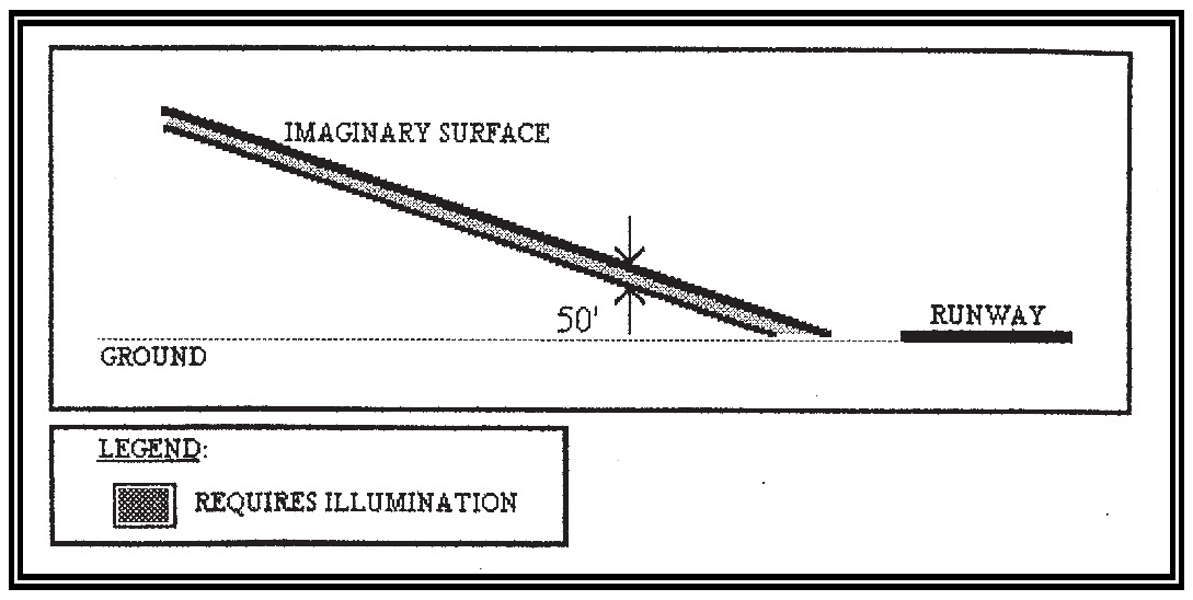
6.
Notification. All such persons proposing the construction of objects, whether of a temporary or permanent nature within twenty thousand (20,000) feet of a public use airport and the height of which penetrates a slope of 100:1 from the nearest point of the nearest runway, shall submit a copy of FAA form 7460-1 to the affected airport for review. Said airport shall have ten (10) business days to make any comments.
5:14.10 Airport Zones Relating to Noise Restrictions.
As noted in subsection 5:14.2, one (1) of the intentions of AP Protective Areas regulations is to encourage development, which is compatible with airport use characteristics. Noise resulting from aircraft operations is the airport use characteristic, which most affects surrounding development.
Relating the zoning format to noise criteria is difficult because two (2) land uses which might otherwise be compatible in a specific zoning category may each be affected differently by airport noise. For example, general commercial zoning may be compatible with airport noise. However, theaters (a commercial use) would need special protection at least to the extent that they were notified of potential incompatible noise characteristics on a proposed site prior to their construction. Supplementary regulations contained in the AP Protective Areas section of the Ordinance would facilitate notification of potential incompatible uses (as a result of aircraft noise) without undue restriction of the establishment of retail uses lists the criteria for evaluating and regulating development around the airport. Sensitive areas surrounding Greenville Downtown Airport and Donaldson Center are divided into Zones I through III. Zone I being the most restrictive. The Official Zoning Map of Greenville County, located at the Greenville County Planning Commission, delineates the location and area of each of the zones around the airport.
Greenville-Spartanburg International Airport is surrounded by an Airport Environs Area, which prohibits certain future land uses. This area is delineated on the Official Zoning Map of Greenville County. The land uses allowed within the Environs Area are stated in the Greenville-Spartanburg Airport Environs Area Zoning Ordinance, which is on file with the Greenville County Planning Commission, the City of Mauldin, and the Greenville-Spartanburg Airport Commission.
5:14.11 Airport Zoning Related to Sanitary Landfill Location.
Various studies and observations have resulted in the conclusion that sanitary landfills attract birds, and that birds in the vicinity of airports create potential hazards to aircraft operations (see FAA order SO 5200.5). Aircraft accidents have resulted when aircraft collided with low-flying birds, particularly during takeoff and landing. In order to prevent such an occurrence in Greenville, the following regulations shall apply with regard to location of landfills:
A.
No landfill shall be located within ten thousand (10,000) feet from a runway of any airport.
B.
Landfills located further than ten thousand (10,000) feet, but within five (5) miles of a runway of any airport will be reviewed on a case by case basis by the respective airport Commission staff, who may in turn contact the Bird Hazard Group and the Federal Aviation Administration. If in the opinion of the airport Commission staff, the landfill poses a threat to safe aircraft operations, then the landfill shall be considered an incompatible land use.
5:14.12 Enforcement.
It shall be the duty of the Zoning Administrator to administer and enforce the regulations prescribed herein. Applications for permits and variances shall be made to the Building Standards Department upon a form published for that purpose. Applications required by this Ordinance to be submitted to the Zoning Administrator shall be promptly considered and granted or denied. Application for action by the Board of Appeals shall be forthwith transmitted by the secretary.
Editor's note— Former § 5:13, AP, Airport Protective Areas, has been redesignated as § 5:14, by the discretion of the editor in order to avoid duplication.
Sec. 5:15 - UVD, Urban Village District.
5:15.1 Purpose and Findings.
The Urban Village District is designed to permit the development of land in a manner consistent with the historic and timeless principles of placemaking. An Urban Village combines commercial, civic and residential uses in a compact, walkable setting. Urban Villages feature a highly interconnected street network and massing appropriate to create a public realm built on a human scale. The intent of this district is to guide the development of Urban Villages in a manner that accomplishes the following purposes:
A.
Promote a diverse mix of business, commercial, office, residential, institutional, educational, cultural, and entertainment activities for workers, visitors, and residents.
B.
Emphasize safe and convenient access to shopping, restaurants, employment centers, entertainment venues, and other essential services to pedestrians, bicyclists, transit riders, motorists, and people with disabilities.
C.
Promote the health and well-being of residents by encouraging physical activity, alternative transportation, and greater social interaction.
D.
Create a sense of place that represents a unique, attractive, and memorable destination for visitors and residents.
E.
Enhance the community's character through the promotion of high-quality urban design.
F.
Create a feeling of vitality in order to attract private investment, invigorate civic pride, and enhance the tax base for the City.
Generally, an Urban Village District is intended to be established over a contiguous area of at least ten (10) acres. However, an Urban Village District may be established at a smaller site where the context of the site is compatible and appropriate for accomplishing the expressed purposes of the Urban Village District. Nothing herein shall prevent a project from being phased in increments of less than ten (10) acres.
5:15.2 Procedures.
A.
Application. The application for a designation of an Urban Village District shall follow the same procedures as a rezoning application with formal reviews by the Planning Commission and the City Council. In addition to the completed rezoning application, the applicant shall also submit a conceptual plan for the entire parcel or assemblage of parcels that conveys the approximate layout of streets and alleys, civic spaces, and buildings. Nothing in the conceptual plan shall be considered binding on the prospective development; rather, the conceptual plan will be used to surmise the applicant's intent to adhere to the guidelines of this district.
Generally, the City of Mauldin finds that the proximity of jobs and shopping activities to housing in an Urban Village can achieve significant trip reductions produced by the internal capture of home-work, home-shopping, and work-shopping trips. The City of Mauldin further finds and determines that there is compelling public interest to encourage new development to occur in accordance with the criteria set forth in this district. Accordingly, an application to establish an Urban Village District classification does not necessarily need to be accompanied by a traffic impact analysis and/or parking analysis. However, City staff or the City Council may request the submission of a traffic impact analysis and/or parking analysis when it has reasonable ground to believe that conditions may exist that would preclude the development from achieving the desired trip reductions noted above.
Applications which consist of property owners of separate tracts of land shall be accompanied by legally binding agreements which establish cross-access, cross-parking, and similar agreements which affect joint planning of the development.
B.
Development Plans. Following approval of the Urban Village District classification, the applicant shall be authorized to submit development plans for review and approval and to obtain any applicable permits. City staff shall have authority to approve development plans and issue the appropriate permits. Development plans shall include the technical requirements, standards and specifications outlined in the City's preliminary plat and site plan checklists, façade elevation checklist and any other materials or information requested by the Business and Development Services Director, or their appointee, where necessary to determine compliance of the proposed development.
C.
Conformance to Zoning and Land Development Regulations. Generally, the appropriate regulations and standards contained in the Zoning Ordinance and the Land Development Regulations shall apply to the Urban Village District. Where the standards specified for this district conflict with other standards contained in the Zoning Ordinance or the Land Development Regulations, the standards for this district shall generally prevail. In order to accomplish the intent of this district, the standards contained in the Zoning Ordinance and the Land Development Regulations may be relaxed at the discretion of the Business and Development Services Director where necessary to advance the purpose of the Urban Village District.
D.
Urban Village District Standards. The design and arrangement of thoroughfares, civic spaces, and building types is critical to accomplishing the intent described for the Urban Village District. Therefore, the standards of this district have been organized by (1) thoroughfare design, (2) civic space design, (3) frontage design and (4) building design. Applicants should give careful attention to the details in how these various elements interact to form the fabric of a successful Urban Village project.
5:15.3 Thoroughfare Standards.
A.
Intent. Good streets form the backbone of healthy communities. Not only do they perform a dual role as vehicular and pedestrian corridors, but they also serve as the community's primary public spaces. The impact of their design on communities cannot be underestimated.
For communities to be walkable, thoroughfares must be designed with pedestrian comfort and safety as critical goals along with the safe and efficient flow of traffic and other considerations, such as the accommodation of emergency vehicles, parking, utilities, and storm water. To elevate the importance of pedestrian safety and comfort, the focus for thoroughfare design should be on design speed rather than the volume of traffic and the level of service. In addition, thoroughfares should typically be narrower than conventional thoroughfares and arranged in an interconnected, gridded network; careful design of intersections should include tighter curb radii.
B.
General Standards.
1.
Connectivity. The most important aspect of any Urban Village is that it be a walkable place with an interconnected system of streets. A well-connected street network spreads traffic efficiently, provides greater opportunities for access by service and emergency vehicles, and furthers pedestrian mobility by increasing the number of destinations that can be reached by walking.
The street network of an Urban Village development shall be designed to form a grid pattern with streets interlinked at numerous points, intersections closely spaced and little to no dead-ends. Generally, thoroughfares within the development shall terminate at other internal thoroughfares and should also connect wherever possible to those on adjacent sites.
2.
Culs-de-Sac. The City of Mauldin finds that the use of culs-de-sac and dead-end streets is inconsistent with the public policy of preserving an interconnected street system. Culs-de-sac and dead-end streets do not promote street connectivity and create inefficiencies in the distribution of traffic and water as well as inefficiencies and increased municipal expenses in the delivery of public services.
In limited situations, culs-de-sac can be used in areas of topographical constraints and/or to avoid disturbing sensitive environmental features. The use of culs-de-sac shall be restricted to appropriate situations; where used, culs-de-sac shall be of the minimum length necessary per the situation. Loop streets, eyebrow configurations, and similar alternatives are encouraged in place of culs-de-sac.
3.
Corner Radius Clear Zone. To allow for emergency vehicles (e.g., fire trucks) to safely turn corners, a twenty-five-foot radius clear zone shall be established free of all vertical obstructions including, but not limited to, telephone poles, sign poles, fire hydrants, and electrical boxes.
4.
Bike Lanes. Where required, bike lanes may be included as individual bike lanes reserved for bicyclists, combined with trails, or striped as part of the street system. Bike lanes shall maintain a minimum overhead clearance of eight (8) feet.
5.
Private Streets. Private streets are permitted herein. The design standards and construction specifications of private streets shall be the same as for public streets, notwithstanding alternative pavement layer materials may be accepted for private streets.
6.
Sidewalk Continuity. Sidewalks shall align vertically and horizontally with abutting sidewalks. Sidewalks shall not be installed in such a manner that they conflict with or are obstructed by power lines, telephone poles, fire hydrants, traffic/street signs, mailboxes, trees, buildings, barriers, light poles, or any other structure. When there is an existing or anticipated obstruction, the sidewalk shall be installed around the object and shall provide the required sidewalk width.
7.
ADA Standards. The City of Mauldin is committed to ensuring that all public and private facilities, including accessible routes, sidewalks and other public walkways, are designed to meet the mobility needs of all users. All new streets, sidewalks and other public walkways shall be constructed in accordance with the Americans with Disabilities Act (ADA) for Accessible Design.
8.
Street Lights. Street light fixtures shall typically be made of metal and shall be consistent in color and style along both sides of the street; however, nothing herein shall prevent street light fixtures from being incorporated with a thematic public art project. Only column-design street lighting shall be acceptable. Street lighting shall incorporate hoods, cut-off lenses, or similar devices that prevent glare or spillover into the sky or into building stories above the ground floor. Cobra-head street lights or street lights of a similar design are prohibited.
9.
Placement of Utilities. All new utility lines shall be placed underground.
C.
Thoroughfare Types. The streets within this district are intended to balance the needs of all types of traffic—auto, bicycle, and pedestrian—to maximize the mobility and convenience for all the citizens and users. While all streets will appropriately balance pedestrian and automobile needs, their character will vary by specific location. Some streets will carry a large volume of both automobile and pedestrian traffic and provide a more intense urban experience while others will provide more intimately scaled street-space. A variety of acceptable thoroughfare types can be calibrated and used in creating a walkable community, including alleys, lanes, roads, streets, commercial/main streets, avenues, and boulevards.
The following thoroughfare types are generally inappropriate in the Urban Village district:
a)
Highway (HW) - A rural and suburban thoroughfare of high vehicular speed and capacity.
b)
Rural Street (RS).
The following thoroughfare types are generally acceptable in the Urban Village district:
a)
Boulevard (BV).
b)
Main Street (MS).
c)
Avenue (AV).
d)
Local Street (LS).
e)
Alley (AL).
1.
Boulevard (BV).
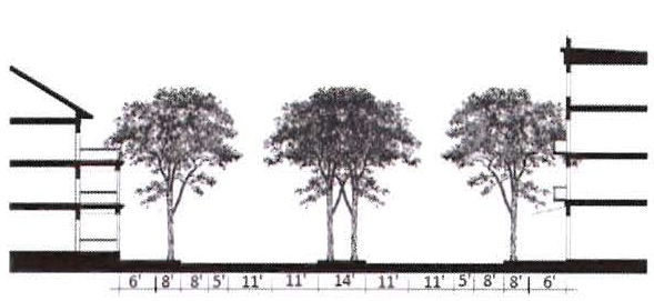
Definition. A thoroughfare designed for high vehicular capacity and moderate speed, traversing an urbanized area.
Guidelines. The following are not regulations, but entail general descriptions to help designers, developers, and engineers better understand the thoroughfare type in order to apply it appropriately.
* Drivers will move unimpeded at higher speeds
Features.
1 Large to medium trees should be used; plantings and other materials within the median shall not obscure the visibility of cars entering a cross street for a distance of twenty (20) feet back from the curb face of the cross street.
2.
Main Street (MS).
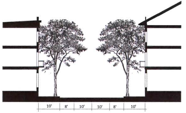
Definition. A thoroughfare lined with mixed-use shopfront buildings that are positioned at the front of each lot.
Guidelines. The following are not regulations, but entail general descriptions to help designers, developers, and engineers better understand the thoroughfare type in order to apply it appropriately.
* Drivers will move slowly based on their perception of the environment and activity in the area, such as the presence of pedestrians.
Features.
1 Walkways shall incorporate street furniture, including benches, trash receptacles, street signs, and traffic lights. Benches and trash receptacles shall be provided at intervals no greater than two hundred (200) feet. Street furniture shall be located so as to maintain a clear pedestrian path and shall be placed within six (6) feet of the curb. Benches may also be placed at the rear of the sidewalk within three (3) feet of the right-of-way line. Benches with backs shall be oriented to face the street. Street furniture shall be made of metal painted with a black or dark green matte finish and/or wood or stone with a natural finish. Street furniture shall be consistent in color and style along both sides of any street.
3.
Avenue (AV).
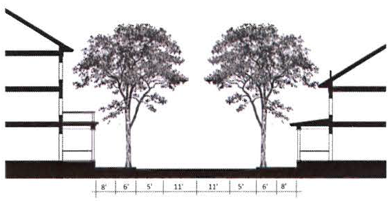
Definition. A thoroughfare of medium vehicular capacity and low to moderate speed, acting as a short distance connector between Urban Villages.
Guidelines. The following are not regulations, but entail general descriptions to help designers, developers, and engineers better understand the thoroughfare type in order to apply it appropriately.
* Drivers will move slowly based on their perception of the environment and activity in the area, such as the presence of pedestrians.
Features.
4.
Local Street (LS).
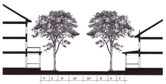
Definition. A local urban thoroughfare of low speed and capacity that primarily provides access to residential development.
Guidelines. The following are not regulations, but entail general descriptions to help designers, developers, and engineers better understand the thoroughfare type in order to apply it appropriately.
* Drivers will move slowly based on their perception of the environment and will slow down or pull to the side to pass in opposite directions
Features.
5.
Alley (AL).
Definition. A vehicular way located to the rear of lots providing access to service areas, parking, and outbuildings and containing utility easements.
Note: Alleys help minimize curb cuts and provide access to parking and service areas behind buildings. Alleys may be incorporated into parking lots as drive aisles and fire lanes. Alleys and drive aisles are permitted to be incorporated through and between buildings.
Guidelines. The following are not regulations, but entail general descriptions to help designers, developers, and engineers better understand the thoroughfare type in order to apply it appropriately.
* Drivers will move slowly based on their perception of the environment and will slow down or pull to the side to pass in opposite directions.
Features.
1 Drainage shall be addressed through an inverted crown at the center or with roll curbs at the edges.
5:15.4 Civic Space Standards.
A.
Intent. Well-designed and well-located civic spaces, such as parks and plazas, are critical for healthy and vibrant communities. They provide access to outdoors, they act as organizing elements within the structure of communities and downtowns, and they serve as public gathering places for all members of the community. Civic spaces should not be made up of residual space left after buildings are placed on a site (i.e., along sound walls, tucked into corners, or the like).
In order for civic spaces to be accessible and usable, they should be located within walking distance of residences and workplaces, typically one (1) every one-fourth (¼) to one-half (½) mile. They should be designed and sized appropriately. For instance, hardscaped plazas work beautifully in the Urban Village district. Landscape design should be carefully considered such that landscape materials do not inadvertently obstruct the casual surveillance of a public space and thereby compromise safety.
B.
General Standards.
1.
Visibility. A clear view through the public space (from two (2) to seven (7) [feet] in height) is required and is important for safety and urban design purposes.
2.
Unstructured Recreation. Civic greens, squares, and plazas should not include active recreation structures such as ball fields and courts.
3.
Slopes. At least fifty (50) percent of the civic space shall have slopes less than seven (7) percent. Exempt: Stormwater management facilities/areas which also function as active or passive recreation areas.
C.
Civic Space Types. The following civic space types are generally acceptable in the Urban Village district:
1.
Civic Green.
Definition. An open space available for unstructured recreation. While it is often surrounded by buildings, a civic green may be spatially defined by landscaping rather than building forms.
Note: Greenbelts, which often run along the perimeter of a development, are an acceptable form of a civic green. Typically these features are designed to buffer a development from surrounding incompatible uses or features, such as a highway corridor or industrial district.
Guidelines. The following are not regulations, but entail general descriptions to help designers, developers, and engineers better understand the civic space type in order to apply it appropriately.
* Civic greens are often landscaped with trees at the edges and open lawns at the center. Civic greens typically contain no structures other than benches, pavilions, and memorials. Trails or pedestrian pathways are optional.
2.
Square.
Definition. An open space available for unstructured recreation and civic purposes. It is generally intended to be an active pedestrian center. A square is typically spatially defined by streets but may also be surrounded by buildings. Squares are generally located at the intersection of important streets.
Guidelines. The following are not regulations, but entail general descriptions to help designers, developers, and engineers better understand the civic space type in order to apply it appropriately.
3.
Plaza.
Definition. An open space available for civic purposes and commercial activities. A plaza is typically spatially defined by building frontages but may also be bounded by streets. Plazas are generally used to emphasize important places, intersections, or centers.
Guidelines. The following are not regulations, but entail general descriptions to help designers, developers, and engineers better understand the civic space type in order to apply it appropriately.
* Trees are optional
4.
Playground.
Definition. An open space designed and equipped for the recreation of children. A playground is generally fenced and may include an open shelter. Playgrounds are also generally interspersed within residential areas and may be placed within a block. Playgrounds may be included within greens.
Guidelines. The following are not regulations, but entail general descriptions to help designers, developers, and engineers better understand the civic space type in order to apply it appropriately.
5:15.5 Frontage Standards.
A.
Intent. The frontage is the way a building engages the public realm. The ultimate intent of regulating frontage is to ensure, after a building is located appropriately, that its interface with the public realm and the transition between the two (2) are detailed appropriately.
B.
General Standards.
1.
Fencing. Where fencing is expressly permitted as a feature of a frontage type, only fences of an ornamental nature (e.g., wrought iron or picket fences) shall be permitted. Chain link fences are strictly prohibited. Where permitted, no fence shall exceed a height of six (6) feet.
2.
Outdoor Dining. Outdoor dining is permitted within the public right-of-way when accompanying a restaurant located in an adjacent building. At least four (4) feet of continual clearance between dining furnishings and any curbline or street furnishings shall be maintained to provide for adequate pedestrian circulation and to maintain accessibility. Dining furnishings shall also stay clear of display windows and entryways of other adjacent businesses.
Tables and chairs used in outdoor dining areas shall be constructed of heavyweight, high-quality materials like metal or wood. Lightweight materials such as plastic and vinyl which may be blown astray by moderate winds are prohibited. The outdoor dining area shall be maintained in a clean and safe condition at all times, including promptly and properly disposing of all trash generated by the operation.
No additional parking spaces shall be required for outdoor dining areas.
3.
Outdoor Display/Sales. The outdoor display of goods is permitted within the public right-of-way when accompanying a shop or store located in an adjacent building. At least six (6) feet of continual clearance between the display and any curbline or street furnishings shall be maintained to provide for adequate pedestrian circulation. Outdoor displays shall also stay clear of display windows and entryways of other adjacent businesses.
C.
Frontage Types. The following frontage types are generally inappropriate the Urban Village district:
a)
Common Yard—A planted frontage wherein the façade is set back substantially from the frontage line. The front yard created typically remains unfenced and is visually continuous with adjacent yards, supporting a common landscape.
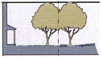
b)
Porch and Fence—A planted frontage wherein the façade is set back from the frontage line with an attached porch permitted to encroach. A fence at the frontage line maintains street spatial definition.
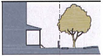
The following frontage types are generally acceptable in the Urban Village district:
a)
Stoop.
b)
Terrace or Lightwell.
c)
Dooryard.
d)
Forecourt.
e)
Common Lawn.
f)
Shopfront.
g)
Gallery.
h)
Arcade.
1.
Stoop.
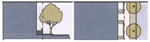
Definition. A frontage wherein the façade is aligned close to the frontage line and an elevated stoop engages the sidewalk. The first story should be elevated above the sidewalk to secure privacy for the windows. The entrance is usually an exterior stair and landing. This type is recommended for ground-floor residential uses with small setbacks.
Features.
a)
The stoop at the door shall be at least four (4) feet deep and at least three (3) feet wide.
b)
The first story should be elevated a minimum of twenty-four (24) inches above the sidewalk but no more than five (5) feet above the sidewalk.
c)
Stoops must correspond directly to the building entry(s).
d)
The stairs from the stoop may lead directly to the sidewalk or may be side loaded.
e)
Fences, walls or handrails defining the stoop may not exceed a height of thirty (30) inches.
2.
Terrace or Lightwell.
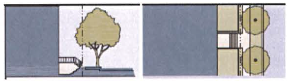
Definition. A frontage where in the façade is set back from the frontage line by an elevated terrace or a sunken lightwell. This type buffers residential use from urban sidewalks and removes the private yard from public encroachment.
Features.
a)
Sub-basements accessed by a lightwell may not be more than six (6) feet below the adjacent sidewalk.
b)
Terraces are suitable for conversion to outdoor dining.
3.
Dooryard.
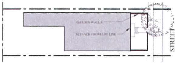
Definition. A frontage wherein the façade is set back from the frontage line by an at-grade courtyard. This type buffers residential use from urban sidewalks and removes the private yard from public encroachment.
Features.
a)
The dooryard should not be more than twenty (20) feet deep.
b)
A one-story wall should be used to define the dooryard.
c)
Large trees within the dooryard may overhang the sidewalk.
d)
The dooryard is suitable for conversion to outdoor dining.
e)
This frontage type should be used sparingly and should not be repeated within a block.
4.
Forecourt.
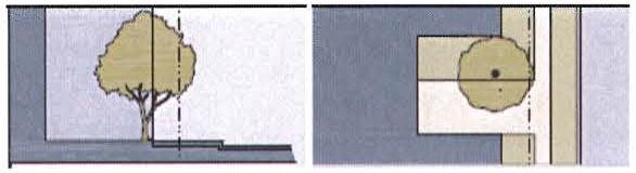
Definition. A frontage wherein a portion of the façade is close to the frontage line and a small percentage of it is set back, creating a small court space. The space could be used as an entry court, additional shopping or restaurant seating area, or in some cases as a vehicular drop-off.
Features.
a)
The forecourt should be at least fifteen (15) feet wide by ten (10) feet deep.
b)
The proportions and orientation of these spaces should be carefully considered for solar orientation and user comfort.
c)
Forecourts with a depth between ten (10) feet and fifteen (15) feet should be substantially paved and enhanced with landscaping. Forecourts larger than this should be designed with a balance of paving and landscaping.
d)
A one-story fence or wall at the property line may be used to define the private space of the yard.
e)
Large trees within the forecourt may overhang the sidewalk.
f)
This frontage type should be used sparingly and should not be repeated within a block.
5.
Common Lawn.
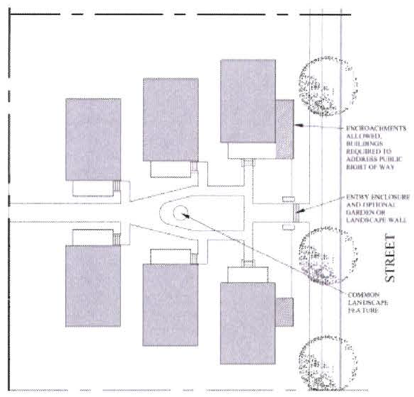
Definition. A frontage wherein a group of buildings share a common lawn on a single lot. The frontage has a visual relation to the street and the buildings across the lawn.
Features.
a)
The common lawn should feature a common landscape with a minimum width of thirty (30) feet.
b)
The front buildings should be arranged close to the street.
c)
The common lawn, or courtyard, should be connected to the public way by a prominent feature such as a zaguan or paseo. The entry may entail a garden or landscape wall.
d)
This frontage type should be used sparingly and should not be repeated within a block.
6.
Shopfront.
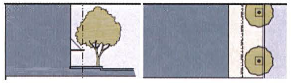
Definition. A frontage wherein the façade is aligned close to the frontage line with the building entrance at sidewalk grade. This type is conventional for retail use.
Features.
a)
The building frontage should have substantial glazing on the sidewalk level, including large transparent display windows and transom windows.
b)
The entry may be recessed from the frontage line by up to five (5) feet.
c)
Awnings may overlap the sidewalk to within two (2) feet of the curb.
7.
Gallery.
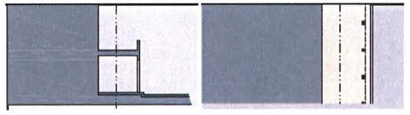
Definition. A frontage wherein the façade is aligned close to the frontage line with an attached cantilevered shed or a lightweight colonnade overlapping the sidewalk. This type can be one (1) or two (2) stories and is intended for retail uses. The gallery should encroach into or overlap the sidewalk close to the curb so that a pedestrian cannot bypass it.
Features.
a)
The entry should be at the same grade as the sidewalk.
b)
The gallery shall be no less than ten (10) feet wide and should overlap the sidewalk.
c)
The gallery shall clear the adjacent sidewalk by a minimum height of ten (10) feet.
d)
The maximum height of the gallery shall be two (2) stories.
e)
The face of the gallery shall be set back at least one (1) foot but no more than three (3) feet from the curb (except at curb extensions for intersections).
f)
Columns and arches at the right-of-way should be spaced at least eight (8) feet apart.
g)
The height and the proportions of the gallery may correspond to the façade consistent with the architectural style of the building.
h)
The building frontage should have substantial glazing on the sidewalk level, including large transparent display windows and transom windows.
8.
Arcade.
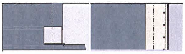
Definition. A colonnade supporting habitable space that overlaps the sidewalk, while the façade at sidewalk level remains at or behind the frontage line. This type is intended for retail uses. The arcade should encroach into or overlap the sidewalk close to the curb so that a pedestrian cannot bypass it.
Features.
a)
The entry should be at the same grade as the sidewalk.
b)
The arcade shall be no less than ten (10) feet wide and should overlap the sidewalk.
c)
The arcade shall clear the adjacent sidewalk by a minimum height of ten (10) feet.
d)
The face of the arcade shall be set back no more than two (2) feet from the curb (except at curb extensions for intersections).
e)
Columns and arches at the right-of-way should be spaced at least eight (8) feet apart.
f)
The height and the proportions of the arcade may correspond to the façade consistent with the architectural style of the building.
g)
The building frontage should have substantial glazing on the sidewalk level, including large transparent display windows and transom windows.
5:15.6 Building Type Standards.
A.
Intent. Building types as used herein are driven primarily by the physical form of the building and secondarily by its use or function. The intent of using building types as a primary means of regulation is to prescribe a fine-grain mix of building types that is necessary to create a great urban form and high-quality place that is not easily accomplished with traditional regulations of floor-area ratio (FAR) and density.
Consider a high-quality historic neighborhood or town. Inevitably, it will include a fine-grained integration of a variety of building types, often within the same block, that creates the fabric of the community that is so cherished.
B.
General Standards.
1.
Architectural Expression. Building walls and facades should have perceivable thickness, visual interest, and character. A selection of architectural details such as vertical and horizontal recesses and projections, changes in height, floor levels, roof forms, parapets, cornice treatments, belt courses, pilasters, window reveals, and forms, and color as appropriate to each site can create shadows and texture and add to the character of the building.
2.
Exterior Finish Materials. Plain concrete block, plain concrete, corrugated metal, plywood, and sheet pressboard are not allowed as exterior finish materials.
3.
Horizontal Massing. Buildings are encouraged to incorporate varied massing and design across long facades. Building walls shall be articulated at a minimum of every fifty (50) feet. Articulation may include storefront bays with modulating building elements such as recesses, projections, expressed entries, building form, columns, pilasters, colonnades, arcades, and/or other clearly expressed architectural details. No horizontal section of the building façade shall exceed fifty (50) feet without incorporating visible changes in the façade elevation.
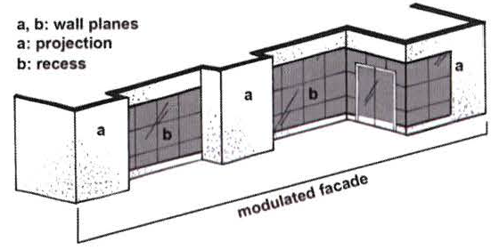
4.
Vertical Massing. Multi-story buildings shall generally include a base, middle, and cap. The base generally consists of the entryway(s) and large transparent windows. The middle is generally described as the upper stories of a building and typically features windows and/or balconies. The cap includes the area from the top floor to the roof of the building.
In order to modulate their scale, multi-story buildings shall articulate the base, middle, and cap through the use of expression lines, cornices, string cornices, step-backs, or similar articulating features as follows:
a)
A horizontal expression line between the base and the middle is vital for reinforcing the pedestrian scale at the adjacent sidewalk. The expression line may entail a molding or reveal placed between the first and second stories or over the second story. The molding or reveal shall have a depth of at least two (2) inches and a height of at least four (4) inches.
b)
The middle may also utilize expression lines to articulate long vertical sections of the building.
c)
The cap shall include an expression line consisting of a cornice or a roof overhang.
Expression lines, including moldings, cornices, and windowsills, shall generally align with those of adjoining buildings.
5.
Ground Floor Windows and Entryways. The ground floors of all buildings shall be designed to encourage and to complement pedestrian-scale activity by the use of windows and doors arranged so that the uses are visible from and/or accessible to the street. Buildings shall maintain a regular rhythm of storefronts along a block with entrances at least every fifty (50) feet on average.
All buildings shall have their principal entrance opening to a street, square, plaza, or public sidewalk. Building entrances should be prominent and easy to identify. The principal entrance shall not open onto a parking lot. Pedestrian access from the public sidewalk, street right-of-way, or driveway to the principal structure shall be provided through an improved surface.
Doors may be recessed into the face of the building to provide a sense of entry and to add variety to the streetscape. Recommended treatments for recessed entries include special paving materials such as ceramic tile, ornamental ceilings such as coffering, and decorative light fixtures.
At the ground level, at least sixty (60) percent, but not more than ninety (90) percent, of the total surface area of the front elevation shall be in public entrances and windows (including retail display windows). Where windows are used on storefronts, transparent glass shall be used to allow maximum visual interaction between pedestrians and the interior of the building. Ground floor windows on storefronts shall not appear false or applied.
Windows shall incorporate decorative architectural features such as sills, trim, and lintels.
The bottom of windows used on storefronts shall be at least twelve (12) inches but not more than thirty-six (36) inches above the grade of the adjacent sidewalk and shall be separated from the ground by a bulkhead. Bulkheads might be a panel of tile or other material that is heavier than the wall materials.
6.
Upper Story Windows and Doors. For multi-story buildings, upper-story windows, doors and other openings shall make up at least thirty (30) percent, but not more than sixty (60) percent, of the wall surface of the upper stories.
All windows shall incorporate decorative architectural features such as sills, trim, and lintels. Windows should be inset a minimum of three (3) inches from the exterior wall surface to add visual relief to the wall.
7.
Awnings and Canopies. Awnings, canopies, and other features that provide shade for pedestrians are strongly encouraged and should be integrally designed with the building. Awnings should fit within enframed storefronts, primarily covering openings such as windows and doors and not extending along the entire façade.
Awning shape, size, color, and material should be consistent with the architectural style and character of the building. Awnings should be compatible with adjacent awnings. The shape, size, and height of each awning should be proportional to the façade. Awnings shall be made of fabric, metal, glass, or similar durable material.
Awnings shall clear the adjacent sidewalk by a minimum height of eight (8) feet.
8.
Height Exceptions. The height limits prescribed herein do not apply to spires, belfries, cupolas, or domes not used for human habitation, nor to chimneys, ventilators, skylights, parapet walls, cornices, solar energy systems, or necessary mechanical appurtenances usually located on the roof level.
9.
Roofs. Roof lines should vary and be expressed in a visually interesting manner that complements the composition of the building and the surrounding area. Flat roofs shall incorporate a strong, attractively detailed cornice or parapet. To create a varied roof line, different types of cornices and varied cornice lines are encouraged. Sculpted roof forms shall employ high quality roofing materials.
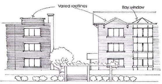
10.
Building Lighting. Lighting should be integral to the design of the building. Building lighting should highlight significant architectural features, signs, entrances, walkways, or display windows. Lighting should specifically be provided at building entrances for security purposes. Building lighting is not allowed to flash or blink repeatedly; notwithstanding animation that will not distract motorists in a hazardous manner may be permissible. Acceptable animation may include animation on upper stories or animation not larger than four (4) square feet on the ground story.
Lighting elements shall exclude those that cast a clearly/perceptively unnatural spectrum of light, such as low pressure sodium. Metal halide or halogen light sources shall be preferred. Fluorescent lights (except compact fluorescent bulbs that screw into standard sockets) shall not be used on the exterior of buildings.
At the front of the building, exterior lights shall be mounted on the building between seven (7) feet and fourteen (14) feet above the adjacent grade.
11.
Mechanical Equipment. Mechanical equipment, electrical meter and service components, and similar utility devices, whether ground level, wall-mounted, or roof-mounted, should be located so as to minimize visibility from all streets and public gathering areas. Mechanical equipment and other like appurtenances shall be screened from view at the front property line and any active street side. Exterior screening materials shall be the same as the predominant exterior materials of the principal building.
12.
Screening. Off-street loading areas, refuse and outdoor storage areas, satellite dishes, and mechanical equipment shall be screened from view at the front property line along blocks that contain buildings that front the public street. The screening shall be a minimum height sufficient to obscure the area or equipment requiring the screening. The screening may be provided by plants, a solid fence or wall, or a combination of walls and plants.
13.
Surface Parking Lot Design. Surface parking lots shall generally conform to the parking area design requirements, including the size of off-street parking spaces, as prescribed in Section 6:1 of the Mauldin Zoning Ordinance. All parking areas shall be surfaced with asphalt, bituminous, brick, turf block, or concrete material.
Off-site parking at satellite locations shall be permitted to meet parking requirements herein provided that such parking is no further than one thousand two hundred (1,200) feet from the facility that it serves.
Surface parking lots shall be landscaped in accordance with the requirements of Section 6:2 of the Mauldin Zoning Ordinance.
14.
Drive-Through Windows. Drive-through services are generally not considered compatible within a mixed-use environment where design is focused on providing a safe and walkable community. Drive-through service windows shall only be permitted when it is deemed that the use will not substantially disrupt pedestrian activity nor interfere with surrounding uses. No drive-through service window, bay, or queuing lane shall be located between the front façade and the right-of-way on the front side of the building.
C.
Building Types. The following building types are generally inappropriate in the Urban Village district:
a)
Paired house (duplex) - A structure with two (2) dwelling units placed one (1) beside the other, sharing a common wall.
b)
Tandem house - Two (2) single-family detached structures that share one (1) platted lot. One (1) unit is typically towards the front of the lot, while the other unit is typically located to the rear of the lot.
c)
Single-family detached house - One (1) dwelling unit on its own lot, detached from other adjoining lots.
The following building types are generally acceptable in the Urban Village district:
a)
Activity-Center Building.
b)
Prominent Civic Building.
c)
Small Civic Building.
d)
Small Commercial Building.
e)
Stacked Dwelling (Apartment Building).
f)
Rowhouse.
g)
Courtyard Housing.
h)
Parking Structure.
1.
Activity-Center Building.
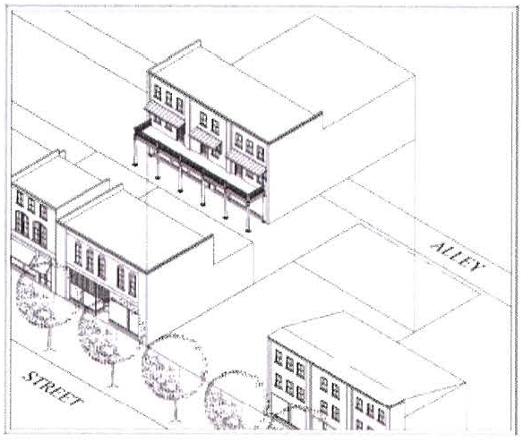
Definition. A structure which may contain a concentration of land uses mixed vertically. It is common for such structures to feature retail on the ground floor with office and/or residential uses on upper floors; however, any mix and arrangement may be considered which promotes appropriate urban activity.
Features.
1 Buildings may be set back further in accordance with frontage types allowed for this building type. Buildings may also be set back further to accommodate wider sidewalks, a plaza or similar courtyard space.
2 When abutting an alley, the minimum rear setback is zero (0) feet. On all corner lots, the building should be built to the rear property line.
3 The Board of Appeals may allow additional stories when they determine that the increased building height will not create any adverse effects on adjacent properties.
4 Where the building fronts on-street parking, parking is only required for office or commercial uses that are in excess of six thousand (6,000) square feet and only for the portion in excess of six thousand (6,000) square feet.
5 At-grade or above-ground parking is encouraged to be wrapped in active uses.
6 Entrance to the upper stories above the ground floor shall be through a street level lobby or through a podium lobby accessible from the street.
2.
Prominent Civic Building.
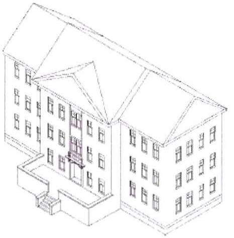
Definition. A civic structure located on a prominent community site. Prominent civic structures are allowed more design flexibility, due to their role in the community.
Features.
1 Prominent civic buildings do not have constraints regarding frontage design.
2 Entrance to the upper stories above the ground floor shall be through a street level lobby or through a podium lobby accessible from the street.
3.
Small Civic Building
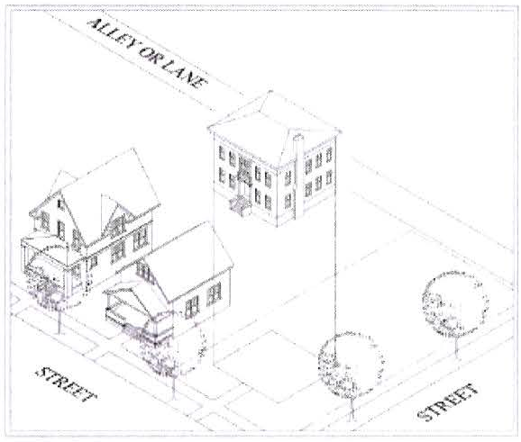
Definition. A building specifically designed for a civic function. Civic functions are not-for-profit organizations dedicated to religious, cultural, governmental, educational, or recreational objectives.
Features.
1 Except as may be permitted at allowable frontage types.
2 When abutting an alley, the minimum rear setback is zero (0) feet.
3 Where the building fronts on-street parking, parking is only required for civic uses that are in excess of six thousand (6,000) square feet and only for the portion in excess of six thousand (6,000) square feet.
4 Entrance to the upper stories above the ground floor shall be through a street level lobby or through a podium lobby accessible from the street.
4.
Small Commercial Building.
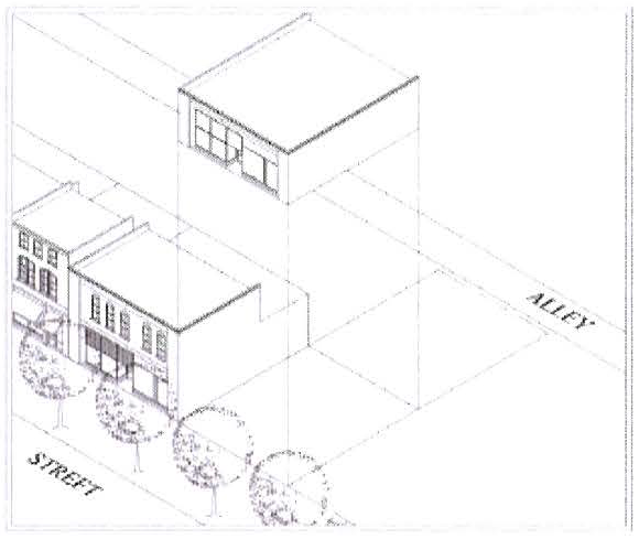
Definition. A single-use structure with either office or commercial use. The small commercial building is generally one (1) story and has a limited application in the Urban Village district.
Features.
1 Except as may be permitted at allowable frontage types.
2 When abutting an alley, the minimum rear setback is zero (0) feet. On all corner lots, the building should be built to the rear property line.
3 Small commercial buildings which only consist of one (1) story shall incorporate clerestory windows along the length of any façade visible from any public right-of-way.
4 Where the building fronts on-street parking, parking is only required for commercial uses that are in excess of six thousand (6,000) square feet and only for the portion in excess of six thousand (6,000) square feet.
5 Entrance to the upper stories above the ground floor shall be through a street level lobby or through a podium lobby accessible from the street.
5.
Stacked Dwelling (Apartment Building).
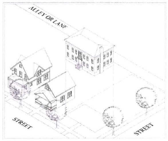
Definition. An exclusively residential building comprised of flats and/or dwelling units above or below. This building type may also be used for lodging purposes.
Features.
1 Except as may be permitted at allowable frontage types.
2 When abutting an alley, the minimum rear setback is zero (0) feet. On all corner lots, the building should be built to the rear property line.
3 The Board of Appeals may allow additional stories when they determine that the increased building height will not create any adverse effects on adjacent properties.
4 At-grade or above-ground parking is encouraged to be wrapped in active uses.
5 Entrance to the upper stories above the ground floor shall be through a street level lobby or through a podium lobby accessible from the street.
6.
Rowhouse.
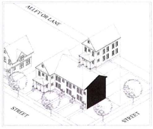
Definition. A dwelling unit attached by a common wall to another dwelling unit. A rowhouse is generally a fee-simple unit, from ground to roof, with no units above or below it. These dwellings are typically two- or three-story buildings with zero (0) side yard setbacks.
Features.
1 Except as may be permitted at allowable frontage types.
2 When abutting an alley, the minimum rear setback is zero (0) feet. On all corner lots, the building should be built to the rear property line.
3 Landscape should not be used to separate a front yard from front yards of adjacent units.
7.
Courtyard Housing.
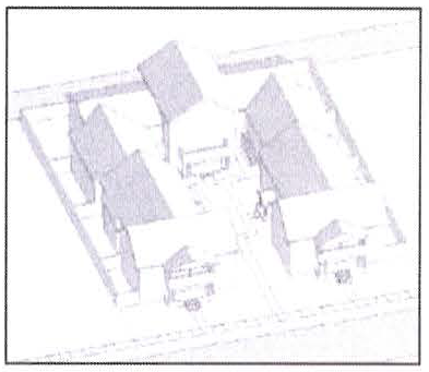
Definition. A group of dwelling units arranged to share one (1) or more common courtyards upon a lot. Dwellings take access from the street or the courtyard(s). The courtyard is intended to be a semi-public space that is an extension of the public realm.
Features.
1 Private patios may be provided in side and rear yards, and in courtyards.
2 Except as may be permitted at allowable frontage types.
3 When abutting an alley, the minimum rear setback is zero (0) feet. On all corner lots, the building should be built to the rear property line.
4 Structures that front the street may incorporate terrace or stoop frontage types. Landscape should not be used to separate a front yard from front yards of adjacent units.
5 Corner lots shall not have garages that face the side street.
8.
Parking Structure.
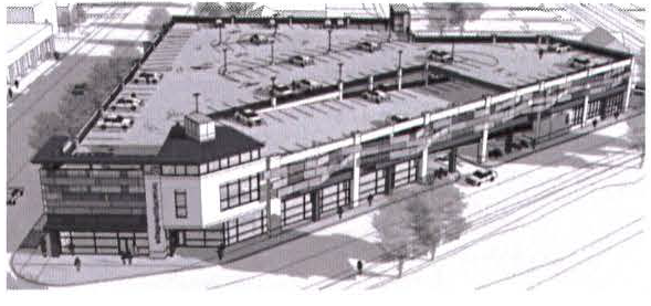
Definition. Parking spaces and adjacent access drives, aisles, and ramps that are located in a structure. This building type does not include private one-story garages for single-, two-, or multifamily dwellings.
Features.
1 Buildings may be set back further in accordance with frontage types allowed for this building type. Buildings may also be set back further to accommodate wider sidewalks, landscaping for the purpose of appropriate screening, a plaza or similar courtyard space.
2 When abutting an alley, the minimum rear setback is zero (0) feet. On all corner lots, the building should be built to the rear property line.
3 Where the building fronts on-street parking, parking is only required for office or commercial uses that are in excess of six thousand (6,000) square feet and only for the portion in excess of six thousand (6,000) square feet.
4 At-grade or above-ground parking is encouraged to be wrapped in active uses. Structures should be designed such that views of vehicles inside the structure are concealed from public streets and public spaces. Signage and light sources internal to the parking structure should not be visible from outside the parking structure.
5 Access should be designed so that conflicts between vehicles and pedestrians are minimized.
6 Entrance to the upper stories above the ground floor shall be through a street level lobby or through a podium lobby accessible from the street.
Design Standards.
a)
Parking structures shall conform to commercial building standards and guidelines pertaining to architectural scaling elements and building materials.
b)
Such structures shall be designed to conceal the view of all parked vehicles and internal light sources from adjacent public right-of-way or public open space for the full height of the structure.
c)
Façade openings (i.e. doors and windows) which face any public right-of-way or open space shall be horizontally aligned and the floor fronting on such facades shall be level.
d)
Parking structures should utilize materials and architectural detailing found in the development.
e)
Parking structures with exposed street frontage in otherwise primarily residential blocks should set back the parking structure façade at least eight (8) feet to accommodate greater landscape screening and to allow greater exposure of residential building corners.
f)
Exposed parking structures shall provide landscape screening at an average rate of one (1) tree and two (2) shrubs per thirty (30) linear feet of the parking structure's perimeter.
5:15.7 Signage Standards.
A.
Intent. Signage is desirable for advertising shops and offices, and as decoration. Signs should be clear, informative to the public, and should weather well. Signs should be scaled to the nature of the location and surrounding architecture. Signage that is glaring or too large creates distraction, intrudes into and lessens the experience within the district, and creates visual clutter.
B.
Permitted Signs. Signage allowances and requirements in the Urban Village district shall be in accordance with Section 6:4 Signs, in the Mauldin Zoning Ordinance.
The following signs are permitted within the Urban Village district:
a)
Wall signs, crown signs, hanging signs, projecting signs, and permanent banner signs.
b)
Awning and canopy signs.
c)
Window signs.
d)
Restaurant menu signs.
e)
Temporary A-frame signs.
f)
Directional signs.
g)
Light pole banner signs.
Other signs that may be permitted and shall be reviewed on a case-by-case basis include:
a)
Marquee signs.
b)
Freestanding monument signs.
c)
Tenant directory signs.
d)
Wayfinding pedestrian kiosks.
e)
Murals.
Where an applicant desires greater creativity in signage beyond the types of signage permitted herein, the applicant may submit a Signage Plan in accordance with Section 6:4.1.16 of the Mauldin Zoning Ordinance. A Signage Plan allows for creativity in the placement and design of signs and may include signs of different sizes, types, location, placement and height from those otherwise enumerated in the sign ordinance.
1.
Walls Signs, Crown Signs, Hanging Signs, and Projecting Signs. Wall signs, hanging signs, projecting signs, and permanent banner signs should generally be installed above display windows and/or at entryways. The combined size of wall signs, hanging signs, projecting signs, and permanent banner signs shall not exceed fifteen (15) percent of the surface area of the façade (including windows and doors) that corresponds to the floor or story on which they are installed. The bottom of a hanging sign or a projecting sign shall be located at least eight (8) feet above the adjacent grade.
a)
Wall Signs.
i.
Wall signs are to be mounted flush and fixed securely to a building wall, projecting no more than twelve (12) inches from the face of a building wall, and not extending beyond the side of the building face or above the highest line of the building to which it is attached.
ii.
Wall signs should be located on the upper portion of the ground level storefront, just above the storefront opening, when possible.
iii.
Upper story tenants with no ground floor presence shall be allowed window signs not exceeding twenty-five (25) percent of each window opening.
iv.
Neon signs are permitted as wall signs on ground floors.
b)
Top Story "Crown" Signs.
i.
As used herein, a "crown" sign is a sign erected parallel to and attached to the exterior façade of the topmost story of a multi-story building. Crown signs are generally, but not always, used to announce the name of the building or the business that occupies the upper floors of the building.
ii.
Crown signs shall not exceed twenty-five (25) percent of the façade measured from the floor of the uppermost story to the top of the building. No more than one (1) crown sign shall be permitted on each building façade.
iii.
Crown signs may project above the roofline of the building provided not more than fifty (50) percent of the crown sign shall project above the roofline.
c)
Hanging Signs and Projecting Signs.
i.
Hanging signs and projecting signs are affixed to the face of a building or structure and project perpendicular from the wall surface. Decorative metal brackets that support projecting signs are encouraged where feasible.
ii.
Hanging signs and projecting signs are permitted to encroach into to the right-of-way but shall not project more than four (4) feet from the building.
iii.
To promote legibility by pedestrians, it is generally better to mount projecting signs and hanging signs below the second floor window sill on multi-storied buildings.
d)
Permanent Banner Signs.
i.
Permanent banner signs often help to add interest and color to blank facades and special buildings that front a sidewalk. These signs are a great way to create vibrancy, promote the brand of the store, or add seasonal interest. Banners with unique shapes are encouraged to provide visual interest to a business. These signs are typically permanent in the sense that the brackets to which they are attached are more or less permanent. The banners themselves may be exchanged at various intervals.
ii.
Permanent banners should be oriented vertically and be mounted perpendicular to the façade. These signs are allowed on building facades built to the property line provided such banners do not adversely impact pedestrian or vehicular access.
iii.
Banners installed more than eight (8) feet above the sidewalk shall be secured to brackets installed at the top and bottom of the banner. Such banners are permitted to encroach into the right-of-way but shall not project more than four (4) feet from the building.
iv.
Banners installed less than eight (8) feet above the sidewalk shall be secured to a bracket installed at the top of the banner. Such banners shall be weighted at the bottom. Such banners are permitted to encroach into the right-of-way but shall not project more than eighteen (18) inches from the building.
e)
Flags.
i.
Flags which bear the official design or insignia of a government, educational institution, church, fraternal, or corporate organization are permissible herein. Flags which are ornamental in nature are also permissible. Flags which are erected for commercial purposes shall be prohibited.
2.
Awning and Canopy Signs.
a)
Awning and canopy signs are signs that are printed on, or attached to, an awning or canopy above a business door or window. They generally serve to bring color and shade to a pedestrian environment.
b)
For better legibility, it is recommended that the lettering color should contract with the background color.
c)
Awnings should be designed with individual awnings for each window and door opening rather than a single awning extending over multiple window openings or masonry piers or arches. Notwithstanding, a single awning may be permitted to extend over fully operable storefront sections and/or café areas.
3.
Window Signs.
a)
Window signs are signs that are painted, posted, displayed, affixed, or etched on an interior translucent or transparent surface, including windows or doors.
b)
Signs on the interior of window glass shall not cover more than twenty-five (25) percent of the window.
4.
Restaurant Menu Signs.
a)
Restaurant menu signs are signs that are typically associated with the incorporation of a menu containing a listing of products and/or prices offered by the business. Such signs are not required, but are generally permissible and encouraged.
b)
Restaurant menu signs may be appropriately illuminated. They should be located in a permanently mounted display box on the surface of the building adjacent to the entry.
5.
Temporary A-Frame Signs.
a)
A-frame/sandwich board signs are portable signs that usually consist of two (2) boards hinged together at the top. When displayed, this type of sign generally forms a shape similar to an "A" and is able to stand by itself. The hinge at the top of the sign enables to the sign to fold/collapse into a flat object that can be more easily transported.
b)
A-frame signs are permitted immediately in front of the applicable business, along its store front. Generally, these signs should be placed within or adjacent to the entry area without obstructing the accessible route. Such signs shall not be placed at street corners or in front of other businesses.
c)
A-frame sign bases shall be properly weighted with weight elements incorporated into the overall design of the sign to ensure stability in windy conditions. Use of improvised measures (e.g., concrete blocks, sand bags, etc.) to secure or stabilize signs are prohibited.
d)
A-frame signs shall not be permanently affixed to any structure or sidewalk and must be removed from the public right-of-way at the end of each business day.
e)
The maximum signage area on any A-frame sign is six (6) square feet. The maximum height of the frame of any A-frame sign is four (4) feet. The maximum width of the frame of any A-frame sign is two (2) feet.
6.
Directional Signs.
a)
Directional signs, to direct traffic flow and mark entrances and exits, shall be permitted on private property. Directional signs may be mounted on posts affixed to the ground.
b)
The sign face area of directional signs shall not exceed a size of four (4) square feet. Directional signs shall not exceed a height of three (3) feet above the ground.
7.
Light Pole Banners.
a)
Light pole banner signs are banners attached to brackets mounted to freestanding light poles. The mount structure or hardware shall support both the top and the bottom of each banner. The mounting structure or hardware shall be similar color as the light pole and shall be positioned below the light arm or light fixture.
b)
Each light pole banner shall not exceed a size of twelve (12) square feet. Not more than one (1) light pole banner sign shall be attached to a single light pole; notwithstanding, two (2) light pole banner signs of identical size may be mounted at the same height on the same light pole.
c)
Light pole banners that are erected along the same street or in the same vicinity shall generally be consistent with one (1) another in terms of banner size and the mounting height of each banner.
8.
Marquee Signs.
a)
Marquee signs are wall or projecting signs attached to or supported by a permanent canopy often made of metal or glass. Marquee signs are to be installed only on buildings occupied by theaters, cinemas, performing arts, athletic, or similar recreational or cultural facilities and shall be reviewed on a case-by-case basis.
b)
Marquee signs shall be appropriate in size, location, and design to the scale and character of the building.
9.
Freestanding Monument Signs.
a)
Monument signs are freestanding signs with a lower profile. Such signs are typically used for buildings that are separated from adjacent streets by substantial setbacks. Monument signs shall generally have a limited application in the Urban Village district and should only be used when other alternative types of signage would not provide adequate identification. Requests for installation of a monument sign shall be on a case-by-case basis.
b)
When a freestanding monument sign is deemed warranted, it shall only be permitted on private property and shall not overhang or encroach onto public property or a dedicated street right-of-way.
c)
Monument signs shall entail a solid base on the ground constructed of brick, stone, or other comparable material. The length of the base of the monument sign shall encompass the entire length of the sign.
d)
Monument signs shall generally not exceed a size one hundred fifty (150) square feet nor a height of sixteen (16) feet. However, monument signs oriented to an interstate highway may be permitted to exceed these limits in accordance with Section 6:4.1.13 of the Mauldin Zoning Ordinance.
10.
Tenant Directory Signs.
a)
Tenant directory signs are used to identify multi-tenant buildings and businesses that do not have direct frontage on a public street. Tenant directory signs shall be constructed and oriented to the pedestrian. Such signs shall be mounted flat against a wall, project from the wall, or be incorporated into a monument sign. Freestanding directory signs shall be reviewed on a case-by-case basis.
11.
Wayfinding Pedestrian Kiosks.
a)
Wayfinding pedestrian kiosks are freestanding structures upon which wayfinding information for pedestrians is depicted. The theme, style, and placement for such signage and structures is typically planned and coordinated throughout a given district.
12.
Murals.
a)
A mural is a large picture painted directly on the side of a building whose content, generally, should reflect a cultural, historic or environmental event or subject matter related to the development. Murals are valuable additions to Urban Villages that can enhance architecturally stark building facades and provide visual interest. Murals will be reviewed on a case-by-case basis.
b)
The material a mural is placed on shall be durable and resistant to weather.
c)
Murals using advertising content, containing logos, or commercial messages are regulated as wall signs and are subject to the same standards as wall signs.
C.
Sign Illumination. Signs may be externally illuminated (e.g., spot lighting) provided that the light source is shielded so as to prevent glare and overspill. The source of the light shall be located and directed in such a manner that the light is not directly visible from any public street or private residence.
Cabinet signs illuminated through internal lighting shall be prohibited. Notwithstanding, internal lighting shall be permitted for reverse channel letter signage or where back-lighting is used to create reverse-lighting or halo-lighting.
D.
Prohibited Signs. Unless specifically permitted herein, signs listed as prohibited in Section 6:4.1.6 of the Mauldin Zoning Ordinance shall also be prohibited in the Urban Village district. Additionally, signs not specifically identified among the permitted signs for the Urban Village district shall generally be prohibited unless included in an approved Signage Plan in accordance with Section 6:4.1.16 of the Mauldin Zoning Ordinance.
(Ord. No. 845, amd. 1, 4-16-2018)
Sec. 5:16 - Residential-Office (R-O) District.
5:16.1 Purpose and Findings.
The Residential-Office (R-O) District is established to promote and accommodate residential uses and offices, including live/work units, in areas that are not exclusively residential or nonresidential by nature. Although nonresidential uses may be permitted, the intent of this district is preserve the residential character of the area through careful attention to the scale and form of development. Furthermore, it is the intent of this district to discourage uses that generate excessive traffic or other activity that would be largely incompatible with the residential nature of the district.
5:16.2 Uses Allowed.
See the Table of Allowed Uses provided in Article 7.
5:16.3 Reserved.
5:16.4 Reserved.
5:16.5 Development Standards Table.
5:16.6 Front Setback Reduction.
In areas where buildings have been built closer to the road than the current setback requirement, the minimum front yard setback requirement may be reduced to the average front building line along the street.
This calculation shall typically just use the adjoining lot on each side of the subject property. However, where there is no building on the adjoining lot or when the Business and Development Services Director determines that the front building line on an adjoining lot is inconsistent with the pattern of the surrounding neighborhood, the average front building line of the lots on the same side of the street as the subject property for the entire length of the block may be used as the minimum front yard setback requirement for the purpose of considering a reduction.
5:16.7 Live/work Arrangements.
Properties or buildings shall be permitted to be used jointly for residential and nonresidential purposes in a live/work arrangement provided the following standards are followed:
A.
The nonresidential use or activity is a permitted use within the zoning district;
B.
The residential occupant is the owner of the on-site business, or an employee of the on-site business, and that person's household;
C.
No portion of the live/work unit may be rented or sold separately; and
D.
The building and site shall meet the standards of the nonresidential design requirements of this zoning district.
Nonresidential uses or activities that are permitted within this zoning district shall not be subject to the home occupation standards of Article 10.
5:16.8 Nonresidential and Live/Work Unit Design Requirements.
A.
Roof Design. Any new roof shall reflect the traditional character of the neighborhood. The roof shall be a type that is commonly found in the surrounding district as determined by the Business and Development Services Director.
B.
Open Space. In order to protect the residential form of this district, open space shall be provided at a rate of twenty (20) percent of the total area of the subject property.
Land used for open space shall be landscaped and permanently maintained with trees, shrubs, indigenous plants and ground cover. Acceptable open space may include natural areas, greenways, playgrounds, plazas, courtyards, greens, and community gardens.
C.
Driveway Design. In order to create a safe environment for both vehicles and pedestrians, the width of the driveway on a nonresidential property within this district shall not exceed twenty-seven (27) feet throughout the right-of-way and the required streetscape buffer, except for driveways at facilities for emergency response vehicles.
D.
Parking Location. In order to protect the residential character of this district, parking is encouraged to be located behind the building. Any parking area that contains more than five (5) parking spaces and is not located behind the building shall be screened from the view of any public or private right(s)-of-way and from any adjacent residential use. Such screening shall be accomplished through the use of evergreen plant materials, fences, walls, or a combination thereof. The height of such screening shall be at least five (5) feet above the grade of the parking area.
E.
Parking Area Surface Material. Parking areas shall generally be surfaced with asphalt, bituminous, brick, turf block, or concrete material to minimize nuisance from dust.
Parking areas that do not contain more than ten (10) parking spaces may be surfaced with stone or pebble aggregate where geosynthetics, or similar stabilizers, are utilized to reinforce the aggregate and provide stabilization, separation, and confinement of the parking area. The type and the size of the aggregate shall be acceptable to the Fire Marshal and shall not give rise to dust and debris. Each parking space shall be clearly marked with a concrete wheel stop or similar means.
Handicap accessible parking spaces and associated accessible routes shall be surfaced with a smooth, hard material such as asphalt, bituminous, brick, turf block, or concrete.
F.
Building Orientation. In order to protect the residential character of this district, the main entrance of each principal building shall face the adjacent street. On corner lots, the main entrance may face either of the streets or be oriented to the corner. For buildings that have more than one main entrance, only one entrance must meet this requirement.
G.
Outdoor Storage and Display. The outdoor display or storage of goods and products shall be strictly prohibited.
H.
Prohibited Activities. The retail sale of food and/or beverages to customer arriving on-site is strictly prohibited. This does not include online (Internet) sales, mail order, or catering preparation.
(Ord. No. 882, amd. 1, 1-22-2019; Ord. No. 917, § 1, 9-16-2019; Ord. No. 970, § 3, 4-19-2021)