
Miramar City Zoning Code
CHAPTER 7
USE REGULATIONS
Sec. 701.- Reserved.
Editor's note— Ord. No. 18-01, § 5(Exh. D), adopted November 1, 2017, repealed § 701. Former § 701 pertained to zoning districts.
Sec. 702. - Reserved.
Editor's note— Ord. No. 17-07, § 10, adopted November 14, 2016, repealed § 702. Former § 702 pertained to the master zoning plan and derived from Ord. No. 16-04, adopted Jan. 27, 2016.
Sec. 703. - Reserved.
Editor's note— Ord. No. 18-01, § 5(Exh. D), adopted November 1, 2017, repealed § 703. Former § 703 pertained to conservation zoning districts.
Sec. 704. - Reserved.
Editor's note— Ord. No. 18-01, § 5(Exh. D), adopted November 1, 2017, repealed § 704. Former § 704 pertained to residential zoning districts and derived from Ord. No. 01-29, adopted April 18, 2001; Ord. No. 07-07, adopted November 29, 2006; and Ord. No. 12-07, adopted November 30, 2011.
Sec. 705. - Reserved.
Editor's note— Ord. No. 18-01, § 5(Exh. D), adopted November 1, 2017, repealed § 705. Former § 705 pertained to commercial zoning districts and derived from Ord. No. 01-03, adopted November 15, 2000; Ord. No. 03-20, adopted September 17, 2003; Ord. No. 04-03, adopted November 19, 2003; Ord. No. 05-02, adopted October 20, 2004; Ord. No. 07-04, adopted November 29, 2006; Ord. No. 07-07, adopted November 29, 2006; Ord. No. 07-15, adopted July 3, 2007; Ord. No. 11-10, adopted September 21, 2011; Ord. No. 12-07, adopted November 30, 2011; Ord. No. 15-05, adopted November 24, 2014; Ord. No. 15-10, adopted February 4, 2015; and Ord. No. 16-05, adopted January 27, 2016.
Sec. 706. - Reserved.
Editor's note— Ord. No. 18-01, § 5(Exh. D), adopted November 1, 2017, repealed § 706. Former § 706 pertained to industrial zoning districts and derived from Ord. No. 07-06, adopted November 29, 2006; Ord. No. 07-07, adopted November 29, 2006; Ord. No. 11-10, adopted September 21, 2011; Ord. No. 12-07, adopted November 30, 2011; Ord. No. 15-10, adopted February 4, 2015; and Ord. No. 16-05, adopted January 27, 2016.
Sec. 707. - Reserved.
Editor's note— Ord. No. 18-01, § 5(Exh. D), adopted November 1, 2017, repealed § 707. Former § 707 pertained to employment center zoning districts and derived from Ord. No. 07-15, adopted July 3, 2007; Ord. No. 11-10, adopted September 21, 2011; and Ord. No. 12-07, adopted November 30, 2011.
Sec. 708. - Reserved.
Editor's note— Ord. No. 18-01, § 5(Exh. D), adopted November 1, 2017, repealed § 708. Former § 708 pertained to commercial recreation zoning districts and derived from Ord. No. 07-15, adopted July 3, 2007.
Sec. 709. - Reserved.
Editor's note— Ord. No. 18-01, § 5(Exh. D), adopted November 1, 2017, repealed § 709. Former § 709 pertained to community facilities zoning districts and derived from Ord. No. 07-07, adopted November 29, 2006; and Ord. No. 12-07, adopted November 30, 2011.
Sec. 710. - Reserved.
Editor's note— Ord. No. 18-01, § 5(Exh. D), adopted November 1, 2017, repealed § 710. Former § 710 pertained to recreation/open space zoning districts.
Sec. 711. - Reserved.
Editor's note— Ord. No. 18-01, § 5(Exh. D), adopted November 1, 2017, repealed § 711. Former § 711 pertained to utilities zoning districts.
Sec. 712. - Overlay districts.
712.1. Overlay districts. These districts are intended to provide for detailed regulations not addressed by the underlying district which are raised by specific concerns such as neighborhood conservation, environmental and natural resource protection, floodplain protection, airport safety and community revitalization. The uses within these overlay districts and their geographic boundaries shall be as provided for by the specific district. These districts may be applied to any land use plan category on the city's land use plan map, however; the application of these districts shall not be in conflict with the underlying land use plan permitted uses.
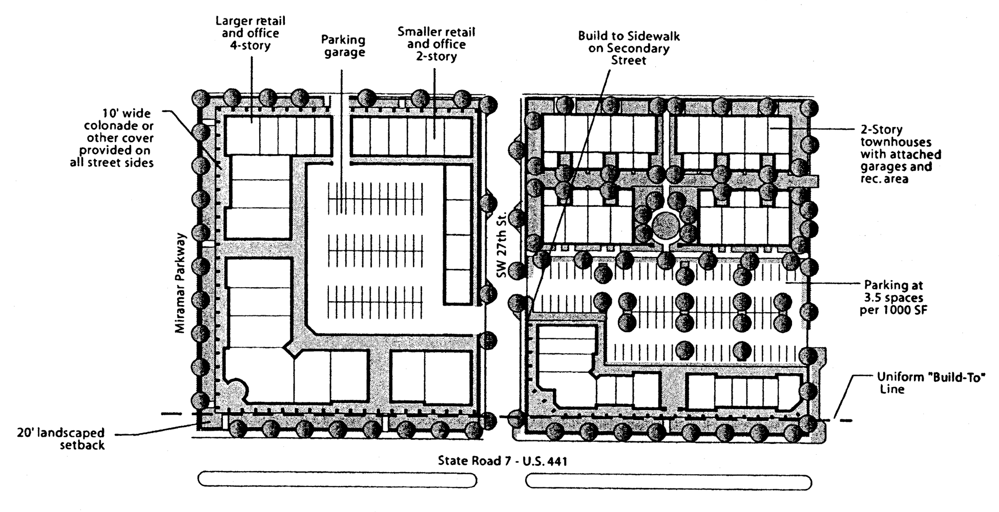
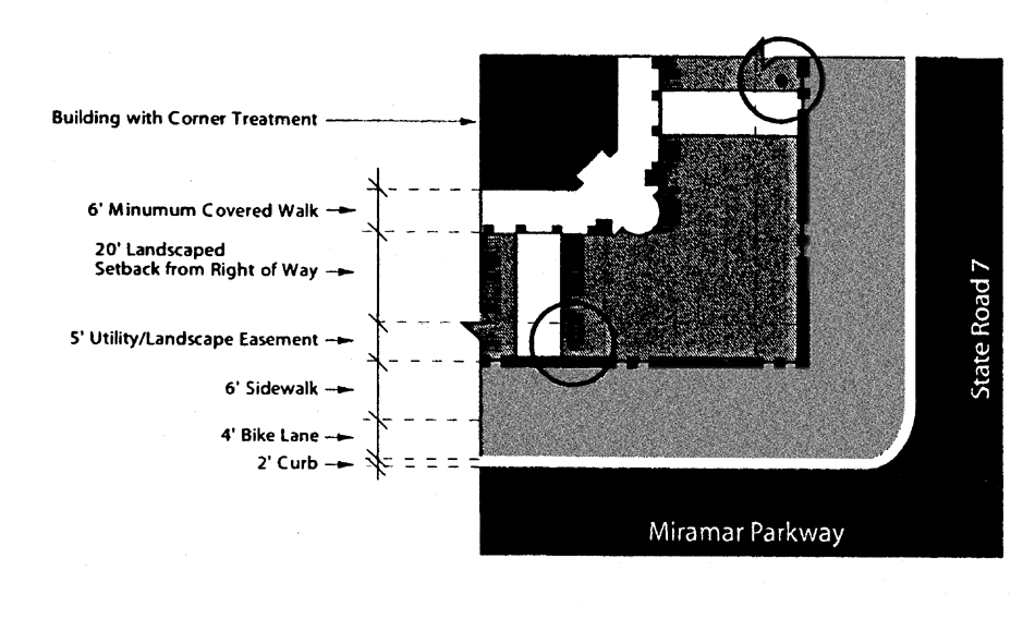
712.2. State Road 7 Corridor Overlay District design regulations purpose and intent. The purpose of these regulations is to promote the redevelopment of the overlay area along the State Road 7 (SR-7) Corridor into a quality, mixed-use district. These provisions offer development intensity bonuses that are specifically intended to promote the assembly of land and to serve as measured incentives to help assure the feasibility of converting the current development pattern along the Corridor into modern commercial, retail, office, or residential uses. Minimum land areas that exceed existing lot sizes are required to ensure that all new development contributes to a growth pattern that attracts high-quality tenants. A wide range of uses is permitted to encourage the market to create mixed-use buildings and to offer developers the flexibility to meet various market needs. Design standards, as well as the lot and bulk standards of these provisions apply to all uses in the SR-7 Overlay District except as noted in Section 712.4 Existing commercial properties. These provisions are added to the underlying zoning district requirements. Application of these provisions does not rezone residential uses to commercial uses.
712.3. SR-7 Overlay District Boundaries. The SR-7 Overlay District is bounded by Pembroke Road to the north, SR-7 to the east, County Line Road to the south and SW 62 Avenue to the west. The SR-7 Overlay District contains two sub-districts, the commercially-zoned properties and the remainder of the district or the residentially-zoned properties. Commercial properties fronting on primary and secondary streets within the district may be developed at the minimum front yard and lot area and at the base land use density listed in Table 1. The remainder of the SR-7 Overlay District is constrained to modest density residential use.
712.4. Existing commercial properties. All non-conforming commercial properties existing as of the enactment of this ordinance within the State Road 7 Corridor Overlay District must be improved to minimize site and building non-conformities. The process by which the non-conforming properties will be brought into compliance is detailed in the provisions below.
712.4.1. Compliance measures for existing commercial properties. All commercial properties of record as of the date of adoption of this ordinance shall be exempt from complying with the requirements of the SR-7 Corridor Overlay District Design Regulations provided that the building footprint is not increased by no more than 50 percent, or no improvement is made to the structure that exceeds 50 percent of the costs of replacing the entire structure. Current commercial property owners and/or business owners shall be responsible for compliance with the requirements listed in Section 712.4.2.2 within the implementation period as provided for in Section 712.4.3 of this ordinance.
712.4.2. State Road 7 Corridor Overlay District compliance plan approval process.
712.4.2.1. Application requirements and processing procedure. All existing commercial properties, as of the enactment of this ordinance, will be required to submit a Compliance Plan application to address site and building non-conformities.
All applications must be submitted as per Section 310 Site Plans and Section 311 Community Appearance Board. All compliance plan must be submitted to the department and reviewed by the development review committee (DRC) and community appearance board (CAB).
Upon approval, all compliance plans must then be submitted to the city commission for review and approval prior to the issuance of a building permit. Building permit application procedures are per Section 318 of Building Permits.
712.4.2.2. Review criteria. All existing commercial properties must meet the minimum standards as identified below in accordance with the time frame set forth in Section 712.4.3. The compliance plan application shall be prepared to minimize all non-conformities to the greatest extent feasible recognizing the following criteria, in order of priority: lot functionality and unsafe site and/or structural conditions; physical site limitations; lot functionality for intended use; negative impact to adjacent properties with respect to traffic, noise, pedestrian movement, appearance or intended operations; and, economic impact to the applicant.
The principal site and building design elements to be reviewed are outlined below. The elements of the site that will be reviewed and the minimum standards necessary to reduce non-conformities, in order of priority, include:
712.4.2.2.1. Site design elements. All sites shall comply with the minimum standards as cited below;
Parking existing parking shall be vested and no additional parking shall be required.
Fences. All existing fencing shall be replaced with metal picket or black or green vinyl coated chain link fences up to a maximum height of eight feet. New fencing shall also be metal picket or black or green vinyl coated chain link up to a maximum height of eight feet. Security measures including motion sensors and surveillance cameras may be used, but no barbed or razor wire shall be permitted.
Landscaping and irrigation—Minimum five-foot landscape buffer from nearest edge of sidewalk to fence shall be required. Low shrubs between sidewalk and hedge on street front shall be provided. Hedges in front of fences shall be maintained at a minimum of 42 inches in height. A minimum three feet side yard landscape buffer inside of fence with hedge is required. Duplication of side yard fences and hedge is not required for adjacent property. All unnecessary paving on-site shall be converted to green space. Shade trees shall be required in all landscape areas with a dimension of six by six feet or greater, otherwise small trees shall be provided. All landscaping shall have 100 percent coverage for irrigation.
712.4.2.2.2. Building design standards. All buildings shall comply with community appearance board design standards Section 813, as it relates to roof, roofline and materials; building color and materials; architectural details and entrance treatments; signage; and accessory structures.
The city commission may approve variances in conjunction with a development review applications when the variance(s) contribute to minimizing non-conformities for the entire property.
712.4.3. Implementation. Compliance plans will be in effect for a period of two years from date of approval, with an option for one extension of six months with commission approval. Improvements can be phased during this term with site design elements being undertaken in the first year and building design elements in the second year. Once all the improvements have been completed, the property owner and/or business owner (tenant) will be issued a letter of compliance from the community development department for recordation with Broward County.
All non-conforming buildings and sites within the SR-7 Corridor Overlay District must perform the work necessary to receive a letter of compliance no later than ten years from the date of the adoption of the SR-7 Overlay District Design Regulations.
If it can be demonstrated to the city's satisfaction that a building is less than 20 years old at the date of the adoption of these overlay district provisions, the period allowed for compliance shall be ten years plus the difference between the established age of the building and 20 years.
If, within the period allowed for compliance, the property owner and/or business owner (tenant) is unable to alter the building to comply with the requirements of the overlay district, it can request an extension of compliance. The property owner and/or business owner (tenant) must demonstrate to the city commission's satisfaction that it has made all reasonable effort to comply with the requirements of the district. If the city commission finds that an extension is warranted, it may grant an increase in the period of compliance by up to three years from the date that compliance would otherwise have been required.
712.5. Land assembly. Land in the SR-7 Overlay District is largely developed on lots platted prior to the adoption of these regulations. The lots within the district are typically too small to accommodate the dimensional demands of current commercial, office, or residential development. Therefore, these regulations require that all new development have a minimum lot area that entails the assembly of land. The allowable range of permitted uses and the intensity of development may be increased in proportion to the assembly of land, in excess of base lot size. The following provisions define the minimum lot area for a development permit and the extent of assembly required.
712.5.1. State Road 7 Frontage Lots. Lots created within existing blocks that have four, six or eight lots shall have
a minimum frontage on SR-7 of one-half of the block, or 225 feet, whichever is less.
Lots created within existing blocks that have five lots shall have a minimum frontage
on SR-7 of ⅖ of the block, or 225 feet, whichever is less. Lots created within existing
blocks that have 12 lots shall have a minimum frontage on SR-7 of ⅓ the block, or
225 feet, whichever is less. An exception shall be made where more than half a block
has previously been assembled, provided that at least two lots with a minimum of 150
feet of frontage on SR-7 remains (see Lot Assembly figure). This section shall also
be applied to the commercially-zoned properties not fronting on SR-7 and located within
the SR-7 Overlay District.
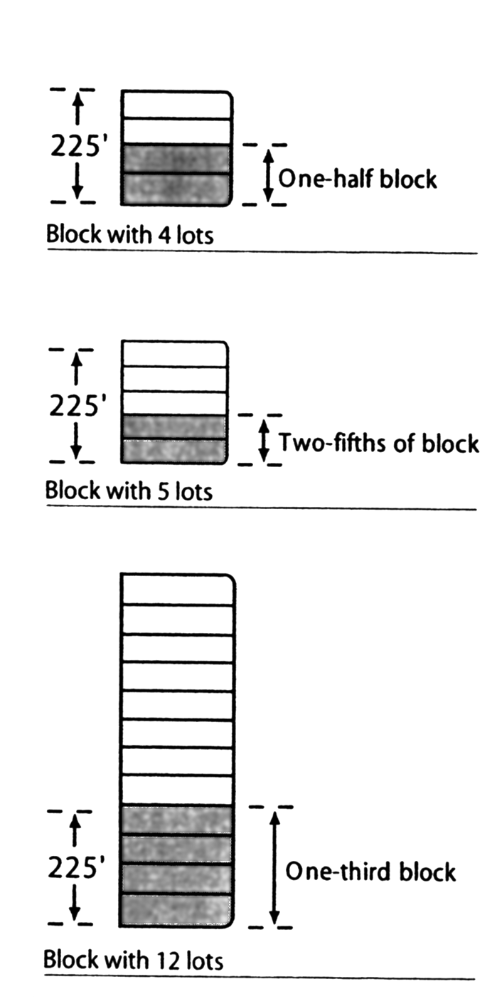
Lot Assembly
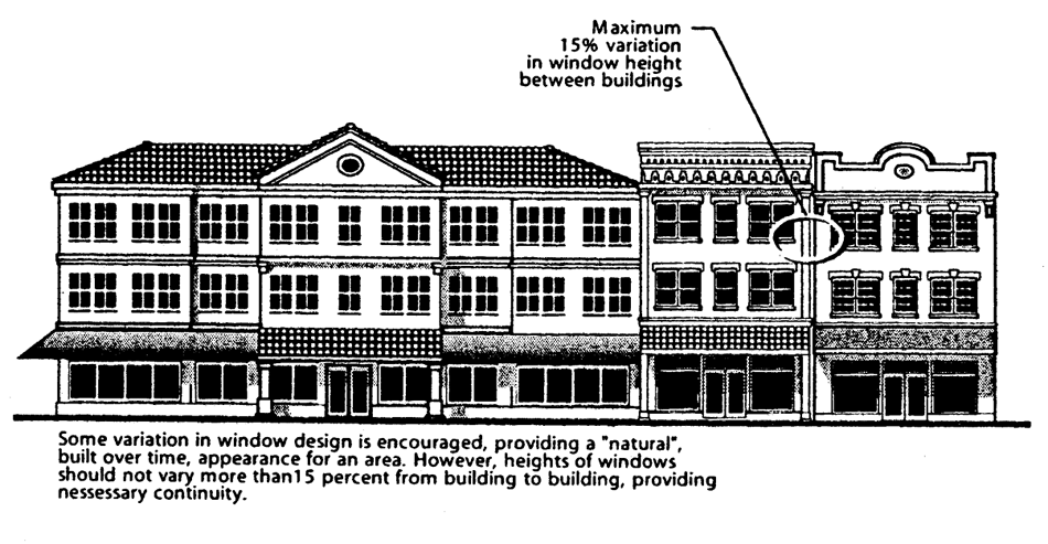
712.6. Land use intensity. As shown in Table 1 and 2, the intensity of land use within the district is dependent upon two variables: the type of land use proposed, and the extent of assembly involved. The highest land use intensity bonuses are permitted for mixed-use development that contains a residential component. Similarly, land use intensity may be increased in accordance with the extent of land assembly. The tallest buildings and the maximum floor area bonuses may be permitted where the maximum assembly is achieved. Sites with minimum frontage on State Road 7 and other commercial-zoned properties within the SR-7 Overlay District are limited to the second lowest land-use intensity.
712.7. Building design.
Table 1
SR-7 OVERLAY DISTRICT LAND USE INTENSITIES
Table 2
ASSEMBLY TABLE
1 Whichever is less
712.7.1. Building design principles.
712.7.1.1. Buildings shall be designed to be compatible with the surrounding environment, both built and natural and in accordance with the City's Mediterranean Revival Architectural Theme and Community Design Plan (CDP).
712.7.1.2. Buildings shall define the streetscape through the use of uniform setbacks along the build-to line for each block.
712.7.1.3. Exterior public and semi-public spaces, such as courtyards or plazas, shall be designed to enhance the surrounding buildings and to provide community amenities.
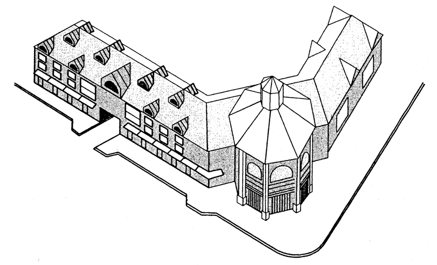
712.7.1.4. Buildings at street corners, having at least two facades exposed to a primary street, defined as State Road 7, Miramar Parkway, Pembroke Road, County Line Road, SW 25th Street and SW 33rd Street, shall be considered significant structures and shall be designed with additional height and architectural embellishments such as corner towers to emphasize their location.
712.7.1.5. Buildings shall reinforce and revitalize streets and public spaces, by providing an ordered variety of entries, windows, bays, and balconies along public ways. Ground floors shall have a high degree of transparency to encourage interaction between sidewalk activity and uses within the building. Buildings shall have human scale in details and massing.
712.7.1.6. Building exteriors shall provide shelter from the sun and rain. Porticos, awnings,
arcades, and overhanging eaves are particularly appropriate at pedestrian pathways
(see building projections figure).
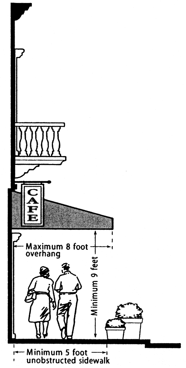
Building Projections
712.7.2. Building massing.
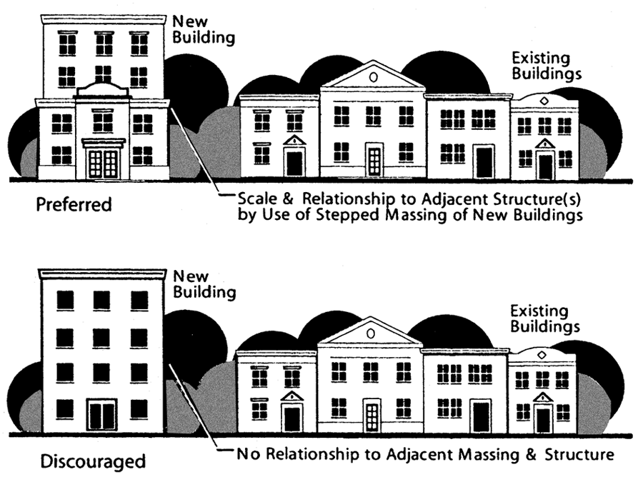
712.7.2.1. Vary massing of large buildings. A single, dominant building mass shall be avoided. Substantial variations in massing
shall include changes in height and horizontal plane. Horizontal masses shall not
exceed a height to width ratio of one to three without a substantial architectural
element that either projects up or away from the building, such as a tower, bay, lattice,
or other architectural feature. False fronts or parapets create an insubstantial appearance
and shall be avoided. Stepping the building can also reduce the apparent scale of
the building and establish a "base" and a "top." Changes in mass shall relate to structural
system(s) and the organization of interior space (see building massing figure).
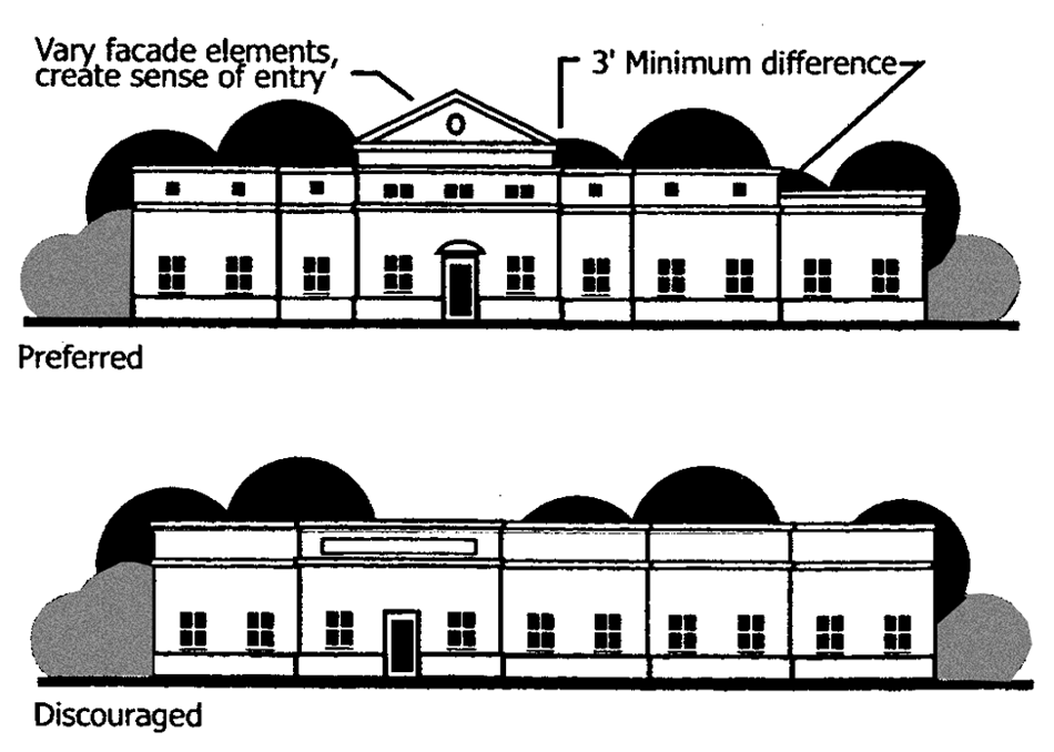
Building Massing
712.7.2.2. Highlight building entries. Building massing, architectural details, entry details or changes in materials shall
be used to highlight the location of building entries. For example, greater height
can be used to accentuate entries in the form of tower elements, tall voids, or a
central mass at an entry plaza (see clearly defined building entry figure).
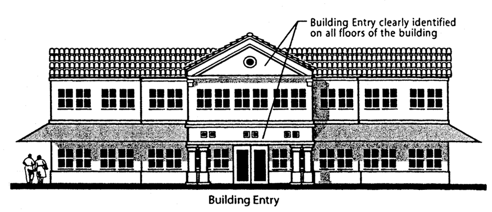
Clearly Defined Building Entries
712.7.3. Unity of character and design. Buildings or structures, which are part of an existing or future complex, shall have
a unity of character and design. The design character of buildings shall be such that
it is aesthetically pleasing and without cluttered forms having no apparent system
of organization (see unity of character figure).
Unity of Character
712.7.4. Building elevations. Although the primary aesthetic emphasis shall be on the main facade(s), all building
elevations shall receive architectural treatment. Stories at sidewalk level shall
be no less than 12 feet in height from finished floor to finished ceiling. To provide
variety to the skyline, the number of stories, not the overall height shall limit
building elevation. Commercial and residential buildings shall not exceed 25-foot
floor-to-floor heights (see building elevations figure).
Building Elevations
712.7.5. Base and top treatment. All facades shall have:
712.7.5.1. A recognizable "base" consisting of (but not limited to): (a) thicker walls, (b) richly textured materials (e.g. stucco, tile or masonry treatments), (c) special materials such as ceramic tile, granite and marble, or (d) contrasting colored materials, mullions, and/or panels.
712.7.5.2. A recognizable "top" consisting of (but not limited to): (a) cornice treatments,
(b) roof overhangs with brackets, (c) stepped parapets, (d) richly textured materials
(e.g. stucco, tile or masonry treatments), and/or (e) differently colored materials;
colored "stripes" are not acceptable. (See—Base and Top Treatment figure)
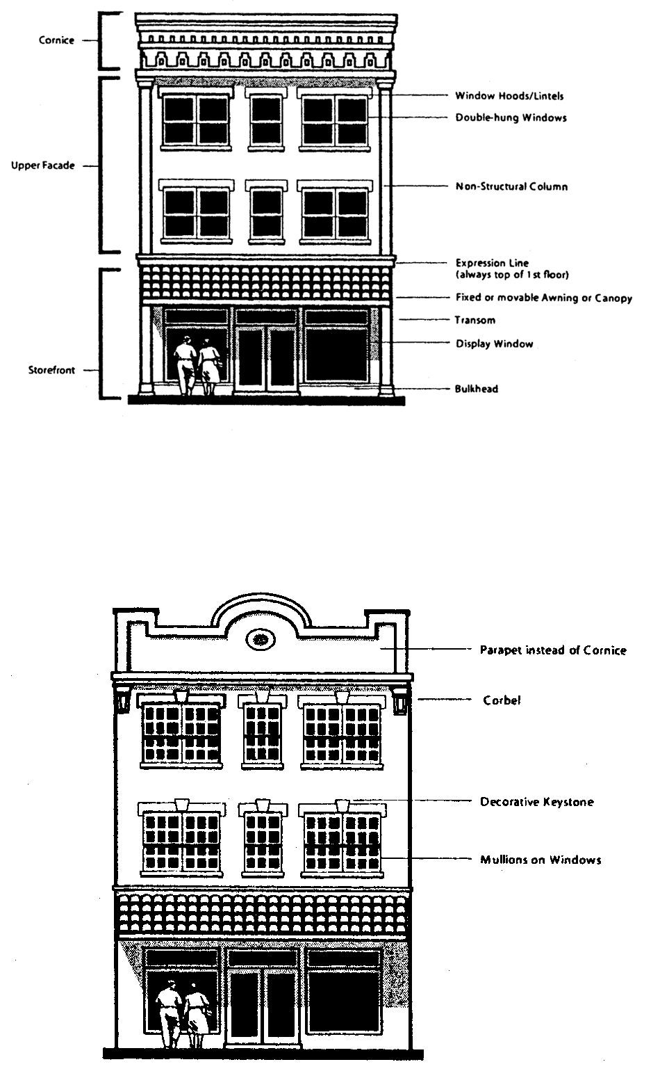
Base and Top Treatment
712.7.6. Transparency. Ground floor windows, in all non-residential buildings within the SR-7 Corridor,
shall be framed by the surrounding wall and shall encompass a minimum of 65 percent
of the total ground-level facade area. Transparency shall be measured from a point
not higher than 18 inches above grade (see storefront transparency figure).
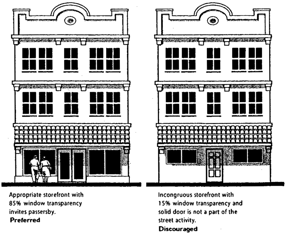
Storefront Transparency
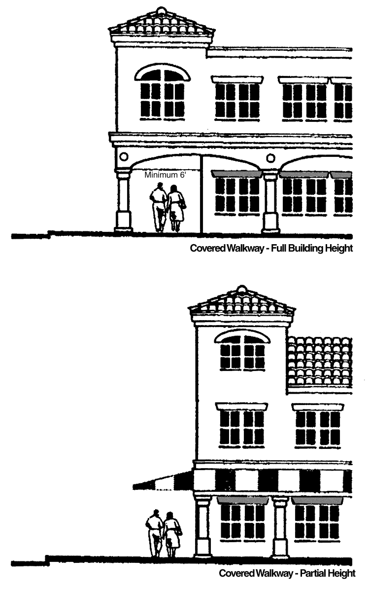
712.7.7. Covered walkways. Buildings along the SR-7 Corridor shall provide covered walkways along the side of
the building facing the corridor. Covered walkways shall conform to the following
provisions (see Covered Walkways figure):
Covered Walkways
712.7.7.1. All covered walkways shall have a clear width of at least six feet for pedestrian movement.
712.7.7.2. Full building height covered walkways shall be detailed so as to have architectural interest in the columns with bases and capital details, the spandrels, cornice, or interior wall to provide interest and character.
712.7.7.3. Partial height covered walkways, second floor detail-covered walkways shall appear to provide a second floor above the covered walkways, whether it is real or simply decorative. Requirements for second floor detail shall be similar to Section 712.7.7.2, except more emphasis will be placed on the relationship between the second floor detailing and the covered walkway.
712.7.7.4. Partial height covered walkways, shed roof detail. This type of covered walkways shall have second floor architecture that terminates the shed roof with a tower or other architectural feature that gives emphasis to the building corners.
712.7.7.5. All covered walkways shall be lighted to illumination levels equal to those on surrounding sidewalks.
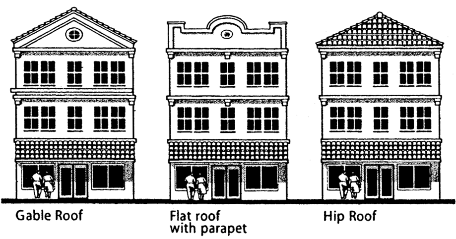
712.7.8. Roof form.
712.7.8.1. Roof types Roof types shall be front or side-gable, hipped, and flat with parapet or a combination
thereof. The principal roof pitch shall be a minimum of 3:12. Mansard roofs are prohibited
(see roof types figure).
Roof Types
712.7.8.2. Roof overhangs. Unless specifically designed otherwise, roof overhangs shall wrap around all four
sides of the building so that there is visual continuity around the entire building
(see side details figure).
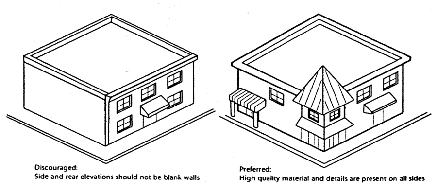
Side Details
712.7.8.3. Roof treatments. Variations in rooflines shall be used to add interest to, and reduce the mass of
buildings. Roof features shall be in scale with the building's mass and complement
the character of adjoining and or adjacent buildings and neighborhoods. Roofing material
shall be constructed of durable high quality material in order to enhance the appearance
and attractiveness of the community (see roof features figure).
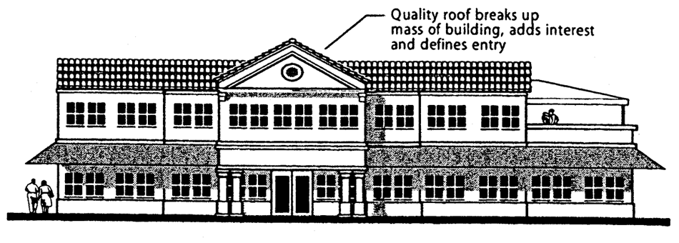
Roof Features
712.7.8.4. Permitted roof materials. Permitted roof materials for pitched roofs include:
1.
Spanish "S";
2.
Barrel Tile.
712.7.9. Floor articulation. In buildings in excess of three stories, the first floor or first two floors shall
have distinctive material changes and/or colors that are different from the upper
floors. Often there is a cap or bottom detail. A change of plane of at least six inches
and cap or support detail will also achieve this result. The floor articulation figure
illustrates acceptable forms of floor articulation.
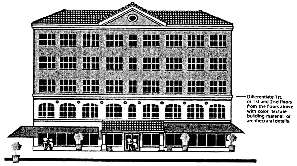
Floor Articulation
712.7.10. Windows and door detailing.
1.
The windows and doors should be in vertical and horizontal alignment and have a harmonious aesthetic appeal. (See Window-Door Alignment figure)
Window-Door Alignment
2.
Windows shall be vertical or square in proportion.
3.
Windows shall be inset a minimum of two inches from the exterior wall surface. (See Window Treatment Figure)
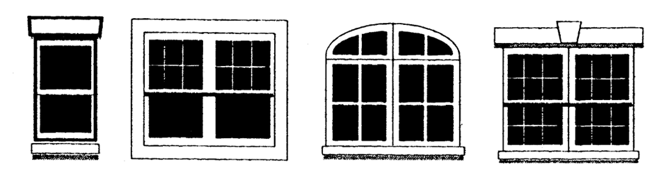
Window Treatment
4.
Mirrored glass is prohibited.
5.
Glass curtain walls are prohibited.
6.
Clear glass shall be used for storefront windows and doors.
7.
Exterior mounted security gates or solid roll down metal windows shall not be permitted.
8.
Link or grill type security devices shall be permitted only if installed from the inside, within the window or doorframes.
9.
Other types of security devices fastened to the exterior walls are not permitted.
712.8. Site design.
712.8.1. Site design principles.
712.8.1.1. Streets and other public outdoor spaces shall be functional, attractive, and designed to enhance the pedestrian life of the community. Development shall be designed to achieve a balanced transportation system that invites pedestrians, bicyclists, and transit riders, as well as motor vehicles.
712.8.1.2. Development shall be sited to enable direct local street access from surrounding neighborhoods so visitors do not need to use arterial streets to access the commercial area.
712.8.1.3. Landscaping shall be designed to frame primary public spaces, to provide shade and enhance the pedestrian environment.
712.8.2. Building orientation/location. The primary facades of all buildings shall contain the primary entry and face a public
street. Frontage on a primary street shall receive the highest priority for building
placement and facade enhancement. Primary streets shall be defined as State Road 7,
Miramar Parkway, Pembroke Road, County Line Road, SW 25th Street and SW 33rd Street.
All other streets shall be considered as secondary streets. The building orientation
figure illustrates the required placement and enhancement for street frontages. The
following rules shall apply for determining the primary street frontage for building
placement and facade transparency:
Building Orientation
712.8.2.1. Sites with frontage only on one street shall be located on the build-to line of the street frontage.
712.8.2.2. Sites with frontage on a primary and a secondary street shall build to the corner of the two streets, allowing for the City of Miramar's sight line requirements, and provide the majority of the transparency on the facade facing the primary street.
712.8.2.3. Sites with frontage on two primary streets shall build to the corner of the two streets. The majority of the transparency on the facade shall face the street with the higher classification. If both streets have the same classification, the developer may choose on which primary street frontage to provide facade transparency.
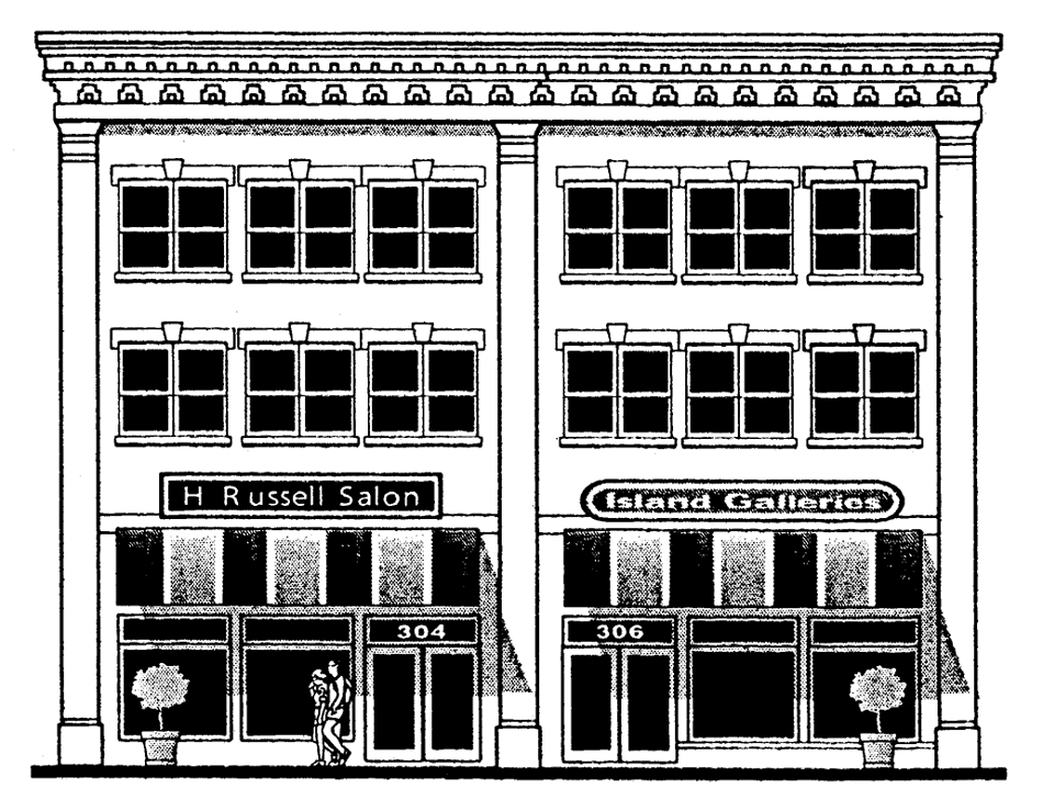
712.8.3. Building frontage. Building frontages along all primary streets shall occupy no less than 80 percent of a lot's street-facing frontage, except as provided in Section 712.8.8. Buildings with multiple storefronts shall be unified through the use of architecturally compatible materials, colors, details, awnings, signage and light fixtures.
712.8.4. Corner lots. Corner lots shall be designed to emphasize their location. Buildings and structures
on corner lots at the intersection of SR-7 and any other primary street (listed in
Section 712.8.2 above) shall be designed with additional architectural embellishments
such as towers, or other design features, to emphasize their locations as gateways
and transition points within the community (see corner lots figure). Once a design
is applied at one corner, the building on the opposite corner shall use the same type
of articulation in an effort to assure design compatibility. The designs do not have
to be identical; however they should generally have the same height and shape.
Corner Lots
712.8.5. Build-to lines. In the SR-7 Overlay District, buildings shall constructed at the build-to line, generally
defined as 20 feet from the property line on SR-7. Non-residential uses on all other
streets within the district shall have a build to line at the back of the sidewalk,
while residential structures have a build-to line that is 20 feet from the front property
line. These setbacks are illustrated in the build-to lines figure and shall be followed
except as indicated in Section 712.8.6 below.
Build-To Lines
712.8.6. Exceptions to build-to line requirement. The following exceptions to the build-to line requirement shall be permitted:
712.8.6.1. Articulated building street face. A portion of the building may be set back from
the build-to line to create interest in the building facade. These standards, shown
in the build-to exceptions figure, vary as follows:
Build-To Exceptions
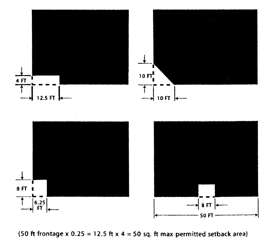
712.8.6.1.1. Along SR-7, the total area of the space created by the setback shall be less than the area that is 60 percent of the frontage times six feet.
712.8.6.1.2. Where the street frontage is the build-to line, the total area of the space created by the setback shall be less than the area that is 25 percent of the frontage times four feet.
712.8.7. Parking. The number of parking spaces shall be based on the underlying district or use requirements. The following standards shall apply to on- or off-street parking in the SR-7 Overlay District Area:
712.8.7.1. Parking in rear. On-site parking shall be located behind the building. Parking areas shall be accessed from side and back streets and from adjacent properties. Access from SR-7 shall be avoided unless no other access is available.
712.8.7.2. Shared and off-site parking. Where a mix of uses creates staggered peak periods of parking demand, shared parking calculations may reflect a reduction in the total amount of required parking. Retail, office, and entertainment uses shall share parking areas and quantities. On- and off-site parking may be used to meet minimum parking requirements as long as reasonable pedestrian access is provided from the parking space to the use. Cross access easements or similar mechanisms shall be used to provide joint access between the parking areas of adjacent properties.
712.8.7.3. On-street parking. Adjacent on-street parking shall be counted towards a land uses' parking requirement. The amount of on-street parking shall be maximized.
712.8.7.4. Reduce scale of lots. Large surface parking lots shall be visually and functionally segmented into several
smaller lots through the use of structures and/or landscaping (see Reduce Scale of
Lots figure). Designs that reduce visibility, especially between parking areas and
business entrances, shall be discouraged. Land devoted to surface parking lots shall
be reduced, over time, through redevelopment and/or construction of structured parking
facilities.
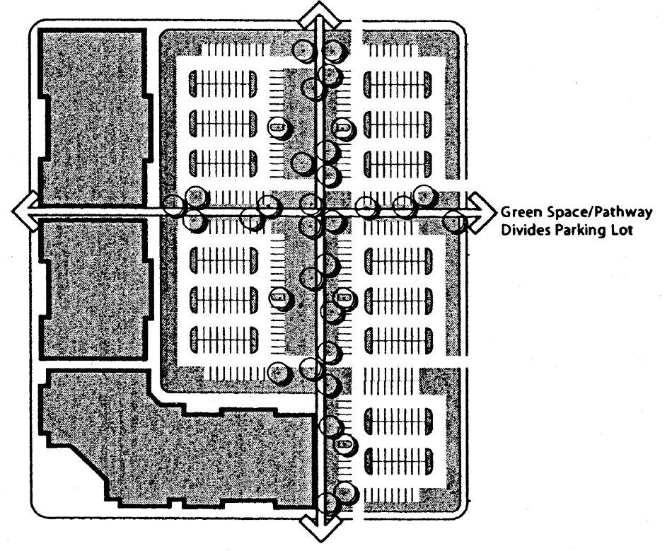
Reduce Scale of Lots
712.8.7.5. Loading facilities.
712.8.7.5.1. When required, loading docks, solid waste facilities, recycling facilities and other service areas shall be placed to the rear or side of a building in visually unobtrusive locations.
712.8.7.5.2. Screening and landscaping shall prevent direct views of loading areas and their driveways from adjacent properties or from the public right-of-way. Screening and landscaping shall also prevent spillover glare, noise, or exhaust fumes. Screening and buffering shall be achieved through walls, fences and landscaping and shall be visually impervious and completely obscure the contents and facilities. Recesses in the building, or depressed access ramps may be used.
712.8.7.6. Parking landscaping. These provisions are intended to achieve enhanced visual quality of parking areas,
encourage the creation and protection of open space, avoid expansive development of
impervious surfaces, and ensure that landscaping is an integral part of development
(see Parking Landscaping figure).
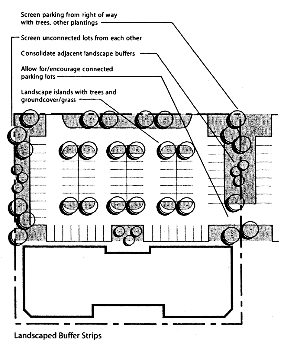
Parking Landscaping
712.8.7.6.1. Buffer strips. A landscaped buffer strip shall be provided separating all parking areas, vehicular circulation facilities, or similar improvements from the right-of-way line of any public street. The landscaped buffer strip shall be continuous except for required vehicular access points and pedestrian circulation facilities. Signs shall be integrated into the landscaping. Buffer strips shall not prevent connections among adjacent parking areas.
712.8.7.6.2. Interior landscaping requirements. The interior of all parking lots shall be landscaped to provide shade and visual relief from large expanses of impervious surfaces. This is best achieved by installing protected planting islands within the parking lot. Landscaped areas shall comprise a minimum of 15 percent of the total area of parking lots with more than six spaces.
712.8.7.6.2.1. At least one landscaped divider island shall be provided for every four parallel rows of parking. A minimum of one deciduous shade tree shall be planted for every four parking spaces. Trees shall be spaced not more than 30 feet on center.
712.8.7.6.2.2. Terminal islands shall be used either to separate parking spaces from driveways and other vehicular travel lanes, or to break up large numbers of parking spaces in a single row of spaces. Landscaped terminal islands shall be provided at the ends of rows of parking where such rows are adjacent to driveways or vehicular travel lanes. In addition, terminal islands shall separate groups of parking spaces in a row, such that no continuous line of adjoining spaces contains more than 25 parking spaces. Terminal islands shall extend the entire length of the parking space and include at least one tree for every 100 square feet, or portion thereof, of said island.
712.8.7.6.2.3. Interior islands shall be eight feet in width (excluding curbing) and not less than 90 square feet and shall be placed within individual rows of contiguous parking spaces so that either is not less than one island for every eight parking spaces, or any portion thereof. Interior islands should be designed to create a no regimented appearance that relieves monotony and increases a tree canopy.
712.8.7.6.2.4. Additional landscaped area may be provided as an alternative to separating groups of parking spaces with small internal terminal-islands. Such additional landscaped area shall be provided as additional depth in the buffer strip, terminal and divider islands adjacent to rows exceeding ten spaces. However, no more than 20 adjoining parking spaces may be provided in a row of spaces, regardless of the size of the landscaped islands at the ends of the row.
712.8.7.7. Pedestrian circulation in parking facilities.
712.8.7.7.1. Parking facilities and appurtenant driveways shall be designed so as to gather pedestrians out of vehicle travel lanes and to maximize the safety and convenience of pedestrians walking between parked cars and business entrances as well as between external points and locations on-site.
712.8.7.7.2. Pedestrian walkways shall be integrated, to the extent possible, into the interior and/or perimeter landscaping of parking lots; constructed with brick pavers, a paved or similarly firm surface, at least six feet in width; and separated from vehicular and parking areas by grade, curbing and/or vegetation, except for necessary ramps.
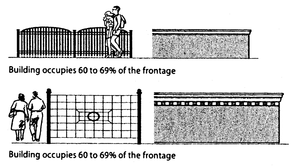
712.8.8. Parking screening. The intent of Section 712.8.3 and Section 712.8.4 is to create a continuous street facade with parking located to the rear of buildings. However, the city may grant exceptions to this requirement if it finds that the depth of a lot is insufficient or where uses require more parking than building area. In these circumstances the following standards shall apply:
712.8.8.1. If a building occupies 60 percent to 79 percent of the frontage or parking exceeds
100 feet in length the remaining frontage shall meet one of the alternatives shown
in the Alternative Street Frontage Treatments figure, Alternative 1.
Alternative Street Frontage Treatment—Alternative 1
712.8.8.2. If a building occupies 45 percent to 59 percent of the frontage or parking exceeds
150 feet in length the remaining frontage shall meet one of the alternatives shown
in the Alternative Street Frontage Treatments figure, Alternative 2.
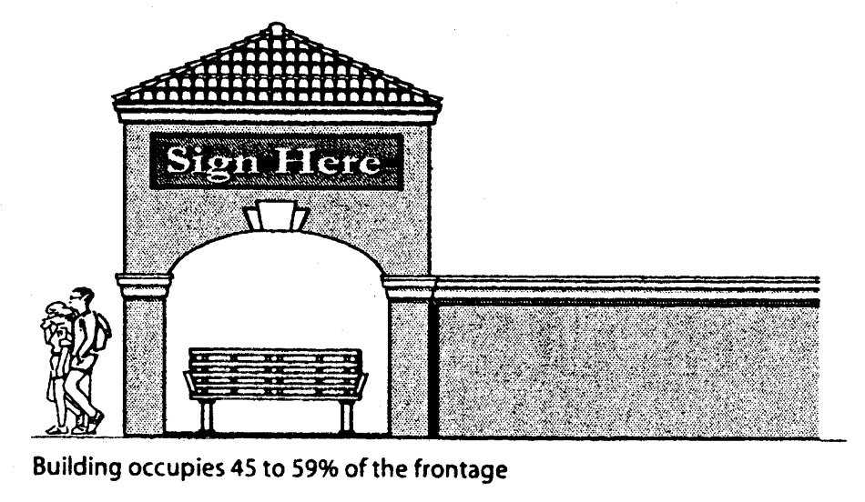
Alternative Street Frontage Treatment—Alternative 2
712.8.8.3. If a building occupies 44 percent or less or parking exceeds 200 feet in length the
remaining frontage shall meet one of the alternatives shown in the Alternative Street
Frontage Treatments figure, Alternative 3.
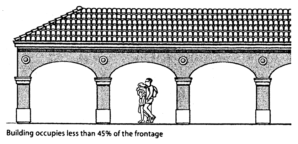
Alternative Street Frontage Treatment—Alternative 3
712.8.8.4. All the remaining frontage of the site on all streets shall be improved except where entry on to the site is required.
712.8.9. Street trees.
712.8.9.1. Specifications. Street trees shall be planted within the front yard, and along any yard facing SR-7, along all lots, at a minimum average spacing of 24 feet on center, with the exact spacing to be evaluated on a site-specific basis. All street trees shall have a clear trunk of six feet and a minimum caliper of three inches at the time of planting. Street trees shall not obscure sign and window displays with the district.
712.8.9.2. Materials. All trees, plants and any other associated landscape or outdoor material shall be of Florida No. 1 or better, as classified by the Florida Department of Agriculture and Consumer Services. Landscaping shall be free form design using the following plant list: Shade trees: live oak or as approved; Palm trees: washingtonia, sabal palm, foxtail, or royal palm and other materials approved by the city.
712.8.9.3. Replacement. The owner shall replace any site tree that dies within the first two years after initial transplant into the district.
712.8.10. Signs.
712.8.10.1. Design guidelines for signs.
712.8.10.1.1. Signs affixed to the exterior of a building shall be architecturally compatible with
the style, composition, materials, colors, and details of the building, as well as
with other signs used on the building or its vicinity (see Sign Placement figure).
Sign Placement
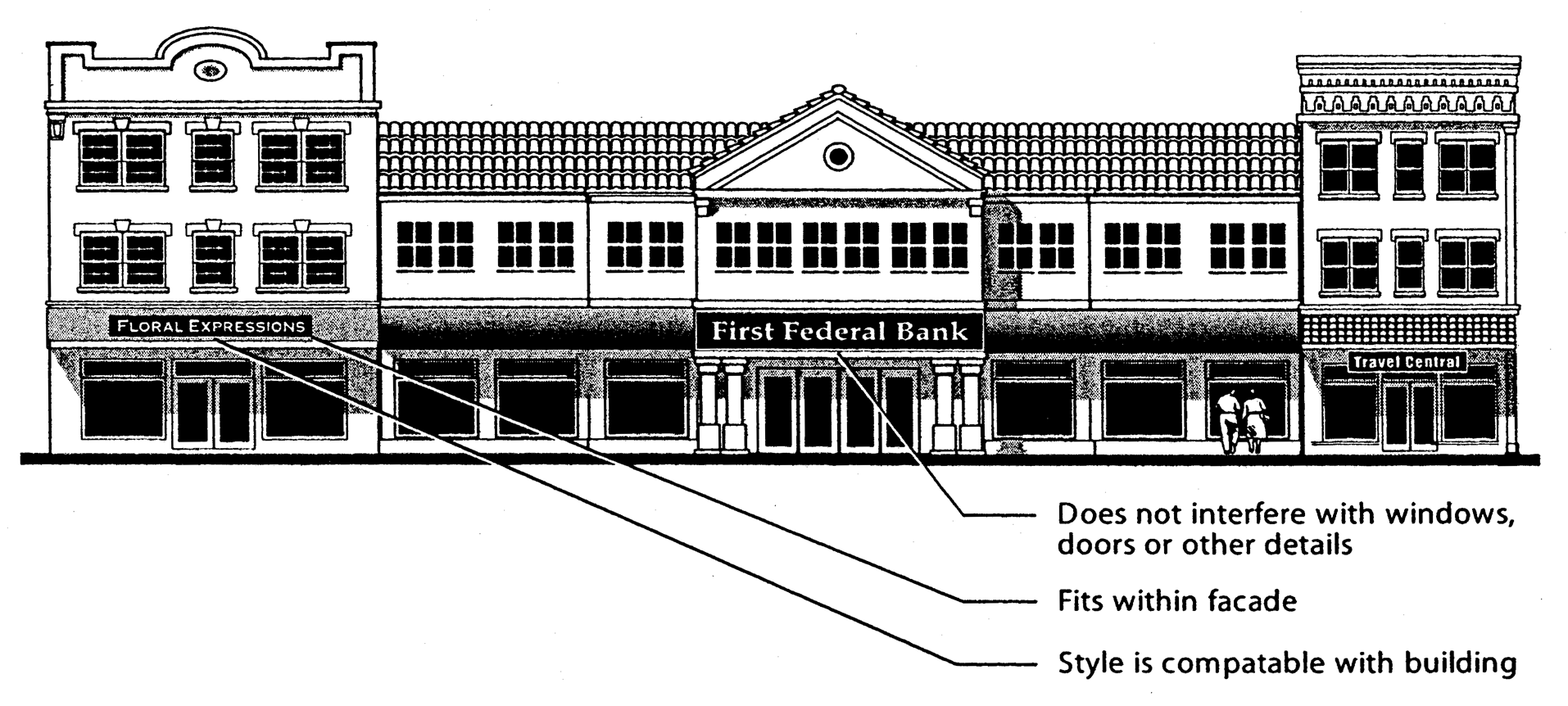
712.8.10.1.2. Signs shall fit within the existing facade features, shall be confined to signable areas, and shall not interfere with door and window openings, conceal architectural details or obscure the composition of the facade where they are located. Signs shall be placed on a facade only in a manner historically appropriate to the style of the building.
712.8.10.1.3. Whenever possible, signs located on buildings within the same block-face shall be placed at the same height in order to create a unified sign band. Lighting that follows the form of a building, structure, or sign is prohibited.
712.8.10.1.4. Signs may be internally illuminated in a channel-letter system or a box that is compatible with the architecture of the building. Wood signs may be used for under-canopy (hanging) signs.
712.8.10.1.5. Sign background colors shall be compatible with the colors of the building facade. Sign lettering may use dark, contrasting colors. A dull or matte finish is recommended for reduction of glare and enhancement of legibility.
712.8.10.1.6. Signs shall be either spot or backlit with a diffused light source. Ground lighting may illuminate a monument sign, but in an aesthetically pleasing manner. Window signs may be internally illuminated but must be within enclosed boxes. Window signs shall not clutter the window area. Neon signs are prohibited.
712.8.10.1.7. Signs shall be mounted so that the method of installation is concealed. Signs applied to masonry surfaces should be mechanically fastened to mortar joints only and not directly into brick or stone. Drilling to provide electrical service should also follow the same rule.
712.8.10.2. Billboards. New and/or replacement billboards shall be prohibited.
(Ord. No. 01-23, § 3, 3-7-01; Ord. No. 18-01, § 2(Exh. D), 11-1-17)
Sec. 713. - Reserved.
Editor's note— Ord. No. 18-01, § 5(Exh. D), adopted November 1, 2017, repealed § 713. Former § 713 pertained to specific use regulations and derived from Ord. No. 01-03, adopted November 15, 2000; Ord. No. 05-22, adopted September 21, 2005; Ord. No. 07-04, adopted November 29, 2006; Ord. No. 07-07, adopted November 29, 2006; Ord. No. 11-10, adopted September 21, 2011; Ord. No. 12-07, adopted November 30, 2011; Ord. No. 13-10, adopted May 15, 2013; Ord. No. 14-01, adopted November 6, 2013; Ord. No. 15-05, adopted November 24, 2014; Ord. No. 16-05, adopted January 17, 2016.
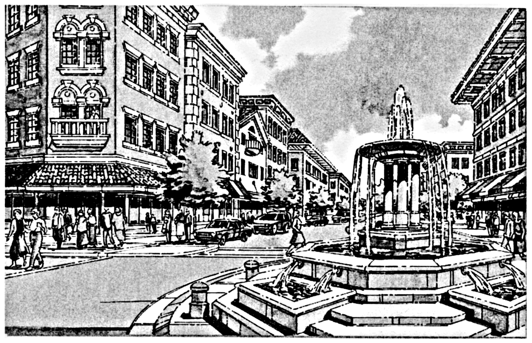
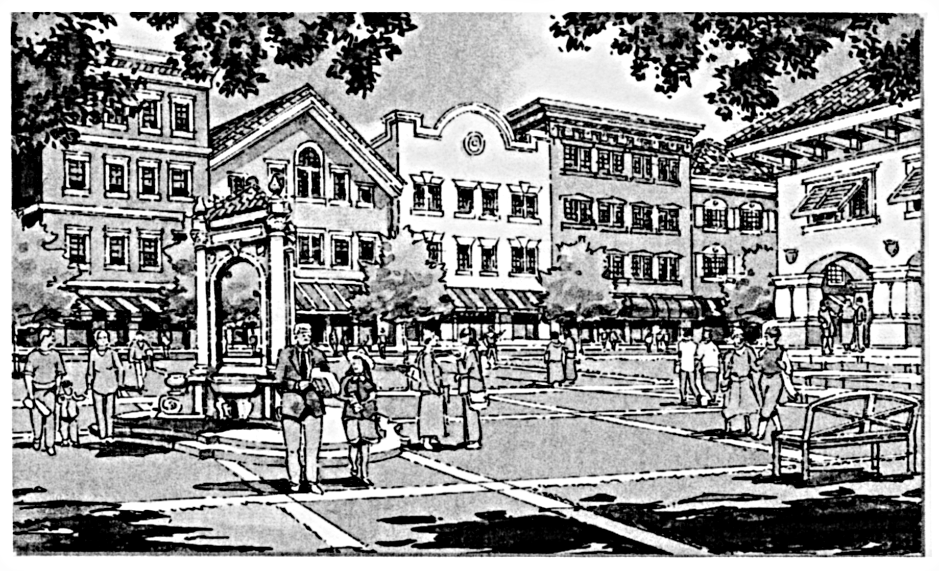
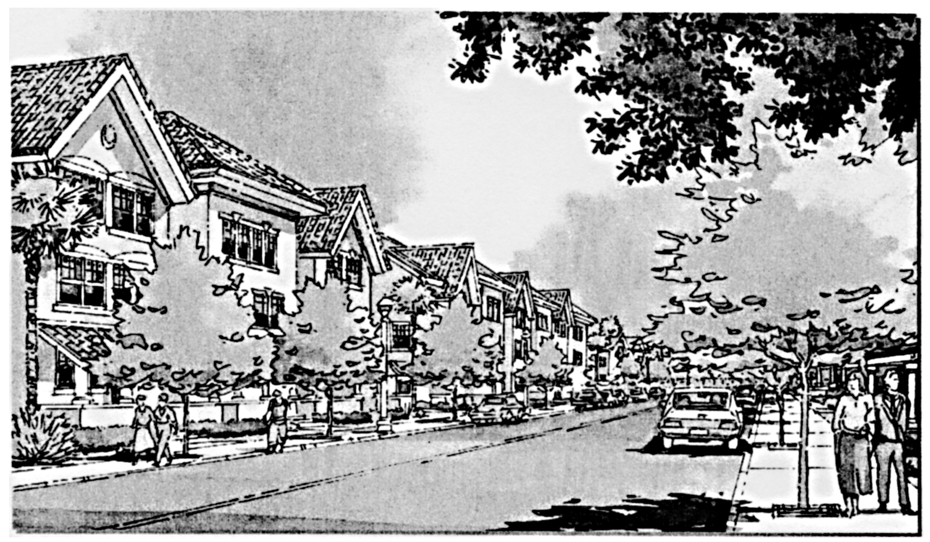
Sec. 714. - Traditional Neighborhood Development (TND) District.
The illustrative drawings contained in this section shall serve as guidance to the development review committee (DRC) with regard to the city's intent for land development within the TND. All illustrative drawings and images contained in this section are meant to demonstrate the character intended for a Traditional Neighborhood Development (TND), but are for illustrative purposes only. The accompanying text and numbers are the rules that govern permitted development. The following regulations shall apply to the TND:
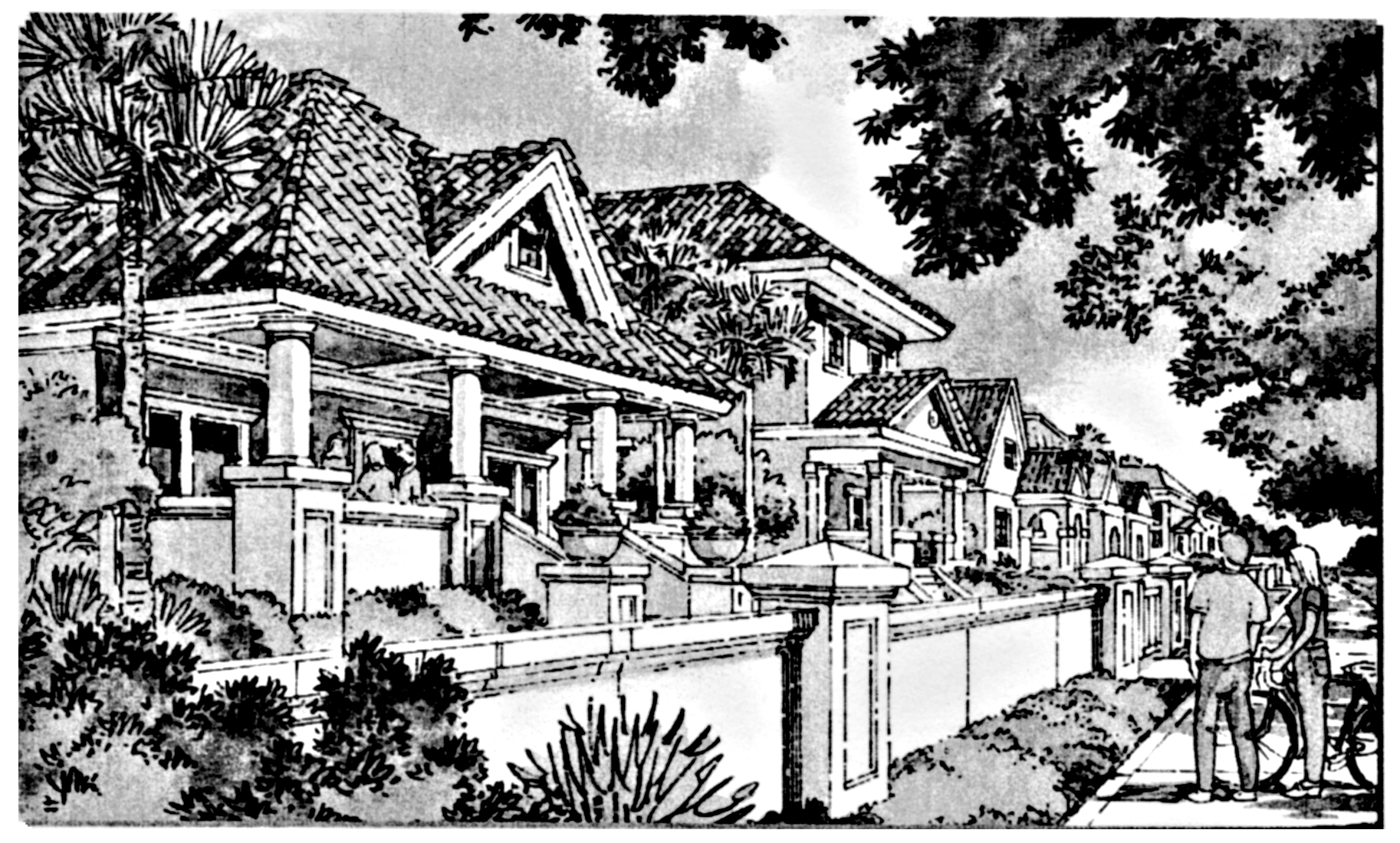
714.1. Purpose of district. The Traditional Neighborhood Development District is provided for the development of new neighborhoods and the revitalization or extension of existing neighborhoods, which are structured upon a network of interconnecting pedestrian oriented streets and other public spaces. These developments are intended to offer a mixture of housing types and prices, prominently sited civic or community buildings, and stores/offices/workplaces to provide a balanced mix of activities. A TND Neighborhood has a recognizable center and should be designed to integrate with the surrounding community; the optimum size of a TND Neighborhood is a quarter mile from center to the edge.
714.2. Conflicts. In the event that a conflict arises between language contained in this Section and language contained elsewhere in the City Code or Land Development Code, the language contained in this section shall take precedence.
714.3. Reserved.
714.4. Comprehensive plan. In conformance with the City of Miramar Comprehensive Plan, TNDs may be located in the regional activity center or in other areas of the city through the allocation of "reserve units" or application of the city's "flexibility" provisions, if necessary.
Comprehensive plan rules regarding the placement of residential uses in non-residential property as designated by the comprehensive plan, and the placement of non-residential uses in residential property as designated by the comprehensive plan, take precedence over the regulations contained in this section.
714.5. Procedure. TNDs require rezoning and site plan approval. Applicants are encouraged to submit TND rezoning applications together with a proposed site plan. Prior to the preparation of a TND rezoning application, each applicant shall meet with the community development director. The general outlines of the proposal should be discussed and a conceptual site plan and written description of the intended plan of development should be provided by the applicant for consideration at such meeting(s). The community development director may also suggest that the applicant meet with state, regional, or county agencies, and affected civic and neighborhood groups, in connection with the preparation of the rezoning application. The purpose of the preapplication conference is to assist in bringing the overall application, as consistently as possible, into conformity with these and other regulations; to define specifically those variations from the usual application of the provisions of the Land Development Code; and to furnish the applicant with recommendations that would inform and assist with the preparation of the components of a TND rezoning application. Submission of the conceptual site plan in no way vests any development rights with respect to the subject property.
714.6. Elements of a TND.
(a)
Size. In order to ensure the development of a cohesive neighborhood that contains all the necessary features of a TND, but not to preclude the possibility of the extension of an existing development in this manner, the minimum size of a TND Neighborhood shall be ten acres. In order to ensure that a TND Neighborhood's central focus is within walking distance for all residents, a TND Neighborhood should not exceed one-half mile at its widest point.
(b)
Categories of use allocation. There are five categories of uses that make up a TND: Public, civic, shopfront, rowhouse, and house. All property within a TND must be allocated to one of these five categories of uses. Categories of uses should not be concentrated in a particular area; they should be mixed together in a pedestrian friendly and compact manner. The following are the minimum percentages of land area to be allocated per category of use in a TND. In the event that a space is intended to be utilized for more than one use (i.e., live/work unit), only the primary use should be utilized for this and all calculations contained in this section.
(1)
Civic use—Minimum of two percent.
(2)
Public use—Minimum of five percent, excluding streets, rights-of-way, and accessways.
(3)
Shopfront use—Minimum of 25 percent.
(4)
Rowhouse use and house use—Minimum of 25 percent.
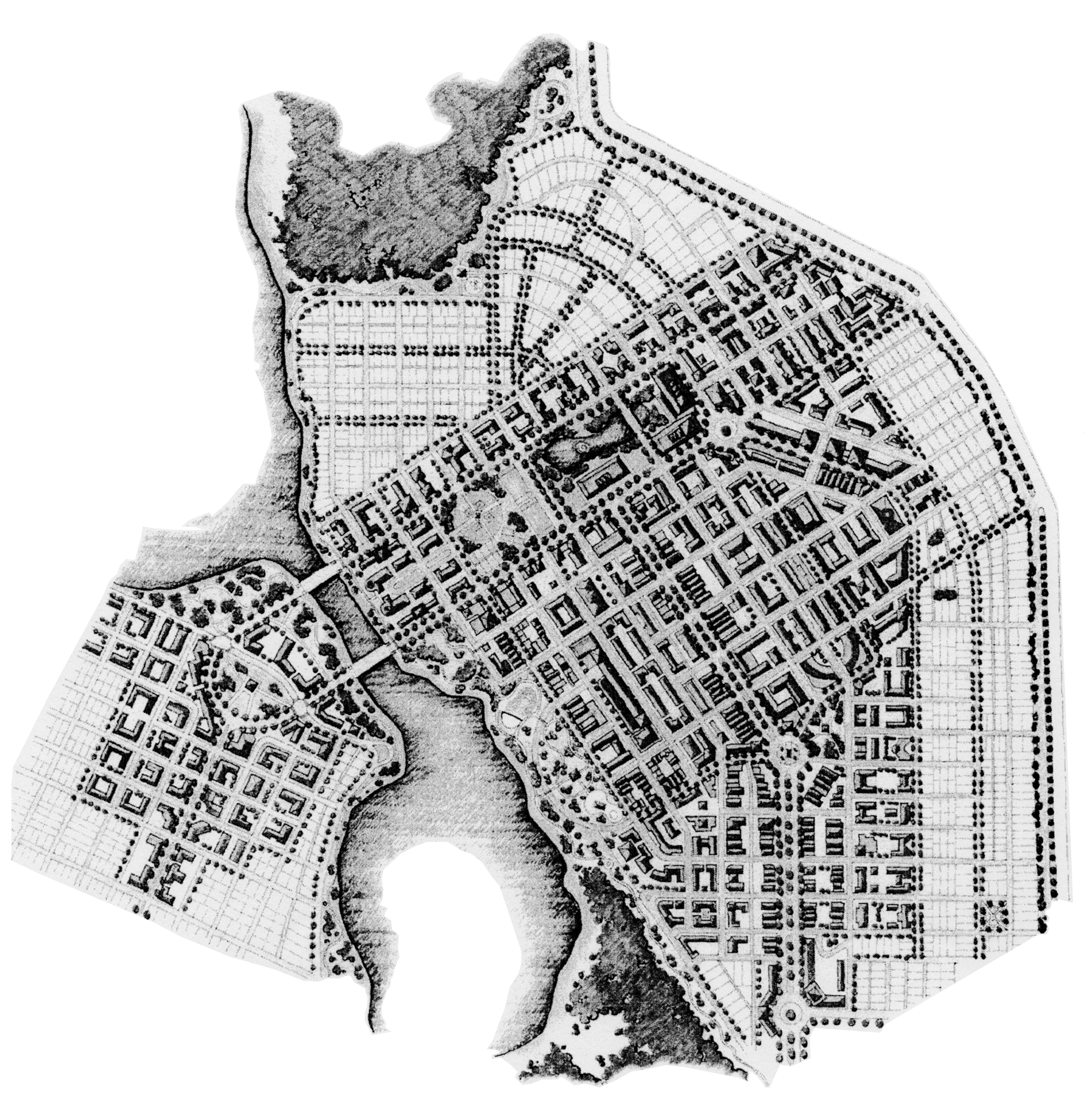
Traditional Neighborhood Development Map
(c)
Architectural design and general standards. The purpose of these requirements is to ensure design continuity in the neighborhood as a whole, without forcing monotonous design indicative of many modern subdivisions. The community appearance board will review prospective TNDs with respect to these criteria.
(1)
A Mediterranean architectural theme, as defined in Section 813 of the Land Development Code, is required for all structures and shall be outlined in a pattern book. The pattern book must demonstrate the types of Mediterranean styles used and define their principles; define the principles for placing structures on their sites; define the layout of the structures in relationship to neighboring uses, adjacent streets, public spaces, and the TND Neighborhood; demonstrate general facade detailing; demonstrate planting details, their interrelationship between the public and private landscaping, and mechanism of maintaining the landscaping; and demonstrate light pole types and generalized locations.
(2)
Colonnades shall have, at and/or over the sidewalk, a minimum clear height of ten feet (excluding signage or lighting) and a minimum clear width of eight feet (from building facade to inside column face). Colonnades may be built over sidewalks for all uses except house uses. Colonnades shall not cause roof drainage into a right-of-way without proper positive drainage design.
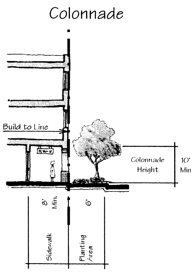
Colonnade
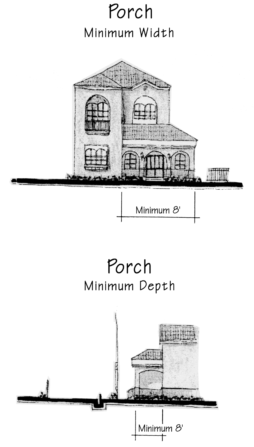
(3)
Porches shall have a minimum depth of six feet on the front facade and a minimum width of eight feet on the front facade. Porches are encouraged to extend to other house elevations as well.
Porches
(4)
Awnings shall have a minimum clear height of eight feet and a maximum length of six feet.
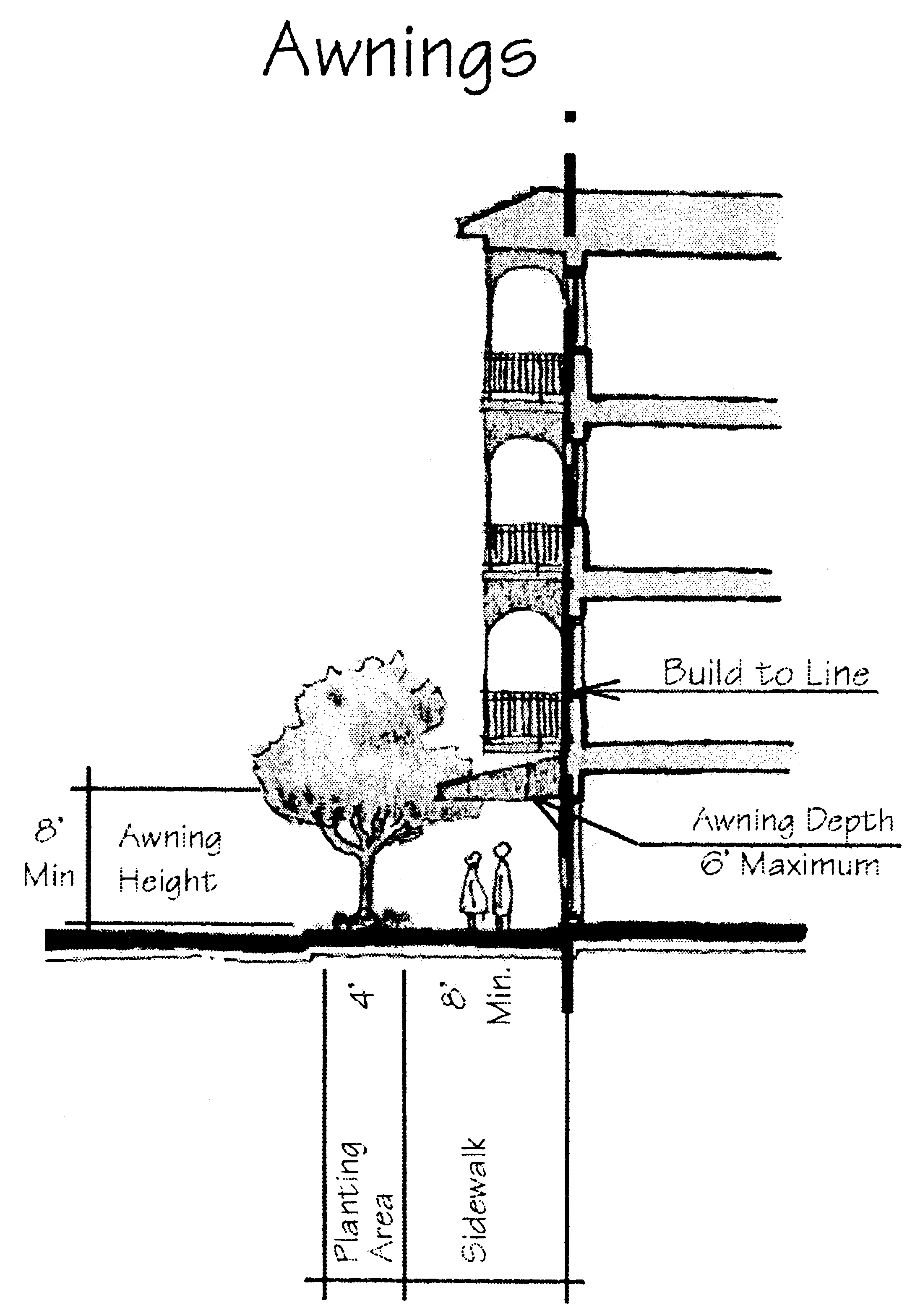
Awnings
(5)
Balconies shall have a minimum depth of four feet. Balconies with a minimum of ten feet of clearance above grade shall be permitted to extend over the sidewalk for all categories of use except house uses.
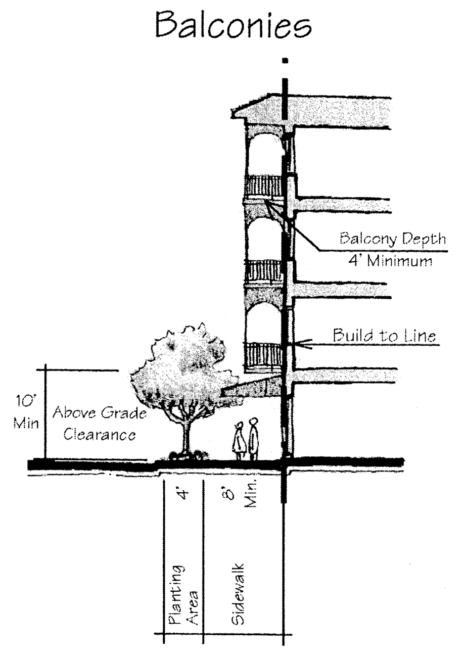
Balconies
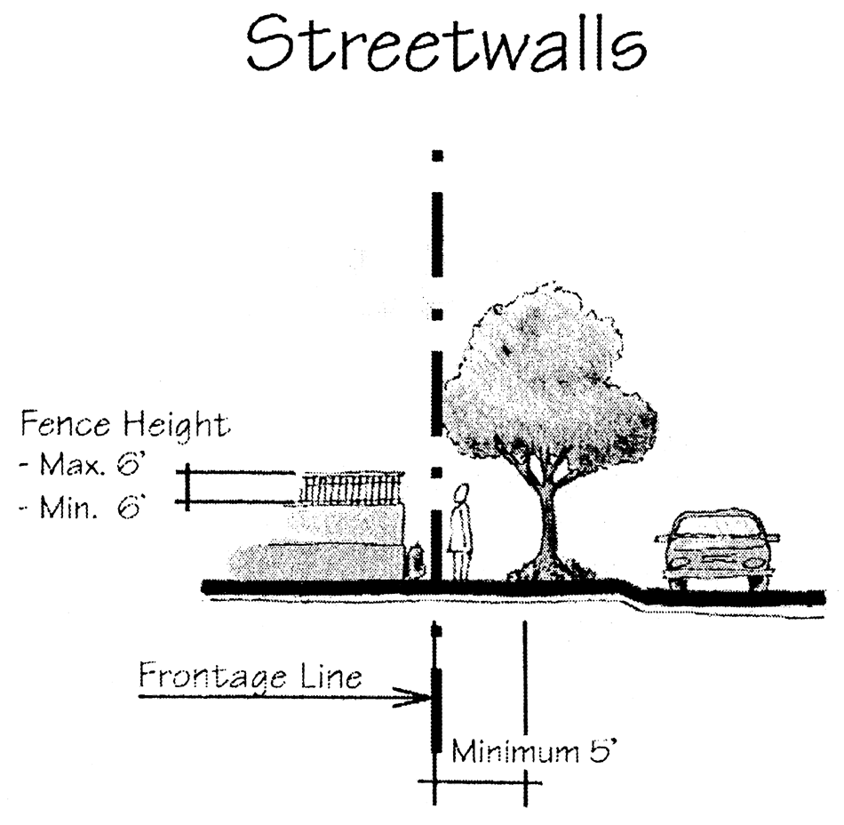
(6)
Streetwalls shall be comprised of a masonry wall, black aluminum fence, wrought iron fence, or landscaped hedge, and shall be six feet in height, no less than 75 percent opaque, and built along the frontage line. Openings along the streetwall should be gated. (The percent opacity is calculated including all openings).
Streetwalls
(7)
Streetedges shall be comprised of a masonry wall, black aluminum fence, wrought iron fence, white picket fence, or landscaped hedge, and shall be two and one-half feet to four feet in height, at least 50 percent transparent, and built along the frontage line. Openings along the streetedge are encouraged to be gated. (The percent opacity shall be calculated including all openings).
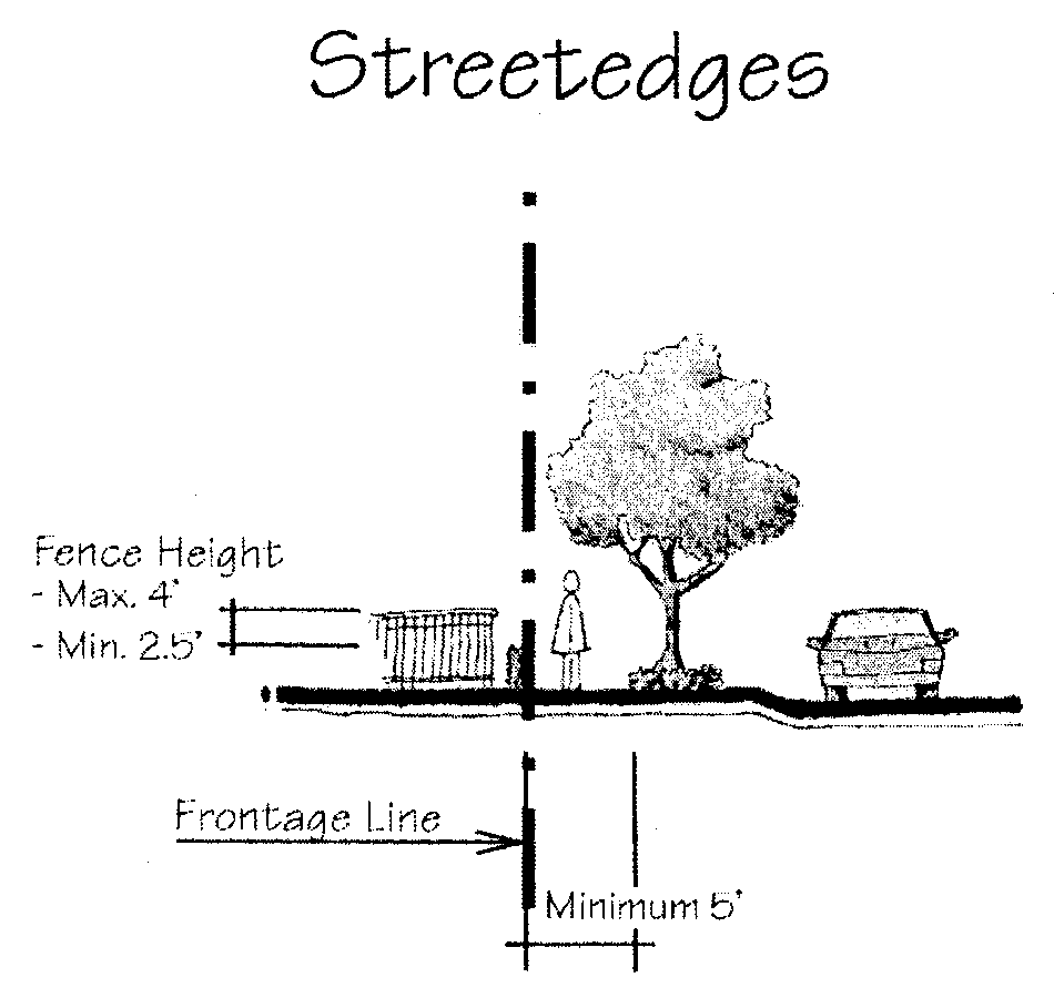
Streetedges
(8)
Residential garages shall be located in the rear-half (farthest from a non-lane street) of the building(s) that they intend to serve.
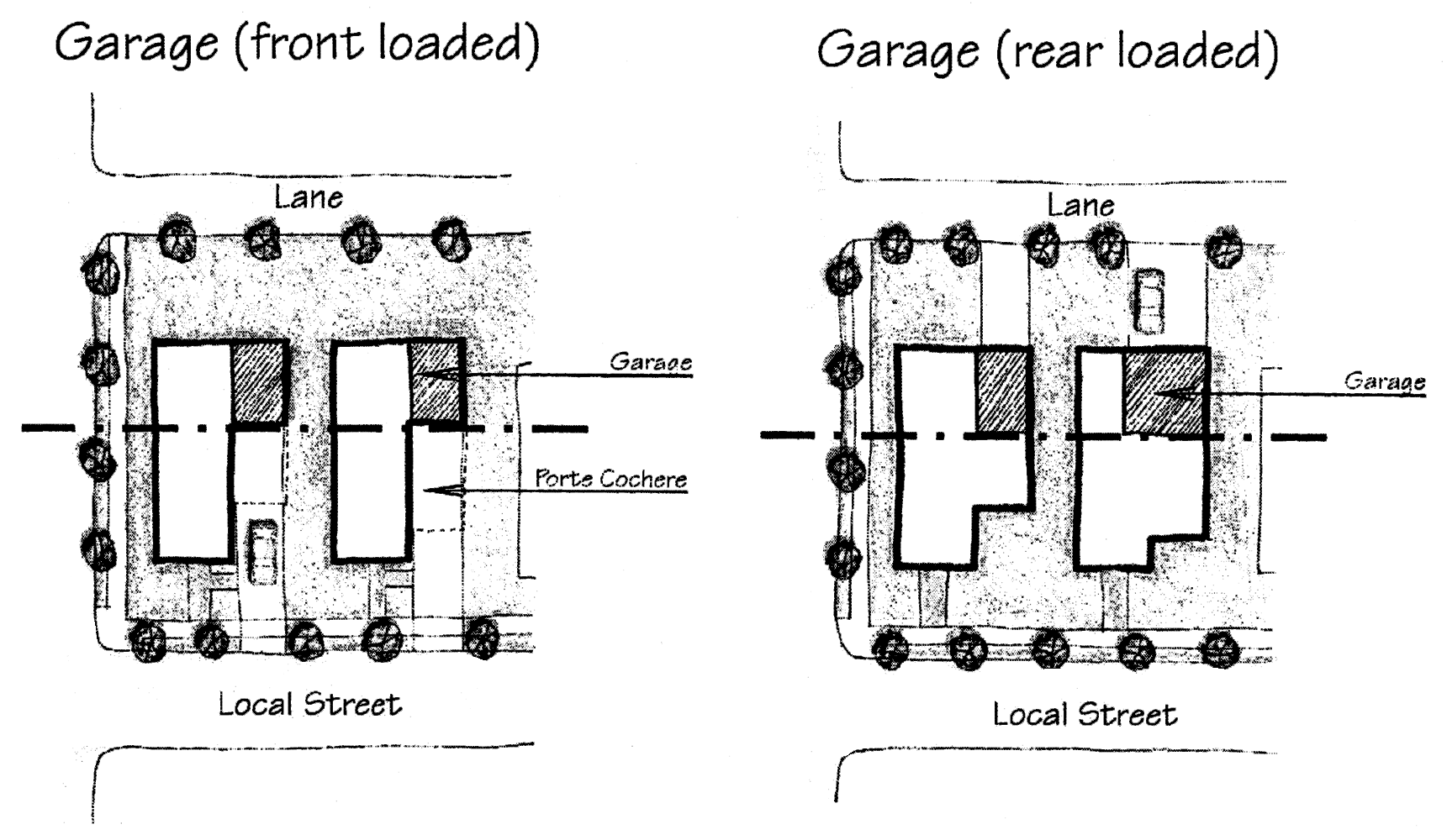
Garages
(9)
Except for requirements contained in this section, structures shall not be required to be setback to any street or right-of-way either within or outside of the TND.
(d)
Phasing. In order to provide residents with employment and recreational opportunities and non-residential uses with a solid customer base, residential and non-residential uses must be built concurrently. A phasing plan must be submitted with a site plan for development of a TND that demonstrates the following:
(1)
It is recommended that at least 25 percent of the non-residential uses be constructed prior to the construction of the initial 50 percent of the residential uses and at least 25 percent of the residential uses be constructed prior to the construction of the initial 50 percent of the non-residential uses.
(2)
At a minimum, at least 20 percent of the non-residential uses shall be constructed prior to the construction of the initial 90 percent of the residential uses and at least 20 percent of the residential uses shall be built prior to the construction of the initial 90 percent of the non-residential uses.
(3)
Gross square feet shall be used when calculating these percentages for non-residential uses and number of dwelling units shall be used when calculating these percentages for residential uses.
(e)
Streets. Streets in a TND are to be inviting public space and integral components of community design. A hierarchical street network should provide for a rich variety of transportation options. In descending order of importance, the hierarchy shall consider pedestrians as the most important, followed by cyclists, mass transit, and automobiles. This system shall be designed to connect and provide access between uses within a TND and adjacent uses within surrounding communities. In order for this street network to be safe for motorists, pedestrians, and cyclists, all design elements must consistently be applied to calm automobile traffic and to facilitate pedestrian use.
(1)
Streets shall be classified into the following four categories:
a.
Boulevard.
b.
Commercial street.
c.
Residential street.
d.
Lane.
(2)
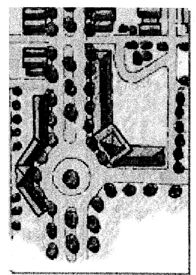
Streets shall, wherever practicable, terminate at other streets within the TND and connect to existing and projected streets outside the TND. Street stubs shall be provided within the development adjacent to open land to provide for future connections. Culs-de-sac and other dead-end streets are discouraged. In the event a cul-de-sac must be used, it shall not exceed 250 feet in length, must be accessed from a street providing internal or external connectivity, and shall be permanently terminated by a vehicular turnaround. In most instances, a close or eyebrow is preferred to a cul-de-sac. Vehicular turnarounds of various configurations are acceptable so long as emergency access is adequately provided, as determined by the city's fire department.
Close—Eyebrow Streets
(3)
The average perimeter of all blocks within a TND Neighborhood shall not exceed 1,500 feet. The maximum perimeter of any block within a TND Neighborhood shall not exceed 2,000 feet. No Block Face within a TND Neighborhood shall have a length greater than 500 feet without a publicly dedicated pedestrian pathway or street providing through access to another street. No Block Face within a TND Neighborhood shall have a length greater than 800 feet without a publicly dedicated street providing through access to another street. These requirements may be exceeded due to superior project design as determined by the community development director.
(4)
A continuous network of rear and side lanes is encouraged to be provided for all buildings in a TND. Where provided, lanes shall serve as the primary means of vehicular ingress and egress for residential uses. Lanes may not provide access to the front of buildings.
(5)
In order to facilitate pedestrian movement and inhibit reckless drivers from turning corners at high speeds, curb return radii shall be nine to 15 feet on all streets. A clear area of sufficient radius, as outlined in the South Florida Building Code (SFBC) or amendments thereto, shall be established for streets designated as a fire access road, as defined by the SFBC or amendments thereto. Streets designated as a fire access road, as defined by the SFBC or amendments thereto, shall be constructed in conformance with SFBC regulations regarding fire access roads.
(6)
In order to distinguish pedestrian areas from vehicular areas, specialty paving is encouraged. Specialty paving is encouraged in order to indicate the entrance to the TND or TND Neighborhood.
(7)
Streets may be comprised of segments. Each segment should have the characteristic of one street type.
(8)
Utilities shall be placed underground and should be located along lanes in order to minimize the disruption caused by their placement and maintenance. In the event that utilities must be placed in streets other than lanes, they should be located in a manner that does not conflict with plantings.
(9)
TND streets shall be organized according to a hierarchy based on function, size, capacity, and design speed; street right-of-ways are therefore expected to differ in dimension. The proposed hierarchy of streets shall be indicated on the submitted site plan with each street type being separately detailed. The elements that comprise streets are as follows: sidewalk, street tree/planting area/optional utility allocation, curb and gutter, on-street parking, bicycle lanes, travel lanes, and landscaped medians.
a.
Sidewalks are required on both sides of streets, except for lanes or a street straddling the undeveloped edge of a TND or TND neighborhood. Sidewalk width shall be a minimum of four feet for residential streets, six feet for boulevards, and eight feet for commercial streets.
b.
Street trees shall be planted approximately every 20 feet on both sides of all streets per Chapter 9 of the Land Development Code. Street trees shall not be required in lanes. The planting area for street trees shall be a minimum of five feet in width for boulevards and residential streets and be a minimum of four feet in width for commercial streets. The planting area may contain other landscaping in addition to the required street trees. A planting area for landscaping shall be a minimum of three feet in width for lanes. The required planting area width may be combined with the required sidewalk width to expand the sidewalk beyond the required width, as long as the street trees are preserved and tree grates or sufficient landscaped area is provided around the base of the trees; this provides for the flexibility of allowing planting areas in any area within the combined area. Provisions should be made to accommodate the proper root zone below finished grade.
c.
On-street parking is required on both sides of the street for commercial streets. On-street parking is required on at least one side of the street for boulevards and residential streets. Parallel on-street parking areas (including area of adjacent paved gutter) shall be seven feet wide for residential streets and seven to eight feet wide for commercial streets and boulevards, and 22 feet long for all streets. In order to ensure that pedestrian crossing distance is minimized, angled on-street parking is not encouraged, but may be provided only along commercial streets and boulevards as long as wheel stops are provided. Angled parking dimensions shall be as provided for in Figure 808-1 of the Land Development Code. A two-foot overhang past the wheel stop is permitted and shall count toward meeting the angled parking stall depth requirements. On-street parking width shall include the adjacent paved gutter area. Curbed bulb-outs containing streets trees and/or other plantings are encouraged to be built at regular intervals and at all intersections within a dedicated on-street parking area.
d.
Where provided, bicycle lanes shall be between three and four feet in width and be placed between on-street parking areas and travel lanes, or between the curb and gutter and the travel lanes in the absence of on-street parking areas. Bicycle lanes are required on streets with design speeds over 35 miles per hour. When four-foot wide bike lanes are used, they shall include standard pavement markings and signs.
e.
Commercial streets, residential streets, and lanes may contain one (one-way) or two travel lanes. Boulevards may contain up to four travel lanes. Travel lanes do not include dedicated turn lanes. Dedicated right-turn lanes are discouraged as they impede pedestrian travel.
f.
Medians in boulevards shall be curbed and contain plantings, water features, and/or specialty pavement and be at least five feet in width, excluding curb.
g.
Design speeds may not exceed 30 miles per hour for most streets within a TND Neighborhood, except for four-lane boulevards. For streets with design speeds of 25 miles per hour or less, travel lanes shall be ten feet wide. For streets with design speeds greater than 25 miles per hour but less than 35 miles per hour, travel lanes shall be ten or 11 feet wide. For streets with design speeds greater than 35 mile per hour, travel lanes shall be 11 or 12 feet wide.
h.
The following cross-section diagrams illustrate typical examples of ways in which street cross-sections may be assembled:
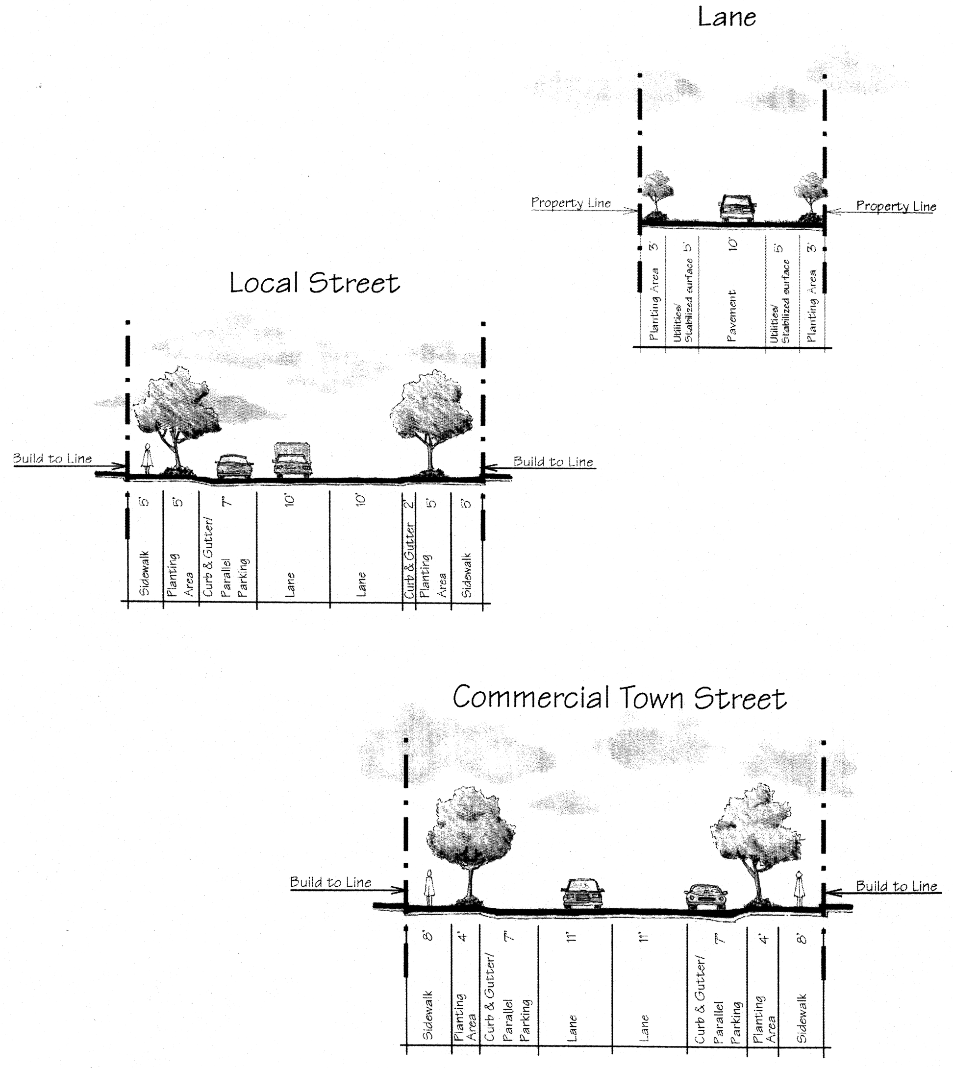
Streets
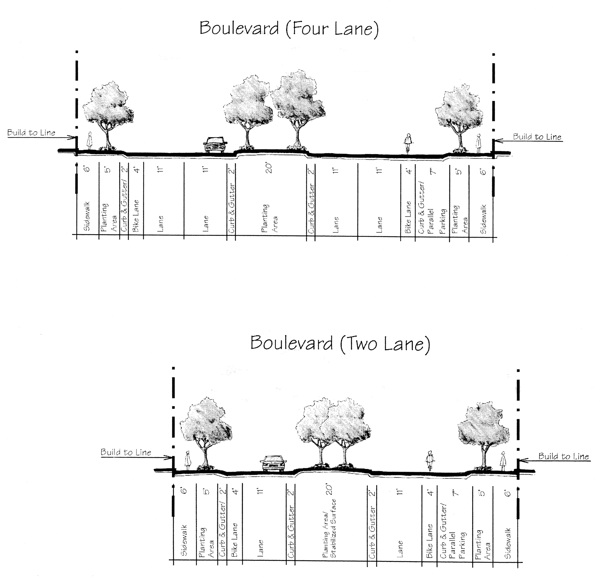
Streets
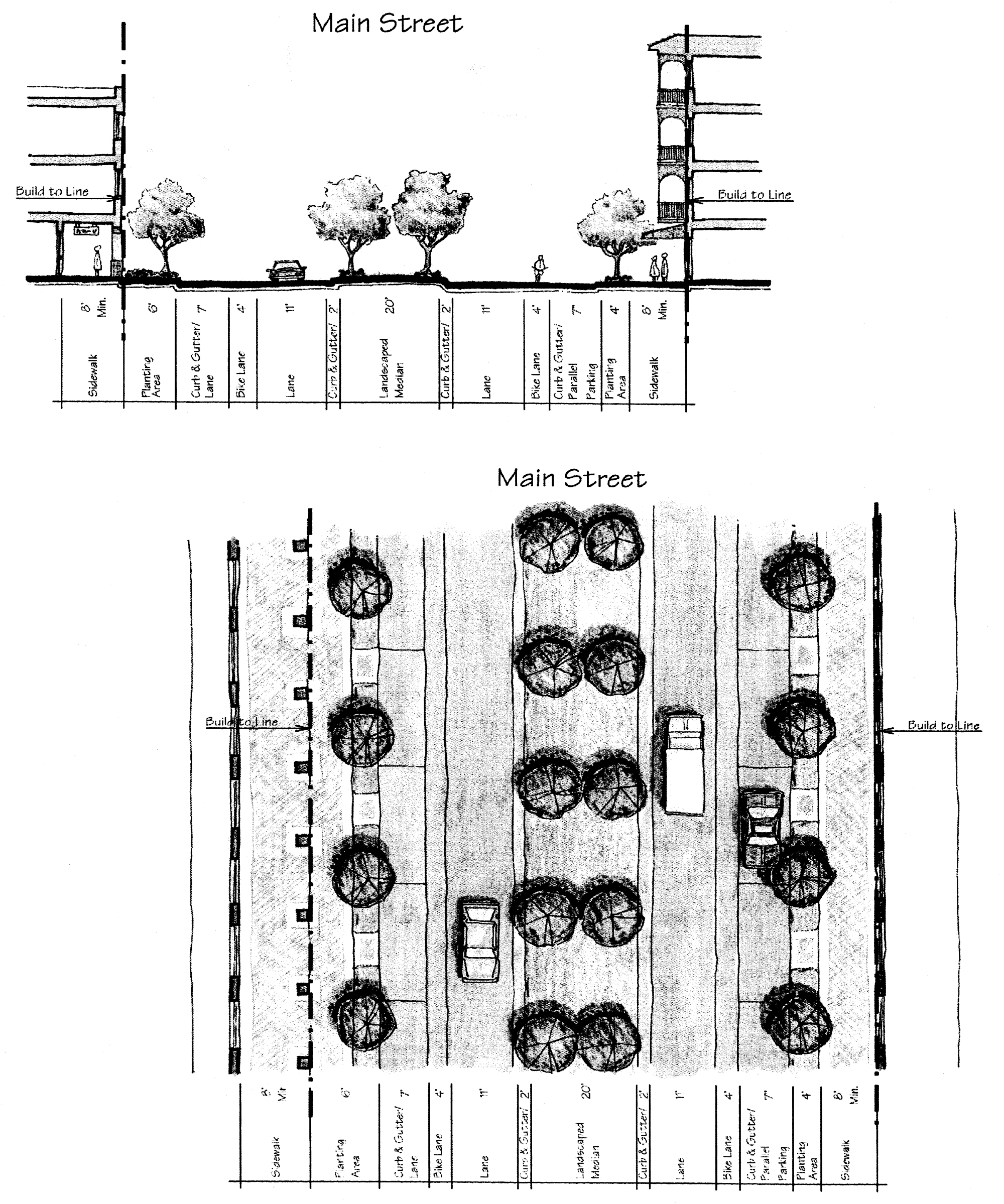
Streets
(f)
Parking. Parking shall be provided pursuant to Section 808 of the Land Development Code, subject to the exceptions noted below and elsewhere in this section:
(1)
Due to their design and compactness, TNDs encourage non-automotive trips between residential and non-residential uses. In order to reflect the reduced necessity of the automobile in this type of efficient development, the amount of parking required for all non-residential uses shall be reduced by 25 percent.
(2)
The parking requirements for buildings containing more than one use shall be the total of the amount of parking required for each use.
(3)
On-street parking adjacent to a building or lot shall count toward fulfilling the parking requirements for that building or use. In the event that there is no building or use on the opposite side of the street, on-street parking on the opposite side of the street, along the same building elevation or lot width may count toward fulfilling the parking requirements. A building or use must cease to utilize parking on the opposite side of the street to fulfill its parking requirements at the time when a building or use is constructed adjacent to said parking. In the event that an on-street parking space is adjacent to more than one property, the property to which the majority of space is adjacent, as determined by the community development director, shall count. However, all house uses shall maintain a minimum of one on-site parking space. On-street parking not adjacent to any building or lot may count toward fulfilling the overall parking requirements of the TND Neighborhood.
(4)
The maximum number of parking spaces required for any dwelling unit is four.
(5)
Garages or carports shall not be required for any dwelling unit.
(6)
Off-site parking areas (i.e., parking lot, parking garage, etc.) are permitted for all categories of use except house uses and shall be credited to the required parking for individual uses. House uses may utilize on-street parking to fulfill their parking requirements, as regulated in this section. Off-site parking areas should provide parking for multiple users and shall be within one-quarter mile of the activity that is utilizing its parking capacity.
(7)
On-street parking and spaces within an off-site parking area may be utilized as shared parking when calculating the required parking for applicable uses. The use of shared parking must be authorized in writing by the community development director. The shared spaces shall not conflict with spaces that have already been designated as shared spaces for other uses likely to occur at the same time. A document graphically outlining the locations, number of shared parking spaces and times of use must be submitted to the community development director prior to shared parking authorization.
(8)
Off-street parking areas shall be located at the rear or at the side of buildings within all categories of use. Parking areas shall not be built into the front elevation of any building, except for buildings containing structured parking, in which case such elevation shall be designed to imitate the surrounding uses. Streetwalls shall be built on the frontage line of all parking lots.
(9)
Parking areas shall not abut street intersections or terminate a street vista. On-street parking shall not be closer than 25 feet to a street intersection, measured from the extended right-of-way lines.
(10)
Up to five percent of the required parking spaces for all uses except house uses may be replaced by providing spaces for motorcycles, motor bikes or racks for bicycles.
(g)
Landscaping and open space.
(1)
Landscaping. Landscaping in a TND is intended to reinforce community identity, minimize visual blight and noise, maintain building and property values, prevent soil erosion, reduce stormwater runoff, reduce air pollution, increase groundwater recharge, create shade and reduce solar overheating.
a.
A cohesive planting theme should emanate throughout the TND. Planting layout and style should not conflict within the TND.
b.
Landscaping requirements shall adhere to the requirements of Chapter 5, Section 506 of the Land Development Code.
c.
Shade trees are recommended in the planting areas along all streets, particularly in the absence of colonnades or awnings that provide shade directly over a sidewalk. It is desirable for street trees opposite each other to have their branches grow into each other to create a canopy effect over the street.
d.
Bufferyards shall not be required adjacent to areas that would offer a natural extension of the TND or that are compatible with the TND as determined by the community development director. This is meant to facilitate the interconnectedness of compatible uses.
(2)
Open spaces. TND open spaces shall be planned, improved and within walking distance from persons living nearby. Open space areas are a vital part of the focal point for each neighborhood. A square or plaza located at the central focus of a TND Neighborhood, for example, may comprise a majority of the required open space. There shall be at least one central plaza or square for each TND Neighborhood. There shall be a hierarchy of open space within TND Neighborhoods, to serve the needs of all residents.
a.
Each TND Neighborhood shall contain open space recreational areas of at least 100 square feet per residential unit. At least 25 percent of this requirement shall be designed as a play lot. The minimum size of any open space recreation area shall be 1,500 square feet. The balance shall include improved land and facility improvements, to include basketball courts, tennis courts, gazebos, open play fields and the like, as determined by the development review committee (DRC). The play lot shall not be located in an area directly adjoining a water body, unless it is otherwise impractical. Residential uses shall not be located further than 600 feet from an open space recreational area.
b.
Each TND Neighborhood shall contain at least one square or plaza. The minimum size of any square or plaza shall be one acre or two percent of the TND Neighborhood land area, whichever is less. The square or plaza should be located near the geometric center of the TND Neighborhood or at its focal point and shall be within one-quarter mile of 80 percent of all residential uses in that neighborhood.
c.
Fifty percent of the border of a plaza must be defined by adjacent buildings, except house use buildings. The remainder may be bordered by streets or pedestrian accessways.
Plaza Border
d.
Seventy-five percent of the border of a square must be defined by Streets, except lanes.
Square Border
(h)
Lighting. The general rule for lighting in a TND is to prefer a greater amount of smaller lights, as opposed to fewer high-intensity lights. This is in keeping with the overall goal of maintaining the elements of a TND street in a human scale, but also allows for more aesthetic matters, such as allowing people to see the night sky.
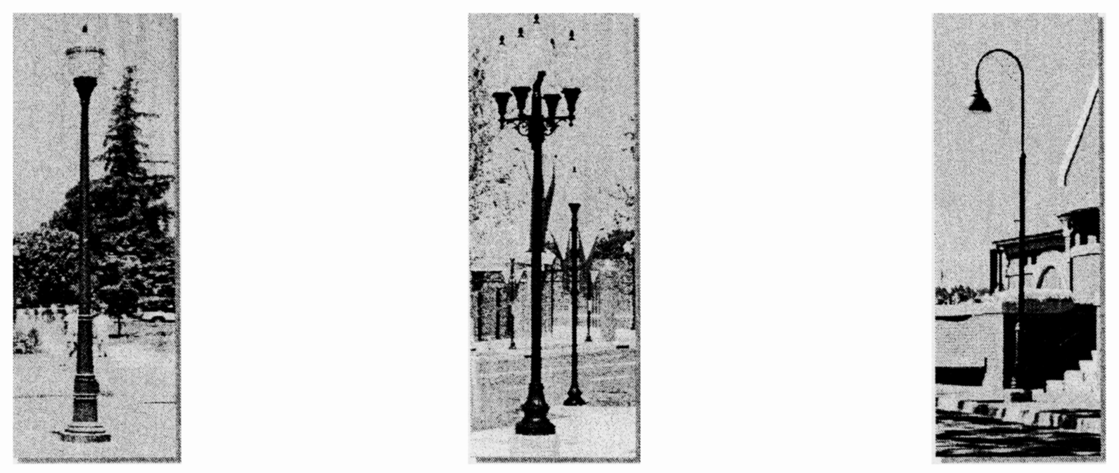
(1)
Height of freestanding lights. For this section, height includes the pole and fixture.
a.
Lighting within the interior of parking areas of two or more acres shall not exceed 25 feet in height, except along the perimeter where it shall not exceed 12 feet in height.
b.
Lighting within the interior of parking areas of less than two acres shall not exceed 16 feet in height, except along the perimeter where it shall not exceed 12 feet in height.
c.
Street lights shall not exceed 12 feet in height.
d.
Lighting in pedestrian and recreational areas shall not exceed ten feet in height.
e.
Lighting within ballfields and recreational uses shall not exceed 40 feet in height, shall be designed to be as inconspicuous as possible, and shall not light surrounding uses, excluding streets.
f.
In cases where the light fixture is placed below the highest point of the pole, the pole may extend an additional three feet.
Examples of lighting:
Examples of Lighting
(2)
Color of light. Lighting elements that provide full-spectrum light (white light) should be used for all street lights, so that colors at night are realistic. This has the effect of deterring criminal activity and providing people with a better awareness of their surroundings. White light sources include incandescent, fluorescent, mercury vapor, and metal halide, with metal halide being preferred.
(3)
Separation from plantings. Lighting that is meant to provide visibility for ground locations (i.e., street lights, parking lot lights, etc.) should not be placed in a manner that illuminates the top of trees or is blocked by structures.
(4)
Decorative lighting. Lighting that enhances the architectural design of buildings and plantings is encouraged.
(i)
Transportation. The TND shall be built in a manner that encourages the viability of transportation mode alternatives to the automobile. The design of the TND should be of sufficient density and accessibility to encourage pedestrian or bicycle travel within the development and to allow coordinated mass transit nodes for travel outside of the development.
(1)
Transit. Since the highest levels of patronage for transit stations and stops are often found where such transit may be conveniently walked to, TND design should be inherently compatible with transit. To properly plan for transit, designers should try to have transit access as direct as possible to locations and buildings in the TND. Each transit route should also have direct, safe, secure, and pleasant pedestrian and bicycle access planned as a part of each route. Transit services should go directly into the center of each TND Neighborhood, since TND Neighborhood centers typically have shops and services which provide people with a safe and pleasant environment while waiting for the transit to arrive.
Mass transit mode is dependent on the number of persons likely to patronize the mode. Mass transit may consist of motorized vehicles (buses, trolleys, shuttles), light rail, or heavy rail. It is expected that mass transit will be limited to motorized vehicles within the City of Miramar's bounds. Therefore, bus shelters and bays must be accommodated in the design of the TND.
(j)
Income levels. A mix of income levels should be represented within a TND to ensure that all occupations necessary to the TND employment areas are adequately represented within the residential population. At least two dwelling unit types (single-family house, garden apartment, mixed use residential/commercial, or townhouse) shall be provided within a TND Neighborhood in order to effect a mix of income levels.
714.7. Specific use standards.
(1)
Distance requirements between establishments that sell alcoholic beverages shall not be applied within a TND.
(2)
No business establishment shall be permitted to sell alcoholic beverages, for consumption either on or off the premises, if the business establishment is adjacent to any established house of worship or school, except as provided for in F.S. Chapter 563, as may be amended from time to time.
(3)
Guesthouses shall contain no more than six rooms for the lodging of guests. Transients shall not be lodged for more than 30 consecutive days.
(4)
The following uses are prohibited where visible from open space areas and all streets, except lanes: Utility boxes and machinery, including but not limited to: backflow devices, electric meters, and air conditioning units, except for fire hydrants and fire department connections.
(5)
Pain management clinics and pharmacies, as defined in Section 201, shall be prohibited in a TND.
714.8. Regulations per category of use.
(a)
Public use.
Public Use
(1)
Land use. Land designated for public use shall consist of open space and recreational property, civic use structures, streets, and public accessways.
(b)
Civic use.
Civic Use
(1)
Land use. Land designated for civic use may include any use permitted in the Community Facilities (CF) zoning district.
(2)
Location. Civic use buildings should be located within or adjacent to a square or plaza or on property terminating a street vista.
(3)
Lots and buildings. Civic use buildings shall not exceed 80 feet in height, excluding spires, cupolas, campaniles, monuments, flag poles, and chimneys.
(c)
Shopfront use.
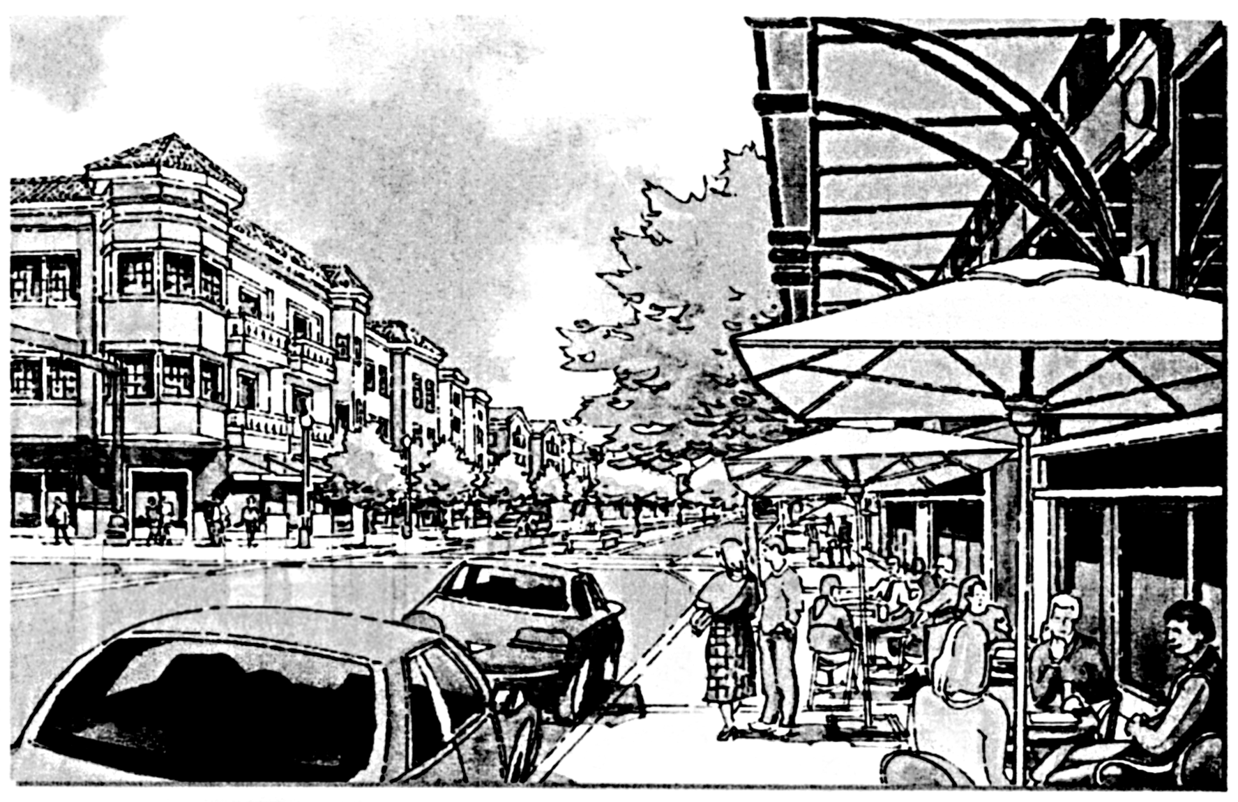
Shopfront Use
(1)
Land use.
a.
Land designated for shopfront use may include any use permitted in Principal Uses Table 403-1; TND District.
b.
Residential uses, except for entries, lobbies, and recreational support uses for residential uses, are not permitted on the ground floors of shopfront use buildings.
(2)
Lots and buildings.
a.
Shopfront use lots and buildings shall have the facade or column face of the colonnade built directly on their frontage line along at least 70 percent of their linear frontage. For lots and buildings with more than one possible frontage line, the facade or column face of the colonnade shall also be built directly on the secondary frontage line(s) for at least 50 percent of their linear frontage.
b.
Shopfront use lots and buildings shall have a streetedge built along the unbuilt portions of their frontage line or their secondary frontage line(s).
c.
A shopfront use building shall be built up to an adjacent property line or building along at least one of its sides.
d.
Minimum floor area, minimum lot area, and minimum lot width shall be as provided for in the Land Development Code for multi-family dwelling units.
e.
Shopfront use buildings shall not be less than 24 feet in height and shall not exceed 100 feet in height (excluding chimneys and elevator towers), except where adjacent to a house use. Where adjacent to a house use, the 15 feet of the building closest to the house use shall not exceed 35 feet in height.
(d)
Rowhouse use.
Rowhouse Use
(1)
Land use.
a.
Land designated for rowhouse use may include any use permitted in the Community Business district (B2) and Multi-family residential districts (RM10, RM16, and RM25), and guesthouses.
b.
Non-residential uses, except live/work units, are only permitted on the ground floors of rowhouse use buildings.
(2)
Lots and buildings.
a.
Rowhouse use lots and buildings are encouraged to have a streetedge built along the unbuilt portions of their frontage line and secondary frontage line(s).
b.
Rowhouse use principal buildings shall have a first floor front elevation of at least two feet above finished sidewalk grade, except for areas used for non-residential uses and buildings that are required to provide a handicapped accessible ramp per the Florida Accessibility Code for Building Construction.
c.
Rowhouse use buildings may be set back a maximum of ten feet from their frontage line and secondary frontage line(s).
d.
Minimum floor area, minimum lot area, and minimum lot width in rowhouse use buildings shall be as provided for in the Land Development Code for multi-family dwelling units.
e.
Rowhouse use buildings shall not exceed 60 feet in height (excluding chimneys and elevator towers), except where adjacent to a house use. Where adjacent to a house use, the 15 feet of the building closest to the house use shall not exceed 35 feet in height.
(e)
House use.
House Use
(1)
Land use.
a.
Land designated for house use may include any use permitted in the single-family residential districts (RS3, RS4, RS5, RS6, and RS7) and guesthouses.
(2)
Lots and buildings.
a.
House use lots and buildings are encouraged to have a streetedge built along the unbuilt portions of their frontage line and secondary frontage line(s).
b.
House use principal buildings shall have a first floor front elevation of at least two feet above finished sidewalk grade.
c.
House use principal buildings shall be set back a minimum of five feet and a maximum of 25 feet from their frontage line and secondary frontage line(s).
d.
House use secondary buildings shall be set back a minimum of five feet from their frontage line and secondary frontage line(s).
e.
House use principal buildings shall be set back from the side lot lines (in total) a minimum of 20 percent of the width of the lot. The entire setback may be allocated to one side; however, a minimum of five feet shall be maintained between adjacent principal structures.
f.
House use lots shall have a minimum width of 40 feet with a minimum lot size of 4,000 square feet.
g.
The minimum floor area of a house use principal building, not including garage or non-air-conditioned areas, shall be 1,200 square feet.
h.
House use buildings shall not exceed 35 feet in height (excluding chimneys).
i.
A maximum of 75 percent of a house use lot's area may be covered by a structure. Front porches and stoops are encouraged and shall not count toward this maximum and may be placed within the frontyard setback.
(f)
Accessory uses.
(1)
Outbuildings on shopfront use, rowhouse use, and house use property are limited to 50 percent of the floor area of the principal structure(s).
(Ord. No. 01-04, § 3, 11-15-00; Ord. No. 11-10, § 7, 9-21-11; Ord. No. 20-09, § 2(Exh. A), 3-18-20; Ord. No. 20-13, § 5(Exh. D), 6-17-20)
Sec. 715. - Transit Oriented Corridor District Code.
715.1.1. Introduction. A Transit Oriented Corridor is generally characterized as a developed environment within a quarter-mile of a public transit system, with building characteristics and public amenities that promote the safe movement of pedestrians.
The City of Miramar's Future Land Use designation, Transit Oriented Corridor ("TOC"), is a component of a regional initiative to revitalize the State Road 7 corridor and its surrounding communities.
Prior to the establishment of the TOC Future Land Use designation, the City formed the Citizens' Master Plan, which was created by the Miramar/West Park Charrette, conducted in February 2005. The Citizens' Master Plan was prepared by the Treasure Coast Regional Planning Council, the South Florida Regional Planning Council, City officials, and Miramar Department of Community Development staff on behalf of Miramar stakeholders and residents. In addition to the Citizens' Master Plan, the City relied on the recommendations of the Historic Miramar Study prepared by Anthony Abbate Architect, PA, in 2003, for development of the areas near State Road 7.
The TOCD Code incorporates the goals of previous efforts with elements of the current Traditional Neighborhood Development ("TND") and State Road 7 Overlay District standards to produce development standards for the TOCD. The TOCD Code facilitates mixed-use development, pedestrian-oriented streets, public mobility options, Mediterranean Revival style architecture, and opportunities for location of work, play, services and entertainment within walking distance.
715.1.2. General. This Code shall be known as the TOCD Code for the City of Miramar. The TOCD Code shall promote the Goals, Objectives and Policies contained of the TOC designation within the Future Land Use Element of the Comprehensive Plan. Specifically, Policy 1.17 and Objective 9D of the Future Land Use Element are designed to maximize the development potential of State Road 7, Pembroke Road, Miramar Parkway, and County Line Road.
The TOCD Code supplements the Land Development Code ("LDC") provisions within the City of Miramar for the area known as the TOCD. The TOCD is generally described as the area bound to the north by Pembroke Road, to the east by State Road 7, to the south by County Line Road, and to the west by Southwest 66th, 61st and 64th Avenues.
To create the "Miramar" envisioned by the citizens during the visioning process, the City of Miramar's TOCD Code is modeled after the SmartCode.
The Smart Code, released by Duany Plater-Zyberk & Company and distributed by the nonprofit Center for Applied Transect Studies, is a Form-Based land development code that addresses the physical form of buildings and community. The open-source SmartCode is a transect-based model code intended to be used as a template for adaptation by local governments.
Form-Based codes are an alternative to conventional zoning that support the disposition of a community, mixed-use development, and a sustainable and walkable environment. As defined by the Form-Based Code Institute, Form-Based codes foster predictable results and a high-quality public realm by using physical form (rather than separation of uses) as the organizing principle for these regulations.
Miramar's TOCD Code is specifically created to encourage compact first-rate projects based upon smart growth principles; to preserve the existing character of neighborhoods surrounding the State Road 7 corridor; to regulate for high-quality infill development, and to create a predictable process for developers and the community to meet these goals.
The intent and purpose of the TOCD Code is to encourage and promote:
• Public Health and Safety.
• Mixed-Use Development.
• Pedestrian Mobility.
• Public Transit.
• Preservation of Neighborhoods.
• Conservation of Land.
• Environmental Protection.
• Energy Efficiency.
• Sustainable Buildings and Practices.
• Aesthetically Pleasing Community Urban Design.
• Adequate Public Utilities and Facilities.
715.1.3. Components of the TOCD Code. The TOCD Code shall be comprised of a Regulating Plan, Pattern Book and Regulations that dictate the placement, character and Function of buildings, signs, and other structures within the TOCD.
715.1.3.1. Miramar's official "zoning" map for the TOCD is the Regulating Plan. All properties within the TOCD shall be classified within regulatory Districts pursuant to the Regulating Plan. The boundaries of all districts within the TOC and their designations are shown on the Regulating Plan. The Regulating Plan may be supplemented by additional layers or separate maps to show specific details of a particular area which the Regulating Plan does not adequately describe.
A.
On the City's official Zoning Map, the commercial properties within the TOCD are rezoned and shown as Mixed-Use Low, Mixed-Use High, and Special District. The six existing zoning districts for Residential properties have been consolidated into two districts, RS8 and RM4. The existing Open Space and Community Facility properties are reclassified as those designations, respectively.
B.
The Regulating Plan, together with all adopted explanatory and supplemental material shown therein, is hereby adopted by reference and shall be part of this Code. The Regulating Plan determines the locations of the districts and graphically depicts the regulation areas.
715.1.3.2. Districts within the TOCD determine the functions and further detail the regulations which limit or determine the height, volume, and form of buildings and structures, the area of yards and other open spaces, and the Density and intensity of functions. TOCD District descriptions are provided in Table 1. TOCD Descriptions.
A.
The TOCD is comprised of zoning designations including Residential Districts, Mixed-Use Districts, and Special Districts.
B.
Residential Districts will retain the same property rights as they had under their previous zoning designations, with the addition of new Setback, height and function requirements established to increase the development potential of the Lots.
C.
The existing commercial areas within the TOCD are rezoned to Mixed-Use districts which are classified according to the Density, intensity and hierarchy of the adjacent corridor.
D.
The Special Districts include areas that have different building characteristics, and in some cases, functions from the other districts. Due to their intrinsic function, placement, or character, the areas within the Special Districts do not conform to one or more of the other districts specified by the TOCD Code.
715.1.3.3. Regulations for each District are divided into categories, which detail building placement, building character, building function, street standards, parking, and landscape standards that determine the type of development allowed in each District.
715.1.3.4. Categories of Building function and allocation.
(a)
It is the intent of this Code that building functions should not be concentrated in a particular area; they should be mixed together in a pedestrian-friendly and compact manner.
(b)
A TOC Monitoring Report will be established and maintained by the Community & Economic Development Department in order to maintain an accurate measure of the development thresholds within the TOC as indicated in Policy 1.17 of the Future Land Use Element of the Comprehensive Plan.
715.1.4. Reserved.
715.1.4.1.—715.1.4.5. Reserved.
715.1.4.6. Existing Parking Areas that provide parking in excess of the requirements of this Code may be reduced in accordance with Section 715.3.1 "Parking."
715.1.5. Administrative approval and variances.
715.1.5.1. There shall be two types of authorized deviations from the requirements of this Code: Administrative Approvals and Variances. The DRC shall have the authority to administratively approve or disapprove a request for an Administrative Approval. Variances shall be subject to review and approval by the Planning and Zoning Board or City Commission, in accordance with the requirements of Section 315 of the LDC.
(a)
An Administrative Approval is a ruling that would permit a practice that is not in strict conformance with a specific provision of this Code, but is determined to be consistent with the goals of the applicable TOC district in accordance with subsection 715.1.5.
(b)
Deviations from this Code which are authorized for Administrative Approval are as specifically provided in the TOCD Code and shall be reviewed, and approved or denied, by the DRC.
(1)
Administrative Approvals Involving Deviations From Development Standards. Except for Administrative Approvals from Table 9A "Specific Function and Use" which shall be considered under the criteria provided in subsection b(2) of this section, the applicant shall demonstrate satisfaction of all of the following criteria:
(A)
The strict application of this Code would prohibit site improvements to bring a TOCD development site as close as possible to meeting TOCD Code requirements;
(B)
The need for the proposed waiver of the applicable TOCD standard arises from some condition peculiar to the specific property involved;
(C)
The proposed waiver of the applicable TOCD standard would improve the quality and/or safety of the property and will not diminish the use of the property, nor negatively impact surrounding properties and the TOCD area; and
(D)
The proposed development meets the requirements of the TOCD Code as nearly as possible under the unique circumstances.
(2)
Administrative Approvals Involving Specific Function And Use Standards. For Administrative Approvals provided in Table 9A. Specific Function and Use, the applicant shall demonstrate that all of the following standards have been met:
(A)
The proposed use is appropriate in the area in which it is proposed;
(B)
The proposed use will be reasonably compatible with surrounding uses;
(C)
The proposed use will not contaminate the Biscayne Aquifer;
(D)
Any nuisance or hazardous feature involved is suitably separated and buffered from adjacent uses;
(E)
The proposed use will not hinder development of the site or nearby vacant property;
(F)
That the use will not have a detrimental effect on vehicular or pedestrian traffic, or parking conditions, and will not result in the generation or creation of traffic inconsistent with the health, safety and welfare of the community;
(G)
The land or building which is involved is adequate for the proposed use; and
(H)
The proposed use complies with the Comprehensive Plan.
(I)
Drive through facilities shall not have direct ingress or egress to Commercial Streets.
(3)
Applications for Administrative Approval shall be submitted to the Department of Community & Economic Development, and scheduled for review by the DRC.
(A)
A Variance is a ruling on a deviation which is not qualified for consideration as an Administrative Approval in accordance with this subsection. Variances shall be available for relief from development standards provided in this Code, which are not expressly subject to Administrative Approval. Variances shall not be granted to allow the establishment of a use which is not otherwise allowed in a TOCD district. Variances from the TOCD Code shall be processed and reviewed in accordance with Section 315 of the LDC.
(B)
The request for a Variance shall not subject the entire application to public hearing, but only the specific issue requiring the relief.
715.1.5.2. Site Plan Submittal and Consideration. Site plans for projects within the TOCD area that do not require Variances shall be processed, and approved or denied, by the DRC. The procedure for site plan filing and submittal shall be as provided for in Section 310 of the LDC. However, for applications subject to administrative review by the DRC under this subsection, the DRC shall determine whether the site plan meets the standards of this Code, and the general site plan criteria of Section 310 of the LDC. The requirements of Section 310 of the LDC shall apply to all site plans approved under this subsection. Site plan approvals may be subject to conditions as approved by the DRC.
715.1.5.3. Request for Quasi-Judicial Hearing. An applicant or affected party may request a quasi-judicial City Commission hearing on an application subject to an administrative decision of the DRC under this subsection. Within five days of the DRC's decision to grant or deny administrative approval of a site plan or other administrative approval under this subsection, the Director shall provide posted and mailed notice of the DRC's decision to the applicant and all owners of property located within 500 feet of the property that is subject to the site plan or administrative approval, advising them of their right to request a quasi-judicial hearing of the City Commission on the application by filing an application on a form provided by the Director. Such request for a hearing of the City Commission shall be made within 30 days of the mailing of the notice by the Director. An approved administrative site plan or administrative approval shall become effective 30 days following the Director's posting and mailing of the notification of the DRC's decision, provided that no request for City Commission hearing is filed. If a request for a quasi-judicial hearing is made by the applicant or an affected property owner, it shall be scheduled for the next available City Commission meeting following the Director's completion of his or her review of the request. The City Commission hearing and decision shall be governed by the standards applicable to site plans and administrative approvals under this section.
715.1.5.4. Should a violation of the Regulating Plan or an approved Site Plan occur during construction, or should any construction, site work, or development be commenced without an approved Regulating Plan or Site Plan, the Building Official shall be authorized to require the owner to stop, remove, and/or mitigate the violation.
715.1.6. Development incentives.
715.1.6.1. To encourage development and redevelopment within the TOCD in accordance with this Code, the City of Miramar grants the following incentives:
1.
Site plan applications under the TOCD Code shall be processed administratively by the DRC and CAB in accordance with subsection 715.1.5.
2.
The City of Miramar has been designated as a "Platinum City" by the Greater Fort Lauderdale Alliance for its permitting excellence process. The purpose of this process is to provide developers with a streamlined, first rate experience when going through the development, permitting, and inspection process.
3.
The City shall internally coordinate the application development approval process for the placement of underground utilities with the appropriate federal, state, and county agencies for all property within the TOCD.
4.
The City shall reduce the planning application fees for site plans and community appearance review by 50% of the established fee rates.
5.
The City shall exempt applicants for development of residential units from the requirement for land dedication or entering into a park agreement with the City and instead shall allow payment of the established Community Parks Land Dedication impact fees.
6.
All development in the TOCD shall receive a maximum of 35 percent reduction from the parking standards listed in Section 808 "Off Street Parking and Loading Standards" of the LDC.
715.1.7. Affordable housing incentives. To encourage the provision of Affordable Housing within the TOCD, the City of Miramar provides the incentives identified in the City's adopted Local Housing Assistance Plan (LHAP), in accordance with Section 420.9071(16), Florida Statutes.
715.1.8. Sustainability standards.
715.1.8.1. Sustainable building practices refers to building and building site design, materials and construction techniques that minimize demand for nonrenewable material and energy resources and water consumption, and minimizes the generation of waste products, pollution, and stormwater runoff.
Sustainable building practices are generally consistent with the techniques used to achieve certification of construction and development through third party sustainable building and development certification programs including the United States Green Building Council ("USGBC") Leadership in Energy and Environmental Design ("LEED"), the Florida Green Building Coalition certification program, and the Florida Green Lodging certification program.
To support sustainable building practices, all buildings and structures within the TOCD shall comply with the following:
1.
Applicants for development within the TOCD are required to schedule a preliminary development application meeting with the Community & Economic Development Department Director.
2.
At the preliminary development application meeting, the applicant shall identify the third party green building development standards proposed to be incorporated in the project design and implementation, and provide a copy of the standards to the Community & Economic Development Director for review.
3.
Approved third party green building development certification programs shall include but are not limited to the certification standards of the Florida Green Building Coalition, Florida Green Lodging, and LEED. If the standards of a third party certification program other than those listed in this subsection are proposed to be incorporated into the development by the applicant, the Community & Economic Development Director shall review the standards of the rating organization certification program intended to be used by the applicant and notify the applicant if the proposed program and standards are accepted or rejected as adequate standards for certification of sustainable building and development practices.
4.
Applicants must choose one of the following options for incorporation of sustainable building practices:
(A)
Formal application for Third Party Green Building Certification Program Development Rating. The applicant may formally apply for third party certification with a selected third party green building development rating organization approved by the Community & Economic Development Director in accordance with subsection (C), including full compliance with the applicable submittal, application and fee requirements for the selected third party certification; or
(B)
Participation in Community & Economic Development Department Sustainability Review Program. As an alternative to formal application for third party organization certification as provided in (D)(1) of this subsection, and as a requirement for those projects that apply for and do not receive certification from a third party organization, the applicant shall list the standards of the approved third party green building certification program which are proposed to be incorporated into the development. The Community & Economic Development Director shall review the building plans and verify their adherence to the third party green building and development standards proposed to be incorporated in the project design and implementation. The applicant shall document compliance with all of the approved third party green building certification program certification criteria on the building plans for the project, to the satisfaction of the Community & Economic Development Director.
5.
Site development plan submittal requirements for demonstration of compliance with this section shall include the following:
(A)
Documentation that the applicant has participated in the preliminary development application meeting and has received written notification that all structures within the proposed development shall incorporate sustainable building practices; and
(B)
For developments seeking formal third party certification with a selected third party green building development rating organization in accordance with (D)(1) of this subsection, a written statement identifying the applicable third party green building and development standards, and demonstrating said third party organization's recognition of the development's compliance with the minimum standards of the third party green building and development standards; or
(C)
For developments participating in the Community & Economic Development Department Sustainability Review Program in accordance with (D)(2) of this subsection, the applicant shall provide a narrative explanation of how the sustainable building measures are being incorporated in the development, including documentation that the applicant has incorporated sustainable practices according to the City's Community & Economic Development Department Sustainability Review Program.
_____
715.2.1. Building function.
715.2.1.1. Building Function:
(a)
The TOCD regulatory districts shall be in accordance with the table below:
_____
(b)
Buildings shall conform to the functions listed in Table 9A. Specific Function and Use.
(c)
Automobile-oriented functions are prohibited in the TOCD Prohibited Functions include:
(1)
Large Surface Parking Lots;
(2)
Gas stations;
(3)
Auto repair;
(4)
Car washes;
(5)
Auto dealers;
(6)
Self-storage;
(7)
Equipment storage;
(8)
"Big Box" warehouses.
(d)
First Story Commercial Functions shall be permitted.
(e)
Residential Functions shall be prohibited on the ground floors of Mixed-Use buildings.
(f)
Drive through facilities shall be permitted only upon an Administrative Approval in accordance with Section 715.1.5.1 B(2).
715.2.1.2. Distance requirements concerning establishments that sell alcoholic beverages, as per Section 713.3.3 of the LDC, shall not be applicable within the TOCD.
715.2.2. Building placement.
A.
The maximum intensity allowed within the TOCD, as provided within the Transit Oriented Corridor Land Use designation of the Future Land Use Element, shall be in accordance with the table below:
B.
Newly platted Lots shall be dimensioned according to Table 6. Building Placement and Character.
C.
The required Setbacks for buildings on newly platted Lots within the TOCD are illustrated on Table 6. Building Placement and Character.
D.
Buildings shall define the streetscape through the function of uniform Setbacks along the Build-to Line for each Block.
E.
Buildings shall be constructed at the Build-to Line which is behind the Pedestrian Zone and typically defined as 15 feet to 20 feet from the edge of the Curb depending on the street type as demonstrated on Tables 2C—F. Thoroughfare Assemblies.
F.
The following exceptions to the Build-to Line and Setback requirements shall be permitted:
1.
A portion of the building may be set back from the Build-to line to create interest in the building Facade. A maximum Setback of 20 feet on Primary Streets and 15 feet maximum on Secondary Streets shall be permitted.
2.
In the case of an Infill Lot, Setbacks shall match one of the existing adjacent Setbacks of an approved TOCD project.
3.
Setbacks and Build-to Lines may otherwise be adjusted by Administrative Approval.
G.
The permitted yard types for each district within the TOCD are indicated in Table 5. Building Disposition.
H.
Land in the TOCD is largely developed on Lots platted prior to the adoption of this Code. Due to limited Lot sizes in the TOCD, Lot assembly is encouraged, and the following standards shall apply:
1.
New Lots created within existing Blocks that have 4, 6 or 8 Lots shall have at minimum a Frontage of one-half of the Block, or 225 feet, whichever is less, on Primary Streets.
2.
New Lots created within existing Blocks that have 5 lots shall have at minimum a Frontage of ⅖ of the Block, or 225 feet, whichever is less, on Primary Streets.
3.
New lots created within existing Blocks that have 12 lots shall have at minimum a Frontage of ⅓ of the Block, or 225 feet, whichever is less, on Primary Streets.
I.
Buildings shall be placed in relation to the boundaries of their Lots in accordance with Table 6. Building Placement and Character.
1.
Buildings with Frontage on a Primary Street shall be prioritized over other Frontages for Building Placement and Facade enhancement in accordance with this Code.
2.
The Principal Frontage of all buildings shall contain the Principal Entrance and face a public street.
715.2.3. Building character.
715.2.3.1. Building heights shall conform to Table 6. Building Placement and Character.
A.
To provide variety to the skyline, the number of stories, not the overall height shall limit building elevation.
B.
Finished ground floor heights shall be 18 inches minimum above the Sidewalk, except for Residential and lodging.
C.
At the ground level, Residential or lodging functions shall be raised a minimum of 2 feet from average Sidewalk grade.
D.
Ground floors from finished floor to finished ceiling shall be a minimum of 12 feet from finished floor to finished ceiling and a maximum of 25 feet.
E.
Upper floors from finished floor to finished ceiling shall be a minimum of 8 feet and a maximum of 14 feet.
F.
A single floor level exceeding 14 feet, or 25 feet at ground level, shall be considered as a double height space and shall be counted as 2 Stories.
G.
Mezzanines extending beyond 33 percent of the usable floor area shall be counted as an additional Story.
H.
Height limits do not apply to raised basements, belfries, clock towers, or elevator bulkheads. Attics shall not exceed 14 feet in height.
715.2.3.2. The Principal Frontage of buildings shall conform to and be allocated in accordance with Table 2A. Public Frontages and Table 7. Private Frontages.
A.
Buildings along the State Road 7 Corridor shall be designed and placed to support pedestrian activity.
B.
Buildings on corner Lots shall have two Principal Frontages.
C.
Buildings along Primary and Secondary Streets shall provide covered walkways, where possible, along the side of the building facing the corridor.
D.
Options for covered walkways and Frontages are listed below. Buildings on Primary and Secondary Streets may choose from Retail Frontages, Gallery Frontages or Arcade Frontages in accordance with this subsection.
1.
The following standards shall apply for usage of a Retail Frontage for buildings on Primary and Secondary Streets.
(a)
All buildings shall provide a Shopfront at Sidewalk level along the entire length of its Private Frontage.
(b)
The Shopfront shall be no less than 70 percent glazed in not more than 20 percent tinted glass and shaded by an Awning, Gallery, or Arcade overlapping the Sidewalk. Reflective film shall not be permitted on glass.
(c)
The first floor shall be confined to Retail function through the depth of the second Layer.
2.
The following standards shall apply for usage of a Gallery Frontage for buildings on Primary and Secondary Streets.
(a)
All buildings shall provide a permanent cover over the Sidewalk, either cantilevered or supported by columns.
(b)
A Gallery Frontage may be combined with a Retail Frontage.
3.
The following standards shall apply for usage of an Arcade Frontage for buildings on Primary and Secondary Streets.
(a)
The Arcade Frontage may be combined with a Retail Frontage.
(b)
All buildings shall overlap the Sidewalk such that the first floor Facade is a Colonnade.
4.
Awnings, Arcades, and galleries may Encroach into the Pedestrian Zone to within 2 feet of the Curb, and may not affect street trees or opt out of the street tree requirement but must clear the Sidewalk vertically by at least 8 feet.
5.
Stoops, Lightwells, Balconies, Bay Windows, and Terraces may Encroach into the Setback depth.
6.
A coordinated Frontage is recommended for all buildings on Primary and Secondary Streets.
(a)
The front Setback and Pedestrian Zone may be coordinated as a single, coherent landscape and paving design.
715.2.3.3. Building Design Principles. Building design shall be in accordance with Section 803 "Architectural Standards" of the LDC.
715.2.3.4. Building Massing. Building massing shall be in accordance with Section 813 "Community Appearance Board Standards" of the LDC.
715.2.3.5. Roof Form. Roof form shall be in accordance with Section 813 "Community Appearance Board Standards" of the LDC.
715.2.3.6. Window Standards. Windows shall be in accordance with Section 813 "Community Appearance Board Standards" of the LDC.
715.2.3.7. Lighting Standards. Exterior lighting posts and poles provided within the TOCD shall be in accordance with Table 3. Public Lighting.
A.
Lighting within the interior of Parking Areas of two or more acres shall not exceed 25 feet in height, except along the perimeter where it shall not exceed 12 feet in height.
B.
Lighting within the interior of Parking Areas of less than two acres shall not exceed 16 feet in height, except along the perimeter where it shall not exceed 12 feet in height.
C.
Pedestrian Street lights shall not exceed 12 feet in height.
D.
Recreational area lighting shall not exceed 12 feet in height, except for ball field or park lighting.
E.
In cases where the light fixture is placed below the highest point of the pole, the pole may extend an additional 3 feet.
F.
Lighting elements that provide full-spectrum light (white light) shall be used for all street lights. Metal halide lighting shall be preferred. Permissible white light sources include the following:
1.
Incandescent;
2.
Fluorescent;
3.
Mercury vapor;
4.
Metal halide.
G.
Lighting that is intended to provide visibility for ground locations (i.e., street lights, parking lot lights, etc.) should not be placed in a manner that illuminates the top of trees or is blocked by structures.
H.
Lighting that enhances the architectural design of buildings and plantings are encouraged.
715.2.3.8. Sound Standards.
A.
Within the TOCD, sound levels measured at the property line of the sound-generating property shall not exceed 70 decibels from sunrise to midnight, and shall not exceed 60 decibels from midnight to sunrise.
B.
Screening and landscaping shall also be used to buffer noise.
715.3.1. Parking and density calculations.
715.3.1.1. Allocations and Calculations.
(a)
All parking allocations must be approved by the DRC.
(b)
All development in the TOCD shall receive a maximum of 35 percent reduction from the parking standards listed in Section 808 "Off Street Parking and Loading Standards" of the LDC.
715.3.1.2. Payment-in-Lieu of Parking Fund. A Payment-in-Lieu of Parking Fund shall be established by the City to provide funding specifically for parking and related improvements within the TOCD. Payment-in-Lieu of Parking Fees will be collected from all applicants for development and uses within the TOCD that do not provide sufficient on-site parking spaces or Shared Parking spaces to meet the minimum parking requirements of the Code. The Payment-in-Lieu of Parking Fee option for compliance with this subsection shall become effective upon adoption by the City Commission of a Resolution which specifies the amount of the Payment-in-Lieu of Parking Fund Fee.
(a)
Payment-in-Lieu of Parking Fund Fee Calculation. The amount of a payment to the Payment-in-Lieu of Parking Fund shall be calculated per parking space which is required but not provided via on-site parking spaces or Shared Parking spaces. The amount per parking space shall be determined by the average cost to the City for the construction of a parking space in a Parking Structure on a program wide basis within the TOCD, which shall be determined by the Director of Construction & Facilities Management in coordination with the Community & Economic Development Director. The average cost shall include actual costs and fees for land acquisition, design and planning, legal fees, engineering, actual construction, and permit review and inspection.
(b)
Payment in Full of Payment-in-Lieu of Parking Fee. For property owners opting to pay in full, or applicants not eligible to provide payment through a Payment in Lieu of Parking Agreement as provided in subsection 715.3.1.2(D), payment of the full amount of the in-lieu fee shall be due prior to the issuance of a building permit for the development, or prior to issuance of a certificate of use for the use for which the payment is required, whichever occurs sooner.
(c)
Payment in Lieu of Parking Agreement. In-Lieu of Parking Fee Agreements shall only be made between the City and the owner(s) of the subject property. Applicants for an in-lieu fee which is not paid in full prior to issuance of a building permit, must enter into an In-Lieu of Parking Fee Agreement with the City prior to the issuance of a building permit for the development, or prior to issuance of a certificate of use for the use for which the payment is required, whichever occurs sooner. Such agreement shall be approved by the community development director, and shall be recorded at the property owner's expense in the Public Records of Broward County, Florida. The In-Lieu of Parking Fee Agreement shall provide that the obligations imposed by the agreement constitute a restrictive covenant upon the property, and shall bind successors, heirs and assigns, and shall be released by the City upon payment in full of the amount due under the agreement.
(d)
Payment in Lieu of Parking Agreement Term. An In-Lieu of Parking Fee Agreement executed by a property owner applicant in accordance with this subsection shall provide that installment payments shall be made over no longer than a 36 month time period in 3 installments. The first installment shall be at least 50 percent of the total fee due, and shall be paid upon signing the agreement, prior to the issuance of a building permit for the development or a certificate of use, whichever occurs sooner. The second installment shall be in the amount of at least 25 percent of the total fee amount due, and shall be paid no later than the second anniversary date of the execution of the agreement. A third and final payment of 25 percent of the total fee may be authorized by the agreement, and shall be due no later than the third anniversary date of the execution of the agreement. A property owner subject to an In-Lieu of Parking Fee Agreement may make a redemption payment of the remainder of the amount due pursuant to the agreement, at any time prior to the final required payment.
715.3.1.3. On-Site Parking.
(a)
All parking lots, garages, and Parking Structures shall be located at the rear of all buildings.
(b)
Parking Areas shall be accessed from side and back streets and from adjacent properties. Access to Parking Areas from SR-7 shall be avoided unless no other access is available.
(c)
Large Surface Parking Lots shall be visually and functionally segmented into several smaller lots through the use of structures and landscaping. Designs that reduce visibility, especially between Parking Areas and business entrances, shall be discouraged.
(d)
Surface Parking Areas shall be obscured from Frontages by a building or Street Screen.
(e)
Existing Surface Parking Lots are intended to be reduced, over time, through redevelopment and/or construction of structured parking facilities.
(f)
Parking Areas shall not abut street intersections or terminate a street vista. On-street parking shall not be closer than 25 feet to a street intersection, measured from the extended right-of-way lines.
715.3.1.4. On-Street Parking (Parallel Parking).
(a)
On-street parking is not allowed on State Road 7.
(b)
On-street parking located adjacent to a building or lot shall count toward fulfilling the parking requirements for that building or function.
715.3.1.5. Shared Parking.
(a)
The parking requirements for buildings containing more than one function shall be the total of the amount of parking required for each function.
(b)
Shared Parking Areas shall be located no further than one-quarter mile of the building or function utilizing the Shared Parking capacity.
(c)
Cross-access easements or similar mechanisms approved by the City Attorney shall be used to provide joint access between Shared Parking Areas.
(d)
In a Parking Structure or Garage, each above-ground level counts as a single Story regardless of its relationship to habitable Stories.
(e)
Parking Structures shall have Liner Buildings along primary frontages and landscape bufferyards adjacent to residential properties.
(f)
Vehicular entrances to parking lots, Parking Garages, and Parking Structures shall be no wider than 24 feet at the Build-to Line.
(g)
Pedestrian walkways shall be integrated, to the extent possible, into the interior and/or perimeter landscaping of parking lots; constructed with brick pavers, stamped concrete or a paved or similarly firm surface, at least six feet in width; and separated from vehicular and Parking Areas by grade, Curbing and/or vegetation, except for necessary ramps.
(h)
Pedestrian exits from all parking lots, garages, and Parking Structures shall be directly to a Build-to Line except underground levels which may be exited by pedestrians directly into a building.
(i)
Parking facilities and appurtenant driveways shall be designed to maximize the safety and convenience of pedestrians walking between parked cars and business entrances as well as between external points and locations on-site.
715.3.1.6. Loading and Service Areas.
(a)
Loading docks, solid waste facilities, recycling facilities and other service areas shall be located to the rear or side of a building in visually unobtrusive locations.
(b)
All trash and recycling service areas shall be enclosed so as not to be visible.
(c)
Loading docks and service areas shall be permitted on Frontages only by Administrative Approval.
715.3.1.7. Amenities. A minimum of one bicycle rack place shall be provided within a Pedestrian Zone for every ten vehicular parking spaces required by this Code within the Mixed-Use High and Mixed-Use Low districts.
715.3.2. Street requirements.
715.3.2.1. Streets in a TOCD are intended to be inviting public spaces and integral components of community design. TOCD streets shall be organized according to a hierarchy based on function, size, capacity, and Design Speed. In descending order of importance, the hierarchy shall consider pedestrians as the most important, followed by cyclists, mass transit, and automobiles. All design elements must consistently be applied to calm automobile traffic and to facilitate pedestrian activity.
715.3.2.2. The hierarchy of streets for the TOCD should adhere to Tables 2A. Public Frontages, 2B. Vehicular Thoroughfares, and 2C—2F. Thoroughfare Assemblies. The proposed hierarchy of streets shall be indicated on the submitted site plan with each street type being separately detailed.
715.3.2.3. Specialty paving required for pedestrian areas and the TOCD entrance is detailed in Tables 2C—2F. Thoroughfare Assemblies.
715.3.2.4. Streets may be comprised of segments. Each segment shall have the characteristic of one street type.
715.3.2.5 The elements that comprise a street within the TOCD are listed below and are depicted in detail in Tables 2C—2F. Thoroughfare Assemblies.
A.
Pedestrian Zone:
1.
Curb and Gutter.
2.
Planting Area.
(a)
Street Trees.
(b)
Shrubs.
(c)
Ground Cover.
3.
Sidewalk.
(a)
Optional Planting Area.
(b)
Pedestrian Accessways, Paths or Passages.
4.
Street Furniture.
5.
Lighting.
B.
Public Utility Equipment or Public Easement (required if determined to be necessary by the Director of Community Development).
C.
On-Street Parking.
D.
Bicycle Lanes.
E.
Travel Lanes.
F.
Landscaped Medians.
715.3.2.6. In the TOCD, Sidewalks in addition to street trees, planting areas and furnishings occur within the Pedestrian Zone, which is comprised of the Build-to Line and the right-of-way.
715.3.2.7. Sidewalks are required on both sides the street except for a street on the undeveloped edge of a TOCD. Sidewalk requirements are listed in Tables 2C-2F. Thoroughfare Assemblies.
715.3.2.8. The primary Facades of all buildings shall contain the primary pedestrian Entry and face a public street.
715.3.2.9. The requirements for placement and types of street trees are specified in Table 4. Public Planting.
715.3.2.10. Street trees shall be planted on both sides of the street except for a street on the undeveloped edge of the TOCD district.
715.3.2.11. Depending on the street type, the planting area may contain the required landscaping, the required street trees, or a combination of both.
715.3.2.12. The required planting area width may be combined with the required Sidewalk to expand the Sidewalk beyond the required width. In this scenario, the street trees must be placed in tree grates.
715.3.2.13. Utilities shall be placed underground and should be located along Rights-of-Way ("ROWs").
715.3.2.14. Curbs and gutters shall conform to the City's Engineering design standards.
715.3.2.15. Parallel on-street Parking Areas (including area of adjacent paved gutter) shall be at least 7 feet wide for Residential streets and at least 7 to 8 feet wide for Primary and Secondary Streets, and at least 22 feet long for all streets.
715.3.2.16. Angled on-street parking may be provided as long as wheel stops or Curbed Sidewalks are provided.
715.3.2.17. On-street parking width shall include the adjacent paved gutter area. Curbed bulb-outs containing streets trees and/or other plantings are encouraged to be built at regular intervals and at all intersections within a dedicated on-street Parking Area.
715.3.2.18. Where provided, Bicycle Lanes shall be at least four feet in width and shall be placed between on-street Parking Areas and travel lanes, or between the Curb and gutter and the travel lanes in the absence of on-street Parking Areas.
715.3.2.19. City approved bus shelters shall be provided by the property owners or the City on all Primary Streets within the TOCD.
715.3.3. Landscape standards. Development within the TOCD shall be exempt from full compliance with the landscape standards of Chapter 5, Section 506 of the LDC, and governed by Table 4, Public Planting and Section 506.9.2.
715.3.4. Reserved.
Editor's note— Similar provisions can be found in ch. 3, § 324.
715.3.5. Special District 1 (SD1).
715.3.5.1. Location. Special District 1, as depicted on the TOCD Regulating Plan, shall be known as the area bound to the north by Southwest 21st Street, to the east by State Road 7 and to the south by Southwest 25th Street and includes all of the parcels facing Southwest 60th Way.
715.3.5.2. Intent and Purpose. The intent and purpose of the Special District 1 is to promote art and entertainment within the City. This district is intended to serve as a venue for local artists and designers, and other artisans, to assemble and create, showcase, store and sell their works. The area is intended to provide for a variety of uses to support the general welfare, education, and recreational pleasure of the public.
715.3.5.3. Development Standards. The developments standards for this district shall conform to Section 4. Graphics and Tables.
A.
Building Heights shall conform to Table 6. Building Placement and Character. Building heights for buildings with Frontages on the State Road 7 Corridor shall conform to the TOCD-Mixed-Use High standards while building heights on the east side of Southwest 60th Terrace shall conform to the standards of Special District 1.
B.
Provision of on-street parking shall be encouraged.
C.
Signage shall conform to Chapter 10 "Signs" of the LDC.
1.
Buildings and other surfaces may be permitted to include murals and other artistic treatments subject to approval by the community development director.
D.
Building Character shall conform to the Mediterranean-Revival style of Miramar.
E.
Building functions shall include uses related to art, culture, and design. Allowable functions shall be as provided in Table 9A. Specific Function and Use. However, buildings with Frontages directly on State Road 7 shall be authorized to include functions provided by the Mixed Use High district.
715.3.6. Open Space.
715.3.6.1. Location. Open Space classifications shall be as depicted on the Regulating Plan.
715.3.6.2. Intent and Purpose. The Open Space classification shall be intended to provide for the recreational and open space needs of the TOCD, and includes existing Open Space areas.
715.3.6.3. Development Standards. The following development standards shall apply to property within the Open Space classification within the TOCD:
A.
Maximum height: No building or structure, or part thereof, shall be erected to a height exceeding two stories or 30 feet, whichever is less.
B.
Setbacks: Every plot upon which a structure is hereafter erected shall have minimum Setbacks as follows:
1.
25 feet in depth.
2.
Adjacent to any trafficway depicted on the Broward County Trafficways Plan, as amended from time to time, 75 feet in depth.
C.
Building Functions: No building or structure, or part thereof, shall be erected, altered or used, or land used in whole or part for other than one or more of the following specific uses:
1.
Open space and passive recreational areas.
2.
Publicly operated camp grounds.
3.
Boat ramps and docks.
4.
Outdoor cultural, educational and Civic facilities.
5.
Parks.
6.
Uses accessory to any of the above uses when located on the same plot.
715.3.7. Community Facility.
715.3.7.1. Location. Community Facility classifications shall be as depicted on the Regulating Plan.
715.3.7.2. Intent and Purpose. The Community Facility designation within the TOCD area is intended for those uses of institutional character such as places of worship, government and cultural buildings, public facilities, hospitals and parks and other facilities which generally benefit the community.
715.3.7.3. Development Standards.
(a)
Maximum height: No building or structure, or part thereof shall be erected to a height exceeding 5 stories.
(b)
Minimum lot area and width: Every plot upon which a structure is hereafter erected shall have a minimum lot size of 20,000 square feet in area and a Lot Width of not less than 100 feet.
(c)
Front yards: Every plot upon which a structure is hereafter erected shall have a minimum front yard as follows:
(1)
25 feet in depth.
(2)
No Parking Areas shall be located within 20 feet of any residentially zoned property or within 5 feet of any street line.
(d)
Side yards: Every plot upon which a structure is hereafter erected shall have a minimum side yard of 25 feet.
(e)
Rear yards: Every plot upon which a structure is hereafter erected shall have a minimum rear yard of 20 feet.
(f)
Functions permitted: No building or structure, or part thereof, shall be erected, altered or used, or land used in whole or part for other than one or more of the following specific uses:
(1)
Parks.
(2)
Places of public assembly.
(3)
Libraries.
(4)
Cultural, Civic and community centers.
(5)
Municipal government, administration, services and maintenance facilities.
(6)
Police and fire protection facilities.
(7)
Uses generally accessory to the above principal uses.
(8)
The following uses if first approved by Administrative Approval:
(A)
Governmentally sponsored or subsidized Residential/care facilities for the aged and/or handicapped, nursing homes, convalescent homes, and congregate care facilities.
(B)
Hospitals and clinics.
(C)
Non-municipal governmental buildings.
(D)
Private fraternal, Civic, charitable, professional or educational non-profit organizations.
715.4.0. Graphics and tables.
A Transit Oriented Corridor is generally characterized as a developed environment within a quarter-mile of a public transit system, with building characteristics and public amenities that promote the safe movement of pedestrians.
The City of Miramar's Transit Oriented Corridor is located in historic Miramar. It is bound to the north by Pembroke Road, the east by State Road 7, the south by Countyline Road, and the west by SW 64th, SW 61st and SW 66th Avenues.
Miramar's Transit Oriented Corridor District Code (TOCD Code) is modeled after the SmartCode which is a form-based code, specifically created to facilitate mixed-use development, with access to transit stations or stops along existing and planned high performance transit service corridors.
The TOCD Code also encourages commercial functions that include shop-fronts at street level, with residential units and office space above, wide pedestrian-friendly and multimodal sidewalks, rear on-site parking, and possibly public parking facilities.
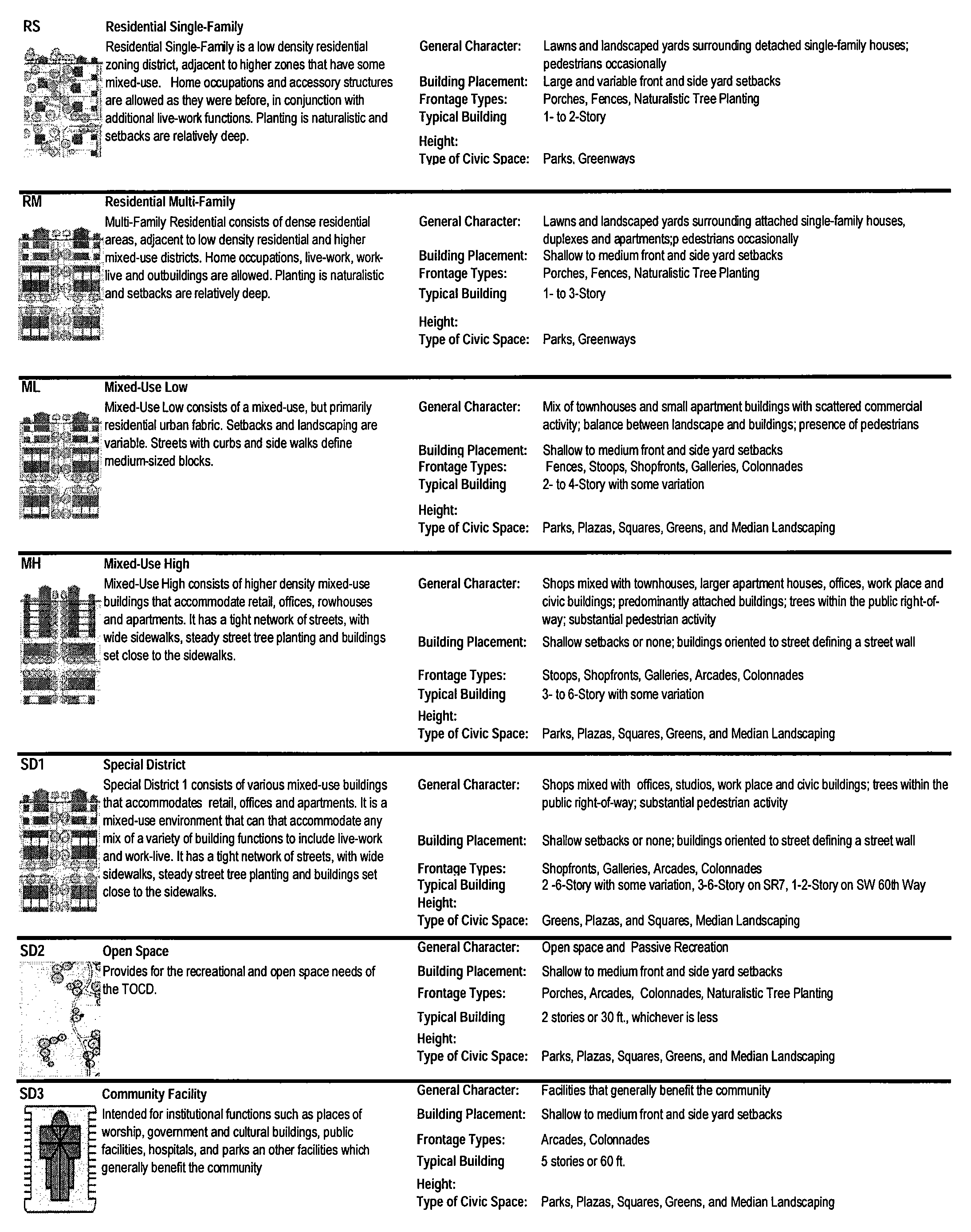
Table 1. TOCD Descriptions
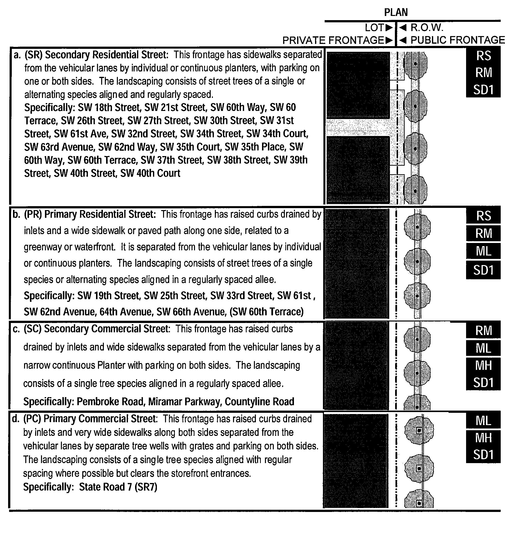
Table 2A. Public Frontages
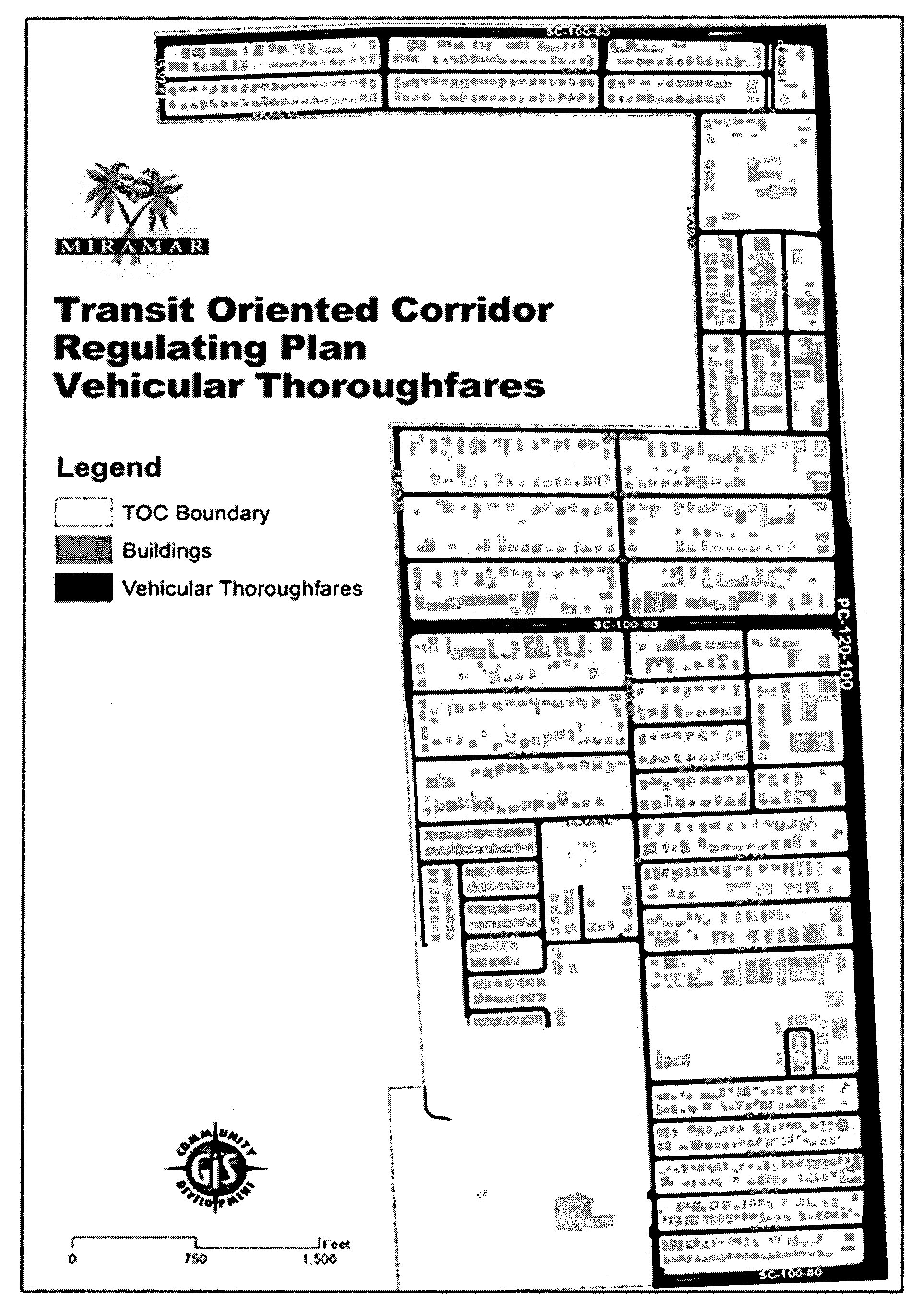
Table 2B. Vehicular Thoroughfares
Table 2C: Thoroughfare Assemblies. These thoroughfares are assembled from the elements that incorporate the public frontages of Table 2A. The key gives the thoroughfare type followed by the right-of-way width, followed by the pavement width, and in some instances followed by specialized transportation capability.
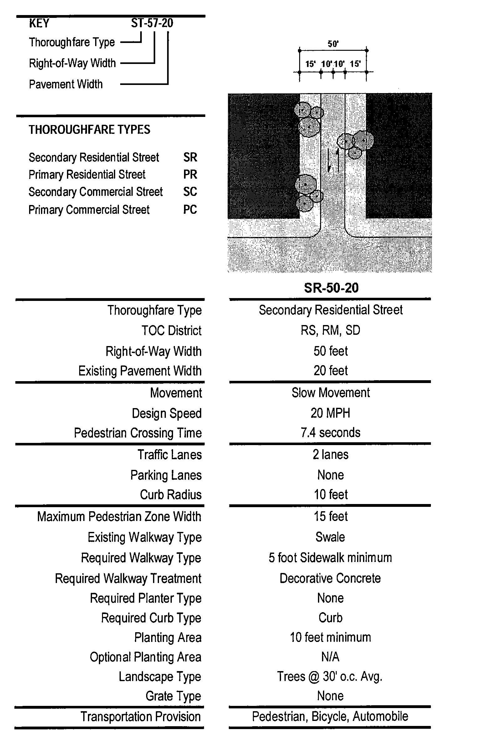
Table 2C. Thoroughfare Assemblies
Table 2D: Thoroughfare Assemblies. These thoroughfares are assembled from the elements that incorporate the public frontages of Table 2A. The key gives the thoroughfare type followed by the right-of-way width, followed by the pavement width, and in some instances followed by specialized transportation capability.
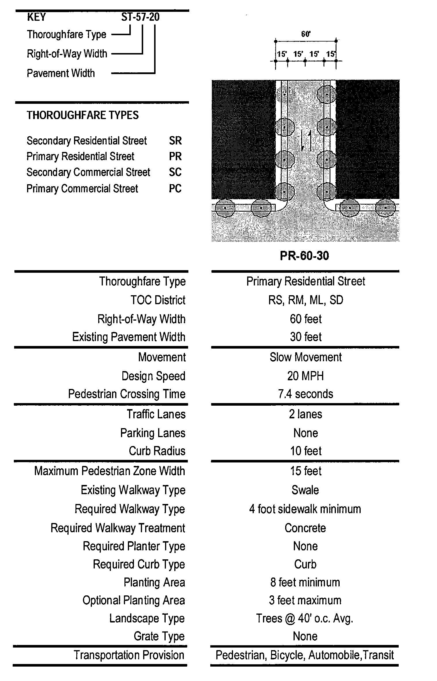
Table 2D. Thoroughfare Assemblies
Table 2E: Thoroughfare Assemblies. These thoroughfares are assembled from the elements that incorporate the public frontages of Table 2A. The key gives the Thoroughfare type followed by the right-of-way width, followed by the pavement width, and in some instances followed by specialized transportation capability.
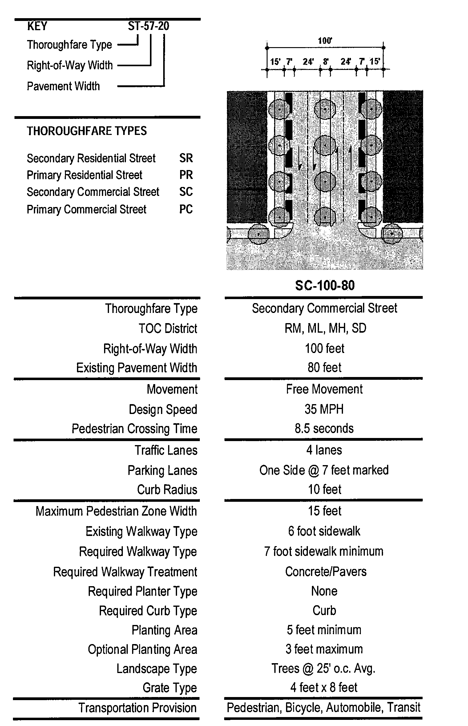
Table 2E: Thoroughfare Assemblies
Table 2F: Thoroughfare Assemblies. These thoroughfares are assembled from the elements that incorporate the public frontages of Table 2A. The key gives the Thoroughfare type followed by the right-of-way width, followed by the pavement width, and in some instances followed by specialized transportation capability.
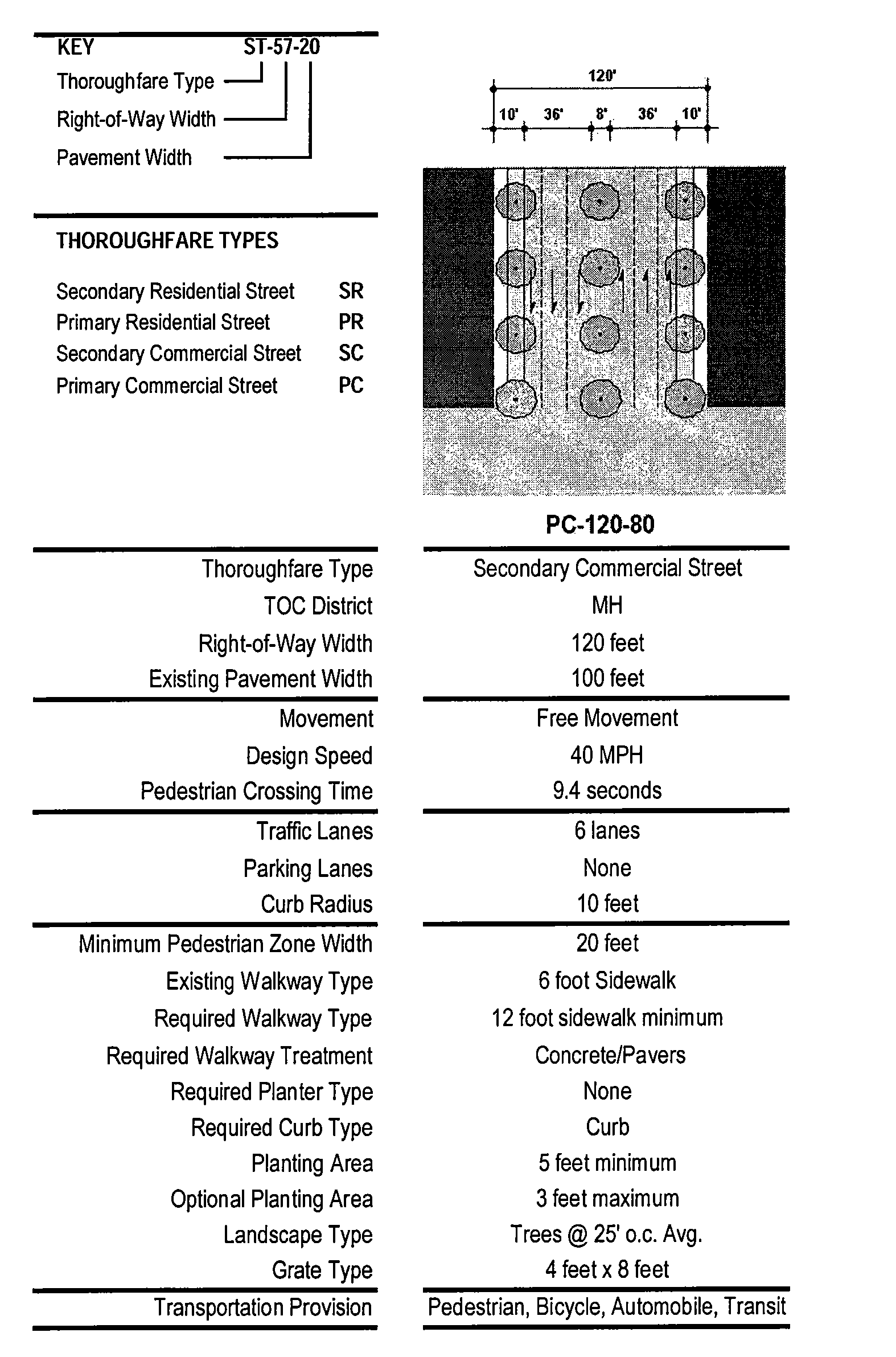
Table 2F: Thoroughfare Assemblies
Table 3: Public Lighting. Lighting varies in brightness and also in the character of the fixture according to the district. The table shows five common types.
| TABLE 3. PUBLIC LIGHTING | |||||
|---|---|---|---|---|---|
| RS | RM | ML | MH | SD1 | |
 | ■ | ■ | ■ | ■ | ■ |
 | ■ | ■ | ■ | ■ | ■ |
 | ■ | ■ | ■ | ■ | |
 | ■ | ■ | ■ | ■ | |
Table 4: Public Planting. This table shows six common types of street tree shapes and their appropriateness within each district.
| TABLE 4. PUBLIC PLANTING | ||||||
|---|---|---|---|---|---|---|
| RS | RM | ML | MH | SD1 | Specifications | |
 | ■ | ■ | ■ | ■ | ■ |
Canary Island Date Palm
Sabal Palm |
 | ■ | ■ | ■ | ■ | ■ |
Ironwood
Red Maple Beautyleaf Bald Cypress Pink Trumpet Tree |
 | ■ | ■ | ■ | ■ | ■ |
Powder Puff
Paradise Tree Pigeon Plum |
 | ■ | ■ | ■ | ■ |
Live Oak
Pygmy Date Palm Gumbo Limbo Dwarf Poinciana Cassia | |
Table 5: Building Disposition. This table approximates the location of the structure relative to the boundaries of each individual lot, establishing suitable basic building types for each district. This table shows six common types of street tree shapes and their appropriateness within each district.
| TABLE 5. BUILDING DISPOSITION | |
|---|---|
| a. Edgeyard: Specific Types—Single-family house, cottage, villa, estate house, urban villa. A building that occupies the center of its lot with setbacks on all sides. This is the least urban of types as the front yard sets it back from the frontage, while the side yards weaken the spatial definition of the public thoroughfare space. The front yard is intended to be visually continuous with the yards of adjacent buildings. The rear yard can be secured for privacy by fences and a well placed backbuilding and/or outbuilding. | 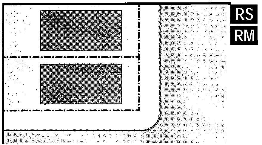 |
| b. Sideyard: Specific Types—Charleston single-house, double house, zero-lot-line house, twin. A building that occupies one side of the lot with the setback to the other side. A shallow frontage setback defines a more urban condition. If the adjacent building is similar with a blank side wall, the yard can be quite private. This type permits systematic climatic orientation in response to the sun or the breeze. If a sideyard house abuts a neighboring sideyard house, the type is known as a twin or double house. Energy costs, and sometimes noise, are reduced by sharing a party wall in this disposition. | 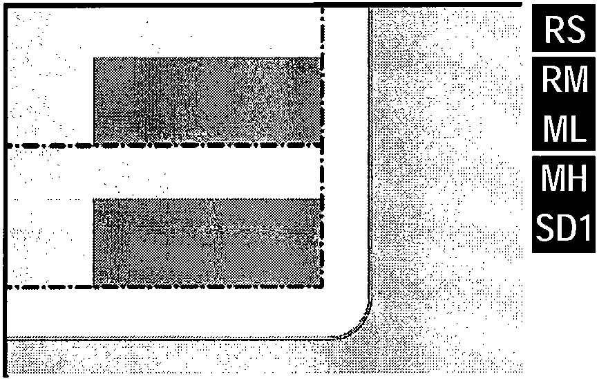 |
| c. Rearyard: Specific Types—Townhouse, rowhouse, live-work unit, loft building, apartment house, mixed use block, flex building, perimeter block. A building that occupies the full frontage, leaving the rear of the lot as the sole yard. This is a very urban type as the continuous facade steadily defines the public thoroughfare. The rear elevations may be articulated for functional purposes. In its residential form, this type is the rowhouse. For its commercial form, the rear yard can accommodate substantial parking. | 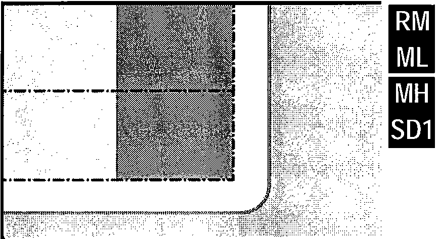 |
| d. Courtyard: Specific Types—Patio house. A building that occupies the boundaries of its Lot while internally defining one or more private patios. This is the most urban of types, as it is able to shield the private realm from all sides while strongly defining the public thoroughfare. Because of its ability to accommodate incompatible activities, masking them from all sides, it is recommended for workshops, loading and schools. The high security provided by the continuous enclosure is useful for crime-prone areas. |  |
| e. Specialized: A building that is not subject to categorization. Buildings dedicated to manufacturing and transportation are often distorted by the trajectories of machinery. Civic buildings, which may express the aspirations of institutions, may be included. |  |
Table 6. Building Placement and Character
TABLE 6A
Bulk Regulations for TOC-RS and TOC-RM Zoned Properties
TABLE 6B
Bulk Regulations for TOC-RS and TOC-RM Zoned Properties
Table 7: Private Frontages. The private frontage is the area between the building facades and the lot lines.
Table 7: Private Frontages.
| TABLE 10. CIVIC SPACE | |
|---|---|
| a. Park: A natural preserve available for unstructured recreation. A park may be independent of surrounding building Frontages. Its landscape shall consist of Paths and trails, meadows, water bodies, woodland and open shelters, all naturalistically disposed. Parks may be lineal, following the trajectories of natural corridors. The minimum size shall be 8 acres. | 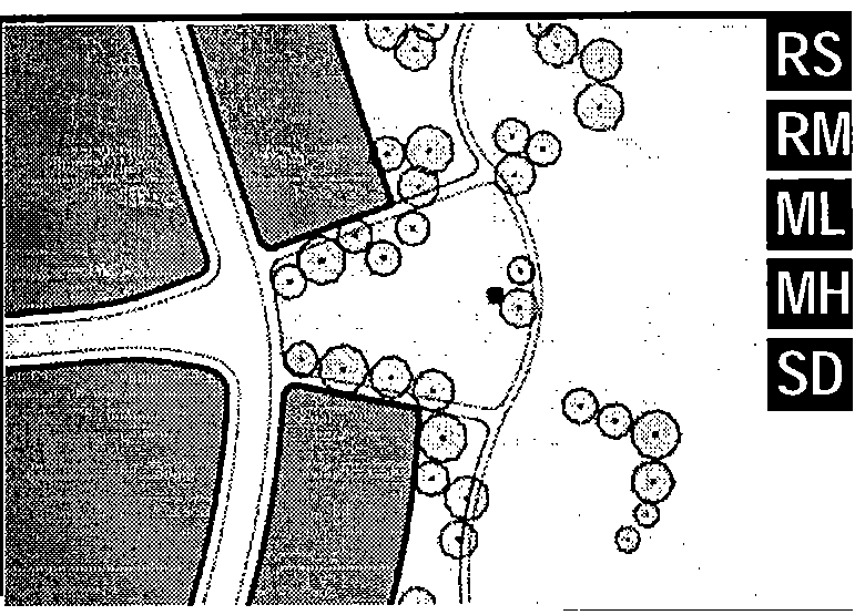 |
| b. Green: An Open Space, available for unstructured recreation. A Green may be spatially defined by landscaping rather than building Frontages. Its landscape shall consist of lawn and trees, naturalistically disposed. The minimum size shall be ½ acre and the maximum shall be 8 acres. | 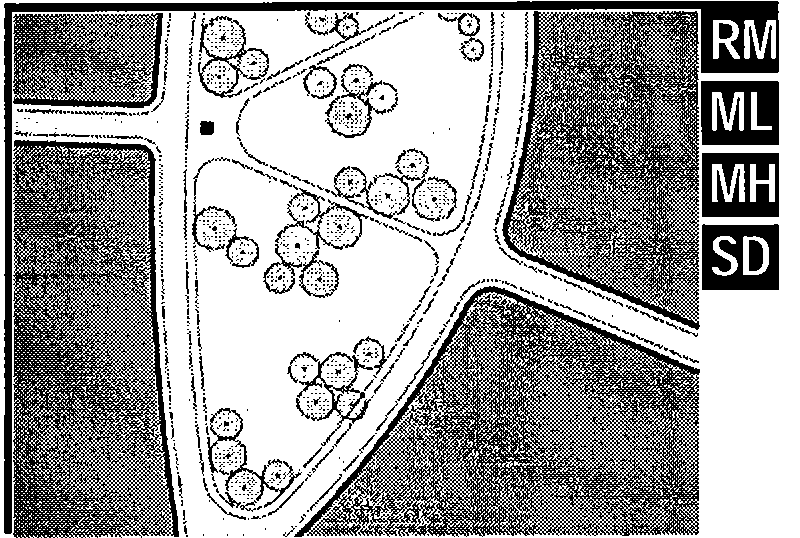 |
| c. Square: An Open Space available for unstructured recreation and Civic purposes. A Square is spatially defined by building Frontages. Its landscape shall consist of paths, lawns and trees, formally disposed. Squares shall be located at the intersection of important Thoroughfares. The minimum size shall be ½ acre and the maximum shall be 5 acres. | 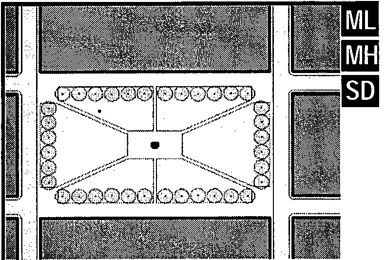 |
| d. Plaza: An Open Space available for Civic purposes and Commercial activities. A Plaza shall be spatially defined by building Frontages. Its landscape shall consist primarily of pavement. Trees are optional. Plazas should be located at the intersection of important streets. The minimum size shall be ½ acre and the maximum shall be 2 acres. | 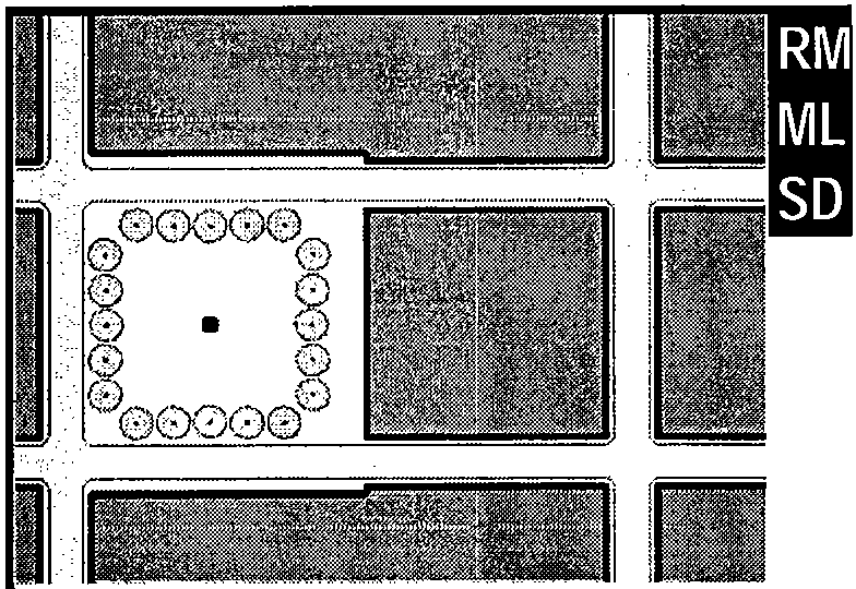 |
| e. Playground: An Open Space designed and equipped for the recreation of children. A Playground should be fenced and may include an open shelter. Playgrounds shall be interspersed within Residential areas and may be placed within a Block. Playgrounds may be included within parks and greens. There shall be no minimum or maximum size. | 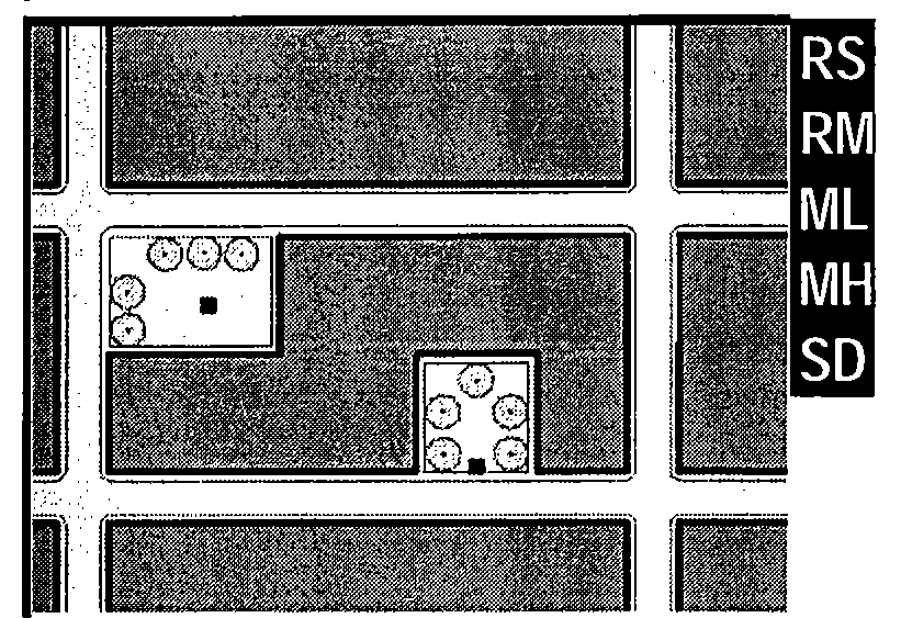 |
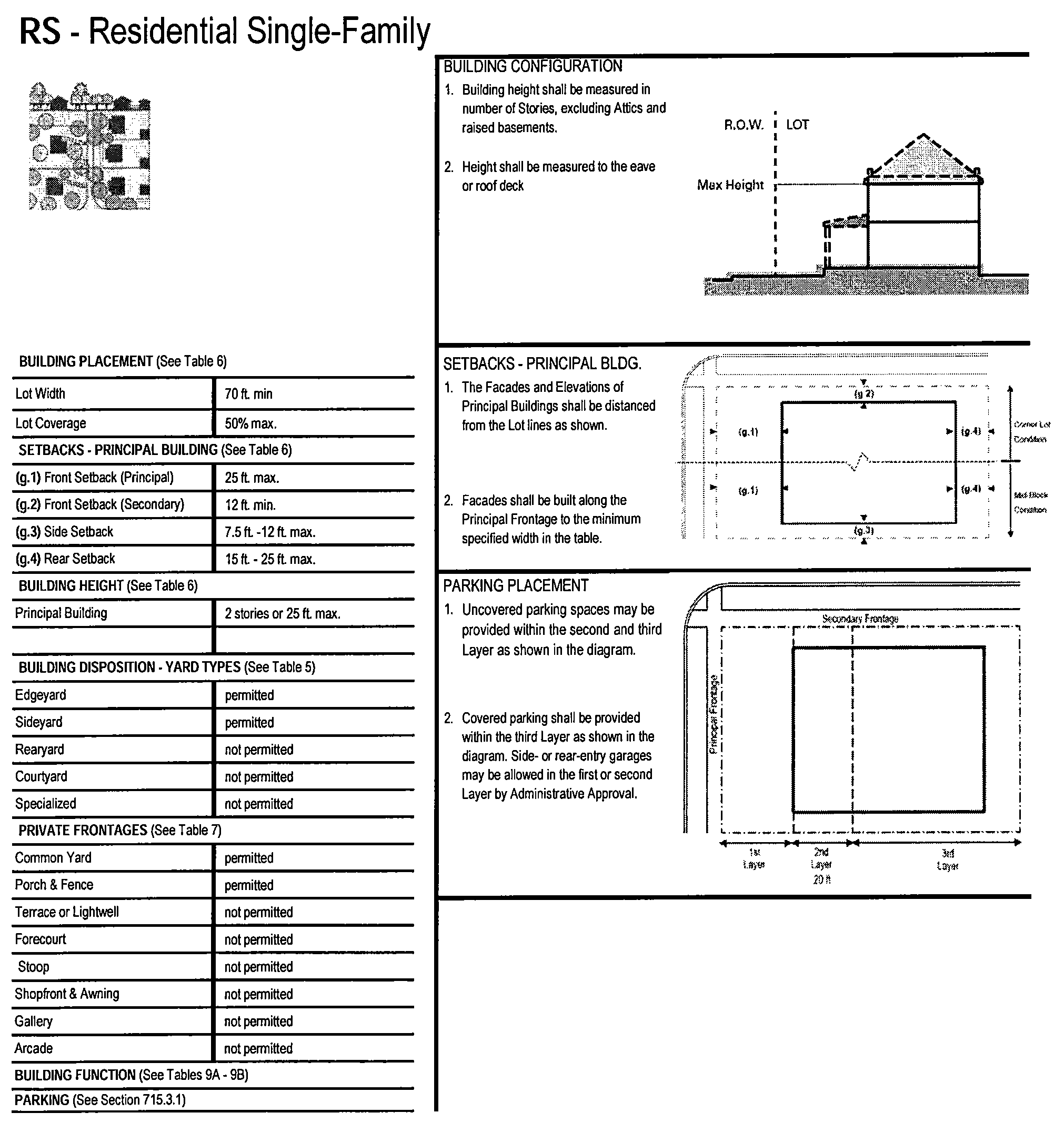
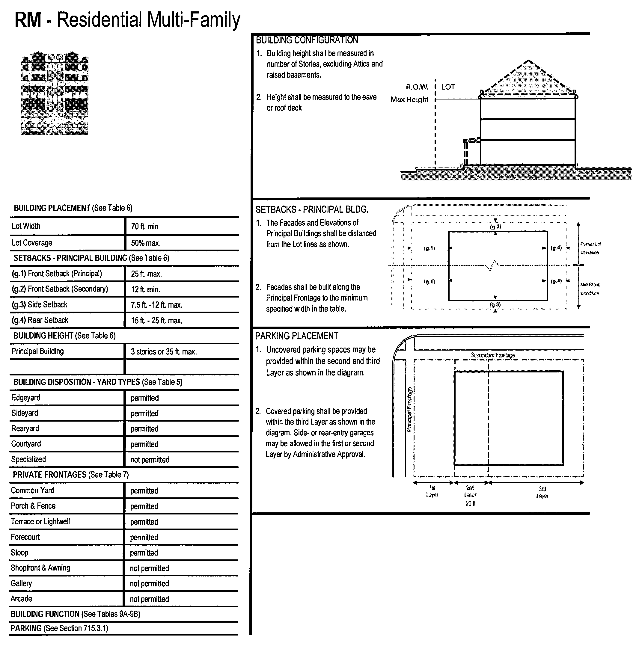
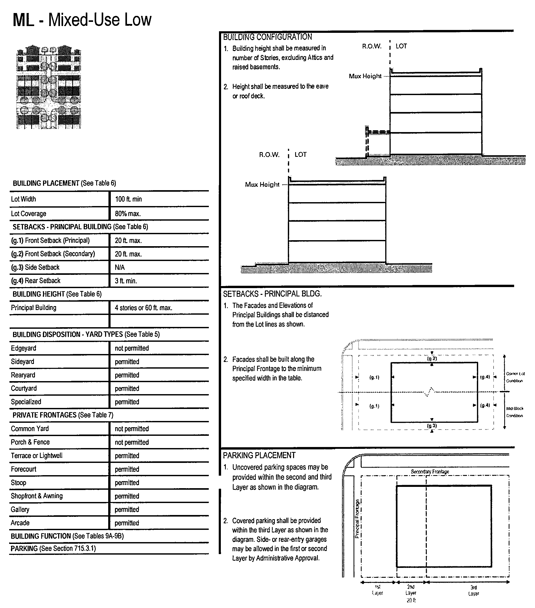
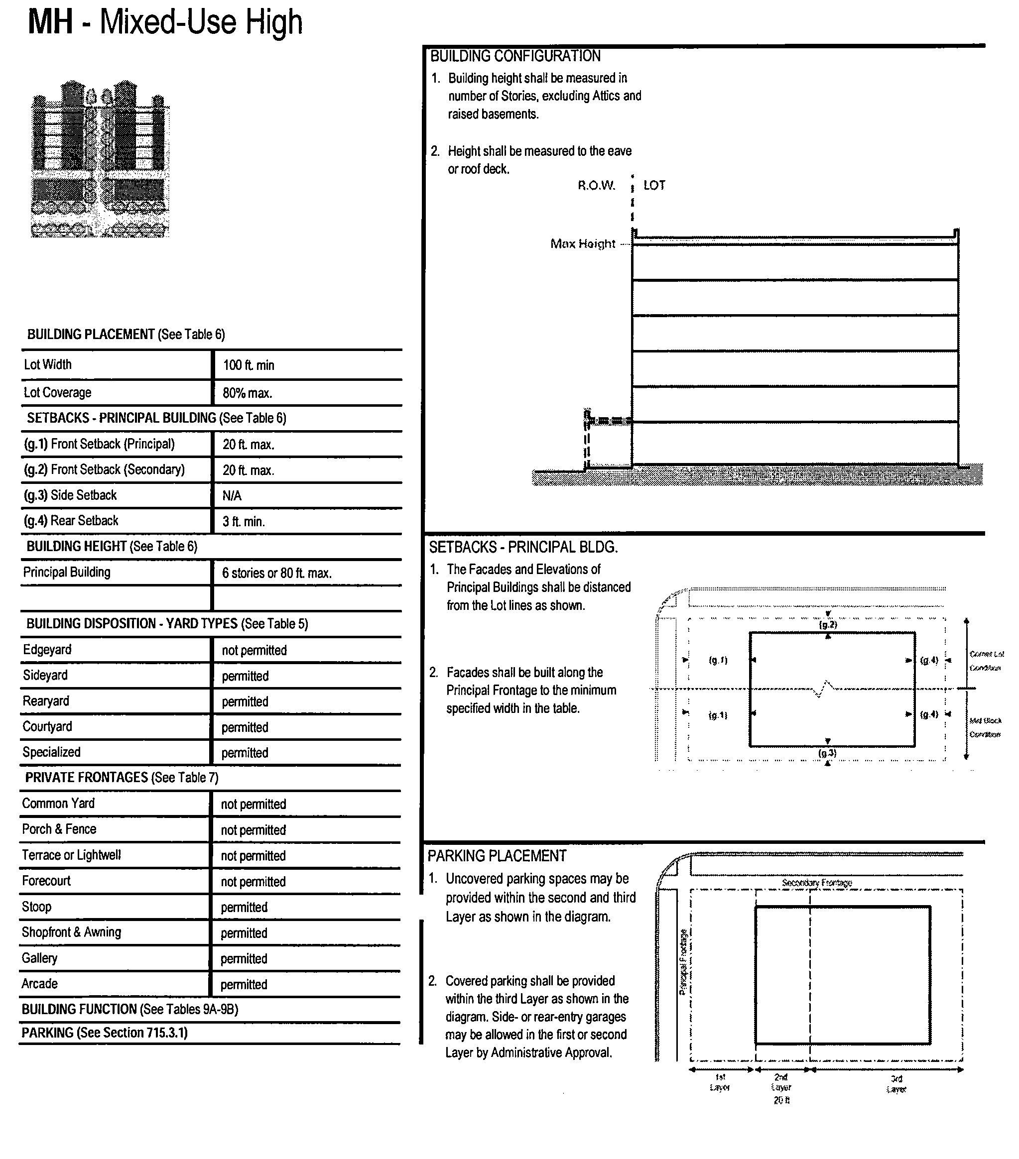
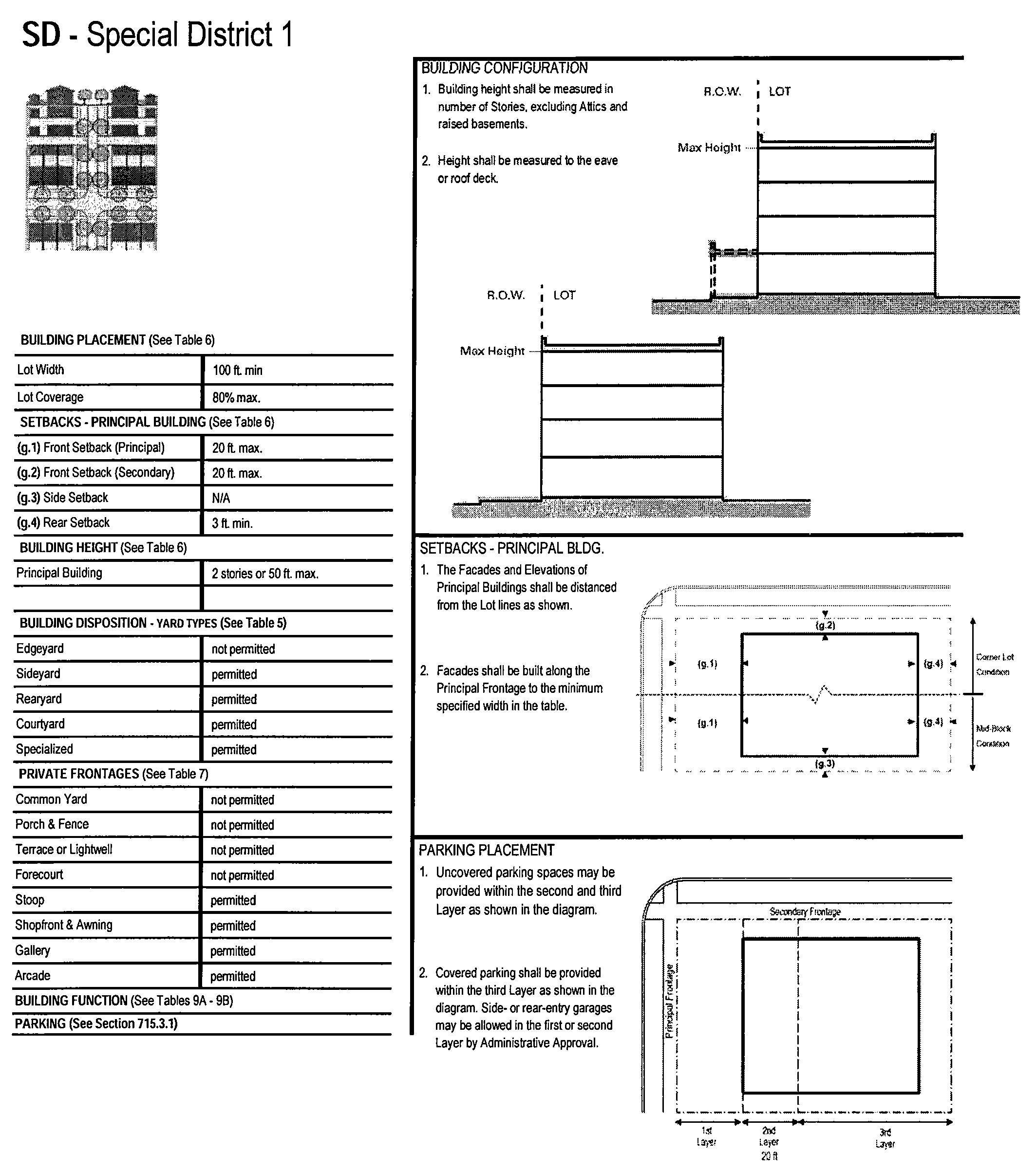
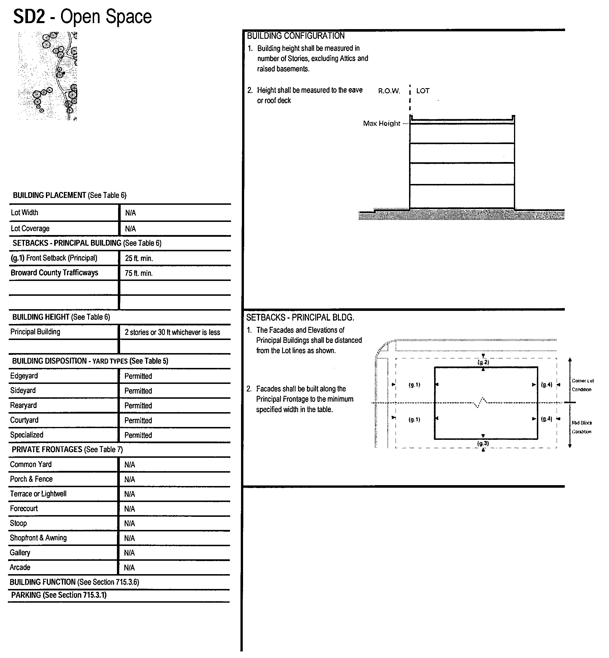
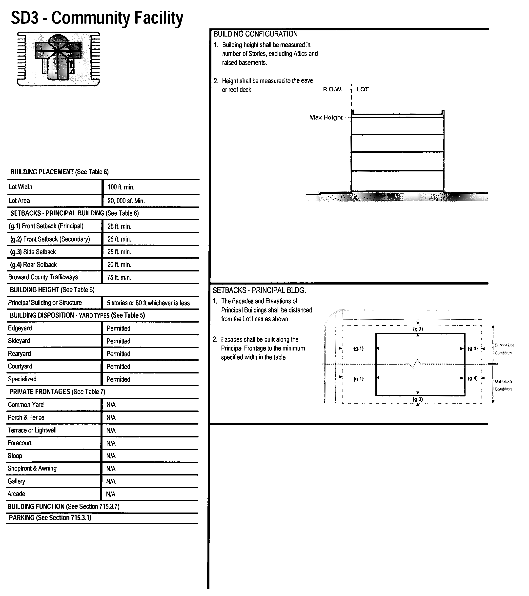
715.5.0. Reserved.
(Ord. No. 12-10, § 2(Exh. A), 3-21-12; Ord. No. 15-04, §§ 2, 3, 11-24-14; Ord. No. 15-10, § 4, 2-4-15; Ord. No. 16-05, § 7, 1-27-16; Ord. No. 18-01, § 2(Exh. D), 11-1-17; Ord. No. 20-01, § 2, 10-2-19; Ord. No. 20-09, § 3(Exh. A), 3-18-20; Ord. No. 20-13, § 5(Exh. D), 6-17-20)