
Mukwonago Town City Zoning Code
ARTICLE VI
ZONING DISTRICTS AND LAND USE
Sec. 36-651. - Legislative findings.
The town board makes the following legislative findings:
(1)
The use of land in the town has a direct bearing on the public health, safety, and welfare.
(2)
Standards are needed to ensure that new development is done in a coordinated manner.
(3)
The provisions contained in this article are adopted consistent with state statutes.
(4)
Each parcel of land in the town is intended to have a zoning designation.
(5)
In some instances, state and federal law limit the town's ability to regulate certain land uses.
(Ord. No. 2020-O-48, § 1(Exh. A), 9-16-2020)
Sec. 36-652. - Purpose.
This article promotes the public health, safety, and welfare and is intended to:
(1)
Promote a sound development pattern by separating the town into various districts where each has uniformly applicable development standards;
(2)
Separate incompatible land uses to the greatest extent possible;
(3)
Encourage the most appropriate use of land throughout the town;
(4)
Regulate and control the erection, construction, reconstruction, alteration, repair, and use of buildings, structures, and land;
(5)
Provide for a variety of housing options;
(6)
Allow different, but compatible land uses (i.e., mixed uses), to occur in specified areas of the town;
(7)
Avoid, or, as a less preferred alternate, minimize congestion;
(8)
Avoid, or, as a less preferred alternate, minimize environmental degradation; and
(9)
Preserve prime agricultural lands and stabilize the economic base of farming in the town as well as to allow for needed urban expansion.
(Ord. No. 2020-O-48, § 1(Exh. A), 9-16-2020)
Sec. 36-661. - Generally.
The town is divided into a number of base zoning districts so that each parcel of land is located in at least one district and potentially more than one district. For each of these districts, appropriate types of land uses are identified along with development standards when applicable.
(Ord. No. 2020-O-48, § 1(Exh. A), 9-16-2020)
Sec. 36-662. - Establishment and purpose of zoning districts.
(a)
Base zoning districts. Recognizing that different areas of the town serve unique functions, the town is divided into a number of zoning districts. Even though some of the districts may share similar characteristics, they possess one or more unique qualities that set them apart from the other districts. Although these districts may not now possess each of the attributes in these descriptions, it is intended that as land uses change over time they more closely reflect the intended uses. Uses are allowed in the various districts consistent with all applicable development standards in this chapter and any development limitations as described in section 36-741. The base zoning districts are listed below.
(1)
Special purpose districts.
a.
Public (P-1) district. This district is intended to accommodate publicly-owned facilities which serve a public use, such as education, recreation, medical care, or government.
b.
Conservancy (C-1) district. This district is intended to include environmentally sensitive lands. Given the various development constraints associated with these lands, development is restricted to land uses compatible with these constraints.
(2)
Agricultural districts.
a.
Agricultural (A-1) district. This district is intended to accommodate the needs of agriculture as a primary use and such residential uses as may be normal and necessary in an agricultural district. The primary purpose of this district is to preserve in agriculture use those lands generally suited for such use and which may have the ultimate potential for residential use but at this time are deemed beyond the current land needs for residential use. Residential development is limited to parcels being created by certified survey map per the town land division and development control ordinance, or by a planned unit development or conservation design development conditional uses. When the agricultural use is terminated in an area not developed as described above, those lands shall be rezoned to a different zoning classification that is consistent with the town's adopted comprehensive plan in accordance with the amendment process described in this chapter.
(3)
Residential districts.
a.
Rural home (RH) district. This district is intended to accommodate primarily single-family residences on scattered lots to foster and maintain the rural character and lifestyle of the surrounding area. The dimensional standards of this district require the largest lot size of all of the residential zoning districts.
b.
Suburban estate (SE) district. This district is intended to accommodate low-density lots primarily for single-family residences and other compatible uses. The district provides a "suburban" arrangement of amenities, services, and facilities on lots generally smaller than what is intended for the RH rural home district.
c.
Residential (R-1) district. This district is intended to accommodate medium-density lots primarily for single-family residences and other compatible uses. This district is intended to provide a "suburban" arrangement of amenities, services, and facilities on lots generally smaller than what is intended for the SE suburban estates district.
d.
Residential (R-2) district. The R-2 residential district is intended to accommodate high density lots primarily for single-family residences and other compatible uses. This district is intended to provide a "suburban" arrangement of amenities, services, and facilities on lots generally smaller than what is intended for the R-1 residential district.
(4)
Business districts.
a.
Local business (B-2) district. This district is intended to accommodate a single retail or service establishment or a small grouping of such establishments that primarily serve the needs of the surrounding community. Because this district is characteristically located in a residential area along a major roadway, these commercial uses need to be compatible in size, intensity, and scope with a residential area.
(b)
Overlay zoning districts. In addition to the base zoning districts enumerated in subsection (a) above, the following overlay zoning districts are established to account for unique conditions or requirements:
(1)
Environmental corridor (EC) district. This district includes those lands designated as environmental corridor by the Southeastern Wisconsin Regional Planning Commission (SEWRPC) in 2015 that are not otherwise part of a C-1 conservancy district. Specific provisions are included in article VIII.
(2)
Hydric soils (HS) district. The hydric soils (HS) district includes those lands that are mapped as having hydric soil conditions (i.e., depth to groundwater of one foot or less) according to the Soil Survey of Milwaukee and Waukesha Counties published by the USDA Soil Conservation Service (now known as the Natural Resources Conservation Service (NRCS)). Specific provisions are included in article VIII.
(3)
Sending parcel overlay district. Sending parcel overlay districts are a special type of zoning district that is used to limit development on those parcels where permissible residential density has been transferred from the sending parcel to a receiving parcel. Each district is unique and therefore has its own set of development standards and limitation as set forth herein. SPO districts are to be numbered sequentially (i.e., SPOD-01, SPOD-2, etc.)
(c)
Planned development district (PDD). Planned development districts are a special type of zoning district and are established consistent with the procedures and requirements in article V. Each district is unique and therefore has its own set of development standards that are documented in the general development plan, and associated development agreement, if any. PDD districts are to be numbered sequentially (i.e., PDD-01, PDD-02, etc.)
(Ord. No. 2020-O-48, § 1(Exh. A), 9-16-2020)
Note— The AP, EFO, R-3, B-1, B-3, M-1, and M-2 districts were removed as part of the 2019 rewrite of the zoning code. Additionally, the environmental corridor (EC) district and the exclusive agricultural conservancy (A-E) district were converted from base zoning districts to overlay districts.
Sec. 36-663. - Relationship between zoning districts.
If a parcel is located in one or more overlay districts, the regulations that apply to the underlying zoning district remain in effect, except as modified by the overlay district(s), and if there is any conflict between the overlay districts, the most restrictive shall control.
(Ord. No. 2020-O-48, § 1(Exh. A), 9-16-2020)
Sec. 36-664. - Necessity of zoning district designation.
It is the intent of this article that no land shall be without a zoning district designation, unless specifically noted on the zoning map. In the event a parcel of land is for any reason deemed to be without a designation, no land development shall occur until such time as the town board has assigned the parcel an appropriate zoning classification.
(Ord. No. 2020-O-48, § 1(Exh. A), 9-16-2020)
Sec. 36-665. - Effect of a boundary line relocation on zoning designation.
Pursuant to Wis. Stats. ch. 236, a lot line between adjoining parcels of land may be relocated in certain circumstances, potentially making one parcel larger and the other smaller. In those situations where the affected parcels are in different zoning districts, a lot line relocation does not alter the location of the zoning district boundary until such time as the zoning map has been amended to reflect the new lot line.
(Ord. No. 2020-O-48, § 1(Exh. A), 9-16-2020)
Sec. 36-666. - Zoning map.
(a)
Title. The map that depicts the location of the various zoning districts shall be titled "Town of Mukwonago Zoning Map—Waukesha County, Wisconsin."
(b)
Official zoning map. The town clerk shall maintain one paper copy of the zoning map as the official map which shall be signed by the town board chairperson and countersigned by the town clerk. If there is a discrepancy between this zoning map and other maps as may be made available, the map maintained by the town clerk shall control in all instances.
(c)
Availability. The zoning map maintained by the town clerk shall be available for public inspection upon request. The town clerk and zoning administrator may post the zoning map on the town's website and otherwise make and distribute copies in a manner deemed appropriate.
(d)
Preparation of a new official map. In the event the zoning map maintained by the town clerk is damaged, lost, or destroyed and after each amendment, the zoning administrator shall prepare a new zoning map and submit it to the town board chairperson and town clerk for signature.
(e)
History of amendment. The zoning map maintained by the town clerk may contain a descriptive history of recent amendments that have been made, indicating the ordinance number and date of action.
(f)
Archive of superseded maps. The town clerk shall maintain a permanent archive of superseded zoning maps that are created after January 1, 2020.
(g)
Amendment. The procedure and requirements to amend the zoning map are set forth in article V of this chapter.
(Ord. No. 2020-O-48, § 1(Exh. A), 9-16-2020; Ord. No. 2024-O-66, §§1—5, 4-3-2024)
Sec. 36-667. - Groundwater recharge areas.
The zoning map shall also depict the location of very high groundwater recharge areas, or portions thereof, in the town delineated on map 43 of the report entitled "Mukwonago River Watershed Protection Plan" produced by the Southeastern Wisconsin Regional Planning Commission (SEWRPC) as community assistance planning report no. 309. Such areas are not intended to constitute a zoning district but are mapped to show those areas that are subject to additional requirements.
(Ord. No. 2020-O-48, § 1(Exh. A), 9-16-2020)
Sec. 36-681. - Land uses generally allowed within zoning districts.
(a)
General purpose zoning districts. For the purposes of this chapter, land uses, as defined in appendix B, are classified as principal, accessory, or temporary. Appendix A lists principal land uses (series 1 to 12), accessory uses (series 13), and temporary uses (series 14). Each of the land uses are designated as one of the following in each of the base zoning districts:
(1)
"P" indicates that the use is permitted in the zoning district by right provided that all other provisions of this chapter are met.
(2)
"C" indicates that the use is allowed in the zoning district as a conditional use provided that all other provisions of this chapter are met.
(3)
"WT" indicates that the use is subject to the special review standards and procedures for wireless telecommunication facilities.
(4)
"TC" indicates that the use is subject to the special review standards and procedures for change in topography
(5)
"-" indicates that the use is not permitted in the zoning district.
Any commercial or industrial land use that is shown as permitted that emits air contaminants, fugitive dust, or potentially offensive odors outside of the building; incinerates any substance; or handles radioactive materials, hazardous substances, hazardous waste, or regulated substances is considered a conditional use.
(b)
Planned unit development districts. Land uses that are permitted in a planned unit development district are enumerated in the general development plan for the district, along with development standards, if any.
(c)
The aboveground storage capacity of materials that produce flammable or explosive vapors shall not exceed 500 gallons unless approved by the plan commission or is located within an agricultural district.
(Ord. No. 2020-O-48, § 1(Exh. A), 9-16-2020)
Sec. 36-682. - Similarity of land uses.
Because the list of land uses does not include every conceivable type of activity, those land uses that are listed shall be interpreted to include other land uses that are of a similar nature in terms of operational characteristics, effects on surrounding land, and intensity.
(Ord. No. 2020-O-48, § 1(Exh. A), 9-16-2020)
Sec. 36-683. - Land uses not listed.
A land use that is not listed, and which cannot be interpreted to be similar to any listed land use as provided in section 36-682 is prohibited. However, any person may submit a petition to allow a use that is not listed by amending the zoning code as set forth in article V.
(Ord. No. 2020-O-48, § 1(Exh. A), 9-16-2020)
Sec. 36-684. - Project classified in more than one land use category.
If a proposed project includes both an allowable land use and a prohibited land use, the prohibited portion of the project shall not occur in the zoning district.
(Ord. No. 2020-O-48, § 1(Exh. A), 9-16-2020)
Sec. 36-685. - Wind energy.
This chapter does not include any regulations relating to wind energy systems. The town may however, enact an ordinance to regulate wind energy systems pursuant to the procedures and requirements set forth in Wis. Stats. § 66.0401.
(Ord. No. 2020-O-48, § 1(Exh. A), 9-16-2020)
Sec. 36-686. - Special standards for residential land uses.
(a)
Residential parking. Parking of vehicles accessory to a residential use shall be limited to those actually used by the residents or for temporary parking for guests. Vans, motor homes, recreational vehicles, or pick-up trucks used for private and recreational use, or one similar vehicle used in a business for transportation to and from a place of employment, may be parked on a residential property as long as such use does not become a nuisance to the neighborhood.
(b)
Parking of trucks and equipment as an ancillary use to a residential use. No other vehicular equipment of a commercial or industrial nature, as excepted in subsection (a) of this section, shall be parked or stored for more than three consecutive hours and six accumulative hours during any 24-hour period on any lot in any zoning district, except business or industrial districts, or as follows:
(1)
Agricultural equipment, such as farm tractors, plows, seeders, combines, cultivators, and farm trucks, used in a farm operation and located within an agricultural district or the RH rural home district.
(2)
One panel, van, or pick-up truck used in the conduct of a conforming business activity being carried on in a residential or an agricultural district. The plan commission may approve a special exception, consistent with the procedures and requirements of article V, to allow more than one such vehicle if the need is evident. No limitation shall be placed on vans or pick-up trucks if they are used for private nonbusiness or noncommercial recreational purposes.
(3)
Vehicular equipment allowed under a conditional use permit as set forth in appendix A.
(c)
On-site storage of a recreational vehicle. One recreational vehicle may be stored outside of a building provided the following conditions are satisfied:
(1)
The overall length of the recreational vehicle including the towing tongue shall not exceed 35 feet.
(2)
The recreational vehicle shall be registered or licensed with the state.
(3)
The condition of the recreational vehicle does not constitute a nuisance as determined by the plan commission.
(d)
Use of a recreational vehicle for occupancy. No recreational vehicle shall be used for the purpose of human habitation (human habitation being defined as entering a recreational vehicle for any purpose other than maintenance), except that the town board may allow such habitation for one continuous six-month period while the construction of a principal structure owned by the same person who is the applicant for the permit provided the waste disposal facilities and water supply facilities for the property upon which the recreational vehicle is to be located have been approved by the county health department.
(Ord. No. 2020-O-48, § 1(Exh. A), 9-16-2020)
Sec. 36-687. - Special standards for accessory land uses.
(a)
Generally. No accessory building shall be constructed until the principal building is completed or is being constructed.
(b)
General exemption for farm buildings. Upon petition, the plan commission may allow farm buildings on a parcel that is 35 acres or larger without the necessity of a residence (i.e., the principal use), provided the commission determines the land is being used for an agricultural pursuit and the farm buildings are directly related to that agricultural pursuit. The owner will provide for proper sanitation and maintenance of the structure.
If the plan commission grants approval, a deed restriction, in a form approved by the town attorney, shall be filed in the county register of deeds office, prior to issuance of a building permit for a farm building.
(c)
Exemption for a utility cabinet. For the purpose of this chapter, a utility cabinet may be established on a vacant lot prior to the establishment of a principal use.
(Ord. No. 2020-O-48, § 1(Exh. A), 9-16-2020)
Sec. 36-688. - Special provisions for community living arrangements.
(a)
Limitations. Under state law, a town may not limit the number of community living arrangements so long as the total capacity of such facilities does not exceed 25 or one percent of the town's population, whichever is greater. When that threshold is exceeded, the town board may prohibit additional community living arrangements from being located in the town. Additionally, when the capacity of community living arrangements in a ward reaches 25 or one percent of the population, whichever is greater, the town board may prohibit additional community living arrangements from being located in the ward. A foster home or a foster treatment home that is the primary domicile of a foster parent or foster treatment parent and that is licensed under Wis. Stats. § 48.62, and an adult family home certified under Wis. Stats. § 50.032(lm)(b), are exempt from this provision.
(b)
Periodic review of existing facilities. Not less than 11 months but not more than 13 months after the first licensure of an adult family home under Wis. Stats. § 50.033, or of a community living arrangement and every year thereafter, the town board may make a determination pursuant to Wis. Stats. § 62.23(7)(i)9, as to the effect of such facility on the health, safety, or welfare of residents of the municipality. If the town board determines such facility poses a threat to the health, safety, or welfare of the residents of the municipality, the town board may order such facility to cease operation or obtain a conditional use permit to continue operation. Such facility shall cease operation within 90 days after date of the order, or the date of final judicial review of the order, or the date of the denial of a conditional use permit, whichever is later. The fact that an individual with acquired immunodeficiency syndrome or a positive test for the presences of HIV, as defined in Wis. Stats. § 252.01(1M), antigen or nonantigenic products of HIV or an antibody to HIV resides in a community living arrangement with a capacity of eight or fewer persons may not be used under this subsection to assert or prove that the existence of the community living arrangement in the community poses a threat to the health, safety, or welfare of the residents of the town.
(Ord. No. 2020-O-48, § 1(Exh. A), 9-16-2020)
State Law reference— Wis. Stats. § 62.23(7)(i).
Sec. 36-689. - Special provisions for specified foster homes and treatment foster homes.
Foster homes which are owned, operated, or contracted for by the state or a county department are not subject to this article. All other foster homes and treatment foster homes shall comply with this article.
(Ord. No. 2020-O-48, § 1(Exh. A), 9-16-2020)
Sec. 36-690. - Map of conditional uses.
The zoning administrator is authorized to prepare a map showing those properties that have an active conditional use permit and to amend the same from time to time.
(Ord. No. 2020-O-48, § 1(Exh. A), 9-16-2020)
Sec. 36-701. - Legislative findings.
The town board makes the following legislative findings relating to reasonable accommodations for persons with disabilities:
(1)
The federal government has adopted various laws with respect to various rights afforded persons with disabilities.
(2)
Some of these laws, most notably the Fair Housing Act and the Americans with Disabilities Act, affect how local zoning rules and regulations are administered by municipalities.
(3)
Under the Fair Housing Act, reasonable accommodations must be made in some circumstances so that a person with a disability has an equal opportunity to use and enjoy a dwelling unit.
(4)
Under Title II of the Americans with Disabilities Act, reasonable accommodations must be made in some circumstances to avoid discrimination as provided in the act.
(5)
If a local municipality can demonstrate that a requested modification would fundamentally alter the nature of its service, program, or activity (such as zoning requirements) it is not required to grant the modification.
(Ord. No. 2020-O-48, § 1(Exh. A), 9-16-2020)
Sec. 36-702. - Reviewing authority.
(a)
Wheelchair ramps in setback and offset areas. The building inspector is authorized to approve the construction of wheelchair access ramps in setback and offset areas pursuant to sections 36-719 and 36-720, respectively. In consideration of the matter, the building inspector shall be the reviewing authority, and shall have the powers to apply the general requirements of this section. In consideration of any such request, the building inspector must determine whether granting the requested accommodation would fundamentally alter the nature of this zoning code and its requirements, and if the building inspector finds that it would not, then the accommodation must be granted subject to all terms and conditions of this division.
(b)
Other reasonable accommodations. All requests for reasonable accommodations, other than for wheelchair ramps, under the above-mentioned federal laws shall be accomplished through the variance process described in article V. The zoning board of appeals shall be the reviewing authority concerning such requests, and shall have the power to apply the general requirements of this section. In consideration of any such special exception request, the zoning board of appeals must determine whether granting the requested accommodation would fundamentally alter the nature of this chapter and its requirements, and if the zoning board of appeals finds that it would not, then the accommodation must be granted subject to all terms and conditions of this division.
(Ord. No. 2020-O-48, § 1(Exh. A), 9-16-2020)
Sec. 36-703. - General requirements.
(a)
Identification of disability. If a person's disability is not obvious or otherwise known, the reviewing authority may request information that:
(1)
Is necessary to verify that the person meets the federal government's definition of disability (i.e., has a physical or mental impairment that substantially limits one or more major life activity);
(2)
Describes the needed accommodation; and
(3)
Shows the relationship between the person's disability and the need for the requested accommodation.
(b)
Confidentiality of applicant information. In reviewing petitions for reasonable accommodations, the reviewing authority will attempt to balance the privacy rights and reasonable request of an applicant for confidentiality, with normal procedural requirements relating to public notice, public hearings, written decision documents that may include findings of fact and conclusions of law, and maintaining adequate records. Any document identifying the disability or medical condition of any specific person shall be treated as confidential and shall not be subject to disclosure by the town for any reason, including for compliance with Wisconsin's Open Records Law, unless ordered to do so by a court of competent jurisdiction and notice is given to the person who provided the document to the town. Specifically, any medical records regardless of source, including statements of medical providers, shall not be subject to disclosure. For any other type of document, such as an application or determination, the document may be subject to disclosure, but only after the nature or description of the person's disability or medical condition is redacted by the town's attorney. A statement regarding the town's handling of information subject to this provision should be included in the decision document.
(c)
Nature of approval. Any accommodation approved under this chapter is considered a personal accommodation for the individual applicant and does not run with the land.
(d)
Imposition of conditions. The reviewing authority may impose conditions of approval deemed necessary to uphold the overall intent of the zoning regulations. Typical conditions of approval include, but are not limited to, the following:
(1)
Periodic inspection of the property to verify compliance with this section and any conditions of approval;
(2)
Removal of the improvements, where removal would not constitute an unreasonable financial burden, when the need for which the accommodation was granted no longer exists;
(3)
Time limits and/or expiration of the approval if the need for which the accommodation was granted no longer exists;
(4)
Recordation of a deed restriction requiring removal of the accommodating feature once the need for it no longer exists;
(5)
Measures to reduce the impact on surrounding properties and uses;
(6)
Measures in consideration of the physical attributes of the property and structures; and
(7)
Other conditions necessary to protect the public health, safety, and welfare.
(e)
Written decision. The reviewing authority shall issue a written decision to document the findings made pursuant to this section, and any conditions imposed on any approval granted pursuant to this section.
(Ord. No. 2020-O-48, § 1(Exh. A), 9-16-2020)
Sec. 36-711. - Generally.
Lots, buildings, and other structures shall conform to the dimensional standards specified in appendix C and D, except as may be otherwise allowed in this chapter. The standards for lots, buildings, and other structures in a planned unit development district are enumerated in the general development plan for the zoning district.
(Ord. No. 2020-O-48, § 1(Exh. A), 9-16-2020)
Sec. 36-712. - Lot area.
(a)
Generally. The minimum size of lots shall comply with the standards specified in appendix C, except as allowed in section 36-732, or appendix D. In addition, certain land uses may have a higher minimum lot requirement than what is otherwise established for the various zoning districts.
(b)
Exemptions. A parcel created by a land division that is authorized by the town is exempt from the minimum lot size requirements if such parcel is to be dedicated to the public or used for stormwater facilities or other types of development-related infrastructure or common open space, including walking and recreation trails.
(c)
Measurement of lot area. Lot area is measured on the horizontal plane and shall not include the area between the front lot line and the base setback line so designated on the county's highway width map. If a parcel of land is located in the county's shoreland jurisdiction and the town's zoning jurisdiction, that portion in the county's shoreland jurisdiction is included in the measurement of lot area. The area of a parcel that is zoned conservancy (C-1) is included in the measurement of lot area. The area of a flag lot constituting the stem is not included in the measurement of lot area.
(d)
Change in lot, generally. No existing lot area shall be reduced by any means so as to create a lot of less than the required size or so that the existing offsets, setbacks, or lot area would be reduced below that required by the regulations for the zoning district in which such lot is located.
(e)
Change in lot with a conditional use. The property boundary lines of a lot containing a conditional use shall not be modified in any manner without the express authorization of the town board upon recommendation of the plan commission. If the town board determines that the proposed reconfiguration or change in lot area is substantive, the proposed change may only occur if the board grants a new approval with the proposed lot consistent with the review procedures and requirements for a conditional use in effect at the time.
(f)
Lot area in the context of land divisions. Minimum lot area requirements are one of many factors that affect how many lots could potentially be created through the land division process.
(Ord. No. 2020-O-48, § 1(Exh. A), 9-16-2020)
Sec. 36-713. - Lot configuration.
(a)
Generally. Lot lines shall be substantially at right angles or radial to street lines. Lot lines shall not cross municipal boundaries.
(b)
Depth and width. The depth to width ratio of a lot shall not exceed 2.5 to 1. The plan commission may approve a special exception, consistent with the procedures and requirements of article V, to exceed this standard to account for special circumstances provided all other requirements can be met. A special exception shall not be granted when doing so will allow an increase in the number of lots that could be created through the land division process.
(Ord. No. 2020-O-48, § 1(Exh. A), 9-16-2020)
Sec. 36-714. - Lot density.
(a)
Generally. The density of lots in a proposed land division shall comply with the standards specified in appendix C or D. If the zoning district does not specify a density standard, the maximum lot density will be presumed to be one lot per the minimum required lot size.
(b)
Calculation. The total number of lots to be created is divided by the total acreage of the parcel(s) to be divided, less any deductions specifically enumerated in this chapter. For example, in a district with a maximum density of one building lot per three acres, no more than ten lots would be allowed to be created from a parcel of 30 acres.
(Ord. No. 2020-O-48, § 1(Exh. A), 9-16-2020)
Sec. 36-715. - Lot width.
(a)
Generally. The width of a lot shall comply with the standards specified in appendix C, except as allowed in section 36-732, or appendix D.
(b)
Exemptions. A parcel created by a land division that is authorized by the town is exempt from the lot width requirements if such parcel is to be dedicated to the public or used for stormwater facilities and other types of development-related infrastructure or common open space including walking and recreation trails.
(c)
Measurement of lot width. Lot width is measured along an imaginary line generally parallel to the front lot line and at a point where one half of the minimum lot area is in front of such line.
(Ord. No. 2020-O-48, § 1(Exh. A), 9-16-2020)
Sec. 36-716. - Lot frontage.
(a)
Generally. A principal building shall not be permitted on a tract of land, which does not abut on a public street unless authorized by subsection (b) of this section. A lot shall only be considered to be abutting on a public street if:
(1)
The lot abuts a public street for at least 60 feet; and
(2)
Either of the following is true:
a.
The lot meets the minimum average width requirement of the zoning district in which it is located at the building setback line; or
b.
One-half the depth of the lot is at least the minimum average width of the zoning district in which it is located; and
(3)
Provided that a lot which has a narrow strip as part of the lot extending to the public street from the main part of the lot where the building could lawfully be placed, shall only be considered to be abutting on the public street if the narrow portion of the lot is as wide as the required minimum average width for the district in which it is located.
(b)
Exceptions. While the town will generally not permit the creation of flag lots, or the utilization of private streets or easements to access tracts of land, there are situations where the town may allow the creation of flag lots, and there are situations existing as of December 1, 1990, in the town that the town may treat as exceptions for the prohibition against the use of private streets and there are situations existing as of January 1, 2002, in the town, or in order to implement the town's park and open space plan or the county development plan park and open space element, may be treated by the town as exceptions from the prohibition against the use of easements or flag lots.
(1)
Flag lots. Subject to the approval of the plan commission and town board, a principal building may be permitted on a tract of land which does not abut a public street, if the tract of land abuts the public street by a narrow strip of land which is an ownership strip and a part of the lot as long as, at a minimum, all of the following requirements are satisfied:
a.
Provided such tract of land excluding the narrow portion of the same tract providing access to the public street conforms to the minimum lot area of the district in which it is located.
b.
Provided such tract of land which has a narrow strip of land is at least 33 feet wide where it abuts the public street and for its entire length.
c.
Provided such tract of land is recorded as a certified survey map or subdivision plat in accordance with chapter 34 of the Municipal Code.
d.
Provided such tract of land has or will have a paved or graveled driveway for a width of 12 feet from the road right-of-way to the area of the proposed residence and said driveway is in compliance with all applicable laws, including with regard to the grade requirements of the town building code, and it does not impact the natural flow of surface water, or if the narrow strip of land is to be used to access a parcel which is designated for public ownership or to be owned by a private conservation organization in order to implement the town's park and open space plan or the county development plan park and open space element.
e.
Provided such tract of land does not conflict with the plans for the future development of streets in the area or the official map for the town.
f.
In the case of the access provided to implement the town's park and open space plan or the county development plan park and open space element, the town may place certain restrictions so as to prohibit a conflict with adjacent neighborhoods.
g.
In order to determine if there is a conflict with plans or future development in the area, the applicant may be required by the plan commission to provide a neighborhood development plan showing street extensions and street patterns as they relate to topography, environmental features, drainage patterns, existing structures and parcels, and soils suitable for development for review by the plan commission. In no case, shall there be more than one residence allowed on such tract of land.
(2)
Private streets. In situations where there is as of December 1, 1990, an existing private street right-of-way of sufficient width as provided below and there are in existence separate recorded tracts of land already created fronting upon said private right-of-way, in that situation the town may permit the private right-of-way to become legal access for these existing separate recorded tracts of land to be served by said right-of-way on the following terms and conditions:
a.
The plan commission determines that the subject tract of land was a legal lot of record prior to December 1, 1990.
b.
The plan commission finds that it is in the best interest of the town to certify the tract of land as a legal parcel.
c.
The plan commission finds that the subject tract of land conforms to the minimum lot area, lot dimensions, lot width, lot sizes, building locations and building sizes of the district in which it is located.
d.
The plan commission finds that the subject tract of land has access by a permanent easement on said private street of at least 33 feet in width to a public street, or where more than one principal residence or lot is proposed, the easement for such access shall be at least 66 feet in width.
e.
The plan commission has determined that the property owner has placed a deed restriction on the property in a form as approved by the town attorney giving notice that access is by way of a private street or way. Said deed restriction must be legally recorded in the office of the county register of deeds.
f.
The plan commission has determined that the ownership of the private street is clearly determined, that the private street or way will be maintained, that a written property maintenance agreement in a form satisfactory to the plan commission is on file with the town, and that all property owners are advised as to their responsibilities for maintenance of the private street or way. Such agreement must be legally recorded in the office of the county register of deeds.
g.
The town board approves a certified survey map for the subject land, which is then recorded in the office of the county register of deeds, unless the land division was previously made by certified survey map or subdivision plat, which was approved by the town board pursuant to chapter 34 of the Municipal Code.
(3)
Easements. In situations where there is as of January 1, 2002, an existing easement of sufficient width as provided below and there is in existence a separate recorded tract of land served by such easement, or where a land division is to occur in order to implement the town's park and open space plan or the county development plan park and open space element, the town may permit the easement to become legal access for such tract of land to be served by said easement on the following terms and conditions:
a.
The plan commission determines that the subject tract of land existed prior to January 1, 2002, as a legally created parcel in accordance with the requirements of this chapter and chapter 34 of the Municipal Code in effect at the time it was created, and was a parcel having a separate tax key number prior to January 1, 2002, or is a parcel which is to be created in order to implement the town's park and open space plan or the county development plan park and open space element.
b.
The plan commission finds that it is in the best interest of the town to certify the tract of land as a legal parcel.
c.
The plan commission finds that the subject tract of land conforms to the minimum lot area, lot dimensions, lot width, lot sizes, building locations, and building sizes of the district in which it is located or implements the town's park and open space plan or the county development plan park and open space element.
d.
The plan commission finds that the subject tract of land has access by a permanent easement of at least 33 feet in width to a public street, or where more than one principal building or lot is proposed, the easement for such access shall be at least 66 feet in width or has adequate width in order to accommodate access to the public or for maintenance equipment on parcels which are created in order to implement the town's park and open space plan or the county development plan park and open space element.
e.
The plan commission determined that the property owner has placed a deed restriction on the property in a form as approved by the town attorney giving notice that access is by way of an easement. Said deed restriction must be legally recorded in the office of the county register of deeds.
f.
The plan commission has determined that ownership of the easement is clearly determined, that the easement will be maintained, that a written property maintenance agreement in a form satisfactory to the plan commission is on file with the town, and that all property owners are advised as to their responsibilities for maintenance of the easement. Said agreement must be legally recorded in the office of the county register of deeds.
g.
The town board approves a certified survey map for the subject land, which is then recorded in the office of the county register of deeds, unless the land division was previously made by certified survey map or subdivision plat, which was approved by the town board pursuant to chapter 34 of the Municipal Code.
(Ord. No. 2020-O-48, § 1(Exh. A), 9-16-2020)
Sec. 36-717. - Residential floor area.
A building intended in whole or part for residential purposes shall provide a minimum floor area as specified in appendix C or D. Such minimums are stated in terms of the minimum total floor area required for a building and that portion of the total which must be provided on the first floor level.
(Ord. No. 2020-O-48, § 1(Exh. A), 9-16-2020)
Sec. 36-718. - Floor area of attached garages.
(a)
Generally. The floor area of an attached residential garage shall comply with the standards in appendix C or D.
(b)
Exception. The plan commission may approve a special exception, consistent with the procedures and requirements of article V, to allow a greater floor area, provided:
(1)
The attached garage has no more than four side-by-side vehicles facing the right-of-way from which the dwelling unit has street access;
(2)
The attached garage is not used for any commercial or industrial purposes, except as otherwise allowed by the chapter;
(3)
The attached garage complies with all other requirements of this chapter; and
(4)
The grant is subject to an equivalent reduction in the total floor area of accessory buildings that are allowed on the lot.
In making their decision, the plan commission shall consider the following factors enumerated in article V and must make the following determinations:
(1)
The architecture of the oversized garage is compatible with the dwelling unit;
(2)
The oversized garage will not be adverse to the public health, safety or welfare;
(3)
The oversized garage will not be in conflict with the spirit or intent of this chapter; and
(4)
The oversized garage will not otherwise be detrimental to the town or the immediate neighborhood where the structure would be located.
The plan commission may impose such conditions it deems necessary including a requirement for screening and/or landscaping.
(c)
Deed restriction required with approval of special exception. If the plan commission approves a special exception under subsection (b) above, a deed restriction, in a form approved by the town attorney, shall be filed in the county register of deeds office, prior to issuance of the building permit indicating that a special exception has been granted and recording any conditions of approval, including the reduction in the permitted square footage of accessory buildings and a statement that the attached garage may only be used for personal use and cannot be used for any type of commercial or industrial purpose unless otherwise permitted by this chapter.
(Ord. No. 2020-O-48, § 1(Exh. A), 9-16-2020)
Sec. 36-719. - Floor area of detached accessory buildings.
(a)
Generally. The total floor area of detached accessory buildings, whether temporary or permanent, shall comply with the standards in appendix C or D. As stated in section 36-511, the floor area of rural accessory buildings is not included in this total.
(b)
Exception. The plan commission may approve a special exception, consistent with the procedures and requirements of article V, to allow a greater floor area, provided:
(1)
a.
The detached building has no more than four side-by-side vehicles facing the right-of-way from which the dwelling unit has street access;
b.
The detached building is not used for any commercial or industrial purposes, except as otherwise allowed by the chapter; and
c.
The detached building complies with all other requirements of this chapter.
(2)
In making their decision, the plan commission shall consider the factors enumerated in article V and must make the following determinations:
a.
The architecture of the accessory building is compatible with the dwelling unit;
b.
The accessory building will not be adverse to the public health, safety or welfare;
c.
The accessory building will not be in conflict with the spirit or intent of this chapter; and
d.
The accessory building will not otherwise be detrimental to the town or the immediate neighborhood where the structure would be located.
(3)
The plan commission may impose such conditions it deems necessary including a requirement for screening and/or landscaping.
(c)
Deed restriction required with approval of special exception. If the plan commission approves a special exception under subsection (b) above, a deed restriction, in a form approved by the town attorney, shall be filed in the Waukesha County register of deeds office, prior to issuance of the building permit indicating that a special exception has been granted and recording any conditions of approval, including a statement that the accessory building may only be used for personal use and cannot be used for any type of commercial or industrial purpose unless otherwise permitted by this chapter.
(Ord. No. 2020-O-48, § 1(Exh. A), 9-16-2020; Ord. No. 2021-O-55, § 9, 7-14-2021)
Sec. 36-720. - Building coverage.
The total footprint of all buildings on a lot shall comply with the standards in appendix C or D. For the purposes of this subsection, all buildings are included including accessory buildings. Decks and patios are specifically not included.
(Ord. No. 2020-O-48, § 1(Exh. A), 9-16-2020)
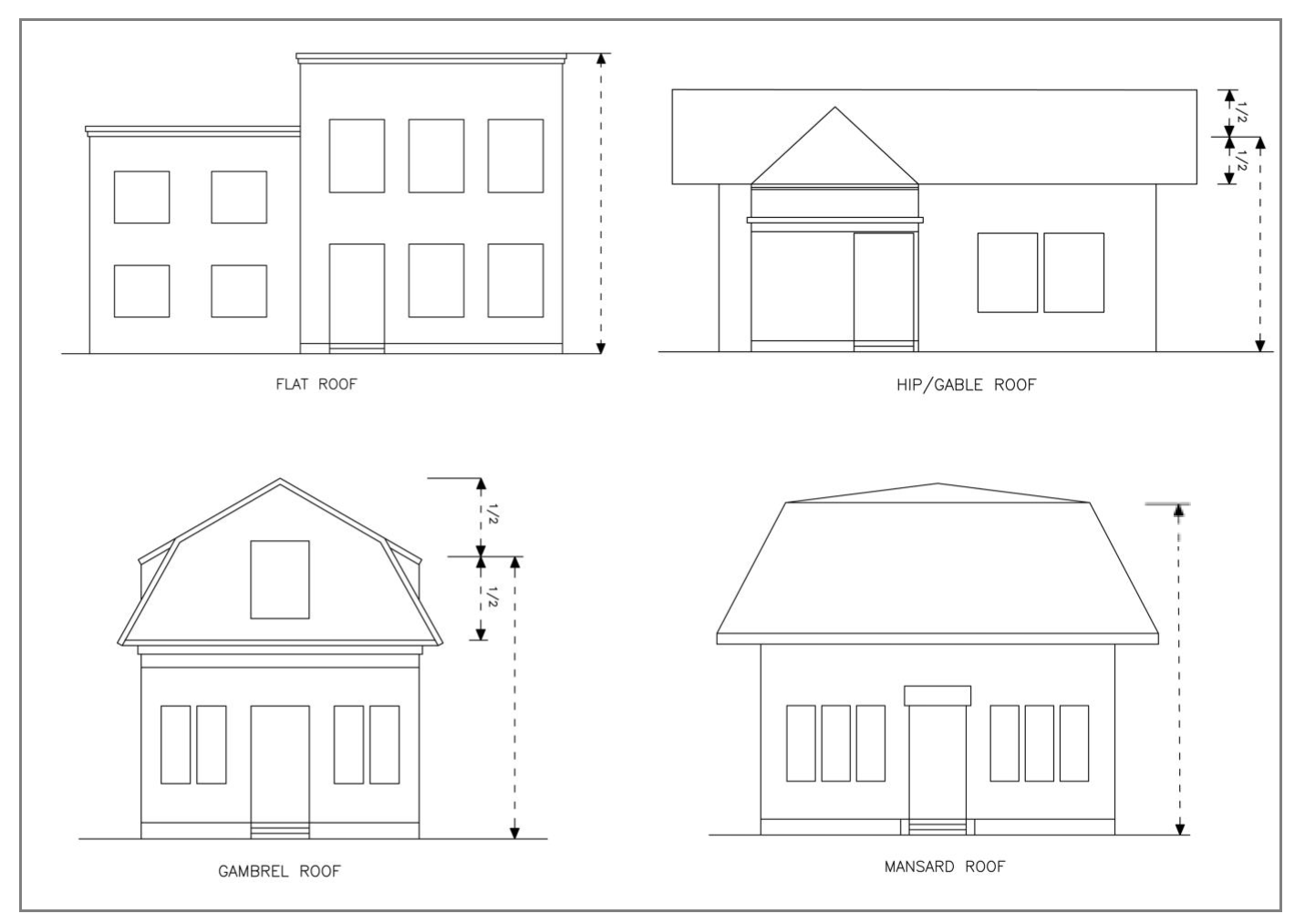
Sec. 36-721. - Building and structure height.
(a)
Generally. Except as specified in this section, the height of structures shall comply with the standards specified in appendix C or D. (See also section 36-742 regarding the establishment of building grades.)
(b)
Measurement of building height. The height of a building shall be measured from the lowest finished grade at the building line to:
(1)
The highest point of a flat roof;
(2)
The mean height of a gable, gambrel, hip, and pitch roof; or
(3)
The deck line of a mansard roof as generally depicted in exhibit 6-1.
When one or more dormers with side walls exceeds 50 percent of the lineal wall width immediately below the dormer(s), the dormer(s) is considered a second floor for purposes of measuring building height.
Exhibit 6-1. Measurement of Building Height by Roof Type
(Ord. No. 2020-O-48, § 1(Exh. A), 9-16-2020)
Sec. 36-722. - Setback requirements.
(a)
Establishment of base setback line. Base setback lines are established parallel to the center line of all streets and highways as follows:
(1)
On all streets or highways for which the ultimate width has been established by the county pursuant to Wis. Stats. § 66.1031, the base setback line shall be located at a distance from the centerline of the street equal to one-half of such established width.
(2)
On all other streets, which shall be designated as "local streets," the base setback line shall be 33 feet from the centerline of such street or 60 feet from the center point of a cul-de-sac unless specifically designated otherwise by action of the town board.
(3)
When a lot abuts a frontage road, the base setback line shall be located at a distance from the centerline equal to one-half the right-of-way width of such frontage road.
In all cases where any of the highways for which setback lines are established by this section are located on municipal boundaries, such establishment shall apply only within the unincorporated area.
(b)
Setback standards. No building shall be erected, altered, or placed so that any roofed or enclosed portion is closer to the base setback line than the setback distance specified in appendix C or D, except as allowed in this section.
(c)
Setback averaging. The following exceptions are applicable only where the setback requirements of the properties involved are identical:
(1)
Where the nearest existing building on one side of such building is within 500 feet and has less than the required setback, the average between such existing setback and the required setback shall apply.
(2)
Where the nearest buildings on both sides of such building are within 500 feet of such buildings but not closer than 300 feet to each other and have less than the required setback, the average of such existing setbacks and the required setback shall apply.
(3)
Where the nearest buildings on both sides of such building are within 300 feet of each other and have less than the required setback, the average between such existing setbacks shall apply.
(4)
In the case of a proposed addition to an existing building which has less than the required setback, such existing building may be considered the "nearest existing building" in order to apply the aforesaid exceptions in determining required setback for the proposed addition.
For the purpose of this subsection, the following rules shall apply when applying setback averaging:
(1)
Building projections which may extend into the setback area are not to be included.
(2)
Setback reductions as allowed by a variance shall not be included.
(d)
Use of setback areas. No other structures of any kind, except necessary highway and traffic signs, public utility lines, drainage structures, rural mailboxes and newspaper boxes shall be erected, altered, or placed within such base setback areas. Private retaining walls, guard posts, or other landscape structures shall not be permitted unless placed below the street centerline elevation. Mailboxes and newspaper boxes shall not be permitted on the circle portion of the cul-de-sac.
(e)
Work on existing structures. Additions to and replacements of existing structures may be made within the established setback areas, subject to approval of the plan commission and provided the owner will file, with the town an agreement in writing to the effect that the owner will remove all new construction, additions and replacements created after the adoption of the ordinance from which this section is derived at his or her expense, when necessary for the improvement of the highway.
(f)
Corner lots. On corner lots of record, as of the date of this chapter, the effect of the setback regulations shall not reduce the buildable width of such corner lot to less than 30 feet.
(Ord. No. 2020-O-48, § 1(Exh. A), 9-16-2020)
Sec. 36-723. - Offset requirements.
(a)
Purpose of offsets. Offsets are established to define a pattern of development in each of the zoning districts (in conjunction with other dimensional standards). The established setback standards provide for a varying degree of:
(1)
Privacy between neighbors;
(2)
Separation to mitigate noise and odor;
(3)
Space for light and air circulation;
(4)
Land for landscaping, recreational use, pleasure, and stormwater management;
(5)
Land for maintaining the exterior of buildings and other structures;
(6)
Room for the placement and maintenance of underground and above-ground utilities; and
(7)
Room for emergency vehicles between and around buildings and other structures.
(b)
Generally. No building shall be erected, structurally altered, or relocated so that any vertical wall, supporting a roofed or enclosed portion, and excluding a roof overhang measuring 24 inches or less, is closer to any lot line than the offset distance specified in appendix C or D.
(c)
Specific building types. In the case of business or manufacturing uses, no building shall be erected, structurally altered, or relocated so that any roofed or enclosed portion is closer to any lot line than the offset distance specified in appendix C or D, except as follows:
(1)
Two or more buildings on adjoining lots may be erected with common or directly adjoining walls provided the requirements of the state industrial code relative to such construction are complied with and provided that at both ends of such "row" type buildings the applicable offset requirements shall be complied with.
(2)
The required offset may be reduced on one side of a structure provided the offset on the other side is increased by an equivalent amount and provided the owners of any property adjoining the area of reduced offset shall file with the town a copy of a recorded deed restriction stipulating that no building shall be erected on said property so as to reduce the combined offset in such case to a distance less than that resulting from the normal application of the minimum offset requirements to both properties.
(d)
Use of offset areas. The following may be located in a required setback or offset, provided they do not extend into, or are located within, a utility easement or a required fire lane and meet all other requirements of this chapter:
(1)
Landscaping;
(2)
Retaining walls;
(3)
Fences;
(4)
Freestanding mailboxes and newspaper boxes;
(5)
Play equipment, except not in a front yard;
(6)
Small objects easily moved by hand such as birdbaths, birdfeeders, and birdhouses;
(7)
Portable grills, picnic tables, and yard furniture but not when located on a patio or deck;
(8)
Gardens;
(9)
Flag poles;
(10)
Compost bins;
(11)
Clotheslines;
(12)
Sidewalks, but not closer than five feet to a lot line of a parcel;
(13)
Driveways, but not closer than five feet to a side lot line;
(14)
Specified building projections as provided for in exhibit 6-2;
(15)
Components of a private on-site sewage system, including holding tanks (if allowed), leach fields, and septic tanks provided separation requirements in chapter 16 of the General Code of Waukesha County are met;
(16)
Wellheads not located in a building or other structure, provided separation requirements in state law are met;
(17)
Those structures and uses where applicable development standards included in appendix B either exempt the structure or use from setback requirements or establish alternate setbacks requirements; and
(18)
Other structures and land uses when exempted by the zoning administrator, provided such exemption is in keeping with the intent of this chapter.
Exhibit 6-2. Allowable Building Projections into a Required Setback or Offset
(Ord. No. 2020-O-48, § 1(Exh. A), 9-16-2020)
Sec. 36-724. - Open space.
(a)
No building shall be erected, structurally altered, or placed on a lot so as to reduce the useable open area of such lot to less than that specified by the regulations specified in appendix C, except as allowed in section 36-732, or appendix D.
(b)
To be considered useable, such open area shall be readily accessible and of a size and shape which can be reasonably considered to provide for the amenities and necessities of light, air, play space, drying yard, garden, etc. For the purpose of this requirement on residential lots, open space includes gardens, crops, pastures, woods, wetlands, patios, decks, swimming pools, sport courts, and similar features. Open space does not include buildings, driveways, and parking areas.
(c)
No part of the open space provided for any building shall be included as part of the open space required for another building; except as provided for planned unit developments.
(Ord. No. 2020-O-48, § 1(Exh. A), 9-16-2020)
Sec. 36-725. - Vision corner setbacks.
(a)
Establishment. Vision setback lines at the intersections of public streets and of a street with a railroad, where the grades are not separated, are established as follows:
(1)
Across each sector between the intersections of a street with a railroad, a vision setback line shall be established by a straight line connecting points on the base setback line and the railroad right-of-way line, which points are located 120 feet from the intersection of the base setback line and the railroad right-of-way.
(2)
Across each sector between intersecting streets, where one or more of which has a designated width of 100 feet or greater, a vision setback line shall be established by a straight line connecting two points on the intersecting base setback lines, which points are located 60 feet distant from the intersection of the base setback lines.
(3)
Across each sector between any other intersecting streets, a vision setback line shall be established by a straight line connecting two points on the intersecting base setback lines, which points are located 30 feet distant from the intersection of said base setback lines.
(b)
Permissible use. No structure of any kind shall be permitted in the vision setback area which exceeds a height of three feet above the elevation of the center of the intersection, except for necessary highway and traffic signs, public utility lines, and open fences through which there is clear vision, nor shall any plant material be permitted which obscures safe vision of the approaches to the intersection.
(Ord. No. 2020-O-48, § 1(Exh. A), 9-16-2020)
Sec. 36-726. - Separation from environmental corridor (EC) overlay district.
(a)
Generally. No land-altering activity, impervious surface, or buildings along with any attached structural improvement, such as stoops and porches, shall be closer than 50 feet to the boundary line of the environmental corridor (EC) district, except as provided for in this section.
(b)
Special exception. The plan commission may approve a special exception, consistent with the procedures and requirements of article V, to allow a lesser separation for buildings, but not less than 20 feet. In making such decision, the plan commission shall consider the following factors along with those enumerated in article V:
(1)
The size and configuration of the buildable area of the subject property taking into account all setback and offset requirements that may apply;
(2)
The size and location of existing structures and other improvements on the subject property;
(3)
The impact, if any, of the encroachment on the natural resources within the EC district at the location of the encroachment;
(4)
The extent and necessity of the encroachment;
(5)
The effect of the encroachment on the structural integrity of the building and any structural improvement and the intended use of the building and any structural improvement;
(6)
the impact, if any, that the encroachment may have upon neighboring properties; and
(7)
Any other factor the plan commission finds to be relevant in the interest of the public health, safety, and welfare.
The plan commission may not approve a special exception when the proposed building or building expansion does not otherwise comply with all other setback and offset requirements that may apply. The plan commission may impose conditions of approval it deems necessary to mitigate the impacts of the encroachment into the setback area. Upon approval, a deed restriction, in a form approved by the town attorney shall be filed in the office of the county register of deeds, prior to issuance of the building permit indicating that a special exception has been granted and recording any conditions of approval, if any.
(c)
Reasonable accommodations. The building inspector may, pursuant to division 4 of this article, allow the construction of an unenclosed wheelchair access ramp in the EC setback area for an existing building, provided:
(1)
The proposed location for the ramp is the only reasonable location based on the configuration of the existing building; and
(2)
The ramp encroaches into the setback area no more than is necessary to provide access to the existing building.
(Ord. No. 2020-O-48, § 1(Exh. A), 9-16-2020)
Sec. 36-727. - Separation from conservancy (C-1) district.
(a)
Generally. All buildings shall be a minimum of 75 feet from the C-1 conservancy district. Attached open decks shall maintain a minimum setback distance of 80 percent of the distance to the existing principal building or 60 feet, whichever is the shorter distance.
(b)
Reasonable accommodations. The building inspector may, pursuant to division 4 of this article, allow the construction of an unenclosed wheelchair access ramp in the C-1 setback area for an existing building, provided:
(1)
The proposed location for the ramp is the only reasonable location based on the configuration of the existing building; and
(2)
The ramp encroaches into the setback area no more than is necessary to provide access to the existing building.
(Ord. No. 2020-O-48, § 1(Exh. A), 9-16-2020)
Sec. 36-728. - Separation requirements for on-site sewage systems and water wells.
On-site sewage systems and water wells shall comply with all separation requirements as may be established by the county or the state.
(Ord. No. 2020-O-48, § 1(Exh. A), 9-16-2020)
Sec. 36-729. - Separation requirements for buildings.
No accessory building shall be erected, structurally altered, or relocated so that any roofed or enclosed portion thereof is closer than ten feet to the principal building on the lot, without a firewall.
(Ord. No. 2020-O-48, § 1(Exh. A), 9-16-2020)
Sec. 36-730. - Number of principal buildings on a parcel.
(a)
Generally. Every building hereafter erected, structurally altered, or relocated shall be located on a single lot. In no case, except in agricultural districts and planned unit development districts, and duplexes and multifamily buildings where allowed and subject to applicable lot density requirements, shall there be more than one principal building on a lot, except as provided in this section. The principal building shall be built first in all districts. In any district where a building other than a residence is considered principal, such construction shall be subject to the prior approval of the town board.
(b)
Distinction between one building and multiple buildings. In the administration of this section, a person may not claim that two or more buildings should be counted as one building by virtue of any of the following:
(1)
Connection by a breezeway of any length;
(2)
Connection by a deck;
(3)
Connection by a porch;
(4)
Any underground connection of any type;
(5)
Any connection that is not heated, ventilated, or air conditioned in the same manner of the main building;
(6)
Any connection that serves no significant purpose other than a walkway;
(7)
Any connection that is significantly smaller in dimension than the connected parts; or
(8)
Any connection that allows motor vehicles to drive through the connection.
The above distinction is intended to require each building to have a single, integrated configuration of enclosed space and to prohibit the appearance of multiple buildings in excess of established limitations.
(c)
Exception. The town board may approve the issuance of a new single-family residential home building permit, and allow the occupancy of an existing residential structure on a parcel, for a period of time not to exceed two years during the construction of the new residence subject to the following conditions:
(1)
Subject to the occupancy of the existing single-family residential building being made by the same person who will occupy the new single-family building for which the new residential home building permit is issued.
(2)
Subject to the applicant submitting to and receiving approval from the town board written proof that the waste disposal system for the property upon which the current residence exists conforms to the applicable sanitary ordinances of the county environmental health division or is otherwise allowed to be used by the county environmental health division.
(3)
Subject to the applicant submitting to the town board and receiving approval as to form from the town attorney and as to amount from the town engineer, a letter of credit or cash in the amount of 115 percent of the removal and restoration costs as determined by the town engineer, and also submitting to and receiving approval from the town attorney and the town engineer, an agreement which would allow the town to access the property and remove the existing structure at the applicant's expense if the new applicant fails to do so within 60 days of issuance of an occupancy permit for the new residence; upon either of the following occurrences:
a.
Prior to the issuance of a new residential home building permit for any lot on which an existing residential home is occupied, or
b.
Prior to occupancy of any existing residential home on any lot for which a new residential home building permit has been issued.
(4)
Subject to such additional conditions as the town board may require in the interest of the health, safety, and welfare of the town.
(d)
Additional standards. When this chapter allows more than one principal building on a lot, the plan commission or town board may:
(1)
Require a greater setback or offset than what is normally required for the zoning district in which it is located;
(2)
Require additional landscaping;
(3)
Establish a minimum separation between principal buildings; and
(4)
Impose any other condition necessary to account for concerns related to the purposes of this chapter as set forth in section 36-5 or in other sections of this chapter.
(Ord. No. 2020-O-48, § 1(Exh. A), 9-16-2020)
Sec. 36-731. - Number of accessory buildings on a parcel.
(a)
Generally. The number of accessory buildings on a parcel of land shall comply with the requirements set forth in appendix C or D. As stated in section 36-511, rural accessory buildings are not included in this total.
(b)
Distinction between one building and multiple buildings. In the administration of this subsection, a person may not claim that two or more buildings should be counted as one building by virtue of any of the following:
(1)
Connection by a breezeway of any length;
(2)
Connection by a deck;
(3)
Connection by a porch;
(4)
Any underground connection of any type;
(5)
Any connection that is not heated, ventilated, or air conditioned in the same manner of the main building;
(6)
Any connection that serves no significant purpose other than a walkway;
(7)
Any connection that is significantly smaller in dimension than the connected parts; or
(8)
Any connection that allows motor vehicles to drive through the connection.
The above distinction is intended to require each building to have a single, integrated configuration of enclosed space and to prohibit the appearance of multiple buildings in excess of established limitations.
(c)
Rural accessory buildings. Pursuant to the procedures and requirements in division 17 of article V, the town board may allow more accessory buildings than what is specified when one or more of the accessory buildings on a lot are designated as a rural accessory building.
(Ord. No. 2020-O-48, § 1(Exh. A), 9-16-2020)
Sec. 36-732. - Special provisions for lots with central water and/or wastewater systems.
(a)
Generally. In the case of any lot proposed to be served by a municipal or municipally-approved communal wastewater system or water system, and where such service would be provided prior to any occupancy of such lot, the town board may reduce the lot size, width, open space, floor area ratio and offset requirements applicable to such lot, upon recommendation of the plan commission following public hearing.
(b)
Public hearing. Notice of such hearing shall be given by official publication and by direct notice to owners of any contiguous property as listed on the previous tax roll, at least ten and not more than 30 days before such hearing.
(c)
Decision criteria. The plan commission in making its recommendation and the town board in making its decision shall give particular consideration to the following and shall make written findings of fact relative thereto:
(1)
The suitability of soil, terrain and water level conditions with regard to effective provision of individual sewage disposal or water supply, with careful consideration of economic and practical engineering aspects involved in the future probability or necessity of providing municipal sewerage or water service in the area.
(2)
The effect of any reduction in the lot size, width, open space, floor area ratio and offset requirements on the character and value of surrounding development.
(3)
The effect of any such reduction on the overall density pattern and the economic balance of land use in the community.
(4)
In the case of reductions involving two or more lots, different provisions may be established for individual lots to meet special circumstances and to carry out the intent of the considerations listed in this section. In no case, however, shall the lot size, width, open space, floor area ratio, and offset requirements be reduced by more than one-third.
(Ord. No. 2020-O-48, § 1(Exh. A), 9-16-2020)
Sec. 36-733. - Placement of detached accessory buildings on a lot.
Except as permitted in this section, a detached accessory building shall be located behind the front face (i.e., face of the building closest to the street) of the principal building (exhibit 6-3). In the case of a corner lot, the detached accessory building shall meet the minimum setback requirements from all streets. Only accessory buildings for agricultural uses are permitted in front of the principal building. Pursuant to the procedures and requirements in article V, the plan commission may approve a special exception to allow an accessory building in front of the principal building on a parcel that is 3 acres or larger. In making such decision, the plan commission and town board shall consider:
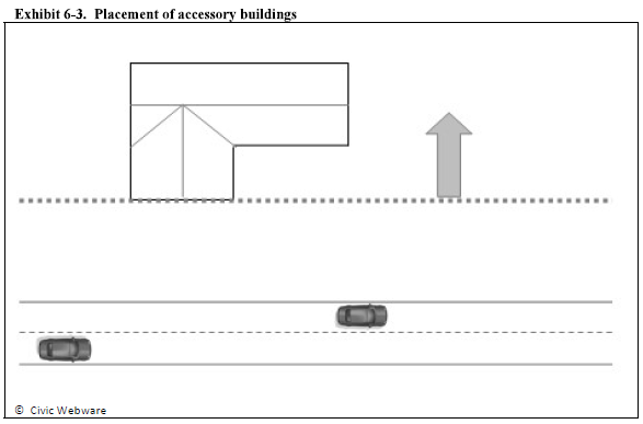
(1)
The size of the subject property;
(2)
The character of the area;
(3)
The size of the proposed accessory building;
(4)
The extent to which the proposed accessory building is visible from public and private streets and other properties in the area
(5)
The practical difficulty in placing the proposed accessory building in the location described in this subsection; and
(6)
Other factors related to relevant circumstances.
(Ord. No. 2020-O-48, § 1(Exh. A), 9-16-2020)
Sec. 36-741. - Site restrictions.
If the zoning administrator determines that a parcel of land, whether vacant, partially developed, or fully developed, contains one or more development constraints that would preclude the normal use of the parcel for a use that is otherwise permitted in the zoning district in which it is located, he or she shall render a written determination that states the best available facts related to the development constraint and other reasoning as may be appropriate. Examples of development constraints include unfavorable topography, rock formations, shallow depth to bedrock, unstable or otherwise unsuitable soils, stormwater runoff, inadequate drainage, high groundwater, or any other constraint that is harmful to the public health, safety, and welfare. Once such a determination has been made, the zoning administrator, building inspector, or other governmental official or body shall not issue a development order or other approval authorizing the development in the area subject to the development constraint. The property owner shall have the right to appeal such administrative decision consistent with the procedures and requirements in article V. The zoning administrator may reconsider his or her determination at any time and render a new determination if new or additional facts become known or if the facts upon which the determination was made are not accurate.
(Ord. No. 2020-O-48, § 1(Exh. A), 9-16-2020)
Sec. 36-742. - Establishment of building grades.
Every building hereafter erected, structurally altered, or relocated shall be at a grade approved by the town building inspector as being in satisfactory relationship with the established street grades, or with the existing street grade where none is established, with particular consideration for proper drainage and safe vehicular access.
(Ord. No. 2020-O-48, § 1(Exh. A), 9-16-2020)
Sec. 36-743. - Drainage.
(a)
Adequate drainage required. No principal building shall be erected on or moved onto land where the building is subject to periodic flooding or where the land is not adequately drained at all times, or where the first floor level is less than two feet above the highest anticipated floodwater level.
(b)
Obstruction to drainage prohibited. The damming, filling, relocating, or otherwise interfering with the natural flow of surface water along any surface water drainage channel or natural water course shall not be permitted except with approval of the plan commission and other agencies as may be required.
(c)
Building restricted adjacent to drainage channels or water courses. All buildings or structures shall comply with the county shoreland/floodland ordinance.
(Ord. No. 2020-O-48, § 1(Exh. A), 9-16-2020)
Sec. 36-744. - Groundwater separation.
No principal building shall be erected, structurally altered, or relocated on land where the distance between the lowest floor surface and the seasonal high-water table is less than one foot. To ensure compliance with the above standards, the procedures and requirements in "Basement Wetness and Flooding Prevention Standards" adopted by the county land resources division with a revision date of April 2016, and as amended, shall apply. In the administration of the procedures and requirements, the zoning administrator for the town shall serve the same role as the land resource division (LRD) and the town board of adjustment shall serve the same role as the county board of adjustment.
(Ord. No. 2020-O-48, § 1(Exh. A), 9-16-2020)
Sec. 36-745. - Sanitation and water supply.
(a)
Sanitation. No principal building shall be erected, structurally altered, or relocated unless it has been certified by the building inspector or plumbing inspector that it conforms to all town ordinances and other governmental laws or regulations then applicable to sewage disposal systems, and that satisfactory evidence has been submitted to show that suitable provisions for disposal of sewage is possible. A county septic system permit shall be required for all new private systems. Certification from the county health department verifying the soil's suitability to meet standards shall be furnished when a specific system is not being proposed. (Explanatory note: While every attempt has been made, through control of minimum lot size, building location, and plumbing standards to ensure that proper disposal of sewage will be provided on any lot, it is recognized that no such standard will completely ensure adequate disposal in every situation. This section has been written for the purpose of giving the community the authority to require whatever additional provisions are necessary to prevent a sanitary problem from developing in a situation where the normal requirement will not ensure proper sewage disposal.)
(b)
Water supply required. No occupancy permit shall be issued for a building used for a residential purpose unless provision is made for a safe and adequate supply of water, or connection is to be made to an approved municipal or community water system.
(Ord. No. 2020-O-48, § 1(Exh. A), 9-16-2020)
Sec. 36-746. - Erosion control and stormwater management.
All land-disturbing activities authorized by this chapter shall comply with the county construction site erosion control and stormwater management ordinance, as may be amended.
(Ord. No. 2020-O-48, § 1(Exh. A), 9-16-2020)
Sec. 36-747. - Traffic impact report.
(a)
When required. A traffic impact report is required for any land use that is classified as a conditional use and the anticipated number of trips in any given day of operation would exceed 250 trips or any commercial, industrial, or institutional use that would exceed 500 trips in any given day of operation. The town board, in its sole discretion, may require a traffic impact report when circumstances warrant such review and the number of trips is 80 percent or more of the above thresholds.
(b)
Submittal. When a traffic impact report is required and relates to a conditional use application, the report must be submitted with the conditional use application and the site plan application. When a report is required for a use not classified as a conditional use, the report must be submitted with the site plan application.
(c)
Qualifications of preparer. A traffic impact report must be prepared by a professional engineer with demonstrated expertise in transportation planning and/or design.
(d)
Trip generation rates. Trip generation rates for various land uses must be based on the manual titled "Trip Generation" (latest edition) published by the Institute of Transportation Engineers. Trip generation rates from other sources may be used if it can be shown to the satisfaction of the town engineer that the alternative source better reflects local conditions.
(e)
Form and content. A traffic impact report must be completed consistent with the most current revision of the traffic impact analysis guidelines published by the state department of transportation.
(Ord. No. 2020-O-48, § 1(Exh. A), 9-16-2020)
Sec. 36-761. - Compliance with building codes.
A building shall comply with all applicable building codes for the intended use.
(Ord. No. 2020-O-48, § 1(Exh. A), 9-16-2020)
Sec. 36-762. - Licensing with the town and county.
In addition to meeting the requirements contained in this article, all land uses shall also meet any requirements for licensing with the town and the county, which may now exist or may be adopted.
(Ord. No. 2020-O-48, § 1(Exh. A), 9-16-2020)
Sec. 36-763. - Licensing with state agencies.
If a land use or any related activity requires a license from the state, or its agent, to operate, such license shall be obtained prior to the establishment of such use and maintained for the life of the use or until the state, or its agent, no longer requires such license.
(Ord. No. 2020-O-48, § 1(Exh. A), 9-16-2020)
Sec. 36-764. - Driveways.
(a)
Generally. Every new residence shall have a driveway that connects the dwelling unit to a public or private street. The driveway shall comply with article IV of chapter 14 of the Municipal Code.
(b)
Number. No more than one driveway shall access onto a public road. The plan commission may approve a special exception, consistent with the procedures and requirements of article V, to allow a second driveway.
(Ord. No. 2020-O-48, § 1(Exh. A), 9-16-2020)
Sec. 36-771. - Applicability.
Those land uses specified in appendix A requiring site plan review shall provide a site plan for new construction and any modification of an existing site.
(Ord. No. 2020-O-48, § 1(Exh. A), 9-16-2020)
Sec. 36-772. - Site design principles.
(a)
Legislative findings. The town board makes the following legislative findings regarding site design requirements:
(1)
The design and layout of a site, including principal and accessory buildings, parking areas and access drives, building service areas, docking and loading areas, and other elements, can have a substantial and long-lasting effect on the utility of the subject property and on surrounding properties and the overall character of a community.
(2)
The requirements in this section are intended to provide meaningful guidance to applicants, design professionals, and public officials.
(3)
The requirements in this section are intended to promote the public health, safety, and welfare and are reasonably related to the public purpose of achieving an attractive, functional, and prosperous community.
(b)
Minimum requirements. Development subject to review under this division shall adhere to the following design principles along with other requirements that may apply:
(1)
A building shall be arranged on the site so as to not impede traffic accessibility and circulation to or from adjacent streets and adjoining sites.
(2)
The front of the building shall be generally parallel to the street or a public area, such as a courtyard, plaza, or the like.
(3)
Cross accesses shall be provided between adjoining commercial parcels whenever it is feasible to do so.
(4)
A docking or loading area or a service area for a commercial, institutional, or industrial building shall be easily accessible to service vehicles, separated from the on-site parking area, and designed to serve multiple establishments and tenants, when possible. Such docking or loading area shall not be readily visible from a public street, an on-site customer parking area, or an abutting property in a business or residential district or in an agricultural zoning district that is designated for future commercial or residential development in an adopted comprehensive plan. Screening from view may be accomplished by (i) integrating such area into the overall design of the building (e.g., inside of the building or use of architectural extension of a building wall) or (ii) using a fence; a berm; landscaping, above what is otherwise required in this chapter; other suitable feature; or any combination thereof.
(5)
Existing natural resources and topographic features on the site shall be preserved to the greatest extent possible while affording a reasonable use of the property.
(6)
The project shall not create any hazard.
(7)
The project shall be designed to avoid existing hazards, whether manmade or natural, and if avoidance is not possible, to mitigate the effects of the hazard to a satisfactory level necessary to protect the public health, safety, and welfare.
(8)
Parking areas and pedestrian accessways located on the site shall be designed to promote safety and efficient traffic flow.
(Ord. No. 2020-O-48, § 1(Exh. A), 9-16-2020)
Sec. 36-773. - Architectural standards.
(a)
Legislative findings. The town board makes the following legislative findings regarding architectural requirements:
(1)
The outward design appearance of a building can have a substantial and long-lasting effect on surrounding properties and the overall character of a community.
(2)
Buildings and especially those within a largely developed area should fit into the context in which they occur.
(3)
Architectural design standards should allow for a variety architectural styles and be flexible to the greatest extent possible.
(4)
The standards in this section are intended to provide meaningful guidance to applicants, design professionals, and public officials.
(5)
This section is not intended to limit or infringe upon reasonable accommodations to afford a person with disabilities equal opportunity to use and enjoy a building.
(6)
The standards in this section are intended to promote the public health, safety, and welfare and are reasonably related to the public purpose of achieving an attractive, functional, and prosperous community.
(b)
Minimum requirements. Buildings subject to review under this division shall adhere to the following architectural standards:
(1)
The scale of the building shall be compatible with the overall massing and the individual parts of adjacent buildings, especially existing and anticipated residential buildings in a residential zoning district or in an agricultural zoning district that is designated for future residential development in an adopted comprehensive plan.
(2)
Windows, doors, and other openings must form a unified composition in proportion to the building elevation.
(3)
On any new building constructed for business or manufacturing use, all building exteriors facing a street or approved way shall have 50 percent of the street face constructed with brick, decorative masonry, glass panel, or other appropriate similar finished façade as may be approved by the plan commission.
(4)
Except as provided in this subsection, the brick, masonry, glass, or other decorative facing used on the front of the building shall extend for a distance of at least 25 feet along the sides of the structure or at least 25 percent of the that side wall distance, whichever is greater. The plan commission may approve a special exception, consistent with the procedures and requirements of article V, to approve a lesser distance. In modifying this standard, the plan commission may consider the intended use of the building and require additional landscaping in-lieu of such exterior materials.
(5)
Principal buildings with a front elevation of more than 750 square feet in area shall be divided into distinct planes of 500 square feet or less. The following design features can be used to meet this provision:
a.
Canopies or awnings;
b.
Arcades;
c.
Porches;
d.
Vertical wall offsets having a minimum depth of eight inches and a minimum width of ten feet;
e.
Horizontal offsets having a minimum depth of two feet;
f.
Pilasters having a minimum depth of eight inches, a minimum width of 12 inches, and a minimum height of 80 percent of the wall height;
g.
Recessed areas for entryways and the like having a minimum depth of eight inches; and
h.
Other suitable multidimensional design features.
(6)
Oversized fenestration elements which tend to create a monumental scale shall not be used unless specifically required by the type of building or relationship to its surroundings.
(7)
Building entrances must be clearly recognizable from parking lots and pedestrian circulation routes.
(8)
No building regulated by this section shall be permitted where any exposed façade is not constructed or faced with a finished material that is aesthetically compatible with the other facades and presents an attractive appearance to the public and to surrounding properties.
(9)
Rooftop mechanical equipment shall be positioned so it is not readily visible from a public street or an abutting property in a residential zoning district. Rooftop mechanical equipment may be placed in an enclosure or screened from view provided such enclosure or screening is used as an element of the building's architecture.
(10)
Fencing shall complement the appearance of buildings onsite.
(11)
The exterior building materials of an accessory building shall be the same as or similar to those used on the principal building.
(12)
Overhead doors shall not face a public street. The plan commission may approve a special exception, consistent with the procedures and requirements of article V, to allow an overhead door to face a public street. In making such decision, the plan commission shall consider:
a.
Whether the overhead door is set back sufficiently from the public street to adequately limit the adverse visual impact of the overhead door;
b.
Whether the number of overhead doors that are proposed to face the public street, due to their number, would create an adverse visual impact;
c.
Whether the natural terrain and other existing features of the lot may affect the visual impact of the overhead door;
d.
Whether the overhead door will be appropriately screened with landscape berms or other landscaping; and
e.
Any other factor not listed but deemed appropriate.
(13)
HVAC (heating, ventilating, air conditioning) equipment shall be screened from view by landscaping or decorative screening materials that form an integral part of the design.
(14)
When trash, garbage, and recyclable materials are stored out-of-doors, such materials shall be stored in a container which is concealed or suitably screened from public view. A brick or stone wall, wood fence, chain-link fence with slats, and/or landscaping shall be used to totally obstruct vision into the storage areas. Any wall, fence and gate, and/or vegetative screening shall be installed or erected to a height at least one foot—six inches above the highest point of the dumpster as generally depicted below.
(Ord. No. 2020-O-48, § 1(Exh. A), 9-16-2020)
Sec. 36-774. - Outdoor storage areas.
(a)
Outdoor storage areas shall be located behind the front face of the building.
(b)
Outdoor storage areas adjoining residential districts shall be screened with a wall, a non-metallic fence, a berm, landscaping, or any combination, as approved by the plan commission.
(c)
Materials shall not exceed the height of required screening.
(d)
Outdoor storage areas shall consist of concrete, asphaltic concrete, gravel, or other material approved by the plan commission.
(e)
As part of the site plan/operation plan review process, the control of fugitive dust shall be addressed to the satisfaction of the reviewing authority.
(Ord. No. 2020-O-48, § 1(Exh. A), 9-16-2020)
Sec. 36-790. - Generally.
The performance standards in this division are established to promote the health, safety, and general welfare of the public by creating an objective and equitable basis to control potentially hazardous and nuisance-like effects of various land uses and to ensure that the community is adequately protected. These performance standards may have the effect of limiting, restricting, and prohibiting the ways in which otherwise permissible land uses may operate. In addition to these established standards, there may be other applicable local, state, and federal codes and standards that also apply.
(Ord. No. 2020-O-48, § 1(Exh. A), 9-16-2020)
Sec. 36-791 - Odors
(a)
Applicability. The odor control standards established in this section apply to all land uses and activities, except where the odor is created by food cooking; the construction of a principal use on the subject property; the application of fertilizers; or incidental traffic, parking, loading, or maintenance operations. Public utilities and services that are otherwise allowed under this code are essential public services and are therefore also exempt.
(b)
Standards. No odors shall be created for periods exceeding a total of 15 minutes per any day that are detectable (by a healthy observer such as the zoning administrator who is unaffected by background odors such as tobacco or food) at the boundary of the subject property, where such property is located in a residential, institutional, or business zoning district.
(Ord. No. 2020-O-48, § 1(Exh. A), 9-16-2020)
Sec. 36-792. - Air pollution.
(a)
Applicability. The air pollution standards established in this section apply to all land uses and activities, except where the air pollution is created during the construction of a principal use on the subject property, or by incidental traffic, parking, loading, or maintenance operations.
(b)
Standards.
(1)
The emission of particulate matter containing a particle diameter larger than 44 microns is prohibited.
(2)
Emission of smoke or particulate matter of a density equal to or greater than Number 2 on the Ringelmann Chart (U.S. Bureau of Mines) is prohibited at all times.
(3)
Dust and other types of air pollution borne by the wind from such sources as storage areas, yards, and roads within the boundaries of any lot shall be controlled by appropriate landscaping, paving, oiling, or other acceptable means as determined by the reviewing authority.
(Ord. No. 2020-O-48, § 1(Exh. A), 9-16-2020)
Sec. 36-793. - Fire and explosive hazards.
(a)
Applicability. The standards for fire and explosive hazards established in this section apply to all land uses and activities.
(b)
Standards.
(1)
Any use involving materials which could decompose by detonation shall be located not less than 400 feet from any residential or business zoning district, except that this standard shall not apply to the storage or usage of liquefied petroleum or natural gas for normal residential or business purposes.
(2)
Flammable and explosive materials at any point shall be provided with adequate safety and fire-fighting devices consistent with all fire prevention codes of the state.
(3)
All materials that range from active to intense burning shall be manufactured, utilized, processed, and stored only in completely enclosed buildings which have noncombustible exterior walls and an automatic fire extinguishing system.
(4)
The storage of fuels and other materials that produce flammable or explosive vapors shall be permitted only after review and approval by the town fire department and in accord with their requirements to minimize fire and explosive hazards.
(Ord. No. 2020-O-48, § 1(Exh. A), 9-16-2020)
Sec. 36-794. - Glare and heat.
(a)
Applicability. The standards for glare and heat established in this section apply to all land uses and activities, except where glare is created during the construction of a principal use on the subject property, or by incidental traffic, parking, loading, or maintenance operations.
(b)
Standards.
(1)
No direct or sky-reflected glare shall be visible at the lot line of the subject property, whether from floodlights or from temperature processes, such as combustion, welding, or otherwise.
(2)
As determined by the zoning administrator, there shall be no discernible transmission of heat or heated air at the lot line.
(Ord. No. 2020-O-48, § 1(Exh. A), 9-16-2020)
Sec. 36-795. - Water quality.
(a)
Applicability. The standards for water quality established in this section apply to all land uses and activities.
(b)
Standards.
(1)
No activity shall locate, store, or permit the discharge of any treated, untreated, or inadequately treated liquid, gaseous, or solid materials of such nature, quantity, obnoxiousness, toxicity or temperature that might runoff, seep, percolate, or wash into surface or subsurface waters so as to contaminate, pollute or harm such waters or cause nuisances such as objectionable shore deposits, floating or submerged debris, oil or scum, color, odor, taste or unsightliness, or be harmful to human, animal, plant, or aquatic life.
(2)
No activity shall withdraw water or discharge any liquid or solid materials so as to exceed or contribute toward exceeding the minimum standards and those other standards and the application of those standards set forth in Wis. Adm. Code NR 102 or in other applicable chapters which regulate water quality.
(Ord. No. 2020-O-48, § 1(Exh. A), 9-16-2020)
Sec. 36-796. - Noise.
No operation or activity shall transmit any noise beyond the boundaries of the property so that it becomes a nuisance.
(Ord. No. 2020-O-48, § 1(Exh. A), 9-16-2020)
Sec. 36-797. - Vibration.
(a)
Applicability. The requirements of this section apply to all uses and activities, except those vibrations created during the construction of the principal use on the subject property.
(b)
Requirements. No physical vibration emanating on a property that is above the vibration perception threshold of an individual shall pass beyond the property line of such property. Vibration perception threshold means the minimum ground- or structure-borne vibrational motion necessary to cause a reasonable person to be aware of the vibration by such direct means as, but not limited to, sensation by touch or visual observation of moving objects.
(Ord. No. 2020-O-48, § 1(Exh. A), 9-16-2020)