
Nashville City Zoning Code
CHAPTER 17
36 - OVERLAY DISTRICTS
17.36.010 - Purpose and intent.
Overlay districts are established by this title as a means of addressing specific aspects of land use control or development design that transcend conventional zoning district provisions. Included is an overlay district that permits greater design flexibility than otherwise permitted by the conventional standards of this code; overlay districts intended to protect the historic attributes of the community; an overlay to promote the development and operation of a comprehensive greenway system; a special overlay to protect the operational integrity and safety of the Nashville International Airport; an overlay district designed to regulate the location of adult entertainment establishments; a special urban design overlay; an institutional overlay to allow colleges and universities to grow in a sensitive and planned manner; and an urban zoning overlay district intended to preserve and protect existing development patterns that predate the mid-1950's and ensure the compatibility of new development.
(Ord. BL2000-364 § 1 (part), 2000; Ord. 96-555 § 9.1(A), 1997)
17.36.020 - Applicability.
An overlay district shall represent a mapped geographic area applied to the official zoning map according to the amendment procedures of Chapter 17.40, Article III. Overlay districts may be applied over any zoning district established by this title, and may encompass one or more of those districts. Unless expressly stated otherwise in this chapter, all lands encumbered by an overlay district shall conform to all other applicable provisions of this title.
(Ord. 96-555 § 9.1(B), 1997)
17.36.020A - Definitions.
The following definitions apply within Overlay Districts:
"Concrete masonry unit" means standardized building block composed of Portland cement, aggregates, and water. Commonly referred to as "CMU".
"Fiber cement products" means manufactured thin sections of hydraulic cementitious matrices and discrete nonasbestos fibers. These products may be commonly referred to by a trade or brand name: Hardie Board.
(Ord. BL2021-1022 § 1, 2022)
17.36.030 - Purpose and intent.
The planned unit development (PUD) district is an alternative zoning process that allows for the development of land in a well-planned and coordinated manner, providing opportunities for more efficient utilization of land than would otherwise be permitted by the conventional zoning provisions of this title. The PUD district may permit a greater mixing of land uses not easily accomplished by the application of conventional zoning district boundaries, or a framework for coordinating the development of land with the provision of an adequate roadway system or essential utilities and services. In return, the PUD district provisions require a high standard for the protection and preservation of environmentally sensitive lands, well-planned living, working and shopping environments, and an assurance of adequate and timely provision of essential utilities and streets.
(Ord. 96-555 § 9.2(A), 1997)
17.36.040 - General provisions.
A.
Applicability. A planned unit development (PUD) district may be applied over any zoning district established by Section 17.08.010 of this title.
B.
Unified Control Required. All land area proposed for inclusion in a planned unit development district shall be under unified control at the time of application and approval of a Master Development Plan. Upon establishment of the overlay district, the PUD district shall be recorded in accordance with Section 17.40.120(A)(6).
C.
Master Development Plan. The development concept of all land areas encompassed by a PUD district shall be adequately described by a master development plan comprised of scaled drawings and associated reports. At a minimum, the master development plan shall adequately describe:
1.
The overall boundary and area of the overlay district, including underlying zoning districts;
2.
The general location, orientation and size of principal structures and associated parking areas; development approaches to be employed to comply with Chapter 15.64, the "Ordinance for Storm Water Management;" landscape and buffer areas required by Chapter 17.24, the location, size and general treatment of environmentally sensitive areas as defined by Chapter 17.28; the general location and size of existing and proposed water mains and sewer trunk lines required to service the development; and general traffic routes (external and internal) to and from the development with major access points identified;
3.
Tabular data sufficient to demonstrate compliance with all applicable provisions of this title, including the range and scope of proposed land uses, proposed densities, floor area ratios or impervious surface ratios as applicable to development type; and land areas devoted to each type of general land use and phase of development;
4.
Full identification, description and supporting rationale for any proposed exception from the typical design standards of this title and the subdivision regulations as authorized by Section 17.36.060G;
5.
A proposed development schedule if the project is to be phased;
6.
A traffic impact study if required by Chapter 17.20; identification of any proposed improvements to existing streets, off-site utility systems or the drainage network considered necessary to support the proposed scope of development, with intended assignments of responsibility for providing those improvements; and
7.
A boundary plat prepared in accordance with accepted surveying practices describing the boundary of the proposed overlay district and all existing properties therein, complete with map and parcel numbers.
D.
Final Site Plan. All final site plans shall conform to the general development concept of an approved master development plan. A final site plan shall consist of a detailed set of construction plans that fully demonstrate compliance with all applicable provisions of this title and accurately represent the resulting form of construction. Applications shall include all necessary drawings, specifications, studies or reports as required by a submittal checklist adopted by the planning commission. An approved final site plan shall serve as the basis for issuance of zoning permits, certificates of compliance, and the subdivision of land.
E.
Professional Design. One or more of the following design professionals shall certify direct involvement in the preparation of a PUD master development plan. A final site plan shall be certified by a civil engineer.
1.
Architect;
2.
Civil engineer;
3.
Landscape architect;
4.
Urban planner.
(Ord. 96-555 § 9.2(B), 1997)
17.36.050 - Minimum performance standards.
In addition to satisfying all other applicable provisions of this title, approval of a proposed master development plan shall be based upon findings that the following design and development objectives have been satisfied.
A.
Protection of Environmentally Sensitive Areas. If encompassing environmentally sensitive areas as defined by Chapter 17.28, approval of a PUD master development plan shall be based upon a finding that the proposed development plan will result in greater protection and preservation of those areas than otherwise would result from development at the minimum protection standards of Chapter 17.28. Areas to be protected shall include undisturbed hillsides of twenty percent or greater slopes, nonmanipulated floodway and floodplain areas, problem soils, streams, creeks and major drains, designated wetlands, and areas containing protected Cedar Glade plant species.
B.
Adequate Streets, Utilities and Drainage. Approval of a PUD shall be based upon a finding that streets, utilities and drainage features will be of adequate capacity to serve the proposed development. As part of a master development plan proposal, a property owner may offer to upgrade or otherwise provide adequate facilities to support the proposed intensity of development. Public facilities already included in an adopted capital improvements budget may be considered a demonstration of adequate capacity if properly timed with anticipated construction of the development.
C.
Coordinated Vehicular Access. The approval of a master development plan shall be based on a finding that the vehicular access and internal circulation shall adequately support the operational needs of the development itself in a manner that maintains and protects the operational integrity of the community's major streets and highways to standards equal to or greater than otherwise required by Chapter 17.20. Further, the traffic circulation system for a master development plan shall be designed in a manner that directs commercial traffic away from residential streets.
D.
Integrity of Adjacent Areas. The approval of a proposed master development plan shall be based on a finding that the project is designed and will be developed in a manner that will not impair the reasonable long-term use of nearby properties in fulfillment of the land use policies of the general plan.
E.
Integrity of an Adopted Greenway Plan. Approval of a PUD master development plan that encompasses land area lying within the greenway overlay district shall be based upon a finding that the plan is designed in a manner that affords an opportunity for eventual implementation of the greenway plan. A master development plan shall take all reasonable measures to protect the visual and operational integrity of an existing or proposed greenway corridor by means of sensitive orientation and placement of improvements to the land, and the protection of mature vegetation and natural land forms. If development bonuses permitted by Section 17.36.090 are utilized, those areas of a master development plan lying within the greenway overlay district shall be dedicated for use as a component of the greenway network.
F.
Preservation of Historic and/or Archaeological Sites. All reasonable measures shall be taken to incorporate features of historical and/or archaeological significance into the design and development of a PUD master development plan in a manner that contributes to the protection and preservation of those features.
(Ord. 96-555 § 9.2(C), 1997)
17.36.060 - General development standards.
A.
Relationship to Other Requirements. Unless explicitly authorized otherwise by the approved master development plan under the authority of subsection G of this section, all requirements and standards established by other chapters of this title, as well as any other applicable metro, state or federal regulation, shall apply to the development and use of properties located within a PUD district. All development within a PUD district shall conform to Chapter 15.64, the "Ordinance for Storm Water Management" and the subdivision regulations. In case of conflict between the standards of this article and other chapters of this Zoning Code, the provisions of this article shall control.
B.
Permitted Land Uses. Land uses permitted within a PUD district shall be established by the underlying zoning district(s). Any land use classified as a "P" or "PC" by the district land use table (Section 17.08.030) shall be permitted within a corresponding PUD district. Special exception uses ("SE") may be permitted within a PUD district if approved initially as part of the master development plan by the metropolitan planning commission and council, or thereafter by the board of zoning appeals upon consideration of a recommendation by the planning commission.
C.
Land Use Allocation. The overall intensity or scope of any given land use permitted within a PUD district by an underlying zone district shall be established by applying the land area within that district classification to the applicable bulk standards of Tables 17.12.020A, 17.12.020B or 17.12.020C. Although the locational arrangement of land uses within a PUD district may vary from the conventional zoning boundaries underlying the overlay, the overall range or scope of any type of land use shall not exceed that permitted by the underlying district corresponding to that use except when utilizing the development bonus provisions offered by this chapter. In the case of residential development, the number of permitted dwelling units and structure type shall be established by the corresponding zoning district(s) within the PUD district.
D.
Residential Density. The maximum overall residential density of a master development plan shall be established by applying the minimum lot size requirements of Table 17.12.020A, the maximum density of Table 17.12.020B, or the maximum floor area ratio standard of Table 17.12.020C (as applicable) to the gross land area encompassed by the underlying zoning district(s) and by deducting fifteen percent of the gross land area for streets and dividing the remaining eighty-five percent of the gross land area by the minimum lot area of the actual zone district. Density shall be calculated on a pro-rata basis if the PUD district overlays more than one residential zoning district. A maximum density shall be assigned to each residential component of the master development plan and recorded by plat or equivalent instrument prior to commencing development of the first phase.
E.
Floor Area Ratio (FAR). The maximum overall floor area permitted within a PUD master development plan shall be established by applying the maximum floor area ratio standards of Tables 17.12.020B or 12.12.020C (as applicable) to the gross land area encompassed by the underlying zoning district(s), excluding the public rights-of-way of existing streets and alleys. When more than one zoning district exists within a PUD district, floor areas shall be calculated on a pro-rata basis. If land uses are redistributed across district boundaries, maximum floor areas shall be assigned to each component of the master development plan and recorded by plat or equivalent instrument prior to commencing development of the first phase.
F.
Impervious Surface Ratio (ISR). The overall area of impervious surface permitted within a master development plan shall not exceed that amount allocated to the gross land area of the underlying zoning district(s) as established by Tables 17.12.020B and 17.12.020C, exclusive of existing public street or alley rights-of-way. When a PUD district includes more than one underlying zoning district, the accumulative total of all impervious surfaces within a PUD master development plan shall not exceed the maximum impervious surface ratio(s) permitted by the underlying zoning district(s) on a pro-rata basis. If land uses are redistributed across district boundaries, the maximum permitted impervious surface ratio shall be established for each component of the master development plan and recorded by plat or equivalent instrument prior to commencing development of the first phase.
G.
Alternative Design Standards. In the approval of a PUD master development plan, the council may authorize the establishment of alternative design standards based on a finding that those standards would serve to enhance the general development concept of the PUD district, would equal or exceed the standard design objectives of this title, and would not impair the reasonable long-term use of other properties in fulfillment of the land use policies of the general plan. Alternate design standards may be approved in lieu of the following provisions of this title for those portions of a master development plan not situated along the perimeter of a PUD district:
1.
The setback and building height standards of Tables 17.12.020A, 17.12.020B or 17.12.020C;
2.
The street setback standards of Section 17.12.030; and
3.
The landscape buffer yard standards of Chapter 17.24.
H.
Common Open Space. Areas of common open space required by this chapter shall be fully described on the master development plan, any applicable final site plan, and a recorded plat of subdivision. Common open space shall be maintained according to the provisions of Section 17.40.120 of this title.
I.
Staged Development. Final site plan construction may occur in stages provided that a staging plan is reflected on the approved master development plan, each phase of development adheres to the applicable standards of this title independently, and streets and associated utilities are provided in a manner supportive of subsequent phases of development. If improvements to the existing street network or utility system are to be phased, an implementation schedule and funding program prorated to each contributing phase of development shall be prepared by the landowner for planning commission approval with the first phase of development.
(Ord. BL99-117 § 1 (part), 2000; Ord. 96-555 § 9.2(D), 1997)
17.36.070 - Residential standards.
A.
Clustering Single-Family and Two-Family Lots.
1.
Residential lots within a PUD district may be grouped to a greater extent than allowed by the conservation development provisions of Section 17.12.090 in return for extraordinary protection of environmentally sensitive areas in a natural state. With proper environmental protection, a PUD master development plan may recapture up to one hundred percent of the average density achievable by similarly zoned land with no environmental constraints. The actual achievable density for any given master development plan may be less depending upon the extent of environmentally sensitive areas to be protected and the minimum lot requirements established below.
2.
Recreational facilities.
a.
Any property owner or developer of a subdivision clustering single-family and two-family lots within a PUD district as provided in subsection A.1. of this section shall install and/or construct recreational facilities on a portion of the required undeveloped common open space. For purposes of this section, "recreation facilities" means active play facilities (including but not limited to tennis courts, basketball courts, swimming pools, playgrounds, baseball/softball diamonds or volleyball courts) and passive amenities (including but not limited to walking trails, picnic shelters or gazebos, shared docks, and similar passive recreation amenities). Proposed recreation facilities shall be defined on the Master Development Plan and shall be demonstrated appropriate to the intended demographics of the single-family and two-family portion of a PUD.
b.
Recreational facilities required pursuant to this subsection shall be located within usable open space areas and shall not be constructed within the following areas:
(1)
Natural areas with slope greater than fifteen percent;
(2)
Within the floodplain;
(3)
Within a sinkhole; or
(4)
Within areas that would impact cultural resources.
Editor's note—The word "usable" was misspelled by staff in the original bill. The dictionary spelling is "useable."
c.
At a minimum, recreational facilities shall be constructed and/or installed in accordance with the following schedule:
(1)
Residential developments containing fewer than twenty-five units shall be exempt from the requirement to install recreation facilities.
(2)
One recreational facility shall be installed for developments containing between twenty-five and ninety-nine total residential units, plus an additional recreational facility for every one hundred residential units in excess of the first ninety-nine units.
B.
Common Open Space. Except for those portions of a master development plan required for the installation of streets and essential utilities, the following areas shall be designated as common open space and protected by a recorded plat in accordance with Section 17.40.120.
1.
Large contiguous areas of natural slopes of twenty percent or greater in all districts. The planning commission may authorize the creation of lots within natural slopes ranging up to twenty-five percent subject to the standards and conditions set out in Section 17.28.030;
2.
Areas classified as natural floodway in a predevelopment state;
3.
Two-thirds of the area classified as natural floodplain in a predevelopment state;
4.
Areas containing protected Cedar Glade plant species as established by Section 17.28.060;
5.
Streams, creeks and major drainage features;
6.
Areas classified as wetlands; and
7.
Landscape buffer yards as required by Chapter 17.24, Article IV.
Notwithstanding the above, a minimum of fifteen percent of the gross land area shall be designated as common open space for single and two-family development. Whenever feasible, areas of common open space within a master development plan should be interconnected in a cohesive and continuous manner.
C.
Minimum Lot Sizes. The minimum size of lots created for single-family and/or two-family development may be less than the standard lot sizes normally required for the underlying zoning district(s) by Table 17.12.020A, subject to the following restrictions.
1.
The minimum size of perimeter lots oriented towards an existing street shall be at least ninety percent of the minimum size required by Table 17.12.020 A for the actual zoning of the property. If, however, the opposite property has previously developed with smaller lot sizes, or has a currently approved plan of development with smaller lots sizes, the planning commission may permit the perimeter lots to be of a comparable size to those opposite lots within the overall size limitations established by this section.
2.
Perimeter double-frontage lots oriented to an internal street may be reduced in size the equivalent of one zoning district provided that a standard C landscape buffer yard is provided within common open space along that boundary. Alternatively, perimeter double frontage lots may be reduced in size the equivalent of two districts with the installation of a standard D landscape buffer yard.
3.
Perimeter lots otherwise abutting a conventional R/R-A or RS/RS-A subdivision may be reduced in size the equivalent of one zoning district with the installation of a standard B landscape buffer yard located within common or natural open space, as applicable. Perimeter lots may be reduced in size the equivalent of two zoning districts with the installation of a standard C landscape buffer yard.
D.
Required Setbacks. The minimum yard and street setback requirements for all residential lots shall be those established by Chapter 17.12 for the alternative zoning district assigned to that particular phase by the adopted master development plan, unless explicitly established otherwise according to Section 17.36.060G. The minimum rear yard setback for double frontage lots along the perimeter of a master development plan shall be no less than the standard street setback requirement of Chapter 17.12.
(Ord. BL2022-1121 §§ 8, 9, 2022; Ord. BL2015-1153 § 16, 2015; Amdt. 1 to Ord. BL2007-1449 § 1, 2007; Ord. BL2007-1449 § 1, 2007; Ord. 98-1268 § 1 (part), 1998; § 1(12) of Amdt. 1 with Ord. 96-555 § 9.2(E), 1997)
17.36.080 - Nonresidential and mixed-use standards.
Land uses within a single PUD district may cross underlying zoning district boundaries when determined appropriate by the metropolitan council. The location of land uses within the PUD district shall be established by the approved master development plan. The following standards apply to development in a PUD district containing nonresidential and mixed-use zoning districts.
A.
Internal Compatibility. Approval of a master development plan containing a mixture of land uses shall be based on a finding that:
1.
The land uses within the master development plan are arranged and designed in a complimentary and compatible manner;
2.
Noncompatible land uses are effectively buffered or otherwise protected utilizing the landscape buffer yard provisions of Chapter 17.24 to the extent necessary to insure full use and enjoyment of all property within the district;
3.
The vehicular circulation system throughout the master development plan directs traffic in an efficient, safe and nonintrusive manner; and
4.
The individual land use components of the master development plan are interconnected by safe and convenient pedestrian linkages.
B.
External Compatibility. If land uses within a master development plan cross underlying district boundaries, approval of the master development plan shall be based upon a finding that land uses are arranged and designed in a manner that does not unreasonably impair the long-term use of properties adjoining the PUD district as established by the general plan.
(Ord. 96-555 § 9.2(F), 1997)
17.36.090 - Development bonuses.
A development bonus may be awarded by the council to a master development plan from which there is an offer of public dedication and subsequent acceptance of land to satisfy or further a recognized community need or the provision of affordable housing.
A.
Public Dedications. For each form of contribution established below, a twenty-five percent increase above the conventional density or floor area ratio (FAR) standard established by Tables 17.12.020A, 17.12.020B or 17.12.020C may be awarded. Calculation of the development bonus shall be limited to the land area being dedicated for public use. All corresponding development accrued from the bonus provisions shall be assigned to suitable locations elsewhere within the same PUD master development plan. The following forms of contribution may qualify for a development bonus:
1.
A platted dedication of street right-of-way in excess of that required by the subdivision regulations for the purpose of accommodating future street widening;
2.
The dedication of land (by title) for a needed public facility, such as a school site, park, library, fire hall or other safety service use;
3.
The dedication of land (by easement or title) for drainage mitigation measures exceeding those otherwise required by this title or Chapter 15.64, "An Ordinance for Storm Water Management;"
4.
The dedication of a site (by use easement or title) identified by the historical commission as being of special historic or archaeological value to the community; or
5.
The dedication of land (by use easement or title) within a greenway overlay district to implement a greenway master plan.
B.
[Reserved.]
(Ord. BL2016-133 § 2, 2016; Ord. BL2006-975 § 2, 2006; Ord. 96-555 § 9.2(G), 1997)
17.36.100 - Purpose and intent.
The historic overlay district provisions are established by this title to insure the ongoing preservation of structures of historic value to Metropolitan Nashville and Davidson County pursuant to the authority contained in Section 13-7-401 of the Tennessee Code Annotated. The provisions of this title are intended:
A.
To preserve and protect the historical and/or architectural value of buildings, structures or areas of significant importance;
B.
To regulate exterior, and in some cases interior, design, arrangement, texture and materials proposed to be used within the historic districts to ensure compatibility.
C.
To create an aesthetic appearance which complements the historic buildings or other structures;
D.
To stabilize and improve property values;
E.
To foster civic beauty;
F.
To strengthen the local economy; and
G.
To promote the use of historic districts for the education, pleasure and welfare of the present and future citizens of Nashville and Davidson County.
(Ord. BL2018-1417 § 1, 2019; Ord. 96-555 § 9.3(A), 1997)
17.36.110 - Historic overlay districts established.
The following classifications of historic overlay districts are made a part of this title, each classification having separate and unique regulations and guidelines established according to the provisions of Chapter 17.40, Article IX.
A.
Historic Preservation (HP) District. The boundaries shall be shown on the zoning map or on special overlays thereto which are made a part of this Zoning Code and noted by name on such maps, in which no structure shall be constructed, altered, repaired, relocated or demolished in whole or in part in this district unless the action complies with the requirements set forth in this title.
B.
Neighborhood Conservation (NC) District. The boundaries shall be shown on the zoning map or on special overlays thereto that are made a part of this Zoning Code and noted by name on such maps, in which no structure shall be constructed, relocated, demolished in part or whole, increased in habitable area, or changed in height unless the action complies with the requirements set forth in this title.
C.
Historic Landmark (HL) District. The boundaries shall be shown on the zoning map or on special overlays thereto that are made a part of this Zoning Code and noted by name on such maps, in which no structure shall be constructed, altered, repaired, relocated or demolished in whole or in part unless the action complies with the requirements set forth in this title.
D.
Historic Bed and Breakfast Homestay (HB) District. The boundaries shall be shown on the zoning map or on special overlays thereto that are made a part of this Zoning Code and noted by name on such maps, in which no structure shall be constructed, altered, repaired, relocated or demolished in whole or in part unless the action complies with the requirements set forth in this title.
E.
Historic Landmark Interiors (HI) District. The boundaries shall be shown on the zoning map or on special overlays thereto that are made a part of this Zoning Code and noted by name on such maps, in which no interior feature shall be constructed, altered, repaired, relocated or demolished in whole or in part within an interior space unless the action complies with the requirements set forth in this title.
F.
Historic Landmark Signage (HS) District. The boundaries shall be shown on the zoning map or on special overlays thereto that are made a part of this zoning code and noted by name on such maps, in which no signage shall be constructed, altered, repaired, relocated or demolished in whole or in part unless the action complies with the requirements set forth in this title.
(Ord. BL2021-843 § 1, 2021; Ord. BL2018-1417 § 2, 2019; Ord. BL2005-701 § 2, 2005; Ord. 96-555 § 9.3(B), 1997)
17.36.120 - Historic districts defined.
A.
Historic Preservation and Neighborhood Conservation Districts. These districts are defined as geographical areas which possess a significant concentration, linkage or continuity of sites, buildings, structures or objects which are united by past events or aesthetically by plan or physical development, and that meet one or more of the following criteria:
1.
The district is associated with an event that has made a significant contribution to local, state or national history; or
2.
It includes structures associated with the lives of persons significant in local, state or national history; or
3.
It contains structures or groups of structures that embody the distinctive characteristics of a type, period or method of construction, or that represent the work of a master, or that possess high artistic values, or that represent a significant and distinguishable entity whose components may lack individual distinction; or
4.
It has yielded or may be likely to yield archaeological information important in history or prehistory; or
5.
It is listed or is eligible for listing in the National Register of Historic Places.
B.
Historic Landmark. An historic landmark is defined as a building, structure, site or object, its appurtenances and the property it is located on, of high historical, cultural, architectural or archaeological importance; whose demolition or destruction would constitute an irreplaceable loss to the quality and character of Nashville and Davidson County; and that meets one or more of the following criteria:
1.
The historic landmark is associated with an event that has made a significant contribution to local, state or national history;
2.
It is associated with the lives of persons significant in local, state or national history;
3.
It embodies the distinctive characteristics of a type, period or method of construction, or that represents the work of a master, or that possesses high artistic value;
4.
It has yielded or may be likely to yield archaeological information important in history or prehistory; or
5.
It is listed or is eligible for listing in the National Register of Historic Places.
C.
Historic Bed and Breakfast Homestay.
1.
An historic bed and breakfast homestay is defined as a building or structure containing three or fewer furnished guest rooms for pay within a private, owner-occupied historically significant structure. Meals may be provided to overnight guests, and the maximum stay for any guest shall be fourteen consecutive days. An historic bed and breakfast homestay shall meet one or more of the following criteria:
a.
The historic bed and breakfast homestay is associated with an event that has made a significant contribution to local, state or national history;
b.
It is associated with the lives of persons significant in local, state or national history;
c.
It embodies the distinctive characteristics of a type, period or method of construction, or that represents the work of a master, or that possesses high artistic value; or
d.
It is listed or is eligible for listing in the National Register of Historic Places.
2.
In addition to the criteria listed in subsection C.1. of this section, the historic bed and breakfast homestay shall satisfy the following conditions:
a.
Exterior work proposed to be done will be subject to design review guidelines adopted by the metropolitan historic zoning commission for determining the architectural compatibility and historical significance of such work. The design review guidelines for neighborhood conservation districts shall apply to historic bed and breakfast homestays. The metropolitan historic zoning commission's approval of work shall be granted in writing as a condition for issuance of a zoning permit.
b.
Owner-occupied. The owner of the property must reside permanently in the historic home. Where there is more than one owner of the home, or where an estate, corporation, limited partnership or similar entity is the owner, a person with controlling interest, or possessing the largest number of outstanding shares owned by any single individual or corporation, shall reside permanently in the historic home. If two or more persons own equal shares that represent the largest ownership, at least one of the persons shall reside permanently in the historic home.
c.
No more than one off-street parking space shall be provided for each guest room. The commission shall advise on the appropriate location and potential adverse impacts caused by the off-street parking of vehicles, and may recommend fencing, screening and landscaping to buffer and protect surrounding residential properties.
d.
Signage. Any sign, as defined in M.C.L. 17.32.030.B, on a property used for a historic bed and breakfast homestay shall be governed by the provision of M.C.L Chapter 17.32 Sign Regulations. An accessory residential sign, not to exceed the dimensions of one square foot of area, may be permitted.
e.
The bulk regulations of the district for a residence shall apply. Overnight guest rooms may be located within historically significant accessory structures.
f.
The owner shall maintain and make available to the zoning administrator a guest register for each calendar year.
g.
Meal service shall be restricted to overnight guests only; no cooking facilities shall be permitted in any guest room.
h.
The metropolitan fire marshal shall approve the structure for safety.
D.
Historic Landmark Interiors. An historic landmark interior is defined as the public interior space of a building or structure of high historical, cultural, and architectural value; where alteration, demolition or destruction would constitute an irreplaceable loss to the quality and character of Nashville and Davidson County; and that meets one or more of the following criteria:
1.
The historic landmark interior is associated with an event that has made a significant contribution to local, state or national history;
2.
It is associated with the lives of persons significant in local, state or national history;
3.
It embodies the distinctive characteristics of a type, period, or method of construction;
4.
It is a historic landmark; or,
5.
It is listed or is eligible for listing in the National Register of Historic Places.
E.
Historic Landmark Signage.
1.
Signage must meet all of the following criteria to qualify as a Historic Landmark Sign (HS):
a.
Materials, technology, and design. The signage must be representative of excellence in a particular period of construction; and/or must be unique in that it demonstrates extraordinary aesthetic quality, creativity or innovation.
b.
Integrity. The signage design must retain the majority of its character-defining features (materials, technologies, structure, colors, shapes, symbols, text, and/or art) that have historical significance, or are integral to overall sign design, or convey historical or regional context. If character-defining features have been altered or removed, the majority must be potentially restorable to their historic function and appearance. This overlay shall not regulate the content or message of the signage.
c.
Location. The sign shall not be [a] billboard, as defined in the Zoning Code.
d.
Age. The sign must have been constructed more than thirty years before the date of application.
2.
Sign calculations for a landmark sign:
a.
Fifty percent of the square footage of the landmark sign shall count toward the total allowable sign area and shall count against the number of signs allowed for the premises.
b.
Sign calculations shall be determined and confirmed by the Codes Department.
(Ord. BL2024-154 § 1, 2024; Ord. BL2021-843 § 2, 2021; Ord. BL2018-1417 § 3, 2019; Amdt. 1 to Ord. BL2016-309 § 4, 2016; Ord. BL2016-309 § 4, 2016; Ord. BL2005-701 § 2, 2005; Ord. 96-555 § 9.3(C), 1997)
17.36.130 - Purpose and intent.
The greenway overlay district is established for the purpose of identifying on the official zoning map those properties which an adopted greenway master plan has determined appropriate for inclusion in a communitywide greenway system. The provisions of the greenway overlay district are intended to facilitate the implementation and ongoing utilization of a countywide greenway system through appropriate design and development of properties within the district, and to encourage active participation in the implementation of an adopted greenway plan through the use of development incentives.
(Ord. 96-555 § 9.4(A), 1997)
17.36.140 - Applicability.
In accordance with Chapter 17.40, Article III, the greenway overlay district may be applied to any property included within a greenway master plan adopted by the metropolitan greenways commission. The provisions of this article shall apply to those portions of a property lying within a greenway overlay district.
(Ord. 96-555 § 9.4(B), 1997)
17.36.150 - General provisions.
A.
Properties encompassed by a mapped greenway overlay district are encouraged to utilize the conservation development option (Section 17.12.090) or planned unit development (Article II of this chapter) provisions of this title, thereby protecting the functional integrity of the adopted greenway master plan.
B.
In consideration of a subdivision plat utilizing the conservation development provisions of Section 17.12.090 or a PUD master development plan containing property within a greenway overlay district, the planning commission shall solicit a recommendation from the metropolitan greenways commission staff regarding the objectives of the adopted greenway plan as they relate to the subject property. The planning commission shall base its approval or disapproval on the extent to which a property owner has taken all reasonable measures to orient development in a manner which protects the value of those areas within the district for incorporation into a greenway system.
(Ord. BL2022-1121 § 10, 2022; Ord. 96-555 § 9.4(C), 1997)
17.36.160 - Dedication incentives.
Development incentives are established by this section to encourage participation in the implementation of a comprehensive greenway network. In return for a development bonus, the landowner shall locate all development outside the overlay district, design and orient all development in a manner which protects the functional and operational integrity of the greenway network, and dedicate all areas within the overlay district for public use by conveyance of easements, property title or equivalent means. The following incentives may be applied to properties lying within a mapped greenway overlay district, and are to be considered bonuses granted above and beyond all other cluster incentives established elsewhere in this title.
A.
Multifamily development in the RM and mixed-use districts may achieve a twenty-five percent bonus in achievable density derived from that amount of land area dedicated for public greenway use. Area dedicated for public greenway use in a PUD development may count one and one-half times towards satisfying the minimum common open space requirement of Section 17.36.070B; all protected trees within the area of dedication may count one and one-half times in satisfying the tree density requirements of Section 17.28.065.
B.
Nonresidential development may be granted a floor area ratio (FAR) bonus of twenty-five percent for that amount of land area dedicated for public greenway use. All protected trees within the area of greenway dedication may count one and one-half times in satisfying the tree density requirements of Section 17.28.065.
C.
Nonresidential development may be granted a floor area ratio (FAR) bonus of twenty-five percent for that amount of land area dedicated for public greenway use. All protected trees within the area of greenway dedication may count one and one-half times in satisfying the tree density requirements of Section 17.28.065.
(Ord. BL2022-1122 § 12, 2022; Ord. BL2022-1121 § 11, 2022; Ord. BL2015-1153 § 16, 2015; Ord. 96-555 § 9.4(D), 1997)
17.36.170 - General provisions.
In addition to the floodplain and floodway protection provisions of Chapter 17.28, the alteration or development of land subject to flooding shall be regulated by Chapter 15.64 of the Metropolitan Code of Laws ("An Ordinance for Storm Water Management"), the purposes being to prevent the obstruction of watercourses and the protection of lives and property from the hazards of flooding. Regulation of flood-prone properties further allows for the reasonable protection of this community's natural ecosystems and wetlands areas, and qualifies Metropolitan Nashville and Davidson County for flood insurance under Public Law 1016, 84th Congress (as amended or superseded).
(Ord. 96-555 § 9.5(A), 1997)
17.36.180 - Official floodplain map.
The Federal Emergency Management Agency Flood Insurance Rate Maps, along with specific basin studies that have been approved by the director of the department of public works shall constitute the official floodplain map for the Metropolitan Government of Nashville and Davidson County. In addition, the floodplain regulations of this title and Chapter 15.64 of the Metropolitan Code of Laws shall apply to lands which can be demonstrated to lie within a floodplain. Conversely, any lands which can be demonstrated by competent engineering to lie beyond the floodplain shall not be subject to these regulations. In cases of discrepancy, the official floodplain map maintained by the department of public works shall take precedence over generalized floodplain boundaries referenced on the official zoning map.
(Ord. 96-555 § 9.5(B), 1997)
17.36.190 - Permitted land uses.
Land uses permitted within the floodplain overlay district shall be established by the underlying base zone district according to the district land use table (Section 17.08.030) or an adopted PUD master development plan (if applicable).
(Ord. 96-555 § 9.5(C), 1997)
17.36.200 - Development standards.
All development within the floodplain overlay district shall be in conformance with Chapter 17.28, Article I of this title, Chapter 15.64 of the Metropolitan Code of Laws, and the subdivision regulations of Nashville and Davidson County.
(Ord. 96-555 § 9.5(D), 1997)
17.36.210 - Floodplain alterations.
Alterations of floodplain land and drainage channels shall be in accordance with applicable provisions of Chapter 15.64, "Stormwater Management."
(Ord. BL2016-513 § 37, 2017; Ord. 96-555 § 9.5(E), 1997)
17.36.220 - Report to stormwater management commission.
A request for a variance to the requirements of Chapter 15.64, Stormwater Management, shall be considered by the stormwater management commission according to the provisions of Chapter 15.64 of the Metropolitan Code of Laws. Prior to consideration of a variance, the stormwater management commission shall solicit a report from the zoning administrator and the planning department regarding the applicability of Chapter 17.28, Article I, or any other provision of this title.
(Ord. BL2023-1888 §§ 26, 27, 2023; Ord. BL2016-513 § 38, 2017; Ord. 96-555 § 9.5(F), 1997)
17.36.230 - General provisions.
The maximum height of all structures within the airport overlay district shall be regulated in order to prevent obstructions to aircraft navigation associated with the Nashville International Airport, thus protecting the health, safety and general welfare of the traveling public and this community. The provisions of this title are a supplement to the provisions of the Federal Aviation Act of 1958, 49 U.S.C. 1101 et seq., and Title 14, Code of Federal Regulations, Part 77 (as amended), all of which are incorporated into this code by reference.
(Ord. 96-555 § 9.6(A), 1997)
17.36.240 - Applicability.
Properties subject to the airport overlay district provisions and the specific height controls encumbering those proper-ties shall be referenced on maps maintained and periodically updated by the Metropolitan Nashville Airport Authority. In cases of discrepancy, the specific airport overlay district boundaries depicted on maps maintained by the Metropolitan Nashville Airport Authority shall take precedence over generalized boundaries referenced on the official zoning map. Within the overlay district, the maximum permitted height of structures shall be as prescribed by the Metropolitan Nashville Airport Authority, or the applicable standard of the base zone district or land use, whichever is less.
(Ord. 96-555 § 9.6(B), 1997)
17.36.250 - Purpose and intent.
The adult entertainment overlay district is intended to provide adequate locational opportunities for adult entertainment establishments within the downtown area of Nashville and Davidson County while reasonably directing such uses to locations that minimize disruption both to the general community and specific land uses noted below.
(Ord. 96-555 § 9.7(A), 1997)
17.36.260 - Locational standards.
A.
All adult entertainment establishments shall be located within a contiguous adult entertainment overlay district, being authorized within those zoning districts classified as "O" in the district land use table of Section 17.08.030 of this code under "Adult entertainment."
B.
Within the overlay district, no adult entertainment establishment shall be located within five hundred feet (measured property line to property line) of:
1.
A religious institution;
2.
A facility engaged primarily in community education;
3.
A day care center or day care home;
4.
A college or university; or
5.
A park.
C.
No adult entertainment establishment shall locate within an adopted redevelopment district unless that redevelopment district specifically authorizes adult entertainment uses as a permitted land use.
D.
No establishment classified as adult entertainment shall locate within one hundred fifty feet (measured property line to property line) of any other adult entertainment establishment.
(Ord. BL2004-490 § 1, 2005)
17.36.270 - Purpose and intent.
The purpose of the urban design overlay district is to allow for the application and implementation of special design standards with the intent of achieving a sense of place by fostering a scale and form of development that emphasizes sensitivity to the pedestrian environment, minimizes intrusion of the automobile into the urban setting, and provides for the sensitive placement of open spaces in relationship to building masses, street furniture and landscaping features in a manner otherwise not insured by the application of the conventional bulk, landscaping and parking standards of this title. Application of this special overlay district shall be limited to areas requiring specialized design standards either to maintain and reinforce an established form or character of development, or to achieve a specific design objective for new development. Any application for an urban design overlay district shall include design goals and objectives that embody this purpose and intent.
(Ord. 2001-856 § 1 (part), 2001; Ord. 96-555 § 9.8(A), 1997)
17.36.280 - Overlay designation.
An urban design overlay district shall be created according to the procedures of Chapter 17.40, Article III and depicted as a geographical area on the official zoning map.
(Ord. 96-555 § 9.8(B), 1997)
17.36.290 - Design guidelines.
An ordinance creating an urban design overlay district shall include a design plan and associated design criteria of sufficient detail to demonstrate how the design goals and objectives will be accomplished.
(Ord. 2001-856 § 1 (part), 2001; Ord. 96-555 § 9.8(C), 1997)
17.36.300 - Permitted land uses.
The range of land uses permitted within an urban design overlay district shall be those afforded by the underlying zoning district(s) as established by the zoning district land use table of Section 17.08.030. While all land uses classified as 'A', 'P', or 'PC' by the underlying zoning district(s) shall be permitted within the urban design overlay district, the urban design overlay guidelines may provide alternative development standards for specific land uses as necessary to achieve the overall design intent of the district.
(Ord. BL2005-702 § 1, 2005; Ord. 96-555 § 9.8(D), 1997)
17.36.310 - Development incentives.
To promote the inclusion of properties within an urban design overlay district for the purpose of achieving specified design objectives, the enacting ordinance may establish development incentives.
(Ord. 2001-856 § 1 (part), 2001; Ord. 96-555 § 9.8(E), 1997)
17.36.320 - Variation of conventional standards.
Variations to the conventional standards of the underlying zoning district(s) as established in Chapter 17.12, Sections 17.12.020 through 17.12.060; Chapter 17.16, Sections 17.16.020 through 17.16.330; the parking, loading and access standards of Chapter 17.20, excluding subsection B of Section 17.20.060, Section 17.20.120, Sections 17.20.140 through 17.20.170 and Section 17.20.190; the landscaping and buffering standards of Chapter 17.24, excluding Article II; and more strict variations to the sign standards of Chapter 17.32 may be incorporated within the specific standards of an overlay district if deemed necessary to achieve stated design objectives of the district.
(Ord. BL2005-702 § 2, 2005; Ord. 99-1615 § 1 (part), 1999)
17.36.330 - Purpose and intent.
The purpose of the institutional overlay district is to provide a means by which colleges and universities situated wholly or partially within areas of the community designated as residential by the general plan may continue to function and grow in a sensitive and planned manner that preserves the integrity and long-term viability of those neighborhoods in which they are situated. The institutional overlay district is intended to delineate on the official zoning map the geographic boundaries of an approved college or university master development plan, and to establish by that master development plan the general design concept and permitted land uses (both existing and proposed) associated with the institution.
(Ord. BL2003-1399 § 4, 2003; Ord. 96-555 § 9.9(A), 1997)
17.36.340 - Master development plan.
Application of the institutional overlay district of this title shall be limited to those land areas encompassed by a college or university master development plan as approved by the council pursuant to the procedures of Section 17.40. At a minimum, an approved master development plan shall be comprised of scaled drawings and accompanying reports which adequately describe the extent of the existing (if applicable) and proposed campus of the institution along with long-range growth objectives and an assignment of institutionally related land uses. The master development plan and accompanying documentation shall be sufficient in detail to provide the public with a good understanding of the developed campus's impact on the adjoining neighborhood(s). The master development plan shall distinguish between the following types of generalized campus activities: academic areas, such as classrooms and labs; general administrative offices; support services, such as major parking areas, food services and bookstores; campus-related residential areas, including dormitories, fraternities and sororities; operational areas, such as maintenance buildings, power plants and garages; and athletic areas, including gymnasiums, intramural facilities, stadiums and tracks. In the approval of a master development plan, the council shall require the inclusion of a phasing plan to insure that campus expansion occurs in a manner that can be supported by adequate public services and minimizes disruption to the surrounding residential community.
(Ord. BL2003-1399 § 5, 2003; Ord. 96-555 § 9.9(B), 1997)
17.36.350 - Development standards.
In addition to other applicable provisions of this code, the following development standards shall apply to new construction associated with the implementation of a campus master development plan.
A.
Street Standard. Unless otherwise precluded by the placement and operation of existing campus facilities, principal driveway access shall be from collector or arterial streets.
B.
Traffic Impact Study. The traffic impact study requirements of Section 17.20.140. A traffic impact study prepared for any campus master development plan shall be subsequently updated at least every five years. Traffic generated by institutional-related uses built subsequent to the initial approval of a campus master plan under this title shall not cause the level of service on any local residential street to fall below level of service C.
C.
Within the boundaries of an approved campus master development plan, existing land uses and structures may continue in conformance with the base zoning district(s) until construction under an approved final site plan is undertaken in conformance with Section 17.40.140(D). Residential properties located within the boundaries of the campus master development plan owned by the institution, or an agent or subsidiary of the institution, shall continue to be used for residential purposes within the limitations of the base zoning district, unless otherwise provided for in the master development plan. Such residential properties shall be maintained in a safe, clean and orderly condition as required by all applicable codes and regulations.
D.
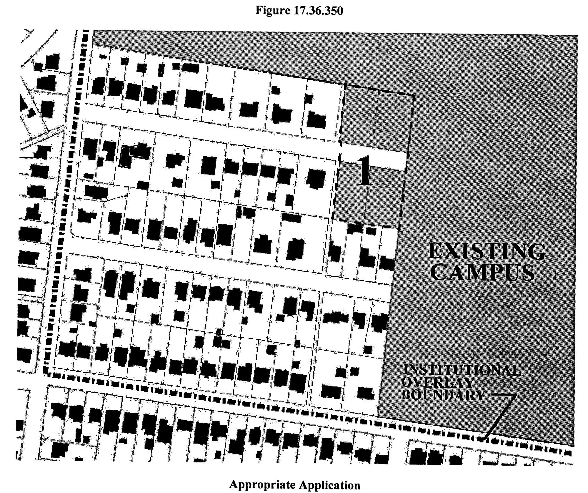
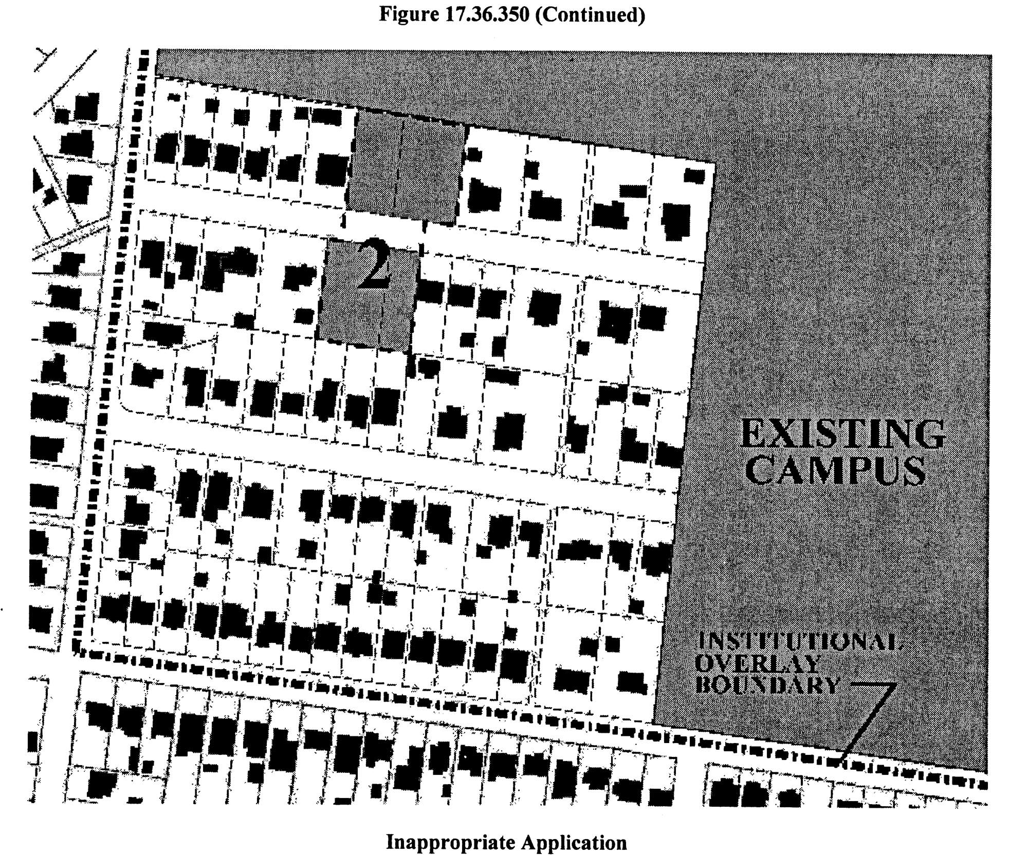
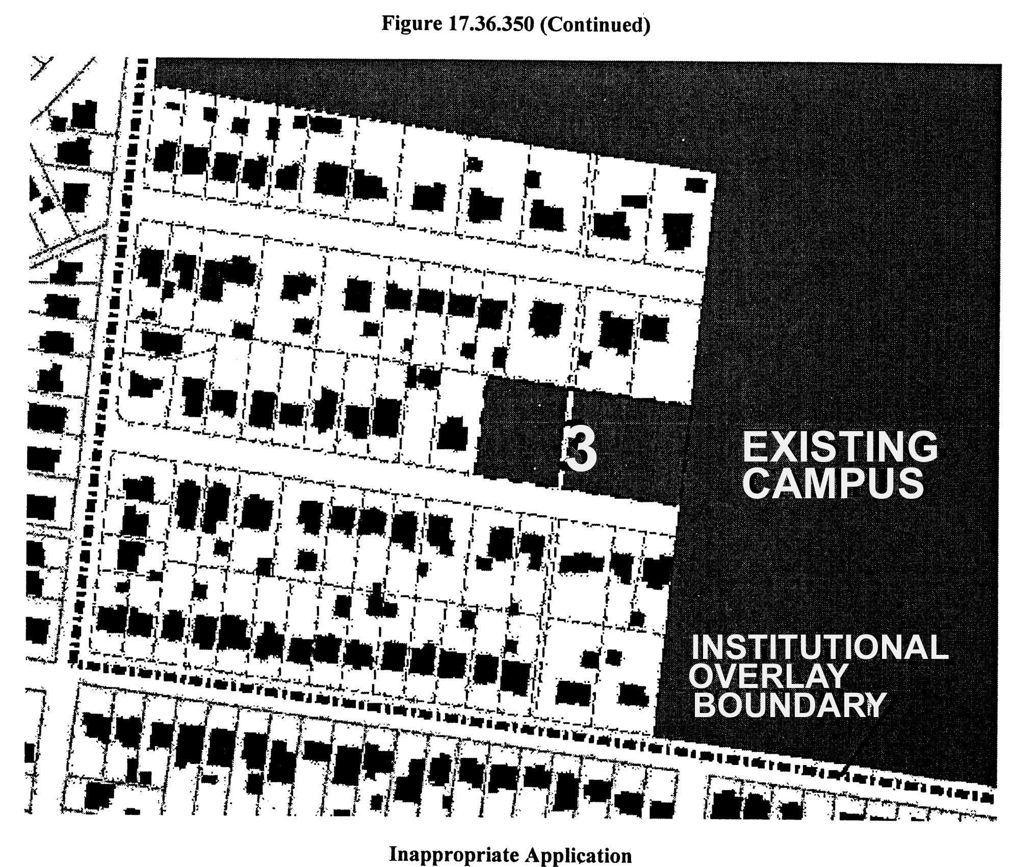
Within the boundaries of an approved campus master development plan, applications for final site plans for institutional-related uses shall be approved only in areas: 1) contiguous to the existing campus as of the date of the application; 2) in accordance with an approved phasing plan; and 3) in a manner that does not further fragment the pattern of residentially used parcels from the residential area outside of the existing campus (See Figure 17.36.350). Each plan phase shall be supported by adequate infrastructure improvements. The introduction of an institutional-related use adjacent to an existing and improved residential lot not owned by, or contractually obligated to, the institution shall incorporate a landscape buffer yard to protect that residential lot. The introduction of parking in these locations should be avoided. For the purpose of determining an adequate buffer, a new parking facility shall be treated as an institutional-related use that is least compatible with residential use. The planning commission shall require an adequate buffer yard under the standards of Table 17.24.230 sufficient to maintain the residential integrity of the residential property not owned by, or contractually obligated to, the institution.
(Ord. BL2003-1399 § 6, 2003; Ord. 96-555 § 9.9(C), 1997)
17.36.360 - Objectives of the impact overlay district.
The objectives of the special impact overlay district are as follows:
A.
To avoid adverse impacts caused by land use changes occasioned by the introduction of a major public facility, such impacts including both adverse influence on other land or on public facilities; and
B.
To insure a thorough analysis of all zoning district amendments within areas subject to adverse impacts from a major public facility.
(Ord. 96-555 § 9.10(A), 1997)
17.36.370 - Effect of zone changes on impact area policies.
All zone changes shall comply with the land use policies contained herein. A set of all maps delineating impact areas and subareas created in this chapter shall be filed in the office of the metropolitan clerk upon adoption of such policies and maps. The applicability of policies adopted in this chapter to zone change proposals within impact areas shall be determined by the metropolitan council. In its recommendation to the council on zone change proposals within impact areas, the metropolitan planning commission shall advise the council on the applicability of the impact area policies. Whenever the metropolitan council determines that a zone change proposal within an impact area is not subject to the impact area policies, it shall consider such zone change proposal in the same manner that zone change proposals outside of impact areas are considered.
(Ord. 96-555 § 9.10(B), 1997)
17.36.380 - I-440 Impact Area 1.
The following policies shall be applicable to I-440 Impact Area 1.
A.
Overview and Applicability. Policies are presented in two parts: Those applicable throughout Impact Area 1 and those applicable only within specific subareas of Impact Area 1. The policies shall apply to zone change proposals that have been determined by the metropolitan council to be related to the presence and/or operational effects of Interstate 440.
B.
Adoption of Impact Area Maps. The maps attached to the ordinance codified in this chapter and on file in the office of the metropolitan clerk, delineating Impact Area 1 and its subareas are adopted as part of this chapter and may be viewed upon request at the office of the metropolitan clerk.
C.
Impact Area 1-Areawide Policies. The policies set forth herein shall apply within Impact Area 1 delineated on Map 1.
1.
The design of Interstate 440 addressed the objectionable visual and auditory impacts typically cited as reasons why property near a major highway is unsuitable for residential use, particularly one-family and two-family housing. Therefore, areas in close proximity to Interstate 440 will remain suitable and appropriate for residential use, and zoning policy should be to vigorously support the preservation and protection of the existing stable housing and neighborhoods adjoining the Interstate 440 corridor with particular emphasis on areas presently zoned for one-family and two-family type housing.
2.
As reflected in Concept 2010: A General Plan for Nashville and Davidson County, adopted land use policy does not support the introduction of any nonresidential base or overlay zoning district in the portion of the impact area that is on the out-of-town side of Interstate 440. Any such rezoning is inappropriate and should be avoided.
3.
Planned unit development overlay zoning provides the best opportunity to address site design, buffering, traffic access and other development considerations that may be of concern to adjoining property owners. Generally, PUD overlay zoning should be used in order to achieve a harmonious relationship among existing and new development.
4.
In general, all rezoning to permit new residential and nonresidential development should be subject to the availability of sufficient traffic, utility and drainage capacity to ensure an adequate level of service after the new development has been added. Further, zone changes to accommodate unforeseen development should be avoided when such development would usurp traffic and utility system capacity intended to support planned growth in the area.
D.
Impact Area 1-Subarea Policies. The policies set forth in this subsection shall be applicable only within the specific subarea referenced.
1.
Subarea 1-A Policies (Map 1-A). Base zoning district changes to higher density or nonresidential zone districts are inappropriate. Residential planned unit developments are appropriate. Such developments that contain other than one-family or two-family type housing structures should be limited to locations along the fringes of this area and careful consideration should be given to design so adjoining one-family and two-family development is not adversely affected.
2.
Subarea 1-B Policies (Map 1-B). Nonresidential zoning changes should be limited to ON or OL zoning only for minor boundary adjustments, where appropriate, along existing ORI and ON or OL district boundaries. Higher density residential zoning is not appropriate unless accessibility is substantially improved to major arterial streets other than West End Avenue, such as Charlotte Pike, and traffic studies conducted by the metropolitan planning commission and metropolitan traffic and parking commission determine that satisfactory levels of traffic service can be maintained with the higher densities in this subarea.
3.
Subarea 1-C Policies (Map 1-C). For portions of the subarea presently zoned ORI, any changes to any base or overlay zone districts which permits a broader range of nonresidential land uses in inappropriate. Limited expansion of nonresidential zoning into Subarea 1-B or 1-F to facilitate good site design for office development fronting along West End Avenue is appropriate only when it is consistent with the policies for the affected subarea and does not materially deteriorate traffic conditions on West End Avenue.
4.
Subarea 1-D Policies (Map 1-D). Rezoning to any nonresidential base or overlay district is inappropriate. High-density residential development should be limited to the frontage of West End Avenue and should not extend to the frontage of streets parallel to and one block removed from West End Avenue. In areas zoned for one-family or two-family type residential uses, residential planned unit developments with one-family and two-family type housing only are appropriate; changes to higher density base districts in these areas are not appropriate. Residential uses along secondary streets should be protected by preserving the primary function of these streets of serving institutionally and residentially generated traffic from this and adjoining areas.
5.
Subarea 1-E Policies (Map 1-E). Rezoning any portion of this subarea to any nonresidential base or overlay district would be inappropriate. Residential base zoning district changes to permit higher densities should be based on a detailed traffic study conducted by the metropolitan traffic and parking commission and the metropolitan planning commission that determines that traffic from additional development in the area together with that generated from currently projected development of 2000 outside of this area can be satisfactorily accommodated within available transportation system capacity. Planned unit development overlay zoning should be used to accommodate residential developments with site designs and housing types not achievable through conventional subdivisions. Development in this area should not result in excessive traffic on secondary streets in adjoining existing residential areas. Whenever roadway improvements and studies allow for consideration of additional development beyond that permitted by present zoning, the densities established for residential medium density and use policy categories should be used to determine the maximum amount of residential development that would be appropriate in this area.
6.
Subarea 1-F Policies (Map 1-F). A change in existing zoning to higher density residential or nonresidential base or overlay districts is appropriate only when all of the following conditions listed for each type of zone change are met:
a.
In the case of a proposal for nonresidential zoning: (i) the proposal abuts existing nonresidential zoning property that has frontage on West End Avenue or Hillsboro Pike, (ii) the property proposed for rezoning is needed together with one or more parcels in the abutting nonresidential zone district in order to provide a development site with adequate depth and the entire development site is submitted for approval as a commercial planned unit development overlay district with the bulk and service characteristics of the proposed use designed to avoid adverse effects on adjoining residentially zoned areas and residentially used streets; for any such PUD along Hillsboro Pike, the intensity of development should not exceed that permitted in the OL base zone district;
b.
In the case of a proposal for higher density residential zoning: The proposal is submitted for approval as a residential planned unit development overlay district and the proposed site: (i) is contiguous to an existing zone district which permits residential development of equal or greater density, (ii) has frontage on a collector or higher order street, (iii) is in the vicinity of an interstate highway interchange, and (iv) is located along the mapped boundary between two residential land use policy categories of the general plan, one of which is either medium-high or high density; or
c.
In the case of residential development proposals in locations other than specified in subdivision (b), the proposal is submitted as a residential planned unit development and the following conditions are met: (i) existing base district zoning is not changed; (ii) the metropolitan planning commission and the metropolitan council strictly adhere to the metropolitan zoning requirements when proposals containing multifamily structures are submitted for consideration, and (iii) careful consideration is given to design and landscape buffering in all such proposals to protect adjoining residential uses.
7.
Subarea 1-G Policies (Map 1-G). Rezoning to any nonresidential base or overlay district is inappropriate in this area. Base district zoning changes to permit higher densities should be avoided. Residential planned unit development overlay zoning may be considered in the area between Interstate 440 and Sharondale Drive provided: (a) such developments contain only one-family and/or two-family type housing; and (b) the conditions hazardous to traffic and pedestrians along Sharondale Drive are first remedied. The area should be protected from heavy volumes of traffic resulting from any extensive development in adjoining areas, particularly Subarea 1-E.
8.
Subarea 1-H Policies (Map 1-H). Zone changes which would permit nonresidential development are inappropriate. Residential development with mixed building types or multifamily structures are appropriate along both margins of Hillsboro Pike. All of the following conditions shall apply to any such development proposed along the west margin of Hillsboro Pike: (a) it is submitted as a planned unit development; (b) the proposed density does not exceed that permitted in the R10 base zone district; (c) it does not extend to a depth in excess of three hundred feet from the right-of-way line of Hillsboro Pike; (d) it is developed in a manner which is compatible with the character of existing adjoining residential development; and (e) it will not materially deteriorate traffic conditions on Hillsboro Pike.
9.
Subarea 1-I Policies (Map 1-I). Rezoning to allow higher intensity office development or a greater diversity of commercial activities is inappropriate. Rezoning to improve the depth of shallow building sites fronting on Hillsboro Pike may be considered along the eastern and western edges of this subarea and should be guided by the policies established for Subareas 1-F and 1-J.
10.
Subarea 1-J Policies (Map 1-J). Residential base zone district changes to higher density zones should be avoided. Residential planned unit developments may be permitted in areas where lot sizes are substantially greater than minimum zoning requirements and prevailing lot sizes such as the lots fronting the west margin of Hazelwood Drive and lots fronting both sides of Cedar Lane west of Hazelwood Drive. Such PUDs should be limited to one-family and two-family type housing except where they would be between existing multifamily developments. Rezoning to nonresidential zones should be limited to commercial planned unit developments to improve the developability of shallow lots fronting on Hillsboro Pike provided: (a) the intensity of the development in the PUD does not exceed that permitted in the base zone of the lot fronting on Hillsboro Pike, (b) generous buffering is provided to protect adjacent residential uses, and (c) access is not oriented to the adjoining residential areas.
11.
Subarea 1-K Policies (Map 1-K). Zone changes to permit nonresidential development are inappropriate. The application of residential planned unit development overlay zoning is appropriate in this subarea. The metropolitan planning commission and the metropolitan council should strictly adhere to the requirements in Article II of this chapter when proposals containing multifamily structures are submitted for consideration. In addition, careful consideration should be given to design and landscape buffering in all such proposals to protect adjoining residential uses.
12.
Subarea 1-L Policies (Map 1-L). Residential base district zoning changes to higher density zones should be avoided. Reduced site size residential planned unit developments should be considered and should be limited to one-family and two-family type housing structures. No rezoning to nonresidential base or overlay zone districts should be permitted.
(Ord. 96-555 § 9.10(C), 1997)
17.36.390 - I-440 Impact Area 2.
The following policies shall be applicable to I-440 Impact Area 2.
A.
Overview and Applicability. Policies are presented in two parts: Those applicable throughout Impact Area 2 and those applicable only within specific subareas of Impact Area 2. The policies shall apply to zone change proposals that have been determined by the metropolitan council to be related to the presence and/or operational effects of Interstate 440.
B.
Adoption of Impact Area Maps. The maps attached to the ordinance codified in this section and on file in the office of the metropolitan clerk delineating Impact Area 2 and its subareas are adopted as part of this title and may be viewed upon request at the office of the metropolitan clerk.
C.
Impact Area 2-Areawide Policies. The policies set forth in this section shall apply within Impact Area 2 as delineated on Map 2.
1.
Proximity to Interstate 440, in and of itself, does not make an area unsuitable for residential use, since the design of the interstate incorporates features which minimize the facility's negative auditory and visual impacts.
2.
Where Concept 2010: A General Plan for Nashville and Davidson County, identifies an area to be conserved for residential use, zoning should reflect that policy at the density indicated. Where the land use policy map identifies an area for nonresidential use, but the zoning has remained residential, changes in zoning should be considered in terms of a managed transition that will create minimum conflicts between uses.
3.
Conflicts between new and existing uses may best be resolved by the use of planned unit development overlay zoning, because it provides the opportunity to address site design, buffering, traffic and other considerations.
4.
Zone changes should be subject to the availability of street, utility and drainage capacity.
D.
Impact Area 2-Subarea Policies. The policies set forth in this subsection shall be applicable only within the specific subarea referenced.
1.
Subarea 2-A Policies (Map 2-A). Retain the current R6 and R6-A base zone throughout the subarea.
2.
Subarea 2-B Policies (Map 2-B). The R6 and R6-A base zone should be maintained. There should be no expansion of the small CS and CS-A strip. Residential planned unit developments of mixed structure types should be considered, if an amendment to the general plan is considered simultaneously.
3.
Subarea 2-C Policies (Map 2-C). Expansion of nonresidential or introduction of higher density residential zoning districts would be inappropriate, except the lots abutting the west margin of Hester Avenue may be considered for nonresidential if combined with the Nolensville Pike lots with all access to Nolensville Pike and the Nolensville Pike portion reclassified to CS and CS-A. Reduced site size residential planned unit developments at densities allowed in the base zoning district would be acceptable south of Vivelle Avenue.
4.
Subarea 2-D Policies (Map 2-D). Expansion of nonresidential zoning or introduction of higher density residential zoning would not be appropriate. Residential planned unit development should be considered.
5.
Subarea 2-E Policies (Map 2-E). Zone changes to industrial uses would be inappropriate. If a mixed-use zoning district is made available, its application to this area would not be contrary to this policy.
6.
Subarea 2-F Policies (Map 2-F). Expansion of the existing RM20, ON, OL, CN and CN-A, CL and CL-A, CS and CS-A zoning districts would not be appropriate. While the R6 base zone should be retained, application of the residential planned unit development overlay, along the southern, western and northern boundaries, would be appropriate if building types are similar to those in the subarea.
7.
Subarea 2-G Policies (Map 2-G). Expansion of the existing CS and CS-A, IWD and RM20 zoning districts is not appropriate. Expansion of the ON or OL zoning districts should be confined to parcels fronting the south margin of Thompson Lane, from the existing OL to the west margin of Dobbs Avenue, and should be allowed only in an orderly progression. Use of residential planned unit development overlays would be appropriate in the development of the large vacant tracts within the R10 base zone.
(Ord. BL2015-1153 § 15, 2015; Ord. 96-555 § 9.10(D), 1997)
17.36.400 - Purpose and intent.
The neighborhood landmark district provisions are established by this title to preserve and protect neighborhood features that are important to maintain and enhance the neighborhood character. Neighborhood features are defined as buildings, structures, objects, sites, and areas of historic, cultural, civic, neighborhood, or architectural value and/or importance to Metropolitan Nashville and Davidson County. The provisions of this title are intended:
A.
To regulate exterior design, arrangement, texture, and materials proposed to be used within the neighborhood landmark districts to ensure protection of the identified feature and compatibility with surrounding uses;
B.
To create an aesthetic appearance which complements the existing buildings, structures, objects, sites, and areas of value or importance on-site;
C.
To stabilize and improve property values;
D.
To foster civic beauty;
E.
To enhance a neighborhood by providing a strong sense of place;
F.
To protect the neighborhood character and context by preserving existing neighborhood fabric while permitting reasonable use of a property;
G.
To strengthen the local economy; and
H.
To promote the use of neighborhood landmark districts for the education, pleasure and welfare of the present and future citizens of Nashville and Davidson County.
(Ord. BL2000-365 Exh. A (part), 2000)
17.36.410 - District established.
Neighborhood Landmark (NL) District. The boundaries shall be shown on the zoning map or special overlays thereto that are made a part of this Zoning Code and noted by name on such maps, in which no feature shall be constructed, altered, repaired, relocated or demolished in whole or in part, increased in size, or changed in height unless the action complies with the requirements set forth in this title.
(Ord. BL2000-365 Exh. A (part), 2000)
17.36.420 - District defined.
A neighborhood landmark is defined as a feature, its appurtenances and the property it is located on which has historical, cultural, architectural, civic, neighborhood, or archaeological value and/or importance; whose demolition or destruction would constitute an irreplaceable loss to the quality and character of a neighborhood within Nashville and Davidson County, and that meets one or more of the following criteria:
1.
It is recognized as a significant element in the neighborhood and/or community;
2.
It embodies characteristics that distinguish it from other features in the neighborhood and/or community;
3.
Rezoning the property on which the feature exists to a general zoning district inconsistent with surrounding or adjacent properties such as, office, commercial, mixed-use, shopping center, or industrial zoning district would significantly impact the neighborhood and/or community;
4.
Retaining the feature is important in maintaining the cohesive and traditional neighborhood fabric;
5.
Retaining the feature will help to preserve the variety of buildings and structures historically present within the neighborhood recognizing such features may be differentiated by age, function and architectural style in the neighborhood and/or community; and
6.
Retaining the feature will help to reinforce the neighborhood and/or community's traditional and unique character.
(Ord. BL2000-365 Exh. A (part), 2000)
17.36.430 - Purpose and intent.
The primary intent of the urban zoning overlay district is to preserve and protect existing development patterns that predate the mid-1950's in portions of metro Nashville that were originally developed before that time and to ensure the compatibility of new development in those older portions of the city. In addition, the urban zoning overlay district is intended to promote reinvestment in areas of metro Nashville originally developed before the mid-1950s by modifying development standards that could add unnecessary expense without improving the safety or compatibility of resulting development. The urban zoning overlay district is also intended to implement provisions of adopted plans that call for particular areas to evolve to a development pattern characterized predominantly by lot sizes, street patterns, and alley systems commonly used before the mid-1950s.
(Ord. BL2000-364 § 1, 2000)
17.36.440 - Applicability.
The provisions of the urban zoning overlay district shall apply to all properties located within a mapped area indicated on a zoning overlay map adopted pursuant to the provisions of Article III of Section 17.40, excluding planned unit developments adopted prior to the effective date of the establishment of the urban zoning overlay district and properties zoned DTC district. However, the UZO District maximum parking space standard shall apply within the DTC. Petitions should contain a minimum of one hundred sixty acres of land in order to avoid piecemeal application of the district and should be for areas characterized predominantly by lot sizes, street patterns, and alley systems commonly used before the mid-1950s or for areas where an adopted plan calls for the evolution of such a development pattern. When properties included in a petition are within the area defined by the 1956 limits of the City of Nashville, they should be contiguous to a previously adopted urban zoning overlay district. For purposes of determining applicability of the urban zoning overlay district provisions within any other overlay district, the urban zoning overlay district provisions shall be treated as base zoning district provisions.
(Ord. BL2022-1412 § 4, 2022; Ord. BL2009-586 § 1(Exh. A, § 44), 2010; Amdt. 10 with Ord. BL2000-364 § 1, 2000)
17.36.450 - Purpose and intent.
The contextual overlay district provides appropriate design standards for residential areas necessary to maintain and reinforce an established form or character of residential development in a particular area.
(Ord. BL2014-771 § 1, 2014)
17.36.460 - Overlay designation.
A contextual overlay district shall be created according to the procedures of Chapter 17.40, Article III and depicted as a geographical area on the official zoning map.
(Ord. BL2014-771 § 1, 2014)
17.36.470 - Design guidelines.
A.
Street Setback. The minimum required street setback shall be the average of the street setback of the two developed lots abutting each side of the lot. When one or more of the abutting lots is vacant, the next developed lot on the same block face shall be used. The minimum provided in [Section] 17.12.030A and the maximum provided in [Section] 17.12.030C.3 shall not apply. Where there is only one abutting lot on the same block face, it shall be used for this calculation. When the subject lot is on a corner, the minimum required street setback shall be calculated and met for each street.
B.
Height.
1.
The maximum height, including the foundation, of any primary structure shall not be greater than thirty-five feet or one hundred twenty-five percent of the average height of the principal structures on the two lots abutting each side of the lot, whichever is less. When one of the abutting lots is vacant, the next developed lot on the same block face shall be used. Where there is only one abutting lot on the same block face, it shall be used for this calculation. When the subject lot is on a corner, the maximum height shall be calculated for each street and limited to thirty-five feet or one hundred twenty-five percent of the average height of the lesser value. When one hundred twenty-five percent of the average of the abutting structures is less than twenty-seven feet, a maximum height of one and one-half stories in twenty-seven feet shall be permitted.
2.
The maximum height, including the foundation, of any accessory structure shall not be greater than twenty-seven feet.
3.
For the purposes of this section, height shall be measured from grade or, if present, the top of a foundation which shall not exceed three feet above grade, to the roof line.
4.
For the purposes of this section, "one-half story" means a partial story under a gable, hip, or gambrel roof, the wall plates of which, on at least two exterior walls, are not more than four feet above the floor of such story. A dormer shall not occupy more than fifty percent of the roof area. The floor area of said half story shall not exceed three-quarters of the floor area of the floor immediately below it. A half story containing an independent dwelling unit or accessory apartment shall be deemed a full story.
C.
Maximum building coverage. The maximum building coverage (excluding detached garages and other accessory buildings) shall be a maximum of one hundred fifty percent of the average of the building coverage (excluding detached garages and other accessory buildings) of the two abutting lots on each side. When the abutting lot is vacant, the next developed lot shall be used. Where there is only one abutting lot on the same block face, it shall be used for this calculation. When the subject lot is on a corner, the maximum building coverage shall be calculated and met for each street.
D.
Access and driveways, garages and parking areas.
1.
Access and Driveways.
a.
Where existing, access shall be from an improved alley. Where no improved alley exists, a driveway within the street setback may be permitted.
b.
For a corner lot, the driveway shall be located within thirty feet of the rear property line.
c.
Driveways are limited to one driveway ramp per public street frontage.
d.
Parking, driveways and all other impervious surfaces in the required street setback shall not exceed twelve feet in width.
2.
Garages.
a.
Detached. The front of any detached garage shall be located behind the rear of the primary structure. The garage door of a detached garage may face the street.
b.
Attached. The garage door shall face the side or rear property line.
(Ord. BL2024-184 § 6, 2024; Ord. BL2014-771 § 1, 2014)
17.36.480 - Permitted land uses.
The range of land uses permitted within a contextual overlay district shall be those permitted by the underlying zoning district(s) as established by the zoning district land use table of Section 17.08.030.
(Ord. BL2014-771 § 1, 2014)
17.36.490 - Variation of conventional standards.
The contextual overlay district varies the conventional standards of the underlying zoning district(s) as established in Chapter 17.12, Sections 17.12.020 through 17.12.060; the parking, loading and access standards of Chapter 17.20; and the nonconforming lot area requirements of Section 17.40.670.
(Ord. BL2014-771 § 1, 2014)
17.36.500 - Contextual overlay district.
A.
Application for a Contextual Overlay District. Lots included in a district must be contiguous and continuous throughout the residential portion of a complete block face(s).
B.
Historic Overlay District. A contextual overlay shall not be applied in an adopted historic overlay district. Adoption of a historic overlay district shall supersede an adopted contextual overlay and only the requirements of the historic overlay district shall apply.
C.
Planning Commission Recommendation. The planning commission shall review a proposed contextual overlay district application for conformance with the General Plan. The planning commission shall act to recommend approval, approval with conditions or disapproval of the application. Within ten working days of an action, the commission's resolution shall be transmitted in writing to the applicant, the metro clerk, the zoning administrator and all other appropriate governmental departments.
D.
Council Consideration. The metropolitan council shall consider an ordinance establishing a contextual overlay district according to the procedures of Article III of Chapter 17.40 (Amendments). All property owners within and proximate to a proposed contextual overlay district shall be notified according to the procedures of Article XV of Chapter 17.40.
E.
Final Site Plan Approval. For property located within a contextual overlay district, a final site plan application shall be submitted for review and approval by the Zoning Administrator in a manner consistent with the procedures of Section 17.40.170A. The applicant is required to submit all necessary information to the Zoning Administrator and to certify the accuracy of the submitted information.
F.
Modifications to Design Standards Not Permitted. Contextual Overlay Districts shall be adopted with the standards outlined in [Section] 17.36.470 (Design guidelines). Modifications to these standards shall not be permitted. Variance requests shall follow the process outlined in Chapter 17.40.
G.
Changes to a Contextual Overlay District Boundary. A proposed change in the geographic boundary of a contextual overlay district on the official zoning map shall be considered by the council according to the procedures of Article III of Chapter 17.40 (Amendments).
(Ord. BL2014-771 § 1, 2014)
17.36.510 - Purpose and intent.
The corridor design overlay district provides appropriate design standards for commercial, office and mixed-use development along corridors necessary to provide incremental improvements to the aesthetics of Nashville's commercial districts and corridors. Application of this overlay district shall be limited to areas requiring transitional standards.
(Ord. BL2019-1540 § 1, 2019)
17.36.520 - Overlay designation.
A corridor design overlay district shall be created according to the procedures of Chapter 17.40, Article III and depicted as a geographical area on the official zoning map.
(Ord. BL2019-1540 § 2, 2019)
17.36.530 - Applicability of standards.
A.
Signage standards apply to any and all new signs, and do not apply to panel changes to existing signs.
B.
Landscaping standards apply to new parking lots, and to the expansion area of existing parking lots that are expanded by ten spaces or more.
C.
Landscaping standards do not apply to existing parking lots, or re-surfacing or re-striping of existing parking lots.
D.
Building materials standards apply to additions greater than fifty percent of the existing building's square footage, and new buildings.
(Ord. BL2019-1540 § 3, 2019)
17.36.540 - Variations to conventional standards.
Variations to the conventional standards of the underlying zoning district(s) are:
A.
Properties in the corridor design overlay district are subject to the following variations regarding signage:
1.
All standards of [Chapter] 17.32 Signage Regulations shall apply according to the zoning district of the property, except Table 17.32.130D.
2.
In place of Table 17.32.130D, Table 17.32.120 shall apply. Any references to Table 17.32.130D shall be substituted with Table 17.32.120.
3.
All notes from Table 17.32.130D shall apply to properties in CL, CL-NS, CS, CS-NS, CA, CA-NS, CF, CF-NS, SCC, SCC-NS, SCR, SCR-NS, IWD, IR and IG districts.
4.
Any uses permitted with conditions are allowed one-half the maximum sign area allowed in [Section] 17.16.070. All other standards of [Section] 17.16.070 shall apply to uses permitted with conditions.
B.
Properties in the corridor design overlay district are subject to the following variations regarding perimeter screening:
1.
All standards of [Section] 17.24.150 shall apply, with the exception that trees shall be installed at a rate of one tree per thirty feet regardless of zoning district or elevation relative to the public street.
C.
Properties in the corridor design overlay district are subject to the following variations regarding building materials:
1.
Each building facade facing a public street or private drive shall be considered a primary facade as specified in Figure 17.36.540.C and is subject to all regulations regarding primary facades. The presence or absence of parking between the primary facade and the street or drive does not influence the designation as a primary facade. Any and all primary facades are subject to all regulations regarding primary facades.
2.
For all calculations related to materials, the primary facade shall be calculated as the entire width of the building multiplied by the entire height of the building, less the width and height of each window or door system. The calculations below are based on the remaining non-glazed facade.
3.
At least seventy-five percent of the primary facade shall be clad in material(s) selected from the following list: brick, brick veneer, stone, cast stone, and/or architecturally treated concrete masonry units, fiber cement products, and/ or material(s) substantially similar in form and function.
i.
Concrete masonry units shall be spilt-face or otherwise treated with texture or visual interest.
ii.
Materials changes shall occur along horizontal lines, not vertical lines.
4.
All other building facades, including those facing interior property lines, rear property lines, loading lanes, etc. - are not primary facades therefore alternative materials not listed in 17.36.540.C.3 may be used. If used on non-primary facades, concrete masonry units shall be split-face or otherwise treated with texture or visual interest.
Figure 17.36.540.C.
(Ord. BL2021-1022 §§ 2, 3, 2022; Ord. BL2019-111 § 1(Exh. A, § 50), 2020; Amdt. 1 to Ord. BL2019-1540 § 4, 2019; Ord. BL2019-1540 § 4, 2019)
17.36.550 - Permitted land uses.
The range of land uses permitted within a corridor design overlay district shall be those permitted by the underlying zoning district(s) as established by the zoning district land use table of Section 17.08.030.
(Ord. BL2019-1540 § 5, 2019)
17.36.560 - Corridor design overlay district.
A.
Planning Commission Recommendation. The planning commission shall review a proposed corridor design overlay district application for conformance with the General Plan. The planning commission shall act to recommend approval, approval with conditions or disapproval of the application. Within ten working days of an action, the commission's resolution shall be transmitted in writing to the applicant, the metro clerk, the zoning administrator and all other appropriate governmental departments.
B.
Council Consideration. The metropolitan council shall consider an ordinance establishing a corridor design overlay district according to the procedures of Article III of Chapter 17.40 (Amendments). All property owners within and proximate to a proposed corridor design overlay district shall be notified according to the procedures of Article XV of Chapter 17.40.
C.
Final Site Plan Approval. For property located within a corridor design overlay district, a final site plan application shall be submitted for review and approval by the zoning administrator in a manner consistent with the procedures of Section 17.40.170A. The applicant is required to submit all necessary information to the zoning administrator and to certify the accuracy of the submitted information.
1.
The plans and specifications submitted pursuant to this section shall be prepared by, or under the direction of, and bear the seal of a professional landscape architect, architect, engineer, or land planner registered in Tennessee. The presence of this seal indicates full compliance with the provisions of the corridor design overlay district.
2.
Before the issuance of a use and occupancy permit, as-built drawings shall be submitted to certify compliance with the standards of this section. The as-built drawings shall be prepared by, or under the direction of, and bear the seal of a professional landscape architect, architect, engineer, or land planner registered in Tennessee. The presence of this seal indicates full compliance with the provisions of the corridor design overlay district.
D.
Modifications to Design Standards. The zoning administrator shall have the authority to grant modifications to the standards of the corridor design overlay district that do not exceed twenty percent of any signage standard, landscaping requirement, or dimensional requirement relating to building materials. At the zoning administrator's discretion, any modification may be referred to the board of zoning appeals for review and action.
E.
Changes to a Corridor Design Overlay District Boundary. A proposed change in the geographic boundary of a corridor design overlay district on the official zoning map shall be considered by the council according to the procedures of Article III of Chapter 17.40. (Amendments).
(Ord. BL2019-1540 § 6, 2019)
17.36.570 - Purpose and intent.
The residential accessory structure overlay district provides appropriate design standards and bulk regulations for accessory structures in residential areas necessary to maintain and reinforce an established form or character of residential development in a particular area.
(Ord. BL2020-151 § 1, 2020)
17.36.580 - Overlay designation.
A residential accessory structure overlay district shall be created according to the procedures of Chapter 17.40, Article III and depicted as a geographical area on the official zoning map.
(Ord. BL2020-151 § 2, 2020)
17.36.590 - Guidelines.
A.
Number. A maximum of two accessory structures may be constructed on a lot.
B.
Location. Accessory structures shall not be erected in any required setback and must be located to the rear of the principle structure.
C.
Size. The combined gross floor area of all accessory structures on a lot shall be no more than thirty percent of the total gross floor area of the principal structure or one thousand two hundred square feet, whichever is less.
D.
Height. Accessory structures shall not exceed one story or sixteen feet in height, whichever is less. The top elevation of an accessory structure shall not exceed the top elevation of the principal structure.
E.
Materials. Accessory structures greater than one hundred fifty square feet in gross floor area must be constructed in a like manner to the principal building in terms of roof style and building materials. Alternative materials that are not metal, plastic, vinyl, or concrete masonry units may be used as primary siding materials for accessory structures greater than one hundred fifty square feet in gross floor area. Metal, plastic, vinyl, or concrete masonry units may be used if that same material is the primary material on the principal structure.
(Ord. BL2021-1022 § 4, 2022; Ord. BL2020-151 § 3, 2020)
17.36.600 - Permitted land uses.
The range of land uses permitted within a residential accessory structure overlay district shall be those permitted by the underlying zoning district(s) as established by the zoning district land use table of Section 17.08.030.
(Ord. BL2020-151 § 4, 2020)
17.36.610 - Variation of conventional standards.
The residential accessory structure overlay district varies the conventional standards of the underlying zoning district(s) as established in Chapter 17.12, Sections 17.12.050 and 17.12.060.
(Ord. BL2020-151 § 5, 2020)
17.36.620 - Residential accessory structure overlay district.
A.
Application for a Residential Accessory Structure Overlay District. Lots included in a district must be contiguous.
B.
Historic Overlay District. A residential accessory structure overlay district shall not be applied in an adopted historic overlay district. Adoption of a historic overlay district shall supersede an adopted residential accessory structure overlay district and only the requirements of the historic overlay district shall apply.
C.
Contextual Overlay District. A residential accessory structure overlay district shall not be applied in an adopted contextual overlay district. Adoption of a contextual overlay district shall supersede an adopted residential accessory structure overlay district and only the requirements of the contextual overlay district shall apply.
D.
Urban Design Overlay District. A residential accessory structure overlay district shall not be applied in an adopted urban design overlay district. Adoption of an urban design overlay district shall supersede an adopted residential accessory structure overlay district and only the requirements of the urban design overlay district shall apply.
E.
Urban Zoning Overlay. A residential accessory structure overlay district shall not be applied in the adopted urban zoning overlay district. Expansion of the urban zoning overlay district shall supersede an adopted residential accessory structure overlay district and only the requirements of the urban zoning overlay district shall apply.
F.
Eligible Zoning Districts. Residential accessory structure overlay districts shall only be applicable in single family (RS and RS-A) and one- and two-family (R and R-A) residential zoning districts. Residential accessory structure overlay districts shall not be applied to property within specific plan (SP) zoning districts.
G.
Planning Commission Recommendation. The planning commission shall review a proposed residential accessory structure overlay district application for conformance with the general plan. The planning commission shall act to recommend approval, approval with conditions or disapproval of the application. Within ten working days of an action, the commission's resolution shall be transmitted in writing to the applicant, the metro clerk, the zoning administrator and all other appropriate governmental departments.
H.
Council Consideration. The metropolitan council shall consider an ordinance establishing a residential accessory structure overlay district according to the procedures of Article III of Chapter 17.40 (Amendments). All property owners within and proximate to a proposed residential accessory structure overlay district shall be notified according to the procedures of Article XV of Chapter 17.40.
I.
Final Site Plan Approval. For property located within a residential accessory structure overlay district, a final site plan application shall be submitted for review and approval by the zoning administrator in a manner consistent with the procedures of Section 17.40.170A. The applicant is required to submit all necessary information to the zoning administrator and to certify the accuracy of the submitted information.
J.
Modifications to Design Standards Not Permitted. Residential accessory structure overlay districts shall be adopted with the standards outlined in 17.36.590 (Guidelines). Modifications to these standards shall not be permitted. Variance requests shall follow the process outlined in Chapter 17.40.
K.
Changes to a Residential Accessory Structure Overlay District Boundary. A proposed change in the geographic boundary of a residential accessory structure overlay district on the official zoning map shall be considered by the council according to the procedures of Article III of Chapter 17.40 (Amendments).
(Ord. BL2020-316 § 3, 2020; Ord. BL2020-151 § 6, 2020)
17.36.630 - Purpose and intent.
The two-story residential overlay district provides appropriate building height standards in residential areas necessary to maintain and reinforce the established form and character of residential development in a particular area.
(Ord. BL2022-1509 § 1, 2023)
17.36.640 - Overlay designation.
A two-story residential overlay district shall be created according to the procedures of Chapter 17.40, Article III and depicted as a geographical area on the official zoning map.
(Ord. BL2022-1509 § 1, 2023)
17.36.650 - Guidelines.
A.
Principal Structures. Principal structures shall not exceed two stories in thirty-five feet in height as measured from the finished grade.
(Amdt. 1 to Ord. BL2022-1509 § 1, 2023; Ord. BL2022-1509 § 1, 2023)
17.36.660 - Permitted land uses.
The range of land uses permitted within a two-story residential overlay district shall be those permitted by the underlying zoning district(s) as established by the zoning district land use table of Section 17.08.030.
(Ord. BL2022-1509 § 1, 2023)
17.36.670 - Variation of conventional standards.
The two-story residential overlay district varies the conventional standards of the underlying zoning district(s) as established in Chapter 17.12, Sections 17.12.020 and 17.12.060.
(Ord. BL2022-1509 § 1, 2023)
17.36.675 - Two-story residential overlay district.
A.
Application for a Two-Story Residential Overlay District. Lots included in a district must be contiguous.
B.
Historic Overlay District. A two-story residential overlay district shall not be applied in an adopted historic overlay district. Adoption of a historic overlay district shall supersede an adopted two-story residential overlay district and only the requirements of the historic overlay district shall apply.
C.
Contextual Overlay District. A two-story residential overlay district shall not be applied in an adopted contextual overlay district. Adoption of a contextual overlay district shall supersede an adopted two-story residential overlay district and only the requirements of the contextual overlay district shall apply.
D.
Urban Design Overlay District. A two-story residential overlay district shall not be applied in an adopted urban design overlay district. Adoption of an urban design overlay district shall supersede an adopted two-story residential overlay district and only the requirements of the urban design overlay district shall apply.
E.
Urban Zoning Overlay. A two-story residential overlay district shall not be applied in the adopted urban zoning overlay district. Expansion of the urban zoning overlay district shall supersede an adopted two-story residential overlay district and only the requirements of the urban zoning overlay district shall apply.
F.
Eligible Zoning Districts. Two-story residential overlay districts shall only be applicable in single family (RS and RS-A) and one- and two-family (R and R-A) residential zoning districts. Two-story residential overlay districts shall not be applied to property within specific plan (SP) zoning districts.
G.
Planning Commission Recommendation. The planning commission shall review a proposed two-story residential overlay district application for conformance with the general plan. The planning commission shall act to recommend approval, approval with conditions or disapproval of the application. Within ten working days of an action, the commission's resolution shall be transmitted in writing to the applicant, the metro clerk, the zoning administrator, and all other appropriate governmental departments.
H.
Council Consideration. The metropolitan council shall consider an ordinance establishing a two-story residential overlay district according to the procedures of Article III of Chapter 17.40 (Amendments). All property owners within and proximate to a proposed two-story residential overlay district shall be notified according to the procedures of Article XV of Chapter 17.40.
I.
Final Site Plan Approval. For property located within a two-story residential overlay district, a final site plan application shall be submitted for review and approval by the zoning administrator in a manner consistent with the procedures of Section 17.40.170A. The applicant is required to submit all necessary information to the zoning administrator and to certify the accuracy of the submitted information.
J.
Modifications to Design Standards Not Permitted. Two-story residential overlay districts shall be adopted with the standards outlined in 17.36.650 (Guidelines). Modifications to these standards shall not be permitted. Variance requests shall follow the process outlined in Chapter 17.40.
K.
Changes to a Two-Story Residential Overlay District Boundary. A proposed change in the geographic boundary of a two-story residential overlay district on the official zoning map shall be considered by the council according to the procedures of Article III of Chapter 17.40 (Amendments).
(Ord. BL2024-595 § 1, 2024; Ord. BL2022-1509 § 1, 2023)
17.36.680 - Purpose and intent.
The DADU overlay district provides additional housing options in the Urban Zoning Overlay and the Highland Heights Study Area, as adopted by the Metropolitan Planning Commission on June 14, 2018.
(Ord. BL2021-784 § 1, 2021; Ord. BL2021-620 § 1, 2021)
17.36.690 - Overlay designation.
A DADU overlay district shall be created within the Urban Zoning Overlay or the Highland Heights Study Area, as adopted by the Metropolitan Planning Commission on June 14, 2018, according to the procedures of Chapter 17.40, Article III and depicted as a geographical area on the official zoning map.
(Ord. BL2021-784 § 2, 2021; Ord. BL2021-620 § 1, 2021)
17.36.700 - Design guidelines.
A detached self-sufficient dwelling unit shall be allowed accessory to a principal structure subject to the standards set forth in Section 17.16.030.G of this zoning code.
(Ord. BL2021-620 § 1, 2021)
17.36.710 - Permitted land uses.
The range of land uses permitted within a DADU overlay district shall be those permitted by the underlying zoning district(s) as established by the zoning district land use table of Section 17.08.030 and detached accessory dwelling unit. On any lot where a new detached accessory dwelling unit is built, or on any lot where a new detached accessory dwelling unit is established via conversion of an existing accessory structure, short term rental property—owner occupied, is not a permitted use in the accessory dwelling unit.
(Ord. BL2024-184 § 7, 2024; Amdt. 1 to Ord. BL2021-620 § 1, 2021; Ord. BL2021-620 § 1, 2021)
17.36.720 - Bulk provisions.
The bulk provisions of the base zoning district shall apply.
(Ord. BL2021-620 § 1, 2021)
17.36.730 - Detached Accessory Dwelling Unit Overlay District.
A.
Application of a DADU overlay.
1.
A DADU overlay shall be applied to properties zoned RS/RS-A or properties where a DADU is a legally permitted use prior to the establishment of the overlay.
2.
A DADU overlay shall consist of a minimum of 30 contiguous lots. For the purposes of this overlay, lots on opposing block faces and opposite sides of alleys shall be considered contiguous.
3.
Properties within a DADU overlay shall not share lot lines with single-family residential zoned properties that are not in the overlay district.
B.
Planning Commission Recommendation. The planning commission shall review a proposed DADU overlay district application for conformance with the General Plan. The planning commission shall act to recommend approval or disapproval of the application. Within ten working days of an action, the commission's resolution shall be transmitted in writing to the applicant, the metro clerk, the zoning administrator and all other appropriate governmental departments.
C.
Council Consideration. The metropolitan council shall consider an ordinance establishing a DADU overlay district according to the procedures of Article III of this chapter (Amendments). All property owners within and proximate to a proposed DADU overlay district shall be notified according to the procedures of Article XV of this chapter.
D.
Final Site Plan Approval. For property located within a DADU overlay district, a final site plan application shall be submitted for review and approval by the Zoning Administrator in a manner consistent with the procedures of Section 17.40.170A. The applicant is required to submit all necessary information to the Zoning Administrator and to certify the accuracy of the submitted information.
E.
Changes to a DADU Overlay District Boundary. A proposed change in the geographic boundary of a DADU overlay district on the official zoning map shall be considered by the council according to the procedures of Article III of this chapter (Amendments).
(Amdt. 1 to Ord. BL2021-620 § 1, 2021; Ord. BL2021-620 § 1, 2021)